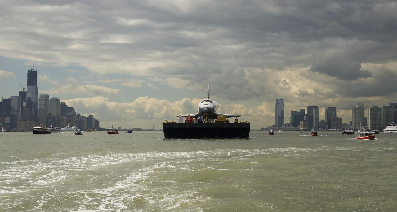
The space shuttle Enterprise is towed by barge up the Hudson River with the New York skyline seen on the left and the Jersey City skyline on the right while on it's way to the Intrepid Sea, Air and Space Museum where it will be permanently displayed, Wednesday, June 6, 2012. Photo Credit: (NASA/Bill Ingalls)

iss074e0003055 (Dec. 20, 2025) --- The New York–Newark–Jersey City Metropolitan Statistical Area, which spans 23 counties across New York, New Jersey, and Connecticut and has a population of about 19.9 million, is pictured at approximately 3:29 a.m. local time from the International Space Station as it orbited 262 miles above the Atlantic coast.

iss072e402101 (Dec. 22, 2024) --- The city lghts of the New York/New Jersey metropolitan area at approximately 3:30 a.m. EST (local time) contrast with the Atlantic coast and the Hudson River in this photograph taken from the International Space Station as it orbited 259 miles above Newfoundland.
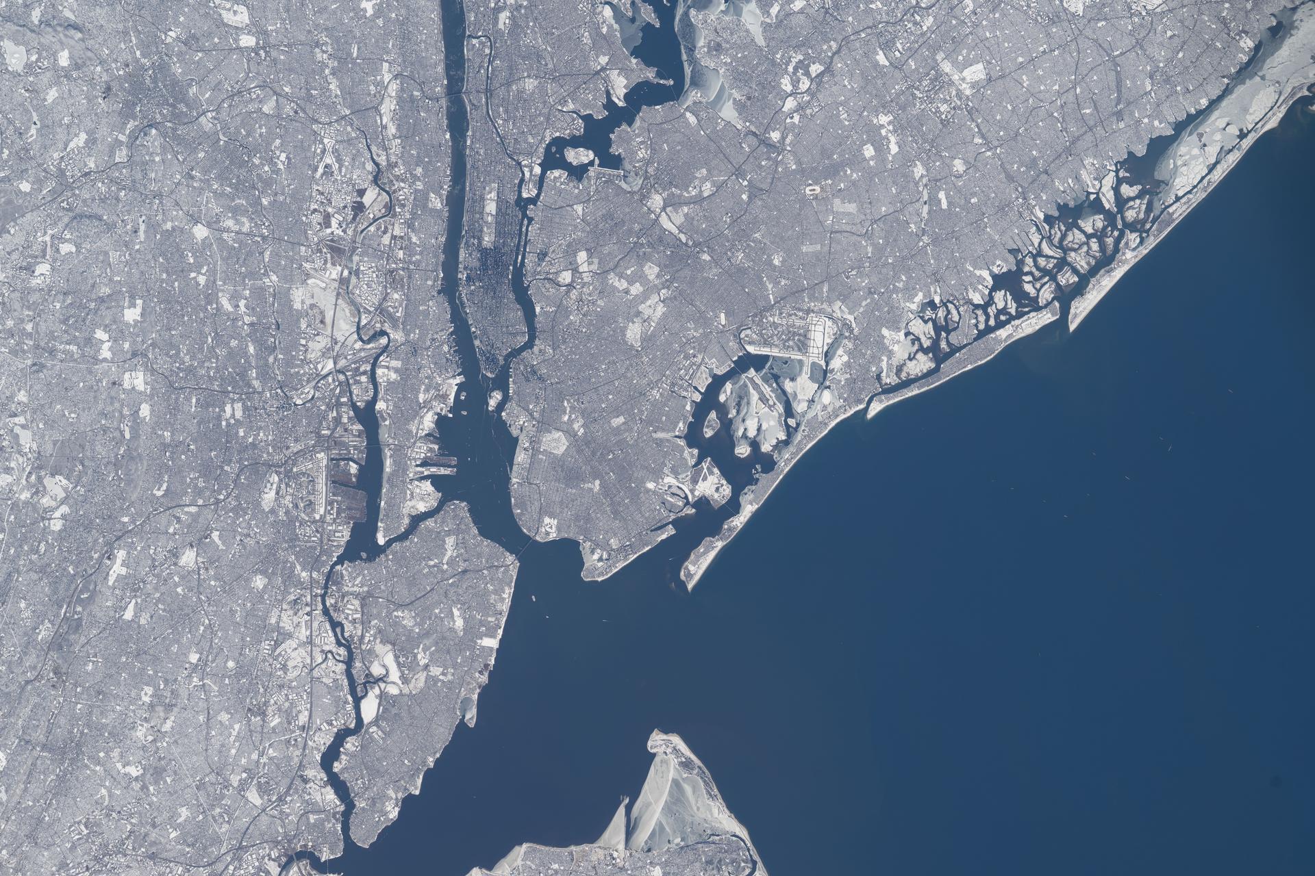
iss074e0315625 (Feb. 13, 2026) --- All five of New York City’s boroughs—Staten Island, Manhattan, Brooklyn, Queens, and the Bronx—are captured in this photograph of the wintry New York–Newark–Jersey City metropolitan area, which has a population of approximately 19.8 million. Near the center right is John F. Kennedy International Airport—America’s sixth-busiest airport, handling over 62 million passengers annually. Credit: NASA/Chris Williams
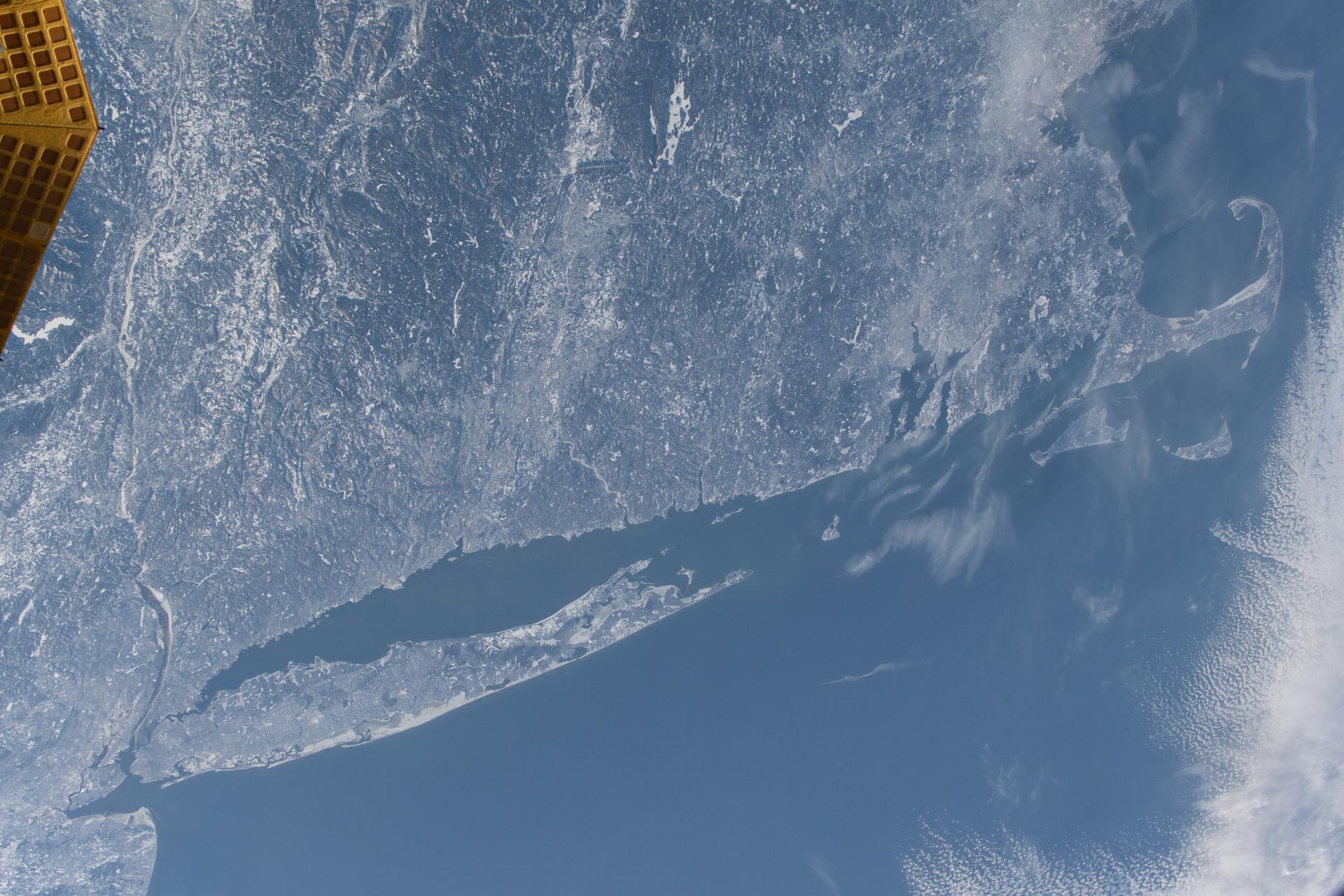
iss074e0300237 (Feb. 2, 2026) --- The wintry landscape from New Jersey to Massachusetts is seen from the International Space Station as it orbited 262 miles above the northeastern United States. Temperatures in New York City (lower left) ranged from a low of about 18 degrees Fahrenheit to a high of around 30 degrees when this photograph was taken.
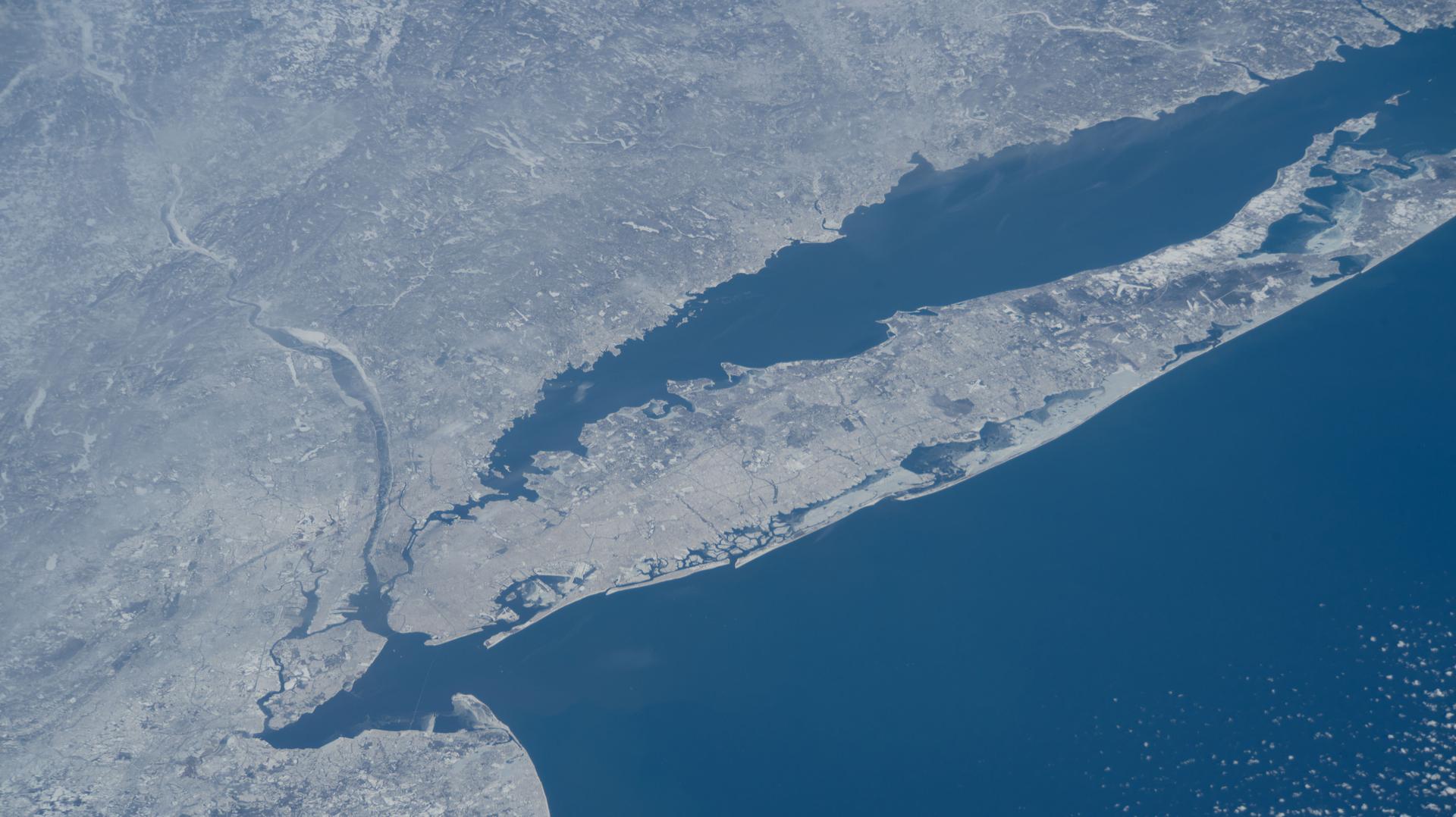
iss074e0209281 (Jan. 28, 2026) --- The wintry landscape of New Jersey, New York, and Connecticut is seen from the International Space Station as it orbited 259 miles above the Atlantic coast of the United States. Temperatures in New York City ranged from a low of about 14 degrees Fahrenheit to a high of around 23 degrees when this photograph was taken.
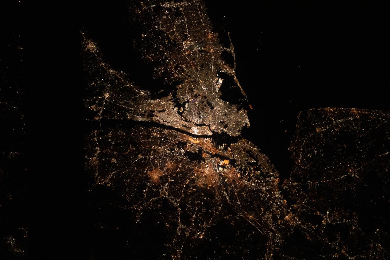
iss061e100776 (Dec. 28, 2019) --- The bright city lights of Long Island, New York City and the New Jersey area contrast the dark waters of Sandy Hook Bay, the Upper and Lower Bays, the Hudson and East Rivers and Long Island Sound, that surround the major metropolitan area of the northeastern United States.
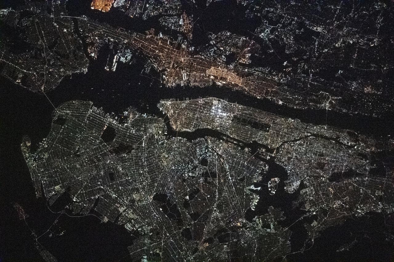
iss064e016772 (Dec. 30, 2020) --- This night time photograph of New York City, and the surrounding New York/New Jersey metropolitan area, was taken from the International Space Station as it orbited 263 miles above Pennsylvania.
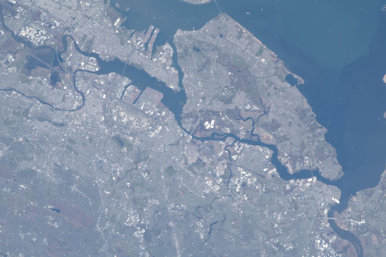
iss063e003768 (April 28, 2020) --- The New York City borough of Staten Island and the New Jersey metropolitan area figure prominently in this image taken from the International Space Station as it orbited above the northeastern United States.
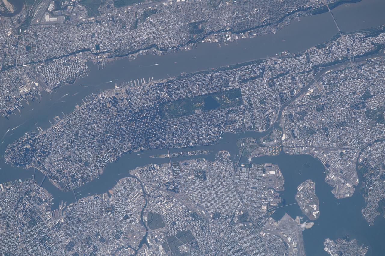
iss056e021682 (June 19, 2018) --- The commercial ports of the state of New Jersey and four out of five boroughs that make up New York City, including portions of Brooklyn, Queens, the Bronx and almost all of Manhattan, are pictured from the International Space Station. The Hudson River separates Manhattan from New Jersey. The East River separates Manhattan from Brooklyn and Queens while the Harlem River separates the Bronx from Manhattan.
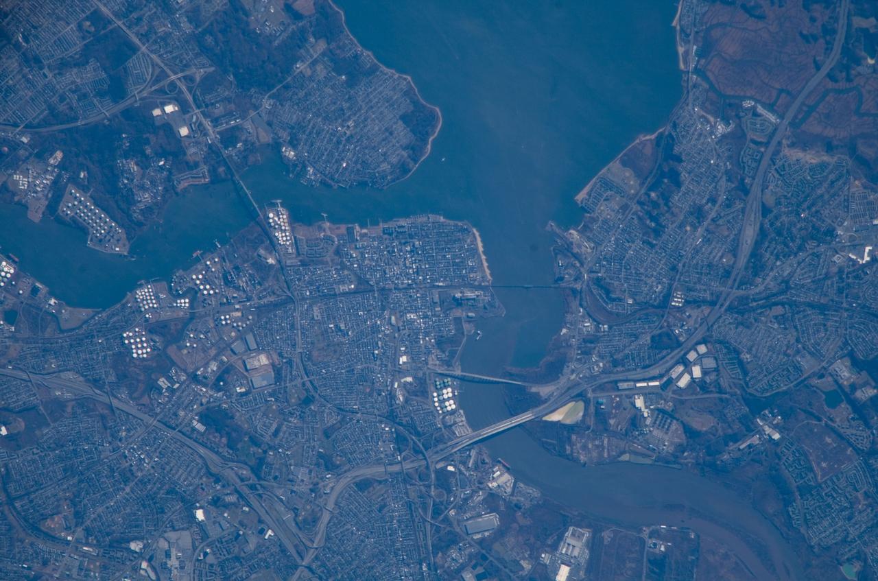
ISS016-E-018493 (24 Dec. 2007) --- Perth Amboy, New Jersey is featured in this image photographed by an Expedition 16 crewmember on the International Space Station. The port city of Perth Amboy is located between the outlets of the Raritan River and Arthur Kill ("river" in Dutch) into Raritan Bay in upper New Jersey. According to scientists, rich clay beds in the region, formed during the Cretaceous Era (approximately 65-144 million years ago), provided the raw materials for numerous pottery and terra cotta manufacturers during the 19th century. The city became an industrial and shipping center, and resort destination, through the early to mid-20th century. While the majority of the industrial factory facilities have left Perth Amboy, petroleum processing and storage remains part of the economic base -- several refining facilities are visible along the banks of Arthur Kill in this image (upper left). Originally known simply as "Amboy", "Perth" was added to the name in honor of the Earl of Perth when the city became the capital of East Jersey in 1686. Together with South Amboy across the Raritan River, both cities are collectively known today as "the Amboys". Perth Amboy is currently undergoing urban renewal and redevelopment to resume its former status of a resort destination. Raritan Bay also provides a source of local income through clam fishing.
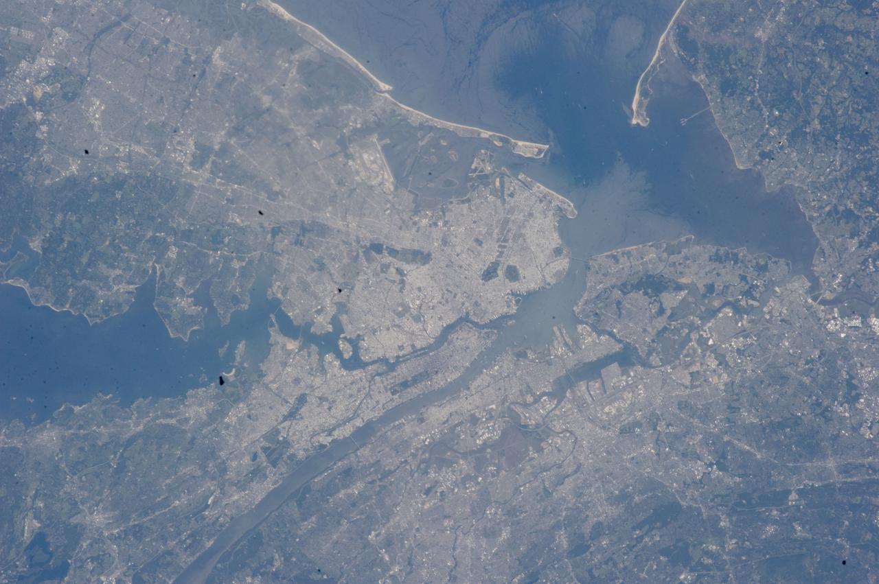
ISS032-E-027898 (12 Sept. 2012) --- This vertical view from the International Space Station features New York City. With a population in the metropolitan New York of 18.9 million (2011 figures from Census Bureau), and in the city of some 8.25 million, the New York City area is one of the leading commercial, financial, cultural, and communication centers in the world. The sediment-laden Hudson River enters the scene near the bottom left (north) of the image and can be seen flowing south emptying into Upper and Lower New York Bays (right of center). Much of Long Island is visible extending to the east at center and upper left of the image. Right (west) of the Hudson River, much of the state of New Jersey and the Newark metropolitan area are visible. Sandy Hook in New Jersey can be seen in the upper right quadrant of the image. Central Park on Manhattan can be seen below and just to the left of center as a dark rectangular patch.

STS100-716-108 (19 April-1 May 2001) --- This vertical view from the Space Shuttle Endeavour features New York City. With a population in the metropolitan New York of 11,685,650, and in the city of 8,008,278 (March 2001), the New York City area is one of the leading commercial, financial, cultural, and communication centers in the world. The sediment-laden Hudson River enters the scene near the bottom left (north) of the image and can be seen flowing south emptying into Upper and Lower New York Bays (right of center). Long Island is visible extending to the east at the upper left of the image. Right (west) of the Hudson River, the state of New Jersey and the Newark metropolitan area are visible. Sandy Hook in New Jersey can be seen in the upper right quadrant of the image.
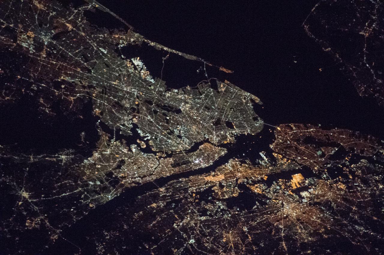
iss053e239527 (Nov. 23, 2017) --- The well-lit metropolitan area of New York City, its five boroughs -- The Bronx, Manhattan, Queens, Brooklyn and Staten Island -- and part of the state of New Jersey are pictured in this photograph taken during a night pass from the International Space Station on Nov. 23, 2017.
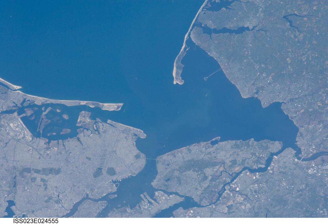
ISS023-E-024555 (14 April 2010) ---Parts of New Jersey, right side of frame, and New York City (generally, left part of photo) are the focus of this still image downlinked from the International Space Station while docked with the space shuttle Discovery.
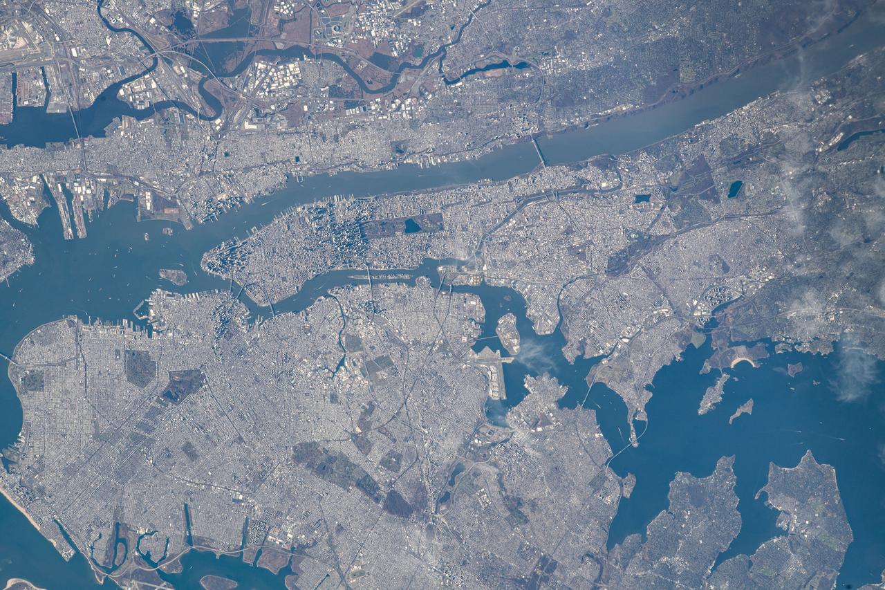
iss070e034497 (Nov. 30, 2023) --- The New York Metroolitan Area, including four of five New York city boroughs, portions of New Jersey, and numeorus waterways, is pictured from the International Space Station as it orbited 261 miles above.

STS003-10-606 (30 March 1982) --- The entire state of New Jersey (39.5N, 74.5W) is seen in great detail in this photograph. Philadelphia, PA on the west bank of the Delaware River and Camden, NJ on the east bank of this natural boundary, are easily seen as well as the coastal resort of Atlantic City. Further north, New York City and most of Long Island can be seen in fair detail while further inland, the northern Appalachian Mountains can be seen going diagonal across the scene. Photo credit: NASA
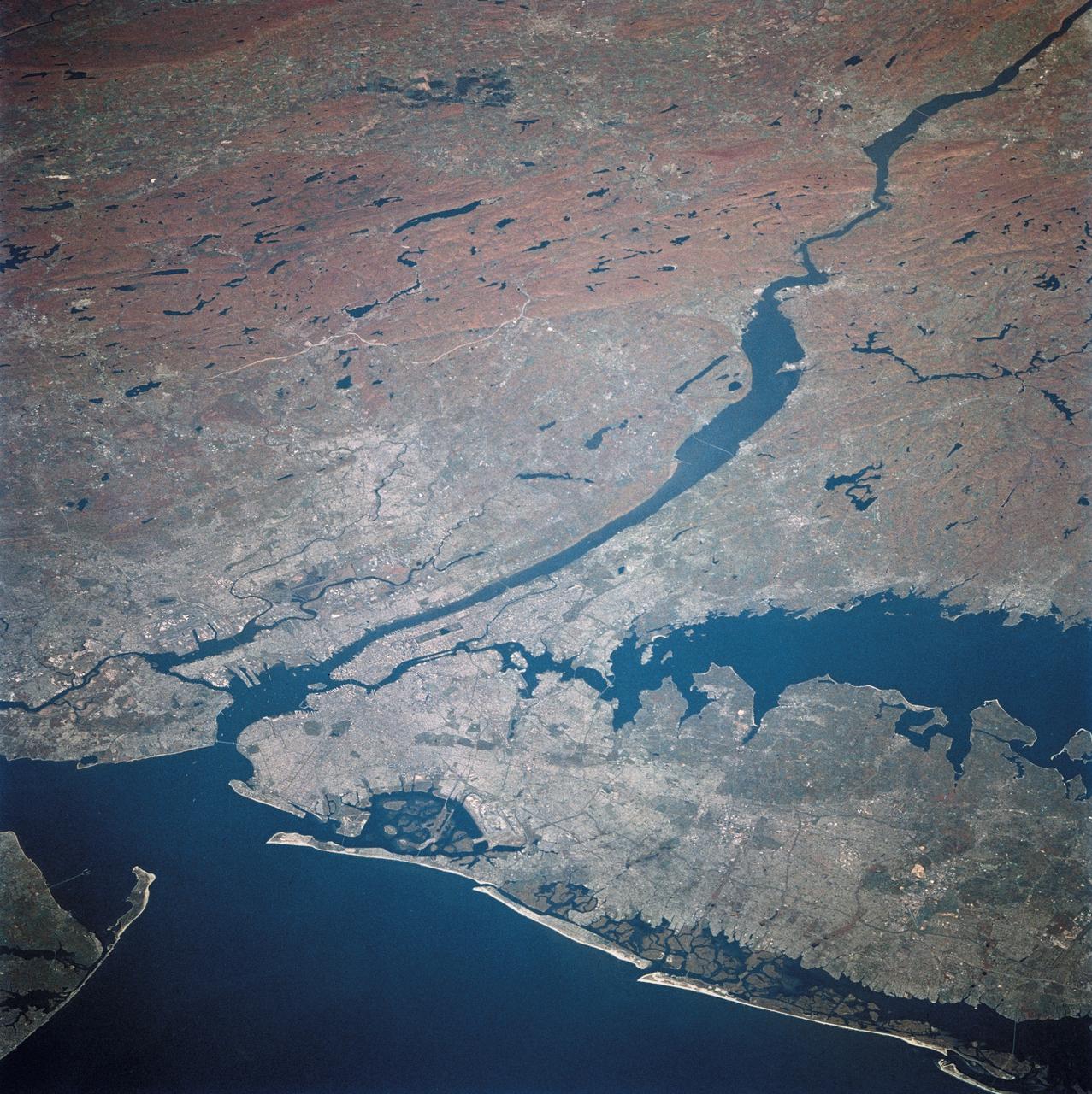
STS058-081-038 (18 Oct-1 Nov 1993) --- Fall colors in the northeast were captured by the STS-58 crew members. Long Island and the lower Hudson River dominate this scene, taken on a clear October day at the peak of the colorful fall foliage season. The maples and oaks of the Hudson Highlands are particularly striking, and contrast with the many lakes and reservoirs north of the city. The New York metropolitan area in New York and New Jersey (including Jersey City and Newark) is easily seen in the foreground. Manhattan Island sits near the middle of the scene, but Central Park foliage is still fairly green. West Point can be seen near the upper right, on the west-pointing bend of the Hudson, and the Catskills are in the far upper left.

iss073e0982136 (Oct. 25, 2025) --- Upper Bay (center) leads to New York City's Statue of Liberty, then splits into the Hudson River and East River, which shape the island borough of Manhattan. Surrounding this iconic borough are New York City's four other boroughs—Staten Island, Brooklyn, Queens, and the Bronx—as well as the neighboring state of New Jersey. The New York City metropolitan area has a population of approximately 19.9 million, making it the 10th most populous region in the world. This photograph was taken from the International Space Station as it orbited 262 miles above the Empire State at approximately 2:23 a.m. local time.
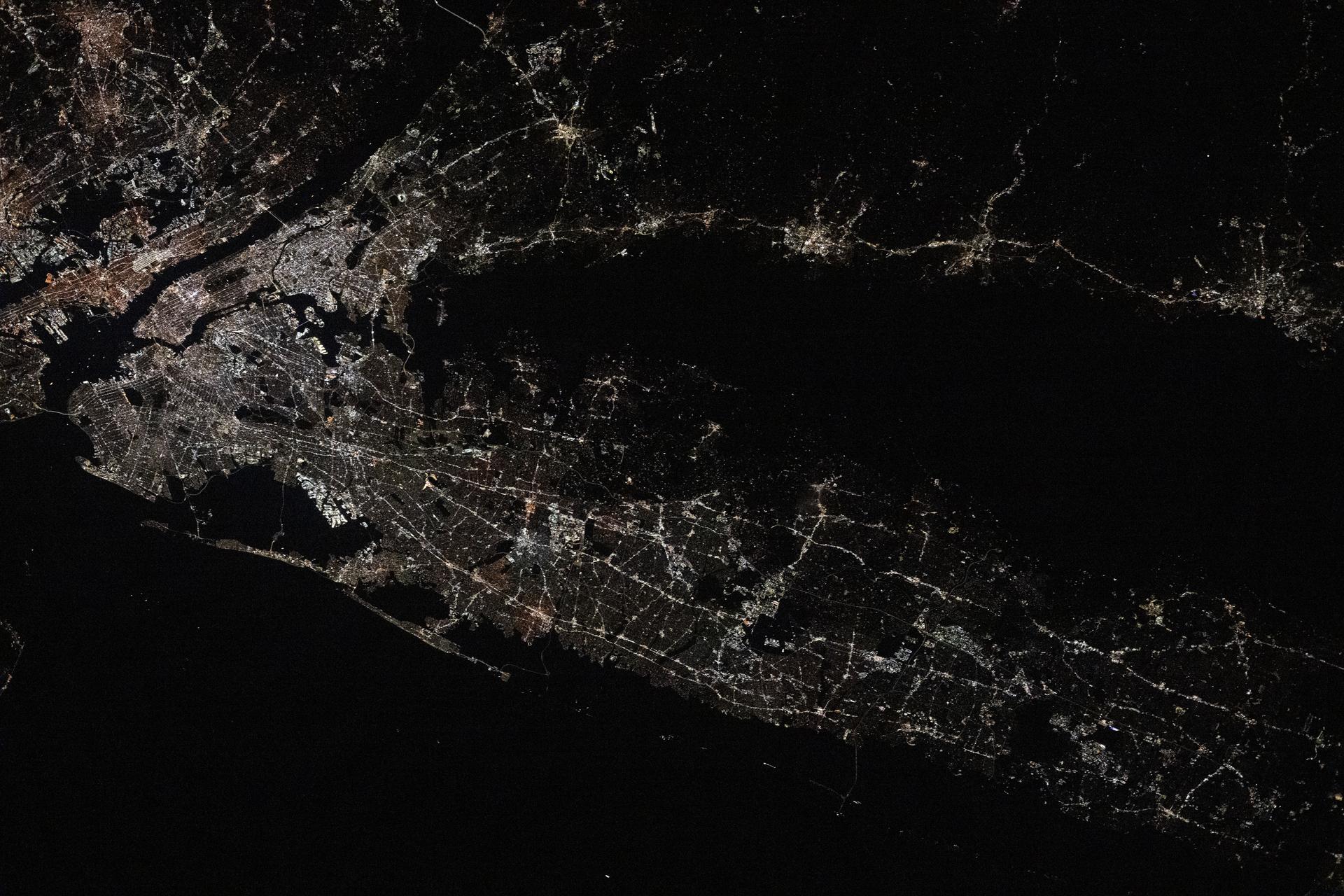
iss073e0982169 (Oct. 25, 2025) --- Long Island, New York—the most populous island in the United States—stretches 118 miles from west to east, extending from Brooklyn to Montauk Point. It lies between Long Island Sound to the north and the New York/New Jersey Bight to the south. Toward the upper left, New York City's island borough of Manhattan is visible, with the Hudson River and East River flowing on either side. The city's bright lights contrast with the elongated, darkened area of Central Park. This image was captured at approximately 2:24 a.m. local time from the International Space Station as it orbited 263 miles above the Empire State.
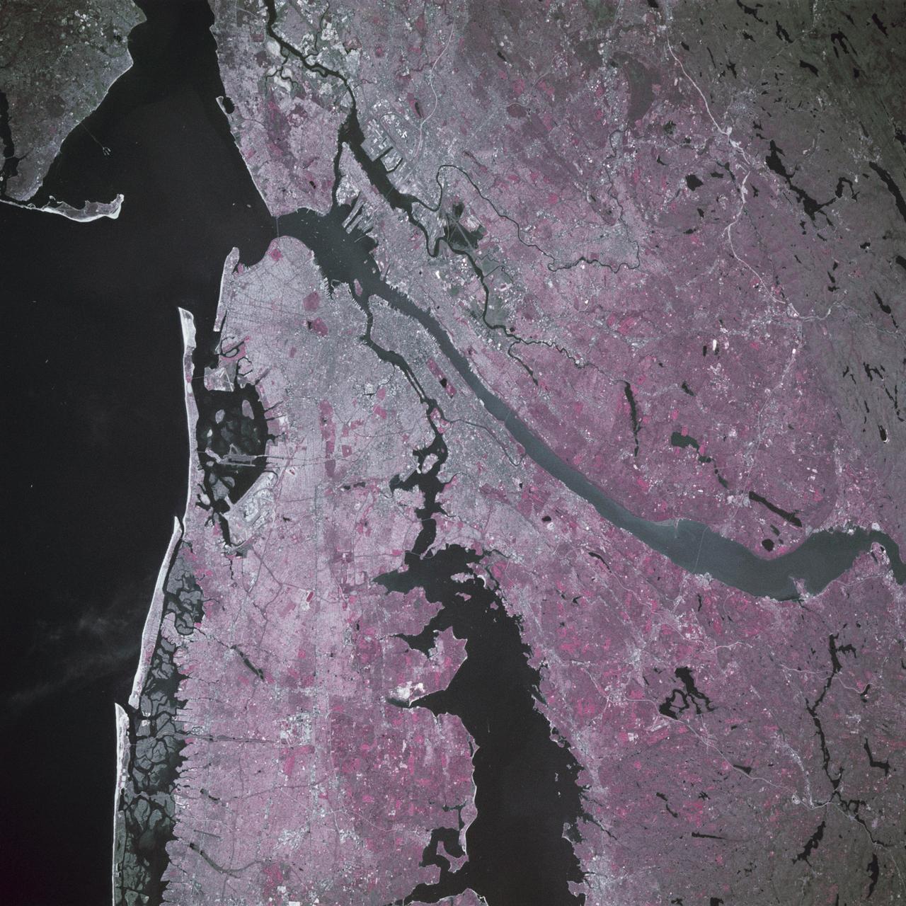
STS039-88-054 (28 April-6 May 1991) --- The dense urban development of the New York City metropolitan area in downstate New York, Long Island and New Jersey shows up as gray and white on this color Infrared photograph. The scene was taken on a remarkably clear spring day. Almost all the major man-made structures of the area are obvious, including ship traffic in and out of New York Harbor, the piers, all of the bridges spanning the area rivers and connecting Manhattan Island with New Jersey, the Bronx, Brooklyn and Queens, the three major airports (Newark, La Guardia and JFK), the New York State thruway, as well as Shea Stadium and Yankee Stadium. The reds and pinks are vegetated areas. Central Park clearly shows up on Manhattan, as do the string of parks along the cliffs (formed by the Palisades sill) along the west side of the Hudson north of the George Washington Bridge.
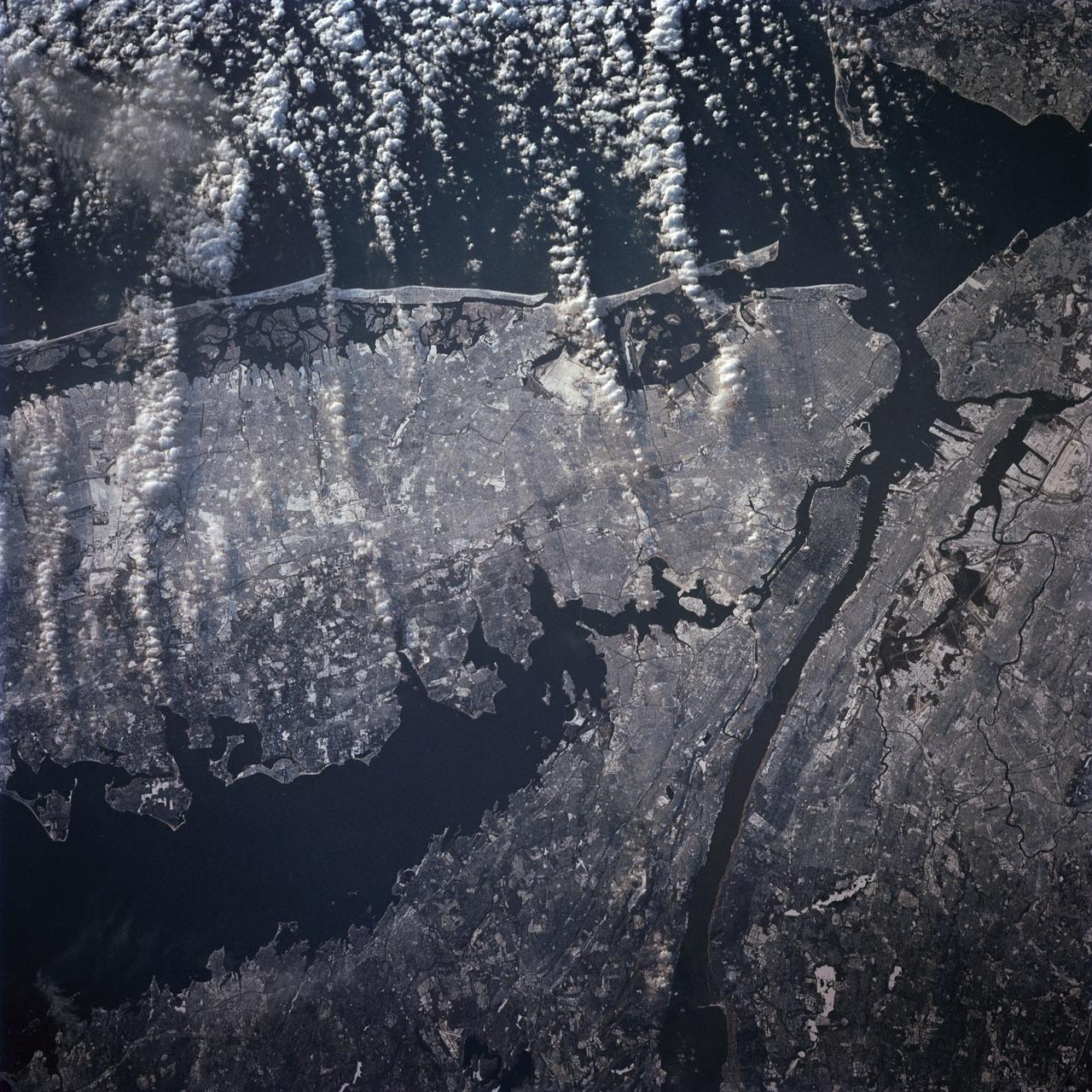
STS-42 Earth observation taken aboard Discovery, Orbiter Vehicle (OV) 103, is of New York City (NYC), New York (41.0N, 74.0W). Snow cover highlights the large areas of development and the many reservoirs in this wintertime scene of the metropolitan NYC area. Features such as Central Park in Manhattan, the George Washington Bridge connecting Manhattan with New Jersey, street patterns in most of the boroughs, La Guardia and JFK airports in Queens, and the extensive harbor system are easily identified.
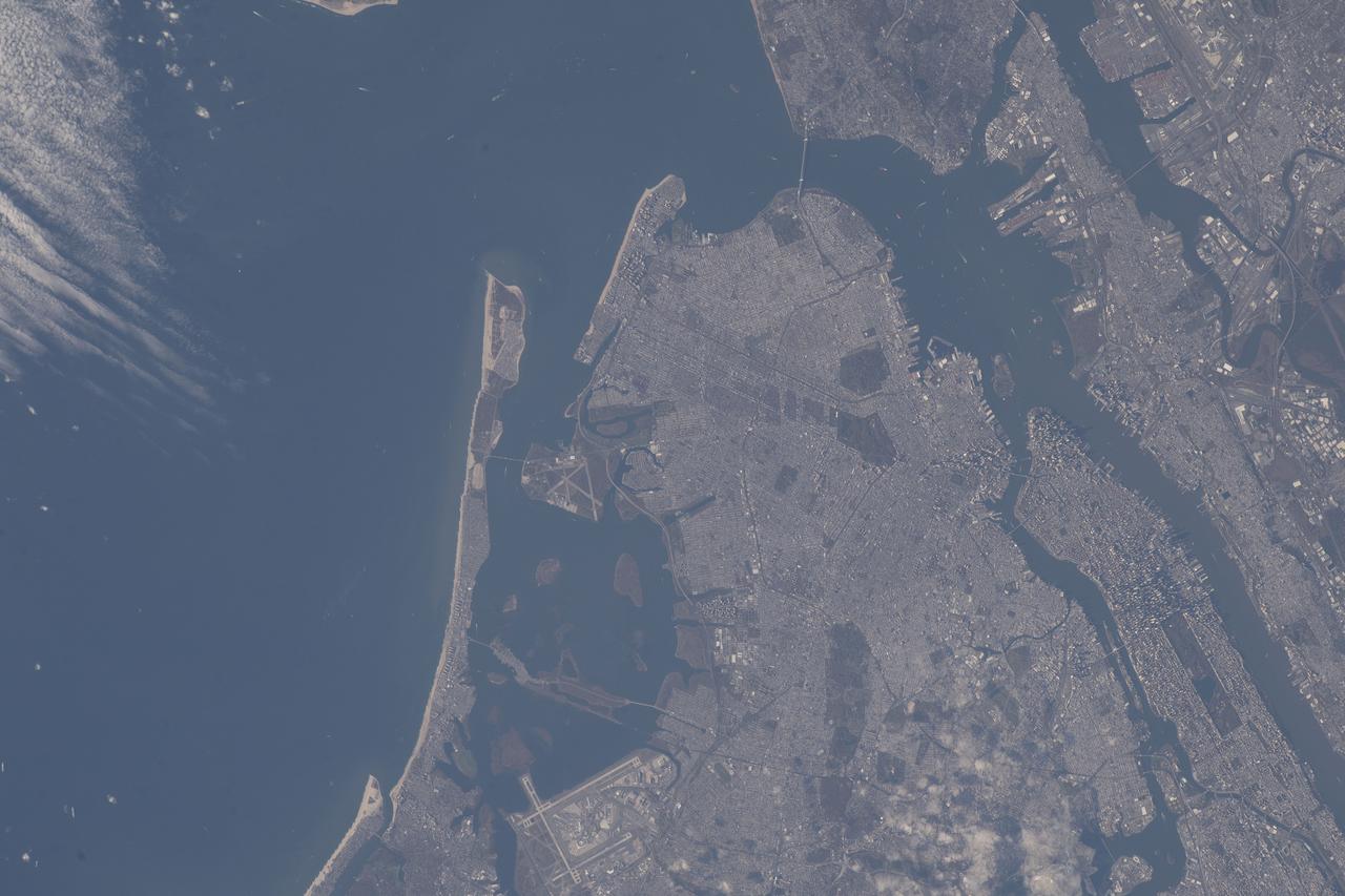
iss068e020106 (Oct. 29, 2022) --- New York City's boroughs of Queens, Brooklyn, and Manhattan figure prominently in this photograph from the International Space Station as it orbited 263 miles above the Atlantic Ocean. Portions of New York's two other boroughs, the Bronx (bottom right) and Staten Island (top right), including northeast New Jersey are also pictured.
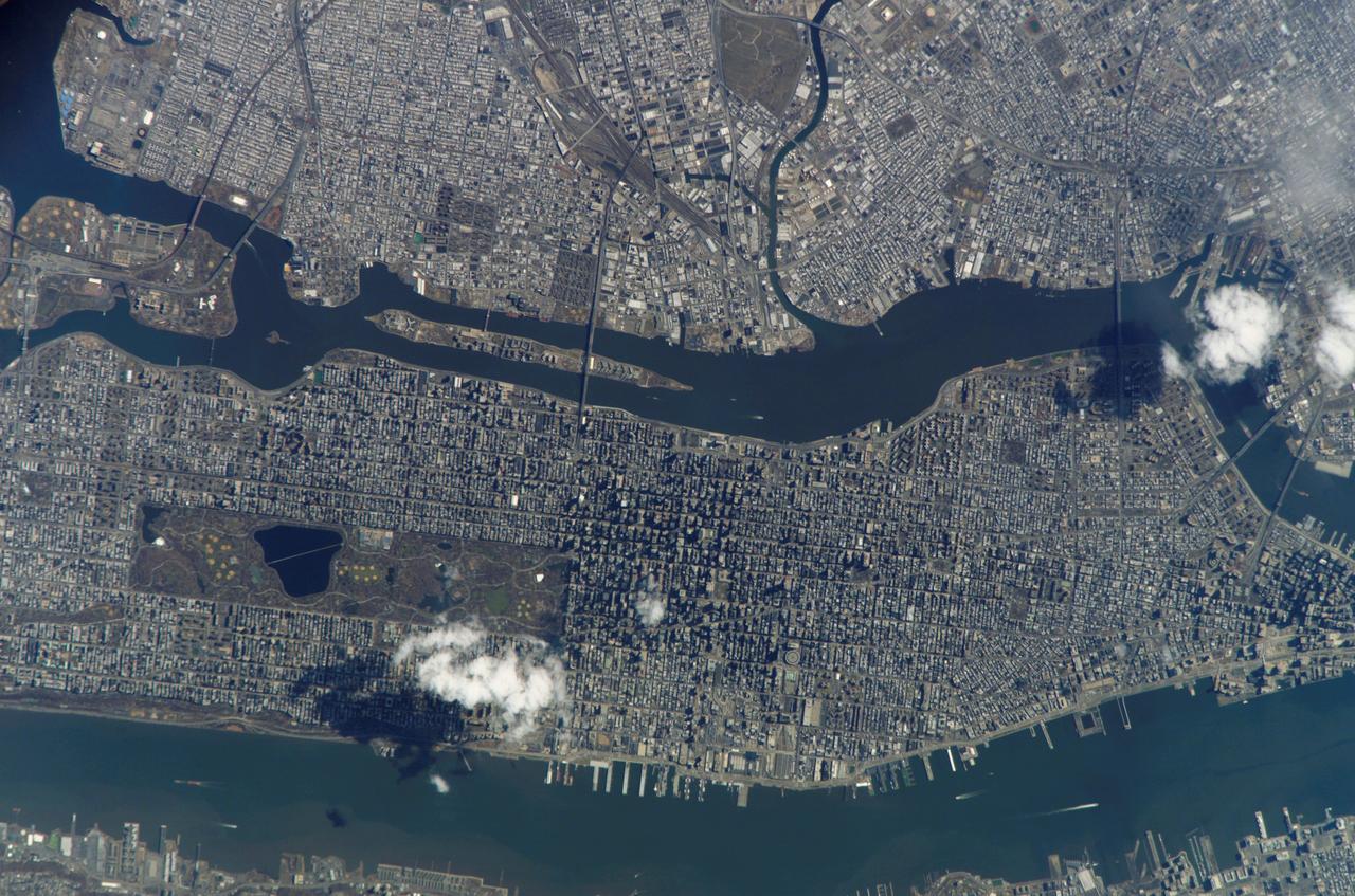
ISS010-E-21487 (26 March 2005) --- Manhattan Island and its easily recognizable Central Park are featured in this image photographed by an Expedition 10 crewmember on the International Space Station. Some of the other New York City boroughs (including parts of Queens and Brooklyn) are also shown, as are two small sections of the New Jersey side of the Hudson River.
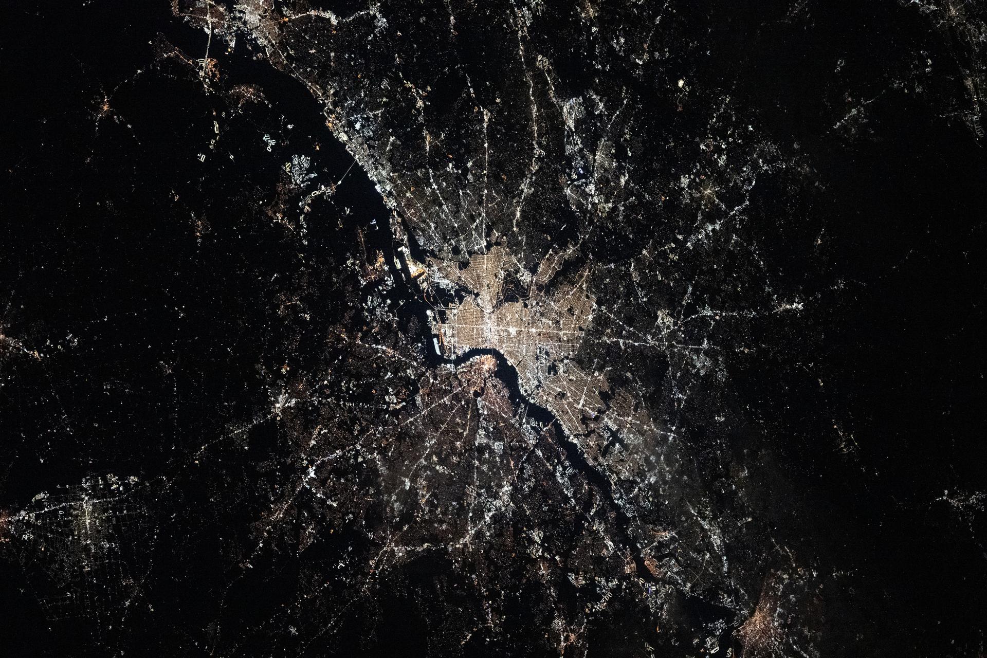
iss074e0002935 (Dec. 20, 2025) --- Philadelphia, Pennsylvania—the United States’ first capital and the city where the Declaration of Independence was signed, with a population of about 1.74 million—sits along the Delaware River, with New Jersey on the opposite bank. This photograph was taken at approximately 3:28 a.m. local time from the International Space Station as it orbited 262 miles above the Atlantic coast.
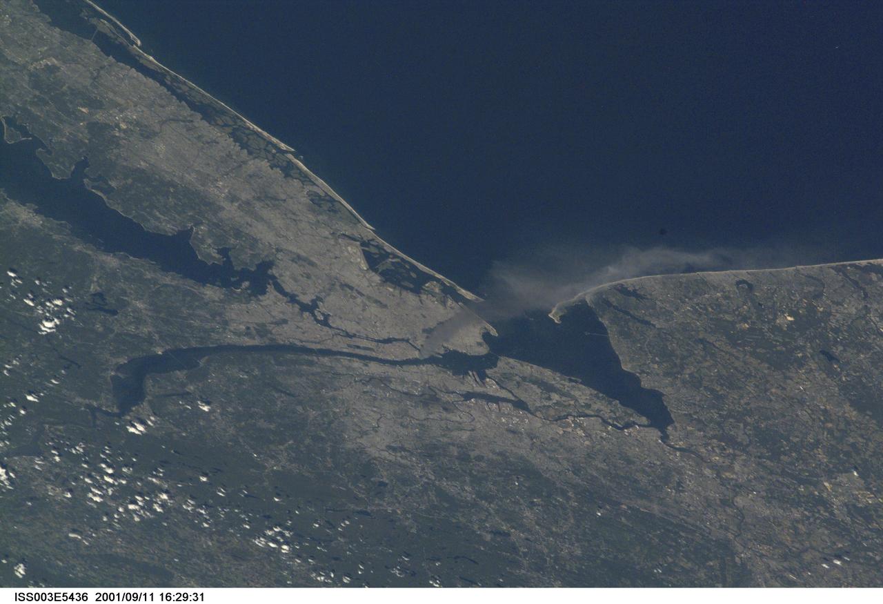
ISS003-E-5436 (11 September 2001) --- One of a series of pictures taken of metropolitan New York City (and other parts of New York as well as New Jersey) by one of the Expedition Three crew members onboard the International Space Station (ISS) at various times during the day of September 11, 2001. The image shows a smoke plume rising from the Manhattan area. The orbital outpost was flying at an altitude of approximately 250 miles. The image was recorded with a digital still camera. Please note: The date identifiers on some frames (other than those that indicate Sept. 11, 2001) are not accurate due to a technical problem with one of the Expedition Three cameras.
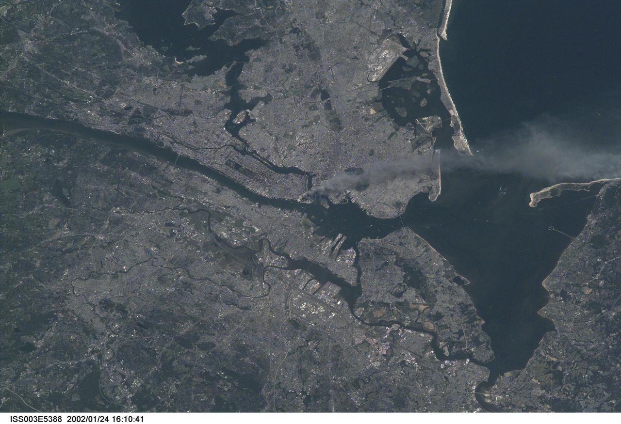
ISS003-E-5388 (11 September 2001) --- One of a series of pictures taken of metropolitan New York City (and other parts of New York as well as New Jersey) by one of the Expedition Three crew members onboard the International Space Station (ISS) at various times during the day of September 11, 2001. The image shows a smoke plume rising from the Manhattan area. The orbital outpost was flying at an altitude of approximately 250 miles. The image was recorded with a digital still camera. Please note: The date identifiers on some frames (other than those that indicate Sept. 11, 2001) are not accurate due to a technical problem with one of the Expedition Three cameras.
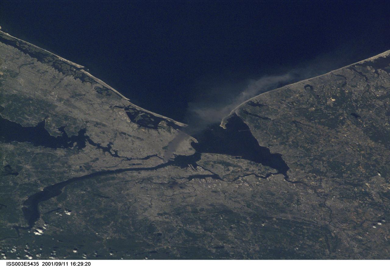
ISS003-E-5435 (11 September 2001) --- One of a series of pictures taken of metropolitan New York City (and other parts of New York as well as New Jersey) by one of the Expedition Three crew members onboard the International Space Station (ISS) at various times during the day of September 11, 2001. The image shows a smoke plume rising from the Manhattan area. The orbital outpost was flying at an altitude of approximately 250 miles. The image was recorded with a digital still camera. Please note: The date identifiers on some frames (other than those that indicate Sept. 11, 2001) are not accurate due to a technical problem with one of the Expedition Three cameras.
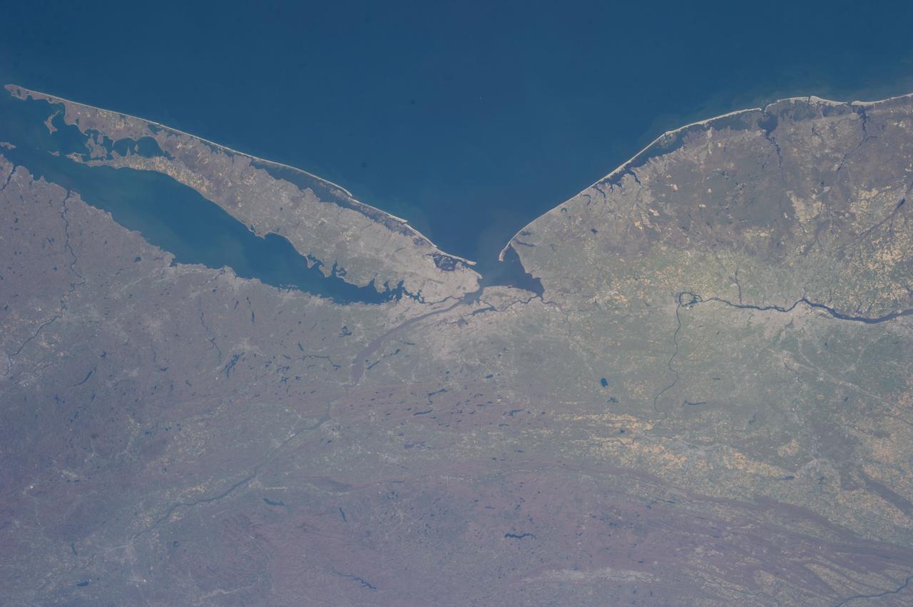
ISS035-E-034029 (2 May 2013) --- One of the Expedition 35 crew members aboard the International Space Station recorded this image featuring parts of the Northeast. Long Island, New York is the most conspicuous tell-tale feature, which juts out into the Atlantic Ocean. The entire length of Long Island is visible from Lower Bay to Block Island Sound. According to geologists, the origin and shape of Long Island are due to continental collision and glaciers that once dominated the landscape. The metropolitan area of New York City is complete within the photo, near frame center. Parts of Connecticut and New Jersey are also visible in the scene.
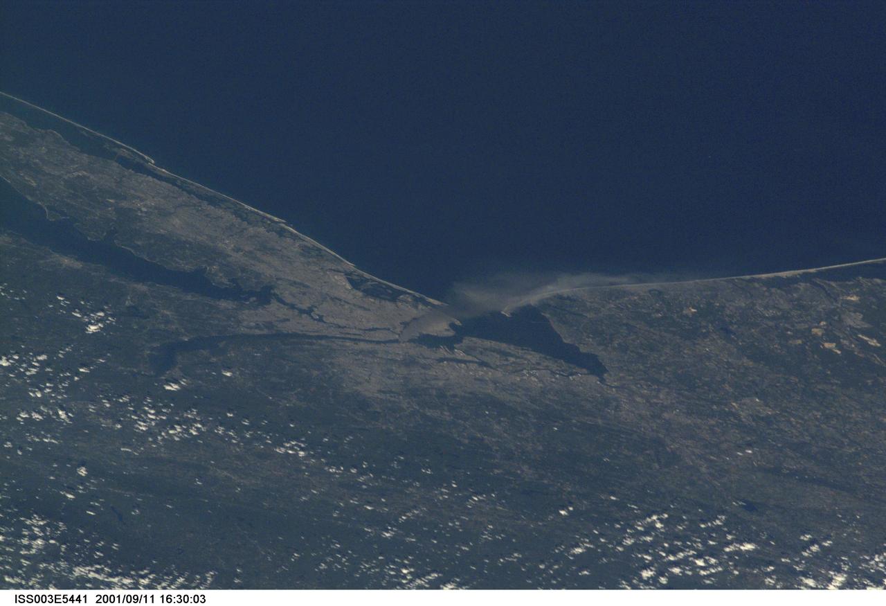
ISS003-E-5441 (11 September 2001) --- One of a series of pictures taken of metropolitan New York City (and other parts of New York as well as New Jersey) by one of the Expedition Three crew members onboard the International Space Station (ISS) at various times during the day of September 11, 2001. The image shows a smoke plume rising from the Manhattan area. The orbital outpost was flying at an altitude of approximately 250 miles. The image was recorded with a digital still camera. Please note: The date identifiers on some frames (other than those that indicate Sept. 11, 2001) are not accurate due to a technical problem with one of the Expedition Three cameras.
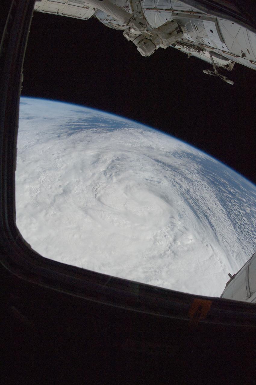
ISS033-E-016695 (29 Oct. 2012) --- One of the Expedition 33 crew members aboard the International Space Station took this photo of Hurricane Sandy at 16:55:32 GMT on Oct. 29, 2012. East is generally at the top of the photo, south to the right. At the camera time of the photo Sandy was located by the National Hurricane Center at approximately 37.5 degrees north latitude and 71.5 degrees west longitude or 25 miles southeast of Atlantic City, New Jersey moving north-northwest at 18 miles per hour and packing winds of 90 miles per hour.
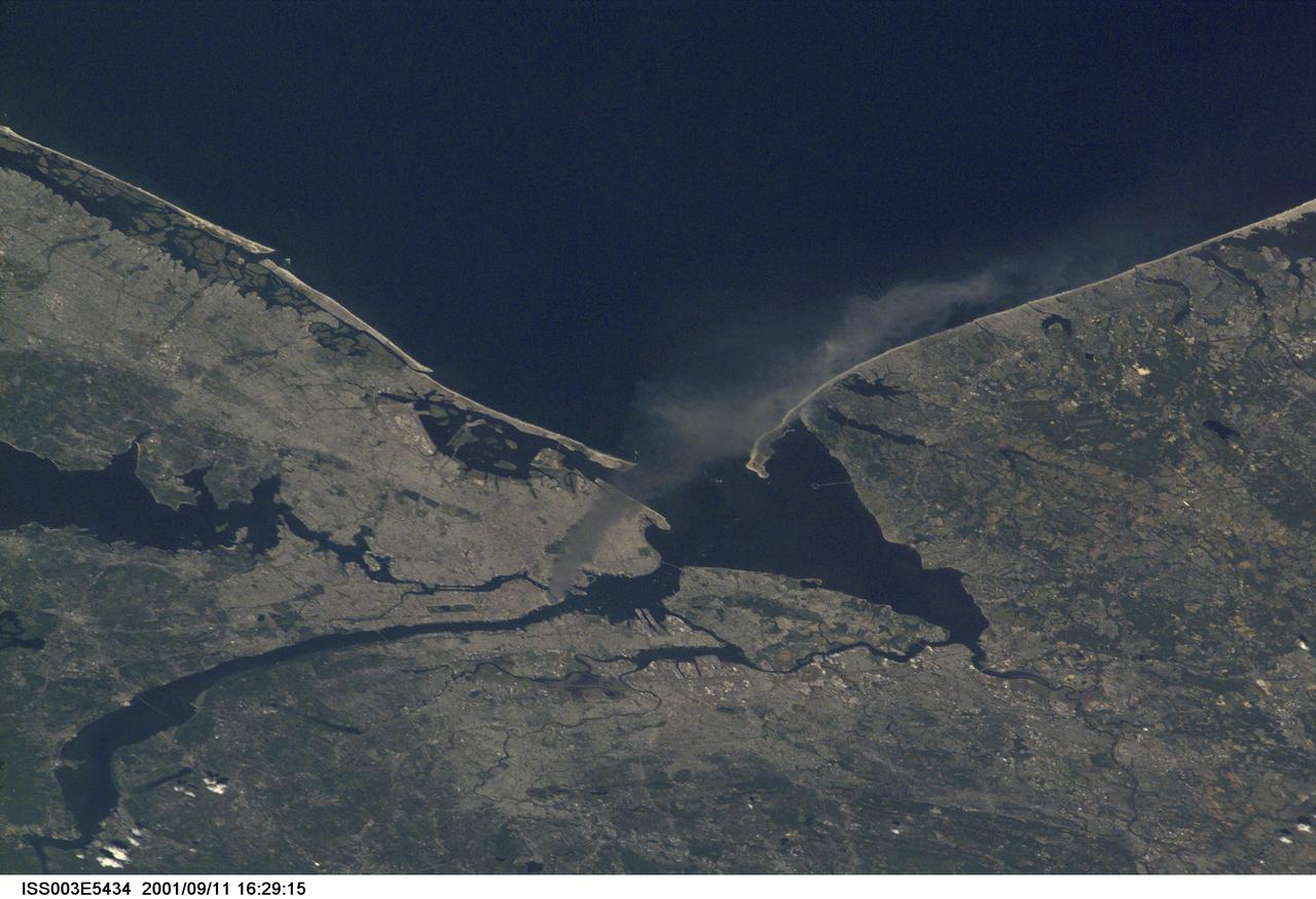
ISS003-E-5434 (11 September 2001) --- One of a series of pictures taken of metropolitan New York City (and other parts of New York as well as New Jersey) by one of the Expedition Three crew members onboard the International Space Station (ISS) at various times during the day of September 11, 2001. The image shows a smoke plume rising from the Manhattan area. The orbital outpost was flying at an altitude of approximately 250 miles. The image was recorded with a digital still camera. Please note: The date identifiers on some frames (other than those that indicate Sept. 11, 2001) are not accurate due to a technical problem with one of the Expedition Three cameras.
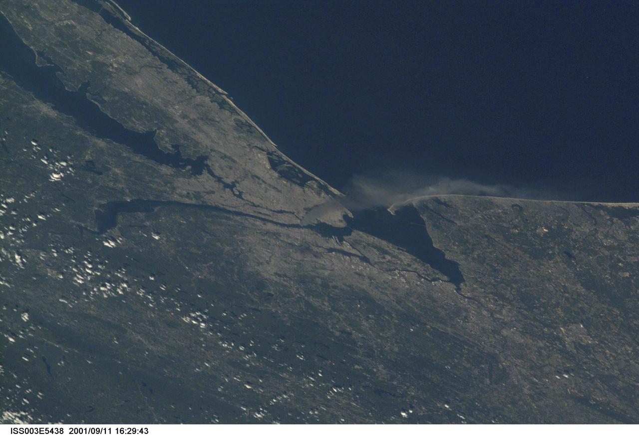
ISS003-E-5438 (11 September 2001) --- One of a series of pictures taken of metropolitan New York City (and other parts of New York as well as New Jersey) by one of the Expedition Three crew members onboard the International Space Station (ISS) at various times during the day of September 11, 2001. The image shows a smoke plume rising from the Manhattan area. The orbital outpost was flying at an altitude of approximately 250 miles. The image was recorded with a digital still camera. Please note: The date identifiers on some frames (other than those that indicate Sept. 11, 2001) are not accurate due to a technical problem with one of the Expedition Three cameras.
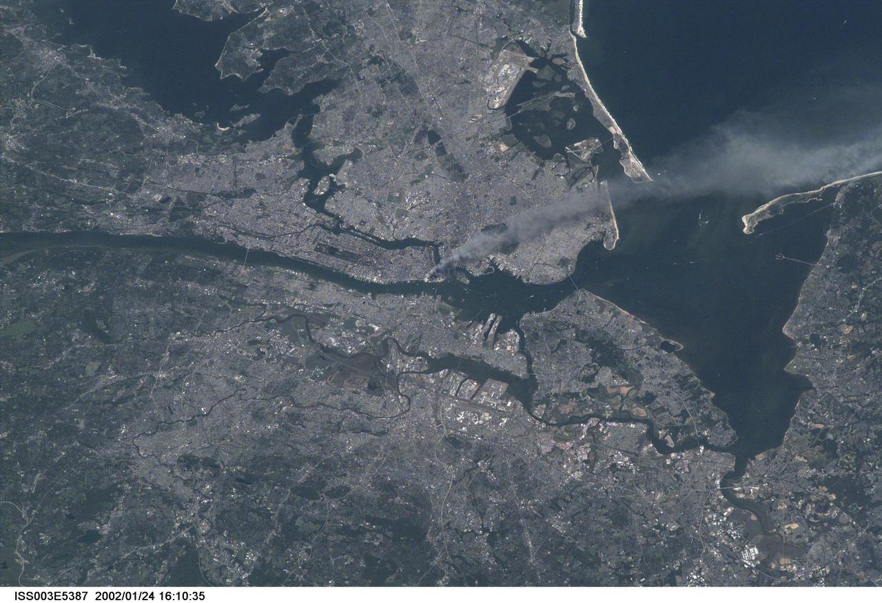
ISS003-E-5387 (11 September 2001) --- One of a series of pictures taken of metropolitan New York City (and other parts of New York as well as New Jersey) by one of the Expedition Three crew members onboard the International Space Station (ISS) at various times during the day of September 11, 2001. The image shows a smoke plume rising from the Manhattan area. The orbital outpost was flying at an altitude of approximately 250 miles. The image was recorded with a digital still camera. Please note: The date identifiers on some frames (other than those that indicate Sept. 11, 2001) are not accurate due to a technical problem with one of the Expedition Three cameras.
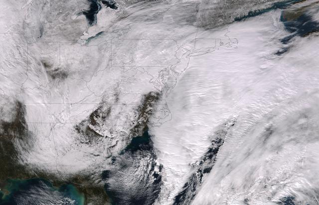
This image was taken by the Suomi NPP satellite's VIIRS instrument at 1825Z on January 26, 2015. A low pressure system currently forming off the mid-Atlantic coast will rapidly strengthen into a major nor'easter today and affect parts of the Northeast U.S. through early Wednesday. This system will be responsible for heavy to intense snowfall and strong winds, with blizzard conditions expected from eastern New Jersey to eastern Massachusetts where Blizzard Warnings are in effect. Accumulations will likely exceed one foot from eastern New Jersey through eastern Maine by late Tuesday. The heaviest snow accumulations, perhaps exceeding two feet, are forecast across portions of Connecticut, Rhode Island and Massachusetts, including the Boston area. Currently, New York City is forecast to receive 18-24 inches of snow, and Boston is forecast to receive 24-36 inches of snow. Wind gusts of 45 to 60 mph will be common from eastern New Jersey to eastern Massachusetts, leading to widespread blizzard conditions. Wind gusts up to 70 mph are possible in far eastern Massachusetts, including Cape Cod and Nantucket. Credit: NASA/NOAA/NPP/VIIRS Via: NASA/NOAA via <b><a href="www.nnvl.noaa.gov/" rel="nofollow"> NOAA Environmental Visualization Laboratory</a></b> <b><a href="http://www.nasa.gov/audience/formedia/features/MP_Photo_Guidelines.html" rel="nofollow">NASA image use policy.</a></b> <b><a href="http://www.nasa.gov/centers/goddard/home/index.html" rel="nofollow">NASA Goddard Space Flight Center</a></b> enables NASA’s mission through four scientific endeavors: Earth Science, Heliophysics, Solar System Exploration, and Astrophysics. Goddard plays a leading role in NASA’s accomplishments by contributing compelling scientific knowledge to advance the Agency’s mission. <b>Follow us on <a href="http://twitter.com/NASAGoddardPix" rel="nofollow">Twitter</a></b> <b>Like us on <a href="http://www.facebook.com/pages/Greenbelt-MD/NASA-Goddard/395013845897?ref=tsd" rel="nofollow">Facebook</a></b> <b>Find us on <a href="http://instagram.com/nasagoddard?vm=grid" rel="nofollow">Instagram</a></b>
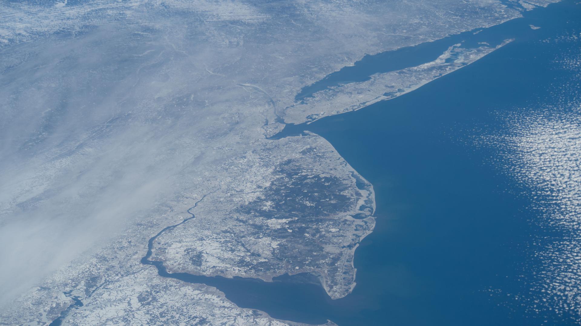
iss074e0209280 (Jan. 28, 2026) --- The wintry landscape from Delaware to Rhode Island is seen from the International Space Station as it orbited 259 miles above the Atlantic coast of the United States. Temperatures in New York City ranged from a low of about 14 degrees Fahrenheit to a high of around 23 degrees when this photograph was taken.
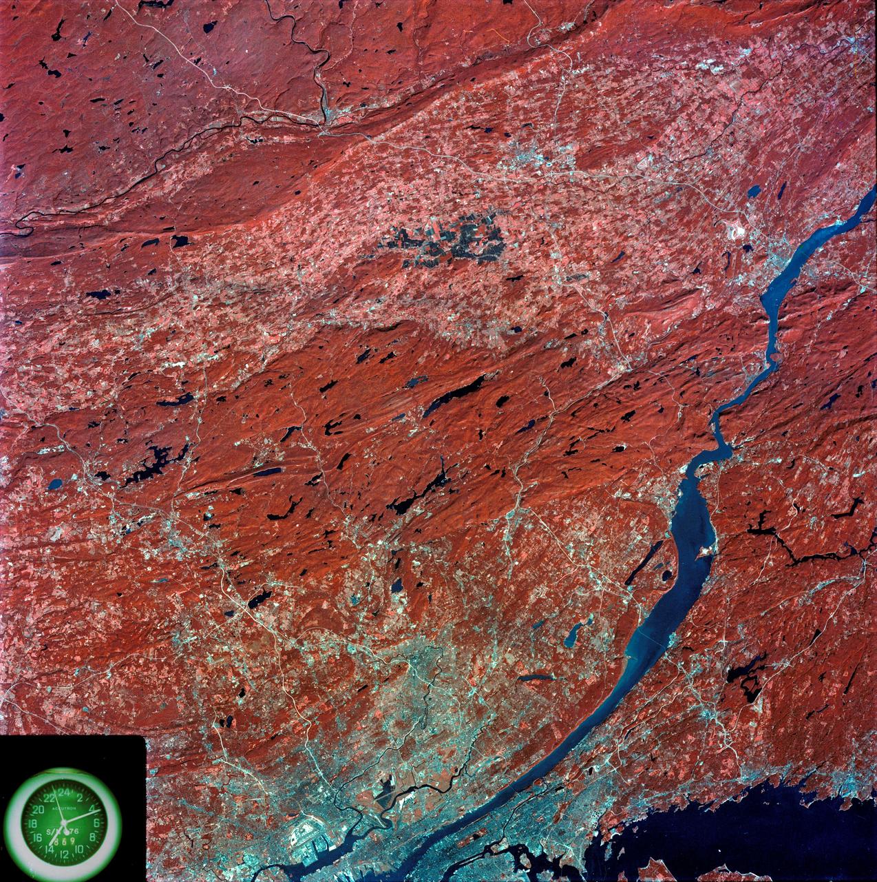
SL3-87-299 (July-September 1973) --- A vertical view of southeastern New York State is seen in this Skylab 3 Earth Resources Experiments Package S190-B (five-inch Earth terrain camera) infrared photograph taken from the Skylab space station in Earth orbit. An 18-inch, 450mm lens and type 2443 infrared Ektachrome film was used. This picture covers the northern part of New Jersey, a part of northwestern Pennsylvania, and the western tip of Connecticut. The body of water is Long Island Sound. The wide Hudson River flows southward across a corner of the photograph. The New York City metropolitan area occupies part of the picture. Federal agencies participating with NASA on the EREP project are the Departments of Agriculture, Commerce, Interior, the Environmental Protection Agency and the Corps of Engineers. All EREP photography is available to the public through the Department of Interior?s Earth Resources Observations Systems Data Center, Sioux Falls, South Dakota, 57198. Photo credit: NASA
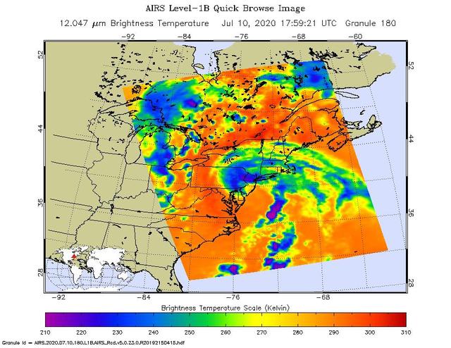
NASA's Atmospheric Infrared Sounder (AIRS) collected this image of Tropical Storm Fay over New England at around 2 p.m. local time on Friday, July 10. The center of the storm made landfall about 10 miles (15 kilometers) north-northeast of Atlantic City, New Jersey, at around 5 p.m. local time, when Fay had maximum sustained winds of around 50 mph (85 kph). In the infrared AIRS image, the purple regions indicate very cold clouds lofted high into the atmosphere by the storm. These clouds are generally linked to heavy rainfall. Warmer clouds closer to the ground show up as green and blue, while the orange areas denote mostly cloud-free parts of the sky. AIRS, together with the Advanced Microwave Sounding Unit (AMSU), measures the infrared and microwave radiation emitted from Earth to study the planet's weather and climate. Both instruments observe Earth from NASA's Aqua satellite, which launched in 2002. AIRS and AMSU work in tandem to make simultaneous observations down to Earth's surface, even in the presence of heavy clouds. With more than 2,000 channels sensing different regions of the atmosphere, the system creates a global, three-dimensional map of atmospheric temperature and humidity, cloud amounts and heights, greenhouse gas concentrations, and many other atmospheric phenomena. https://photojournal.jpl.nasa.gov/catalog/PIA23783
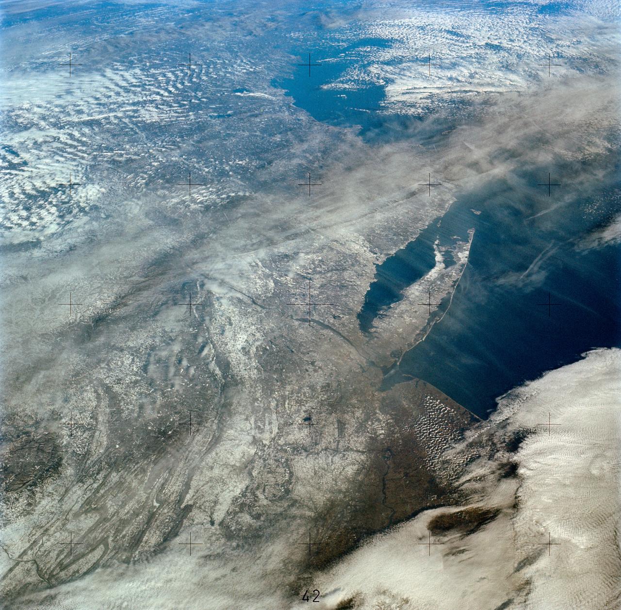
SL4-138-3894 (5 Jan. 1974) --- An oblique view of a portion of the northeastern part of the United States, as photographed from the Skylab space station in Earth orbit by one of the Skylab 4 crewmen. The camera used was a hand-held 70mm Hasselblad, and with SO-368 medium-speed Ektachrome film. This is an excellent example of the regional view which is available from space. The entire area of New Jersey, eastern Pennsylvania, southeastern New York, and southern New England can be examined in one view. Long Island, New York City and the lower Hudson River Valley are readily seen in their regional framework. The Boston area, although blurred by clouds, is also included. The spackling of the snow enhances the contrast, especially of terrain and cultural features. Different levels of clouds can be studies, especially the crossing layers of cirrus in the center of the photograph, with the lower cirrus trending north-south and the upper (probably associated with a jet stream) trending east-west. Photo credit: NASA
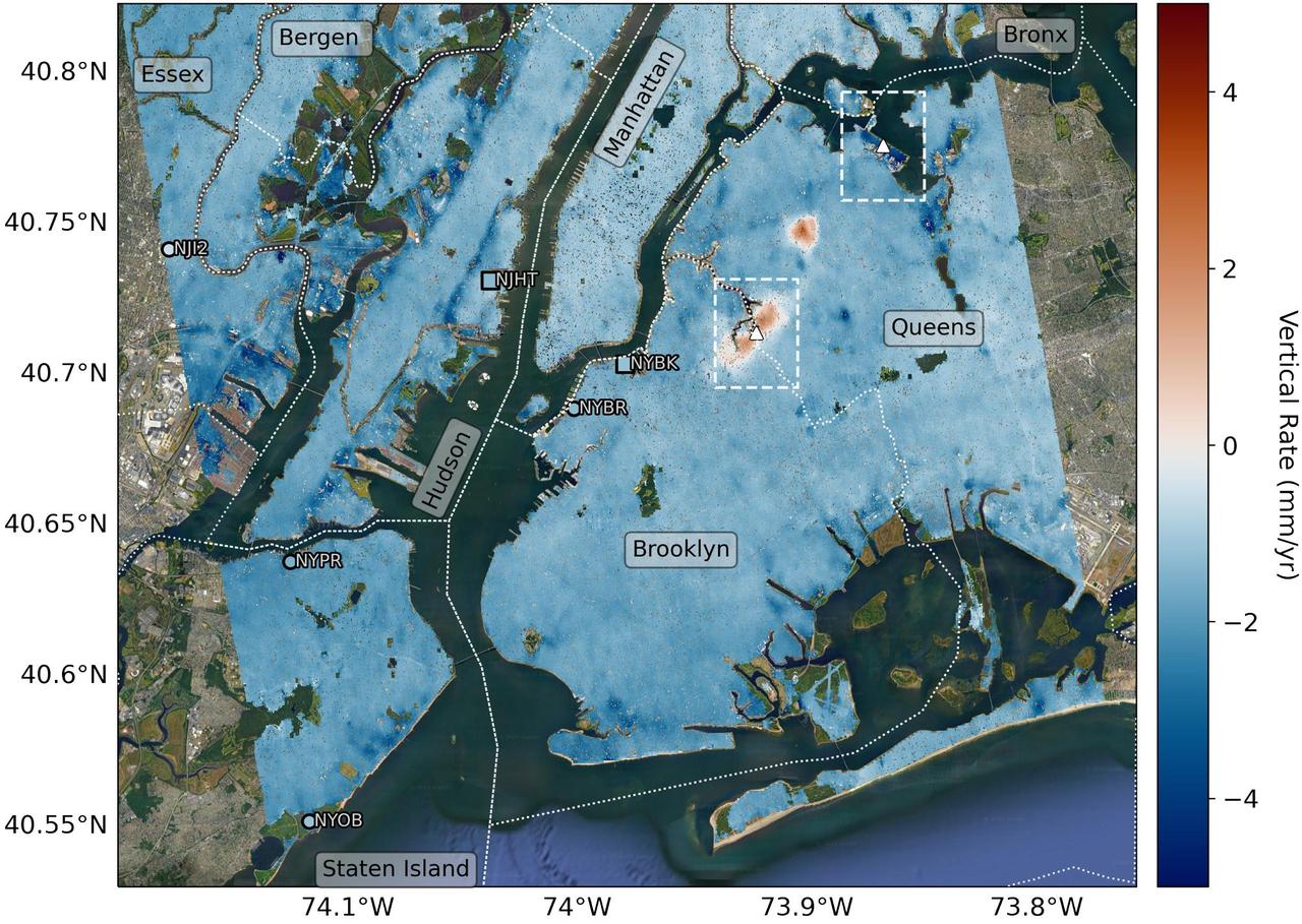
Researchers from NASA's Jet Propulsion Laboratory in Southern California and Rutgers University in New Jersey produced this map in their analysis of upward and downward vertical land motion – also known as uplift and subsidence – across the New York City metropolitan area from 2016 to 2023. Most of the study region was found to be gradually subsiding (indicated here in blue), while isolated locations of uplift (in red) were also observed. The white dotted lines indicate county/borough borders. The researchers found that on average the metropolitan area subsided by about 0.06 inches (1.6 millimeters) per year – about the same amount that a toenail grows in a month. They mapped the motion in detail and pinpointed neighborhoods and landmarks that were subsiding more rapidly than the average. Causes for the observed motion include natural geologic adjustments that have been unfolding since the most recent ice age, as well as human land-use practices such as the construction of landfills, which make the ground looser and more compressible beneath buildings. A few locations in Queens and Brooklyn were observed to rise due to activities that may include pollution remediation efforts and groundwater injection. To create this map, the researchers employed a remote sensing technique called interferometric synthetic aperture radar (InSAR), which combines two or more three-dimensional observations of the same region to reveal surface motion down to fractions of inches. They used the radars on the ESA (European Space Agency) Sentinel-1 satellites, along with advanced data processing methods. https://photojournal.jpl.nasa.gov/catalog/PIA25527
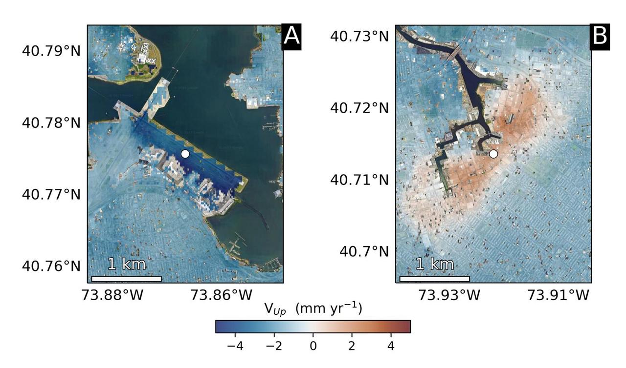
Using radars on the ESA (European Space Agency) Sentinel-1 satellites, along with advanced data processing techniques, a team of researchers measured upward and downward vertical land motion – also known as uplift and subsidence – across the New York City metropolitan area from 2016 to 2023. They mapped the motion in detail and pinpointed specific locations seen here – an airport runway and part of a Superfund site – that were notably sinking or rising. Runway 13/31 at LaGuardia Airport in Queens, left, is co-located with a former landfill and subsiding at a rate of about 0.15 inches (3.7 millimeters) per year. Part of the Newtown Creek Superfund site in East Williamsburg, Brooklyn, right, is rising unevenly by about 0.06 inches (1.6 millimeters) per year, possibly due to groundwater pumping and treatment activities. The site is undergoing extensive environmental remediation to address decades of pollution, including the Greenpoint oil spill that was discovered in the late 1970s. The researchers, from NASA's Jet Propulsion Laboratory in Southern California and Rutgers University in New Jersey, found that on average the metropolitan area subsided by about (0.06 inches) (1.6 millimeters) per year – about the same amount that a toenail grows in a month. Causes for the observed motion include natural geologic adjustments that have been unfolding since the most recent ice age, as well as land-use practices such as the construction of landfills, which make the ground looser and more compressible beneath buildings. To create this map, the researchers employed a remote sensing technique called interferometric synthetic aperture radar (InSAR), which combines two or more three-dimensional observations of the same region to reveal surface motion down to fractions of inches. https://photojournal.jpl.nasa.gov/catalog/PIA25528
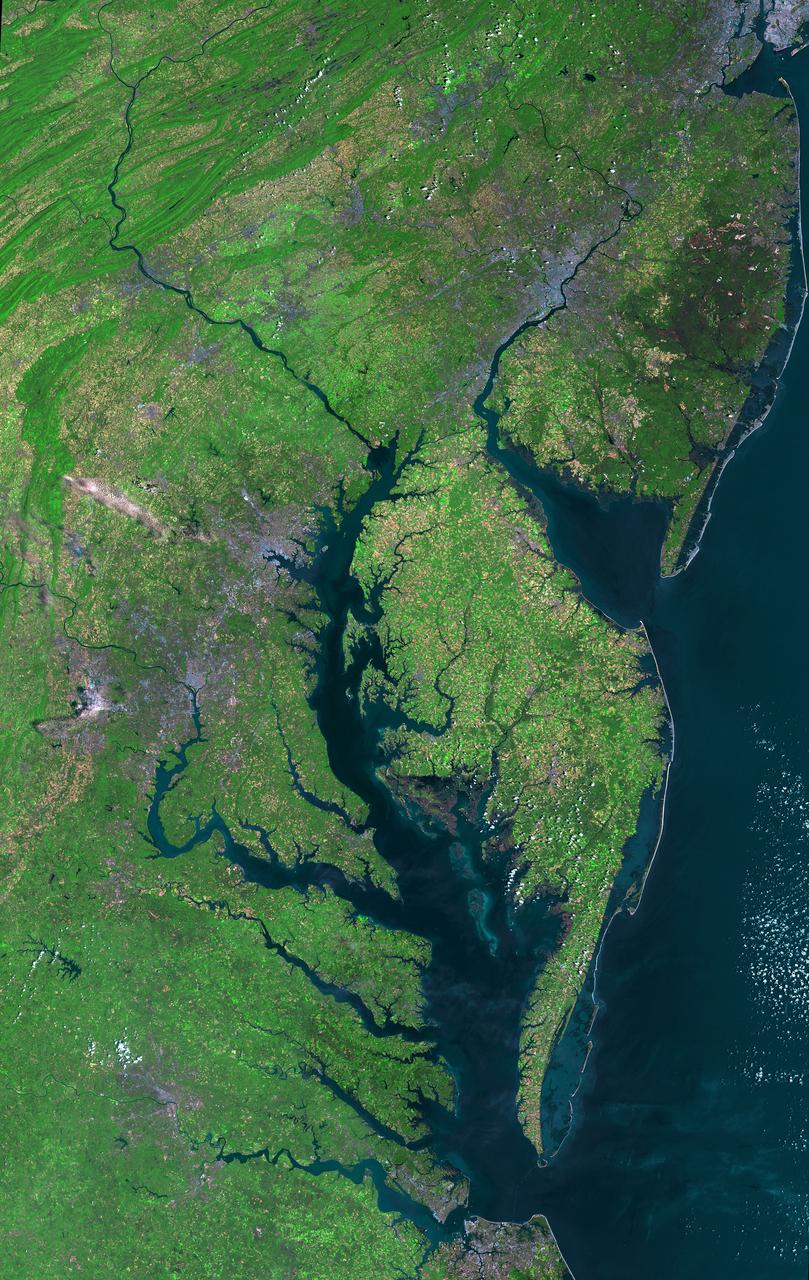
Aug 30, 2011 USGS has released a new mosaic of the Chesapeake Bay. Using six Landsat 5 images collected in July 2009 and 2011 a beautiful, seamless mosaic of the Chesapeake Bay region was created by the USGS Landsat team. The Washington D.C.-Baltimore-Philadelphia-New York City corridor can be clearly seen (look for silvery purple) as can the Chesapeake and Delaware Bays and the coastal Atlantic barrier islands from Fishermans Island, Virginia to Sandy Hook, New Jersey. To download the full high res go to: <a href="http://landsat.gsfc.nasa.gov/news/news-archive/news_0387.html" rel="nofollow">landsat.gsfc.nasa.gov/news/news-archive/news_0387.html</a> Credit: NASA/USGS/Landsat 5 <b><a href="http://www.nasa.gov/centers/goddard/home/index.html" rel="nofollow">NASA Goddard Space Flight Center</a></b> enables NASA’s mission through four scientific endeavors: Earth Science, Heliophysics, Solar System Exploration, and Astrophysics. Goddard plays a leading role in NASA’s accomplishments by contributing compelling scientific knowledge to advance the Agency’s mission. <b>Follow us on <a href="http://twitter.com/NASA_GoddardPix" rel="nofollow">Twitter</a></b> <b>Like us on <a href="http://www.facebook.com/pages/Greenbelt-MD/NASA-Goddard/395013845897?ref=tsd" rel="nofollow">Facebook</a></b> <b>Find us on <a href="http://instagrid.me/nasagoddard/?vm=grid" rel="nofollow">Instagram</a></b>
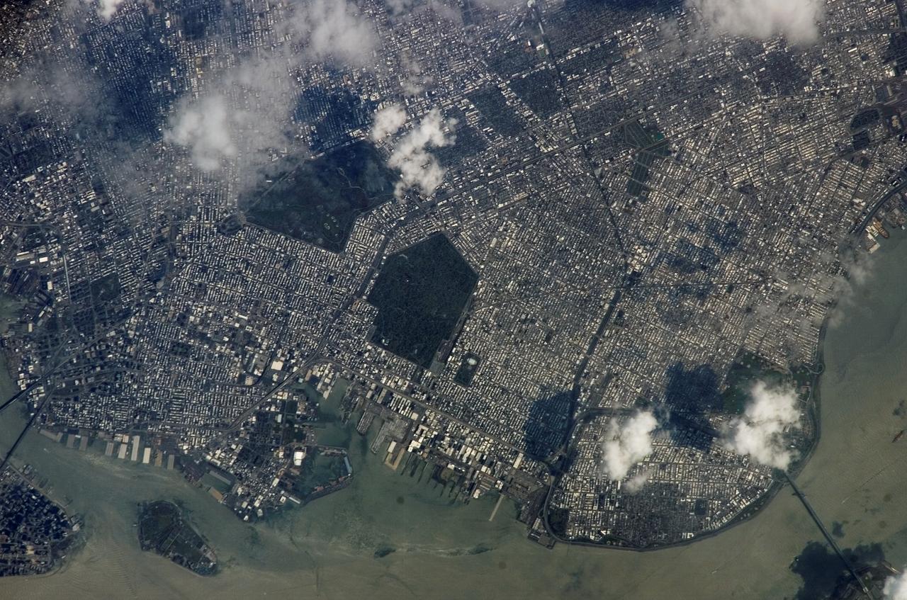
ISS015-E-05483 (28 April 2007) --- Brooklyn, New York waterfront is featured in this image photographed by an Expedition 15 crewmember on the International Space Station. This view illustrates the dense urban fabric of Brooklyn, New York City's largest borough (population of 2.6 million), characterized by the regular pattern of highly reflective building rooftops (white). Two main arteries from Manhattan into Brooklyn, the famous Brooklyn Bridge and neighboring Manhattan Bridge, cross the East River along the left (north) side of the image. The dense built-up fabric contrasts with the East River and Upper New York Bay (bottom center) waterfront areas, recognizable by docks and large industrial loading facilities that extend across the bottom center from left to right. Much of the shipping traffic has moved to the New Jersey side of New York Bay--this has spurred dismantling and redevelopment of the historic dockyards and waterfront warehouses into residential properties. However, efforts to conserve historic buildings are also ongoing. The original name for Brooklyn, Breukelen, means "broken land" in Dutch--perhaps in recognition of the highly mixed deposits (boulders, sand, silt, and clay) left behind by the Wisconsin glacier between 20,000--90,000 years ago, according to scientists. These deposits form much of Long Island, of which Brooklyn occupies the western tip. This image features one of Brooklyn's largest green spaces, the Green-Wood Cemetery. Today, the cemetery functions as both a natural park and a place of internment. The green tree canopy of the Cemetery contrasts sharply with the surrounding urban land cover, is an Audubon Sanctuary, and provides the final resting place for many 19th and 20th century New York celebrities. Also visible in the image is Governor's Island, which served as a strategic military installation for the US Army (1783--1966) and a major US Coast Guard installation (1966--1996). Today the historic fortifications on the island and their surroundings comprise the Governors Island National Monument.
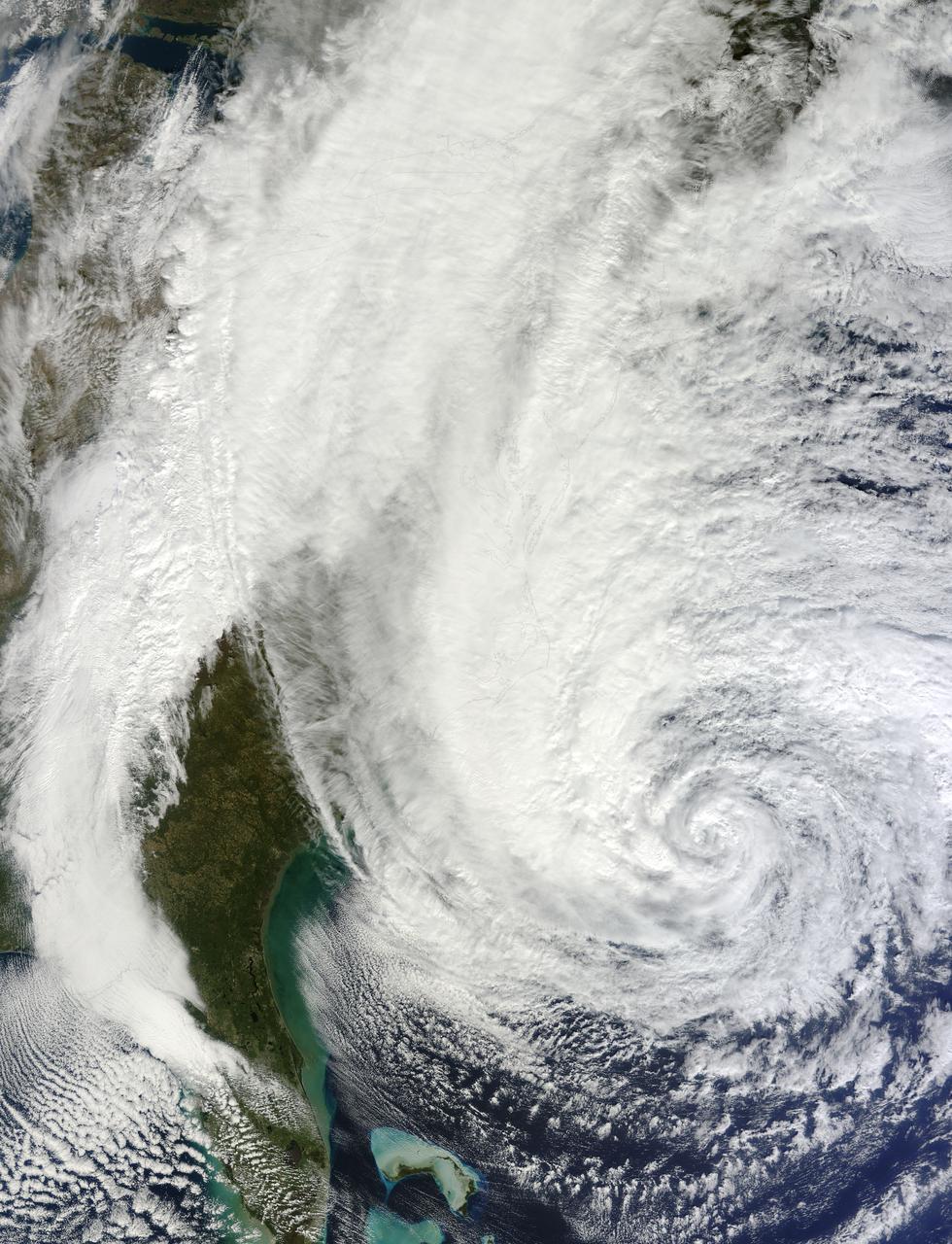
NASA image acquired acquired October 28, 2012 <b>For the latest info from NASA on Hurricane Sandy go to: <a href="http://1.usa.gov/Ti5SgS" rel="nofollow">1.usa.gov/Ti5SgS</a></b> At noon Eastern Daylight Time (16:00 Universal Time) on October 28, 2012, the Moderate Resolution Imaging Spectroradiometer (MODIS) on NASA’s Terra satellite acquired this image of Hurricane Sandy off the southeastern United States. At 11 a.m. local time (one hour before the image was captured), the U.S. National Hurricane Center reported that the storm was located at 32.5° North and 72.6° West, about 250 miles (400 kilometers) southeast of Cape Hatteras, North Carolina, and 575 miles (930 kilometers) south of New York City. Maximum sustained winds were 75 miles (120 kilometers) per hour, and the central pressure was 951 millibars (28.08 inches). Forecasters predicted that the storm would continue heading north-northeast until the morning of October and then take a hard turn to the northwest into the coastaline of Delaware, New Jersey, or New York. The wind field from the storm was said to stretch 500 to 700 miles and was likely to affect an area from South Carolina to Maine, and as far inland as the Great Lakes. The storm has already caused significant damage in the Bahamas, Cuba, Jamaica, Puerto Rico, the Dominican Republic, and Haiti; at least 65 lives have been lost to the storm. NASA image courtesy LANCE MODIS Rapid Response Team at NASA GSFC. Caption by Michael Carlowicz. Instrument: Terra - MODIS Credit: <b><a href="http://www.earthobservatory.nasa.gov/" rel="nofollow"> NASA Earth Observatory</a></b> <b><a href="http://www.nasa.gov/audience/formedia/features/MP_Photo_Guidelines.html" rel="nofollow">NASA image use policy.</a></b> <b><a href="http://www.nasa.gov/centers/goddard/home/index.html" rel="nofollow">NASA Goddard Space Flight Center</a></b> enables NASA’s mission through four scientific endeavors: Earth Science, Heliophysics, Solar System Exploration, and Astrophysics. Goddard plays a leading role in NASA’s accomplishments by contributing compelling scientific knowledge to advance the Agency’s mission. <b>Follow us on <a href="http://twitter.com/NASA_GoddardPix" rel="nofollow">Twitter</a></b> <b>Like us on <a href="http://www.facebook.com/pages/Greenbelt-MD/NASA-Goddard/395013845897?ref=tsd" rel="nofollow">Facebook</a></b> <b>Find us on <a href="http://instagrid.me/nasagoddard/?vm=grid" rel="nofollow">Instagram</a></b>