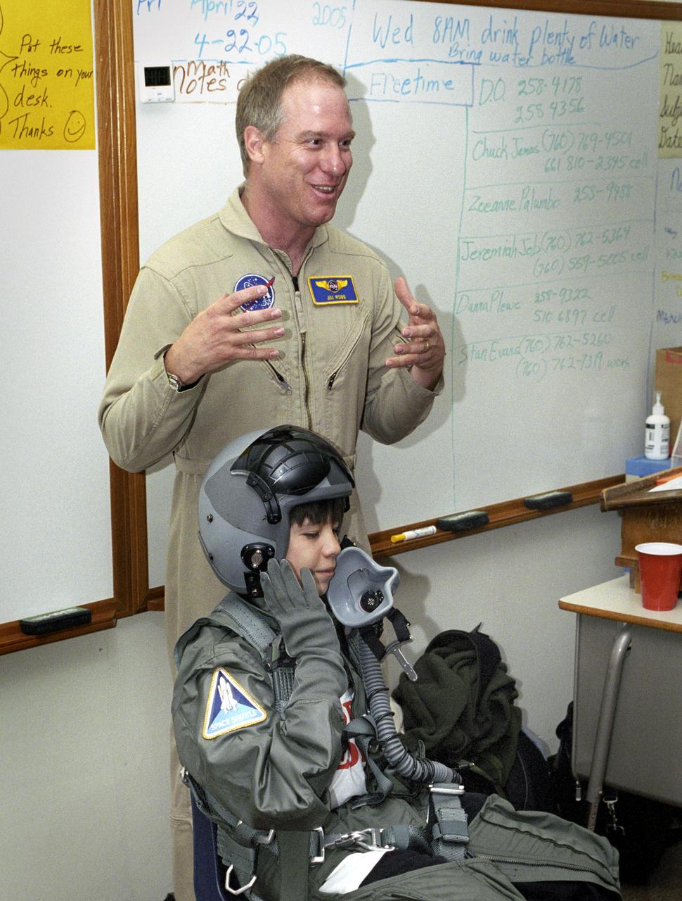
While NASA Dryden's Jim Ross outlined his job as an aerial photographer, sixth-grade student Leo Banuelos learned first-hand about the gear Ross wears in the cockpit.

NASA photographer Jim Ross captured this shot while pilot Troy Asher flew inverted in an F-15D. The F-15B is seen here flying over the mirror farm, AKA the Abengoa Mojave Solar Project, east of Four Corners off of Highway 58 in Southern California.
NASA research pilot Nils Larson and photographer Jim Ross complete aerobatic maneuvers in a NASA Armstrong Flight Research Center in Edwards, California owned T-34C aircraft during a proficiency flight.

NASA Administrator Jim Bridenstine, left, and Amy Ross, a spacesuit engineer at NASA’s Johnson Space Center, left, are seen with Kristine Davis, a spacesuit engineer at NASA’s Johnson Space Center, wearing a ground prototype of NASA’s new Exploration Extravehicular Mobility Unit (xEMU), during a demonstration of the suit, Tuesday, Oct. 15, 2019 at NASA Headquarters in Washington. The xEMU suit improves on the suits previous worn on the Moon during the Apollo era and those currently in use for spacewalks outside the International Space Station and will be worn by first woman and next man as they explore the Moon as part of the agency’s Artemis program. Photo Credit: (NASA/Joel Kowsky)
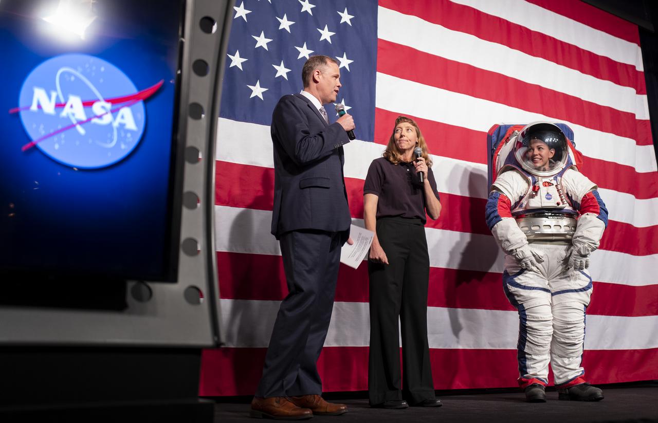
NASA Administrator Jim Bridenstine, left, and Amy Ross, a spacesuit engineer at NASA’s Johnson Space Center, left, are seen with Kristine Davis, a spacesuit engineer at NASA’s Johnson Space Center, wearing a ground prototype of NASA’s new Exploration Extravehicular Mobility Unit (xEMU), during a demonstration of the suit, Tuesday, Oct. 15, 2019 at NASA Headquarters in Washington. The xEMU suit improves on the suits previous worn on the Moon during the Apollo era and those currently in use for spacewalks outside the International Space Station and will be will be worn by first woman and next man as they explore the Moon as part of the agency’s Artemis program. Photo Credit: (NASA/Joel Kowsky)

NASA Administrator Jim Bridenstine, left, gives a thumbs up as Amy Ross, a spacesuit engineer at NASA’s Johnson Space Center, center, high fives Kristine Davis, a spacesuit engineer at NASA’s Johnson Space Center, wearing a ground prototype of NASA’s new Exploration Extravehicular Mobility Unit (xEMU), after a demonstration of the suits enhanced mobility, Tuesday, Oct. 15, 2019 at NASA Headquarters in Washington. The xEMU suit improves on the suits previous worn on the Moon during the Apollo era and those currently in use for spacewalks outside the International Space Station and will be will be worn by first woman and next man as they explore the Moon as part of the agency’s Artemis program. Photo Credit: (NASA/Joel Kowsky)

NASA Administrator Jim Bridenstine, left, and Amy Ross, a spacesuit engineer at NASA’s Johnson Space Center, left, are seen with Kristine Davis, a spacesuit engineer at NASA’s Johnson Space Center, wearing a ground prototype of NASA’s new Exploration Extravehicular Mobility Unit (xEMU), during a demonstration of the suit, Tuesday, Oct. 15, 2019 at NASA Headquarters in Washington. The xEMU suit improves on the suits previous worn on the Moon during the Apollo era and those currently in use for spacewalks outside the International Space Station and will be worn by first woman and next man as they explore the Moon as part of the agency’s Artemis program. Photo Credit: (NASA/Joel Kowsky)
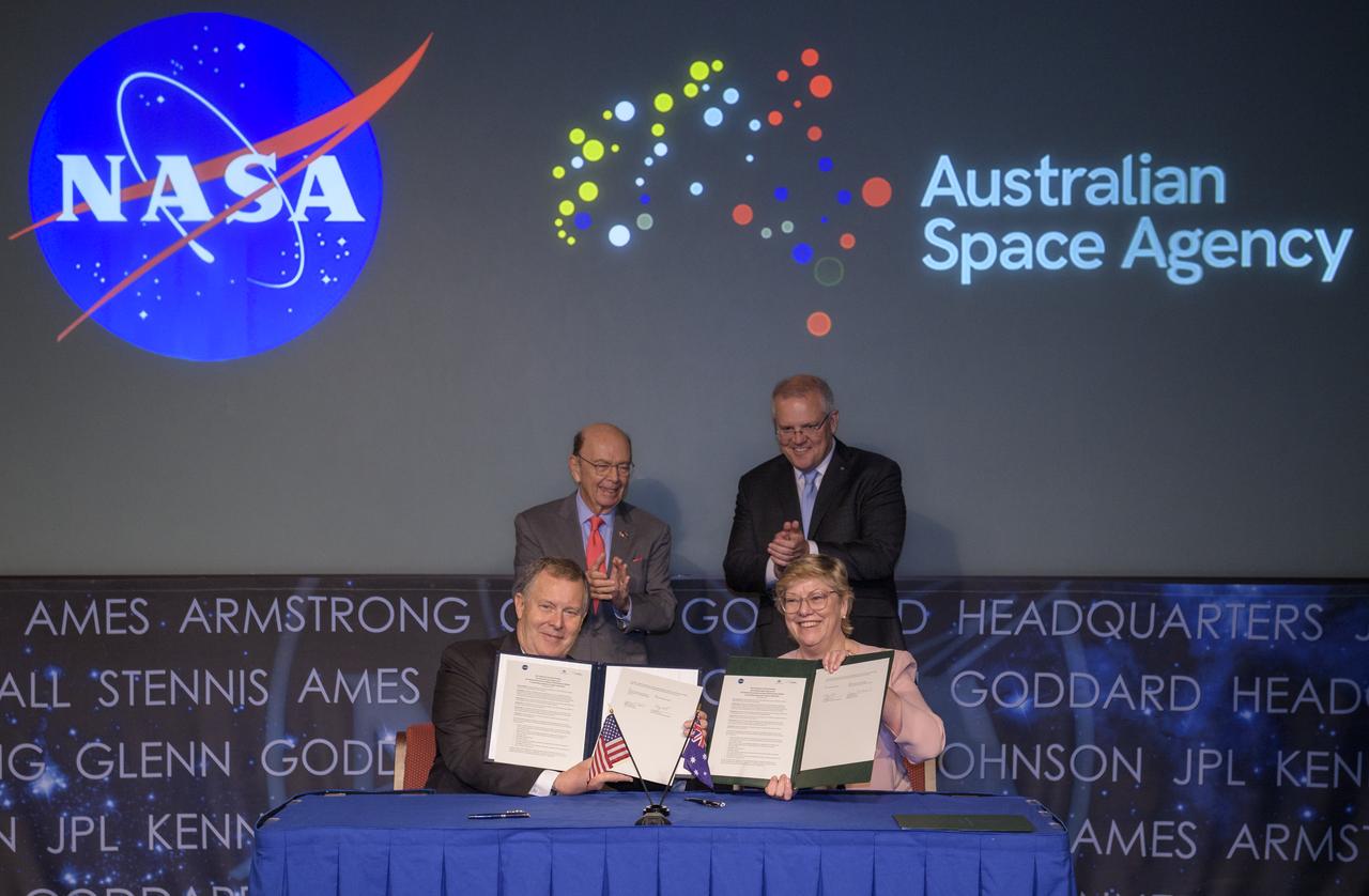
U.S. Secretary of Commerce Wilbur Ross, top left, and Australian Prime Minister Scott Morrison, top right, witness the signing of a letter of intent between NASA and the Australian Space Agency by NASA Deputy Administrator Jim Morhard, left, and Dr. Megan Clark, Head of the Australian Space Agency, right, Saturday, Sept. 21, 2019 at NASA Headquarters in Washington. NASA and the Australian Space Agency will build on over 60 years of collaboration in space exploration between the two countries and commit to expanding cooperation. Photo Credit: (NASA/Joel Kowsky)
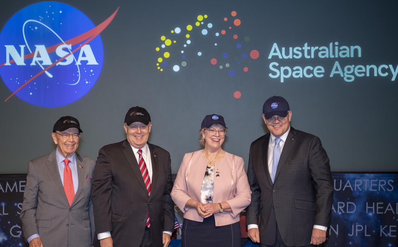
U.S. Secretary of Commerce Wilbur Ross, left, NASA Deputy Administrator Jim Morhard, second from left, Dr. Megan Clark, Head of the Australian Space Agency, second from right, and Australian Prime Minister Scott Morrison, right, pose for a picture after exchanging space agency hats following the signing of a letter of intent between NASA and the Australian Space Agency, Saturday, Sept. 21, 2019 at NASA Headquarters in Washington. NASA and the Australian Space Agency will build on over 60 years of collaboration in space exploration between the two countries and commit to expanding cooperation. Photo Credit: (NASA/Joel Kowsky)
U.S. Secretary of Commerce Wilbur Ross, left, NASA Deputy Administrator Jim Morhard, second from left, Dr. Megan Clark, Head of the Australian Space Agency, second from right, and Australian Prime Minister Scott Morrison, right, pose for a picture after exchanging space agency hats following the signing of a letter of intent between NASA and the Australian Space Agency, Saturday, Sept. 21, 2019 at NASA Headquarters in Washington. NASA and the Australian Space Agency will build on over 60 years of collaboration in space exploration between the two countries and commit to expanding cooperation. Photo Credit: (NASA/Joel Kowsky)

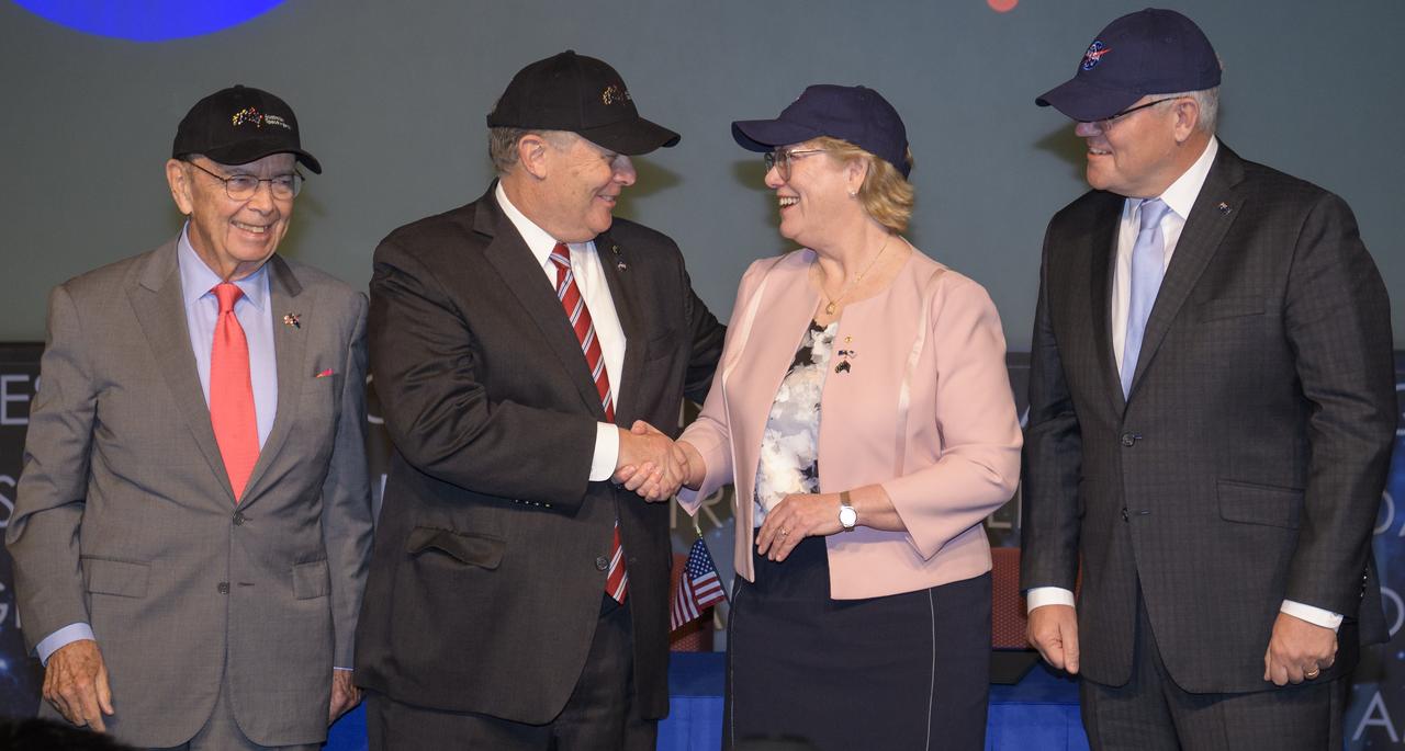
NASA Deputy Administrator Jim Morhard, second from left, shakes hands with Dr. Megan Clark, Head of the Australian Space Agency, second from right, as they pose for a photo with U.S. Secretary of Commerce Wilbur Ross, left, and Australian Prime Minister Scott Morrison, right, following the signing of a letter of intent between NASA and the Australian Space Agency, Saturday, Sept. 21, 2019 at NASA Headquarters in Washington. NASA and the Australian Space Agency will build on over 60 years of collaboration in space exploration between the two countries and commit to expanding cooperation. Photo Credit: (NASA/Joel Kowsky)
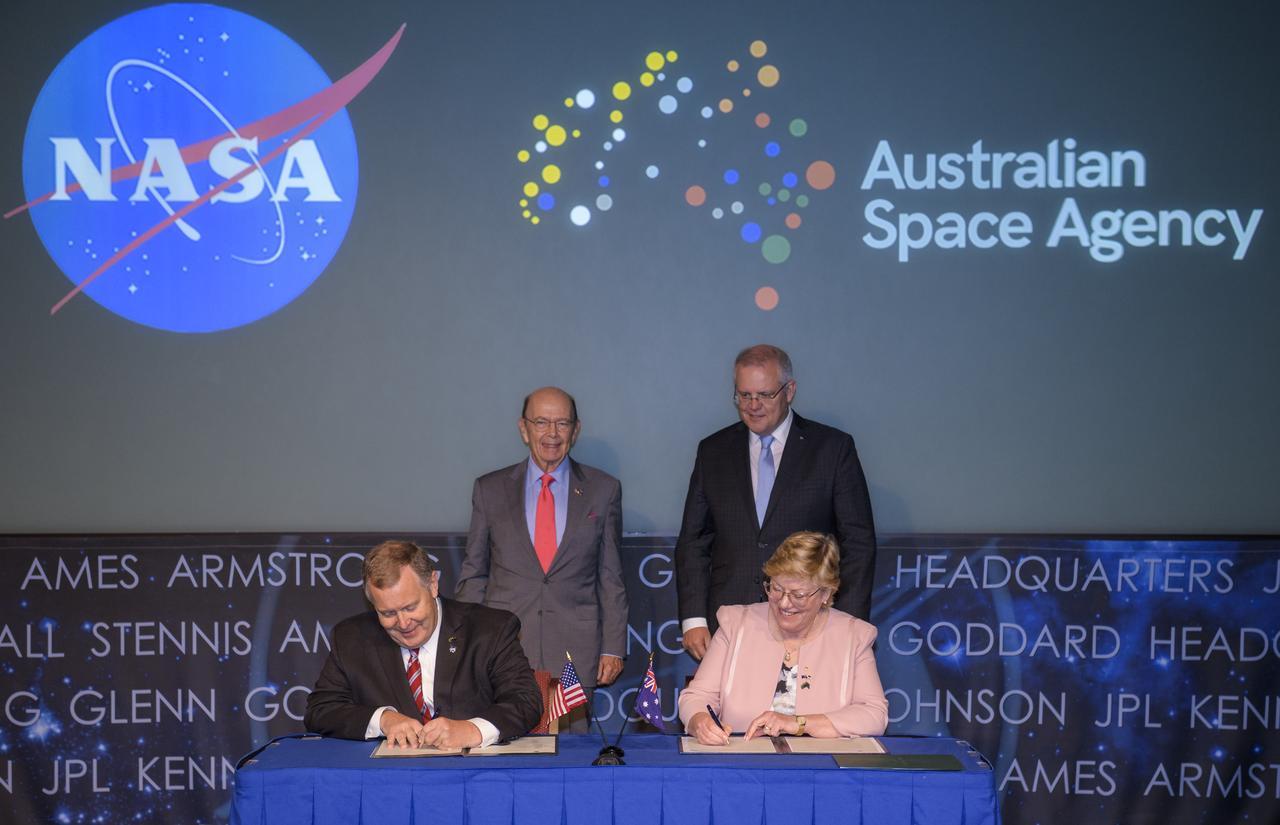
U.S. Secretary of Commerce Wilbur Ross, top left, and Australian Prime Minister Scott Morrison, top right, witness the signing of a letter of intent between NASA and the Australian Space Agency by NASA Deputy Administrator Jim Morhard, left, and Dr. Megan Clark, Head of the Australian Space Agency, right, Saturday, Sept. 21, 2019 at NASA Headquarters in Washington. NASA and the Australian Space Agency will build on over 60 years of collaboration in space exploration between the two countries and commit to expanding cooperation. Photo Credit: (NASA/Joel Kowsky)

Secretary of Commerce Wilbur Ross, left, NASA Administrator Jim Bridenstine, center, and Commander, U.S. Strategic Command, General John Hyten prepare to testify before the House Subcommittee on Strategic Forces during a hearing on Space Situational Awareness: Whole of Government Perspectives on Roles and Responsibilities, Friday, June 22, 2018 at the Rayburn House Office Building in Washington. Photo Credit: (NASA/Bill Ingalls)

Secretary of Commerce Wilbur Ross, left, NASA Administrator Jim Bridenstine, center, and Commander, U.S. Strategic Command, General John Hyten testify before the House Subcommittee on Strategic Forces during a hearing on Space Situational Awareness: Whole of Government Perspectives on Roles and Responsibilities, Friday, June 22, 2018 at the Rayburn House Office Building in Washington. Photo Credit: (NASA/Bill Ingalls)

Secretary of Commerce Wilbur Ross, left, NASA Administrator Jim Bridenstine, center, and Commander, U.S. Strategic Command, General John Hyten testify before the House Subcommittee on Strategic Forces during a hearing on Space Situational Awareness: Whole of Government Perspectives on Roles and Responsibilities, Friday, June 22, 2018 at the Rayburn House Office Building in Washington. Photo Credit: (NASA/Bill Ingalls)

Secretary of Commerce Wilbur Ross, left, NASA Administrator Jim Bridenstine, center, and Commander, U.S. Strategic Command, General John Hyten testify before the House Subcommittee on Strategic Forces during a hearing on Space Situational Awareness: Whole of Government Perspectives on Roles and Responsibilities, Friday, June 22, 2018 at the Rayburn House Office Building in Washington. Photo Credit: (NASA/Bill Ingalls)
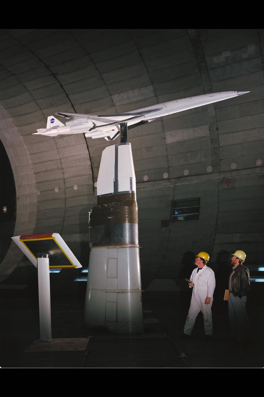
HSCT (High Speed Civil Transport) Ref-H Model test-594 in 40x80ft w.t. with Jim Ross & Boeing Engineer

Amy Ross, a spacesuit engineer at NASA’s Johnson Space Center, left, and NASA Administrator Jim Bridenstine, second from left, watch as Kristine Davis, a spacesuit engineer at NASA’s Johnson Space Center, wearing a ground prototype of NASA’s new Exploration Extravehicular Mobility Unit (xEMU), and Dustin Gohmert, Orion Crew Survival Systems Project Manager at NASA’s Johnson Space Center, wearing the Orion Crew Survival System suit, right, wave after being introduced by the administrator, Tuesday, Oct. 15, 2019 at NASA Headquarters in Washington. The xEMU suit improves on the suits previous worn on the Moon during the Apollo era and those currently in use for spacewalks outside the International Space Station and will be worn by first woman and next man as they explore the Moon as part of the agency’s Artemis program. The Orion suit is designed for a custom fit and incorporates safety technology and mobility features that will help protect astronauts on launch day, in emergency situations, high-risk parts of missions near the Moon, and during the high-speed return to Earth. Photo Credit: (NASA/Joel Kowsky)
CAPE CANAVERAL, Fla. – At NASA's Kennedy Space Center in Florida, three members of the STS-88 space shuttle crew speak to spaceport employees during a celebration commemorating the 15th anniversary of the start of assembly of the International Space Station. On stage, from the left, are mission specialist Nancy Currie and Jerry Ross, along with and mission commander Bob Cabana, who is Kennedy's director. The Russian Space Agency's Functional Cargo Block, named "Zarya," was launched from the Baikonur Cosmodrome in Kazakhstan on Nov. 20, 1998. Two weeks later, on Dec. 4, 1998, the space shuttle Endeavour lifted off from Kennedy on STS-88 with node 1, called "Unity." In addition to Cabana, Curie and Ross, the crew also included pilot Rick Sturckow, along with mission specialists Jim Newman and Sergei Krikalev, a Russian cosmonaut. For more information, visit: http://www.nasa.gov/mission_pages/station/main/index.html Photo credit: NASA/Jim Grossman
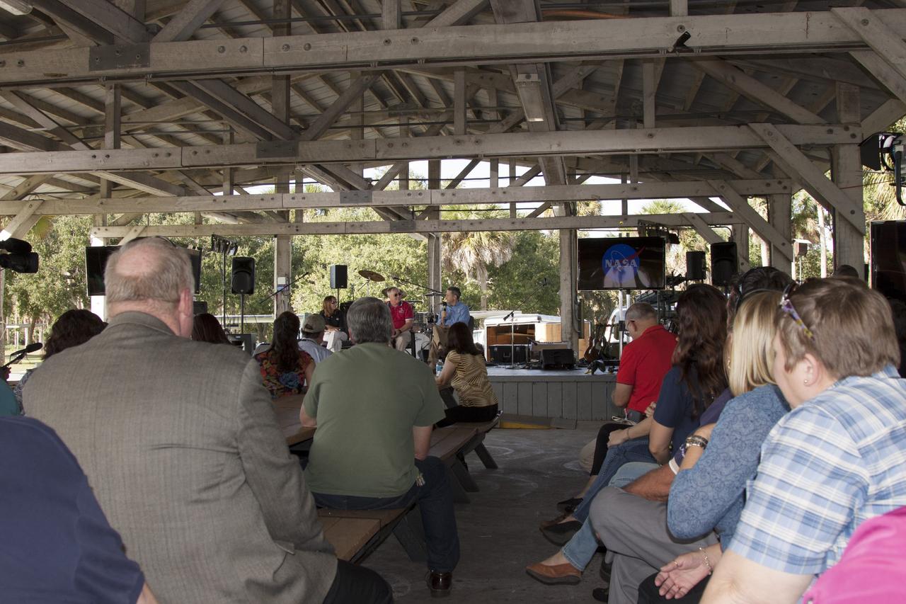
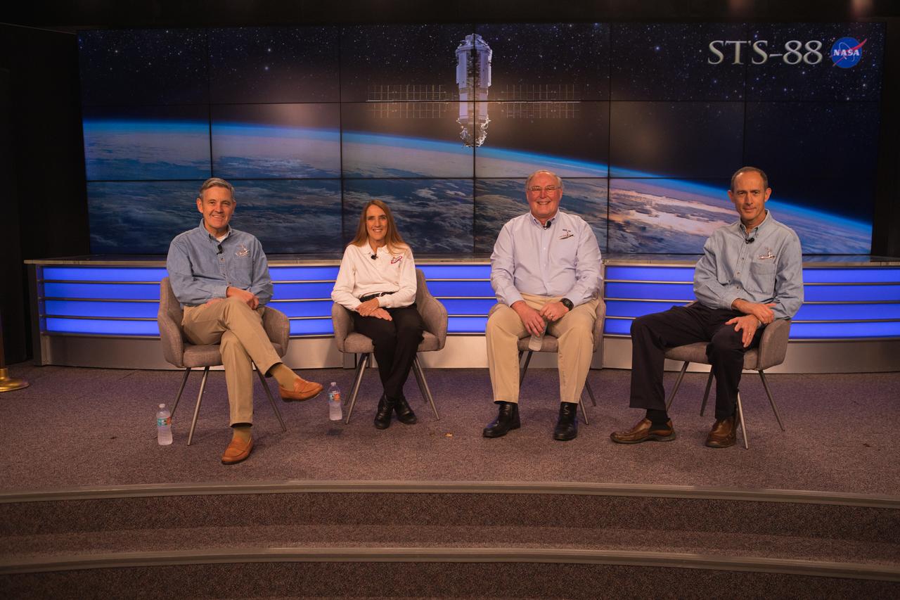
Chief NASA Test Director Jeremy Graeber, left, talks with members of the STS-88 crew inside the Launch Control Center at Kennedy Space Center in Florida on Dec. 10, 2018. They are, from left, Commander Bob Cabana, and mission specialists Nancy Currie-Gregg, Jim Newman and Jerry Ross. Earlier in the day, the group held a panel discussion in recognition of the 20th anniversary of the mission.
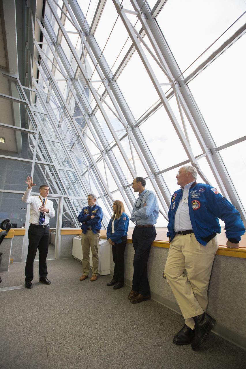
Members of the STS-88 crew tour Kennedy Space Center’s Neil Armstrong Operations & Checkout building on Dec. 10, 2018. Earlier in the day, STS-88 commander Bob Cabana, along with mission specialists Jerry Ross, Nancy Currie-Gregg and Jim Newman, held a panel discussion in recognition of the 20th anniversary of the first International Space Station assembly mission.
From left, Kennedy Space Center Director and STS-88 commander Bob Cabana, along with STS-88 mission specialists Nancy Currie-Gregg, Jerry Ross and Jim Newman, are recognized Dec. 10, 2018, at Kennedy Space Center in Florida during a 20th anniversary celebration of the first International Space Station assembly mission. The STS-88 mission paved the way for humans to live and work on the space station.
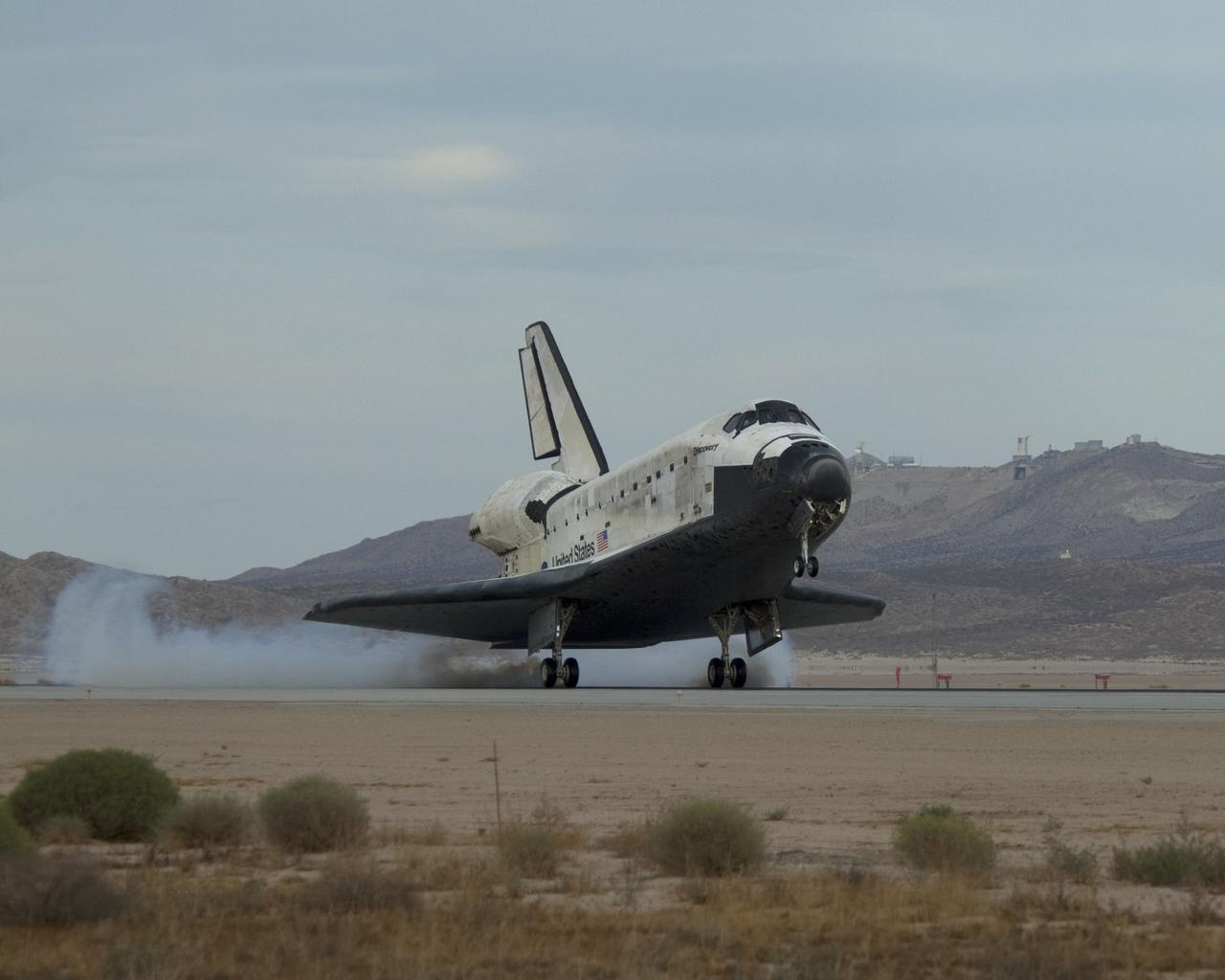
EDWARDS AIR FORCE BASE, Calif. -- (ED09-0253-01) Streams of smoke trail from the main landing gear tires as Space Shuttle Discovery touches down on Runway 22L at Edwards Air Force Base to conclude the almost 14-day STS-128 mission to the International Space Station. (NASA photo / Jim Ross)

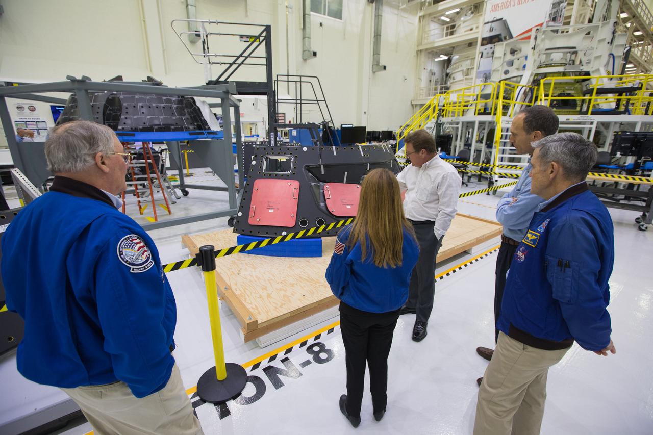
Kennedy Space Center Director Bob Cabana, front left, talks with Scott Wilson, manager of production operations for the Orion Program, inside Kennedy’s Neil Armstrong Operations and Checkout building on Dec. 10, 2018. Cabana, who commanded the first International Space Station assembly mission, was accompanied by fellow STS-88 crew members Jim Newman, Nancie Currie-Gregg and Jerry Ross. Earlier in the day, the group held a panel discussion in recognition of the 20th anniversary of the mission.
Members of the STS-88 crew tour Kennedy Space Center’s Neil Armstrong Operations & Checkout building on Dec. 10, 2018. Earlier in the day, STS-88 commander Bob Cabana, along with mission specialists Jerry Ross, Nancy Currie-Gregg and Jim Newman, held a panel discussion in recognition of the 20th anniversary of the first International Space Station assembly mission.

House Subcommittee on Strategic Forces holds a hearing on Space Situational Awareness: Whole of Government Perspectives on Roles and Responsibilities, Friday, June 22, 2018 at the Rayburn House Office Building in Washington. Witnesses: NASA Administrator Jim Bridenstine; Commander, U.S. Strategic Command, General John Hyten; and Secretary of Commerce Wilbur Ross. Photo Credit: (NASA/Bill Ingalls)

House Subcommittee on Strategic Forces holds a hearing on Space Situational Awareness: Whole of Government Perspectives on Roles and Responsibilities, Friday, June 22, 2018 at the Rayburn House Office Building in Washington. Witnesses: NASA Administrator Jim Bridenstine; Commander, U.S. Strategic Command, General John Hyten; and Secretary of Commerce Wilbur Ross. Photo Credit: (NASA/Bill Ingalls)
CAPE CANAVERAL, Fla. – At NASA's Kennedy Space Center in Florida, the center's director, Bob Cabana, right, speaks during an employee celebration commemorating the 15th anniversary of the start of assembly of the International Space Station. Cabana served as commander of STS-88, the space shuttle mission that launched the first American-built element of the space station, beginning the effort to construct the orbiting complex. Participating in the presentation, from the left, are STS-88 crew members Nancy Currie, Jerry Ross and Cabana. The Russian Space Agency's Functional Cargo Block, named "Zarya," was launched from the Baikonur Cosmodrome in Kazakhstan on Nov. 20, 1998. Two weeks later, on Dec. 4, 1998, the space shuttle Endeavour lifted off from Kennedy on STS-88 with node 1, called "Unity." In addition to Cabana, Curie and Ross, the crew also included pilot Rick Sturckow, along with mission specialists Jim Newman and Sergei Krikalev, a Russian cosmonaut. For more information, visit: http://www.nasa.gov/mission_pages/station/main/index.html Photo credit: NASA/Jim Grossman
CAPE CANAVERAL, Fla. – At NASA's Kennedy Space Center in Florida, the center's director, Bob Cabana, speaks during an employee celebration commemorating the 15th anniversary of the start of assembly of the International Space Station. Cabana served as commander of STS-88, the space shuttle mission that launched the first American-built element of the space station, beginning the effort to construct the orbiting complex. Also participating in the ceremony were STS-88 mission specialists Nancy Currie and Jerry Ross. The Russian Space Agency's Functional Cargo Block, named "Zarya," was launched from the Baikonur Cosmodrome in Kazakhstan on Nov. 20, 1998. Two weeks later, on Dec. 4, 1998, the space shuttle Endeavour lifted off from Kennedy on STS-88 with node 1, called "Unity." In addition to Cabana, Curie and Ross, the crew also included pilot Rick Sturckow, along with mission specialists Jim Newman and Sergei Krikalev, a Russian cosmonaut. For more information, visit: http://www.nasa.gov/mission_pages/station/main/index.html Photo credit: NASA/Jim Grossman
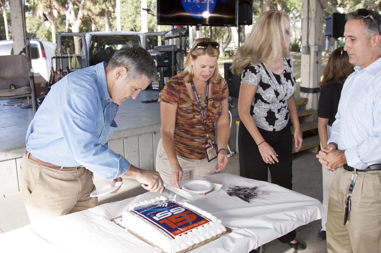
CAPE CANAVERAL, Fla. – At NASA's Kennedy Space Center in Florida, the center's director, Bob Cabana, cuts a 15th anniversary cake during an employee celebration commemorating the start of assembly of the International Space Station. Cabana served as commander of STS-88, the space shuttle mission that launched the first American-built element of the space station, beginning the effort to construct the orbiting complex. Also participating in the ceremony were STS-88 mission specialists Nancy Currie and Jerry Ross. The Russian Space Agency's Functional Cargo Block, named "Zarya," was launched from the Baikonur Cosmodrome in Kazakhstan on Nov. 20, 1998. Two weeks later, on Dec. 4, 1998, the space shuttle Endeavour lifted off from Kennedy on STS-88 with node 1, called "Unity." In addition to Cabana, Curie and Ross, the crew also included pilot Rick Sturckow, along with mission specialists Jim Newman and Sergei Krikalev, a Russian cosmonaut. For more information, visit: http://www.nasa.gov/mission_pages/station/main/index.html Photo credit: NASA/Jim Grossman
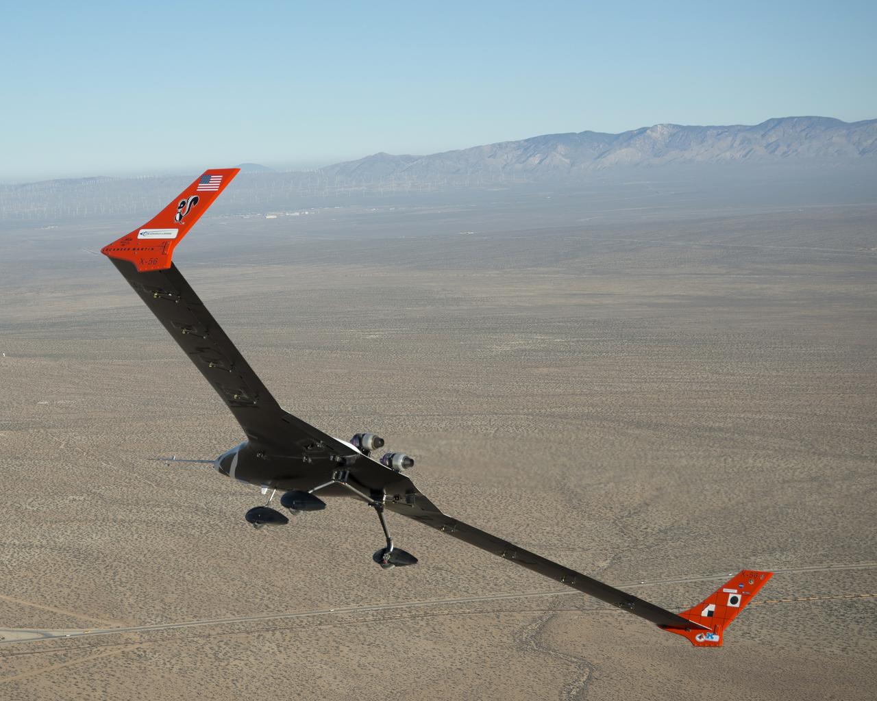
The X-56A flies over the desert near NASA Armstrong Flight Research Center, Edwards, California. NASA researchers are using the remotely piloted X-56A to explore the behavior of lightweight, flexible aircraft structures.
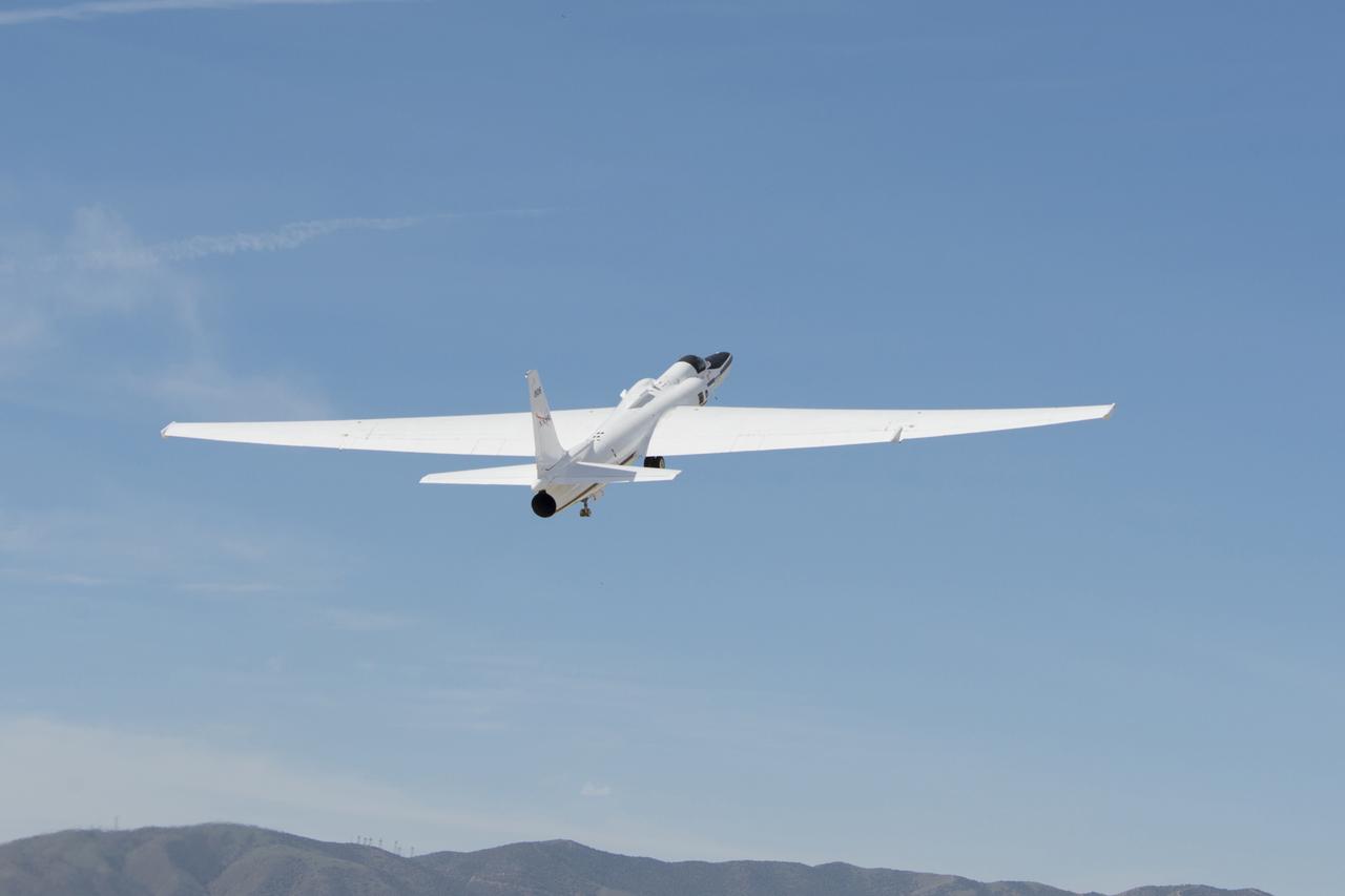
NASA’s ER-2 takes off from its base of operations at NASA’s Armstrong Flight Research Center Building 703 in Palmdale, California to test instruments that will support upcoming science flights for the Geostationary Operational Environmental Satellite-R-series.
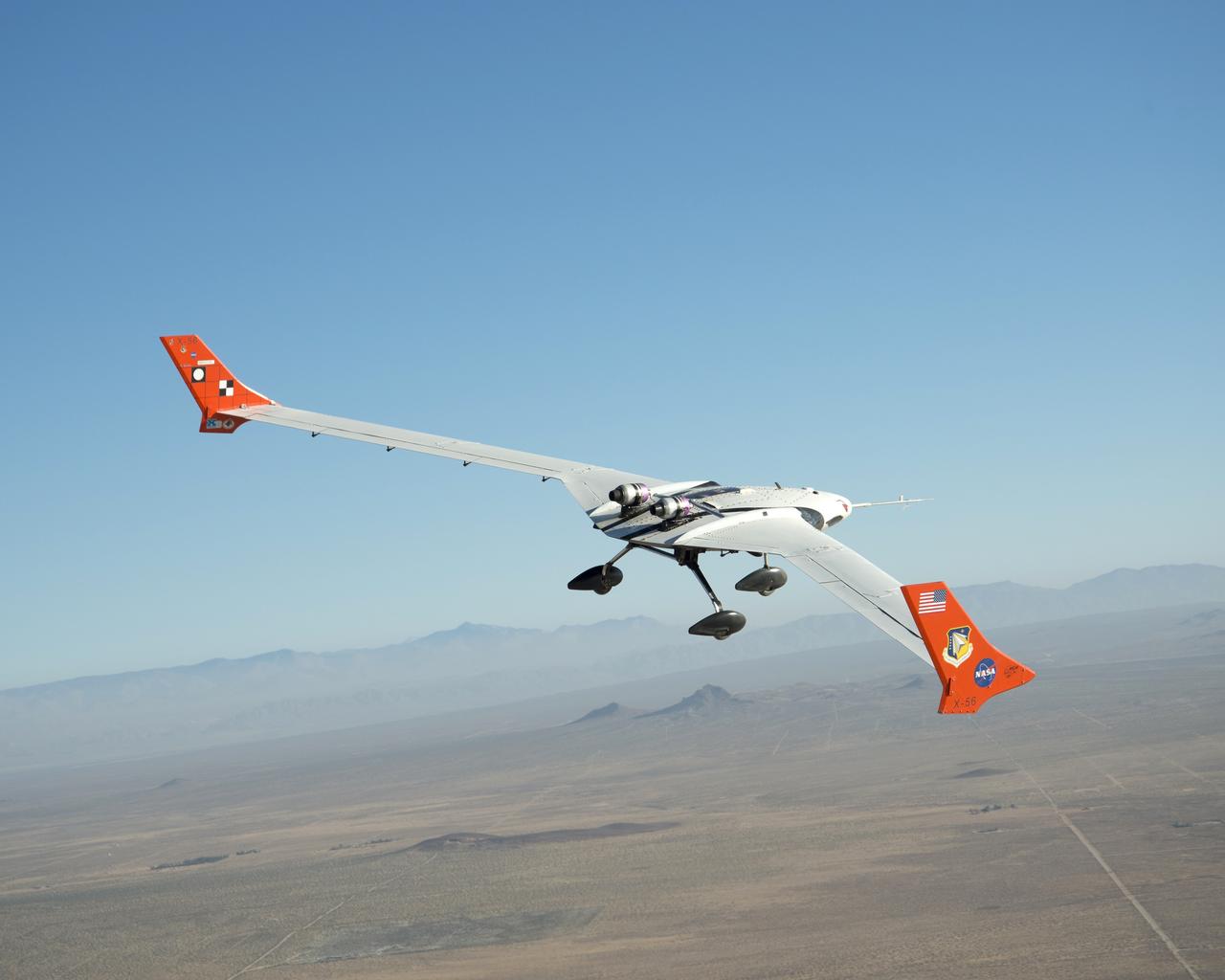
The X-56A flies over the desert near NASA Armstrong Flight Research Center, Edwards, California. NASA researchers are using the remotely piloted X-56A to explore the behavior of lightweight, flexible aircraft structures.
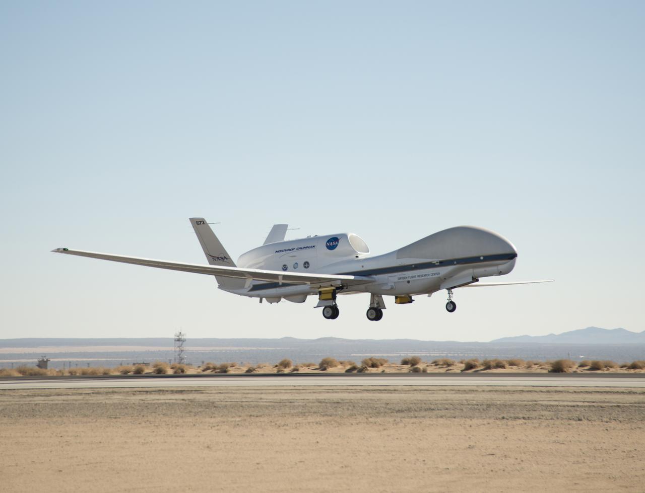
NASA's Global Hawk 872 lifted off the runway at Edwards Air Force Base during a checkout flight of instruments for the 2014 ATTREX mission over the western Pacific Ocean. Yellow and black pods housing the Hawkeye cloud particle probe instruments being used during the mission can be seen underneath the wings.

Space Shuttle Endeavour is affixed atop NASA’s 747 Shuttle Carrier Aircraft as it prepares for a landing at Los Angeles International Airport to conclude a final flight on Sept. 21, 2012.
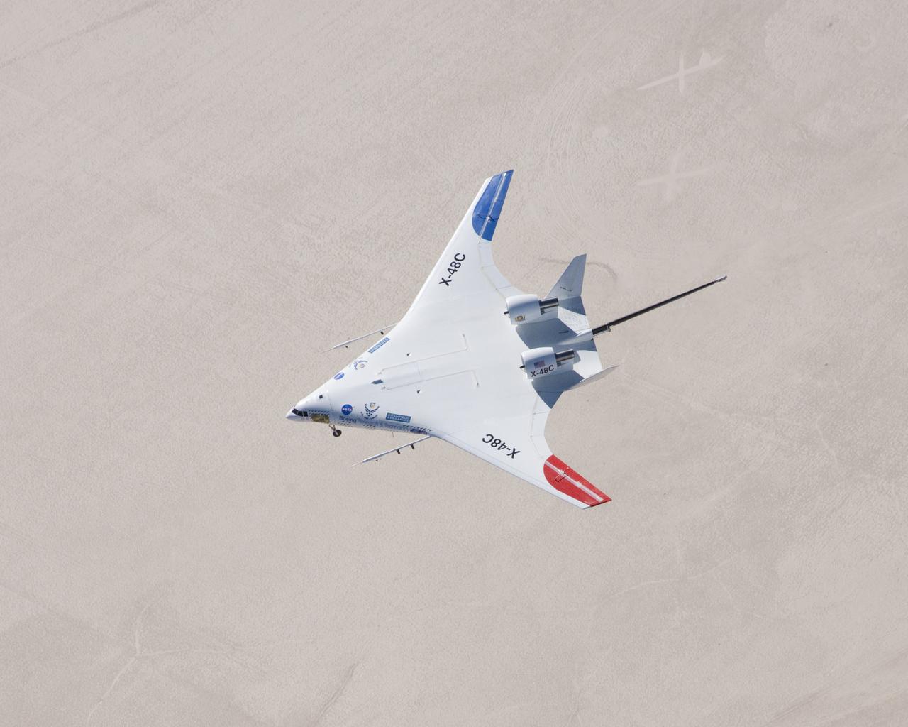
The X-48C Hybrid Wing Body aircraft flew over Rogers Dry Lake on Feb. 28, 2013, from NASA's Dryden Flight Research Center, Edwards, CA. The long boom protruding from between the tails was part of the aircraft's parachute-deployment flight termination system.
Research on the Eagle Aero Probe is ongoing from an F-15B flight test fixture, as the aircraft flies missions over the high desert.
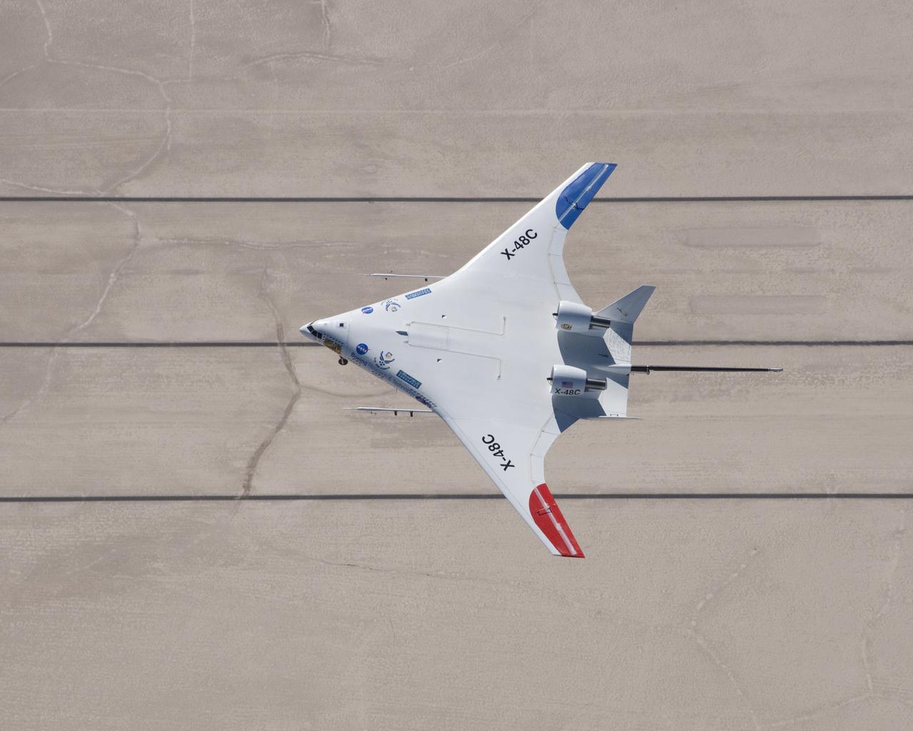
NASA X-48C Hybrid Wing Body aircraft flew over one of the runways laid out on Rogers Dry Lake at Edwards Air Force Base, CA, during a test flight from NASA's Dryden Flight Research Center on Feb. 28, 2013.
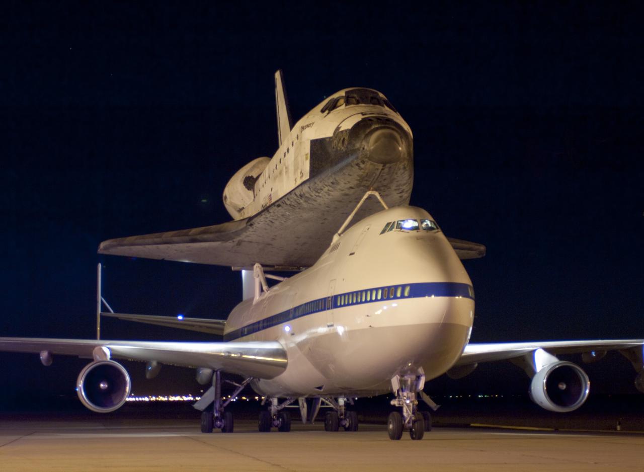
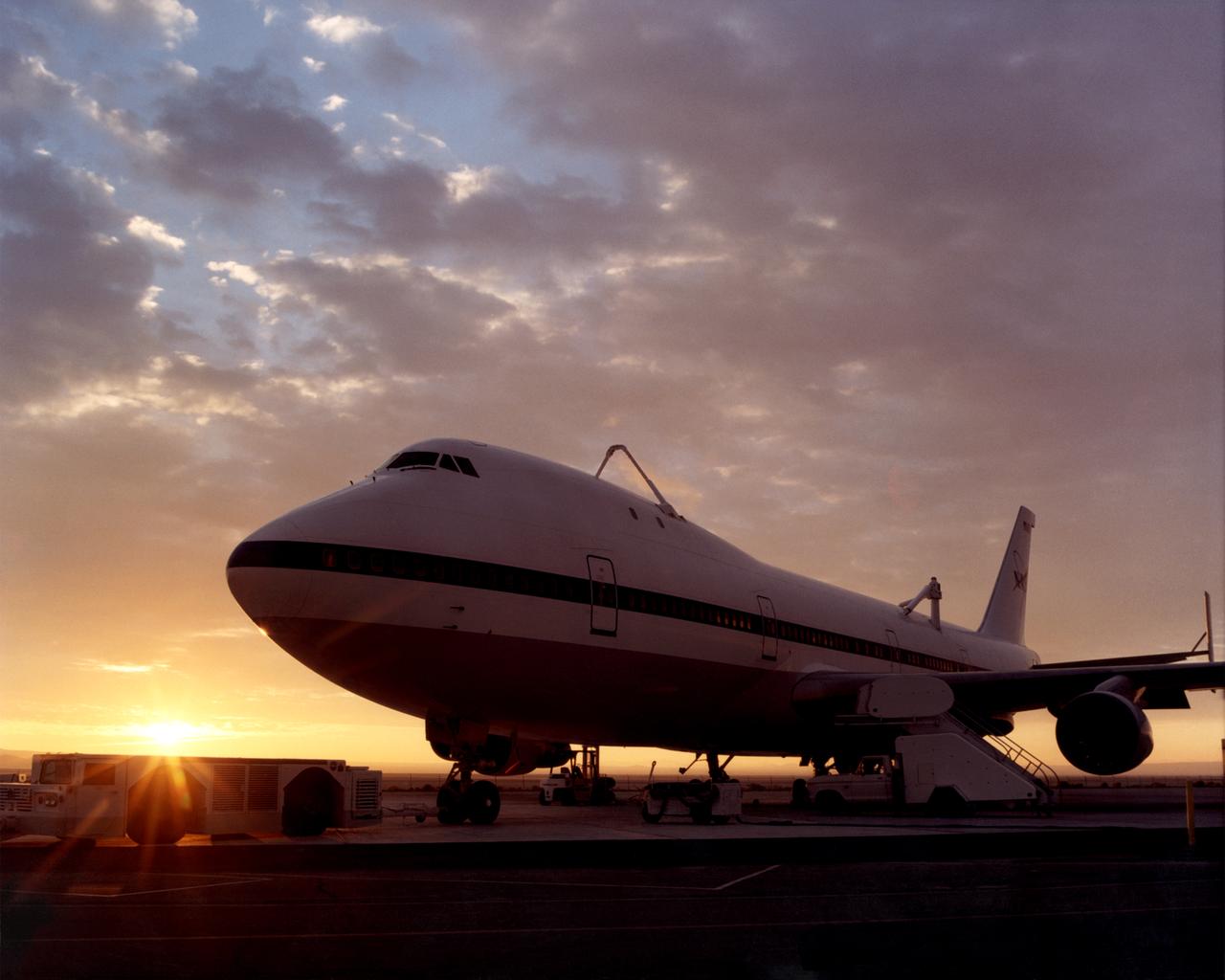
EDWARDS AIR FORCE BASE, Calif. – (ED09-0253-114) NASA’s modified Boeing 747 carrying the space shuttle Discovery taxis toward the runway at Edwards Air Force Base in Southern California shortly before dawn on Sept. 20, 2009 prior to taking off on their two-day ferry flight to the Kennedy Space Center in Florida. Discovery had landed at Edwards Sept. 11 after the almost 14-day mission STS-128 to the International Space Station. The shuttle delivered more than 7 tons of supplies, science racks and equipment, as well as additional environmental hardware to sustain six crew members on the International Space Station. NASA photo /Jim Ross
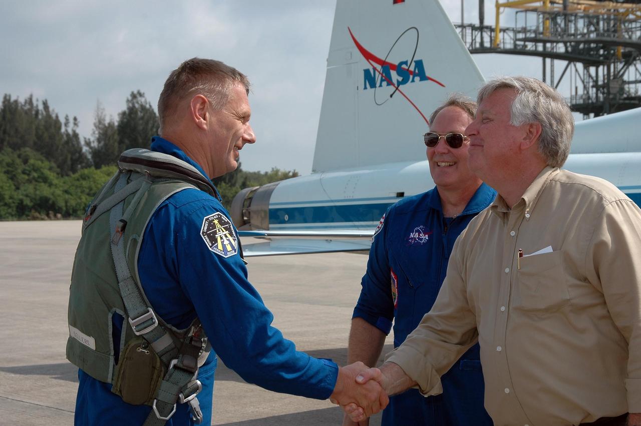
KENNEDY SPACE CENTER, FLA. - After his arrival at KSC, STS-121 Mission Specialist Piers Sellers is greeted by Center Director Jim Kennedy. Behind Kennedy is Jerry Ross, who is chief of the Vehicle Integration Test Office at Johnson Space Center. During the 12-day mission, the STS-121 crew will test new equipment and procedures to improve shuttle safety, as well as deliver supplies and make repairs to the International Space Station. This mission is the 115th shuttle flight and the 18th U.S. flight to the International Space Station. Photo credit: NASA/Kim Shiflett
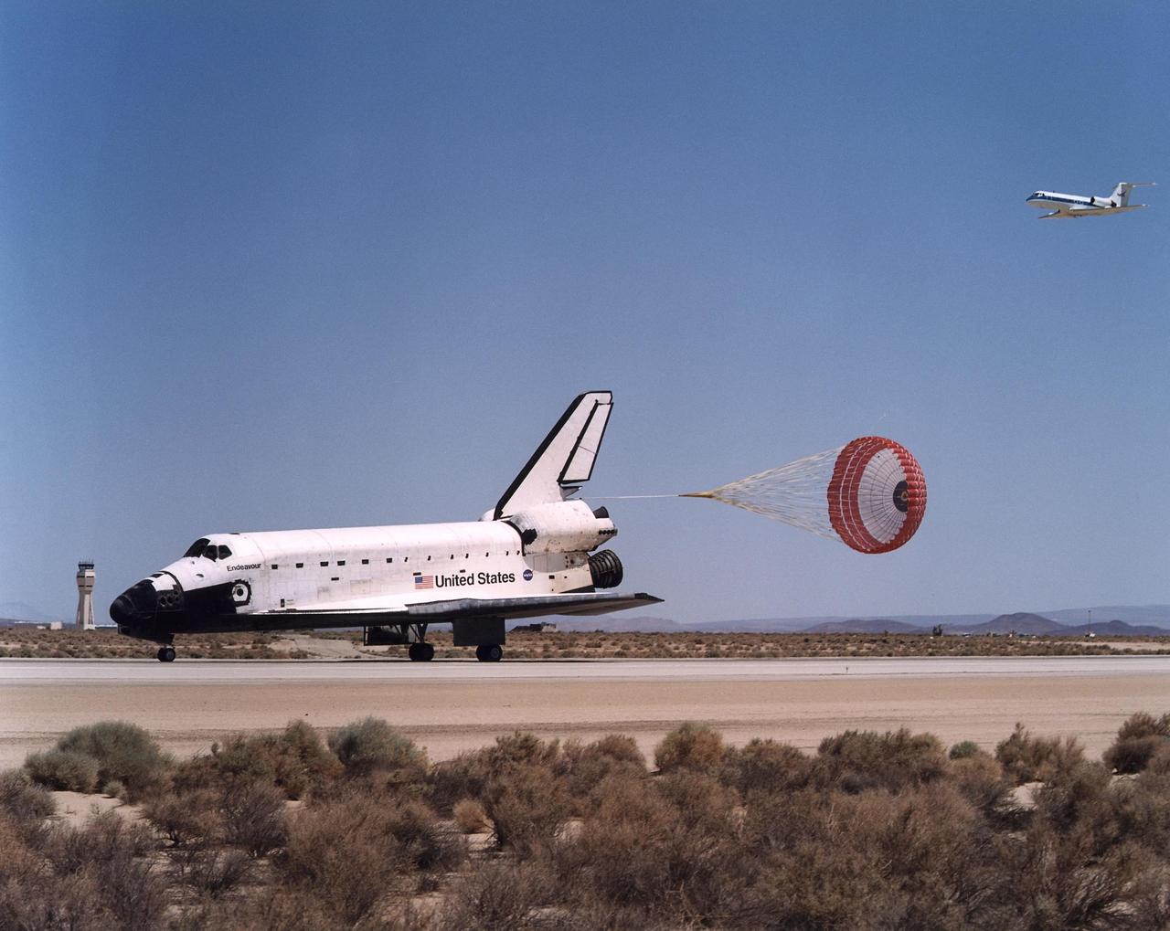
EDWARDS AFB, CALIF. -- A chase plane follows behind Endeavour as it lands on concrete runway 22 at Dryden Flight Research Center, Edwards Air Force Base, Calif., completing mission STS-111. Endeavour traveled 5.8 million miles in space during 217 orbits. Three days of unfavorable weather conditions at KSC prompted the decision to land at Edwards, which enjoyed pristine, dry conditions.. Main gear touchdown occurred at 1:57:41 p.m EDT, nose gear touchdown at 1:57:53 p.m. EDT and wheel stop at 1:58:45 p.m. EDT. [Photo by Jim Ross
![EDWARDS AFB, CALIF. -- After traveling 5.8 million miles in space during 217 orbits, and with drag chute deployed, Endeavour lands on concrete runway 22 at Dryden Flight Research Center, Edwards Air Force Base, Calif., completing mission STS-111. Three days of unfavorable weather conditions at KSC prompted the decision to land at Edwards, which enjoyed pristine, dry conditions.. Main gear touchdown occurred at 1:57:41 p.m. EDT, nose gear touchdown at 1:57:53 p.m. EDT and wheel stop at 1:58:45 p.m. EDT. [Photo by Jim Ross]](https://images-assets.nasa.gov/image/KSC-02pp1114/KSC-02pp1114~medium.jpg)
EDWARDS AFB, CALIF. -- After traveling 5.8 million miles in space during 217 orbits, and with drag chute deployed, Endeavour lands on concrete runway 22 at Dryden Flight Research Center, Edwards Air Force Base, Calif., completing mission STS-111. Three days of unfavorable weather conditions at KSC prompted the decision to land at Edwards, which enjoyed pristine, dry conditions.. Main gear touchdown occurred at 1:57:41 p.m. EDT, nose gear touchdown at 1:57:53 p.m. EDT and wheel stop at 1:58:45 p.m. EDT. [Photo by Jim Ross]
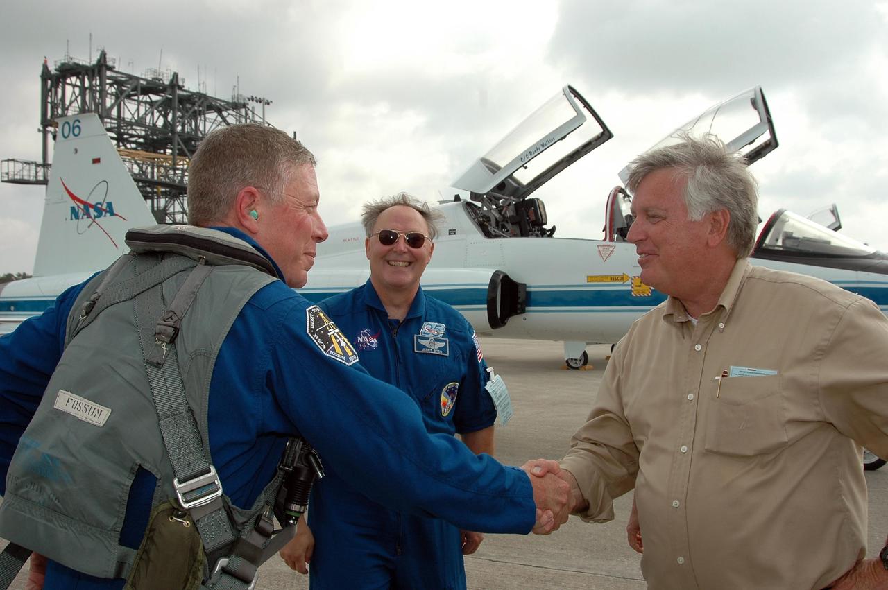
KENNEDY SPACE CENTER, FLA. - STS-121 Mission Specialist Michael Fossum (left) is greeted by Center Director Jim Kennedy after arriving at KSC to get ready for launch on July 1. Behind him is Jerry Ross, who is chief of the Vehicle Integration Test Office at Johnson Space Center. During the 12-day mission, the STS-121 crew will test new equipment and procedures to improve shuttle safety, as well as deliver supplies and make repairs to the International Space Station. This mission is the 115th shuttle flight and the 18th U.S. flight to the International Space Station. Photo credit: NASA/Kim Shiflett
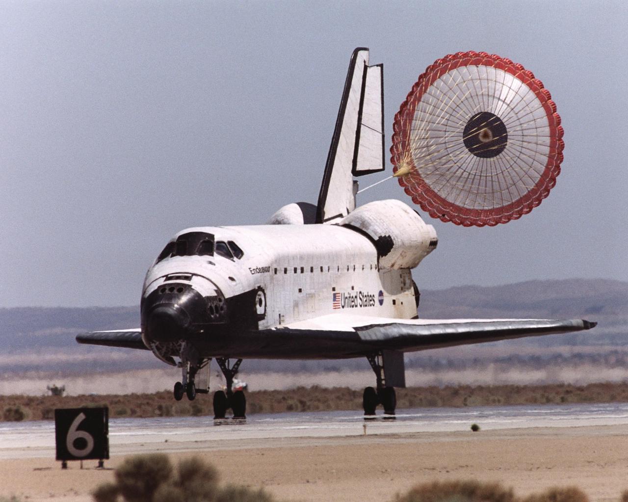
EDWARDS AFB, CALIF. -- After traveling 5.8 million miles in space during 217 orbits, and with drag chute deployed, Endeavour lands on concrete runway 22 at Dryden Flight Research Center, Edwards Air Force Base, Calif., completing mission STS-111. Three days of unfavorable weather conditions at KSC prompted the decision to land at Edwards, which enjoyed pristine, dry conditions.. Main gear touchdown occurred at 1:57:41 p.m EDT, nose gear touchdown at 1:57:53 p.m. EDT and wheel stop at 1:58:45 p.m. EDT. [Photo by Jim Ross
KENNEDY SPACE CENTER, FLA. - Center Director Jim Kennedy (right) greets STS-114 Mission Specialist Soichi Noguchi after his landing at NASA Kennedy Space Center. The Return to Flight STS-114 crew has returned to KSC to get ready for a second launch attempt aboard Space Shuttle Discovery. Behind Noguchi and Kennedy is astronaut Jerry Ross, who serves as chief of the Vehicle Integration Test Office at Johnson Space Center in Houston. Mission Commander Eileen Collins later told the media who waited nearby that since the scrub on July 13, the crew has focused on the on-orbit part of the mission and training for night landings using the Shuttle Training Aircraft. She praised the engineers and technicians who have been troubleshooting the elusive sensor problem and thanked them. STS-114 is scheduled to launch July 26 at 10:39 a.m. EDT from Launch Pad 39B.
NASA’s DC-8 aircraft from Armstrong Flight Research Center in Edwards, California flies to Everett, Washington to conduct science research about reducing engine particle emissions. Partners include Boeing, United, General Electric Aerospace, German Aerospace Center (DLR), the FAA, and World Energy. Boeing’s new passenger aircraft uses revolutionary Sustainable Aviation Fuel, SAF, and NASA’s DC-8 flies behind the Boeing plane to measure its impact throughout flight. The results of this study will be released publicly to facilitate the improvement of aviation technology worldwide.
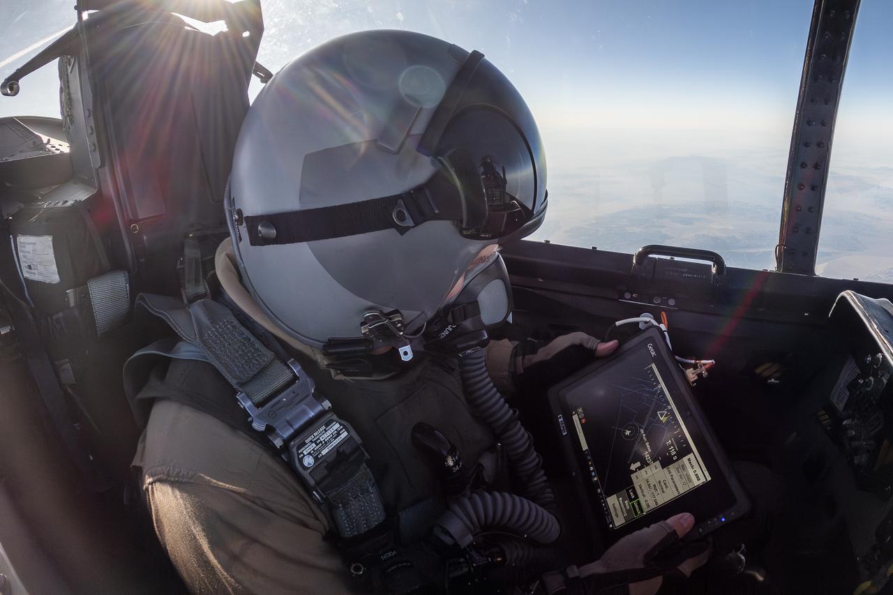
NASA photographer James Ross monitors the Airborne Location Integrating Geospatial Navigation System (ALIGNS) from the backseat of an F-15 near NASA’s Armstrong Flight Research Center in Edwards, California. The ALIGNS provides real-time positioning guidance between aircraft for shock wave probing and schlieren imagery capture.

A Beech T-34C mission support aircraft flown by NASA Dryden Flight Research Center shows off its classic lines as it soars over the desert near Edwards Air Force Base.

The second X-45A Unmanned Combat Air Vehicle (UCAV) technology demonstrator completed its first flight on November 21, 2002, after taking off from a dry lakebed at NASA's Dryden Flight Research Center, Edwards Air Force Base, California. X-45A vehicle two flew for approximately 30 minutes and reached an airspeed of 195 knots and an altitude of 7500 feet. This flight validated the functionality of the UCAV flight software on the second air vehicle. Dryden is supporting the DARPA/Boeing team in the design, development, integration, and demonstration of the critical technologies, processes, and system attributes leading to an operational UCAV system. Dryden support of the X-45A demonstrator system includes analysis, component development, simulations, ground and flight tests.

Pre-Columbian archaeological ruins are revealed through Costa Rican rain forest in this photo taken during NASA's AirSAR 2004 Mesoamerica campaign. AirSAR 2004 Mesoamerica is a three-week expedition by an international team of scientists that uses an all-weather imaging tool, called the Airborne Synthetic Aperture Radar (AirSAR) which is located onboard NASA's DC-8 airborne laboratory. The radar, developed by NASA's Jet Propulsion Laboratory, can penetrate clouds and also collect data at night. Its high-resolution sensors operate at multiple wavelengths and modes, allowing AirSAR to see beneath treetops, through thin sand, and dry snow pack. Much of the archaeological evidence needed to understand Pre-Columbian societies in Central America comes from features on the landscape. Difficult terrain and logistics have limited ground data collection. AirSAR helped to detect signs of ancient civilizations hidden beneath the forest. Its images will shed insights into the way modern humans interact with their landscape, and how ancient peoples lived and what became of their civilizations.
NASA Dryden Flight Research Center's two T-38A Talon mission support aircraft flew together for the first time on Sept. 26, 2007 while conducting pitot-static airspeed calibration checks during routine pilot proficiency flights. The two aircraft, flown by NASA research pilots Kelly Latimer and Frank Batteas, joined up with a NASA Dryden F/A-18 flown by NASA research pilot Dick Ewers to fly the airspeed calibrations at several speeds and altitudes that would be flown by the Stratospheric Observatory for Infrared Astronomy (SOFIA) Boeing 747SP during its initial flight test phase. The T-38s, along with F/A-18s, serve in a safety chase role during those test missions, providing critical instrument and visual monitoring for the flight test series.
The DC-8 flies for the last time from NASA’s Armstrong Flight Research Center Building 703 in Palmdale, California, to Idaho State University in Pocatello, Idaho. The DC-8 will provide real-world experience to train future aircraft technicians at the college’s Aircraft Maintenance Technology Program.
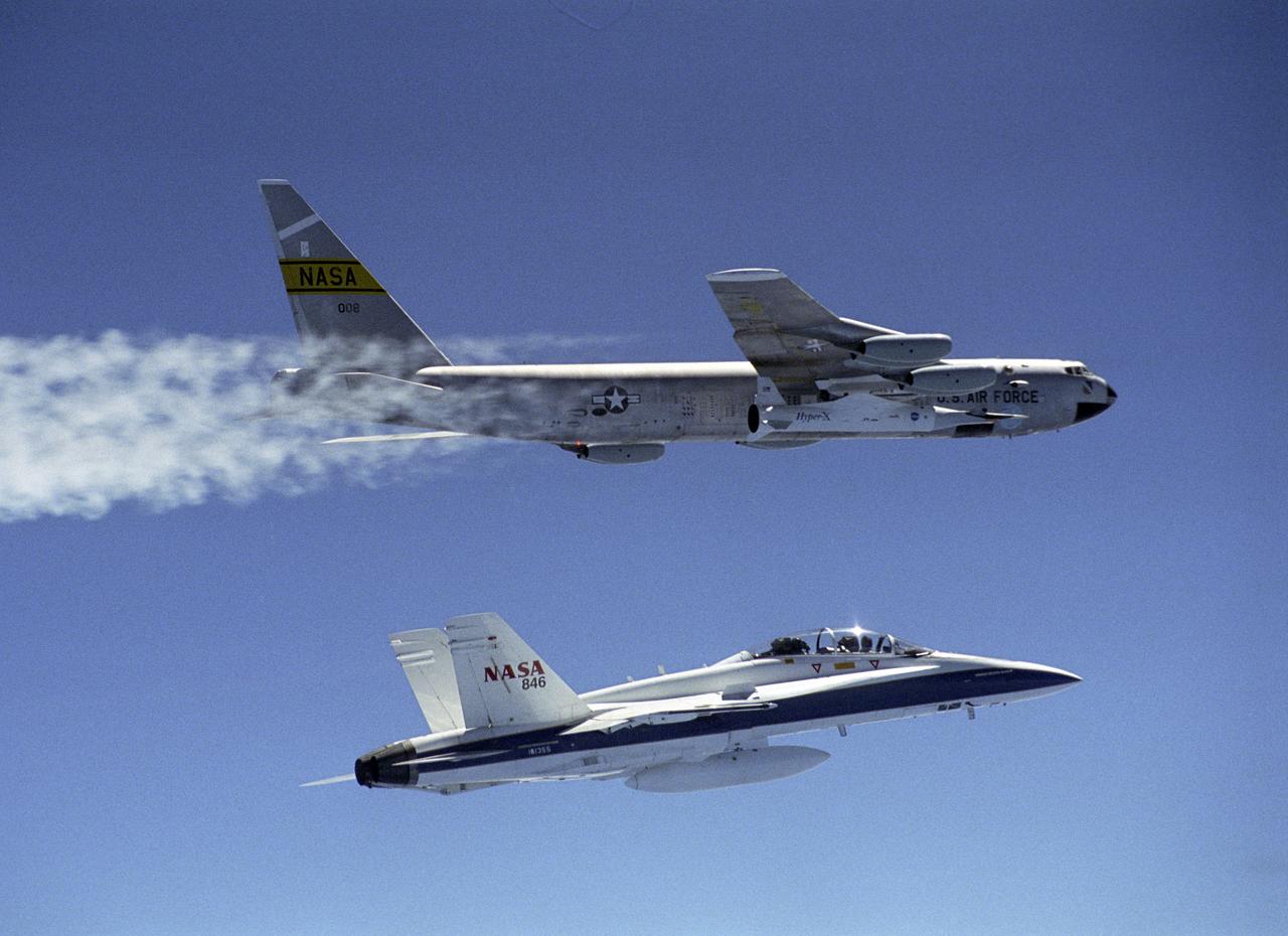
The second X-43A hypersonic research aircraft, attached to a modified Pegasus booster rocket and followed by a chase F-18, was taken to launch altitude by NASA's B-52B launch aircraft from the NASA Dryden Flight Research Center at Edwards Air Force Base, Calif., on March 27, 2004. About an hour later the Pegasus booster was released from the B-52 to accelerate the X-43A to its intended speed of Mach 7. In a combined research effort involving Dryden, Langley, and several industry partners, NASA demonstrated the value of its X-43A hypersonic research aircraft, as it became the first air-breathing, unpiloted, scramjet-powered plane to fly freely by itself. The March 27 flight, originating from NASA's Dryden Flight Research Center, began with the Agency's B-52B launch aircraft carrying the X-43A out to the test range over the Pacific Ocean off the California coast. The X-43A was boosted up to its test altitude of about 95,000 feet, where it separated from its modified Pegasus booster and flew freely under its own power. Two very significant aviation milestones occurred during this test flight: first, controlled accelerating flight at Mach 7 under scramjet power, and second, the successful stage separation at high dynamic pressure of two non-axisymmetric vehicles. To top it all off, the flight resulted in the setting of a new aeronautical speed record. The X-43A reached a speed of over Mach 7, or about 5,000 miles per hour faster than any known aircraft powered by an air-breathing engine has ever flown.
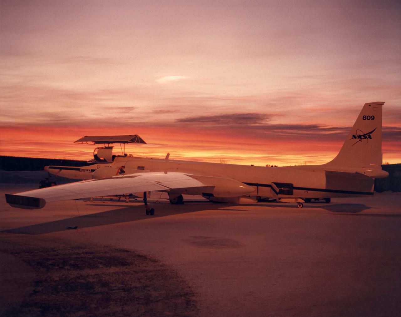
ER-2 #809 awaiting pilot entry for the third flight of the SAGE III Ozone Loss and Validation Experiment (SOLVE). The ER-2, a civilian variant of Lockheed's U-2, and another NASA flying laboratory, Dryden's DC-8, were based north of the Arctic Circle in Kiruna, Sweden during the winter of 2000 to study ozone depletion as part of SOLVE. A large hangar built especially for research, "Arena Arctica" housed the instrumented aircraft and the scientists. Scientists have observed unusually low levels of ozone over the Arctic during recent winters, raising concerns that ozone depletion there could become more widespread as in the Antarctic ozone hole. The NASA-sponsored international mission took place between November 1999 and March 2000 and was divided into three phases. The DC-8 was involved in all three phases returning to Dryden between each phase. The ER-2 flew sample collection flights between January and March, remaining in Sweden from Jan. 9 through March 16. "The collaborative campaign will provide an immense new body of information about the Arctic stratosphere," said program scientist Dr. Michael Kurylo, NASA Headquarters. "Our understanding of the Earth's ozone will be greatly enhanced by this research."
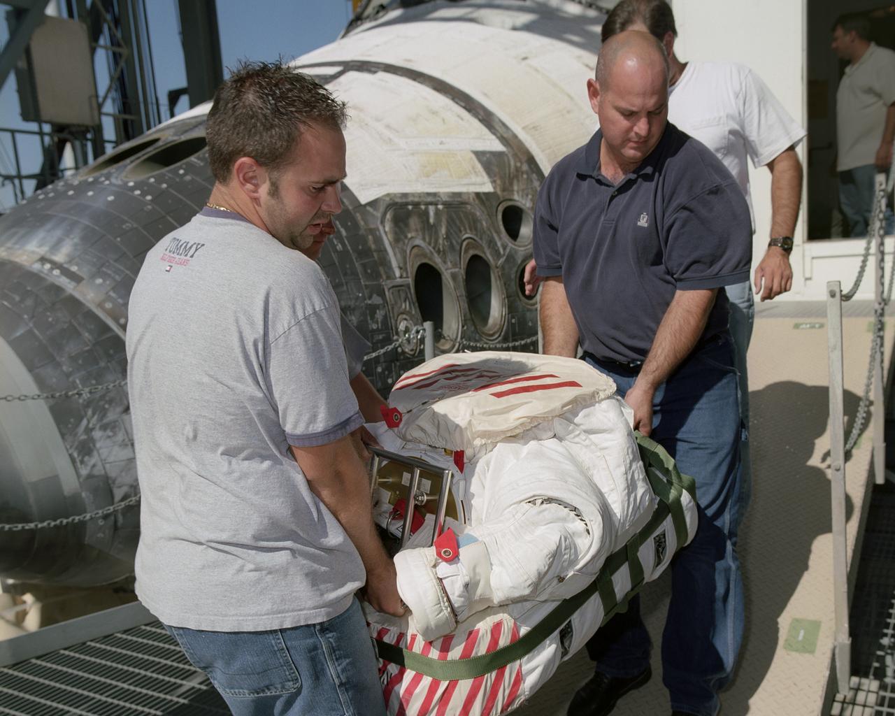
Flight Crew Systems Technicians Ray Smith and Raphael Rodriguez remove one of the Extravehicular Mobility Units, or EMUs, from the Space Shuttle Discovery after it's successful landing at NASA's Dryden Flight Research Center. The Space Shuttles receive post-flight servicing in the Mate-Demate Device (MDD) following landings at NASA's Dryden Flight Research Center, Edwards, California. The gantry-like MDD structure is used for servicing the shuttle orbiters in preparation for their ferry flight back to the Kennedy Space Center in Florida, including mounting the shuttle atop NASA's modified Boeing 747 Shuttle Carrier Aircraft. Space Shuttle Discovery landed safely at NASA's Dryden Flight Research Center at Edwards Air Force Base in California at 5:11:22 a.m. PDT, August 9, 2005, following the very successful 14-day STS-114 return to flight mission. During their two weeks in space, Commander Eileen Collins and her six crewmates tested out new safety procedures and delivered supplies and equipment the International Space Station. Discovery spent two weeks in space, where the crew demonstrated new methods to inspect and repair the Shuttle in orbit. The crew also delivered supplies, outfitted and performed maintenance on the International Space Station. A number of these tasks were conducted during three spacewalks. In an unprecedented event, spacewalkers were called upon to remove protruding gap fillers from the heat shield on Discovery's underbelly. In other spacewalk activities, astronauts installed an external platform onto the Station's Quest Airlock and replaced one of the orbital outpost's Control Moment Gyroscopes. Inside the Station, the STS-114 crew conducted joint operations with the Expedition 11 crew. They unloaded fresh supplies from the Shuttle and the Raffaello Multi-Purpose Logistics Module. Before Discovery undocked, the crews filled Raffeallo with unneeded items and returned to Shuttle payload bay. Discovery launched on July 26 and spent almost 14
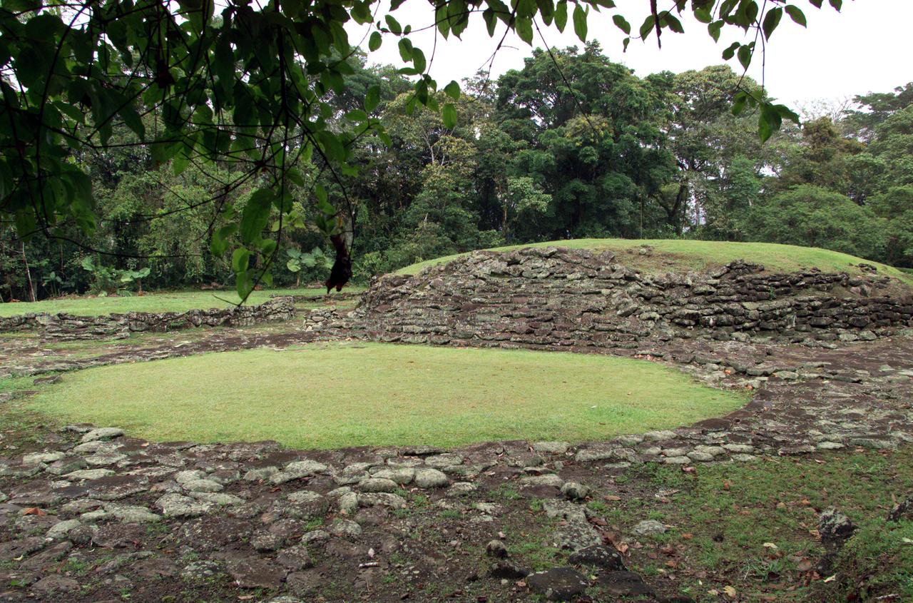
Pre-Columbian archaeological ruins are revealed through Costa Rican rain forest in this photo taken during NASA's AirSAR 2004 Mesoamerica campaign. AirSAR 2004 Mesoamerica is a three-week expedition by an international team of scientists that uses an all-weather imaging tool, called the Airborne Synthetic Aperture Radar (AirSAR) which is located onboard NASA's DC-8 airborne laboratory. The radar, developed by NASA's Jet Propulsion Laboratory, can penetrate clouds and also collect data at night. Its high-resolution sensors operate at multiple wavelengths and modes, allowing AirSAR to see beneath treetops, through thin sand, and dry snow pack. Much of the archaeological evidence needed to understand Pre-Columbian societies in Central America comes from features on the landscape. Difficult terrain and logistics have limited ground data collection. AirSAR helped to detect signs of ancient civilizations hidden beneath the forest. Its images will shed insights into the way modern humans interact with their landscape, and how ancient peoples lived and what became of their civilizations.
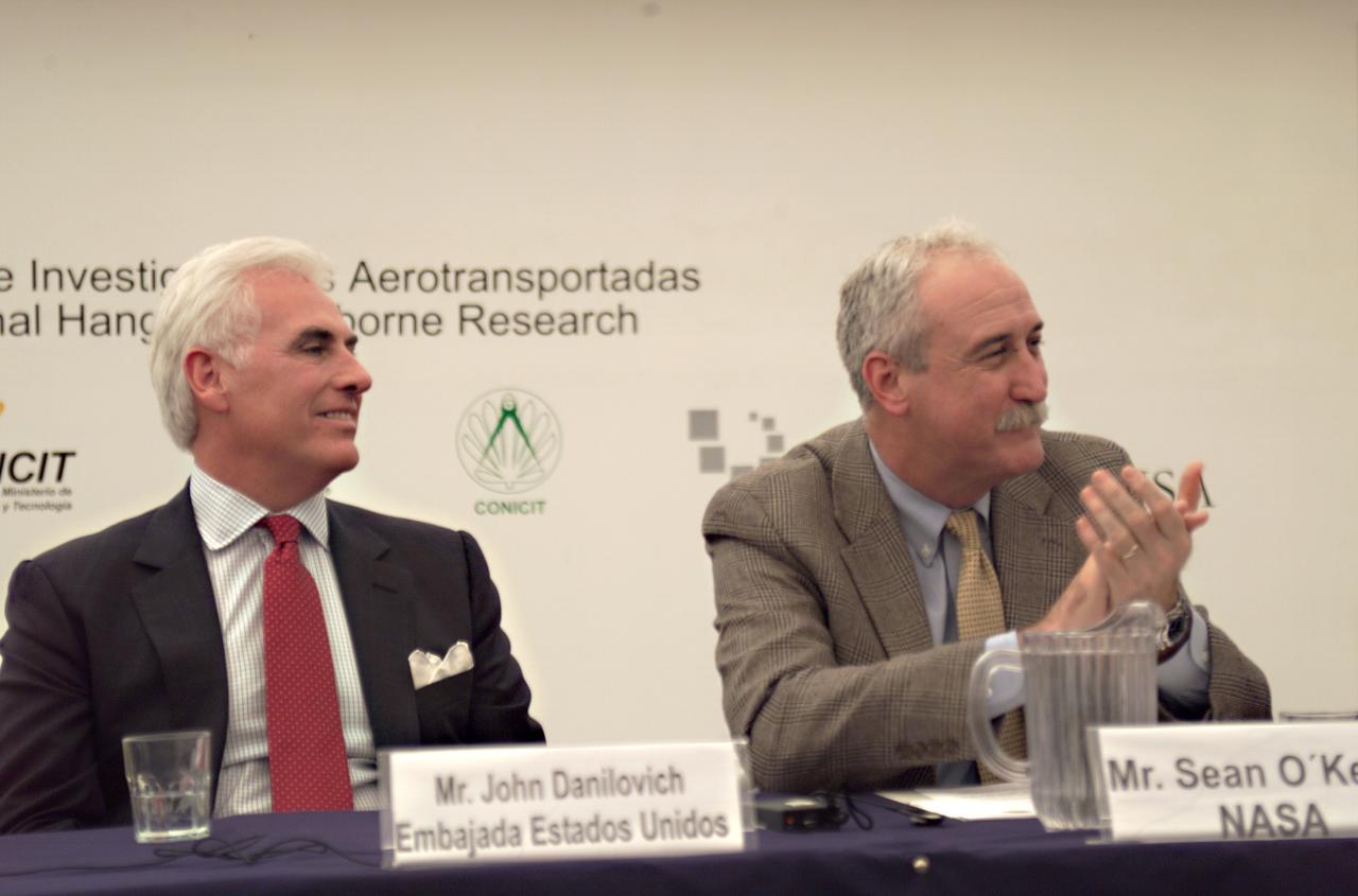
Mr. John Danilovich, US Ambassador to Costa Rica, and NASA Administrator Sean O'Keefe at the AirSAR 2004 Mesoamerica hangar naming ceremony. AirSAR 2004 Mesoamerica is a three-week expedition by an international team of scientists that will use an all-weather imaging tool, called the Airborne Synthetic Aperture Radar (AirSAR), in a mission ranging from the tropical rain forests of Central America to frigid Antarctica.
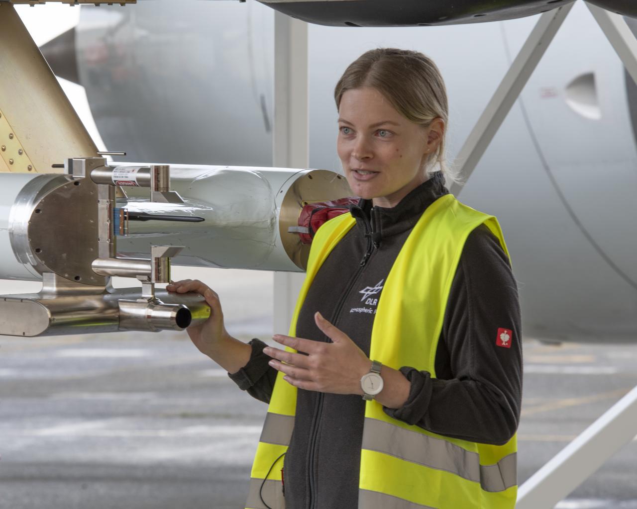
NASA’s DC-8 aircraft from Armstrong Flight Research Center in Edwards, California flies to Everett, Washington to conduct science research about reducing engine particle emissions. Partners include Boeing, United, General Electric Aerospace, German Aerospace Center (DLR), the FAA, and World Energy. Boeing’s new passenger aircraft uses revolutionary Sustainable Aviation Fuel, SAF, and NASA’s DC-8 flies behind the Boeing plane to measure its impact throughout flight. The results of this study will be released publicly to facilitate the improvement of aviation technology worldwide.
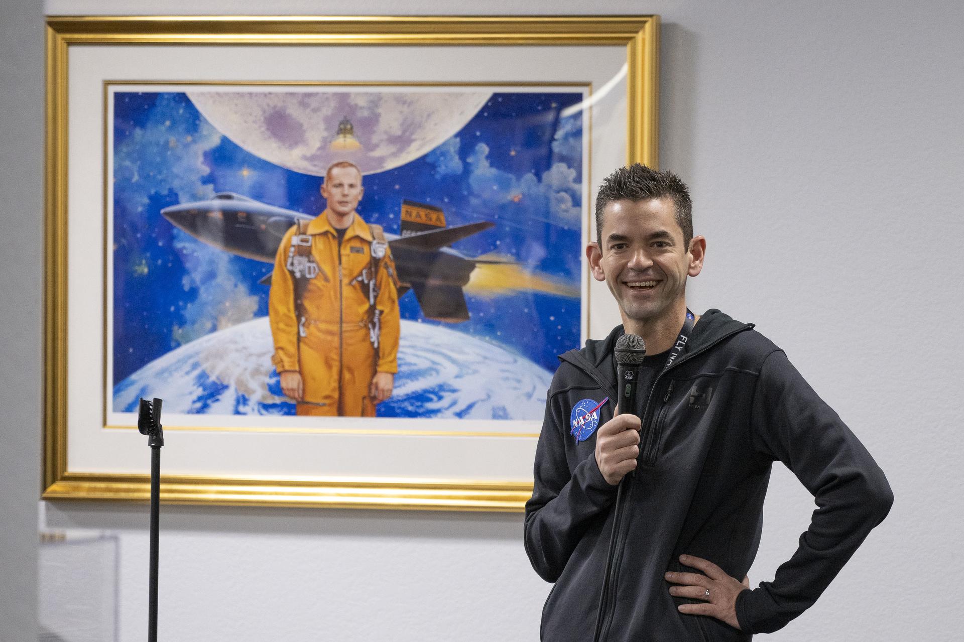
NASA Administrator Jared Isaacman speaks with employees and contractors in front of a painting of former astronaut and research pilot Neil Armstrong during Isaacman’s visit to NASA’s Armstrong Flight Research Center in Edwards, California, on Sunday, Jan. 25, 2026. Isaacman, NASA’s 15th administrator, began visiting the agency’s centers after his appointment on Dec. 17, 2025.
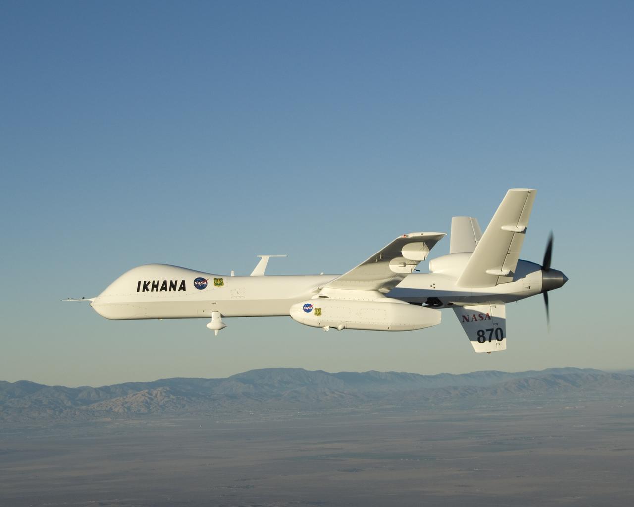
With its sensor pod under its left wing, NASA's remotely piloted Ikhana unmanned aircraft cruises over California during the Western States Fire Mission.
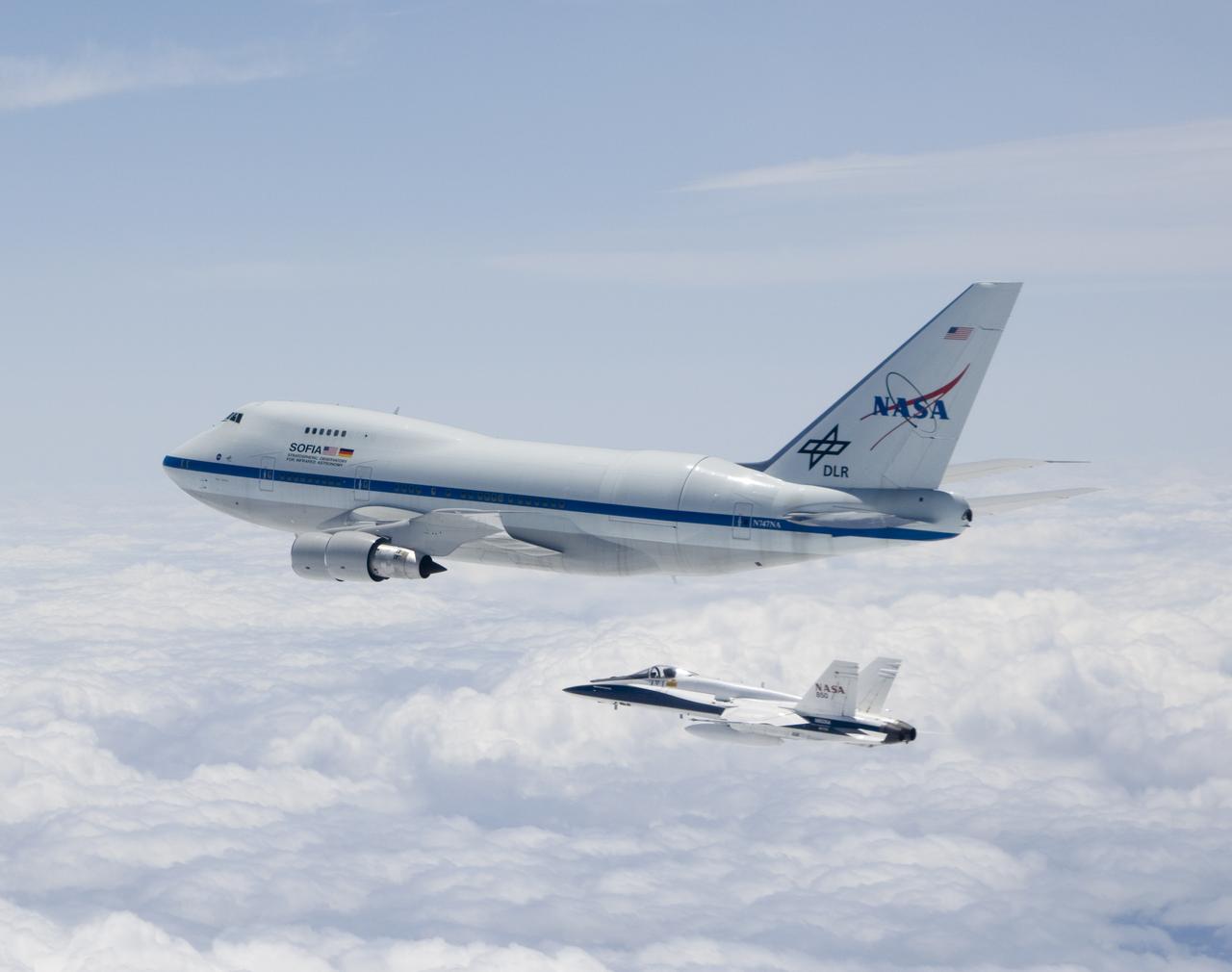
NASA's SOFIA airborne observatory is shadowed by a NASA F/A-18 safety chase aircraft during its second checkout flight near Waco, Texas on May 10, 2007.
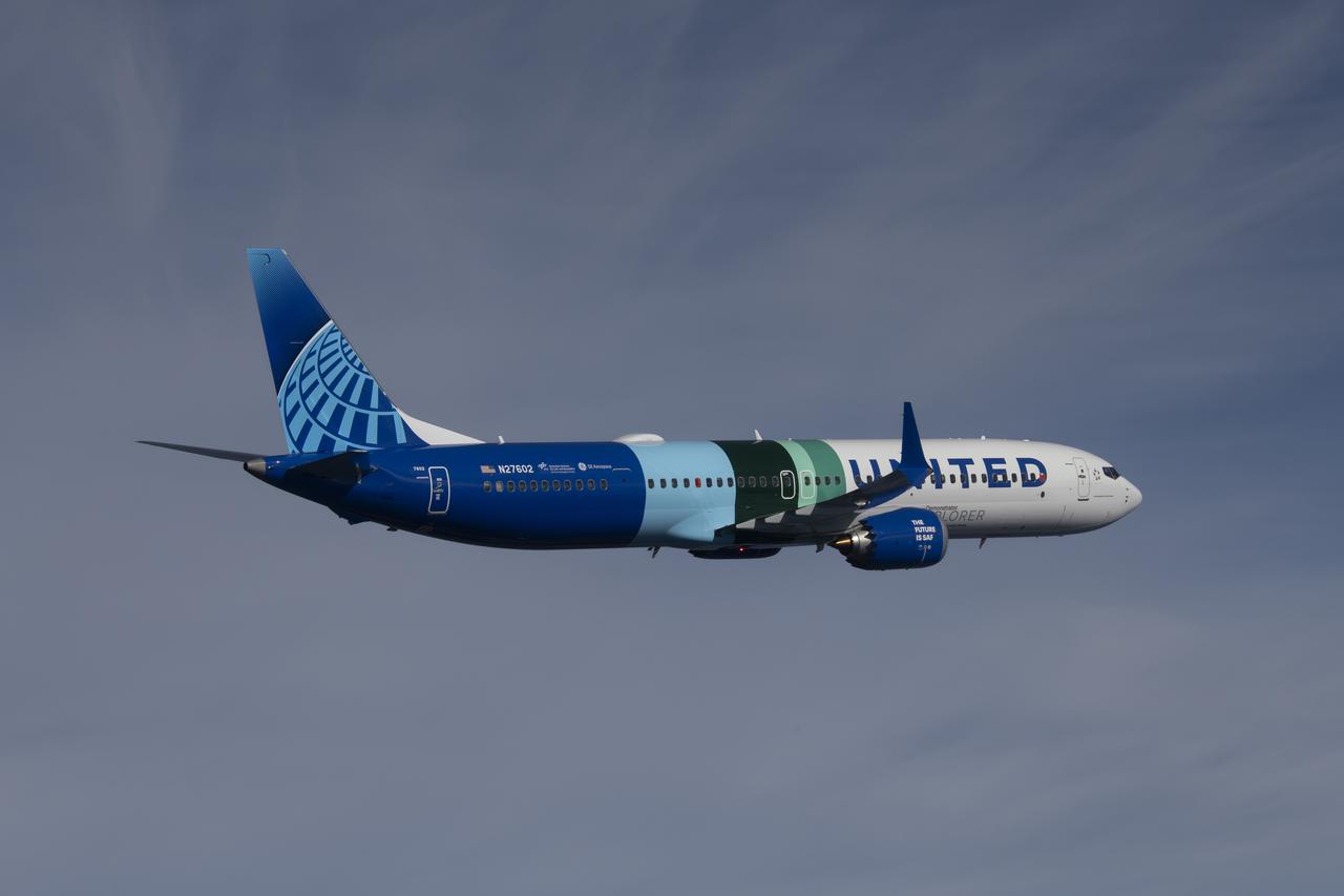
NASA’s DC-8 aircraft from Armstrong Flight Research Center in Edwards, California flies to Everett, Washington to conduct science research about reducing engine particle emissions. Partners include Boeing, United, General Electric Aerospace, German Aerospace Center (DLR), the FAA, and World Energy. Boeing’s new passenger aircraft uses revolutionary Sustainable Aviation Fuel, SAF, and NASA’s DC-8 flies behind the Boeing plane to measure its impact throughout flight. The results of this study will be released publicly to facilitate the improvement of aviation technology worldwide.
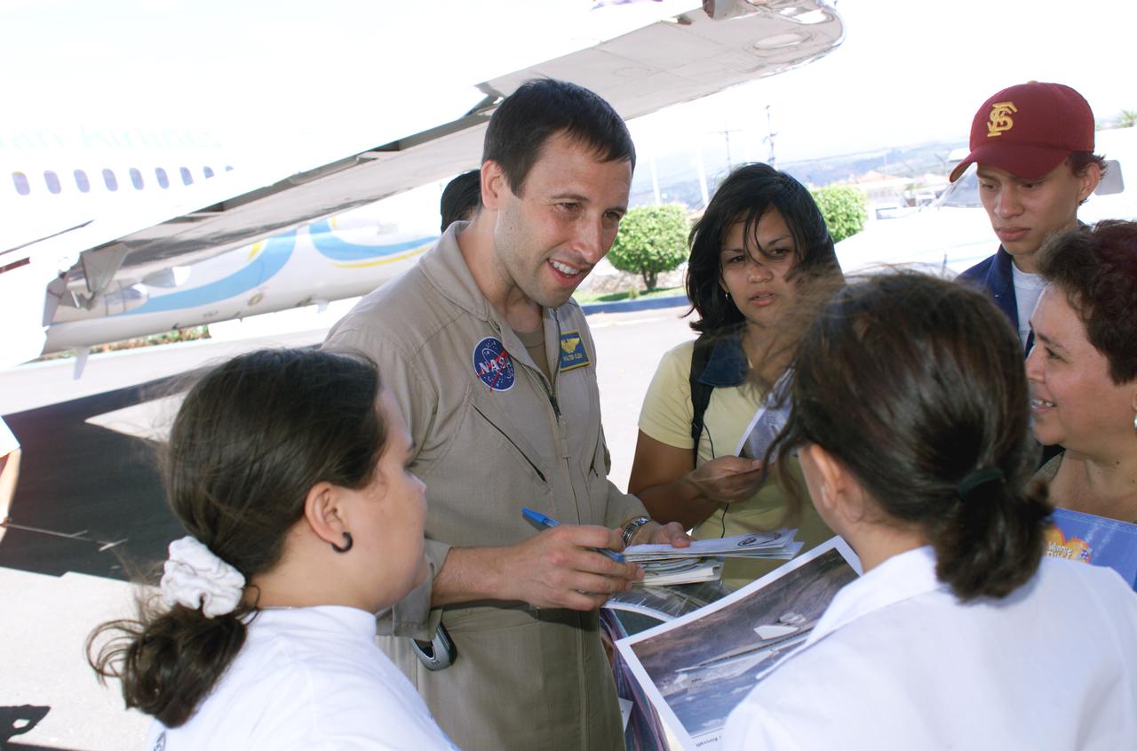
NASA Dryden Mission Manager Walter Klein passes out Airborne Science stickers and lithographs to underprivileged school children that visited the airport on Monday March 8, 2004. In spanish, he explained to them the mission of the DC-8 AirSAR 2004 Mesoamerican campaign in Costa Rica. AirSAR 2004 Mesoamerica is a three-week expedition by an international team of scientists that uses an all-weather imaging tool, called the Airborne Synthetic Aperture Radar (AirSAR) which is located onboard NASA's DC-8 airborne laboratory. Scientists from many parts of the world including NASA's Jet Propulsion Laboratory are combining ground research done in several areas in Central America with NASA's AirSAR technology to improve and expand on the quality of research they are able to conduct. The radar, developed by NASA's Jet Propulsion Laboratory, can penetrate clouds and also collect data at night. Its high-resolution sensors operate at multiple wavelengths and modes, allowing AirSAR to see beneath treetops, through thin sand, and dry snow pack. AirSAR's 2004 campaign is a collaboration of many U.S. and Central American institutions and scientists, including NASA; the National Science Foundation; the Smithsonian Institution; National Geographic; Conservation International; the Organization of Tropical Studies; the Central American Commission for Environment and Development; and the Inter-American Development Bank.
NASA’s DC-8 aircraft from Armstrong Flight Research Center in Edwards, California flies to Everett, Washington to conduct science research about reducing engine particle emissions. Partners include Boeing, United, General Electric Aerospace, German Aerospace Center (DLR), the FAA, and World Energy. Boeing’s new passenger aircraft uses revolutionary Sustainable Aviation Fuel, SAF, and NASA’s DC-8 flies behind the Boeing plane to measure its impact throughout flight. The results of this study will be released publicly to facilitate the improvement of aviation technology worldwide.
NASA's DC-8 flying laboratory takes off from Juan Santamaria International Airport in San Jose, Costa Rica, on NASA's AirSAR 2004 campaign. AirSAR 2004 is a three-week expedition by an international team of scientists that will use an all-weather imaging tool, called the Airborne Synthetic Aperture Radar (AirSAR), in a mission ranging from the tropical rain forests of Central America to frigid Antarctica.
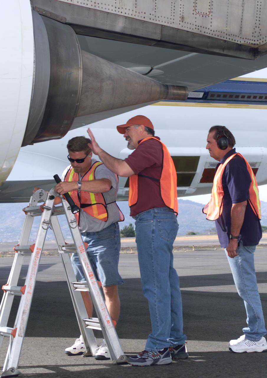
NASA Dryden DC-8 maintenance crew members inspect the aircraft prior to take-off. L-R; Scott Silver, Paul Ristrim and Mike Lakowski. AirSAR 2004 Mesoamerica is a three-week expedition by an international team of scientists that uses an all-weather imaging tool, called the Airborne Synthetic Aperture Radar (AirSAR) which is located onboard NASA's DC-8 airborne laboratory. Scientists from many parts of the world including NASA's Jet Propulsion Laboratory are combining ground research done in several areas in Central America with NASA's AirSAR technology to improve and expand on the quality of research they are able to conduct. The radar, developed by NASA's Jet Propulsion Laboratory, can penetrate clouds and also collect data at night. Its high-resolution sensors operate at multiple wavelengths and modes, allowing AirSAR to see beneath treetops, through thin sand, and dry snow pack. AirSAR's 2004 campaign is a collaboration of many U.S. and Central American institutions and scientists, including NASA; the National Science Foundation; the Smithsonian Institution; National Geographic; Conservation International; the Organization of Tropical Studies; the Central American Commission for Environment and Development; and the Inter-American Development Bank.
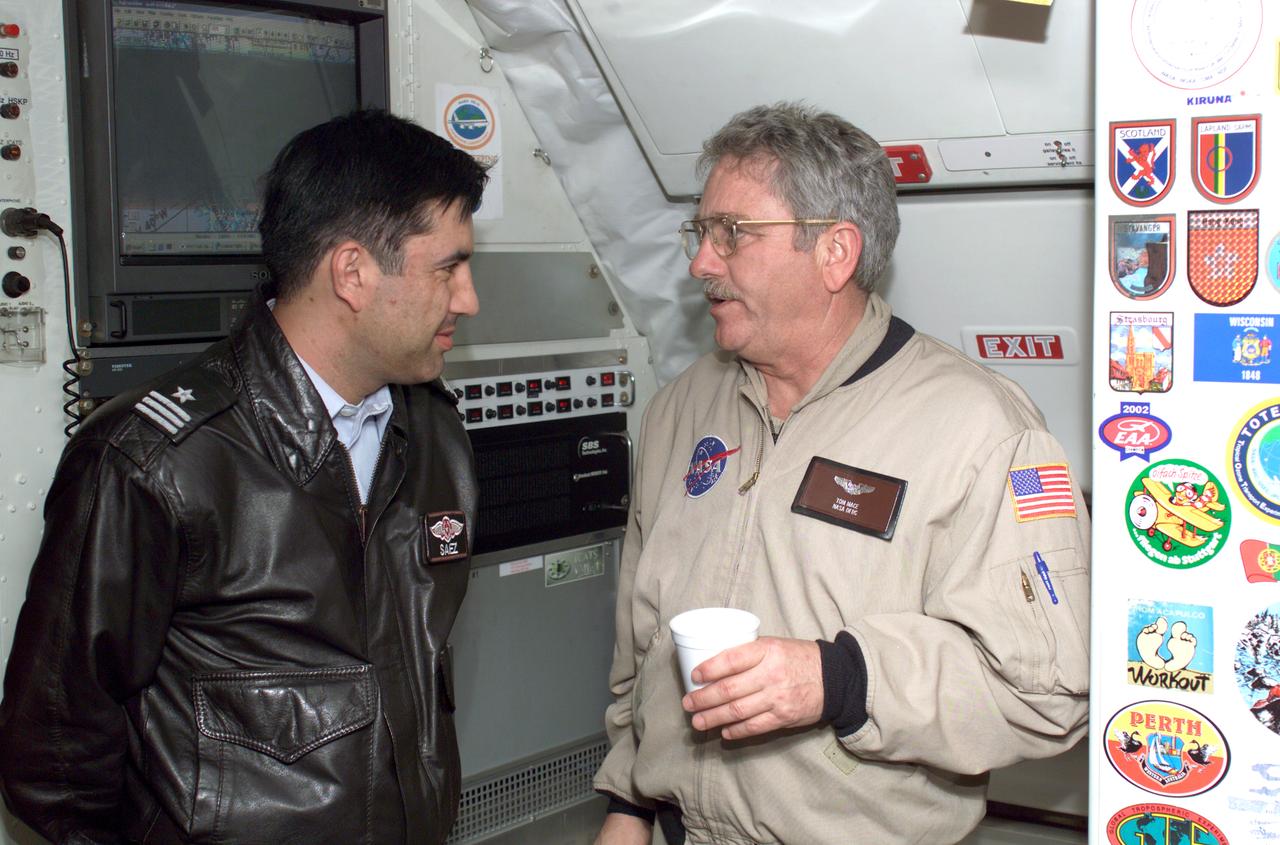
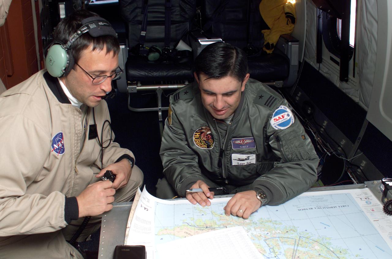
Chilean Air Force Captain Saez and Dr. Tom Mace, DFRC Director of Airborne Sciences, discuss airborne science during a DC-8 ferry flight from Santiago to Punta Arenas, Chile. AirSAR 2004 is a three-week expedition by an international team of scientists that uses an all-weather imaging tool, called the Airborne Synthetic Aperture Radar (AirSAR) which is located onboard NASA's DC-8 airborne laboratory. Scientists from many parts of the world including NASA's Jet Propulsion Laboratory are combining ground research done in several areas in Central and South America with NASA's AirSAR technology to improve and expand on the quality of research they are able to conduct. In South America and Antarctica, AirSAR collected imagery and data to help determine the contribution of Southern Hemisphere glaciers to sea level rise due to climate change. In Patagonia, researchers found this contribution had more than doubled from 1995 to 2000, compared to the previous 25 years. AirSAR data will make it possible to determine whether that trend is continuing or accelerating. AirSAR will also provide reliable information on ice shelf thickness to measure the contribution of the glaciers to sea level.
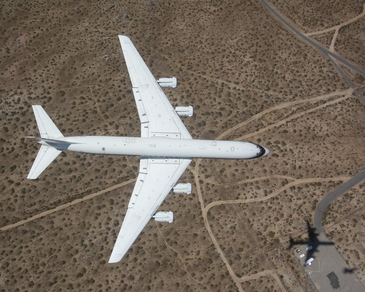
One of NASA’s two modified Boeing 747 Shuttle Carrier Aircraft is bathed in the morning Sun at NASA’s Dryden Flight Research Center at Edwards, California. The modified jumbo jetliners are used to ferry the Space Shuttle orbiters between Dryden and the Kennedy Space Center in Florida and Boeing’s Reusable Space Systems modification facility at Palmdale, California. Features which distinguish the two SCAs from standard 747 jetliners are three struts, with associated interior structural strengthening, which protrude from the top of the fuselage (two aft, one forward) on which the orbiter is attached, and two additional vertical stabilizers, one on each end of the standard horizontal stabilizer, to enhance directional stability. All interior furnishings and equipment aft of the forward No. 1 doors have also been removed to reduce weight. The two SCAs are under the operational control of NASA's Johnson Space Center, Houston, Texas.
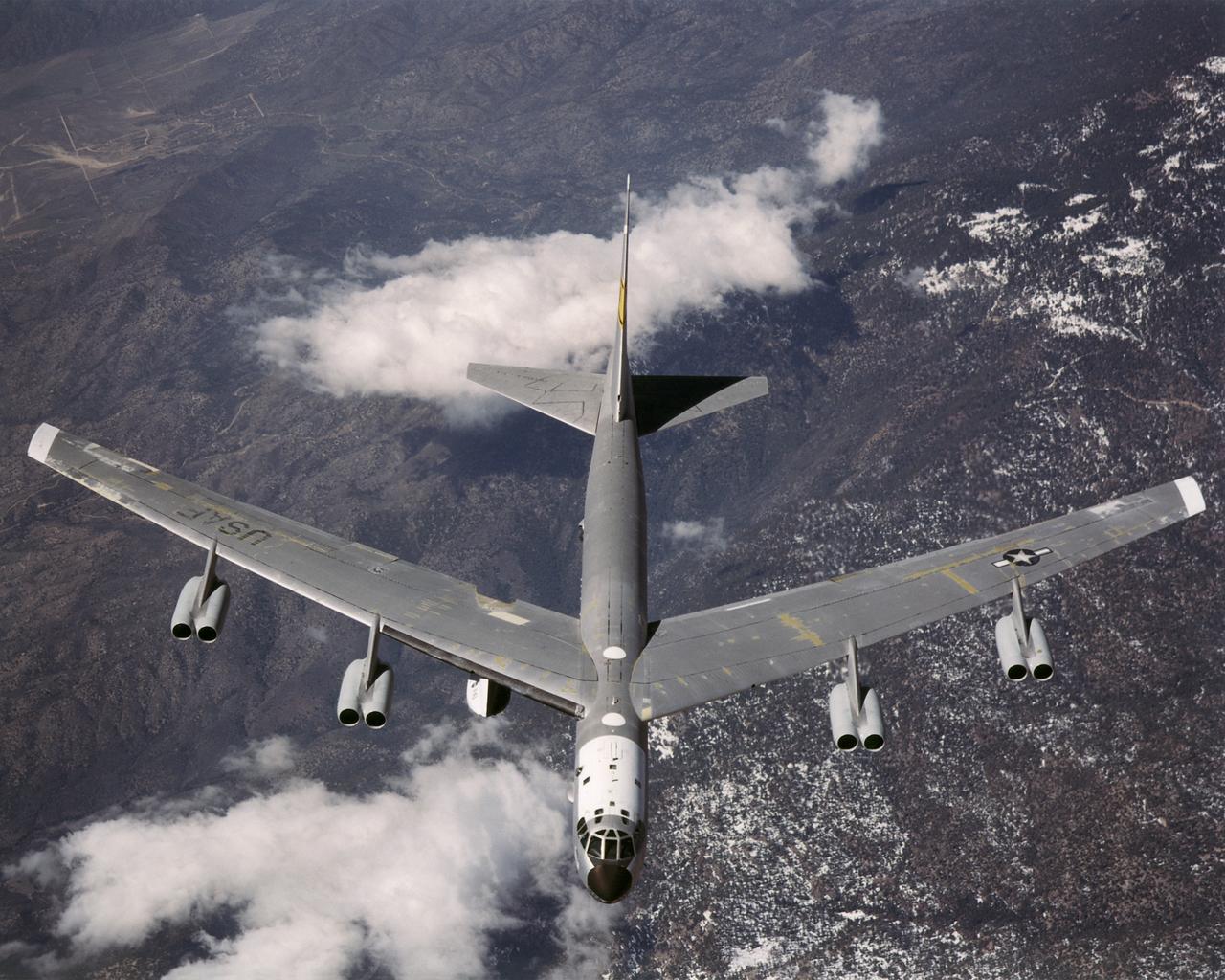
B-52H over Dryden Flight Research Center

The first X-45A Unmanned Combat Air Vehicle (UCAV) technology demonstrator completed its sixth flight on Dec. 19, 2002, raising its landing gear in flight for the first time. The X-45A flew for 40 minutes and reached an airspeed of 195 knots and an altitude of 7,500 feet. Dryden is supporting the DARPA/Boeing team in the design, development, integration, and demonstration of the critical technologies, processes, and system attributes leading to an operational UCAV system. Dryden support of the X-45A demonstrator system includes analysis, component development, simulations, ground and flight tests.
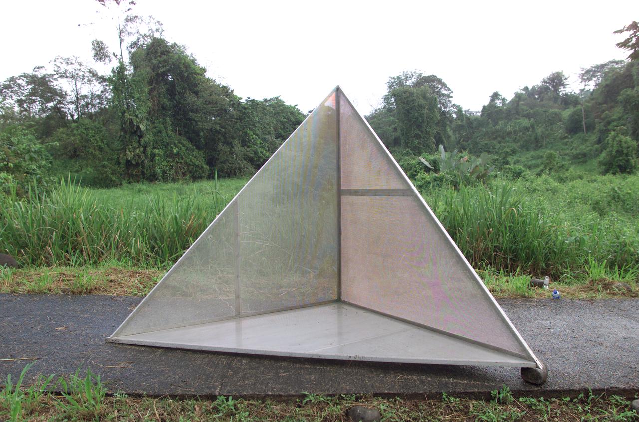
Reflectors setup in the La Selva region of the Costa Rican rain forest by scientist Paul Siqueira from NASA’s Jet Propulsion Lab. These reflectors are used by JPL scientists onboard Dryden's DC-8 aircraft to calibrate the Airborne Synthetic Aperture Radar (AirSAR) system. Scientists place these reflectors at known points on the ground, allowing researchers onboard the aircraft to verify their data. AirSAR 2004 Mesoamerica is a three-week expedition by an international team of scientists that uses an all-weather imaging tool, called the Airborne Synthetic Aperture Radar (AirSAR) which is located onboard NASA's DC-8 airborne laboratory. Scientists from many parts of the world including NASA's Jet Propulsion Laboratory are combining ground research done in several areas in Central America with NASA's AirSAR technology to improve and expand on the quality of research they are able to conduct. The radar, developed by NASA's Jet Propulsion Laboratory, can penetrate clouds and also collect data at night. Its high-resolution sensors operate at multiple wavelengths and modes, allowing AirSAR to see beneath treetops, through thin sand, and dry snow pack. AirSAR's 2004 campaign is a collaboration of many U.S. and Central American institutions and scientists, including NASA; the National Science Foundation; the Smithsonian Institution; National Geographic; Conservation International; the Organization of Tropical Studies; the Central American Commission for Environment and Development; and the Inter-American Development Bank.
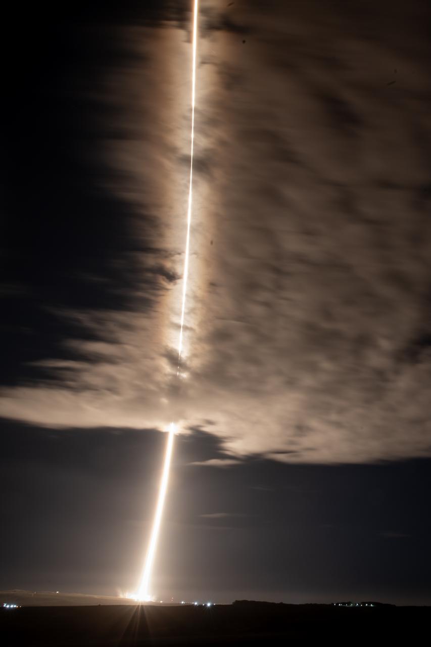
A streak lights up the sky following the launch of NASA’s SPHEREx (Spectro-Photometer for the History of the Universe, Epoch of Reionization and Ices Explorer) observatory and PUNCH (Polarimeter to Unify the Corona and Heliosphere) satellites at Space Launch Complex 4 East from Vandenberg Space Force Base in California on Tuesday, March 11, 2025. SPHEREx will use its telescope to provide an all-sky spectral survey, creating a 3D map of the entire sky to help scientists investigate the origins of our universe. PUNCH will study origins of the Sun’s outflow of material, or the solar wind, capturing continuous 3D images of the Sun’s corona and the solar wind’s journey into the solar system.

A Beech T-34C flown by NASA Dryden Flight Research Center for mission support descends over the Southern California desert near Edwards Air Force Base.
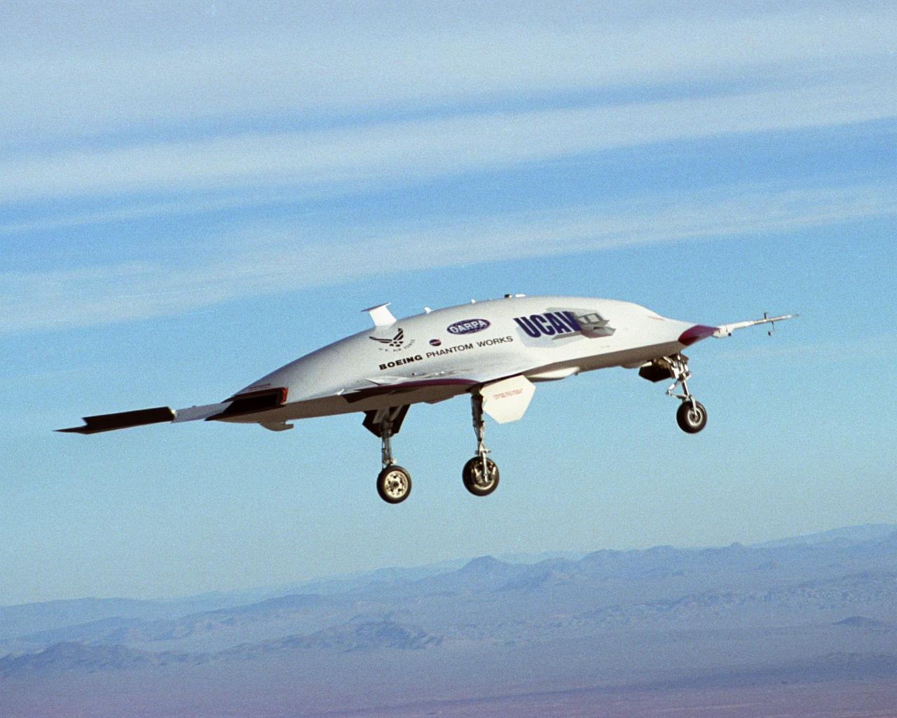
The second X-45A Unmanned Combat Air Vehicle (UCAV) technology demonstrator completed its first flight on November 21, 2002, after taking off from a dry lakebed at NASA's Dryden Flight Research Center, Edwards Air Force Base, California. X-45A vehicle two flew for approximately 30 minutes and reached an airspeed of 195 knots and an altitude of 7500 feet. This flight validated the functionality of the UCAV flight software on the second air vehicle. Dryden is supporting the DARPA/Boeing team in the design, development, integration, and demonstration of the critical technologies, processes, and system attributes leading to an operational UCAV system. Dryden support of the X-45A demonstrator system includes analysis, component development, simulations, ground and flight tests.

Glacier Grey view from Lago Grey (Grey Lake), photographed during NASA's AirSAR 2004 campaign in Chile. Land visible in this photo was covered by glacier just 6 years earlier. AirSAR 2004 is a three-week expedition in Central and South America by an international team of scientists that is using an all-weather imaging tool, called the Airborne Synthetic Aperture Radar (AirSAR), located onboard NASA's DC-8 airborne laboratory. Scientists from many parts of the world are combining ground research with NASA's AirSAR technology to improve and expand on the quality of research they are able to conduct. Founded in 1959, Torres del Paine National Park encompasses 450,000 acres in the Patagonia region of Chile. This region is being studied by NASA using a DC-8 equipped with an Airborne Synthetic Aperture Radar (AirSAR) developed by scientists from NASA’s Jet Propulsion Laboratory. This is a very sensitive region that is important to scientists because the temperature has been consistently rising causing a subsequent melting of the region’s glaciers. AirSAR will provide a baseline model and unprecedented mapping of the region. This data will make it possible to determine whether the warming trend is slowing, continuing or accelerating. AirSAR will also provide reliable information on ice shelf thickness to measure the contribution of the glaciers to sea level.
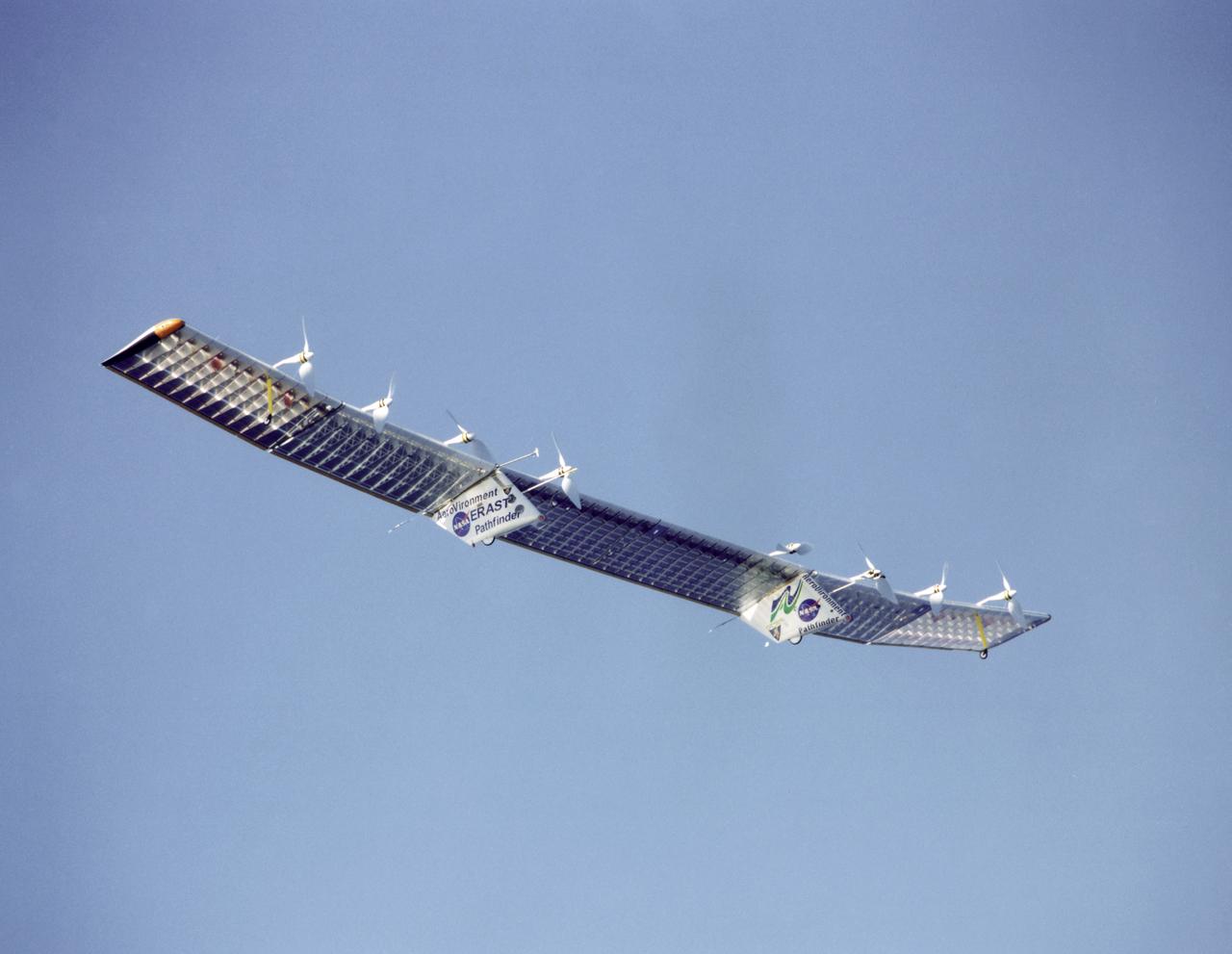
Pathfinder-Plus on flight over Hawaii.

The Space Shuttle Endeavour receives post-flight servicing in the Mate-Demate Device (MDD), following its landing at NASA's Dryden Flight Research Center, Edwards, California, May 1, 2001. Once servicing was complete, one of NASA's two 747 Shuttle Carrier Aircraft, No. 905, was readied to ferry Endeavour back to the Kennedy Space Center, FL.
NASA’s DC-8 aircraft from Armstrong Flight Research Center in Edwards, California flies to Everett, Washington to conduct science research about reducing engine particle emissions. Partners include Boeing, United, General Electric Aerospace, German Aerospace Center (DLR), the FAA, and World Energy. Boeing’s new passenger aircraft uses revolutionary Sustainable Aviation Fuel, SAF, and NASA’s DC-8 flies behind the Boeing plane to measure its impact throughout flight. The results of this study will be released publicly to facilitate the improvement of aviation technology worldwide.

Julianna Scheiman, director, NASA Science Missions, SpaceX, participates in a prelaunch news conference on Friday, March 7, 2025, to discuss the upcoming launch of NASA’s SPHEREx (Spectro-Photometer for the History of the Universe, Epoch of Reionization and Ices Explorer) observatory and PUNCH (Polarimeter to Unify the Corona and Heliosphere) satellites at Vandenberg Space Force Base in California. SPHEREx will use its telescope to provide an all-sky spectral survey, creating a 3D map of the entire sky to help scientists investigate the origins of our universe. PUNCH will study origins of the Sun’s outflow of material, or the solar wind, capturing continuous 3D images of the Sun’s corona and the solar wind’s journey into the solar system. Liftoff aboard a SpaceX Falcon 9 rocket is targeted for NET 10:10 p.m. EST (7:10 p.m. PST), Saturday, March 8, 2025, at Space Launch Complex 4 East from Vandenberg Space Force Base in California.
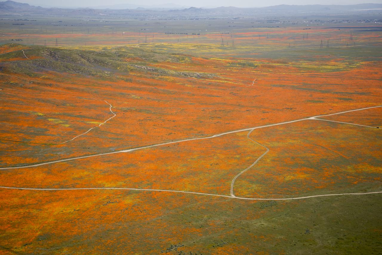
View from a NASA aircraft, TG-14, over the Superbloom of yellow wildflowers and orange poppies from the Antelope Valley in Southern California, Poppy Reserve and solar panels are in the background.
DC-8 returning from AFWEX deployment showing AeroSAPIENT Ku-band antennas
NASA’s DC-8 aircraft from Armstrong Flight Research Center in Edwards, California flies to Everett, Washington to conduct science research about reducing engine particle emissions. Partners include Boeing, United, General Electric Aerospace, German Aerospace Center (DLR), the FAA, and World Energy. Boeing’s new passenger aircraft uses revolutionary Sustainable Aviation Fuel, SAF, and NASA’s DC-8 flies behind the Boeing plane to measure its impact throughout flight. The results of this study will be released publicly to facilitate the improvement of aviation technology worldwide.
JPL scientist Dr. David Imel and U.S. Air Force Colonel Gwen Linde, the Defense Department Attache Officer assigned to the Chilean Embassy, lead Chilean students on a tour of the DC-8 aircraft at Carlos Ibanez del Campo International Airport in Punta Arenas, Chile. AirSAR 2004 is a three-week expedition by an international team of scientists that is using an all-weather imaging tool, called the Airborne Synthetic Aperture Radar (AirSAR) which is located onboard NASA's DC-8 airborne laboratory. Scientists from many parts of the world including NASA's Jet Propulsion Laboratory are combining ground research done in several areas in Central and South America with NASA's AirSAR technology to improve and expand on the quality of research they are able to conduct. In South America and Antarctica, AirSAR will collect imagery and data to help determine the contribution of Southern Hemisphere glaciers to sea level rise due to climate change. In Patagonia, researchers found this contribution had more than doubled from 1995 to 2000, compared to the previous 25 years. AirSAR data will make it possible to determine whether that trend is decreasing, continuing or accelerating. AirSAR will also provide reliable information on ice shelf thickness to measure the contribution of the glaciers to sea level.
The Eclipse projectís modified QF-106 under tow by a USAF C-141A.

The Larsen Ice Shelf in Antarctica viewed from NASA's DC-8 aircraft during the AirSAR 2004 campaign. AirSAR 2004 is a three-week expedition in Central and South America by an international team of scientists that is using an all-weather imaging tool, called the Airborne Synthetic Aperture Radar (AirSAR), located onboard NASA's DC-8 airborne laboratory. Scientists from many parts of the world are combining ground research with NASA's AirSAR technology to improve and expand on the quality of research they are able to conduct. These photos are from the DC-8 aircraft while flying an AirSAR mission over Antarctica. The Antarctic Peninsula is more similar to Alaska and Patagonia than to the rest of the Antarctic continent. It is drained by fast glaciers, receives abundant precipitation, and melts significantly in the summer months. In recent decades, the Peninsula has experienced significant atmospheric warming (about 2 degrees C since 1950), which has triggered a vast and spectacular retreat of its floating ice shelves, glacier reduction, a decrease in permanent snow cover and a lengthening of the melt season. As a result, the contribution to sea level from this region could be rapid and substantial. With an area of 120,000 km, or ten times the Patagonia ice fields, the Peninsula could contribute as much as 0.4mm/yr sea level rise, which would be the largest single contribution to sea level from anywhere in the world. This region is being studied by NASA using a DC-8 equipped with the Airborne Synthetic Aperture Radar developed by scientists from NASA’s Jet Propulsion Laboratory. AirSAR will provide a baseline model and unprecedented mapping of the region. This data will make it possible to determine whether the warming trend is slowing, continuing or accelerating. AirSAR will also provide reliable information on ice shelf thickness to measure the contribution of the glaciers to sea level.
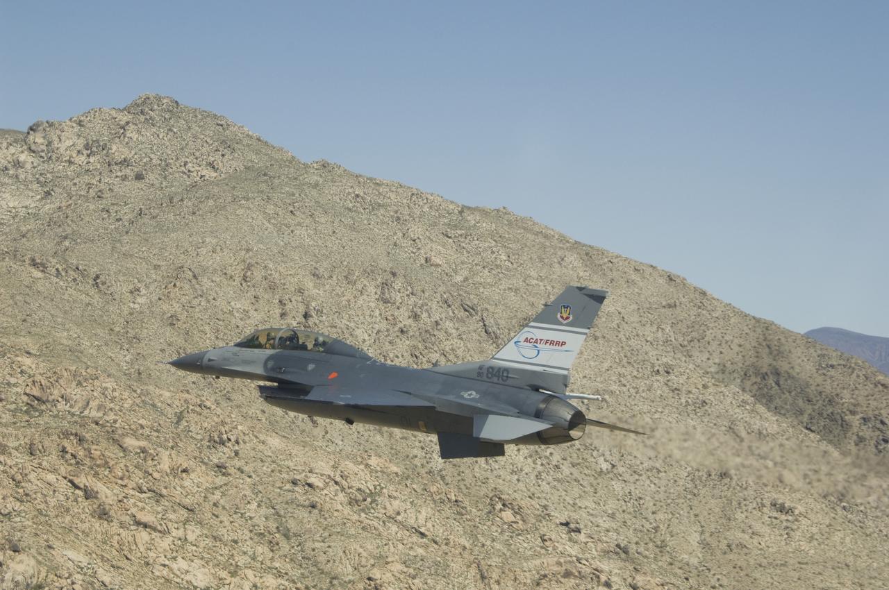
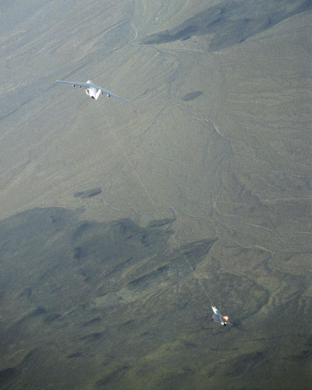
The U.S. Air Force's F-16D Automatic Collision Avoidance Technology (ACAT) aircraft crew takes a close look at a Mojave Desert hill during a March 2009 flight. NASA's Dryden Flight Research Center worked with the Air Force Research Laboratory in the ACAT Fighter Risk Reduction Project to develop collision avoidance technologies for fighter/attack aircraft that would reduce the risk of ground and mid-air collisions.
NASA Dryden Flight Research Center's F-18B Systems Research Aircraft on an External Vision System project flight.
Dr. Tom Mace, NASA DFRC Director of Airborne Sciences, greets NASA Administrator Sean O'Keefe as he enters the DC-8 aircraft during a stop-off on the AirSAR 2004 Mesoamerica campaign. AirSAR 2004 Mesoamerica is a three-week expedition by an international team of scientists that will use an all-weather imaging tool, called the Airborne Synthetic Aperture Radar (AirSAR), in a mission ranging from the tropical rain forests of Central America to frigid Antarctica.
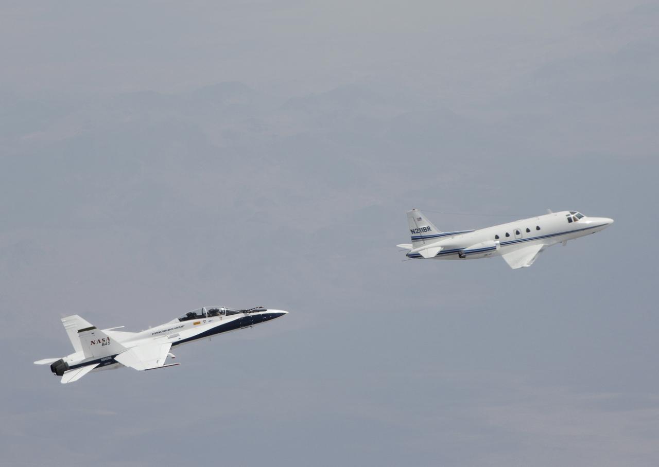
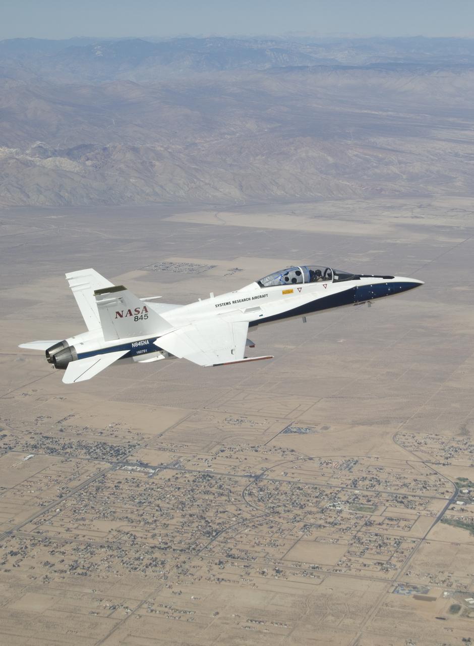
Testing autonomous software for AARD program using a NASA F/A-18 #845 following a chartered Sabreliner.

Erin Askins, second from left, accepts the 2018 NASA Armstrong Exchange Harold W. Walker Memorial Scholarship from Center Director David McBride. Next to Erin Askins is her mother Dana Askins.

NASA’s DC-8 aircraft from Armstrong Flight Research Center in Edwards, California flies to Everett, Washington to conduct science research about reducing engine particle emissions. Partners include Boeing, United, General Electric Aerospace, German Aerospace Center (DLR), the FAA, and World Energy. Boeing’s new passenger aircraft uses revolutionary Sustainable Aviation Fuel, SAF, and NASA’s DC-8 flies behind the Boeing plane to measure its impact throughout flight. The results of this study will be released publicly to facilitate the improvement of aviation technology worldwide.

Space Shuttle Discovery landed safely at NASA's Dryden Flight Research Center at Edwards Air Force Base in Calif. at 5:11:22 a.m. PDT this morning, following the very successful 14-day STS-114 return to flight mission. During their two weeks in space, Commander Eileen Collins and her six crewmates tested out new safety procedures and delivered supplies and equipment the International Space Station. Discovery spent two weeks in space, where the crew demonstrated new methods to inspect and repair the Shuttle in orbit. The crew also delivered supplies, outfitted and performed maintenance on the International Space Station. A number of these tasks were conducted during three spacewalks. In an unprecedented event, spacewalkers were called upon to remove protruding gap fillers from the heat shield on Discovery's underbelly. In other spacewalk activities, astronauts installed an external platform onto the Station's Quest Airlock and replaced one of the orbital outpost's Control Moment Gyroscopes. Inside the Station, the STS-114 crew conducted joint operations with the Expedition 11 crew. They unloaded fresh supplies from the Shuttle and the Raffaello Multi-Purpose Logistics Module. Before Discovery undocked, the crews filled Raffeallo with unneeded items and returned to Shuttle payload bay. Discovery launched on July 26 and spent almost 14 days on orbit.
NASA DC-8 Mission Manager Walter Klein and Chilean Air Force Advisor Captain Saez review maps of the Antarctic Peninsula during an AirSAR 2004 mission. AirSAR 2004 is a three-week expedition in Central and South America by an international team of scientists that is using an all-weather imaging tool, called the Airborne Synthetic Aperture Radar (AirSAR), located onboard NASA's DC-8 airborne laboratory. Scientists from many parts of the world are combining ground research with NASA's AirSAR technology to improve and expand on the quality of research they are able to conduct. These photos are from the DC-8 aircraft while flying an AirSAR mission over Antarctica. The Antarctic Peninsula is more similar to Alaska and Patagonia than to the rest of the Antarctic continent. It is drained by fast glaciers, receives abundant precipitation, and melts significantly in the summer months. In recent decades, the Peninsula has experienced significant atmospheric warming (about 2 degrees C since 1950), which has triggered a vast and spectacular retreat of its floating ice shelves, glacier reduction, a decrease in permanent snow cover and a lengthening of the melt season. As a result, the contribution to sea level from this region could be rapid and substantial. With an area of 120,000 km, or ten times the Patagonia ice fields, the Peninsula could contribute as much as 0.4mm/yr sea level rise, which would be the largest single contribution to sea level from anywhere in the world. This region is being studied by NASA using a DC-8 equipped with the Airborne Synthetic Aperture Radar developed by scientists from NASA’s Jet Propulsion Laboratory. AirSAR will provide a baseline model and unprecedented mapping of the region. This data will make it possible to determine whether the warming trend is slowing, continuing or accelerating. AirSAR will also provide reliable information on ice shelf thickness to measure the contribution of the glaciers to sea level.
B-52 Launch Aircraft in Flight
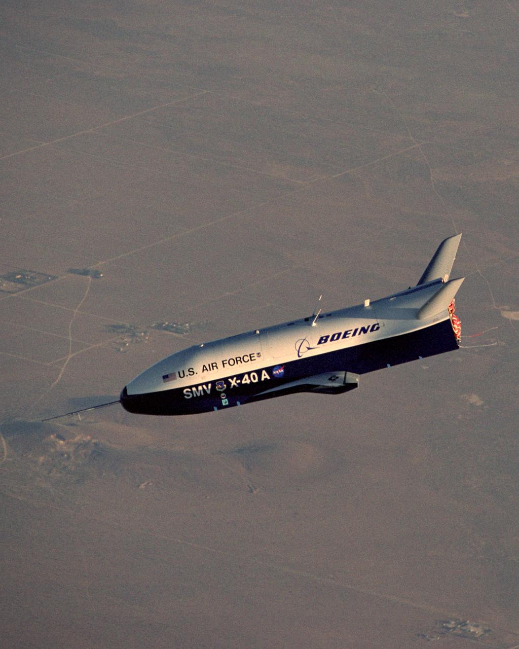
X-40A Free Flight #5. The unpowered X-40A, an 85 percent scale risk reduction version of the proposed X-37, proved the capability of an autonomous flight control and landing system in a series of glide flights at NASA's Dryden Flight Research Center in California. NASA's Marshall Space Flight Center in Huntsville, Alabama, manages the X-37 project. At Dryden, the X-40A underwent a series of ground and air tests to reduce possible risks to the larger X-37, including drop tests from a helicopter to check guidance and navigation systems planned for use in the X-37. The X-37 is designed to demonstrate technologies in the orbital and reentry environments for next-generation reusable launch vehicles that will increase both safety and reliability, while reducing launch costs from $10,000 per pound to $1,000 per pound.
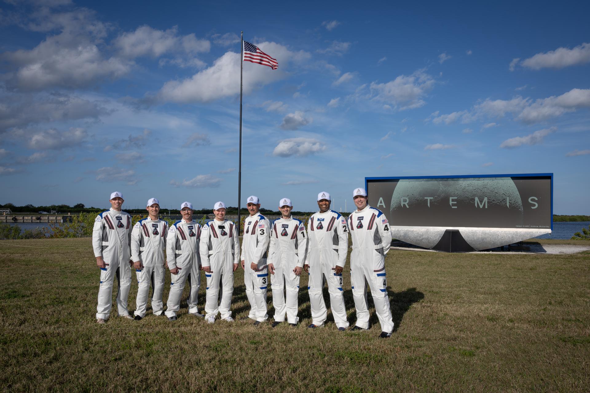
Members of the Artemis II closeout crew, from left, William Sattler; Tyler Sutherland; Michael Heinemann; Jenni Gibbons, Artemis II backup crew member; Bill Owens; Taylor Hose; Andre Douglas, Artemis II backup crew member; and Christian Warriner pose for a photo near the countdown clock featuring the Artemis Moon logo at the NASA News Center at the agency’s Kennedy Space Center in Florida on Thursday, Dec. 19, 2025. The closeout crew is responsible for safely securing the astronauts inside the Orion spacecraft on launch day and closing the hatch during launch countdown.

NASA’s DC-8 aircraft from Armstrong Flight Research Center in Edwards, California flies to Everett, Washington to conduct science research about reducing engine particle emissions. Partners include Boeing, United, General Electric Aerospace, German Aerospace Center (DLR), the FAA, and World Energy. Boeing’s new passenger aircraft uses revolutionary Sustainable Aviation Fuel, SAF, and NASA’s DC-8 flies behind the Boeing plane to measure its impact throughout flight. The results of this study will be released publicly to facilitate the improvement of aviation technology worldwide.

The Space Shuttle Endeavour, accompanied by a convoy of recovery vehicles, is towed up the taxiway at NASA's Dryden Flight Research Center at Edwards Air Force Base, California, following its landing on June 19, 2002. The landing, the 49th to occur at Edwards, concluded mission STS-111 to the International Space Station. It was the 18th orbital mission of Endeavour and the 110th space shuttle mission overall.
Two panels of Space Shuttle TPS insulation were mounted on the flight test fixture underneath NASA's F-15B during the Lifting Foam Trajectory flight test series.
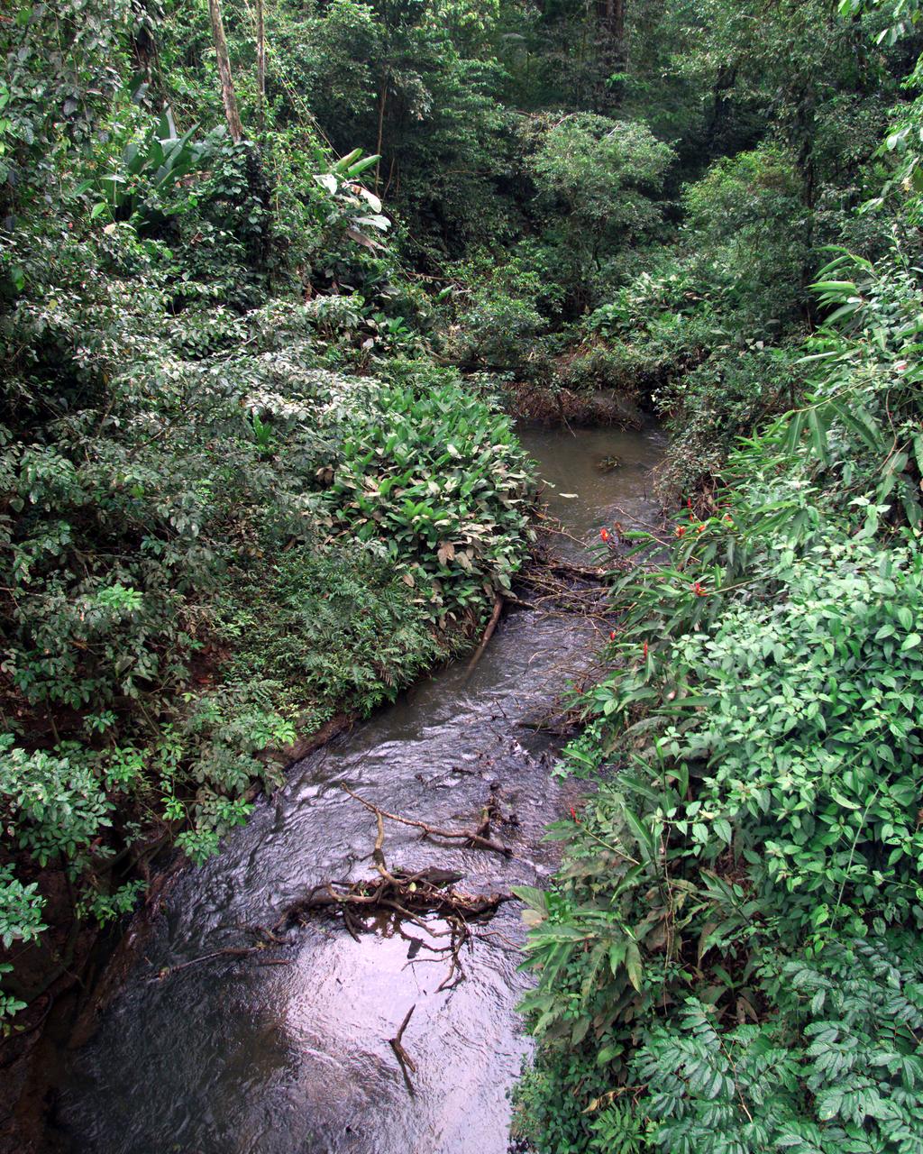
This photograph shows a stream in the La Selva region of the Costa Rican rain forest, taken during NASA's AirSAR 2004 Mesoamerica campaign. AirSAR 2004 Mesoamerica is a three-week expedition by an international team of scientists that will use an all-weather imaging tool, called the Airborne Synthetic Aperture Radar (AirSAR) which is located onboard NASA's DC-8 airborne laboratory. Scientists from many parts of the world including NASA's Jet Propulsion Laboratory are combining ground research done in several areas in Central America with NASA's AirSAR technology to improve and expand on the quality of research they are able to do. NASA's AIRSAR technolgy provides two essential elements to the ground-based scientists. First, it tests and provides accurate measurements of the forest structure. Secondly, AirSAR can study a larger area of the forest versus the smaller area that can be tested and plotted by the ground scientists. It also provides a unique one-of-a-kind system of measurement that obtains important information for the scientists, such as where forests are located and what exactly is in them.