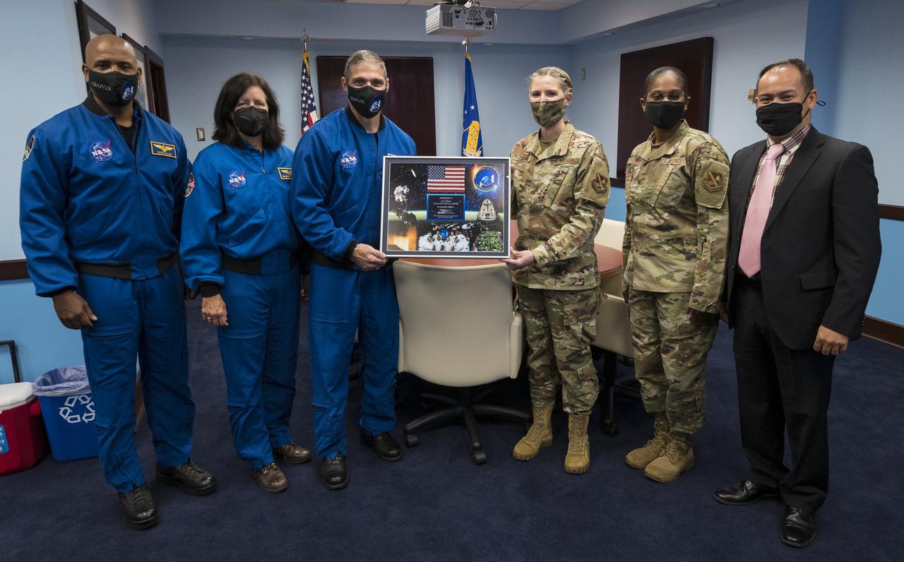
SpaceX Crew-1 NASA astronauts, from left, Victor Glover, Shannon Walker, and Mike Hopkins, pose for a photo after presenting a montage from their mission to Col. Catherine Logan, commander of Joint Base Anacostia-Bolling (JBAB), Chief Master Sergeant at Joint Base Anacostia-Bolling, Christy L. Peterson, and Director of Staff at Joint Base Anacostia-Bolling, John Eichstadt, Friday, Nov. 19, 2021, in Washington. Hopkins, Glover, Walker, and Japan Aerospace Exploration Agency (JAXA) astronaut Soichi Noguchi, launched on the first crew rotation mission to the International Space Station for SpaceX’s Falcon 9 and Crew Dragon spacecraft as part of the agency’s Commercial Crew Program and spent 168 days in space across Expeditions 64 and 65. Photo Credit: (NASA/Aubrey Gemignani)
This mosaic combines color-enhanced images taken over Jupiter's north pole when the lighting was excellent for detecting high bands of haze. The images were taken in the final hours of Juno's perijove 12 approach on April 1, 2018. Citizen scientists Gerald Eichstädt and John Rogers created this image using data from the spacecraft's JunoCam imager. https://photojournal.jpl.nasa.gov/catalog/PIA22934. - Enhanced image by Gerald Eichstädt and John Rogers based on images provided courtesy of NASA/JPL-Caltech/SwRI/MSSS
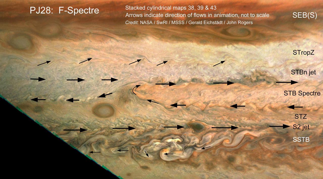
The motion of small clouds on Jupiter is used to determine wind direction (indicated with arrows) in this work by citizen scientists John Rogers and Gerald Eichstädt. Using multiple images to track the motion of clouds was enabled by the Juno spacecraft's slow departure from Jupiter's southern hemisphere on perijove pass 28, on July 25, 2020. Zonal winds are a well-known phenomenon on Jupiter, correlating with its familiar belts and zones. Within a latitudinal band there can be regional circulation, such as the South Temperate Belt (STB) Spectre shown in this image. The STB Spectre is cyclonic (winds rotating in clockwise direction), spread out in latitude but confined in longitude. This work is representative of an ongoing and fruitful collaboration of amateur astronomers with the Juno project. John Rogers analyzed cloud movement in three JunoCam images processed by citizen scientist Gerald Eichstädt to identify winds. Latitudinal belts and zones ( labeled with the conventions used by the amateur astronomy community and professional observers), are: SEB(S): South Equatorial Belt (south); STropZ: South Tropical Zone; STBn jet: South Temperate Belt (north) jet; STZ: South Temperate Zone; and SSTB: South South Temperate Belt. https://photojournal.jpl.nasa.gov/catalog/PIA24235
The JunoCam imager on NASA's Juno spacecraft snapped this shot of Jupiter's northern latitudes on Dec. 11, 2016 at 8:47 a.m. PST (11:47 a.m. EST), as the spacecraft performed a close flyby of the gas giant planet. The spacecraft was at an altitude of 10,300 miles (16,600 kilometers) above Jupiter's cloud tops. This stunning view of the high north temperate latitudes fortuitously shows NN-LRS-1, a giant storm known as the Little Red Spot (lower left). This storm is the third largest anticyclonic reddish oval on the planet, which Earth-based observers have tracked for the last 23 years. An anticyclone is a weather phenomenon with large-scale circulation of winds around a central region of high atmospheric pressure. They rotate clockwise in the northern hemisphere, and counterclockwise in the southern hemisphere. The Little Red Spot shows very little color, just a pale brown smudge in the center. The color is very similar to the surroundings, making it difficult to see as it blends in with the clouds nearby. Citizen scientists Gerald Eichstaedt and John Rogers processed the image and drafted the caption. http://photojournal.jpl.nasa.gov/catalog/PIA21378. - Enhanced image by Gerald Eichstädt / John Rogers based on images provided courtesy of NASA/JPL-Caltech/SwRI/MSSS
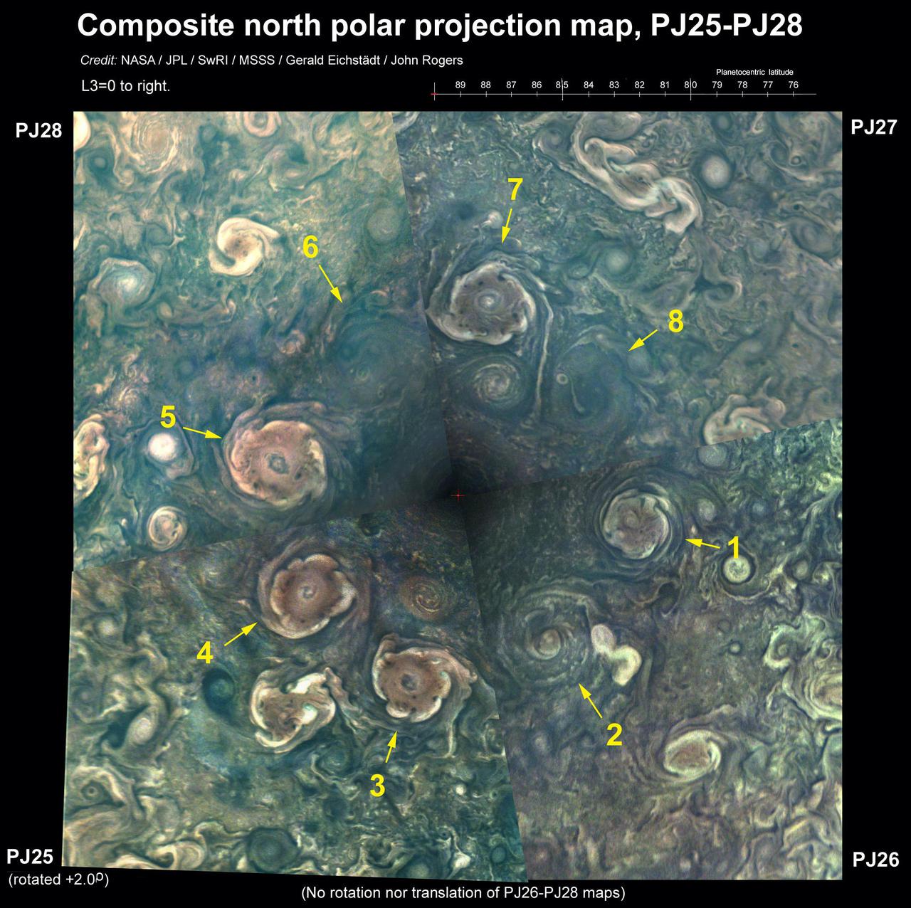
This composite of images from the JunoCam imager aboard NASA's Juno spacecraft shows the eight circumpolar cyclones around a central cyclone located at Jupiter's north pole. The sizes of these cyclones range from 1,500 miles (2,400 kilometers) to 1,740 miles (2,800 kilometers) across — about the same distance from the southern tip of Texas to the border with Canada. The composite depicts the remarkable stability of the octogonal configuration: No cyclones have arrived or disappeared since Juno began its mission in 2016. The evolution of Juno's elliptical orbit is bringing the spacecraft closer to the north pole on each pass. At the beginning of Juno's mission the northern polar cyclone was hidden in polar night, but as the Sun moves toward the northern hemisphere, it is beginning to emerge into the daylight. As a visible camera JunoCam can only take pictures when the cyclones are in daylight, it took four perijove passes to see all eight. The original JunoCam images used to produce this composite were taken during consecutive science passes on Feb. 17, April 10, June 2, and July 25 of 2020. Citizen scientist Gerald Eichstädt processed the images to enhance the color and contrast. Citizen scientist John Rogers created the composite and added the labels. https://photojournal.jpl.nasa.gov/catalog/PIA24237