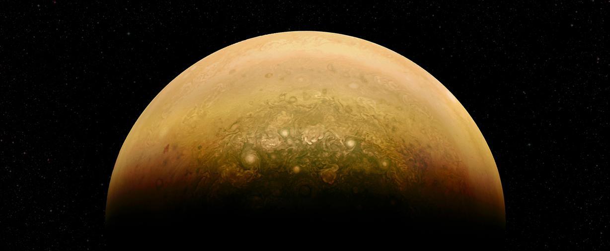
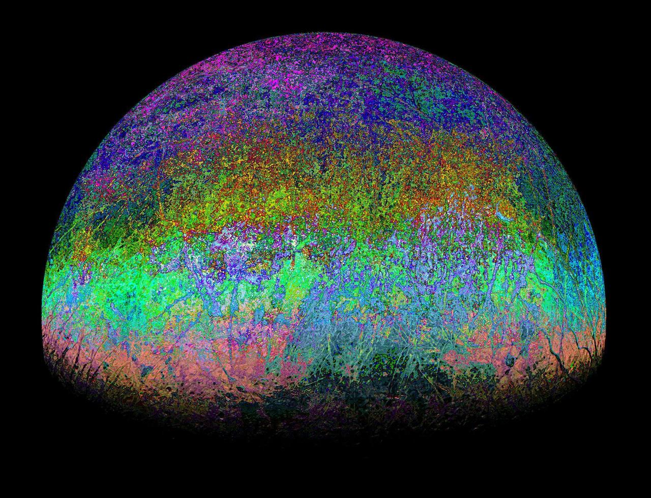
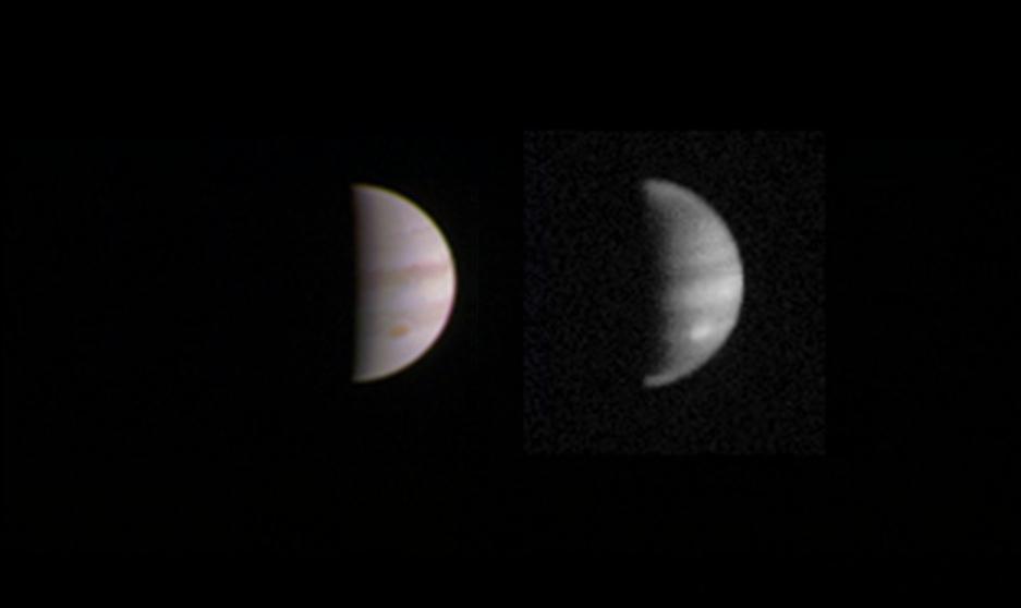
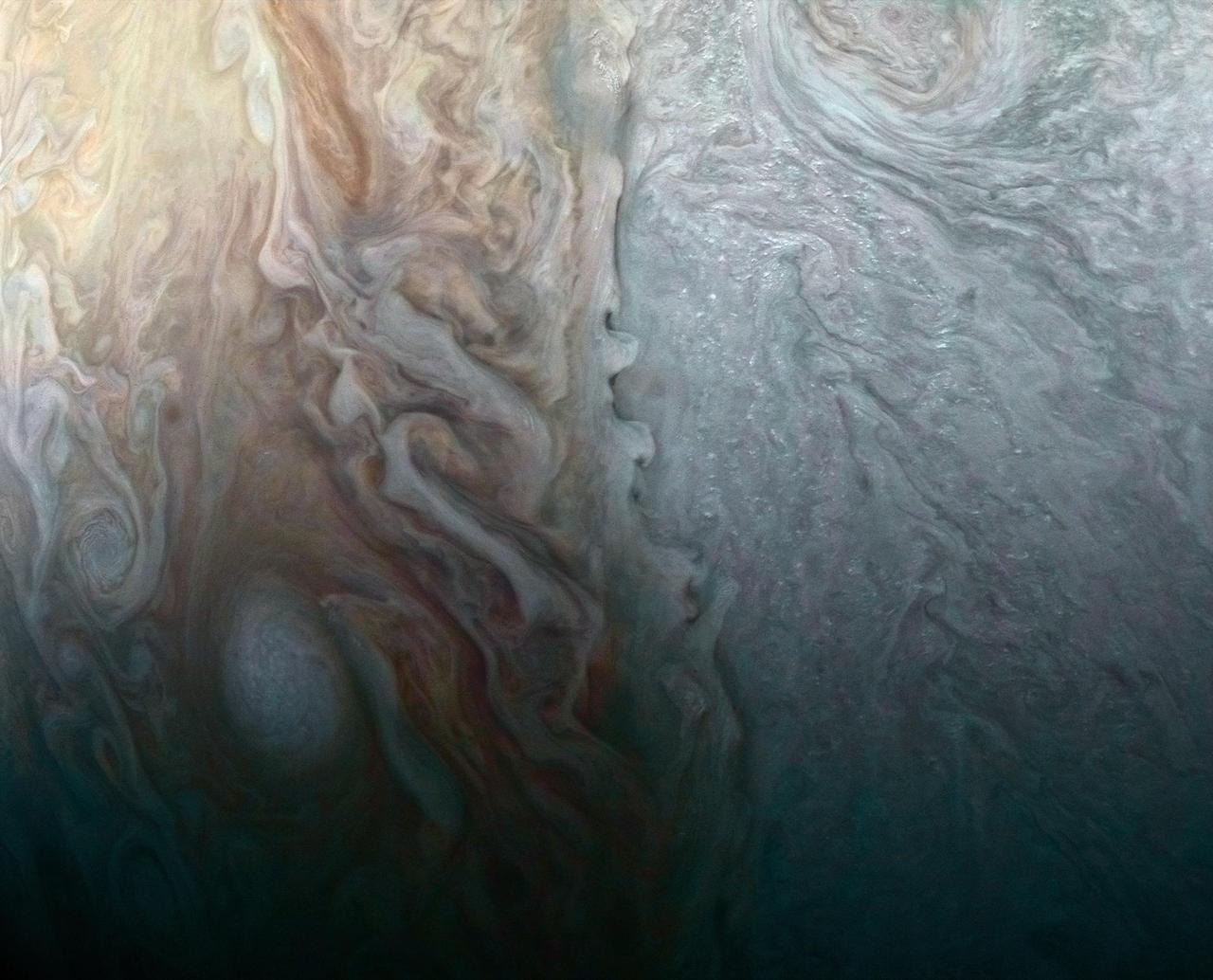
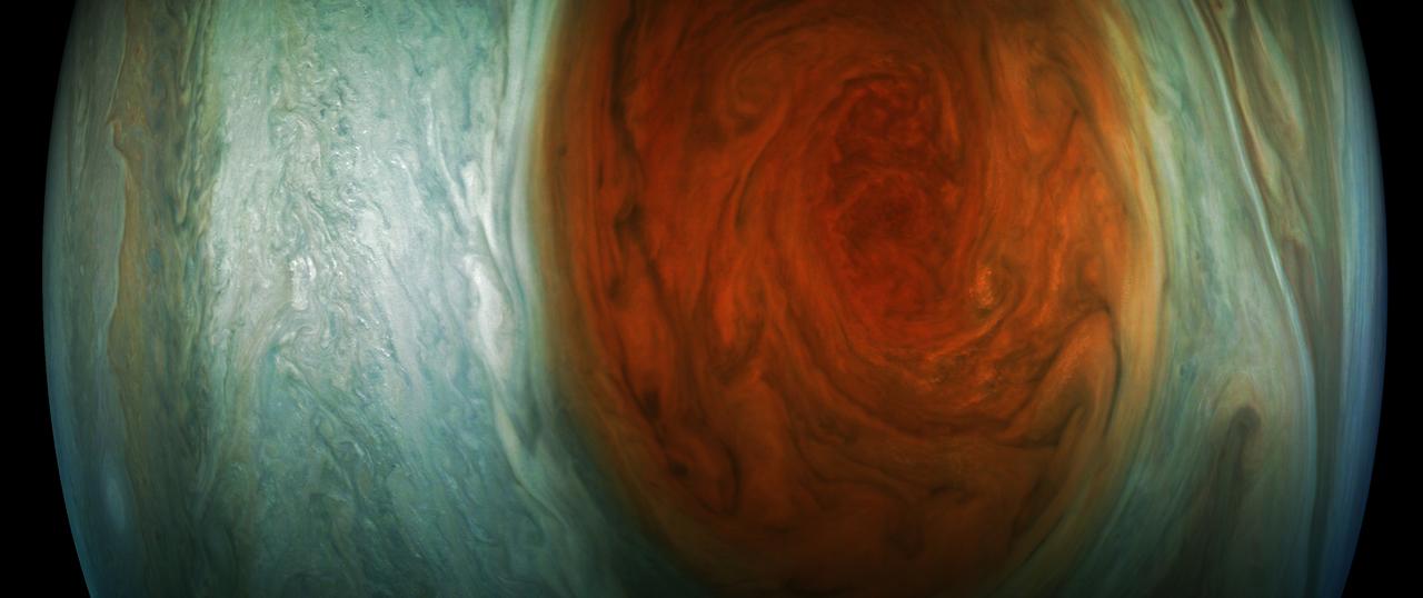
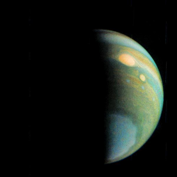
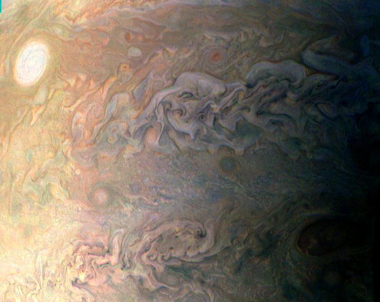
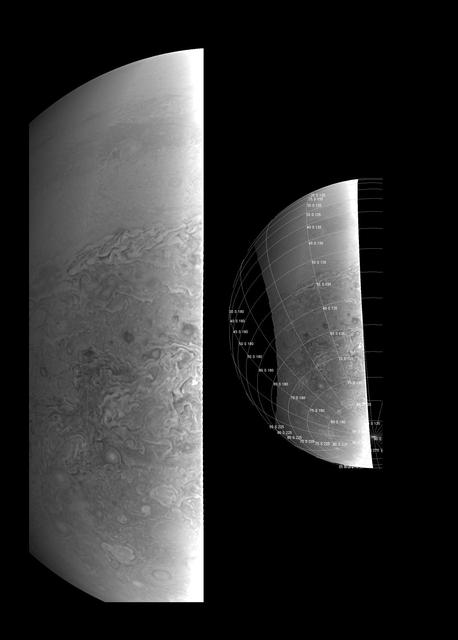
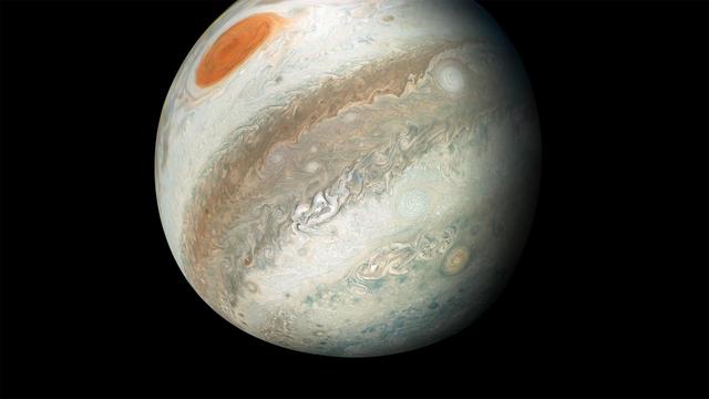
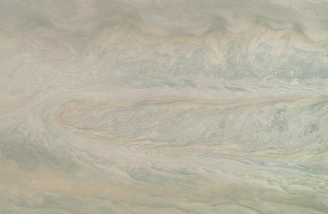
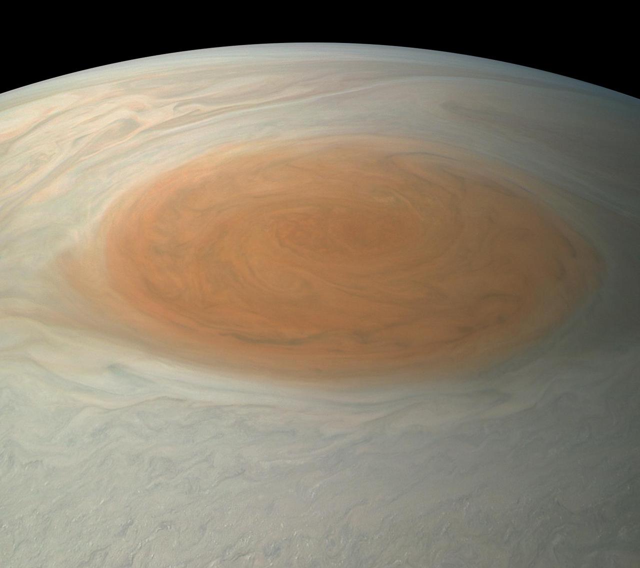
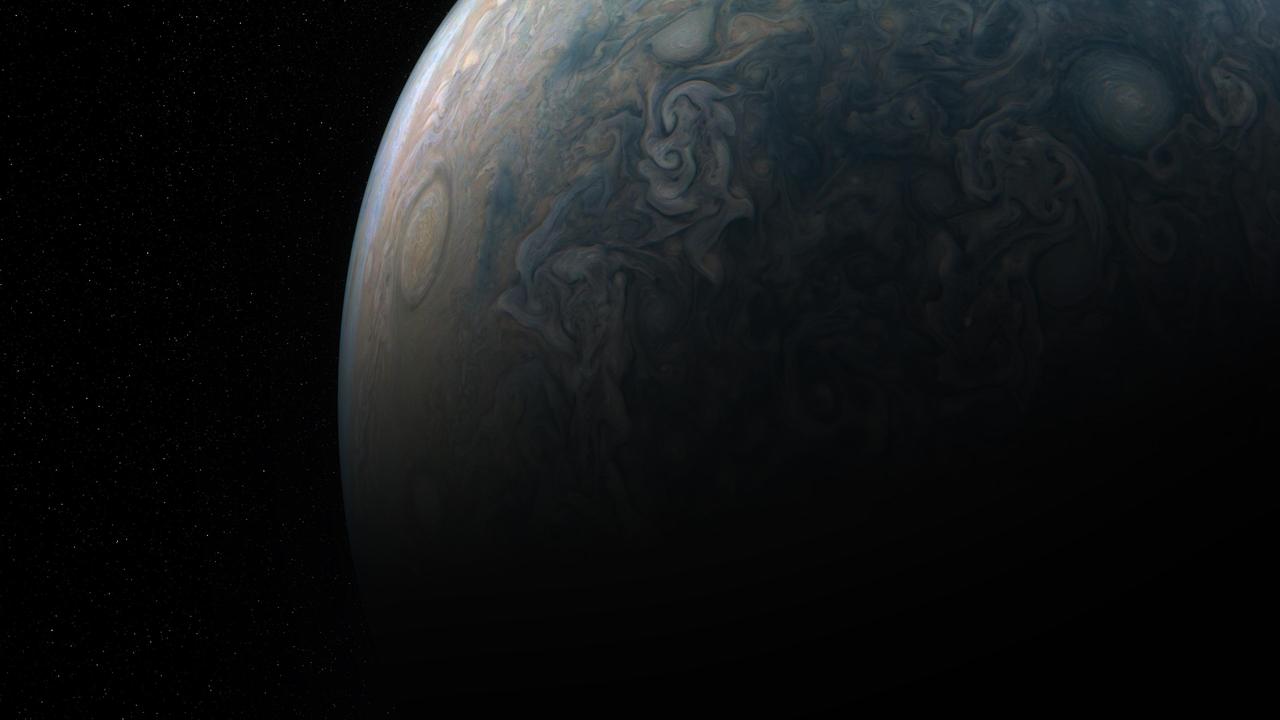
This image of the sunlit part of Jupiter and its swirling atmosphere was created by a citizen scientist (Alex Mai) using data from Juno's JunoCam instrument. JunoCam's raw images are available at www.missionjuno.swri.edu/junocam for the public to peruse and process into image products. http://photojournal.jpl.nasa.gov/catalog/PIA21108 . - Enhanced image by Alex Mai (CC-BY) based on images provided courtesy of NASA/JPL-Caltech/SwRI/MSSS
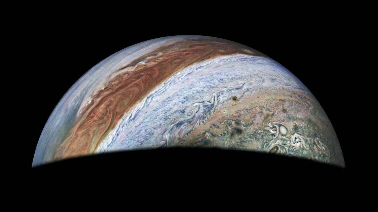
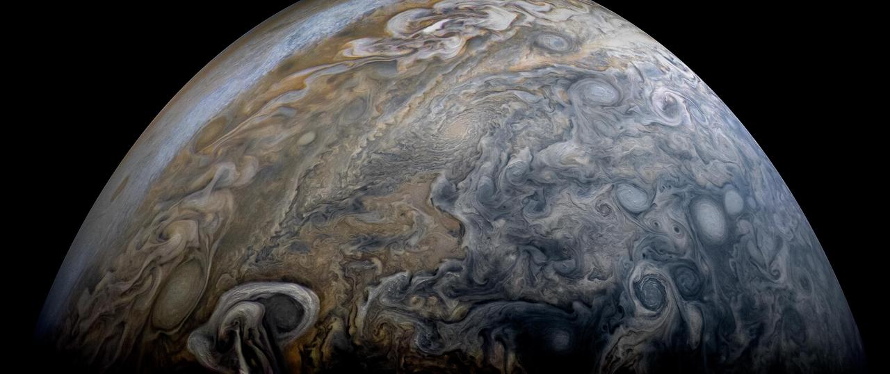
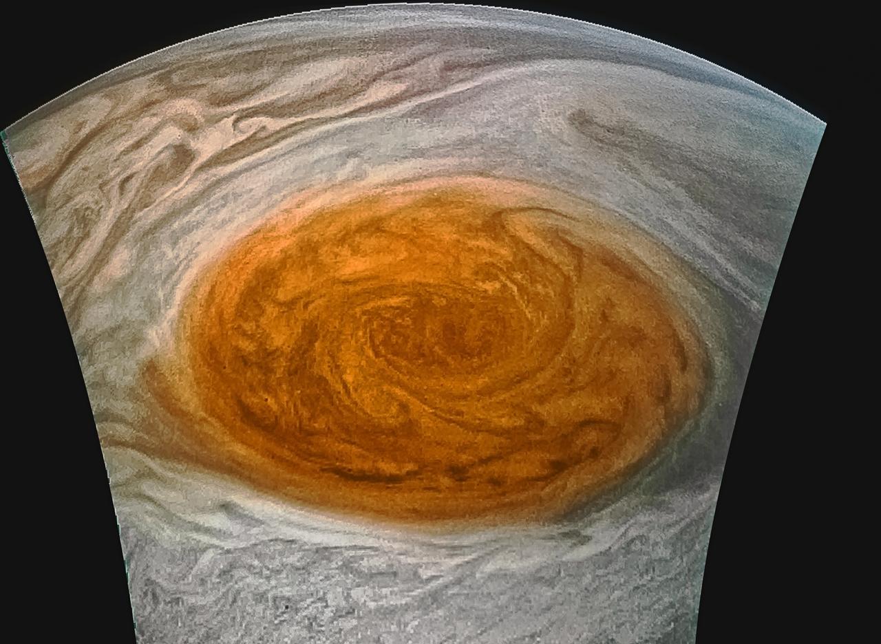
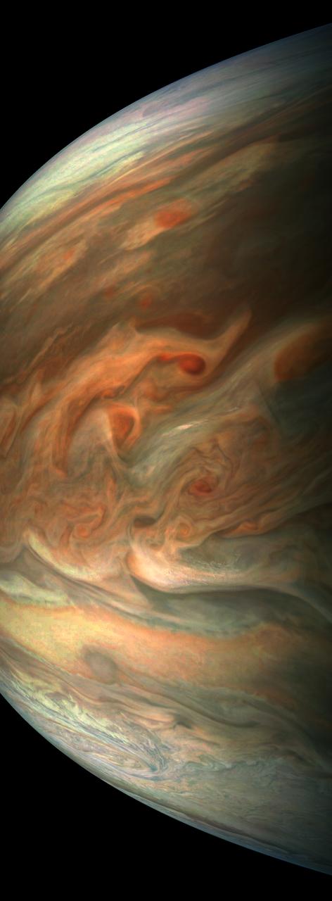
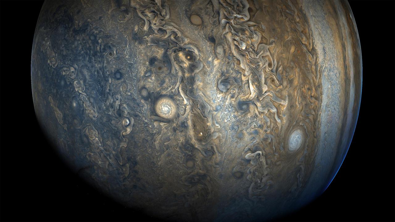
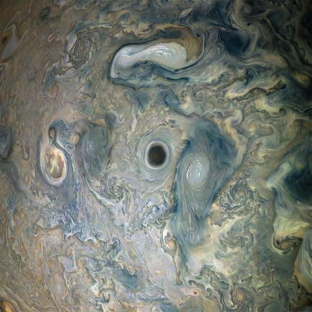
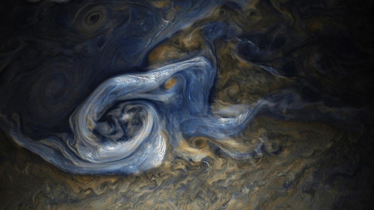
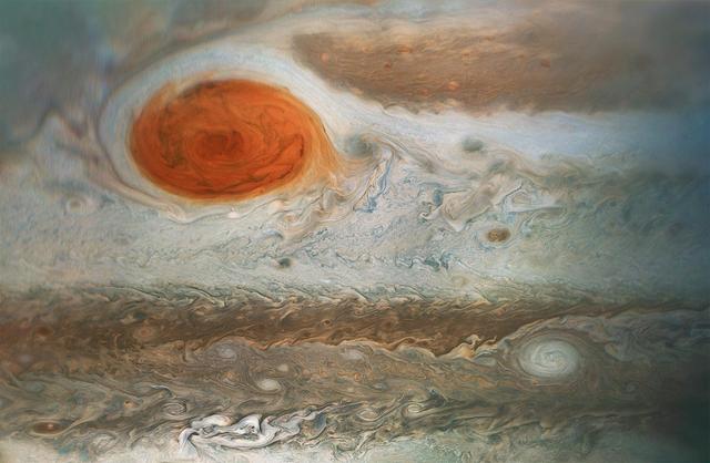
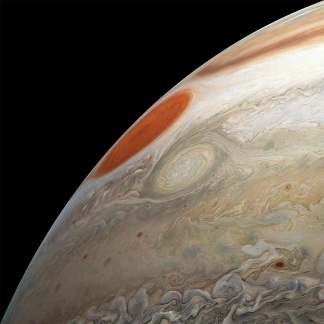
This view of Jupiter was captured by the JunoCam instrument aboard NASA's Juno spacecraft during the mission's 62nd close flyby of the giant planet on June 13, 2024. Citizen scientist Jackie Branc made the image using raw JunoCam data. https://photojournal.jpl.nasa.gov/catalog/PIA26350
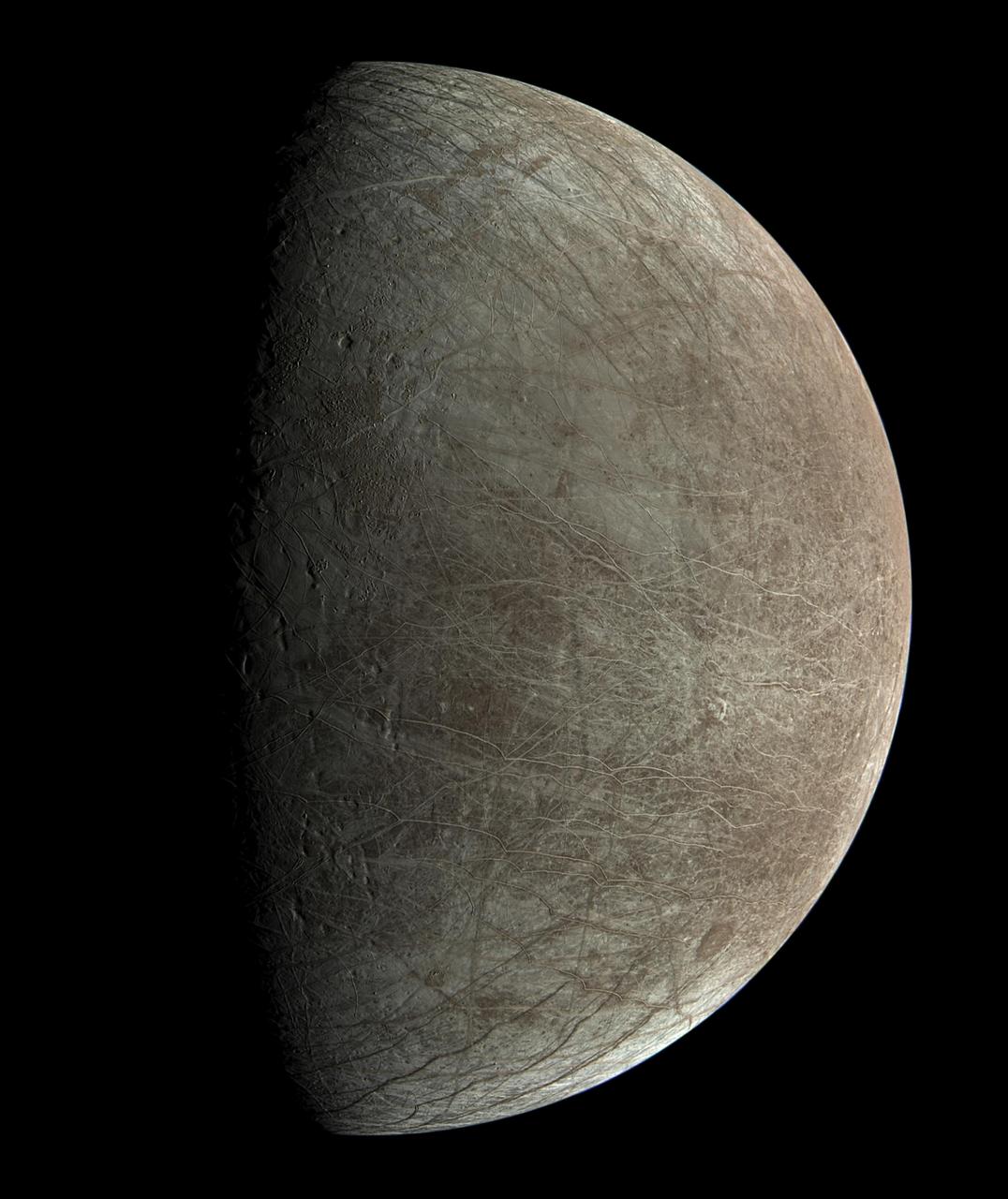
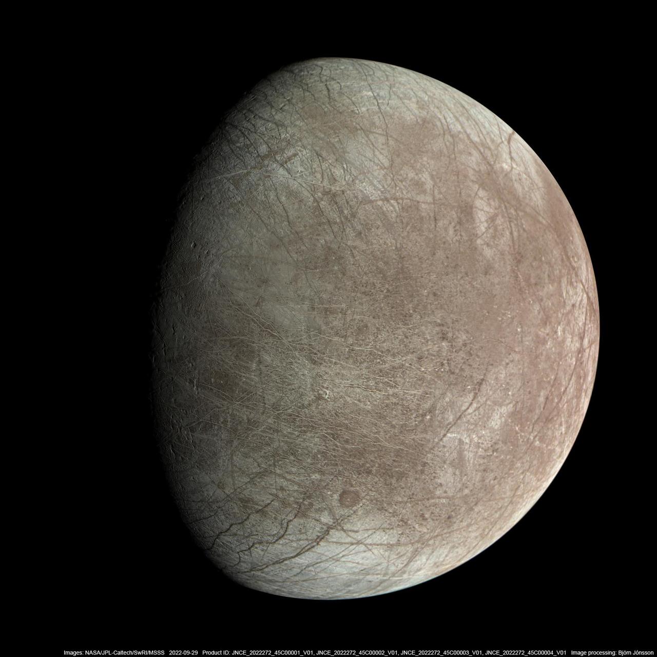
This view of Jupiter's icy moon Europa was captured by JunoCam, the public engagement camera aboard NASA's Juno spacecraft, during the mission's close flyby on Sept. 29, 2022. Citizen scientist Björn Jónsson processed the view to create this image. Jónsson processed the image to enhance the color and contrast. The resolution is about 0.6 miles (1 kilometer) per pixel. JunoCam took the image at an altitude of 945 miles (1,521 kilometers) above a region of the moon called Annwn Regio. In the image, terrain beside the day-night boundary is revealed to be rugged, with pits and troughs. Numerous bright and dark ridges and bands stretch across a fractured surface, revealing the tectonic stresses that the moon has endured over millennia. The circular dark feature at the lower right is Callanish Crater. JunoCam images of Europa help fill in gaps in the maps from images obtained during by NASA's Voyager and Galileo missions. In processing raw images taken by JunoCam, members of the public create deep-space portraits of the Jovian moon that aren't only awe-inspiring but also worthy of further scientific scrutiny. Juno citizen scientists have played an invaluable role in processing the numerous JunoCam images obtained during science operations at Jupiter. https://photojournal.jpl.nasa.gov/catalog/PIA25334
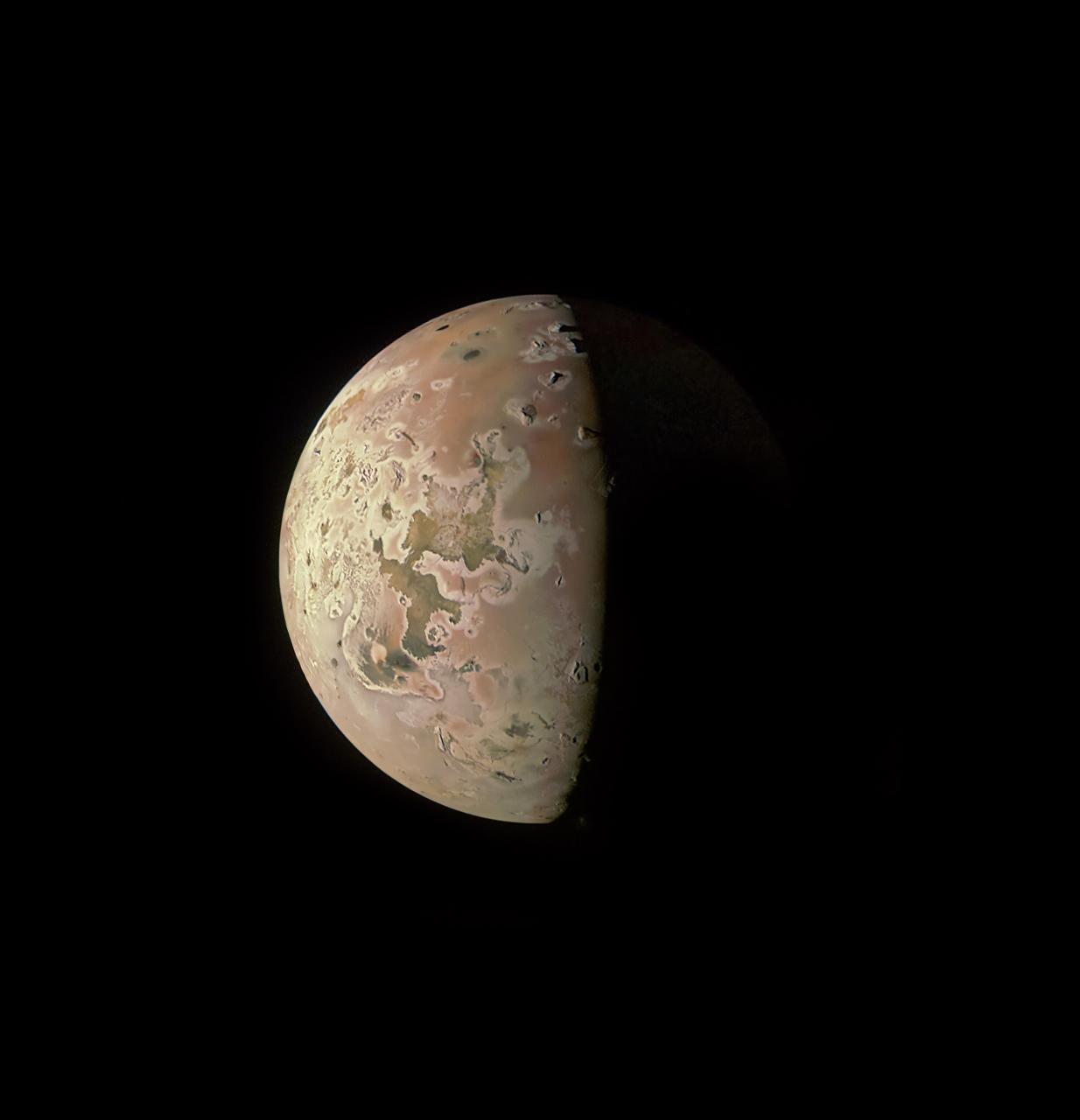
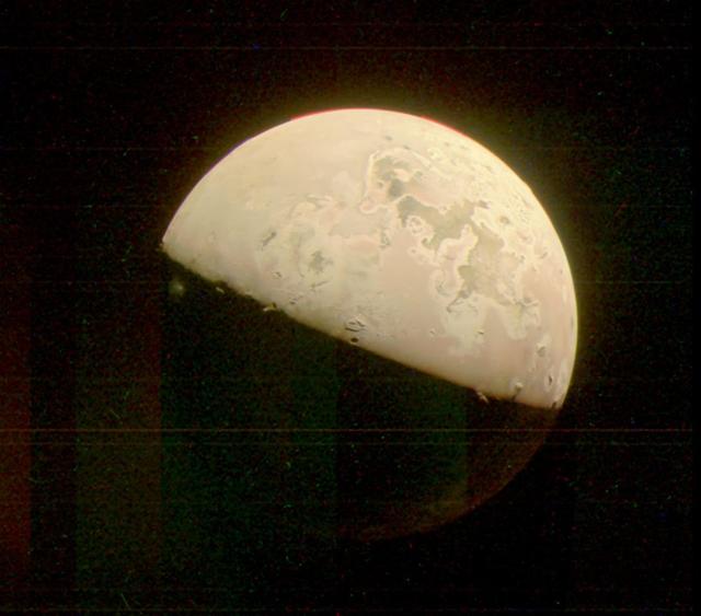
The JunoCam instrument aboard NASA's Juno spacecraft captured two volcanic plumes rising above the horizon of Jupiter's moon Io on Feb. 3, 2024. Mission scientists think the plumes were emitted either by two vents from one giant volcano, or two volcanoes near each other. The JunoCam instrument imaged the plumes from a distance of about 2,400 miles (3,800 kilometers). Citizen scientist Andrea Luck made this image from raw JunoCam data. https://photojournal.jpl.nasa.gov/catalog/PIA26340
This highly stylized view of Jupiter's icy moon Europa is based on an image captured by JunoCam, the public engagement camera aboard NASA's Juno spacecraft, during the mission's close flyby on Sept. 29, 2022. Citizen scientist Fernando Garcia Navarro created the image by processing a JunoCam previously worked on by fellow citizen scientist Kevin M. Gill. Navarro calls his rendering "Fall Colors of Europa." In processing raw images taken by JunoCam, members of the public create deep-space portraits of the Jovian moon that aren't only awe-inspiring but also worthy of further scientific scrutiny. Juno citizen scientists have played an invaluable role in processing the numerous JunoCam images obtained during science operations at Jupiter. https://photojournal.jpl.nasa.gov/catalog/PIA25335
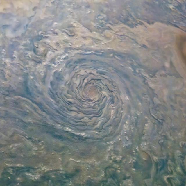
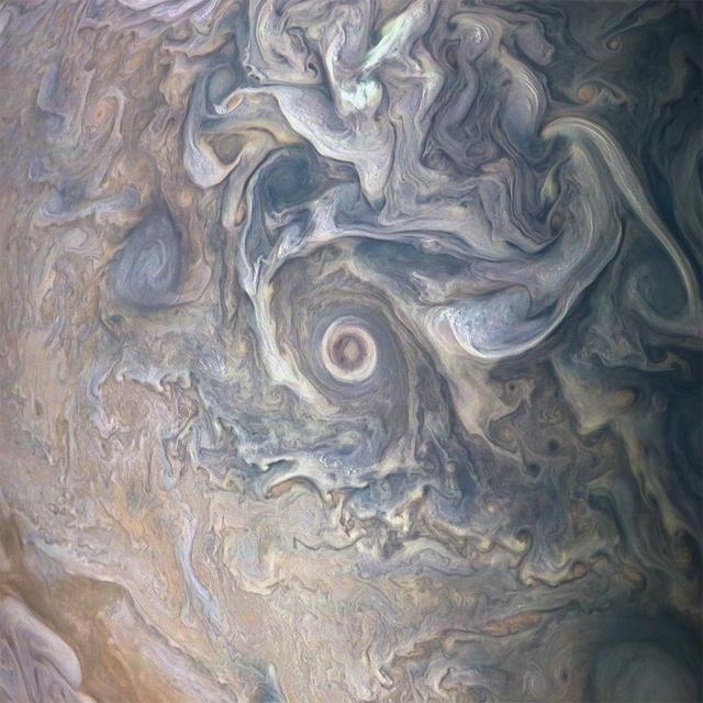
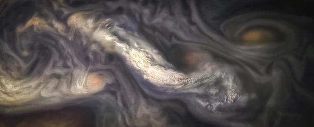
This image capturing one of the circumpolar cyclones on Jupiter's north pole was taken Nov. 22, 2023, by the JunoCam imager aboard NASA's Juno as the spacecraft flew past at an altitude of about 10,880 miles (17,500 kilometers). The horizontal lines and overall graininess of the image show the effects of radiation damage on the camera. The Juno team has been experimenting with a technique called annealing to address the damage and restore the quality of JunoCam images. https://photojournal.jpl.nasa.gov/catalog/PIA26642
This image revealing the north polar region of the Jovian moon Io was taken on October 15, 2023, by the JunoCam imager aboard NASA's Juno spacecraft. Since the high latitudes were not well covered in imagery gathered by NASA's Voyager and Galileo missions, three of the peaks captured here were observed for the first time. Those mountains are seen at the upper part of the image, near the terminator (the line dividing day and night). At the time the image was taken, the Juno spacecraft was about 7,270 miles (11,700 kilometers) above Io's surface. Citizen scientist Ted Stryk made this image using raw data from the JunoCam instrument, processing the data to enhance details. https://photojournal.jpl.nasa.gov/catalog/PIA26234

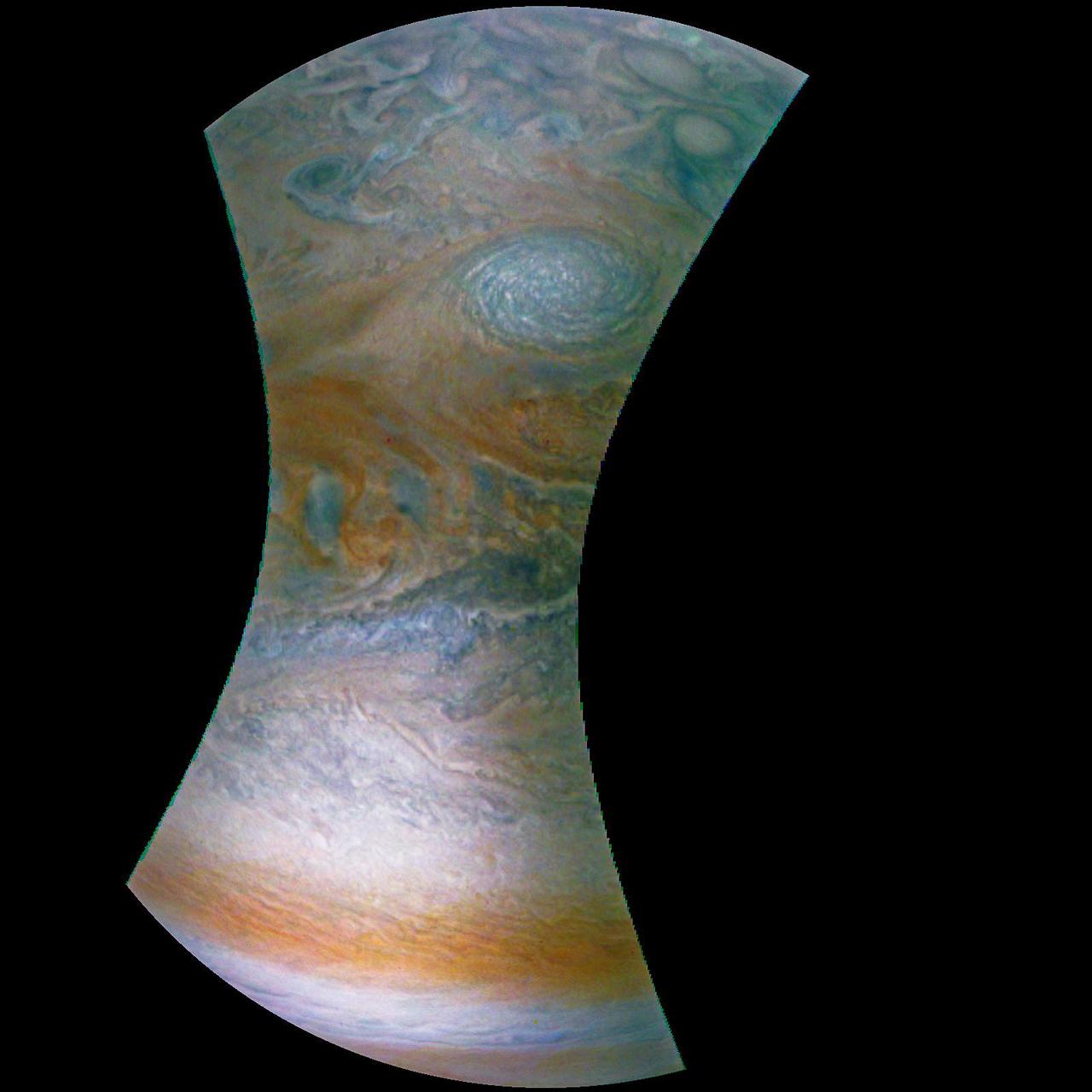
This enhanced color Jupiter image, taken by the JunoCam imager on NASA's Juno spacecraft, showcases several interesting features on the apparent edge (limb) of the planet. Prior to Juno's fifth flyby over Jupiter's mysterious cloud tops, members of the public voted on which targets JunoCam should image. This picture captures not only a fascinating variety of textures in Jupiter's atmosphere, it also features three specific points of interest: "String of Pearls," "Between the Pearls," and "An Interesting Band Point." Also visible is what's known as the STB Spectre, a feature in Jupiter's South Temperate Belt where multiple atmospheric conditions appear to collide. JunoCam images of Jupiter sometimes appear to have an odd shape. This is because the Juno spacecraft is so close to Jupiter that it cannot capture the entire illuminated area in one image -- the sides get cut off. Juno acquired this image on March 27, 2017, at 2:12 a.m. PDT (5:12 a.m. EDT), as the spacecraft performed a close flyby of Jupiter. When the image was taken, the spacecraft was about 12,400 miles (20,000 kilometers) from the planet. https://photojournal.jpl.nasa.gov/catalog/PIA21389. - Enhanced image by Björn Jónsson (CC-NC-SA) based on images provided courtesy of NASA/JPL-Caltech/SwRI/MSSS
The surface of Jupiter's moon Europa is shown in an image from the JunoCam color public engagement camera aboard NASA's Juno spacecraft. The data for this image was taken Sept. 29, 2022. During its flybys in the late 1990s and 2000, NASA's Galileo mission mapped much of Jupiter's moon Europa at a resolution of 0.6 miles per pixel (1 kilometer per pixel) or better, but there are some patches that were imaged only at low resolution. Images from JunoCam have now filled in one of those regions, shown here. Cracks, ridges, and bands show up clearly, and can be visually traced across images to match up to the cracks and ridges that appear in the earlier Galileo images. The way these features crosscut the surface can reveal which sections of the terrain are younger and which are older, helping scientists to fill in Europa's tectonic history. Paul Schenk processed the images. https://photojournal.jpl.nasa.gov/catalog/PIA25696
Jupiter's moon Europa was captured by the JunoCam instrument aboard NASA's Juno spacecraft during the mission's close flyby on Sept. 29, 2022. The picture is a composite of JunoCam's second, third, and fourth images taken during the flyby, as seen from the perspective of the fourth image. North is at the top. The resolution of images ranges from just over 0.5 to 2.5 miles per pixel (1 to 4 kilometers per pixel). As with our Moon and Earth, one side of Europa always faces Jupiter, and that is the side of Europa visible here. Europa's surface is crisscrossed by fractures, ridges, and bands, which have erased terrain older than about 90 million years. Citizen scientist Björn Jónsson processed the images to enhance the color and contrast. https://photojournal.jpl.nasa.gov/catalog/PIA26331
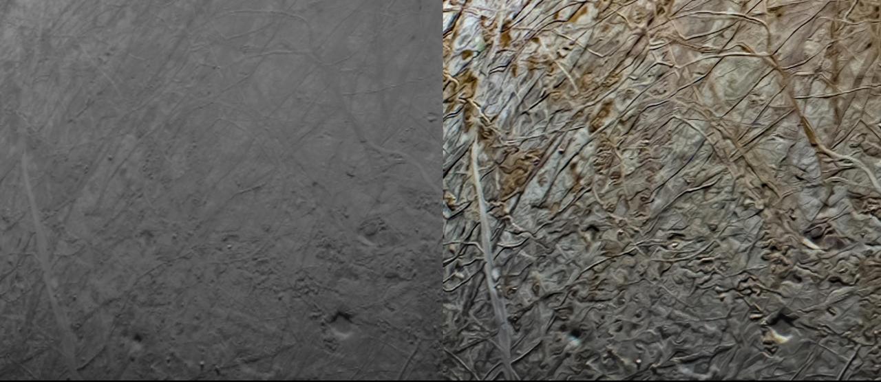
This pair of images shows the same portion of Jupiter's moon Europa before and after it was processed. The original (minimally processed) image, left, was captured by JunoCam, the public engagement camera aboard NASA's Juno spacecraft, during the mission's close flyby on Sept. 29, 2022. Captured at an altitude of 945 miles (1,521 kilometers) above a region of the moon called Annwn Regio, it was minimally processed. Citizen scientist Navaneeth Krishnan reprocessed the image to produce the version on the right. The enhanced color contrast causes larger surface features to stand out more. An example of the results can be seen in the lower right of this image, where the pits and a small rectangular block (reflecting more light than surrounding features) cast notable shadows. Small-scale texturing of the surface in the image needs to be carefully studied to distinguish between features and artifacts from processing, but the image serves both art and science by drawing us deeper into Europa's alien landscape. In processing raw images taken by JunoCam, members of the public create deep-space portraits of the Jovian moon that aren't only awe-inspiring but also worthy of further scientific scrutiny. Juno citizen scientists have played an invaluable role in processing the numerous JunoCam images obtained during science operations at Jupiter. https://photojournal.jpl.nasa.gov/catalog/PIA25333
NASA's Juno spacecraft was racing away from Jupiter following its seventh close pass of the planet when JunoCam snapped this image on May 19, 2017, from about 29,100 miles (46,900 kilometers) above the cloud tops. The spacecraft was over 65.9 degrees south latitude, with a lovely view of the south polar region of the planet. This image was processed to enhance color differences, showing the amazing variety in Jupiter's stormy atmosphere. The result is a surreal world of vibrant color, clarity and contrast. Four of the white oval storms known as the "String of Pearls" are visible near the top of the image. Interestingly, one orange-colored storm can be seen at the belt-zone boundary, while other storms are more of a cream color. Citizen scientists Gerald Eichstädt and Seán Doran processed this image using data from the JunoCam imager. https://photojournal.jpl.nasa.gov/catalog/PIA21392
Small bright clouds dot Jupiter's entire south tropical zone in this image acquired by JunoCam on NASA's Juno spacecraft on May 19, 2017, at an altitude of 7,990 miles (12,858 kilometers). Although the bright clouds appear tiny in this vast Jovian cloudscape, they actually are cloud towers roughly 30 miles (50 kilometers) wide and 30 miles (50 kilometers) high that cast shadows on the clouds below. On Jupiter, clouds this high are almost certainly composed of water and/or ammonia ice, and they may be sources of lightning. This is the first time so many cloud towers have been visible, possibly because the late-afternoon lighting is particularly good at this geometry. Citizen scientists Gerald Eichstädt and Seán Doran created this image using data from the spacecraft's JunoCam imager. https://photojournal.jpl.nasa.gov/catalog/PIA21647
When team members from NASA's Juno mission invited the public to process JunoCam images, they did not anticipate that they would receive back such beautiful, creative expressions of art. The oranges and grayed-out regions of blue-green in this tiled and color-enhanced image resemble a color scheme much like Romantic era paintings, but more abstract. The lack of discreet objects to focus on allows the mind to seek familiar Earthly shapes, and the brightest spots seem to draw the eye. Citizen scientist Eric Jorgensen created this Jovian artwork with a JunoCam image taken when the spacecraft was at an altitude of 11,100 miles (17,800 kilometers) above Jupiter's cloudtops on Dec. 11, 2016 at 9:22 a.m. PT (12:22 p.m. ET). http://photojournal.jpl.nasa.gov/catalog/PIA21385 . - Enhanced image by Eric Jorgensen based on images provided courtesy of NASA/JPL-Caltech/SwRI/MSSS
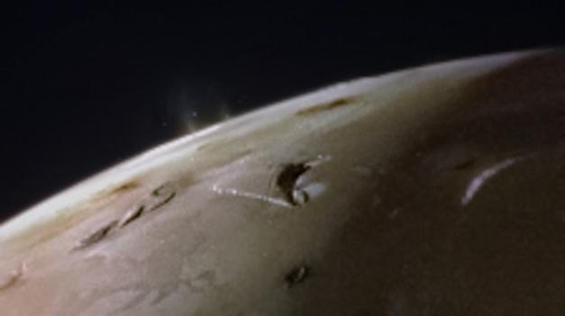
This image of Jupiter's moon Io was taken by the JunoCam visible-light imager as NASA's Juno spacecraft flew past the Jovian moon on October 15, 2023. A plume over the location of the volcano Prometheus can be seen just standing out from the darkness on the left side of the image, just below the terminator (the line dividing day and night). https://photojournal.jpl.nasa.gov/catalog/PIA26235
Cyclones swirl around the south pole, and white oval storms can be seen near the limb -- the apparent edge of the planet -- in this image of Jupiter's south polar region taken by the JunoCam imager aboard NASA's Juno spacecraft. The image was acquired on February 2, 2017, at 5:52 a.m. PST (8:52 a.m. EST) from an altitude of 47,600 miles (76,600 kilometers) above Jupiter's swirling cloud deck. Prior to the Feb. 2 flyby, the public was invited to vote for their favorite points of interest in the Jovian atmosphere for JunoCam to image. The point of interest captured here was titled "Jovian Antarctica" by a member of the public, in reference to Earth's Antarctica. http://photojournal.jpl.nasa.gov/catalog/PIA21380
JunoCam images aren't just for art and science -- sometimes they are processed to bring a chuckle. This image, processed by citizen scientist Jason Major, is titled "Jovey McJupiterface." By rotating the image 180 degrees and orienting it from south up, two white oval storms turn into eyeballs, and the "face" of Jupiter is revealed. The original image was acquired by JunoCam on NASA's Juno spacecraft on May 19, 2017 at 11:20 a.m. PT (2: 20 p.m. ET) from an altitude of 12,075 miles (19,433 kilometers). https://photojournal.jpl.nasa.gov/catalog/PIA21394 . - Enhanced image by Jason Major based on images provided courtesy of NASA/JPL-Caltech/SwRI/MSSS
This dual view of Jupiter was taken on August 23, when NASA's Juno spacecraft was 2.8 million miles (4.4 million kilometers) from the gas giant planet on the inbound leg of its initial 53.5-day capture orbit. The image on the left is a color composite taken with Junocam's visible red, green, and blue filters. The image on the right was also taken by JunoCam, but uses the camera's infrared filter, which is sensitive to the abundance of methane in the atmosphere. Bright features like the planet's Great Red Spot are higher in the atmosphere, and so have less of their light absorbed by the methane. http://photojournal.jpl.nasa.gov/catalog/PIA20884

This image captures the swirling cloud formations around the south pole of Jupiter, looking up toward the equatorial region. NASA's Juno spacecraft took the color-enhanced image during its eleventh close flyby of the gas giant planet on Feb. 7 at 7:11 a.m. PST (10:11 a.m. EST). At the time, the spacecraft was 74,896 miles (120,533 kilometers) from the tops of Jupiter's clouds at 84.9 degrees south latitude. Citizen scientist Gerald Gerald Eichstädt processed this image using data from the JunoCam imager. This image was created by reprocessing raw JunoCam data using trajectory and pointing data from the spacecraft. This image is one in a series of images taken in an experiment to capture the best results for illuminated parts of Jupiter's polar region. To make features more visible in Jupiter's terminator -- the region where day meets night -- the Juno team adjusted JunoCam so that it would perform like a portrait photographer taking multiple photos at different exposures, hoping to capture one image with the intended light balance. For JunoCam to collect enough light to reveal features in Jupiter's dark twilight zone, the much brighter illuminated day-side of Jupiter becomes overexposed with the higher exposure. https://photojournal.jpl.nasa.gov/catalog/PIA21980. - Enhanced image by Gerald Eichstädt based on images provided courtesy of NASA/JPL-Caltech/SwRI/MSSS

This composite image of the Jovian moon Io was generated using data collected by the JunoCam imager aboard NASA's Juno spacecraft during four separate flybys. The resolution of the images gets progressively better as the distance between spacecraft and moon decreases with each flyby. The image of the moon on the far left has a resolution 44 miles (71 kilometers) per pixel. It was taken on April 9, 2022, during Juno's 41st orbit of Jupiter (perijove 41, or PJ41), when the spacecraft flew past Io at a distance of about 66,000 miles (106,000 kilometers). Note the gray, roughly triangular patch at the terminator near the moon's center. Citizen scientist Björn Jónsson created this image using data from JunoCam. The center-left image was acquired on July 5, 2022, during Juno's 43rd orbit of Jupiter (PJ43) at a distance of 53,000 miles (86,000 kilometers). The resolution in this image has improved to 36 miles (58 kilometers) per pixel. In this view, more detail of the gray patch is seen (from a different perspective). Citizen scientist Jason Perry created this image using data from JunoCam. By the time the center-right image of Io was taken on Dec. 14, 2022, (PJ47), the distance between spacecraft and moon had decreased to 40,000 miles (64,000 kilometers), which increased the resolution to 27 miles (43 kilometers) per pixel. Here, the gray triangle appears as three distinct volcanoes with the central vents visible as dark spots in their centers. Characteristics of other nearby volcanoes also begin to stand out. Citizen scientist Mike Ravine created this image using data from JunoCam. The far-right image, taken during Juno's 49th flyby (PJ49) on March 1, 2023, shows that the spacecraft again approached the moon from a changed perspective, allowing different territory on Io's surface to be viewed. The triplet of volcanoes that make up the gray triangular patch are visible near the top of the image, and more detail of the volcanic terrain can be made out. The altitude at the time of closest approach was about 32,000 miles (51,500 kilometers), allowing resolution to increase to 22 miles (35 kilometers) per pixel. Citizen scientist Kevin M. Gill created this image using data from JunoCam. https://photojournal.jpl.nasa.gov/catalog/PIA25887
NASA Juno spacecraft skimmed the upper wisps of Jupiter atmosphere when JunoCam snapped this image on Feb. 2, 2017. from an altitude of about 9,000 miles 14,500 kilometers above the giant planet swirling cloudtops. Streams of clouds spin off a rotating oval-shaped cloud system in the Jovian southern hemisphere. Citizen scientist Roman Tkachenko reconstructed the color and cropped the image to draw viewers' eyes to the storm and the turbulence around it. http://photojournal.jpl.nasa.gov/catalog/PIA21383 . - Enhanced image by Roman Tkachenko (CC-BY) based on images provided courtesy of NASA/JPL-Caltech/SwRI/MSSS

Waves of clouds at 37.8 degrees latitude dominate this three-dimensional Jovian cloudscape, courtesy of NASA's Juno spacecraft. JunoCam obtained this enhanced-color picture on May 19, 2017, at 5:50 UTC from an altitude of 5,500 miles (8,900 kilometers). Details as small as 4 miles (6 kilometers) across can be identified in this image. The small bright high clouds are about 16 miles (25 kilometers) across and in some areas appear to form "squall lines" (a narrow band of high winds and storms associated with a cold front). On Jupiter, clouds this high are almost certainly composed of water and/or ammonia ice. Citizen scientists Gerald Eichstädt and Seán Doran created this image using data from the spacecraft's JunoCam imager. https://photojournal.jpl.nasa.gov/catalog/PIA21646

This image captures swirling cloud belts and tumultuous vortices within Jupiter's northern hemisphere. NASA's Juno spacecraft took this color-enhanced image at 10:23 p.m. PDT on May 23, 2018 (1:23 a.m. EDT on May 24), as the spacecraft performed its 13th close flyby of Jupiter. At the time, Juno was about 9,600 miles (15,500 kilometers) from the planet's cloud tops, above a northern latitude of 56 degrees. The region seen here is somewhat chaotic and turbulent, given the various swirling cloud formations. In general, the darker cloud material is deeper in Jupiter's atmosphere, while bright cloud material is high. The bright clouds are most likely ammonia or ammonia and water, mixed with a sprinkling of unknown chemical ingredients. A bright oval at bottom center stands out in the scene. This feature appears uniformly white in ground-based telescope observations. However, with JunoCam we can observe the fine-scale structure within this weather system, including additional structures within it. There is not significant motion apparent in the interior of this feature; like the Great Red Spot, its winds probably slows down greatly toward the center. Citizen scientists Gerald Eichstädt and Seán Doran created this image using data from the spacecraft's JunoCam imager. The view is a composite of several separate JunoCam images that were re-projected, blended, and healed. https://photojournal.jpl.nasa.gov/catalog/PIA22424

This close-up view of Jupiter captures the turbulent region just west of the Great Red Spot in the South Equatorial Belt, with resolution better than any previous pictures from Earth or other spacecraft. NASA's Juno spacecraft captured this image with its JunoCam citizen science instrument when the spacecraft was a mere 5,400 miles (8,700 kilometers) above Jupiter's cloudtops on Dec. 11, 2016 at 9:14 a.m. PT (12:14 p.m. ET). Citizen scientist Sergey Dushkin produced the sublime color processing and cropped the image to draw viewers' eyes to the dynamic clouds. http://photojournal.jpl.nasa.gov/catalog/PIA21384 . - Enhanced image by Sergey Dushkin based on images provided courtesy of NASA/JPL-Caltech/SwRI/MSSS
This image, taken by the JunoCam imager on NASA's Juno spacecraft, highlights a swirling storm just south of one of the white oval storms on Jupiter. The image was taken on March 27, 2017, at 2:12 a.m. PDT (5:12 a.m. EDT), as the Juno spacecraft performed a close flyby of Jupiter. At the time the image was taken, the spacecraft was about 12,400 miles (20,000 kilometers) from the planet. Citizen scientist Jason Major enhanced the color and contrast in this image, turning the picture into a Jovian work of art. He then cropped it to focus our attention on this beautiful example of Jupiter's spinning storms. https://photojournal.jpl.nasa.gov/catalog/PIA21387 . - Enhanced image by Jason Major (CC-BY) based on images provided courtesy of NASA/JPL-Caltech/SwRI/MSSS

See a jet stream speeding through Jupiter's atmosphere in this new view taken by NASA's Juno spacecraft. The jet stream, called Jet N2, was captured along the dynamic northern temperate belts of the gas giant planet. It is the white stream visible from top left to bottom right in the image. The color-enhanced image was taken at 10:34 p.m. PST on May 23 (1:34 a.m. EST on May 24), as Juno performed its 13th close flyby of Jupiter. At the time the image was taken, the spacecraft was about 3,516 miles (5,659 kilometers) from the tops of the clouds of the planet at a northern latitude of 32.9 degrees. Citizen scientists Gerald Eichstädt and Seán Doran created this image using data from the spacecraft's JunoCam imager. The view is a composite of several separate JunoCam images that were re-projected, blended, and healed. https://photojournal.jpl.nasa.gov/catalog/PIA22422
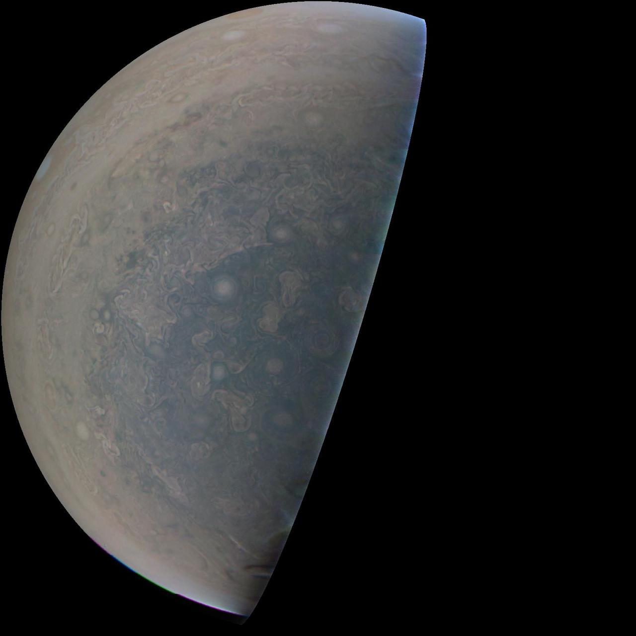
This image of Jupiter's southern hemisphere was captured by NASA's Juno spacecraft on the outbound leg of a close flyby of the gas-giant planet. The color-enhanced image was taken at 11:31 p.m. PDT on May 23, 2018 (2:31 a.m. EDT on May 24), as the spacecraft performed its 13th close flyby of Jupiter. At the time, Juno was about 44,300 miles (71,400 kilometers) from the planet's cloud tops, above a southern latitude of 71 degrees. JunoCam takes advantage of Juno's unique polar orbit, studying the atmospheric dynamics and clouds right up to Jupiter's poles, which no spacecraft has ever done before. Citizen scientist Kevin M. Gill created this image using data from the spacecraft's JunoCam imager. https://photojournal.jpl.nasa.gov/catalog/PIA22425 . - Enhanced image by Kevin M. Gill (CC-BY) based on images provided courtesy of NASA/JPL-Caltech/SwRI/MSSS
This image, taken by the JunoCam imager on NASA's Juno spacecraft, highlights a feature on Jupiter where multiple atmospheric conditions appear to collide. This publicly selected target is called "STB Spectre." The ghostly bluish streak across the right half of the image is a long-lived storm, one of the few structures perceptible in these whitened latitudes where the south temperate belt of Jupiter would normally be. The egg-shaped spot on the lower left is where incoming small dark spots make a hairpin turn. The image was taken on March 27, 2017, at 2:06 a.m. PDT (5:06 a.m. EDT), as the Juno spacecraft performed a close flyby of Jupiter. When the image was taken, the spacecraft was 7,900 miles (12,700 kilometers) from the planet. The image was processed by Roman Tkachenko, and the description is from John Rogers, the citizen scientist who identified the point of interest. https://photojournal.jpl.nasa.gov/catalog/PIA21388 . - Enhanced image by Roman Tkachenko (CC-BY) based on images provided courtesy of NASA/JPL-Caltech/SwRI/MSSS
This image, taken by the JunoCam imager on NASA's Juno spacecraft, highlights the seventh of eight features forming a 'string of pearls' on Jupiter -- massive counterclockwise rotating storms that appear as white ovals in the gas giant's southern hemisphere. Since 1986, these white ovals have varied in number from six to nine. There are currently eight white ovals visible. Since 1986, these white ovals have varied in number from six to nine. There are currently eight white ovals visible. The image was taken on Dec. 11, 2016, at 9:27 a.m. PST (12:27 EST) as the Juno spacecraft performed its third close flyby of the planet. At the time the image was taken, the spacecraft was about 15,300 miles (24,600 kilometers) from Jupiter. http://photojournal.jpl.nasa.gov/catalog/PIA21219

This image shows Jupiter's south pole, as seen by NASA's Juno spacecraft from an altitude of 32,000 miles (52,000 kilometers). The oval features are cyclones, up to 600 miles (1,000 kilometers) in diameter. Multiple images taken with the JunoCam instrument on three separate orbits were combined to show all areas in daylight, enhanced color, and stereographic projection. https://photojournal.jpl.nasa.gov/catalog/PIA21641 . - Enhanced image by Betsy Asher Hall/Gervasio Robles based on images provided courtesy of NASA/JPL-Caltech/SwRI/MSSS
NASA's Juno spacecraft captured this stunning Jovian cloudscape at 5:38 a.m. PST (8:38 a.m. EST) on Feb. 7, 2018, as the spacecraft performed its 11th close flyby of Jupiter. Citizen scientist Kevin M. Gill created this color-enhanced image using data from the spacecraft's JunoCam imager. https://photojournal.jpl.nasa.gov/catalog/PIA22931. - Enhanced image by Kevin M. Gill (CC-BY) based on images provided courtesy of NASA/JPL-Caltech/SwRI/MSSS
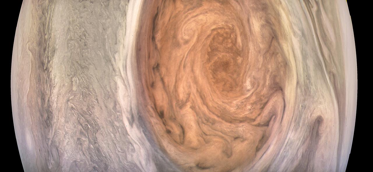
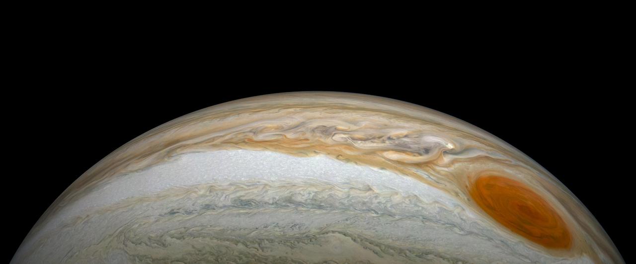
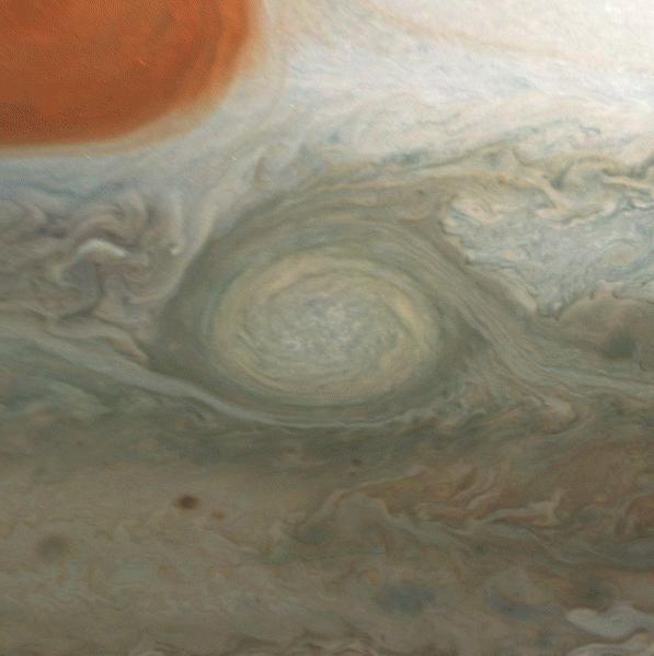
This enhanced-color image of Jupiter's Great Red Spot was created by citizen scientist Kevin Gill using data from the JunoCam imager on NASA's Juno spacecraft. The image was taken on July 10, 2017 at 07:07 p.m. PDT (10:07 p.m. EDT), as the Juno spacecraft performed its 7th close flyby of Jupiter. At the time the image was taken, the spacecraft was about 6,130 miles (9,866 kilometers) from the tops of the clouds of the planet. https://photojournal.jpl.nasa.gov/catalog/PIA21395 . - Enhanced image by Kevin M. Gill (CC-BY) based on images provided courtesy of NASA/JPL-Caltech/SwRI/MSSS
This enhanced-color image of Jupiter's Great Red Spot was created by citizen scientist Gerald Eichstädt using data from the JunoCam imager on NASA's Juno spacecraft. The image was taken on July 10, 2017 at 07:10 p.m. PDT (10:10 p.m. EDT), as the Juno spacecraft performed its 7th close flyby of Jupiter. At the time the image was taken, the spacecraft was about 8,648 miles (13,917 kilometers) from the tops of the clouds of the planet. https://photojournal.jpl.nasa.gov/catalog/PIA21772. - Enhanced image by Gerald Eichstädt based on images provided courtesy of NASA/JPL-Caltech/SwRI/MSSS
This enhanced-color image of Jupiter's Great Red Spot was created by citizen scientist Jason Major using data from the JunoCam imager on NASA's Juno spacecraft. The image was taken on July 10, 2017 at 07:10 p.m. PDT (10:10 p.m. EDT), as the Juno spacecraft performed its 7th close flyby of Jupiter. At the time the image was taken, the spacecraft was about 8,648 miles (13,917 kilometers) from the tops of the clouds of the planet. https://photojournal.jpl.nasa.gov/catalog/PIA21772 . - Enhanced image by Jason Major based on images provided courtesy of NASA/JPL-Caltech/SwRI/MSSS
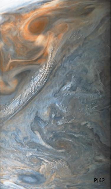
This image of a "jet" in Jupiter's atmosphere was taken by the JunoCam public engagement camera aboard NASA's Juno spacecraft on May 23, 2022. Jupiter's atmosphere is organized into belts and zones, separated by jets, which are associated with turbulence along belt-zone boundaries, leading to chaotic regions of multicolored clouds. In this image, the color in these two regions has been enhanced to bring out detail and show the different layers of cloud decks. Juno's orbit around Jupiter changes every time the spacecraft passes the giant planet, with the point of closest approach – the perijove, or "PJ" – moving steadily northward. As the perijove changes, the resolution of images taken in the northern hemisphere steadily increases. This image of Jet N3 was acquired on PJ42, Juno's 42nd pass by Jupiter, at 41.6 degrees north from an altitude of 2,361 miles (3,800 kilometers). It shows features as small as 1.6 miles (2.6 kilometers) across. Citizen scientist Sergio Díaz processed the image to enhance the color and contrast. https://photojournal.jpl.nasa.gov/catalog/PIA25693

This series of enhanced-color images shows Jupiter up close and personal, as NASA's Juno spacecraft performed its eighth flyby of the gas giant planet. The images were obtained by JunoCam. From left to right, the sequence of images taken on Sept. 1, 2017 from 3:03 p.m. to 3:11 p.m. PDT (6:03 p.m. to 6:11 p.m. EDT). At the times the images were taken, the spacecraft ranged from 7,545 to 14,234 miles (12,143 to 22,908 kilometers) from the tops of the clouds of the planet at a latitude range of -28.5406 to -44.4912 degrees. Points of Interest include "Dalmatian Zone/Eye of Odin," "Dark Eye/STB Ghost East End," "Coolest Place on Jupiter," and "Renslow/Hurricane Rachel." The final image in the series on the right shows Jupiter's south pole coming into view. Citizen scientists Gerald Eichstädt and Seán Doran created this image using data from the spacecraft's JunoCam imager. https://photojournal.jpl.nasa.gov/catalog/PIA21780
A dynamic storm at the southern edge of Jupiter's northern polar region dominates this Jovian cloudscape, courtesy of NASA's Juno spacecraft. This storm is a long-lived anticyclonic oval named North North Temperate Little Red Spot 1 (NN-LRS-1); it has been tracked at least since 1993, and may be older still. An anticyclone is a weather phenomenon where winds around the storm flow in the direction opposite to that of the flow around a region of low pressure. It is the third largest anticyclonic oval on the planet, typically around 3,700 miles (6,000 kilometers) long. The color varies between red and off-white (as it is now), but this JunoCam image shows that it still has a pale reddish core within the radius of maximum wind speeds. Citizen scientists Gerald Eichstädt and Seán Doran processed this image using data from the JunoCam imager. The image has been rotated so that the top of the image is actually the equatorial regions while the bottom of the image is of the northern polar regions of the planet. The image was taken on July 10, 2017 at 6:42 p.m. PDT (9:42 p.m. EDT), as the Juno spacecraft performed its seventh close flyby of Jupiter. At the time the image was taken, the spacecraft was about 7,111 miles (11,444 kilometers) from the tops of the clouds of the planet at a latitude of 44.5 degrees. https://photojournal.jpl.nasa.gov/catalog/PIA21776
This false color view of Jupiter's polar haze was created by citizen scientist Gerald Eichstädt using data from the JunoCam instrument on NASA's Juno spacecraft. The image was taken on Dec. 11, 2016 at 2:30 p.m. PST (5:30 p.m. EST), when the spacecraft was 285,000 miles (459,000 kilometers) from Jupiter on the outbound leg of its third close flyby. This image is composited from four images taken through different filters: red, green, blue and methane. When the near-infrared methane image is processed with the others, the result is a false color product that highlights high clouds and high altitude hazes. The Great Red Spot and Oval BA (just below the Great Red Spot) are high in Jupiter's atmosphere, thus bright in this picture. The high-altitude haze layer over the south pole partially obscures our view of the storms below. By combining the methane data with the visible light images, we can learn about the vertical structure of Jupiter's atmosphere. http://photojournal.jpl.nasa.gov/catalog/PIA21379. - Enhanced image by Gerald Eichstädt based on images provided courtesy of NASA/JPL-Caltech/SwRI/MSSS
This striking image of Jupiter was captured by NASA's Juno spacecraft as it performed its eighth flyby of the gas giant planet. The image was taken on Sept. 1, 2017 at 2:58 p.m. PDT (5:58 p.m. EDT). At the time the image was taken, the spacecraft was 4,707 miles (7,576 kilometers) from the tops of the clouds of the planet at a latitude of about -17.4 degrees. Citizen scientist Gerald Eichstädt processed this image using data from the JunoCam imager. Points of interest are "Whale's Tail" and "Dan's Spot." https://photojournal.jpl.nasa.gov/catalog/PIA21966. - Enhanced image by Gerald Eichstädt based on images provided courtesy of NASA/JPL-Caltech/SwRI/MSSS
As NASA's Juno spacecraft closed in on Jupiter for its Aug. 27, 2016 pass, its view grew sharper and fine details in the north polar region became increasingly visible. The JunoCam instrument obtained this view on August 27, about two hours before closest approach, when the spacecraft was 120,000 miles (195,000 kilometers) away from the giant planet (i.e., for Jupiter's center). Unlike the equatorial region's familiar structure of belts and zones, the poles are mottled with rotating storms of various sizes, similar to giant versions of terrestrial hurricanes. Jupiter's poles have not been seen from this perspective since the Pioneer 11 spacecraft flew by the planet in 1974. http://photojournal.jpl.nasa.gov/catalog/PIA21030

A south tropical disturbance that has just passed Jupiter's iconic Great Red Spot is captured in this color-enhanced image from NASA's Juno spacecraft. Threads of orange haze are pulled from the Great Red Spot by the turbulence of the south tropical disturbance. The image was taken at 3:04 a.m. PDT (6:04 p.m. EDT) on April 1, 2018, as the spacecraft performed its 12th close flyby of Jupiter. Citizen scientist Kevin M. Gill created this image using data from the spacecraft's JunoCam imager. https://photojournal.jpl.nasa.gov/catalog/PIA22938. - Enhanced image by Kevin M. Gill (CC-BY) based on images provided courtesy of NASA/JPL-Caltech/SwRI/MSSS
See intricate cloud patterns in the northern hemisphere of Jupiter in this new view taken by NASA's Juno spacecraft. The color-enhanced image was taken on April 1, 2018 at 2:32 a.m. PST (5:32 a.m. EST), as Juno performed its twelfth close flyby of Jupiter. At the time the image was taken, the spacecraft was about 7,659 miles (12,326 kilometers) from the tops of the clouds of the planet at a northern latitude of 50.2 degrees. Citizen scientist Kevin M. Gill processed this image using data from the JunoCam imager. https://photojournal.jpl.nasa.gov/catalog/PIA21984 . - Enhanced image by Kevin M. Gill (CC-BY) based on images provided courtesy of NASA/JPL-Caltech/SwRI/MSSS
A cyclonic storm in Jupiter's northern hemisphere is captured in this image from NASA's Juno spacecraft. Many bright white cloud tops can be seen popping up in and around the arms of the rotating storm. The color-enhanced image was taken at 9:25 a.m. PST (12:25 p.m. EST) on Feb. 12, 2019, as the spacecraft performed its 17th science flyby of Jupiter. At the time, Juno was about 5,000 miles (8,000 kilometers) from the planet's cloud tops, above approximately 44 degrees north latitude. Citizen scientists Gerald Eichstädt and Seán Doran created this image using data from the spacecraft's JunoCam imager. https://photojournal.jpl.nasa.gov/catalog/PIA22947
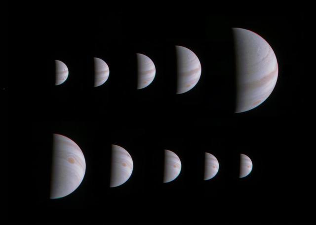
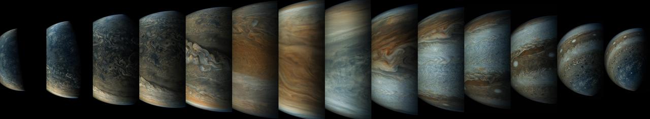
This montage of 10 JunoCam images shows Jupiter growing and shrinking in apparent size before and after NASA's Juno spacecraft made its closest approach on August 27, 2016, at 12:50 UTC. The images are spaced about 10 hours apart, one Jupiter day, so the Great Red Spot is always in roughly the same place. The small black spots visible on the planet in some of the images are shadows of the large Galilean moons. The images in the top row were taken during the inbound leg of the orbit, beginning on August 25 at 13:15 UTC when Juno was 1.4 million miles (2.3 million kilometers) away from Jupiter, and continuing to August 27 at 04:45 UTC when the spacecraft was 430,000 miles (700,000 kilometers) away. The images in the bottom row were obtained during the outbound leg of the orbit. They begin on August 28 at 00:45 UTC when Juno was 750,000 miles (920,000 kilometers) away and continue to August 29 at 16:45 UTC when the spacecraft was 1.6 million miles (2.5 million kilometers) away. http://photojournal.jpl.nasa.gov/catalog/PIA21034

See Jupiter's northern polar belt region in this view taken by NASA's Juno spacecraft. This color-enhanced image was taken on Dec. 16, 2017 at 9:47 a.m. PST (12:47 p.m. EST), as Juno performed its tenth close flyby of Jupiter. At the time the image was taken, the spacecraft was about 5,600 miles (8,787 kilometers) from the tops of the clouds of the planet at a latitude of 38.4 degrees north. Citizen scientist Björn Jónsson processed this image using data from the JunoCam imager. This image has been processed from the raw JunoCam framelets by removing the effects of global illumination. Jónsson then increased the contrast and color and sharpened smallscale features. The image has also been cropped. While at first glance the view may appear to be in Jupiter's south, the raw source images were obtained when Juno was above the planet's northern hemisphere looking south, potentially causing a sense of disorientation to the viewer. The geometry of the scene can be explored using the time of the image and the Juno mission module of NASA's Eyes on the Solar System. https://photojournal.jpl.nasa.gov/catalog/PIA21976. - Enhanced image by Björn Jónsson (CC-NC-SA) based on images provided courtesy of NASA/JPL-Caltech/SwRI/MSSS
See Jupiter's Great Red Spot as you've never seen it before in this new Jovian work of art. Artist Mik Petter created this unique, digital artwork using data from the JunoCam imager on NASA's Juno spacecraft. The art form, known as fractals, uses mathematical formulas to create art with an infinite variety of form, detail, color and light. The tumultuous atmospheric zones in and around the Great Red Spot are highlighted by the author's use of colorful fractals. Vibrant colors of various tints and hues, combined with the almost organic-seeming shapes, make this image seem to be a colorized and crowded petri dish of microorganisms, or a close-up view of microscopic and wildly-painted seashells. The original JunoCam image was taken on July 10, 2017 at 7:10 p.m. PDT (10:10 p.m. EDT), as the Juno spacecraft performed its seventh close flyby of Jupiter. The spacecraft captured the image from about 8,648 miles (13,917 kilometers) above the tops of the clouds of the planet at a latitude of -32.6 degrees. https://photojournal.jpl.nasa.gov/catalog/PIA21777 . - Enhanced image by Mik Petter (CC-NC-SA) based on images provided courtesy of NASA/JPL-Caltech/SwRI/MSSS
This image of a crescent Jupiter and the iconic Great Red Spot was created by a citizen scientist (Roman Tkachenko) using data from Juno's JunoCam instrument. You can also see a series of storms shaped like white ovals, known informally as the "string of pearls." Below the Great Red Spot a reddish long-lived storm known as Oval BA is visible. The image was taken on Dec. 11, 2016 at 2:30 p.m. PST (5:30 p.m. EST), as the Juno spacecraft performed its third close flyby of Jupiter. At the time the image was taken, the spacecraft was about 285,100 miles (458,800 kilometers) from the planet. http://photojournal.jpl.nasa.gov/catalog/PIA21376 . - Enhanced image by Roman Tkachenko (CC-BY) based on images provided courtesy of NASA/JPL-Caltech/SwRI/MSSS
This amateur-processed image was taken on Dec. 11, 2016, at 9:27 a.m. PST (12:27 p.m. EST), as NASA's Juno spacecraft performed its third close flyby of Jupiter. At the time the image was taken, the spacecraft was about 15,200 miles (24,400 kilometers) from the gas giant planet. The citizen scientist (Eric Jorgensen) cropped the JunoCam image and enhanced the color to draw attention to Jupiter's swirling clouds southeast of the "pearl." The "pearl" is one of eight massive rotating storms at 40 degrees south latitude on Jupiter, known colloquially as the "string of pearls." The processing of this image highlights the turbulence of the clouds in the south temperate belt of the planet. http://photojournal.jpl.nasa.gov/catalog/PIA21377 . - Enhanced image by Eric Jorgensen based on images provided courtesy of NASA/JPL-Caltech/SwRI/MSSS

This image of Jupiter's southern hemisphere was captured by NASA's Juno spacecraft as it performed a close flyby of the gas giant planet on Dec. 16, 2017. Juno captured this color-enhanced image at 10:24 a.m. PST (1:24 p.m. EST) when the spacecraft was about 19,244 miles (30,970 kilometers) from the tops of Jupiter's clouds at a latitude of 49.9 degrees south -- roughly halfway between the planet's equator and its south pole. Citizen scientist Gerald Eichstädt processed this image using data from the JunoCam imager. https://photojournal.jpl.nasa.gov/catalog/PIA21977. - Enhanced image by Gerald Eichstädt based on images provided courtesy of NASA/JPL-Caltech/SwRI/MSSS

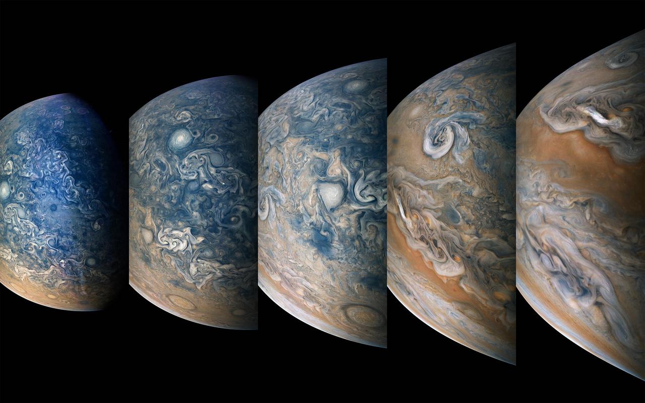
This sequence of color-enhanced images shows how quickly the viewing geometry changes for NASA's Juno spacecraft as it swoops by Jupiter. The images were obtained by JunoCam. Once every 53 days, Juno swings close to Jupiter, speeding over its clouds. In just two hours, the spacecraft travels from a perch over Jupiter's north pole through its closest approach (perijove), then passes over the south pole on its way back out. This sequence shows 11 color-enhanced images from Perijove 8 (Sept. 1, 2017) with the south pole on the left (11th image in the sequence) and the north pole on the right (first image in the sequence). The first image on the right shows a half-lit globe of Jupiter, with the north pole approximately at the upper center of the image close to the terminator -- the dividing line between night and day. As the spacecraft gets closer to Jupiter, the horizon moves in and the range of visible latitudes shrinks. The second and third images in this sequence show the north polar region rotating away from the spacecraft's field of view while the first of Jupiter's lighter-colored bands comes into view. The fourth through the eighth images display a blue-colored vortex in the mid-southern latitudes near Points of Interest "Collision of Colours," "Sharp Edge," "Caltech, by Halka," and "Structure01." The Points of Interest are locations in Jupiter's atmosphere that were identified and named by members of the general public. Additionally, a darker, dynamic band can be seen just south of the vortex. In the ninth and tenth images, the south polar region rotates into view. The final image on the left displays Jupiter's south pole in the center. From the start of this sequence of images to the end, roughly 1 hour and 35 minutes elapsed. https://photojournal.jpl.nasa.gov/catalog/PIA21967 . - Enhanced image by Kevin M. Gill (CC-BY) based on images provided courtesy of NASA/JPL-Caltech/SwRI/MSSS

This image captures a close-up view of a storm with bright cloud tops in the northern hemisphere of Jupiter. NASA's Juno spacecraft took this color-enhanced image on Feb. 7 at 5:38 a.m. PST (8:38 a.m. EST) during its 11th close flyby of the gas giant planet. At the time, the spacecraft was 7,578 miles (12,195 kilometers) from the tops of Jupiter's clouds at 49.2 degrees north latitude. Citizen scientist Matt Brealey processed the image using data from the JunoCam imager. Citizen scientist Gustavo B C then adjusted colors and embossed Matt Brealey's processing of this storm. https://photojournal.jpl.nasa.gov/catalog/PIA21981 . - Enhanced image by Matt Brealey / Gustavo B C based on images provided courtesy of NASA/JPL-Caltech/SwRI/MSSS

A multitude of magnificent, swirling clouds in Jupiter's dynamic North North Temperate Belt is captured in this image from NASA's Juno spacecraft. Appearing in the scene are several bright-white "pop-up" clouds as well as an anticyclonic storm, known as a white oval. This color-enhanced image was taken at 1:58 p.m. PDT on Oct. 29, 2018 (4:58 p.m. EDT) as the spacecraft performed its 16th close flyby of Jupiter. At the time, Juno was about 4,400 miles (7,000 kilometers) from the planet's cloud tops, at a latitude of approximately 40 degrees north. Citizen scientists Gerald Eichstädt and Seán Doran created this image using data from the spacecraft's JunoCam imager. https://photojournal.jpl.nasa.gov/catalog/PIA22692
See Jupiter's southern hemisphere in beautiful detail in this new image taken by NASA's Juno spacecraft. The color-enhanced view captures one of the white ovals in the "String of Pearls," one of eight massive rotating storms at 40 degrees south latitude on the gas giant planet. The image was taken on Oct. 24, 2017 at 11:11 a.m. PDT (2:11 p.m. EDT), as Juno performed its ninth close flyby of Jupiter. At the time the image was taken, the spacecraft was 20,577 miles (33,115 kilometers) from the tops of the clouds of the planet at a latitude of minus 52.96 degrees. The spatial scale in this image is 13.86 miles/pixel (22.3 kilometers/pixel). Citizen scientists Gerald Eichstädt and Seán Doran processed this image using data from the JunoCam imager. https://photojournal.jpl.nasa.gov/catalog/PIA21970
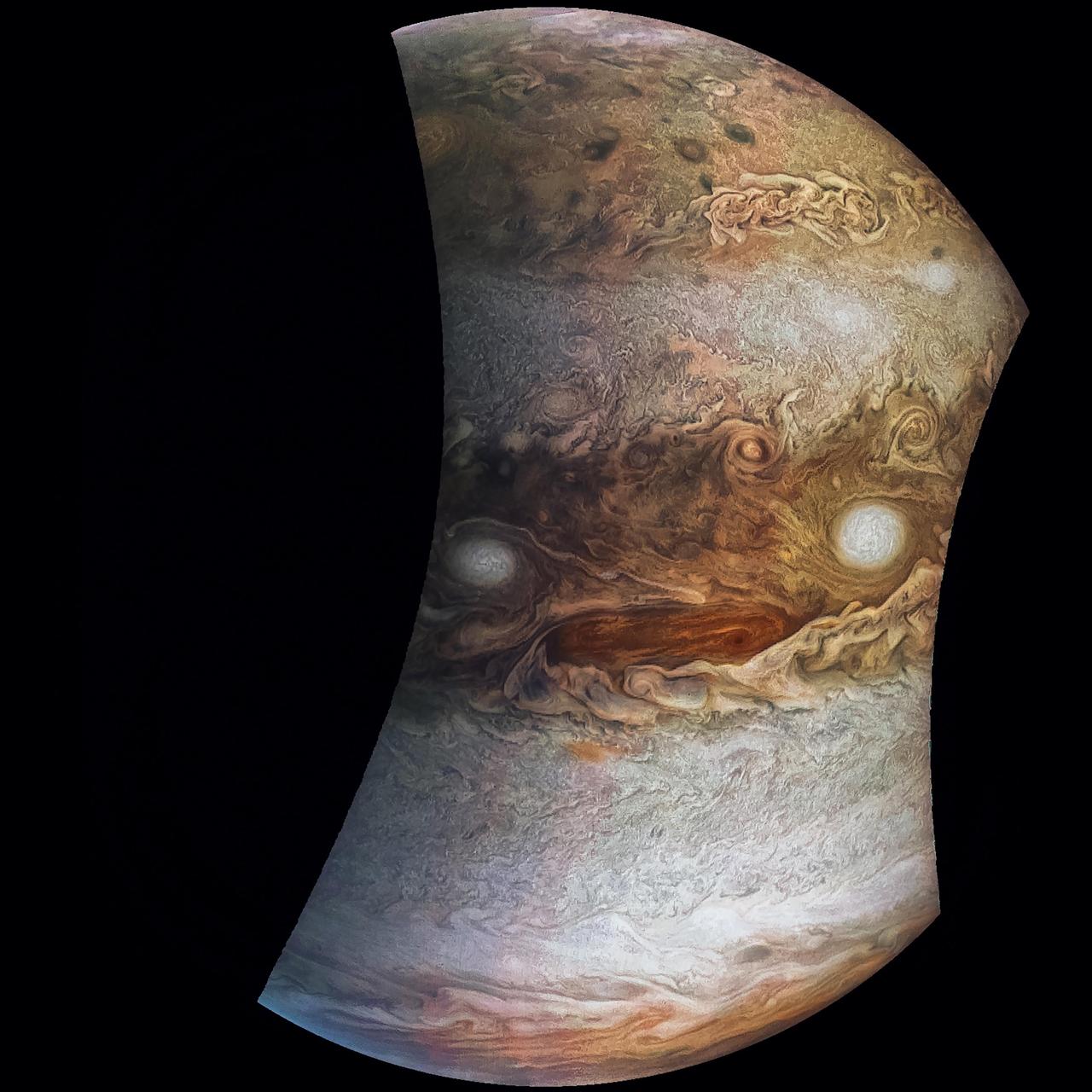
NASA's Juno spacecraft saw this striking vista during its most recent close flyby of Jupiter. This view highlights the contrast between the colorful South Equatorial Belt and the mostly white Southern Tropical Zone, a latitude that also features Jupiter's most famous phenomenon, the persistent, anticyclonic storm known as the Great Red Spot. Citizen scientist Kevin M. Gill created this image using data from the spacecraft's JunoCam imager. The raw image was taken on July 20, 2019, at 9:37 p.m. PDT (July 21, 2019, at 12:37 a.m. EDT) as the Juno spacecraft performed its 21st close flyby of Jupiter. At the time the image was taken, the spacecraft was 26,697 miles (42,965 kilometers) from the tops of the clouds, above a latitude of 46 degrees south. Enhanced image by Kevin M. Gill (CC-BY) based on images provided courtesy of NASA/JPL-Caltech/SwRI/MSSS.
Intricate swirls in Jupiter's volatile northern hemisphere are captured in this color-enhanced image from NASA's Juno spacecraft. Bursts of bright-white "pop-up" clouds appear scattered throughout the scene, with some visibly casting shadows on the neighboring cloud layers beneath them. Juno scientists are using shadows to determine the distances between cloud layers in Jupiter's atmosphere, which provide clues to their composition and origin. This image was taken at 10:27 p.m. PDT on May 23, 2018 (1:27 a.m. EDT on May 24) as the spacecraft performed its 13th close flyby of Jupiter. At the time, Juno was about 7,050 miles (11,350 kilometers) from the planet's cloud tops, above a northern latitude of approximately 49 degrees. Citizen scientists Gerald Eichstädt and Seán Doran created this image using data from the spacecraft's JunoCam imager. https://photojournal.jpl.nasa.gov/catalog/PIA22687
This image provides a close-up view of Jupiter's southern hemisphere, as seen by NASA's Juno spacecraft on August 27, 2016. The JunoCam instrument captured this image with its red spectral filter when the spacecraft was about 23,600 miles (38,000 kilometers) above the cloud tops. The image covers an area from close to the south pole to 20 degrees south of the equator, centered on a longitude at about 140 degrees west. The transition between the banded structures near the equator and the more chaotic polar region (south of about 65 degrees south latitude) can be clearly seen. The smaller version at right of this image shows the same view with a latitude/longitude grid overlaid. This image has been processed to remove shading effects near the terminator -- the dividing line between day and night -- caused by Juno's orbit. http://photojournal.jpl.nasa.gov/catalog/PIA21035
NASA's Juno spacecraft captured this view of an area within a Jovian jet stream showing a vortex that has an intensely dark center. Nearby, other features display bright, high altitude clouds that have puffed up into the sunlight. The color-enhanced image was taken at 12:55 a.m. PDT (3:55 a.m. EDT) on May 29, 2019, as the spacecraft performed its 20th science flyby of Jupiter. At the time, Juno was about 9,200 miles (14,800 kilometers) from the planet's cloud tops, above approximately 52 degrees north latitude. Citizen scientists Gerald Eichstädt and Seán Doran created this image using data from the spacecraft's JunoCam imager. https://photojournal.jpl.nasa.gov/catalog/PIA22948

NASA's Juno spacecraft was a little more than one Earth diameter from Jupiter when it captured this mind-bending, color-enhanced view of the planet's tumultuous atmosphere. Jupiter completely fills the image, with only a hint of the terminator (where daylight fades to night) in the upper right corner, and no visible limb (the curved edge of the planet). Juno took this image of colorful, turbulent clouds in Jupiter's northern hemisphere on Dec. 16, 2017 at 9:43 a.m. PST (12:43 p.m. EST) from 8,292 miles (13,345 kilometers) above the tops of Jupiter's clouds, at a latitude of 48.9 degrees. The spatial scale in this image is 5.8 miles/pixel (9.3 kilometers/pixel).. Citizen scientists Gerald Eichstädt and Seán Doran processed this image using data from the JunoCam imager. https://photojournal.jpl.nasa.gov/catalog/PIA21973

This image from NASA's Juno spacecraft provides a never-before-seen perspective on Jupiter's south pole. The JunoCam instrument acquired the view on August 27, 2016, when the spacecraft was about 58,700 miles (94,500 kilometers) above the polar region. At this point, the spacecraft was about an hour past its closest approach, and fine detail in the south polar region is clearly resolved. Unlike the equatorial region's familiar structure of belts and zones, the poles are mottled by clockwise and counterclockwise rotating storms of various sizes, similar to giant versions of terrestrial hurricanes. The south pole has never been seen from this viewpoint, although the Cassini spacecraft was able to observe most of the polar region at highly oblique angles as it flew past Jupiter on its way to Saturn in 2000. http://photojournal.jpl.nasa.gov/catalog/PIA21032
This image captures the dynamic nature of Jupiter's northern temperate belt. The view reveals a white, oval-shaped anticyclonic storm called WS-4. NASA's Juno spacecraft took this color-enhanced image on April 1 at 2:38 a.m. PST (5:38 a.m. EST) during its 12th close flyby of the gas giant planet. At the time, the spacecraft was 4,087 miles (6,577 kilometers) from the tops of Jupiter's clouds at 35.6 degrees north latitude. This image was created by citizen scientist Emma Walimaki using data from the JunoCam imager on NASA's Juno spacecraft. https://photojournal.jpl.nasa.gov/catalog/PIA22420 . - Enhanced image by Emma Walimaki based on images provided courtesy of NASA/JPL-Caltech/SwRI/MSSS
This enhanced-color image of a mysterious dark spot on Jupiter seems to reveal a Jovian "galaxy" of swirling storms. Juno acquired this JunoCam image on Feb. 2, 2017, at 5:13 a.m. PDT (8:13 a.m. EDT), at an altitude of 9,000 miles (14,500 kilometers) above the giant planet's cloud tops. This publicly selected target was simply titled "Dark Spot." In ground-based images it was difficult to tell that it is a dark storm. Citizen scientist Roman Tkachenko enhanced the color to bring out the rich detail in the storm and surrounding clouds. Just south of the dark storm is a bright, oval-shaped storm with high, bright, white clouds, reminiscent of a swirling galaxy. As a final touch, he rotated the image 90 degrees, turning the picture into a work of art. http://photojournal.jpl.nasa.gov/catalog/PIA21386 . - Enhanced image by Roman Tkachenko (CC-BY) based on images provided courtesy of NASA/JPL-Caltech/SwRI/MSSS

Storm systems and weather activity unlike anything encountered in the solar system are on view in these color images of Jupiter's north polar region from NASA's Juno spacecraft. Two versions of the image have been contrast-enhanced differently to bring out detail near the dark terminator and near the bright limb. The JunoCam instrument took the images to create this color view on August 27, when the spacecraft was about 48,000 miles (78,000 kilometers) above the polar cloud tops. A wavy boundary is visible halfway between the grayish region at left (closer to the pole and the nightside shadow) and the lighter-colored area on the right. The wavy appearance of the boundary represents a Rossby wave -- a north-south meandering of a predominantly east-west flow in an atmospheric jet. This may be caused by a difference in temperature between air to the north and south of this boundary, as is often the case with such waves in Earth's atmosphere. The polar region is filled with a variety of discrete atmospheric features. Some of these are ovals, but the larger and brighter features have a "pinwheel" shape reminiscent of the shape of terrestrial hurricanes. Tracking the motion and evolution of these features across multiple orbits will provide clues about the dynamics of the Jovian atmosphere. This image also provides the first example of cloud shadowing on Jupiter: near the top of the image, a high cloud feature is seen past the normal boundary between day and night, illuminated above the cloud deck below. While subtle color differences are visible in the image, some of these are likely the result of scattered light within the JunoCam optics. Work is ongoing to characterize these effects. http://photojournal.jpl.nasa.gov/catalog/PIA21031
This sequence of enhanced-color images shows how quickly the viewing geometry changes for NASA's Juno spacecraft as it swoops by Jupiter. The images were obtained by JunoCam. Once every 53 days the Juno spacecraft swings close to Jupiter, speeding over its clouds. In just two hours, the spacecraft travels from a perch over Jupiter's north pole through its closest approach (perijove), then passes over the south pole on its way back out. This sequence shows 14 enhanced-color images. The first image on the left shows the entire half-lit globe of Jupiter, with the north pole approximately in the center. As the spacecraft gets closer to Jupiter, the horizon moves in and the range of visible latitudes shrinks. The third and fourth images in this sequence show the north polar region rotating away from our view while a band of wavy clouds at northern mid-latitudes comes into view. By the fifth image of the sequence the band of turbulent clouds is nicely centered in the image. The seventh and eighth images were taken just before the spacecraft was at its closest point to Jupiter, near Jupiter's equator. Even though these two pictures were taken just four minutes apart, the view is changing quickly. As the spacecraft crossed into the southern hemisphere, the bright "south tropical zone" dominates the ninth, 10th and 11th images. The white ovals in a feature nicknamed Jupiter's "String of Pearls" are visible in the 12th and 13th images. In the 14th image Juno views Jupiter's south poles. Citizen scientists Gerald Eichstädt and Seán Doran created this image using data from the spacecraft's JunoCam imager. https://photojournal.jpl.nasa.gov/catalog/PIA21645
This extraordinary view of Jupiter was captured by NASA's Juno spacecraft on the outbound leg of its 12th close flyby of the gas giant planet. This new perspective of Jupiter from the south makes the Great Red Spot appear as though it is in northern territory. This view is unique to Juno and demonstrates how different our view is when we step off the Earth and experience the true nature of our three-dimensional universe. Juno took the images used to produce this color-enhanced image on April 1 between 3:04 a.m. PDT (6:04 a.m. EDT) and 3:36 a.m. PDT (6:36 a.m. EDT). At the time the images were taken, the spacecraft was between 10,768 miles (17,329 kilometers) to 42,849 miles (68,959 kilometers) from the tops of the clouds of the planet at a southern latitude spanning 34.01 to 71.43 degrees. Citizen scientists Gerald Eichstädt and Seán Doran created this image using data from the spacecraft's JunoCam imager. The view is a composite of several separate JunoCam images that were re-projected, blended, and healed. https://photojournal.jpl.nasa.gov/catalog/PIA22421
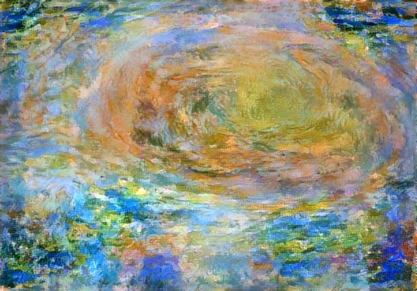
Citizen scientist David Englund created this avant-garde Jovian artwork using data from the JunoCam imager on NASA's Juno spacecraft. The unique interpretation of Jupiter's Great Red Spot was done in a style that pays tribute to French Impressionist painter Claude Monet. The original image was taken on July 10, 2017 at 7:12 p.m. PDT (10:12 p.m. EDT), as the Juno spacecraft performed its 7th close flyby of Jupiter. At the time the image was taken, the spacecraft was 10,274 miles (16,535 kilometers) from the tops of the clouds of the planet, at a latitude of -36.9 degrees. https://photojournal.jpl.nasa.gov/catalog/PIA21779 . - Enhanced image by David Englund based on images provided courtesy of NASA/JPL-Caltech/SwRI/MSSS
See swirling cloud formations in the northern area of Jupiter's north temperate belt in this new view taken by NASA's Juno spacecraft. The color-enhanced image was taken on Feb. 7 at 5:42 a.m. PST (8:42 a.m. EST), as Juno performed its eleventh close flyby of Jupiter. At the time the image was taken, the spacecraft was about 5,086 miles (8,186 kilometers) from the tops of the clouds of the planet at a latitude of 39.9 degrees. Citizen scientist Kevin M. Gill processed this image using data from the JunoCam imager. https://photojournal.jpl.nasa.gov/catalog/PIA21978 . - Enhanced image by Kevin M. Gill (CC-BY) based on images provided courtesy of NASA/JPL-Caltech/SwRI/MSSS

This image of Jupiter's swirling south polar region was captured by NASA's Juno spacecraft as it neared completion of its tenth close flyby of the gas giant planet. The "empty" space above and below Jupiter in this color-enhanced image can trick the mind, causing the viewer to perceive our solar system's largest planet as less colossal than it is. In reality, Jupiter is wide enough to fit 11 Earths across its clouded disk. The spacecraft captured this image on Dec. 16, 2017, at 11:07 PST (2:07 p.m. EST) when the spacecraft was about 64,899 miles (104,446 kilometers) from the tops of the clouds of the planet at a latitude of 83.9 degrees south -- almost directly over Jupiter's south pole. The spatial scale in this image is 43.6 miles/pixel (70.2 kilometers/pixel). Citizen scientist Gerald Eichstädt processed this image using data from the JunoCam imager. https://photojournal.jpl.nasa.gov/catalog/PIA21975

Jupiter's iconic Great Red Spot is a 10,000-mile-wide (16,000-kilometer-wide) storm that has been raging since at least the 1800s — and possibly for more than 350 years. Observations with NASA's Juno spacecraft previously indicated that the vertical extent of the Great Red Spot is over 120 miles (200 kilometers), consistent with a storm feature that develops deep in Jupiter's atmosphere. Since NASA's Voyager spacecraft visited Jupiter in 1979, the Great Red Spot has shrunk from about the size of 1.8 Earths to the size of about 1.3 Earths today. NASA's Juno spacecraft has imaged the Great Red Spot numerous times, providing unique information on the details of how the Great Red Spot dynamically changes while it is shrinking. This montage includes five map-projected mosaics of the giant storm, processed from images obtained by the JunoCam imager during several orbits between July 2017 and July 2019. The mosaics show how the Great Red Spot and nearby areas have changed over the course of the Juno mission. Will the Great Red Spot continue to shrink? Only time will tell, but as we study Jupiter's atmosphere, we learn more about how weather systems work, both on giant planets such as Jupiter and Saturn and also on our own home, Earth. Citizen scientist Björn Jónsson created this montage using JunoCam data. The images cover latitudes from about 5 degrees to 38 degrees south. Enhanced image by Björn Jónsson (CC-NC-SA) based on images provided courtesy of NASA/JPL-Caltech/SwRI/MSSS
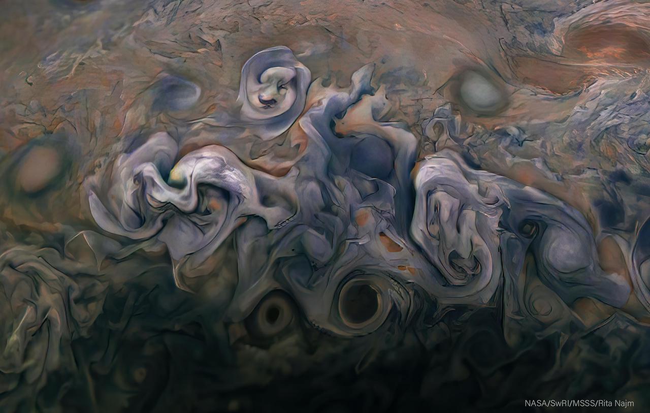
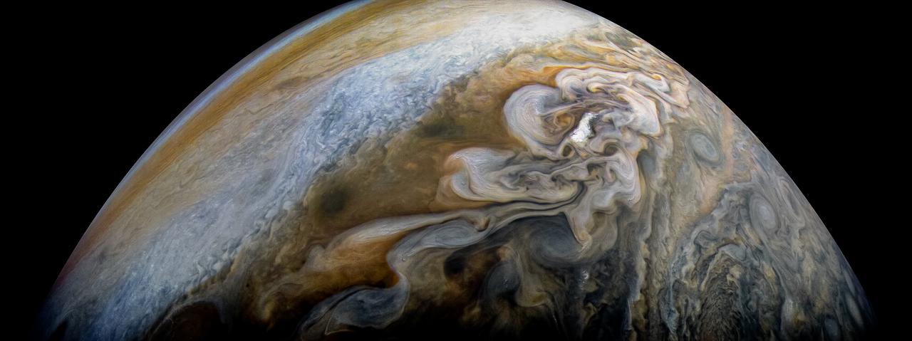
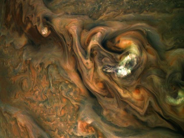
Images from the Juno spacecraft's visible-light amera JunoCam are posted after every close pass for the public to enjoy and process themselves. JunoCam's images of Jupiter inspire art and science. An image taken by JunoCam during Juno's 25th perijove pass on February 17, 2020, inspired citizen scientist Rita Najm to enhance its color and contrast and to give it the impression of a painting that's ready to be framed. The original JunoCam image used to produce this view was taken from from an altitude of about 7,900 miles (12,700 kilometers) above Jupiter's cloud tops. https://photojournal.jpl.nasa.gov/catalog/PIA24293
A giant, spiraling storm in Jupiter's southern hemisphere is captured in this animation from NASA's Juno spacecraft. The storm is approximately 5,000 miles (8,000 kilometers) across, or roughly the width of the United States. The counterclockwise motion of the storm, called Oval BA, is clearly on display. A similar rotation can be seen in the famous Great Red Spot at the top of the animation. Juno took the nine images used to produce this movie sequence on Dec. 21, 2018, between 9:24 a.m. PST (12:24 p.m. EST) and 10:07 a.m. PST (1:07 p.m. EST). At the time the images were taken, the spacecraft was between approximately 15,400 miles (24,800 kilometers) and 60,700 miles (97,700 kilometers) from the planet's cloud tops above southern latitudes spanning about 36 to 74 degrees. Citizen scientists Gerald Eichstädt and Seán Doran created this animation using data from the spacecraft's JunoCam imager. Animation available at https://photojournal.jpl.nasa.gov/catalog/PIA22943

See Jovian clouds in striking shades of blue in this new view taken by NASA's Juno spacecraft. The Juno spacecraft captured this image when the spacecraft was only 11,747 miles (18,906 kilometers) from the tops of Jupiter's clouds -- that's roughly as far as the distance between New York City and Perth, Australia. The color-enhanced image, which captures a cloud system in Jupiter's northern hemisphere, was taken on Oct. 24, 2017 at 10:24 a.m. PDT (1:24 p.m. EDT) when Juno was at a latitude of 57.57 degrees (nearly three-fifths of the way from Jupiter's equator to its north pole) and performing its ninth close flyby of the gas giant planet. The spatial scale in this image is 7.75 miles/pixel (12.5 kilometers/pixel). Because of the Juno-Jupiter-Sun angle when the spacecraft captured this image, the higher-altitude clouds can be seen casting shadows on their surroundings. The behavior is most easily observable in the whitest regions in the image, but also in a few isolated spots in both the bottom and right areas of the image. Citizen scientists Gerald Eichstädt and Seán Doran processed this image using data from the JunoCam imager. https://photojournal.jpl.nasa.gov/catalog/PIA21972
This view from NASA's Juno spacecraft captures colorful, intricate patterns in a jet stream region of Jupiter's northern hemisphere known as "Jet N3." Jupiter's cloud tops do not form a simple, flat surface. Data from Juno helped scientists discover that the swirling bands in the atmosphere extend deep into the planet, to a depth of about 1,900 miles (3,000 kilometers). At center right, a patch of bright, high-altitude "pop-up" clouds rises above the surrounding atmosphere. Citizen scientist Gerald Eichstädt created this enhanced-color image using data from the spacecraft's JunoCam imager. The original image was taken on May 29, 2019, at 1:01 a.m. PDT (4:01 a.m. EDT) as the Juno spacecraft performed its 20th close flyby of Jupiter. At the time the image was taken, the spacecraft was about 6,000 miles (9,700 kilometers) from the tops of the clouds, at a latitude of 39 degrees north. PIA23439 - Enhanced image by Gerald Eichstädt based on images provided courtesy of NASA/JPL-Caltech/SwRI/MSSS
Striking atmospheric features in Jupiter's northern hemisphere are captured in this series of color-enhanced images from NASA's Juno spacecraft. An anticyclonic white oval, called N5-AWO, can be seen at center left of the first image (at far left) and appears slightly higher in the second and third images. A tempest known as the Little Red Spot is visible near the bottom of the second and third images. The reddish-orange band that is prominently displayed in the fourth and fifth images is the North North Temperate Belt. From left to right, this sequence of images was taken between 9:54 p.m. and 10:11 p.m. PDT on July 15 (12:54 a.m. and 1:11 a.m. EDT on July 16), as the spacecraft performed its 14th close flyby of Jupiter. At the time, Juno's altitude ranged from about 15,700 to 3,900 miles (25,300 to 6,200 kilometers) from the planet's cloud tops, above a latitude of approximately 69 to 36 degrees. Citizen scientists Gerald Eichstädt and Seán Doran created this image using data from the spacecraft's JunoCam imager. https://photojournal.jpl.nasa.gov/catalog/PIA22686
This images is one of two true-color images taken 12 minutes apart neatly captures storm movement in the southern hemisphere of Jupiter. NASA's Juno spacecraft took these images during its tenth close flyby of the gas giant planet on Dec. 16, 2017 at 10:12 a.m. PST (1:12 p.m. EST) and 10:24 a.m. PST (1:24 p.m. EST). At the time, the spacecraft was about 8,453 miles (13,604 kilometers) and 19,244 miles (30,970 kilometers) from the tops of the clouds above the planet, with the images centered on south latitudes of 27.96 degrees and 49.91 degrees. The animation reveals the cyclonic motion of the STB Ghost, a large elongated feature in Jupiter's South Temperate Belt. This feature is elongated in the east-west direction and is located near the center in these images. Citizen scientist Björn Jónsson processed the image using data from the JunoCam imager. An animation is available at https://photojournal.jpl.nasa.gov/catalog/PIA21982. - Enhanced image by Björn Jónsson (CC-NC-SA) based on images provided courtesy of NASA/JPL-Caltech/SwRI/MSSS
This color-enhanced image of Jupiter and two of its largest moons -- Io and Europa -- was captured by NASA's Juno spacecraft as it performed its eighth flyby of the gas giant planet. The image was taken on Sept. 1, 2017 at 3:14 p.m. PDT (6:14 p.m. EDT). At the time the image was taken, the spacecraft was about 17,098 miles (27,516 kilometers) from the tops of the clouds of the planet at a latitude of minus 49.372 degrees. Closer to the planet, the Galilean moon of Io can be seen at an altitude of 298,880 miles (481,000 kilometers) and at a spatial scale of 201 miles (324 kilometers) per pixel. In the distance (to the left), another one of Jupiter's Galilean moons, Europa, is visible at an altitude of 453,601 miles (730,000 kilometers) and at a spatial scale of 305 miles (492 kilometers) per pixel. Citizen scientist Roman Tkachenko processed this image using data from the JunoCam imager. https://photojournal.jpl.nasa.gov/catalog/PIA21968 . - Enhanced image by Roman Tkachenko (CC-BY) based on images provided courtesy of NASA/JPL-Caltech/SwRI/MSSS
This color-enhanced image of a massive, raging storm in Jupiter's northern hemisphere was captured by NASA's Juno spacecraft during its ninth close flyby of the gas giant planet. The image was taken on Oct. 24, 2017 at 10:32 a.m. PDT (1:32 p.m. EDT). At the time the image was taken, the spacecraft was about 6,281 miles (10,108 kilometers) from the tops of the clouds of Jupiter at a latitude of 41.84 degrees. The spatial scale in this image is 4.2 miles/pixel (6.7 kilometers/pixel). The storm is rotating counter-clockwise with a wide range of cloud altitudes. The darker clouds are expected to be deeper in the atmosphere than the brightest clouds. Within some of the bright "arms" of this storm, smaller clouds and banks of clouds can be seen, some of which are casting shadows to the right side of this picture (sunlight is coming from the left). The bright clouds and their shadows range from approximately 4 to 8 miles (7 to 12 kilometers) in both widths and lengths. These appear similar to the small clouds in other bright regions Juno has detected and are expected to be updrafts of ammonia ice crystals possibly mixed with water ice. Citizen scientists Gerald Eichstädt and Seán Doran processed this image using data from the JunoCam imager. https://photojournal.jpl.nasa.gov/catalog/PIA21971
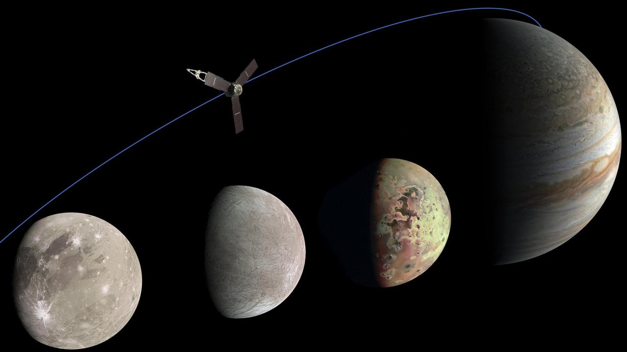
This photo illustration of Jupiter and the three Jovian moons NASA's Juno mission has flown past was generated from data collected by the spacecraft's JunoCam imager. Ganymede, the moon furthest to the left, was imaged by JunoCam as it flew past on June 8, 2021. Citizen scientist Kevin M. Gill created this image using data from JunoCam. The moon second from the left is Europa, which Juno imaged on Sept. 29, 2022. Citizen scientist Kevin M. Gill created this image using data from JunoCam. The image of Io was captured during a flyby of the moon on May 16, 2023. Citizen scientist Thomas Thomopoulos created this image using data from JunoCam. The image of Jupiter was captured on Dec. 15, 2022. Citizen scientist Kevin M. Gill created this image using data from JunoCam. https://photojournal.jpl.nasa.gov/catalog/PIA25966
This image of Jupiter's iconic Great Red Spot (GRS) was created by citizen scientist Björn Jónsson using data from the JunoCam imager on NASA's Juno spacecraft. This true-color image offers a natural color rendition of what the Great Red Spot and surrounding areas would look like to human eyes from Juno's position. The tumultuous atmospheric zones in and around the Great Red Spot are clearly visible. The image was taken on July 10, 2017 at 07:10 p.m. PDT (10:10 p.m. EDT), as the Juno spacecraft performed its seventh close flyby of Jupiter. At the time the image was taken, the spacecraft was about 8,648 miles (13,917 kilometers) from the tops of the clouds of the planet at a latitude of -32.6 degrees. https://photojournal.jpl.nasa.gov/catalog/PIA21775. - Enhanced image by Björn Jónsson (CC-NC-SA) based on images provided courtesy of NASA/JPL-Caltech/SwRI/MSSS
This image of Jupiter's iconic Great Red Spot and surrounding turbulent zones was captured by NASA's Juno spacecraft. The color-enhanced image is a combination of three separate images taken on April 1 between 3:09 a.m. PDT (6:09 a.m. EDT) and 3:24 a.m. PDT (6:24 a.m. EDT), as Juno performed its 12th close flyby of Jupiter. At the time the images were taken, the spacecraft was 15,379 miles (24,749 kilometers) to 30,633 miles (49,299 kilometers) from the tops of the clouds of the planet at a southern latitude spanning 43.2 to 62.1 degrees. Citizen scientists Gerald Eichstädt and Seán Doran processed this image using data from the JunoCam imager. https://photojournal.jpl.nasa.gov/catalog/PIA21985
This image captures a high-altitude cloud formation surrounded by swirling patterns in the atmosphere of Jupiter's North North Temperate Belt region. The North North Temperate Belt is one of Jupiter's many colorful, swirling cloud bands. Scientists have wondered for decades how deep these bands extend. Gravity measurements collected by Juno during its close flybys of the planet have now provided an answer. Juno discovered that these bands of flowing atmosphere actually penetrate deep into the planet, to a depth of about 1,900 miles (3,000 kilometers). NASA's Juno spacecraft took this color-enhanced image at 10:11 p.m. PDT on July 15, 2018 (1:11 a.m. EDT on July 16), as the spacecraft performed its 14th close flyby of Jupiter. At the time, Juno was about 3,900 miles (6,200 kilometers) from the planet's cloud tops, above a latitude of 36 degrees. Citizen scientist Jason Major created this image using data from the spacecraft's JunoCam imager. https://photojournal.jpl.nasa.gov/catalog/PIA22426 . - Enhanced image by Jason Major based on images provided courtesy of NASA/JPL-Caltech/SwRI/MSSS
A swirling storm somersaults through Jupiter's South Equatorial Belt in this view taken by NASA's Juno spacecraft. This feature -- not to be confused with the planet's iconic Great Red Spot -- is escorted by several smaller, reddish vortices above and to the left. This natural color view offers an approximation of what Jupiter would look like to human eyes from Juno's vantage point near the time of closest approach in its orbit. Jupiter's stunning appearance is due to its atmosphere of colorful cloud bands and spots. The vivid red and orange hues are created by chemicals of uncertain composition called "chromophores." The image was taken at 10:28 p.m. PDT on July 15, 2018 (1:28 a.m. EDT on July 16), as the spacecraft performed its 14th close flyby of Jupiter. At the time, Juno was about 4,900 miles (8,000 kilometers) from the planet's cloud tops, above a southern latitude of 36 degrees. Citizen scientist Björn Jónsson created this image using data from the spacecraft's JunoCam imager. https://photojournal.jpl.nasa.gov/catalog/PIA22427. - Enhanced image by Björn Jónsson (CC-NC-SA) based on images provided courtesy of NASA/JPL-Caltech/SwRI/MSSS
Tumultuous tempests in Jupiter's northern hemisphere are seen in this portrait taken by NASA's Juno spacecraft. Like our home planet, Jupiter has cyclones and anticyclones, along with fast-moving jet streams that circle its globe. This image captures a jet stream, called Jet N6, located on the far right of the image. It is next to an anticyclonic white oval that is the brighter circular feature in the top right corner. The North North Little Red Spot is also visible in this view. The image was taken at 10 p.m. PDT on July 15, 2018 (1 a.m. EDT on July 16), as the spacecraft performed its 14th close flyby of Jupiter. At the time, Juno was about 10,600 miles (17,000 kilometers) from the planet's cloud tops, above a latitude of 59 degrees. Citizen scientists Brian Swift and Seán Doran created this image using data from the spacecraft's JunoCam imager. The image has been rotated clockwise so that north is to the right. The stars were artfully added to the background for effect. https://photojournal.jpl.nasa.gov/catalog/PIA22428

Colorful swirling cloud belts dominate Jupiter's southern hemisphere in this image captured by NASA's Juno spacecraft. Jupiter appears in this color-enhanced image as a tapestry of vibrant cloud bands and storms. The dark region in the far left is called the South Temperate Belt. Intersecting the belt is a ghost-like feature of slithering white clouds. This is the largest feature in Jupiter's low latitudes that's a cyclone (rotating with clockwise motion). This image was taken on Dec. 16, 2017 at 10:12 PST (1:12 p.m. EST), as Juno performed its tenth close flyby of Jupiter. At the time the image was taken, the spacecraft was about 8,453 miles (13,604 kilometers) from the tops of the clouds of the planet at a latitude of 27.9 degrees south. The spatial scale in this image is 5.6 miles/pixel (9.1 kilometers/pixel). Citizen scientist Kevin M. Gill processed this image using data from the JunoCam imager. https://photojournal.jpl.nasa.gov/catalog/PIA21974 . - Enhanced image by Kevin M. Gill (CC-BY) based on images provided courtesy of NASA/JPL-Caltech/SwRI/MSSS

This trio of NASA Junocam views of Earth was taken during Juno close flyby on October 9, 2013.
This image of Jupiter's turbulent southern hemisphere was captured by NASA's Juno spacecraft as it performed its most recent close flyby of the gas giant planet on Dec. 21, 2018. This new perspective captures the notable Great Red Spot, as well as a massive storm called Oval BA. The storm reached its current size when three smaller spots collided and merged in the year 2000. The Great Red Spot, which is about twice as wide as Oval BA, may have formed from the same process centuries ago. Juno captured Oval BA in another image earlier on in the mission on Feb. 7, 2018. The turbulent regions around, and even the shape of, the storm have significantly changed since then. Oval BA further transformed in recent months, changing color from reddish to a more uniform white. Juno took the three images used to produce this color-enhanced view on Dec. 21, between 9:32 a.m. PST (12:32 p.m. EST) and 9:42 a.m. PST (12:42 p.m. EST). At the time the images were taken, the spacecraft was between approximately 23,800 miles (38,300 kilometers) to 34,500 miles (55,500 kilometers) from the planet's cloud tops above southern latitudes spanning 49.15 to 59.59 degrees. Citizen scientists Gerald Eichstädt and Seán Doran created this image using data from the spacecraft's JunoCam imager. https://photojournal.jpl.nasa.gov/catalog/PIA22942
A long, brown oval known as a "brown barge" in Jupiter's South Equatorial Belt is captured in this color-enhanced image from NASA's Juno spacecraft. Brown barges are cyclonic regions that usually lie within Jupiter's dark North Equatorial Belt, although they are sometimes found in the similarly dark South Equatorial Belt as well. They can often be difficult to detect visually because their color blends in with the dark surroundings. At other times, as with this image, the dark belt material recedes, creating a lighter-colored background against which the brown barge is more conspicuous. Brown barges usually dissipate after the entire cloud belt undergoes an upheaval and reorganizes itself. Juno is giving us the first glimpses of the detailed structure within such a barge. This image was taken at 6:26 p.m. PDT on Sept. 6, 2018 (9:26 p.m. EDT) as the spacecraft performed its 15th close flyby of Jupiter. At the time, Juno was 7,425 miles (11,950 kilometers) from the planet's cloud tops, above a southern latitude of approximately 22 degrees. Citizen scientist Kevin M. Gill created this image using data from the spacecraft's JunoCam imager. The image has been rotated 90 degrees to the right from the original image. https://photojournal.jpl.nasa.gov/catalog/PIA22688 . - Enhanced image by Kevin M. Gill (CC-BY) based on images provided courtesy of NASA/JPL-Caltech/SwRI/MSSS
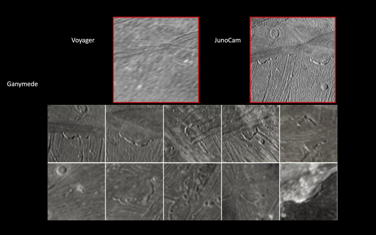
JunoCam, the public engagement camera aboard NASA's Juno spacecraft, captured these views of Jupiter's moon Ganymede during a close pass on June 7, 2021. JunoCam was able to obtain significantly higher quality images compared to those taken by NASA's Voyager spacecraft in 1979 (upper left). In these images, JunoCam revealed 12 paterae – broad, shallow bowl-shaped features on a planetary body's surface – only two of which are evident in the Voyager data. These features were likely formed by late-stage volcanic processes. https://photojournal.jpl.nasa.gov/catalog/PIA25721
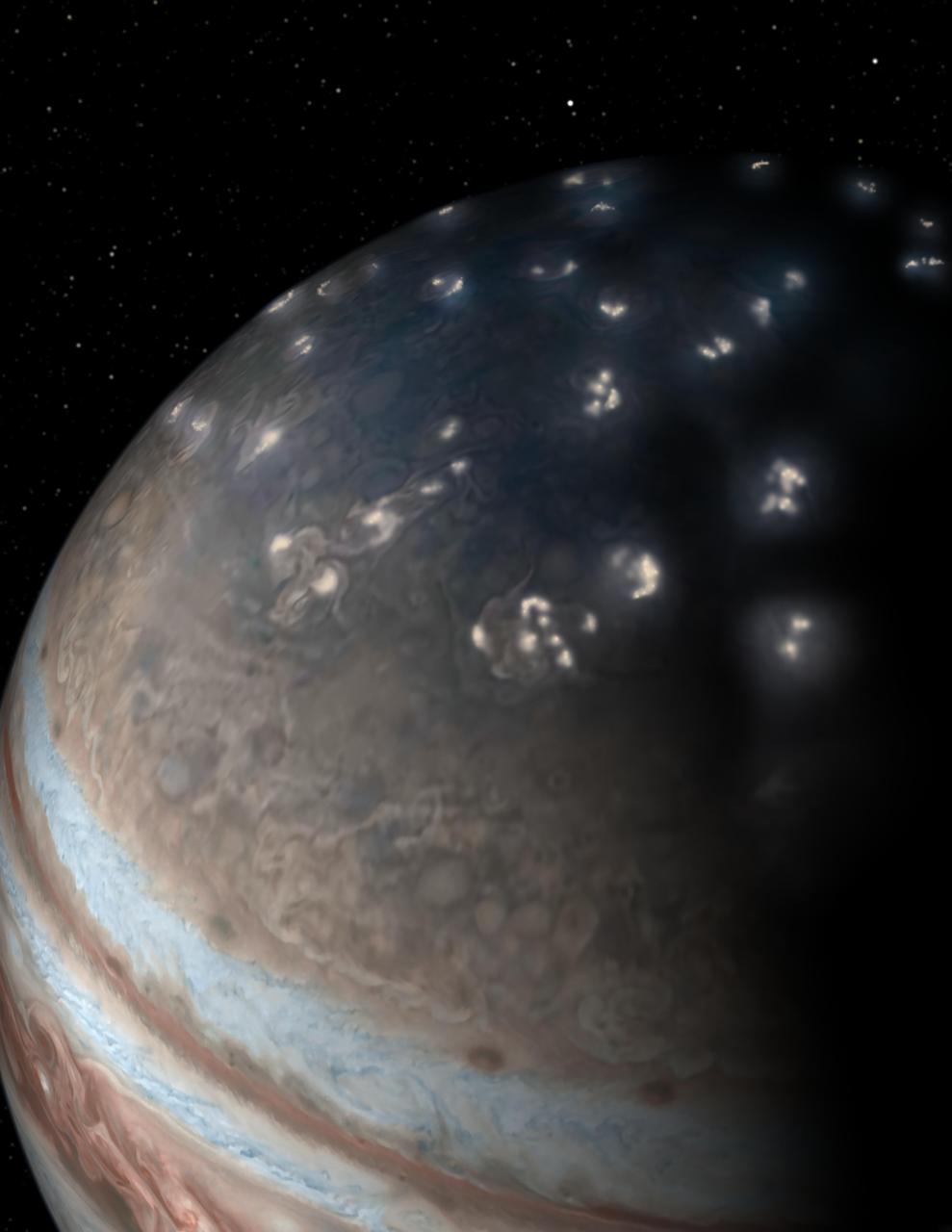
This artist's concept of lightning distribution in Jupiter's northern hemisphere incorporates a JunoCam image with artistic embellishments. Data from NASA's Juno mission indicates that most of the lightning activity on Jupiter is near its poles. https://photojournal.jpl.nasa.gov/catalog/PIA22474
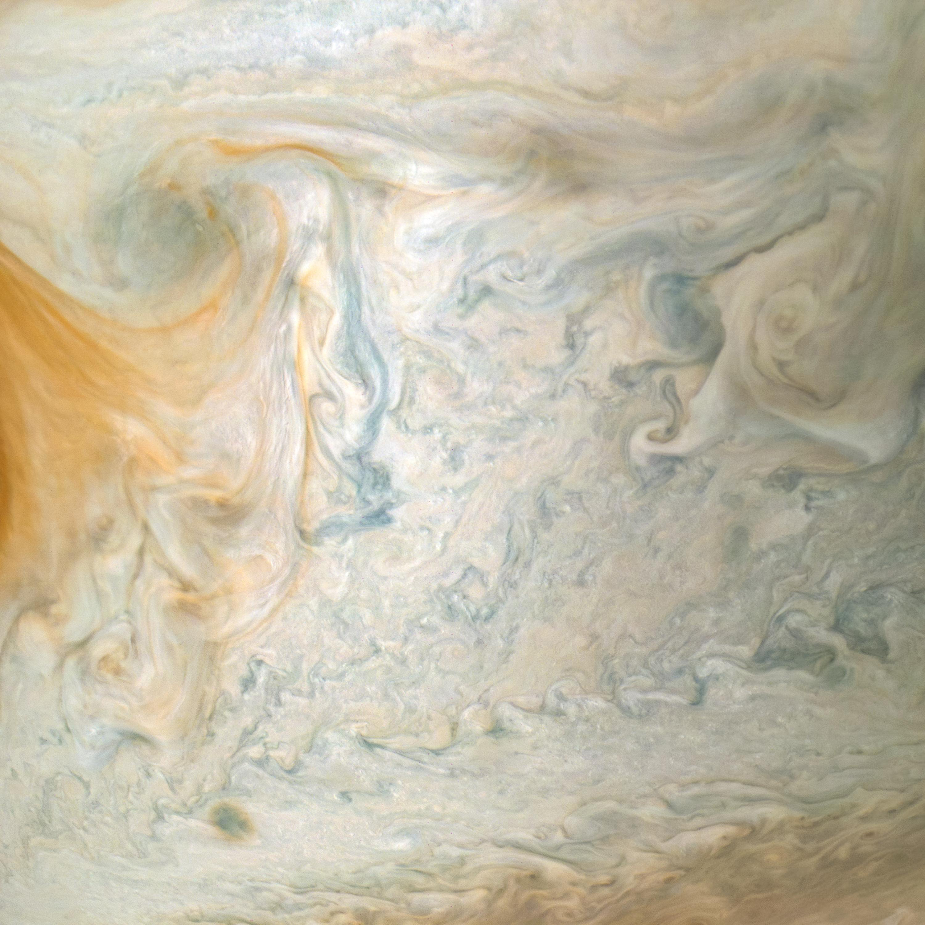
The easternmost edge of Jupiter's Great Red Spot and surrounding south tropical disturbance are captured in this image from NASA's Juno spacecraft. At left, wispy tendrils from the Red Spot give the atmosphere a layered appearance as they partially obscure cloud features below. Jupiter's appearance is a tapestry of vivid colors and swirling atmospheric vortices. Many aspects of the planet's atmosphere are still a mystery. For example, the origin of individual storms or churning cloud features is unknown. By studying Jupiter's weather up close for the first time, Juno is helping researchers better understand how atmospheres work in general -- including our own. What we learn about Jupiter's atmosphere will also help scientists understand how gas-giant planets work in general, including those now being discovered beyond our solar system. This color-enhanced image was taken at 3:01 a.m. PDT on April 1, 2018 (6:01 a.m. EDT), as the spacecraft performed its 12th close flyby of Jupiter. At the time, Juno was about 7,900 miles (12,750 kilometers) from the planet's cloud tops, above a southern latitude of approximately 26 degrees. Citizen scientist Kevin M. Gill created this image using data from the spacecraft's JunoCam imager. https://photojournal.jpl.nasa.gov/catalog/PIA22429 . - Enhanced image by Kevin M. Gill (CC-BY) based on images provided courtesy of NASA/JPL-Caltech/SwRI/MSSS
This illustration combines an image of Jupiter from the JunoCam instrument aboard NASA's Juno spacecraft with a composite image of Earth to depict the size and depth of Jupiter's Great Red Spot. https://photojournal.jpl.nasa.gov/catalog/PIA24817

The JunoCam instrument aboard NASA's Juno spacecraft captured this view of Jupiter's moon Io – the first-ever image of the moon's south polar region – during Juno's 60th flyby of Jupiter on Apr. 9, 2024. Citizen scientist Thomas Thomopoulos made this image by applying further processing to an image created from raw JunoCam data by another citizen scientist, Gerald Eichstädt. At the time the raw image was taken, Juno was about 10,250 miles (16,500 kilometers) above the surface of Io. https://photojournal.jpl.nasa.gov/catalog/PIA25697
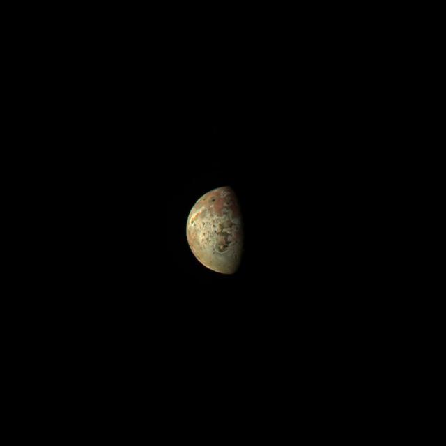
This image of the Jovian moon Io was generated using data collected by the JunoCam imager aboard NASA's Juno spacecraft during a flyby of the moon on March 1, 2023. At the time of closest approach, Juno was about 32,000 miles (51,500 kilometers) away from Io. The image's resolution is about 22 miles (35 kilometers) per pixel. Citizen scientist Kevin M. Gill created this image using data from JunoCam. https://photojournal.jpl.nasa.gov/catalog/PIA25885

The main image and the inset image were taken by the JunoCam imager about NASA's Juno spacecraft a few hours before its closest approach to Jupiter on its 38th perijove pass, on Nov. 29, 2021, during an encounter with the Jovian moon Io. After snapping a series of Io images, JunoCam acquired this picture of Jupiter and Io together. Much fainter and more distant is Jupiter's moon Callisto, barely visible below and to the right of Io. The original JunoCam image used to produce this view was taken from an altitude of 15,404 miles (24,791 kilometers) above Jupiter's cloud tops near its north pole. At the time, Io was at a distance of 270,648 miles (435,567 kilometers), and Callisto was almost 1.2 million miles (2 million kilometers). Citizen scientist Brian Swift processed the main image and inset to enhance the color and contrast. https://photojournal.jpl.nasa.gov/catalog/PIA25032
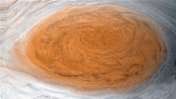
Winds around Jupiter's Great Red Spot are simulated in this JunoCam view that has been animated using a model of the winds there. The wind model, called a velocity field, was derived from data collected by NASA's Voyager spacecraft and Earth-based telescopes. NASA's Juno spacecraft acquired the original, static view during passage over the spot on July 10, 2017. Citizen scientists Gerald Eichstädt and Justin Cowart turned the JunoCam data into a color image mosaic. Juno scientists Shawn Ewald and Andrew Ingersoll applied the velocity data to the image to produce a looping animation. An animation is available at https://photojournal.jpl.nasa.gov/catalog/PIA22178
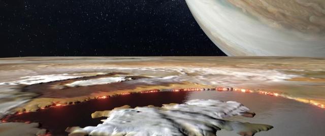
Created using data collected by the JunoCam imager aboard NASA's Juno spacecraft, this animation is an artist's concept that shows an aerial view of Loki Patera, a lava lake on the Jovian moon Io. The 124-mile-long (200-kilometer-long) lake is filled with magma, rimmed with hot lava, and dotted with islands. Loki provided a spectacular reflection when imaged by JunoCam during flybys of the moon in December 2023 and February 2024, suggesting it and other parts of Io's surface are as smooth as glass. The large island in Loki Patera does not have a name. Animation available at https://photojournal.jpl.nasa.gov/catalog/PIA26293
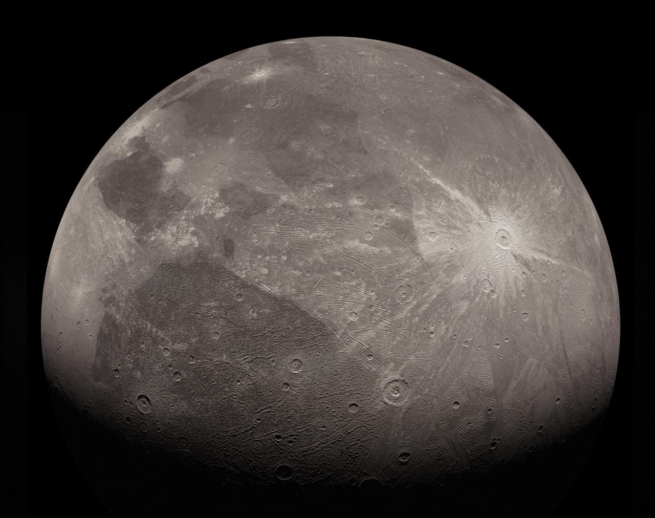
This enhanced image of the Jovian moon Ganymede was obtained by the JunoCam imager aboard NASA's Juno spacecraft during the mission's June 7, 2021, flyby of the icy moon on Juno's 34th pass close to Jupiter. This is an extended, upscaled and artistically enhanced version of a previously released JunoCam image: PIA24681. The missing top part of the original JunoCam image has been reconstructed, for the most part, using an additional image. To make the new, enhanced image, small surface features have been extracted from elsewhere on Ganymede's surface. During the June 7 flyby, Juno passed just 645 miles (1,038 kilometers) above the surface of the Ganymede, which is the solar system's largest moon. The spacecraft has been in orbit around Jupiter since July 4, 2016, but this was the first pass close to one of Jupiter's large moons. Juno is a spin-stabilized spacecraft (with a rotation rate of 2 rpm), and the JunoCam imager has a fixed field of view. To obtain Ganymede images as Juno rotated, the camera acquired a strip at a time as the target passed through its field of view. These image strips were captured separately through red, green and blue filters. To generate the final image product, the strips must be stitched together and the colors aligned. https://photojournal.jpl.nasa.gov/catalog/PIA25028
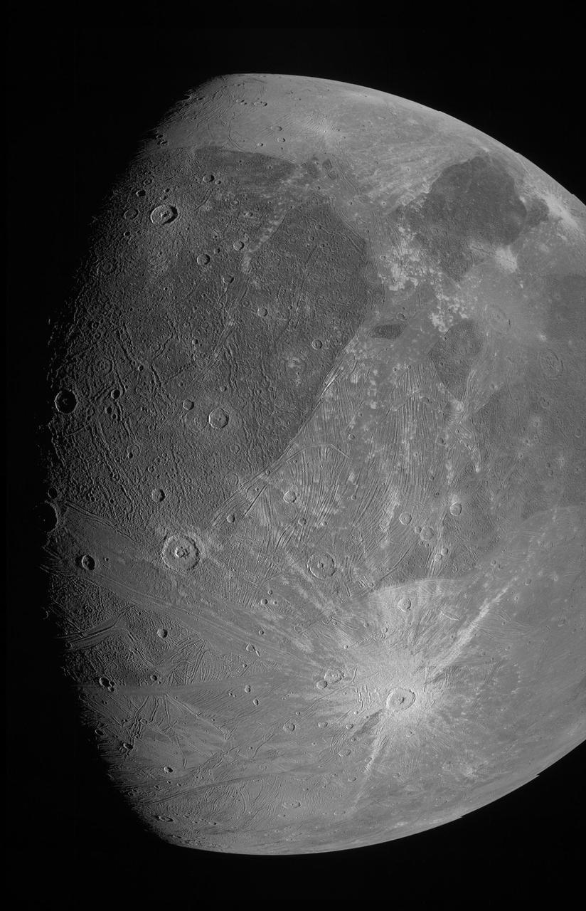
This image of the Jovian moon Ganymede was obtained by the JunoCam imager aboard NASA's Juno spacecraft during its June 7, 2021, flyby of the icy moon. At the time of closest approach, Juno was within 645 miles (1,038 kilometers) of its surface – closer to Jupiter's largest moon than any other spacecraft has come in more than two decades. This image is a preliminary product – Ganymede as seen through JunoCam's green filter. Juno is a spin-stabilized spacecraft (with a rotation rate of 2 rpm), and the JunoCam imager has a fixed field of view. To obtain Ganymede images as Juno rotated, the camera acquired a strip at a time as the target passed through its field of view. These image strips were captured separately through the red, green, and blue filters. To generate the final image product, the strips must be stitched together and colors aligned. At the time this preliminary image was generated, the "spice kernels" (navigation and other ancillary information providing precision observation geometry) necessary to properly map-project the imagery were not available. The red, and blue filtered image strips were also not available. When the final spice kernel data and images from the two filters are incorporated, the images seams (most prevalent on lower right of sphere) will disappear and a complete color image will be generated. https://photojournal.jpl.nasa.gov/catalog/PIA24681
This JunoCam image of Jupiter's south temperate belt and Great Red Spot was taken on Dec. 30, 2020. Wide enough to contain Earth, the Great Red Spot is the most dominant atmospheric feature in the planet's southern hemisphere. https://photojournal.jpl.nasa.gov/catalog/PIA24962

Ground-based astronomers will be playing a vital role in NASA Juno mission. Images from the amateur astronomy community are needed to help the JunoCam instrument team predict what features will be visible when the camera images are taken.
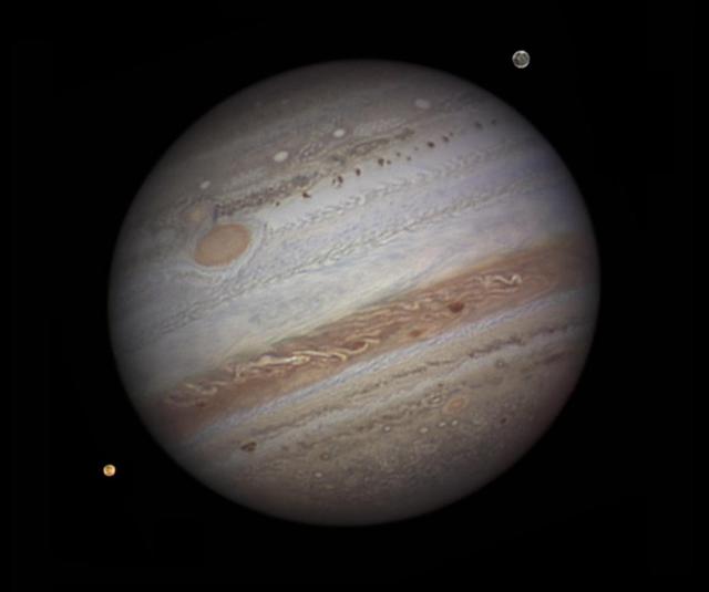
Ground-based astronomers will be playing a vital role in NASA Juno mission. Images from the amateur astronomy community are needed to help the JunoCam instrument team predict what features will be visible when the camera images are taken.