CAPE CANAVERAL, Fla. – At NASA’s Kennedy Space Center in Florida, construction is almost complete on the Antenna Test Bed Array for the Ka-Band Objects Observation and Monitoring, or Ka-BOOM, system. The Ka-BOOM project is one of the final steps in developing the techniques to build a high power, high resolution radar system capable of becoming a Near Earth Object Early Warning System. While also capable of space communication and radio science experiments, developing radar applications is the primary focus of the arrays. The 40-foot-diameter dish antenna arrays are near the former Vertical Processing Facility, which has been demolished. Photo credit: NASA_Charisse Nahser
CAPE CANAVERAL, Fla. – At NASA’s Kennedy Space Center in Florida, construction is almost complete on the Antenna Test Bed Array for the Ka-Band Objects Observation and Monitoring, or Ka-BOOM, system. The Ka-BOOM project is one of the final steps in developing the techniques to build a high power, high resolution radar system capable of becoming a Near Earth Object Early Warning System. While also capable of space communication and radio science experiments, developing radar applications is the primary focus of the arrays. The 40-foot-diameter dish antenna arrays are near the former Vertical Processing Facility, which has been demolished. Photo credit: NASA_Charisse Nahser
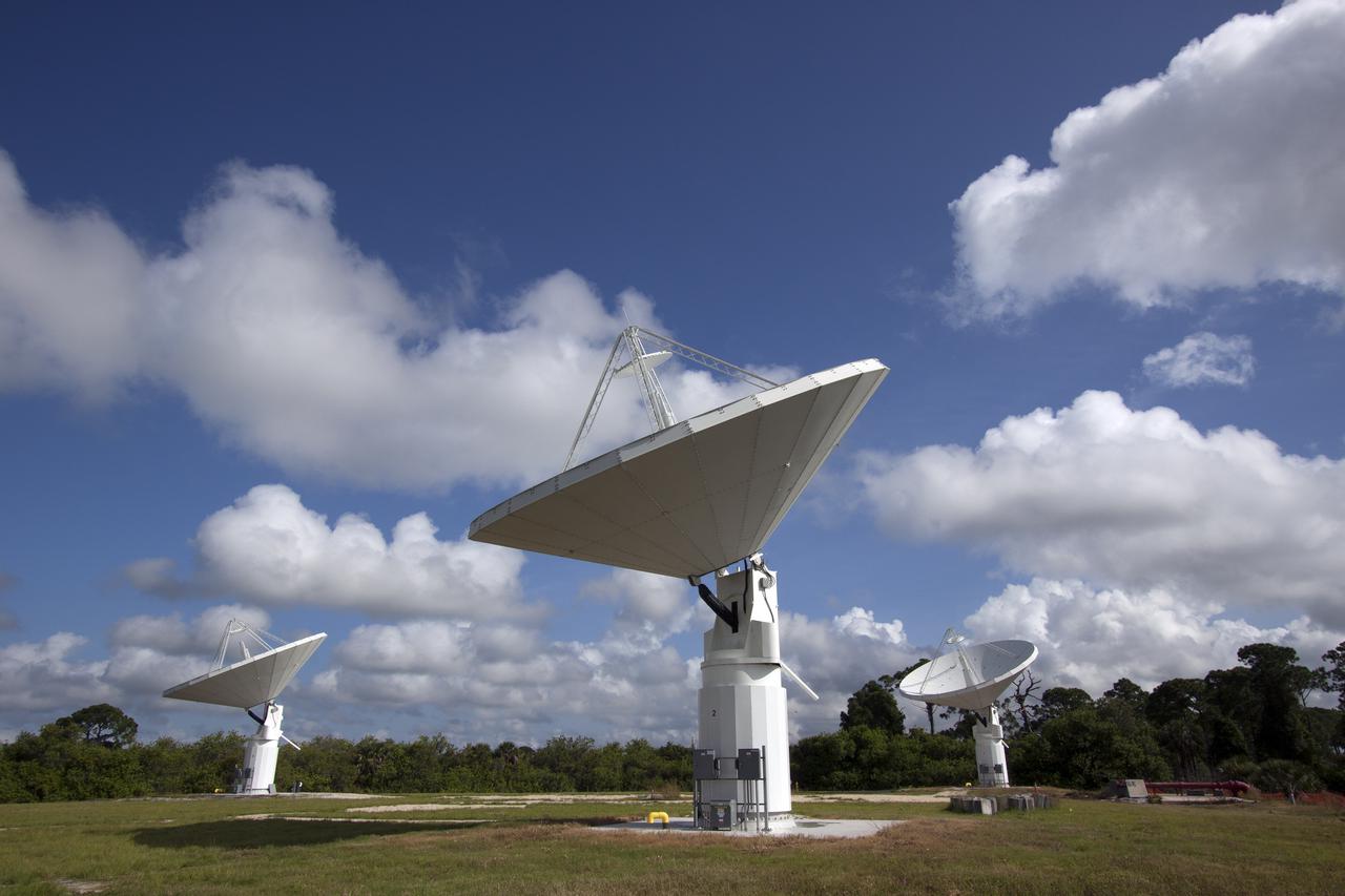
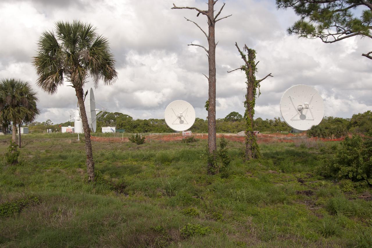
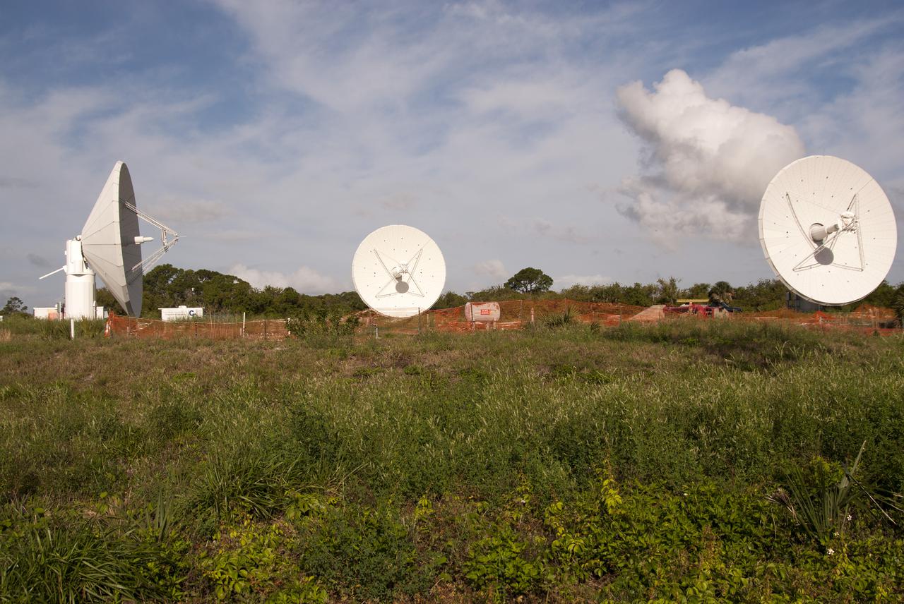
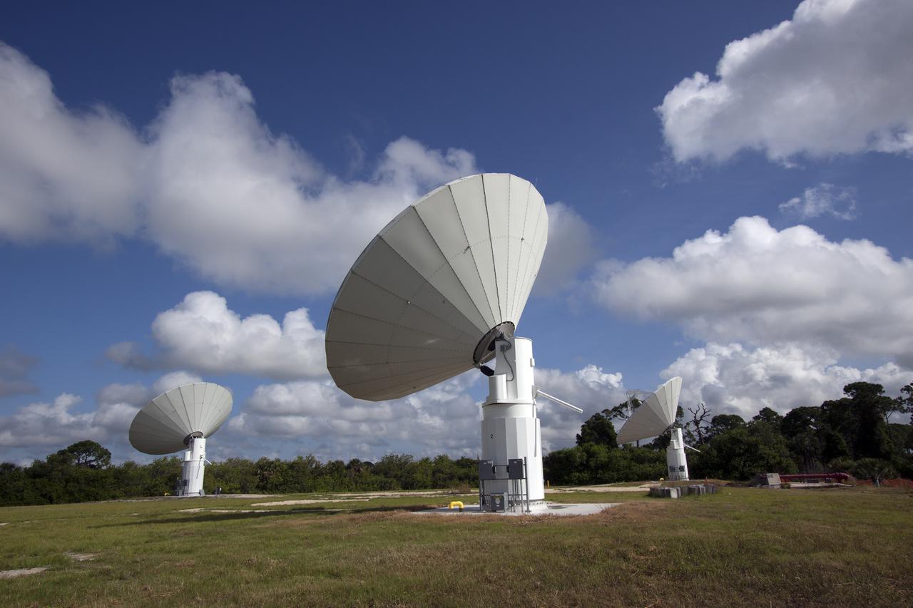
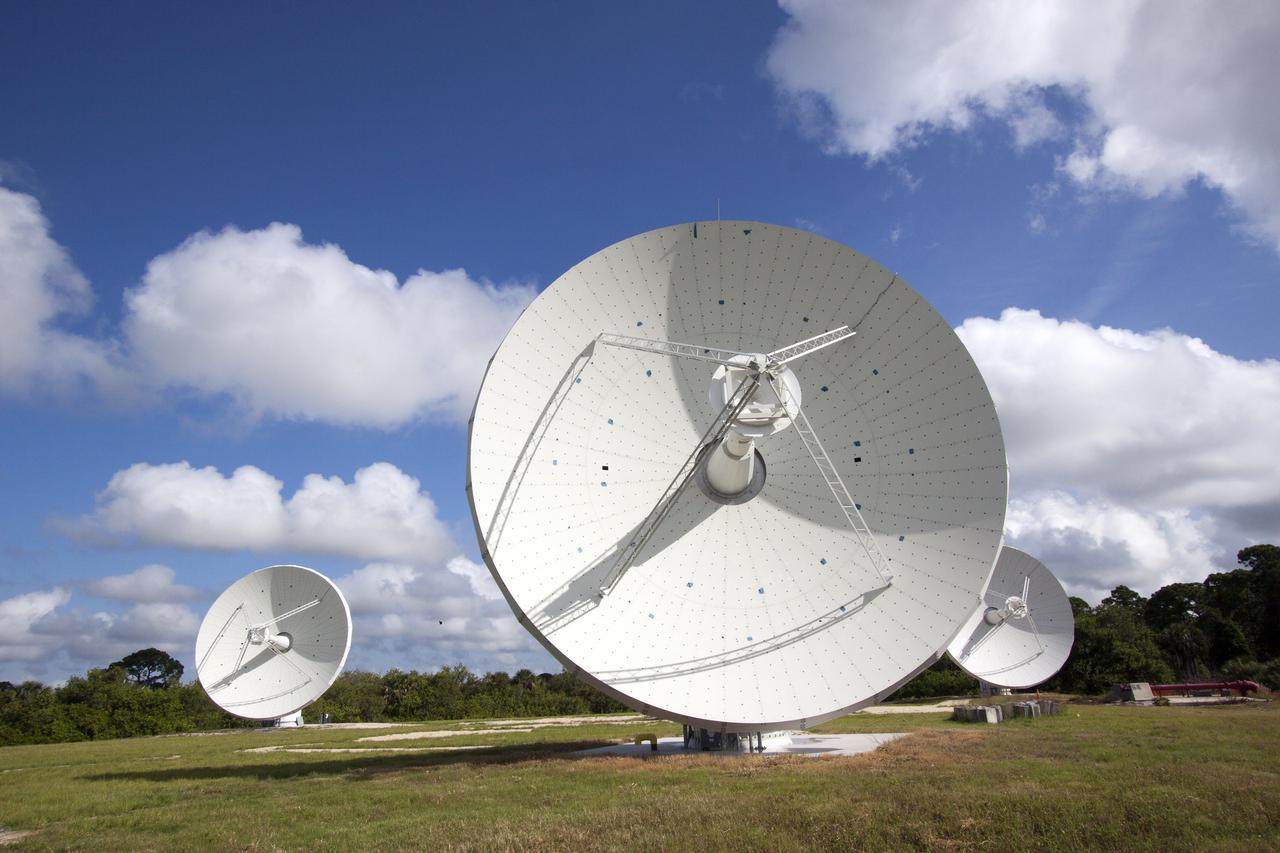
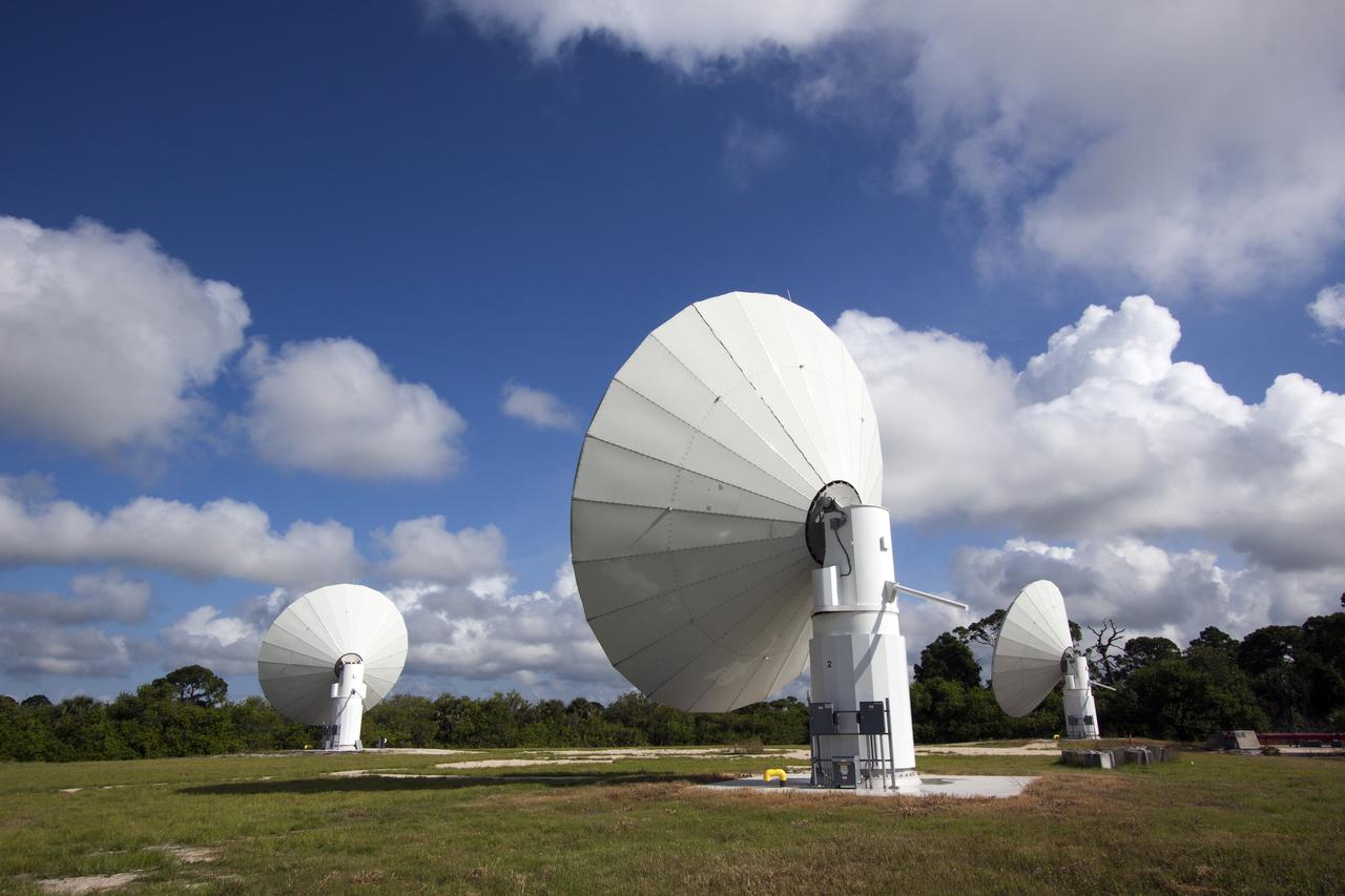
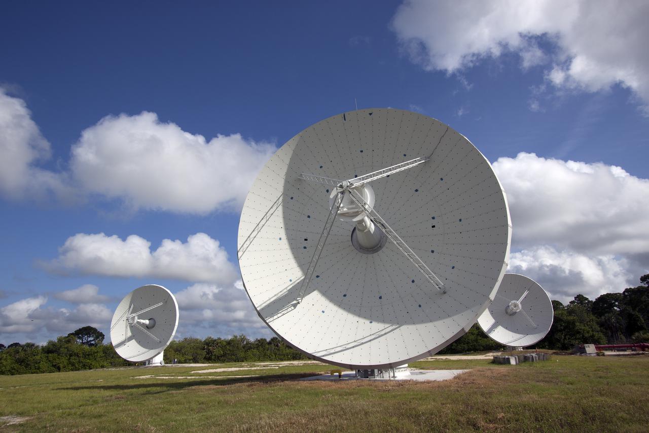
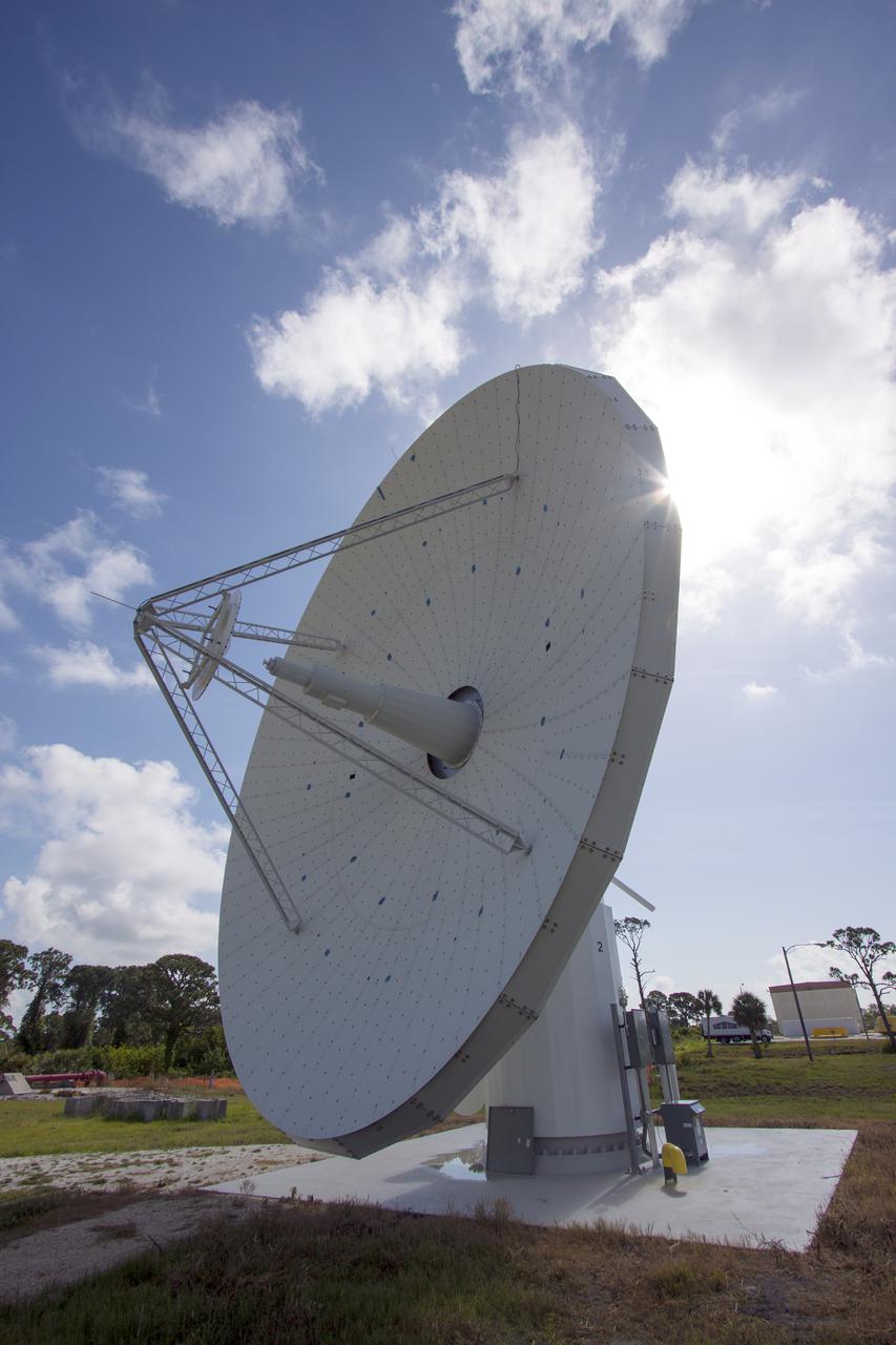
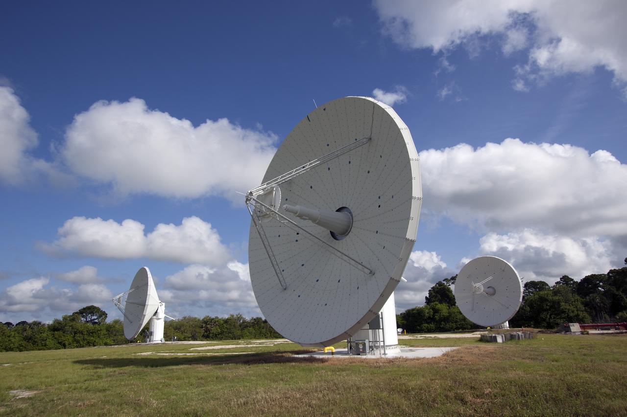
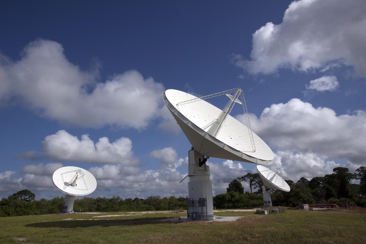
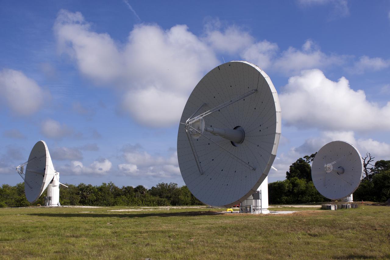
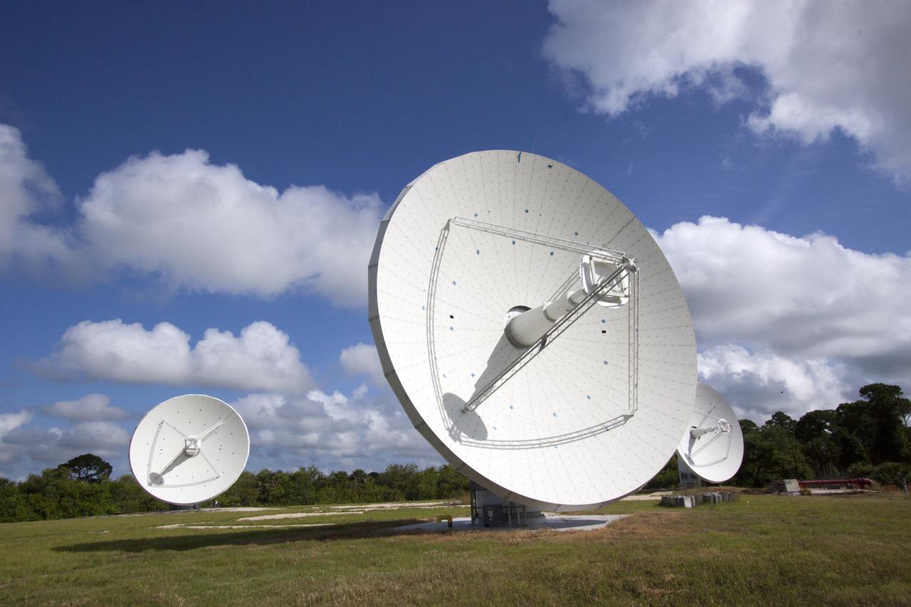
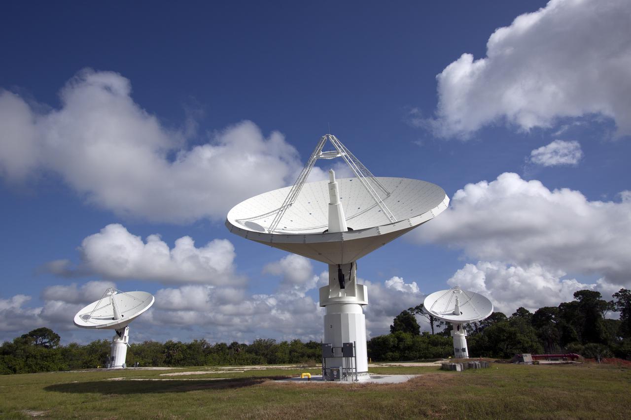
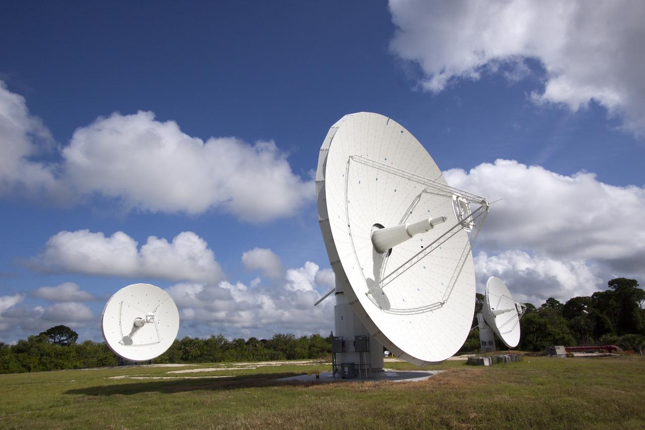
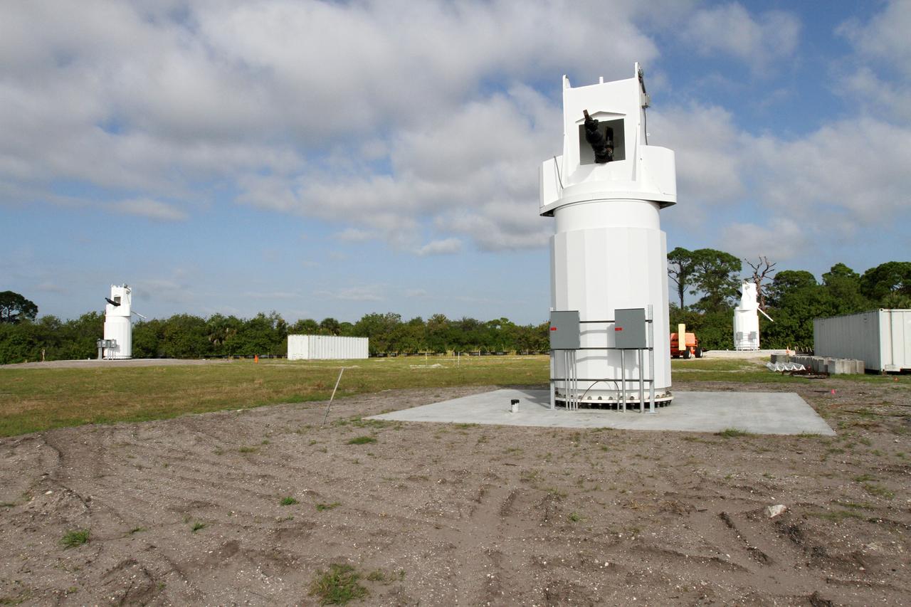
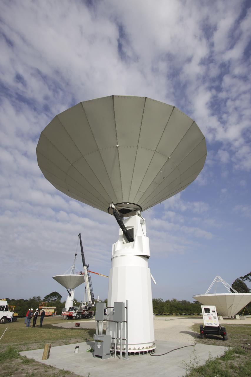
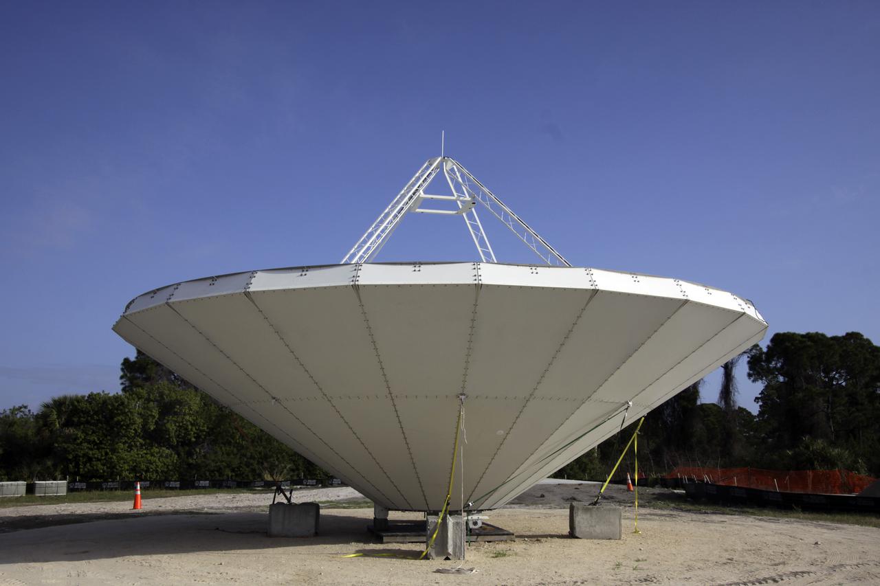
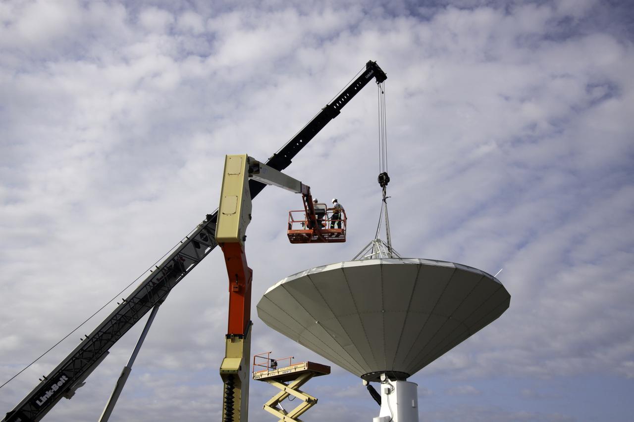
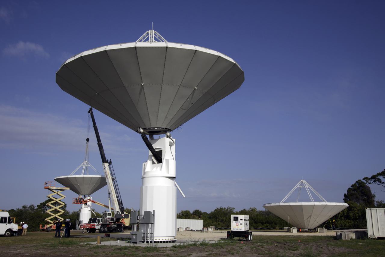
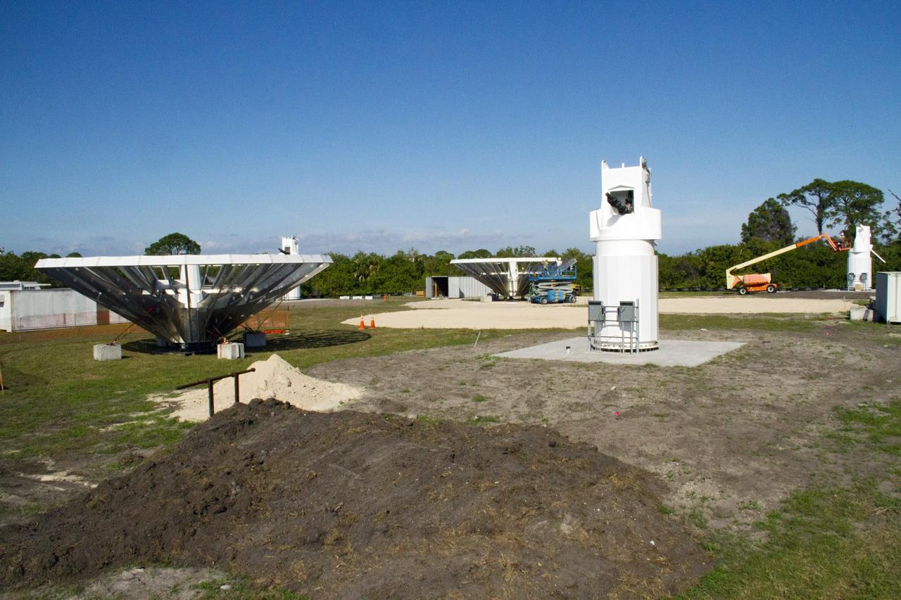
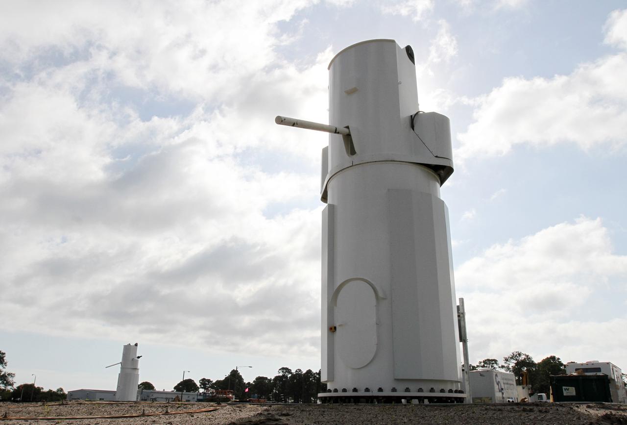
CAPE CANAVERAL, Fla. -- At NASA’s Kennedy Space Center in Florida, the three Ka-Band Objects Observation and Monitoring, or Ka-BOOM, testbed antennas are used to track the pattern of the sun during initial testing of the new system. The goal of Ka-BOOM is to prove technologies that will allow future systems to characterize near-Earth objects in terms of size, shape, rotation_tumble rate and to determine the trajectory of those objects. Radar studies can determine the trajectory 100,000 times more precisely than can optical methods. While also capable of space communication and radio science experiments, developing radar applications is the primary focus of the arrays. The 40-foot-diameter dish antenna arrays are at the site of the former Vertical Processing Facility, which has been demolished. Photo credit: NASA_Jim Grossmann
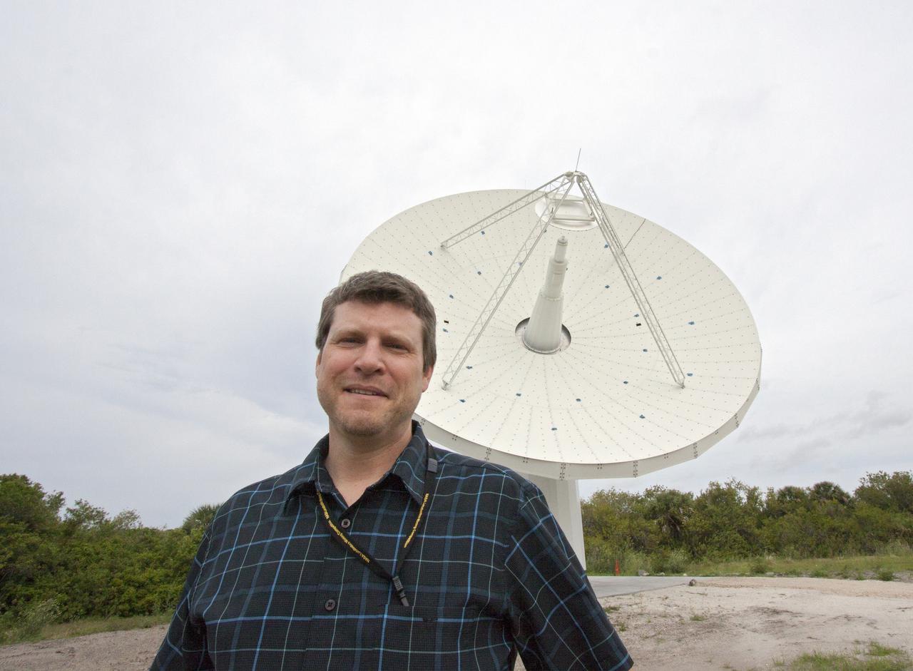
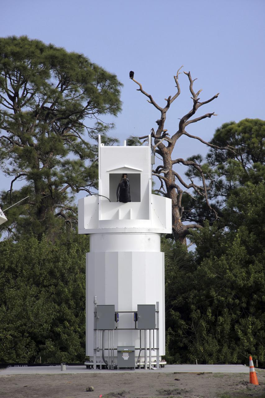
CAPE CANAVERAL, Fla. – At NASA’s Kennedy Space Center in Florida, Marc Seibert, the manager for Tracking and Timing Integration in the Research and Technology Management Office, stands near one of the three antennas that comprise the KA-Band Objects Observation and Monitoring, or Ka-BOOM, System. The Ka-BOOM project is one of the final steps in developing the techniques to build a high power, high resolution radar system capable of becoming a Near Earth Object Early Warning System. While also capable of space communication and radio science experiments, developing radar applications is the primary focus of the arrays. The 40-foot-diameter dish antenna arrays are near the former Vertical Processing Facility, which has been demolished. Photo credit: NASA_Jim Grossmann
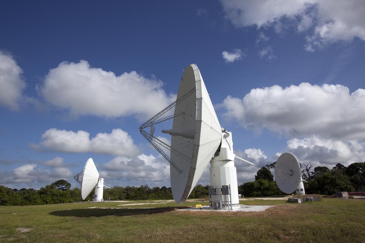
CAPE CANAVERAL, Fla. -- At NASA’s Kennedy Space Center in Florida, the three Ka-Band Objects Observation and Monitoring, or Ka-BOOM, testbed antennas are used to track the pattern of the sun during initial testing of the new system. The goal of Ka-BOOM is to prove technologies that will allow future systems to characterize near-Earth objects in terms of size, shape, rotation_tumble rate and to determine the trajectory of those objects. Radar studies can determine the trajectory 100,000 times more precisely than can optical methods. While also capable of space communication and radio science experiments, developing radar applications is the primary focus of the arrays. The 40-foot-diameter dish antenna arrays are at the site of the former Vertical Processing Facility, which has been demolished. Photo credit: NASA_Jim Grossmann
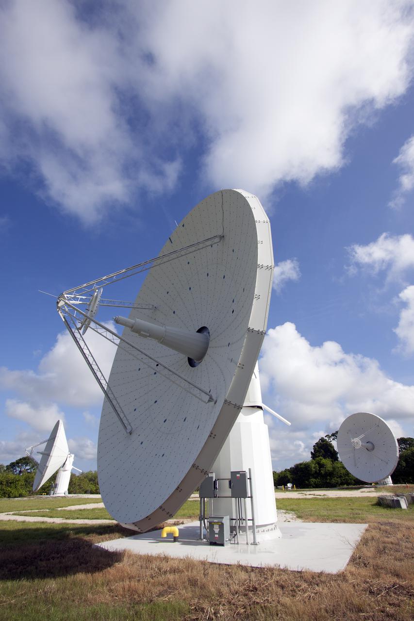
CAPE CANAVERAL, Fla. -- At NASA’s Kennedy Space Center in Florida, one of the three Ka-Band Objects Observation and Monitoring, or Ka-BOOM, testbed antennas is used to track the sun during initial testing of the new system. The goal of Ka-BOOM is to prove technologies that will allow future systems to characterize near-Earth objects in terms of size, shape, rotation_tumble rate and to determine the trajectory of those objects. Radar studies can determine the trajectory 100,000 times more precisely than can optical methods. While also capable of space communication and radio science experiments, developing radar applications is the primary focus of the arrays. The 40-foot-diameter dish antenna arrays are at the site of the former Vertical Processing Facility, which has been demolished. Photo credit: NASA_Jim Grossmann
CAPE CANAVERAL, Fla. -- At NASA’s Kennedy Space Center in Florida, the three Ka-Band Objects Observation and Monitoring, or Ka-BOOM, testbed antennas are used to track the pattern of the sun during initial testing of the new system. The goal of Ka-BOOM is to prove technologies that will allow future systems to characterize near-Earth objects in terms of size, shape, rotation_tumble rate and to determine the trajectory of those objects. Radar studies can determine the trajectory 100,000 times more precisely than can optical methods. While also capable of space communication and radio science experiments, developing radar applications is the primary focus of the arrays. The 40-foot-diameter dish antenna arrays are at the site of the former Vertical Processing Facility, which has been demolished. Photo credit: NASA_Jim Grossmann
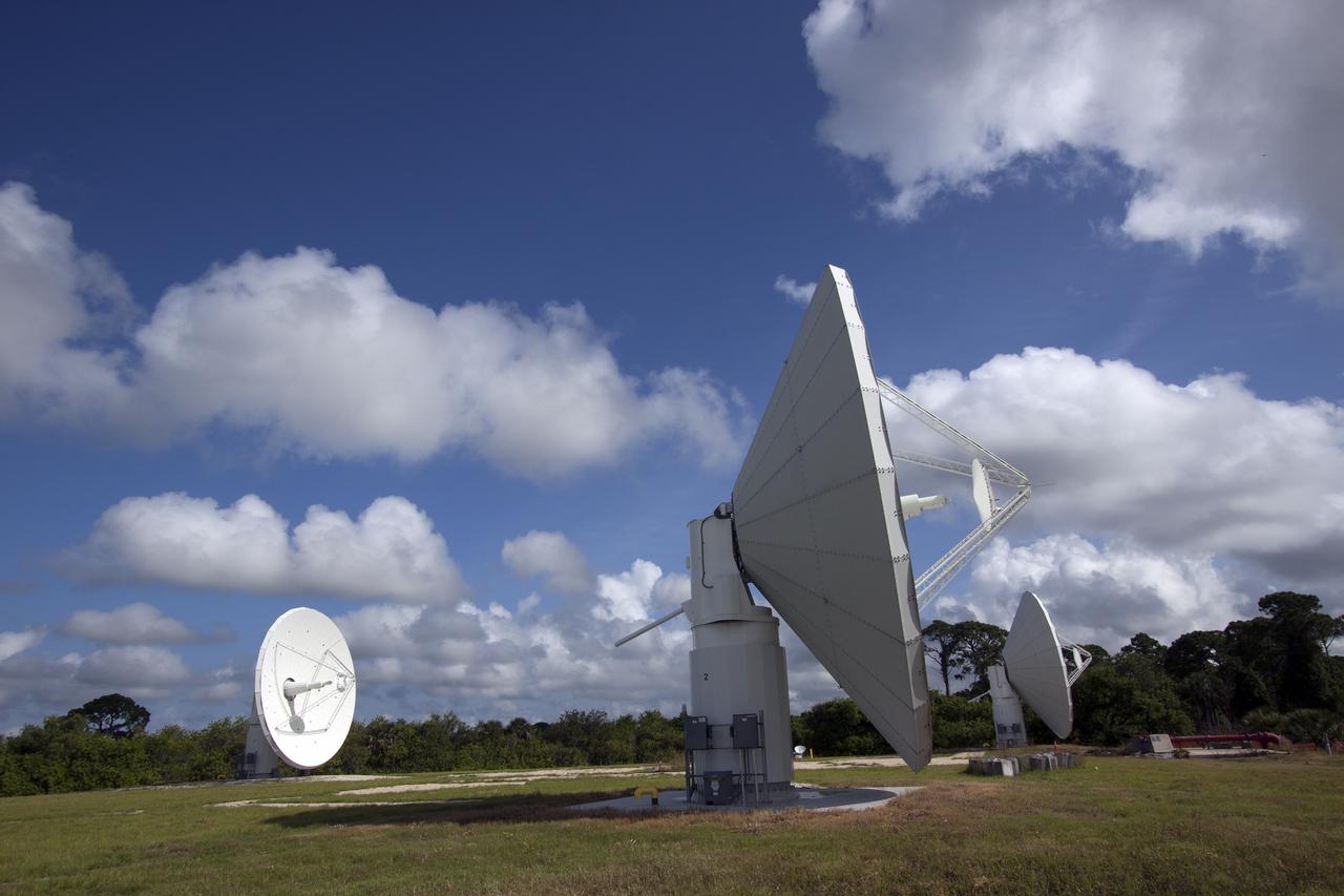
CAPE CANAVERAL, Fla. -- At NASA’s Kennedy Space Center in Florida, the three Ka-Band Objects Observation and Monitoring, or Ka-BOOM, testbed antennas are used to track the pattern of the sun during initial testing of the new system. The goal of Ka-BOOM is to prove technologies that will allow future systems to characterize near-Earth objects in terms of size, shape, rotation_tumble rate and to determine the trajectory of those objects. Radar studies can determine the trajectory 100,000 times more precisely than can optical methods. While also capable of space communication and radio science experiments, developing radar applications is the primary focus of the arrays. The 40-foot-diameter dish antenna arrays are at the site of the former Vertical Processing Facility, which has been demolished. Photo credit: NASA_Jim Grossmann
CAPE CANAVERAL, Fla. -- At NASA’s Kennedy Space Center in Florida, the three Ka-Band Objects Observation and Monitoring, or Ka-BOOM, testbed antennas are used to track the pattern of the sun during initial testing of the new system. The goal of Ka-BOOM is to prove technologies that will allow future systems to characterize near-Earth objects in terms of size, shape, rotation_tumble rate and to determine the trajectory of those objects. Radar studies can determine the trajectory 100,000 times more precisely than can optical methods. While also capable of space communication and radio science experiments, developing radar applications is the primary focus of the arrays. The 40-foot-diameter dish antenna arrays are at the site of the former Vertical Processing Facility, which has been demolished. Photo credit: NASA_Jim Grossmann
CAPE CANAVERAL, Fla. -- At NASA’s Kennedy Space Center in Florida, the three Ka-Band Objects Observation and Monitoring, or Ka-BOOM, testbed antennas are used to track the pattern of the sun during initial testing of the new system. The goal of Ka-BOOM is to prove technologies that will allow future systems to characterize near-Earth objects in terms of size, shape, rotation_tumble rate and to determine the trajectory of those objects. Radar studies can determine the trajectory 100,000 times more precisely than can optical methods. While also capable of space communication and radio science experiments, developing radar applications is the primary focus of the arrays. The 40-foot-diameter dish antenna arrays are at the site of the former Vertical Processing Facility, which has been demolished. Photo credit: NASA_Jim Grossmann
CAPE CANAVERAL, Fla. -- At NASA’s Kennedy Space Center in Florida, the three Ka-Band Objects Observation and Monitoring, or Ka-BOOM, testbed antennas are used to track the pattern of the sun during initial testing of the new system. The goal of Ka-BOOM is to prove technologies that will allow future systems to characterize near-Earth objects in terms of size, shape, rotation_tumble rate and to determine the trajectory of those objects. Radar studies can determine the trajectory 100,000 times more precisely than can optical methods. While also capable of space communication and radio science experiments, developing radar applications is the primary focus of the arrays. The 40-foot-diameter dish antenna arrays are at the site of the former Vertical Processing Facility, which has been demolished. Photo credit: NASA_Jim Grossmann
CAPE CANAVERAL, Fla. -- At NASA’s Kennedy Space Center in Florida, the three Ka-Band Objects Observation and Monitoring, or Ka-BOOM, testbed antennas are used to track the pattern of the sun during initial testing of the new system. The goal of Ka-BOOM is to prove technologies that will allow future systems to characterize near-Earth objects in terms of size, shape, rotation_tumble rate and to determine the trajectory of those objects. Radar studies can determine the trajectory 100,000 times more precisely than can optical methods. While also capable of space communication and radio science experiments, developing radar applications is the primary focus of the arrays. The 40-foot-diameter dish antenna arrays are at the site of the former Vertical Processing Facility, which has been demolished. Photo credit: NASA_Jim Grossmann
CAPE CANAVERAL, Fla. -- At NASA’s Kennedy Space Center in Florida, one of the three Ka-Band Objects Observation and Monitoring, or Ka-BOOM, testbed antennas is used to track the pattern of the sun during initial testing of the new system. The goal of Ka-BOOM is to prove technologies that will allow future systems to characterize near-Earth objects in terms of size, shape, rotation_tumble rate and to determine the trajectory of those objects. Radar studies can determine the trajectory 100,000 times more precisely than can optical methods. While also capable of space communication and radio science experiments, developing radar applications is the primary focus of the arrays. The 40-foot-diameter dish antenna arrays are at the site of the former Vertical Processing Facility, which has been demolished. Photo credit: NASA_Jim Grossmann
CAPE CANAVERAL, Fla. -- At NASA’s Kennedy Space Center in Florida, one of the three Ka-Band Objects Observation and Monitoring, or Ka-BOOM, testbed antennas is used to track the pattern of the sun during initial testing of the new system. The goal of Ka-BOOM is to prove technologies that will allow future systems to characterize near-Earth objects in terms of size, shape, rotation_tumble rate and to determine the trajectory of those objects. Radar studies can determine the trajectory 100,000 times more precisely than can optical methods. While also capable of space communication and radio science experiments, developing radar applications is the primary focus of the arrays. The 40-foot-diameter dish antenna arrays are at the site of the former Vertical Processing Facility, which has been demolished. Photo credit: NASA_Jim Grossmann
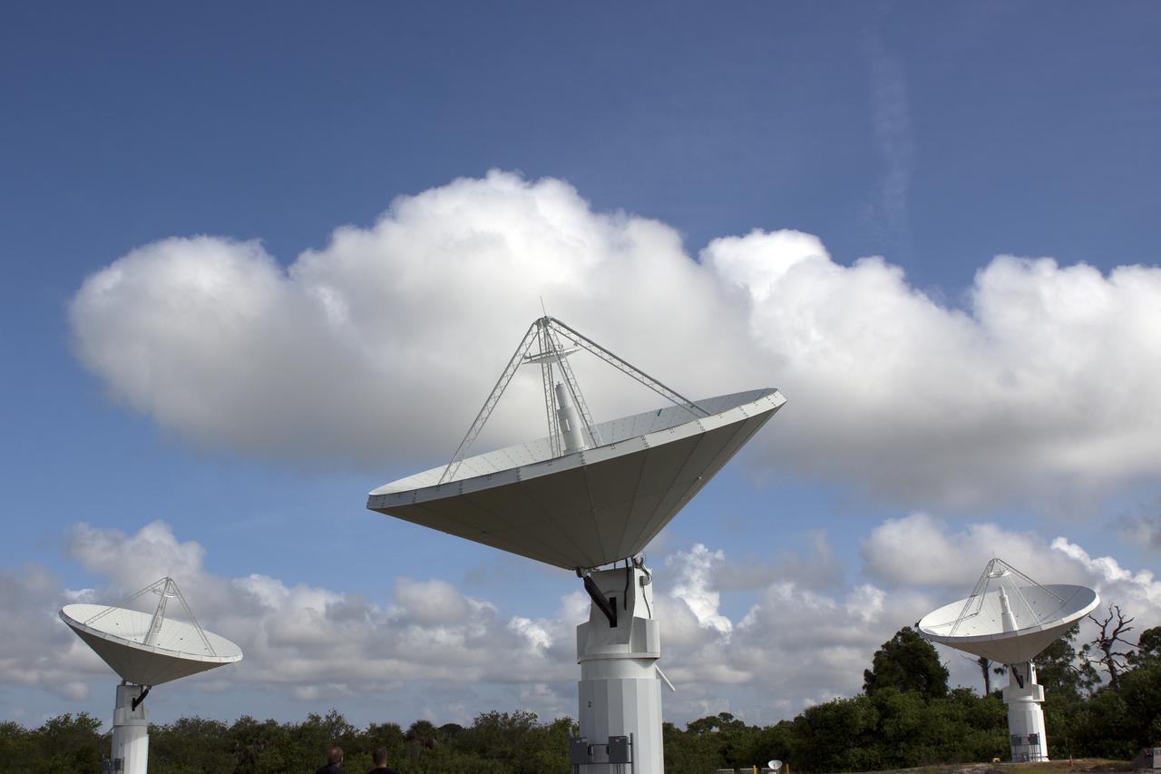
CAPE CANAVERAL, Fla. -- At NASA’s Kennedy Space Center in Florida, the three Ka-Band Objects Observation and Monitoring, or Ka-BOOM, testbed antennas are used to track the pattern of the sun during initial testing of the new system. The goal of Ka-BOOM is to prove technologies that will allow future systems to characterize near-Earth objects in terms of size, shape, rotation_tumble rate and to determine the trajectory of those objects. Radar studies can determine the trajectory 100,000 times more precisely than can optical methods. While also capable of space communication and radio science experiments, developing radar applications is the primary focus of the arrays. The 40-foot-diameter dish antenna arrays are at the site of the former Vertical Processing Facility, which has been demolished. Photo credit: NASA_Jim Grossmann
CAPE CANAVERAL, Fla. -- At NASA’s Kennedy Space Center in Florida, one of the three Ka-Band Objects Observation and Monitoring, or Ka-BOOM, testbed antennas is used to track the sun during initial testing of the new system. The goal of Ka-BOOM is to prove technologies that will allow future systems to characterize near-Earth objects in terms of size, shape, rotation_tumble rate and to determine the trajectory of those objects. Radar studies can determine the trajectory 100,000 times more precisely than can optical methods. While also capable of space communication and radio science experiments, developing radar applications is the primary focus of the arrays. The 40-foot-diameter dish antenna arrays are at the site of the former Vertical Processing Facility, which has been demolished. Photo credit: NASA_Jim Grossmann
CAPE CANAVERAL, Fla. -- At NASA’s Kennedy Space Center in Florida, the three Ka-Band Objects Observation and Monitoring, or Ka-BOOM, testbed antennas are used to track the pattern of the sun during initial testing of the new system. The goal of Ka-BOOM is to prove technologies that will allow future systems to characterize near-Earth objects in terms of size, shape, rotation_tumble rate and to determine the trajectory of those objects. Radar studies can determine the trajectory 100,000 times more precisely than can optical methods. While also capable of space communication and radio science experiments, developing radar applications is the primary focus of the arrays. The 40-foot-diameter dish antenna arrays are at the site of the former Vertical Processing Facility, which has been demolished. Photo credit: NASA_Jim Grossmann
CAPE CANAVERAL, Fla. -- At NASA’s Kennedy Space Center in Florida, the three Ka-Band Objects Observation and Monitoring, or Ka-BOOM, testbed antennas are used to track the pattern of the sun during initial testing of the new system. The goal of Ka-BOOM is to prove technologies that will allow future systems to characterize near-Earth objects in terms of size, shape, rotation_tumble rate and to determine the trajectory of those objects. Radar studies can determine the trajectory 100,000 times more precisely than can optical methods. While also capable of space communication and radio science experiments, developing radar applications is the primary focus of the arrays. The 40-foot-diameter dish antenna arrays are at the site of the former Vertical Processing Facility, which has been demolished. Photo credit: NASA_Jim Grossmann
CAPE CANAVERAL, Fla. -- At NASA’s Kennedy Space Center in Florida, the three Ka-Band Objects Observation and Monitoring, or Ka-BOOM, testbed antennas are used to track the pattern of the sun during initial testing of the new system. The goal of Ka-BOOM is to prove technologies that will allow future systems to characterize near-Earth objects in terms of size, shape, rotation_tumble rate and to determine the trajectory of those objects. Radar studies can determine the trajectory 100,000 times more precisely than can optical methods. While also capable of space communication and radio science experiments, developing radar applications is the primary focus of the arrays. The 40-foot-diameter dish antenna arrays are at the site of the former Vertical Processing Facility, which has been demolished. Photo credit: NASA_Jim Grossmann
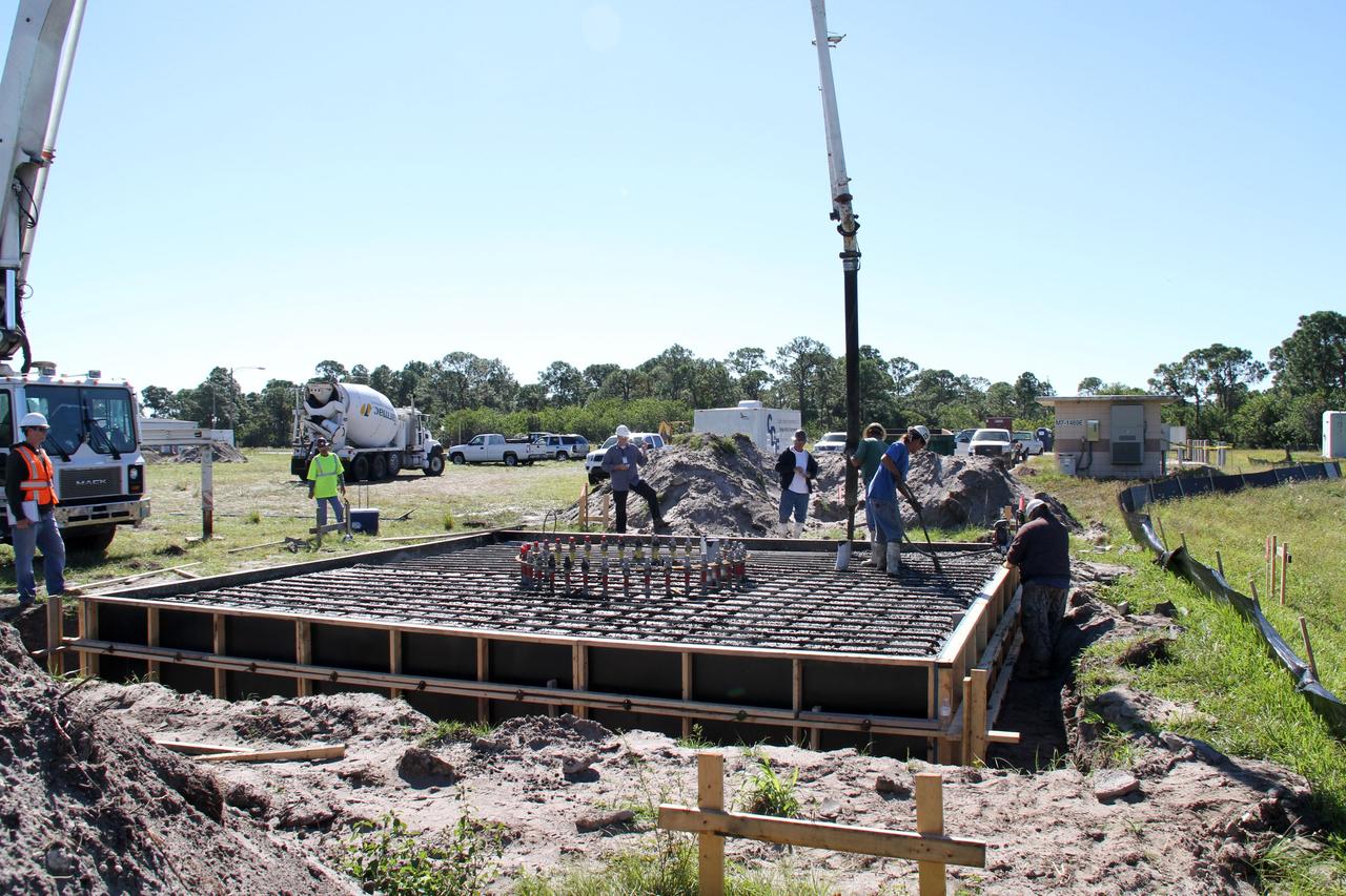
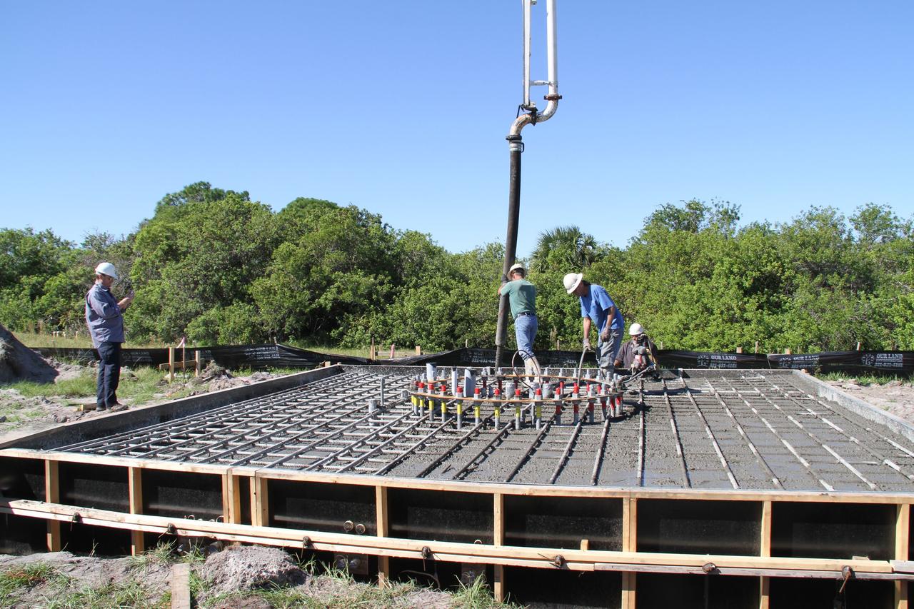
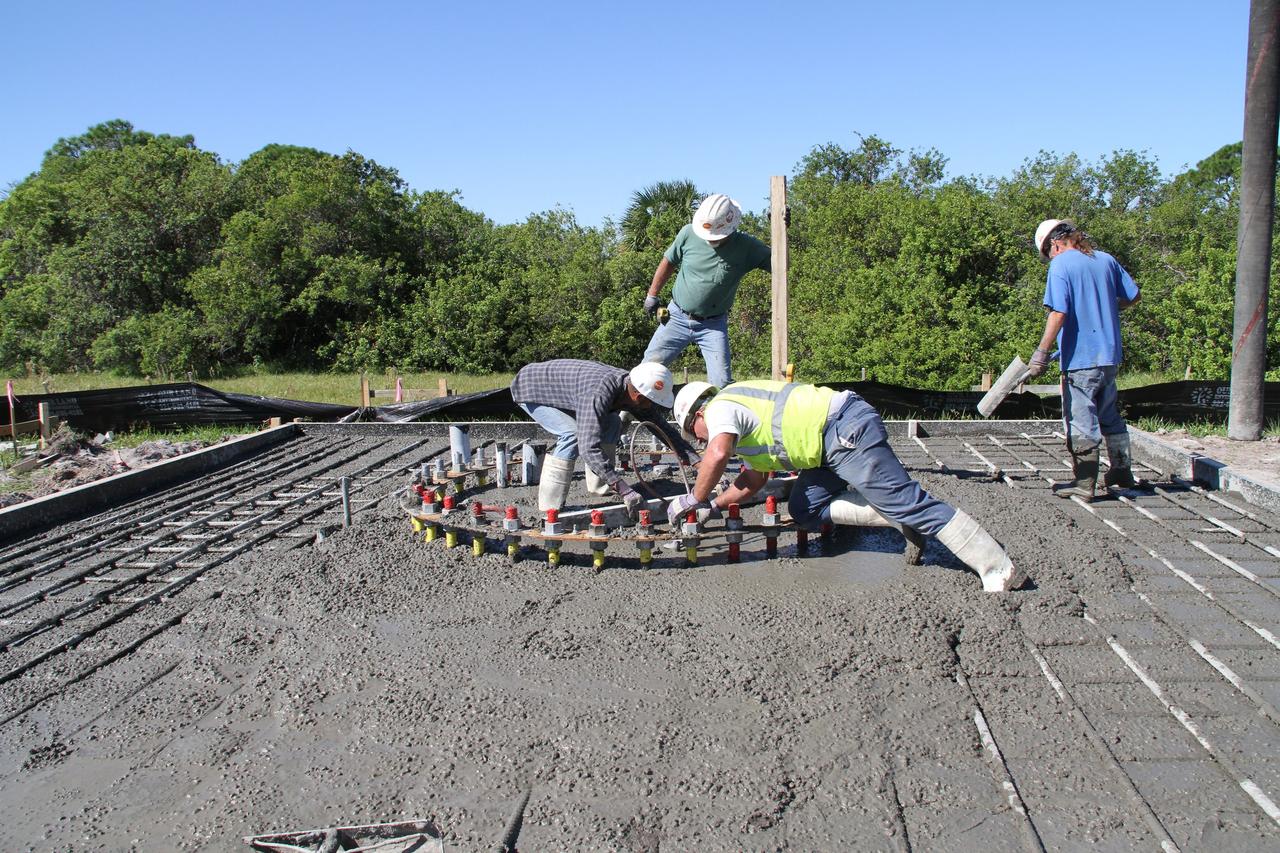
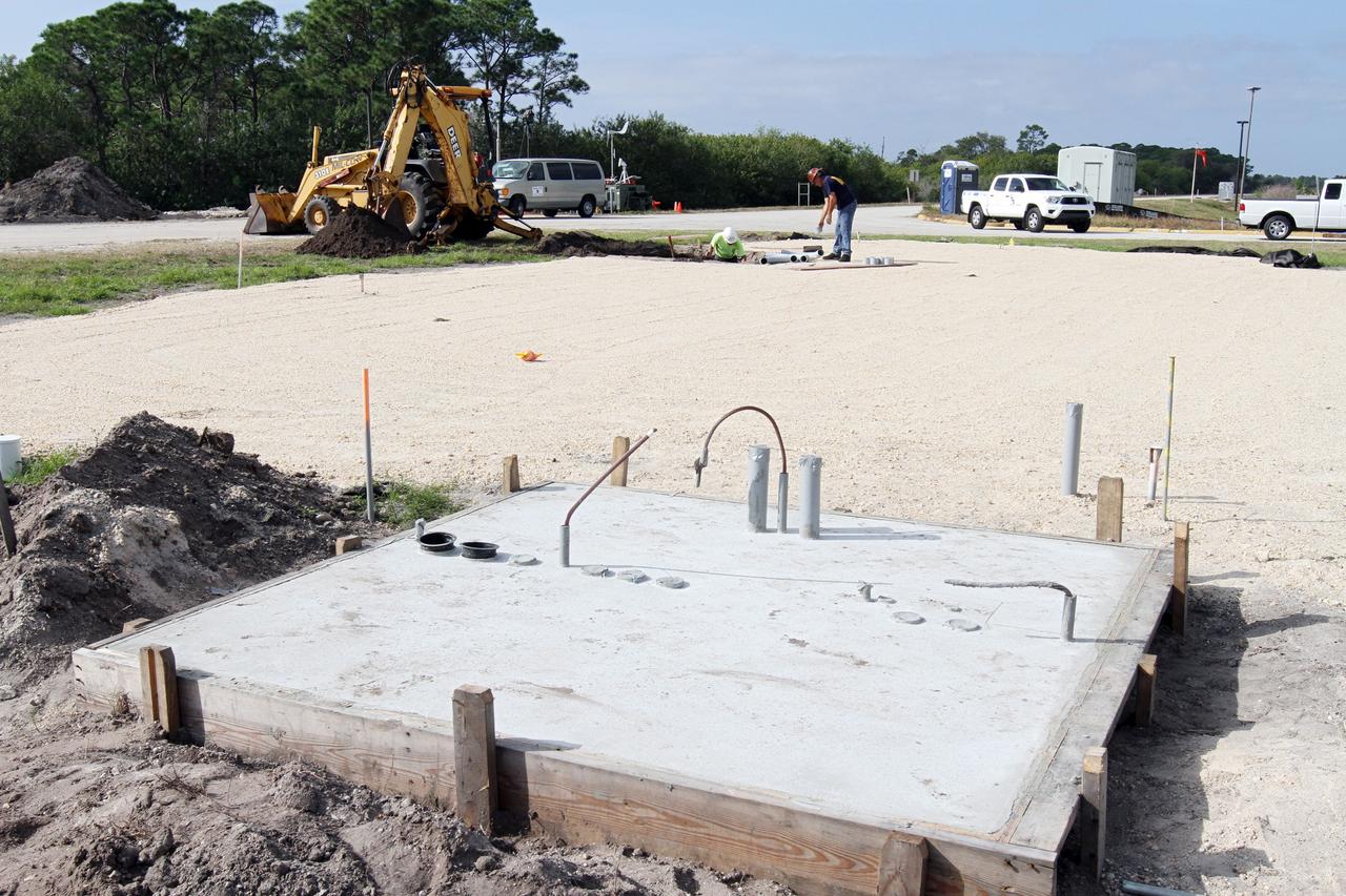
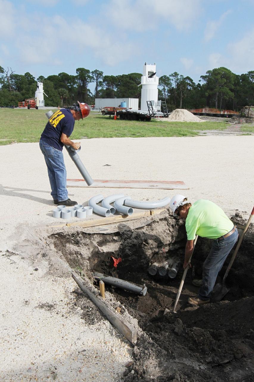
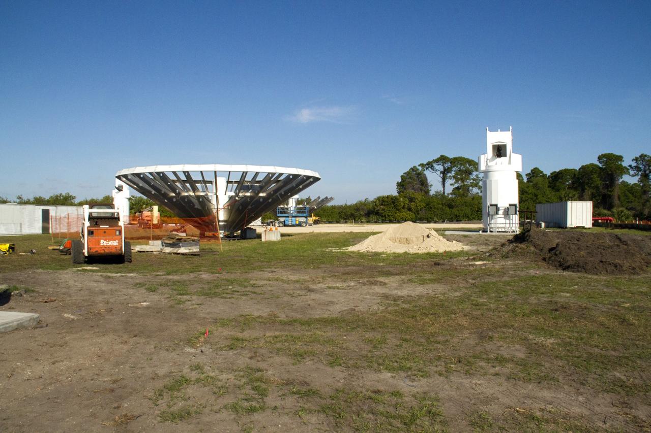
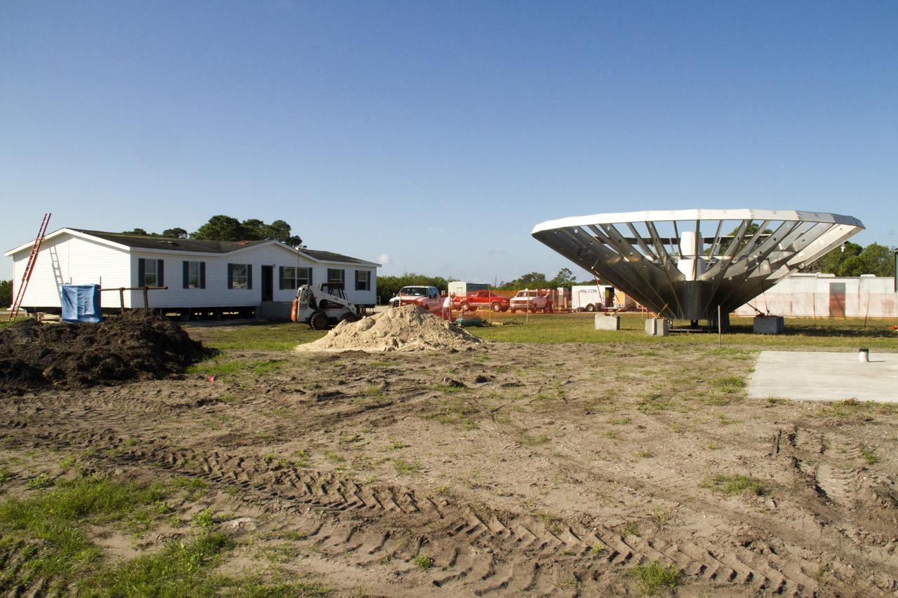
CAPE CANAVERAL, Fla. – At NASA’s Kennedy Space Center in Florida, workers pour concrete at the base of the site of the Antenna Test Bed Array for the Ka-Band Objects Observation and Monitoring, or Ka-BOOM system. The construction site is near the former Vertical Processing Facility, which has been demolished. Workers are placing the pile foundations for the 40-foot-diameter dish antenna arrays and their associated utilities, and preparing the site for the operations command center facility. Photo credit: NASA/Ben Smegelski
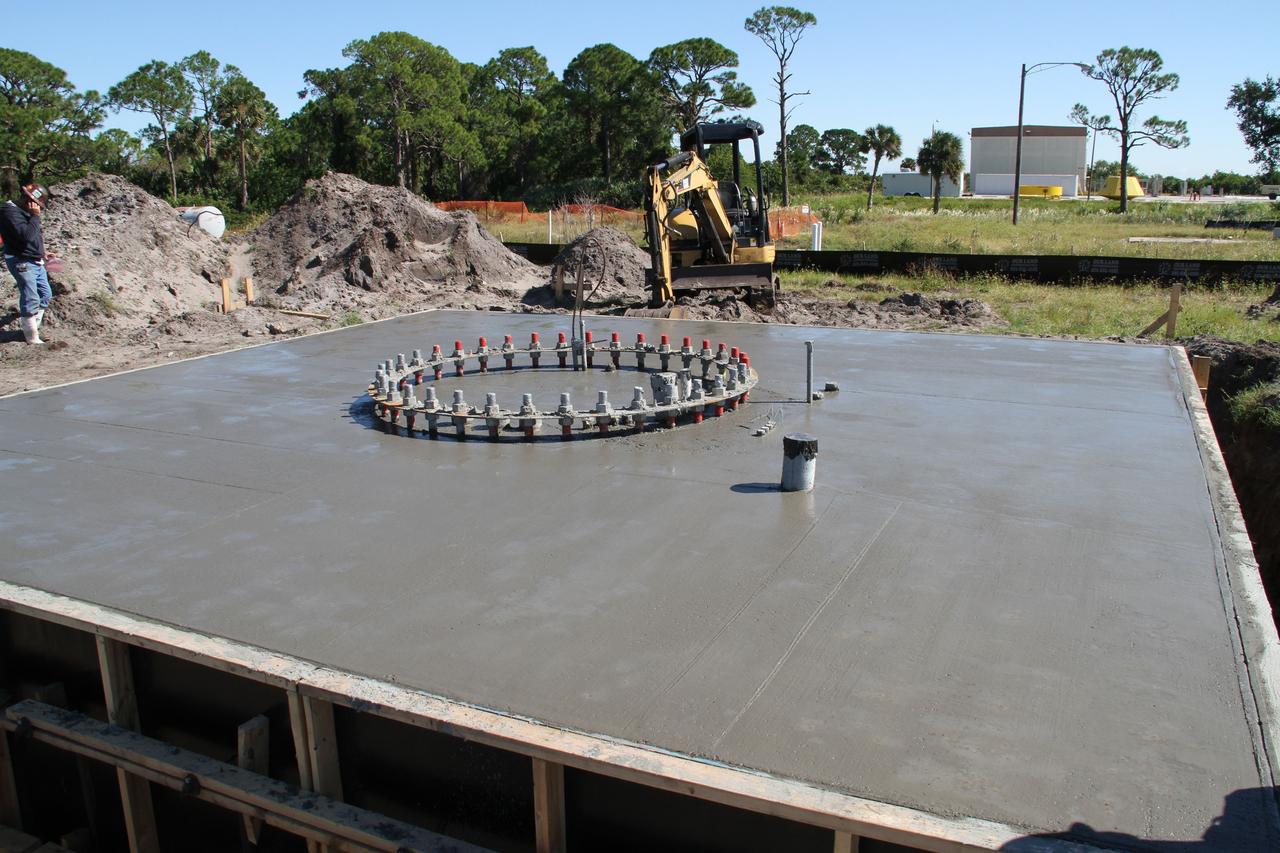
CAPE CANAVERAL, Fla. – At NASA’s Kennedy Space Center in Florida, concrete has been poured at the site of the Antenna Test Bed Array for the Ka-Band Objects Observation and Monitoring, Ka-BOOM system. The construction site is near the former Vertical Processing Facility, which has been demolished. Workers are placing the pile foundations for the 40-foot-diameter dish antenna arrays and their associated utilities, and preparing the site for the operations command center facility. Photo credit: NASA/Ben Smegelski
CAPE CANAVERAL, Fla. – At NASA’s Kennedy Space Center in Florida, workers continue construction of the Antenna Test Bed Array for the Ka-Band Objects Observation and Monitoring, or Ka-BOOM, system. The construction site is near the former Vertical Processing Facility, which has been demolished. Workers are placing the pile foundations for the 40-foot-diameter dish antenna arrays and their associated utilities, and preparing the site for the operations command center facility. Photo credit: NASA/Ben Smegelski
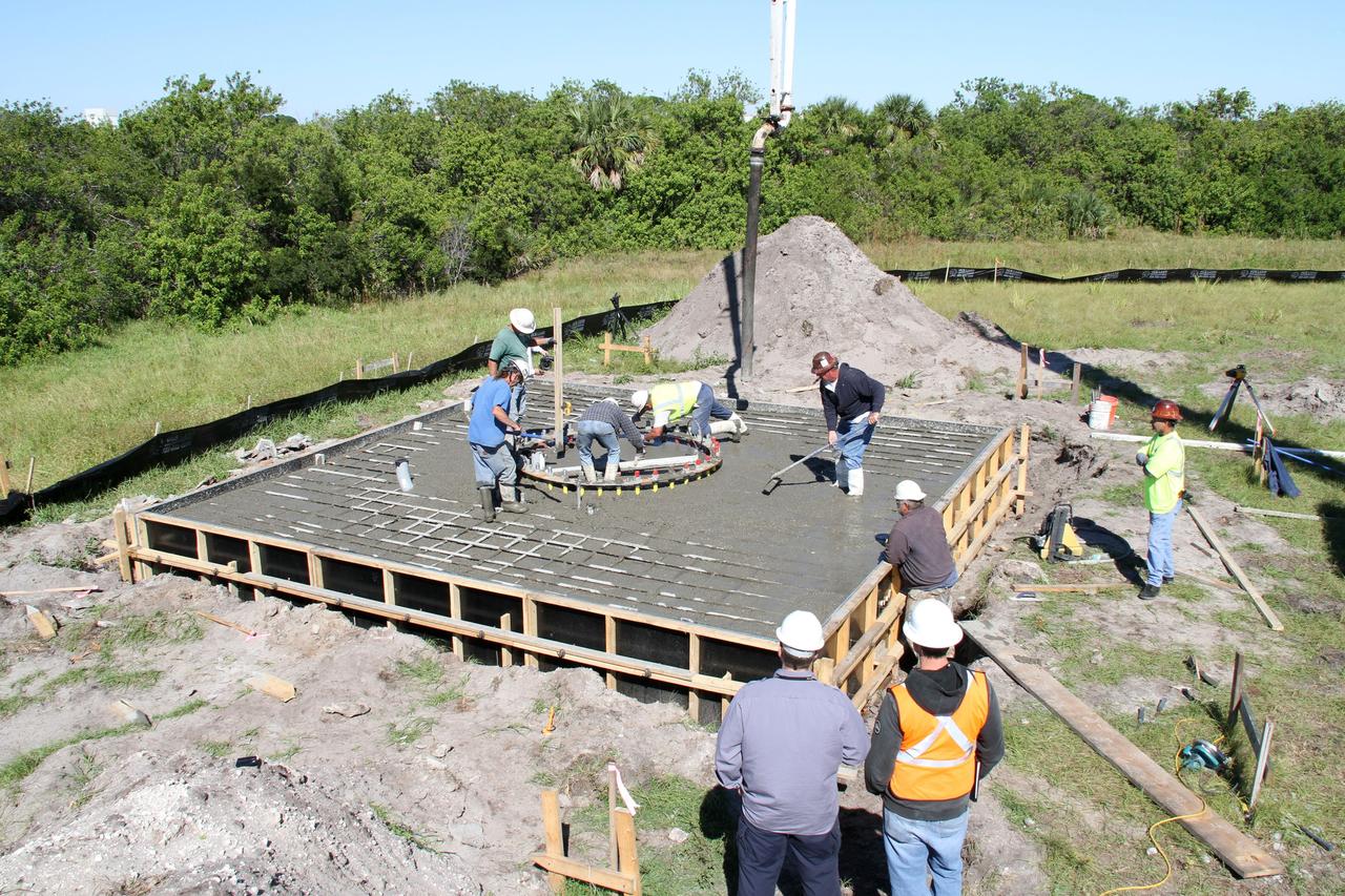
CAPE CANAVERAL, Fla. – At NASA’s Kennedy Space Center in Florida, workers pour and spread concrete at the base of the site of the Antenna Test Bed Array for the Ka-Band Objects Observation and Monitoring, Ka-BOOM system. The construction site is near the former Vertical Processing Facility, which has been demolished. Workers are placing the pile foundations for the 40-foot-diameter dish antenna arrays and their associated utilities, and preparing the site for the operations command center facility. Photo credit: NASA/Ben Smegelski
CAPE CANAVERAL, Fla. – At NASA’s Kennedy Space Center in Florida, workers continue construction of the Antenna Test Bed Array for the Ka-Band Objects Observation and Monitoring, or Ka-BOOM, system. The construction site is near the former Vertical Processing Facility, which has been demolished. Workers are placing the pile foundations for the 40-foot-diameter dish antenna arrays and their associated utilities, and preparing the site for the operations command center facility. Photo credit: NASA/Ben Smegelski
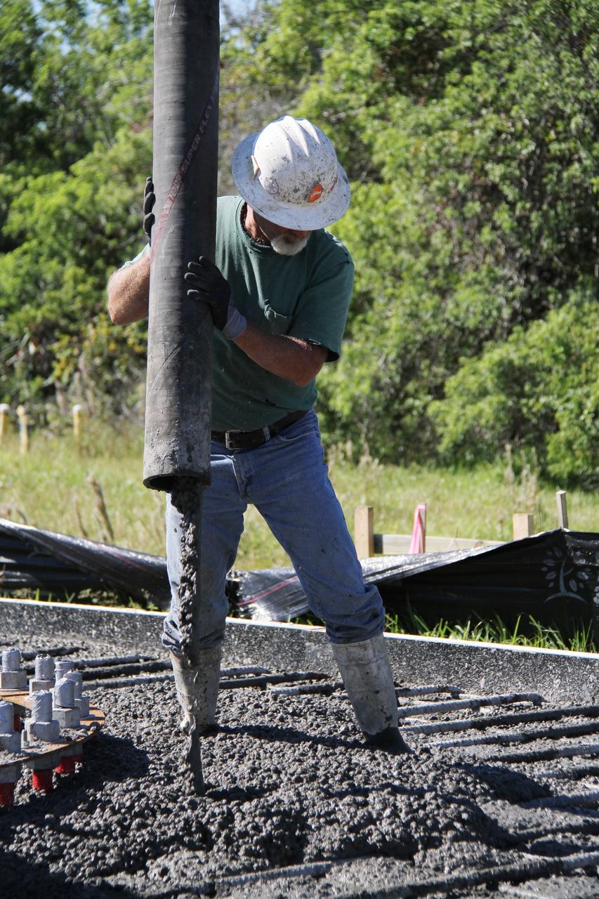
CAPE CANAVERAL, Fla. – At NASA’s Kennedy Space Center in Florida, a worker continues construction of the Antenna Test Bed Array for the Ka-Band Objects Observation and Monitoring, or Ka-BOOM, system. The construction site is near the former Vertical Processing Facility, which has been demolished. Workers are placing the pile foundations for the 40-foot-diameter dish antenna arrays and their associated utilities, and preparing the site for the operations command center facility. Photo credit: NASA/Ben Smegelski
CAPE CANAVERAL, Fla. -- At NASA’s Kennedy Space Center in Florida, groundbreaking will begin for the construction of the Antenna Test Bed Array for the Ka-Band Objects Observation and Monitoring, or Ka-BOOM, system. The construction site is near the former Vertical Processing Facility, which has been demolished. Workers will begin construction on the pile foundations for the 40-foot-diameter dish antenna arrays and their associated utilities, and prepare the site for the operations command center facility. Photo credit: NASA/Charisse Nahser
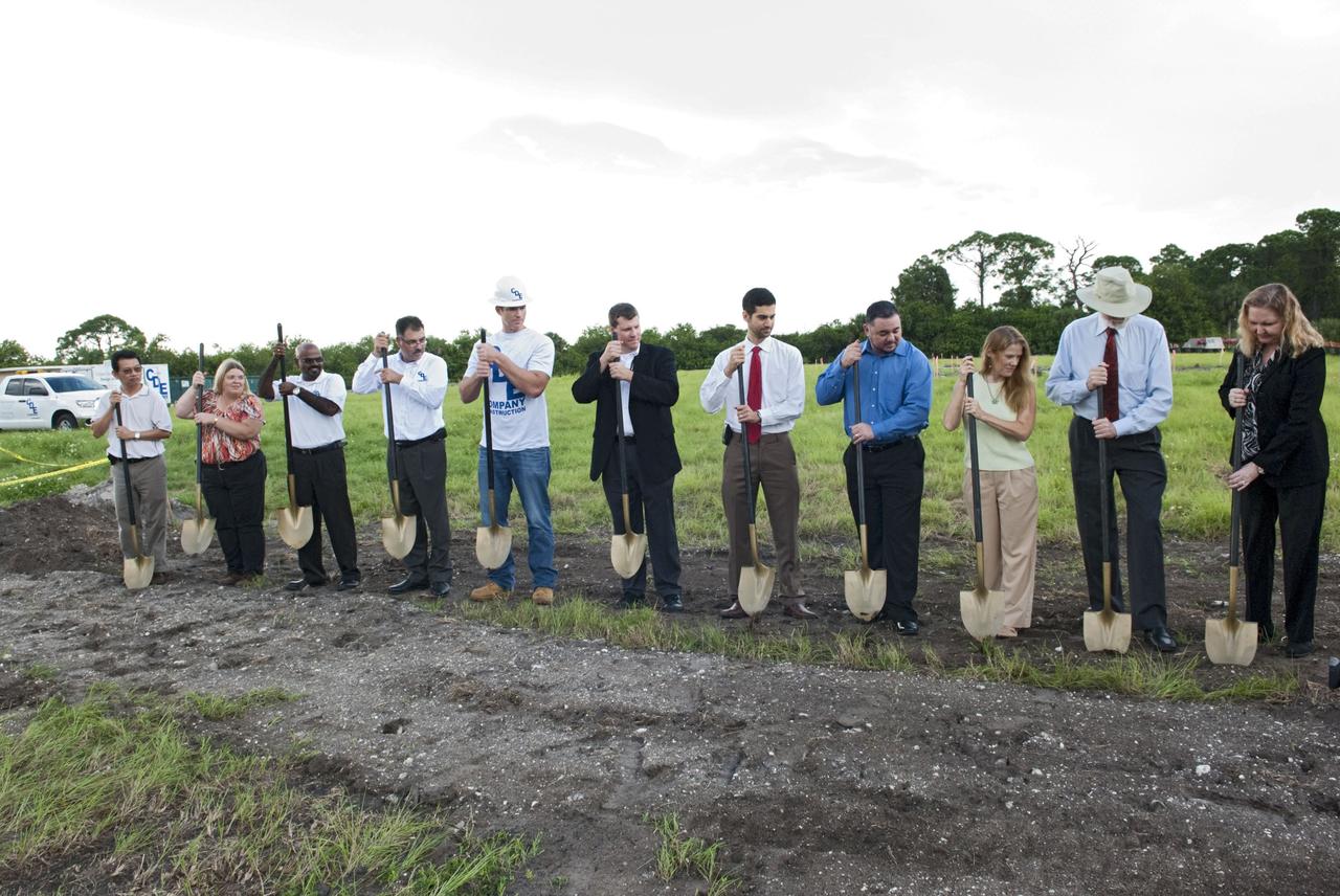
CAPE CANAVERAL, Fla. -- At NASA’s Kennedy Space Center in Florida, a groundbreaking was held to mark the start of construction on the Antenna Test Bed Array for the Ka-Band Objects Observation and Monitoring, or Ka-BOOM system. Holding ceremonial shovels, from left are Michael Le, lead design engineer and construction manager Sue Vingris, Cape Design Engineer Co. project manager Kannan Rengarajan, chief executive officer of Cape Design Engineer Co. Lutfi Mized, president of Cape Design Engineer Co. David Roelandt, construction site superintendent with Cape Design Engineer Co. Marc Seibert, NASA project manager Michael Miller, NASA project manager Peter Aragona, KSC’s Electromagnetic Lab manager Stacy Hopper, KSCs master planning supervisor Dr. Bary Geldzabler, NASA chief scientist and KSC’s Chief Technologist Karen Thompson. The construction site is near the former Vertical Processing Facility, which has been demolished. Workers will begin construction on the pile foundations for the 40-foot-diameter dish antenna arrays and their associated utilities, and prepare the site for the operations command center facility. Photo credit: NASA/Charisse Nahser
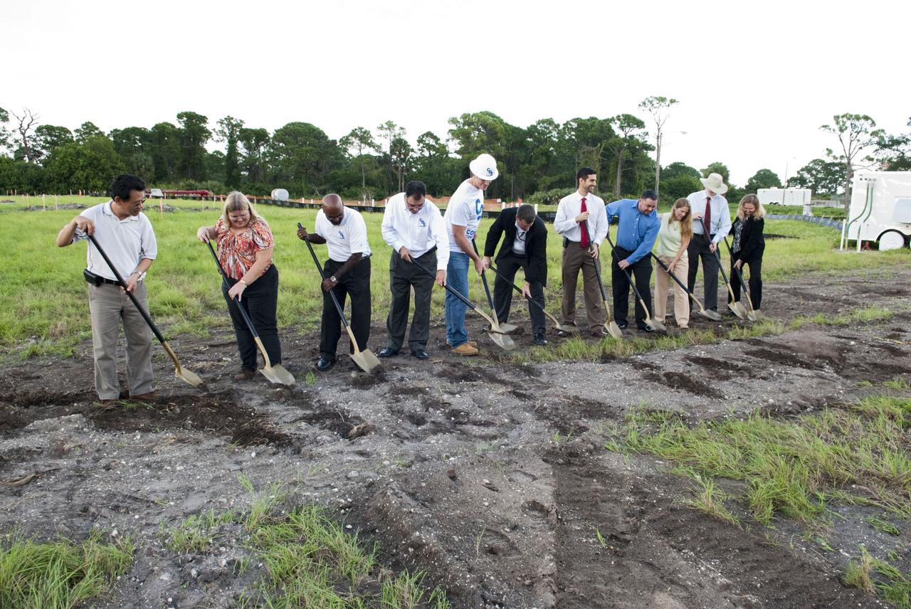
CAPE CANAVERAL, Fla. -- At NASA’s Kennedy Space Center in Florida, a groundbreaking was held to mark the start of construction on the Antenna Test Bed Array for the Ka-Band Objects Observation and Monitoring, or Ka-BOOM system. Using ceremonial shovels to mark the site, from left are Michael Le, lead design engineer and construction manager Sue Vingris, Cape Design Engineer Co. project manager Kannan Rengarajan, chief executive officer of Cape Design Engineer Co. Lutfi Mized, president of Cape Design Engineer Co. David Roelandt, construction site superintendent with Cape Design Engineer Co. Marc Seibert, NASA project manager Michael Miller, NASA project manager Peter Aragona, KSC’s Electromagnetic Lab manager Stacy Hopper, KSCs master planning supervisor Dr. Bary Geldzabler, NASA chief scientist and KSC’s Chief Technologist Karen Thompson. The construction site is near the former Vertical Processing Facility, which has been demolished. Workers will begin construction on the pile foundations for the 40-foot-diameter dish antenna arrays and their associated utilities, and prepare the site for the operations command center facility. Photo credit: NASA/Charisse Nahser

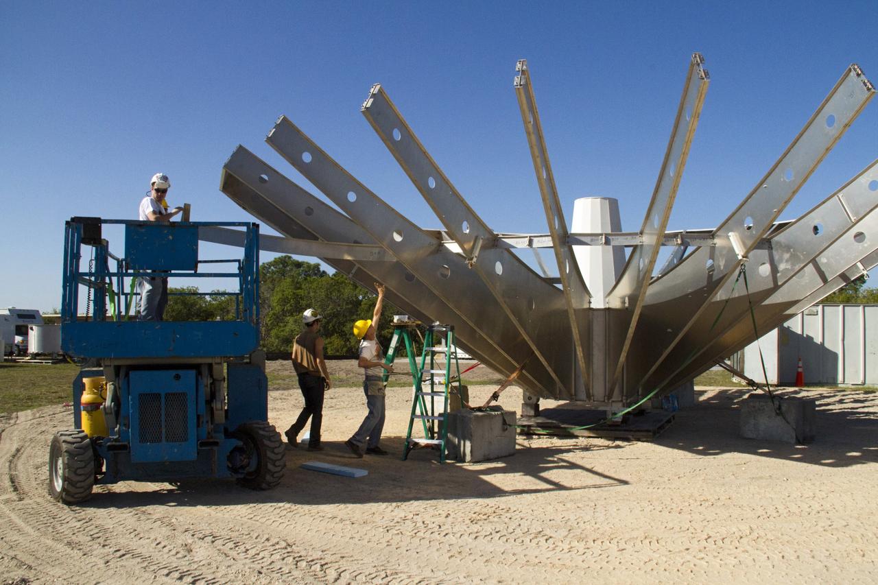
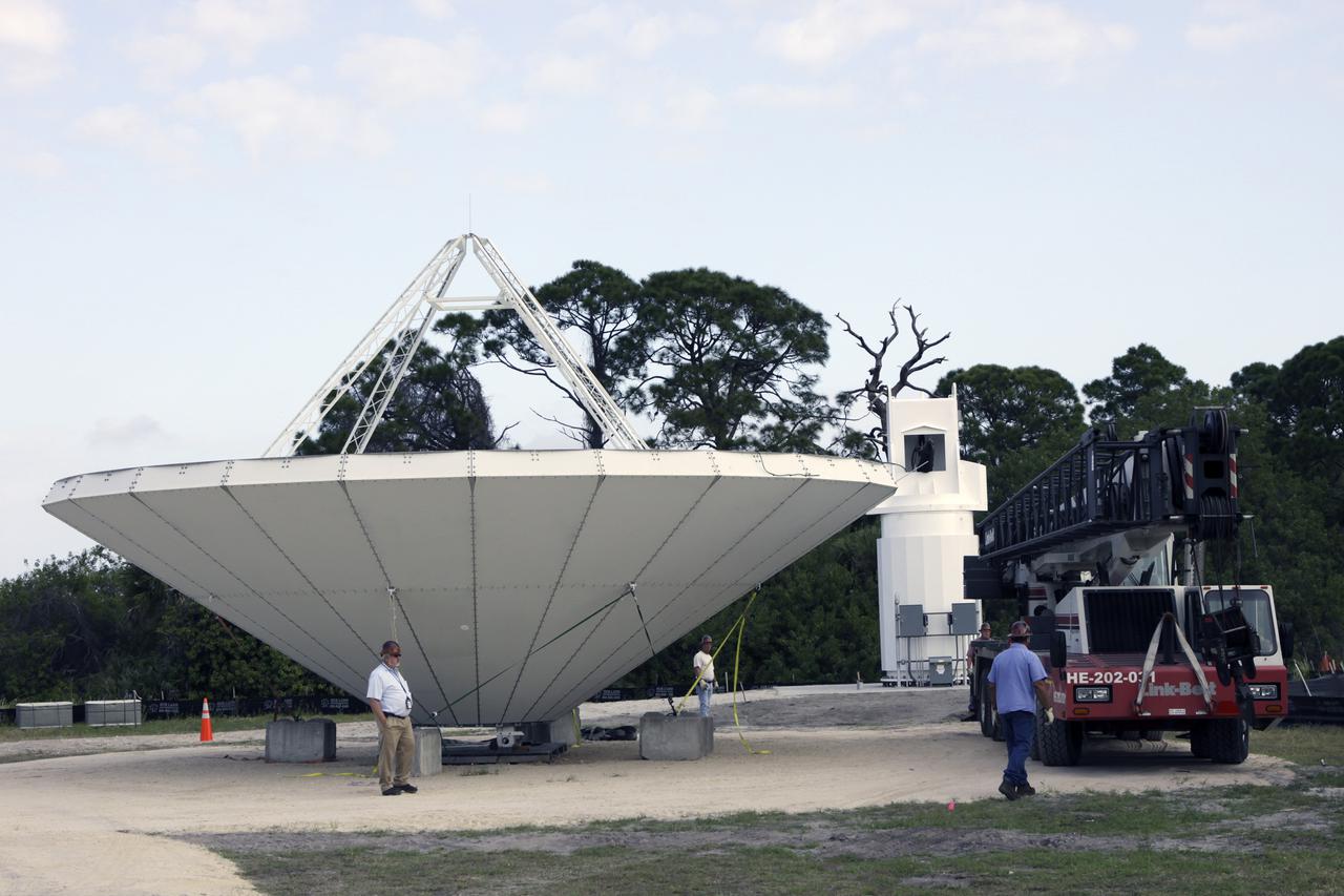
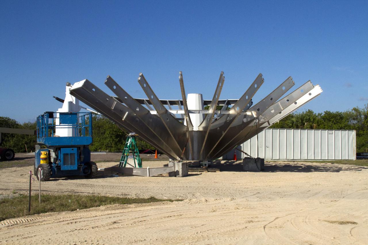
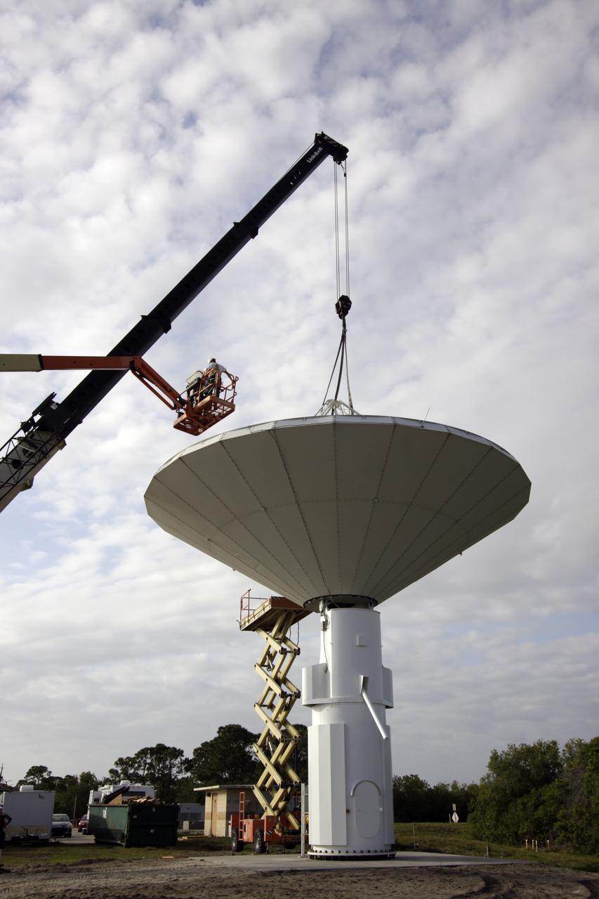
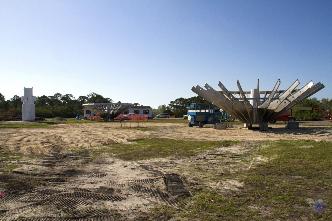
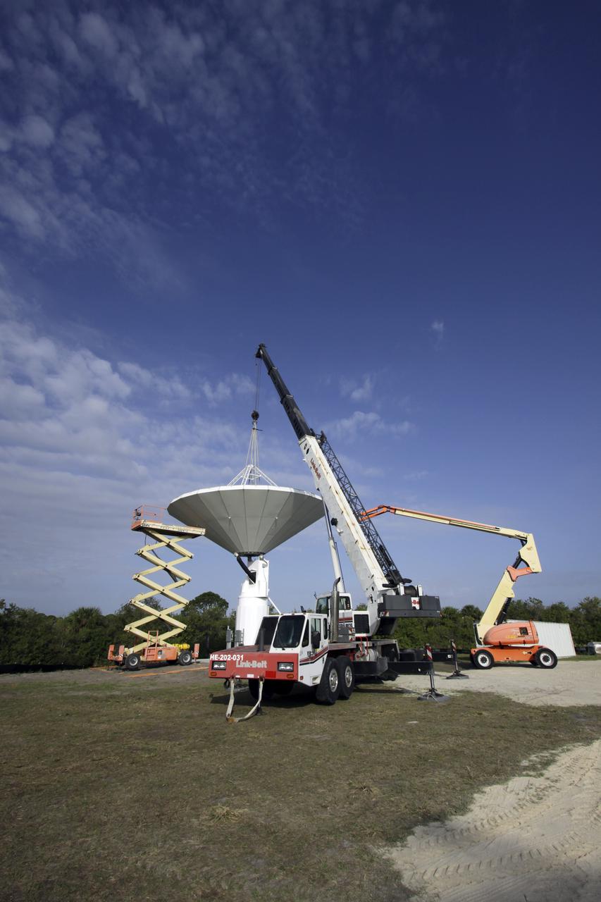
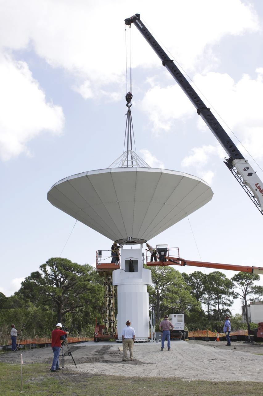
CAPE CANAVERAL, Fla. – At NASA’s Kennedy Space Center in Florida, workers are constructing 40-foot-diameter dish antenna arrays for the Ka-Band Objects Observation and Monitoring, or Ka-BOOM system. The antennas will be part of the operations command center facility. The construction site is near the former Vertical Processing Facility, which has been demolished. The Ka-BOOM project is one of the final steps in developing the techniques to build a high power, high resolution radar system capable of becoming a Near Earth Object Early Warning System. While also capable of space communication and radio science experiments, developing radar applications is the primary focus of the arrays. Photo credit: NASA/ Ben Smegelsky

CAPE CANAVERAL, Fla. – At NASA’s Kennedy Space Center in Florida, workers are constructing 40-foot-diameter dish antenna arrays for the Ka-Band Objects Observation and Monitoring, or Ka-BOOM system. The antennas will be part of the operations command center facility. The construction site is near the former Vertical Processing Facility, which has been demolished. The Ka-BOOM project is one of the final steps in developing the techniques to build a high power, high resolution radar system capable of becoming a Near Earth Object Early Warning System. While also capable of space communication and radio science experiments, developing radar applications is the primary focus of the arrays. Photo credit: NASA/ Ben Smegelsky
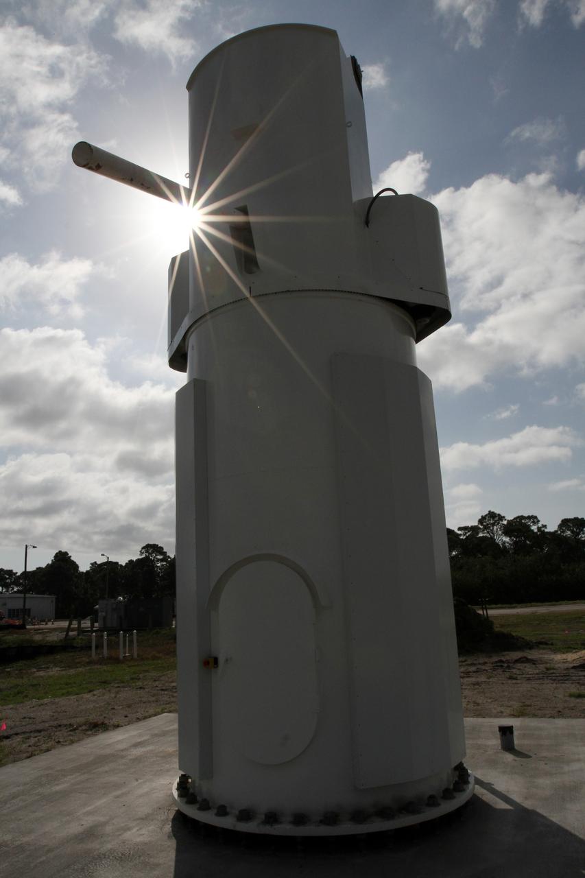
CAPE CANAVERAL, Fla. – At NASA’s Kennedy Space Center in Florida, new towers are being constructed for the Antenna Test Bed Array for the Ka-Band Objects Observation and Monitoring, or Ka-BOOM system. The antennas will be part of the operations command center facility. The construction site is near the former Vertical Processing Facility, which has been demolished. The Ka-BOOM project is one of the final steps in developing the techniques to build a high power, high resolution radar system capable of becoming a Near Earth Object Early Warning System. While also capable of space communication and radio science experiments, developing radar applications is the primary focus of the arrays. Photo credit: NASA/ Ben Smegelsky
CAPE CANAVERAL, Fla. – At NASA’s Kennedy Space Center in Florida, workers are constructing 40-foot-diameter dish antenna arrays for the Ka-Band Objects Observation and Monitoring, or Ka-BOOM system. The antennas will be part of the operations command center facility. The construction site is near the former Vertical Processing Facility, which has been demolished. The Ka-BOOM project is one of the final steps in developing the techniques to build a high power, high resolution radar system capable of becoming a Near Earth Object Early Warning System. While also capable of space communication and radio science experiments, developing radar applications is the primary focus of the arrays. Photo credit: NASA/ Ben Smegelsky
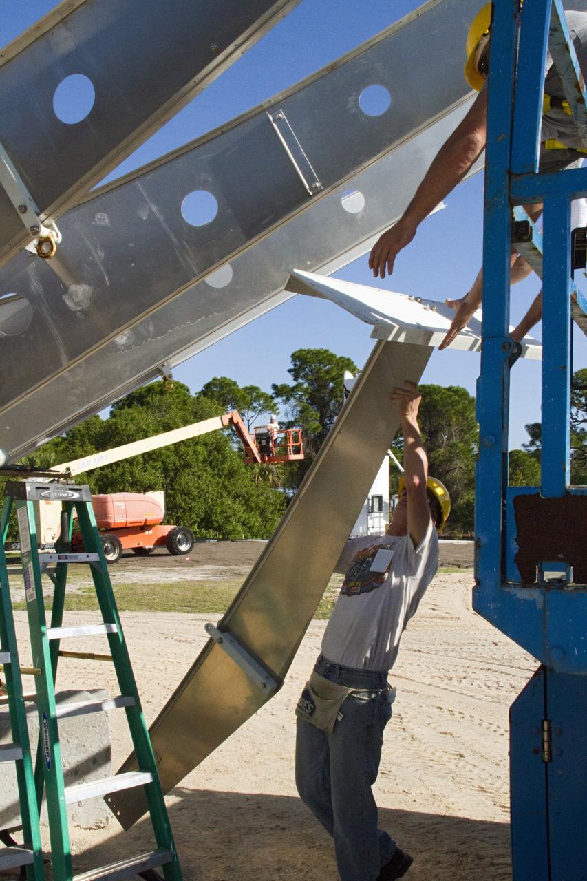
CAPE CANAVERAL, Fla. – At NASA’s Kennedy Space Center in Florida, workers are constructing 40-foot-diameter dish antenna arrays for the Ka-Band Objects Observation and Monitoring, or Ka-BOOM system. The antennas will be part of the operations command center facility. The construction site is near the former Vertical Processing Facility, which has been demolished. The Ka-BOOM project is one of the final steps in developing the techniques to build a high power, high resolution radar system capable of becoming a Near Earth Object Early Warning System. While also capable of space communication and radio science experiments, developing radar applications is the primary focus of the arrays. Photo credit: NASA/ Ben Smegelsky
CAPE CANAVERAL, Fla. – At NASA’s Kennedy Space Center in Florida, new towers are being constructed for the Antenna Test Bed Array for the Ka-Band Objects Observation and Monitoring, or Ka-BOOM system. The construction site is near the former Vertical Processing Facility, which has been demolished. Workers soon will begin construction on the 40-foot-diameter dish antenna arrays and their associated utilities, and prepare the site for the operations command center facility. The Ka-BOOM project is one of the final steps in developing the techniques to build a high power, high resolution radar system capable of becoming a Near Earth Object Early Warning System. While also capable of space communication and radio science experiments, developing radar applications is the primary focus of the arrays. Photo credit: NASA/ Ben Smegelsky
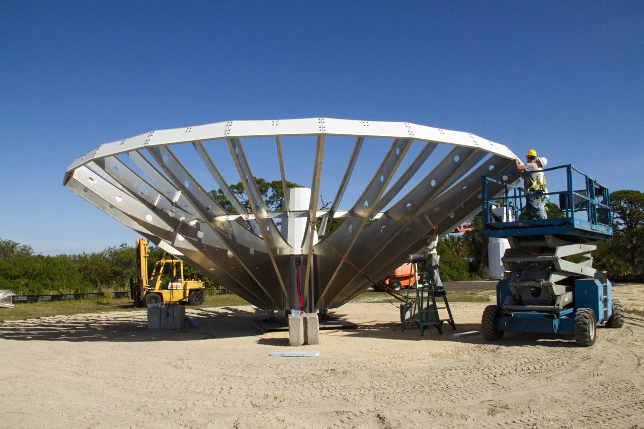
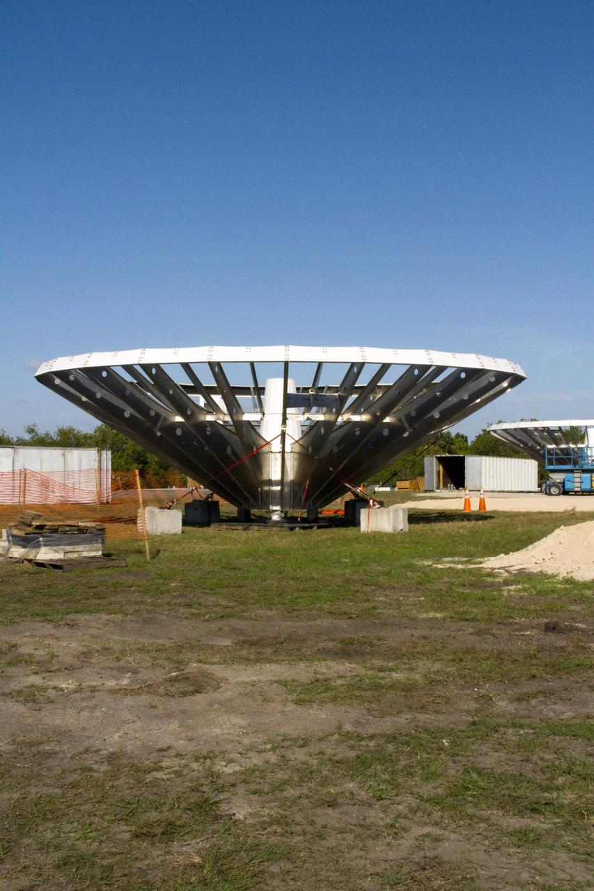
CAPE CANAVERAL, Fla. – At NASA’s Kennedy Space Center in Florida, 40-foot-diameter dish antenna arrays are being constructed as part of the Antenna Test Bed Array for the Ka-Band Objects Observation and Monitoring, or Ka-BOOM system. The antennas will be part of the operations command center facility. The construction site is near the former Vertical Processing Facility, which has been demolished. The Ka-BOOM project is one of the final steps in developing the techniques to build a high power, high resolution radar system capable of becoming a Near Earth Object Early Warning System. While also capable of space communication and radio science experiments, developing radar applications is the primary focus of the arrays. Photo credit: NASA_Jim Grossmann

CAPE CANAVERAL, Fla. – At NASA’s Kennedy Space Center in Florida, 40-foot-diameter dish antenna arrays are being constructed as part of the Antenna Test Bed Array for the Ka-Band Objects Observation and Monitoring, or Ka-BOOM system. The antennas will be part of the operations command center facility. The construction site is near the former Vertical Processing Facility, which has been demolished. The Ka-BOOM project is one of the final steps in developing the techniques to build a high power, high resolution radar system capable of becoming a Near Earth Object Early Warning System. While also capable of space communication and radio science experiments, developing radar applications is the primary focus of the arrays. Photo credit: NASA_Jim Grossmann
CAPE CANAVERAL, Fla. – At NASA’s Kennedy Space Center in Florida, 40-foot-diameter dish antenna arrays are being constructed as part of the Antenna Test Bed Array for the Ka-Band Objects Observation and Monitoring, or Ka-BOOM system. The antennas will be part of the operations command center facility. The construction site is near the former Vertical Processing Facility, which has been demolished. The Ka-BOOM project is one of the final steps in developing the techniques to build a high power, high resolution radar system capable of becoming a Near Earth Object Early Warning System. While also capable of space communication and radio science experiments, developing radar applications is the primary focus of the arrays. Photo credit: NASA_Jim Grossmann
CAPE CANAVERAL, Fla. – At NASA’s Kennedy Space Center in Florida, 40-foot-diameter dish antenna arrays are being constructed as part of the Antenna Test Bed Array for the Ka-Band Objects Observation and Monitoring, or Ka-BOOM system. The antennas will be part of the operations command center facility. The construction site is near the former Vertical Processing Facility, which has been demolished. The Ka-BOOM project is one of the final steps in developing the techniques to build a high power, high resolution radar system capable of becoming a Near Earth Object Early Warning System. While also capable of space communication and radio science experiments, developing radar applications is the primary focus of the arrays. Photo credit: NASA_Jim Grossmann
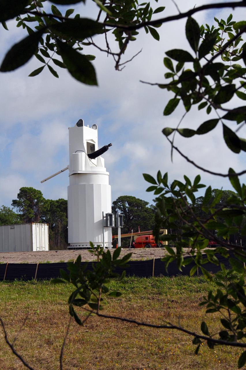
CAPE CANAVERAL, Fla. – At NASA’s Kennedy Space Center in Florida, new towers are being constructed for the Antenna Test Bed Array for the Ka-Band Objects Observation and Monitoring, or Ka-BOOM system. The construction site is near the former Vertical Processing Facility, which has been demolished. Workers soon will begin construction on the 40-foot-diameter dish antenna arrays and their associated utilities, and prepare the site for the operations command center facility. The Ka-BOOM project is one of the final steps in developing the techniques to build a high power, high resolution radar system capable of becoming a Near Earth Object Early Warning System. While also capable of space communication and radio science experiments, developing radar applications is the primary focus of the arrays. Photo credit: NASA/ Ben Smegelsky
CAPE CANAVERAL, Fla. – At NASA’s Kennedy Space Center in Florida, 40-foot-diameter dish antenna arrays are being constructed as part of the Antenna Test Bed Array for the Ka-Band Objects Observation and Monitoring, or Ka-BOOM system. The antennas will be part of the operations command center facility. The construction site is near the former Vertical Processing Facility, which has been demolished. The Ka-BOOM project is one of the final steps in developing the techniques to build a high power, high resolution radar system capable of becoming a Near Earth Object Early Warning System. While also capable of space communication and radio science experiments, developing radar applications is the primary focus of the arrays. Photo credit: NASA/ Ben Smegelsky
CAPE CANAVERAL, Fla. – At NASA’s Kennedy Space Center in Florida, 40-foot-diameter dish antenna arrays are being constructed as part of the Antenna Test Bed Array for the Ka-Band Objects Observation and Monitoring, or Ka-BOOM system. The antennas will be part of the operations command center facility. The construction site is near the former Vertical Processing Facility, which has been demolished. The Ka-BOOM project is one of the final steps in developing the techniques to build a high power, high resolution radar system capable of becoming a Near Earth Object Early Warning System. While also capable of space communication and radio science experiments, developing radar applications is the primary focus of the arrays. Photo credit: NASA_Jim Grossmann
CAPE CANAVERAL, Fla. – At NASA’s Kennedy Space Center in Florida, 40-foot-diameter dish antenna arrays are being constructed as part of the Antenna Test Bed Array for the Ka-Band Objects Observation and Monitoring, or Ka-BOOM system. The antennas will be part of the operations command center facility. The construction site is near the former Vertical Processing Facility, which has been demolished. The Ka-BOOM project is one of the final steps in developing the techniques to build a high power, high resolution radar system capable of becoming a Near Earth Object Early Warning System. While also capable of space communication and radio science experiments, developing radar applications is the primary focus of the arrays. Photo credit: NASA_Jim Grossmann
CAPE CANAVERAL, Fla. – At NASA’s Kennedy Space Center in Florida, 40-foot-diameter dish antenna arrays are being constructed as part of the Antenna Test Bed Array for the Ka-Band Objects Observation and Monitoring, or Ka-BOOM system. The antennas will be part of the operations command center facility. The construction site is near the former Vertical Processing Facility, which has been demolished. The Ka-BOOM project is one of the final steps in developing the techniques to build a high power, high resolution radar system capable of becoming a Near Earth Object Early Warning System. While also capable of space communication and radio science experiments, developing radar applications is the primary focus of the arrays. Photo credit: NASA_Jim Grossmann
CAPE CANAVERAL, Fla. – At NASA’s Kennedy Space Center in Florida, workers continue construction of the Antenna Test Bed Array for the Ka-Band Objects Observation and Monitoring, or Ka-BOOM, system. The construction site is near the former Vertical Processing Facility, which has been demolished. Workers soon will begin construction on the 40-foot-diameter dish antenna arrays and their associated utilities, and prepare the site for the operations command center facility. The Ka-BOOM project is one of the final steps in developing the techniques to build a high power, high resolution radar system capable of becoming a Near Earth Object Early Warning System. While also capable of space communication and radio science experiments, developing radar applications is the primary focus of the arrays. Photo credit: NASA/ Ben Smegelsky
CAPE CANAVERAL, Fla. – At NASA’s Kennedy Space Center in Florida, workers continue construction of the Antenna Test Bed Array for the Ka-Band Objects Observation and Monitoring, or Ka-BOOM, system. The construction site is near the former Vertical Processing Facility, which has been demolished. Workers soon will begin construction on the 40-foot-diameter dish antenna arrays and their associated utilities, and prepare the site for the operations command center facility. The Ka-BOOM project is one of the final steps in developing the techniques to build a high power, high resolution radar system capable of becoming a Near Earth Object Early Warning System. While also capable of space communication and radio science experiments, developing radar applications is the primary focus of the arrays. Photo credit: NASA/ Ben Smegelsky
CAPE CANAVERAL, Fla. – At NASA’s Kennedy Space Center in Florida, new towers are being constructed for the Antenna Test Bed Array for the Ka-Band Objects Observation and Monitoring, or Ka-BOOM system. The construction site is near the former Vertical Processing Facility, which has been demolished. Workers soon will begin construction on the 40-foot-diameter dish antenna arrays and their associated utilities, and prepare the site for the operations command center facility. The Ka-BOOM project is one of the final steps in developing the techniques to build a high power, high resolution radar system capable of becoming a Near Earth Object Early Warning System. While also capable of space communication and radio science experiments, developing radar applications is the primary focus of the arrays. Photo credit: NASA/ Ben Smegelsky
CAPE CANAVERAL, Fla. – At NASA’s Kennedy Space Center in Florida, 40-foot-diameter dish antenna arrays are being constructed as part of the Antenna Test Bed Array for the Ka-Band Objects Observation and Monitoring, or Ka-BOOM system. The antennas will be part of the operations command center facility. The construction site is near the former Vertical Processing Facility, which has been demolished. The Ka-BOOM project is one of the final steps in developing the techniques to build a high power, high resolution radar system capable of becoming a Near Earth Object Early Warning System. While also capable of space communication and radio science experiments, developing radar applications is the primary focus of the arrays. Photo credit: NASA/ Ben Smegelsky
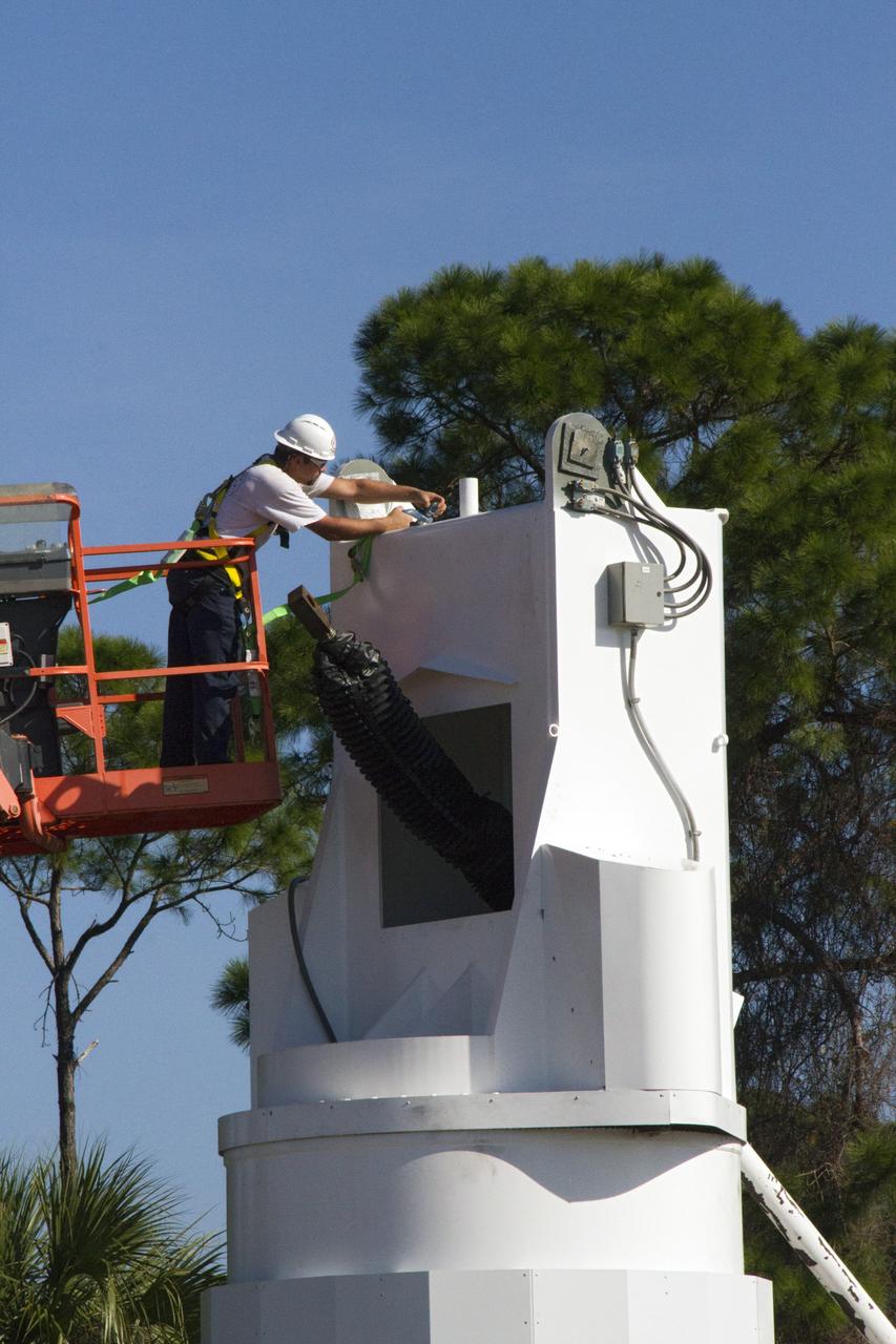
CAPE CANAVERAL, Fla. – At NASA’s Kennedy Space Center in Florida, a worker makes adjustments on a new tower being constructed for the Antenna Test Bed Array for the Ka-Band Objects Observation and Monitoring, or Ka-BOOM system. The antennas will be part of the operations command center facility. The construction site is near the former Vertical Processing Facility, which has been demolished. The Ka-BOOM project is one of the final steps in developing the techniques to build a high power, high resolution radar system capable of becoming a Near Earth Object Early Warning System. While also capable of space communication and radio science experiments, developing radar applications is the primary focus of the arrays. Photo credit: NASA/ Ben Smegelsky
CAPE CANAVERAL, Fla. – At NASA’s Kennedy Space Center in Florida, 40-foot-diameter dish antenna arrays are being constructed as part of the Antenna Test Bed Array for the Ka-Band Objects Observation and Monitoring, or Ka-BOOM system. The antennas will be part of the operations command center facility. The construction site is near the former Vertical Processing Facility, which has been demolished. The Ka-BOOM project is one of the final steps in developing the techniques to build a high power, high resolution radar system capable of becoming a Near Earth Object Early Warning System. While also capable of space communication and radio science experiments, developing radar applications is the primary focus of the arrays. Photo credit: NASA/ Ben Smegelsky
CAPE CANAVERAL, Fla. – At NASA’s Kennedy Space Center in Florida, 40-foot-diameter dish antenna arrays are being constructed as part of the Antenna Test Bed Array for the Ka-Band Objects Observation and Monitoring, or Ka-BOOM system. The antennas will be part of the operations command center facility. The construction site is near the former Vertical Processing Facility, which has been demolished. The Ka-BOOM project is one of the final steps in developing the techniques to build a high power, high resolution radar system capable of becoming a Near Earth Object Early Warning System. While also capable of space communication and radio science experiments, developing radar applications is the primary focus of the arrays. Photo credit: NASA_Jim Grossmann
CAPE CANAVERAL, Fla. – At NASA’s Kennedy Space Center in Florida, 40-foot-diameter dish antenna arrays are being constructed as part of the Antenna Test Bed Array for the Ka-Band Objects Observation and Monitoring, or Ka-BOOM system. The antennas will be part of the operations command center facility. The construction site is near the former Vertical Processing Facility, which has been demolished. The Ka-BOOM project is one of the final steps in developing the techniques to build a high power, high resolution radar system capable of becoming a Near Earth Object Early Warning System. While also capable of space communication and radio science experiments, developing radar applications is the primary focus of the arrays. Photo credit: NASA/ Ben Smegelsky
CAPE CANAVERAL, Fla. – At NASA’s Kennedy Space Center in Florida, 40-foot-diameter dish antenna arrays are being constructed as part of the Antenna Test Bed Array for the Ka-Band Objects Observation and Monitoring, or Ka-BOOM system. The antennas will be part of the operations command center facility. The construction site is near the former Vertical Processing Facility, which has been demolished. The Ka-BOOM project is one of the final steps in developing the techniques to build a high power, high resolution radar system capable of becoming a Near Earth Object Early Warning System. While also capable of space communication and radio science experiments, developing radar applications is the primary focus of the arrays. Photo credit: NASA/Jim Grossmann
CAPE CANAVERAL, Fla. – At NASA’s Kennedy Space Center in Florida, new towers are being constructed for the Antenna Test Bed Array for the Ka-Band Objects Observation and Monitoring, or Ka-BOOM system. The construction site is near the former Vertical Processing Facility, which has been demolished. Workers soon will begin construction on the 40-foot-diameter dish antenna arrays and their associated utilities, and prepare the site for the operations command center facility. The Ka-BOOM project is one of the final steps in developing the techniques to build a high power, high resolution radar system capable of becoming a Near Earth Object Early Warning System. While also capable of space communication and radio science experiments, developing radar applications is the primary focus of the arrays. Photo credit: NASA/ Ben Smegelsky
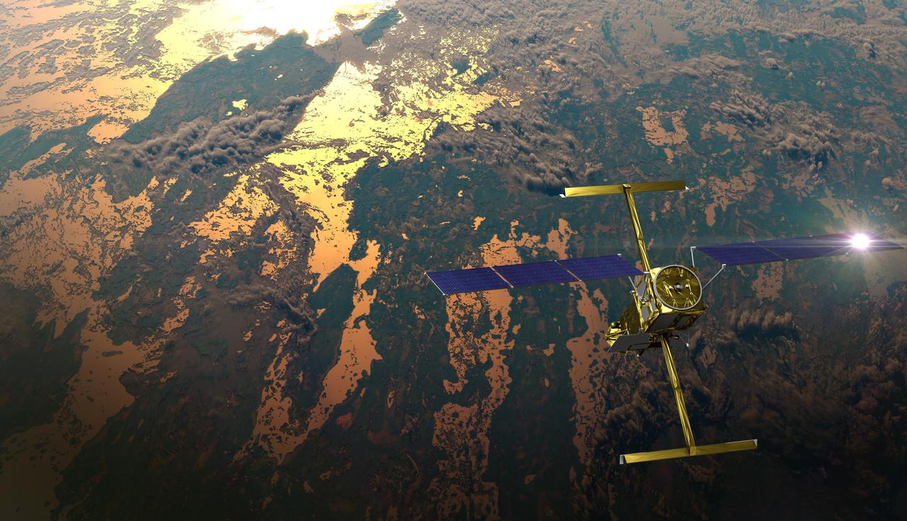
The international Surface Water and Ocean Topography (SWOT) satellite is shown in orbit over Earth in this illustration, with sunlight glinting off one of its solar arrays and both antennas of its Ka-band Radar Interferometer (KaRIn) instrument extended. The mission is a collaborative effort between NASA and the French space agency Centre National d'Études Spatiales (CNES) – with contributions from the Canadian Space Agency (CSA) and the UK Space Agency. KaRIn is the scientific heart of the SWOT satellite, which will survey the water on more than 90% of Earth's surface, measuring the height of water in lakes, rivers, reservoirs, and the ocean. To do that, KaRIn will transmit radar pulses to Earth's surface and use its two antennas to triangulate the return signals that bounce back. Mounted at the ends of a boom 33 feet (10 meters) long, the antennas will collect data along a swath 30 miles (50 kilometers) wide on either side of the satellite. KaRIn will operate in two modes: A lower-resolution mode over the ocean will involve significant onboard processing of the data to reduce the volume of information sent during downlinks to Earth; a higher-resolution mode will be used mainly over land. Scheduled to launch from Vandenberg Space Force Base in Central California on Dec. 15, 2022, SWOT is being jointly developed by NASA and CNES, with contributions from the CSA and the UK Space Agency. NASA's Jet Propulsion Laboratory, which is managed for the agency by Caltech in Pasadena, California, leads the U.S. component of the project. For the flight system payload, NASA is providing the Ka-band Radar Interferometer (KaRIn) instrument, a GPS science receiver, a laser retroreflector, a two-beam microwave radiometer, and NASA instrument operations. CNES is providing the Doppler Orbitography and Radioposition Integrated by Satellite (DORIS) system, the dual frequency Poseidon altimeter (developed by Thales Alenia Space), the KaRIn radio-frequency subsystem (together with Thales Alenia Space and with support from the UK Space Agency), the satellite platform, and ground control segment. CSA is providing the KaRIn high-power transmitter assembly. NASA is providing the launch vehicle and associated launch services. https://photojournal.jpl.nasa.gov/catalog/PIA25595
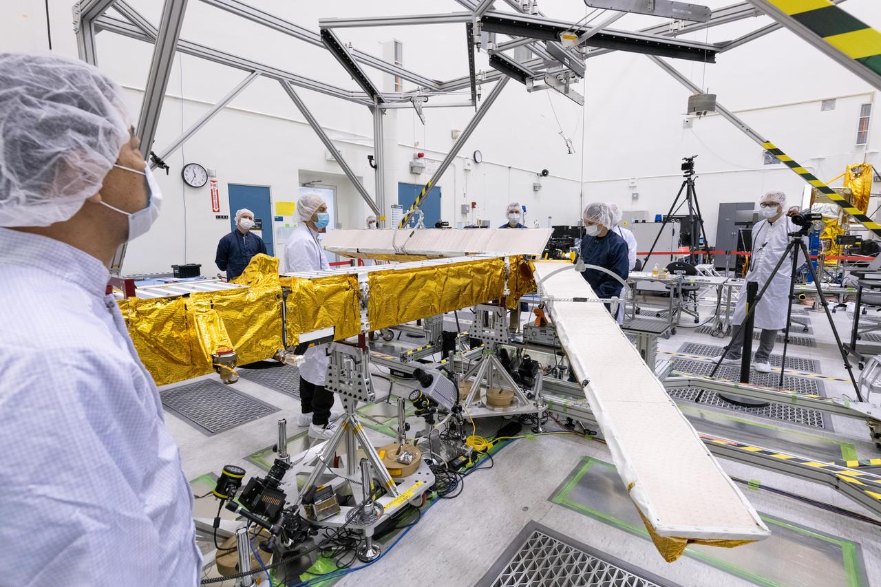
Members of the international Surface Water and Ocean Topography (SWOT) mission test one of the antennas for the Ka-band Radar Interferometer (KaRIn) instrument in a clean room at NASA's Jet Propulsion Laboratory in Southern California. The mission is a collaborative effort between NASA and the French space agency Centre National d'Études Spatiales (CNES) – with contributions from the Canadian Space Agency (CSA) and the UK Space Agency. KaRIn is the scientific heart of the SWOT satellite, which will survey the water on more than 90% of Earth's surface, measuring the height of water in lakes, rivers, reservoirs, and the ocean. To do that, KaRIn will transmit radar pulses to Earth's surface and use its two antennas to triangulate the return signals that bounce back. Mounted at the ends of a boom 33 feet (10 meters) long, the antennas will collect data along a swath 30 miles (50 kilometers) wide on either side of the satellite. KaRIn will operate in two modes: A lower-resolution mode over the ocean will involve significant onboard processing of the data to reduce the volume of information sent during downlinks to Earth; a higher-resolution mode will be used mainly over land. Scheduled to launch from Vandenberg Space Force Base in Central California on Dec. 15, 2022, SWOT is being jointly developed by NASA and CNES, with contributions from the CSA and the UK Space Agency. NASA's Jet Propulsion Laboratory, which is managed for the agency by Caltech in Pasadena, California, leads the U.S. component of the project. For the flight system payload, NASA is providing the Ka-band Radar Interferometer (KaRIn) instrument, a GPS science receiver, a laser retroreflector, a two-beam microwave radiometer, and NASA instrument operations. CNES is providing the Doppler Orbitography and Radioposition Integrated by Satellite (DORIS) system, the dual frequency Poseidon altimeter (developed by Thales Alenia Space), the KaRIn radio-frequency subsystem (together with Thales Alenia Space and with support from the UK Space Agency), the satellite platform, and ground control segment. CSA is providing the KaRIn high-power transmitter assembly. NASA is providing the launch vehicle and associated launch services. https://photojournal.jpl.nasa.gov/catalog/PIA25594
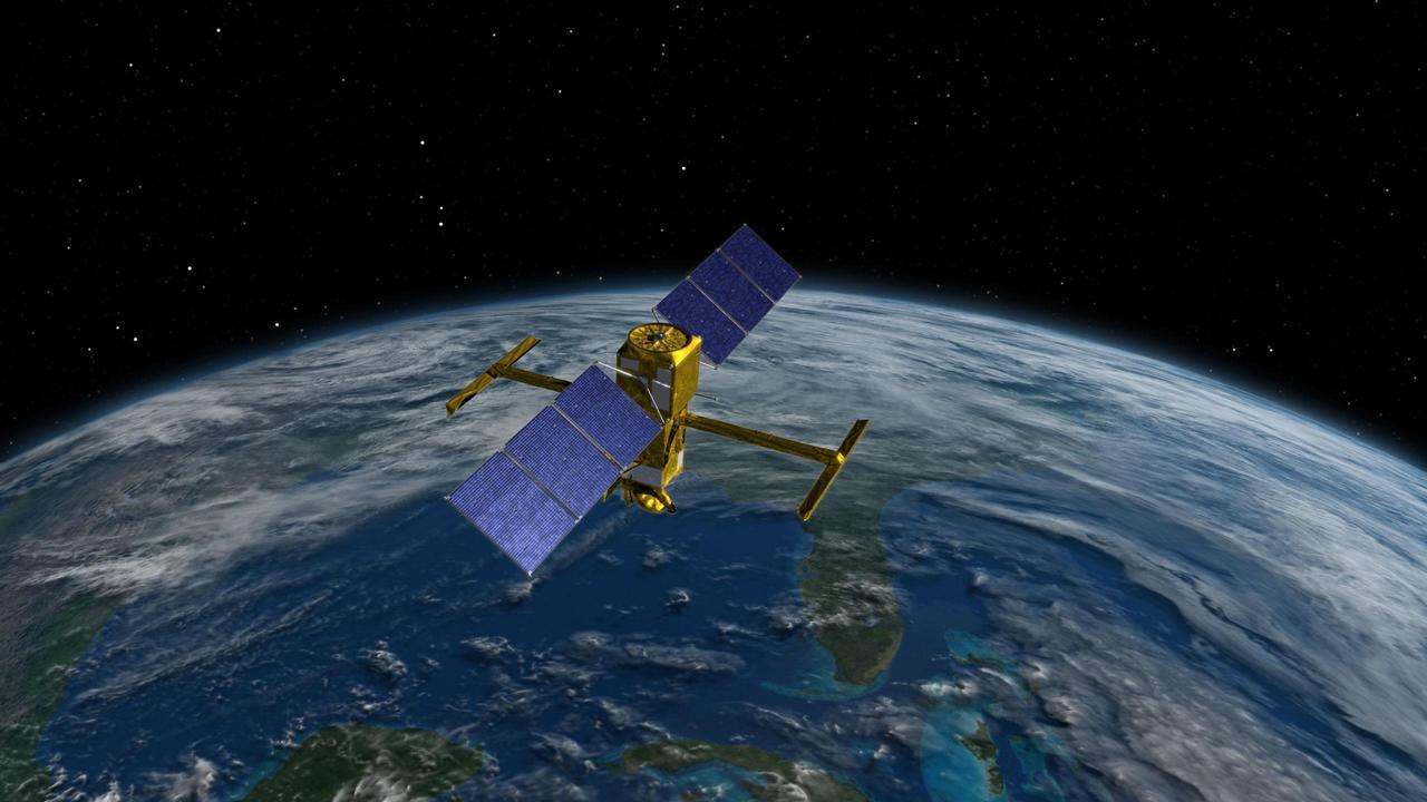
This illustration depicts the Surface Water and Ocean Topography (SWOT) satellite, a mission led by NASA and the French space agency Centre National d'Études Spatiales (CNES). The scientific heart of the SWOT satellite is the Ka-band Radar Interferometer (KaRIn) instrument, which will measure the height of water in Earth's lakes, rivers, reservoirs, and ocean. To do that, KaRIn will transmit radar pulses to Earth's surface and use two antennas – seen to the left and right of the spacecraft bus – to triangulate the return signals that bounce back. Mounted at the ends of a boom 33 feet (10 meters) long, the antennas will collect data over two swaths of Earth's surface at a time, each of them 30 miles (50 kilometers) wide and located on either side of the satellite. KaRIn will operate in two modes: A lower-resolution mode over the ocean will involve significant onboard processing of the data to reduce the volume of information sent during downlinks to Earth; a higher-resolution mode will be used mainly over land. https://photojournal.jpl.nasa.gov/catalog/PIA25621
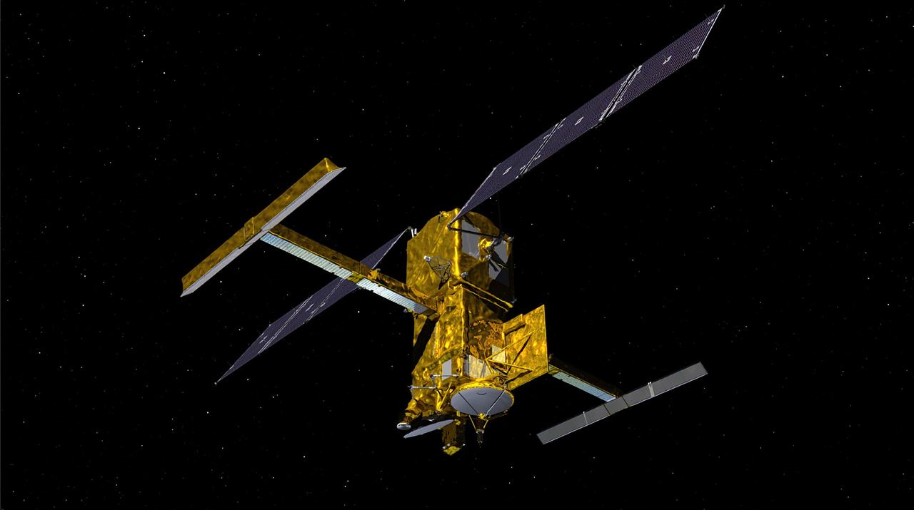
This illustration depicts the Surface Water and Ocean Topography satellite, a mission led by NASA and the French space agency Centre National d'Études Spatiales (CNES). The scientific heart of the SWOT satellite is the Ka-band Radar Interferometer (KaRIn) instrument, which will measure the height of water in Earth's lakes, rivers, reservoirs, and ocean. To do that, KaRIn will transmit radar pulses to Earth's surface and use two antennas – seen to the left and right of the spacecraft bus – to triangulate the return signals that bounce back. Mounted at the ends of a boom 33 feet (10 meters) long, the antennas will collect data over two swaths of Earth's surface at a time, each of them 30 miles (50 kilometers) wide and located on either side of the satellite. KaRIn will operate in two modes: A lower-resolution mode over the ocean will involve significant onboard processing of the data to reduce the volume of information sent during downlinks to Earth; a higher-resolution mode will be used mainly over land. https://photojournal.jpl.nasa.gov/catalog/PIA24530
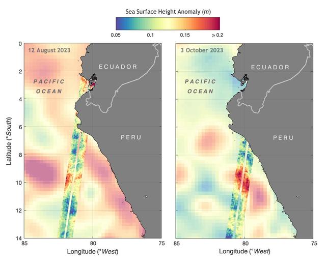
The illustration above shows sea levels off the coasts of Peru and Ecuador on Aug. 12, 2023, and Oct. 3, 2023. The Surface Water and Ocean Topography (SWOT) satellite collected the ocean data during its operational phase, which began in late July. The red and orange colors represent sea levels that are higher than average (units are in meters), while green and blue indicate sea levels that are lower than average. The SWOT data shows some of the development of an El Niño along the west coast of the Americas. The SWOT science team made the measurements using the spacecraft's Ka-band Radar Interferometer (KaRIn) instrument. With two antennas spread 33 feet (10 meters) apart on a boom, KaRIn produces a pair of data swaths (tracks visible in the animation) as it circles the globe, bouncing radar pulses off the water's surface to collect surface-height measurements. Launched on Dec. 16, 2022, from Vandenberg Space Force Base in central California, SWOT is now in its operations phase, measuring the height of nearly all water on Earth's surface. The satellite will provide one of the most detailed, comprehensive views yet of the planet's oceans and fresh water lakes and rivers, collecting data that will be used for research and other purposes. https://photojournal.jpl.nasa.gov/catalog/PIA26181
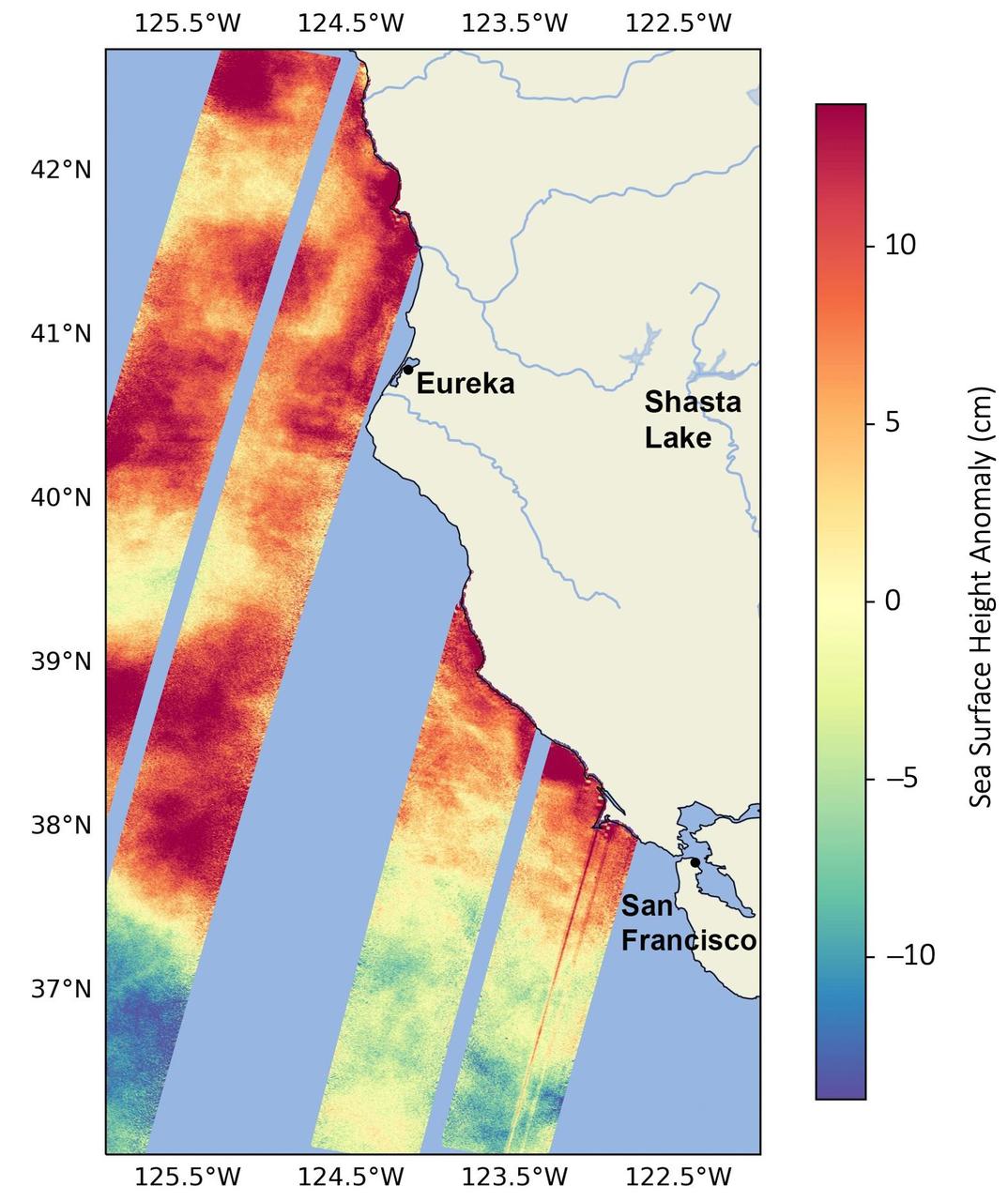
This data visualization image above shows sea surface heights off the northern California coast in August 2023 as measured by the Surface Water and Ocean Topography (SWOT) satellite. Red indicates higher-than-average ocean heights, while blue represents lower-than-average heights. Warm ocean waters from the developing El Niño are shifting north along coastlines in the eastern Pacific Ocean. Along the coast of California, these warm waters are interacting with a persistent marine heat wave that recently influenced the development of Hurricane Hilary. SWOT is able to spot the movement of these warm ocean waters in unprecedented detail. The SWOT science team made the measurements with the Ka-band Radar Interferometer (KaRIn) instrument. With two antennas spread 33 feet (10 meters) apart on a boom, KaRIn produces a pair of data swaths as it circles the globe, bouncing radar pulses off the water's surface to collect water-height measurements. The visualization combines data from two passes of the SWOT satellite. https://photojournal.jpl.nasa.gov/catalog/PIA26091
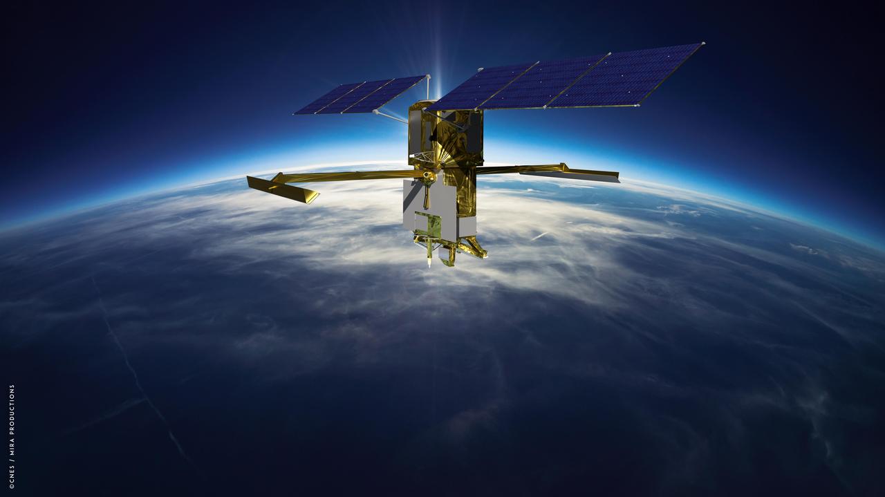
This illustration depicts the Surface Water and Ocean Topography (SWOT) satellite with solar arrays fully deployed. Measuring 48.8 feet (14.9 meters) in length with an area of 335 square feet (31 square meters), the two arrays will remain pointed at the Sun via small motors to provide 8 kilowatts of power; the spacecraft has a 1.5-kilowatt total power demand. The scientific heart of the SWOT satellite is the Ka-band Radar Interferometer (KaRIn) instrument, which will measure the height of water in Earth's lakes, rivers, reservoirs, and ocean. To do that, KaRIn will transmit radar pulses to Earth's surface and use two antennas – seen to the left and right of the spacecraft bus – to triangulate the return signals that bounce back. Mounted at the ends of a boom 33 feet (10 meters) long, the antennas will collect data over two swaths of Earth's surface at a time, each of them 30 miles (50 kilometers) wide and located on either side of the satellite. KaRIn will operate in two modes: A lower-resolution mode over the ocean will involve significant onboard processing of the data to reduce the volume of information sent during downlinks to Earth; a higher-resolution mode will be used mainly over land. https://photojournal.jpl.nasa.gov/catalog/PIA25623
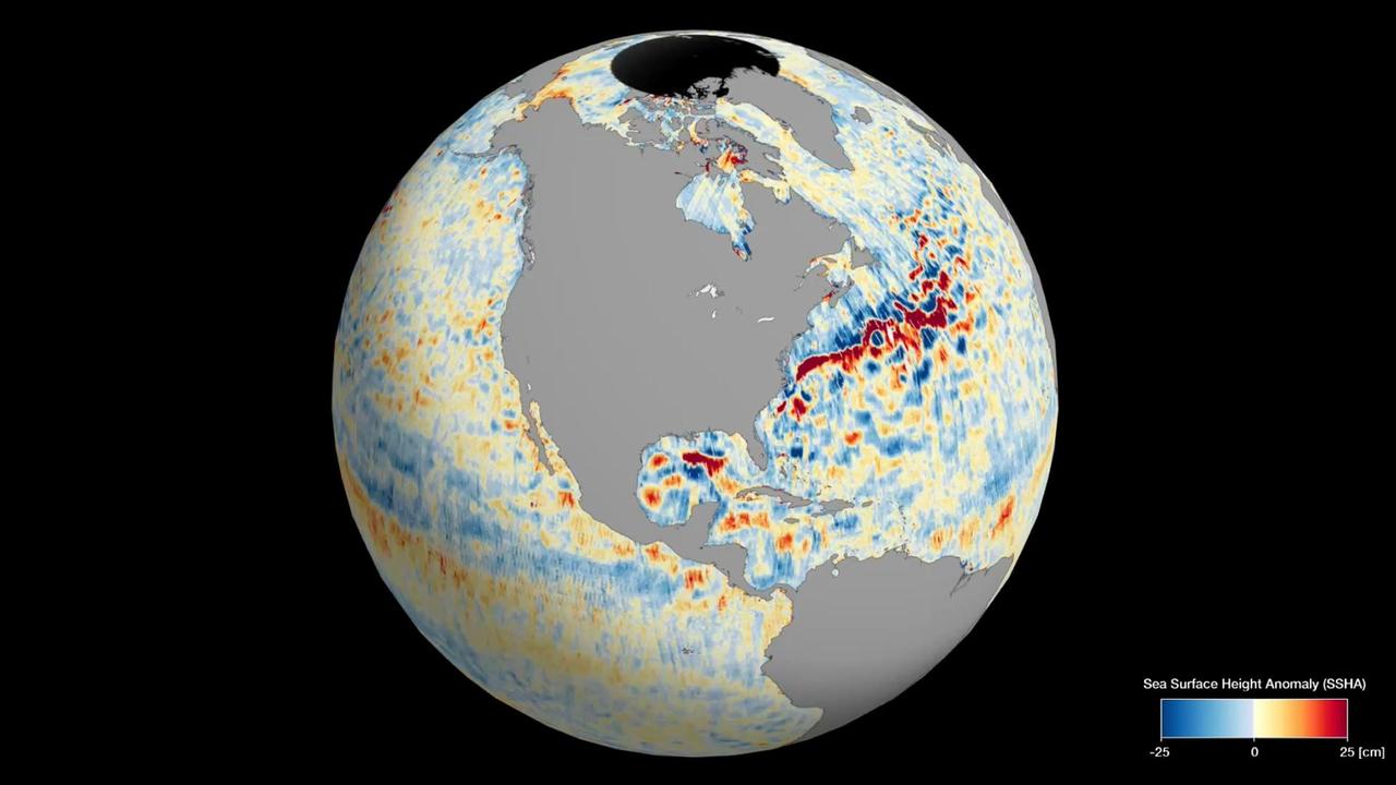
This animation shows global sea level data collected by the Surface Water and Ocean Topography (SWOT) satellite during its first 21-day science orbit, which it completed from July 26 to Aug. 16, 2023. Red and orange indicate ocean heights that were higher than the global mean sea surface height, while blue represents lower-than-the mean. Sea level differences can highlight ocean currents, like the Gulf Stream coming off the U.S. East Coast or the Kuroshio current off the east coast of Japan. Increased sea surface heights can also indicate regions of relatively warmer water – like the eastern part of the equatorial Pacific Ocean during an El Niño – because water expands as it warms. The SWOT science team made the measurements using the spacecraft's Ka-band Radar Interferometer (KaRIn) instrument. With two antennas spread 33 feet (10 meters) apart on a boom, KaRIn produces a pair of data swaths (tracks visible in the animation) as it circles the globe, bouncing radar pulses off the water's surface to collect surface-height measurements. Launched on Dec. 16, 2022, from Vandenberg Space Force Base in central California, SWOT is now in its operations phase, measuring the height of nearly all water on Earth's surface. The satellite will provide one of the most detailed, comprehensive views yet of the planet's oceans and fresh water lakes and rivers, collecting data that will be used for research and other purposes. Animation available at https://photojournal.jpl.nasa.gov/catalog/PIA26100

A series of atmospheric rivers drenched California in February 2024, with record amounts of rainfall and hurricane-force winds sweeping across parts of the state. The Surface Water and Ocean Topography (SWOT) mission captured data on coastal flooding near the community of Manchester, roughly 105 miles (169 kilometers) north of San Francisco. The satellite is a collaboration between NASA and the French space agency, CNES (Centre National d'Études Spatiales). The image shows the area on Jan. 15, 2024, before the rain and snow from atmospheric rivers hit California, and then again on Feb. 4, 2024, after the first in a series of storms soaked the state. Water heights are shown in shades of green and blue, with lighter hues indicating the highest levels relative to mean sea level. (Data for inland areas includes the height of the floodwaters plus the ground elevation beneath it.) Each pixel in the image represents an area that is 330 feet by 330 feet (100 meters by 100 meters). Since December 2022, SWOT has been measuring the height of nearly all water on Earth's surface, developing one of the most detailed, comprehensive views yet of the planet's oceans and freshwater lakes and rivers. Not only can the satellite detect the extent of the water on Earth's surface, as other satellites can, but SWOT can also provide water level data. The mission science team made the measurements using the Ka-band Radar Interferometer (KaRIn) instrument. With two antennas spread 33 feet (10 meters) apart on a boom, KaRIn produces a pair of data swaths as it circles the globe, bouncing radar pulses off water surfaces to collect surface-height measurements. Launched from Vandenberg Space Force Base in central California, SWOT is now in its operations phase, collecting data that will be used for research and other purposes. https://photojournal.jpl.nasa.gov/catalog/PIA26182
This visualization shows water features on New York's Long Island – shown as bright pink splotches nestled within the landscape. Purple, yellow, green, and dark blue shades represent different land elevations, while the surrounding ocean is a lighter blue. The data was collected on Jan. 21, 2023, by an instrument on the Surface Water and Ocean Topography (SWOT) satellite called the Ka-band Radar Interferometer (KaRIn). KaRIn is the scientific heart of the SWOT mission. It's a radar instrument with one antenna at each end of a boom that’s 33 feet (10 meters) long. This enables KaRIn to look off to either side of a center line directly below the satellite as the instrument bounces microwave signals off of Earth's surface. The returning radar signals arrive at each antenna slightly out of step, or phase, from one another. When these signals are combined with other information about the antennas and the satellite's altitude, scientists will be able to map the height of water on Earth's surface with never-before-seen clarity. This initial inland image is a tantalizing indication of how SWOT can measure details of smaller lakes, ponds, and rivers in ways that satellites could not before. Such data will be used to produce an extraordinary accounting of the freshwater on Earth's surface in ways useful to researchers, policymakers, and water resource managers. Led by NASA and the French space agency Centre National d'Études Spatiales (CNES), SWOT will measure the height of water on over 90% of Earth's surface, providing a high-definition survey of our planet's water for the first time. The satellite's measurements of freshwater bodies and the ocean will provide insights into how the ocean influences climate change; how a warming world affects lakes, rivers, and reservoirs; and how communities can better prepare for floods and other disasters. Launched on Dec. 16, 2022, from Vandenberg Space Force Base in central California, SWOT is now in a six-month period called commissioning, calibration and validation. This is when engineers on the mission check out the satellite's systems and science instruments to ensure data accuracy before the start of science operations in July. https://photojournal.jpl.nasa.gov/catalog/PIA25774
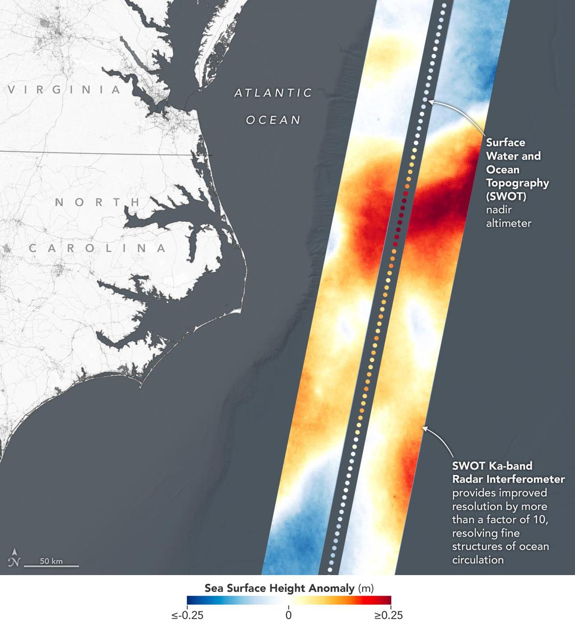
This visualization shows sea surface height measurements in the Gulf Stream off the coast of North Carolina and Virginia. The data was collected on Jan. 21, 2023, by an instrument on the Surface Water and Ocean Topography (SWOT) satellite called the Ka-band Radar Interferometer (KaRIn). KaRIn's two antennas acquired data that was mapped as two wide, colored strips spanning a total of 75 miles (120 kilometers) across. In the visualization, red and orange areas represent sea levels that are higher than the global average, while shades of blue represent sea levels that are lower than average. The spatial resolution of SWOT ocean measurements is 10 times greater than the composite of sea surface height data gathered over the same area by seven other satellites that same day. KaRIn is the scientific heart of the SWOT mission. It's a radar instrument with one antenna at each end of a boom that's 33 feet (10 meters) long. This enables KaRIn to look off to either side of a center line directly below the satellite as the instrument bounces microwave signals off of Earth's surface. The returning radar signals arrive at each antenna slightly out of step, or phase, from one another. When these signals are combined with other information about the antennas and the satellite's altitude, scientists will be able to map the height of water on Earth's surface with never-before-seen clarity. Led by NASA and the French space agency Centre National d'Études Spatiales (CNES), SWOT will measure the height of water on over 90% of Earth's surface, providing a high-definition survey of our planet's water for the first time. The satellite's measurements of freshwater bodies and the ocean will provide insights into how the ocean influences climate change; how a warming world affects lakes, rivers, and reservoirs; and how communities can better prepare for disasters like floods. Launched on Dec. 16, 2022, from Vandenberg Space Force Base in central California, SWOT is now in a six-month period called commissioning, calibration and validation. This is when engineers on the mission check out the satellite's systems and science instruments to ensure data accuracy before the start of science operations in July. https://photojournal.jpl.nasa.gov/catalog/PIA25772
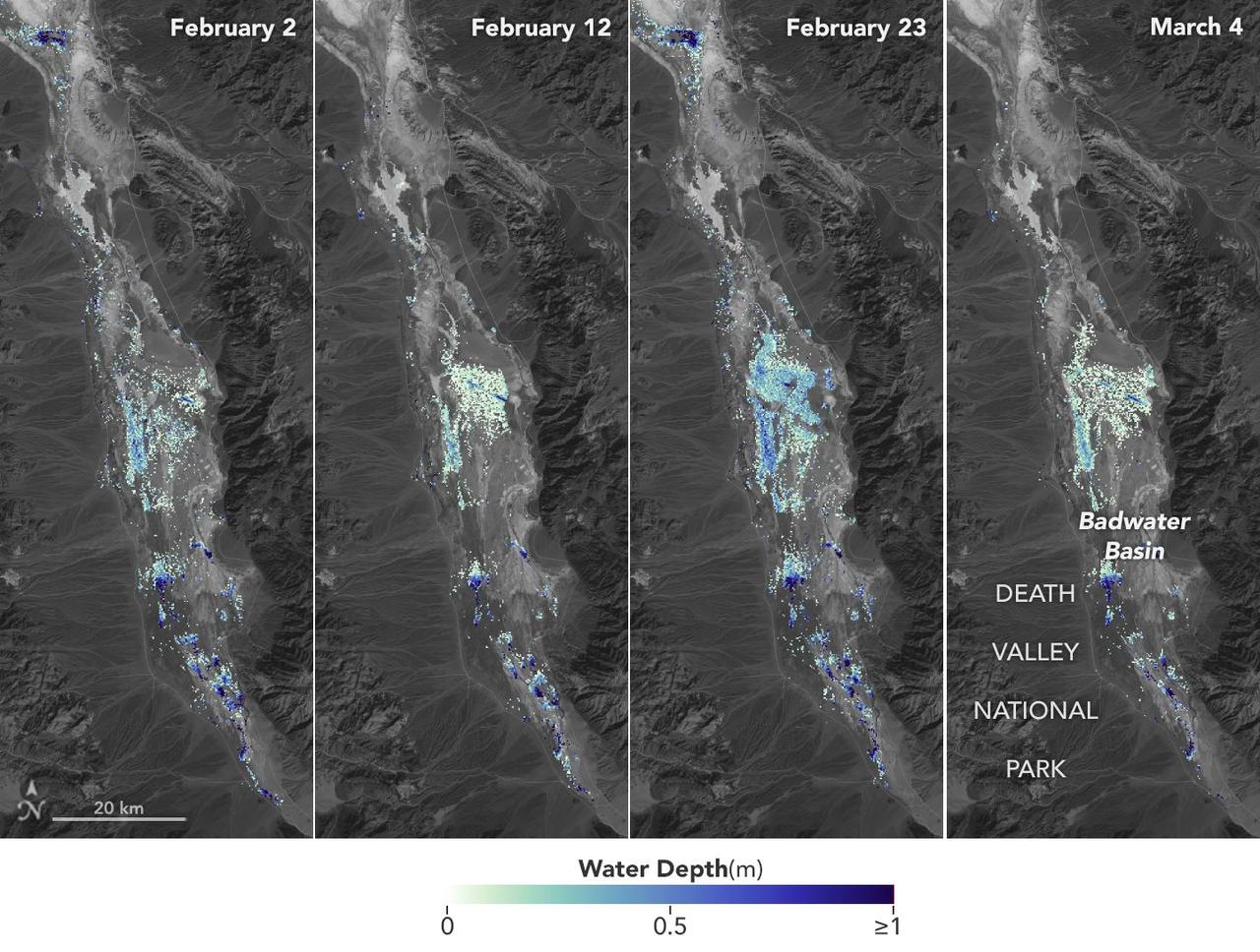
California's Death Valley, the driest place in North America, has hosted an ephemeral lake since late 2023. In March 2024, a NASA-led analysis calculated water depths in the temporary lake over several weeks in February and March 2024, demonstrating the possibilities of the latest water-observing mission, the U.S.-French Surface Water and Ocean Topography (SWOT) satellite. The analysis found that water depths in the lake ranged between about 3 feet (1 meter) to less than 1.5 feet (0.5 meters) over the course of several weeks. This period included a series of storms that swept across California, bringing record amounts of rainfall. To estimate the depth of the lake, known informally as Lake Manly, researchers used water level data collected by SWOT and subtracted corresponding U.S. Geological Survey land elevation information for Badwater Basin. The researchers found that the water levels varied across space and time in the roughly 10-day period between SWOT observations. In the visualization above, water depths of about 3 feet (1 meter) appear dark blue; those of less than 1.5 feet (0.5 meters) appear light yellow. Right after a series of storms in early February, the temporary lake was about 6 miles (10 kilometers) long and 3 miles (5 kilometers) wide. Each pixel in the image represents an area that is about 330 feet by 330 feet (100 meters by 100 meters). Unlike many lakes around the world, Death Valley's lake is temporary, relatively shallow, and strong winds are enough to move the freshwater body a couple of miles, as happened from Feb. 29 to March 2. Since there isn't typically water in Badwater Basin, researchers don't have permanent instruments in place for studying water in this area. SWOT can fill the data gap for when places like this, and others around the world, become inundated. Since shortly after launch in December 2022, SWOT has been measuring the height of nearly all water on Earth's surface, developing one of the most detailed and comprehensive views of the planet's oceans and freshwater lakes and rivers. Not only can the satellite detect the extent of water, as other satellites can, but SWOT can also measure water surface levels. Combined with other types of information, SWOT measurements can yield water depth data for inland features like lakes and rivers. The SWOT science team makes its measurements using the Ka-band Radar Interferometer (KaRIn) instrument. With two antennas spread 33 feet (10 meters) apart on a boom, KaRIn produces a pair of data swaths as it circles the globe, bouncing radar pulses off water surfaces to collect surface-height information. Launched from Vandenberg Space Force Base in central California, SWOT is now in its operations phase, collecting data that will be used for research and other purposes. Animation available at https://photojournal.jpl.nasa.gov/catalog/PIA26184
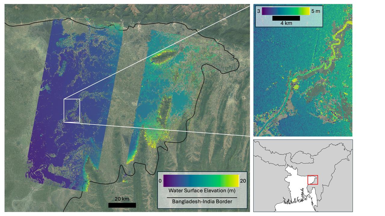
Flooding from monsoon rains covers a wide region of northeast Bangladesh near the India border in this Oct. 8, 2023, image showing data from the U.S.-French Surface Water and Ocean Topography (SWOT) satellite. Around that time, heavy monsoon rains affected various parts of Bangladesh, including the region depicted here, home to Sylhet, the country's fifth-largest city (population approximately 700,000). Sylhet and surrounding areas experienced substantial flooding. The SWOT data, overlaid on a standard Google Earth image, shows the precise surface elevation of the floodwaters. The vast majority of the land area within the region imaged by SWOT is flooded. In the main image at left, dark blue indicates waters just above sea level, while yellow represents 65 feet (20 meters) above sea level. The inset at top right zooms in on a section of the Kalni River, a tributary of one of Bangladesh's three major rivers, the Meghna. The main channel of the Kalni is about 650 feet (200 meters) wide. In the inset at top right, dark blue indicates water about 10 feet (3 meters) above sea level and yellow is used for waters about 16 feet (5 meters) above sea level. The zoomed-in data can be used to determine the slope of the river, which tells hydrologists how fast water flows through it and off a landscape. The water surface elevations depicted are higher in the top right of the inset than they are in the bottom left. The data also shows the elevation of the river is generally greater than that of water in the floodplain around it, telling hydrologists that water is likely flowing from the river into the floodplain. Each pixel in the image represents an area that is about 330 feet by 330 feet (100 meters by 100 meters). The image shows data from SWOT's Ka-band Radar Interferometer (KaRIn) instrument antennas, which don't cover a 12-mile-wide (20-kilometer-wide) strip right underneath the satellite. For that gap, a separate instrument collects water surface elevation data that isn't shown here. Bangladesh is a low-lying, generally flat country that chronically suffers from two types of flooding. Monsoon rains cause rivers that flow into Bangladesh from neighboring countries, especially India, to flood. And flash flooding occurs during the pre-monsoon season and can damage agricultural crops if not forecast with sufficient warning. While the use of satellite altimetry and precipitation in models has shown some promise for flood forecasting in Bangladesh, forecasting both types of flooding with sufficient lead time has remained challenging due to a lack of timely, high-spatial-resolution information on water elevation. SWOT is the first satellite to provide this information over entire regions, enabling improved forecasts and filling the data gap when places like Bangladesh become inundated. The Bangladesh Water Development Board, which is in charge of national flood forecasting and management, is now exploring how to incorporate SWOT water elevation information into its flood inundation forecasting system. Since shortly after launch in December 2022, SWOT has been measuring the height of nearly all water on Earth's surface, developing one of the most detailed, comprehensive views yet of the planet's oceans and freshwater lakes and rivers. The mission science team makes measurements using the KaRIn instrument. With two antennas spread 33 feet (10 meters) apart on a boom, KaRIn produces a pair of data swaths as it circles the globe, bouncing radar pulses off water surfaces to collect surface-height information. https://photojournal.jpl.nasa.gov/catalog/PIA26343