Kaiser Crater
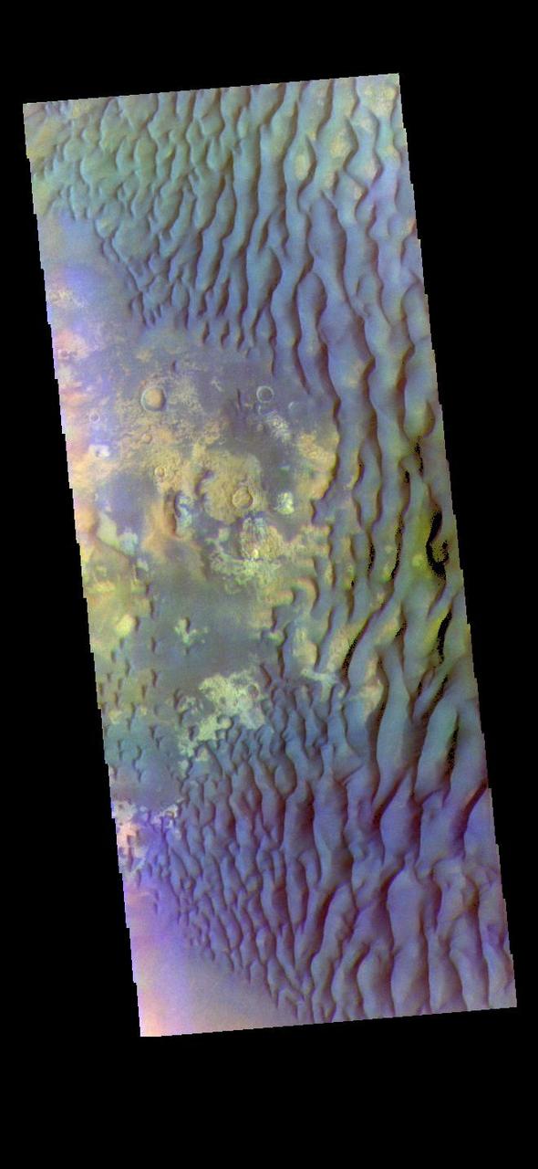
![This enhanced-color image from NASA Mars Reconnaissance Orbiter shows a patch of well-exposed bedrock on the floor of Kaiser Crater. The wind has stripped off the overlying soil, and created grooves and scallops in the bedrock. The narrow linear ridges are fractures that have been indurated, probably by precipitation of cementing minerals from groundwater flow. The rippled dark blue patches consist of sand. The map is projected here at a scale of 25 centimeters (9.8 inches) per pixel. [The original image scale is 25.3 centimeters (9.9 inches) per pixel (with 1 x 1 binning); objects on the order of 76 centimeters (29.9 inches) across are resolved.] North is up. http://photojournal.jpl.nasa.gov/catalog/PIA21559](https://images-assets.nasa.gov/image/PIA21559/PIA21559~medium.jpg)
This enhanced-color image from NASA Mars Reconnaissance Orbiter shows a patch of well-exposed bedrock on the floor of Kaiser Crater. The wind has stripped off the overlying soil, and created grooves and scallops in the bedrock. The narrow linear ridges are fractures that have been indurated, probably by precipitation of cementing minerals from groundwater flow. The rippled dark blue patches consist of sand. The map is projected here at a scale of 25 centimeters (9.8 inches) per pixel. [The original image scale is 25.3 centimeters (9.9 inches) per pixel (with 1 x 1 binning); objects on the order of 76 centimeters (29.9 inches) across are resolved.] North is up. http://photojournal.jpl.nasa.gov/catalog/PIA21559
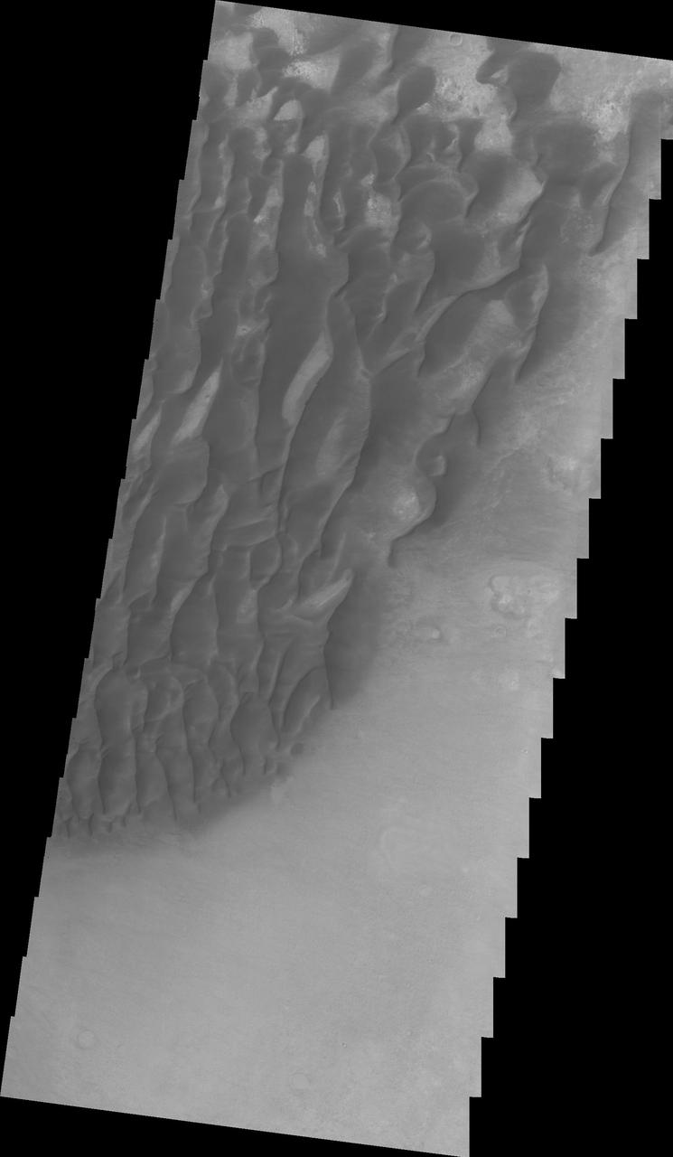
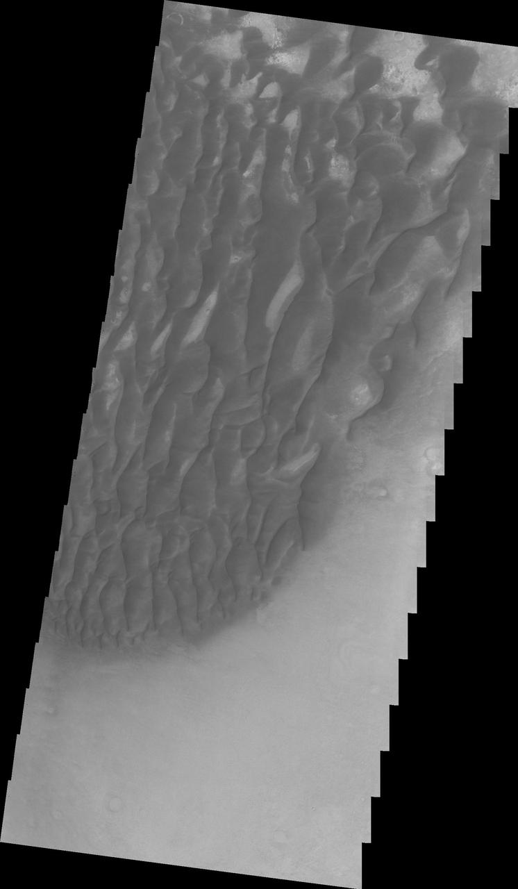
Sand Dunes in Kaiser Crater
Kaiser Crater Dunes IR
Kaiser Crater Dunes IR
Kaiser Crater Dunes VIS
Kaiser Crater Dust Devils
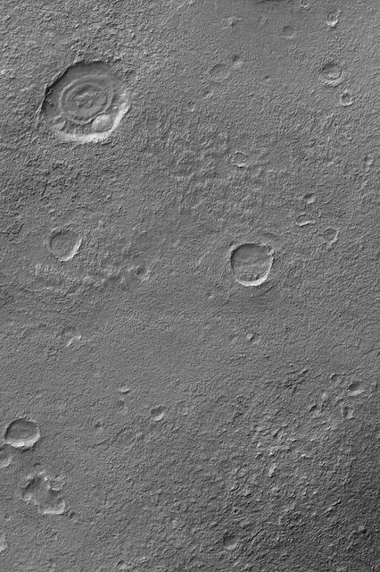
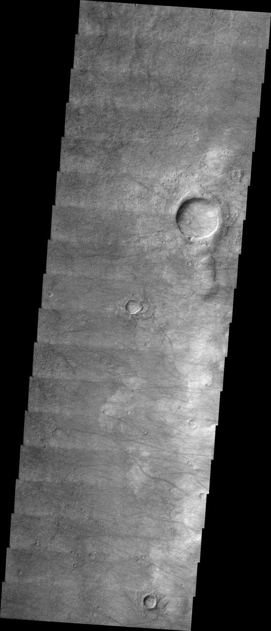
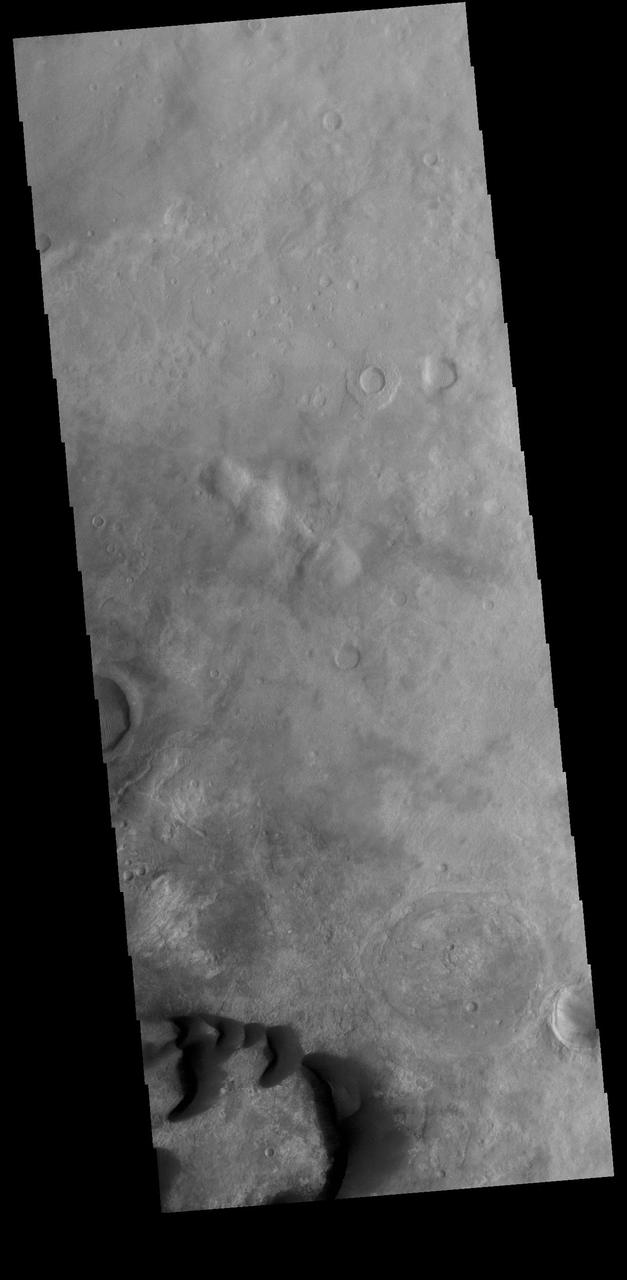
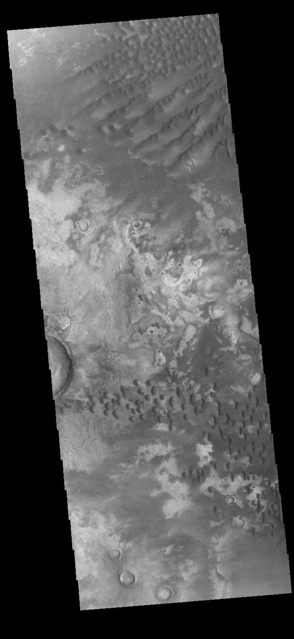
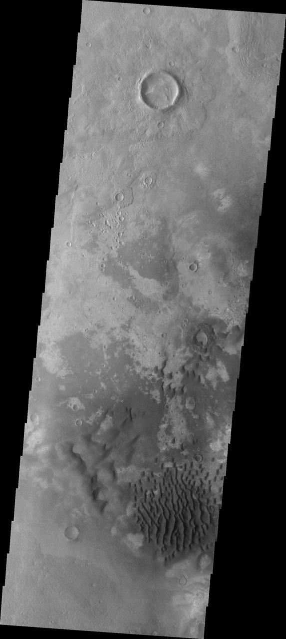
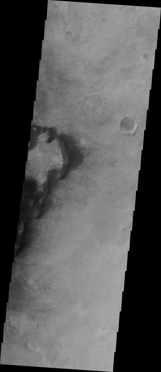
Exhumed Craters near Kaiser
Kaiser Crater Dunes VIS
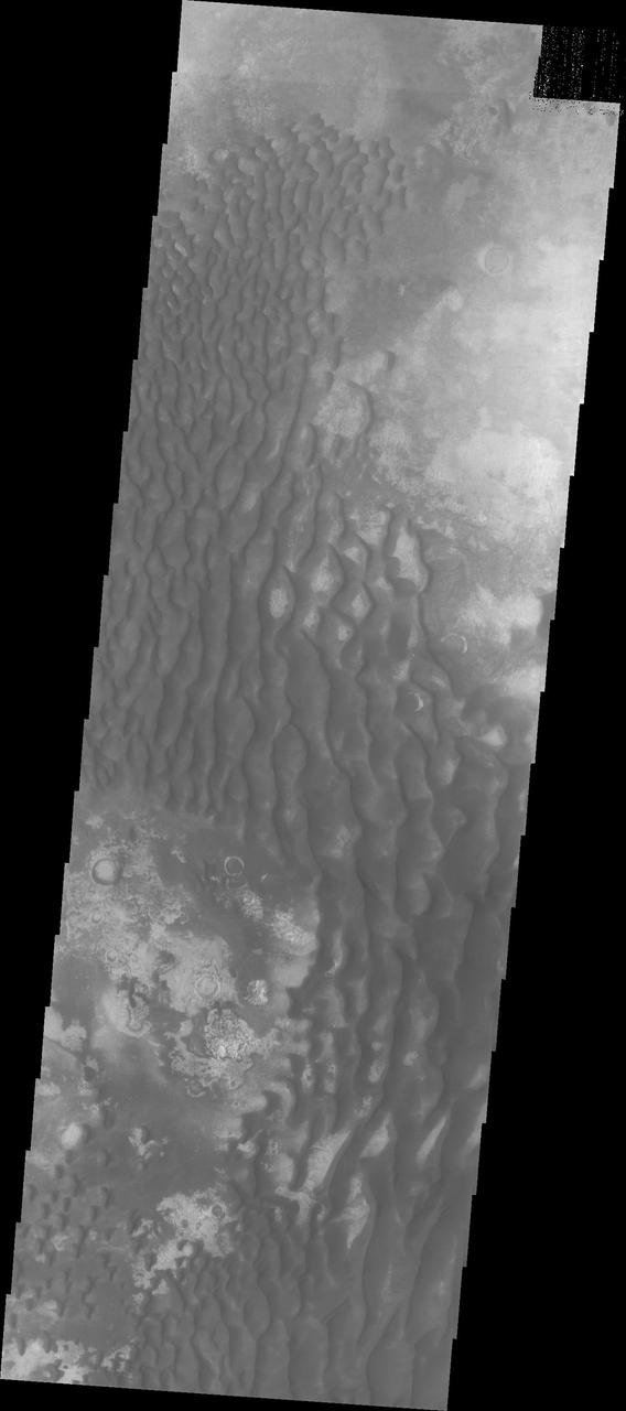
Kaiser Crater Dune Field
Kaiser Crater DCS
This daytime infrared image of Kaiser Crater shows warm dunes on the crater floor.
Winter Frosted Dunes in Kaiser Crater
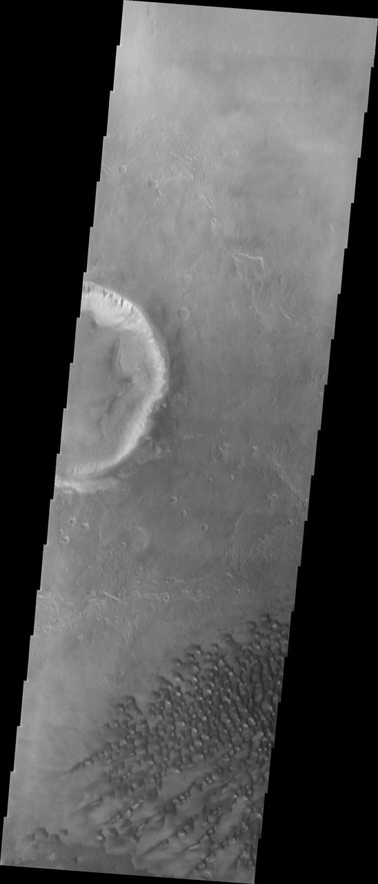
Gullies and Streaks on Crater wall Kaiser
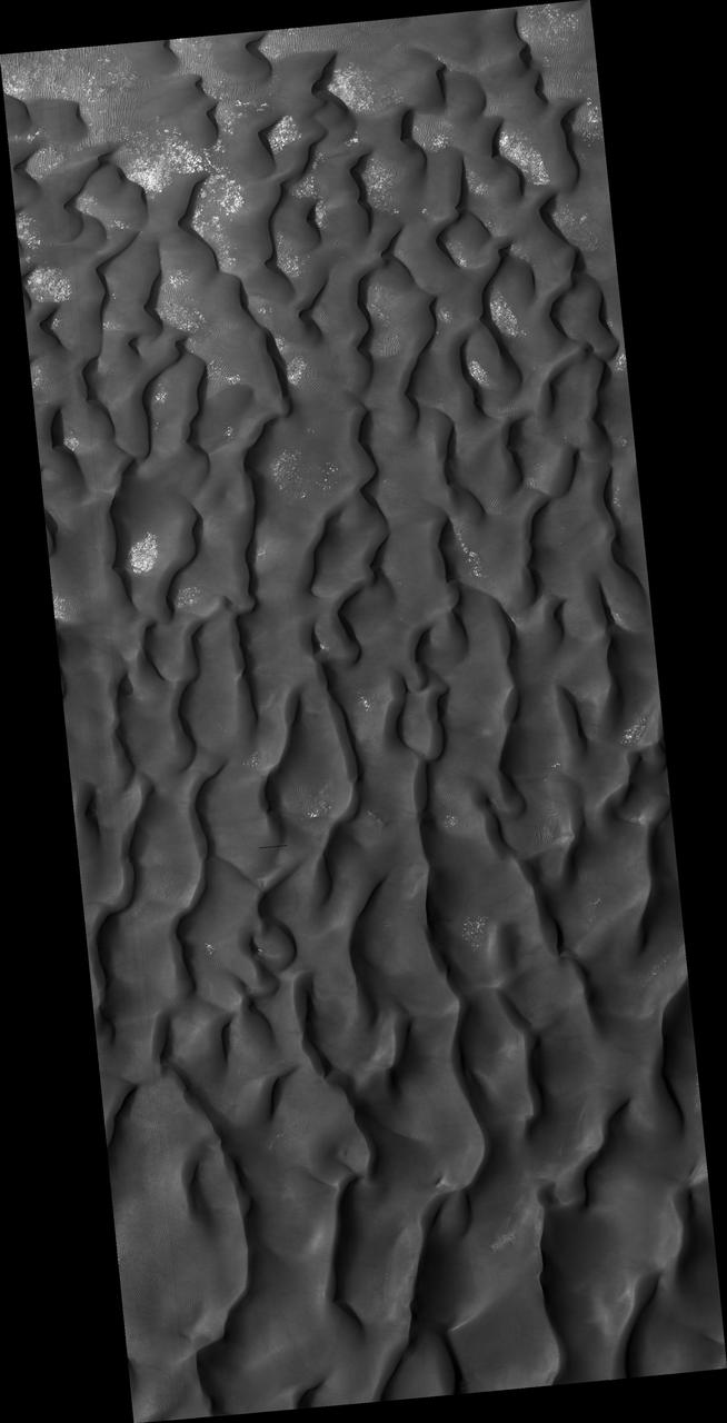
Kaiser Crater hosts a large field of sand dunes. Every winter the dunes are covered with a layer of seasonal carbon dioxide ice (dry ice). In early spring the ice begins to sublimate (going directly from solid ice to gas). In this image, the dunes are partially free of seasonal ice, with the contrast making it easy to see the ripples. Deep alcoves have been carved at the crest of the dune. We hypothesize that this is the result of the gas coming from the dry ice, destabilizing the sand at the crest. As blocks of ice protected in the cold shadows of the alcove break off they slide downslope, carving the channels we see. http://photojournal.jpl.nasa.gov/catalog/PIA21038
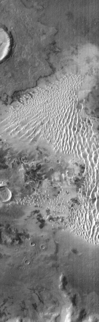
This VIS image shows part of the floor of Kaiser Crater, including several sand dunes. Kaiser Crater is located in Noachis Terra. Orbit Number: 74559 Latitude: -46.4271 Longitude: 20.1136 Instrument: VIS Captured: 2018-10-05 10:35 https://photojournal.jpl.nasa.gov/catalog/PIA22855
The dunes in this image captured by NASA Mars Odyssey are located on the floor of Kaiser Crater.
This 2001 Mars Odyssey image shows a portion of the dune field located on the floor of Kaiser Crater.
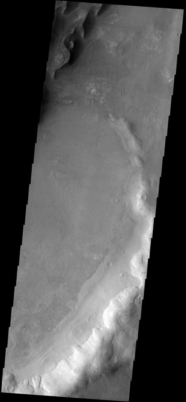
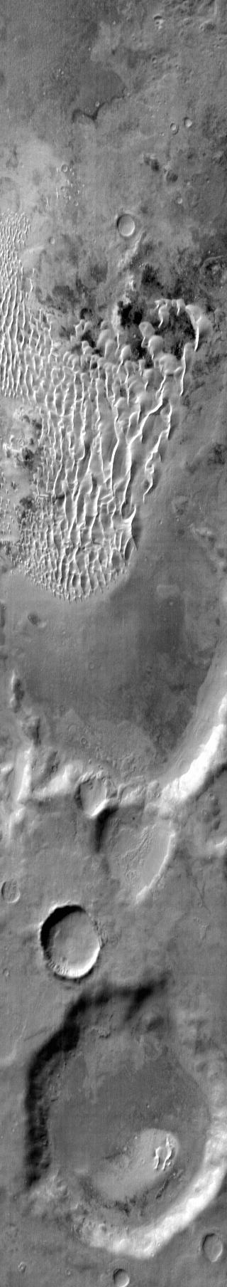
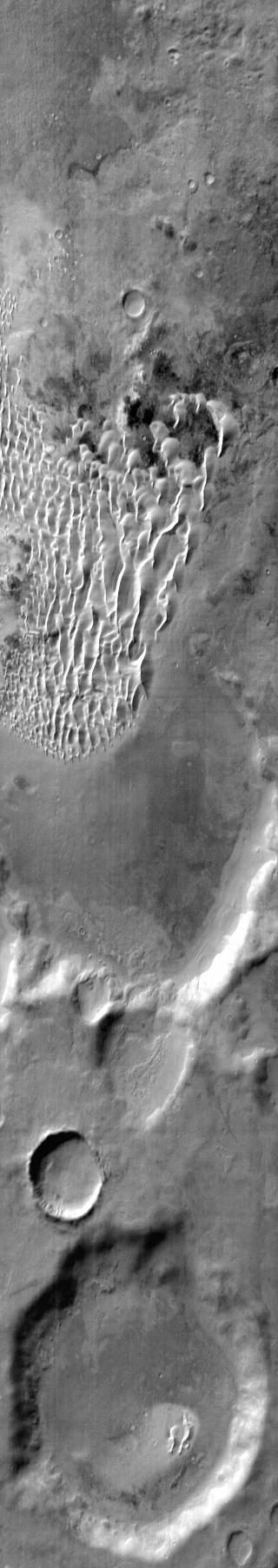
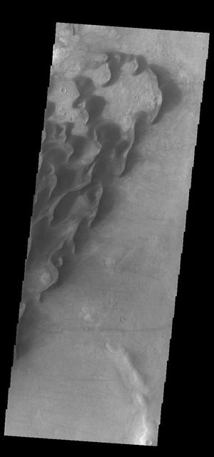
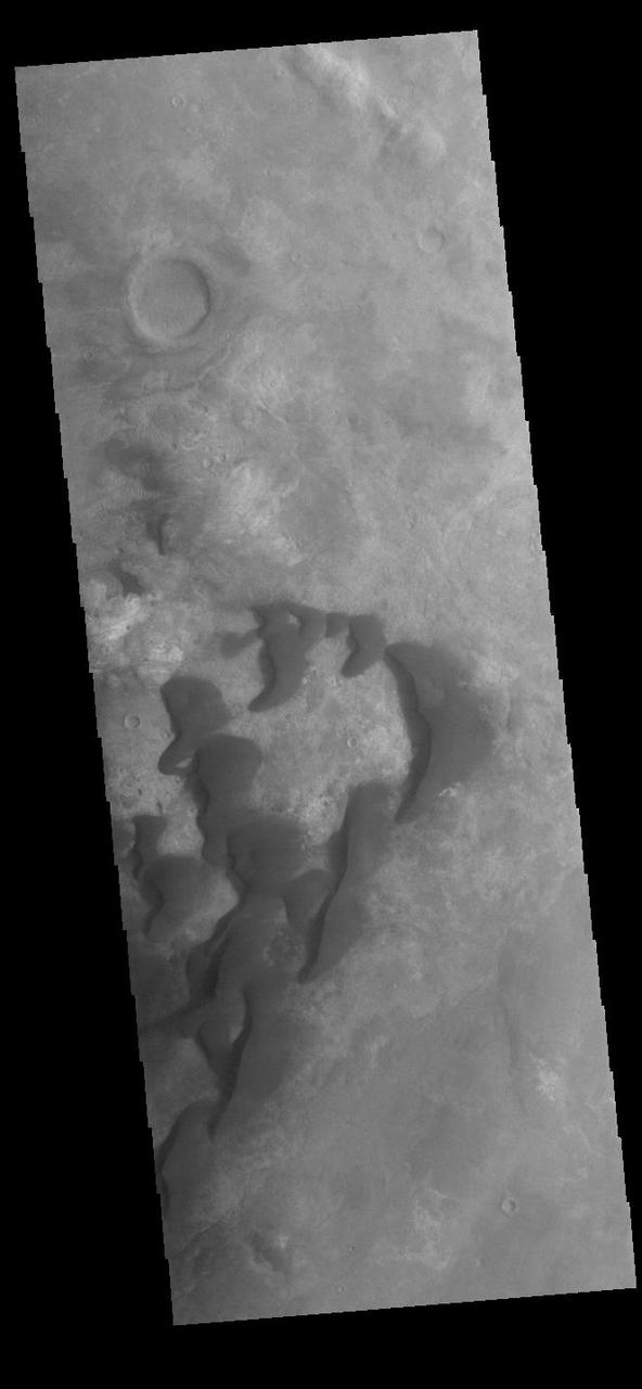
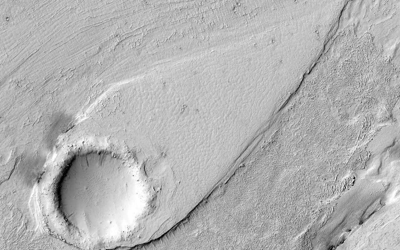
Today's VIS image shows part of the inner rim of Kaiser Crater. The rim has been dissected by numerous gullies. Kaiser Crater is located in Noachis Terra. Orbit Number: 74952 Latitude: -44.6907 Longitude: 19.7647 Instrument: VIS Captured: 2018-11-06 18:59 https://photojournal.jpl.nasa.gov/catalog/PIA22995
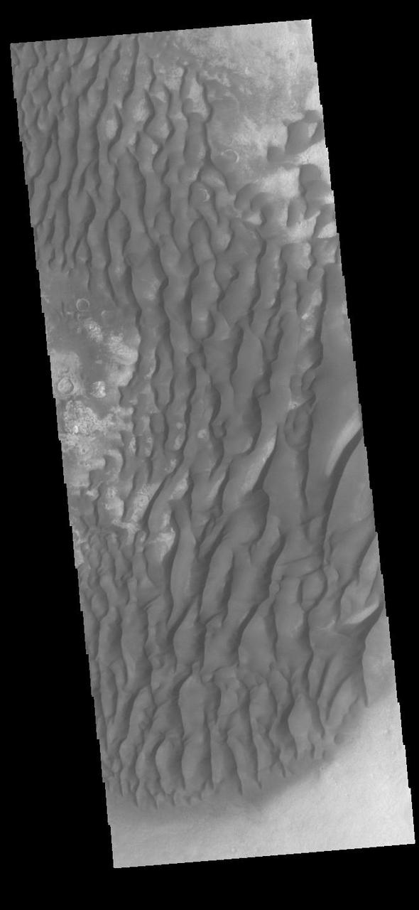
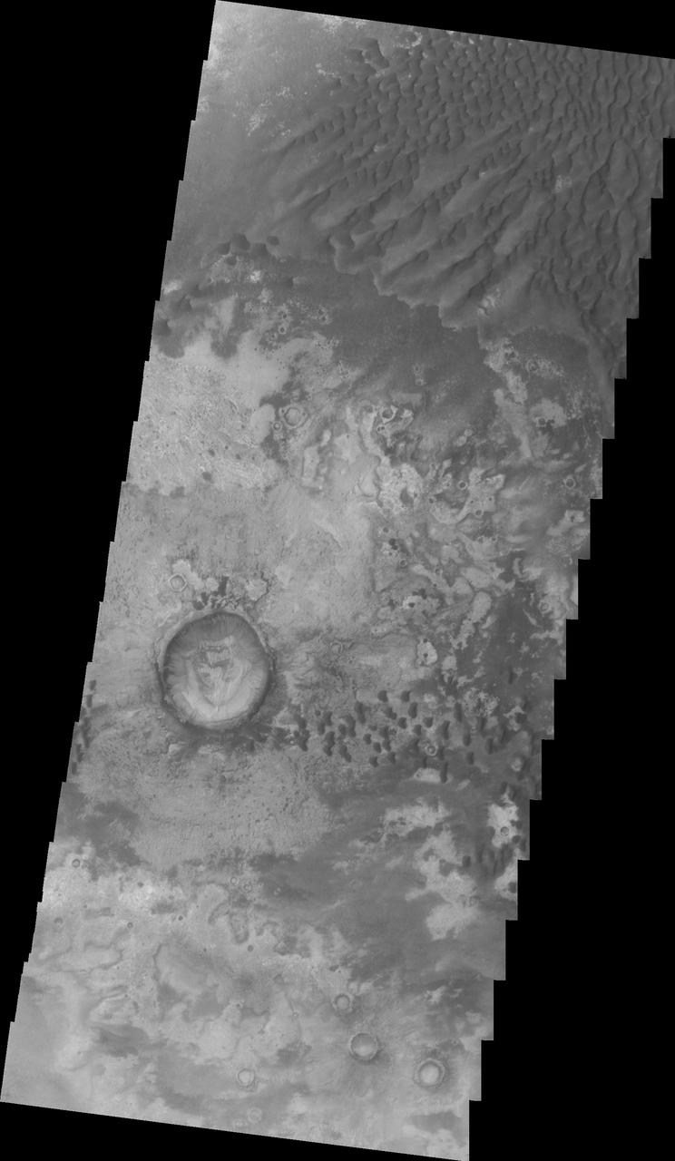
This VIS image shows part of the floor of Kaiser Crater. Kaiser Crater is 207 km (129 miles) in diameter and is located in Noachis Terra west of Hellas Planitia. This sand dune field is one of several regions of sand dunes located on the southern part of the crater floor. The image also shows the complex crater floor beneath the dunes. Orbit Number: 91155 Latitude: -46.9828 Longitude: 19.3481 Instrument: VIS Captured: 2022-07-02 23:58 https://photojournal.jpl.nasa.gov/catalog/PIA25534
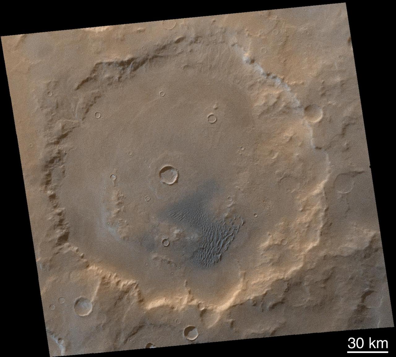
HiRISE has often imaged inside Kaiser Crater to monitor active sand dunes and gullies. Surrounding these dunes, we often find clean bedrock exposures, because the actively moving sand clears off the dust. Kaiser Crater is 207 kilometers wide and was named after Frederik Kaiser, a Dutch astronomer (1808-1872). https://photojournal.jpl.nasa.gov/catalog/PIA23184
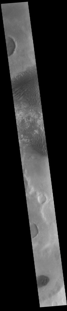
This daytime infrared image of Kaiser Crater, taken by NASA 2001 Mars Odyssey spacecraft, shows the majority of the dune field located on the floor of the crater.
This daytime infrared image of Kaiser Crater, taken by NASA 2001 Mars Odyssey spacecraft, shows the majority of the dune field located on the floor of the crater.

This image captured by NASA's 2001 Mars Odyssey spacecraft shows an infrared image of Kaiser Crater and the dune field on the crater floor. Brighter tones in the image are warmer surfaces. The basaltic dunes are dark in the visible, but bright in infrared. Orbit Number: 66814 Latitude: -47.0992 Longitude: 19.782 Instrument: IR Captured: 2017-01-05 08:54 http://photojournal.jpl.nasa.gov/catalog/PIA21504
This image captured by NASA Mars Odyssey shows a portion of the dunes located in the floor of Kaiser Crater.
This VIS image shows part of the floor of Kaiser Crater. Kaiser Crater is 207 km (129 miles) in diameter and is located in Noachis Terra west of Hellas Planitia. This sand dune field is one of several regions of sand dunes located in the southern part of the crater floor. The small individual dunes at the bottom of the image indicate that in this region there is only limited amounts of sand available to form dunes. The image also shows the complex crater floor around the dunes. Orbit Number: 90294 Latitude: -46.9286 Longitude: 18.9726 Instrument: VIS Captured: 2022-04-23 02:29 https://photojournal.jpl.nasa.gov/catalog/PIA25471

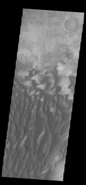
This VIS image shows large individual dunes on the floor of Kaiser Crater. Small dark lines to the right of the sand dunes are the tracks made by dust devils as they move along the surface. Kaiser Crater is located in Noachis Terra. Orbit Number: 75451 Latitude: -46.7049 Longitude: 20.0962 Instrument: VIS Captured: 2018-12-17 21:20 https://photojournal.jpl.nasa.gov/catalog/PIA23120
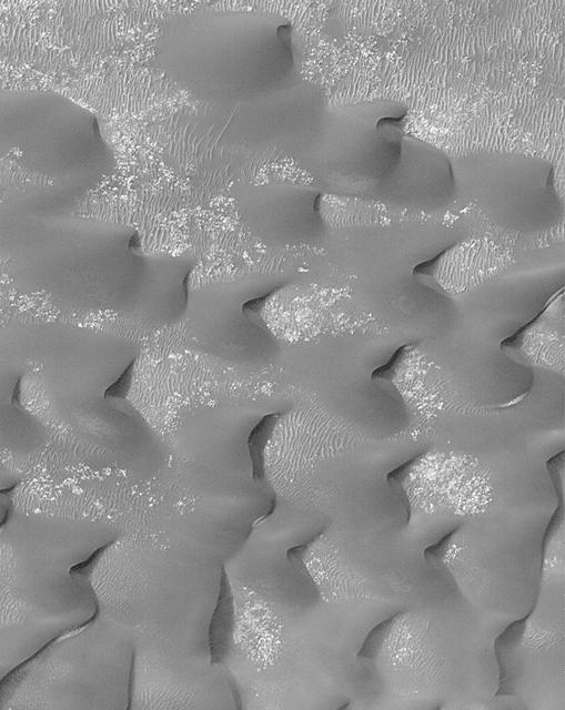
This VIS image is located in Kaiser Crater and shows many individual dunes. The crater floor is visible between the dunes, indicating that there is a limited sand supply creating the dunes. Local winds continue to move the sand dunes across the crater floor. There are two sides to a dune, the low angle slope of the windward face and the high angle slope of the leeward side. The steep side is called the slip face. Wind blows sand grains up the low angle slope of the dunes which then "fall down" the slip face. In this way the whole dune moves towards the slip face. The winds blow from the windward to the leeward side of the dunes. In this image the slip faces are on the left side of the dune, so the dunes are slowly moving to the left side of this image. Kaiser Crater is located in Noachis Terra. Orbit Number: 84872 Latitude: -47.0102 Longitude: 20.0034 Instrument: VIS Captured: 2021-01-31 15:23 https://photojournal.jpl.nasa.gov/catalog/PIA24735
This VIS image is located in Kaiser Crater and shows many individual dunes. The crater floor is visible between some of the dunes, indicating that there is a limited sand supply creating the dunes. Local winds continue to move the sand dunes across the crater floor. There are two sides to a dune, the low angle slope of the windward face and the high angle slope of the leeward side. The steep side is called the slip face. Wind blows sand grains up the low angle slope of the dunes which then "fall down" the slip face. In this way the whole dune moves towards the slip face. The winds blow from the windward to the leeward side of the dunes. In this image the slip faces are on the left side of the dune, so the dunes are slowly moving to the left side of this image. Kaiser Crater is located in Noachis Terra. Orbit Number: 91442 Latitude: -46.9786 Longitude: 19.5191 Instrument: VIS Captured: 2022-07-26 15:07 https://photojournal.jpl.nasa.gov/catalog/PIA25571
This VIS image is located in Kaiser Crater and shows many individual dunes. The crater floor is visible between the dunes, indicating that there is a limited sand supply creating the dunes. Local winds continue to move the sand dunes across the crater floor. There are two sides to a dune, the low angle slope of the windward face and the high angle slope of the leeward side. The steep side is called the slip face. Wind blows sand grains up the low angle slope of the dunes which then "fall down" the slip face. In this way the whole dune moves towards the slip face. The winds blow from the windward to the leeward side of the dunes. In this image the slip faces are on the left side of the dune, so the dunes are slowly moving to the left side of this image. Kaiser Crater is located in Noachis Terra. Orbit Number: 89982 Latitude: -46.6859 Longitude: 20.0452 Instrument: VIS Captured: 2022-03-28 09:55 https://photojournal.jpl.nasa.gov/catalog/PIA25467
This VIS image is located in Kaiser Crater and shows many individual dunes. The crater floor is visible between the dunes, indicating that there is a limited sand supply creating the dunes. Local winds continue to move the sand dunes across the crater floor. There are two sides to a dune, the low angle slope of the windward face and the high angle slope of the leeward side. The steep side is called the slip face. Wind blows sand grains up the low angle slope of the dunes which then "fall down" the slip face. In this way the whole dune moves towards the slip face. The winds blow from the windward to the leeward side of the dunes. In this image the slip faces are on the left side of the dune, so the dunes are slowly moving to the left side of this image. Kaiser Crater is located in Noachis Terra. Orbit Number: 83387 Latitude: -46.8031 Longitude: 19.7369 Instrument: VIS Captured: 2020-10-01 08:54 https://photojournal.jpl.nasa.gov/catalog/PIA24256

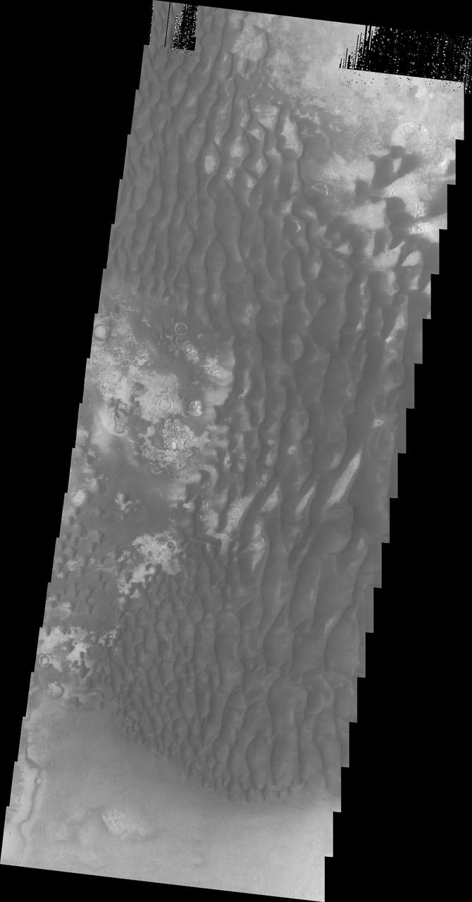
This VIS image of the floor of Kaiser Crater contains several sand dune shapes and sizes. The "whiter" material is the hard crater floor surface. Kaiser Crater is located in the southern hemisphere in the Noachis region west of Hellas Planitia. Kaiser Crater is just one of several large craters with extensive dune fields on the crater floor. Other nearby dune filled craters are Proctor, Russell, and Rabe. Kaiser Crater is 207 km (129 miles) in diameter. The dunes are located in the southern part of the crater floor. The Odyssey spacecraft has spent over 15 years in orbit around Mars, circling the planet more than 71,000 times. It holds the record for longest working spacecraft at Mars. THEMIS, the IR/VIS camera system, has collected data for the entire mission and provides images covering all seasons and lighting conditions. Over the years many features of interest have received repeated imaging, building up a suite of images covering the entire feature. From the deepest chasma to the tallest volcano, individual dunes inside craters and dune fields that encircle the north pole, channels carved by water and lava, and a variety of other feature, THEMIS has imaged them all. For the next several months the image of the day will focus on the Tharsis volcanoes, the various chasmata of Valles Marineris, and the major dunes fields. We hope you enjoy these images! Orbit Number: 39910 Latitude: -46.9063 Longitude: 19.8112 Instrument: VIS Captured: 2010-12-13 11:17 https://photojournal.jpl.nasa.gov/catalog/PIA22264

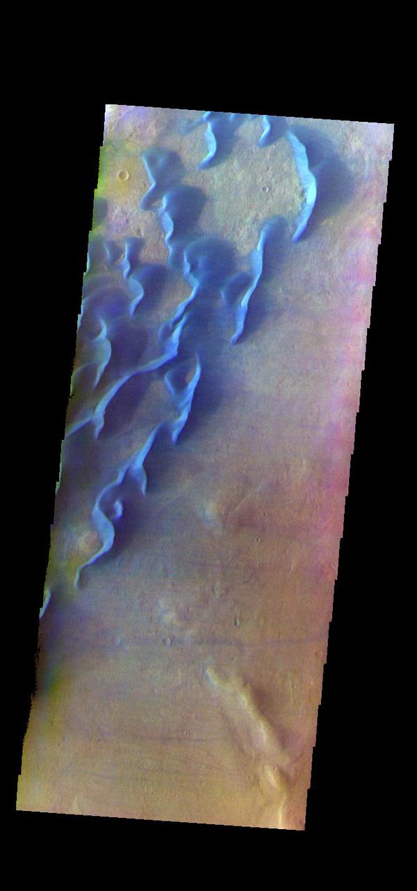
This is a false color image of Kaiser Crater. In this combination of filters "blue" typically means basaltic sand. This VIS image crosses 3/4 of the crater and demonstrates how extensive the dunes are on the floor of Kaiser Crater. Kaiser Crater is located in the southern hemisphere in the Noachis region west of Hellas Planitia. Kaiser Crater is just one of several large craters with extensive dune fields on the crater floor. Other nearby dune filled craters are Proctor, Russell, and Rabe. Kaiser Crater is 207 km (129 miles) in diameter. The dunes are located in the southern part of the crater floor. The THEMIS VIS camera contains 5 filters. The data from different filters can be combined in multiple ways to create a false color image. These false color images may reveal subtle variations of the surface not easily identified in a single band image. The Odyssey spacecraft has spent over 15 years in orbit around Mars, circling the planet more than 71,000 times. It holds the record for longest working spacecraft at Mars. THEMIS, the IR/VIS camera system, has collected data for the entire mission and provides images covering all seasons and lighting conditions. Over the years many features of interest have received repeated imaging, building up a suite of images covering the entire feature. From the deepest chasma to the tallest volcano, individual dunes inside craters and dune fields that encircle the north pole, channels carved by water and lava, and a variety of other feature, THEMIS has imaged them all. For the next several months the image of the day will focus on the Tharsis volcanoes, the various chasmata of Valles Marineris, and the major dunes fields. We hope you enjoy these images! Orbit Number: 66602 Latitude: -47.0551 Longitude: 19.446 Instrument: VIS Captured: 2016-12-18 21:42 https://photojournal.jpl.nasa.gov/catalog/PIA22265
This VIS image of Kaiser Crater shows a region of the dunes with varied appearances. The different dune forms developed due to different amounts of available sand, different wind directions, and the texture of the crater floor. Dune size, shape, and spacing is controlled by a variety of factors. Note the dune that fills half of the crater in the center of the image. Kaiser Crater is located in the southern hemisphere in the Noachis region west of Hellas Planitia. Kaiser Crater is just one of several large craters with extensive dune fields on the crater floor. Other nearby dune filled craters are Proctor, Russell, and Rabe. Kaiser Crater is 207 km (129 miles) in diameter. The dunes are located in the southern part of the crater floor. The Odyssey spacecraft has spent over 15 years in orbit around Mars, circling the planet more than 71000 times. It holds the record for longest working spacecraft at Mars. THEMIS, the IR/VIS camera system, has collected data for the entire mission and provides images covering all seasons and lighting conditions. Over the years many features of interest have received repeated imaging, building up a suite of images covering the entire feature. From the deepest chasma to the tallest volcano, individual dunes inside craters and dune fields that encircle the north pole, channels carved by water and lava, and a variety of other feature, THEMIS has imaged them all. For the next several months the image of the day will focus on the Tharsis volcanoes, the various chasmata of Valles Marineris, and the major dunes fields. We hope you enjoy these images! Orbit Number: 14953 Latitude: -46.7919 Longitude: 18.4314 Instrument: VIS Captured: 2005-04-28 12:59 https://photojournal.jpl.nasa.gov/catalog/PIA22175
This VIS image of Kaiser Crater shows the central part of the crater floor. At the bottom of the image there is a topographic rise. The change in topography has altered the winds in this region, forming a linear pattern at the edge of the high land. Kaiser Crater is located in the southern hemisphere in the Noachis region west of Hellas Planitia. Kaiser Crater is just one of several large craters with extensive dune fields on the crater floor. Other nearby dune filled craters are Proctor, Russell, and Rabe. Kaiser Crater is 207 km (129 miles) in diameter. The dunes are located in the southern part of the crater floor. The Odyssey spacecraft has spent over 15 years in orbit around Mars, circling the planet more than 71000 times. It holds the record for longest working spacecraft at Mars. THEMIS, the IR/VIS camera system, has collected data for the entire mission and provides images covering all seasons and lighting conditions. Over the years many features of interest have received repeated imaging, building up a suite of images covering the entire feature. From the deepest chasma to the tallest volcano, individual dunes inside craters and dune fields that encircle the north pole, channels carved by water and lava, and a variety of other feature, THEMIS has imaged them all. For the next several months the image of the day will focus on the Tharsis volcanoes, the various chasmata of Valles Marineris, and the major dunes fields. We hope you enjoy these images! Orbit Number: 5505 Latitude: -46.2432 Longitude: 19.028 Instrument: VIS Captured: 2003-03-12 17:05 https://photojournal.jpl.nasa.gov/catalog/PIA22174
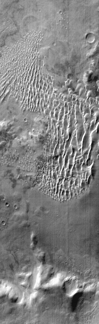
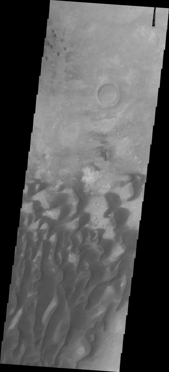
Kaiser Crater is located in the southern hemisphere in the Noachis region west of Hellas Planitia. Kaiser Crater is just one of several large craters with extensive dune fields on the crater floor. Other nearby dune filled craters are Proctor, Russell, and Rabe. Kaiser Crater is 207 km (129 miles) in diameter. The dunes are located in the southeastern part of the crater floor. Most of the individual dunes in Kaiser Crater are barchan dunes. Barchan dunes are crescent shaped with the points of the crescent pointing downwind. The sand is blown up the low angle side of the dune and then tumbles down the steep slip face. This dune type forms on hard surfaces where there is limited amounts of sand. Barchan dunes can merge together over time with increased sand in the local area. The Odyssey spacecraft has spent over 15 years in orbit around Mars, circling the planet more than 69000 times. It holds the record for longest working spacecraft at Mars. THEMIS, the IR/VIS camera system, has collected data for the entire mission and provides images covering all seasons and lighting conditions. Over the years many features of interest have received repeated imaging, building up a suite of images covering the entire feature. From the deepest chasma to the tallest volcano, individual dunes inside craters and dune fields that encircle the north pole, channels carved by water and lava, and a variety of other feature, THEMIS has imaged them all. For the next several months the image of the day will focus on the Tharsis volcanoes, the various chasmata of Valles Marineris, and the major dunes fields. We hope you enjoy these images! Orbit Number: 1036 Latitude: -46.7795 Longitude: 20.2075 Instrument: VIS Captured: 2002-03-09 20:07 https://photojournal.jpl.nasa.gov/catalog/PIA22172
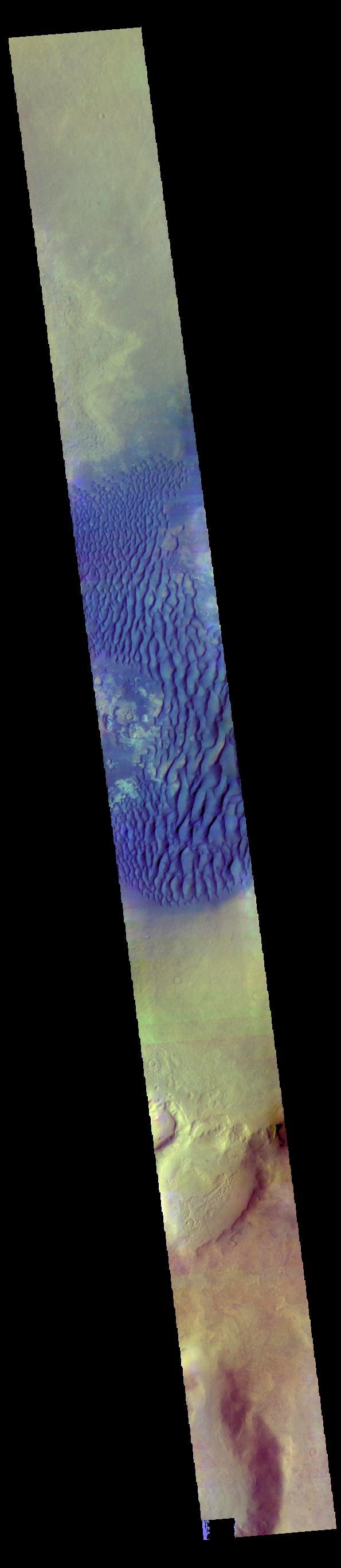
This false color image shows part of the floor of Kaiser Crater. Kaiser Crater is 207 km (129 miles) in diameter and is located in Noachis Terra west of Hellas Planitia. This sand dune field is one of several regions of sand dunes located in the southern part of the crater floor. Dark blue in this false color combination are typically basaltic sand. The dunes in this image are moving west - towards the left side of the image. The THEMIS VIS camera contains 5 filters. The data from different filters can be combined in multiple ways to create a false color image. These false color images may reveal subtle variations of the surface not easily identified in a single band image. Orbit Number: 66602 Latitude: -47.0551 Longitude: 19.446 Instrument: VIS Captured: 2016-12-18 21:42 https://photojournal.jpl.nasa.gov/catalog/PIA23630
This VIS image is located in Kaiser Crater and shows a dune field on the crater floor. The crater floor is visible between the dunes, indicating that there is a limited sand supply creating the dunes. Local winds continue to move the sand dunes across the crater floor. There are two sides to a dune, the low angle slope of the windward face and the high angle slope of the leeward side. The steep side is called the slip face. Wind blows sand grains up the low angle slope of the dunes which then "fall down" the slip face. In this way the whole dune moves towards the slip face. The winds blow from the windward to the leeward side of the dunes. In this image the slip faces are on the left side of the dune, so the dunes are slowly moving to the left side of this image. Kaiser Crater is 207 km (129 miles) in diameter and is located in Noachis Terra west of Hellas Planitia. Orbit Number: 84585 Latitude: -45.8116 Longitude: 19.5816 Instrument: VIS Captured: 2021-01-08 00:14 https://photojournal.jpl.nasa.gov/catalog/PIA24415
This VIS image of Kaiser Crater shows individual dunes and where the dunes have coalesced into longer dune forms. The addition of sand makes the dunes larger and the intra-dune areas go from sand-free to complete coverage of the hard surface of the crater floor. With a continued influx of sand the region will transition from individual dunes to a sand sheet with surface dune forms. Kaiser Crater is located in the southern hemisphere in the Noachis region west of Hellas Planitia. Kaiser Crater is just one of several large craters with extensive dune fields on the crater floor. Other nearby dune filled craters are Proctor, Russell, and Rabe. Kaiser Crater is 207 km (129 miles) in diameter. The dunes are located in the southern part of the crater floor. The Odyssey spacecraft has spent over 15 years in orbit around Mars, circling the planet more than 69000 times. It holds the record for longest working spacecraft at Mars. THEMIS, the IR/VIS camera system, has collected data for the entire mission and provides images covering all seasons and lighting conditions. Over the years many features of interest have received repeated imaging, building up a suite of images covering the entire feature. From the deepest chasma to the tallest volcano, individual dunes inside craters and dune fields that encircle the north pole, channels carved by water and lava, and a variety of other feature, THEMIS has imaged them all. For the next several months the image of the day will focus on the Tharsis volcanoes, the various chasmata of Valles Marineris, and the major dunes fields. We hope you enjoy these images! Orbit Number: 1423 Latitude: -46.9573 Longitude: 18.6192 Instrument: VIS Captured: 2002-04-10 16:44 https://photojournal.jpl.nasa.gov/catalog/PIA22173

This VIS image of the floor of Kaiser Crater contains a large variety of sand dune shapes and sizes. The "whiter" material is the hard crater floor surface. Kaiser Crater is located in the southern hemisphere in the Noachis region west of Hellas Planitia. Kaiser Crater is just one of several large craters with extensive dune fields on the crater floor. Other nearby dune filled craters are Proctor, Russell, and Rabe. Kaiser Crater is 207 km (129 miles) in diameter. The dunes are located in the southern part of the crater floor. The Odyssey spacecraft has spent over 15 years in orbit around Mars, circling the planet more than 71,000 times. It holds the record for longest working spacecraft at Mars. THEMIS, the IR/VIS camera system, has collected data for the entire mission and provides images covering all seasons and lighting conditions. Over the years many features of interest have received repeated imaging, building up a suite of images covering the entire feature. From the deepest chasma to the tallest volcano, individual dunes inside craters and dune fields that encircle the north pole, channels carved by water and lava, and a variety of other feature, THEMIS has imaged them all. For the next several months the image of the day will focus on the Tharsis volcanoes, the various chasmata of Valles Marineris, and the major dunes fields. We hope you enjoy these images! Orbit Number: 35430 Latitude: -46.8699 Longitude: 19.4731 Instrument: VIS Captured: 2009-12-09 14:09 https://photojournal.jpl.nasa.gov/catalog/PIA22263
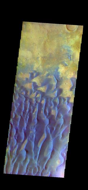
The THEMIS VIS camera contains 5 filters. The data from different filters can be combined in multiple ways to create a false color image. These false color images may reveal subtle variations of the surface not easily identified in a single band image. This false color image shows part of the floor of Kaiser Crater. Kaiser Crater is 207 km (129 miles) in diameter and is located in Noachis Terra west of Hellas Planitia. This sand dune field is one of several regions of sand dunes located in the southern part of the crater floor. With enough wind and sand, sand dunes are formed. Dune morphology typically has a shallow slope on the side the wind is blowing from and a steep face on the other side. The lighter part of the dunes in this image are the steep slopes. Wind blows sand particles up the shallow slope and then the particles 'fall' off the crest of the dune down the steep side. With time, the constant wind will move the crest of the dune forward. Depending on the amount of available sand, dunes can grow to large heights and sizes. The dunes in this image are moving west - towards the left side of the image. Dark blue in this false color combination are typically basaltic sand. Orbit Number: 83387 Latitude: -46.8031 Longitude: 19.7369 Instrument: VIS Captured: 2020-10-01 08:54 https://photojournal.jpl.nasa.gov/catalog/PIA24708
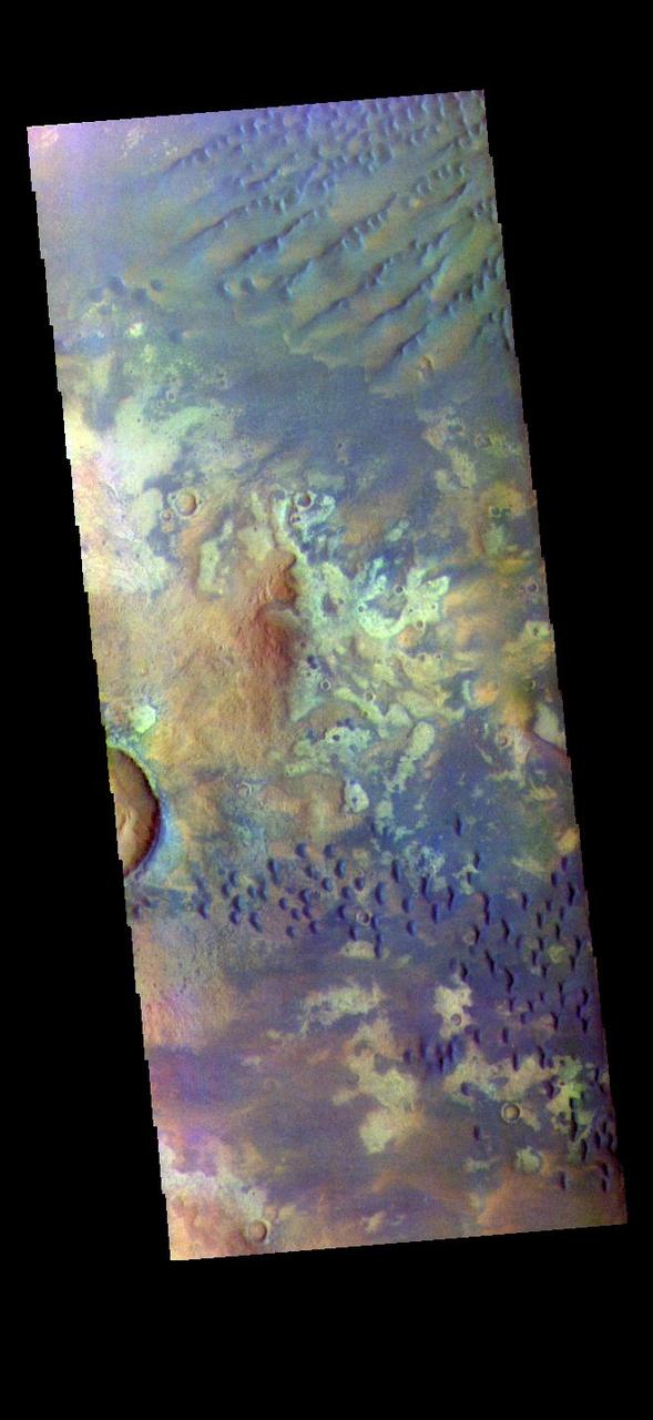
The THEMIS VIS camera contains 5 filters. The data from different filters can be combined in multiple ways to create a false color image. These false color images may reveal subtle variations of the surface not easily identified in a single band image. Today's false color image shows part of the floor of Kaiser Crater. Kaiser Crater is 207 km (129 miles) in diameter and is located in Noachis Terra west of Hellas Planitia. This sand dune field is one of several regions of sand dunes located on the southern part of the crater floor. The image also shows the complex crater floor beneath the dunes. These dunes are composed of basaltic sand that has collected in the bottom of the crater. The topographic depression of the crater forms a sand trap that prevents the sand from escaping. Dune fields are common in the bottoms of craters on Mars and appear as dark splotches that often lean up against the downwind walls of the craters. Dunes are useful for studying both the geology and meteorology of Mars. The sand forms by erosion of larger rocks, but it is unclear when and where this erosion took place on Mars or how such large volumes of sand could be formed. The dunes also indicate the local wind directions by their morphology. The THEMIS VIS camera is capable of capturing color images of the Martian surface using five different color filters. In this mode of operation, the spatial resolution and coverage of the image must be reduced to accommodate the additional data volume produced from using multiple filters. To make a color image, three of the five filter images (each in grayscale) are selected. Each is contrast enhanced and then converted to a red, green, or blue intensity image. These three images are then combined to produce a full color, single image. Because the THEMIS color filters don't span the full range of colors seen by the human eye, a color THEMIS image does not represent true color. Also, because each single-filter image is contrast enhanced before inclusion in the three-color image, the apparent color variation of the scene is exaggerated. Nevertheless, the color variation that does appear is representative of some change in color, however subtle, in the actual scene. Note that the long edges of THEMIS color images typically contain color artifacts that do not represent surface variation. Orbit Number: 90294 Latitude: -46.9314 Longitude: 18.9731 Instrument: VIS Captured: 2022-04-23 02:29 https://photojournal.jpl.nasa.gov/catalog/PIA26058
The THEMIS VIS camera contains 5 filters. The data from different filters can be combined in multiple ways to create a false color image. These false color images may reveal subtle variations of the surface not easily identified in a single band image. Today's false color image shows part of the floor of Kaiser Crater. Kaiser Crater is 207 km (129 miles) in diameter and is located in Noachis Terra west of Hellas Planitia. This sand dune field is one of several regions of sand dunes located on the southern part of the crater floor. The image also shows the complex crater floor beneath the dunes. These dunes are composed of basaltic sand that has collected in the bottom of the crater. The topographic depression of the crater forms a sand trap that prevents the sand from escaping. Dune fields are common in the bottoms of craters on Mars and appear as dark splotches that often lean up against the downwind walls of the craters. Dunes are useful for studying both the geology and meteorology of Mars. The sand forms by erosion of larger rocks, but it is unclear when and where this erosion took place on Mars or how such large volumes of sand could be formed. The dunes also indicate the local wind directions by their morphology. The THEMIS VIS camera is capable of capturing color images of the Martian surface using five different color filters. In this mode of operation, the spatial resolution and coverage of the image must be reduced to accommodate the additional data volume produced from using multiple filters. To make a color image, three of the five filter images (each in grayscale) are selected. Each is contrast enhanced and then converted to a red, green, or blue intensity image. These three images are then combined to produce a full color, single image. Because the THEMIS color filters don't span the full range of colors seen by the human eye, a color THEMIS image does not represent true color. Also, because each single-filter image is contrast enhanced before inclusion in the three-color image, the apparent color variation of the scene is exaggerated. Nevertheless, the color variation that does appear is representative of some change in color, however subtle, in the actual scene. Note that the long edges of THEMIS color images typically contain color artifacts that do not represent surface variation. Orbit Number: 91155 Latitude: -46.9827 Longitude: 19.3481 Instrument: VIS Captured: 2022-07-02 23:58 https://photojournal.jpl.nasa.gov/catalog/PIA26059
The THEMIS VIS camera contains 5 filters. The data from different filters can be combined in multiple ways to create a false color image. These false color images may reveal subtle variations of the surface not easily identified in a single band image. Today's false color image shows part of the floor of Kaiser Crater. Kaiser Crater is 207 km (129 miles) in diameter and is located in Noachis Terra west of Hellas Planitia. This sand dune field is one of several regions of sand dunes located on the southern part of the crater floor. The image also shows the complex crater floor beneath the dunes. These dunes are composed of basaltic sand that has collected in the bottom of the crater. The topographic depression of the crater forms a sand trap that prevents the sand from escaping. Dune fields are common in the bottoms of craters on Mars and appear as dark splotches that often lean up against the downwind walls of the craters. Dunes are useful for studying both the geology and meteorology of Mars. The sand forms by erosion of larger rocks, but it is unclear when and where this erosion took place on Mars or how such large volumes of sand could be formed. The dunes also indicate the local wind directions by their morphology. In this case, there are few clear slipfaces that would indicate the downwind direction. The crests of the dunes also typically run north-south in the image. This dune form indicates that there are probably two prevailing wind directions that run east and west (left to right and right to left). The THEMIS VIS camera is capable of capturing color images of the Martian surface using five different color filters. In this mode of operation, the spatial resolution and coverage of the image must be reduced to accommodate the additional data volume produced from using multiple filters. To make a color image, three of the five filter images (each in grayscale) are selected. Each is contrast enhanced and then converted to a red, green, or blue intensity image. These three images are then combined to produce a full color, single image. Because the THEMIS color filters don't span the full range of colors seen by the human eye, a color THEMIS image does not represent true color. Also, because each single-filter image is contrast enhanced before inclusion in the three-color image, the apparent color variation of the scene is exaggerated. Nevertheless, the color variation that does appear is representative of some change in color, however subtle, in the actual scene. Note that the long edges of THEMIS color images typically contain color artifacts that do not represent surface variation. Orbit Number: 91442 Latitude: -46.9777 Longitude: 19.5189 Instrument: VIS Captured: 2022-07-26 15:07 https://photojournal.jpl.nasa.gov/catalog/PIA26060
This VIS image is located in Kaiser Crater and shows several regions of sand dunes located on the southern part of the crater floor. The crater floor is visible between the dunes, indicating that there is a limited sand supply creating the dunes. These dunes are composed of basaltic sand that has collected in the bottom of the crater. The topographic depression of the crater forms a sand trap that prevents the sand from escaping. Dune fields are common in the bottoms of craters on Mars and appear as dark splotches that often lean up against the downwind walls of the craters. Dunes are useful for studying both the geology and meteorology of Mars. The sand forms by erosion of larger rocks, but it is unclear when and where this erosion took place on Mars or how such large volumes of sand could be formed. Local winds continue to move the sand dunes across the crater floor. There are two sides to a dune, the low angle slope of the windward face and the high angle slope of the leeward side. The steep side is called the slip face. Wind blows sand grains up the low angle slope of the dunes which then "fall down" the slip face. In this way the whole dune moves towards the slip face. The winds blow from the windward to the leeward side of the dunes. In this image the slip faces are on the left side of the dune, so the dunes are slowly moving to the left side of this image. Kaiser Crater is 207km in diameter (129 miles) and is located in Noachis Terra west of Hellas Planitia. Orbit Number: 92902 Latitude: -47.3127 Longitude: 19.2697 Instrument: VIS Captured: 2022-11-23 20:18 https://photojournal.jpl.nasa.gov/catalog/PIA25802
This VIS image is located in Kaiser Crater and shows many individual dunes. This sand dune field is one of several regions of sand dunes located on the southern part of the crater floor. The crater floor is visible between the dunes, indicating that there is a limited sand supply creating the dunes. These dunes are composed of basaltic sand that has collected in the bottom of the crater. The topographic depression of the crater forms a sand trap that prevents the sand from escaping. Dune fields are common in the bottoms of craters on Mars and appear as dark splotches that often lean up against the downwind walls of the craters. Dunes are useful for studying both the geology and meteorology of Mars. The sand forms by erosion of larger rocks, but it is unclear when and where this erosion took place on Mars or how such large volumes of sand could be formed. Local winds continue to move the sand dunes across the crater floor. There are two sides to a dune, the low angle slope of the windward face and the high angle slope of the leeward side. The steep side is called the slip face. Wind blows sand grains up the low angle slope of the dunes which then "fall down" the slip face. In this way the whole dune moves towards the slip face. The winds blow from the windward to the leeward side of the dunes. In this image the slip faces are on the left side of the dune, so the dunes are slowly moving to the left side of this image. Kaiser Crater is 207km in diameter (129 miles) and is located in Noachis Terra west of Hellas Planitia. Orbit Number: 92016 Latitude: -46.8341 Longitude: 19.8564 Instrument: VIS Captured: 2022-09-11 21:26 https://photojournal.jpl.nasa.gov/catalog/PIA25719
This VIS image of Kaiser Crater shows a region of the dunes with varied appearances. The different dune forms developed due to different amounts of available sand, different wind directions, and the texture of the crater floor. The dune forms change from the bottom to the top of the image - large long connected dunes, to large individual dunes, to the very small individual dunes at the top of the image. Kaiser Crater is located in the southern hemisphere in the Noachis region west of Hellas Planitia. Kaiser Crater is just one of several large craters with extensive dune fields on the crater floor. Other nearby dune filled craters are Proctor, Russell, and Rabe. Kaiser Crater is 207 km (129 miles) in diameter. The dunes are located in the southern part of the crater floor. The Odyssey spacecraft has spent over 15 years in orbit around Mars, circling the planet more than 71,000 times. It holds the record for longest working spacecraft at Mars. THEMIS, the IR/VIS camera system, has collected data for the entire mission and provides images covering all seasons and lighting conditions. Over the years many features of interest have received repeated imaging, building up a suite of images covering the entire feature. From the deepest chasma to the tallest volcano, individual dunes inside craters and dune fields that encircle the north pole, channels carved by water and lava, and a variety of other feature, THEMIS has imaged them all. For the next several months the image of the day will focus on the Tharsis volcanoes, the various chasmata of Valles Marineris, and the major dunes fields. We hope you enjoy these images! Orbit Number: 17686 Latitude: -46.6956 Longitude: 19.8394 Instrument: VIS Captured: 2005-12-09 13:25 https://photojournal.jpl.nasa.gov/catalog/PIA22261

The THEMIS VIS camera contains 5 filters. The data from different filters can be combined in multiple ways to create a false color image. These false color images may reveal subtle variations of the surface not easily identified in a single band image. Today's false color image shows part of the floor of Kaiser Crater, including some of the sand dunes found there. In this false color combination dark blue often indicates basaltic sands. Orbit Number: 66814 Latitude: -46.2976 Longitude: 19.611 Instrument: VIS Captured: 2017-01-05 08:55 https://photojournal.jpl.nasa.gov/catalog/PIA24051
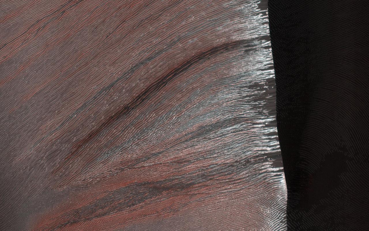
The sand dunes in Kaiser Crater are partially covered with seasonal carbon dioxide ice (dry ice) in this image. The dunes are made of dark sand, showing through where the dry ice has sublimated (turned to gas) in the spring sun. The fine scale structure of the ripples on the dunes shows up highlighted by the presence or absence of the ice, and the low angle of the sun on the slope. https://photojournal.jpl.nasa.gov/catalog/PIA25181
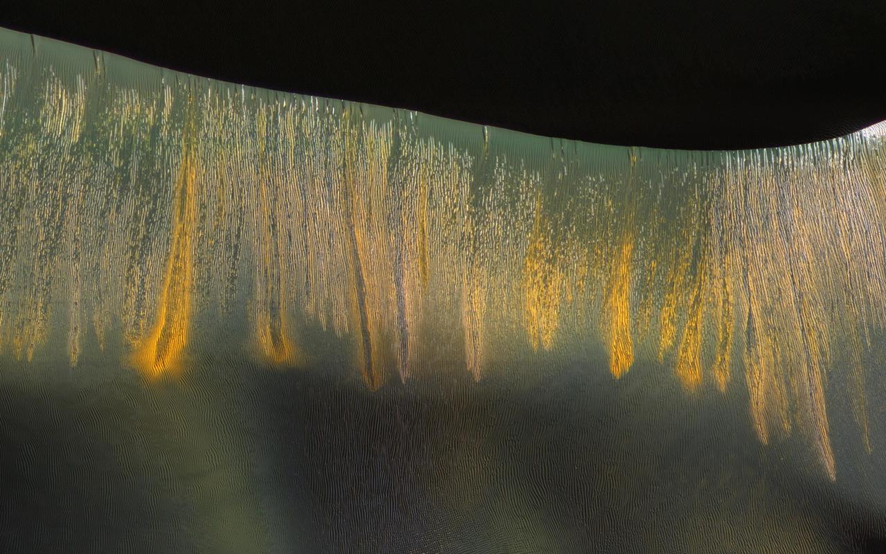
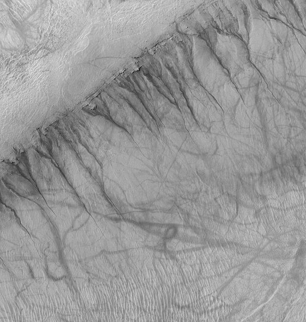
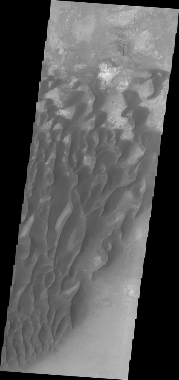
The giant sand dunes in Kaiser Crater experience gully erosion of the steep slip faces every year in late winter as the sun warms these slopes and seasonal carbon dioxide frost sublimates (meaning it changes from a solid to gas). Some of these gullies produce a variety of colors that are highlighted on the west-facing (illuminated) slopes, where the gullies appear to be glowing in the winter light. http://photojournal.jpl.nasa.gov/catalog/PIA20736
The THEMIS VIS camera contains 5 filters. The data from different filters can be combined in multiple ways to create a false color image. These false color images may reveal subtle variations of the surface not easily identified in a single band image. This false color image shows part of the floor of Kaiser Crater. Kaiser Crater is 207 km (129 miles) in diameter and is located in Noachis Terra west of Hellas Planitia. This sand dune field is one of several regions of sand dunes located in the southern part of the crater floor. With enough wind and sand, sand dunes are formed. Dune morphology typically has a shallow slope on the side the wind is blowing from and a steep face on the other side. The lighter part of the dunes in this image are the steep slopes. Wind blows sand particles up the shallow slope and then the particles 'fall' off the crest of the dune down the steep side. With time, the constant wind will move the crest of the dune forward. Depending on the amount of available sand, dunes can grow to large heights and sizes. The dunes in this image are moving west – towards the left side of the image. Dark blue in this false color combination are typically basaltic sand. The THEMIS VIS camera is capable of capturing color images of the Martian surface using five different color filters. In this mode of operation, the spatial resolution and coverage of the image must be reduced to accommodate the additional data volume produced from using multiple filters. To make a color image, three of the five filter images (each in grayscale) are selected. Each is contrast enhanced and then converted to a red, green, or blue intensity image. These three images are then combined to produce a full color, single image. Because the THEMIS color filters don't span the full range of colors seen by the human eye, a color THEMIS image does not represent true color. Also, because each single-filter image is contrast enhanced before inclusion in the three-color image, the apparent color variation of the scene is exaggerated. Nevertheless, the color variation that does appear is representative of some change in color, however subtle, in the actual scene. Note that the long edges of THEMIS color images typically contain color artifacts that do not represent surface variation. Orbit Number: 84872 Latitude: -47.0102 Longitude: 20.0034 Instrument: VIS Captured: 2021-01-31 15:23 https://photojournal.jpl.nasa.gov/catalog/PIA25006
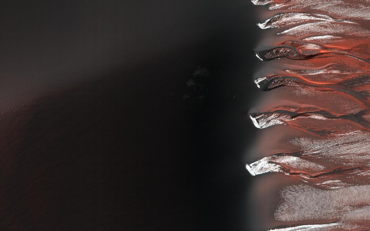
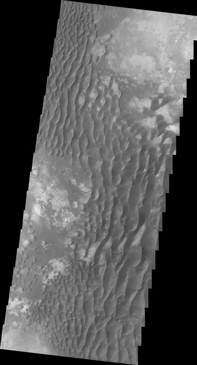
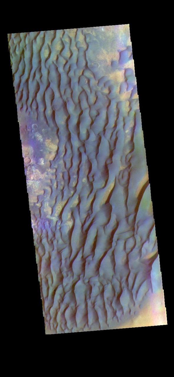
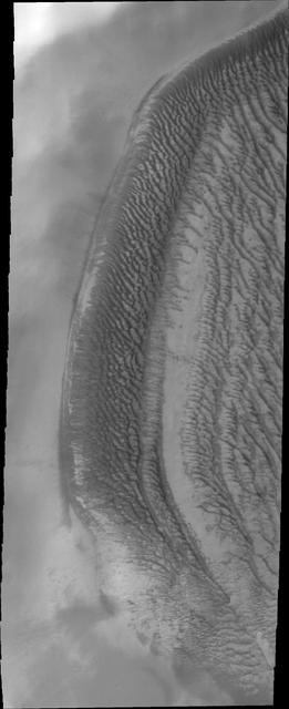
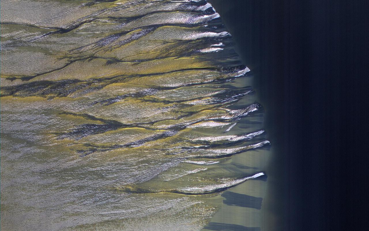
![This large crescent dune in Kaiser Crater shows the scars of many types of seasonal erosional activities. Along its downwind slope are large gullies which are active during winter, when frost drives dune material downslope, carving out channels and creating fan-shaped aprons. On the upwind slope (bottom), dust devil tracks are visible: dark lines and curliques created during the spring season by small wind vortices vacuuming up a thin layer of dust and exposing the dark dune sand. Note: Both the cutout and the above image are rotated so that North is to the right. The map is projected here at a scale of 25 centimeters (9.8 inches) per pixel. [The original image scale is 25.3 centimeters (10 inches) per pixel (with 1 x 1 binning); objects on the order of 76 centimeters (30 inches) across are resolved.] North is up. http://photojournal.jpl.nasa.gov/catalog/PIA21458](https://images-assets.nasa.gov/image/PIA21458/PIA21458~medium.jpg)
This large crescent dune in Kaiser Crater shows the scars of many types of seasonal erosional activities. Along its downwind slope are large gullies which are active during winter, when frost drives dune material downslope, carving out channels and creating fan-shaped aprons. On the upwind slope (bottom), dust devil tracks are visible: dark lines and curliques created during the spring season by small wind vortices vacuuming up a thin layer of dust and exposing the dark dune sand. Note: Both the cutout and the above image are rotated so that North is to the right. The map is projected here at a scale of 25 centimeters (9.8 inches) per pixel. [The original image scale is 25.3 centimeters (10 inches) per pixel (with 1 x 1 binning); objects on the order of 76 centimeters (30 inches) across are resolved.] North is up. http://photojournal.jpl.nasa.gov/catalog/PIA21458
This daytime infrared image of Kaiser Crater shows warm dunes on the crater floor.
These sand dunes are located on the floor of Kaiser Crater.
These sand dunes are located on the floor of Kaiser Crater
This VIS image is located in Kaiser Crater and shows several individual dunes. With continued winds sand dunes will move across the surface. There are two sides to a dune, the low angle slope of the windward face and the high angle slope of the leeward side. The steep side is called the slip face. Wind blows sand grains up the low angle slope of the dunes which then "fall down" the slip face. In this way the whole dune moves towards the slip face. The winds blow from the windward to the leeward side of the dunes. In this image the slip faces are on the left side of the dune, so the dunes are slowly moving to the left side of this image. Orbit Number: 75451 Latitude: -46.7049 Longitude: 20.0962 Instrument: VIS Captured: 2018-12-17 21:20 https://photojournal.jpl.nasa.gov/catalog/PIA23036
At the top of this VIS image crescent shaped dunes are visible. As the dunes approach a break in elevation the forms change to connect the crescents together forming long aligned dune forms. Kaiser Crater is located in the southern hemisphere in the Noachis region west of Hellas Planitia. Kaiser Crater is just one of several large craters with extensive dune fields on the crater floor. Other nearby dune filled craters are Proctor, Russell, and Rabe. Kaiser Crater is 207 km (129 miles) in diameter. The dunes are located in the southern part of the crater floor. The Odyssey spacecraft has spent over 15 years in orbit around Mars, circling the planet more than 71,000 times. It holds the record for longest working spacecraft at Mars. THEMIS, the IR/VIS camera system, has collected data for the entire mission and provides images covering all seasons and lighting conditions. Over the years many features of interest have received repeated imaging, building up a suite of images covering the entire feature. From the deepest chasma to the tallest volcano, individual dunes inside craters and dune fields that encircle the north pole, channels carved by water and lava, and a variety of other feature, THEMIS has imaged them all. For the next several months the image of the day will focus on the Tharsis volcanoes, the various chasmata of Valles Marineris, and the major dunes fields. We hope you enjoy these images! Orbit Number: 34157 Latitude: -46.9336 Longitude: 18.9272 Instrument: VIS Captured: 2009-08-26 18:49 https://photojournal.jpl.nasa.gov/catalog/PIA22262
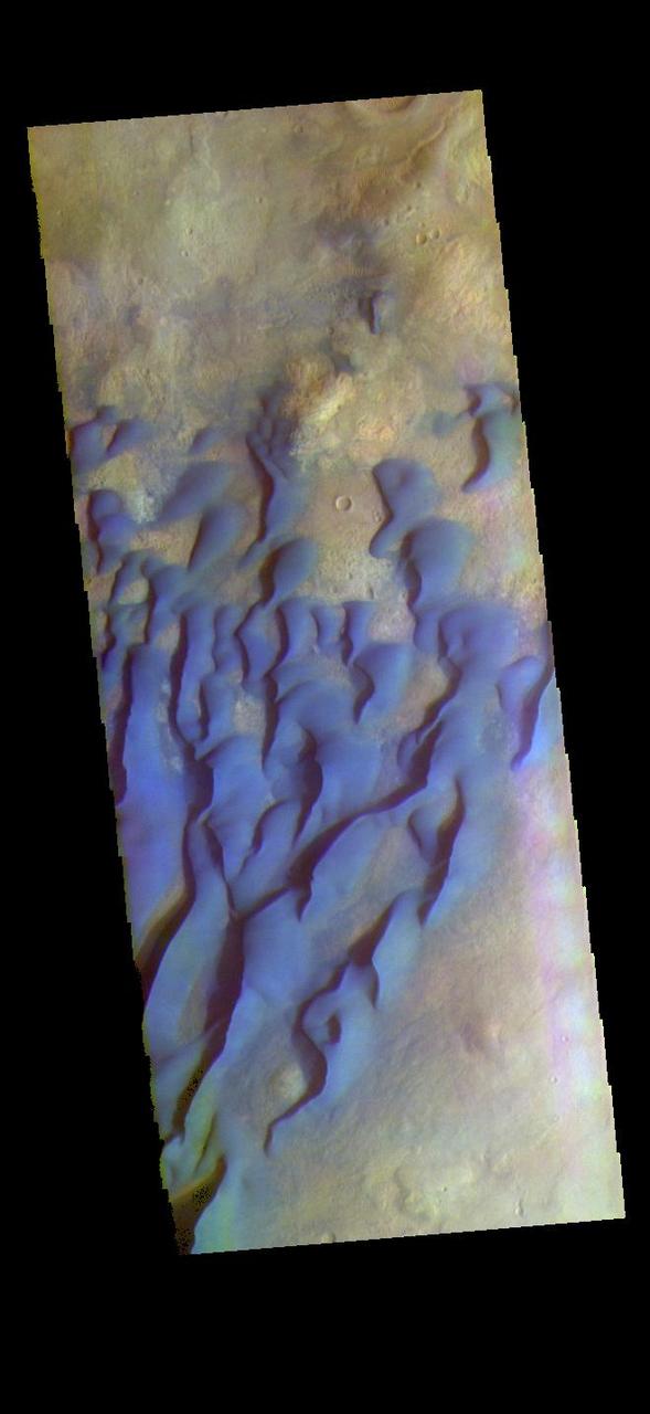
The THEMIS VIS camera contains 5 filters. The data from different filters can be combined in multiple ways to create a false color image. These false color images may reveal subtle variations of the surface not easily identified in a single band image. This false color image shows part of the floor of Kaiser Crater. Kaiser Crater is 207 km (129 miles) in diameter and is located in Noachis Terra west of Hellas Planitia. This sand dune field is one of several regions of sand dunes located in the southern part of the crater floor. With enough wind and sand, sand dunes are formed. Dune morphology typically has a shallow slope on the side the wind is blowing from and a steep face on the other side. The lighter part of the dunes in this image are the steep slopes. Wind blows sand particles up the shallow slope and then the particles 'fall' off the crest of the dune down the steep side. With time, the constant wind will move the crest of the dune forward. Depending on the amount of available sand, dunes can grow to large heights and sizes. The dunes in this image are moving west – towards the left side of the image. Dark blue in this false color combination are typically basaltic sand. The THEMIS VIS camera is capable of capturing color images of the Martian surface using five different color filters. In this mode of operation, the spatial resolution and coverage of the image must be reduced to accommodate the additional data volume produced from using multiple filters. To make a color image, three of the five filter images (each in grayscale) are selected. Each is contrast enhanced and then converted to a red, green, or blue intensity image. These three images are then combined to produce a full color, single image. Because the THEMIS color filters don't span the full range of colors seen by the human eye, a color THEMIS image does not represent true color. Also, because each single-filter image is contrast enhanced before inclusion in the three-color image, the apparent color variation of the scene is exaggerated. Nevertheless, the color variation that does appear is representative of some change in color, however subtle, in the actual scene. Note that the long edges of THEMIS color images typically contain color artifacts that do not represent surface variation. Orbit Number: 92016 Latitude: -46.8341 Longitude: 19.8564 Instrument: VIS Captured: 2022-09-11 21:26 https://photojournal.jpl.nasa.gov/catalog/PIA26086
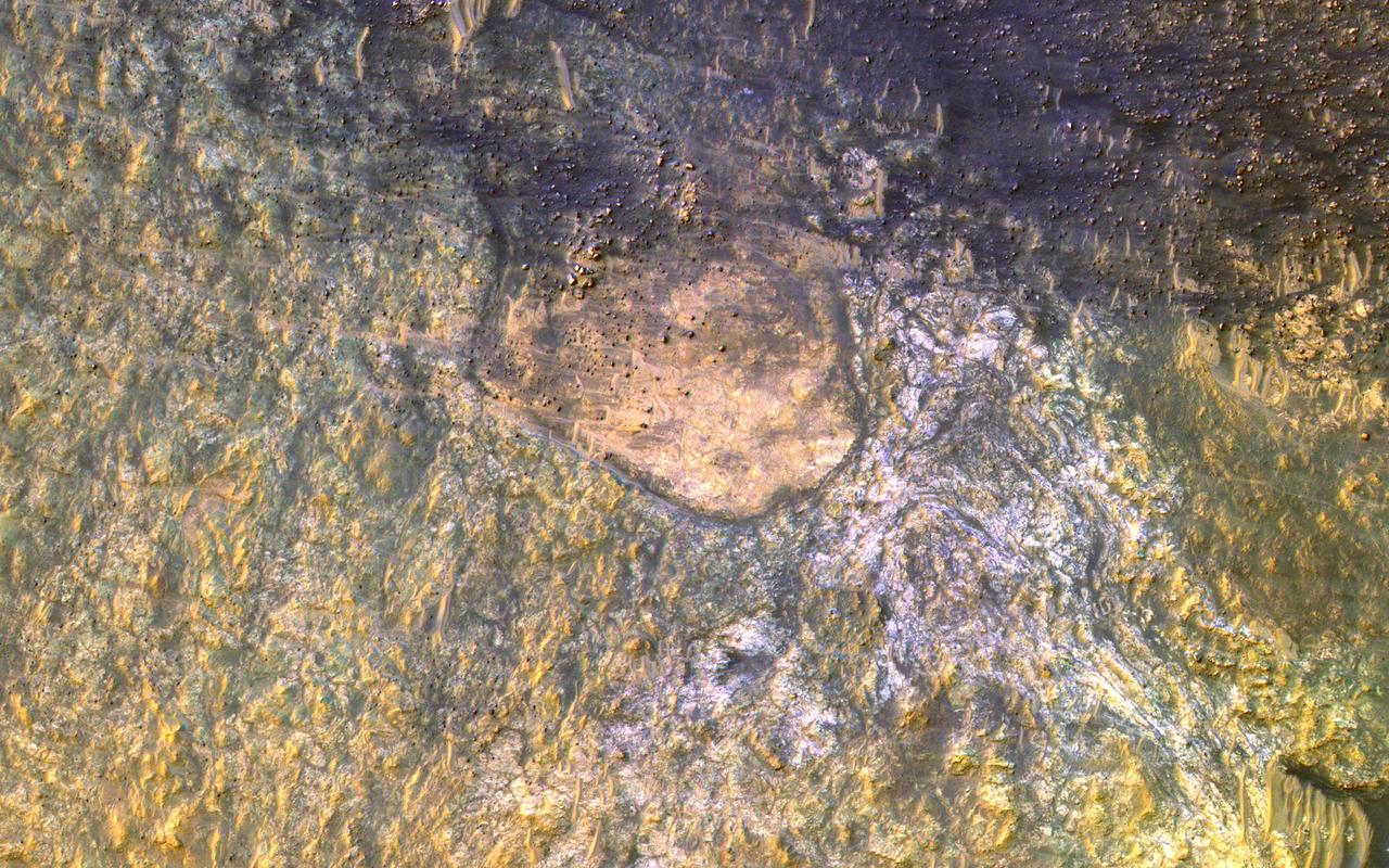
![This white, purple, and pink surface is located on the floor of an impact crater on the southeast rim of the larger Vinogradov Crater in southern Margaritifer Terra. The surface consists of what is left of a series of thin layers that subsequently eroded to create a "bullseye" pattern. The rough, etched appearance of the surface is similar-looking to deposits in other craters in the region and that are often associated with alluvial fans. The apparent ease and manner in which the materials are eroded relative to nearby fans and crater materials suggests they are fine-grained and the dominant agent of erosion is the wind. Although the origin of the deposits remains speculative, their physical character and common association with alluvial fans suggests they may be the result of deposition into a shallow lake or playa enabled by water flowing off the adjacent fan surfaces. The map is projected here at a scale of 25 centimeters (9.8 inches) per pixel. [The original image scale is 26 centimeters (10.2 inches) per pixel (with 1 x 1 binning); objects on the order of 78 centimeters (30.7 inches) across are resolved.] North is up. http://photojournal.jpl.nasa.gov/catalog/PIA21560](https://images-assets.nasa.gov/image/PIA21560/PIA21560~medium.jpg)
This white, purple, and pink surface is located on the floor of an impact crater on the southeast rim of the larger Vinogradov Crater in southern Margaritifer Terra. The surface consists of what is left of a series of thin layers that subsequently eroded to create a "bullseye" pattern. The rough, etched appearance of the surface is similar-looking to deposits in other craters in the region and that are often associated with alluvial fans. The apparent ease and manner in which the materials are eroded relative to nearby fans and crater materials suggests they are fine-grained and the dominant agent of erosion is the wind. Although the origin of the deposits remains speculative, their physical character and common association with alluvial fans suggests they may be the result of deposition into a shallow lake or playa enabled by water flowing off the adjacent fan surfaces. The map is projected here at a scale of 25 centimeters (9.8 inches) per pixel. [The original image scale is 26 centimeters (10.2 inches) per pixel (with 1 x 1 binning); objects on the order of 78 centimeters (30.7 inches) across are resolved.] North is up. http://photojournal.jpl.nasa.gov/catalog/PIA21560
This daytime IR image from NASA Mars Odyssey spacecraft shows part of the dune field on the floor of Kaiser Crater. The dune sand is warmer than the surrounding materials, so it appears bright in the IR image.
This image shows a portion of Lethe Vallis, an outflow channel that also transported lava. Another investigation of this area (Balme et al., 2011) discovered a repeat pattern of dune-like forms in the channel interpreted as fluvial dunes (or, giant current ripples) which are dunes formed by flowing water. This is one of only a few places on Mars where these pristine-appearing landforms have been identified. The channel formed by catastrophic floods, during which it produced the prominent crater-cored, teardroped-shaped island in the middle. The island has the blunter end pointing upstream and the long tail pointing downstream. Both the island and the fluvial dunes were formed by these extreme floods and their size is an indicator of the enormous discharges required to create them. The margins of the channel also show the terminal front of a pristine lava flow unit that inundated the channel from the south and the dunes show the remnants of another older lava flow. The top of the island displays polygonal patterned ground texture, which is a characteristic of periglacial processes in ice-rich ground. The dark materials from the channel and island walls are probably dark sand being eroded from an underlying horizontal basaltic (lava) layer. The crater at the core of the island has elongated dunes and reticulate dust ridges inside. This single image thus contains features formed by periglacial, volcanic, fluvial, impact, aeolian and mass wasting processes, all in one place. http://photojournal.jpl.nasa.gov/catalog/PIA21039
This image was collected at the same time as yesterday infrared image. In the visible wavelengths the dunes are dark, in IR they are bright warm.
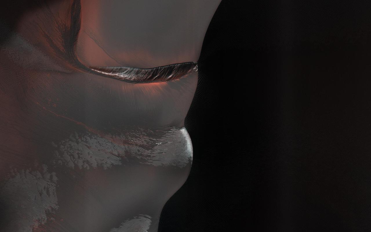
The dark sand dune at the center of this observation is covered in a blanket of white seasonal ice in the winter. In this Martian springtime image, the western slope of the dune is partly defrosted. Bright patches of frost (white in enhanced color) are clearly visible and are made up of water and carbon dioxide ices. Dark streaks of sand have flowed down the dune's slope that sometimes covers the frost. These flows are caused by the rapid transformation of the frost from ice to gas as the sun heats the dune in the spring. We can also see how these flows are diverted by the ripples on the dune. (The width of the cutout is around 520 meters.) https://photojournal.jpl.nasa.gov/catalog/PIA25188
HiRISE has been monitoring this dune field since 2008, and it changes every year from gully erosion in the winter and blowing sand in the summer. https://photojournal.jpl.nasa.gov/catalog/PIA23673