Kerwan Crater, at 174 miles (280 kilometers) in diameter is the largest crater that Dawn has discovered on Ceres. A portion of its jagged rim runs from the top left to bottom center of this image. Kerwan was named for the Hopi spirit of the sprouting maize. Dawn took this image on Oct. 19 from its second extended-mission science orbit (XMO2), at a distance of about 920 miles (1,480 kilometers) above the surface. The image resolution is about 460 feet (140 meters) per pixel. http://photojournal.jpl.nasa.gov/catalog/PIA21232
This scene from Ceres features terrain near the rim of the large crater named Kerwan, at lower left. At 174 miles (280 kilometers) in diameter, Kerwan is the largest crater that Dawn has discovered on Ceres. A much smaller, fresher crater called Cacaguat is seen in the lower right corner. Cacaguat, named for the Nicaraguan god of cacao, is 8.5 miles (13.6 kilometers) in diameter. Dawn took this image on Oct. 20, 2016, from its second extended-mission science orbit (XMO2), at a distance of about 920 miles (1,480 kilometers) above the surface. The image resolution is about 460 feet (140 meters) per pixel. http://photojournal.jpl.nasa.gov/catalog/PIA21241
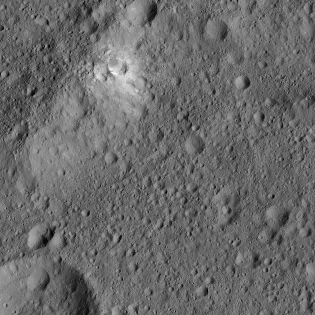
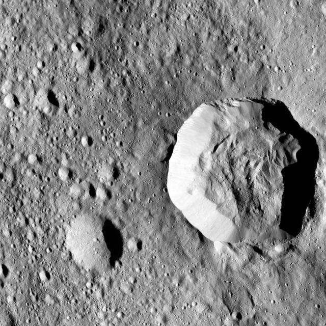
This image from NASA's Dawn spacecraft features bright material (at upper left) along the rim of the giant crater named Kerwan (174 miles, 280 kilometers wide) on Ceres. The image is centered at 1.8 degrees south latitude, 112 degrees east longitude. Dawn took this image on June 6, 2016, from its low-altitude mapping orbit, at a distance of about 240 miles (385 kilometers) above the surface. The image resolution is 120 feet (35 meters) per pixel. http://photojournal.jpl.nasa.gov/catalog/PIA20956
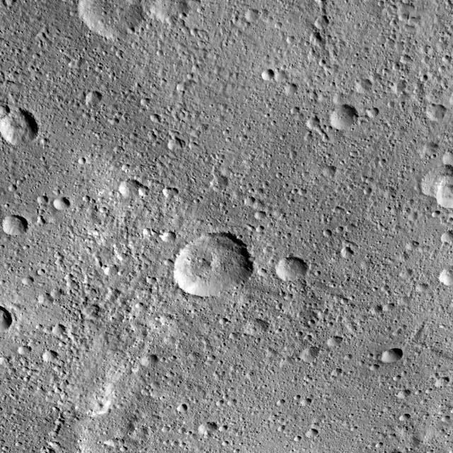
The 16-mile-wide (26-kilometer-wide) crater Insitor is located almost exactly in the center of Kerwan crater on Ceres. Scientists can compute the chances that a cosmic dart would hit exactly at the bullseye of the largest crater on Ceres by using models of impact frequency as a function of time, combined with the period of time since Kerwan's formation. By counting the number of craters within Kerwan and comparing that number to the distribution of craters on Earth's moon and other bodies, it is possible to derive an approximate time for Kerwan's formation of between 550 and 750 million years ago. The chance that a crater the size of Insitor would be formed at the center of Kerwan over that period is only one in one hundred. This image of Ceres was obtained by NASA's Dawn spacecraft on September 23, 2015, from an altitude of about 915 miles (1,470 kilometers). Insitor crater is located at 10.7 degrees south latitude, 124.9 degrees east longitude. The crater gets its name from the Roman agricultural deity in charge of the sowing of crops. https://photojournal.jpl.nasa.gov/catalog/PIA21614
This image from NASA's Dawn spacecraft shows the largest crater on Ceres, called Kerwan. The crater has an appearance scientists refer to as "relaxed," meaning its sharp features have softened since Kerwan formed. Its overall shape looks something like a pancake, especially when viewed near Ceres' limb. The origin of its polygonal shape is not yet well understood; it might be due to large faults in the subsurface generated by other large impacts, as has been suggested for other craters. The smaller crater named Insitor sits in the center of Kerwan. The dark material seen at top right is ejecta from Dantu crater. At 174 miles (280 kilometers) wide, Kerwan is so large that it would have taken about 50 images at Dawn's low-altitude mapping orbit (called LAMO, at 240 miles or 385 kilometers altitude) to cover the crater from one side to the other. Kerwan was also too wide to fit within the camera's field of view at Dawn's high-altitude mapping orbit (called HAMO, at 915 miles, 1,470 kilometers). It fit nicely into this frame from Dawn's Survey phase (an altitude of 2,700 miles or 4,400 kilometers), taken shortly after the spacecraft entered orbit in 2015. Kerwan takes its name from the Hopi spirit of sprouting maize. This picture was obtained on June 12, 2015. Its center coordinates are 10.8 degrees south latitude, 123.9 degrees east longitude. https://photojournal.jpl.nasa.gov/catalog/PIA21411
NASA's Dawn spacecraft took this picture as it reached its new orbit to observe Ceres in opposition, when Dawn is directly between the sun and the Occator Crater bright spots. Entering the very tight opposition geometry (explained here) is a major feat that requires extra checks for increased delivery accuracy. Hence, this picture was part of a series of images intended to help the navigation of the spacecraft relative to Ceres. This vantage point highlights the southern hemisphere of Ceres. Abundant polygonal craters can be seen, starting with Kerwan, Ceres' largest crater at 174 miles (280 kilometers) in diameter, in the upper right of Ceres' circular disc. Kerwan's rims appear subdued and its floor is relatively relaxed. The crater found almost in the "bullseye" of the crater is called Insitor (16 miles or 26 kilometers in diameter). The Inamahari and Homshuk craters featured here can be found at the top of the disc. Another large polygonal crater called Chaminuka (76 miles, 122 kilometers in diameter) is found toward the center. This map can be used to locate these and more features. The name "Kerwan" refers to the Hopi spirit of sprouting maize and "Chaminuka" to the Shona (Zimbabwe) spirit who provides rains in times of droughts. "Insitor" is named for the Roman agricultural deity in charge of the sowing. This picture was taken on April 17, 2017, from an altitude of about 28,000 miles (45,000 kilometers). https://photojournal.jpl.nasa.gov/catalog/PIA21403

This image from NASA's Dawn spacecraft shows Dantu Crater, which is 78 miles (126 kilometers) across. Its shape is reminiscent of Occator Crater -- in particular, they both have shallow floors and central pits. This suggests melting and possibly some hydrothermal activity occurred following impact that formed Dantu. Part of the energy generated by the impact would have been turned into heat. The relatively warm temperatures found at the low latitudes of Dantu and Occator make it easier for Ceres' ice-rich material to melt as a consequence of impact-generated heat. The unnamed crater seen below Dantu in this image is smaller and has a much rougher floor. This is because the smaller impact event would not have generated as much heat. The numerous bright spots found across the crater suggest bright material may be just below the surface, exposed through small impacts and landslides. Ejected material from Dantu extends up to Kerwan crater, with a dark color reminiscent of material that came from Occator. Dantu was named for the Ghanaian god associated with the planting of the corn. This picture was taken by the Dawn framing camera on September 25, 2015, from 915 miles (1,470 kilometers) altitude. The center coordinates of this picture are 22 degrees north latitude, 133 degrees east longitude. https://photojournal.jpl.nasa.gov/catalog/PIA21412
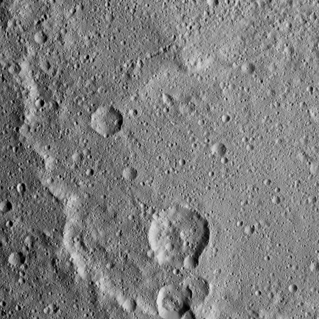
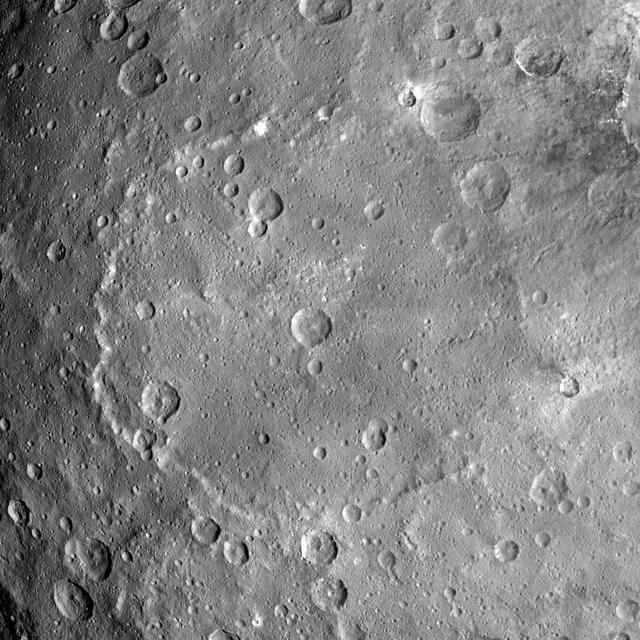
Ceres surface shows evidence for different types of flows that indicate the presence of ice in the regolith. One type of flow encircles the large impact crater at right in this image taken by NASA Dawn spacecraft. One type of flow encircles the large impact crater at right in this image. Scientists see features in this flow that indicate a low degree of internal friction within its material, meaning it was able to flow easily and far from its source. This could be due to the incorporation of a significant amount of liquid water or water vapor into the ejecta blanket. This flow also shows a large ridge along its edge (seen most clearly just to the left of the large crater). These features are commonly associated with flows on Mars called "fluidized ejecta blankets." This feature is located southwest of Kerwan crater at 40 degrees south latitude, 109 degrees east longitude. This is in the vicinity of the latitudes where Dawn's gamma ray and neutron spectrometer (GRaND) instrument sensed the presence of ice in the first meter of Ceres' regolith. The image was taken on August, 7, 2016 from an altitude of about 240 miles (390 kilometers) above Ceres. The image resolution is about 120 feet (35 meters) per pixel. https://photojournal.jpl.nasa.gov/catalog/PIA21404