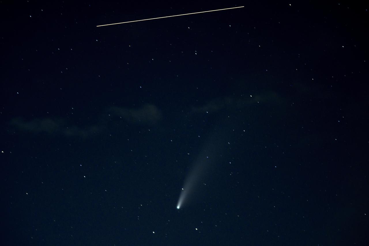
The International Space Station, with a crew of five onboard, is seen in this 10 second exposure above comet NEOWISE, Saturday, July 18, 2020 from Keys Gap, W.Va. The comet was discovered by NASA’s Near-Earth Object Wide-field Infrared Survey Explorer, or NEOWISE, on March 27. Since then, the comet — called comet C/2020 F3 NEOWISE and nicknamed comet NEOWISE — has been spotted by several NASA spacecraft, including Parker Solar Probe, NASA’s Solar and Terrestrial Relations Observatory, the ESA/NASA Solar and Heliospheric Observatory, and astronauts aboard the International Space Station. Onboard the International Space Station are Expedition 63 NASA astronauts Chris Cassidy, Douglas Hurley, Robert Behnken, and Roscosmos cosmonauts Anatoly Ivanishin and Ivan Vagner. Photo Credit: (NASA/Bill Ingalls)
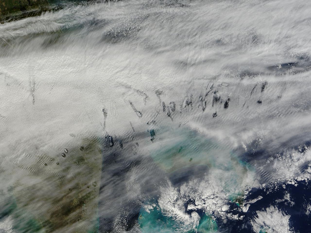
In elementary school, students learn that water freezes at 0 degrees Celsius (32 degrees Fahrenheit). That is true most of the time, but there are exceptions to the rule. For instance, water with very few impurities (such as dust or pollution particles, fungal spores, bacteria) can be chilled to much cooler temperatures and still remain liquid—a process known as supercooling. Supercooling may sound exotic, but it occurs pretty routinely in Earth’s atmosphere. Altocumulus clouds, a common type of mid-altitude cloud, are mostly composed of water droplets supercooled to a temperature of about -15 degrees C. Altocumulus clouds with supercooled tops cover about 8 percent of Earth’s surface at any given time. Supercooled water droplets play a key role in the formation of hole-punch and canal clouds, the distinctive clouds shown in these satellite images. Hole-punch clouds usually appear as circular gaps in decks of altocumulus clouds; canal clouds look similar but the gaps are longer and thinner. This true-color image shows hole-punch and canal clouds off the coast of Florida, as observed on December 12, 2014, by the Moderate Resolution Imaging Spectroradiometer (MODIS) on NASA’s Terra satellite. Both types of cloud form when aircraft fly through cloud decks rich with supercooled water droplets and produce aerodynamic contrails. Air expands and cools as it moves around the wings and past the propeller, a process known as adiabatic cooling. Air temperatures over jet wings often cool by as much as 20 degrees Celsius, pushing supercooled water droplets to the point of freezing. As ice crystals form, they absorb nearby water droplets. Since ice crystals are relatively heavy, they tend to sink. This triggers tiny bursts of snow or rain that leave gaps in the cloud cover. Whether a cloud formation becomes a hole-punch or canal depends on the thickness of the cloud layer, the air temperature, and the degree of horizontal wind shear. Both descending and ascending aircraft—including jets and propeller planes—can trigger hole-punch and canal clouds. The nearest major airports in the images above include Miami International, Fort Lauderdale International, Grand Bahama International, and Palm Beach International. Credit: NASA/GSFC/Jeff Schmaltz/MODIS Land Rapid Response Team <b><a href="http://www.nasa.gov/audience/formedia/features/MP_Photo_Guidelines.html" rel="nofollow">NASA image use policy.</a></b> <b><a href="http://www.nasa.gov/centers/goddard/home/index.html" rel="nofollow">NASA Goddard Space Flight Center</a></b> enables NASA’s mission through four scientific endeavors: Earth Science, Heliophysics, Solar System Exploration, and Astrophysics. Goddard plays a leading role in NASA’s accomplishments by contributing compelling scientific knowledge to advance the Agency’s mission. <b>Follow us on <a href="http://twitter.com/NASAGoddardPix" rel="nofollow">Twitter</a></b> <b>Like us on <a href="http://www.facebook.com/pages/Greenbelt-MD/NASA-Goddard/395013845897?ref=tsd" rel="nofollow">Facebook</a></b> <b>Find us on <a href="http://instagram.com/nasagoddard?vm=grid" rel="nofollow">Instagram</a></b>
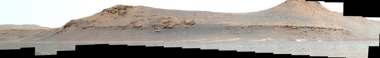
NASA's Perseverance Mars rover looks out at the expanse of Jezero Crater's river delta on April 11, 2022, the 406th Martian day, or sol, of the mission. This panorama is made up of 64 individual images from the rover's Mastcam-Z camera system and stitched together after the files were sent back from Mars. The color bands of the image have been processed to improve visual contrast and accentuate color differences. The sky would not actually look blue to a human explorer on the Red Planet. The delta formed billions of years ago from sediment that an ancient river carried to the mouth of the lake that once existed in the crater. Aeolian bedforms (sand dunes) can be seen running along the base of the delta. The hills visible on the distant horizon to the far left of the image – about 3.8 miles (6.2 kilometers) away from the rover – are actually part of the rim of Jezero Crater. The peak of the delta remnant to the right center of the image is about 920 feet (260 meters) away and the peak of the hill camera right is about 950 feet (280 meters) away. The portion of the delta farthest left in this image (visible directly below the crater wall) is the area where "Cape Nukshak" and "Hawksbill Gap" channels can be found. The rover is expected to ascend to the top of the delta via one of these two channels. A key objective for Perseverance's mission on Mars is astrobiology, including the search for signs of ancient microbial life. The rover will characterize the planet's geology and past climate, pave the way for human exploration of the Red Planet, and be the first mission to collect and cache Martian rock and regolith (broken rock and dust). Subsequent NASA missions, in cooperation with ESA (European Space Agency), would send spacecraft to Mars to collect these sealed samples from the surface and return them to Earth for in-depth analysis. The Mars 2020 Perseverance mission is part of NASA's Moon to Mars exploration approach, which includes Artemis missions to the Moon that will help prepare for human exploration of the Red Planet. https://photojournal.jpl.nasa.gov/catalog/PIA25212
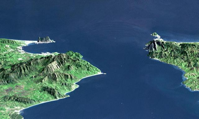
This perspective view shows the Strait of Gibraltar, which is the entrance to the Mediterranean Sea from the Atlantic Ocean. Europe (Spain) is on the left. Africa (Morocco) is on the right. The Rock of Gibraltar, administered by Great Britain, is the peninsula in the back left. The Strait of Gibraltar is the only natural gap in the topographic barriers that separate the Mediterranean Sea from the world's oceans. The Sea is about 3700 kilometers (2300 miles) long and covers about 2.5 million square kilometers (one million square miles), while the Strait is only about 13 kilometers (8 miles) wide. Sediment samples from the bottom of the Mediterranean Sea that include evaporite minerals, soils, and fossil plants show that about five million years ago the Strait was topographically blocked and the Sea had evaporated into a deep basin far lower in elevation than the oceans. Consequent changes in the world's hydrologic cycle, including effects upon ocean salinity, likely led to more ice formation in polar regions and more reflection of sunlight back to space, resulting in a cooler global climate at that time. Today, topography plays a key role in our regional climate patterns. But through Earth history, topographic change, even perhaps over areas as small as 13 kilometers across, has also affected the global climate. This image was generated from a Landsat satellite image draped over an elevation model produced by the Shuttle Radar Topography Mission (SRTM). The view is eastward with a 3-times vertical exaggeration to enhance topographic expression. Natural colors of the scene (green vegetation, blue water, brown soil, white beaches) are enhanced by image processing, inclusion of some infrared reflectance (as green) to highlight the vegetation pattern, and inclusion of shading of the elevation model to further highlight the topographic features. Landsat has been providing visible and infrared views of the Earth since 1972. SRTM elevation data matches the 30-meter (99-feet) resolution of most Landsat images and will substantially help in analyses of the large Landsat image archive. Elevation data used in this image was acquired by the Shuttle Radar Topography Mission (SRTM) aboard the Space Shuttle Endeavour, launched on February 11, 2000. http://photojournal.jpl.nasa.gov/catalog/PIA03397
NASA's Perseverance Mars rover used its Mastcam-Z stereo imaging system to capture this 360-degree panorama of "Van Zyl Overlook," where the rover was parked for 13 days as the Ingenuity helicopter performed its first flights. The 2.4 billion-pixel panorama is made up of 992 individual right-eye Mastcam-Z images stitched together. The images were taken between April 15 and 26, 2021, or the 53rd and 64th Martian days, or sols, of the mission. A few small patches of near-field sand had been covered by parts of Perseverance when the right-eye Mastcam-Z images were taken; those gaps were filled with images of the same sandy patches taken by the Mastcam-Z left-eye camera at the same time, or from the earlier navigation camera images. Imaging coverage of the sky has also been digitally smoothed and expanded based on the actual sky color observed as the panorama was being acquired on Mars. Arizona State University in Tempe leads the operations of the Mastcam-Z instrument, working in collaboration with Malin Space Science Systems in San Diego. A key objective for Perseverance's mission on Mars is astrobiology, including the search for signs of ancient microbial life. The rover will characterize the planet's geology and past climate, pave the way for human exploration of the Red Planet, and be the first mission to collect and cache Martian rock and regolith (broken rock and dust). Subsequent NASA missions, in cooperation with ESA (European Space Agency), would send spacecraft to Mars to collect these sealed samples from the surface and return them to Earth for in-depth analysis. The Mars 2020 Perseverance mission is part of NASA's Moon to Mars exploration approach, which includes Artemis missions to the Moon that will help prepare for human exploration of the Red Planet. https://photojournal.jpl.nasa.gov/catalog/PIA24663