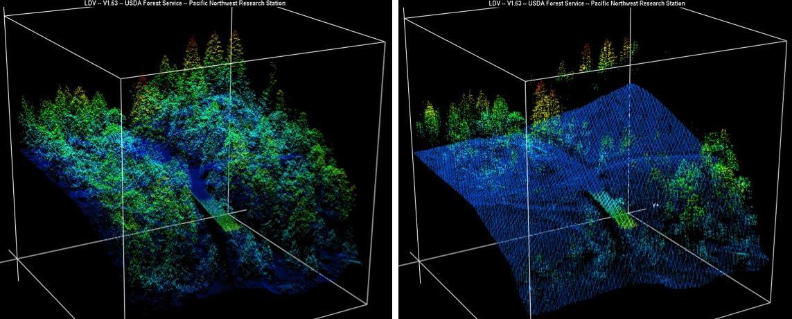
New maps of two recent California megafires that combine unique data sets from the U.S. Forest Service and NASA's Jet Propulsion Laboratory in Pasadena, California, are answering some of the urgent questions that follow a huge wildfire. These before-and-after USFS LIght Detection And Ranging (LIDAR) images from the 2014 King fire region in El Dorado National Forest, California are among new maps. They show a small section of the Rubicon River drainage basin, where fire damage was severe. Blue indicates ground level; lighter colors are higher. A road -- bordered by dense trees in the before image at left -- and part of a bridge are in the center, with the bridge appearing green. http://photojournal.jpl.nasa.gov/catalog/PIA19360
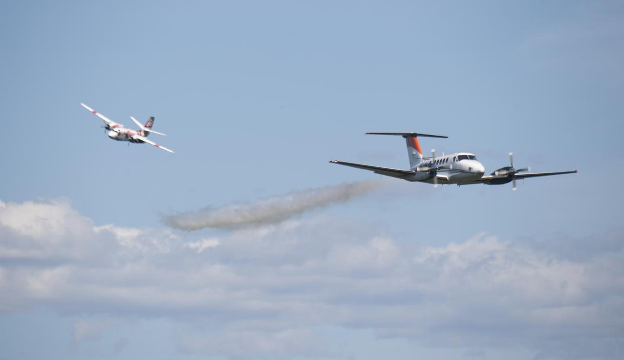
A Cal Fire S2-T airtanker follows a U.S. Forest Service King Air 200 during an aerial attack on a simulated wildfire, Tuesday, May 4, 2021 as Cal Fire conducts aerial fire fighting training exercises near Redding, California. STEReO, the Scalable Traffic Management for Emergency Response Operations project, led by NASA’s Ames Research Center, builds on NASA’s expertise in air traffic management, human factors research, and autonomous technology development to apply the agency’s work in Unmanned Aircraft Systems Traffic Management, or UTM, to public safety uses. Photo Credit: (NASA/Joel Kowsky)

NASA’s B200 King Air team includes, from left, principal engineer Cory Hill, operations engineer KC Sujan, pilot Tracy Phelps, crew chief Mario Soto, aircraft technician Ruben Saiza, quality assurance technician Scott Silver, and senior engineer Alexander Soibel. The compact Fire Infrared Radiance Spectral Tracker (c-FIRST) instrument was tested on the B200 aircraft – based at NASA’s Armstrong Flight Research Center in Edwards, California – over the wildfires in the Pacific Palisades and Altadena, California, on November 21, 2024.
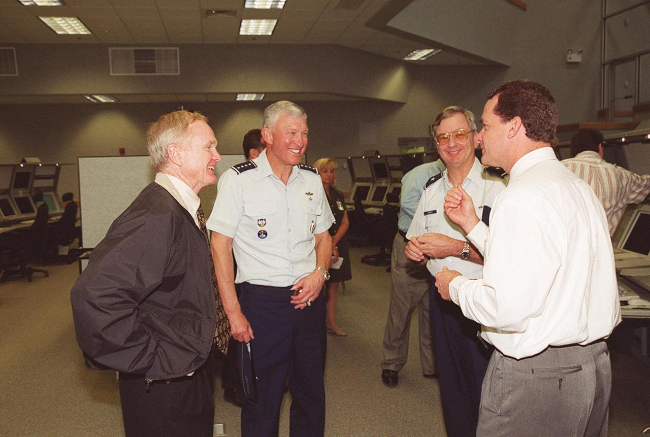
Inside the new firing room at the Launch Control Center, Center Director Roy Bridges, Gen. Ralph Everhart and Brig. Gen. Donald Pettit listen to Director of Shuttle Processing Dave King as he relates a story. Gen. Everhart is Commander of Space Command and Gen. Pettit is Commander of the 45th Space Wing, Cape Canaveral

Inside the new firing room at the Launch Control Center, Center Director Roy Bridges, Gen. Ralph Everhart and Brig. Gen. Donald Pettit listen to Director of Shuttle Processing Dave King as he relates a story. Gen. Everhart is Commander of Space Command and Gen. Pettit is Commander of the 45th Space Wing, Cape Canaveral
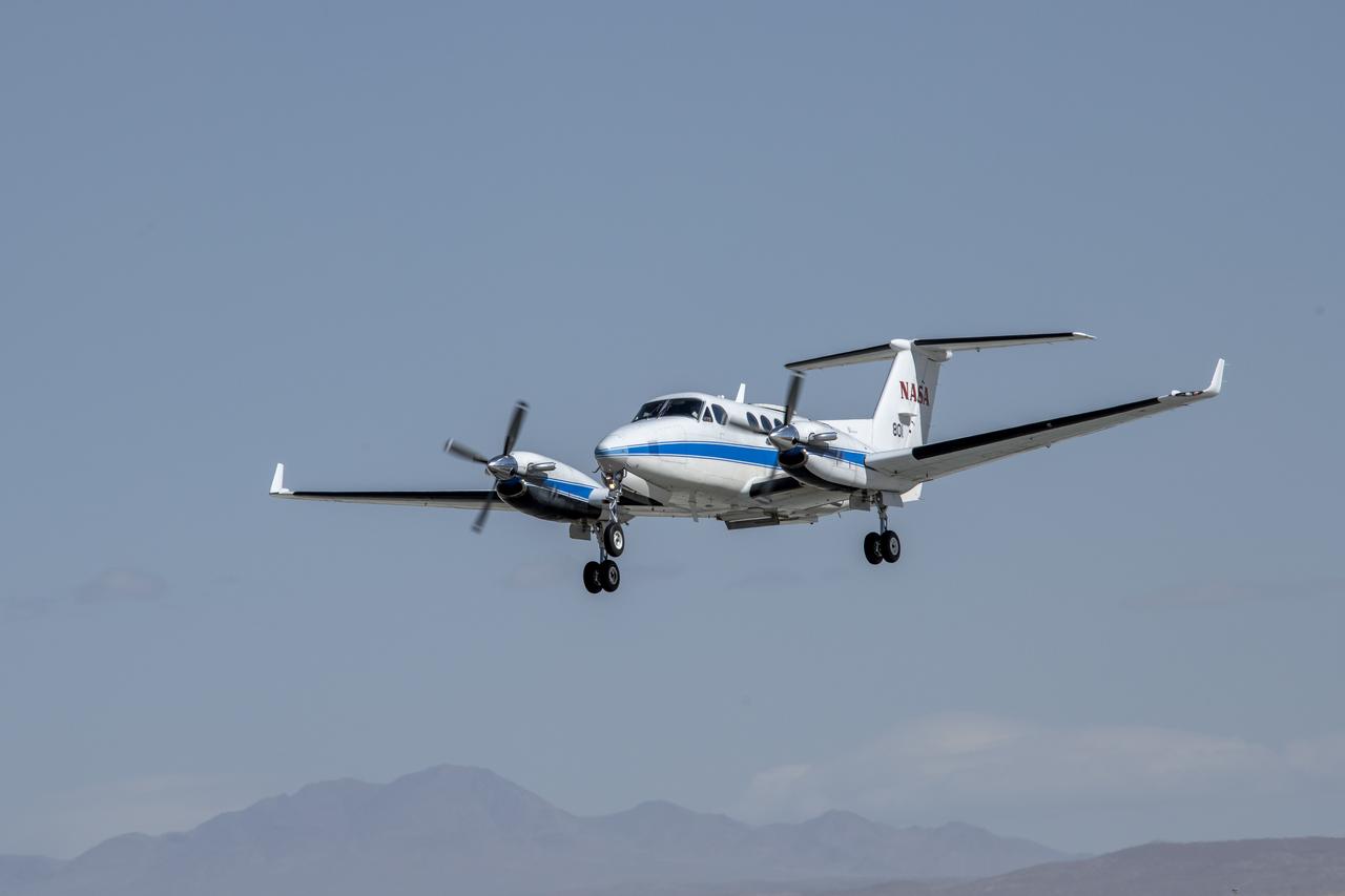
NASA’s B200 King Air aircraft – based at NASA’s Armstrong Flight Research Center in Edwards, California – ascends to support a prescribed burn in Geneva State Forest, about 100 miles south of Montgomery, Alabama, on March 17, 2025. The effort is part of NASA’s multi-year FireSense project, which aims to test technology that predicts fire and smoke behavior. This data could eventually benefit the U.S. Forest Service as well as local, state, and other federal wildland fire agencies.

NASA’s B200 King Air aircraft – based at NASA’s Armstrong Flight Research Center in Edwards, California – ascends to support a prescribed burn in Geneva State Forest, about 100 miles south of Montgomery, Alabama, on March 17, 2025. The effort is part of NASA’s multi-year FireSense project, which aims to test technology that predicts fire and smoke behavior. This data could eventually benefit the U.S. Forest Service as well as local, state, and other federal wildland fire agencies.

CAPE CANAVERAL, Fla. -- In the firing room, Bill Parsons (left), director of NASA's Kennedy Space Center, and Dave King, director of NASA's Marshall Space Flight Center, discuss the imminent launch of space shuttle Discovery on its STS-124 mission. Discovery is making its 35th flight. The STS-124 mission is the 26th in the assembly of the space station. It is the second of three flights launching components to complete the Japan Aerospace Exploration Agency's Kibo laboratory. The shuttle crew will install Kibo's large Japanese Pressurized Module and its remote manipulator system, or RMS. The 14-day flight includes three spacewalks. Photo credit: NASA/Kim Shiflett
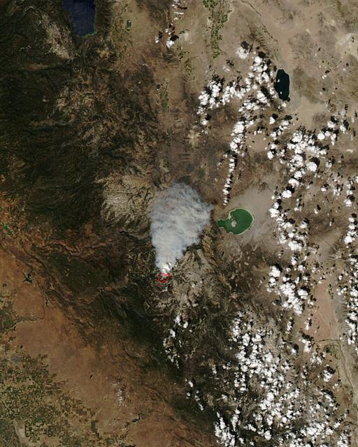
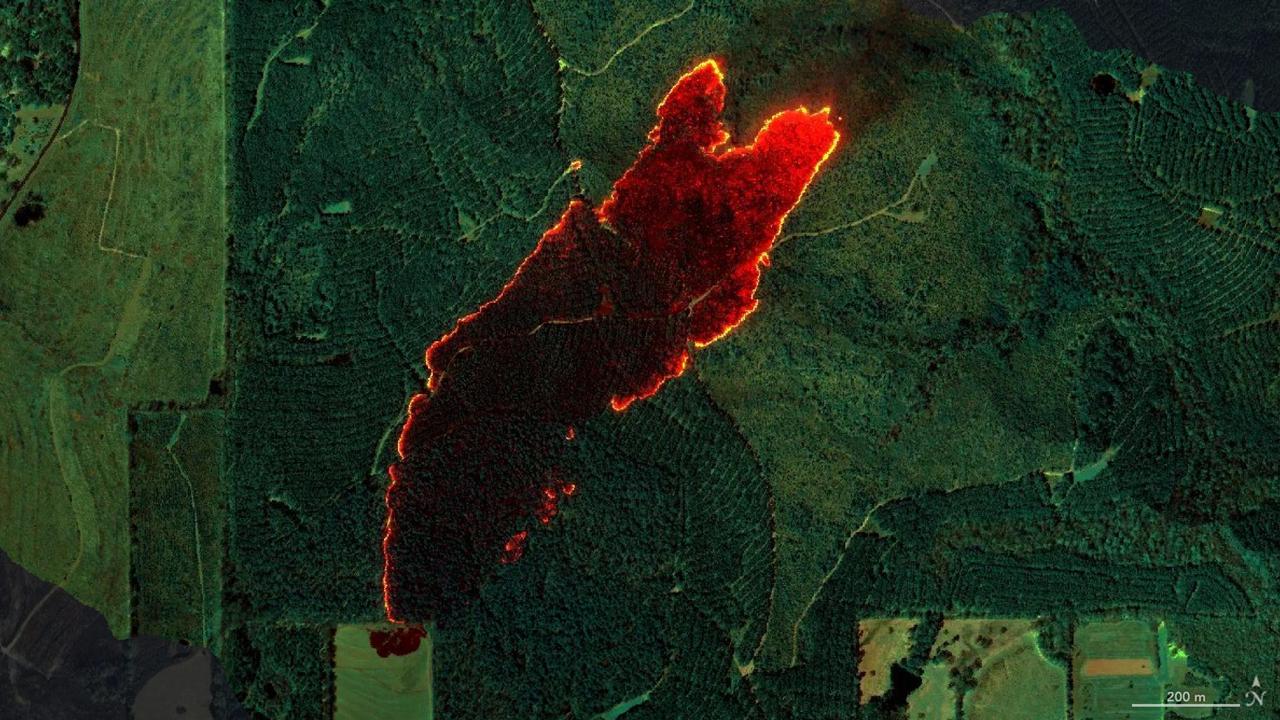
The Meadow Fire in Yosemite National Park is a remote, hold-over lightning caused fire which began on September 4 and is located five miles east of Yosemite Valley, CA. The fuel burning is timber and brush. There is active fire behavior with long range spotting. The National Park Service reports that a fire, that may be a spot fire, from the Meadow lightning-caused fire, was discovered at approximately 12:30 PM, Sunday September 7. The fire is approximately 2,582 acres. It is burning within the Little Yosemite Valley on both sides of the Merced River. All trails in the area are closed. Approximately 100 hikers and backpackers were evacuated from the fire area in Little Yosemite Valley. Half-Dome, a popular tourist destination, has been closed. The fire is burning in Yosemite Wilderness. Eighty-five hikers and climbers were also evacuated from the summit of Half Dome by helicopters from the California Highway Patrol, US Department of Agriculture Forest Service, Sequoia Kings Canyon National Park, and CAL Fire. This natural-color satellite image was collected by the Moderate Resolution Imaging Spectroradiometer (MODIS) aboard the Aqua satellite on Sept. 07, 2014. Actively burning areas, detected by MODIS’s thermal bands, are outlined in red. NASA image courtesy Jeff Schmaltz, MODIS Rapid Response Team. Caption: NASA/Goddard, Lynn Jenner with information from the National Park Service and the National Interagency Coordination Center. <b><a href="http://www.nasa.gov/audience/formedia/features/MP_Photo_Guidelines.html" rel="nofollow">NASA image use policy.</a></b> <b><a href="http://www.nasa.gov/centers/goddard/home/index.html" rel="nofollow">NASA Goddard Space Flight Center</a></b> enables NASA’s mission through four scientific endeavors: Earth Science, Heliophysics, Solar System Exploration, and Astrophysics. Goddard plays a leading role in NASA’s accomplishments by contributing compelling scientific knowledge to advance the Agency’s mission. <b>Follow us on <a href="http://twitter.com/NASAGoddardPix" rel="nofollow">Twitter</a></b> <b>Like us on <a href="http://www.facebook.com/pages/Greenbelt-MD/NASA-Goddard/395013845897?ref=tsd" rel="nofollow">Facebook</a></b> <b>Find us on <a href="http://instagram.com/nasagoddard?vm=grid" rel="nofollow">Instagram</a></b>
CAPE CANAVERAL, Fla. – In Firing Room 4 of the Launch Control Center at NASA's Kennedy Space Center in Florida, NASA management waits for the launch of space shuttle Discovery on the STS-119 mission. From left are (standing) Director of NASA's Marshall Space Flight Center Dave King, Center Director Bob Cabana, Director of NASA's Johnson Space Center Michael Coats, (seated) Space Shuttle Program Manager John Shannon, NASA Associate Administrator for Space Operations William Gerstenmaier and NASA Acting Administrator Chris Scolese. Launch was on time at 7:43 p.m. EDT. The STS-119 mission is the 28th to the space station and Discovery's 36th flight. Discovery will deliver the final pair of power-generating solar array wings and the S6 truss segment. Installation of S6 will signal the station's readiness to house a six-member crew for conducting increased science. Photo credit: NASA/Kim Shiflett
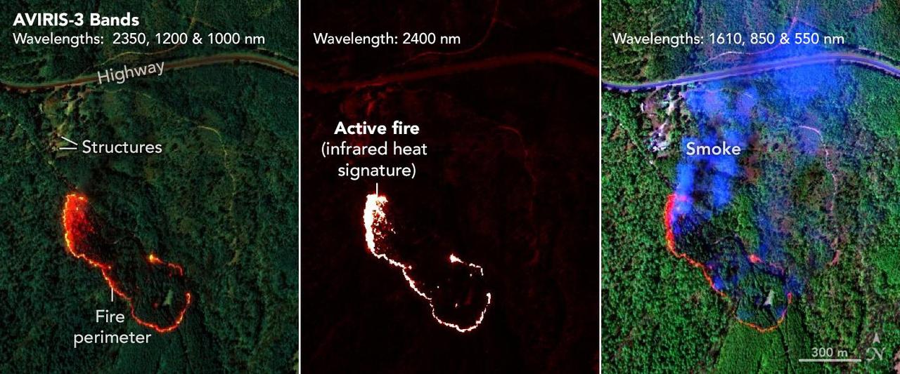
NASA's AVIRIS-3 sensor, an airborne imaging spectrometer built and operated by the agency's Jet Propulsion Laboratory in Southern California, captured infrared data on a wildfire about 3 miles (5 kilometers) west of the town of Mount Vernon, Alabama, on March 21, 2025. Within minutes of flying over, real-time maps of the fire were sent via satellite internet to firefighters with the Alabama Forestry Commission, who used it to contain the fire, preventing it from reaching four buildings. The first image in the series combines reflection data from AVIRIS-3 (Airborne Visible Infrared Imaging Spectrometer 3) at three infrared wavelengths that are invisible to the human eye – 2,350 nanometers, 1,200 nanometers, and 1,000 nanometers. In the resulting composite image, the colors indicate where the fire was burning most intensely. Orange and red areas show cooler-burning areas, while yellow indicates the most intense flames. Burned areas show up as dark red or brown. The second image in the series looks solely at the 2,400 nanometers wavelength. This wavelength is particularly useful for seeing hot spots and the perimeters of fires, which show brightly against a red background. The third image in the series combines light at 1,610 nanometers, 850 nanometers, and 550 nanometers. This view shows burn areas and smoke. The AVIRIS-3 sensor belongs to a line of imaging spectrometers built at JPL since 1986. The instruments have been used to study a wide range of phenomena – including fire – by measuring sunlight reflecting from the planet's surface. Data from imaging spectrometers like AVIRIS-3 typically takes days or weeks to be processed into highly detailed, multilayer image products used for research. By simplifying the calibration algorithms, researchers were able to process data on a computer aboard the plane in a sliver of the time it otherwise would have taken, and airborne satellite internet connectivity enabled the images to be distributed almost immediately, while the plane was still in flight, rather than after it landed. Flying about 9,000 feet (3,000 meters) in altitude aboard a NASA King Air B200 research plane, AVIRIS-3 collected data on the Castleberry Fire while preparing for prescribed burn experiments that took place in the Geneva State Forest in Alabama on March 28 and at Fort Stewart-Hunter Army Airfield in Georgia from April 14 to 20. The burns were part of a NASA 2025 FireSense Airborne Campaign. https://photojournal.jpl.nasa.gov/catalog/PIA26499
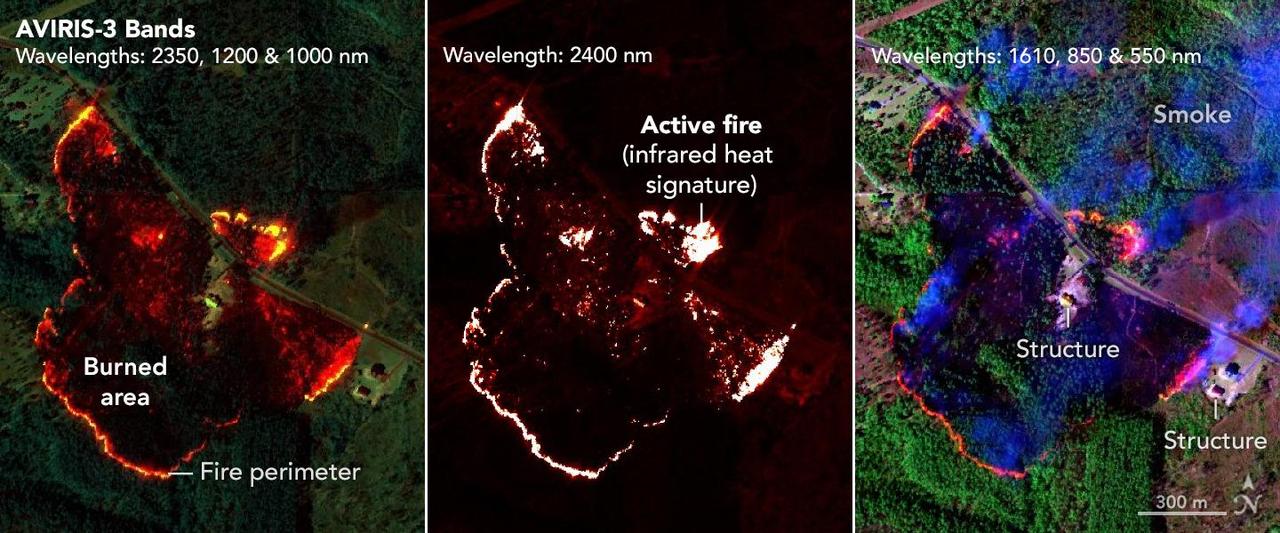
NASA's AVIRIS-3 sensor, an airborne imaging spectrometer built and operated by the agency's Jet Propulsion Laboratory in Southern California, captured infrared data of a wildfire 4 miles (2.5 kilometers) southwest of the unincorporated community of Perdido, Alabama, on March 21, 2025. Within minutes of flying over, real-time maps of the fire were sent via satellite internet to firefighters with the Alabama Forestry Commission, who used it to contain the fire, preventing it from reaching six buildings. The first image in the series combines reflection data from AVIRIS-3 (Airborne Visible Infrared Imaging Spectrometer 3) at three infrared wavelengths that are invisible to the human eye – 2,350 nanometers, 1,200 nanometers, and 1,000 nanometers. In the resulting composite image, the colors indicate where the fire was burning most intensely. Orange and red areas show cooler-burning areas, while yellow indicates the most intense flames. Burned areas show up as dark red or brown. The second image in the series looks solely at the 2,400 nanometers wavelength. The images are particularly useful for seeing hot spots and the perimeters of fires, which show brightly against a red background. The third image in the series combines light at 1,610 nanometers, 850 nanometers, and 550 nanometers. This view shows burn areas and smoke. The AVIRIS-3 sensor belongs to a line of imaging spectrometers built at JPL since 1986. The instruments have been used to study a wide range of phenomena – including fire – by measuring sunlight reflecting from the planet's surface. Data from imaging spectrometers like AVIRIS-3 typically takes days or weeks to be processed into highly detailed, multilayer image products used for research. By simplifying the calibration algorithms, researchers were able to process data on a computer aboard the plane in a sliver of the time it otherwise would have taken, and airborne satellite internet connectivity enabled the images to be distributed almost immediately, while the plane was still in flight, rather than after it landed. Flying about 9,000 feet (3,000 meters) in altitude aboard a NASA King Air B200 research plane, AVIRIS-3 collected data on the Castleberry Fire while preparing for prescribed burn experiments that took place in the Geneva State Forest in Alabama on March 28 and at Fort Stewart-Hunter Army Airfield in Georgia from April 14 to 20. The burns were part of a NASA 2025 FireSense Airborne Campaign. https://photojournal.jpl.nasa.gov/catalog/PIA26498

ISS016-E-022772 (11 Jan. 2008) --- Perth, Australia is featured in this image photographed by an Expedition 16 crewmember on the International Space Station (ISS). Perth is the capital of the state of Western Australia, and the largest city of the southwestern continent of Australia with an estimated population of over 1.5 million (December 2006). The downtown area of Perth and the surrounding suburbs are located on flood plain deposits of the Swan and Canning Rivers that flow through the center of the metropolitan area. Perth enjoys a Mediterranean climate, where the summers are hot and dry and winters are cool and moist. Wildfires can develop during the summer months; several large fires threatened the eastern portion of the metropolitan area in 2005. This view captures variations in urban land cover in the visible wavelengths to which the human eye is sensitive (visible red, green, and blue). The downtown center of Perth at left is characterized by large buildings (such as skyscrapers) with white reflective rooftops. Suburbs to the south (across the Swan River) are characterized by higher density of small buildings with predominantly reddish-purple roofs. Several areas of green vegetation are visible in the image. Parks and golf courses comprised mainly of grass present an even green coloration, while the dense tree canopy of Kings Park appears dark green. Variations in the coloration of the Swan and Canning Rivers is due to sunglint, or light reflected off the water surface back to the observer (in this case, a crewmember onboard the ISS).

KENNEDY SPACE CENTER, FLA. -- In the firing room, NASA officials wait for the countdown of the second launch attempt of Space Shuttle Discovery on mission STS-116. At the consoles, from left, are NASA Administrator Mike Griffin, Associate Administrator for Space Operations Mission William Gerstenmaier, Johnson Space Center Director Mike Coats, Kennedy Space Center Director Jim Kennedy and Marshall Space Flight Center Director Dave King. This was the second launch attempt for mission STS-116. The first launch attempt on Dec. 7 was postponed due a low cloud ceiling over Kennedy Space Center. This is Discovery's 33rd mission and the first night launch since 2002. The 20th shuttle mission to the International Space Station, STS-116 carries another truss segment, P5. It will serve as a spacer, mated to the P4 truss that was attached in September. After installing the P5, the crew will reconfigure and redistribute the power generated by two pairs of U.S. solar arrays. Landing is expected Dec. 21 at KSC. Photo credit: NASA/Kim Shiflett
NASA's AVIRIS-3 sensor, an airborne imaging spectrometer built and operated by the agency's Jet Propulsion Laboratory in Southern California, captured infrared data of a roughly 120-acre wildfire about 3 miles (5 kilometers) east of the town of Castleberry, Alabama, on March 19, 2025. Within minutes of flying over the Castleberry Fire, which had not previously been reported to authorities, real-time maps of where burning was most intense were sent via satellite internet to firefighters with the Alabama Forestry Commission, who used it to decide how to deploy their personnel and firefighting equipment. The image combines reflection data from AVIRIS-3 (Airborne Visible Infrared Imaging Spectrometer 3) at three infrared wavelengths that are invisible to the human eye: 2,350 nanometers, 1,200 nanometers, and 1,000 nanometers. In the resulting composite image, the colors indicate where the fire was burning most intensely. Orange and red areas show cooler-burning areas, while yellow indicates the most intense flames. Burned areas show up as dark red or brown. The AVIRIS-3 sensor belongs to a line of imaging spectrometers built at JPL since 1986. The instruments have been used to study a wide range of phenomena – including fire – by measuring sunlight reflecting from the planet's surface. Data from imaging spectrometers like AVIRIS-3 typically takes days or weeks to be processed into highly detailed, multilayer image products used for research. By simplifying the calibration algorithms, researchers were able to process data on a computer aboard the plane in a sliver of the time it otherwise would have taken, and airborne satellite internet connectivity enabled the images to be distributed almost immediately, while the plane was still in flight, rather than after it landed. Flying about 9,000 feet (3,000 meters) in altitude aboard a NASA King Air B200 research plane, AVIRIS-3 collected data on the Castleberry Fire while preparing for prescribed burn experiments that took place in the Geneva State Forest in Alabama on March 28 and at Fort Stewart-Hunter Army Airfield in Georgia from April 14 to 20. The burns were part of a NASA 2025 FireSense Airborne Campaign. https://photojournal.jpl.nasa.gov/catalog/PIA26497
Bruce A. Peterson standing beside the M2-F2 lifting body on Rogers Dry Lake. Peterson became the NASA project pilot for the lifting body program after Milt Thompson retired from flying in late 1966. Peterson had flown the M2-F1, and made the first glide flight of the HL-10 heavy-weight lifting body in December 1966. On May 10, 1967, Peterson made his fourth glide flight in the M2-F2. This was also the M2-F2's 16th glide flight, scheduled to be the last one before the powered flights began. However, as pilot Bruce Peterson neared the lakebed, the M2-F2 suffered a pilot induced oscillation (PIO). The vehicle rolled from side to side in flight as he tried to bring it under control. Peterson recovered, but then observed a rescue helicopter that seemed to pose a collision threat. Distracted, Peterson drifted in a cross-wind to an unmarked area of the lakebed where it was very difficult to judge the height over the lakebed because of a lack of the guidance the markers provided on the lakebed runway. Peterson fired the landing rockets to provide additional lift, but he hit the lakebed before the landing gear was fully down and locked. The M2-F2 rolled over six times, coming to rest upside down. Pulled from the vehicle by Jay King and Joseph Huxman, Peterson was rushed to the base hospital, transferred to March Air Force Base and then the UCLA Hospital. He recovered but lost vision in his right eye due to a staph infection.