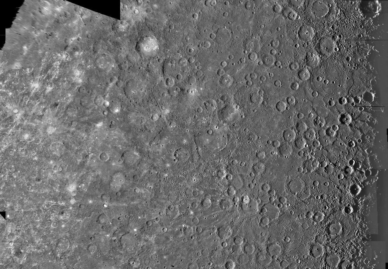
The Kuiper Quadrangle was named in memory of Dr. Gerard Kuiper, an imaging team member, and well-known astronomer, of NASA Mariner 10 Venus/Mercury. The Kuiper crater is seen left of center in this image.
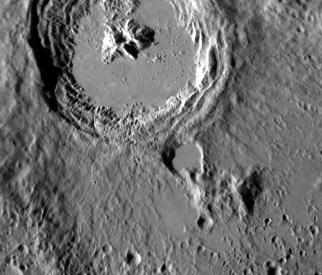
Date acquired: April 05, 2013 This striking image of Kuiper shows the crater in a new perspective. This image highlights the crater's smooth impact melt and central peaks. Kuiper, first seen by Mariner 10, is an easily identifiable feature on Mercury's surface due to its bright rays, similar to Hokusai. This image was acquired as a high-resolution targeted observation. Targeted observations are images of a small area on Mercury's surface at resolutions much higher than the 200-meter/pixel morphology base map. It is not possible to cover all of Mercury's surface at this high resolution, but typically several areas of high scientific interest are imaged in this mode each week. The MESSENGER spacecraft is the first ever to orbit the planet Mercury, and the spacecraft's seven scientific instruments and radio science investigation are unraveling the history and evolution of the Solar System's innermost planet. During the first two years of orbital operations, MESSENGER acquired over 150,000 images and extensive other data sets. MESSENGER is capable of continuing orbital operations until early 2015. Credit: NASA/Johns Hopkins University Applied Physics Laboratory/Carnegie Institution of Washington
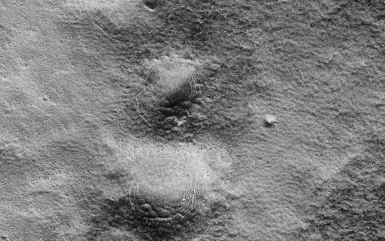
This image shows a lava channel north of Kuiper Crater in the high southern latitudes just before spring equinox. It was a target suggested by members of the public, using our suggestion tool called HiWish. The channel confluence at the top of the image illustrates interesting volcanic processes that took place long ago. However, it was the mounds on the rim of the channel to the south of the confluence that we initially found alarming. These mounds, up to 400 meters in diameter, are decorated by radial and concentric patterns that resemble spider webs. Radial and concentric fractures are familiar from forces penetrating a brittle layer, such as a rock thrown through a glass window. These particular fractures were evidently produced by something emerging from below the brittle surface of Mars. It seems likely that ice lenses, resulting from the accumulation of ice beneath the surface, created these peculiar mounds. Ice is less dense than rock, so the buried ice rose and pushed upwards on the surface and generated these spider web-like patterns. An analogous process creates similar sized mounds in arctic tundra on Earth that are known as "pingos," an Inuit word. The Martian fractures in this location are nowadays filled with dust instead of ice, so it is unclear how long ago this activity took place. It seems likely that these pingo-forming periglacial processes took place much more recently than the volcanic activity also evident in this region of Mars. http://photojournal.jpl.nasa.gov/catalog/PIA21110
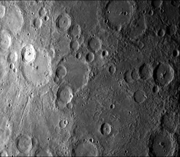
NASA Mariner 10 took this picture some 2 1/2 hours before it passed Mercury on March 29, 1974. The bright-floored crater is the center of a very large bright area which could be seen in pictures from more than two million miles distant
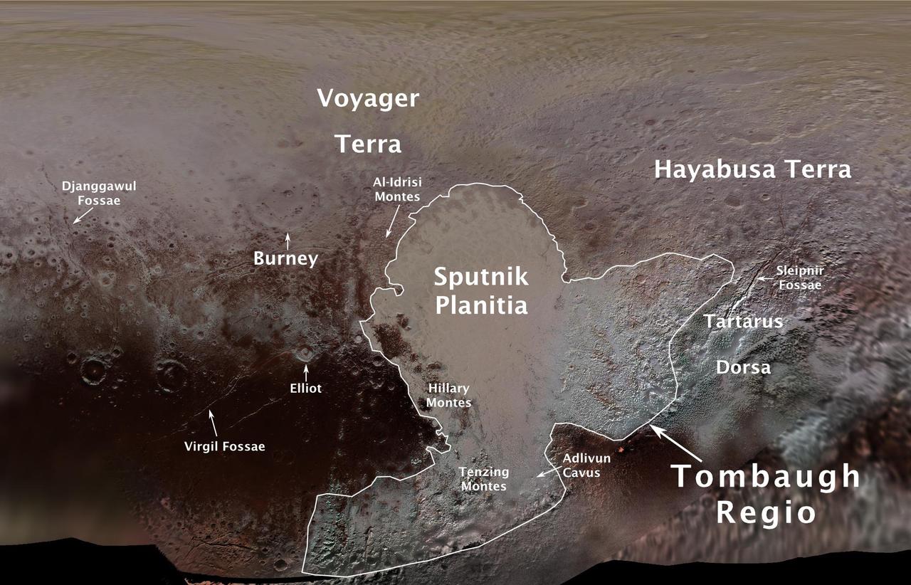
The International Astronomical Union (IAU), the internationally recognized authority for naming celestial bodies and their surface features, approved names of 14 surface features on Pluto in August 2017. The names were proposed by NASA's New Horizons team following the first reconnaissance of Pluto and its moons by the New Horizons spacecraft in 2015. The names, listed below, pay homage to the underworld mythology, pioneering space missions, historic pioneers who crossed new horizons in exploration, and scientists and engineers associated with Pluto and the Kuiper Belt. Tombaugh Regio honors Clyde Tombaugh (1906-1997), the U.S. astronomer who discovered Pluto in 1930 from Lowell Observatory in Arizona. Burney crater honors Venetia Burney (1918-2009), who as an 11-year-old schoolgirl suggested the name "Pluto" for Clyde Tombaugh's newly discovered planet. Later in life she taught mathematics and economics. Sputnik Planitia is a large plain named for Sputnik 1, the first space satellite, launched by the Soviet Union in 1957. Tenzing Montes and Hillary Montes are mountain ranges honoring Tenzing Norgay (1914-1986) and Sir Edmund Hillary (1919-2008), the Indian/Nepali Sherpa and New Zealand mountaineer were the first to reach the summit of Mount Everest and return safely. Al-Idrisi Montes honors Ash-Sharif al-Idrisi (1100-1165/66), a noted Arab mapmaker and geographer whose landmark work of medieval geography is sometimes translated as "The Pleasure of Him Who Longs to Cross the Horizons.†Djanggawul Fossae defines a network of long, narrow depressions named for the Djanggawuls, three ancestral beings in indigenous Australian mythology who traveled between the island of the dead and Australia, creating the landscape and filling it with vegetation. Sleipnir Fossa is named for the powerful, eight-legged horse of Norse mythology that carried the god Odin into the underworld. Virgil Fossae honors Virgil, one of the greatest Roman poets and Dante's fictional guide through hell and purgatory in the Divine Comedy. Adlivun Cavus is a deep depression named for Adlivun, the underworld in Inuit mythology. Hayabusa Terra is a large land mass saluting the Japanese spacecraft and mission (2003-2010) that performed the first asteroid sample return. Voyager Terra honors the pair of NASA spacecraft, launched in 1977, that performed the first "grand tour" of all four giant planets. The Voyager spacecraft are now probing the boundary between the Sun and interstellar space. Tartarus Dorsa is a ridge named for Tartarus, the deepest, darkest pit of the underworld in Greek mythology. Elliot crater recognizes James Elliot (1943-2011), an MIT researcher who pioneered the use of stellar occultations to study the solar system -- leading to discoveries such as the rings of Uranus and the first detection of Pluto's thin atmosphere. https://photojournal.jpl.nasa.gov/catalog/PIA21944