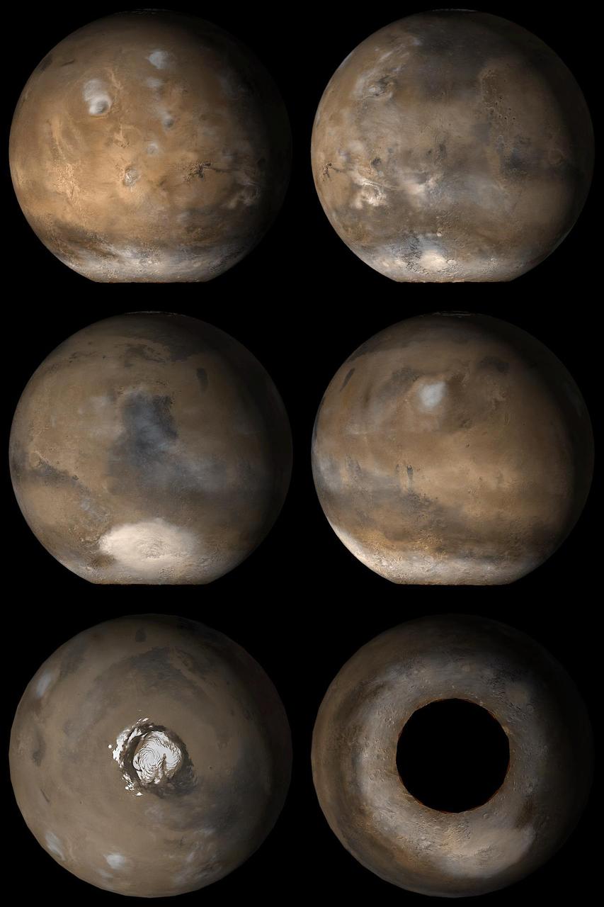
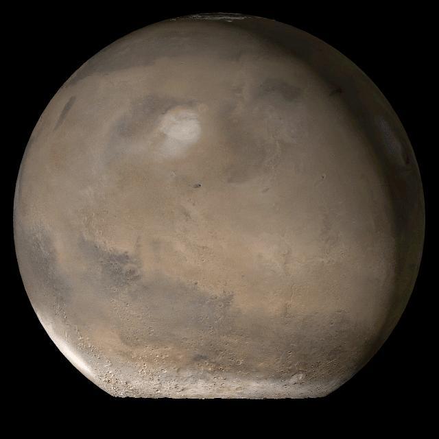
Mars at L<sub>s</sub> 137°
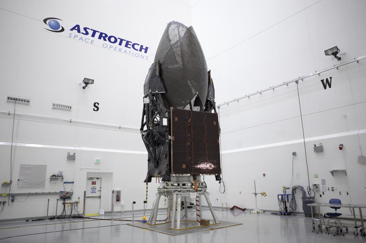
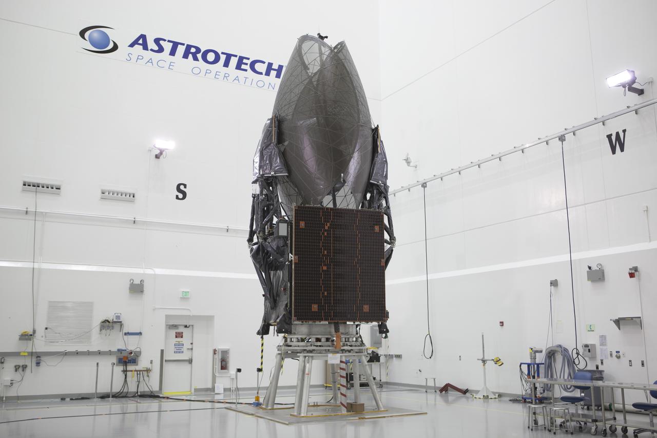
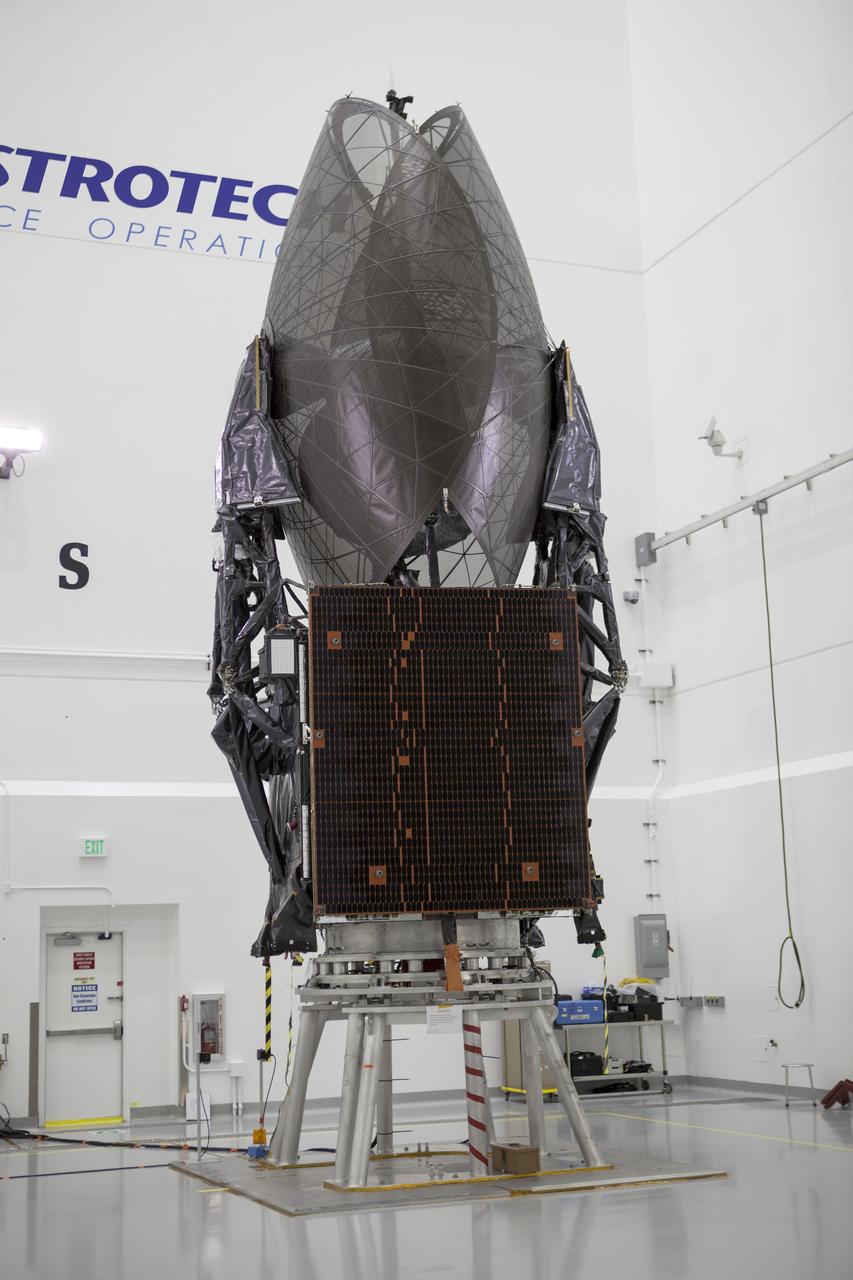
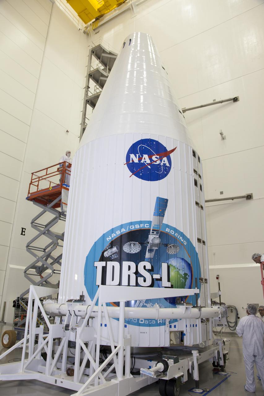
CAPE CANAVERAL, Fla. – – Inside the Astrotech payload processing facility in Titusville, NASA's Tracking and Data Relay Satellite, or TDRS-L, spacecraft is undergoing preflight processing. TDRS-L is being prepared for encapsulation inside its payload fairing prior to being transported to Launch Complex 41 at Cape Canaveral Air Force Station. The TDRS-L satellite will be a part of the second of three next-generation spacecraft designed to ensure vital operational continuity for the NASA Space Network. It is scheduled to launch from Cape Canaveral's Space Launch Complex 41 atop a United Launch Alliance Atlas V rocket on Jan. 23, 2014. The current Tracking and Data Relay Satellite system consists of eight in-orbit satellites distributed to provide near continuous information relay contact with orbiting spacecraft ranging from the International Space Station and Hubble Space Telescope to the array of scientific observatories. For more information, visit: http://www.nasa.gov/mission_pages/tdrs/home/index.html Photo credit: NASA/Dimitri Gerondidakis

JOHNNY STEPHENSON WITH MATTHEW YAZZIE, L, AND JIMMY YELLOWHORSE, R, SPEAKS ABOUT NOT JUDGING PEOPLE BY THEIR APPEARANCE

View of the audience at the memorial service at JSC for the Crew of STS 51-L. Sultan Salman Abdelazize Al-Saud of Saudi Arabia is seen in the center of the view.

The crew of STS-98 poses for a group photo shortly before leaving NASA's Dryden Flight Research Center after a successful landing of the Space Shuttle Atlantis the day before. L to R: Mission Specialists Robert L. Curbeam, Thomas D. Jones, and Marsha S. Ivins, Commander Kenneth D. Cockrell, and Pilot Mark L. Polansky.
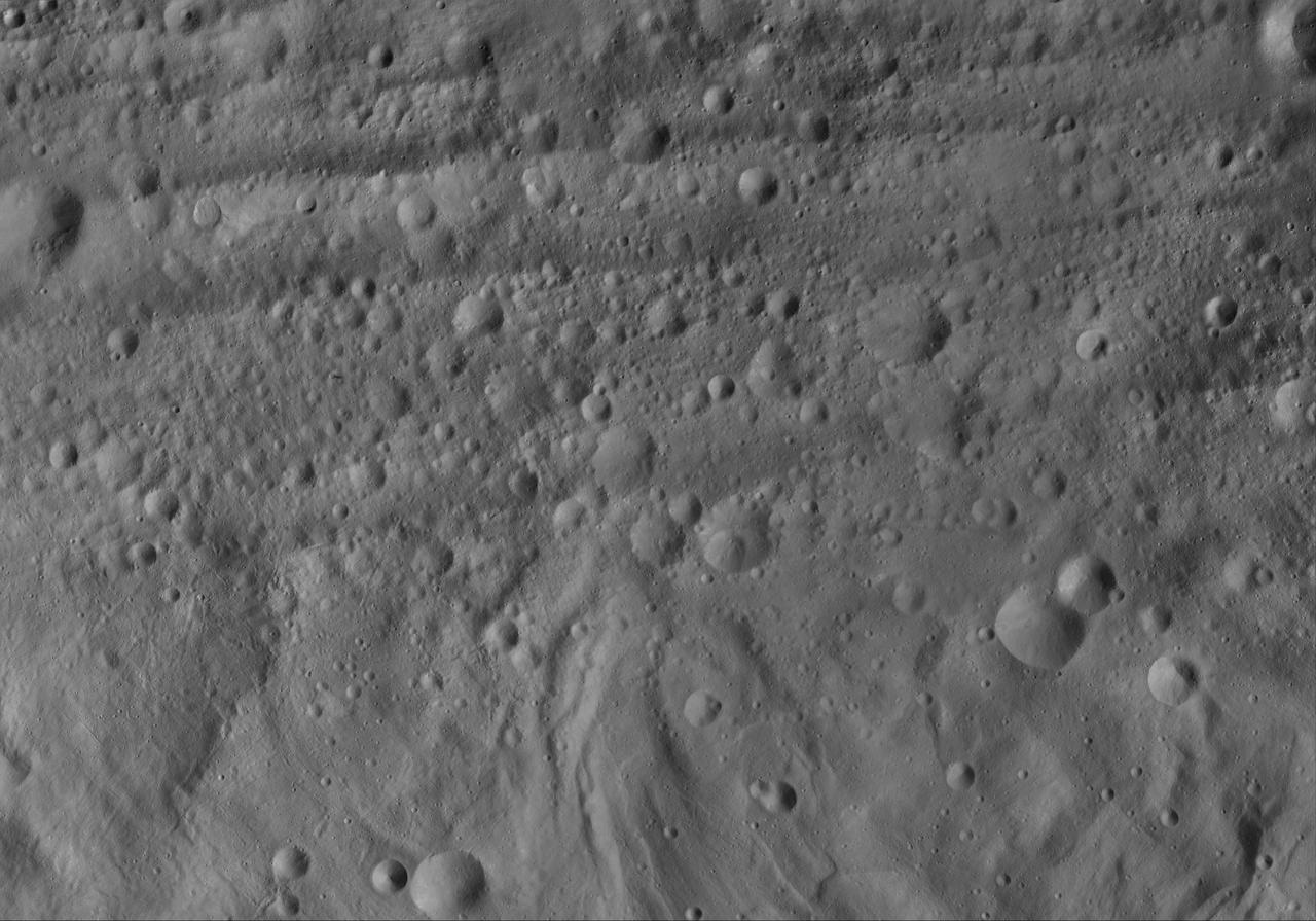
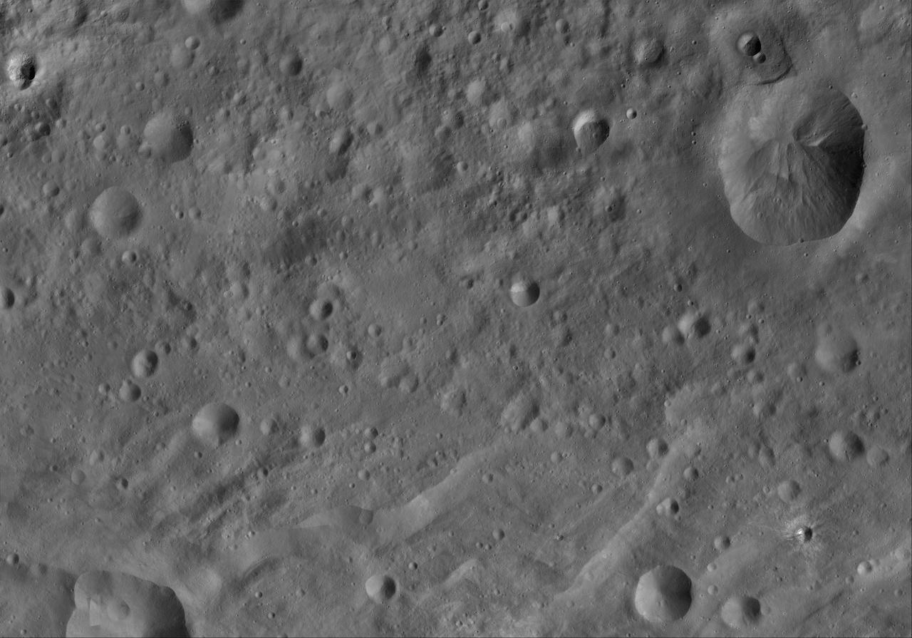
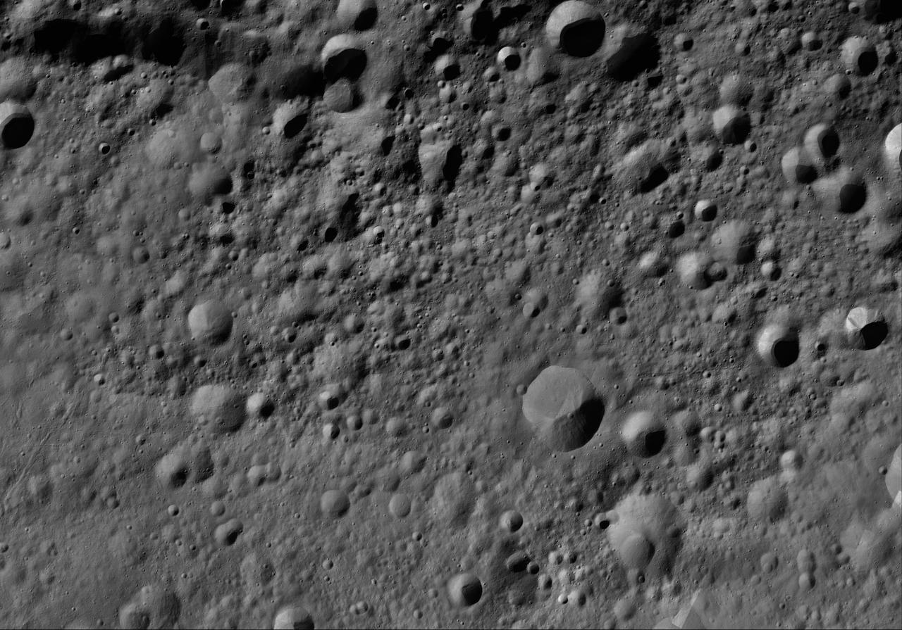
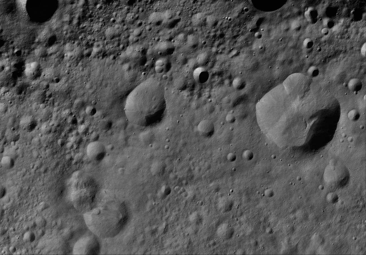
Images take for NASA Document L-1220
Images take for NASA Document L-1220
Images take for NASA Document L-1220
Images take for NASA Document L-1220
Images take for NASA Document L-1220

Overall view of the audience at the memorial service at JSC for the Crew of STS 51-L.

Portrait of Floyd L. Thompson NASA Langley Center Director 1960-1968. Died in 1976

Inside the Electromagnetic Lab at NASA's Kennedy Space Center in Florida, Gabor Tamasy, Hose Management Assembly (HMA) system lead for Restore-L, prepares the HMA test unit for electromagnetic interference testing on Feb. 19, 2020. The HMA is able to extend and retract the hose, somewhat similar to the function of a tape measure. Managed by the agency's Goddard Space Flight Center in Greenbelt, Maryland, Restore-L is an inflight robotic satellite servicer spacecraft.

Inside the Electromagnetic Lab at NASA's Kennedy Space Center in Florida, Gabor Tamasy, Hose Management Assembly (HMA) system lead for Restore-L, prepares the HMA test unit for electromagnetic interference testing on Feb. 19, 2020. The HMA is able to extend and retract the hose, somewhat similar to the function of a tape measure. Managed by the agency's Goddard Space Flight Center in Greenbelt, Maryland, Restore-L is an inflight robotic satellite servicer spacecraft.

Inside the Electromagnetic Lab at NASA's Kennedy Space Center in Florida, Gabor Tamasy, Hose Management Assembly (HMA) system lead for Restore-L, prepares the HMA test unit for electromagnetic interference testing on Feb. 19, 2020. The HMA is able to extend and retract the hose, somewhat similar to the function of a tape measure. Managed by the agency's Goddard Space Flight Center in Greenbelt, Maryland, Restore-L is an inflight robotic satellite servicer spacecraft.
The Restore-L hose management assembly (HMA) test unit undergoes electromagnetic interference testing in the Electromagnetic Lab at NASA's Kennedy Space Center in Florida on Feb. 19, 2020. The HMA is able to extend and retract the hose, somewhat similar to the function of a tape measure. Managed by the agency's Goddard Space Flight Center in Greenbelt, Maryland, Restore-L is an inflight robotic satellite servicer spacecraft.

The Restore-L hose management assembly (HMA) test unit undergoes electromagnetic interference testing in the Electromagnetic Lab at NASA's Kennedy Space Center in Florida on Feb. 19, 2020. The HMA is able to extend and retract the hose, somewhat similar to the function of a tape measure. Managed by the agency's Goddard Space Flight Center in Greenbelt, Maryland, Restore-L is an inflight robotic satellite servicer spacecraft.
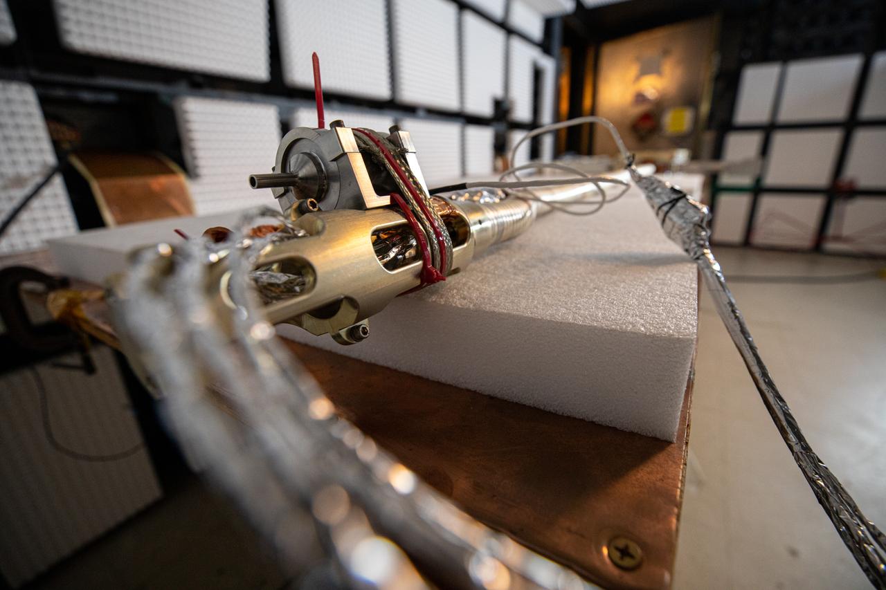
The Restore-L hose management assembly (HMA) test unit undergoes electromagnetic interference testing in the Electromagnetic Lab at NASA's Kennedy Space Center in Florida on Feb. 19, 2020. The HMA is able to extend and retract the hose, somewhat similar to the function of a tape measure. Managed by the agency's Goddard Space Flight Center in Greenbelt, Maryland, Restore-L is an inflight robotic satellite servicer spacecraft.

Overall view of the news media at the memorial service at JSC for the Crew of STS 51-L.

Secretary Elaine L. Chao, of the U.S. Department of Transportation (DOT), visits NASA’s Kennedy Space Center in Florida on April 24, 2019. She spoke to Kennedy’s leadership in the Operations and Support Building II and discussed the DOT’s role in enabling commercial space.

Secretary Elaine L. Chao, of the U.S. Department of Transportation (DOT), visits NASA’s Kennedy Space Center in Florida on April 24, 2019. She spoke to Kennedy’s leadership in the Operations and Support Building II and discussed the DOT’s role in enabling commercial space.

Secretary Elaine L. Chao, of the U.S. Department of Transportation (DOT), visits NASA’s Kennedy Space Center in Florida on April 24, 2019. She spoke to Kennedy’s leadership in the Operations and Support Building II and discussed the DOT’s role in enabling commercial space.

Family and friends of the STS 51-L crew prepare to be seated at the Memorial service at JSC. In the center of the view appears to be the family of Astronaut Ellison Onizuka.

51L-S-108 (31 Jan. 1986) --- Barbara R. Morgan, 51-L backup payload specialist to Christa McAuliffe, with others on the stage at the Memorial service for the Challenger Seven at JSC. Photo credit: NASA
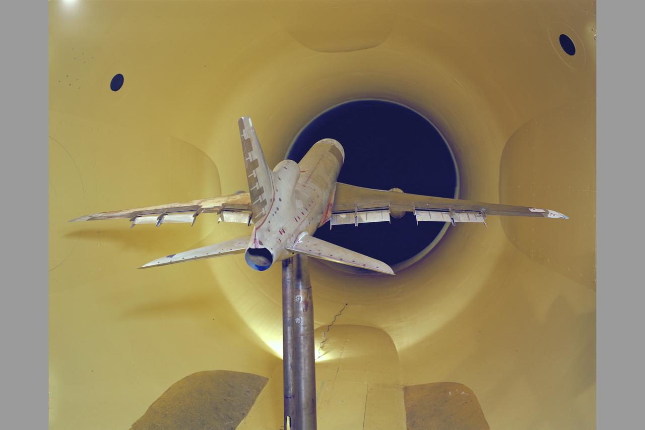
Lockheed L-1011 EET (Energy Efficient Transport) 12ft w.t. test-516
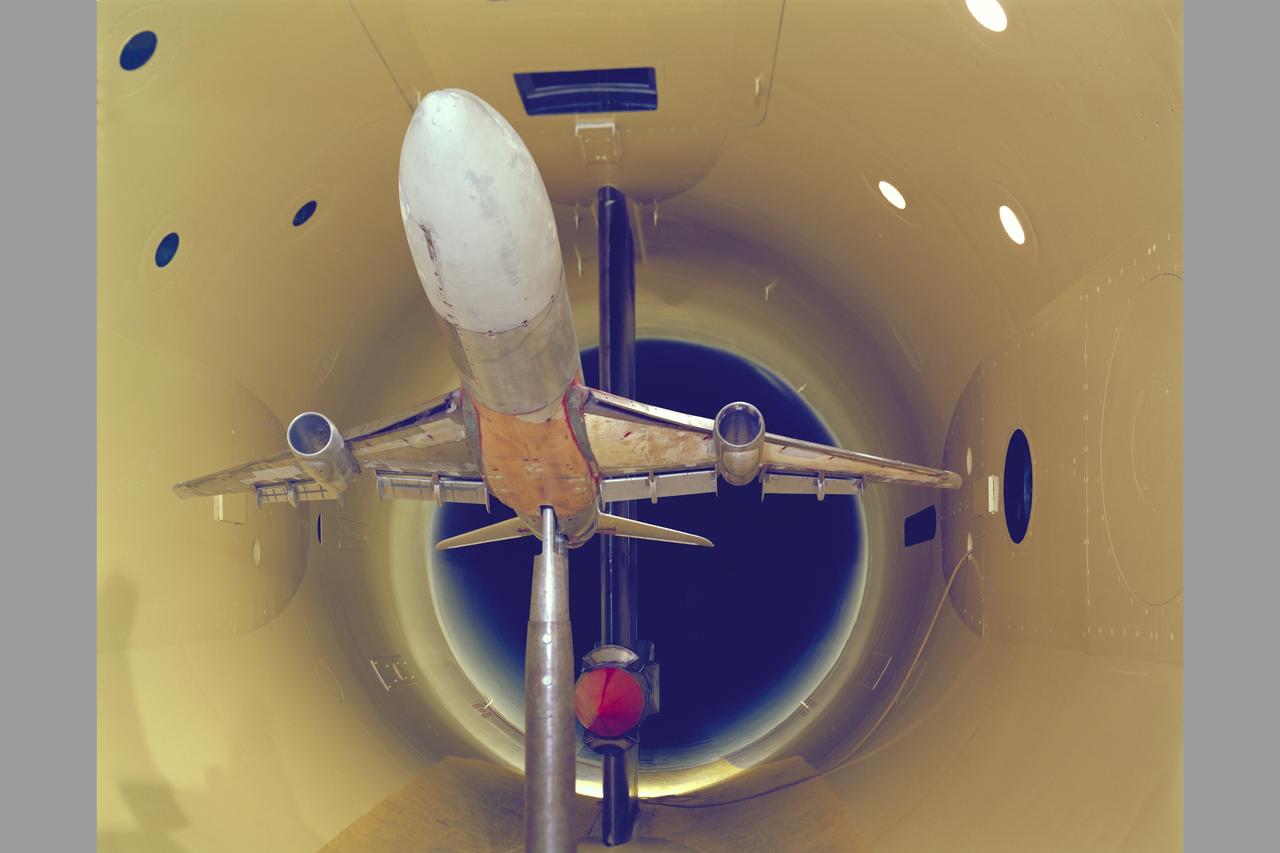
Lockheed L-1011 EET (Energy Efficient Transport) test-516 in 12ft. W.T.

S84-40232 (1984) --- Astronaut Frank L. Culbertson, 1984 ASCAN.

ISS011-E-06401 (18 May 2005) --- Astronaut John L. Phillips, Expedition 11 NASA science officer and flight engineer, is photographed among stowage bags in an airlock on the international space station.

Portrait of Floyd L. Thompson NASA Langley Center Director from 1960 to 1968. Died in 1976
View of internal airlock (A/L) in the Japanese Experiment Module (JEM) Pressurized Module (JPM). Photo was taken during Expedition 34.

View of stowed Extravehicular Mobility Units (EMUs),in the Airlock (A/L). Photo was taken during Expedition 34.

S85-39943 (9 Sept. 1985) --- Sharon Christa McAuliffe, STS-51L citizen observer/payload specialist representing the Teacher in Space Program, meets the other STS-51L crew members. The crew members pictured are (l.-r.) astronauts Michael J. Smith, pilot; Ronald E. McNair, mission specialist; and Francis R. (Dick) Scobee, mission commander. Photo credit: NASA

View of Mike Hopkins, Expedition 38 Flight Engineer (FE), during remove and replace (R&R) of Hard Upper Torso (HUT) of Extravehicular Mobility Unit (EMU), in the airlock (A/L) during preparation for EVA-24. Photo was taken during Expedition 38. Image was released by astronaut on Twitter.

S67-35799 (1967) --- Astronaut Donald L. Holmquest.
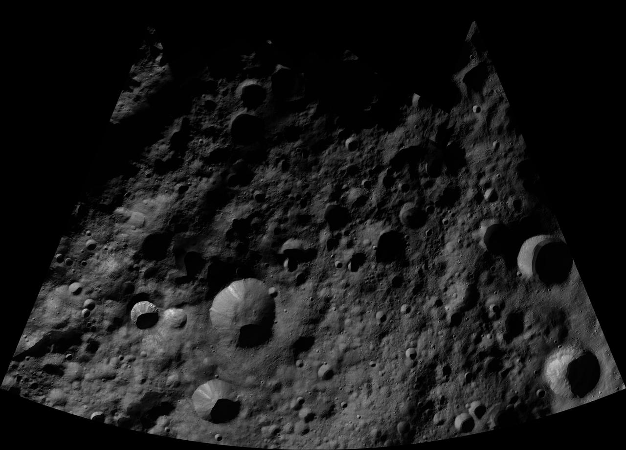
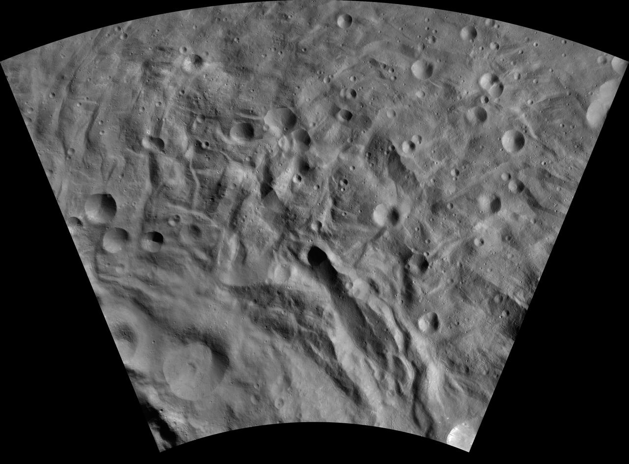
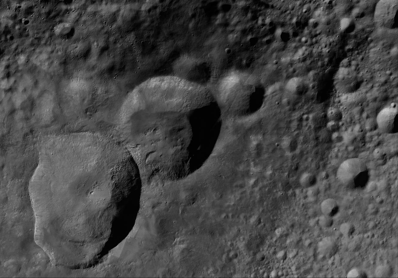
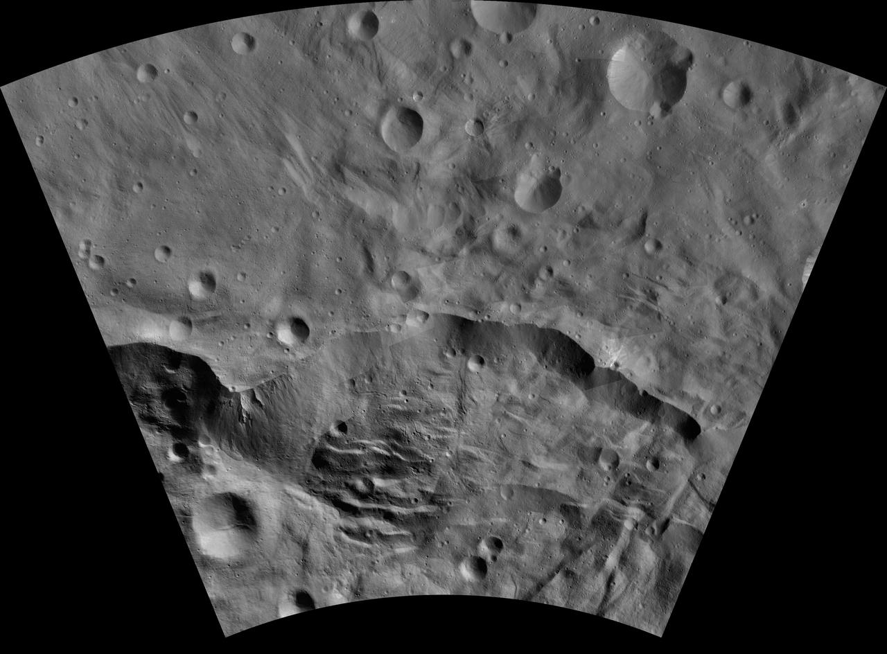
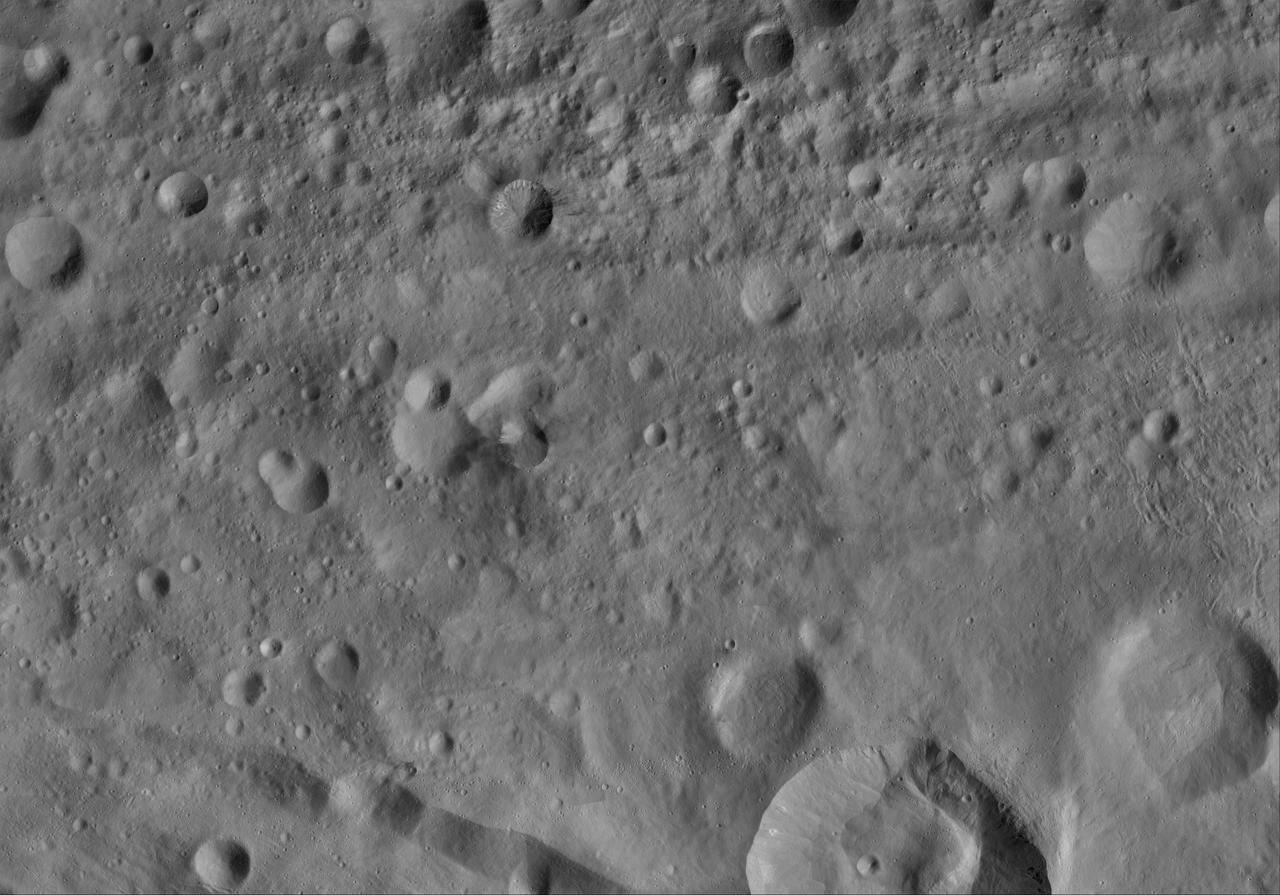
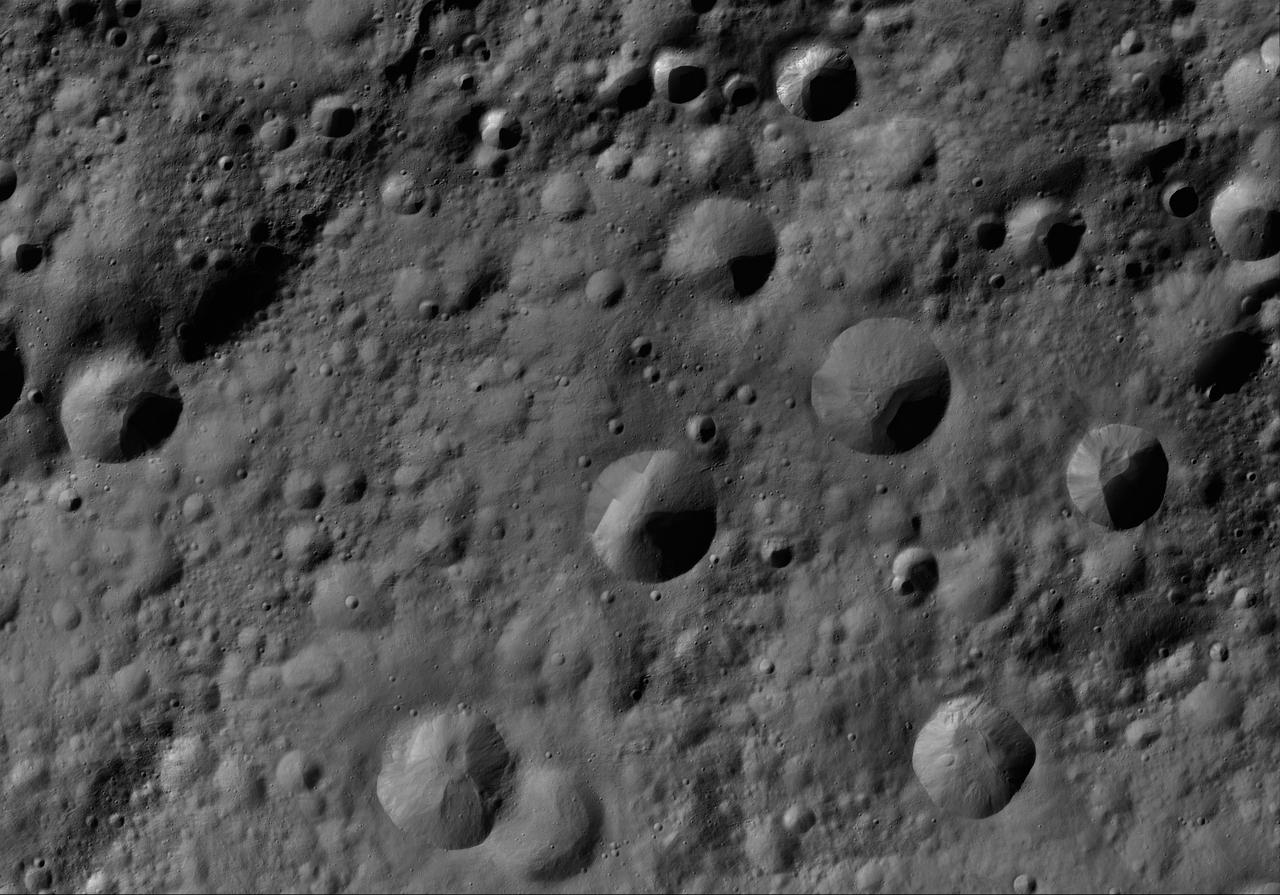
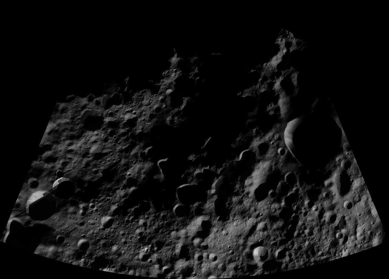
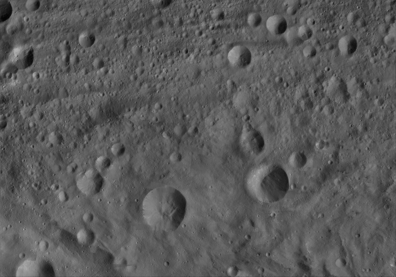
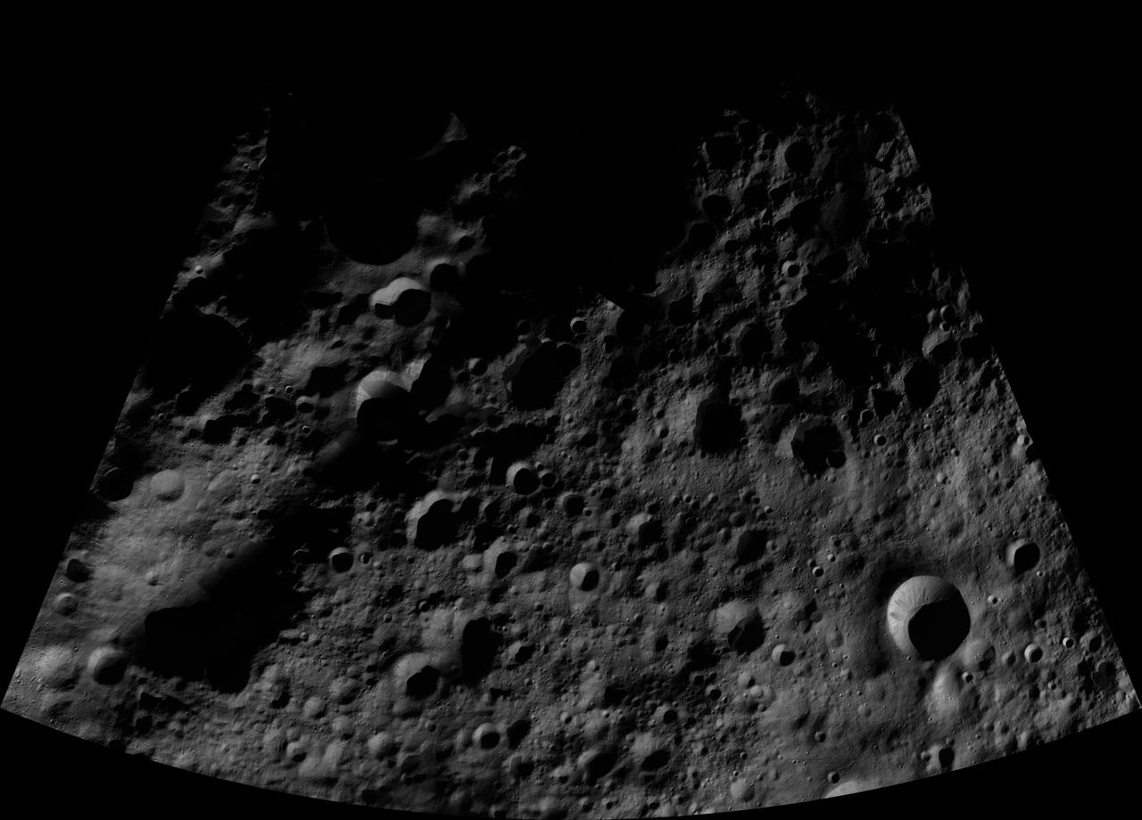
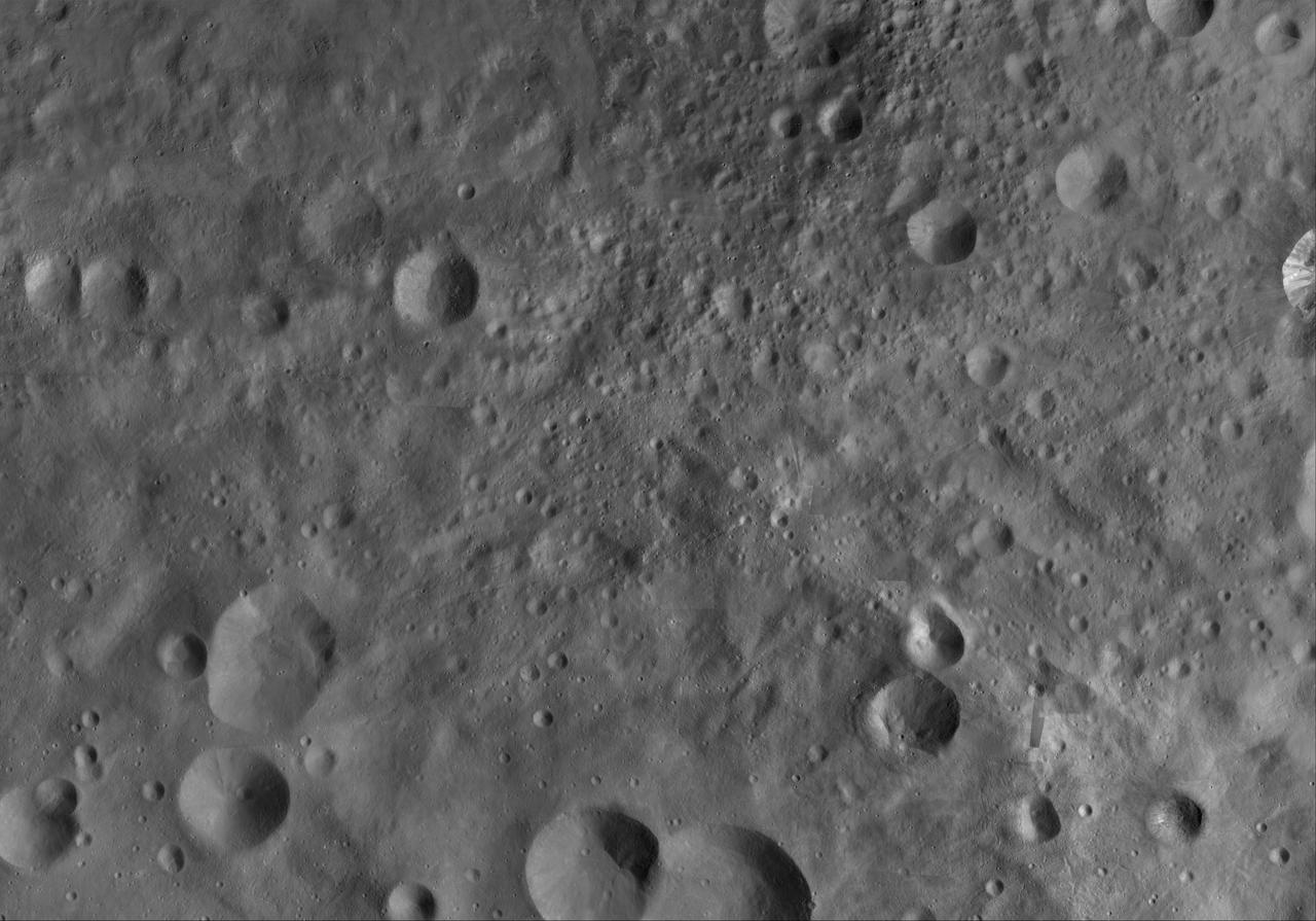
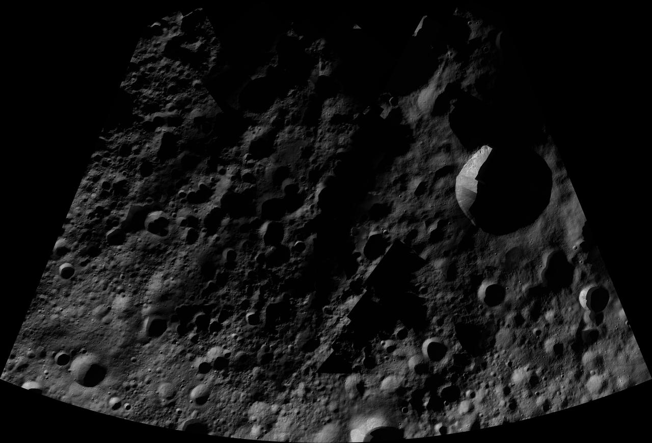
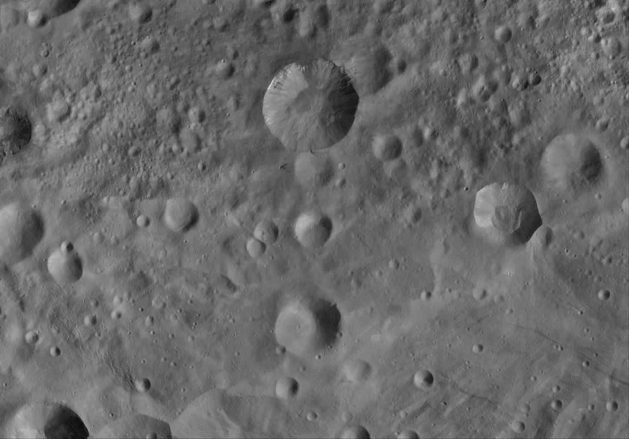
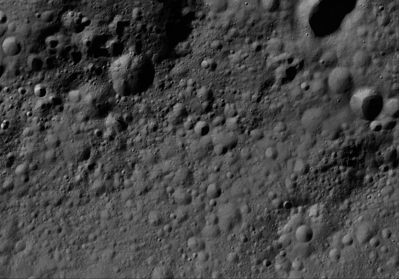
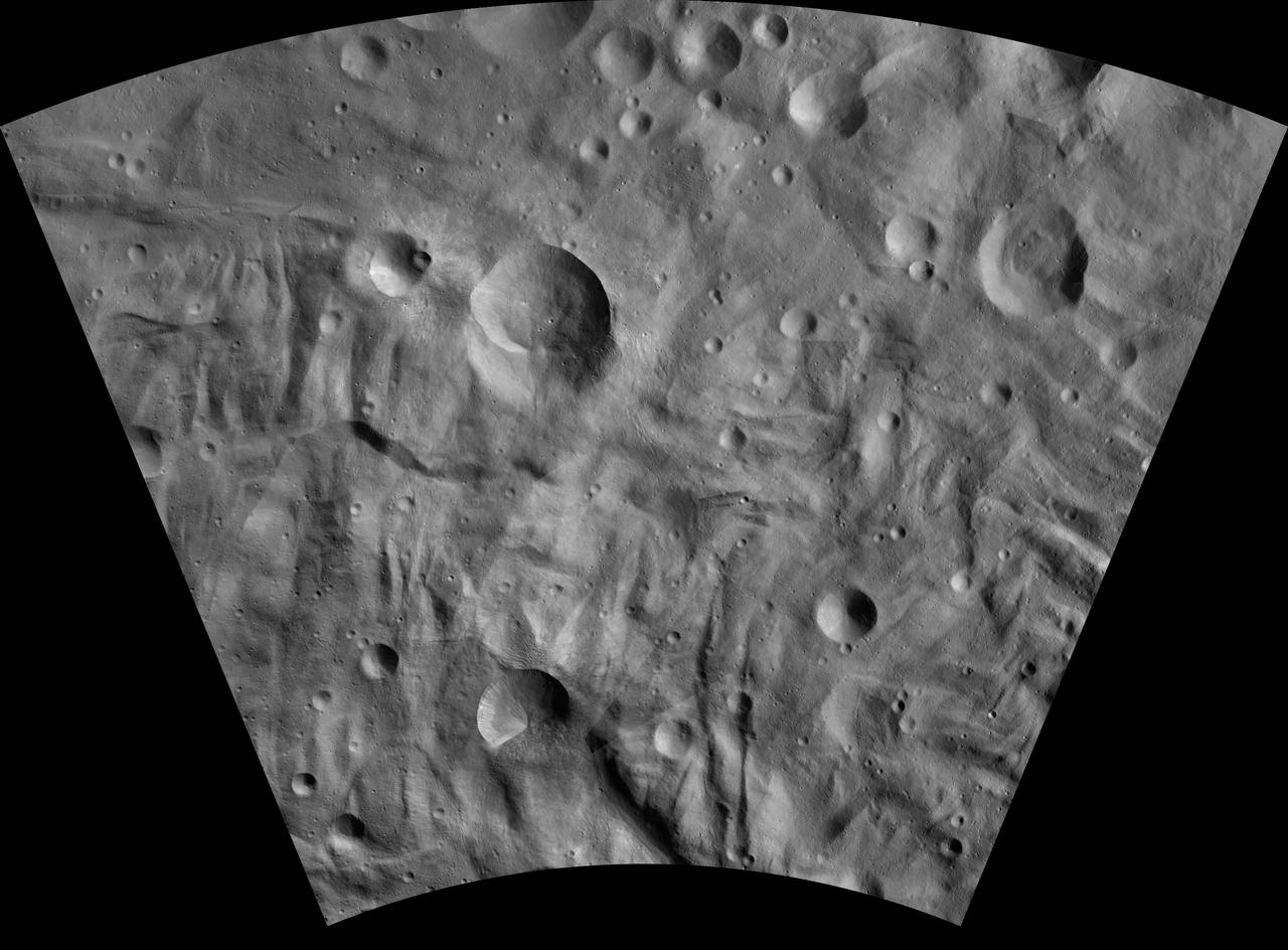
This image of Arruntia AV-L-03, from the atlas of the giant asteroid Vesta, was created from images taken as NASA Dawn mission flew around the object, also known as a protoplanet. The set of maps was created from mosaics of10,000 images from Dawn's framing camera instrument, taken at a low altitude of about 130 miles (210 kilometers). This map is mostly at a scale about that of regional road touring maps, where every inch of map is equivalent to a little more than 3 miles of asteroid (one centimeter equals 2 kilometers). http://photojournal.jpl.nasa.gov/catalog/PIA19507
This image of Justina AV-L-29, from the atlas of the giant asteroid Vesta, was created from images taken as NASA Dawn mission flew around the object, also known as a protoplanet. The set of maps was created from mosaics of10,000 images from Dawn's framing camera instrument, taken at a low altitude of about 130 miles (210 kilometers). This map is mostly at a scale about that of regional road touring maps, where every inch of map is equivalent to a little more than 3 miles of asteroid (one centimeter equals 2 kilometers). http://photojournal.jpl.nasa.gov/catalog/PIA19533
This image of Marcia AV-L-12, from the atlas of the giant asteroid Vesta, was created from images taken as NASA Dawn mission flew around the object, also known as a protoplanet. The set of maps was created from mosaics of10,000 images from Dawn's framing camera instrument, taken at a low altitude of about 130 miles (210 kilometers). This map is mostly at a scale about that of regional road touring maps, where every inch of map is equivalent to a little more than 3 miles of asteroid (one centimeter equals 2 kilometers). http://photojournal.jpl.nasa.gov/catalog/PIA19516

This image of Fabia AV-L-13, from the atlas of the giant asteroid Vesta, was created from images taken as NASA Dawn mission flew around the object, also known as a protoplanet. The set of maps was created from mosaics of10,000 images from Dawn's framing camera instrument, taken at a low altitude of about 130 miles (210 kilometers). This map is mostly at a scale about that of regional road touring maps, where every inch of map is equivalent to a little more than 3 miles of asteroid (one centimeter equals 2 kilometers). http://photojournal.jpl.nasa.gov/catalog/PIA19517
This image of Matronalia AV-L-25, from the atlas of the giant asteroid Vesta, was created from images taken as NASA Dawn mission flew around the object, also known as a protoplanet. The set of maps was created from mosaics of10,000 images from Dawn's framing camera instrument, taken at a low altitude of about 130 miles (210 kilometers). This map is mostly at a scale about that of regional road touring maps, where every inch of map is equivalent to a little more than 3 miles of asteroid (one centimeter equals 2 kilometers). http://photojournal.jpl.nasa.gov/catalog/PIA19529
This image of Domna AV-L-17, from the atlas of the giant asteroid Vesta, was created from images taken as NASA Dawn mission flew around the object, also known as a protoplanet. The set of maps was created from mosaics of10,000 images from Dawn's framing camera instrument, taken at a low altitude of about 130 miles (210 kilometers). This map is mostly at a scale about that of regional road touring maps, where every inch of map is equivalent to a little more than 3 miles of asteroid (one centimeter equals 2 kilometers). http://photojournal.jpl.nasa.gov/catalog/PIA19521
This image of Oppia AV-L-22, from the atlas of the giant asteroid Vesta, was created from images taken as NASA Dawn mission flew around the object, also known as a protoplanet. The set of maps was created from mosaics of10,000 images from Dawn's framing camera instrument, taken at a low altitude of about 130 miles (210 kilometers). This map is mostly at a scale about that of regional road touring maps, where every inch of map is equivalent to a little more than 3 miles of asteroid (one centimeter equals 2 kilometers). http://photojournal.jpl.nasa.gov/catalog/PIA19526

This image of Licinia AV-L-08, from the atlas of the giant asteroid Vesta, was created from images taken as NASA Dawn mission flew around the object, also known as a protoplanet. The set of maps was created from mosaics of10,000 images from Dawn's framing camera instrument, taken at a low altitude of about 130 miles (210 kilometers). This map is mostly at a scale about that of regional road touring maps, where every inch of map is equivalent to a little more than 3 miles of asteroid (one centimeter equals 2 kilometers). http://photojournal.jpl.nasa.gov/catalog/PIA19512
This image of Paulina AV-L-15, from the atlas of the giant asteroid Vesta, was created from images taken as NASA Dawn mission flew around the object, also known as a protoplanet. The set of maps was created from mosaics of10,000 images from Dawn's framing camera instrument, taken at a low altitude of about 130 miles (210 kilometers). This map is mostly at a scale about that of regional road touring maps, where every inch of map is equivalent to a little more than 3 miles of asteroid (one centimeter equals 2 kilometers). http://photojournal.jpl.nasa.gov/catalog/PIA19519
This image of Lepida AV-L-14, from the atlas of the giant asteroid Vesta, was created from images taken as NASA Dawn mission flew around the object, also known as a protoplanet. The set of maps was created from mosaics of10,000 images from Dawn's framing camera instrument, taken at a low altitude of about 130 miles (210 kilometers). This map is mostly at a scale about that of regional road touring maps, where every inch of map is equivalent to a little more than 3 miles of asteroid (one centimeter equals 2 kilometers). http://photojournal.jpl.nasa.gov/catalog/PIA19518
This image of Rubria AV-L-16, from the atlas of the giant asteroid Vesta, was created from images taken as NASA Dawn mission flew around the object, also known as a protoplanet. The set of maps was created from mosaics of10,000 images from Dawn's framing camera instrument, taken at a low altitude of about 130 miles (210 kilometers). This map is mostly at a scale about that of regional road touring maps, where every inch of map is equivalent to a little more than 3 miles of asteroid (one centimeter equals 2 kilometers). http://photojournal.jpl.nasa.gov/catalog/PIA19520
This image of Gegania AV-L-09, from the atlas of the giant asteroid Vesta, was created from images taken as NASA Dawn mission flew around the object, also known as a protoplanet. The set of maps was created from mosaics of10,000 images from Dawn's framing camera instrument, taken at a low altitude of about 130 miles (210 kilometers). This map is mostly at a scale about that of regional road touring maps, where every inch of map is equivalent to a little more than 3 miles of asteroid (one centimeter equals 2 kilometers). http://photojournal.jpl.nasa.gov/catalog/PIA19513
This image of Floronia AV-L-07, from the atlas of the giant asteroid Vesta, was created from images taken as NASA Dawn mission flew around the object, also known as a protoplanet. The set of maps was created from mosaics of10,000 images from Dawn's framing camera instrument, taken at a low altitude of about 130 miles (210 kilometers). This map is mostly at a scale about that of regional road touring maps, where every inch of map is equivalent to a little more than 3 miles of asteroid (one centimeter equals 2 kilometers). http://photojournal.jpl.nasa.gov/catalog/PIA19511
This image of Serena AV-L-18, from the atlas of the giant asteroid Vesta, was created from images taken as NASA Dawn mission flew around the object, also known as a protoplanet. The set of maps was created from mosaics of10,000 images from Dawn's framing camera instrument, taken at a low altitude of about 130 miles (210 kilometers). This map is mostly at a scale about that of regional road touring maps, where every inch of map is equivalent to a little more than 3 miles of asteroid (one centimeter equals 2 kilometers). http://photojournal.jpl.nasa.gov/catalog/PIA19522
This image of Domitia AV-L-05, from the atlas of the giant asteroid Vesta, was created from images taken as NASA Dawn mission flew around the object, also known as a protoplanet. The set of maps was created from mosaics of10,000 images from Dawn's framing camera instrument, taken at a low altitude of about 130 miles (210 kilometers). This map is mostly at a scale about that of regional road touring maps, where every inch of map is equivalent to a little more than 3 miles of asteroid (one centimeter equals 2 kilometers). http://photojournal.jpl.nasa.gov/catalog/PIA19509

This image of Rheasilvia AV-L-30, from the atlas of the giant asteroid Vesta, was created from images taken as NASA Dawn mission flew around the object, also known as a protoplanet. The set of maps was created from mosaics of10,000 images from Dawn's framing camera instrument, taken at a low altitude of about 130 miles (210 kilometers). This map is mostly at a scale about that of regional road touring maps, where every inch of map is equivalent to a little more than 3 miles of asteroid (one centimeter equals 2 kilometers). http://photojournal.jpl.nasa.gov/catalog/PIA19534
This image of Vibidia AV-L-20, from the atlas of the giant asteroid Vesta, was created from images taken as NASA Dawn mission flew around the object, also known as a protoplanet. The set of maps was created from mosaics of10,000 images from Dawn's framing camera instrument, taken at a low altitude of about 130 miles (210 kilometers). This map is mostly at a scale about that of regional road touring maps, where every inch of map is equivalent to a little more than 3 miles of asteroid (one centimeter equals 2 kilometers). http://photojournal.jpl.nasa.gov/catalog/PIA19524
This image of Mamilia AV-L-06, from the atlas of the giant asteroid Vesta, was created from images taken as NASA Dawn mission flew around the object, also known as a protoplanet. The set of maps was created from mosaics of10,000 images from Dawn's framing camera instrument, taken at a low altitude of about 130 miles (210 kilometers). This map is mostly at a scale about that of regional road touring maps, where every inch of map is equivalent to a little more than 3 miles of asteroid (one centimeter equals 2 kilometers). http://photojournal.jpl.nasa.gov/catalog/PIA19510

This image of Aricia AV-L-11, from the atlas of the giant asteroid Vesta, was created from images taken as NASA Dawn mission flew around the object, also known as a protoplanet. The set of maps was created from mosaics of10,000 images from Dawn's framing camera instrument, taken at a low altitude of about 130 miles (210 kilometers). This map is mostly at a scale about that of regional road touring maps, where every inch of map is equivalent to a little more than 3 miles of asteroid (one centimeter equals 2 kilometers). http://photojournal.jpl.nasa.gov/catalog/PIA19515
This image of Numisia AV-L-21, from the atlas of the giant asteroid Vesta, was created from images taken as NASA Dawn mission flew around the object, also known as a protoplanet. The set of maps was created from mosaics of10,000 images from Dawn's framing camera instrument, taken at a low altitude of about 130 miles (210 kilometers). This map is mostly at a scale about that of regional road touring maps, where every inch of map is equivalent to a little more than 3 miles of asteroid (one centimeter equals 2 kilometers). http://photojournal.jpl.nasa.gov/catalog/PIA19525
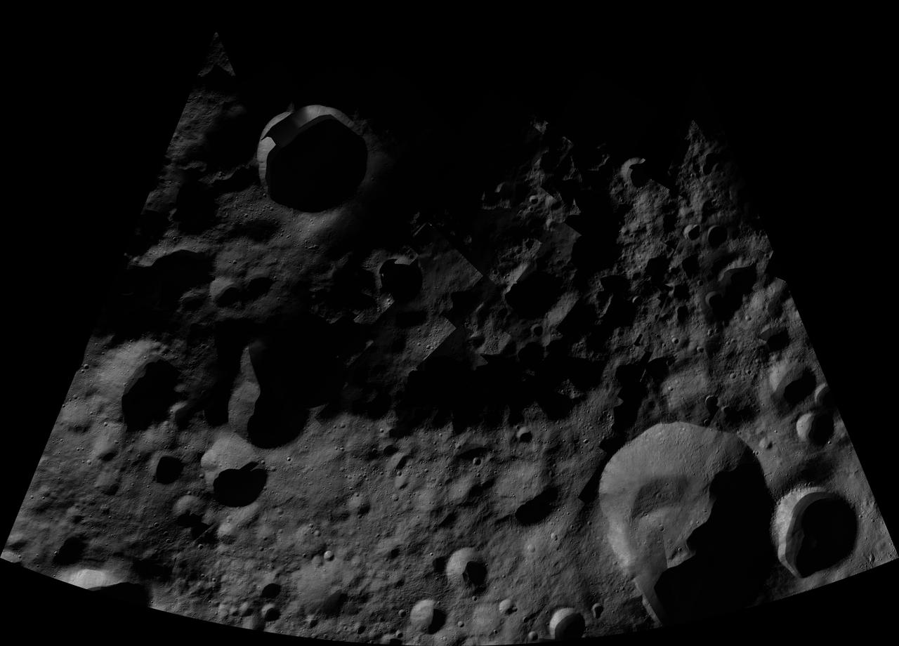
This image of Caparronia AV-L-04, from the atlas of the giant asteroid Vesta, was created from images taken as NASA Dawn mission flew around the object, also known as a protoplanet. The set of maps was created from mosaics of10,000 images from Dawn's framing camera instrument, taken at a low altitude of about 130 miles (210 kilometers). This map is mostly at a scale about that of regional road touring maps, where every inch of map is equivalent to a little more than 3 miles of asteroid (one centimeter equals 2 kilometers). http://photojournal.jpl.nasa.gov/catalog/PIA19508
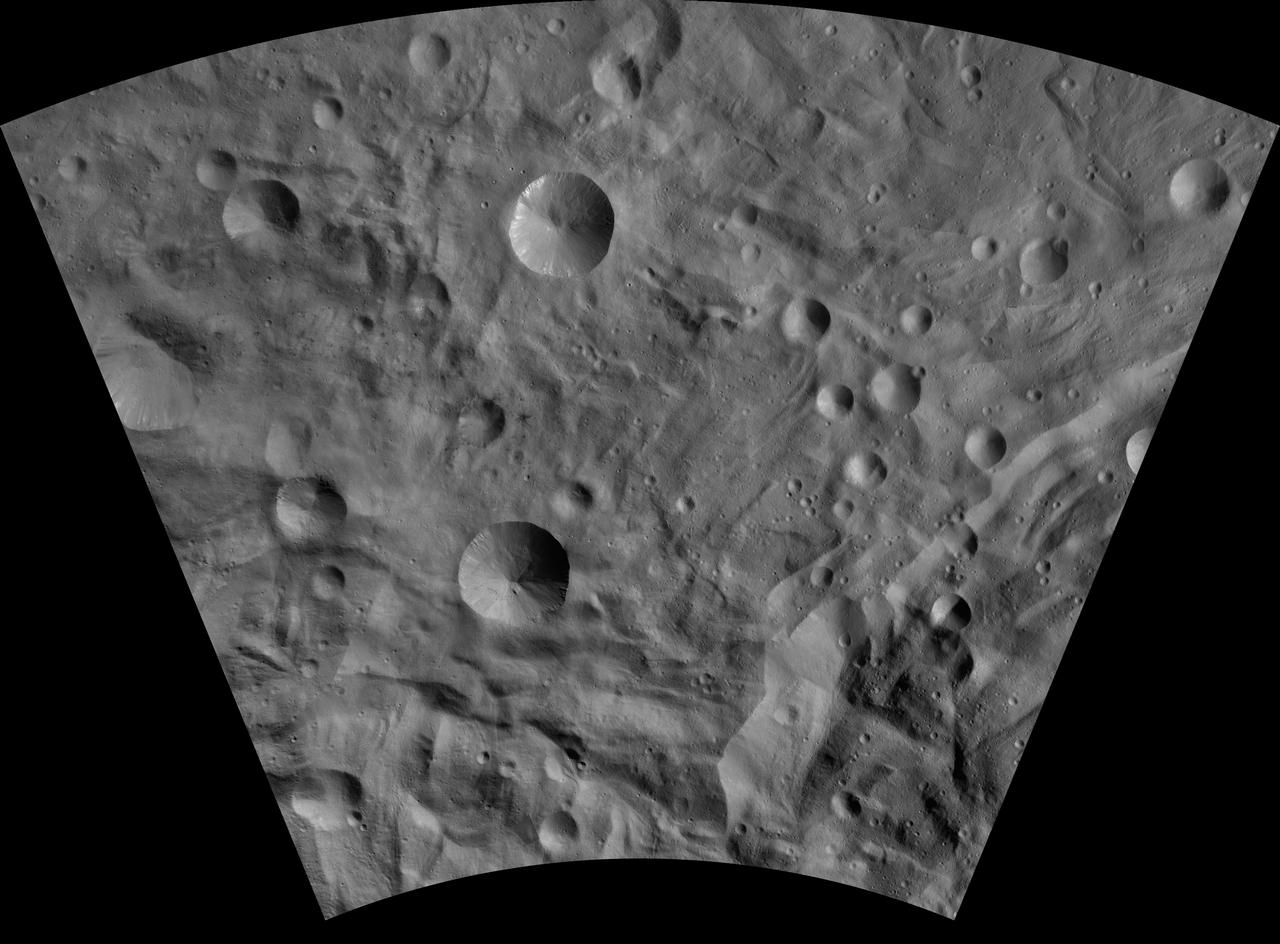
This image of Sextilia AV-L-26, from the atlas of the giant asteroid Vesta, was created from images taken as NASA Dawn mission flew around the object, also known as a protoplanet. The set of maps was created from mosaics of10,000 images from Dawn's framing camera instrument, taken at a low altitude of about 130 miles (210 kilometers). This map is mostly at a scale about that of regional road touring maps, where every inch of map is equivalent to a little more than 3 miles of asteroid (one centimeter equals 2 kilometers). http://photojournal.jpl.nasa.gov/catalog/PIA19530
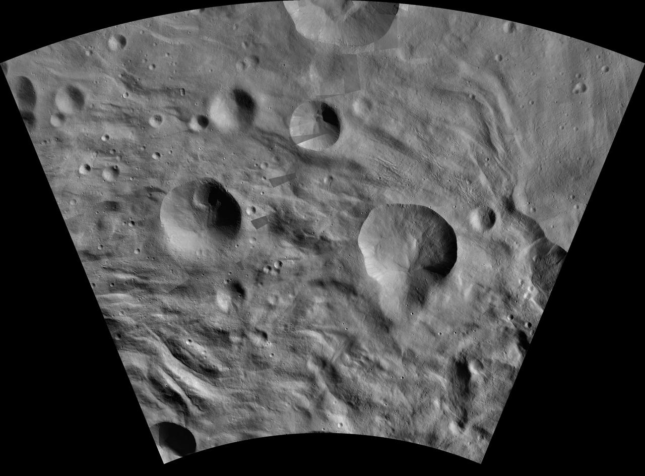
This image of Aquilia AV-L-24, from the atlas of the giant asteroid Vesta, was created from images taken as NASA Dawn mission flew around the object, also known as a protoplanet. The set of maps was created from mosaics of10,000 images from Dawn's framing camera instrument, taken at a low altitude of about 130 miles (210 kilometers). This map is mostly at a scale about that of regional road touring maps, where every inch of map is equivalent to a little more than 3 miles of asteroid (one centimeter equals 2 kilometers). http://photojournal.jpl.nasa.gov/catalog/PIA19528
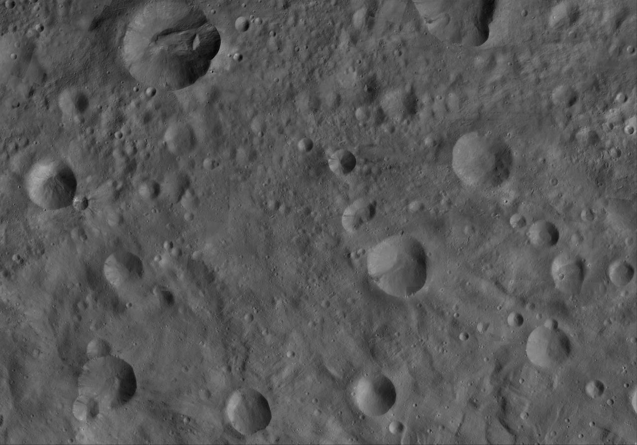
This image of Octavia AV-L-19, from the atlas of the giant asteroid Vesta, was created from images taken as NASA Dawn mission flew around the object, also known as a protoplanet. The set of maps was created from mosaics of10,000 images from Dawn's framing camera instrument, taken at a low altitude of about 130 miles (210 kilometers). This map is mostly at a scale about that of regional road touring maps, where every inch of map is equivalent to a little more than 3 miles of asteroid (one centimeter equals 2 kilometers). http://photojournal.jpl.nasa.gov/catalog/PIA19523
This image of Eutropia AV-L-10, from the atlas of the giant asteroid Vesta, was created from images taken as NASA Dawn mission flew around the object, also known as a protoplanet. The set of maps was created from mosaics of10,000 images from Dawn's framing camera instrument, taken at a low altitude of about 130 miles (210 kilometers). This map is mostly at a scale about that of regional road touring maps, where every inch of map is equivalent to a little more than 3 miles of asteroid (one centimeter equals 2 kilometers). http://photojournal.jpl.nasa.gov/catalog/PIA19514

This image of Canuleia AV-L-28, from the atlas of the giant asteroid Vesta, was created from images taken as NASA Dawn mission flew around the object, also known as a protoplanet. The set of maps was created from mosaics of10,000 images from Dawn's framing camera instrument, taken at a low altitude of about 130 miles (210 kilometers). This map is mostly at a scale about that of regional road touring maps, where every inch of map is equivalent to a little more than 3 miles of asteroid (one centimeter equals 2 kilometers). http://photojournal.jpl.nasa.gov/catalog/PIA19532
This image of Eusebia AV-L-27, from the atlas of the giant asteroid Vesta, was created from images taken as NASA Dawn mission flew around the object, also known as a protoplanet. The set of maps was created from mosaics of10,000 images from Dawn's framing camera instrument, taken at a low altitude of about 130 miles (210 kilometers). This map is mostly at a scale about that of regional road touring maps, where every inch of map is equivalent to a little more than 3 miles of asteroid (one centimeter equals 2 kilometers). http://photojournal.jpl.nasa.gov/catalog/PIA19531

View of Extravehicular Mobility Unit (EMU) with geocaching travel bug,in the airlock (A/L). Photo was taken during Expedition 38. Image was released by astronaut on Twitter.
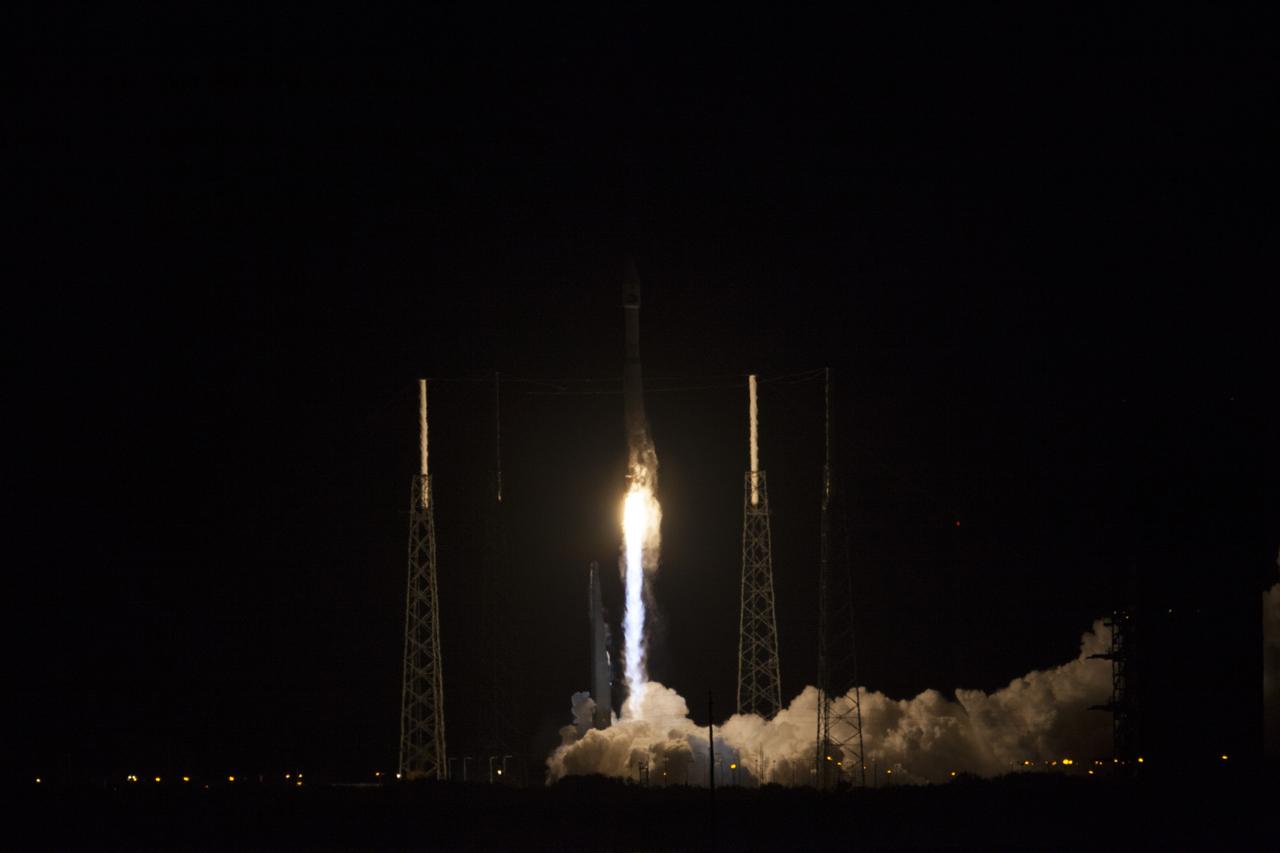
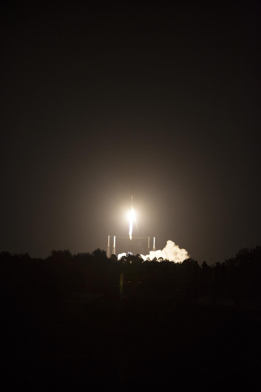
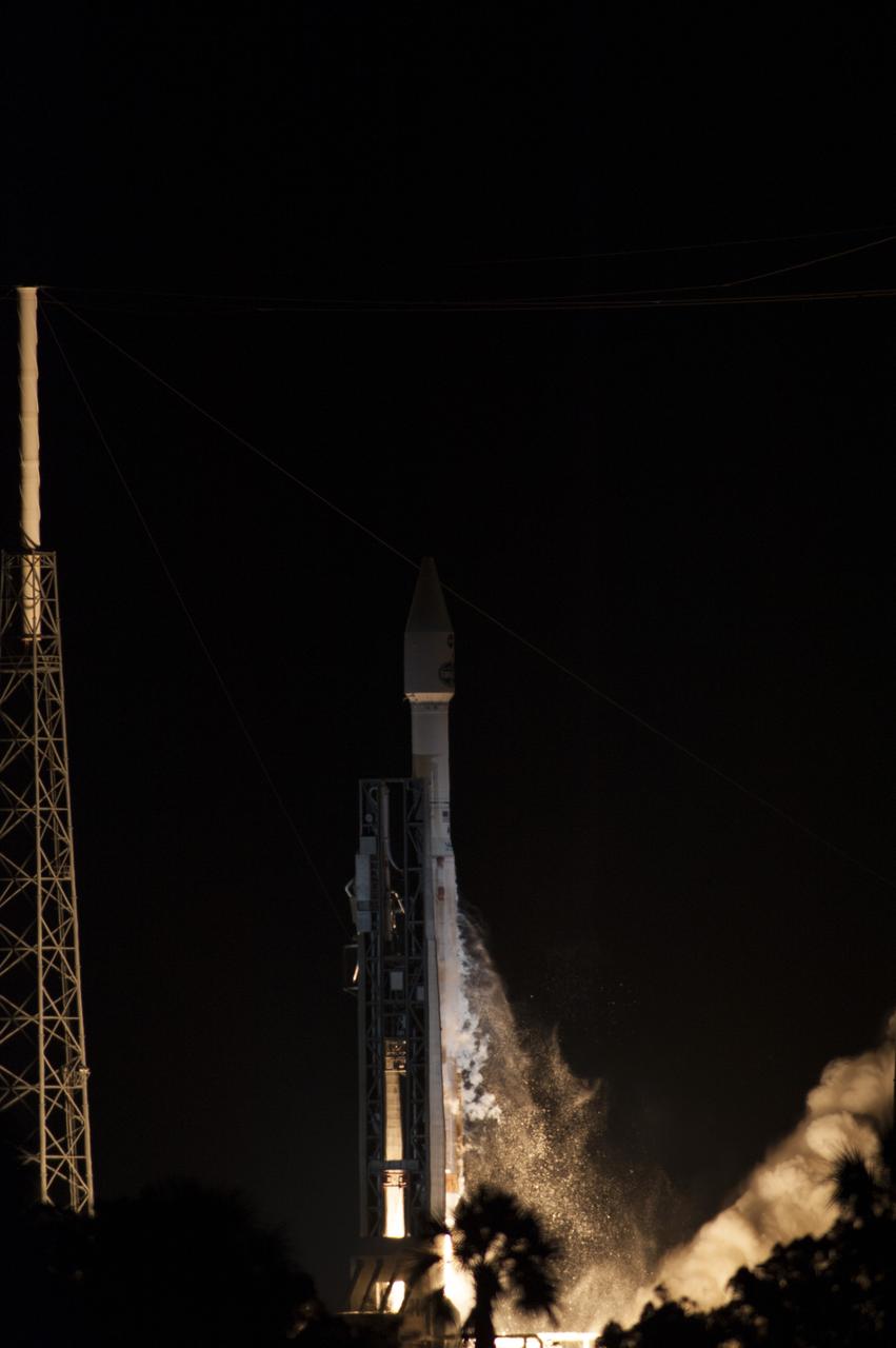
CAPE CANAVERAL, Fla. -- The exhaust plume builds at Space Launch Complex 41 on Cape Canaveral Air Force Station in Florida as the engines ignite under the United Launch Alliance Atlas V rocket carrying NASA's Tracking and Data Relay Satellite, or TDRS-L, to Earth orbit. Launch was at 9:33 p.m. EST Jan. 23 during a 40-minute launch window. The TDRS-L spacecraft is the second of three new satellites designed to ensure vital operational continuity for NASA by expanding the lifespan of the Tracking and Data Relay Satellite System TDRSS fleet, which consists of eight satellites in geosynchronous orbit. The spacecraft provide tracking, telemetry, command and high-bandwidth data return services for numerous science and human exploration missions orbiting Earth. These include NASA's Hubble Space Telescope and the International Space Station. TDRS-L has a high-performance solar panel designed for more spacecraft power to meet the growing S-band communications requirements. TDRSS is one of three NASA Space Communication and Navigation SCaN networks providing space communications to NASA’s missions. For more information more about TDRS-L, visit http://www.nasa.gov/tdrs. To learn more about SCaN, visit www.nasa.gov/scan. Photo credit: NASA/Kim Shiflett
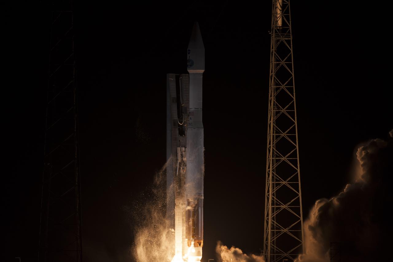
CAPE CANAVERAL, Fla. – The dual rocket engines beneath the United Launch Alliance Atlas V are ablaze as the rocket lifts off Space Launch Complex 41 on Cape Canaveral Air Force Station in Florida, carrying NASA's Tracking and Data Relay Satellite, or TDRS-L, to Earth orbit. Liftoff was at 9:33 p.m. EST Jan. 23 during a 40-minute launch window. The TDRS-L spacecraft is the second of three new satellites designed to ensure vital operational continuity for NASA by expanding the lifespan of the Tracking and Data Relay Satellite System TDRSS fleet, which consists of eight satellites in geosynchronous orbit. The spacecraft provide tracking, telemetry, command and high-bandwidth data return services for numerous science and human exploration missions orbiting Earth. These include NASA's Hubble Space Telescope and the International Space Station. TDRS-L has a high-performance solar panel designed for more spacecraft power to meet the growing S-band communications requirements. TDRSS is one of three NASA Space Communication and Navigation SCaN networks providing space communications to NASA’s missions. For more information more about TDRS-L, visit http://www.nasa.gov/tdrs. To learn more about SCaN, visit www.nasa.gov/scan. Photo credit: NASA/George Roberts
CAPE CANAVERAL, Fla. -- An exhaust plume forms at Space Launch Complex 41 on Cape Canaveral Air Force Station in Florida as the engines ignite under the United Launch Alliance Atlas V rocket carrying NASA's Tracking and Data Relay Satellite, or TDRS-L, to Earth orbit. Launch was at 9:33 p.m. EST Jan. 23 during a 40-minute launch window. The TDRS-L spacecraft is the second of three new satellites designed to ensure vital operational continuity for NASA by expanding the lifespan of the Tracking and Data Relay Satellite System TDRSS fleet, which consists of eight satellites in geosynchronous orbit. The spacecraft provide tracking, telemetry, command and high-bandwidth data return services for numerous science and human exploration missions orbiting Earth. These include NASA's Hubble Space Telescope and the International Space Station. TDRS-L has a high-performance solar panel designed for more spacecraft power to meet the growing S-band communications requirements. TDRSS is one of three NASA Space Communication and Navigation SCaN networks providing space communications to NASA’s missions. For more information more about TDRS-L, visit http://www.nasa.gov/tdrs. To learn more about SCaN, visit www.nasa.gov/scan. Photo credit: NASA/Kim Shiflett
CAPE CANAVERAL, Fla. -- The exhaust plume builds at Space Launch Complex 41 on Cape Canaveral Air Force Station in Florida following engine ignition under the United Launch Alliance Atlas V rocket carrying NASA's Tracking and Data Relay Satellite, or TDRS-L, to Earth orbit. Launch was at 9:33 p.m. EST Jan. 23 during a 40-minute launch window. The TDRS-L spacecraft is the second of three new satellites designed to ensure vital operational continuity for NASA by expanding the lifespan of the Tracking and Data Relay Satellite System TDRSS fleet, which consists of eight satellites in geosynchronous orbit. The spacecraft provide tracking, telemetry, command and high-bandwidth data return services for numerous science and human exploration missions orbiting Earth. These include NASA's Hubble Space Telescope and the International Space Station. TDRS-L has a high-performance solar panel designed for more spacecraft power to meet the growing S-band communications requirements. TDRSS is one of three NASA Space Communication and Navigation SCaN networks providing space communications to NASA’s missions. For more information more about TDRS-L, visit http://www.nasa.gov/tdrs. To learn more about SCaN, visit www.nasa.gov/scan. Photo credit: NASA/Dan Casper
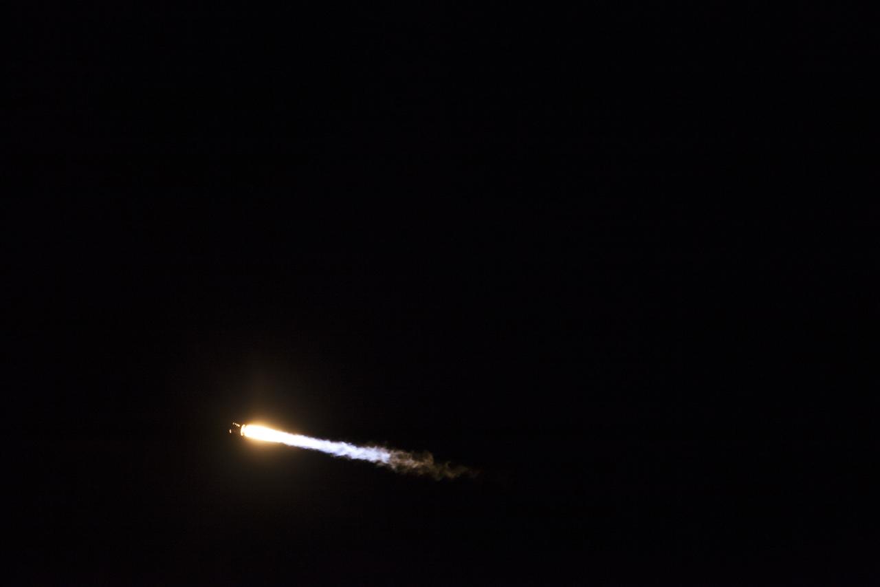
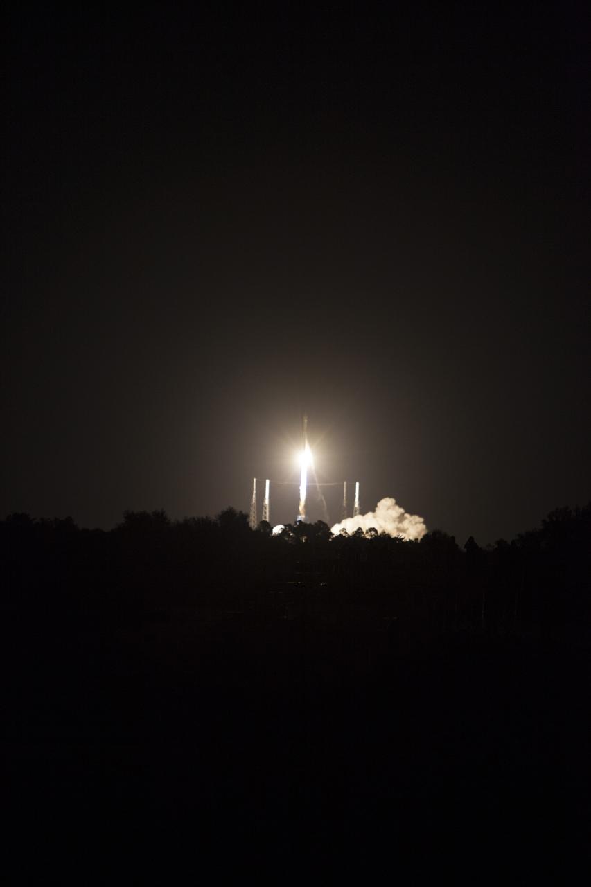
CAPE CANAVERAL, Fla. -- A United Launch Alliance Atlas V rocket streaks through the night sky over Space Launch Complex 41 at Cape Canaveral Air Force Station in Florida, carrying NASA's Tracking and Data Relay Satellite, or TDRS-L, to Earth orbit. Launch was at 9:33 p.m. EST Jan. 23 during a 40-minute launch window. The TDRS-L spacecraft is the second of three new satellites designed to ensure vital operational continuity for NASA by expanding the lifespan of the Tracking and Data Relay Satellite System TDRSS fleet, which consists of eight satellites in geosynchronous orbit. The spacecraft provide tracking, telemetry, command and high-bandwidth data return services for numerous science and human exploration missions orbiting Earth. These include NASA's Hubble Space Telescope and the International Space Station. TDRS-L has a high-performance solar panel designed for more spacecraft power to meet the growing S-band communications requirements. TDRSS is one of three NASA Space Communication and Navigation SCaN networks providing space communications to NASA’s missions. For more information more about TDRS-L, visit http://www.nasa.gov/tdrs. To learn more about SCaN, visit www.nasa.gov/scan. Photo credit: NASA/Kim Shiflett
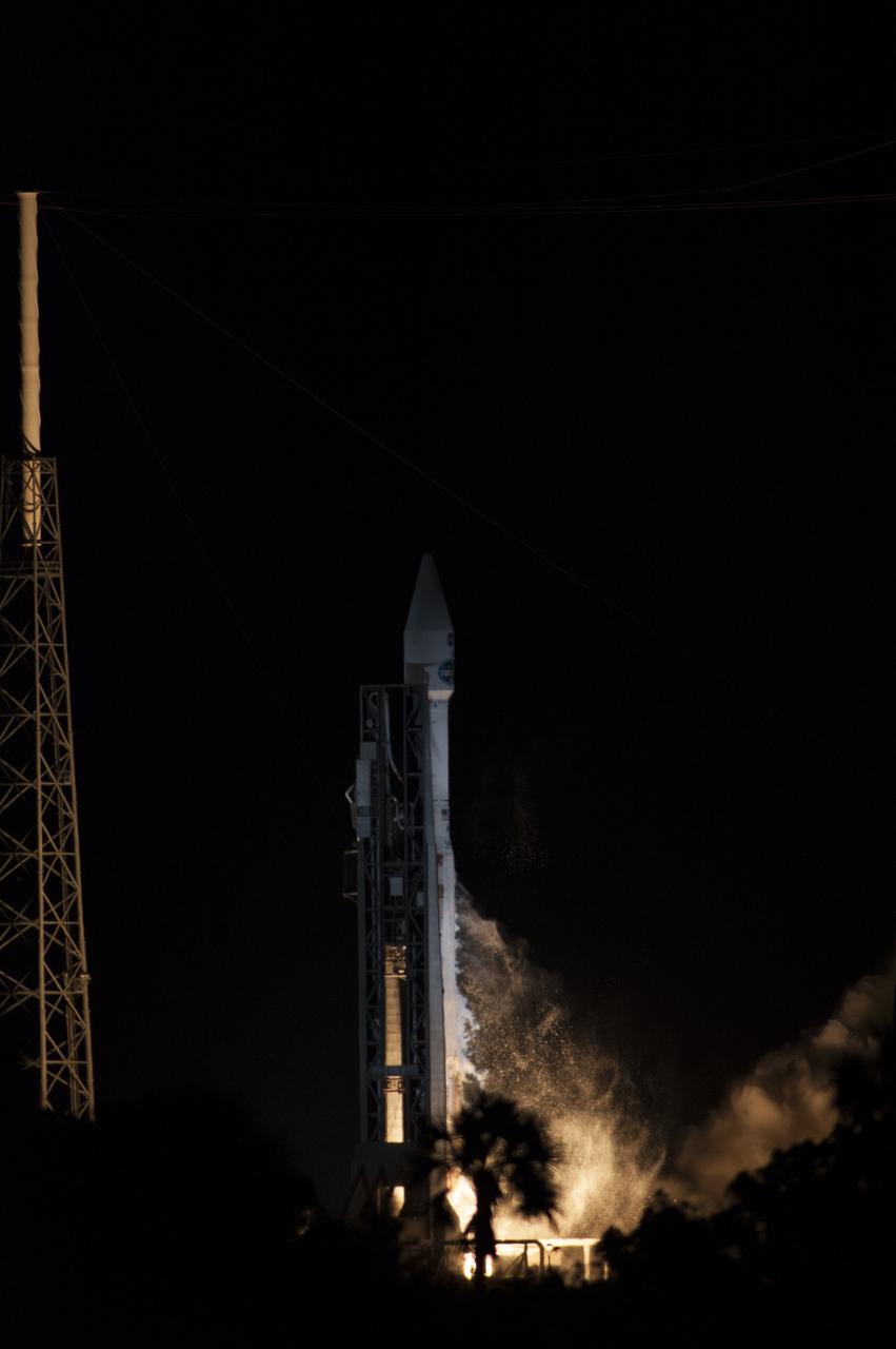
CAPE CANAVERAL, Fla. -- An exhaust plume forms at Space Launch Complex 41 on Cape Canaveral Air Force Station in Florida as the engines ignite under the United Launch Alliance Atlas V rocket carrying NASA's Tracking and Data Relay Satellite, or TDRS-L, to Earth orbit. Launch was at 9:33 p.m. EST Jan. 23 during a 40-minute launch window. The TDRS-L spacecraft is the second of three new satellites designed to ensure vital operational continuity for NASA by expanding the lifespan of the Tracking and Data Relay Satellite System TDRSS fleet, which consists of eight satellites in geosynchronous orbit. The spacecraft provide tracking, telemetry, command and high-bandwidth data return services for numerous science and human exploration missions orbiting Earth. These include NASA's Hubble Space Telescope and the International Space Station. TDRS-L has a high-performance solar panel designed for more spacecraft power to meet the growing S-band communications requirements. TDRSS is one of three NASA Space Communication and Navigation SCaN networks providing space communications to NASA’s missions. For more information more about TDRS-L, visit http://www.nasa.gov/tdrs. To learn more about SCaN, visit www.nasa.gov/scan. Photo credit: NASA/Kevin O'Connell

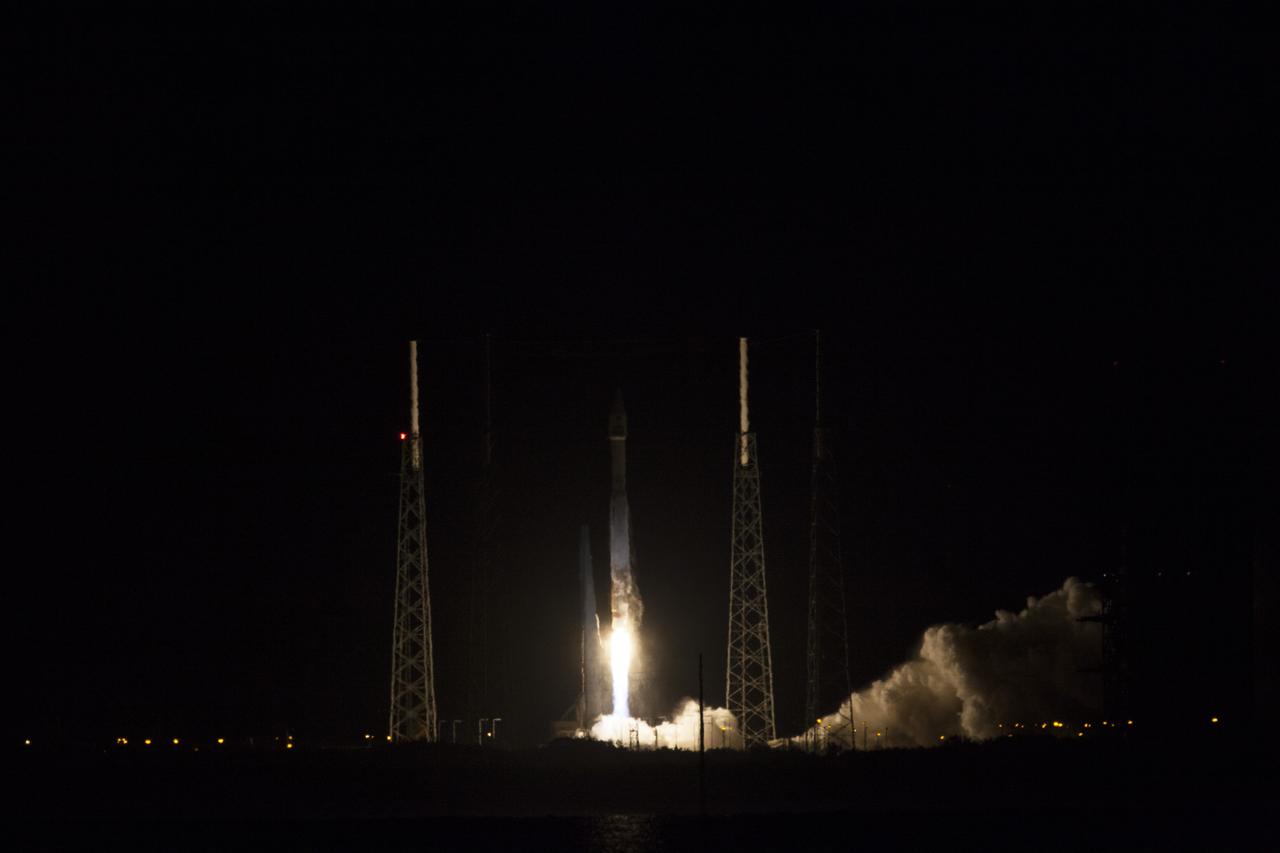
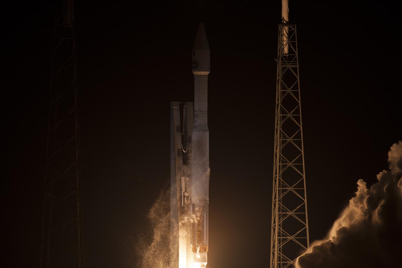
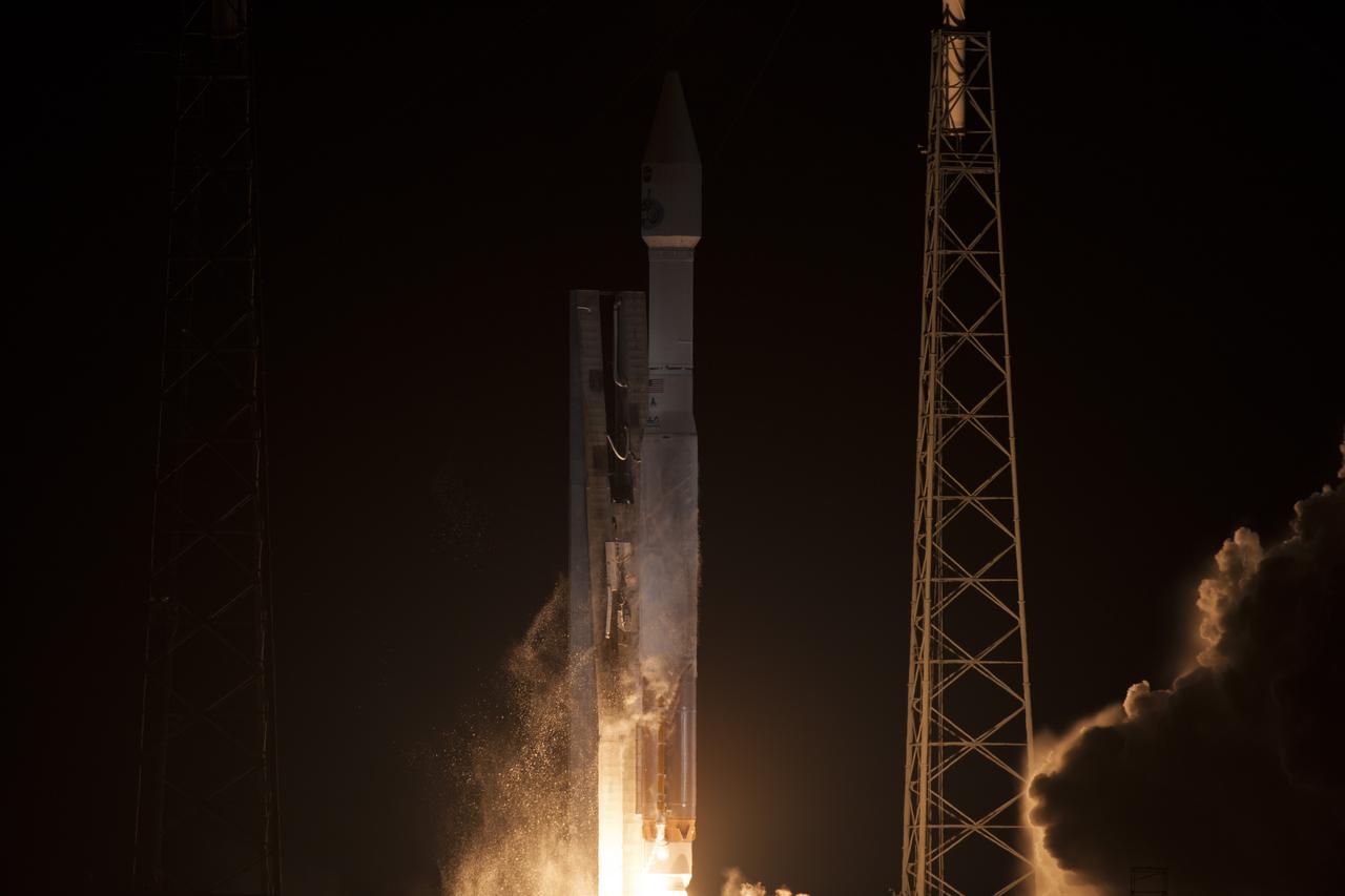
CAPE CANAVERAL, Fla. -- The engines ignite under the United Launch Alliance Atlas V rocket, lifting NASA's Tracking and Data Relay Satellite, or TDRS-L, off Space Launch Complex 41 on Cape Canaveral Air Force Station in Florida. Launch was at 9:33 p.m. EST Jan. 23 during a 40-minute launch window. The TDRS-L spacecraft is the second of three new satellites designed to ensure vital operational continuity for NASA by expanding the lifespan of the Tracking and Data Relay Satellite System TDRSS fleet, which consists of eight satellites in geosynchronous orbit. The spacecraft provide tracking, telemetry, command and high-bandwidth data return services for numerous science and human exploration missions orbiting Earth. These include NASA's Hubble Space Telescope and the International Space Station. TDRS-L has a high-performance solar panel designed for more spacecraft power to meet the growing S-band communications requirements. TDRSS is one of three NASA Space Communication and Navigation SCaN networks providing space communications to NASA’s missions. For more information more about TDRS-L, visit http://www.nasa.gov/tdrs. To learn more about SCaN, visit www.nasa.gov/scan. Photo credit: NASA/Frankie Martin
CAPE CANAVERAL, Fla. – A United Launch Alliance Atlas V rocket lifts off from Space Launch Complex 41 on Cape Canaveral Air Force Station carrying NASA's Tracking and Data Relay Satellite, or TDRS-L, to Earth orbit. Liftoff was at 9:33 p.m. EST Jan. 23 during a 40-minute launch window. The TDRS-L spacecraft is the second of three new satellites designed to ensure vital operational continuity for NASA by expanding the lifespan of the Tracking and Data Relay Satellite System TDRSS fleet, which consists of eight satellites in geosynchronous orbit. The spacecraft provide tracking, telemetry, command and high-bandwidth data return services for numerous science and human exploration missions orbiting Earth. These include NASA's Hubble Space Telescope and the International Space Station. TDRS-L has a high-performance solar panel designed for more spacecraft power to meet the growing S-band communications requirements. TDRSS is one of three NASA Space Communication and Navigation SCaN networks providing space communications to NASA’s missions. For more information more about TDRS-L, visit http://www.nasa.gov/tdrs. To learn more about SCaN, visit www.nasa.gov/scan. Photo credit: NASA/Frankie Martin
CAPE CANAVERAL, Fla. -- The exhaust plume builds at Space Launch Complex 41 on Cape Canaveral Air Force Station in Florida following engine ignition under the United Launch Alliance Atlas V rocket carrying NASA's Tracking and Data Relay Satellite, or TDRS-L, to Earth orbit. Launch was at 9:33 p.m. EST Jan. 23 during a 40-minute launch window. The TDRS-L spacecraft is the second of three new satellites designed to ensure vital operational continuity for NASA by expanding the lifespan of the Tracking and Data Relay Satellite System TDRSS fleet, which consists of eight satellites in geosynchronous orbit. The spacecraft provide tracking, telemetry, command and high-bandwidth data return services for numerous science and human exploration missions orbiting Earth. These include NASA's Hubble Space Telescope and the International Space Station. TDRS-L has a high-performance solar panel designed for more spacecraft power to meet the growing S-band communications requirements. TDRSS is one of three NASA Space Communication and Navigation SCaN networks providing space communications to NASA’s missions. For more information more about TDRS-L, visit http://www.nasa.gov/tdrs. To learn more about SCaN, visit www.nasa.gov/scan. Photo credit: NASA/George Roberts
CAPE CANAVERAL, Fla. -- An exhaust plume forms at Space Launch Complex 41 on Cape Canaveral Air Force Station in Florida as the engines ignite under the United Launch Alliance Atlas V rocket carrying NASA's Tracking and Data Relay Satellite, or TDRS-L, to Earth orbit. Launch was at 9:33 p.m. EST Jan. 23 during a 40-minute launch window. The TDRS-L spacecraft is the second of three new satellites designed to ensure vital operational continuity for NASA by expanding the lifespan of the Tracking and Data Relay Satellite System TDRSS fleet, which consists of eight satellites in geosynchronous orbit. The spacecraft provide tracking, telemetry, command and high-bandwidth data return services for numerous science and human exploration missions orbiting Earth. These include NASA's Hubble Space Telescope and the International Space Station. TDRS-L has a high-performance solar panel designed for more spacecraft power to meet the growing S-band communications requirements. TDRSS is one of three NASA Space Communication and Navigation SCaN networks providing space communications to NASA’s missions. For more information more about TDRS-L, visit http://www.nasa.gov/tdrs. To learn more about SCaN, visit www.nasa.gov/scan. Photo credit: NASA/George Roberts

CAPE CANAVERAL, Fla. -- The engines ignite under the United Launch Alliance Atlas V rocket, lifting NASA's Tracking and Data Relay Satellite, or TDRS-L, off Space Launch Complex 41 on Cape Canaveral Air Force Station in Florida. Launch was at 9:33 p.m. EST Jan. 23 during a 40-minute launch window. The TDRS-L spacecraft is the second of three new satellites designed to ensure vital operational continuity for NASA by expanding the lifespan of the Tracking and Data Relay Satellite System TDRSS fleet, which consists of eight satellites in geosynchronous orbit. The spacecraft provide tracking, telemetry, command and high-bandwidth data return services for numerous science and human exploration missions orbiting Earth. These include NASA's Hubble Space Telescope and the International Space Station. TDRS-L has a high-performance solar panel designed for more spacecraft power to meet the growing S-band communications requirements. TDRSS is one of three NASA Space Communication and Navigation SCaN networks providing space communications to NASA’s missions. For more information more about TDRS-L, visit http://www.nasa.gov/tdrs. To learn more about SCaN, visit www.nasa.gov/scan. Photo credit: NASA/Kim Shiflett
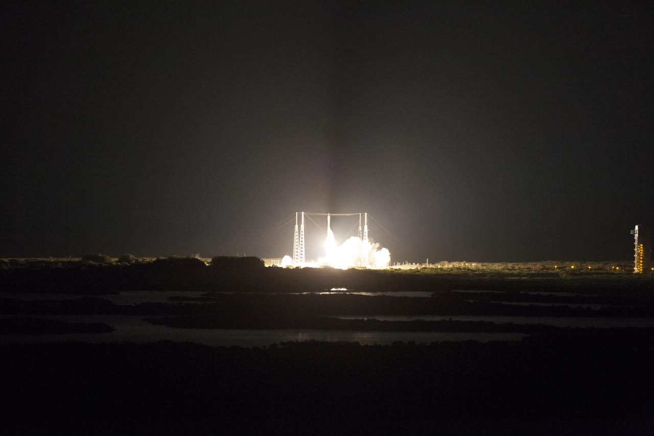
CAPE CANAVERAL, Fla. -- The United Launch Alliance Atlas V rocket carrying NASA's Tracking and Data Relay Satellite, or TDRS-L, soars off Space Launch Complex 41 on Cape Canaveral Air Force Station in Florida. Launch was at 9:33 p.m. EST Jan. 23 during a 40-minute launch window. The TDRS-L spacecraft is the second of three new satellites designed to ensure vital operational continuity for NASA by expanding the lifespan of the Tracking and Data Relay Satellite System TDRSS fleet, which consists of eight satellites in geosynchronous orbit. The spacecraft provide tracking, telemetry, command and high-bandwidth data return services for numerous science and human exploration missions orbiting Earth. These include NASA's Hubble Space Telescope and the International Space Station. TDRS-L has a high-performance solar panel designed for more spacecraft power to meet the growing S-band communications requirements. TDRSS is one of three NASA Space Communication and Navigation SCaN networks providing space communications to NASA’s missions. For more information more about TDRS-L, visit http://www.nasa.gov/tdrs. To learn more about SCaN, visit www.nasa.gov/scan. Photo credit: NASA/Frankie Martin
CAPE CANAVERAL, Fla. -- The United Launch Alliance Atlas V rocket carrying NASA's Tracking and Data Relay Satellite, or TDRS-L, rises off Space Launch Complex 41 on Cape Canaveral Air Force Station in Florida. Launch was at 9:33 p.m. EST Jan. 23 during a 40-minute launch window. The TDRS-L spacecraft is the second of three new satellites designed to ensure vital operational continuity for NASA by expanding the lifespan of the Tracking and Data Relay Satellite System TDRSS fleet, which consists of eight satellites in geosynchronous orbit. The spacecraft provide tracking, telemetry, command and high-bandwidth data return services for numerous science and human exploration missions orbiting Earth. These include NASA's Hubble Space Telescope and the International Space Station. TDRS-L has a high-performance solar panel designed for more spacecraft power to meet the growing S-band communications requirements. TDRSS is one of three NASA Space Communication and Navigation SCaN networks providing space communications to NASA’s missions. For more information more about TDRS-L, visit http://www.nasa.gov/tdrs. To learn more about SCaN, visit www.nasa.gov/scan. Photo credit: NASA/Kevin O'Connell
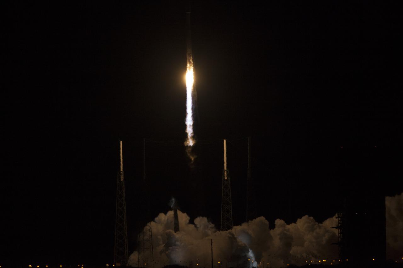
CAPE CANAVERAL, Fla. -- A United Launch Alliance Atlas V rocket streaks into the night from Space Launch Complex 41 at Cape Canaveral Air Force Station in Florida, carrying NASA's Tracking and Data Relay Satellite, or TDRS-L, to Earth orbit. Launch was at 9:33 p.m. EST Jan. 23 during a 40-minute launch window. The TDRS-L spacecraft is the second of three new satellites designed to ensure vital operational continuity for NASA by expanding the lifespan of the Tracking and Data Relay Satellite System TDRSS fleet, which consists of eight satellites in geosynchronous orbit. The spacecraft provide tracking, telemetry, command and high-bandwidth data return services for numerous science and human exploration missions orbiting Earth. These include NASA's Hubble Space Telescope and the International Space Station. TDRS-L has a high-performance solar panel designed for more spacecraft power to meet the growing S-band communications requirements. TDRSS is one of three NASA Space Communication and Navigation SCaN networks providing space communications to NASA’s missions. For more information more about TDRS-L, visit http://www.nasa.gov/tdrs. To learn more about SCaN, visit www.nasa.gov/scan. Photo credit: NASA/Kim Shiflett
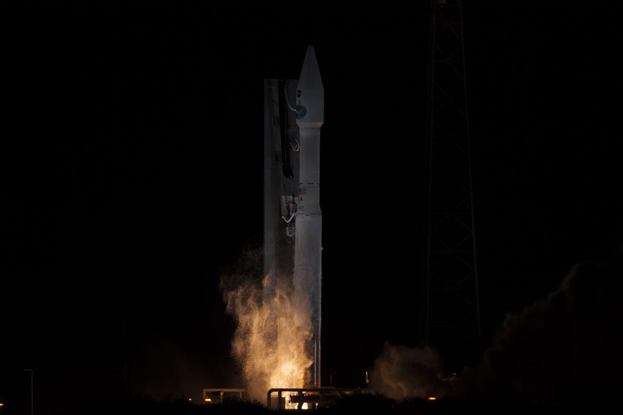
CAPE CANAVERAL, Fla. – At Space Launch Complex 41 on Cape Canaveral Air Force Station in Florida, dual rocket engines roar to life under the United Launch Alliance Atlas V rocket that will boost NASA's Tracking and Data Relay Satellite, or TDRS-L, to Earth orbit. Liftoff was at 9:33 p.m. EST Jan. 23 during a 40-minute launch window. The TDRS-L spacecraft is the second of three new satellites designed to ensure vital operational continuity for NASA by expanding the lifespan of the Tracking and Data Relay Satellite System TDRSS fleet, which consists of eight satellites in geosynchronous orbit. The spacecraft provide tracking, telemetry, command and high-bandwidth data return services for numerous science and human exploration missions orbiting Earth. These include NASA's Hubble Space Telescope and the International Space Station. TDRS-L has a high-performance solar panel designed for more spacecraft power to meet the growing S-band communications requirements. TDRSS is one of three NASA Space Communication and Navigation SCaN networks providing space communications to NASA’s missions. For more information more about TDRS-L, visit http://www.nasa.gov/tdrs. To learn more about SCaN, visit www.nasa.gov/scan. Photo credit: NASA/George Roberts
CAPE CANAVERAL, Fla. -- A United Launch Alliance Atlas V rocket soars into the night from Space Launch Complex 41 at Cape Canaveral Air Force Station in Florida, carrying NASA's Tracking and Data Relay Satellite, or TDRS-L, to Earth orbit. Launch was at 9:33 p.m. EST Jan. 23 during a 40-minute launch window. The TDRS-L spacecraft is the second of three new satellites designed to ensure vital operational continuity for NASA by expanding the lifespan of the Tracking and Data Relay Satellite System TDRSS fleet, which consists of eight satellites in geosynchronous orbit. The spacecraft provide tracking, telemetry, command and high-bandwidth data return services for numerous science and human exploration missions orbiting Earth. These include NASA's Hubble Space Telescope and the International Space Station. TDRS-L has a high-performance solar panel designed for more spacecraft power to meet the growing S-band communications requirements. TDRSS is one of three NASA Space Communication and Navigation SCaN networks providing space communications to NASA’s missions. For more information more about TDRS-L, visit http://www.nasa.gov/tdrs. To learn more about SCaN, visit www.nasa.gov/scan. Photo credit: NASA/Frankie Martin

CAPE CANAVERAL, Fla. -- Obscured in darkness, a United Launch Alliance Atlas V rocket soars past the lightning protection masts on Space Launch Complex 41 at Cape Canaveral Air Force Station in Florida, carrying NASA's Tracking and Data Relay Satellite, or TDRS-L, to Earth orbit. Launch was at 9:33 p.m. EST Jan. 23 during a 40-minute launch window. The TDRS-L spacecraft is the second of three new satellites designed to ensure vital operational continuity for NASA by expanding the lifespan of the Tracking and Data Relay Satellite System TDRSS fleet, which consists of eight satellites in geosynchronous orbit. The spacecraft provide tracking, telemetry, command and high-bandwidth data return services for numerous science and human exploration missions orbiting Earth. These include NASA's Hubble Space Telescope and the International Space Station. TDRS-L has a high-performance solar panel designed for more spacecraft power to meet the growing S-band communications requirements. TDRSS is one of three NASA Space Communication and Navigation SCaN networks providing space communications to NASA’s missions. For more information more about TDRS-L, visit http://www.nasa.gov/tdrs. To learn more about SCaN, visit www.nasa.gov/scan. Photo credit: NASA/George Roberts
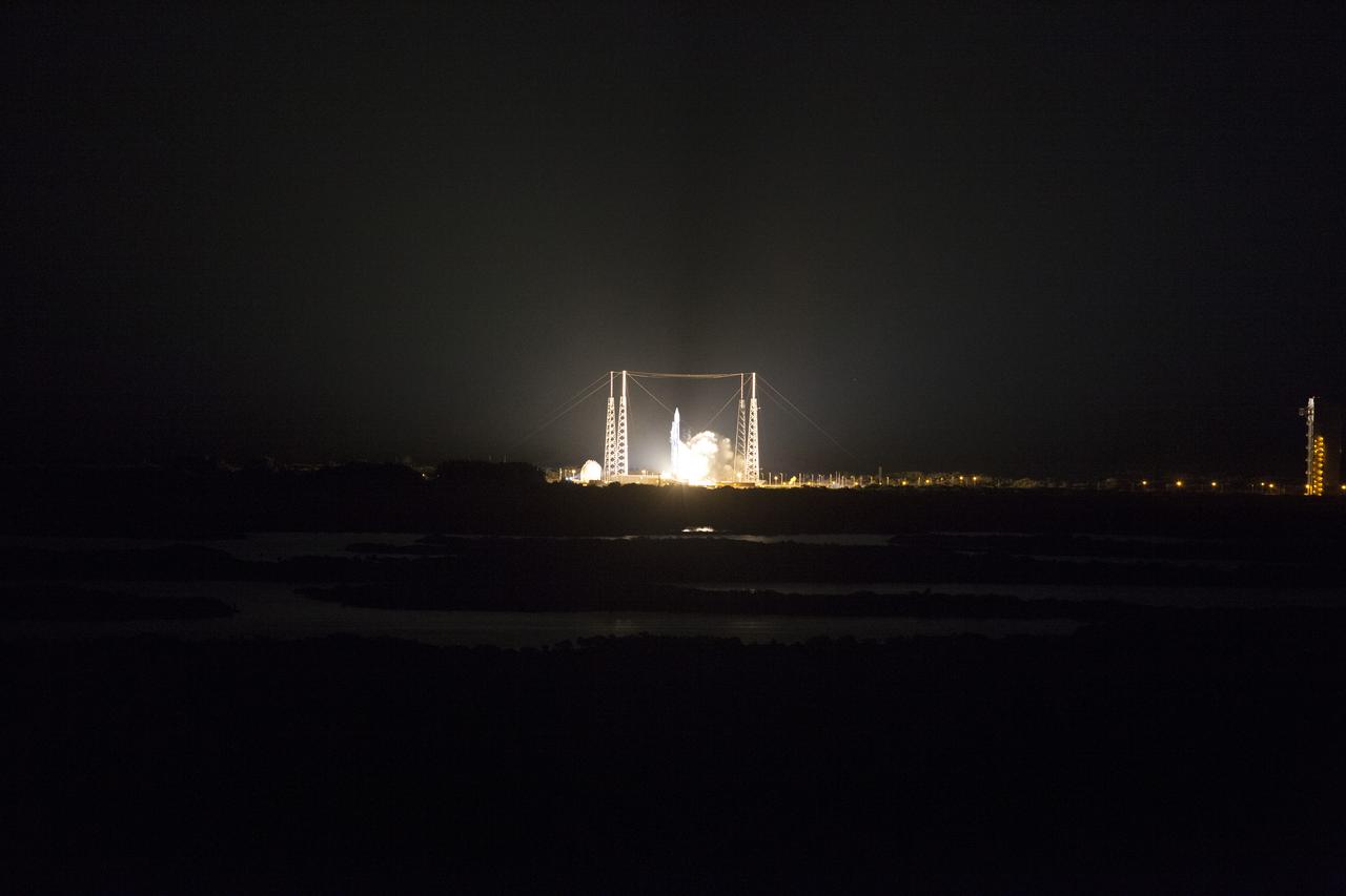
CAPE CANAVERAL, Fla. – Dual rocket engines roar to life under the United Launch Alliance Atlas V rocket at Space Launch Complex 41 on Cape Canaveral Air Force Station in Florida that will boost NASA's Tracking and Data Relay Satellite, or TDRS-L, to Earth orbit. Liftoff was at 9:33 p.m. EST Jan. 23 during a 40-minute launch window. The TDRS-L spacecraft is the second of three new satellites designed to ensure vital operational continuity for NASA by expanding the lifespan of the Tracking and Data Relay Satellite System TDRSS fleet, which consists of eight satellites in geosynchronous orbit. The spacecraft provide tracking, telemetry, command and high-bandwidth data return services for numerous science and human exploration missions orbiting Earth. These include NASA's Hubble Space Telescope and the International Space Station. TDRS-L has a high-performance solar panel designed for more spacecraft power to meet the growing S-band communications requirements. TDRSS is one of three NASA Space Communication and Navigation SCaN networks providing space communications to NASA’s missions. For more information more about TDRS-L, visit http://www.nasa.gov/tdrs. To learn more about SCaN, visit www.nasa.gov/scan. Photo credit: NASA/Dan Casper
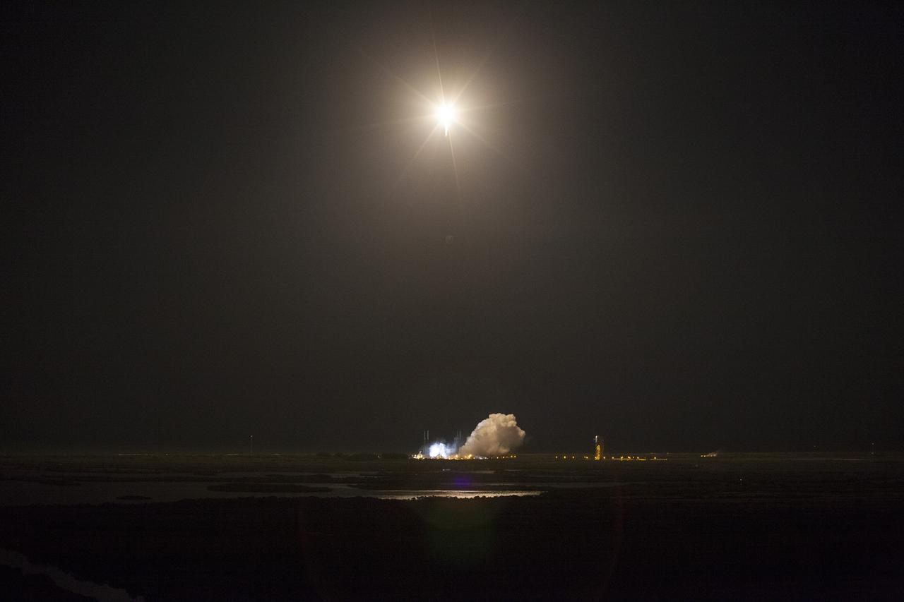
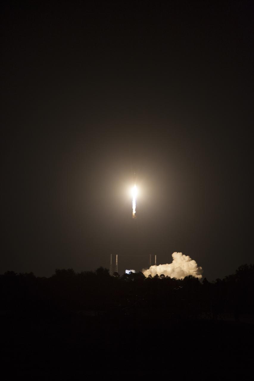
CAPE CANAVERAL, Fla. -- Only the exhaust plume remains at Space Launch Complex 41 on Cape Canaveral Air Force Station in Florida as the United Launch Alliance Atlas V rocket carrying NASA's Tracking and Data Relay Satellite, or TDRS-L, to Earth orbit soars into the night. Launch was at 9:33 p.m. EST Jan. 23 during a 40-minute launch window. The TDRS-L spacecraft is the second of three new satellites designed to ensure vital operational continuity for NASA by expanding the lifespan of the Tracking and Data Relay Satellite System TDRSS fleet, which consists of eight satellites in geosynchronous orbit. The spacecraft provide tracking, telemetry, command and high-bandwidth data return services for numerous science and human exploration missions orbiting Earth. These include NASA's Hubble Space Telescope and the International Space Station. TDRS-L has a high-performance solar panel designed for more spacecraft power to meet the growing S-band communications requirements. TDRSS is one of three NASA Space Communication and Navigation SCaN networks providing space communications to NASA’s missions. For more information more about TDRS-L, visit http://www.nasa.gov/tdrs. To learn more about SCaN, visit www.nasa.gov/scan. Photo credit: NASA/Dan Casper
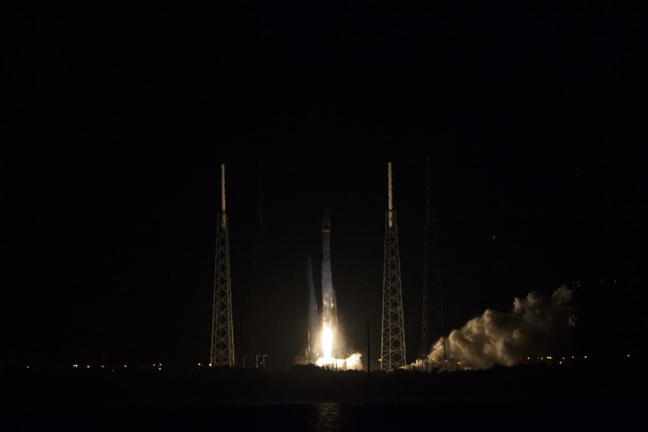
CAPE CANAVERAL, Fla. -- A United Launch Alliance Atlas V rocket soars off Space Launch Complex 41 at Cape Canaveral Air Force Station in Florida into the night, carrying NASA's Tracking and Data Relay Satellite, or TDRS-L, to Earth orbit. Launch was at 9:33 p.m. EST Jan. 23 during a 40-minute launch window. The TDRS-L spacecraft is the second of three new satellites designed to ensure vital operational continuity for NASA by expanding the lifespan of the Tracking and Data Relay Satellite System TDRSS fleet, which consists of eight satellites in geosynchronous orbit. The spacecraft provide tracking, telemetry, command and high-bandwidth data return services for numerous science and human exploration missions orbiting Earth. These include NASA's Hubble Space Telescope and the International Space Station. TDRS-L has a high-performance solar panel designed for more spacecraft power to meet the growing S-band communications requirements. TDRSS is one of three NASA Space Communication and Navigation SCaN networks providing space communications to NASA’s missions. For more information more about TDRS-L, visit http://www.nasa.gov/tdrs. To learn more about SCaN, visit www.nasa.gov/scan. Photo credit: NASA/Kim Shiflett

S86-26428 (31 Jan. 1986) --- Dozens of cameras and thousands of eyes focus on President Ronald Reagan (out of frame at left) during the 51-L memorial services Jan. 31 on the mall at the Johnson Space Center (JSC). The photograph was taken from special bleachers quickly erected to accommodate hundreds of members of the news media. The audience of thousands was largely made up of JSC employees and family and friends of the Challenger crew members who perished four days earlier in the attempted launch of NASA’s 25th STS mission. Photo credit: NASA

S84-40463 (24 Aug 1984) --- Astronaut Manley L. "Sonny" Carter, Jr., 1984 ASCAN.

Portrait of Astronaut Frank L. Culbertson dressed in an orange launch/entry suit with his helmet on the table in front of him.
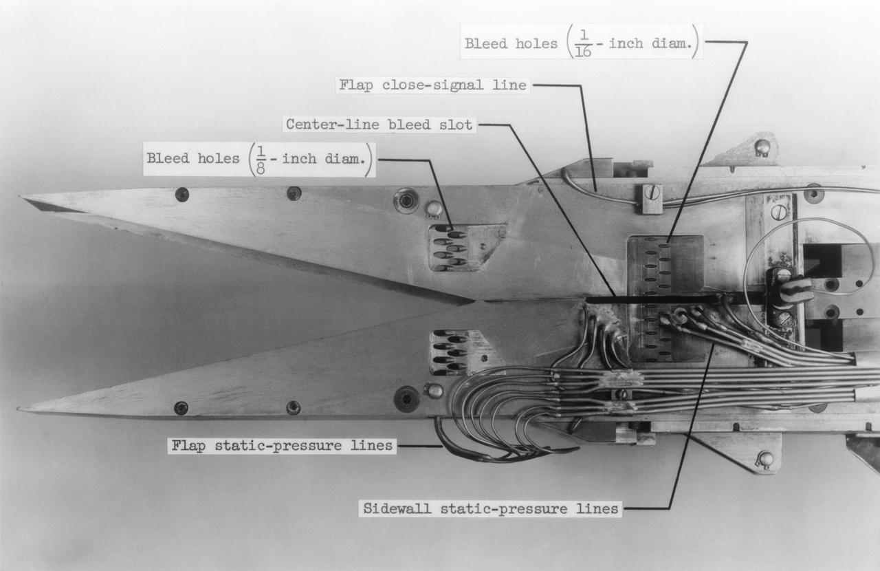
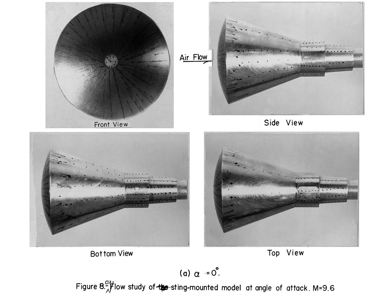
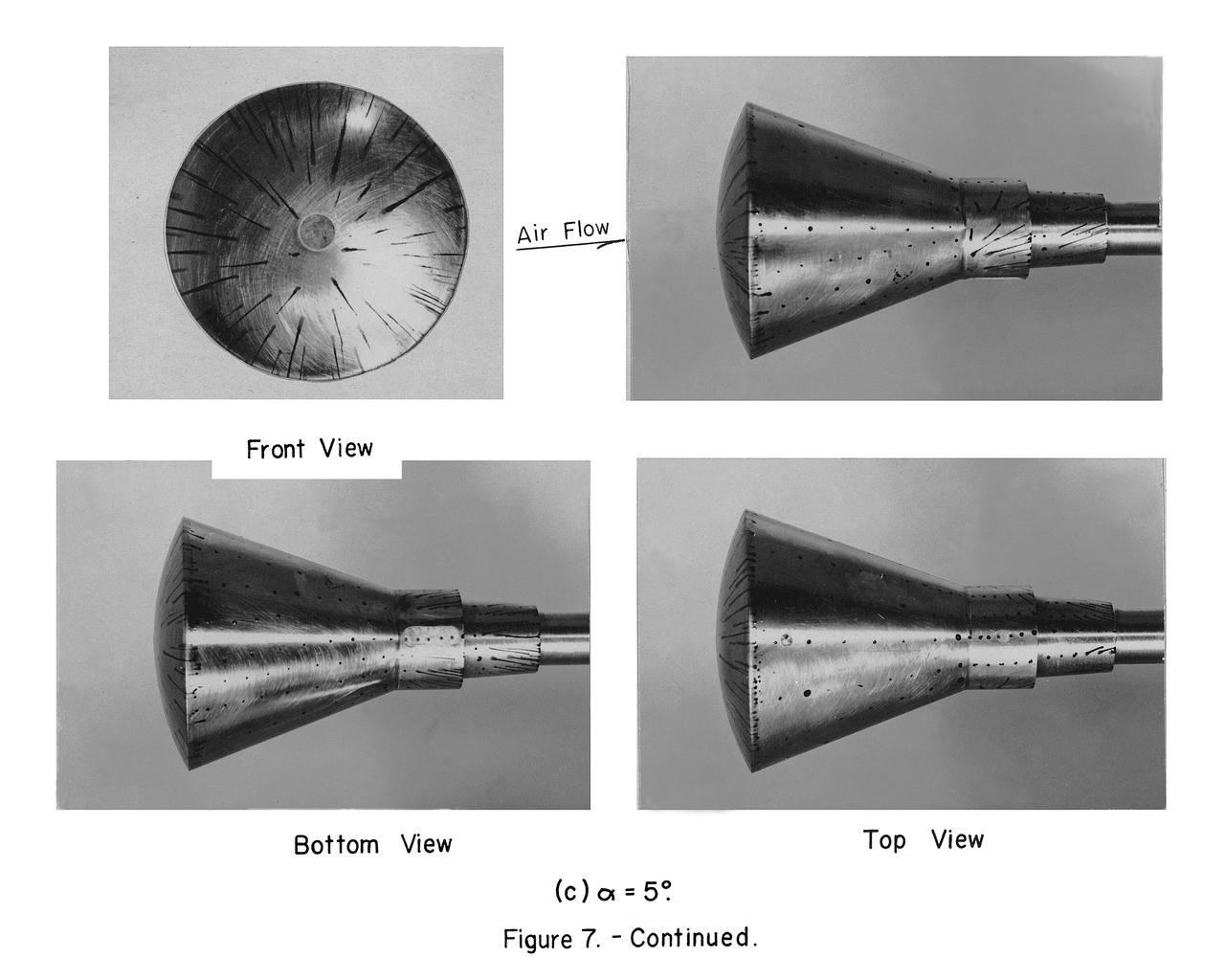
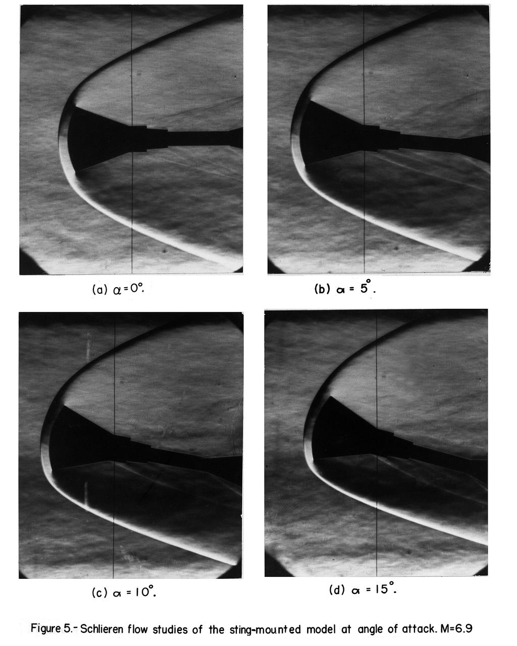
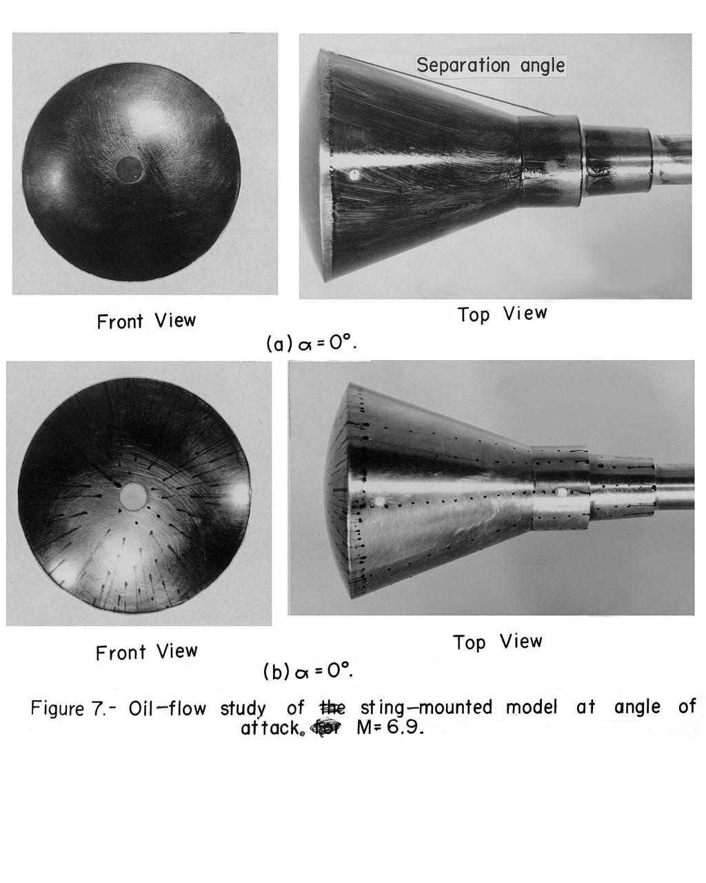
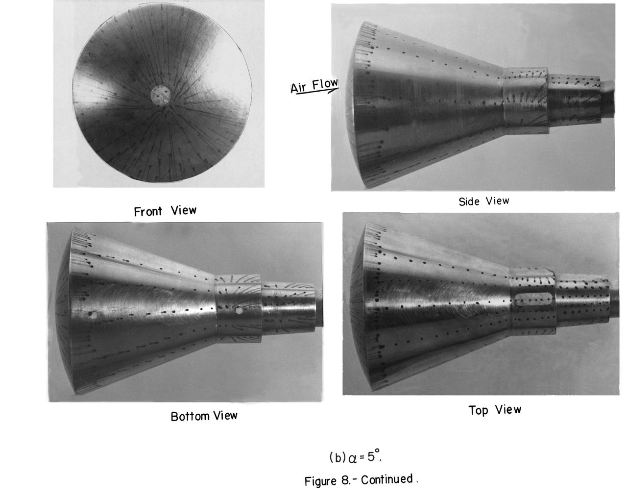
Mach number 6.9 Inlet. These negatives in jackets also: L-1958-2984.1 Figure 3b cone in NASA document L-1643 L-1958-2980.1 Figures 3a in document L-1643 declassified from Confidential
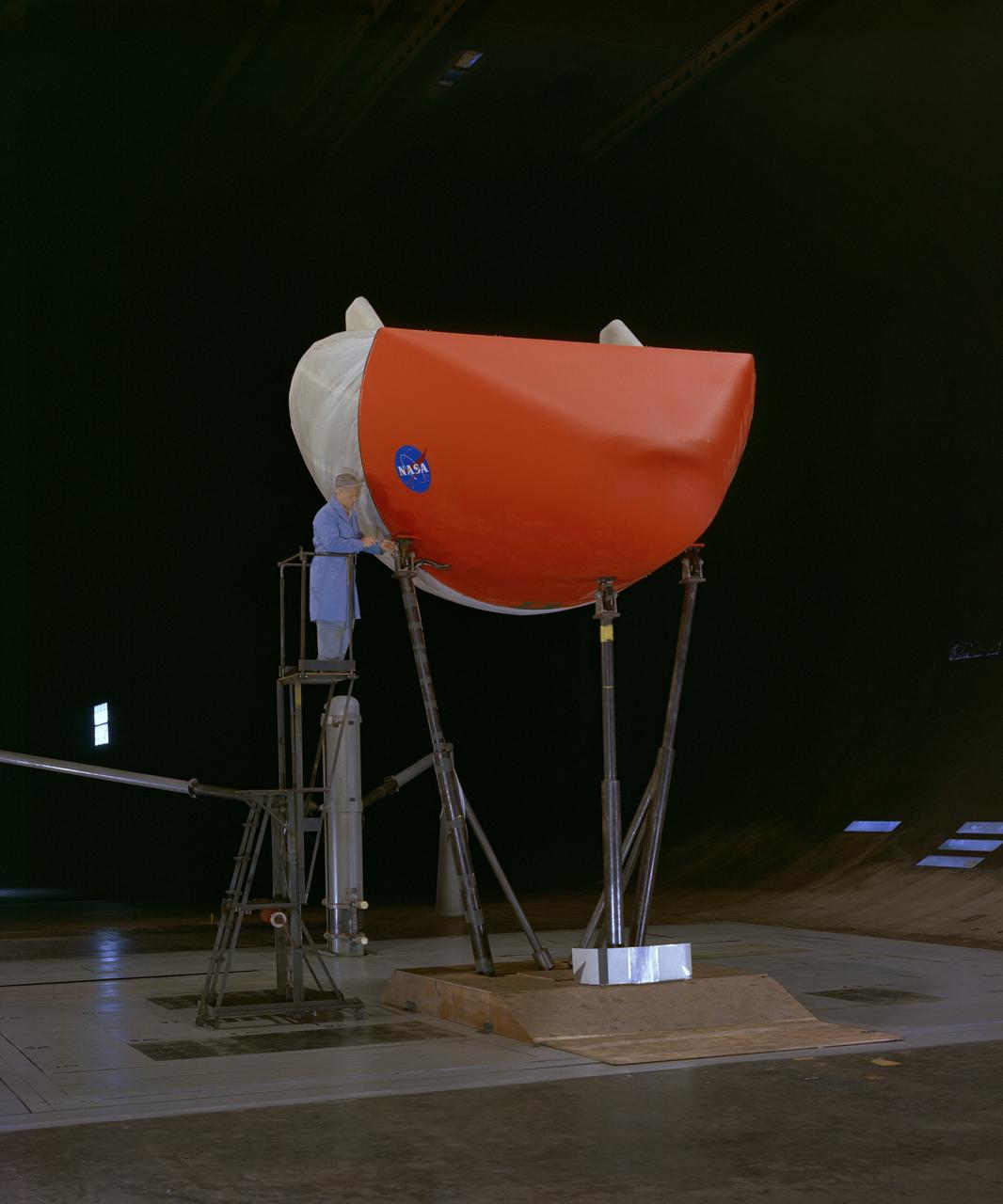
3/4 front view of M-1-L inflatable recovery able lifting body model in Ames 40x80 foot wind tunnel. Mechanic, Ray Schmorance included in picture.

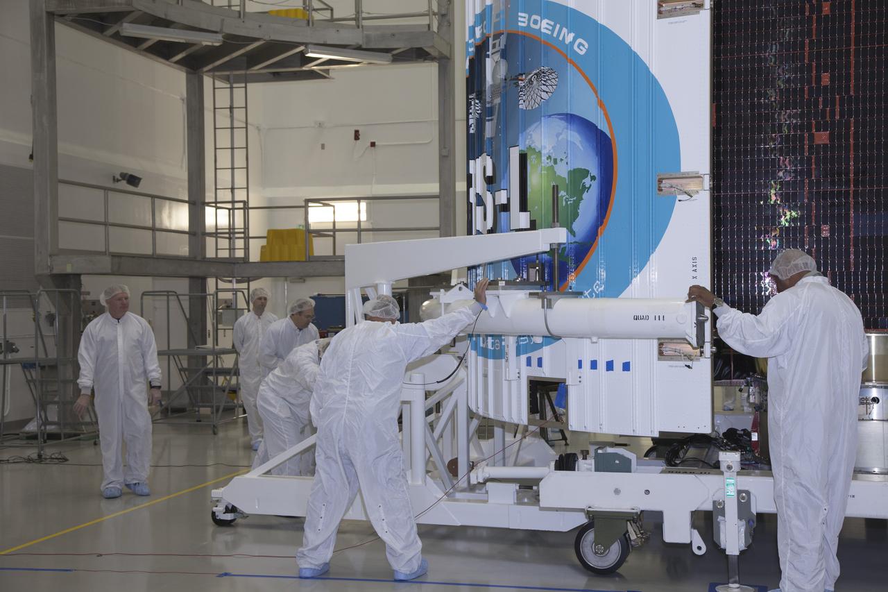
TITUSVILLE, Fla. – Members of the news media are given an up-close look at the Tracking and Data Relay Satellite, or TDRS-L, spacecraft undergoing preflight processing inside the Astrotech payload processing facility in Titusville. TDRS-L is being prepared for encapsulation inside its payload fairing prior to being transported to Launch Complex 41 at Cape Canaveral Air Force Station. Journalists visited Astrotech as part of TDRS-L Media Day to conduct interviews and photograph the satellite that will be a part of the second of three next-generation spacecraft designed to ensure vital operational continuity for the NASA Space Network. It is scheduled to launch from Cape Canaveral's Space Launch Complex 41 atop an Atlas V rocket in January 2014. The current Tracking and Data Relay Satellite system consists of eight in-orbit satellites distributed to provide near continuous information relay contact with orbiting spacecraft ranging from the International Space Station and Hubble Space Telescope to the array of scientific observatories. For more information, visit: http://www.nasa.gov/mission_pages/tdrs/home/index.html
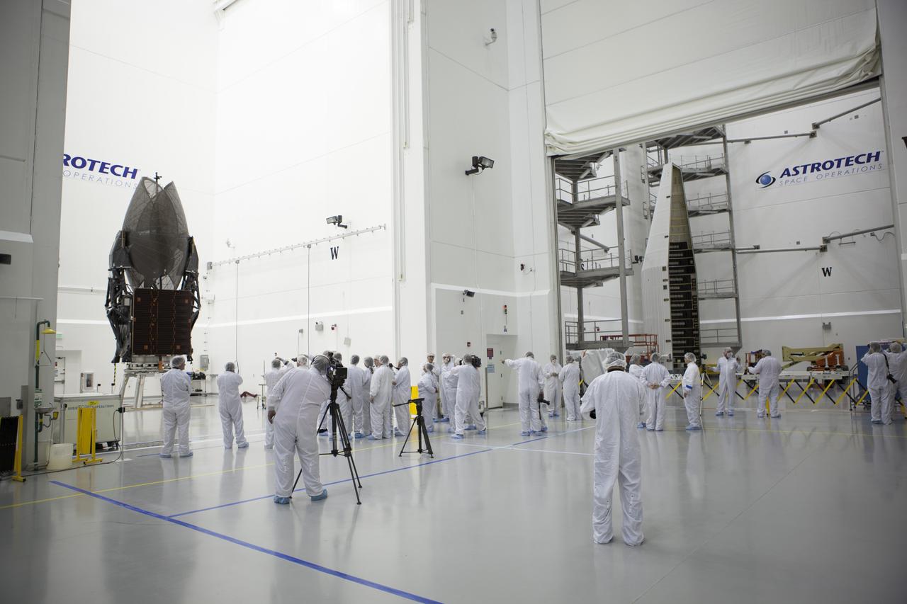
TITUSVILLE, Fla. – Members of the news media are given an up-close look at the Tracking and Data Relay Satellite, or TDRS-L, spacecraft undergoing preflight processing inside the Astrotech payload processing facility in Titusville. TDRS-L is being prepared for encapsulation inside its payload fairing prior to being transported to Launch Complex 41 at Cape Canaveral Air Force Station. Journalists visited Astrotech as part of TDRS-L Media Day to conduct interviews and photograph the satellite that will be a part of the second of three next-generation spacecraft designed to ensure vital operational continuity for the NASA Space Network. It is scheduled to launch from Cape Canaveral's Space Launch Complex 41 atop an Atlas V rocket in January 2014. The current Tracking and Data Relay Satellite system consists of eight in-orbit satellites distributed to provide near continuous information relay contact with orbiting spacecraft ranging from the International Space Station and Hubble Space Telescope to the array of scientific observatories. For more information, visit: http://www.nasa.gov/mission_pages/tdrs/home/index.html
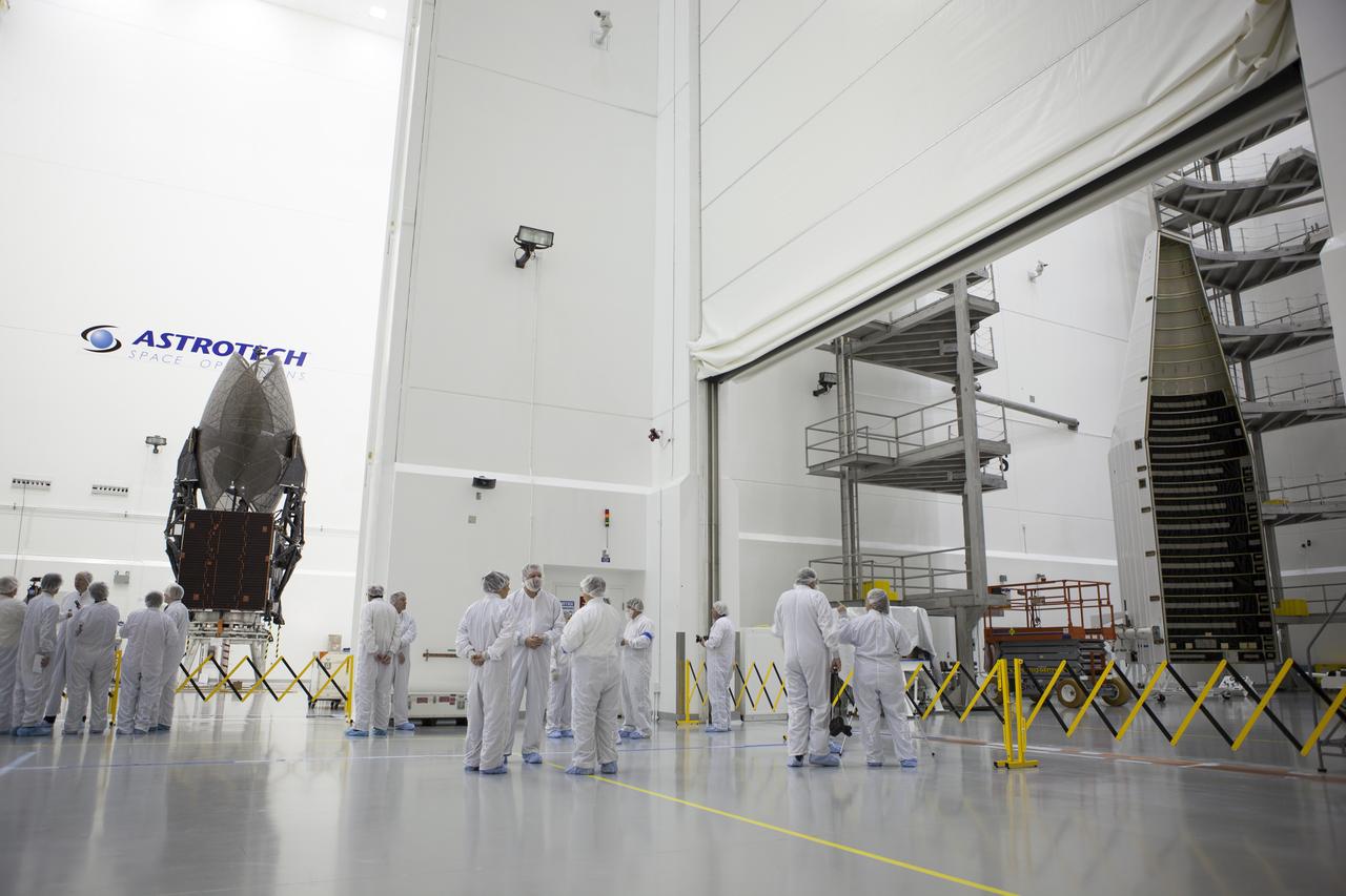
TITUSVILLE, Fla. – Members of the news media are given an up-close look at the Tracking and Data Relay Satellite, or TDRS-L, spacecraft undergoing preflight processing inside the Astrotech payload processing facility in Titusville. TDRS-L is being prepared for encapsulation inside its payload fairing prior to being transported to Launch Complex 41 at Cape Canaveral Air Force Station. Journalists visited Astrotech as part of TDRS-L Media Day to conduct interviews and photograph the satellite that will be a part of the second of three next-generation spacecraft designed to ensure vital operational continuity for the NASA Space Network. It is scheduled to launch from Cape Canaveral's Space Launch Complex 41 atop an Atlas V rocket in January 2014. The current Tracking and Data Relay Satellite system consists of eight in-orbit satellites distributed to provide near continuous information relay contact with orbiting spacecraft ranging from the International Space Station and Hubble Space Telescope to the array of scientific observatories. For more information, visit: http://www.nasa.gov/mission_pages/tdrs/home/index.html
TITUSVILLE, Fla. – Members of the news media are given an opportunity for an up-close look at the Tracking and Data Relay Satellite, or TDRS-L, spacecraft undergoing preflight processing inside the Astrotech payload processing facility in Titusville. TDRS-L is being prepared for encapsulation inside its payload fairing prior to being transported to Launch Complex 41 at Cape Canaveral Air Force Station. Journalists visited Astrotech as part of TDRS-L Media Day to conduct interviews and photograph the satellite that will be a part of the second of three next-generation spacecraft designed to ensure vital operational continuity for the NASA Space Network. It is scheduled to launch from Cape Canaveral's Space Launch Complex 41 atop an Atlas V rocket in January 2014. The current Tracking and Data Relay Satellite system consists of eight in-orbit satellites distributed to provide near continuous information relay contact with orbiting spacecraft ranging from the International Space Station and Hubble Space Telescope to the array of scientific observatories. For more information, visit: http://www.nasa.gov/mission_pages/tdrs/home/index.html
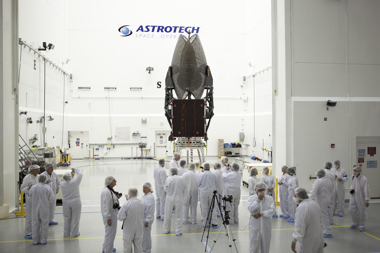
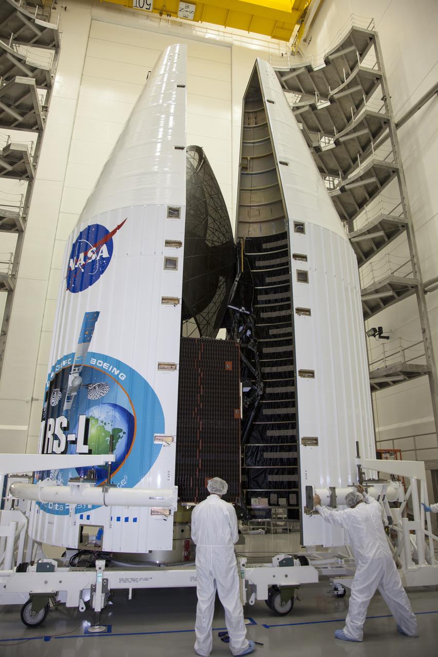
TITUSVILLE, Fla. – Inside the Astrotech payload processing facility in Titusville, United Launch Alliance engineers and technicians encapsulate the Tracking and Data Relay Satellite, or TDRS-L, spacecraft in its payload fairing. TDRS-L will then be transported to Launch Complex 41 at Cape Canaveral Air Force Station. The TDRS-L satellite will be a part of the second of three next-generation spacecraft designed to ensure vital operational continuity for the NASA Space Network. It is scheduled to launch from Cape Canaveral's Space Launch Complex 41 atop a United Launch Alliance Atlas V rocket on January 23, 2014. The current Tracking and Data Relay Satellite system consists of eight in-orbit satellites distributed to provide near continuous information relay contact with orbiting spacecraft ranging from the International Space Station and Hubble Space Telescope to the array of scientific observatories. For more information, visit: http://www.nasa.gov/mission_pages/tdrs/home/index.html
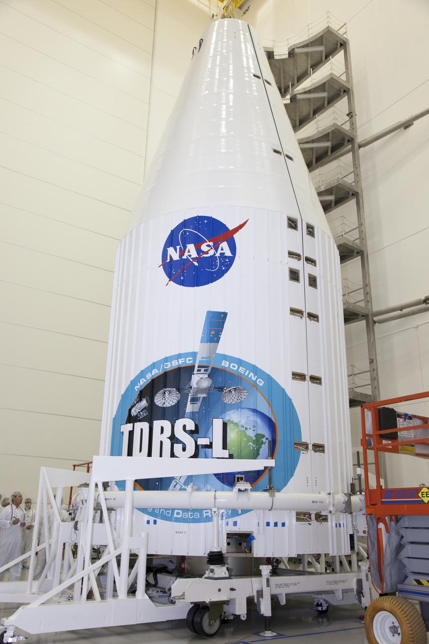
TITUSVILLE, Fla. – Inside the Astrotech payload processing facility in Titusville, NASA's Tracking and Data Relay Satellite, or TDRS-L, spacecraft has been encapsulated in its payload fairing. TDRS-L will then be transported to Launch Complex 41 at Cape Canaveral Air Force Station. The TDRS-L satellite will be a part of the second of three next-generation spacecraft designed to ensure vital operational continuity for the NASA Space Network. It is scheduled to launch from Cape Canaveral's Space Launch Complex 41 atop a United Launch Alliance Atlas V rocket on January 23, 2014. The current Tracking and Data Relay Satellite system consists of eight in-orbit satellites distributed to provide near continuous information relay contact with orbiting spacecraft ranging from the International Space Station and Hubble Space Telescope to the array of scientific observatories. For more information, visit: http://www.nasa.gov/mission_pages/tdrs/home/index.html
TITUSVILLE, Fla. – Inside the Astrotech payload processing facility in Titusville, United Launch Alliance engineers and technicians encapsulate the Tracking and Data Relay Satellite, or TDRS-L, spacecraft in its payload fairing. TDRS-L will then be transported to Launch Complex 41 at Cape Canaveral Air Force Station. The TDRS-L satellite will be a part of the second of three next-generation spacecraft designed to ensure vital operational continuity for the NASA Space Network. It is scheduled to launch from Cape Canaveral's Space Launch Complex 41 atop a United Launch Alliance Atlas V rocket on January 23, 2014. The current Tracking and Data Relay Satellite system consists of eight in-orbit satellites distributed to provide near continuous information relay contact with orbiting spacecraft ranging from the International Space Station and Hubble Space Telescope to the array of scientific observatories. For more information, visit: http://www.nasa.gov/mission_pages/tdrs/home/index.html
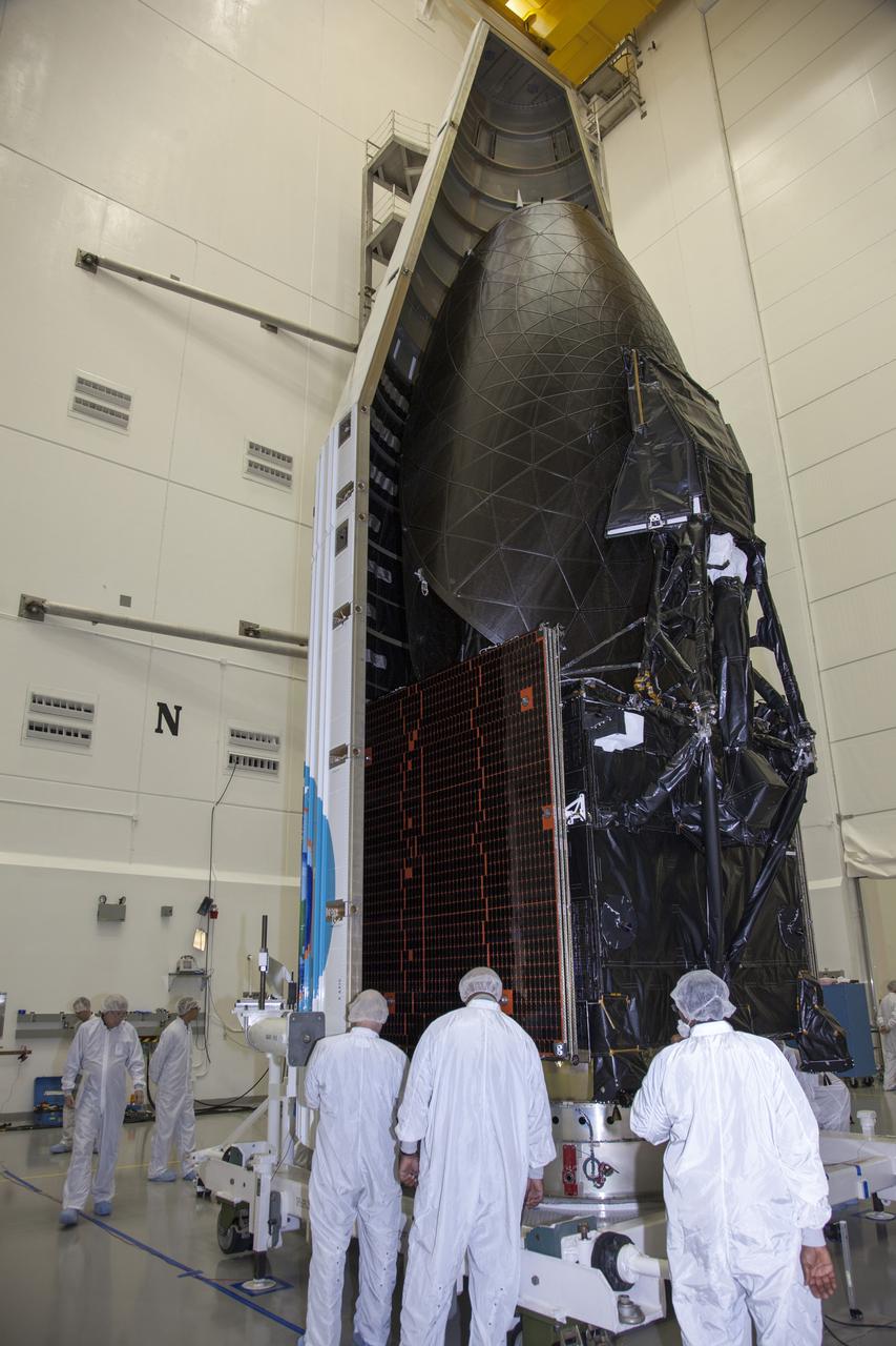
TITUSVILLE, Fla. – Inside the Astrotech payload processing facility in Titusville, United Launch Alliance engineers and technicians encapsulate the Tracking and Data Relay Satellite, or TDRS-L, spacecraft in its payload fairing. TDRS-L will then be transported to Launch Complex 41 at Cape Canaveral Air Force Station. The TDRS-L satellite will be a part of the second of three next-generation spacecraft designed to ensure vital operational continuity for the NASA Space Network. It is scheduled to launch from Cape Canaveral's Space Launch Complex 41 atop a United Launch Alliance Atlas V rocket on January 23, 2014. The current Tracking and Data Relay Satellite system consists of eight in-orbit satellites distributed to provide near continuous information relay contact with orbiting spacecraft ranging from the International Space Station and Hubble Space Telescope to the array of scientific observatories. For more information, visit: http://www.nasa.gov/mission_pages/tdrs/home/index.html
TITUSVILLE, Fla. – Inside the Astrotech payload processing facility in Titusville, NASA's Tracking and Data Relay Satellite, or TDRS-L, spacecraft has been encapsulated in its payload fairing. TDRS-L will then be transported to Launch Complex 41 at Cape Canaveral Air Force Station. The TDRS-L satellite will be a part of the second of three next-generation spacecraft designed to ensure vital operational continuity for the NASA Space Network. It is scheduled to launch from Cape Canaveral's Space Launch Complex 41 atop a United Launch Alliance Atlas V rocket on January 23, 2014. The current Tracking and Data Relay Satellite system consists of eight in-orbit satellites distributed to provide near continuous information relay contact with orbiting spacecraft ranging from the International Space Station and Hubble Space Telescope to the array of scientific observatories. For more information, visit: http://www.nasa.gov/mission_pages/tdrs/home/index.html
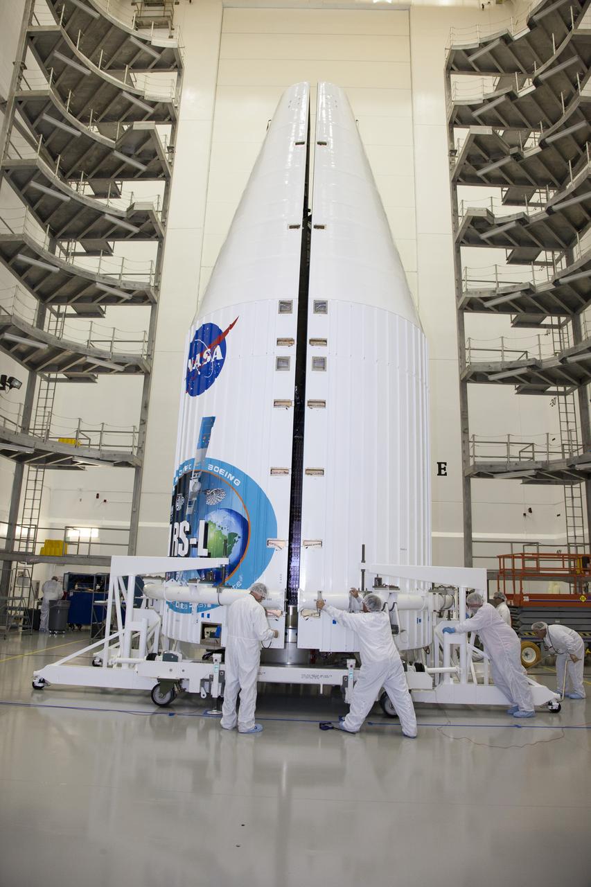
TITUSVILLE, Fla. – Inside the Astrotech payload processing facility in Titusville, United Launch Alliance engineers and technicians encapsulate the Tracking and Data Relay Satellite, or TDRS-L, spacecraft in its payload fairing. TDRS-L will then be transported to Launch Complex 41 at Cape Canaveral Air Force Station. The TDRS-L satellite will be a part of the second of three next-generation spacecraft designed to ensure vital operational continuity for the NASA Space Network. It is scheduled to launch from Cape Canaveral's Space Launch Complex 41 atop a United Launch Alliance Atlas V rocket on January 23, 2014. The current Tracking and Data Relay Satellite system consists of eight in-orbit satellites distributed to provide near continuous information relay contact with orbiting spacecraft ranging from the International Space Station and Hubble Space Telescope to the array of scientific observatories. For more information, visit: http://www.nasa.gov/mission_pages/tdrs/home/index.html
This picture is a composite of Mars Global Surveyor MGS Mars Orbiter Camera MOC daily global images acquired at L<sub>s</sub> 107° of the Elysium/Mare Cimmerium face during a previous Mars year