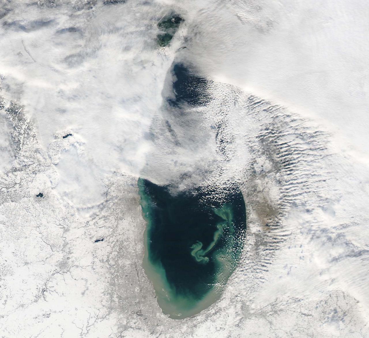
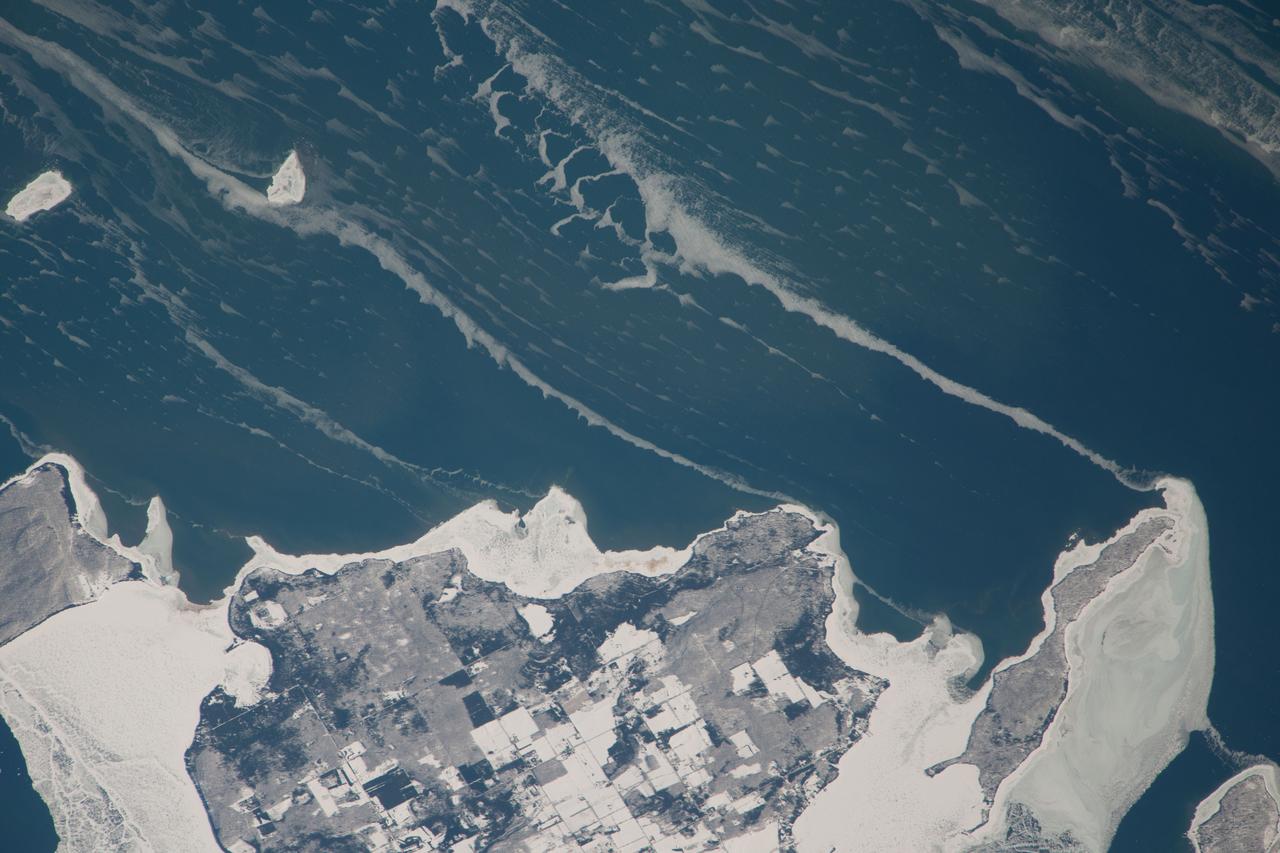
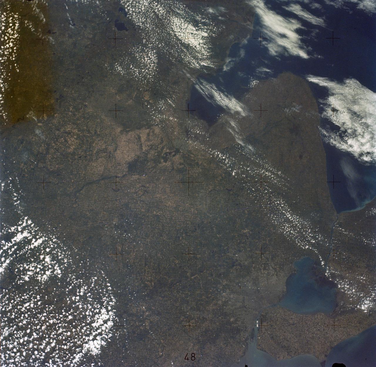
NASA image acquired December 17, 2010 In mid-December 2010, suspended sediments transformed the southern end of Lake Michigan. Ranging in color from brown to green, the sediment filled the surface waters along the southern coastline and formed a long, curving tendril extending toward the middle of the lake. The Moderate Resolution Imaging Spectroradiometer (MODIS) on NASA’s Aqua satellite captured these natural-color images on December 17, 2010 (top), and December 10, 2010 (bottom). Such sediment clouds are not uncommon in Lake Michigan, where winds influence lake circulation patterns. A scientificpaper published in 2007 described a model of the circulation, noting that while the suspended particles mostly arise from lake-bottom sediments along the western shoreline, they tend to accumulate on the eastern side. When northerly winds blow, two circulation gyres, rotating in opposite directions, transport sediment along the southern shoreline. As the northerly winds die down, the counterclockwise gyre predominates, and the smaller, clockwise gyre dissipates. Clear water—an apparent remnant of the small clockwise gyre—continues to interrupt the sediment plume. George Leshkevich, a researcher with the U.S. National Oceanic and Atmospheric Administration, explains that the wind-driven gyres erode lacustrine clay (very fine lakebed sediment) on the western shore before transporting it, along with re-suspended lake sediments, to the eastern shore. On the eastern side, the gyre encounters a shoreline bulge that pushes it toward the lake’s central southern basin, where it deposits the sediments. The sediment plume on December 17 followed a windy weather front in the region on December 16. NASA image courtesy MODIS Rapid Response Team at NASA GSFC. Caption by Michon Scott. Instrument: Aqua - MODIS <b><a href="http://www.nasa.gov/centers/goddard/home/index.html" rel="nofollow">NASA Goddard Space Flight Center</a></b> enables NASA’s mission through four scientific endeavors: Earth Science, Heliophysics, Solar System Exploration, and Astrophysics. Goddard plays a leading role in NASA’s accomplishments by contributing compelling scientific knowledge to advance the Agency’s mission. <b>Follow us on <a href="http://twitter.com/NASA_GoddardPix" rel="nofollow">Twitter</a></b> <b>Join us on <a href="http://www.facebook.com/pages/Greenbelt-MD/NASA-Goddard/395013845897?ref=tsd" rel="nofollow">Facebook</a></b> To read more about this image go to: <a href="http://earthobservatory.nasa.gov/IOTD/view.php?id=48511" rel="nofollow">earthobservatory.nasa.gov/IOTD/view.php?id=48511</a>

STS040-77-045 (6 June 1991) --- This image, photographed on June 6, 1991, is an oblique view looking north-northeast and shows most of the Great Lakes region. Part of Columbia's cargo bay and the Spacelab Life Sciences (SLS-1) module are in the foreground. In the center of the image is Lake Michigan with Chicago clearly visible along the southwest shore. According to NASA photo experts studying the STS-40 imagery, this image shows several interesting meteorological phenomena. The difference in temperature between the warming land and the cold lake waters is illustrated by the low level clouds. The warming land surface results in rising air and the formation of clouds, while the lake waters are cold and result in the lakes remaining cloud free. Also visible is evidence of lake breezes developing around several of the lakes. This phenomena is also driven by the difference in temperature between the land and the water. Winds blowing off the lakes must travel 25 - 30 miles inland before it warms sufficiently to create clouds.

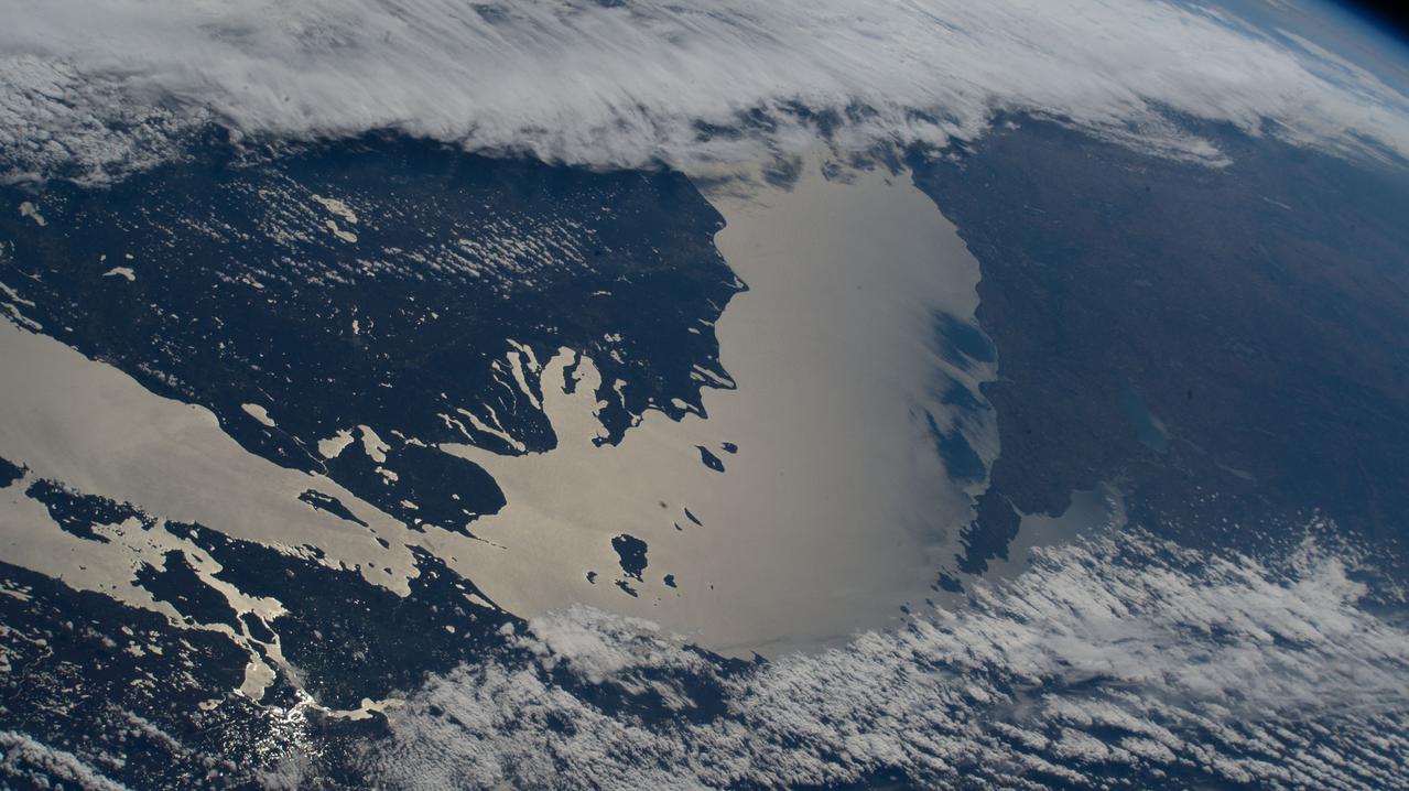
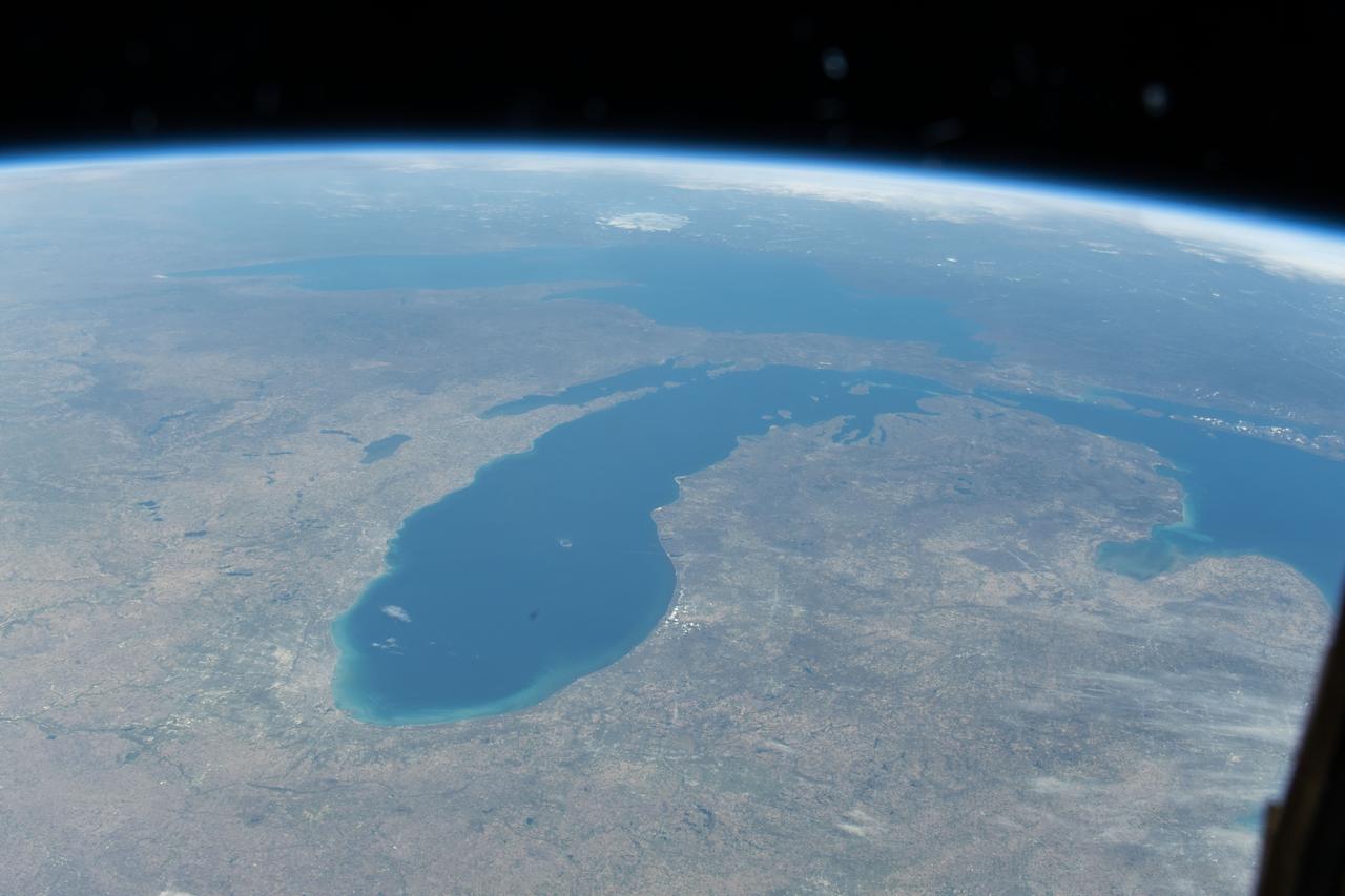
iss058e013234 (Feb. 13, 2019) --- The International Space Station was flying 256 miles above Canada when an Expedition 58 crew member, looking north to south, photographed Lake Superior and Lake Michigan surrounded by the cloudy and frozen terrain of the North American continent.
iss073e0865640 (Oct. 7, 2025) --- Lake Michigan beams in the afternoon sunlight as clouds blanket its southern tip—spanning Michigan, Indiana, and Illinois—in this photograph taken from the International Space Station while orbiting 263 miles above Earth. The northern tip of Lake Huron is visible at left.
NASA Terra satellite presents this false color view of portions of Wisconsin and Michigan, including Devil Lake, Druid Lake, Ghost Lake, Spider Lake, and Witches Lake in Wisconsin; and Bat Lake, Corpse Pond and Witch Lake in Michigan.
iss073e0000553 (April 22, 2025) --- The freshwater Lake St. Clair rests in between Detroit, Michigan (left), and Ontario, Canada, and connects Lake Huron and Lake Erie in North America in this photograph from the International Space Station as it orbited 260 miles above.
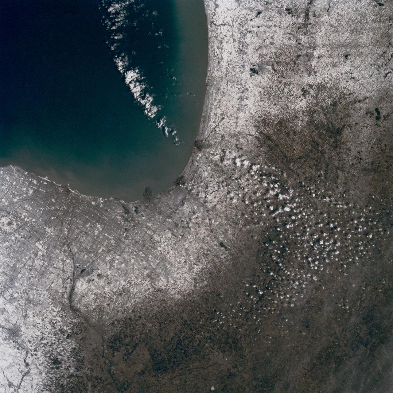
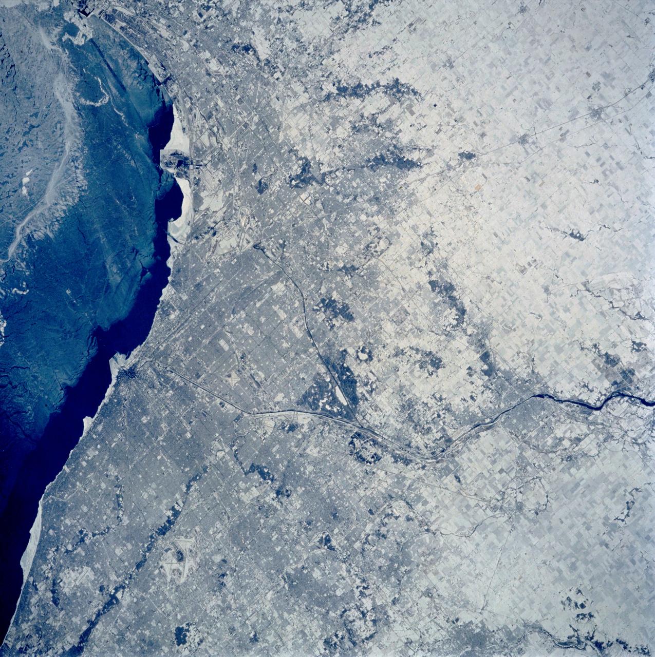
In this late winter scene of Chicago, Illinois, USA (41.5N, 87.0W) the light dusting of snow has actually enhanced the determination of the cities street pattern, parks and other cultural features. Sited at the south end of Lake Michigan, Chicago has long served as an industrial, transportation and communications center for the midwest. The obvious snowline on the ground enables meteorologists to trace the regional groundtracks of winter storms.

iss072e097446 (Oct. 24, 2024) -- As the International Space Station soared 257 miles above Lake Michigan, NASA astronaut and Expedition 72 Flight Engineer Don Pettit captured this long-exposure photograph of city lights streaking across Earth while a green and red aurora moved through the atmosphere.
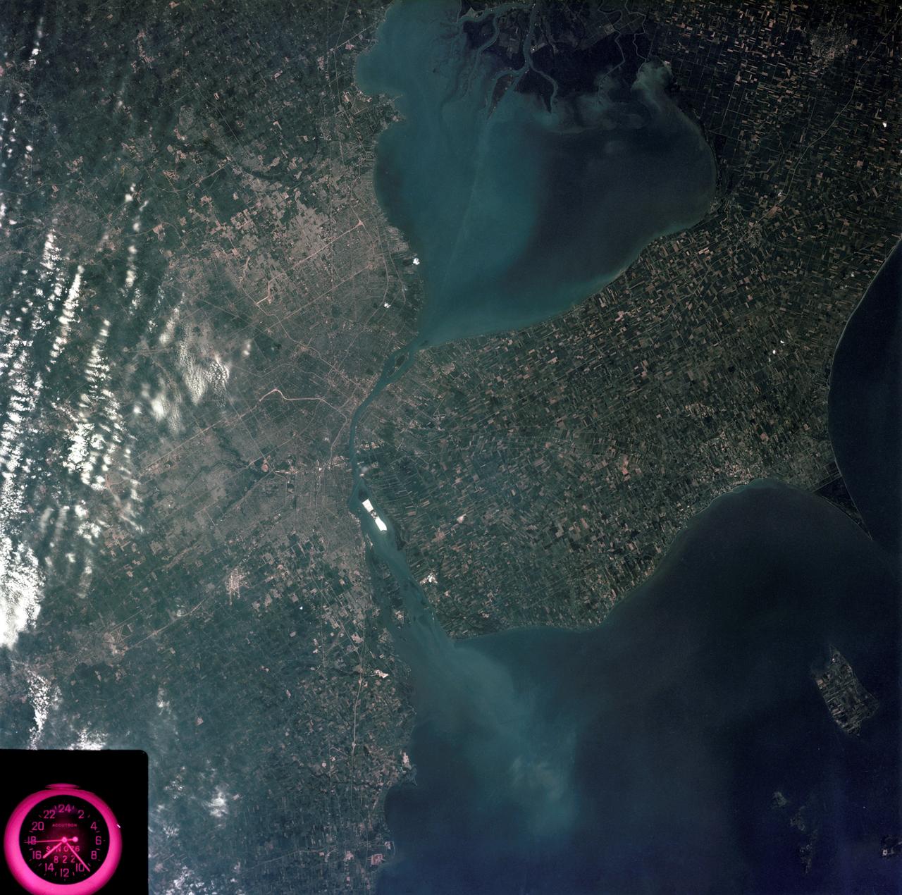
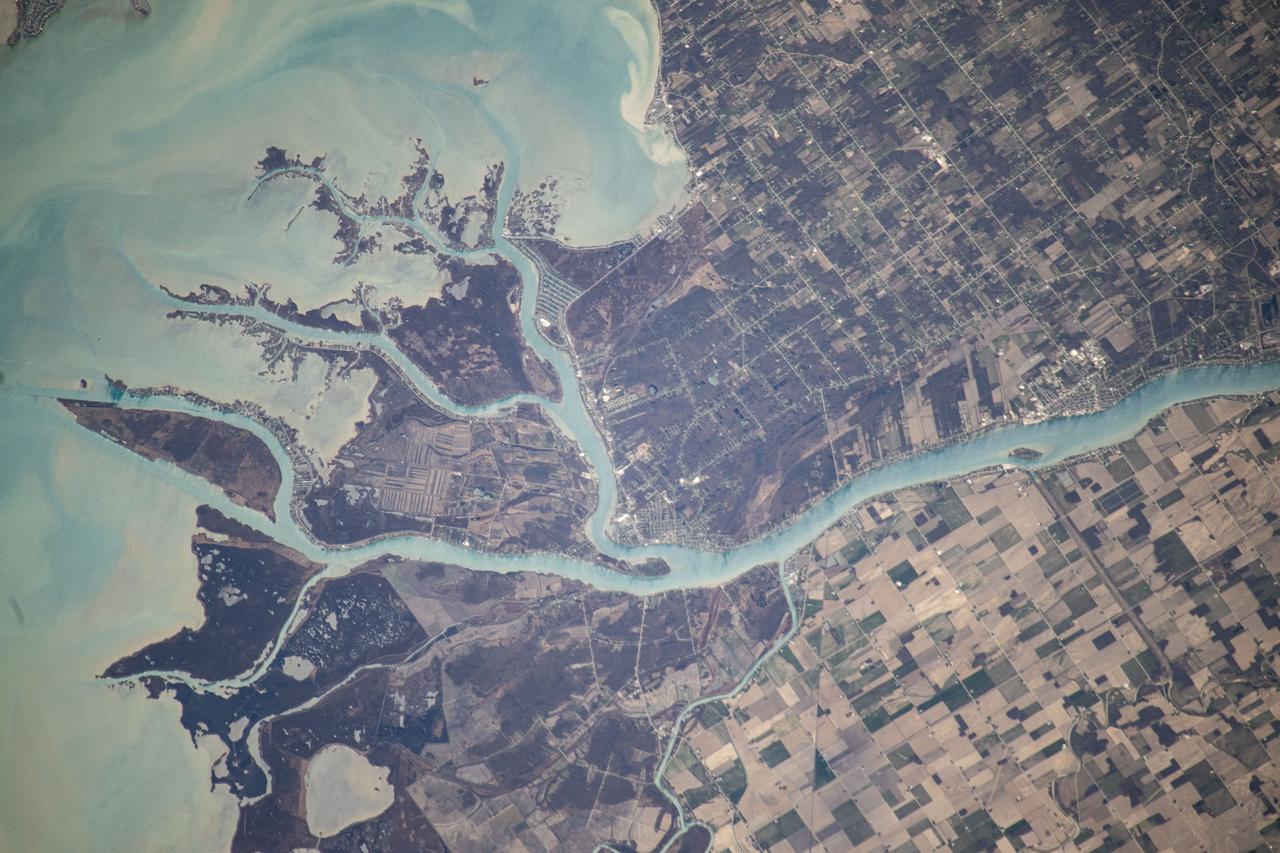
SL3-83-0152 (July-September 1973) --- A near vertical view of the metropolitan Detroit, Michigan area is seen in this Skylab 3 Earth Resources Experiments Package S190-B (five-inch Earth terrain camera) photograph taken from the Skylab space station in Earth orbit. The 25-mile long Detroit River drains the smaller body of water (Lake St. Clair) and flows southwestward separating Detroit from Windsor, Ontario, and empties into Lake Erie. The Detroit River handles a great deal of Great Lakes barge and ship traffic. Major streets and thoroughfares radiating from the city are clearly visible. Fighting Island is the highly reflective, white area located almost in the center of the picture. This high reflectivity is caused by the functional use of the island-disposal ponds for chemical salts. Sedimentation and/or pollution patterns in the area provide interesting visual phenomena for speculation and analysis. Distinct and rather unique cultivated field patterns can be observed south and east of Windsor, Ontario. This is a direct result of an English survey and land tenure system which was utilized when the area was settled. New areas of residential development are fairly easy to differentiate from older, established residential areas. Vegetation and extent of area coverage can be determined. The Oakland County Planning Commission and the Federal Bureau of Outdoor Recreation working closely with Irv Sattinger of the Environmental Research Institute of Michigan (University of Michigan) are presently processing and analyzing photographic and Multispectral scanner data to determine its usefulness for recreation and open space site studies for this area. Photo credit: NASA
iss055e018833 (April 10, 2018) --- An Expedition 55 crew member photographed the Mackinac Bridge which connects the upper and lower peninsulas of the state of Michigan across an area of water separating Lake Michigan and Lake Huron.

STS084-710-098 (15-24 May 1997) --- A rare view of the Great Lakes captured in one frame. The Great Lakes region is home to 8.5 million Canadians and 32.5 million Americans. At center is Lake Huron and Georgian Bay. Above Lake Huron and towards the horizon is Lake Michigan, the only Great Lake to be located entirely within the United States. To the right of Lake Michigan, and partially under clouds, is Lake Superior the second largest lake in the world after the Caspian Sea. Lake Erie is located to the left of Lake Huron. Next to Lake Erie is Lake Ontario. According to geologists, the Great Lakes were created by glacial processes that began about 1,000,000 years ago.

ISS046e005404 (01/05/2016) --- The glittering lights of the American Midwest illuminate the Earth in this captivating image taken by the International Space Station Expedition 46 crew on Jan. 5, 2016. The picture, which was taken while the station was flying above Alabama, shows numerous major cities, including the major city of Chicago (middle-left) situated on the Lake Michigan coastline. Also in view are three of the American Great Lakes, including Lake Michigan (left), Lake Huron (middle) and Lake Erie (right).
ISS036-E-017925 (11 July 2013) --- One of the Expedition 36 crew members aboard the Earth-orbiting International Space Station on July 11 captured this high oblique view of Lake Michigan (left) and Lake Huron and much of the state of Michigan in between.

Mackinac Island, Michigan, is a small island off the northern coast of Lake Huron. What makes it special is that all cars and motor vehicles were banned in 1900 from the 3.8-sq-island, home to 600 year-round residents. Each year over 1 million tourists visit the island to enjoy its peace and tranquility. The scene was acquired August 9, 2021 , covers an area of 13.8 by 21.3 km, and is located at 45.8 degrees north, 84.6 degrees west. https://photojournal.jpl.nasa.gov/catalog/PIA26621
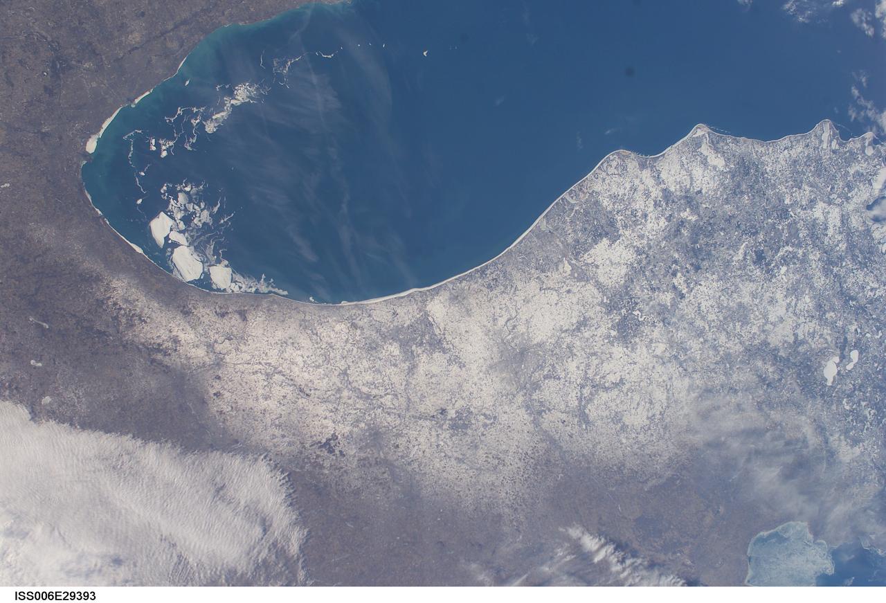
ISS006-E-29393 (21 February 2003) --- A number of large pieces of ice collected along and just off the shoreline southwest of Benton Harbor, Michigan and smaller pieces trailing northward offshore from Chicago, Illinois were captured with a digital still camera by one of the Expedition Six crewmembers on board the International Space Station (ISS). Note the ice accumulation along the entire eastern shoreline of Lake Michigan as well as the wind-drive lake-effect snow cover over the western half of the Lower Michigan Peninsula.
iss071e045652 (April 25, 2024) --- Lake Michigan figures prominently in the United States' upper midwest region with Lake Superior and Lake Huron in this photograph from the International Space Station as it orbited 257 miles above North America.
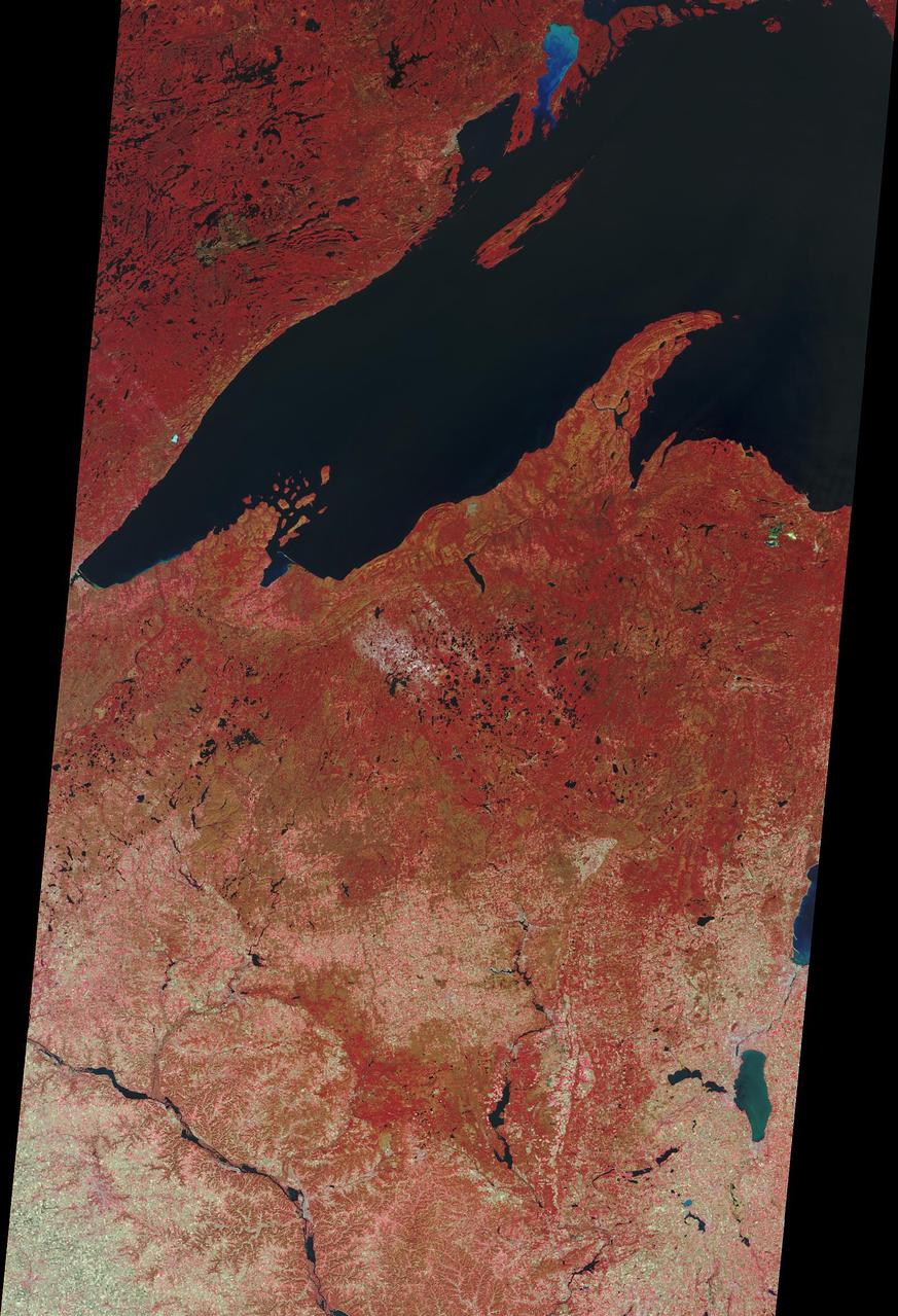
STS059-S-027 (10 April 1994) --- This image is a false-color composite of Raco, Michigan, centered at 46.39 degrees north latitude, 84.88 degrees east longitude. This image was acquired by the Spaceborne Imaging Radar-C and X-Band Synthetic Aperture Radar (SIR-C/X-SAR) aboard the Space Shuttle Endeavour on its 6th orbit and during the first full-capacity test of the instrument. This image was produced using both L-Band and C-Band data. The area shown is approximately 20 kilometers by 50 kilometers. Raco is located at the eastern end of Michigan's upper peninsula, west of Sault Ste. Marie and south of Whitefish Bay on Lake Superior. The site is located at the boundary between the boreal forests and the northern temperate forests, a transitional zone that is expected to be ecologically sensitive to anticipated global changes resulting from climatic warming. On any given day, there is a 60 percent chance that this area will be obscured to some extent by cloud cover which makes it difficult to image using optical sensors. In this color representation (Red=LHH, Green=LHV, Blue=CHH), darker areas in the image are smooth surfaces such as frozen lakes and other non-forested areas. The colors are related to the types of trees and the brightness is related to the amount of plant material covering the surface, called forest biomass. Accurate information about land-cover is important to area resource managers and for use in regional- to global-scale scientific models used to understand global change. SIR-C/X-SAR radars illuminate Earth with microwaves allowing detailed observations at any time, regardless of weather or sunlight conditions. SIR-C/X-SAR uses three microwave wavelengths: L-Band (24 cm), C-Band (6 cm), and X-Band (3 cm). The multi-frequency data will be used by the international scientific community to better understand the global environment and how it is changing. The SIR-C/X-SAR data, complemented by aircraft and ground studies, will give scientists clearer insights into those environmental changes which are caused by nature and those changes which are induced by human activity. SIR-C was developed by NASA's Jet Propulsion Laboratory (JPL). X-SAR was developed by the Dornire and Alenia Spazio Companies for the German Space Agency, Deutsche Agentur fuer Raumfahrtangelegenheiten (DARA), and the Italian Space Agency, Agenzia Spaziale Italiana (ASI). JPL Photo ID: P-43882
iss061e004575 (Oct. 8, 2019) --- The Sun's glint beams off Lake Michigan in this southward view taken from the International Space Station orbiting 253 miles above Canada just north of Lake Superior.
iss073e0000460 (April 22, 2025) --- The sun's glint beams off the freshwater Lake St. Clair, sits in between Lake Huron (right) and Lake Erie (bottom left), and separates Detroit, Michigan (top left) from Ontario, Canada, in this photograph from the International Space Station as it orbited 260 miles above.
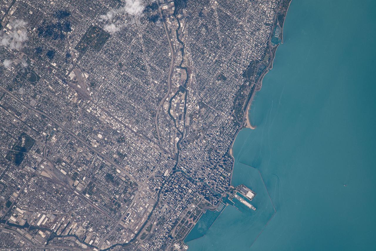
iss065e086284 (June 3, 2021) --- Chicago, Illinois, is pictured from the International Space Station as it orbited 262 miles above Lake Michigan.
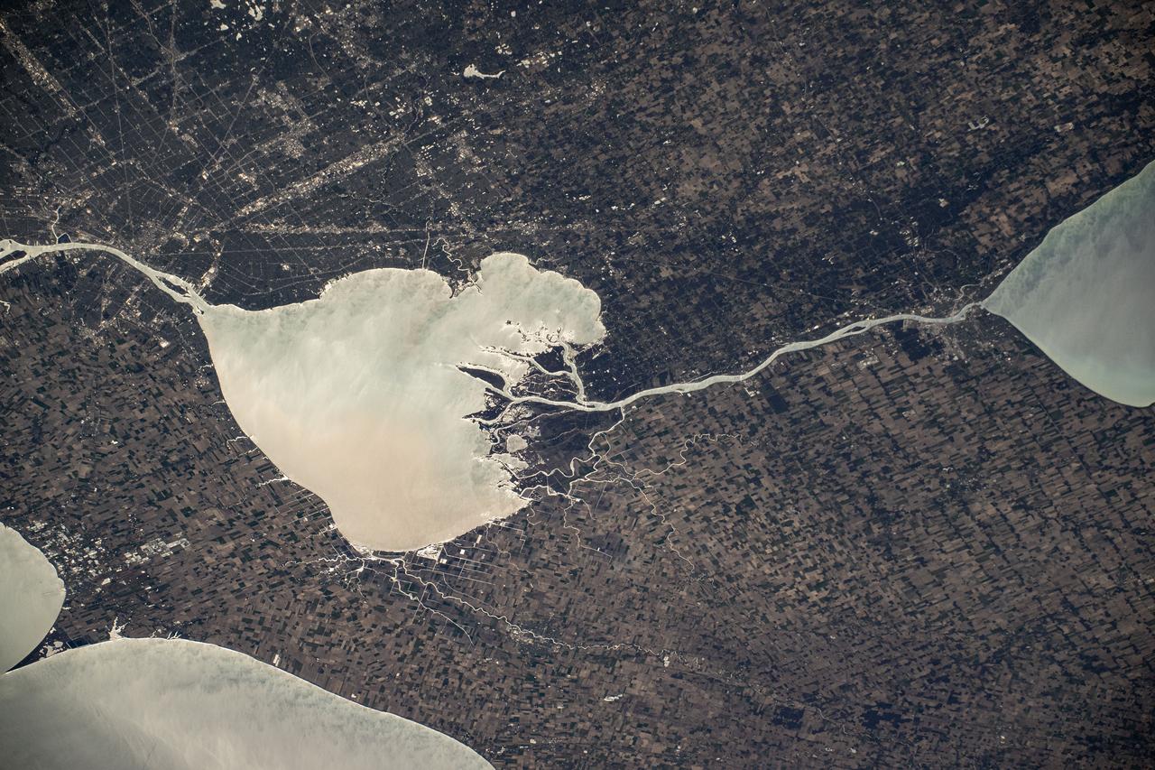
ISS028-E-044831 (7 Sept. 2011) --- While many of the Great Lakes and their surrounding areas are covered by the remnants of Tropical Storm Lee and upper level low over Michigan and southeastern Canada, Lake Michigan and Chicago are mostly clear and can be easily delineated (lower left center) in this image. The view was photographed by one of the Expedition 28 crew members aboard the International Space Station on Sept. 7, 2011.
STS058-102-018 (18 Oct-1 Nov 1993) --- A cloud-free, wide-angle view from above western Tennessee to the northern edge of Lake Michigan. The view extends from Saint Louis, Missouri near the lower left-hand corner, past Evansville, Indiana and Louisville, Kentucky to Cincinnati, Ohio. A range of hills covered by trees in Fall foliage extends from the Ohio River toward Lake Michigan, ending just southwest of Indianapolis, Indiana.

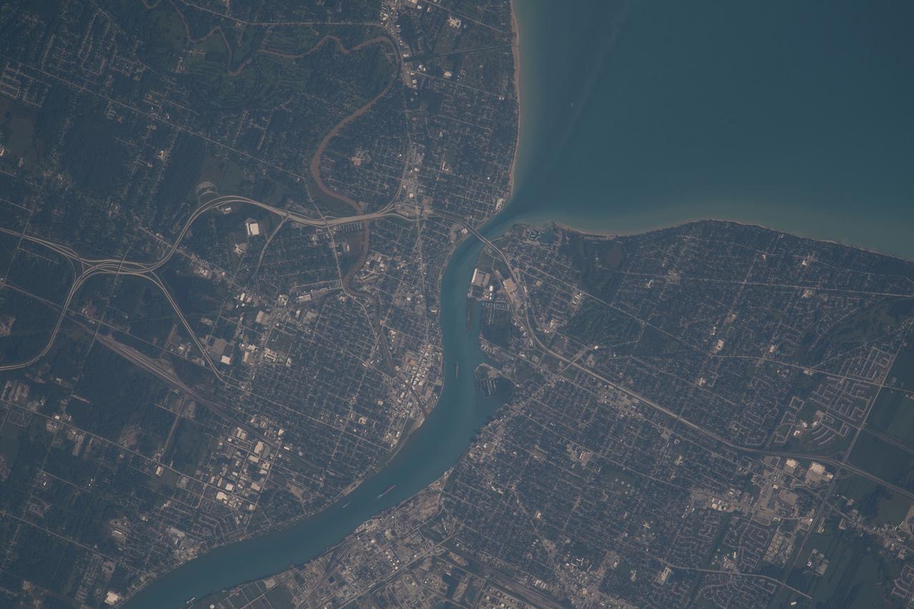
iss064e051420 (April 2, 2021) --- The Detroit River, pictured from the International Space Station as it orbited 264 miles above, separates Detroit, Michigan, from Windsor in Ontario, Canada. The Detroit River also connects to Lake St. Clair (pictured at top) and Lake Erie (out of frame).
ISS047e043884 (04/05/2016) --- Expedition 47 crewmembers on board the International Space Station captured this brightly lit night image of the largest city along Lake Michigan in the US Midwest state of Illinois: Chicago.

iss070e099645 (Feb., 23, 2024) --- Chicago, Illinois, was pictured at night by Expedition 70 Flight Engineer Jasmin Moghbeli as the International Space Station orbited 261 miles above Lake Michigan.

iss071e000004 (April 7, 2024) --- Lakes Michigan, Huron, and Erie figure prominently in this photograph from the International Space Station as it orbited 261 miles above The Prairie State of Illinois.
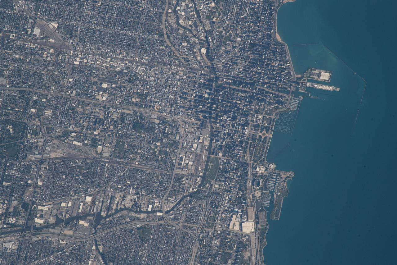
iss056e085102 (July 8, 2018) --- An Expedition 56 crew member photographed downtown Chicago, Illinois as the International Space Station was beginning its orbit over Lake Michigan.
iss059e090279 (June 3, 2019) --- Lakes Erie and St. Clair and the cities of Detroit, Michigan and Toledo, Ohio are pictured as the International Space Station orbited 257 miles over North America.
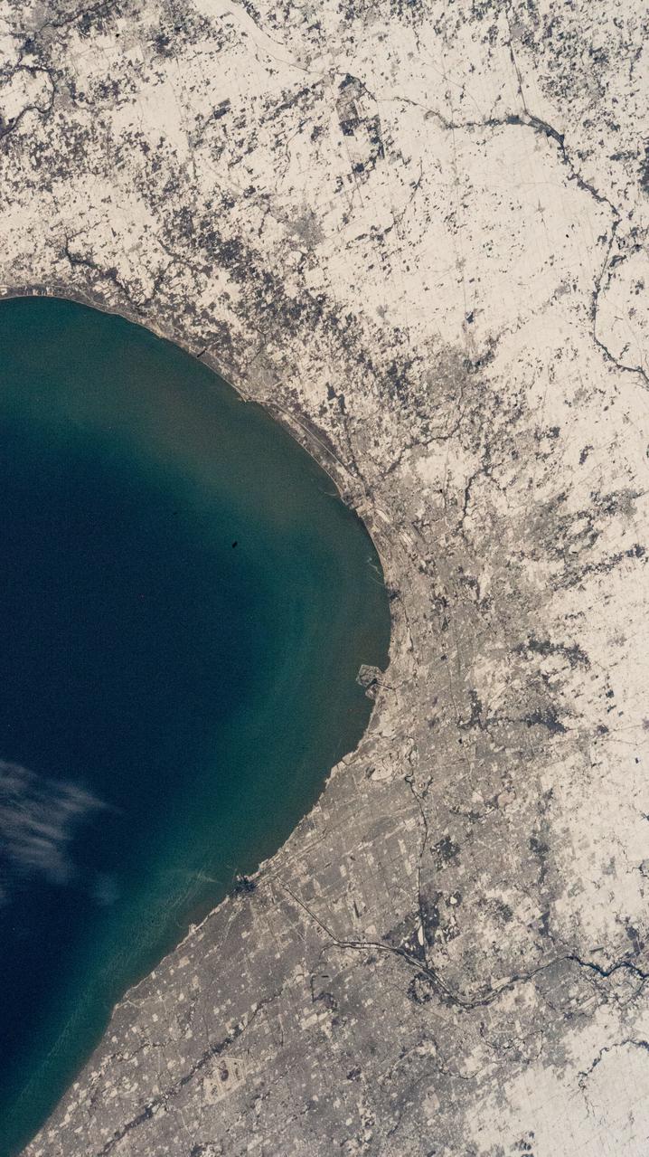
iss066e146455 (Feb. 18, 2022) --- The southern tip of Lake Michigan and a snow-covered Chicago, Illinois, are pictured from the International Space Station as it orbited 260 miles above.
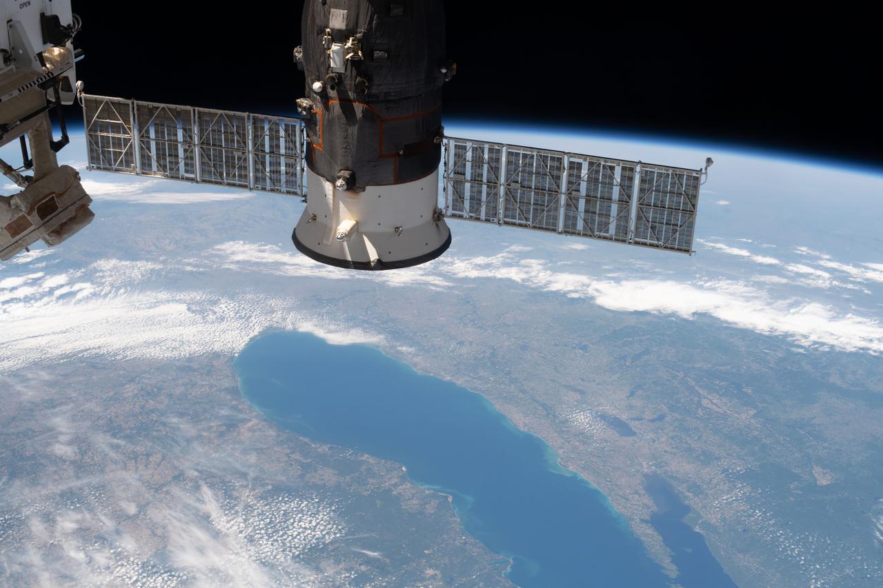
iss063e027839 (June 13, 2020) --- Lake Michigan figures prominently in this photograph of North America from the International Space Station with Russia's Progress 74 resupply ship in the foreground.
iss073e0814049 (Sept. 26, 2025) --- Detroit, Michigan, sits on the banks of the Detroit River, which connects Lake St. Clair (center) to Lake Erie to the south. To the north, the St. Clair River links Lake St. Clair with Lake Huron. Both rivers serve as natural borders between the United States and Canada. The International Space Station was orbiting 259 miles above Ontario, Canada, at the time of this photograph.
ISS028-E-010162 (29 June 2011) --- Sault Ste Marie, Ontario and Michigan are featured in this image photographed by an Expedition 28 crew member on the International Space Station. The twin cities of Sault Ste Marie are located across the St. Mary?s River that forms part of the international boundary between Canada (Province of Ontario) and the United States (State of Michigan). This photograph highlights the two cities, together with the region of lakes and islands that separates Lakes Huron and Superior, two of the Great Lakes of North America. Smaller lakes include Lake George to the west; the large forested islands of St. Joseph and Drummond are visible at lower left. The Sault Ste Marie urban areas (upper right) have a distinctive gray to white coloration in the image, contrasting with the deep green of forested areas in Ontario and the lighter green of agricultural fields in Michigan. The coloration of water surfaces in the lakes and rivers varies from blue to blue-green to silver, and is likely caused by varying degrees of sediment and sunglint ? light reflecting back to the observer on the space station from the water surface, much as light reflects from a mirror. Prior to formalization of the US/Canada border in 1817, Sault Ste Marie was a single community. Archeological evidence suggests that the region had been occupied by Native Americans at least five hundred years ago. A mission ? the first European settlement in Michigan ? was established there in 1668 by the French Jesuit Father Jacques Marquette. Today, shipping locks and canals in both urban areas are an important part of the Great Lakes shipping traffic system.
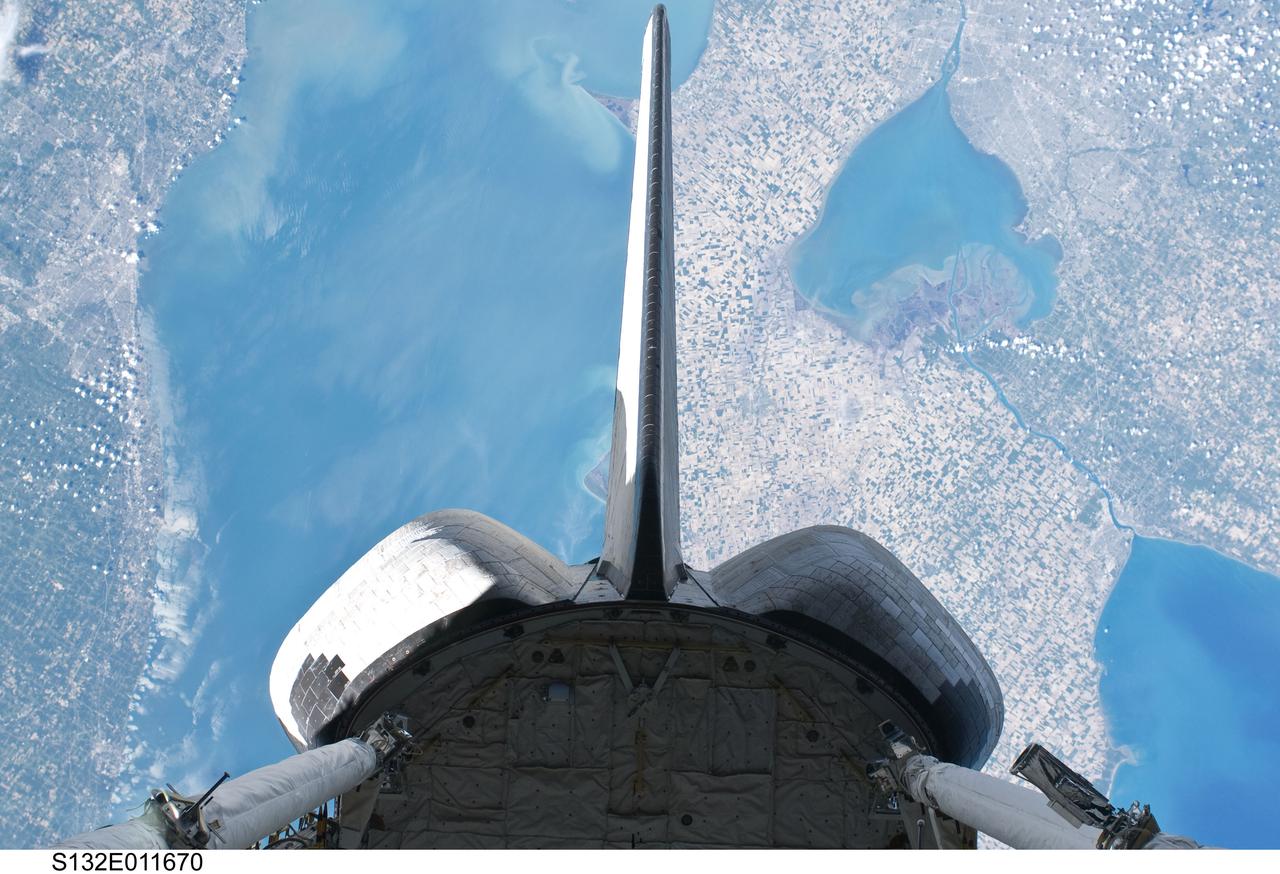
S132-E-011670 (25 May 2010) --- Backdropped over parts of Michigan and the Canadian province of Ontario, space shuttle Atlantis? vertical stabilizer, orbital maneuvering system (OMS) pods and aft payload bay are featured in this image photographed by an STS-132 on the shuttle during flight day 12 activities. Recognizable features in the photo include Lake St. Clair and parts of Lake Huron and Lake Erie.
iss073e0000481 (April 22, 2025) --- The St. Clair River flows into the freshwater Lake St. Clair and separates the American state of Michigan (top) from the Canadian province of Ontario (bottom) in this photograph from the International Space Station as it orbited 260 miles above.
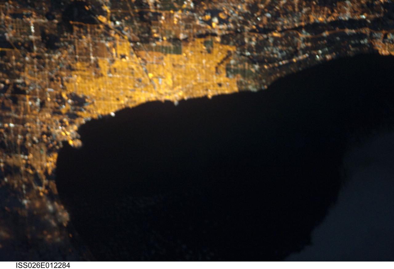
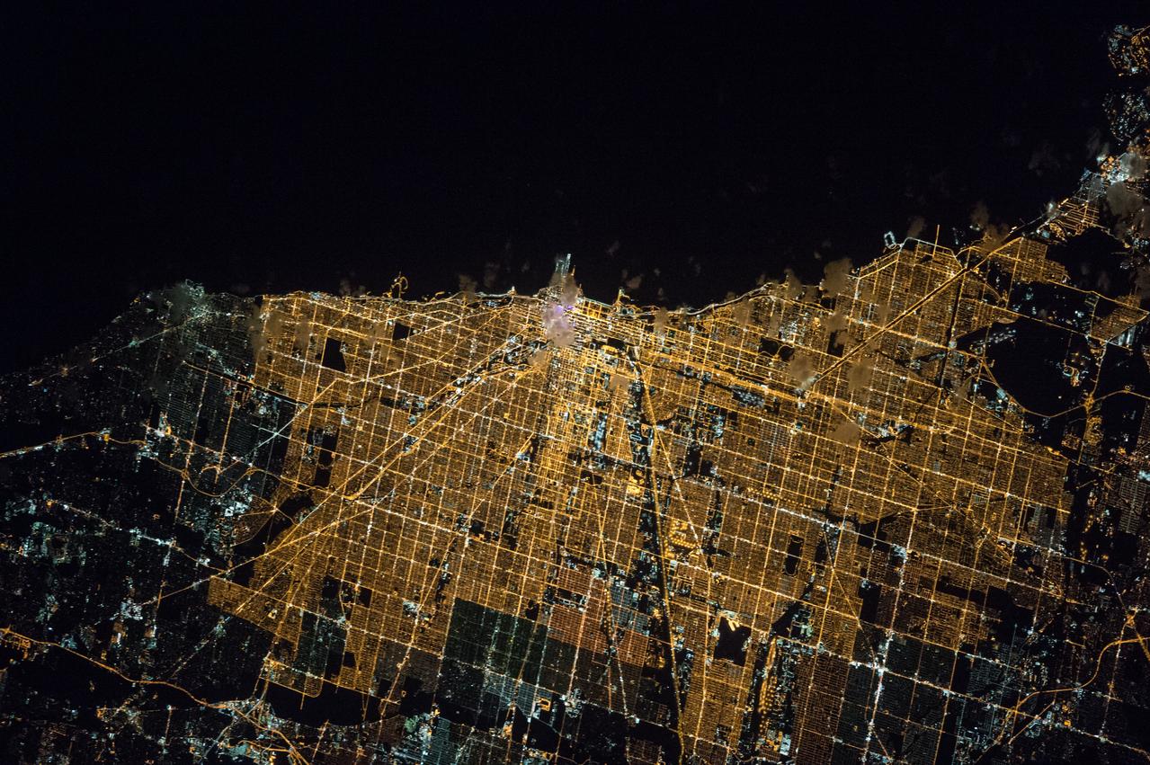
ISS026-E-012284 (23 Dec. 2010) --- From 220 miles above Earth, one of the Expedition 26 crew members aboard the International Space Station recorded this night image of the Chicago metropolitan area and part of Lake Michigan, using a still camera equipped with a 180-mm lens.
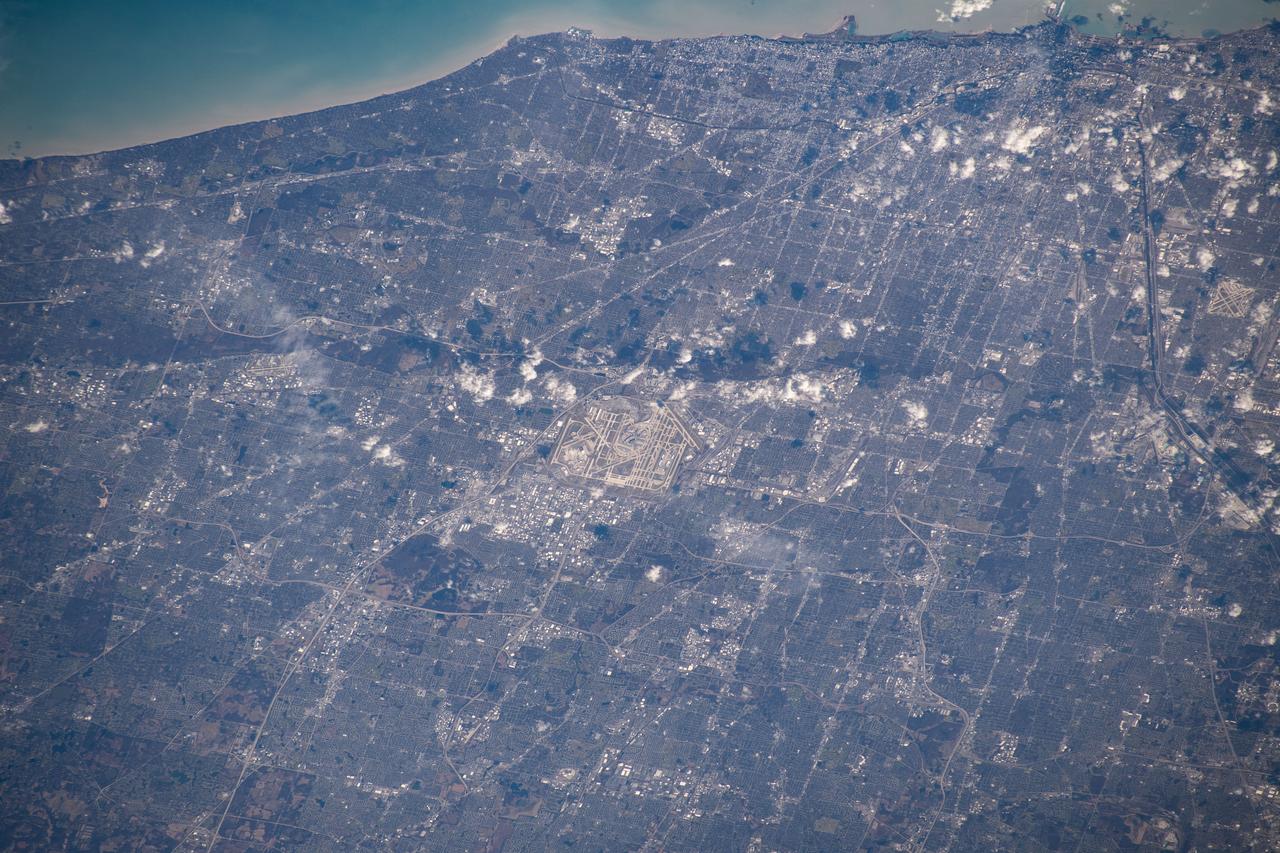
iss061e067911 (Dec. 6, 2019) --- Chicago's O'Hare International Airport is centered in this photograph with the Windy City's downtown at the top right corner on the coast of Lake Michigan. The International Space Station was orbiting 259 miles above the state of Illinois when this picture was taken.
iss069e060965 (Aug. 16, 2023) --- The St. Clair River separates the American city of Port Huron, Michigan (left), from the Canadian city of Sarnia, Ontario (right), and enters into Lake Huron in this photograph from the International Space Station as it orbited 263 miles above.
ISS037-E-006132 (5 Oct. 2013) --- One of the Expedition 37 crew members aboard the International Space Station recorded this nearly vertical night image featuring the southwest coast of Lake Michigan, including the greater metropolitan area of Chicago, IL, on Oct. 5, 2013.
STS105-714-028 (20 August 2001) --- Backdropped by Lake Michigan, this distant view shows the recently deployed small science satellite called Simplesat, which is an engineering satellite, designed to evaluate the use of inexpensive commercial hardware for spacecraft. It was spring-ejected from a canister at the rear of the Shuttle's cargo bay.
ISS008-E-06565 (30 November 2003) --- This view featuring the Lake Michigan area was photographed by an Expedition 8 crewmember on the International Space Station (ISS). The photo also shows Chicago area; Illinois River; Mississippi and Missouri Rivers meeting at St. Louis. Aircraft contrails are also visible.
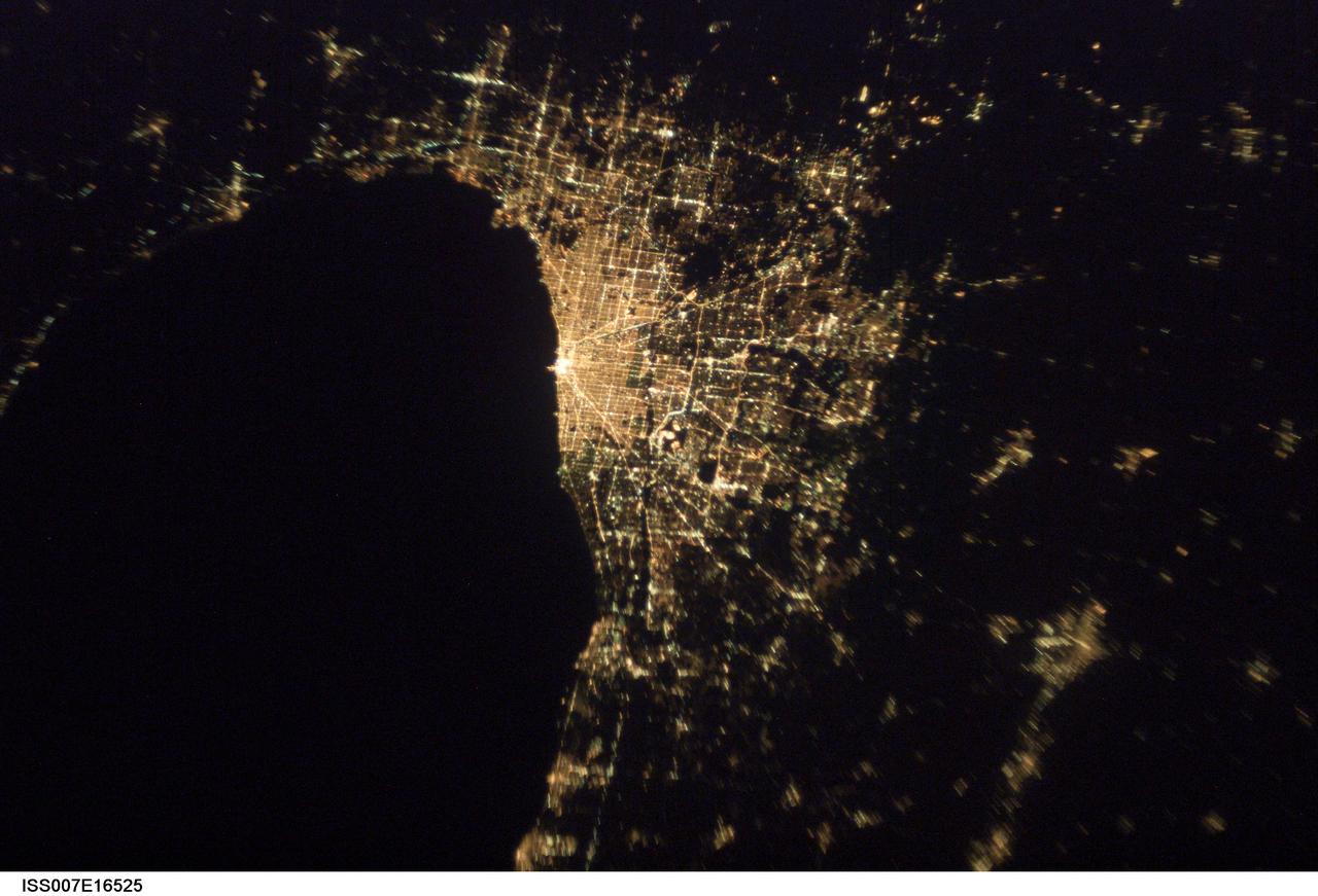
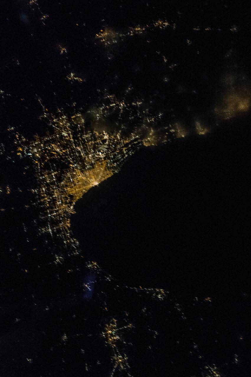
ISS007-E-16525 (7 October 2003) --- This image of Chicago, Illinois at night, taken by an Expedition 7 crewmember onboard the International Space Station (ISS), shows patterns of the city center and major roads along the coast of Lake Michigan.

iss073e0080182 (May 15, 2025) --- Chicago, Illinois, with a metropolitan population of 9.6 million near the southern tip of Lake Michigan, is pictured at approximately 1:32 a.m. local time from the International Space Station as it orbited 261 miles above.
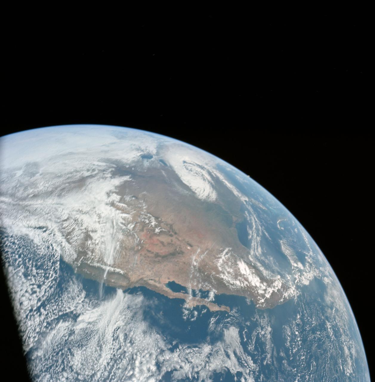
In this oblique view of the Georgia and South Carolina coast, the southern most Appalachians (32.0N, 83.0W) dominate the foreground. Contrails criss cross over Atlanta, a major airline hub. The coastal plain which wraps around the southern Appalachians, is well delineated. Faintly visible under the haze toward Earth's limb are the Great lakes (Lake Michigan near center), the folded belts of the central Appalachians and Long Island, New York.

SL2-05-390 (22 June 1973) --- Greater Detroit (42.0N, 82.5W) is located at the southeastern border of Michigan on the Detroit River across from Windsor, Ontario, Canada and Lake Huron to the north. The river connecting Lake Erie is a channel left over from the Ice Age Glaciers. The land use pattern in this scene is typical of this part of the upper Midwest. The once extensive forests have been cleared for farmland and pasture, but narrow rows of trees still line farm boundaries. Photo credit: NASA

iss056e032790 (June 20, 2018) --- Canada and the United States are separated at this entry point by the St. Mary's River. The similarly named cities of Sault Ste. Marie, Michigan is to the south and Sault Ste. Marie, Ontario is to the north (in this orientation they are from left to right). The St. Mary's River leads into Lake Superior heading west and Lake Huron heading south.
SL2-05-454 (22 June 1973) --- This view shows the west end of Lake Superior and Duluth, MN (47.0N, 91.0W). Portions of Minnesota, Michigan and Ontario, Canada are in the scene. The Duluth metropolitan area is at the west end of the lake. The discoloration plume in the water at Duluth is the result of tailings from the iron ore smelters that process the iron ore from the nearby open pit mines seen near the upper left corner of the photo. Photo credit: NASA
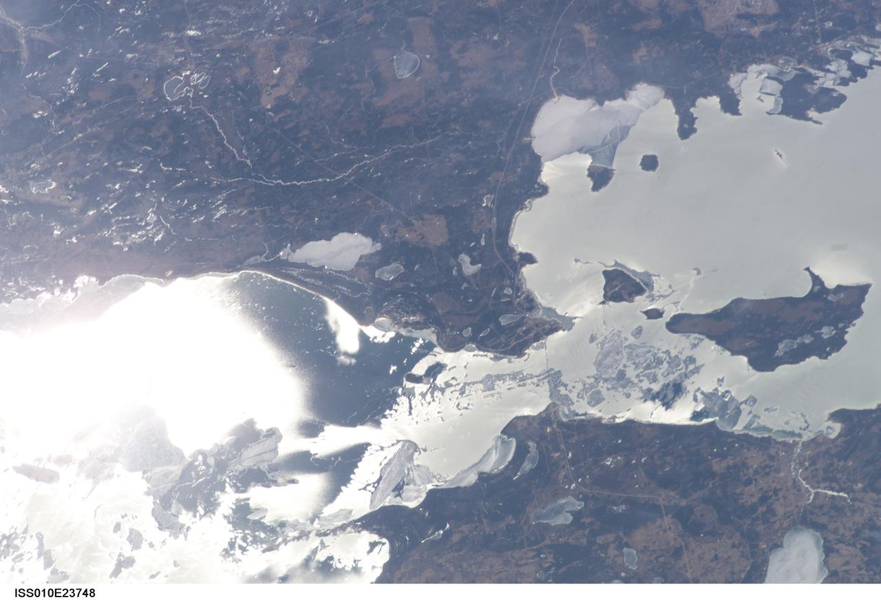
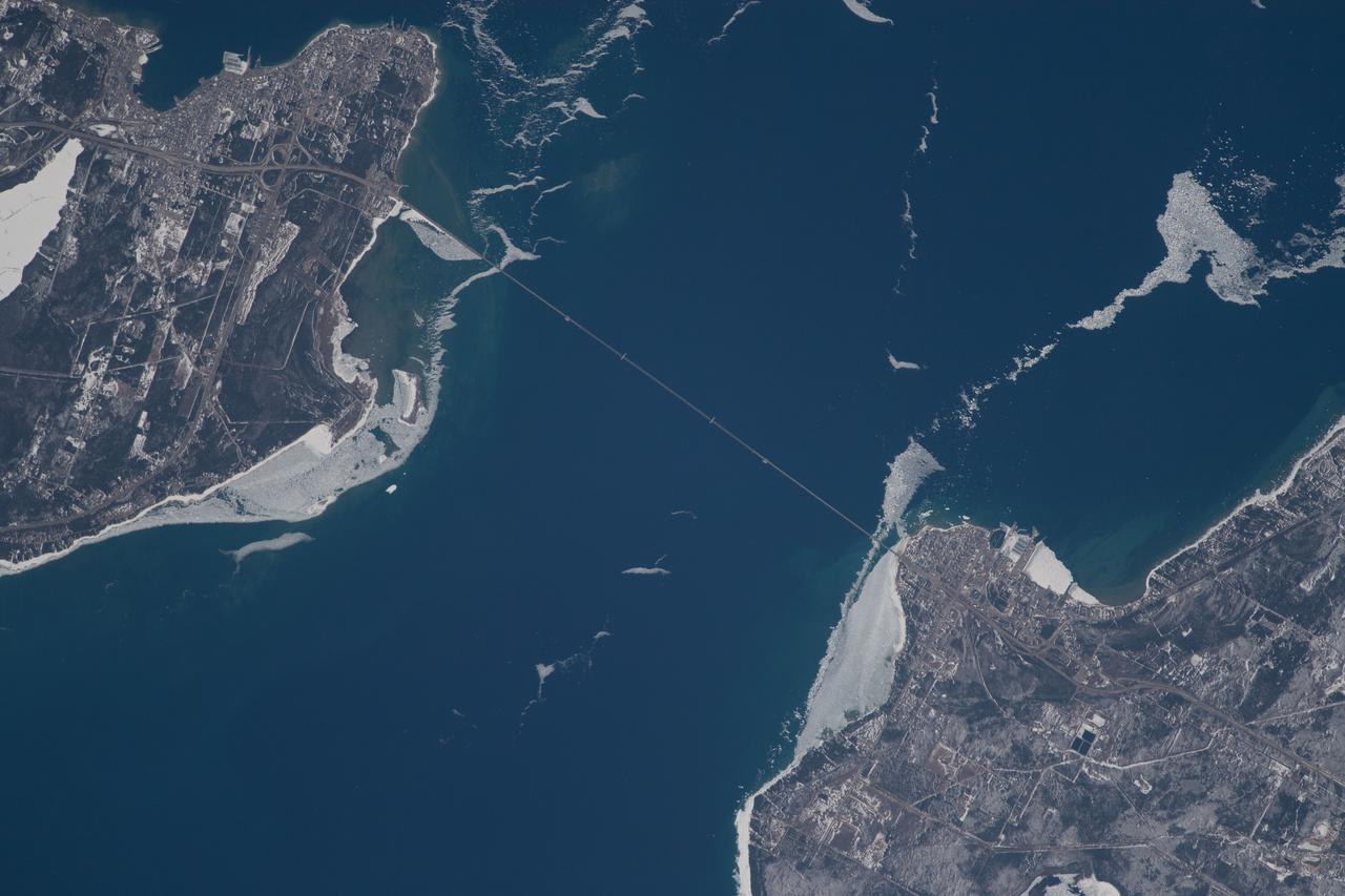
ISS010-E-23748 (9 April 2005) --- The Straits of Mackinac are featured in this image photographed by an Expedition 10 crewmember on the International Space Station (ISS). The Mackinac Bridge spans a stretch of water five miles wide between Michigan’s lower and upper peninsulas. The strait connects Lakes Michigan (left) and Huron (right). The bridge is a combination of pier-supported spans with a high, central suspension sector that allows passage of lake steamers. The suspension sector is the longest in the Americas (8614 feet or 1.6 miles). Prior to construction of the bridge, the only passage across the straits was by ferryboat. This view shows the ice broken into a series of irregular rafts that appear gray against bright water in this partial sunglint view. The shipping channel is maintained even through remnants of the ice mass, but the ice ridges can be hazardous to shipping during ice break-up.
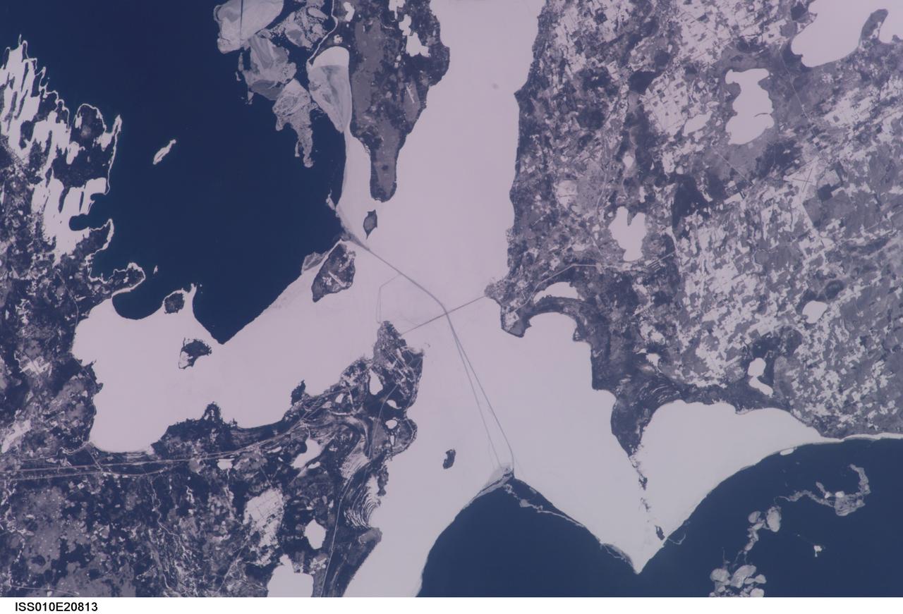
ISS010-E-20813 (22 March 2005) --- The Straits of Mackinac are featured in this image photographed by an Expedition 10 crewmember on the International Space Station (ISS). The Mackinac Bridge spans a stretch of water five miles wide between Michigan’s lower and upper peninsulas. The strait connects Lakes Michigan (left) and Huron (right). The bridge is a combination of pier-supported spans with a high, central suspension sector that allows passage of lake steamers. The suspension sector is the longest in the Americas (8614 feet or 1.6 miles). Prior to construction of the bridge, the only passage across the straits was by ferryboat. This view shows shipping lanes opened by ice breakers. A narrow passage leads to the small town of St. Ignace at the north end of the bridge (Mackinaw City appears at the south end). The shipping channel is maintained even through remnants of the ice mass, but the ice ridges can be hazardous to shipping during ice break-up.
ISS038-E-057977 (22 Feb. 2014) --- Snow-covered fields appear as geometric patterns on Washington Island, on Lake Michigan, in this photograph taken by the Expedition 38 crew of the International Space Station. The island is nine kilometers long (5.6 miles) and lies on the western shore of Lake Michigan, as a continuation of Door Peninsula (Wisconsin). Note that north is to the lower left in the image. White coastal ice hugs the shoreline and connects Washington Island with Detroit Island and Rock Island. Ice typically accumulates first near land, where cooling is more rapid than in deeper lake water. Two other snow-covered islands (image top left) are small enough and far enough from land to evade the collars of ice. On the day this image was taken, southwesterly winds were blowing ice into the lake in the form of long, coherent stringers. The thickness of a stringer is related to the length of coastline that feeds it. The smallest northern stringer (image left) is fed by the shortest section of upwind coastline, and the longest (image right) is supplied by the large amount of shore ice around Detroit Island.
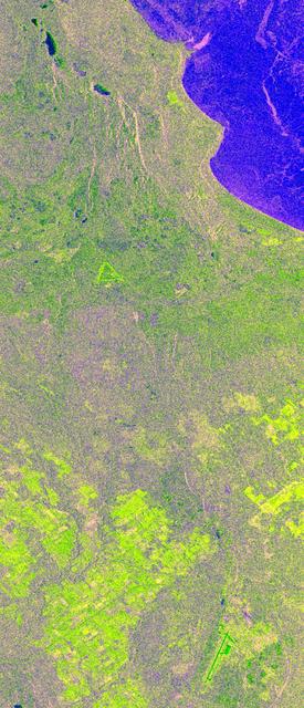
This is an X-band image of seasonal changes at the ecological test site of Raco, Michigan, located south of Whitefish Bay on Lake Superior. The image is centered at about 46 degrees north latitude and 85 degrees west longitude. This image was acquired by the X-band Synthetic Aperture Radar onboard the space shuttle Endeavour on April 10th, 1994, and on October 1, 1994. The areas shown in red correspond to the April 10th data; the areas in blue correspond to data acquired on October 1, 1994; green indicates the ratio of data acquired on April 10 and October 1, 1994. The area shown is 22.7 kilometers by 53 kilometers (14 miles by 33 miles). Lake Superior in the upper right was frozen in April and had small waves (ripples) on its surface in October. The land area contains mostly forests and, to a lesser extent, agricultural regions. In April the area was covered in wet snow. By October, there agricultural areas were covered with grass. Vegetation and soils were moist due to rainfalls three days before the data was acquired on October 1, 1994. The bright light green/yellow tones in the lower half of the image show the stronger reflections of the snow-covered agricultural fields. The pinkish color corresponds to the coniferous and deciduous forests. The green area represents red pines. These trees are smaller than the surrounding forest cover and allow more radar penetration. The area is green because the radar is sensing the surface, which undergoes great change from snow to grass and fern undergrowth between April and October. The bright green triangle in the upper half of the image is an old airstrip, while the modern airport can be seen on the bottom right side of the image. The Raco site is an important location for monitoring seasonal changes and future global change because it is situated at the ecological transition zone between the boreal forests and the northern temperate forests. This transitional zone is expected to be ecologically sensitive to anticipated global changes resulting from climatic warming. Baseline studies of vegetation are essential in monitoring these expected changes. http://photojournal.jpl.nasa.gov/catalog/PIA01734
ISS013-E-27872 (28 May 2006) --- Considerable sunglint emphasizes features on Lake Erie in this image photographed by an Expedition 13 crewmember on the International Space Station. This detailed, south-looking image shows features on the surface of Lake Erie, about 30 miles west of Cleveland, Ohio. This view shows the Vermilion River in strong sunglint. The angular water bodies along the river are likely marinas. The main part of the image show numerous ship wakes in the zone of partial glint around the disk of the Sun's reflection point. The wakes radiate from the mouth of the Vermilion River, with many of them heading northwest in the direction of Detroit, Michigan.
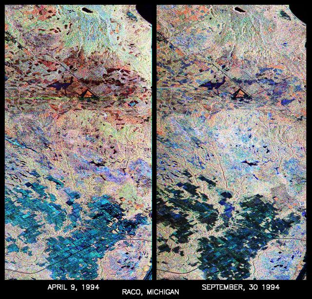
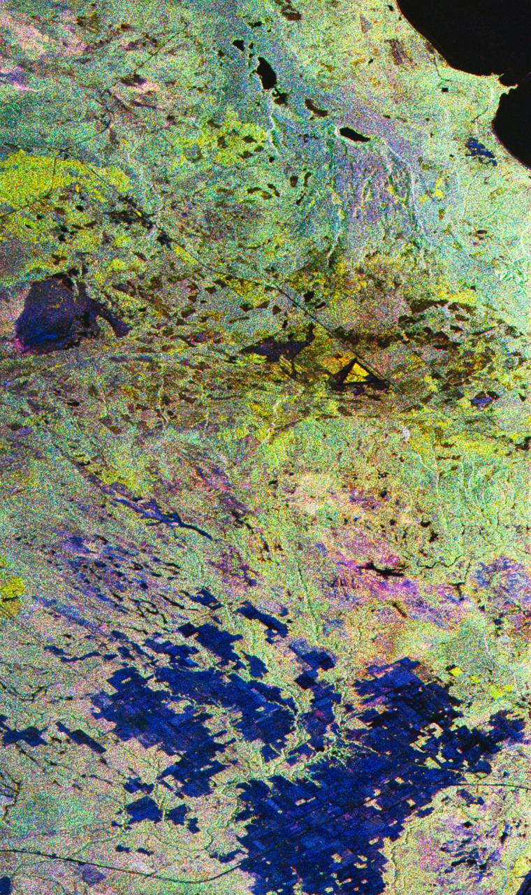
These are two false-color composites of Raco, Michigan, located at the eastern end of Michigan upper peninsula, west of Sault Ste. Marie and south of Whitefish Bay on Lake Superior. The two images (centered at 46.39 degrees north latitude, 84.88 degrees west longitude) show significant seasonal changes in the mid-latitude region of mixed deciduous and coniferous forests. The images were acquired by the Spaceborne Imaging Radar-C and X-band Synthetic Aperture Radar (SIR-C/X-SAR) aboard the shuttle Endeavour on the sixth orbit of each mission. In these images, red is L-band (23 cm) with horizontal/vertical polarization; green is C-band (6 cm) with horizontal/vertical polarization; blue is C-band with horizontal/horizontal polarization. The region shown is largely forested and includes a large portion of Hiawatha National Forest, as well as an agricultural region near the bottom of each image. In early April, the area was snow-covered with up to 50 centimeters (19.5 inches) of snow in forest clearings and agricultural fields. Buds had not yet broken on deciduous trees, but the trees were not frozen and sap was generally flowing. Lake Superior, in the upper right, and the small inland lakes were frozen and snow-covered on April 9, 1994. By the end of September, deciduous trees were just beginning to change color after a relatively wet period. Leaf loss was estimated at about 30 percent, depending on the species, and the soil was moist to wet after a heavy rainfall on September 28, 1994. Most agricultural fields were covered with grasses of up to 60 centimeters (23 inches) in height. In the two images the colors are related to the types of land cover (i.e. vegetation type) and the brightness is related to the amount of plant material and its relative moisture content. Significant seasonal changes between early spring and early fall are illustrated by this pair of images. For the agricultural region near the bottom of the images, the change from snow-cover to moist soil with short vegetation cover is shown by the color change from blue to green and blue. The green color corresponds to significant increases in vegetation cover and field-to-field differences in blue are the result of differences in surface roughness and soil moisture. In the forested areas, many of the conifer forests appear similar in both images (red pine forests appear red in both images). However, there is more blue and green in the September 30, 1994 image as a consequence of greater foliage and more moisture in the forest crowns. Lowland conifer forests (spruce and northern white cedars) appear as bright green in both images. Deciduous forests produce very strong radar returns at these frequencies and polarization combinations, resulting in a nearly white appearance on the images (the specific color mix is related to the local species mix). In the September 30, 1994 image, the areas of deciduous forest appear darker than in the April image because of the weaker radar signal from the foliage in the crown layer. The clear-cut areas (shown in April by the irregularly shaped dark areas in the center) change dramatically in appearance due to loss of snow cover and increases in soil moisture and vegetation cover by the end of September. http://photojournal.jpl.nasa.gov/catalog/PIA01730
SL2-05-389 (22 June 1973) --- This scene displays the southeastern part of Michigan's Lower Peninsula and adjacent Ontario, Canada (43.0N, 84.0W). Detroit can be recognized by its radial pattern of development and sediment plumes in the rivers from the massive industrial activity. The area pockmarked by lakes northwest of Detroit essentially outlines the limits of the Defiance Moraine caused by the stagnation and melting of Ice Age glaciers. Photo credit: NASA

iss070e022671 (Nov. 10, 2023) --- The sun's first rays begin illuminating Earth's atmosphere in this photograph from the International Space Station as it orbited 260 miles above the central United States. At far left, the city lights of Chicago, Illinois, are outlined by Lake Michigan. At far right, the city lights of the Dallas/Forth Worth metropolitan area shine through the clouds.
61A-31-005 (30 Oct 1985) --- This almost vertical view, photographed from Earth-orbit by an STS-61A crew member, centers on the metropolis of Milwaukee, Wisconsin, and some of the adjacent Lake Michigan shoreline, southward toward the Illinois border. The 70mm frame was photographed on the first day of the Spacelab D-1 mission with a handheld Hasselblad camera.
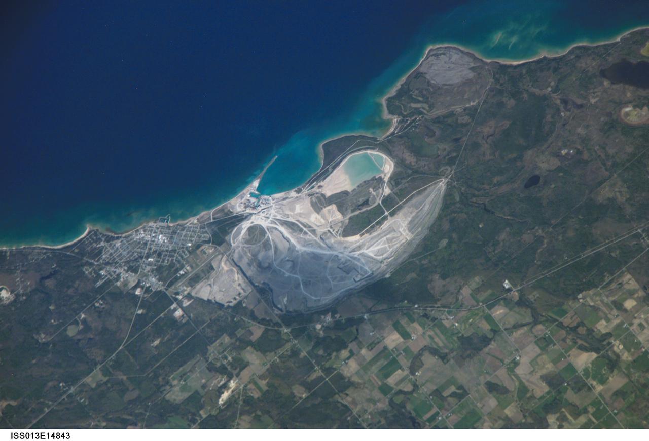
ISS013-E-14843 (6 May 2006) --- Calcite Quarry, Michigan is featured in this image photographed by an Expedition 13 crewmember on the International Space Station. While the Great Lakes region of North America is well known for its importance to shipping between the United States, Canada, and the Atlantic Ocean, it is also the location of an impressive structure in the continent's bedrock -- the Michigan Basin, NASA scientists point out. The Basin looks much like a large bull's-eye defined by the arrangement of exposed rock layers, which all tilt inwards towards the center forming a huge bowl-shaped structure. While this "bowl" is not readily apparent while on the ground, detailed mapping of the rock units on a regional scale revealed the structure to geologists. The outer layers of the Basin include thick deposits of carbonates (limestone and dolomite). These carbonate rocks are mined throughout the Great Lakes region using large open-pit mines. The largest carbonate mine in the world, Calcite Quarry, is depicted in this image. The mine has been active for over 85 years; the worked area (grey region in image center) measures approximately 7 kilometers long by 4 kilometers wide, and is crossed by several access roads (white) into various areas of the mine.
ISS036-E-035635 (24 Aug. 2013) --- Plankton bloom and Lake Ontario are featured in this image photographed by an Expedition 36 crew member on the International Space Station. This photograph highlights a late summer plankton bloom visible throughout much of Lake Ontario (one of the Great Lakes, together with Michigan, Superior, Erie, and Huron). Cyanobacteria, or blue-green algae, can reach such large concentrations that they color the water to such an extent that the change is visible from orbit. Harmful algal blooms, or HABs, have been observed in all of the Great Lakes – particularly Lake Erie - and are associated with a variety of causative factors including changes in precipitation; drought; invasive species (quagga, zebra mussels, Asian carp); nutrient loading from runoff and sewage (nitrogen and phosphorus); and warmer average temperatures. In addition to reduced water quality and human health concerns, algal blooms can also lead to hypoxia (reduction of oxygen in the bottom waters) that kills large numbers of fish and other aquatic life. Lake Ontario, like the other Great Lakes Erie, Huron, and Superior is roughly divided between the USA and Canada. The USA side of Lake Ontario has its shoreline along the state of New York, while its Canadian shoreline lies within the province of Ontario. The city of Kingston, Ontario, is visible near the Saint Lawrence River outflow from the lake. Several other landscape features of New York State are visible in the image, including the Finger Lakes region to the west of Syracuse, NY (upper left). To the northeast of Syracuse, the dark wooded slopes of the Adirondack Mountains are visible at lower right. Patchy white cloud cover obscures much of the land surface to the west of Lake Ontario.
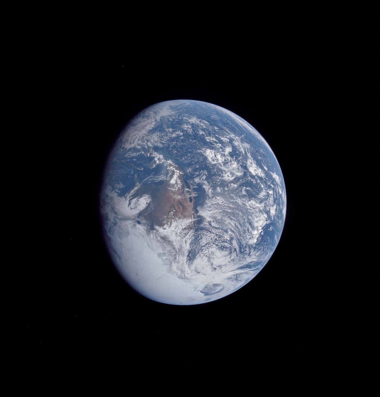
AS16-118-18885 (16 April 1972) --- A good view of Earth photographed about one and one-half hours after trans-lunar injection on April 16, 1972. Although there is much cloud cover, the United States in large part, most of Mexico and some parts of Central America are clearly visible. Note Lake Michigan and Lake Superior and the Bahama Banks (see different shade of blue below Florida). Just beginning man's fifth lunar landing mission were astronauts John W. Young, commander; Thomas K. Mattingly, II, command module pilot and Charles M. Duke Jr., lunar module pilot. While astronauts Young and Duke descended in the Lunar Module (LM) "Orion" to explore the Descartes highlands region of the moon, astronaut Mattingly remained with the Command and Service Modules (CSM) "Casper" in lunar orbit.

ISS030-E-062540 (2 Feb. 2012) --- This nighttime image, photographed by one of the members of the Expedition 30 crew from the International Space Station, features the Greater Chicago Metropolitan Area strung along the southwest shore of Lake Michigan. The region is partially covered by clouds, probably low-hanging, or even fog. Meteorologists say there is a fine line between low thin clouds and fog. Fog is not common in the Great Lakes area this time of the year (usually too windy), but this has been an exceptionally mild winter. The faint gold line of airglow—caused by ultraviolet radiation exciting the gas molecules in the upper atmosphere—parallels the horizon or Earth limb. Minor auroral activity (Borealis) is visible in upper right.
AS16-118-18873 (16 April 1972) --- A good view of Earth photographed shortly after trans-lunar injection of April 16, 1972. Although there is much cloud cover (over Canada and the oceans), the United States in large part, most of Mexico and some parts of Central America are clearly visible. Note Lake Michigan and Lake Superior, also note the Bahama Banks at upper right part of the sphere. A large part of the Rocky Mountain Range is also visible. Just beginning man's fifth lunar landing mission were astronauts John W. Young, commander; Thomas K. Mattingly II, command module pilot; and Charles M. Duke Jr., lunar module pilot. While astronauts Young and Duke descended in the Lunar Module (LM) to explore the moon, astronaut Mattingly remained with the Command and Service Modules (CSM) in lunar orbit.
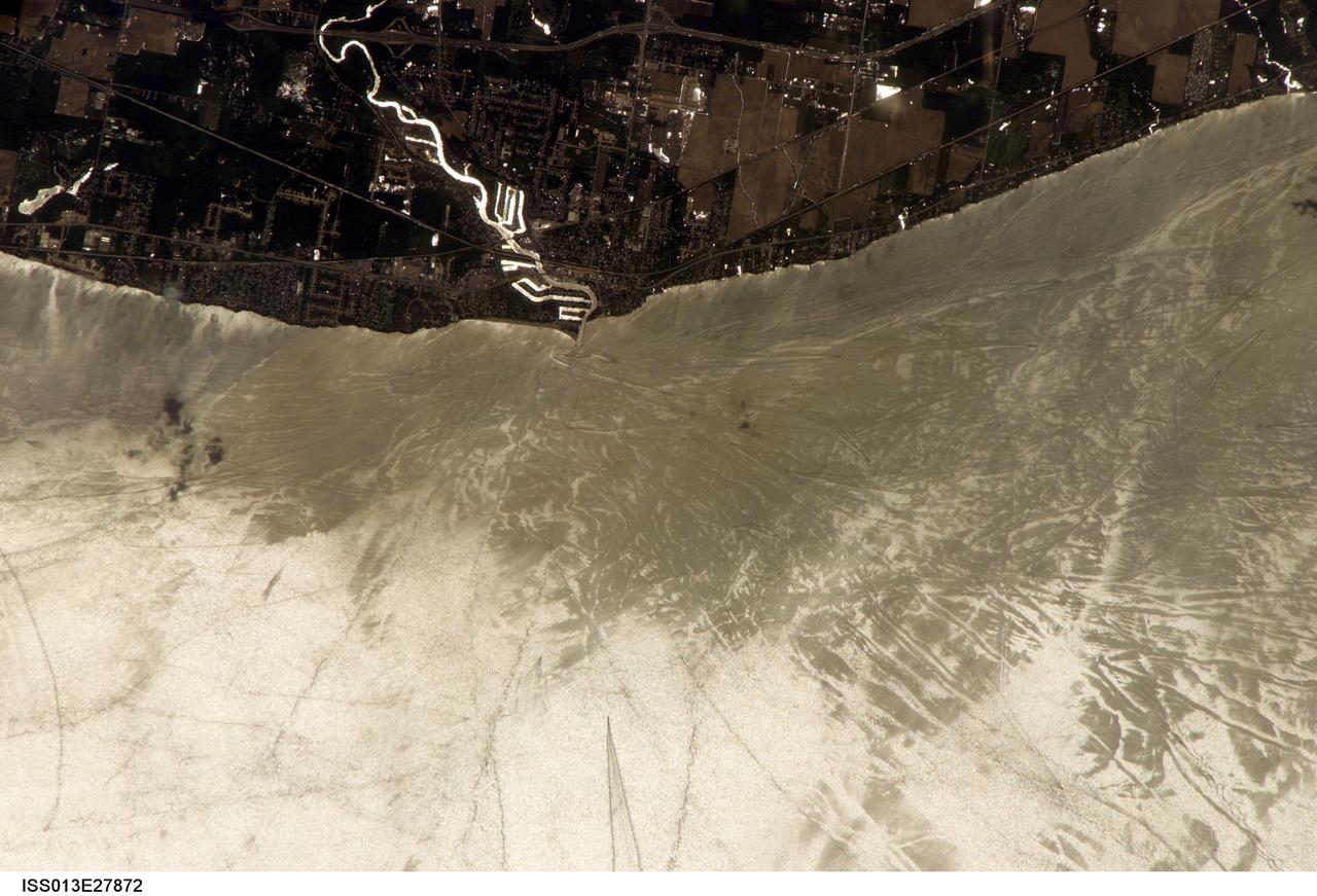
STS060-103-089 (3-11 Feb. 1994) --- The Chicago, Illinois area is in this northeast looking low oblique view obtained in February, 1994. Lake Michigan, a good portion covered with ice due to the very cold winter weather that has plagued this region since early December, 1993, can be seen to the east of the city. The Des Plaines river is visible traversing northeast to southwest through the center of the city. O'Hare International Airport and the Glenview Naval Air Station can be seen to the north of the Des Plaines River. Midway Airport is visible just to the south of the river. Chicago is a port of entry; a major Great Lakes port located at the junction of the St. Lawrence Seaway with the Mississippi River system; the busiest air center in the United States; and an important rail and highway transportation hub. Chicago is known for large grain mills and elevators, iron and steel works, steel fabrication plants, stockyards, meat-packing establishments, and printing and publishing houses. In the early days of settlement, the narrow watershed between Lake Michigan and the Des Plaines River (draining the Mississippi River through the Illinois River), offered an easy portage that led explorers like Father Marquette and Louis Joliet and others to the Great Central Plains. Fort Dearborn, a military post was established in 1803. By 1860, the railroad connected Chicago to the rest of the country and the city became a great mid-continent shipping and receiving center. In 1871, the city built of wood, was almost entirely destroyed by a great fire. After the fire, Chicago was built as a city of steel and stone. During the World's Colombian Exposition held in Chicago in 1893, the city became a leading architectural center. It was here during the Exposition that the skyscraper came into being. Chicago continues to lead the way in this type of architectural structure as is evidenced with the completion of the Sears Tower in 1974.
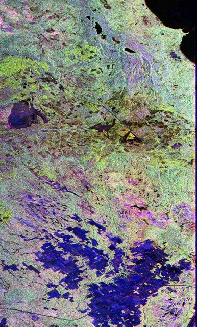
This image is a false-color composite of Raco, Michigan, centered at 46.39 degrees north latitude, 84.88 degrees west longitude. This image was acquired by the Spaceborne Imaging Radar-C and X-Band Synthetic Aperture Radar (SIR-C/X-SAR) aboard the space shuttle Endeavour on its sixth orbit and during the first full-capability test of the instrument on April 9, 1994. This image was produced using both L-band and C-band data. The area shown is approximately 20 kilometers by 50 kilometers (12 by 30 miles). Raco is located at the eastern end of Michigan's upper peninsula, west of Sault Ste. Marie and south of Whitefish Bay on Lake Superior. The site is located at the boundary between the boreal forests and the northern temperate forests, a transitional zone that is expected to be ecologically sensitive to anticipated global changes resulting from climatic warming. On any given day, there is a 60 percent chance that this area will be obscured to some extent by cloud clover which makes it difficult to image using optical sensors. http://photojournal.jpl.nasa.gov/catalog/PIA01700
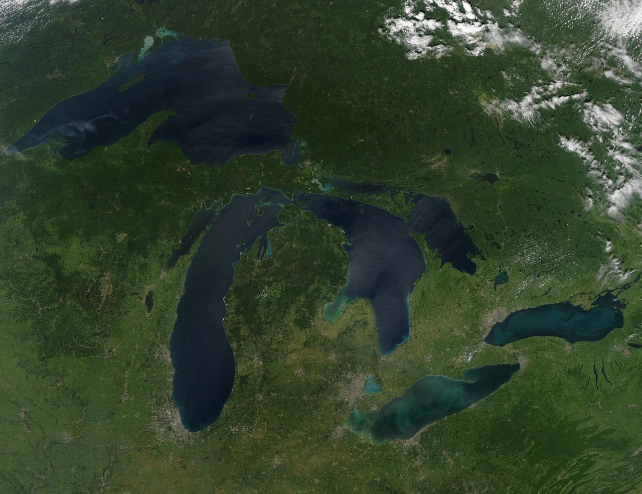
NASA image acquired August 28, 2010 Late August 2010 provided a rare satellite view of a cloudless summer day over the entire Great Lakes region. North Americans trying to sneak in a Labor Day weekend getaway on the lakes were hoping for more of the same. The Great Lakes comprise the largest collective body of fresh water on the planet, containing roughly 18 percent of Earth's supply. Only the polar ice caps contain more fresh water. The region around the Great Lakes basin is home to more than 10 percent of the population of the United States and 25 percent of the population of Canada. Many of those people have tried to escape record heat this summer by visiting the lakes. What they found, according to The Hamilton Spectator, was record-breaking water temperatures fueled by record-breaking air temperatures in the spring and summer. By mid-August, the waters of Lake Superior were 6 to 8°C (11 to 14°F) above normal. Lake Michigan set records at about 4°C (7°F) above normal. The other three Great Lakes – Huron, Erie, and Ontario -- were above normal temperatures, though no records were set. The image was gathered by the Moderate Resolution Imaging Spectroradiometer (MODIS) on NASA’s Aqua satellite at 1:30 p.m. Central Daylight Time (18:30 UTC) on August 28. Open water appears blue or nearly black. The pale blue and green swirls near the coasts are likely caused by algae or phytoplankton blooms, or by calcium carbonate (chalk) from the lake floor. The sweltering summer temperatures have produced an unprecedented bloom of toxic blue-green algae in western Lake Erie, according to the Cleveland Plain Dealer. NASA image by Jeff Schmaltz, MODIS Rapid Response Team, Goddard Space Flight Center. Caption by Mike Carlowicz. Instrument: Aqua - MODIS Click here to see more images from <b><a href="#//earthobservatory.nasa.gov/" rel="nofollow"> NASA Goddard’s Earth Observatory</a></b> <b><a href="http://www.nasa.gov/centers/goddard/home/index.html" rel="nofollow">NASA Goddard Space Flight Center</a></b> is home to the nation's largest organization of combined scientists, engineers and technologists that build spacecraft, instruments and new technology to study the Earth, the sun, our solar system, and the universe. <b>Follow us on <a href="http://twitter.com/NASA_GoddardPix" rel="nofollow">Twitter</a></b> <b>Join us on <a href="http://www.facebook.com/pages/Greenbelt-MD/NASA-Goddard/395013845897?ref=tsd" rel="nofollow">Facebook</a></b>

AS16-118-18880 (16 April 1972) --- A good view of Earth photographed about one hour after trans-lunar injection on April 16, 1972. Although there is much cloud cover, the United States in large part, most of Mexico and some of Central America are clearly visible. Note the Great Lakes (Michigan and Superior) and the Bahama Banks (note different shade of blue below Florida). While astronauts John W. Young, commander, and Charles M. Duke Jr., lunar module pilot, descended in the Lunar Module (LM) "Orion" to explore the Descartes highlands region of the moon, astronaut Thomas K. (Ken) Mattingly II, command module pilot, remained with the Command and Service Modules (CSM) "Casper" in lunar orbit.

National Aeronautics and Space Administration (NASA) pilot Cliff Crabbs and the flight operations crew prepare a Convair F-106B Delta Dart for a flight from the Lewis Research Center in Cleveland, Ohio. NASA acquired the aircraft three years earlier to investigate noise-reducing inlet and nozzle designs for the supersonic transport engine program. Two General Electric J85 engines were installed underneath the aircraft’s delta wings to simulate the general shape of the supersonic transport’s engines. One of the engines was modified with experimental inlet or nozzle configurations. The unmodified engine was used for comparison. Most F-106B flights were flown in a 200-mile path over the lake between Buffalo and Sandusky, known as the Lake Erie Corridor. The 1100-miles per hour flight took only 11 minutes at an altitude of 30,000 feet. The aircraft almost always returned with a depleted fuel supply so a Visual Flight Rules operation was required. Following the crash of another jet fighter at Lewis in July 1969, the F-106s were stationed at Selfridge Air Force Base in Michigan. NASA pilots flew transport planes each morning to the base before commencing the F-106B missions.
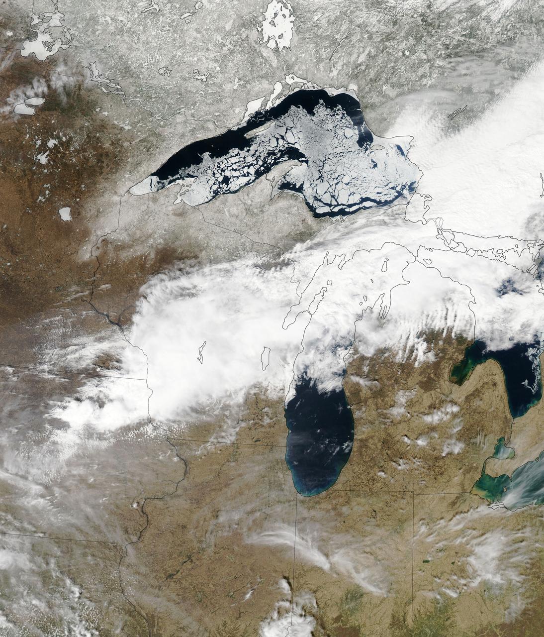
Though North America is a full month into astronomical spring, the Great Lakes have been slow to give up on winter. As of April 22, 2014, the Great Lakes were 33.9 percent ice covered. The lake they call Superior dominated the pack. In the early afternoon on April 20, 2014, the Moderate Resolution Imaging Spectroradiometer (MODIS) on NASA’s Aqua satellite captured this natural-color image of Lake Superior, which straddles the United States–Canada border. At the time Aqua passed over, the lake was 63.5 percent ice covered, according to the NOAA Great Lakes Environmental Research Lab (GLERL). Averaged across Lake Superior, ice was 22.6 centimeters (8.9 inches) thick; it was as much as twice that thickness in some locations. GLERL researcher George Leshkevich affirmed that ice cover this spring is significantly above normal. For comparison, Lake Superior had 3.6 percent ice cover on April 20, 2013; in 2012, ice was completely gone by April 12. In the last winter that ice cover grew so thick on Lake Superior (2009), it reached 93.7 percent on March 2 but was down to 6.7 percent by April 21. Average water temperatures on all of the Great Lakes have been rising over the past 30 to 40 years and ice cover has generally been shrinking. (Lake Superior ice was down about 79 percent since the 1970s.) But chilled by persistent polar air masses throughout the 2013-14 winter, ice cover reached 88.4 percent on February 13 and 92.2 percent on March 6, 2014, the second highest level in four decades of record-keeping. Air temperatures in the Great Lakes region were well below normal for March, and the cool pattern is being reinforced along the coasts because the water is absorbing less sunlight and warming less than in typical spring conditions. The graph below, based on data from Environment Canada, shows the 2014 conditions for all of the Great Lakes in mid-April compared to the past 33 years. Lake Superior ice cover got as high as 95.3 percent on March 19. By April 22, it was reported at 59.9 percent; Lake Huron was nearly 30.4 percent. News outlets noted that as many as 70 ships have been backed up in Lakes Michigan, Huron, and Erie, waiting for passage into ports on Lake Superior. The U.S. Coast Guard has been grouping ships together into small convoys after they pass through locks at Sault Ste. Marie, in order to maximize ice-breaking efficiency and to protect ships from damage. Superior is the world’s largest freshwater lake by area (82,100 square kilometers or 31,700 square miles) and the third largest by volume. The waters average 147 meters (483 feet) in depth, and the basin is believed to hold about 10 percent of the world’s liquid fresh water. NASA image courtesy Jeff Schmaltz LANCE/EOSDIS MODIS Rapid Response Team, GSFC. Caption by Mike Carlowicz. Read more: <a href="http://earthobservatory.nasa.gov/IOTD/view.php?id=83541&eocn=home&eoci=iotd_title" rel="nofollow">earthobservatory.nasa.gov/IOTD/view.php?id=83541&eocn...</a> Credit: <b><a href="http://www.earthobservatory.nasa.gov/" rel="nofollow"> NASA Earth Observatory</a></b> <b><a href="http://www.nasa.gov/audience/formedia/features/MP_Photo_Guidelines.html" rel="nofollow">NASA image use policy.</a></b> <b><a href="http://www.nasa.gov/centers/goddard/home/index.html" rel="nofollow">NASA Goddard Space Flight Center</a></b> enables NASA’s mission through four scientific endeavors: Earth Science, Heliophysics, Solar System Exploration, and Astrophysics. Goddard plays a leading role in NASA’s accomplishments by contributing compelling scientific knowledge to advance the Agency’s mission. <b>Follow us on <a href="http://twitter.com/NASAGoddardPix" rel="nofollow">Twitter</a></b> <b>Like us on <a href="http://www.facebook.com/pages/Greenbelt-MD/NASA-Goddard/395013845897?ref=tsd" rel="nofollow">Facebook</a></b> <b>Find us on <a href="http://instagram.com/nasagoddard?vm=grid" rel="nofollow">Instagram</a></b>

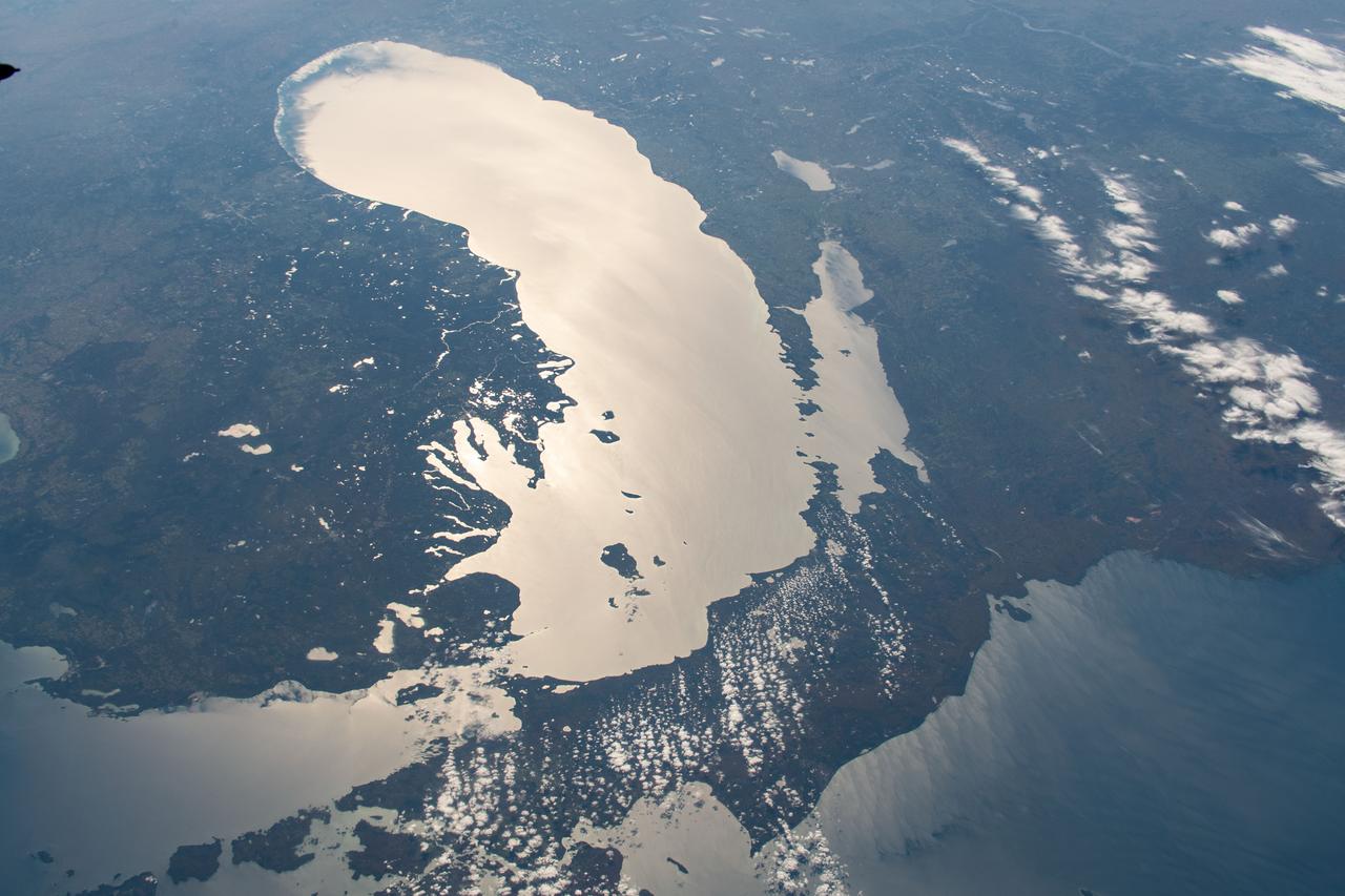
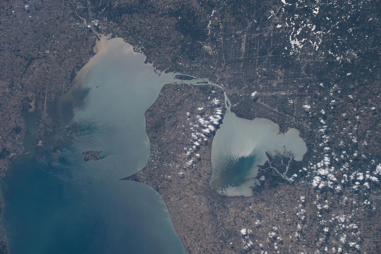
ISS038-E-057979 (22 Feb. 2014) --- This image, photographed by one of the Expedition 38 crew members aboard the International Space Station, shows the city of Green Bay, Wisconsin at the southern end of icebound Green Bay. This arm of Lake Michigan is six miles wide as seen in this view. The heavy snowfalls of the winter of 2014 cover the landscape. Combined with low sun illumination of a winter day, all surfaces appear as shades of gray. Fields appear brighter (top right, lower right), the cityscape (lower half of the image) appears as a checkerboard of grays, and forests (top left) appear dark. The center of the city lies on the Fox River, one of the few larger rivers in the United States that flow north. Open water appears as dark patches at the mouth of the river where a power station emits warm water. Thinner (grayer) ice can be detected where slightly warmer water extends from the river mouth towards Long Tail Point, an ancient shoreline of the bay. Crews aboard the space station do not usually take such detailed photographs because of the difficulty of getting sharp images with long lenses (in this case a 1000mm lens). Streets and bridges crossing the Fox River appear quite clearly.
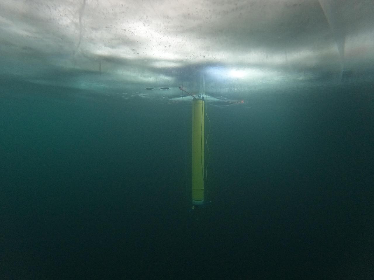
A prototype of an autonomous robot, part of a project called IceNode being developed at NASA's Jet Propulsion Laboratory, is seen from beneath the frozen surface of Lake Superior, off Michigan's Upper Peninsula. The three thin legs of the robot's "landing gear" affix it to the icy ceiling. A remote camera captured the image during a field test in 2022. The IceNode project envisions a fleet of such robots to venture beneath Antarctic ice shelves and gather data that would help scientists calculate how rapidly the ice shelves there are melting – and how fast that melting could cause global sea levels to rise. Each about 8 feet (2.4 meters) long and 10 inches (25 centimeters) in diameter, the robots use three-legged "landing gear" that springs out from one end to attach the robot to the underside of the ice. Rather than using propulsion, the robots would autonomously position themselves with the help of novel algorithms based on models of ocean currents. Released from a borehole or a vessel in the open ocean, the robots would ride those currents on a long journey beneath an ice shelf. They would target the underwater area known as the "grounding zone," where floating ice shelves, ocean, and land meet, deep inside unmapped cavities where the ice may be melting the fastest. Each robot would detach a ballast and rise up to affix itself to the underside of the ice, where their suite of sensors would measure how fast warm, salty ocean water is circulating up to melt the ice, and how quickly cold meltwater is sinking. As conceived, the IceNode fleet would operate for up to a year, continuously capturing data, including seasonal fluctuations. Then the robots would detach themselves from the ice, drift back out to open ocean, and transmit their data via satellite. This test was conducted through the U.S. Navy Arctic Submarine Laboratory's biennial Ice Camp, a three-week operation that provides researchers a temporary base camp from which to conduct field work in the harsh Arctic environment. IceNode has been funded through JPL's internal research and technology development program and its Earth Science and Technology Directorate. JPL is managed for NASA by Caltech in Pasadena, California. https://photojournal.jpl.nasa.gov/catalog/PIA26421

A Convair F-106B Delta Dart rolls to the right to reveal the two research engines installed under its wings by the National Aeronautics and Space Administration (NASA) Lewis Research Center. Lewis acquired the aircraft in October of 1966 to study inlet and nozzle designs for the supersonic transport engine program. Two General Electric J85 engines were mounted beneath the F-106B’s wings and operated from Mach 1 to 1.5. The right wing always carried reference nozzle for which the performance was known. Six supersonic nozzle variations and two inlets were tested on the left engine. The designs had already been studied in the Lewis wind tunnels, but those tests were limited by shock waves in the tunnels. Most F-106B flights were flown in a 200-mile path over the lake between Buffalo and Sandusky, known as the Lake Erie Corridor. The 1100-mile-per-hour flight took only 11 minutes at an altitude of 30,000 feet. The aircraft almost always returned with a depleted fuel supply so a Visual Flight Rules operation was required. Following the crash of another jet fighter at Lewis in July 1969, the F-106s were stationed at Selfridge Air Force Base in Michigan. NASA pilots flew transport planes each morning to the base before commencing the F-106B missions. After the supersonic transport program was cancelled, the F-106B was used as a test bed for additional engine exhaust nozzle configurations. The F-106B was also used to test inlet configurations for the noise reduction program.
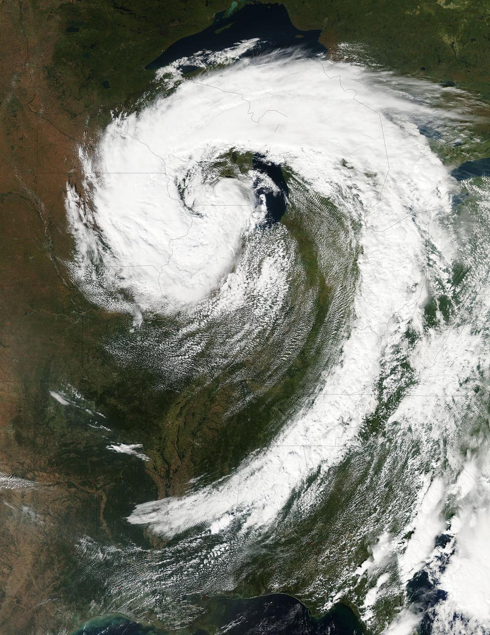
This visible image of the Great Lakes low pressure area was taken from the Moderate Resolution Imaging Spectroradiometer (MODIS) instrument on NASA's Aqua satellite. It was taken at 19:05 UTC (3:05 p.m. EDT) on Monday, Sept. 26, 2011. Credit: NASA Goddard MODIS Rapid Response Team Two Instruments on NASA's Aqua Satellite Catch the Pesky Great Lakes Low A low pressure area has been sitting over the Great Lakes region for about a week now, keeping the region and the U.S. northeast and Mid-Atlantic under cloud cover. NASA's Aqua satellite flew over head yesterday, Sept. 26, and captured two views of it from space. That low pressure area continues to spin counter-clockwise today over the Great Lakes. Its centered over northern Illinois and southeastern Wisconsin and is once again going to keep the region cloudy, cool and wet with showers. When the Aqua satellite passed overhead Monday afternoon at 3:05 p.m. EDT (Sept. 26) a detailed, clear image was captured from the Moderate Resolution Imaging Spectroradiometer (MODIS) instrument . The clouds from the low spread over Illinois, Wisconsin, parts of Iowa, northeastern Missouri, southeastern Minnesota, Michigan, Ohio, Indiana, Pennsylvania, Kentucky, Tennessee, Alabama, Mississippi, Georgia, and the northeastern and Mid-Atlantic states. A second visible image was captured by the Atmospheric Infrared Sounder (AIRS) instrument that also flies aboard NASA's Aqua satellite and showed the huge comma shape of the storm that spans the U.S. from its northern to southern borders. (seen here: <a href="http://www.flickr.com/photos/gsfc/6188946564">www.flickr.com/photos/gsfc/6188946564</a> ) According to the National Weather Service, the low will finally start moving to the east as an upper-atmospheric trough (an elongated area of low pressure) continues to strengthen and move into the upper Midwest. However, a ridge (elongated area) of high pressure will slow its move eastward, so it will be slow clearing this week in the northeastern and Mid-Atlantic U.S. Rob Gutro NASA's Goddard Space Flight Center <b><a href="http://www.nasa.gov/audience/formedia/features/MP_Photo_Guidelines.html" rel="nofollow">NASA image use policy.</a></b> <b><a href="http://www.nasa.gov/centers/goddard/home/index.html" rel="nofollow">NASA Goddard Space Flight Center</a></b> enables NASA’s mission through four scientific endeavors: Earth Science, Heliophysics, Solar System Exploration, and Astrophysics. Goddard plays a leading role in NASA’s accomplishments by contributing compelling scientific knowledge to advance the Agency’s mission. <b>Follow us on <a href="http://twitter.com/NASA_GoddardPix" rel="nofollow">Twitter</a></b> <b>Like us on <a href="http://www.facebook.com/pages/Greenbelt-MD/NASA-Goddard/395013845897?ref=tsd" rel="nofollow">Facebook</a></b> <b>Find us on <a href="http://instagrid.me/nasagoddard/?vm=grid" rel="nofollow">Instagram</a></b>

Canada has already had its share of wildfires this season, and the smoke from these wildfires is slowly drifting south over the United States' Midwest. The drifting smoke can be seen in this Terra satellite image over Lake Michigan, as well as parts of Minnesota, Wisconsin, Indiana and Ohio. The smoke released by any type of fire (forest, brush, crop, structure, tires, waste or wood burning) is a mixture of particles and chemicals produced by incomplete burning of carbon-containing materials. All smoke contains carbon monoxide, carbon dioxide and particulate matter (PM or soot). Smoke can contain many different chemicals, including aldehydes, acid gases, sulfur dioxide, nitrogen oxides, polycyclic aromatic hydrocarbons (PAHs), benzene, toluene, styrene, metals and dioxins. The type and amount of particles and chemicals in smoke varies depending on what is burning, how much oxygen is available, and the burn temperature. Exposure to any type of smoke should be avoided if possible, but especially by those with respiratory issues, the elderly, and children. This natural-color satellite image was collected by the Moderate Resolution Imaging Spectroradiometer (MODIS) aboard the Terra satellite on June 09, 2015. Credit: NASA image courtesy Jeff Schmaltz, MODIS Rapid Response Team <b><a href="http://www.nasa.gov/audience/formedia/features/MP_Photo_Guidelines.html" rel="nofollow">NASA image use policy.</a></b> <b><a href="http://www.nasa.gov/centers/goddard/home/index.html" rel="nofollow">NASA Goddard Space Flight Center</a></b> enables NASA’s mission through four scientific endeavors: Earth Science, Heliophysics, Solar System Exploration, and Astrophysics. Goddard plays a leading role in NASA’s accomplishments by contributing compelling scientific knowledge to advance the Agency’s mission. <b>Follow us on <a href="http://twitter.com/NASAGoddardPix" rel="nofollow">Twitter</a></b> <b>Like us on <a href="http://www.facebook.com/pages/Greenbelt-MD/NASA-Goddard/395013845897?ref=tsd" rel="nofollow">Facebook</a></b> <b>Find us on <a href="http://instagrid.me/nasagoddard/?vm=grid" rel="nofollow">Instagram</a></b>
SL4-139-3953 (7 Jan. 1974) --- An oblique view of a portion of the Middle West looking northeastward toward Lake Superior and Ontario, Canada, as seen from the Skylab space station in Earth orbit. This picture was taken by one of the Skylab 4 crewmen with a hand-held 70mm Hasselblad camera using a 100mm lens. Most of the land mass in the foreground is Wisconsin. Iowa is in the lower left corner. Minnesota is at left and upper left. Ontario is in the far right background. Michigan is at right center. Note the circular-shaped feature at center left which was first observed by the Skylab 4 crewmen. The feature is 85 kilometers (55 miles) in diameter, and it is centered near 91.5 degrees west longitude and 44.5 degrees north latitude. The Mississippi River Valley forms the southwest side of the circular feature. The City of La Crosse, Wisconsin, is just south of the near side of the circle, and the Black River completes the southern and eastern part. The City of Eau Claire is at the north edge of the circle. The most likely origin of circular features of this magnitude are (1) volcanic, (2) structural, or (3) meteorite impact. The feature is not volcanic -- the rocks are the wrong type. Possibly it is structural, formed by slight warping of layered rocks into a basin or dome, followed by erosion of all but the most subtle trace of the structure. The feature could be a severely eroded meteorite impact crater. If so, a thorough study of the area may yield evidence of the extreme pressure and temperature the rocks were subjected to by the shock of an impacting meteorite. Photo credit: NASA
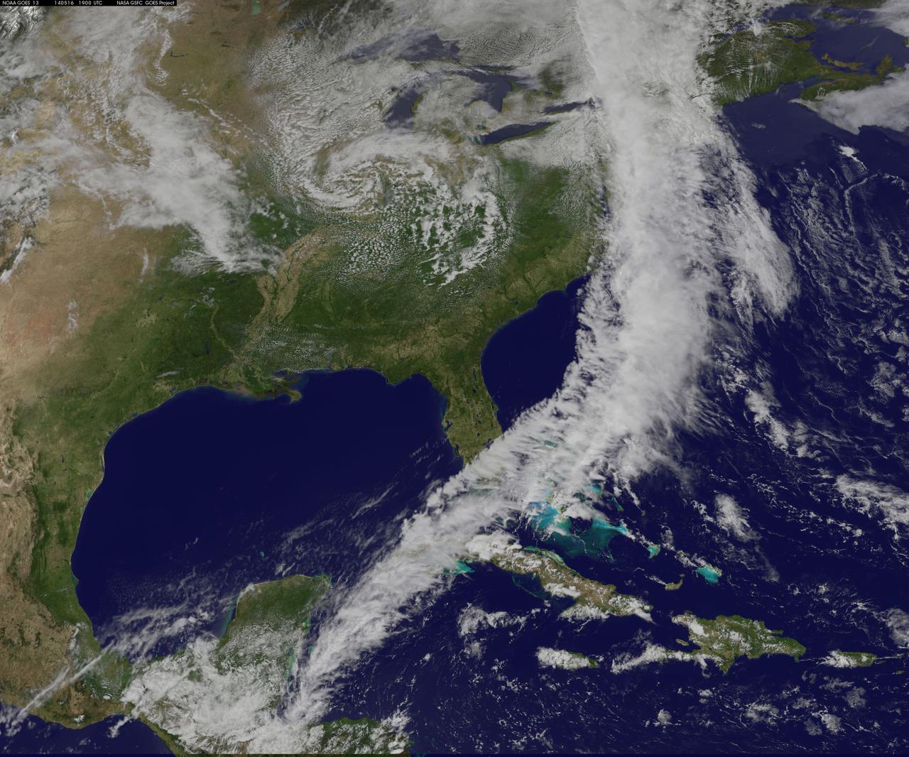
NOAA's GOES-East satellite captured an image of a powerful cold front that triggered flash flood watches and warnings along the U.S. East Coast on May 16. NOAA's National Weather Service noted flash flooding was possible from New England into eastern North Carolina today, May 16. The clouds associated with the long cold front was captured using visible data from NOAA's GOES-East or GOES-13 satellite on at 1900 UTC (3:00 p.m. EDT) and was made into an image by NASA/NOAA's GOES Project at NASA's Goddard Space Flight Center in Greenbelt, Md. The clouds stretched from Maine south through the Mid-Atlantic down to southern Florida with a tail of clouds extending into the western Caribbean Sea. South of Lake Michigan the rounded swirl of clouds indicates another low pressure system. GOES satellites provide the kind of continuous monitoring necessary for intensive data analysis. Geostationary describes an orbit in which a satellite is always in the same position with respect to the rotating Earth. This allows GOES to hover continuously over one position on Earth's surface, appearing stationary. As a result, GOES provide a constant vigil for the atmospheric "triggers" for severe weather conditions such as tornadoes, flash floods, hail storms and hurricanes. For updated information about the storm system, visit NOAA's National Weather Service website: <a href="http://www.weather.gov" rel="nofollow">www.weather.gov</a> For more information about GOES satellites, visit: <a href="http://www.goes.noaa.gov/" rel="nofollow">www.goes.noaa.gov/</a> or <a href="http://goes.gsfc.nasa.gov/" rel="nofollow">goes.gsfc.nasa.gov/</a> Rob Gutro NASA's Goddard Space Flight Center <b><a href="http://www.nasa.gov/audience/formedia/features/MP_Photo_Guidelines.html" rel="nofollow">NASA image use policy.</a></b> <b><a href="http://www.nasa.gov/centers/goddard/home/index.html" rel="nofollow">NASA Goddard Space Flight Center</a></b> enables NASA’s mission through four scientific endeavors: Earth Science, Heliophysics, Solar System Exploration, and Astrophysics. Goddard plays a leading role in NASA’s accomplishments by contributing compelling scientific knowledge to advance the Agency’s mission. <b>Follow us on <a href="http://twitter.com/NASAGoddardPix" rel="nofollow">Twitter</a></b> <b>Like us on <a href="http://www.facebook.com/pages/Greenbelt-MD/NASA-Goddard/395013845897?ref=tsd" rel="nofollow">Facebook</a></b> <b>Find us on <a href="http://instagram.com/nasagoddard?vm=grid" rel="nofollow">Instagram</a></b>

ISS029-E-012564 (29 Sept. 2011) --- The Midwestern United States at night with Aurora Borealis is featured in this image photographed by an Expedition 29 crew member on the International Space Station. The night skies viewed from the space station are illuminated with light from many sources. For example, the Midwestern United States presents a night-time appearance not unlike a patchwork quilt when viewed from orbit. The artificial light from human settlements appears everywhere with a characteristic yellow tinge in this photograph. But green light of the Aurora Borealis also appears strongly in this view (top left)—even seeming to be reflected off Earth’s surface—in Canada—beneath the aurora. A small white patch of light is almost certainly lightning from a storm on the East coast (top right). Part of the International Space Station appears across the top of the image. This photograph highlights the Chicago, IL, metropolitan area as the largest cluster of lights at center, next to the dark patch of Lake Michigan. The other largest metropolitan areas include St. Louis, MO (lower right), Minneapolis–St. Paul, MN (left) and the Omaha–Council Bluffs region on the Nebraska–Iowa border (lower left). City light clusters give an immediate sense of relative city size; demographers have used night time satellite imagery to make estimates of city populations, especially in the developing world where city growth can be very rapid. The U.S. northeast seaboard lies in the most oblique (meaning viewed at an angle) part of the image at top right, just beyond the Appalachian Mts., a dark winding zone without major cities. Scales change significantly in oblique views: Omaha is only 200 kilometers from Des Moines, but appears roughly the same distance from Minneapolis—which is actually 375 kilometers to the north of Des Moines. In addition to the major metropolitan areas, the rectangular NS/EW-oriented pattern of townships is clearly visible in the rural, lower left part of the image. This pattern instantly gives the sense of north orientation (toward the top left corner) and is a distinctive characteristic of the United States, so that ISS crew members can quickly know which continent they are flying over even at night. In contrast to the regular township pattern, interstate highways converge on St. Louis (e.g. Hwy 44), Chicago and other large cities, much like wheel spokes around a central hub. Rivers—major visual features in daylight—become almost invisible at night. The course of the Mississippi River appears as a slightly meandering zone from Minneapolis through St. Louis (dashed line)—the river course continues out of the lower right corner of the image.