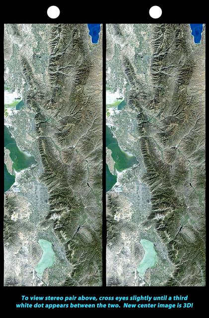
iss071e014284 (April 20, 2024) -- Lake Tahoe, situated in the Sierra Nevada Mountains and straddling the border of California and Nevada, was photographed as the International Space Station orbited 258 miles above.
As seen from space, the Great Salt Lake, Utah, USA (41.5N, 112.5W) appears as two separate bodies of water with a narrow divider in the middle. At the turn of the century, a railroad bridge without culverts, was built across the lake and ever since, the water and salinity levels have been uneqal on either side. Fed by snowmelt from the nearby Wasatch Mountains, the lake in recent years has had record high water levels, threatening to flood the local areas.
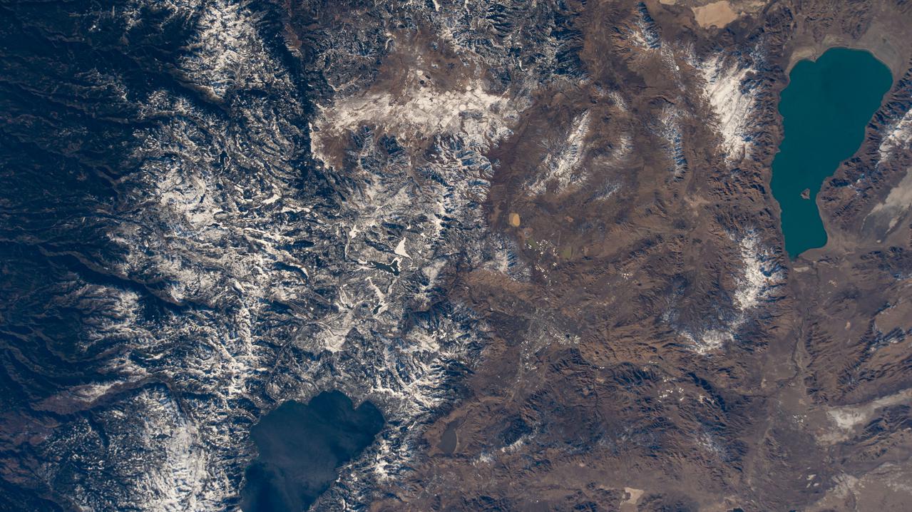
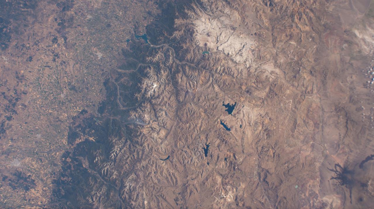
iss072e398041 (Dec. 21, 2024) --- The snow-tipped Andes mountain range and its many lakes on the southern border between Chile and Argentina are pictured from the International Space Station as it orbited 268 miles above South America.
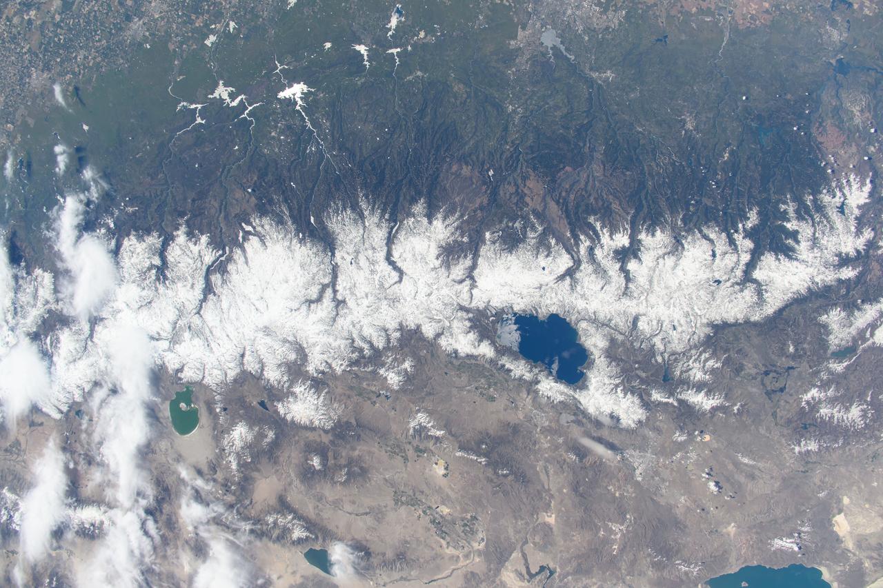
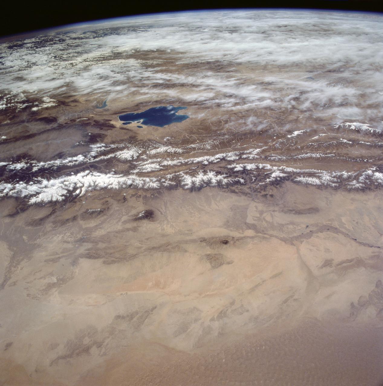
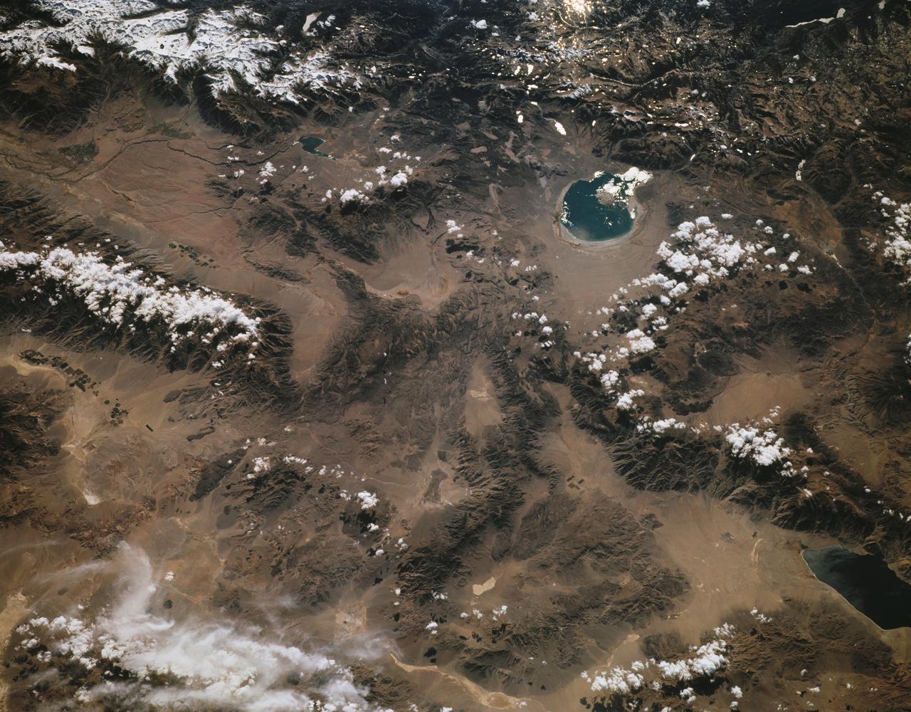
SL2-102-900 (22 June 1973) --- The Great Himalayan Mountain Range, India/Tibet (30.5N, 81.5E) is literally the top of the world where mountains soar to over 20,000 ft. effectively isolating Tibet from the rest of the world. The two lakes seen in the center of the image are the Laga Co and the Kunggyu Co located just inside the Tibet border. Although clouds and rainfall are rare in this region, snow is always present on the mountain peaks. Photo credit: NASA
STS059-154-160 (9-20 April 1994) --- Orient with Mono Lake, California at the lower right; then the view is westward across the Sierra Nevada into the San Joaquin River drainage. A tiny network of ski trails can be seen on the Mono Lake side of the Sierras, on a line between Mono Lake and the snow-free San Joaquin headwaters. The ski trails mark Mammoth Mountain, where SRL investigators are studying microwave measurements of the water content of snowpacks. Linhof camera.
AST-30-2601 (20 July 1975) --- An area of the Cascade Mountains southeast of Seattle in the State of Washington, as photographed from the Apollo spacecraft in Earth orbit during the joint U.S.-USSR Apollo-Soyuz Test Project mission. The view includes Snoqualmie Pass, Cle Elum Lake, Kachess Lake and Keechelus Lake. The picture was taken at an altitude of 228 kilometers (141 statute miles) with a 70mm Hasselblad camera using medium-speed Ektachrome QX-807 type film.
This perspective view of upstate New York shows Lake Ontario in the lower left, the Adirondack Mountains in the upper left, and the Catskill Mountains on the right.
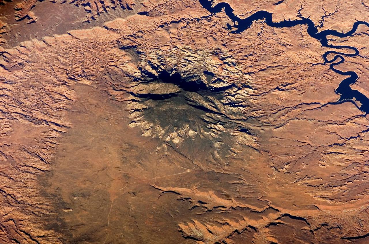
STS040-151-123 (5-14 June 1991) --- This large format view shows parts of northern Arizona and southern Utah. San Juan River, Lake Powell and Monument Valley are visible. Water of Lake Powell can be seen filling the valleys of the Colorado and San Juan Rivers at the top of the image. The darker green areas indicate high, forested country of the lone Navajo Mountain (center left) and Black Mesa (bottom right). Strip mines can be seen south of the rim of Black Mesa. Monument Valley lies between the San Juan River and Black Mesa. Shadows thrown by the individual steep-sided hills make them stand out in the scene.
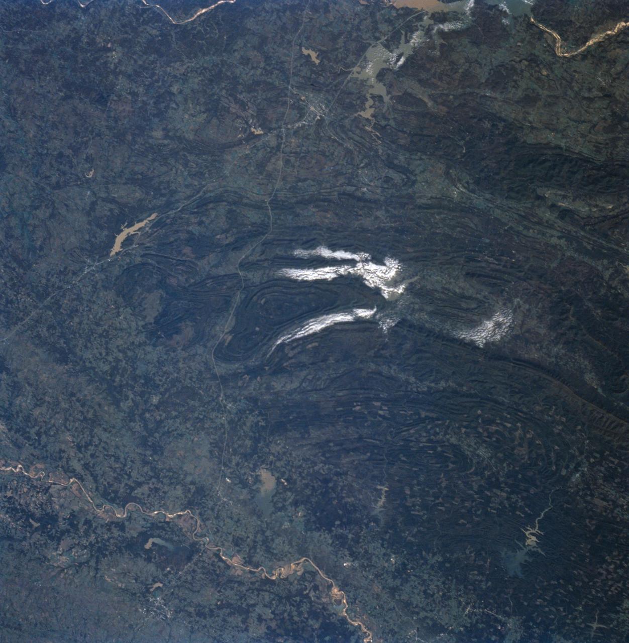
STS058-91-058 (18 Oct-1 Nov 1993) --- In this unusually clear view, the Ouachita Mountains of southeastern Oklahoma are framed on the north by Lake Eufaula on the South Canadian River, and on the south by the Red River. Sandstone, shale and chert (similar to flint) deposited in a sea several thousand feet deep were squeezed up to form the mountains about 250 million years ago. During the ensuing time, erosion of the western end of the Ouachita Mountains has emphasized linear ridges of resistant rock in the plunging anticlines and synclines, causing relief of 800 meters (2,600 feet) or more. Clouds formed by upslope winds border both the north and south sides of one of the most dramatic plunging synclines (in a syncline the rock layers dip toward the center of the structure). Toward the west, densely forested mountains give way to gently rolling, less rocky terrain and a drier climate which is better suited to farming. The mountains centered on Broken Bow, in the lower right corner of the scene, display abundant timber clearcuts that are being regenerated.

NASA's highly modified NF-15B research aircraft cruises over Southern California's Tehachapi Mountains near Lake Isabella during a research mission.
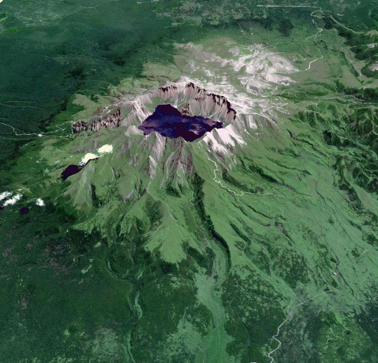
This image from NASA Terra spacecraft shows Baektu Mountain, an active volcano on the border between North Korea and China. Rising to 2744 m, its summit caldera is filled with a crater lake, Heaven Lake.
The 2002 Winter Olympics are hosted by Salt Lake City at several venues within the city, in nearby cities, and within the adjacent Wasatch Mountains.
These images from NASA Terra spacecraft show the nadir view of the eastern United States, stretching from Lake Ontario to northern Georgia, and spanning the Appalachian Mountains.
The 2002 Winter Olympics are hosted by Salt Lake City at several venues within the city, in nearby cities, and within the adjacent Wasatch Mountains.
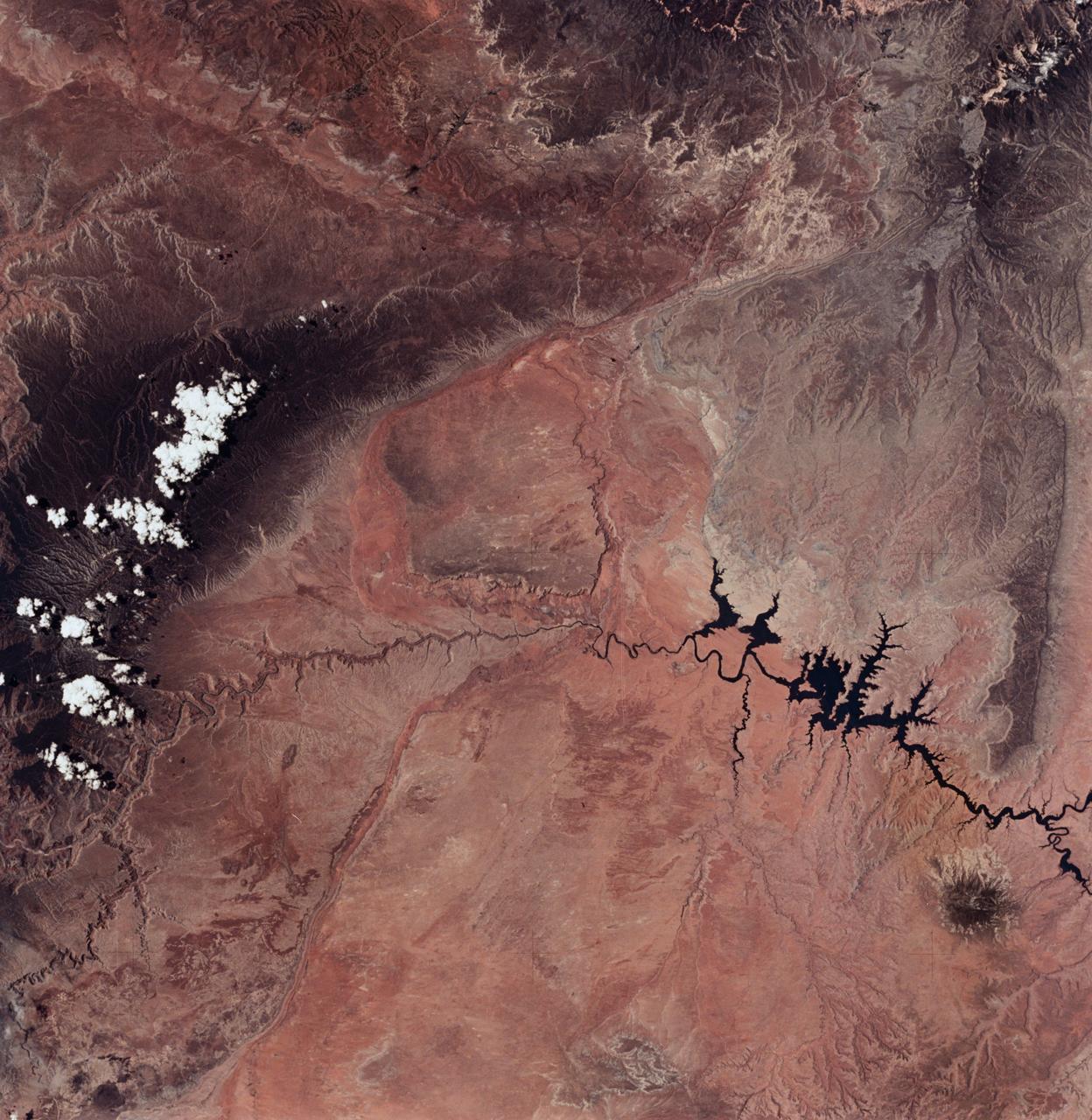
SL2-04-018 (June 1973) --- A vertical view of the Arizona-Utah border area showing the Colorado River and Grand Canyon photographed from the Skylab 1/2 space station in Earth orbit. This picture was taken by one of the six lenses of the Itek-furnished S190-A Multispectral Photographic Facility Experiment in the Multiple Docking Adapter of the space station. Type S0-356 film was used. The row of white clouds extend north-south over the dark colored Kaibab Plateau. The junction of the Colorado and Little Colorado rivers is in the southwest corner of the picture. The body of water is Lake Powell on the Colorado River upstream from the Grand Canyon. The lone peak at the eastern edge of the photograph south of Colorado River is the 10,416-foot Navajo Mountain. The S190-A experiment is part of the Skylab Earth Resources Experiments Package(EREP). Photo credit: NASA
Yamzho Yumco (Sacred Swan) Lake in Tibet is surrounded by snow-capped mountains and is one of the three largest sacred lakes. It is highly crenellated with many bays and inlets. The lake is home to Samding Monastery, headed by a female re-incarnation (Wikipedia). The image was acquired March 6, 2014, covers an area of 49.8 by 60 km, and is centered at 28.9 degrees north, 90.6 degrees east. http://photojournal.jpl.nasa.gov/catalog/PIA21304
STS058-72-004 (18 Oct-1 Nov 1993) --- The Sierra Nevada Mountain Range can be seen in this north-looking high oblique view taken in October, 1993, by the STS-58 crew. Visible in the view to the west of the Sierra Nevada are the San Joaquin and Sacramento Valleys of central California. The San Francisco/Oakland Bay Area can be seen to the west of the valley at the extreme left of the photograph. To the east or right of the Sierra Nevada, the basin and Range Region of central and northern Nevada is visible. Mono Lake, Lake Tahoe and Pyramid Lake are also visible in this scene. The long northwest/southeast trending Walker Lane Shear Zone, which lies just to the east (right) of the Sierra Nevada is also visible. Near the top of the view (near the horizon), the snow covered volcanic peak Mount Shasta can be seen. Over 645 kilometers (400 miles) long and from 65 to 130 kilometers (40 to 80 miles) wide, the Sierra Nevada have many peaks in excess of 3,300 meters (11,000 feet) above sea level. A titled fault block in structure (the largest in the United States) and shaped by glaciers during the last ice age over 12,000 years ago, the Sierra Nevada eastern front rises sharply from the Great Basin of Nevada, while its western slope descends gradually to the hills bordering the Central Valley of California. Snow-fed streams supply much of the irrigation water to the Central Valley and to western Nevada and also generate hydroelectricity. Recent above normal precipitation (snowfall) of the last two years has helped in alleviating the drought conditions that had prevailed throughout most of California in the mid and late 1980's and early 1990's.
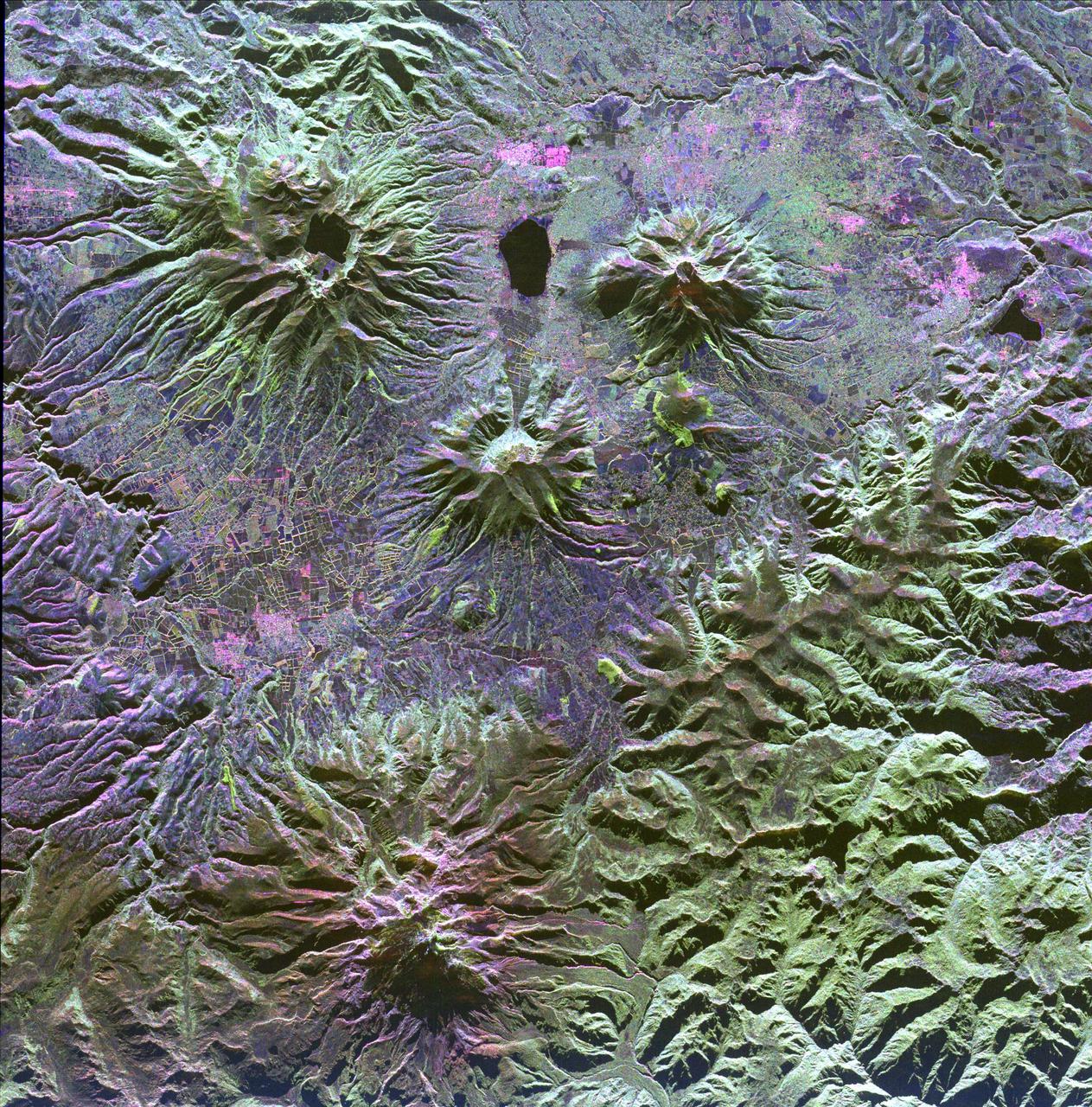
A family of dormant volcanoes dominates the landscape in this radar image of the Andes Mountains in northern Ecuador. The city of Otavalo, shown in pink, and Lake Otavalo lie within the triangle formed by three volcanoes in the upper part of the image.
Cassini powerful radar eyes have uncovered a geologic goldmine in a region called Xanadu on Saturn moon Titan. Panning west to east, the geologic features include river channels, mountains and hills, a crater and possible lakes
NASA New Horizons spacecraft captured this feature which appears to be a frozen, former lake of liquid nitrogen, located in a mountain range just north of Pluto informally named Sputnik Planum.
SL3-27-180 (July-September 1973) --- A vertical view of the Snowy Mountains area of Australian Alps in the States of Victoria and New South Wales, Australia, as photographed from Earth orbit by one of the six lenses of the Itek-furnished S190-A Multispectral Photographic Facility Experiment aboard the Skylab space station. This picture was taken with type 2443 infrared color film. The lake near the center of the picture is the Eucumbene Reservoir. This area is located immediately south-southwest of the capital city of Canberra. Federal agencies participating with NASA on the EREP project are the Departments of Agriculture, Commerce, Interior, the Environmental Protection Agency and the Corps of Engineers. All EREP photography is available to the public through the Department of Interior?s Earth Resources Observations Systems Data Center, Sioux Falls, South Dakota, 57198. Photo credit: NASA
iss066e090079 (Dec. 11, 2021) --- The frozen Achit Lake, in the Altay Mountain range of the Central Asian nation of Mongolia, is pictured from the International Space Station as it orbited 266 miles above. Just west of Achit Lake is the Harhiraa Uul mountain (at bottom right) with an elevation of 13,255 feet, or 4040 meters.
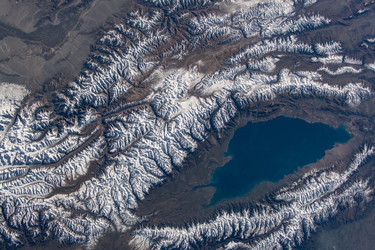
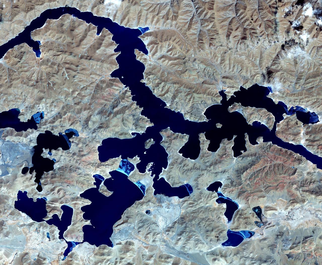
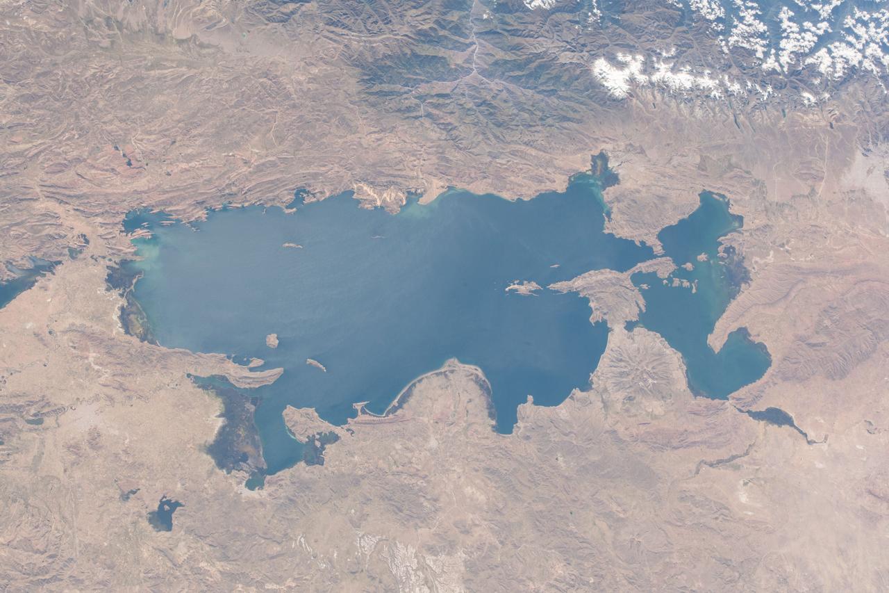
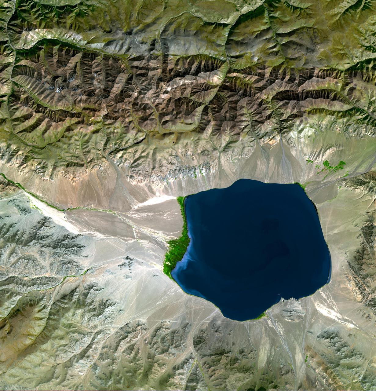
iss061e006705 (Oct. 16, 2019) --- Issyk-Kul Lake in the central Asian nation of Kyrgyzstan is surrounded by the snow-capped Tian Shen mountains. It is the second-largest mountain lake in the world behind Lake Titicaca in South America. The International Space Station was orbiting 252 miles above southeastern Kazakhstan with a ground distance of 72 miles from Issykul-Lake when this photograph was taken.
GMT362_21_17_Terry Virts_CB_washington mountains vancouver across canada to great lakes zoom_131
GMT362_21_17_Terry Virts_CB_washington mountains vancouver across canada to great lakes zoom_131
GMT362_21_17_Terry Virts_CB_washington mountains vancouver across canada to great lakes zoom_131
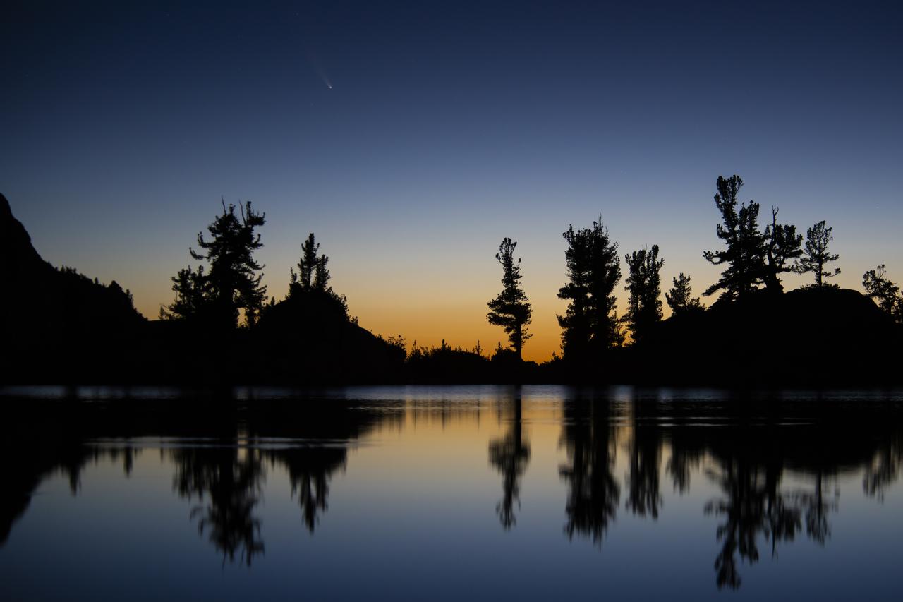
An image of the Comet C/2020 F3 NEOWISE (Comet NEOWISE) captured above the tree line of Lone Pine Lake, located on the Mount Whitney Trail in the Eastern Sierra Nevada Mountains in California. The photo was taken at 4:59 am on July 14, 2020. Visiting from the distant parts of the solar system, it’s characterized by a glowing tail and is visible during the month of July. The comet returns in 6,800 years.
iss070e015250 (Oct. 29, 2023) --- Lake Titicaca, a freshwater lake nestled in between Peru and Bolivia in the Andes Mountains, is pictured from the International Space Station as it orbited 261 miles above the South American continent.
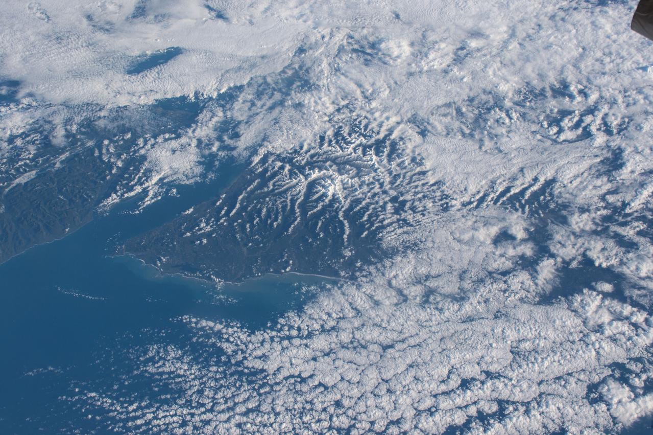
iss071e051532 (May 5, 2024) -- Lake Tekapo's turquoise color contrasts against the surrounding mountains as the International Space Station orbited 266 miles above New Zealand's South Island. Fed by the Godley River, it's one of three nearly parallel lakes in the Mackenzie Basin. Next to it lies Lake Alexandria.
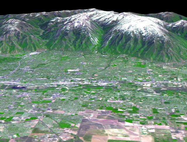
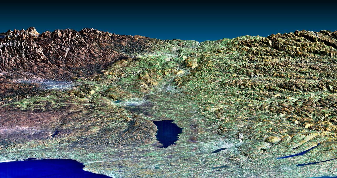
The 2002 Winter Olympics are hosted by Salt Lake City at several venues within the city, in nearby cities, and within the adjacent Wasatch Mountains. This 3-D perspective view, in simulated natural colors, presents a late spring view over Salt Lake City towards the snow-capped Wasatch Mountains to the east. The image was created by draping ASTER image data over digital topography data from the US Geological Survey's National Elevation Data. This image was acquired on May 28, 2000 by the Advanced Spaceborne Thermal Emission and Reflection Radiometer (ASTER) on NASA's Terra satellite. With its 14 spectral bands from the visible to the thermal infrared wavelength region, and its high spatial resolution of 15 to 90 meters (about 50 to 300 feet), ASTER will image Earth for the next 6 years to map and monitor the changing surface of our planet. http://photojournal.jpl.nasa.gov/catalog/PIA03466
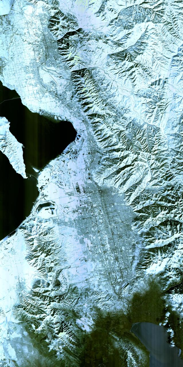
The 2002 Winter Olympics are hosted by Salt Lake City at several venues within the city, in nearby cities, and within the adjacent Wasatch Mountains. This simulated natural color image presents a snowy, winter view of north central Utah that includes all of the Olympic sites. The image extends from Ogden in the north, to Provo in the south; and includes the snow-capped Wasatch Mountains and the eastern part of the Great Salt Lake. This image was acquired on February 8, 2001 by the Advanced Spaceborne Thermal Emission and Reflection Radiometer (ASTER) on NASA's Terra satellite. With its 14 spectral bands from the visible to the thermal infrared wavelength region, and its high spatial resolution of 15 to 90 meters (about 50 to 300 feet), ASTER will image Earth for the next 6 years to map and monitor the changing surface of our planet. http://photojournal.jpl.nasa.gov/catalog/PIA03465
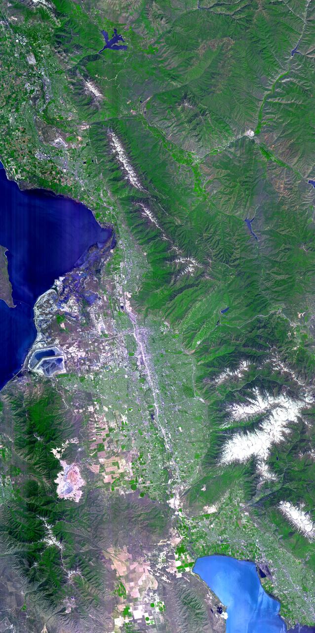
The 2002 Winter Olympics are hosted by Salt Lake City at several venues within the city, in nearby cities, and within the adjacent Wasatch Mountains. This simulated natural color image presents a late spring view of north central Utah that includes all of the Olympic sites. The image extends from Ogden in the north, to Provo in the south; and includes the snow-capped Wasatch Mountains and the eastern part of the Great Salt Lake. This image was acquired on May 28, 2000 by the Advanced Spaceborne Thermal Emission and Reflection Radiometer (ASTER) on NASA's Terra satellite. With its 14 spectral bands from the visible to the thermal infrared wavelength region, and its high spatial resolution of 15 to 90 meters (about 50 to 300 feet), ASTER will image Earth for the next 6 years to map and monitor the changing surface of our planet. http://photojournal.jpl.nasa.gov/catalog/PIA03464
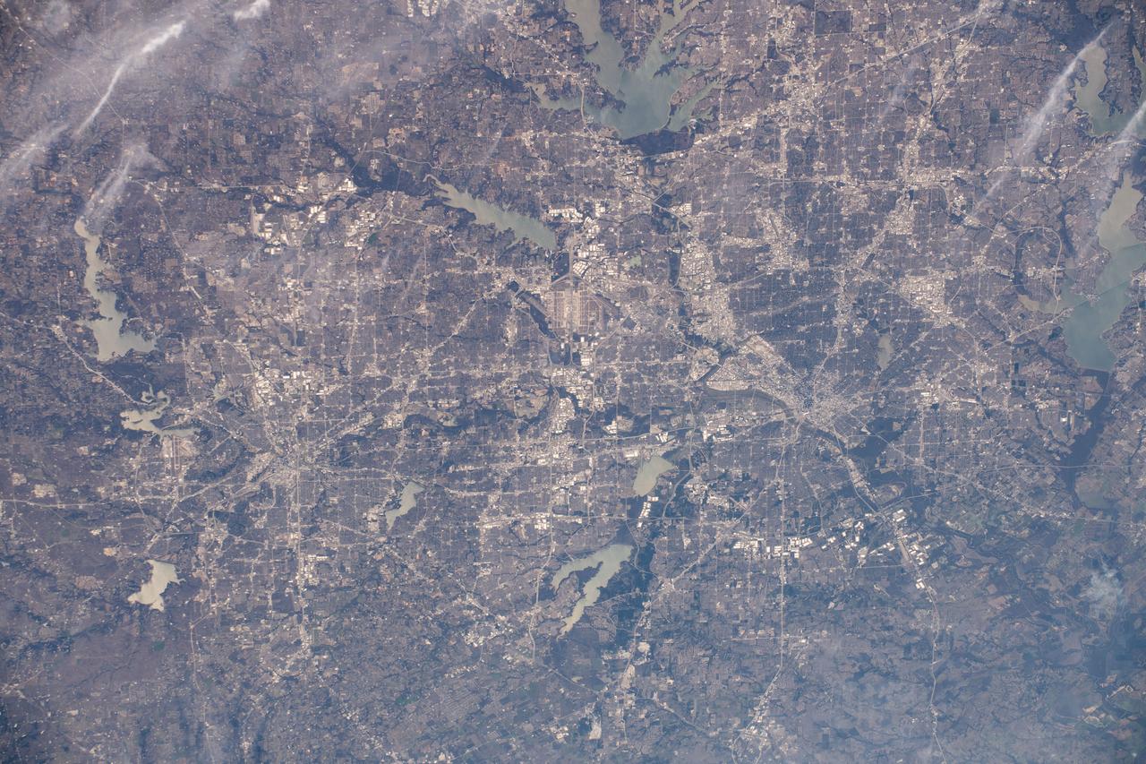
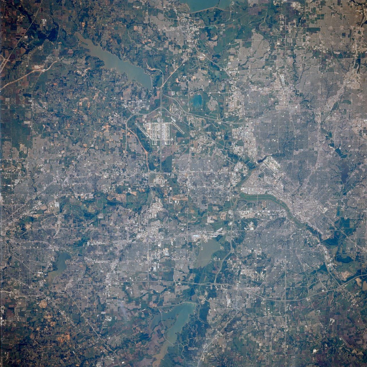
iss061e067843 (Dec. 6, 2019) --- The Dallas-Fort Worth, Texas metropolitan area is pictured along with such landmarks as DFW International Airport and Dallas Love Field Airport from an altitude of 258 miles. Several bodies of water are pictured including Joe Pool Lake, Mountain Creek Lake, White Rock Lake, Lake Ray Hubbard, Lewisville Lake and Grapevine Lake among others.
iss064e015104 (Dec. 23, 2020) --- Pyramid Lake (upper right) in Nevada; Lake Tahoe (lower left) in California; and the snow-capped Sierra Nevada mountains are pictured from the International Space Station as it was orbiting 262 miles above the southwestern United States.
iss069e071176 (Aug. 20, 2023) --- Ka Nasi Lake (lower left) and Ake Kule Lake (upper right), in China's Altai Mountain range near Mongolia's far western border, are pictured in this photograph as the International Space Station orbited 265 miles above.

iss063e053023 (July 22, 2020) --- Lake Titicaca, pictured from the International Space Station as it orbited off the Pacific coast of South America, is located between the nations of Peru and Bolivia in the Andes Mountains and is one of the highest navigable lakes in the world.
STS060-90-007 (3-11 Feb 1994) --- Parts of the Swiss Cantons of Vaud and Valois and the French province of Chablais are shown. These mountains were created in the last great mountain-building episode in Europe around 50 million years ago. They have been reshaped by glaciers during the Pleistocene. The glaciers created the wide valley of the Rhone River by scouring a pre-existing stream. The fertile Swiss Plateau runs northwest from the shore of Lake Geneva and is visible in the upper right. The Franco-Swiss border is located in the center of the lake and follows a mountain divide east of the Rhone Valley. According to NASA geologists eutrofication is a problem in Lake Geneva. In 1971 a Swiss Commission was formed to try to slow the problem. Strong discharge laws were enacted, but they are hard to enforce due to the multi-national and multi-organizational parties contributing to the problem.

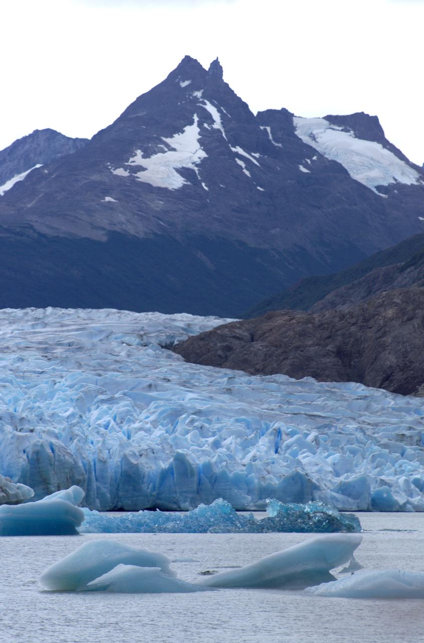
STS113-708-014 (23 November - 7 December 2002) --- The STS-113 crewmembers used a handheld 70mm still camera to record this image of Patagonia lakes in southern Argentina. The lowest of the three lakes in this view is Lake Argentino. The next one north (middle lake) is Lake Viedma, and the lake on the top margin is Lake San Martín. According to NASA scientists studying the STS-113 Earth imagery, all three of these large lakes have been carved out by glaciers in the "recent" ice age, descending from the Andes Mountains (under cloud along the right side of the view). Three glacier tongues can be discerned as small white features leading into the western (left) ends of each lake. The rounded ends of the lakes, according to the Johnson Space Center scientists, are produced by the slow "flowing" action of glacial ice on the plains next to the mountain chain. Snow cap on lower peaks next to the cloud make a jagged pattern.
In eastern California, along the western edge of the Great Basin, sits Mono Lake. This is a salty remnant of a wetter era. Estimates are that the lake existed for at least 760,000 years. Now surrounded by mountain ranges, however, Mono Lake has no outlet; water entering the lake can only evaporate away, so Mono Lake is saltier than the ocean. South of the lake appear some of the geologic features known as Mono Craters. Geologists estimate that the Mono Craters last erupted about 650 years ago. The image was acquired July 7, 2016, covers an area of 22.6 by 34 km, and is located at 37.9 degrees north, 119 degrees west. http://photojournal.jpl.nasa.gov/catalog/PIA21518
iss068e025502 (Nov. 30, 2022) --- Lake Titicaca in the Andes Mountains is pictured from the International Space Station as it orbited 264 miles above western Bolivia on the South American continent.
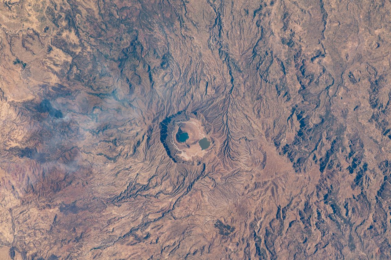
iss064e006219 (Nov. 26, 2020) --- The Deriba caldera in Darfur, Sudan, which holds two lakes, was pictured from the International Space Station as it orbited 260 miles above the Marrah Mountains.
iss067e344813 (Sept. 5, 2022) --- A portion of the Tanggula Mountains near Hala Lake in western China is pictured from the International Space Station as it orbited 260 miles above.
iss064e011823 (Dec. 11, 2020) --- Snow-covered mountains along the Kazakhstan-China border, including Sayram Lake at top, are pictured from the International Space Station as it orbited 263 miles above the Asian nations.
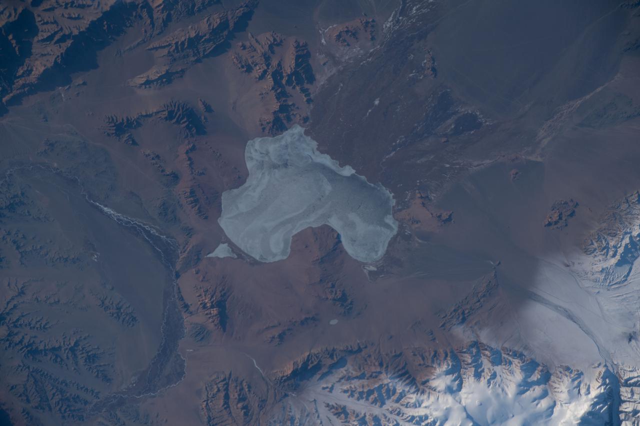
iss068e043794 (Jan. 28, 2023) --- Tiny lakes, in the Andes mountain range on the border between Argentina and Chile, are pictured from the International Space Station as it orbited 264 miles above the South American continent near the Pacific coast.
STS106-330-003 (8-20 September 2000)--- The International Space Station (ISS) is backdropped over mountains and Lake Issyk-Kul in this 35mm frame, photographed during the fly-around by the Space Shuttle Atlantis.
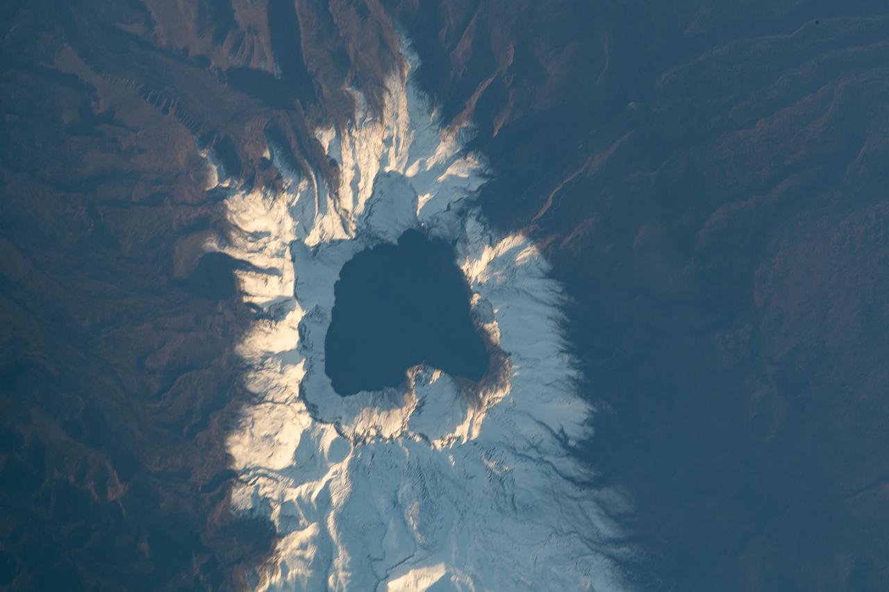
iss065e444007 (Oct. 8, 2021) --- Heaven Lake rests in the crater of the active volcano Paektu Mountain that lies on the China-North Korea border. The International Space Station was orbiting 263 miles above Asia at the time this photograph was taken.
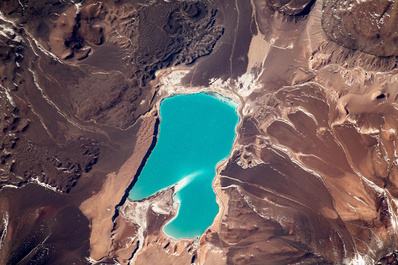
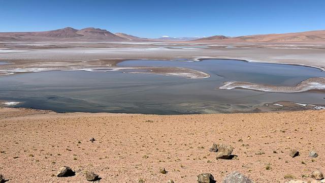
iss069e030011 (July 7, 2023) --- Laguna Verde, a high-altitude lake in the Andes mountains of Chile near the world's highest volcano Ojos del Salado, is pictured from the International Space Station as it orbited 264 miles above.
iss055e071030 (May 14, 2018) --- Lake Titicaca is bisected by the South American countries of Peru and Bolivia with the Andes Mountain range skirting up against its northwestern edge.
iss064e003738 (Nov. 8, 2020) --- The snow-capped peaks of the Andes Mountains in southern Chile, with General Carrera Lake at bottom left, are pictured from the International Space Station as it orbited above South America.
STS059-209-081 (9-20 April 1994) --- Lake Balkhash, in eastern Kazakhstan, is some 300 miles long. The lake, frozen in this scene, thawed noticeably during the mission. The shape of the lake is controlled by the delta of the Ili River, which flows from the Tien Shan Mountains in western China across this arid steppe. SRL scientists will use radar data to study the microwave effects of differences in soil moisture, and in freezing or thawing, on the deltaic sediments. Hasselblad camera.
ISS013-E-78506 (7 Sept. 2006) --- Sand dunes near Mongolia's Har Lake are featured in this image photographed by an Expedition 13 crewmember on the International Space Station. Har (or Black) Lake is located in the western part of the country within the Valley of Lakes--part of a system of closed basins that stretches across central Asia. According to scientists, these basins are the remnants of larger paleolakes that had begun to shrink in size by approximately five thousand years ago as regional climate became drier. Today, the Valley of Lakes is an important ecological resource for study of steppe grasslands, and as resting points for large numbers of migratory birds. Portions of the basin are designated as national parks or other protected areas, and Har Lake itself is an ecotourism destination (usually by horseback). This oblique view captures the dynamic nature of the landscape of Har Lake. The lake is encircled by sand dune fields which encroach on the lower slopes of the Tobhata Mountains to the west and south. Gaps in the mountains have been exploited by sand dunes moving eastward (indicating westerly winds) -- the most striking example being a series of dunes entering Har Lake along its southwestern shoreline. Here, the dune forms reflect the channeling of winds through the break in the mountain ridgeline, leading to dune crests oriented transverse to northwesterly winds. Another well-developed line of dunes is visible between Har and Baga Lakes. While these dunes appear to cut across a lake surface, the dunes have in fact moved across a narrow stream channel.
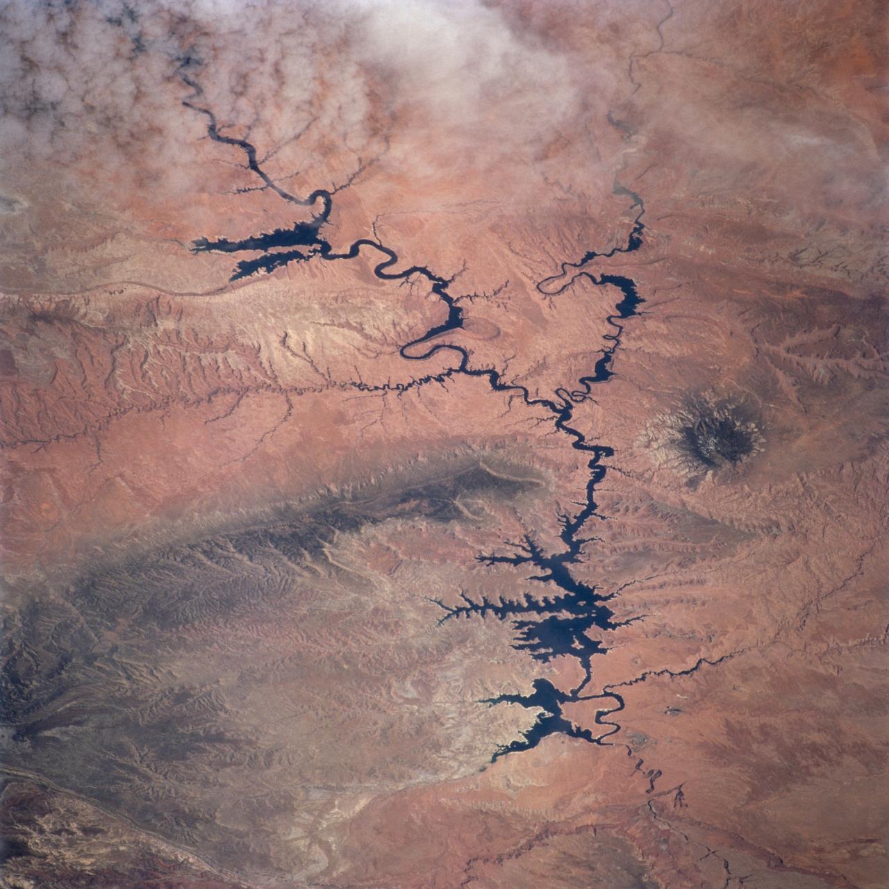
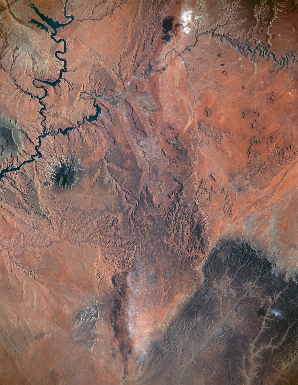
STS100-716-176 (19 April-1 May 2001) --- The deeply entrenched, meandering Colorado River is distinctively dark as the river winds its way across the arid terrain of southeast Utah in this 70mm frame photographed from the Earth-orbiting Space Shuttle Endeavour. While Glen Canyon Dam (bottom of image) is located in northern Arizona, the reservoir of Lake Powell is in Utah. The Escalante and San Juan Rivers, two major tributaries that flow into Lake Powell (from the northwest and east respectively) are also discernable. The darker-looking, elongated and elevated feature north of Lake Powell is the Kaiparowits Plateau. Navajo Mountain is the darker circular feature to the south (to the right) of the lake.
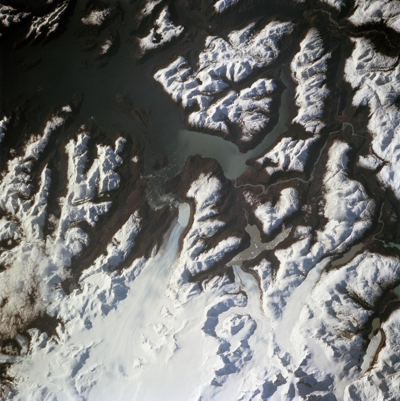
STS068-260-078 (30 September-11 October 1994) --- The ice visible along the bottom of this view is the north end of the larger (southern) of two great remaining ice field of the Andes Mountains in Chile. The longest glacier visible here flows down into the Calen Fjord (an arm of the Pacific Ocean known as Canal Baker) where numerous calved icebergs can be seen floating. The other three glaciers end in glacier-cut valleys with small lakes - the bigger lake has numerous icebergs as well. the river snaking through the mountains to the fjord drains water from the great Lake O'Higgins, which lies out of the picture to the right. Glacial mud can be seen emptying into the fjord and discoloring the water with its milky color.
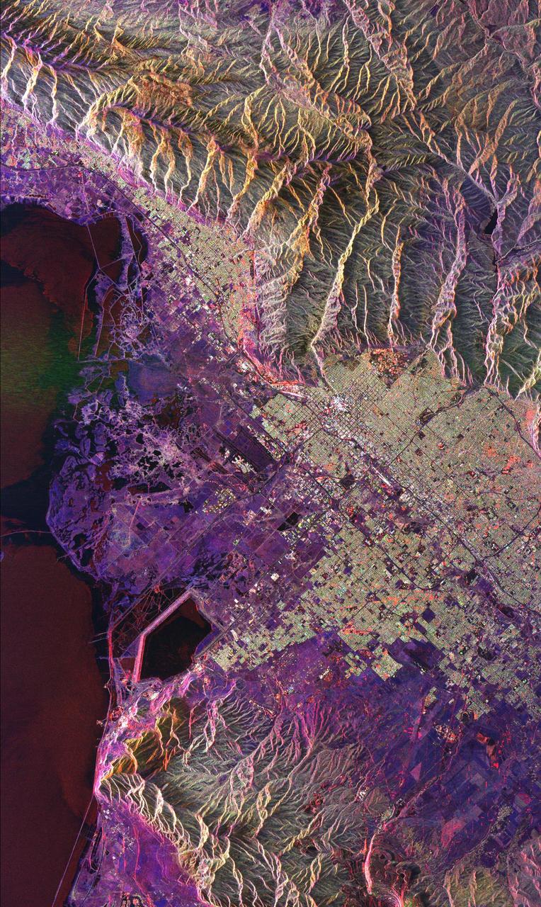
This radar image of Salt Lake City, Utah, illustrates the different land use patterns that are present in the Utah Valley. Salt Lake City lies between the shores of the Great Salt Lake (the dark area on the left side of the image) and the Wasatch Front Range (the mountains in the upper half of the image). The Salt Lake City area is of great interest to urban planners because of the combination of lake, valley and alpine environments that coexist in the region. Much of the southern shore of the Great Salt Lake is a waterfowl management area. The green grid pattern in the right center of the image is Salt Lake City and its surrounding communities. The Salt Lake City airport is visible as the brown rectangle near the center of the image. Interstate Highway 15 runs from the middle right edge to the upper left of the image. The bright white patch east of Interstate 15 is the downtown area, including Temple Square and the state capitol. The University of Utah campus is the yellowish area that lies at the base of the mountains, east of Temple Square. The large reservoir in the lower left center is a mine tailings pond. The semi-circular feature in the mountains at the bottom edge of the image is the Kennecott Copper Mine. The area shown is 60 kilometers by 40 kilometers (37 miles by 25 miles) and is centered at 40.6 degrees north latitude, 112.0 degrees west longitude. North is toward the upper left. This image was acquired by the Spaceborne Imaging Radar-C/X-Band Synthetic Aperture Radar (SIR-C/X-SAR) aboard the space shuttle Endeavour on April 10, 1994. The colors in this image represent the following radar channels and polarizations: red is L-band, horizontally transmitted and received; green is L-band, horizontally transmitted and vertically received; and blue is C-band, horizontally transmitted and vertically received. SIR-C/X-SAR, a joint mission of the German, Italian and United States space agencies, is part of NASA's Mission to Planet Earth program. http://photojournal.jpl.nasa.gov/catalog/PIA01798
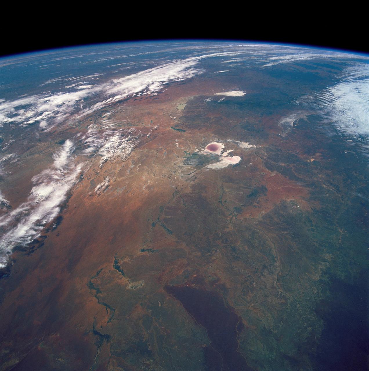
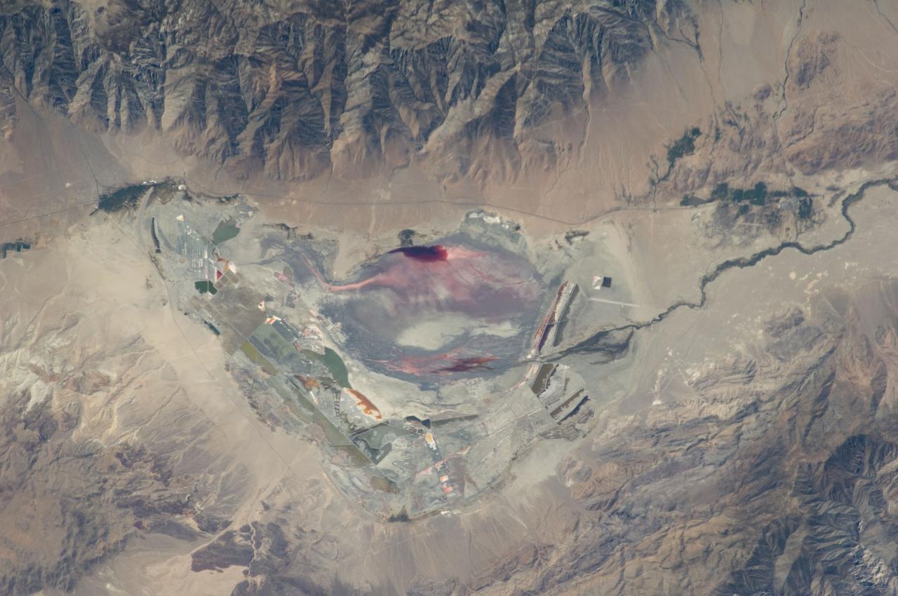
STS035-501-007 (2-10 Dec. 1990) --- The STS-35 crewmembers aboard the Earth-orbiting Space Shuttle Columbia photographed this view of the Arid Simpson Desert of Australia with a handheld Rolleiflex camera. Lake Eyre is normally dry; however, the STS-35 crew was able to recognize water in the lowest parts of the lake (dark pink area) and possibly in Lake Blanche east of Lake Eyre. Lake Frome lies in the distance separated from Lake Torrens (top right) by dark hills of Flinders Range. The Finke River (bottom left to middle) flows into the Eyre basin from the northwest. Although it is the largest river entering the basin, Finke's floods seldom reach Lake Eyre. The dark brown patch in the foreground is an area of ancient, brown lateritic soils partly covered by dunes.
Glacier Grey in front of the Cuernos del Paine mountains, photographed from Lago Grey (Grey Lake) during NASA's AirSAR 2004 campaign in Chile. AirSAR 2004 is a three-week expedition in Central and South America by an international team of scientists that is using an all-weather imaging tool, called the Airborne Synthetic Aperture Radar (AirSAR), located onboard NASA's DC-8 airborne laboratory. Scientists from many parts of the world are combining ground research with NASA's AirSAR technology to improve and expand on the quality of research they are able to conduct. Founded in 1959, Torres del Paine National Park encompasses 450,000 acres in the Patagonia region of Chile. This region is being studied by NASA using a DC-8 equipped with an Airborne Synthetic Aperture Radar (AirSAR) developed by scientists from NASA’s Jet Propulsion Laboratory. This is a very sensitive region that is important to scientists because the temperature has been consistently rising causing a subsequent melting of the region’s glaciers. AirSAR will provide a baseline model and unprecedented mapping of the region. This data will make it possible to determine whether the warming trend is slowing, continuing or accelerating. AirSAR will also provide reliable information on ice shelf thickness to measure the contribution of the glaciers to sea level.
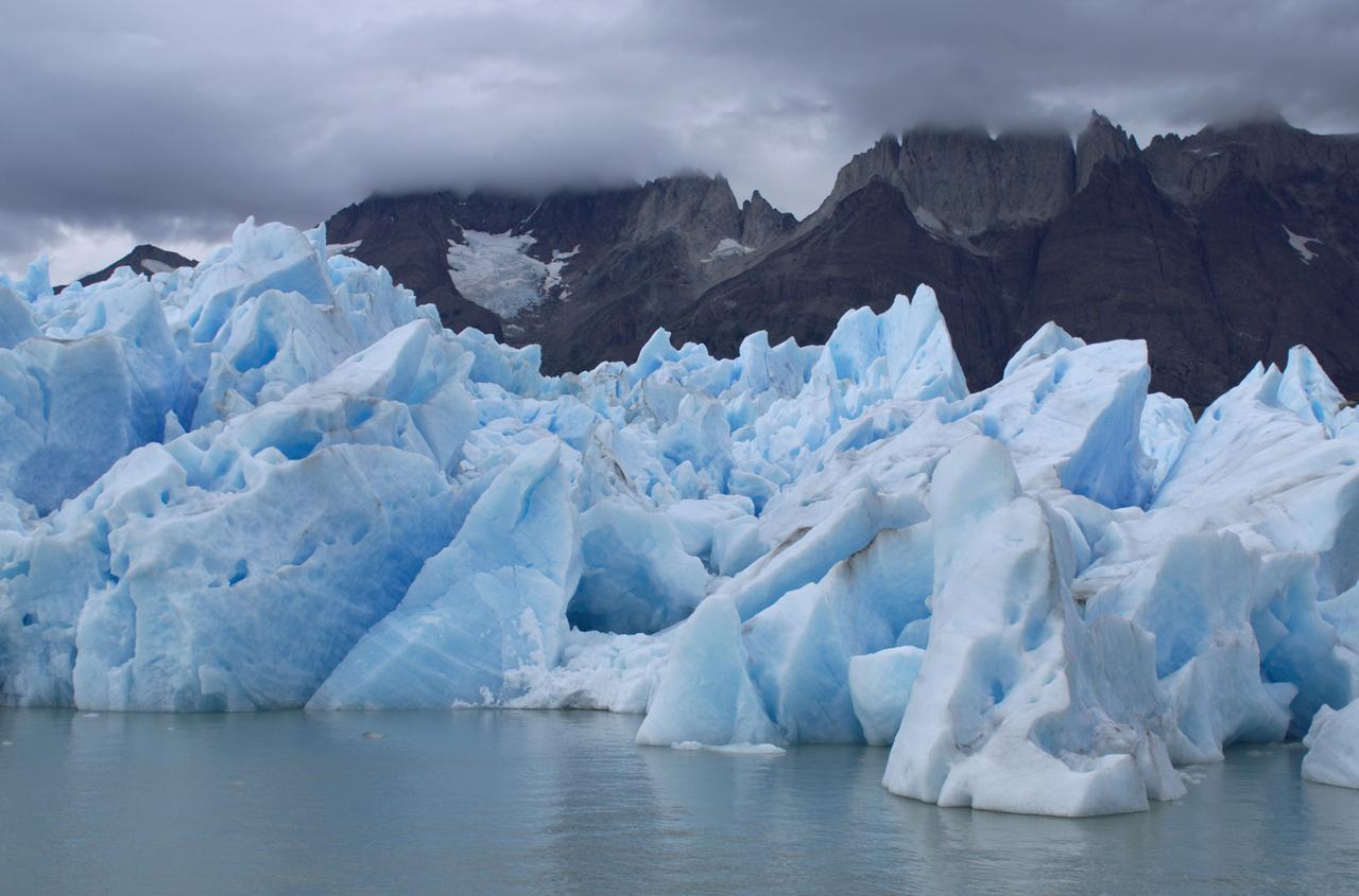
View of Glacier Grey from Lago Grey (Grey Lake), with the Cuernos del Paine mountains in the background, seen during NASA's AirSAR 2004 campaign in Chile. AirSAR 2004 is a three-week expedition in Central and South America by an international team of scientists that is using an all-weather imaging tool, called the Airborne Synthetic Aperture Radar (AirSAR), located onboard NASA's DC-8 airborne laboratory. Scientists from many parts of the world are combining ground research with NASA's AirSAR technology to improve and expand on the quality of research they are able to conduct. Founded in 1959, Torres del Paine National Park encompasses 450,000 acres in the Patagonia region of Chile. This region is being studied by NASA using a DC-8 equipped with an Airborne Synthetic Aperture Radar (AirSAR) developed by scientists from NASA’s Jet Propulsion Laboratory. This is a very sensitive region that is important to scientists because the temperature has been consistently rising causing a subsequent melting of the region’s glaciers. AirSAR will provide a baseline model and unprecedented mapping of the region. This data will make it possible to determine whether the warming trend is slowing, continuing or accelerating. AirSAR will also provide reliable information on ice shelf thickness to measure the contribution of the glaciers to sea level.
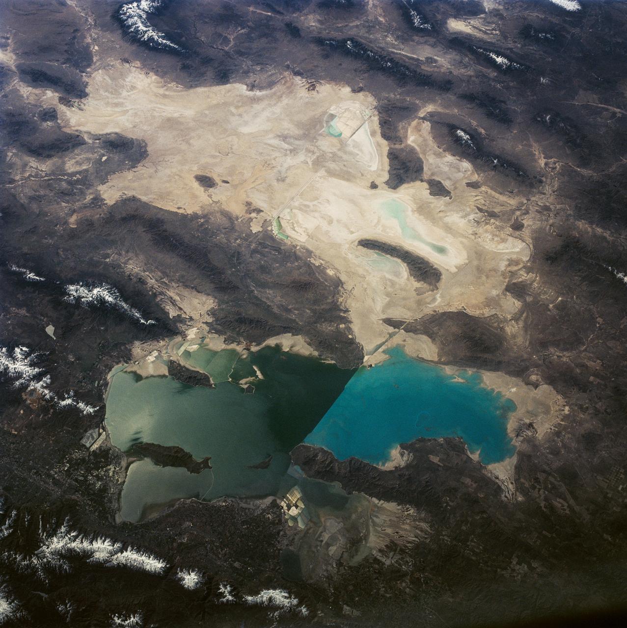
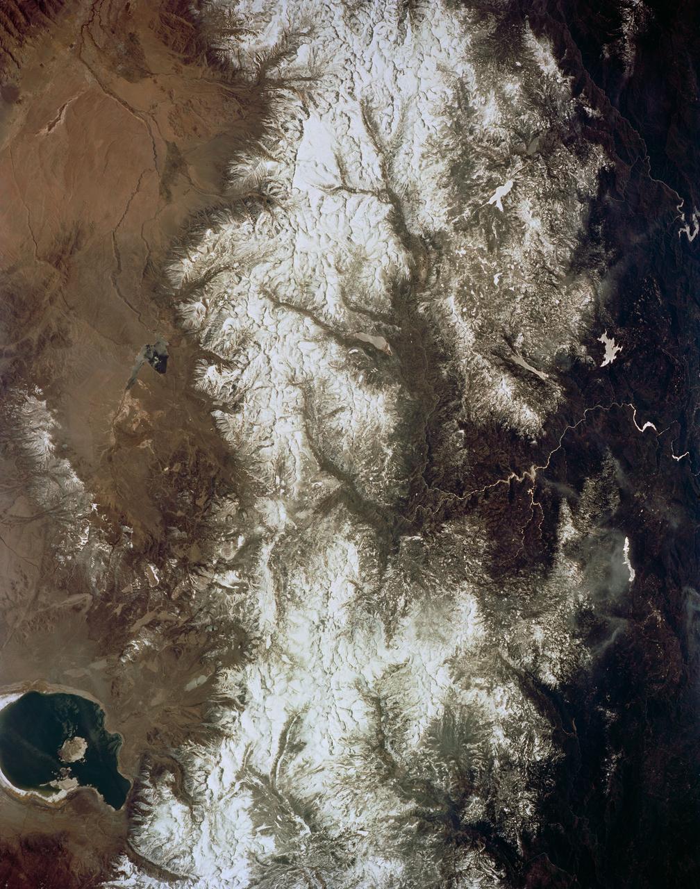
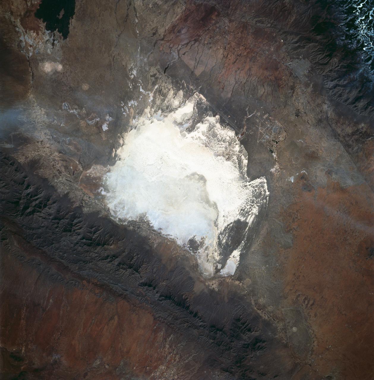
This is a view of the Great Salt Lake and nearby Bonneville Salt Flats, UT, (41.0N, 112.5W). A railroad causeway divides the lake with a stark straight line changing the water level and chemistry of the lake as a result. Fresh water runoff enters from the south adding to the depth and reducing the salinity. The north half receives little frsh water and is more saline and shallow. The Bonnieville Salt Flats is the lakebed of a onetime larger lake.

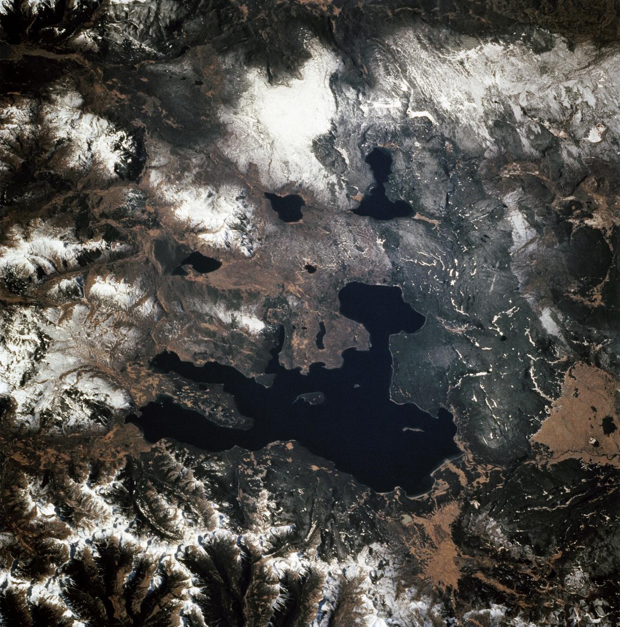
STS060-87-087 (3-11 Feb 1994) --- Lake Baikal, in southeastern Siberia, is the largest freshwater lake in the world by volume, holding nearly 20 per cent of the world's fresh water. Lake Baikal is a biospheric reserve of high international interest to the global scientific community. It is home to some 600 endemic species, many found in no other location. This view shows the northern end of the lake, and was taken in the early morning with low sun highlighting the mountain ranges rimming the lake basin. Pristine forests surround the lake, although heavy logging is evident in other photography of the central and southern portions of the lake. Another unique aspect of Lake Baikal is the existence of the world's only known freshwater hydrothermal springs. The fault system which bounds the lake allows fluids to circulate deep into the Earth and resurface as hot springs around and in the lake. Russian and American scientists are using the Shuttle photography to examine the relationship of the lake's ice cover to areas of known hydrothermal activity. Thus Lake Baikal has been and continues to be a high-priority site for photography from space from both the Space Shuttle and the Russian Space Station MIR.

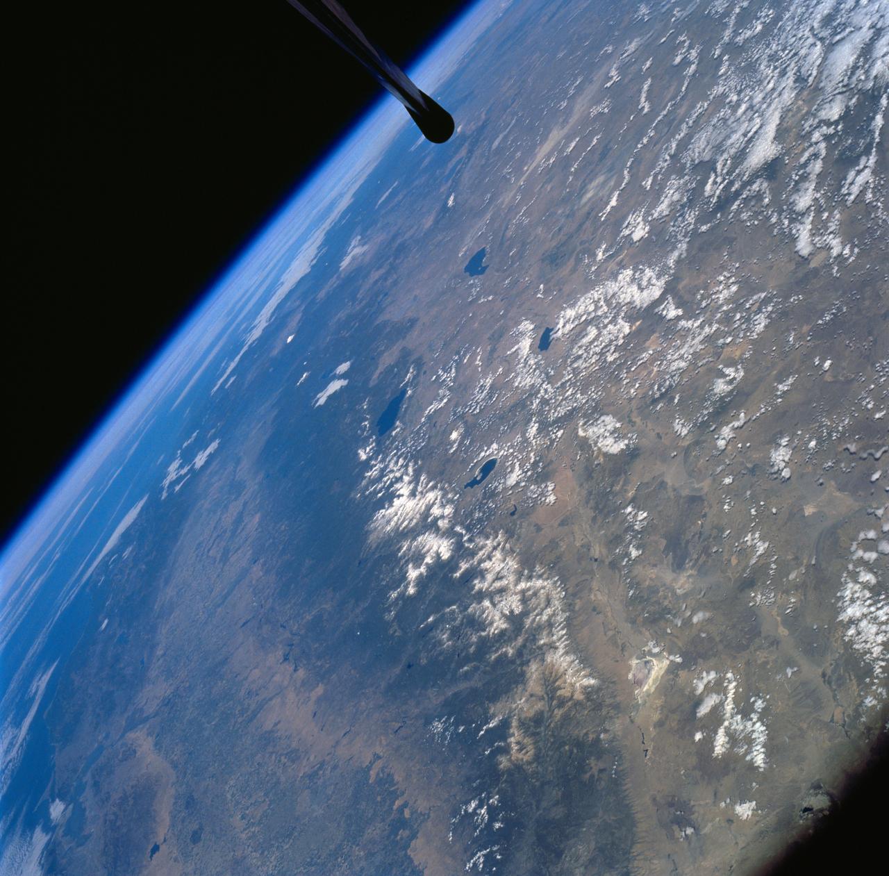
ISS007-E-17557 (17 October 2003) --- This sweeping view of the Rocky Mountains and the western US was taken when the International Space Station (ISS) traveled over eastern Washington on October 17, 2003. The POV of the Station was looking southeast over the mountains of Idaho (foreground) and Wyoming (Yellowstone, the Tetons and the Wind River Range are just right and above the center of the image). Great Salt Lake is in the lower right of the image.
STS059-220-041 (9-20 April 1994) --- View to the south by southwest across the southern Gobi Desert (China) across the Chi-Lien-Shan or Quilienshan or Nanshan (Mountains) in Gansu Province to Lake Quinghai or Ch'ing-Hai (orthography varies with political conditions and scholarship) in Quinghai Province. The lake has a surface elevation of 10,450 feet, partially filling one of the easternmost closed drainage basins of Central Asia. Hasselblad photograph.
Filled with briny lakes, the Quisquiro salt flat in South America's Altiplano represents the kind of landscape that scientists think may have existed in Gale Crater, which NASA's Curiosity rover is exploring. This salt flat is located in Chile, though the Altiplano sprawls across countries. Streams and rivers flowing from mountain ranges into this arid, high-altitude plateau lead to closed basins similar to Mars' ancient Gale Crater. Lakes on the Altiplano are heavily influenced by climate in the same way as Gale. https://photojournal.jpl.nasa.gov/catalog/PIA23374

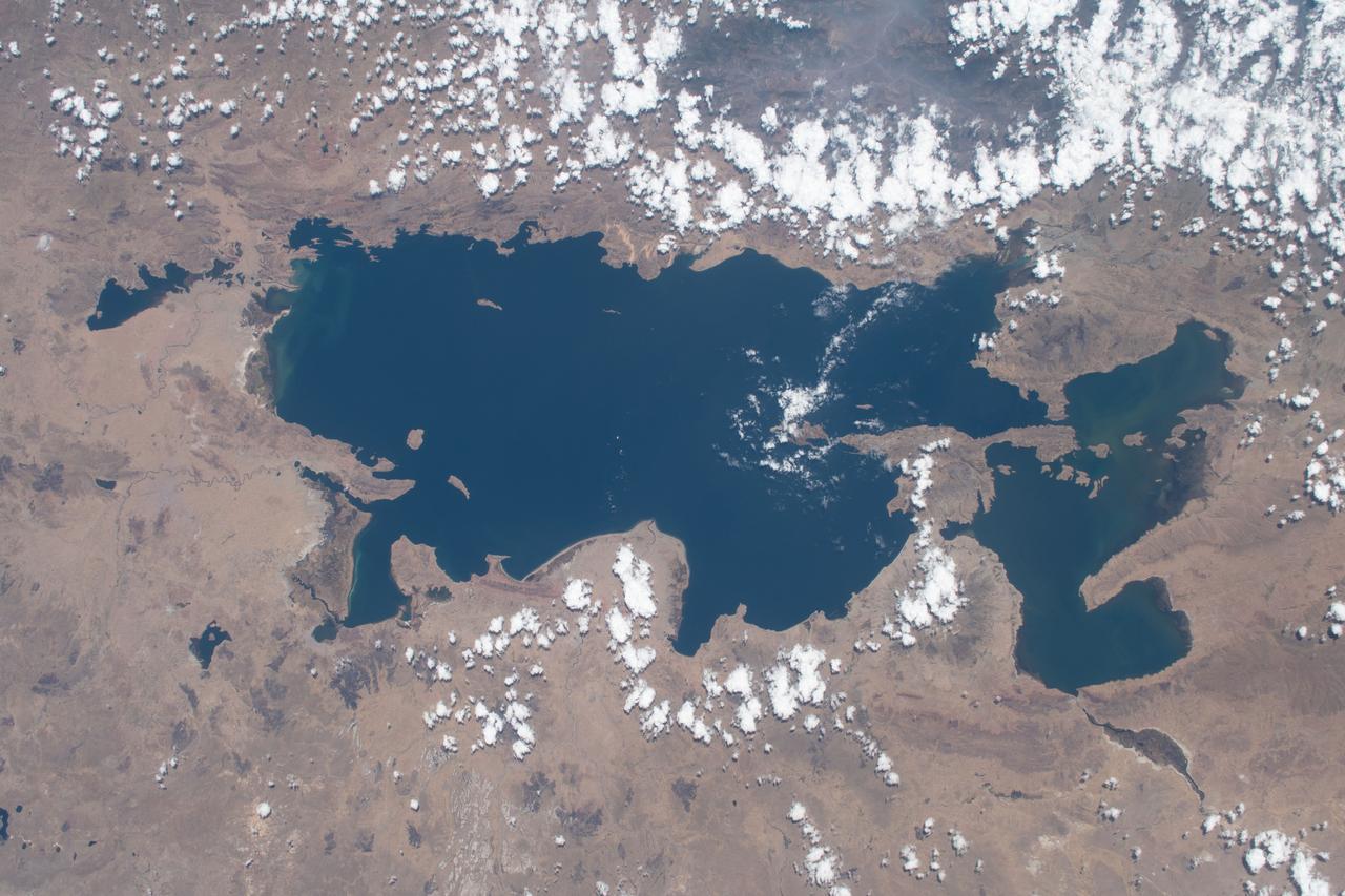
STS058-95-028 (18 Oct-1Nov 1993) --- Lake Urmia (Orumiyeh) in the high desert plateau of northwest Iran dominates the center of this northeast-looking view. The left edge of the view cuts Lake Van in eastern Turkey. The Caucasus Mountains in war-torn Georgia appear just beyond. Mount Ararat, of biblical fame, is a major peak north of Lake Van. The Caspian Sea, an international body of water, stretches across the top right of the view. Countries bordering the Caspian are Iran in the south, Kazakhstan in the west, and Russia and Azerbaijan in the west.
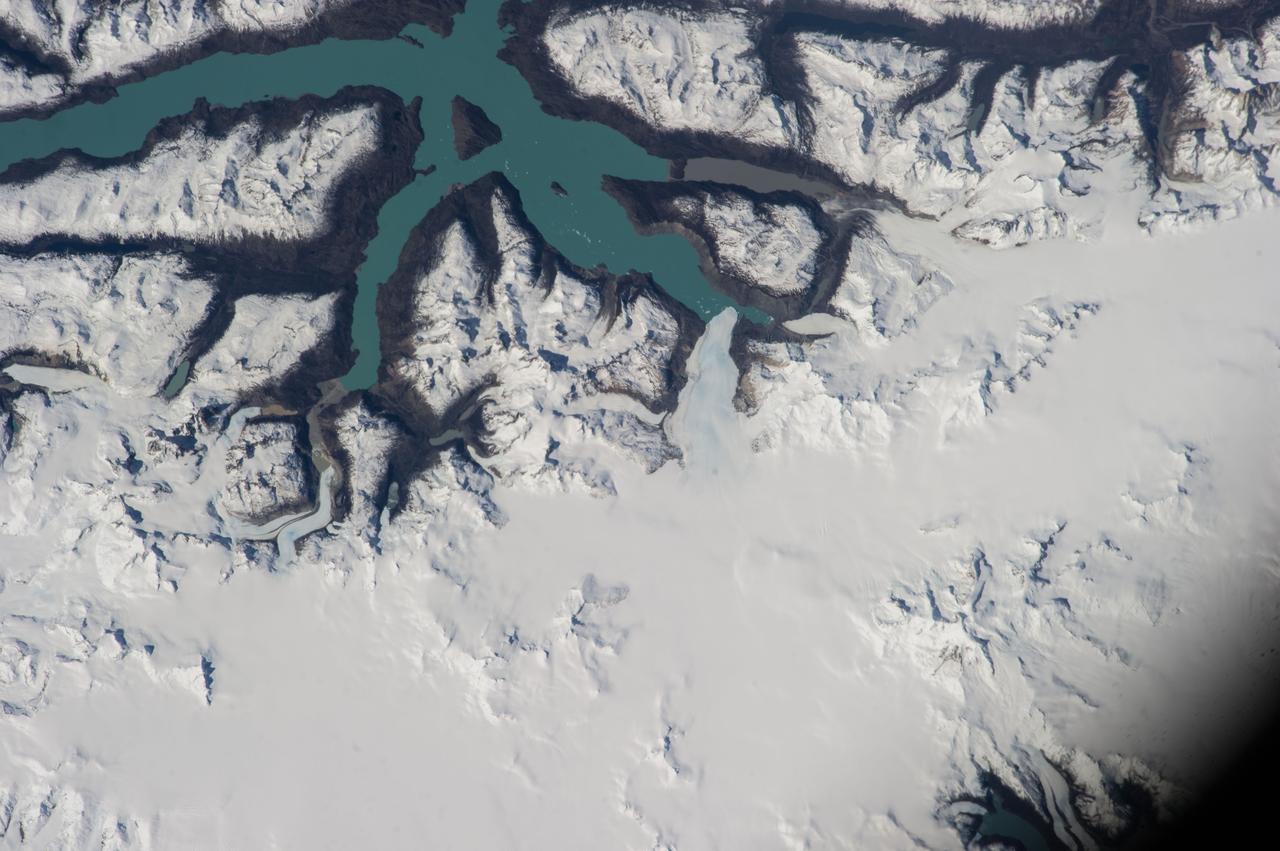
ISS037-E-004176 (28 Sept. 2013) --- Part of Chile, featuring Lake O'Higgins, Andes Mountains and a South Patagonia ice field, was photographed by one of the Expedition 37 crew members aboard the International Space Station on Sept. 28, 2013.
iss067e031910 (April 27, 2022) --- Lake Salinas del Bebedero rests southwest of San Luis, Argentina (upper left), in this photograph from the International Space Station as it orbited 269 miles above. The area pictured lies at the foot of the Sierra Grande Mountains in the temperate grassland region of central Argentina.
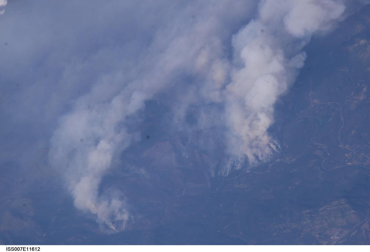
ISS007-E-11612 (2 August 2003) --- This digital still camera's view of Glacier National Park in Montana, was captured by one of the crew members aboard the International Space Station orbiting earth at 215 nautical miles. The area pictured is north of Flathead Lake on the southern flank of the Apgar Mountains, just across the Flathead River.

STS-28 Columbia, Orbiter Vehicle (OV) 102, approaches Runway 17 dry lake bed at Edwards Air Force Base (EAFB) California and is photographed just moments before main landing gear (MLG) touchdown. In the distance, are peaks of Southern California mountain range.
STS068-150-020 (30 September-11 October 1994) --- An exceptionally clear, high-contrast view of the desert basins east and south of Mono Lake, California. Light clouds dot the mountain ranges; the clouds were transparent to radar beams from the Space Radar Laboratory 2 (SRL-2) payload.
STS060-83-016 (3-11 Feb 1994) --- White Sands National Monument (Park) is easily recognized in the center of this near-vertical color photograph. White Sands is the world's largest gypsum dune field. It represents an alabaster sea that covers nearly 300 square miles. The National Park Service has the responsibility to preserve this unique feature, allowing the dune world to unfold in its natural environment, but without interference from humans. White Sands lies within a spectacular, oblong geological depression called the Tularosa Basin bounded by the Sacramento Mountains on the east and the San Andres Mountains on the west. Climatically the basin is a true desert, averaging less than 10 inches of rainfall per year. In terms of topographic relief the Sacramento Mountains attain elevations greater than 9,000 feet above sea level, while the San Andres Mountains on the west exceed altitudes of 8,000 feet. At the southwest corner of the White Sands is dry lake, Lucero. This lake is the lowest point in the Tularosa Basin at 3,900 feet. In terms of cultural features the city of Alamogordo (over 20,000 population) and Holloman Air Force Base can be seen with great clarity on this photograph. The area is accessible by highways U.S.70 & 82 from Las Cruces, New Mexico, and U.S.54 from El Paso, Texas.
STS068-247-061 (30 September-11 October 1994) --- Photographed through the Space Shuttle Endeavour's flight windows, this 70mm frame centers on Yellowstone Lake in the Yellowstone National Park. North will be at the top if picture is oriented with series of sun glinted creeks and river branches at top center. The lake, at 2,320 meters (7,732 feet) above sea level, is the largest high altitude lake in North America. East of the park part of the Absaroka Range can be traced by following its north to south line of snow capped peaks. Jackson Lake is southeast of Yellowstone Park, and the connected Snake River can be seen in the lower left corner. Yellowstone, established in 1872 is the world's oldest national park. It covers an area of 9,000 kilometers (3,500 square miles), lying mainly on a broad plateau of the Rocky Mountains on the Continental Divide. It's average altitude is 2,440 meters (8,000 feet) above sea level. The plateau is surrounded by mountains exceeding 3,600 meters (12,000 feet) in height. Most of the plateau was formed from once-molten lava flows, the last of which is said to have occurred 100,000 years ago. Early volcanic activity is still evident in the region by nearly 10,000 hot springs, 200 geysers and numerous vents found throughout the park.
STS112-708-002 (7-18 October 2002) --- This image, photographed from the Earth-orbiting Space Shuttle Atlantis, covers parts of Utah, Colorado, Wyoming and Idaho. The Front Range of the Rockies is the dark range crossing the bottom of the view, with Denver and neighboring cities (grays) situated in the gentle embayment of the mountains (bottom center of the view). Great Salt Lake in Utah appears as two colors of blue top left, with the snow-covered Uinta Mountains just below, in this northwesterly view. Most of the view encompasses the brown plains of western Wyoming (center) and the cluster of mountains around Yellowstone (top center, top right, with snow). Beyond the brown Snake River Plain, black rocks of the Sawtooth Mountains and neighboring ranges of central Idaho appear top center.
The Uvs Nuur Basin in Mongolia and the Russian Federation is the northernmost of the enclosed basins of Central Asia. It takes its name from Uvs Nuur Lake, a large, shallow and very saline lake, very important for migrating birds. Inscribed as a UNESCO World Heritage Site in 2003, the site is made up of twelve protected areas representing major biomes of eastern Eurasia. The steppe ecosystem supports a rich diversity of birds and the desert is home to a number of rare gerbil, jerboas and the marbled polecat. The mountains are an important refuge for the endangered snow leopard, mountain sheep, and the Asiatic ibex. The image covers an area of 46 x 47.8 km, was acquired on September 4, 2001, and is located near 50.3 degrees north latitude, 90.7 degrees east longitude. This image is from NASA Terra satellite. http://photojournal.jpl.nasa.gov/catalog/PIA10613

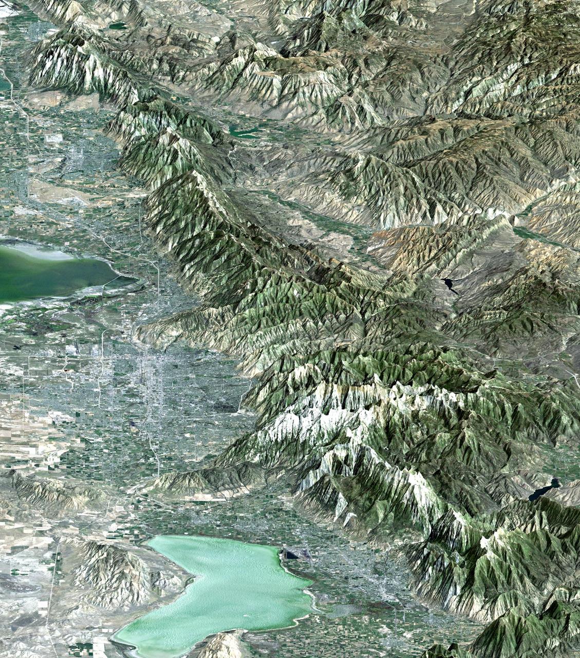
ISS011-E-13889 (30 September 2005) --- Wasatch Range, Utah is featured in this image photographed by an Expedition 11 crewmember on the international space station. The Wasatch Range forms an impressive backdrop to the Salt Lake City metropolitan area, and is a frequent destination for hikers, backpackers, and skiers. The range is considered to be the westernmost part of the Rocky Mountains, and rises to elevations of approximately 3600 meters (12,000 feet) above sea level. This photograph, taken at the end of September, captures red- (maple trees) and gold-mantled (aspen trees) hill slopes along the western mountain front to the south of Salt Lake City. Other common tree species at these elevations include pine, fir, spruce, willow, birch, and oak. A portion of Draper City is visible in the left half of the image. The elevation of Lone Peak, visible at upper right, is approximately 3410 meters (11,253 feet).
STS039-85-032 (28 April-6 May 1991) --- A large portion of the Dallas - Fort Worth metropolitan area is seen in this 70mm frame, photographed from the Earth-orbiting Space Shuttle Discovery. Hold photograph with the Dallas - Ft. Worth Airport directly above the center point of the picture so that north will be at the top. Compared with Apollo 6 pictures made 23 years earlier (April 1968), this photo indicates notable growth in the municipalities between Dallas and Ft. Worth as well as great outer growth of the two cities. (Most of the western portions of Ft. Worth did not make it into this frame). Easily recognizable bodies of water are Grapevine Lake and North Lake (both near the huge airport), Mountain Creek Lake (southwest of Dallas), Lake Arlington (southeast of Ft. Worth) and the Trinity River which flows southward to the Gulf of Mexico.
STS068-267-097 (30 September-11 October 1994) --- An extensive view eastward from the irrigated San Joaquin Valley in the foreground, across the Sierra Nevada (living up to its name in early October), into the desert of eastern California and Nevada (which has no snow, despite the name). Mono Lake is just visible at the left edge of the frame; Owens Valley extends southward to Owens Lake, the next valley is Panamint Valley, and then Death Valley. Las Vegas and Lake Mead are visible at the upper right of the frame. The Space Radar Laboratory 2 (SRL-2) obtained extensive, multiple-pass data from many test sites within the region displayed, including Mammoth Mountain ski area south of Mono Lake, and in Death Valley.
ISS018-E-005660 (28 Oct. 2008) --- The Great Divide of the Rocky Mountains in Colorado is featured in this image photographed by an Expedition 18 crewmember on the International Space Station. This view highlights a portion of the Great Divide in the Rocky Mountains approximately 31 kilometers due west of Boulder, Colorado. The Great Divide is one of four continental divides recognized by geographers and hydrologists in North America -- the others being the Northern, Eastern, and Saint Lawrence Seaway Divides -- but it is still generally (and erroneously) known as "the" Continental Divide. The Great Divide is a hydrologic boundary defined by the ultimate destination of precipitation -- rainfall on the western side of the Divide flows to the Pacific Ocean, while rainfall on the eastern side of the Divide flows to the Gulf of Mexico. It is easy to visualize such a boundary traced along the high ridges of the Rocky Mountains, but in regions of less topography more detailed study of the local geomorphology and hydrology are required to map the location of the Divide. This portion of the Rocky Mountains also hosts the Niwot Ridge Long Term Ecological Research (LTER) site. Part of the National Science Foundation LTER program, the Niwot Ridge LTER site studies climate interactions with tundra and alpine ecosystems. Niwot Ridge is visible in this image as a large eastward spur off the central spine of the mountains. The entire Niwot LTER site is located at elevations higher than 3000 m, and includes an active cirque glacier and glacial landforms, tarns (glacial lakes), and permafrost. Lake Granby, located to the west of the Great Divide, is a reservoir on the Colorado River and the second-largest manmade body of water in the state of Colorado. Storage of water began in 1949. Today, the Lake is popular location for fishing, boating and camping.
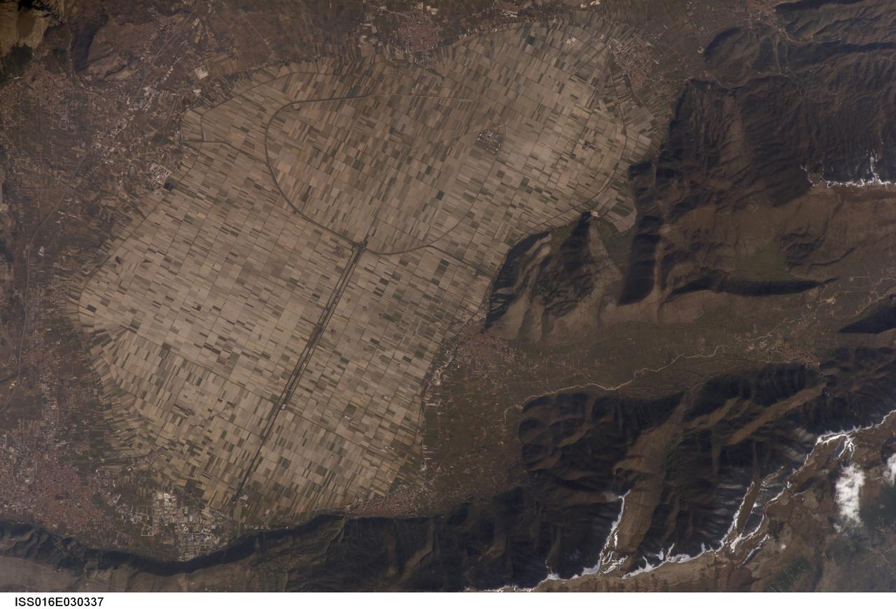
ISS016-E-030337 (26 Feb. 2008) --- Fucine Lake, central Italy is featured in this image photographed by an Expedition 16 crewmember on the International Space Station. The light tan oval in this image is the floor of a lake in central Italy that has been drained by a tunnel dug through the surrounding hills. Numerous rectangular fields can be seen on this former lake bottom--now one of the most fertile regions of Italy. The existence of a former lake explains the name of the area. The town of Avezzano (bottom left), near the drainage outlet of the basin, lies 80 kilometers east of Rome. The "circumference road" can be detected tracking around the edge of the lake; it roughly follows the boundary between green, vegetated fields around the basin and tan fallow fields within. This recent photograph shows a dusting of snow along mountain ridges to the south (image upper and lower right). The basin of Fucine Lake has no natural outlet. Consequently the level of the original lake fluctuated widely with any higher-than-average rainfall.
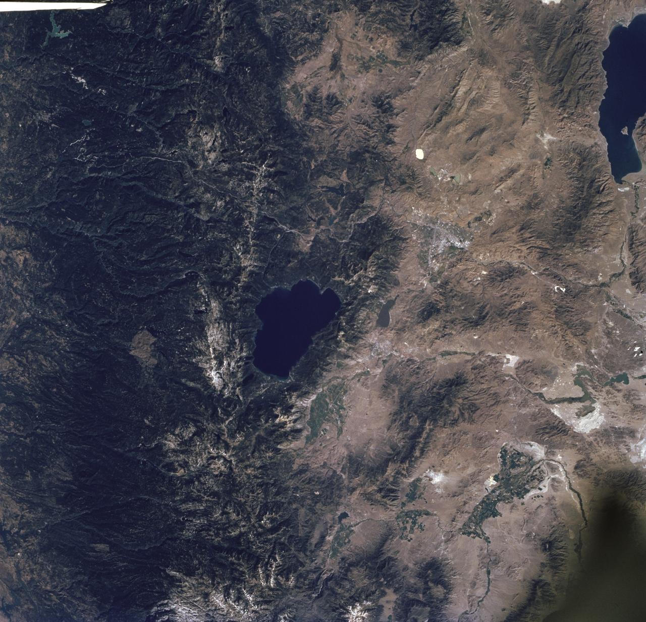
STS085-716-061 (7 - 19 August 1997) --- The dark green forests of the Sierra Nevada Mts. occupy the left side of the picture. Reno lies between Lake Tahoe (center) and Pyramid Lake (top right). Lake Tahoe, is a clear, deep alpine lake (over 505 meters deep), surrounded by Montane forest, ski resorts and casinos. Although Tahoe is known as one of the clearest lakes in the world, water quality in the lake has been declining due to soil erosion from development. Since 1968, it has lost about 30 feet of clarity. A partnership was recently formed between environmentalists and resort owners to protect their common interest in keeping the lake as clear as possible. Over the last five years they have slowed the erosion and the growth of algae that it causes so that clarity is now "only" lost at a rate of roughly one foot per year. Pyramid Lake (on the upper right of the photo) is as different from Tahoe as a lake could be. The sagebrush desert around the lake and is owned by the Pyramid Lake Paiute tribe who manage it as a fishery for an endangered sucker (fish), the cui-cui. The tribe has added modern fisheries' biology methods to their traditional management and chooses not to develop the lake as a recreation destination. Anaho Island, in the lower half of the lake, is a wildlife refuge managed for American White Pelicans which fly hundreds of miles each day to get from this safe breeding area to the shallow marshes where they feed. Directly above Lake Tahoe is Donner pass, near the site where the beleaguered Donner Party spent the winter of 1846 - 1847 trapped in the mountains. Several shallow ephemeral lakes can be seen in Lemmon Valley north of Reno's core urban area. These lakes would normally have dried up by August when this photo was taken, but are still wet because of the extremely wet winter and floods of January 1997.
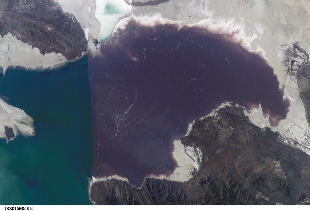
ISS015-E-05815 (30 April 2007) --- Algae in Great Salt Lake, Utah is featured in this image photographed by an Expedition 15 crewmember on the International Space Station. According to scientists, the Great Salt Lake of northern Utah is a remnant of glacial Lake Bonneville that extended over much of present-day western Utah, and into the neighboring states of Nevada and Idaho, approximately 32,000 to 14,000 years ago. During this time, the peaks of adjacent ranges such as the Promontory and Lakeside Mountains were most likely islands. As climate warmed and precipitation decreased in the region, glaciers that fed melt-water to Lake Bonneville disappeared, and the lake began to dry up. The present-day Great Salt Lake is a terminal lake in that water does not flow out of the lake basin. Water loss through the year is due primarily to evaporation, and when this loss exceeds input of water from rivers, streams, precipitation, and groundwater the lake level decreases. This is particularly evident during droughts. This process of evaporation, together with the relatively shallow water levels (maximum lake depth is around 33 feet), has led to increased salinity (dissolved salt content) of the lake waters. The north arm of the Lake, displayed in this image, typically has twice the salinity of the rest of the lake due to impoundment of water by a railroad causeway that crosses the lake from east to west. This restriction of water flow has led to a striking division in the types of algae and bacteria found in the north and south arms of the lake. In the northern arm (north of the causeway), the red algae Dunaliella Salina and the bacterial species Halo bacterium produce a pronounced reddish cast to the water, whereas the south arm (south of the causeway) is dominated by green algae such as Dunaliella viridis. The Great Salt Lake also supports brine shrimp and brine flies; and is a major stopover point for migratory birds including avocets, stilts, and plovers.
STS059-L09-162 (9-20 April 1994) --- Orient with the snow-covered mountains (Sierra Nevada of California) in the upper right corner. Then Owens Valley runs along the top of the photograph to Owens Lake playa at top center. The upper end of Death Valley extends from right to left in the foreground, with the drainage running down to a playa at Stovepipe Wells in the left foreground. Geologists are studying microwave signatures of the different playa surfaces, and the coatings on alluvial fans that extend from mountain masses, to try to sort out the history of different climates in this formerly wet but now hyperarid region.
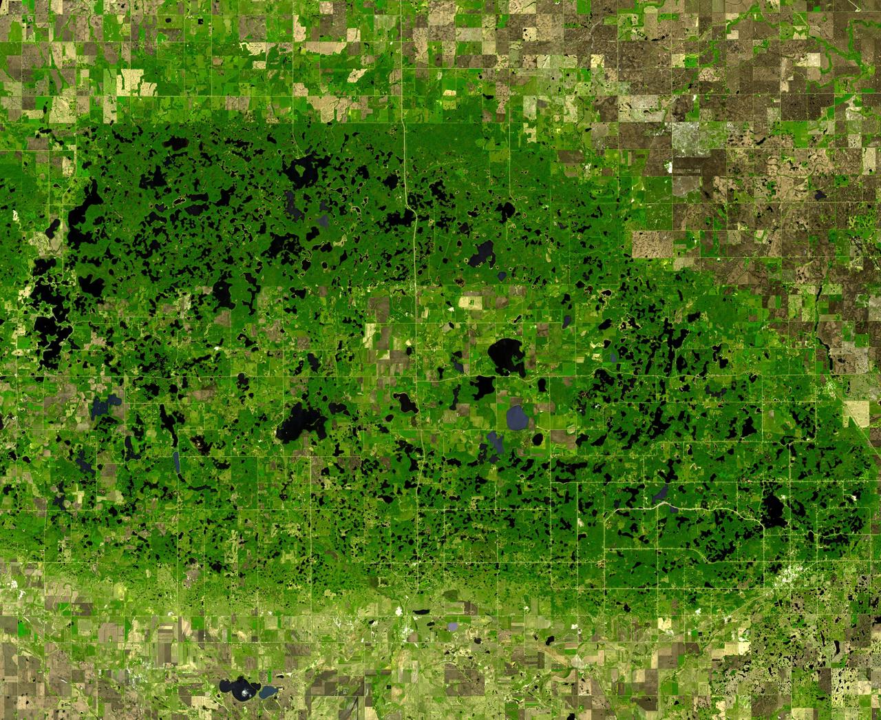
This image from NASA Terra spacecraft shows the Turtle Mountains, which straddle the US-Canada border in central North Dakota. Underlain by 55 million year old sandstones and shales of the Cannonball Formation, the upland surface was sculpted by glaciations. Due to the mountain's 150m elevation above the surrounding lowlands, glacial ice tended to stagnate, forming thousands of lakes and sloughs. The image was acquired May 19, 2006, covers an area of 43.5 x 53.1 km, and is located at 49 degrees north, 100.1 degrees west. http://photojournal.jpl.nasa.gov/catalog/PIA19435
STS068-243-076 (30 September-11 October 1994) --- Parts of the Swiss Cantons of Vaud and Valois, the French province of Chablis and parts of northwestern Italy are seen in this widely stretching image photographed from the Space Shuttle Endeavour. Pennine Alps, said to have been created 50 million years ago, have been reshaped by glaciers during Pleistocene. The glaciers created the wide valley of the Rhone River by scourting a pre-existing seam. The fertile Swiss Plateau runs northwest from the shore of Lake Geneva and is visible in lower left. The Franco-Swiss border is located in the center of the lake and follows a mountain divide east of Rhone Valley. Italy lies south of the Rhone.
SL4-138-3846 (February 1974) --- A near vertical view of the snow-covered northwest corner of Wyoming as seen from the Skylab space station in Earth orbit. A Skylab 4 crewman used a hand-held 70mm Hasselblad camera to take this picture. A small portion of Montana and Idaho is seen in this photograph also. The dark area is Yellowstone National Park. The largest body of water is Yellowstone Lake. The Absaroka Range is immediately east and northeast of Yellowstone Lake. The elongated range in the eastern part of the picture is the Big Horn Mountain range. The Wind River Range is at bottom center. The Grand Teton National Park area is almost straight south of Yellowstone Lake. Approximately 30 per cent of the state of Wyoming can be seen in this photograph. Photo credit: NASA
S66-38313 (5 June 1966) --- Areas of Peru (upper right), Chile (top center) and Bolivia as seen from the Gemini-9 spacecraft during its 35th revolution of Earth. The large body of water at lower right is Lake Titicaca. The smaller lake at left edge is Lake Poopo. Salar de Uyuni is the large light-colored area at upper left. At the bottom of the picture is the snow-capped Cordillera Real range of the Andes Mountains. The Pacific coastline of Peru and Chile is at upper right. The range running parallel with the coastline is the Cordillera Occidental. The image was taken with a modified 70mm Hasselblad camera, using Eastman Kodak, Ektachrome MS (S.O. 217) color film. Photo credit: NASA
ISS012-E-05172 (14 October 2005) --- Navajo Mountain, Utah is featured in this image photographed by an Expedition 12 crewmember on the international space station. According to scientists, the Colorado Plateau of Arizona, Colorado, New Mexico, and Utah is characterized by mostly flat-lying sedimentary layers that record paleoclimate extremes ranging from oceans to widespread deserts over the last 1.8 billion years. Navajo Mountain is formed by a dome-shaped body of igneous rock (called a laccolith by geologists), one of several in southeast Utah that intrude and uplift the surrounding sedimentary layers of the Plateau. This oblique image highlights Navajo Mountain in the center of the image, surrounded by light red-brown Navajo Sandstone (also visible in canyons at bottom of image). Scientists believe the peak of Navajo Mountain, at approximately 3148 meters (10,388 feet) elevation, is comprised of uplifted Dakota Sandstone deposited during the Cretaceous Period. The establishment of Rainbow Bridge National Monument (1910), and the filling of Glen Canyon by Lake Powell in 1963 (upper right), have facilitated tourism and aesthetic appreciation of this previously remote region. Access to Navajo Mountain is still regulated by the sovereign Navajo Nation, and the process of permitting is required to hike in the region.

ISS032-E-010487 (29 July 2012) --- Walker Lake, Nevada is featured in this image photographed by an Expedition 32 crew member on the International Space Station. According to scientists, the Pleistocene landscape of western Nevada approximately 15,000 years ago was one of narrow mountain ranges and numerous interconnected lakes that together formed the extensive glacial Lake Lahontan. Scientists believe drying and warming of the regional climate since the last Ice Age led to the disappearance of the glaciers feeding meltwater to Lake Lahontan, and eventual disappearance of the lake itself. Today, few remnants of Lahontan remain; most of its arms have become dry enclosed basins known as playas. This photograph highlights Walker Lake, one of only two remnant lakes that contain water throughout the year (Pyramid Lake in Nevada is the other). The lake is located in an enclosed basin bounded by the Wassuk Range to the west and the Gillis Range to the east. It is fed by the Walker River flowing from the north. The current dimensions of the lake are approximately 21 kilometers north-south by 9 kilometers east-west. Shoreline deposits at higher elevations than the current lake level form concentric bands that are just visible in the image (bottom center) ? these record varying lake levels in the geologic past. The nearest town is Hawthorne, Nevada to the southeast. To the southwest the highest peak of the Wassuk Range, Mount Grant (elevation 3,496 meters above sea level), dominates the skyline. Green agricultural fields, primarily alfalfa, located to the west of the Wassuk Range (lower right) provide a striking contrast to the surrounding Great Basin desert. These fields are irrigated using water from the nearby East Fork of the Walker River (right, just visible alongside the fields).
ISS028-E-035137 (30 Aug. 2011) --- Owens Lake in California is featured in this image photographed by an Expedition 28 crew member on the International Space Station. This photograph highlights the mostly dry bed of Owens Lake, located in the Owens River Valley between the Inyo Mountains and the Sierra Nevada. Shallow groundwater, springs, and seeps support minor wetlands and a central brine pool. Two bright red areas along the margins of the brine pool indicate the presence of halophilic, or salt-loving organisms known as Achaeans. Grey and white materials within the lake bed are exposed lakebed sediments and salt crusts. The towns of Olancha and Lone Pine are delineated by the presence of green vegetation indicating a more constant availability of water. According to scientists, the present-day Owens Lake was part of a much larger lake and river system that existed during the Pleistocene Epoch (approximately 3 million to approximately 12,000 years ago) along the current northeastern border of California with Nevada. Meltwater from alpine glaciers in the Sierra Nevada filled the regional valleys of the Basin and Range to form several glacial lakes that were ancestral to the now-dry lakebeds (or playas) of Owens, Searles Lake, and China Lake. While Searles and China Lakes dried out due to regional changes to a hotter and drier climate over thousands of years, Owens Lake became desiccated largely due to the diversion of Owens River water in the early 20th century to serve the needs of the City of Los Angeles, CA located 266 kilometers to the south. Following complete desiccation of the lakebed in 1926, significant amounts of windblown dust were produced ? indeed, the term ?Keeler fog? was coined by residents of the now largely abandoned town on the eastern side of Owens Lake due to the dust. In addition to adverse health effects on local residents, dust from Owens Lake has been linked to visibility reduction in nearby national parks, forests, and wilderness areas. Recently, efforts to control dust evolution from the lakebed have been undertaken by the City of Los Angeles.
ISS036-E-035635 (24 Aug. 2013) --- Plankton bloom and Lake Ontario are featured in this image photographed by an Expedition 36 crew member on the International Space Station. This photograph highlights a late summer plankton bloom visible throughout much of Lake Ontario (one of the Great Lakes, together with Michigan, Superior, Erie, and Huron). Cyanobacteria, or blue-green algae, can reach such large concentrations that they color the water to such an extent that the change is visible from orbit. Harmful algal blooms, or HABs, have been observed in all of the Great Lakes – particularly Lake Erie - and are associated with a variety of causative factors including changes in precipitation; drought; invasive species (quagga, zebra mussels, Asian carp); nutrient loading from runoff and sewage (nitrogen and phosphorus); and warmer average temperatures. In addition to reduced water quality and human health concerns, algal blooms can also lead to hypoxia (reduction of oxygen in the bottom waters) that kills large numbers of fish and other aquatic life. Lake Ontario, like the other Great Lakes Erie, Huron, and Superior is roughly divided between the USA and Canada. The USA side of Lake Ontario has its shoreline along the state of New York, while its Canadian shoreline lies within the province of Ontario. The city of Kingston, Ontario, is visible near the Saint Lawrence River outflow from the lake. Several other landscape features of New York State are visible in the image, including the Finger Lakes region to the west of Syracuse, NY (upper left). To the northeast of Syracuse, the dark wooded slopes of the Adirondack Mountains are visible at lower right. Patchy white cloud cover obscures much of the land surface to the west of Lake Ontario.
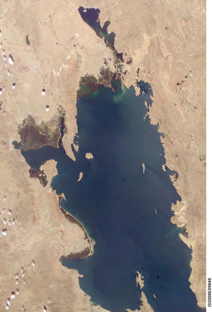
ISS008-E-05649 (8 November 2003) --- Lake Titicaca was featured in this image taken by one of the Expedition 8 crewmembers onboard the International Space Station (ISS). Lake Titicaca, at an elevation of 12,507 feet in the Andean Altiplano, is the highest large lake in the world. More than 120 miles long and 50 miles wide, it was the center of Incan civilization, and today straddles the boundary between Peru and Bolivia. Scientists have studied indicators of the water level changes over time to tease out information about precipitation shifts in the high Andes and the South American tropics. Following are some observations by NASA scientists who are studying this imagery: Because the lake occupies the low point of the Altiplano, much of the water of the high plateau eventually trickles into the lake. And because it is surrounded by mountains, very little of Lake Titicaca’s water drains out -- the Rio Desguadero is the only major outflow river. So, like a bathtub with no drain, this large and deep lake (with depths of several hundred feet) has become the collecting basin for thousands of years of sediment. These sediments and their fossils contain clues about past climate conditions. The restricted outflow of the lake creates conditions where even shorter, interannual climate cycles (like El Niño /Southern Oscillation) impact Lake Titicaca’s water levels. Recent lake level variations have been several meters, with low levels occurring during regional droughts of El Niños. Right now, the region is relatively wet. In this image, the dark greens of the wetlands along the shallower margins of the lake contrast strongly with the surrounding desert. But the even large cities like Puno, Peru (100,000 people) are difficult to discern from the surrounding countryside.

S130-E-010355 (18 Feb. 2010) --- Japan Aerospace Exploration Agency (JAXA) astronaut Soichi Noguchi, Expedition 22 flight engineer, uses a still camera at a window in the Cupola of the International Space Station while space shuttle Endeavour (STS-130) remains docked with the station. The mountains in the center window are the western Burhan Budai Shan (lower right), with Qaidam Basin and lakes, (center), all just north of the city of Golmud, Qinghai Province, China.

S119-E-010690 (27 March 2009) --- On its final full day in space before a scheduled return home on March 28, the crew of Space Shuttle Discovery took some pictures of the home planet. Unlike most of the images, which showed closer views of Earth featuring oceans, lakes, rivers, clouds, mountains and deserts, this view shows Earth's limb as the spacecraft approached a rising or setting sun.

iss070e027906 (Nov. 19, 2023) --- The night lights of Mexico City, the capital and largest city of Mexico with a population of 9.2 million, are pictured from the International Space Station as it orbited 260 miles above the central American nation. At far left, the well-lit Felipe Ángeles International Airport is easily observable from low-Earth orbit. The large, dark area at center top, is Lake Texcoco Ecological Park. The dark area just below, is the Sierra de Guadalupe mountain range.
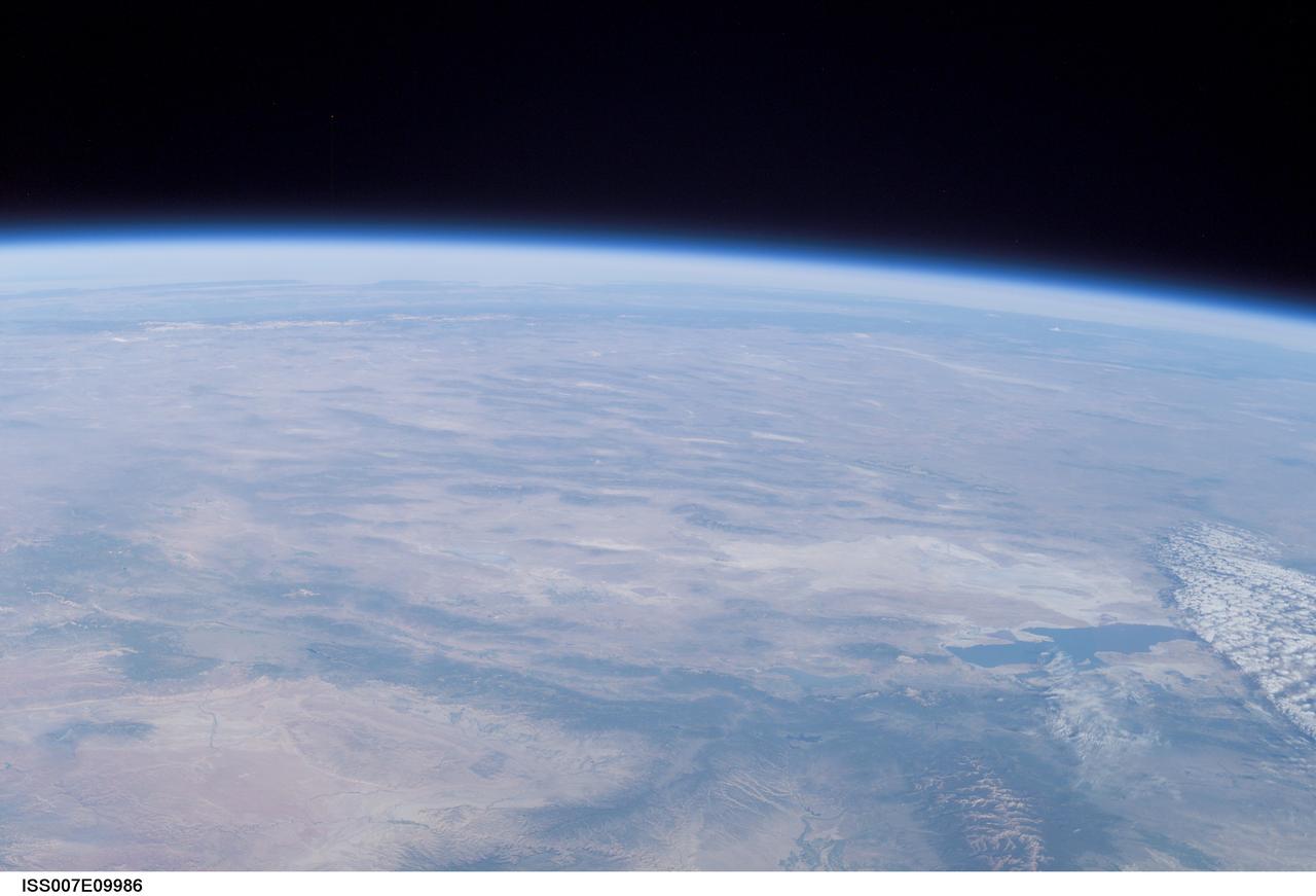
ISS007-E-09986 (11 July 2003) --- This view of Earth’s horizon was taken by an Expedition 7 crewmember onboard the International Space Station (ISS) while the Station was in orbit over Dodge City, Kansas. In the lower right is the Great Salt Lake. At the left side in the distance are the Sierra Nevada Mountains with elevations between 12,000 and 15,000 feet, and coastal California.
AS09-20-3137 (3-13 March 1969) --- The Grand Canyon is sharply etched on the snow-covered Colorado Plateau in Arizona in this photograph from the Apollo 9 spacecraft during its Earth-orbital mission. Lake Powell behind Glen Canyon Dam is in the upper right corner. Humphreys Peak and the many volcanic craters around the San Francisco Mountains near Flagstaff, Arizona, are right of center. Prescott is under clouds at lower center.
On the border between Mongolia and China, southward draining ephemeral streams have carved a series of parallel channels. Mountains to the north have an elevation of 1800 m; the catchment lake for the streams lies at 500 m elevation. The flat, featureless, homogeneous plain between the source and sink controls the geometry of the drainage pattern. The image was acquired August 17, 2014, covers an area of 17.7 by 36.3 kilometers, and is located at 42.7 degrees north, 100.9 degrees east. https://photojournal.jpl.nasa.gov/catalog/PIA23196
ISS015-E-22269 (13 Aug. 2007) --- The crew aboard the International Space Station provided this image of the wide-spread forest fires in the Payette National Forest, Central Idaho within the Salmon River Mountains. North is toward the left of the image. The Salmon River is the feature in the bottom central part of the frame. Lake Cascade is seen at the lower right.
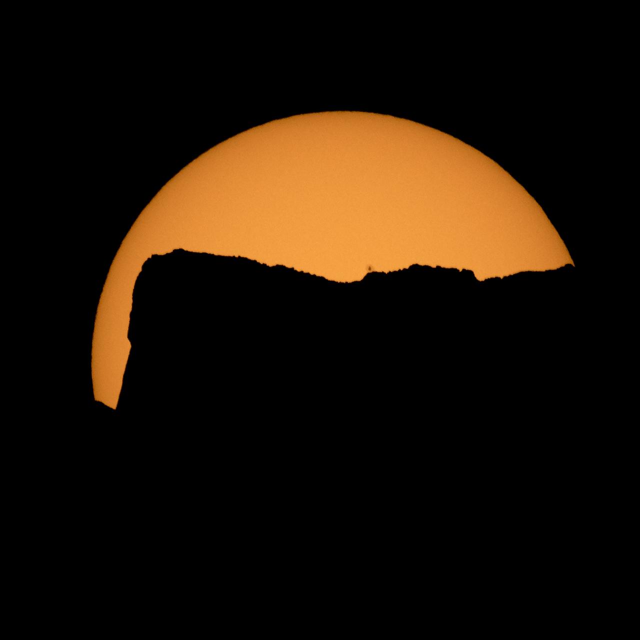
The Sun is seen as it rises behind Jack Mountain head of the solar eclipse, Monday, Aug. 21, 2017, Ross Lake, Northern Cascades National Park, Washington. A total solar eclipse will sweep across a narrow portion of the contiguous United States from Lincoln Beach, Oregon to Charleston, South Carolina. A partial solar eclipse was visible across the entire North American continent along with parts of South America, Africa, and Europe. Photo Credit: (NASA/Bill Ingalls)
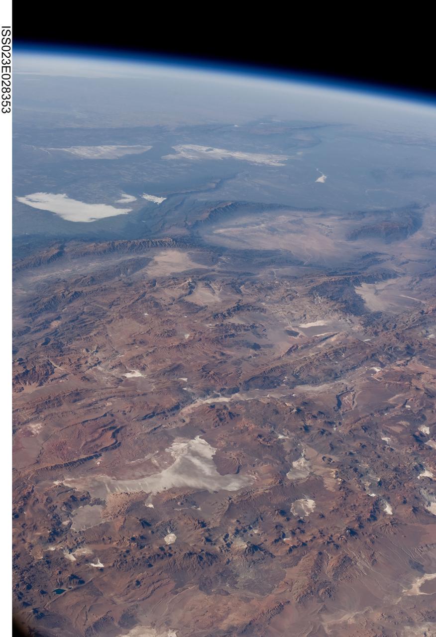
ISS023-E-028353 (26 April 2010) --- Central Andes Mountains, Salar de Arizaro, Argentina are featured in this image photographed by an Expedition 23 crew member on the International Space Station. The high plains (3,000 to greater than 5,000 meters elevation, 13,000 to 19,000 feet) of the Andes Mountains, also known as the Puna, appear in the foreground of this photograph, with a line of young volcanoes facing the much lower Atacama Desert (1,000–2,000 meters elevation). Several large dry lakes, marked by light-toned salt crusts, occupy the basins between major thrust faults in the Puna. Salar de Arizaro (foreground) is the largest of the dry lakes in this view (salar means waterless salt flat in Spanish). This panorama was taken by a station crew member looking southeast across the South American continent when the ISS was almost directly over the Atacama Desert near Chile’s Pacific coast. The Atlantic Ocean coastline (River Plate where Argentina’s capital city of Buenos Aires is located) is dimly visible at top left. A striking geological and landscape contrast is visible at center which separates two distinct geological zones, namely the Puna and the Sierras Pampeanas. The Sierras Pampeanas Mountains are lower in elevation and have few young volcanoes, in contrast to the Puna. Sharp-crested ranges are separated by wide, low valleys in this region. The Salinas Grandes—ephemeral shallow salt lakes at top left (salina means salt lake in Spanish) — occupies one of these valleys. The general color change from reds and browns in the foreground to blues and greens in the upper part of the image reflects the major climatic regions, namely the deserts of the Atacama and Puna, versus the low grassy plains of central Argentina where rainfall is sufficient to promote lush prairie grass growth—known famously as the pampas in Argentina. The Salinas Grandes mark an intermediate semiarid region. What accounts for the changes in landscape? The geology of this part of the Andes is a result of the eastward subduction of the Nazca tectonic plate underneath South America. Investigations using seismic data suggest that the Puna is underlain by a steeply dipping sector of the subducting Nazca plate. The Sierras Pampeanas zone however, is underlain by a sector of the Nazca plate that is almost horizontal, possibly due to the subduction of a submarine mountain range known as the Juan Fernandez Ridge. In the simplest terms, ridges are topographic highs that are difficult to stuff down subduction zones, with profound effects on the volcanism and structures of the upper plate.
This is a single scene from a pair (frames 021 & 024) to study the effects of polarized light in Earth Observations. One scene was exposed with vertically polarized light, the other, horizontally. The subject in this study, is a lake behind Presa (dam) Don Martin (27.5N, 100.5W) on the edge of the Rio Grande Plain near it's boundry with the Sierra Madre Orientral in Coahuila, Mexico.
AST-16-1132 (20 July 1975) --- A vertical view of the eastern portion of the state of South Australia in Australia, as photographed from the Apollo spacecraft in Earth orbit during the joint U.S.-USSR Apollo-Soyuz Test Project mission. The highlands area is the Flinders Range. The light-colored body of water is Lake Blanche. The lake to the south is Callabonna. This picture was taken at an altitude of 224 kilometers (139 statute miles) with a 70mm Hasselblad camera using high-definition aerial Ektachrome SO-242 type film.