Polar Landforms
Isidis Landforms
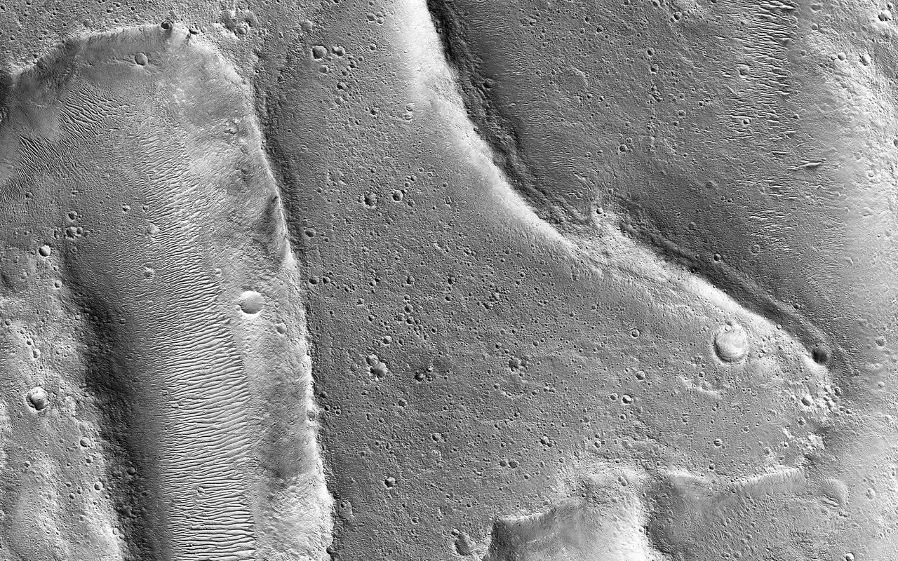
Exhuming Landforms

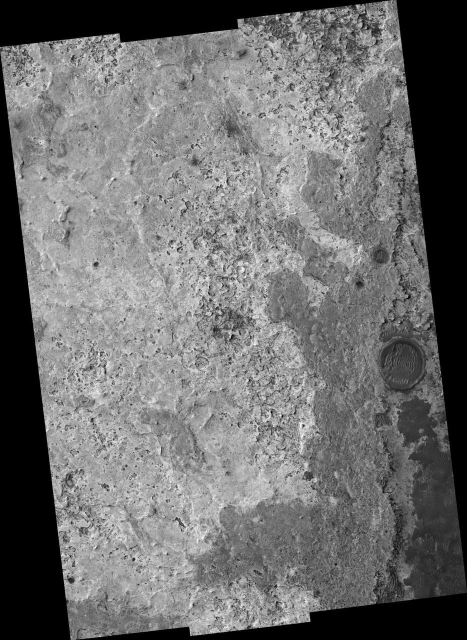
A Smorgasbord of Landforms
South Polar Landforms
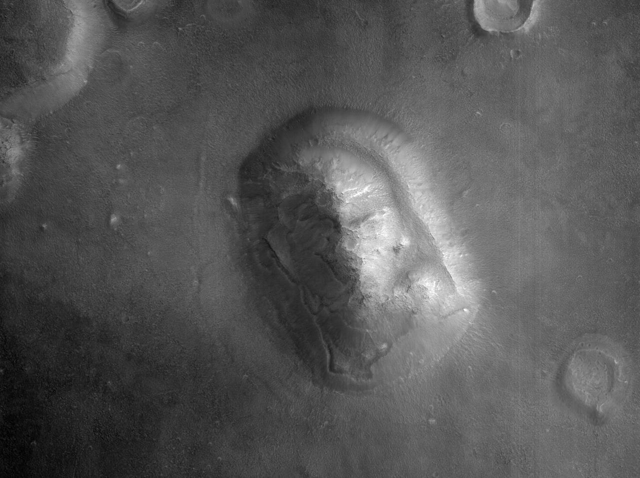
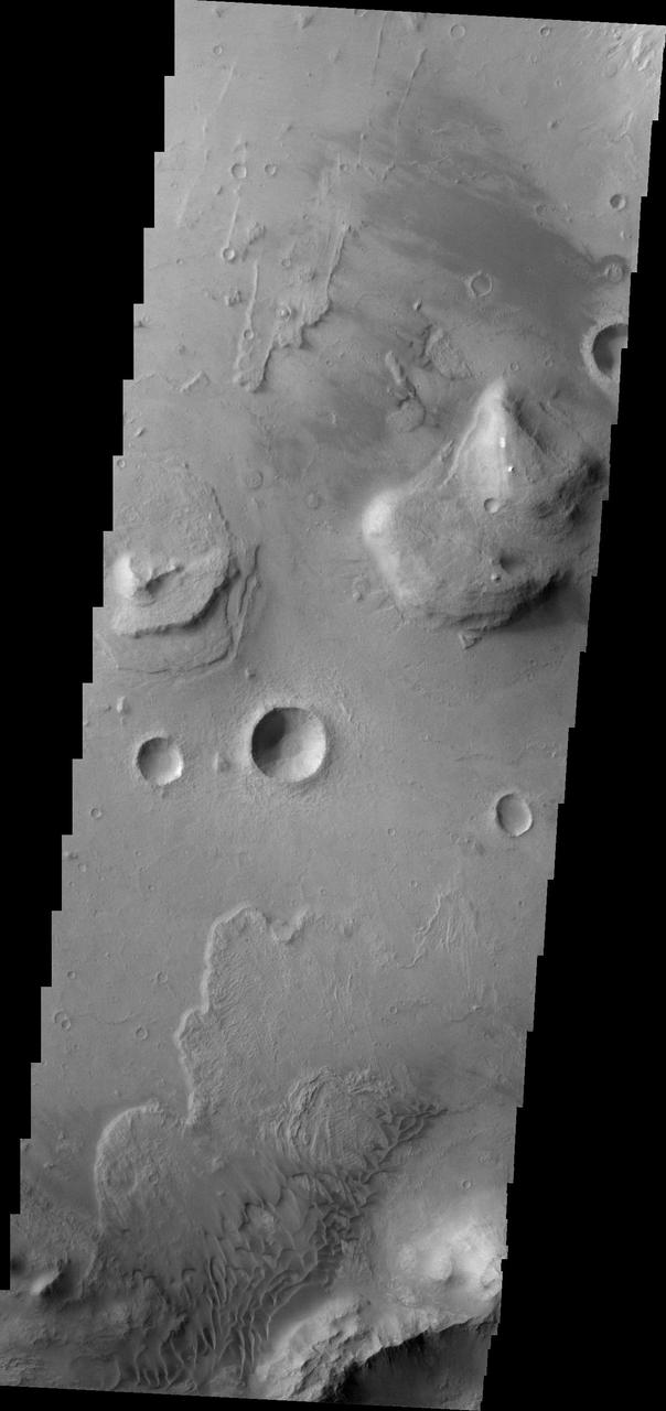
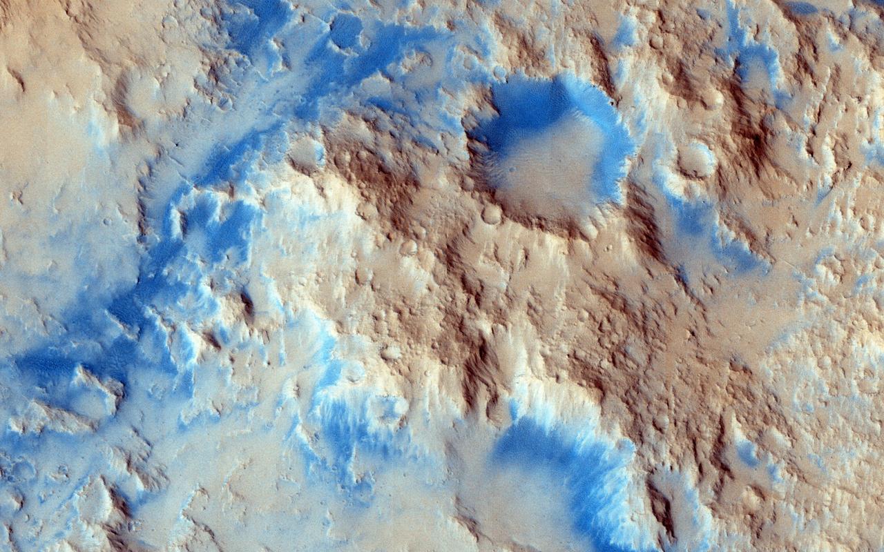
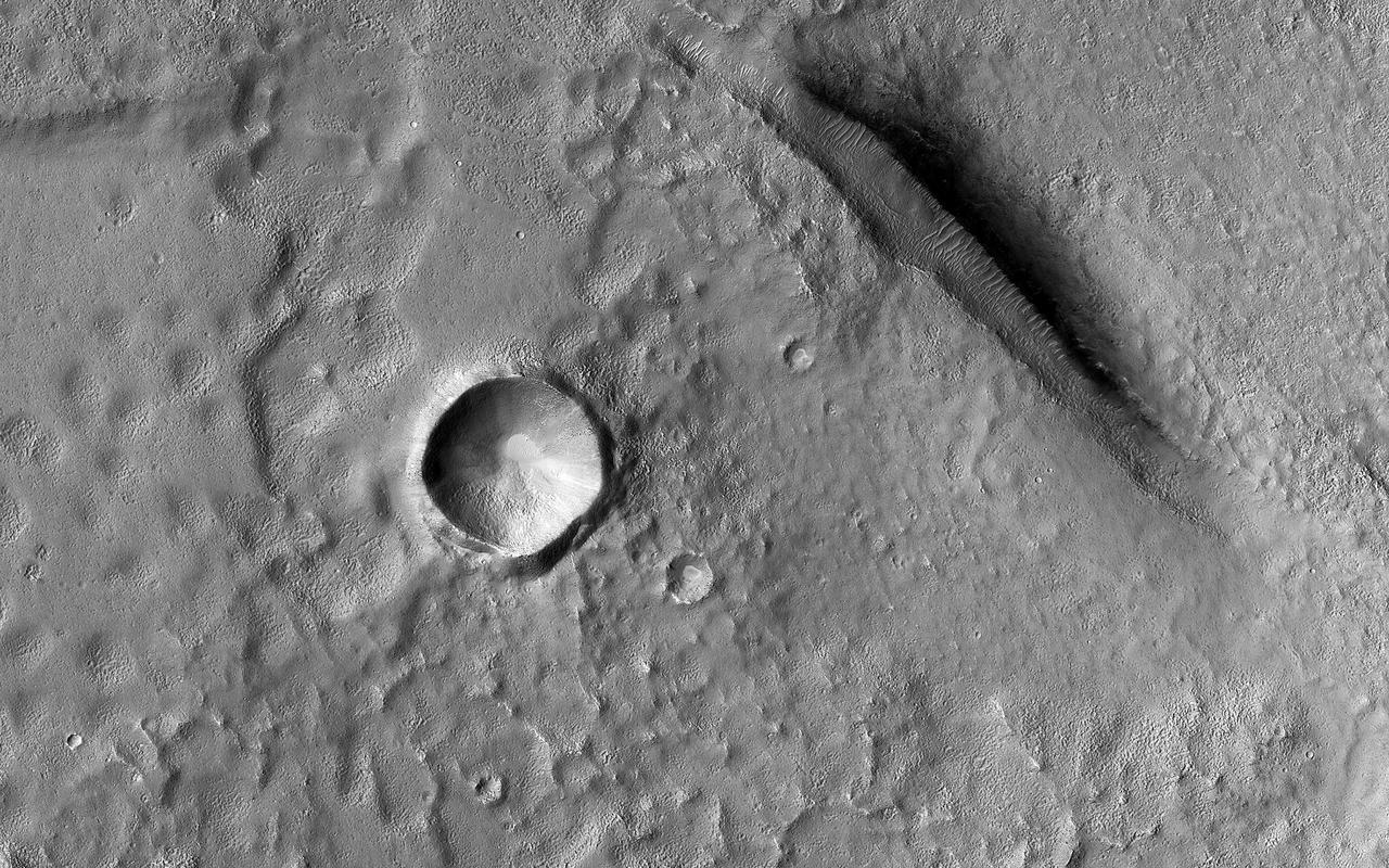
Popular Landform in Cydonia Region
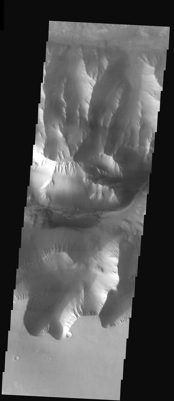
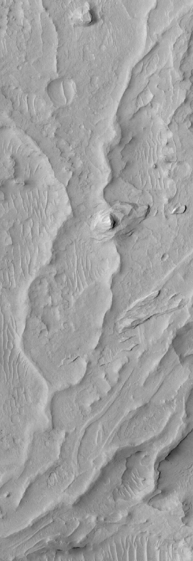
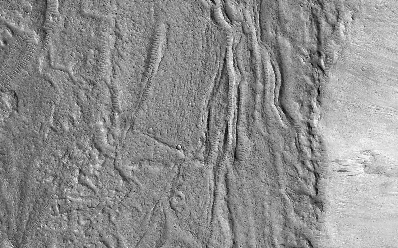
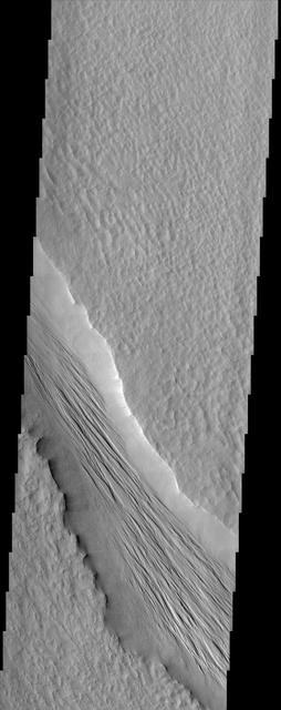
Landforms in East Candor
Northeast Sinus Meridiani Landforms
East Arabia Landforms
North Sinus Meridiani Landforms
Carbon Dioxide Landforms
Stunning Landforms in Raditladi Basin
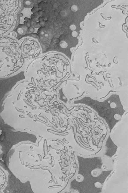
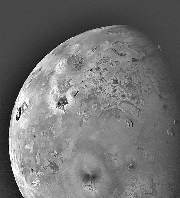
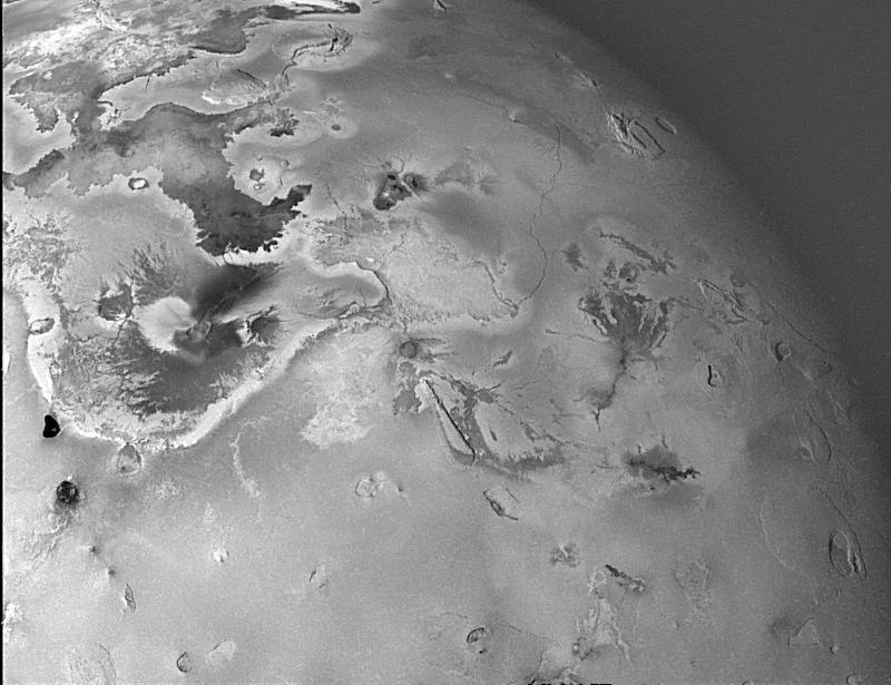
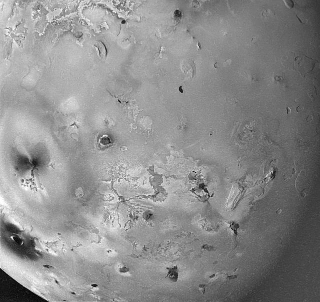
Geologic Landforms on Io
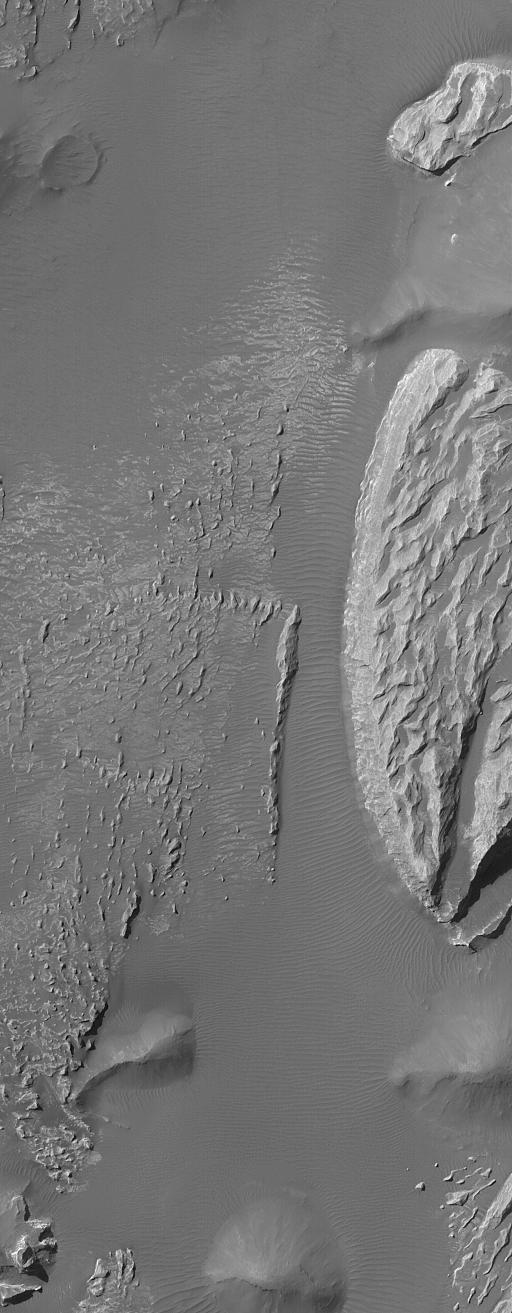
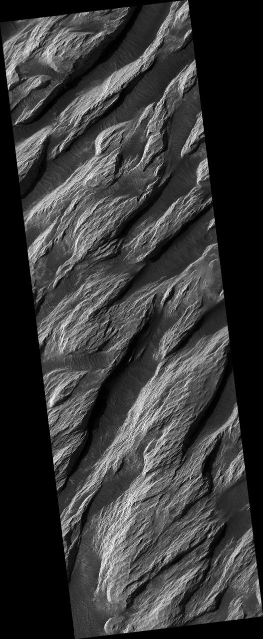
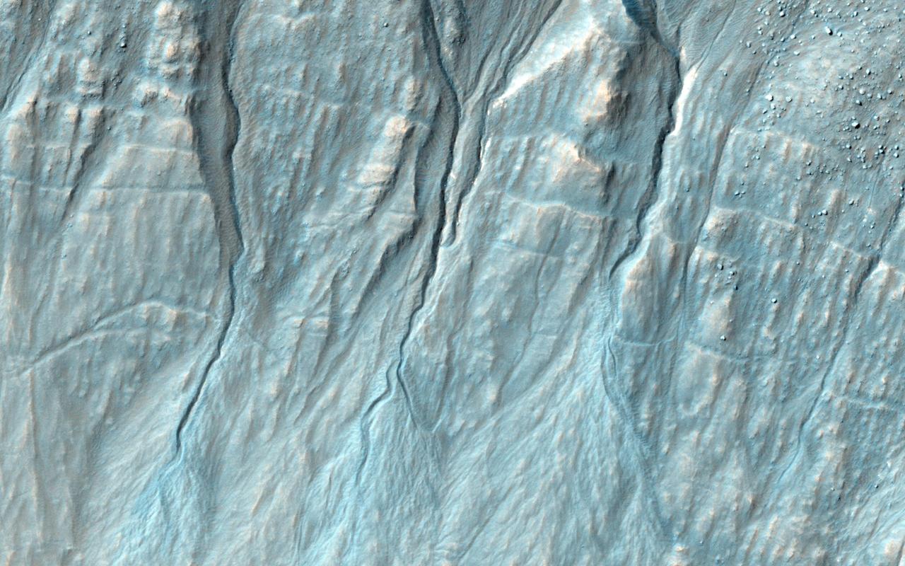
Valles Marineris Landforms
Arsinoes Chaos Landforms
Olympica Fossae Landforms
Geologic Landforms on Io Area 2
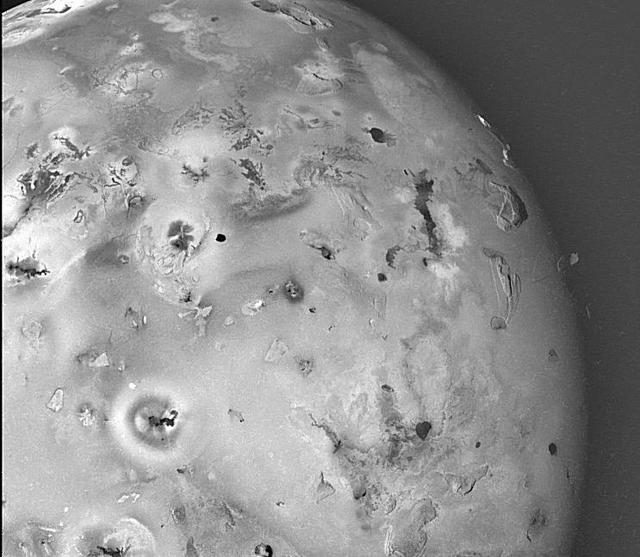
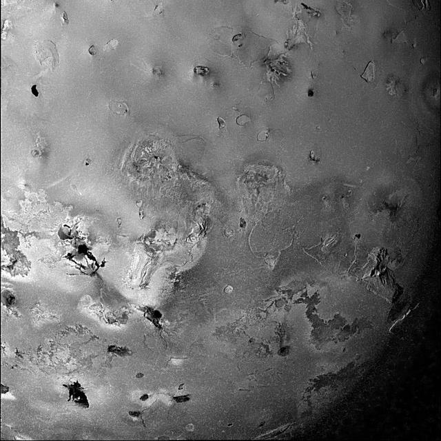
Geologic Landforms on Io Area 1
White Rock Landform in Pollack Crater
Geologic Landforms on Io Area 5
Geologic Landforms on Io Area 3
Geologic Landforms on Io Area 4
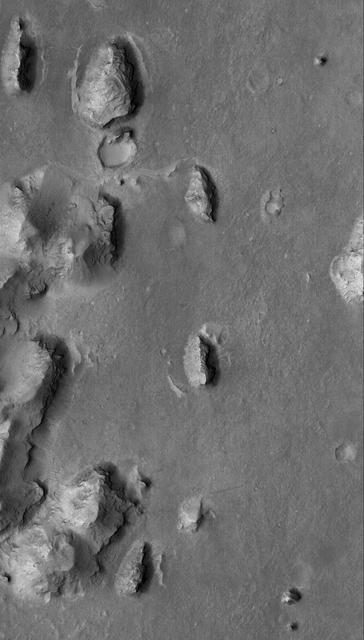
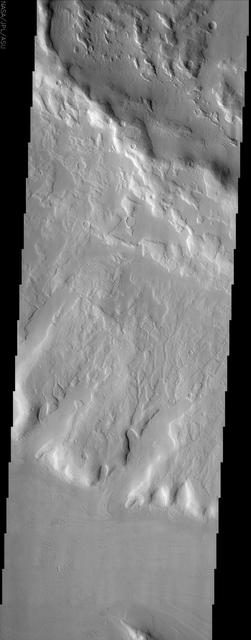
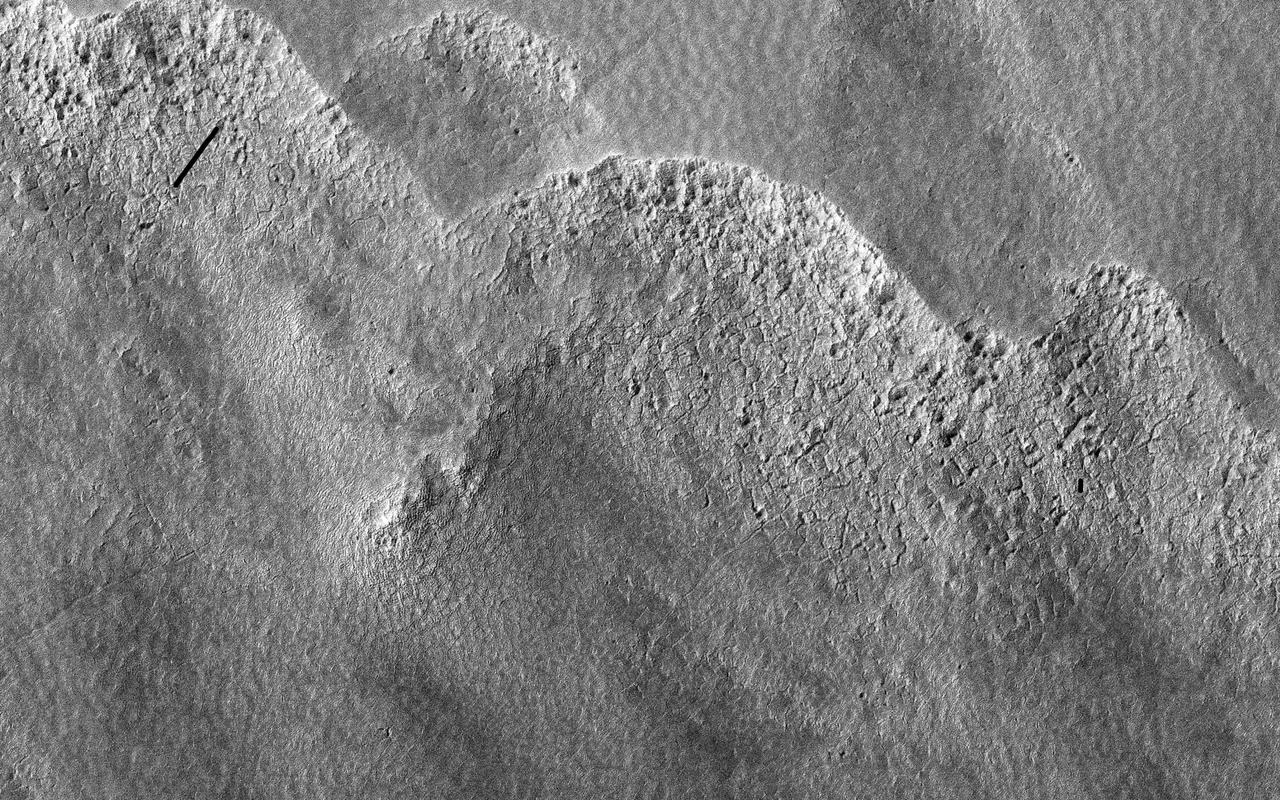
This Mars Global Surveyor MGS Mars Orbiter Camera MOC image shows layered buttes, knobs, and other landforms exposed by erosion in the Aeolis region of Mars
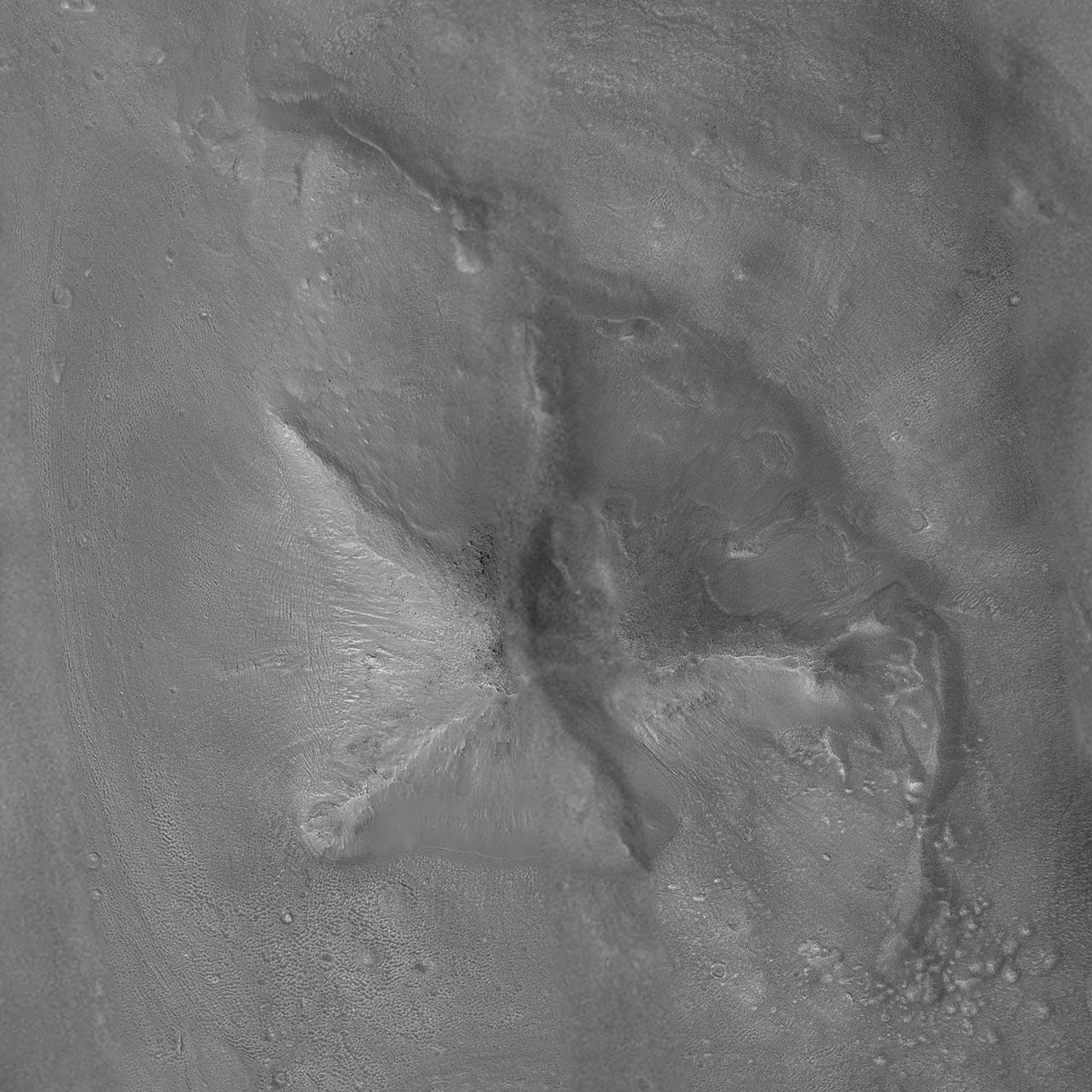
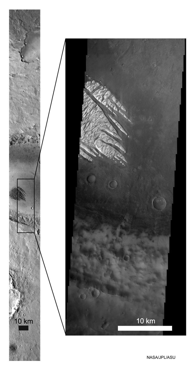
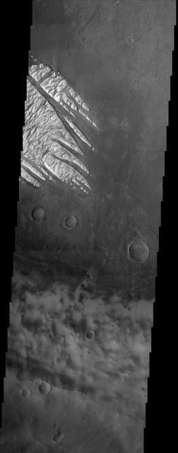
The focus of this image from NASA Mars Reconnaissance Orbiter is on the western end of a fan-shaped landform, located at the end point of a sinuous valley. Our observation covers crater-retaining mesas which overlie light-toned materials, both potentially related to the formation of the fan. There are also craters younger than the fan which impacted into these materials. http://photojournal.jpl.nasa.gov/catalog/PIA19845
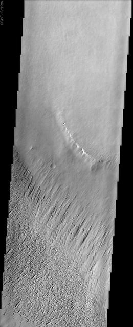
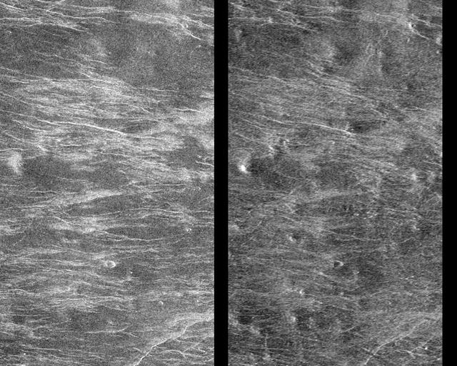
Images of the Cydonia region of Mars continue to be popular among visitors to the Mars Global Surveyor (MGS) Mars Orbiter Camera (MOC)web site. The two pictures (one annotated, the other not) are mosaics of two images from MGS MOC and one from the Mars Odyssey Thermal Emission Imaging System visible camera (THEMIS VIS). The mosaics highlight a Cydonia landform popularly known as the "D&M Pyramid." It is located near 40.7°N, 9.6°W. Although it is not really shaped like a pyramid, the Cydonia landform is one of thousands of massifs, buttes, mesas, knobs, and blocks that mark the transition from the far northwestern Arabia Terra cratered highlands down to the northeastern Acidalia Planitia lowlands. Each block, whether shaped like a face, a pyramid, or simply a mesa, massif, or knob, is a remnant of the bedrock of northeastern Arabia that was left behind as erosion slowly degraded the terrain along this zone between the highlands and the lowlands. A few outcroppings of layers in this ancient bedrock can be seen in the mosaic of the pyramid-like landform shown here; much of the landform is covered with eroded mantling material that was deposited long after this highlands remnant became an isolated feature in Cydonia. The mosaic was created from two MOC images obtained in June (R06-00469) and July (R07-00422) of 2003 and one THEMIS VIS image acquired in 2002 (V01024003). The mosaic is 8 km by 8 km (5 mi by 5 mi) across and each of the three images is illuminated from the lower left. North is up. The picture on the right shows the location of the two MOC images as black outlines; the THEMIS image not only covers the gap between the two MOC images, it also fills out the lower left and upper right corners. http://photojournal.jpl.nasa.gov/catalog/PIA04745
Ares Vallis is a large valley that was carved billions of years ago by water flowing across the surface of Mars. This image shows an area where the flowing water may have stripped away some of the rocks and soils at the bottom of the valley, leaving behind the ridge-like formations. In other areas of our observation, such as the smooth terrain in the middle portion of this image, the flowing water appears to have carried in and left behind rocks and soils from somewhere upstream. Scientists study landforms, rocks and soils such as these to understand how, where and when floods occurred in Mars' past. https://photojournal.jpl.nasa.gov/catalog/PIA25551
![This image from NASA's Mars Reconnaissance Orbiter (MRO) targets a portion of a group of honeycomb-textured landforms in northwestern Hellas Planitia, which is part of one of the largest and most ancient impact basins on Mars. In a larger Context Camera image, the individual "cells" are about 5 to 10 kilometers wide. With HiRISE, we see much greater detail of these cells, like sand ripples that indicate wind erosion has played some role here. We also see distinctive exposures of bedrock that cut across the floor and wall of the cells. These resemble dykes, which are usually formed by volcanic activity. Additionally, the lack of impact craters suggests that the landscape, along with these features, have been recently reshaped by a process, or number of processes that may even be active today. Scientists have been debating how these honeycombed features are created, theorizing from glacial events, lake formation, volcanic activity, and tectonic activity, to wind erosion. The map is projected here at a scale of 50 centimeters (19.7 inches) per pixel. [The original image scale is 53.8 centimeters (21.2 inches) per pixel (with 2 x 2 binning); objects on the order of 161 centimeters (23.5 inches) across are resolved.] North is up. https://photojournal.jpl.nasa.gov/catalog/PIA22118](https://images-assets.nasa.gov/image/PIA22118/PIA22118~medium.jpg)
This image from NASA's Mars Reconnaissance Orbiter (MRO) targets a portion of a group of honeycomb-textured landforms in northwestern Hellas Planitia, which is part of one of the largest and most ancient impact basins on Mars. In a larger Context Camera image, the individual "cells" are about 5 to 10 kilometers wide. With HiRISE, we see much greater detail of these cells, like sand ripples that indicate wind erosion has played some role here. We also see distinctive exposures of bedrock that cut across the floor and wall of the cells. These resemble dykes, which are usually formed by volcanic activity. Additionally, the lack of impact craters suggests that the landscape, along with these features, have been recently reshaped by a process, or number of processes that may even be active today. Scientists have been debating how these honeycombed features are created, theorizing from glacial events, lake formation, volcanic activity, and tectonic activity, to wind erosion. The map is projected here at a scale of 50 centimeters (19.7 inches) per pixel. [The original image scale is 53.8 centimeters (21.2 inches) per pixel (with 2 x 2 binning); objects on the order of 161 centimeters (23.5 inches) across are resolved.] North is up. https://photojournal.jpl.nasa.gov/catalog/PIA22118
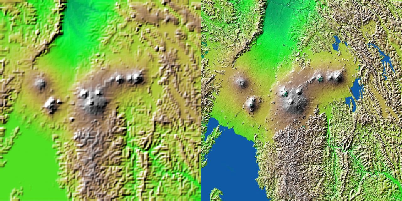
![The diversity of landforms that make up the state of California is evident in this new [sic] rendition of the 3-D topography of the state.](https://images-assets.nasa.gov/image/PIA03333/PIA03333~medium.jpg)
The diversity of landforms that make up the state of California is evident in this new [sic] rendition of the 3-D topography of the state.
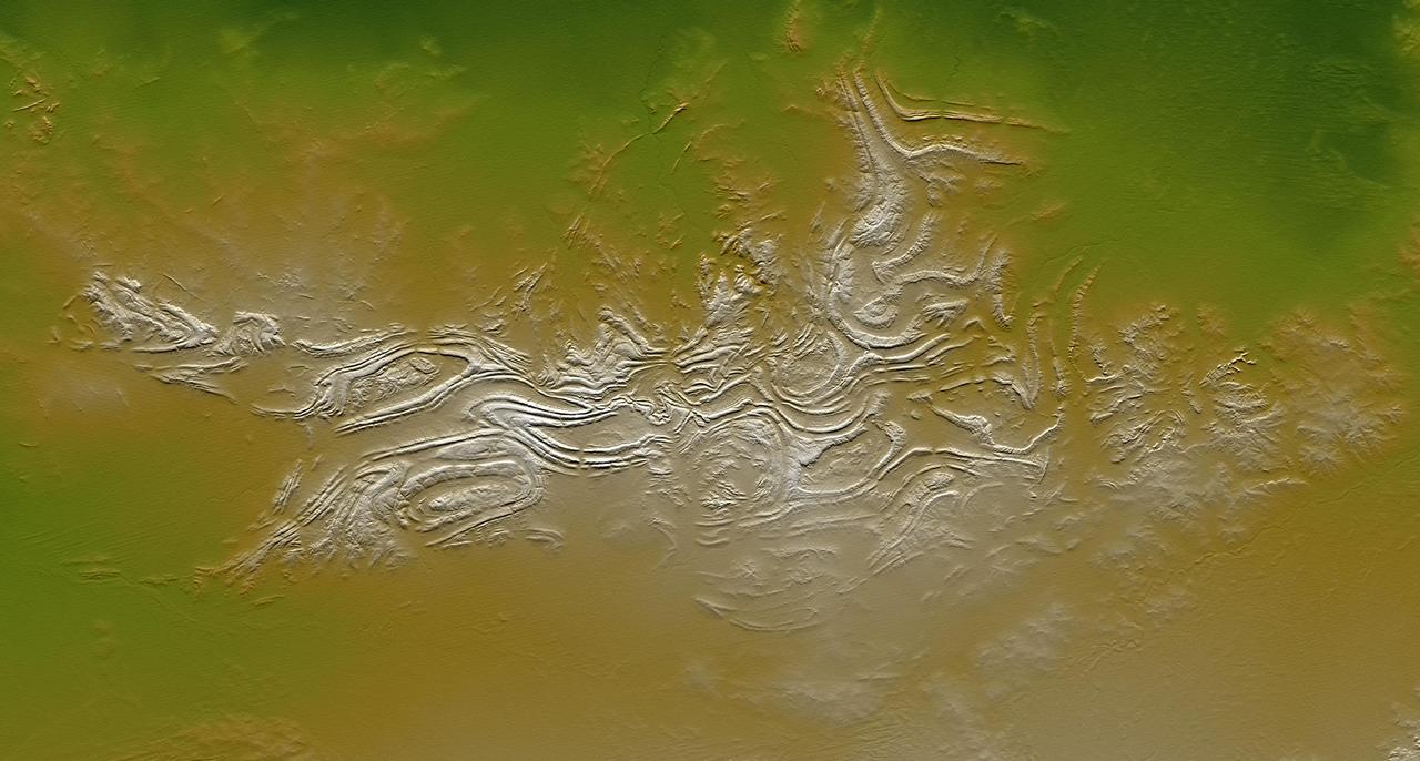
All of the major landforms relate to volcanism and/or erosion in this Shuttle Radar Topography Mission scene of Patagonia, near La Esperanza, Argentina.
![The diversity of landforms that make up the state of California is evident in this new [sic] rendition of the 3-D topography of the state.](https://images-assets.nasa.gov/image/PIA03347/PIA03347~medium.jpg)
The diversity of landforms that make up the state of California is evident in this new [sic] rendition of the 3-D topography of the state.
NASA Mars Reconnaissance Orbiter reveals that gullies, or ravines, are landforms commonly found in the mid-latitudes on Mars, particularly in the Southern highlands.
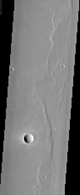
This MOC image shows sinuous ridges and other landforms exposed by erosion in the Aeolis region of Mars
Perched on the northern rim of the enormous Hellas Basin, Terby Crater, imaged by NASA Mars Odyssey, is host to an impressive range of landforms. As is common for many Martian craters, Terby has been filled with layered material, presumably sediments. The process of erosion has exposed some of these layers along with strange, rectilinear ridges. Sinuous channels, collapse pits, and a scoured-looking cap rock are some of the other interesting landforms in Terby. Such a variety of landforms attests to a diversity of rock types and geologic processes in the relatively small area of this THEMIS image. http://photojournal.jpl.nasa.gov/catalog/PIA04024
The floor of Melsa Chasma contains a variety of landforms. This image from NASA 2001 Mars Odyssey shows deposits of fine materials as well as layered deposits.
This pair of infrared images from NASA Mars Odyssey spacecraft shows the so-called face on Mars landform viewed during both the day and night.
This set of images from NASA Mars Odyssey spacecraft shows the so-called face on Mars landform located in the northern plains of Mars.
The floor of Coprates Chasma contains many different geologic landforms. This image, taken by NASA 2001 Mars Odyssey spacecraft, shows the effects of wind and landslides.
This image from NASA Mars Reconnaissance Orbiter shows an unusual landform on the floor of Oxus Patera. Oxus Patera is an ancient, eroded depression in northern Arabia Terra.
A broad channel in the Deuteronilus Mensae region, shown in this NASA Mars Odyssey image, displays the strange landforms common to the northern mid-latitudes where ground ice likely plays a role in their formation.
This observation captured by NASA Mars Reconnaissance Orbiter shows a couple of landforms that may result from the loss of large amounts of ice from subsurface deposits: polygonal patterns of troughs and large scallop-shaped depressions.
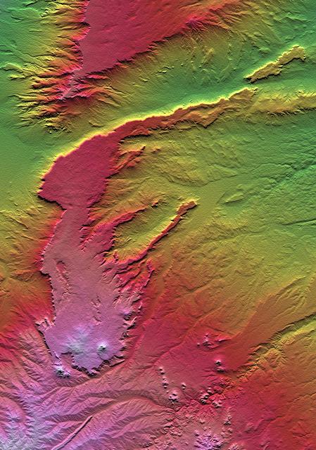
Digital elevation models DEMs, such as those produced by NASA Shuttle Radar Topography Mission SRTM, allow user-controlled visualization of the Earth landforms that is not possible using satellite imagery alone.
Volcanic, tectonic, erosional and sedimentary landforms are all evident in this comparison of two elevation models of a region along the East African Rift at Lake Kivu. The area shown covers parts of Congo, Rwanda and Uganda.
This observation from NASA Mars Reconnaissance Orbiter shows a set of landforms that appears to form a nested chevron pattern on a slope in Coloe Fossae. Interestingly, nearby surfaces on the same slope are all parallel.
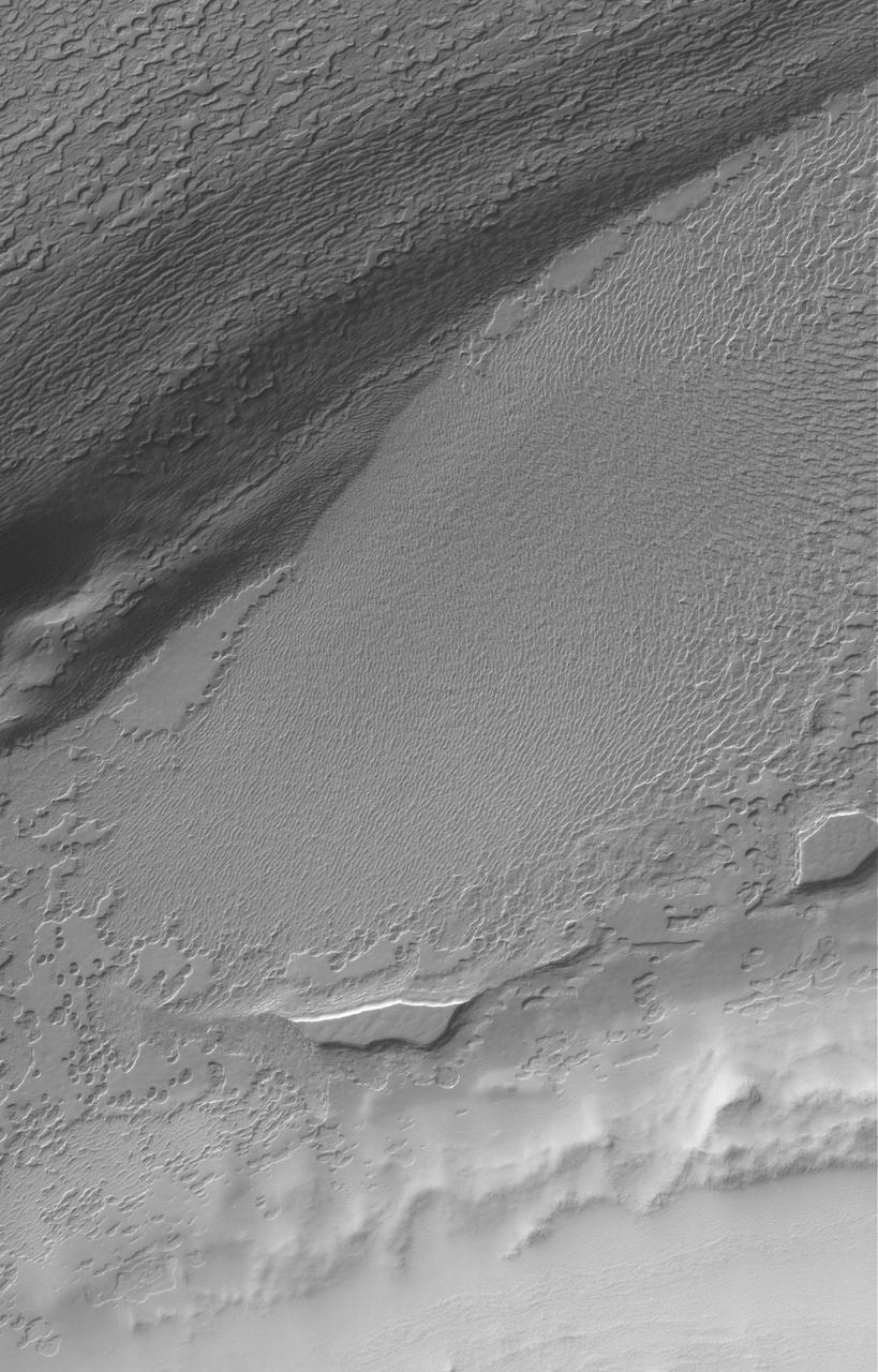
This image of Candor Chasma taken by NASA 2001 Mars Odyssey contains eroded deposits of material and a large landslide deposit. Gravity, wind, and water all played a role in shaping the landforms we see in this image.
This NASA Mars Odyssey image is of the ridged plains of Lunae Planum in the northern hemisphere of Mars. Wrinkle ridges, a very common landform on Mars, Mercury, Venus, and the Moon, are found mostly along the eastern side of the image.
These Mars Odyssey images show the White Rock feature on Mars in both infrared left and visible right wavelengths. White Rock is the unofficial name for this landform that was first observed during NASA Mariner 9 mission in the early 1970.
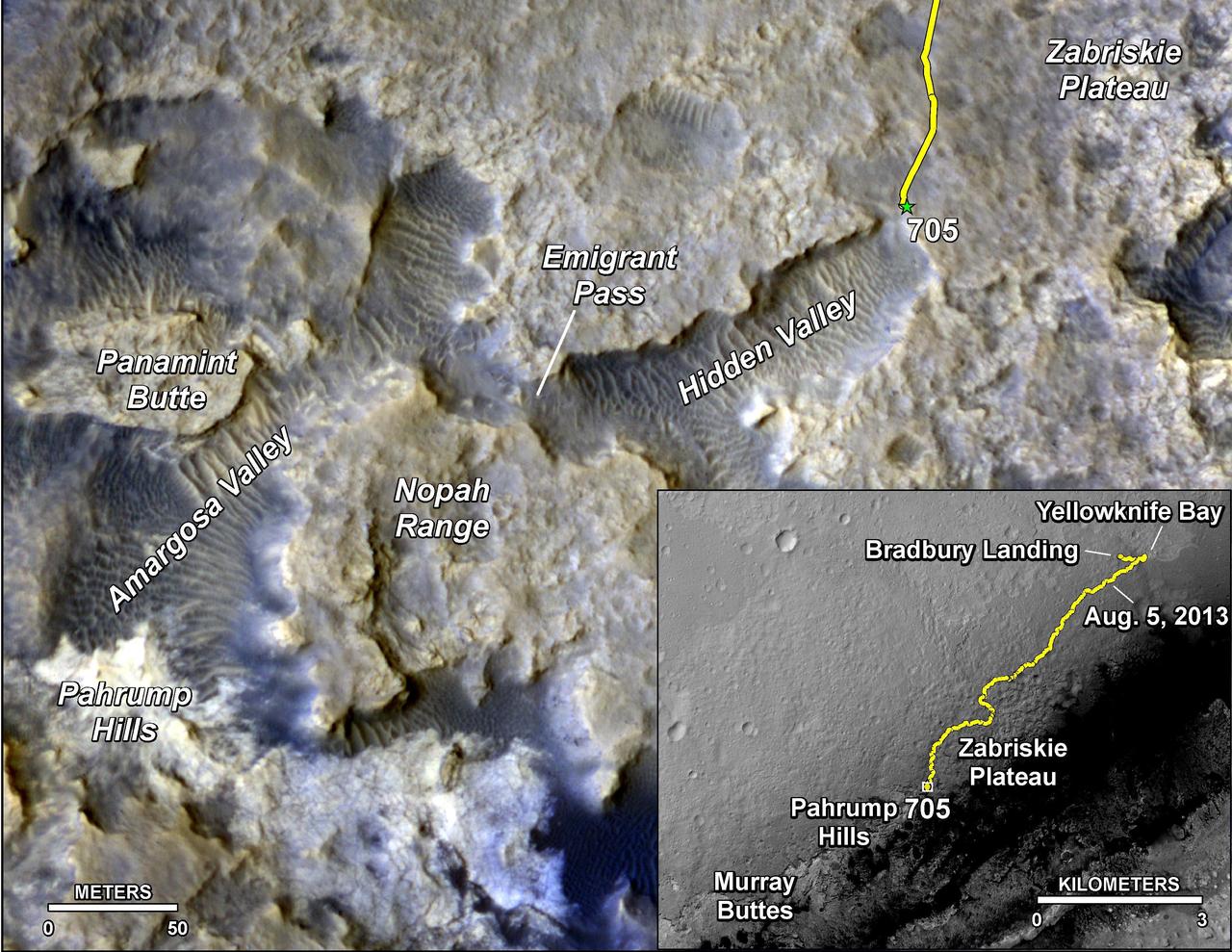
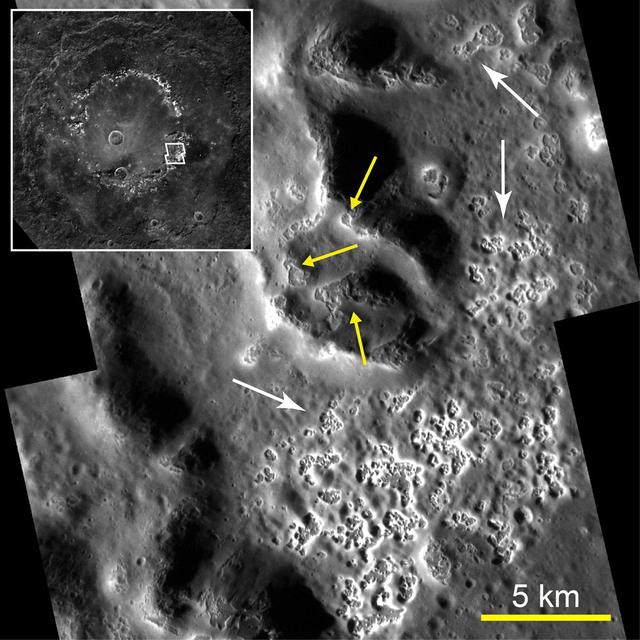
The main map shows landforms near NASA Curiosity Mars rover as the rover second anniversary of landing on Mars nears. The gold traverse line ends at Curiosity position as of July 31, 2014 Sol 705.
White Rock is the unofficial name for this unusual landform which was first observed during NASA Mariner 9 mission in the early 1970 and is now shown here in an image from NASA Mars Odyssey spacecraft.
This image from NASA Mars Odyssey covers a portion of the Medusa Fossae formation, near the equator of Mars. The most characteristic feature of the Medusa Fossae formation is the abundance of yardangs, which are erosional landforms carved by wind.
This Magellan image depicts a stereoscopic pair of an area on Venus with small volcanic domes. Stereoscopic images of Venus offer exciting new possibilities for scientific analysis of Venusian landforms. http://photojournal.jpl.nasa.gov/catalog/PIA00251
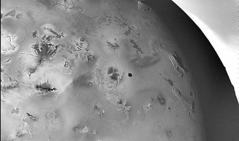
The lowland plains of Elysium Planitia contains a terrain that puzzles Mars scientists. Landforms in the region are the plates and ridges seen throughout most of this image from NASA Mars Odyssey.
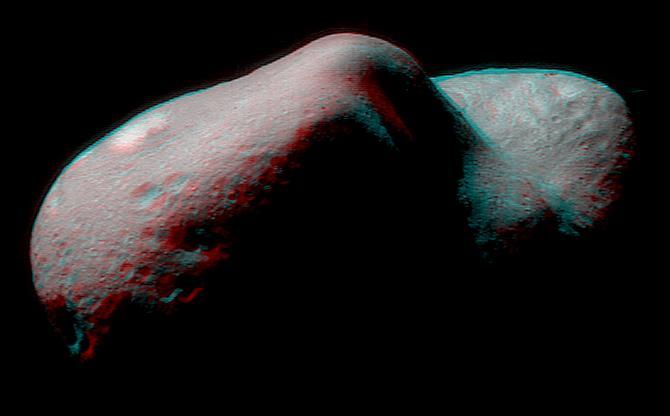
Stereo imaging, an important tool on NASA NEAR Shoemaker for geologic analysis of Eros, provides three-dimensional information on the asteroid landforms and structures. 3D glasses are necessary to view this image.
The Davenport Ranges of central Australia have been inferred to be among the oldest persisting landforms on Earth, founded on the belief that the interior of Australia has been tectonically stable for at least 700 million years.
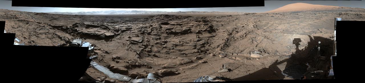
This mid-afternoon, 360-degree panorama was acquired by NASA Curiosity Mars rover on April 4, 2016, as part of long-term campaign to document the context and details of the geology and landforms along Curiosity traverse inside Gale Crater.
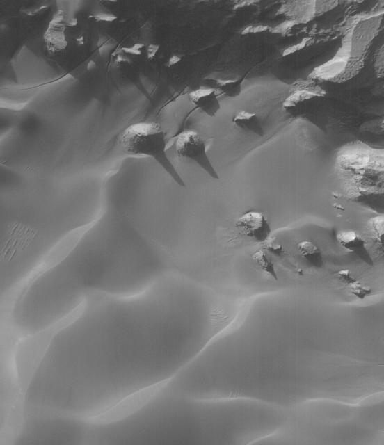
This MOC shows buttes and mesas surrounded by sand dunes on the floor of Rabe Crater, Mars. Gullies of uncertain origin cut sand dune surfaces in the top north quarter of the scene
The eroded, layered deposit in this NASA Mars Odyssey image of Gale Crater is a mound of material rising 3 km about 2 miles above the crater floor. It has been sculpted by wind and possibly water to produce the dramatic landforms seen today.
This image from NASA Mars Odyssey shows a region of Mars northern hemisphere called Ismenia Fossae. Most of the landforms are the degraded remains of impact crater rim and ejecta from an unnamed crater 75 km diameter just north of this scene.
One of the strangest landforms spotted by NASA New Horizons spacecraft when it flew past Pluto last July was the bladed terrain just east of Tombaugh Regio, the informal name given to Pluto large heart-shaped surface feature.
Granicus Valles form a low-lying complex of channel systems located west of the volcano Elysium Mons. They are one of several larger systems known as outflow channels because the water source is from the subsurface. In this case, Granicus Valles emanate from a series of fractures on the western flank of Elysium Mons. In this image, large, streamlined features and grooves have been carved by enormous water volumes into the floor of Granicus and point to the direction of flow towards the northwest. The floods of Granicus Valles are thought to have formed later in Mars history during the Amazonian epoch, several billion years ago. https://photojournal.jpl.nasa.gov/catalog/PIA25990
Cataracts are large landforms, and this oblique image from NASA's Mars Reconnaissance Orbiter covers only a small area of the innermost channel. The ridged material on the channel floor may be a lava flow that followed this channel after it was initially carved by giant floods of water.Obviously these are not the kind of cataracts that can develop in the lenses of your eyes, but large erosional scallops that form in river channels, like the Niagara Falls draining the Great Lakes of North America. Obviously these are not the kind of cataracts that can develop in the lenses of your eyes, but large erosional scallops that form in river channels, like the Niagara Falls draining the Great Lakes of North America. https://photojournal.jpl.nasa.gov/catalog/PIA21869
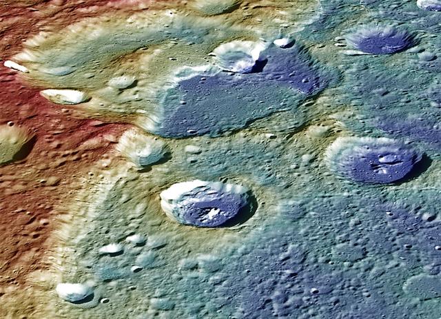
This image from NASA MESSENGER spacecraft provides a perspective view of the center portion of Carnegie Rupes, a large tectonic landform, which cuts through Duccio crater. The image shows the terrain (variations in topography) as measured by the MLA instrument and surface mapped by the MDIS instrument. The image was color-coded to highlight the variations in topography (red = high standing terrain, blue = low lying terrain). Tectonic landforms such as Carnegie Rupes form on Mercury as a response to interior planetary cooling, resulting in the overall shrinking of the planet. To make this graphic, 48 individual MDIS images were used as part of the mosaic. Instruments: Mercury Dual Imaging System (MDIS) and Mercury Laser Altimeter (MLA) Latitude: 57.1° Longitude: 304.0° E Scale: Duccio crater has a diameter of roughly 105 kilometers (65 miles) Height: Portions of Carnegie Rupes are nearly 2 kilometers (1.2 miles) in height Orientation: North is roughly to the left of the image http://photojournal.jpl.nasa.gov/catalog/PIA19422
About a third of Mars has water ice just below the dusty surface. Figuring out exactly where is vital for future human explorers. One of the ways scientists do this is to look for landforms that only occur when this buried ice is present. These scallops are one of those diagnostic landforms. A layer of clean ice lies just below the surface in this image. As the ice ablates away in some spots the surface dust collapses into the hole that's left. These holes grow into the scallops visible here as more and more ice is lost. Between the scallops, the ice is still there, ready for some astronaut to come along and dig it up. https://photojournal.jpl.nasa.gov/catalog/PIA24468
This observation from NASA Mars Reconnaissance Orbiter shows an interesting crater floor with what appear to be inverted channels, rounded lobe-like landforms, and light-toned layered deposits along the southern portion of the crater wall. High resolution can help study the layers, with an enhanced-color image showing us any variations in composition between those light-toned layers and the darker-toned surfaces. http://photojournal.jpl.nasa.gov/catalog/PIA19353
Three impact craters in three-dimensional perspective located approximately 27 degrees south latitude, 339 degrees east longitude in the northwestern portion of Lavinia Planitia. The viewpoint is located southwest of Howe Crater which appears centered in the lower portion of the image. Howe has a diameter of 37.3 kilometers (23.1 miles) located at 28.6 degrees south latitude, 337.1 degrees east longitude. Danilova, a crater with a diameter of 47.6 kilometers (29.5 miles) and located at 26.35 degrees south latitude and 337.5 east longitude, appears above and to the left of Howe in the image. Aglaonice, a crater with a diameter of 62.7 kilometers (38.9 miles) and located at 26.5 degrees south latitude and 340 degrees east longitude is on the right of Danilova. Magellan synthetic aperture radar data is combined with radar altimetry to develop a 3D map of the surface. Rays cast in a computer intersect the surface to create a 3D view. Simulated color and a digital elevation map developed by the United States (U.S.) Geological Survey is used to enhance small-scale structure. The simulated hues are based on color images recorded by the Soviet Venera 13 and 14 spacecraft. The image was processed at the Jet Propulsion Laboratory (JPL) Multimission Image Processing Laboratory and is a single frame from a video released at the JPL news conference 05-29-91. View provided by JPL with alternate number P-39146.
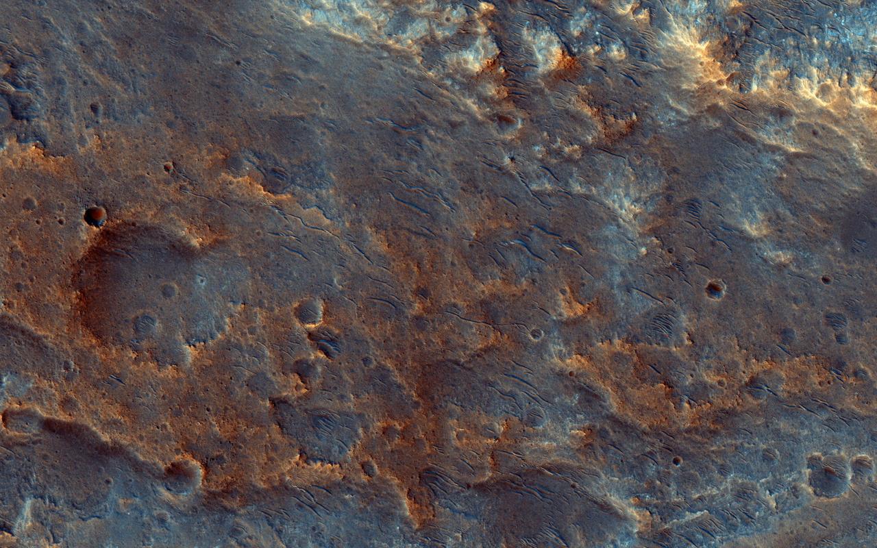
![This enhanced-color sample reveals the incredible diversity of landforms on some Martian plains that appear bland and uniform at larger scales. Here we see layers, small channels suggesting water flow, craters, and indurated sand dunes. The map is projected here at a scale of 25 centimeters (9.8 inches) per pixel. [The original image scale is 25.7 centimeters (10.1 inches) per pixel (with 1 x 1 binning); objects on the order of 77 centimeters (30.3 inches) across are resolved.] North is up. http://photojournal.jpl.nasa.gov/catalog/PIA21573](https://images-assets.nasa.gov/image/PIA21573/PIA21573~medium.jpg)
This enhanced-color sample reveals the incredible diversity of landforms on some Martian plains that appear bland and uniform at larger scales. Here we see layers, small channels suggesting water flow, craters, and indurated sand dunes. The map is projected here at a scale of 25 centimeters (9.8 inches) per pixel. [The original image scale is 25.7 centimeters (10.1 inches) per pixel (with 1 x 1 binning); objects on the order of 77 centimeters (30.3 inches) across are resolved.] North is up. http://photojournal.jpl.nasa.gov/catalog/PIA21573
This image is of a portion of the Southern plains region within Hellas, the largest impact basin on Mars, with a diameter of about 2300 kilometers 1400 miles, as observed by NASA Mars Reconnaissance Orbiter. There are three main phenomena apparent in this image. First, the faint dark streaks that criss-cross the terrain are dust devil tracks that clear the bright dust along their way. Second, the subtle overall bumpy "basketball" texture of the surface is formed by repeated seasonal freezing and thawing of the ice-rich regolith and is common at higher latitudes. Third, the large, elliptical, scalloped depressions are common in permafrost terrains in both hemispheres, where thick, latitude-dependent sedimentary mantles comprise the surface units. These mantles are composed of ice-rich sediments that degrade as the ice sublimates away and is heated either by the Sun or by locally higher geothermal gradients. Sublimation, or the direct change in phase from ice to gas, occurs on Mars because of its low density atmosphere. These depressions have steeper pole-facing slopes, whereas the equator-facing slopes gently fade into the surrounding terrain. At full resolution (see close up view), numerous sublimation pits and networks of polygonal cracks are visible on the steeper, unstable pole-ward facing slopes. The overall morphology of this terrain is characteristic of what is called "thermokarstic degradation processes," which is a term used to describe the formation of pits in an ice-rich terrain due to loss of ice creating pits and collapse features. http://photojournal.jpl.nasa.gov/catalog/PIA19350
In the northern section of this from image NASA Mars Reconnaissance Orbiter, we see flat terrain that is probably an ancient lava field. These dust avalanches are common in dust-covered regions on Mars.
This terrain looks like lumpy sediment on top of patterned ground. The lumpy sediment is likely just loosely consolidated because it is covered with spidery channels. This landform is uniquely Martian, formed in the spring as seasonal dry ice turns directly into gas that erodes channels in the surface. http://photojournal.jpl.nasa.gov/catalog/PIA14452
This image shows part of the steep wall of the caldera (a large volcanic crater) at the top of Ascraeus Mons, one of Mars' giant volcanoes. We can see chutes carved into the soft dust that has built up on the slope, with some similarities to gully landforms elsewhere on the planet. https://photojournal.jpl.nasa.gov/catalog/PIA22804
There are some interesting erosional signs in this observation from NASA Mars Reconnaissance Orbiter, which will make for a good comparison with other intracrater fans and fluvial sedimentary landforms. We can also see an inverted channel system, possibly ponded toward the southwest. As we've learned recently, it's possible that perhaps a fluid was in part of this crater, as is hypothesized for Gale Crater (see artist rendition picture) where Curiosity is exploring. At high resolution, we might be able to resolve fine-scale layering/bedding and/or large, transported clasts (boulders). Reuyl Crater is approximately 86 kilometers in diameter and was named after Dirk Reuyl, a Dutch-American physicist and astronomer (1906-1972) who made astronomical measurements of the diameter of Mars in the 1940s. http://photojournal.jpl.nasa.gov/catalog/PIA19356
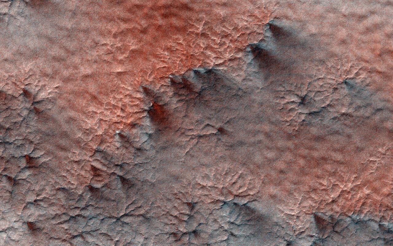
Dune-like sandy landforms (or bedforms) self-organize into distinct shapes and patterns as dictated by wind conditions and other factors. The spacing and frequency of migration for bedforms will partially depend on the particle size range of local sediment. Larger coarse sand tends to "roll" during less frequent wind gusts, as compared with smaller more-mobile grains that "hop." This image in the Southern Hemisphere region of Terra Cimmeria displays an unusual class of hybrid bedforms. They display a consistent shape and tone, but range several orders of magnitude in size or spacing. The smallest examples here are less than 10 meters in spacing while larger ones are separated by several hundreds of meters. This is unusual variability for bedforms that evolve over long time scales and consistent climate of recent Mars. A Mars geomorphologist might classify some of these as small dunes or giant ripples, depending on their perspective. https://photojournal.jpl.nasa.gov/catalog/PIA24862
In February 1917, Albert Einstein wrote in a letter: "It is a pity that we do not live on Mars and just observe man's nasty antics by telescope." We do have a telescope at Mars, but we use it to image Mars rather than Earth, such as this image of bizarre landforms in Gorgonum Basin. This basin may have contained an ancient lake, with channels draining into the lake from the sides. After sediments are deposited, they become hardened to varying degrees, then eroded by the wind. More hardened bedrock will remain as high-standing topography following erosion of the weaker materials, perhaps inverting the initial forms. For example, high-standing linear or meandering topography may have been fluvial channels. The enhanced-color cutout shows some of the bedrock as well as dark sand. http://photojournal.jpl.nasa.gov/catalog/PIA20811
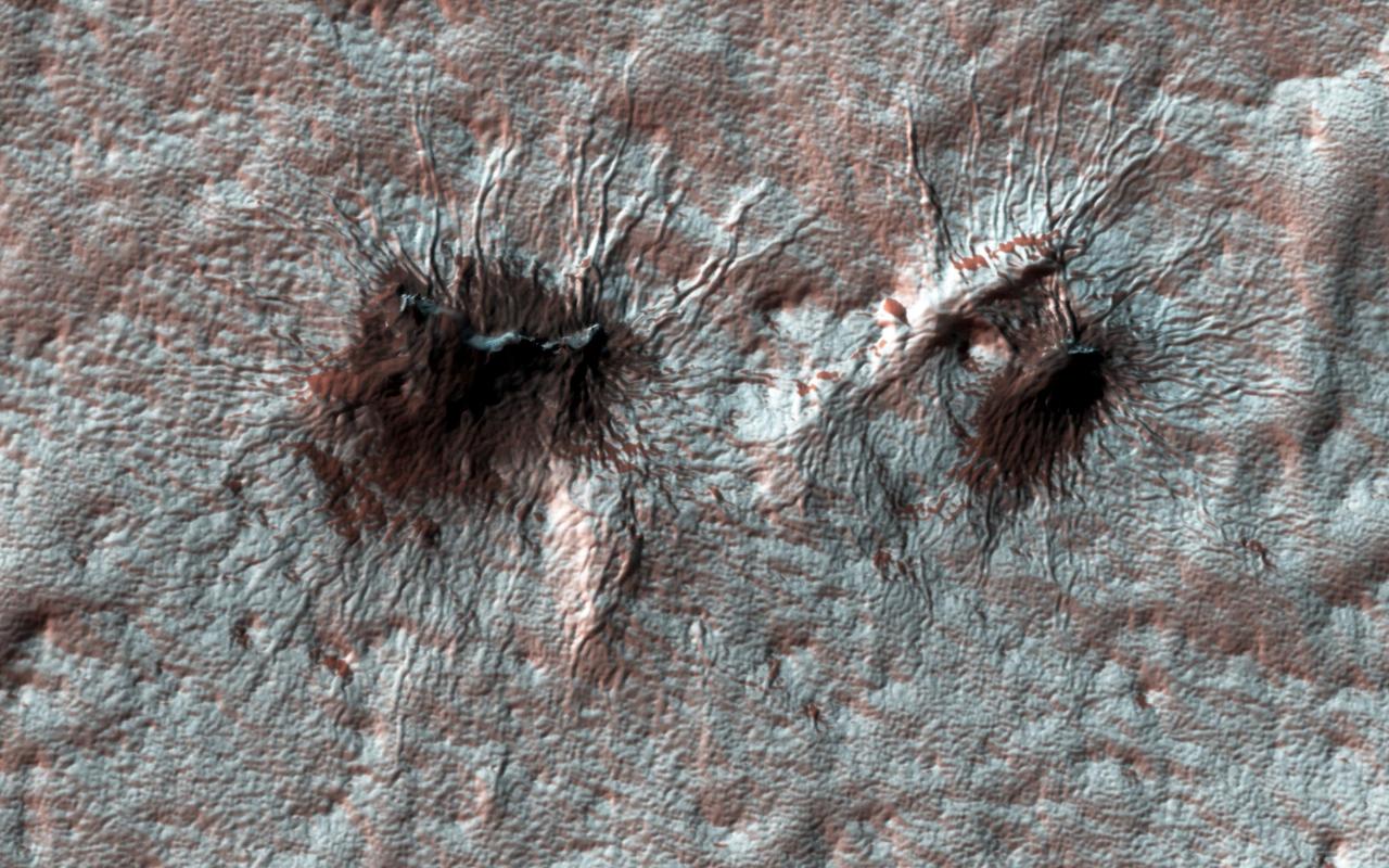
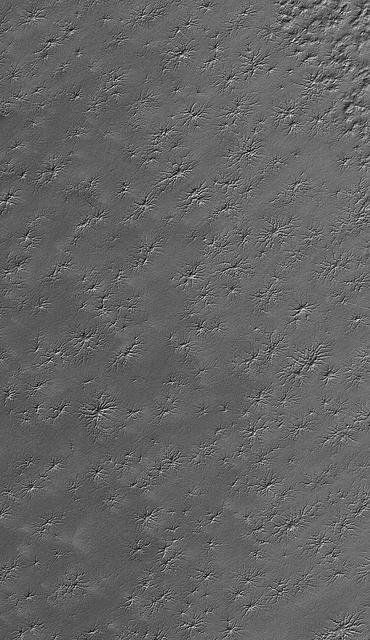
Subtle variations in color look like brush strokes as the lightly frosted terrain reflects light. These variations provide a backdrop to some exotic features referred to colloquially as "spiders." The radial channels branching out from a central depression are formed when the seasonal layer of dry ice turns to gas in the spring and erodes the surface, which is a uniquely Martian landform. http://photojournal.jpl.nasa.gov/catalog/PIA21214
The Utopia Planitia region contains many distinctive landscapes. The bumpy and pitted ground in this image may have formed through the eruption of either lava or mud onto the surface from deep underground. Mud volcanoes on Earth provide oases for life. If these features also formed through the eruption of mud, these landforms may hold clues to possible life-supporting oases in Mars' distant past. https://photojournal.jpl.nasa.gov/catalog/PIA24917
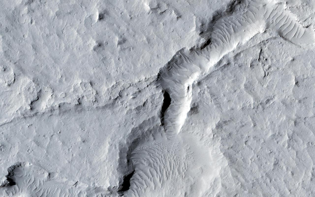
This VIS image runs from northern Juventae Chasma to just short of the southern canyon wall. Illustrating the variety of landforms within the chasma, this image contains the rough canyon floor at the northern extent of the chasma, layered materials in the center of the image and dunes located in the southern, deepest section of the chasma. Orbit Number: 71356 Latitude: -3.55335 Longitude: 298.389 Instrument: VIS Captured: 2018-01-14 14:25 https://photojournal.jpl.nasa.gov/catalog/PIA22381

This unique photo offers a view of the Florida peninsula, western Bahamas, north central Cuba and the deep blue waters of the Gulf Stream, that hugs the east coast of Florida (27.0N, 82.0W). In addition to being an excellent photograph for showing the geographical relationships between the variety of landforms in this scene, the typical effect of the land-sea breeze is very much in evidence as few clouds over water, cumulus build up over landmass.
This image from NASA's Mars Reconnaissance Orbiter shows an elongated depression from three merged craters. The raised rims and ejecta indicate that these are impact craters rather than collapse or volcanic landforms. The pattern made by the ejecta and the craters suggest this was a highly oblique (low angle to the surface) impact, probably coming from the west. There may have been three major pieces flying in close formation to make this triple crater. https://photojournal.jpl.nasa.gov/catalog/PIA21652
This VIS image shows where an impact created a crater on top of a group of ridges called Tanaica Montes. The slightly out-of-round shape and the distribution of the ejecta was likely all due to the pre-existing landforms. Orbit Number: 60555 Latitude: 39.6442 Longitude: 268.824 Instrument: VIS Captured: 2015-08-08 20:37 http://photojournal.jpl.nasa.gov/catalog/PIA19780

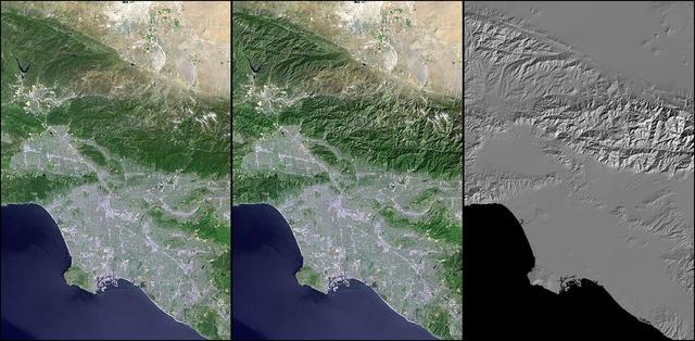
STS001-12-308 (12-14 April 1981) --- Space shuttle Columbia approached Edwards Air Force Base from the left to land at the dry lake at the center. The view is to the southwest. The edge of the light "vee" is the intersection of the San Andres and Garlock Faults at Fort Tejon. Los Angeles is at upper right. Owens Lake is at the lower center. Photo credit: NASA
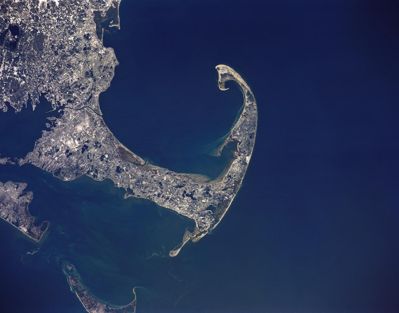
STS036-151-225 (2 March 1990) --- Surrounded by waters of the Atlantic Ocean, Cape Cod Bay and Nantucket Sound, the jutting Cape Cod feature caught the attention of the astronaut crewmembers aboard the Earth-orbiting Space Shuttle Atlantis, 126 nautical miles above Earth. Parts of Martha's Vineyard and Nantucket are in bottom left corner. Plymouth Bay is in upper left corner. Center point coordinates are 42 degrees north latitude and 70 degrees west longitude. A large format Linhof camera (4" x 5" film) was used to expose the frame.
Magellan synthetic aperture radar data was used to create this three- dimensional (3D) perspective view of Venus' western Eistla Regio. This viewpoint is located at 1,310 kilometers (812 miles) southwest of Gula Mons at an elevation of 0.178 kilometers (0.48 miles). The view is of the northeast with Gula Mons appearing on the horizon. Gula Mons, a 3 kilometer (1.86 mile) high volcano, is located at approximately 22 degrees north latitude, 359 degrees east longitude. The impact crater Cunitz, named for the astronomer and mathematician Maria Cunitz, is visible in the center of the image. The crater is 48.5 kilometers (30 miles) in diameter and is 215 kilometers (133 miles) from the viewer's position. Magellan synthetic aperture radar data is combined with radar altimetry to develop a 3D map of the surface. Rays cast in a computer intersect the surface to create a 3D view. Simulated color and a digital elevation map developed by the United States (U.S.) Geological Survey is used to enhance small-scale structure. The simulated hues are based on color images recorded by the Soviet Venera 13 and 14 spacecraft. The image was produced at the Jet Propulsion Laboratory (JPL) Multimission Image Processing Laboratory and is a single frame from a video released at the JPL news conference 03-05-91. View was provided by JPL with alternate number P-38720 MGN76.
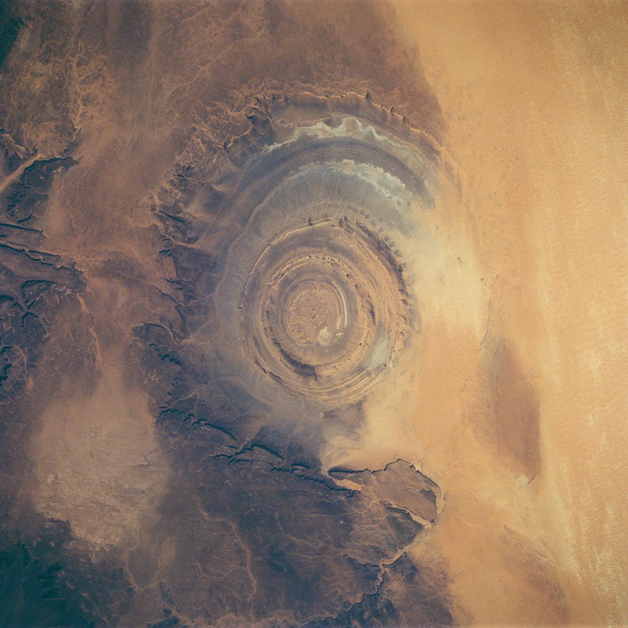
STS058-88-017 (18 Oct-1 Nov 1993) --- The eye-catching "bullseye" of the Richat Structure adds interest to the barren Gres de Chinguetti Plateau in central Mauretania, northwest Africa. It represents domally uplifted, layered (sedimentary) rocks that have been eroded by water and wind into the present shape. Desert sands have invaded the feature from the south. The origin of the structure is unknown. It is not an impact structure, because field work showed that strata are undisturbed and flat-lying in the middle of the feature, and no shock-altered rock could be found. There is no evidence for a salt dome or shale diapir, nor is there any geophysical evidence for an underlying dome of dense igneous rock having about the same density as the sedimentary layers.
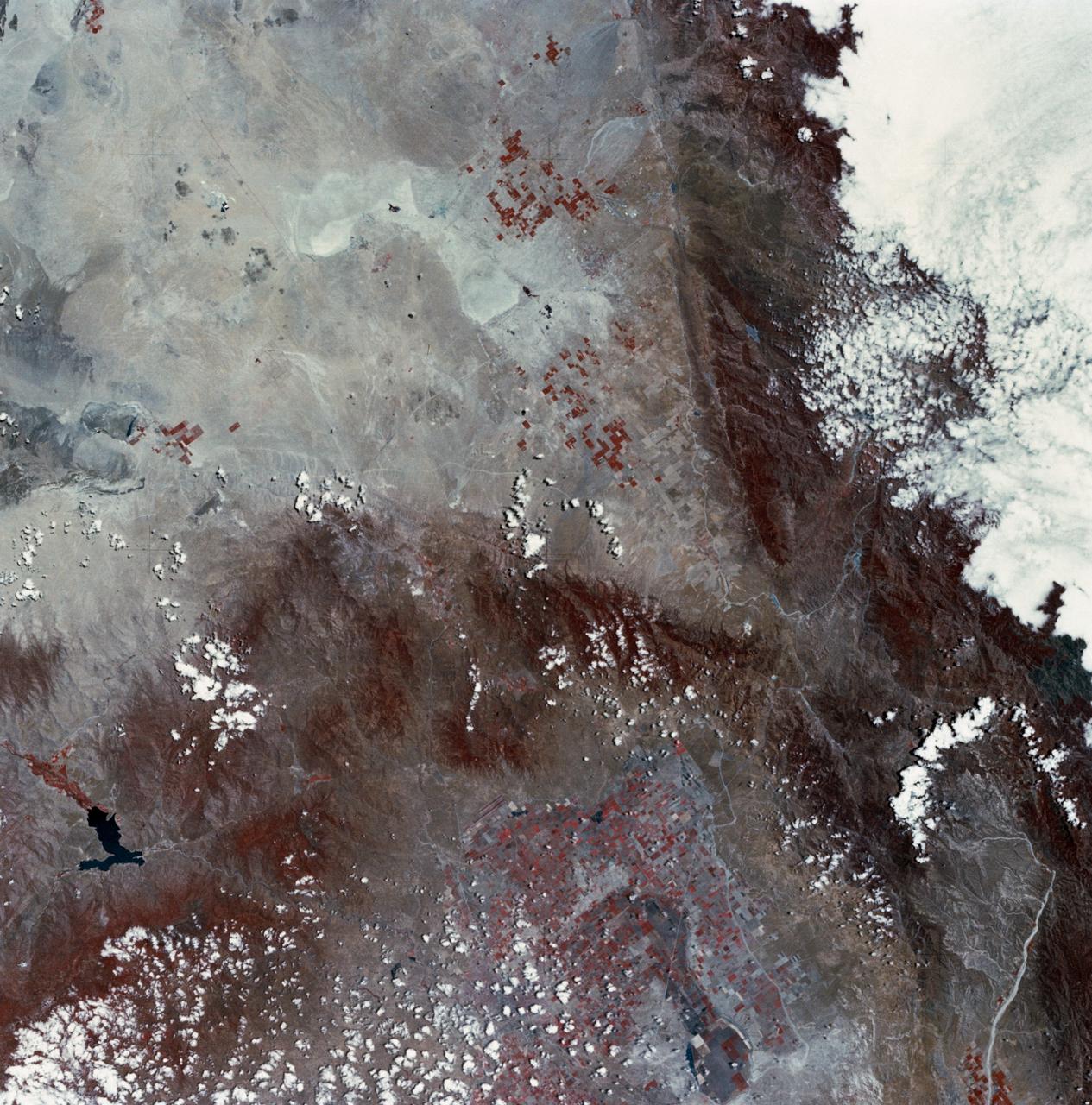
SL2-03-126 (June 1973) --- A color infrared photograph of the Los Angeles County and Kern County area, taken from the Skylab space station in Earth orbit during its first manned Skylab mission. The Mojave Desert occupies the northeast one-fourth of the photograph. Lake Isabella in the Sierra Nevada Mountains is the v-shaped body of water. The San Gabriel Mountains extend across the southern part of the picture. At lower center is the intersection of the San Andreas and Garlock faults. The San Joaquin Valley is in the center at the left edge. (The picture should be held with the heavy cloud cover at lower right corner so that north will be at top.) This picture was exposed by one of the six lenses of the Itek-furnished S190-A Multispectral Photographic Facility experiment in the Multiple Docking Adapter of the Skylab space station. Type 2443 film was used. Photo credit: NASA
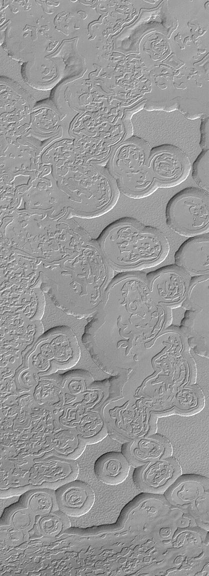
This image is illuminated by sunlight from the upper left. Looking like pieces of sliced and broken swiss cheese, the upper layer of the martian south polar residual cap has been eroded, leaving flat-topped mesas into which are set circular depressions such as those shown here. The circular features are depressions, not hills. The largest mesas here stand about 4 meters (13 feet) high and may be composed of frozen carbon dioxide and/or water. Nothing like this has ever been seen anywhere on Mars except within the south polar cap, leading to some speculation that these landforms may have something to do with the carbon dioxide thought to be frozen in the south polar region. On Earth, we know frozen carbon dioxide as "dry ice." On Mars, as this picture might be suggesting, there may be entire landforms larger than a small town and taller than 2 to 3 men and women that consist, in part, of dry ice. No one knows for certain whether frozen carbon dioxide has played a role in the creation of the "swiss cheese" and other bizarre landforms seen in this picture. The picture covers an area 3 x 9 kilometers (1.9 x 5.6 miles) near 85.6°S, 74.4°W at a resolution of 7.3 meters (24 feet) per pixel. This picture was taken by the Mars Global Surveyor (MGS) Mars Orbiter Camera (MOC) during early southern spring on August 3, 1999. http://photojournal.jpl.nasa.gov/catalog/PIA02367
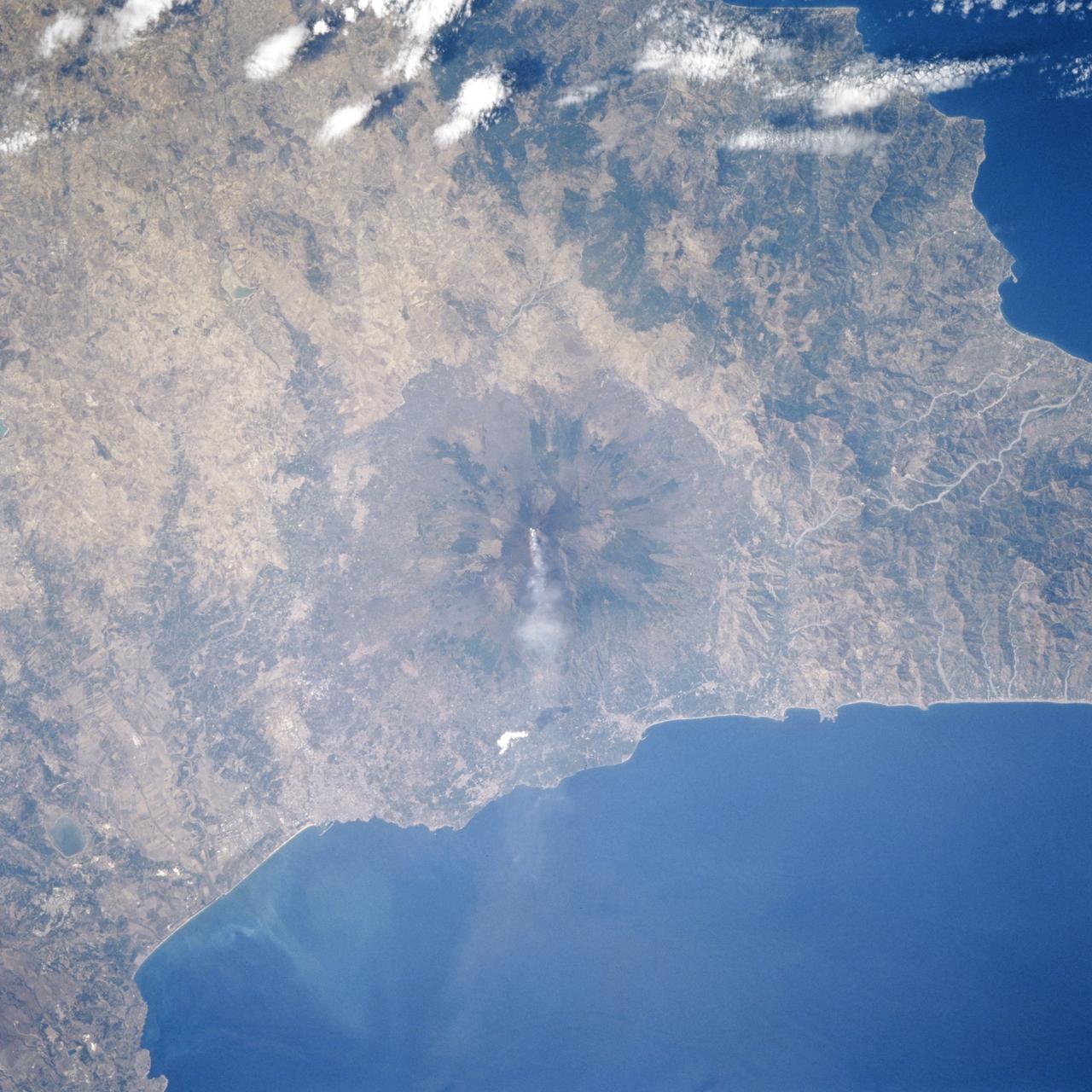
STS106-706-055 (8-20 September 2000) --- One of the STS-106 crew members on board the Space Shuttle Atlantis used a handheld 70mm camera to photograph this image of the Etna Volcano on Sicily. Mt. Etna is known as the volcano with the longest record of volcanic activity with the first being in 1500 BC. It has erupted many times since then and is almost continuously venting gas and steam, as shown in this view. Astronauts can almost be assured of seeing some venting whenever they fly in orbit. Mt. Etna appears as a cone with an almost circular base in this near-vertical view. The Salso River winds around the western and southern flanks of the volcano. The city of Catania appears as a diffuse gray patch at the foot of the volcano where the river meets the Mediterranean Sea. Mt. Etna has a complex of cones at its summit, which is nearly 3300 meters above sea level. Its slopes are a patchwork of colors, the darker colors being lava flows of different ages. Greens are patches of forest on slopes which have not been disrupted by lava and ash in the last few decades. Mt. Etna is a constructional landform which has been built upwards for millennia; it contrasts subtly but distinctly in this view with the surrounding lower hills which are water-eroded landforms everywhere sculpted into V-shaped valleys by the erosive power of flowing water of streams.
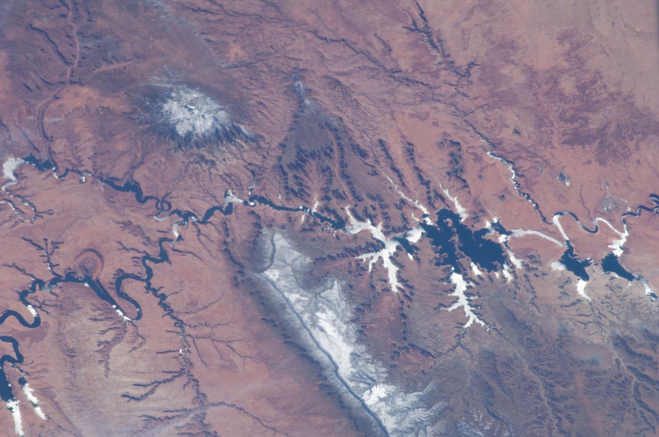
ISS034-E-066804 (12 March 2013) --- One of the Expedition 34 crew members aboard the Earth-orbiting International Space Station on March 12 , 2013 photographed this image of the Colorado Plateau, which spans northern Arizona, southern Utah, northwestern New Mexico and southwestern Colorado. This physiographic province is well known for its striking landscapes and broad vistas—an impression that is enhanced by the view from the orbital perspective of the space station. The image highlights part of the Utah-Arizona border region of the plateau and includes several prominent landforms. The Colorado River, dammed to form Lake Powell in 1963, crosses from east to west, (which is actually left to right in this image because the view looks toward the south, and north appears toward the bottom of the frame). The confluence of the Colorado and San Juan Rivers is also visible in the image. Sunglint, or sunlight reflected off a water surface back toward the observer, provides a silvery. Mirror-like sheen to some areas of the water surfaces. The geologic uplift of the Colorado Plateau led to rapid down cutting of rivers into the flat sedimentary bedrock, leaving spectacular erosional landforms. One such feature – the Rincon ---preserves evidence of a former meander bend of the Colorado River. Photo credit: NASA

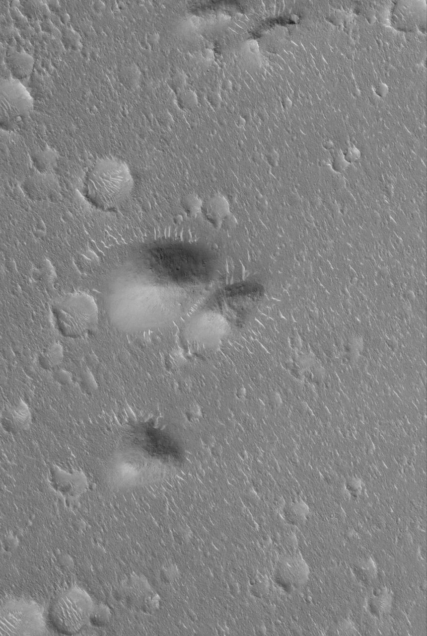
This image shows a bright, rectangular-looking landform surrounded by a dark floor. How did this feature get here if it looks so different than its surroundings? The feature resembles a plateau. Dark streaks mark steep slopes on its sides while the top appears flat. The slope streaks are not all the same age, as we see a variation in colors from faint to dark. Craters in a variety of sizes and ages pepper the entire rectangle, but the dark, textured floor has very few noticeable craters. The evidence suggests that this rectangular feature is a high-standing "island" of older land surrounded by one or more younger lava flows. This landmass is located in Amazonis Planitia, a smooth plains area potentially formed by large-scale lava floods between the Tharsis and Elysium volcanic regions. As lava flowed into this area, the rectangular plateau was too high to cover completely, leaving a bright spot sticking out of the dark basalt floor for us to find. https://photojournal.jpl.nasa.gov/catalog/PIA22725
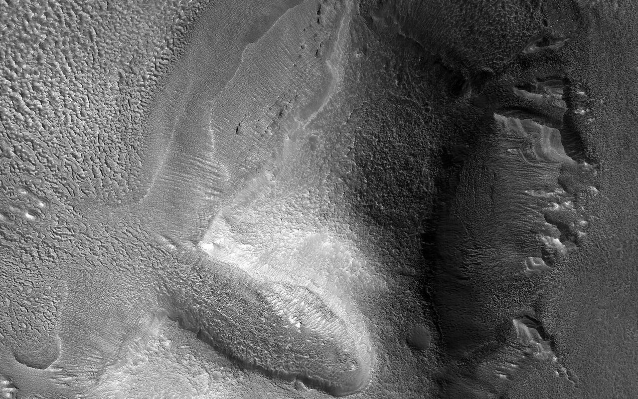
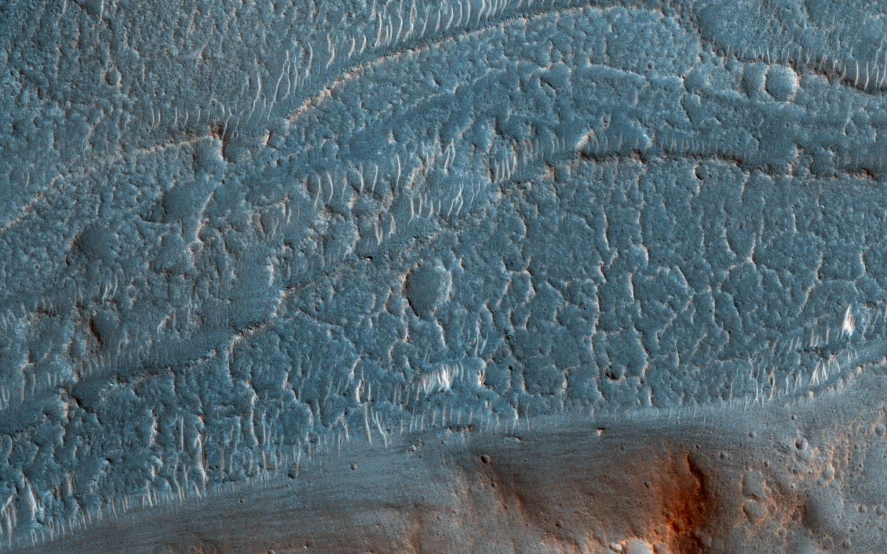
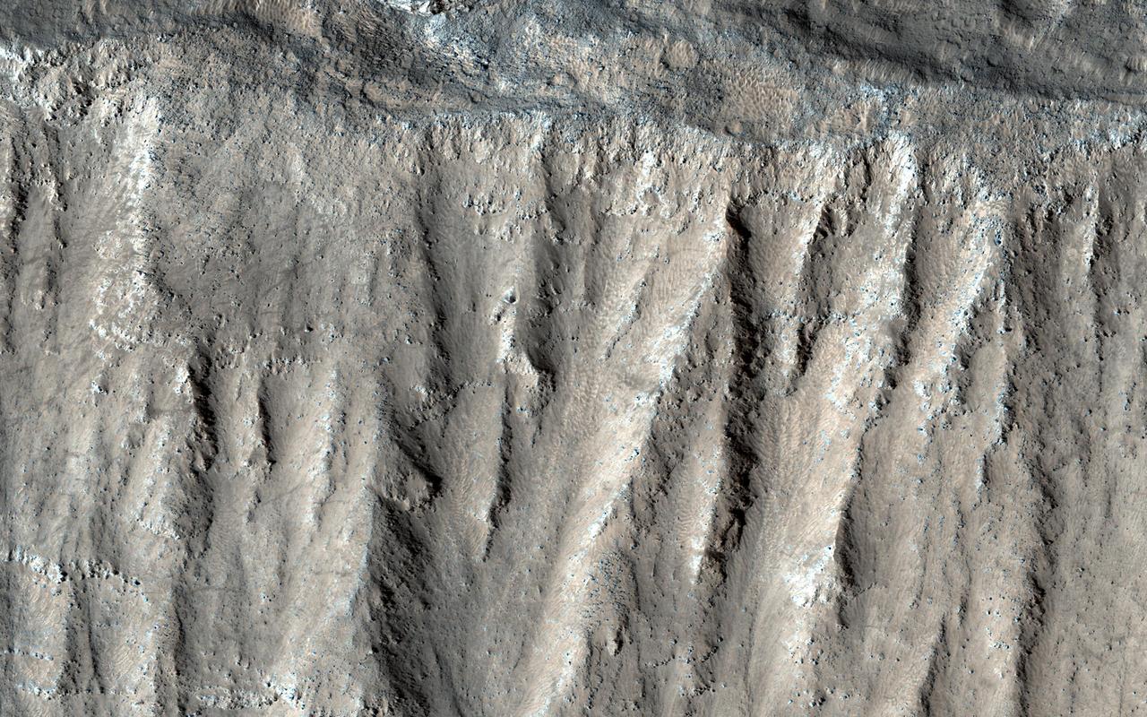
Lobate debris aprons (LDA) are commonly found surrounding dissected plateaus in the Deuteronilus Mensae region of Mars. They have been interpreted as debris-covered glaciers and radar data have shown their interiors to be composed of pure ice. The mound in this image is slightly removed from most of the other plateaus, and the LDA surrounding it is highly degraded. The sharp scarps on the western and eastern sides of the mound indicate that a great deal of the ice once found in these landforms has since sublimated away, leaving behind these collapsed debris cliffs. https://photojournal.jpl.nasa.gov/catalog/PIA24464
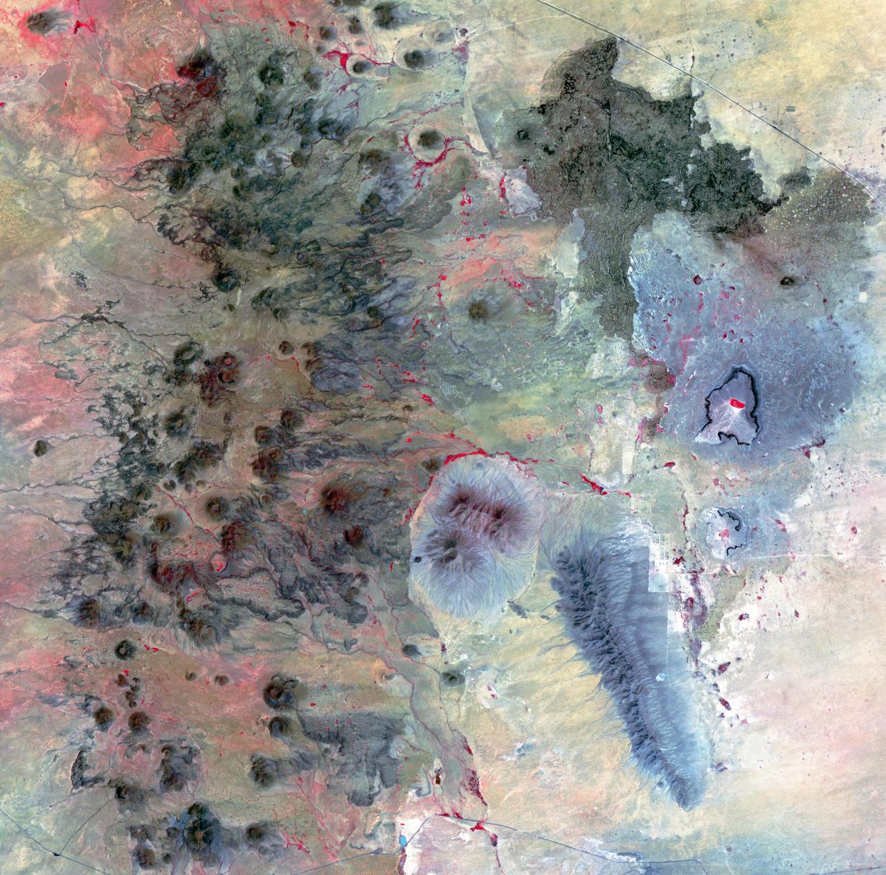
The Potrillo volcanic field is located on the Rio Grande Rift in southern New Mexico. Different kinds of volcanism form distinct landforms. The western part is composed of hundreds of cinder cones and flows. The eastern side has a small shield volcano with many tube-fed lava flows and two large maar craters, formed by the explosive interaction of magma with ground water. The age of the field is between 1 million to 20,000 years old. The image was acquired August 26, 2002, covers an area of 36 by 36.4 kilometers, and is located at 32 degrees north, 107.1 degrees west. https://photojournal.jpl.nasa.gov/catalog/PIA23065
The northern lowlands of Mars in this location are stippled with mounds, such as those visible throughout this image. These lighter-toned circular mounds with bowl-shaped depressions are easy to spot against the darker-toned floor. Scientists think these landforms are similar to mud volcanoes that are also found here on Earth. Mud volcanoes form as gas and liquid-rich sediment interacts underground. Over time, this slurry of mud is brought to the surface and forms a rounded mound. Scientists are interested in studying mud volcanoes on Mars because the material forming the mound has the potential to be organic in nature and would give insight into possible microbial life below the surface. https://photojournal.jpl.nasa.gov/catalog/PIA25987
These Martian dunes in Mars' northern hemisphere were captured from above by NASA's Mars Reconnaissance Orbiter using its High-Resolution Imaging Science Experiment (HiRISE) camera on Sept. 8, 2022. Scientists use such images to track the amount of frost that settles on the landforms and then disappears as the weather warms in spring. Martian dunes migrate just like dunes on Earth, with wind blowing away sand on one side of the dune and building up on another. Recent research has shown that winter frost stops the movement of sand grains, locking the dunes in place until the spring thaw. https://photojournal.jpl.nasa.gov/catalog/PIA26517
STS091-707-008 (2-12 June 1998) --- Photographed by one of the STS-91 crew members aboard the Space Shuttle Discovery, this area northwest of Monterrey, Mexico is a good example of a tectonic landform where the Earth's crust folds in a "wrinkled-rug" style. The Sierra Madrid Oriental is the easternmost extension of the North American Cordillera. The complicated structure of this arid region is the affects of wind eroding the softer rocks and leaving the harder ones making it look like it may be a photo of another planet. Monclova, Mexico is located near the center of the photo.

NASA's New Horizons spacecraft captured this high-resolution enhanced color view of Pluto on July 14, 2015. The image combines blue, red and infrared images taken by the Ralph/Multispectral Visual Imaging Camera (MVIC). Pluto's surface sports a remarkable range of subtle colors, enhanced in this view to a rainbow of pale blues, yellows, oranges, and deep reds. Many landforms have their own distinct colors, telling a complex geological and climatological story that scientists have only just begun to decode. The image resolves details and colors on scales as small as 0.8 miles (1.3 kilometers). http://photojournal.jpl.nasa.gov/catalog/PIA19952
The geologic setting and latitude here suggest this is a glacial (ice-rich) flow, but the surface is broken into plates like many lava flows on Mars. An image was targeted here to get a better look. At the meter-scale resolution of HiRISE, we see a hummocky surface with boulders and craters plus some wind-blown landforms that seems consistent with either the glacial or lava hypothesis. This is a common result: getting a higher-resolution image doesn't necessarily provide more information about large-scale processes, instead providing information about how the surface has been modified. https://photojournal.jpl.nasa.gov/catalog/PIA25794

Remember this? Since its first observation in 2009, the volcanic vent complex to the northeast of Rachmaninoff basin has rewarded us with remarkable views of its explosive history. Portions of the vent are blanketed in a layer of very fine-grained material thought to be composed of pyroclastic particles, and when we last saw this landform at very high resolution we could appreciate just how fine that texture is. Now, with a resolution almost four times greater than that last image, we can see how the pyroclastic deposit softens the form of adjacent impact craters - almost like snow. Fiery, hot, angry snow. http://photojournal.jpl.nasa.gov/catalog/PIA19230
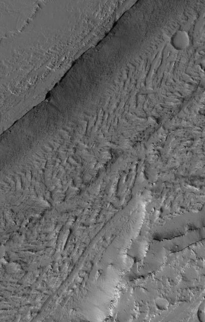
This VIS image shows part of Medusa Fossae. Winds have eroded materials in this region, creating ridges and valleys aligned with the direction of the wind. These features are created by long term winds scouring a poorly cemented surface material. It has been suggested that this region of Mars provides a large percentage of the surface dust seen around the planet. Ash falls from nearby volcanoes may have been the source of the surface materials eroded into these and other wind eroded landforms. Orbit Number: 79144 Latitude: -4.5831 Longitude: 200.487 Instrument: VIS Captured: 2019-10-18 00:48 https://photojournal.jpl.nasa.gov/catalog/PIA23576
Today's VIS image shows a complex block of material located on the floor of an unnamed crater in Arabia Terra. The feature is offset from the center of the circular depression and is approximately the same height of the surrounding surface. It is unlikely to be a peak created during the cratering event. Perhaps the crater is not an impact formed feature and was created by some other process. It is often difficult to interpret the geologic processes that created landforms from data collected far above the surface. Orbit Number: 77292 Latitude: 33.8263 Longitude: 348.721 Instrument: VIS Captured: 2019-05-18 12:52 https://photojournal.jpl.nasa.gov/catalog/PIA23325
Yardangs are present at the top of this VIS image. These features are created by long term winds scouring a poor cemented surface material into linear ridges and valleys. These yardangs are part of the Medusa Fossae Formation. It has been suggested that this region of Mars provides a large percentage of the surface dust seen around the planet. Ash falls from nearby volcanoes may have been the source of the surface materials eroded into these and other wind eroded landforms. Orbit Number: 77922 Latitude: -12.7644 Longitude: 177.96 Instrument: VIS Captured: 2019-07-09 09:43 https://photojournal.jpl.nasa.gov/catalog/PIA23398
The Tharsis Montes region on Mars is a major center of volcanic and tectonic activity. The channel in this image from NASA Mars Odyssey is west of the relatively small volcano called Biblis Patera although it shows no obvious relationship to that volcano. Instead, it may be related to the more distant, but more massive volcano Olympus Mons to the north. The channel may have hosted flowing lava at one time but now contains a material that has eroded into an impressive ridge-and-groove pattern. These features may be yardangs, landforms produced from the erosion by wind of sedimentary material. http://photojournal.jpl.nasa.gov/catalog/PIA04020
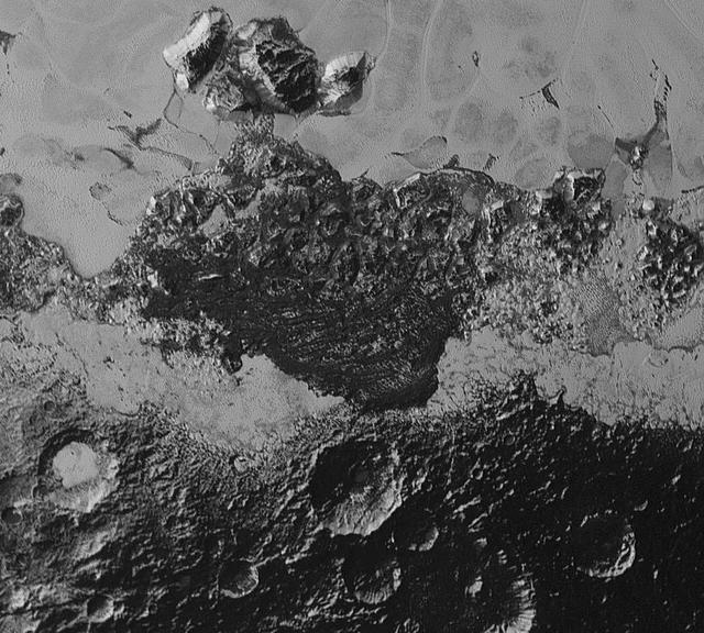
This 220-mile (350-kilometer) wide view of Pluto from NASA's New Horizons spacecraft illustrates the incredible diversity of surface reflectivities and geological landforms on the dwarf planet. The image includes dark, ancient heavily cratered terrain; bright, smooth geologically young terrain; assembled masses of mountains; and an enigmatic field of dark, aligned ridges that resemble dunes; its origin is under debate. The smallest visible features are 0.5 miles (0.8 kilometers) in size. This image was taken as New Horizons flew past Pluto on July 14, 2015, from a distance of 50,000 miles (80,000 kilometers). http://photojournal.jpl.nasa.gov/catalog/PIA19933