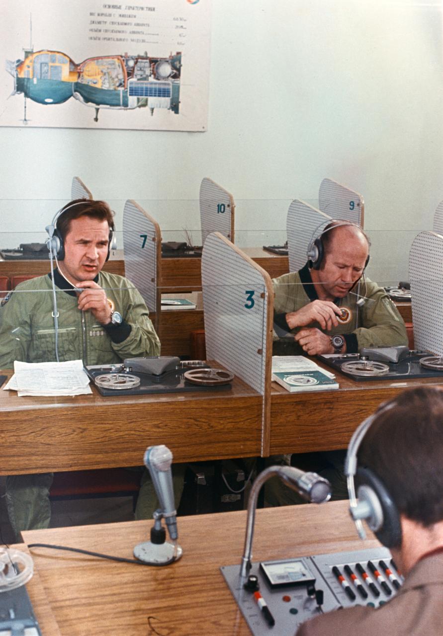
S75-32340 (July 1975) --- Cosmonauts Valeriy N. Kubasov (left) and Aleksey A. Leonov participate in English language training during Apollo-Soyuz Test Project preflight preparations at the Cosmonaut Training Center (Star City) near Moscow. Leonov was the commander of the Soviet ASTP first (prime) crew; and Kubasov was the flight engineer on the same crew. They are seated in the language laboratory at Star City. PHOTO COURTESY: USSR ACADEMY OF SCIENCES

S74-23117 (6 June 1974) --- Two astronauts associated with the joint U.S.-USSR Apollo-Soyuz Test Project receive instructions in the Russian language during ASTP activity at the Johnson Space Center. They are Robert F. Overmyer, a member of the support team of the American ASTP crew, who is seated at left; and Vance D. Brand (center), the command module pilot of the American ASTP prime crew. The instructor is Anatoli Forestanko.

Apollo Soyuz Test Project (ASTP) astronauts Donald K. Slayton, docking module pilot; and Thomas P. Stafford, commander are photographed during ASTP Russian language class.
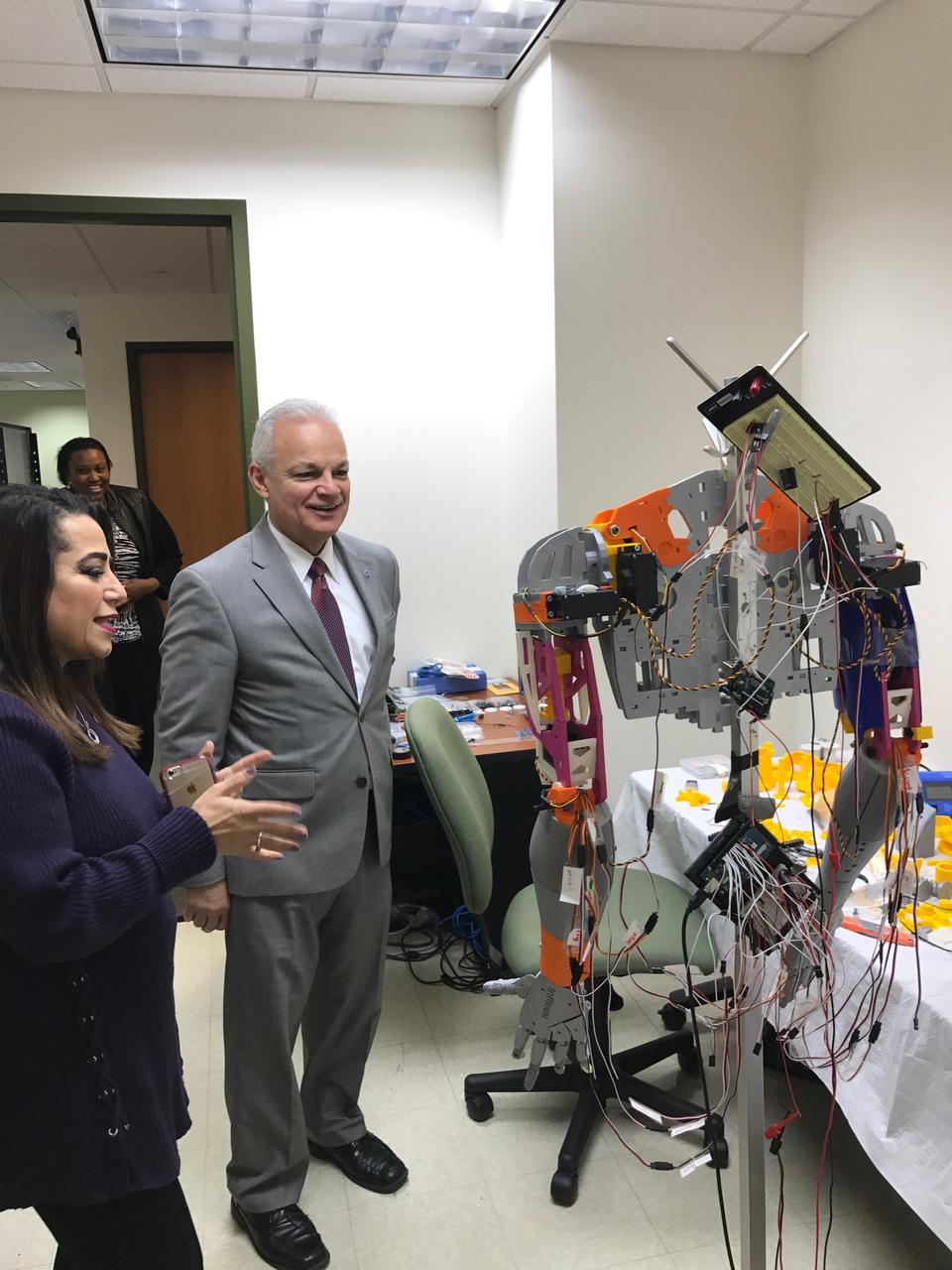
Norfolk State University Associate Professor Rasha Morsi showcases a phone operated, 3D-printed robot sign language interpreter to NASA Chief Technologist Douglas Terrier during a tour of the university’s Creative Gaming Simulation lab on February 6, 2018. (Credit: NASA)

This graph of data from NASA Spitzer Space Telescope shows changes in the infrared light output of two star-planet systems one above, one below located hundreds of light-years away.
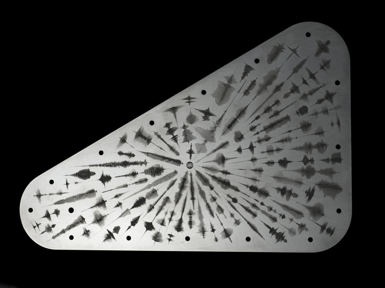
NASA's Europa Clipper spacecraft will carry a special message when it launches in October 2024 and heads toward Jupiter's moon Europa. The moon shows strong evidence of an ocean under its icy crust, with more than twice the amount of water of all of Earth's oceans combined. A triangular metal plate, seen here, will honor that connection to Earth. The plate is made of tantalum metal and is about 7 by 11 inches (18 by 28 centimeters). It is engraved on both sides and seals an opening in the electronics vault, which houses the spacecraft's sensitive electronics. The art on this side of the plate features waveforms that are visual representations of the sound waves formed by the word "water" in 103 languages. The waveforms radiate out from a symbol representing the American Sign Language sign for "water." In the spirit of the Voyager spacecraft's Golden Record, which carries sounds and images to convey the richness and diversity of life on Earth, the layered message on Europa Clipper aims to spark the imagination and offer a unifying vision. Europa Clipper, set to launch from Kennedy Space Center in Florida, will arrive at the Jupiter system in 2030 and conduct about 50 flybys of the moon Europa. The mission's main science goal is to determine whether there are places below Europa, that could support life. The mission's three main science objectives are to determine the thickness of the moon's icy shell and its surface interactions with the ocean below, to investigate its composition, and to characterize its geology. The mission's detailed exploration of Europa will help scientists better understand the astrobiological potential for habitable worlds beyond our planet. https://photojournal.jpl.nasa.gov/catalog/PIA26063
Astronauts Jim Reilly and Bornie Dunbar are going through the Mechanics of Granular Materials (MGM) experiment procedures as they are expected to run in flight; to gain experience with the experiment equipment and to test the clarity and language of the procedures as written.

jsc2023e038728 (6/22/2023) --- Students hold Hoshi-Tomo badges at The Japanese Language School in Charlotte, North Carolina. Two types of Hoshi-Tomo badges were designed by students. “Hoshi” implies star(s), planet(s), or the Earth in Japanese. “Tomo” means friend(s) in Japanese. I-Space Essay provides students and teachers the online opportunity to create wishes, which are delivered to the International Space Station's Japanese Experimental Module Kibo. Image courtesy of Mitsumura-Tosho and IHI Corporation.
NASA Administrator Charles Bolden, right, poses with U.S. Rep. Lincoln Diaz-Balart, R-Fla., prior to the start of an event at the National Press Club in Washington, Tuesday, Feb. 23, 2010. NASA is working with Univision Communications Inc. to develop a partnership in support of the Spanish-language media outlet's initiative to improve high school graduation rates, prepare Hispanic students for college, and encourage them to pursue careers in science, technology, engineering and mathematics, or STEM, disciplines. Photo Credit: (NASA/Bill Ingalls)

Univision Communications President and Chief Executive Officer Joe Uva speaks at an event at the National Press Club in Washington, Tuesday, Feb. 23, 2010. NASA is working with Univision Communications Inc. to develop a partnership in support of the Spanish-language media outlet's initiative to improve high school graduation rates, prepare Hispanic students for college, and encourage them to pursue careers in science, technology, engineering and mathematics, or STEM, disciplines. Photo Credit: (NASA/Bill Ingalls)

Univision Networks president Cesar Conde speaks at the National Press Club in Washington, Tuesday, Feb. 23, 2010. NASA is working with Univision Communications Inc. to develop a partnership in support of the Spanish-language media outlet's initiative to improve high school graduation rates, prepare Hispanic students for college, and encourage them to pursue careers in science, technology, engineering and mathematics, or STEM, disciplines. Photo Credit: (NASA/Bill Ingalls)
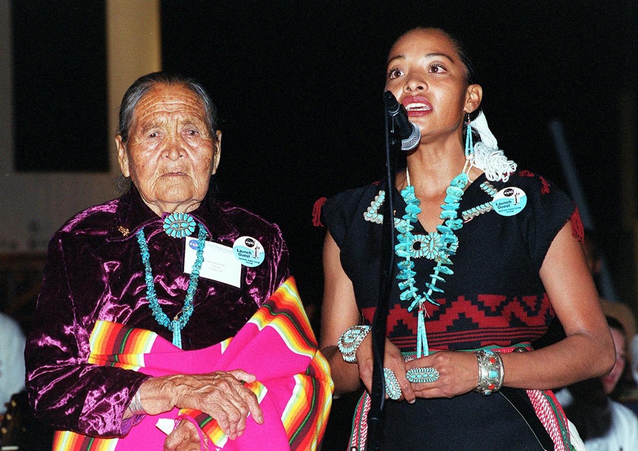
KENNEDY SPACE CENTER, FLA. -- During a pre-launch Native American ceremony, Radmilla Cody (right) , the 2001 Miss Navaho Nation, sings the "Star Spangled Banner" in her native language. With her is her grandmother. The ceremony was part of several days' activities commemorating John B. Herrington as the first tribally enrolled Native American astronaut to fly on a Shuttle mission. Herrington is a Mission Specialist on STS-113.
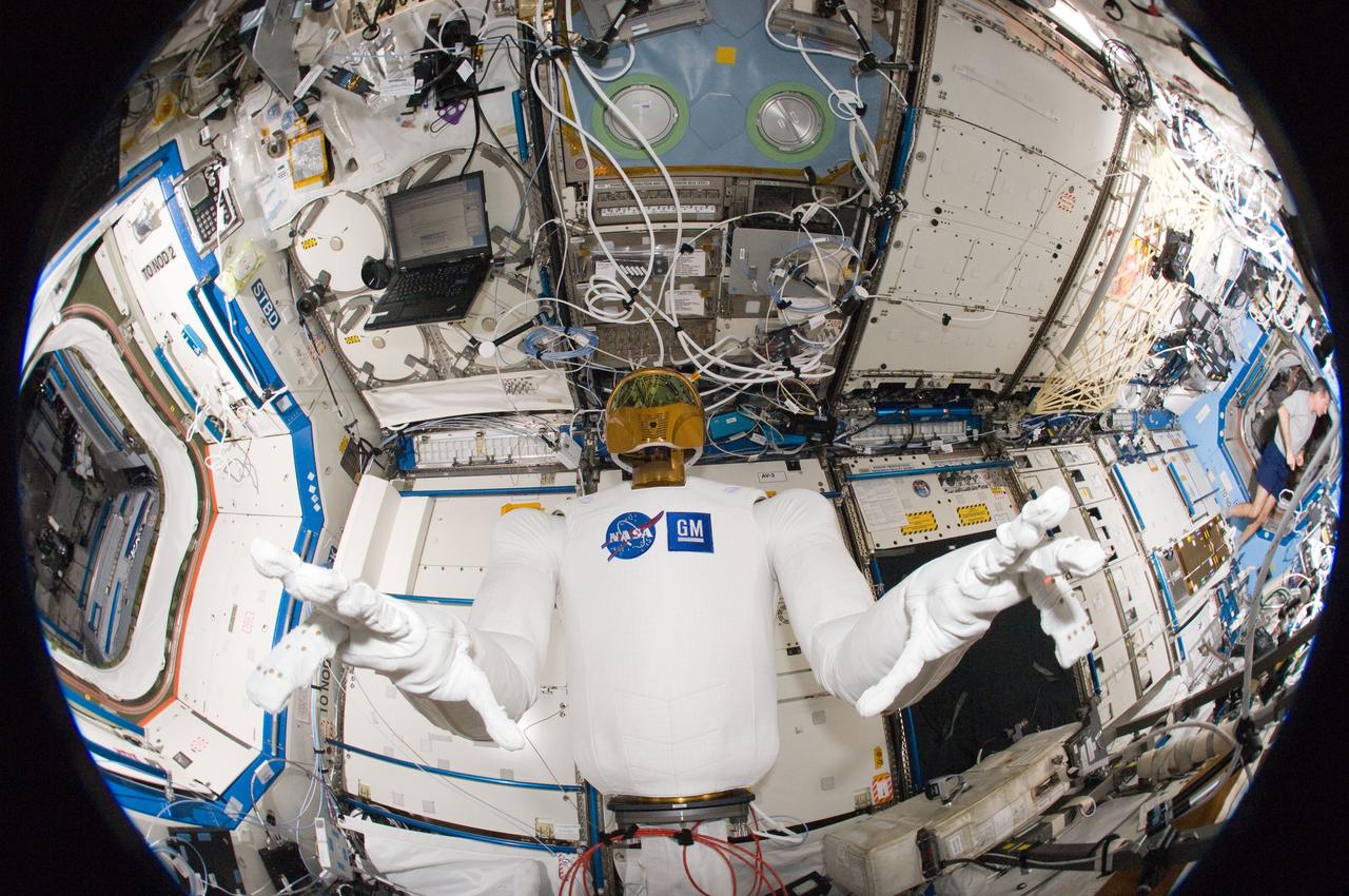
ISS030-E-135157 (13 March 2012) --- A fisheye lens attached to an electronic still camera was used to capture this image of Robonaut 2 humanoid robot during another system checkout in the Destiny laboratory of the International Space Station. Teams on the ground commanded Robonaut through a series of dexterity tests as it spelled out ?Hello world? in sign language.
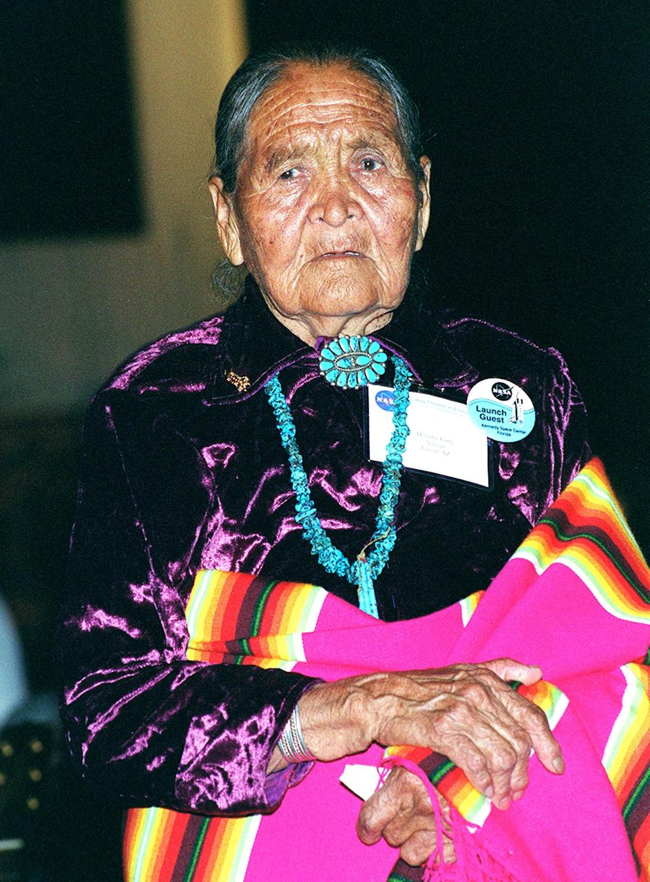
KENNEDY SPACE CENTER, FLA. - An elder of her Navaho tribe, Dorothy Cody shares the stage with her granddaughter Radmilla Cody (not shown), the 2001 Miss Navaho Nation, who is singing the "Star Spangled Banner" in her native language during a pre-launch Native American ceremony. The ceremony was part of several days' activities commemorating John B. Herrington as the first tribally enrolled Native American astronaut to fly on a Shuttle mission. Herrington is a Mission Specialist on STS-113.

NASA Administrator Charles Bolden, left, speaks with Melinda French Gates, of the Bill & Melinda Gates Foundation, right, prior to the start of an event at the National Press Club in Washington, Tuesday, Feb. 23, 2010. NASA is working with Univision Communications Inc. to develop a partnership in support of the Spanish-language media outlet's initiative to improve high school graduation rates, prepare Hispanic students for college, and encourage them to pursue careers in science, technology, engineering and mathematics, or STEM, disciplines. Photo Credit: (NASA/Bill Ingalls)

Univision news anchor Jorge Ramos speaks at an event at the National Press Club in Washington, Tuesday, Feb. 23, 2010. NASA is working with Univision Communications Inc. to develop a partnership in support of the Spanish-language media outlet's initiative to improve high school graduation rates, prepare Hispanic students for college, and encourage them to pursue careers in science, technology, engineering and mathematics, or STEM, disciplines. Photo Credit: (NASA/Bill Ingalls)

The channel in today's VIS image is called Auqakuh Vallis and is located in northern Terra Sabaea. Large channels on Mars are named for the word "mars/star" in different languages on Earth, small channels are named for rivers on Earth. "Auqakuh" is the word "mars" in Quechua (Inca). Orbit Number: 80122 Latitude: 31.0234 Longitude: 60.4953 Instrument: VIS Captured: 2020-01-06 13:42 https://photojournal.jpl.nasa.gov/catalog/PIA23813
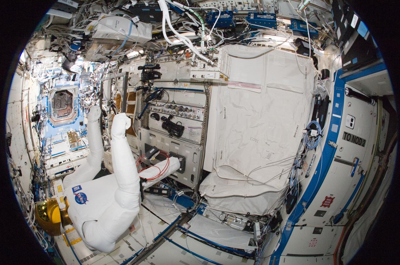
ISS030-E-135148 (13 March 2012) --- A fisheye lens attached to an electronic still camera was used to capture this image of Robonaut 2 humanoid robot during another system checkout in the Destiny laboratory of the International Space Station. Teams on the ground commanded Robonaut through a series of dexterity tests as it spelled out ?Hello world? in sign language.
The channel in today's VIS image is called Auqakuh Vallis. Large channels on Mars are named for the word "mars/star" in different languages on Earth, small channels are named for rivers on Earth. "Auqakuh" is the word "mars" in Quechua (Inca). Orbit Number: 79261 Latitude: 29.0373 Longitude: 60.3106 Instrument: VIS Captured: 2019-10-27 16:12 https://photojournal.jpl.nasa.gov/catalog/PIA23659
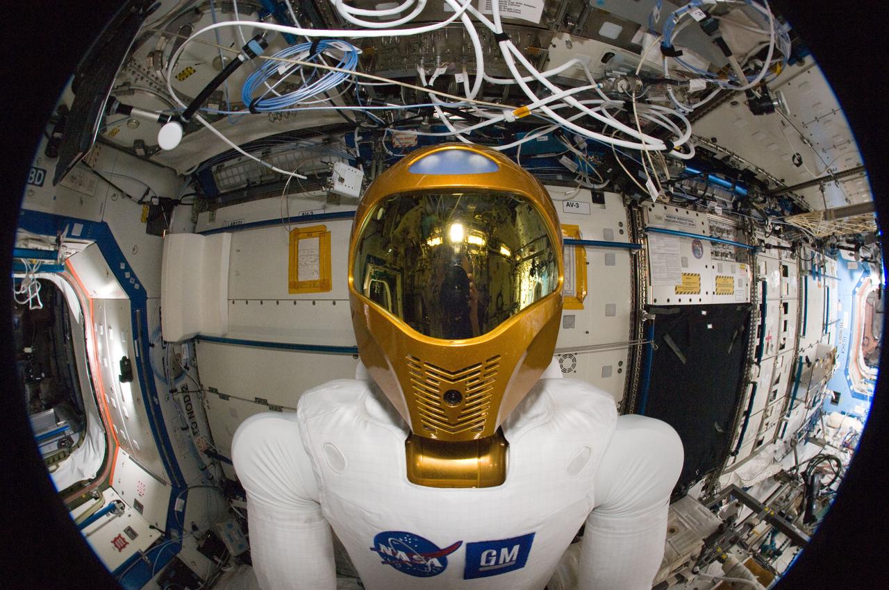
ISS030-E-135140 (13 March 2012) --- A fisheye lens attached to an electronic still camera was used to capture this image of Robonaut 2 humanoid robot during another system checkout in the Destiny laboratory of the International Space Station. Teams on the ground commanded Robonaut through a series of dexterity tests as it spelled out ?Hello world? in sign language.

Melinda French Gates, of the Bill & Melinda Gates Foundation, speaks during an event at the National Press Club in Washington, Tuesday, Feb. 23, 2010. NASA is working with Univision Communications Inc. to develop a partnership in support of the Spanish-language media outlet's initiative to improve high school graduation rates, prepare Hispanic students for college, and encourage them to pursue careers in science, technology, engineering and mathematics, or STEM, disciplines. Photo Credit: (NASA/Bill Ingalls)
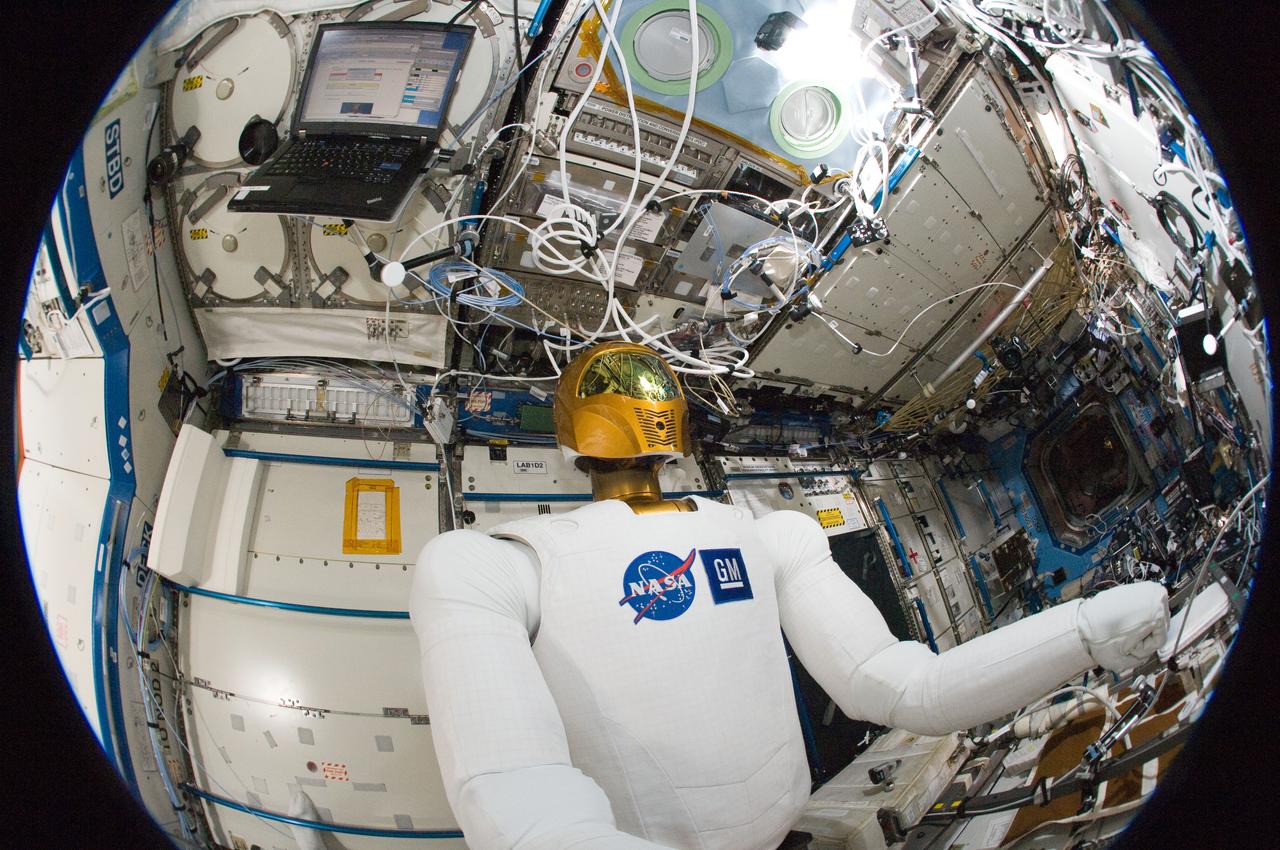
ISS030-E-135135 (13 March 2012) --- A fisheye lens attached to an electronic still camera was used to capture this image of Robonaut 2 humanoid robot during another system checkout in the Destiny laboratory of the International Space Station. Teams on the ground commanded Robonaut through a series of dexterity tests as it spelled out ?Hello world? in sign language.
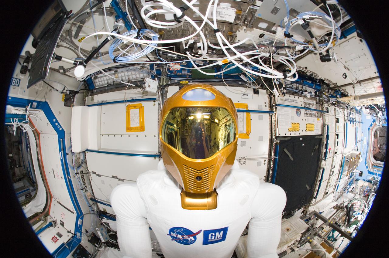
ISS030-E-135163 (13 March 2012) --- A fisheye lens attached to an electronic still camera was used to capture this image of Robonaut 2 humanoid robot during another system checkout in the Destiny laboratory of the International Space Station. Teams on the ground commanded Robonaut through a series of dexterity tests as it spelled out ?Hello world? in sign language.

U.S. Secretary of Labor Hilda Solis speaks at an event at the National Press Club in Washington, Tuesday, Feb. 23, 2010. NASA is working with Univision Communications Inc. to develop a partnership in support of the Spanish-language media outlet's initiative to improve high school graduation rates, prepare Hispanic students for college, and encourage them to pursue careers in science, technology, engineering and mathematics, or STEM, disciplines. Photo Credit: (NASA/Bill Ingalls)

U.S. Secretary of Education Arne Duncan speaks during an event at the National Press Club in Washington, Tuesday, Feb. 23, 2010. NASA is working with Univision Communications Inc. to develop a partnership in support of the Spanish-language media outlet's initiative to improve high school graduation rates, prepare Hispanic students for college, and encourage them to pursue careers in science, technology, engineering and mathematics, or STEM, disciplines. Photo Credit: (NASA/Bill Ingalls)

U.S. Secretary of Education Arne Duncan speaks at an event at the National Press Club in Washington, Tuesday, Feb. 23, 2010. NASA is working with Univision Communications Inc. to develop a partnership in support of the Spanish-language media outlet's initiative to improve high school graduation rates, prepare Hispanic students for college, and encourage them to pursue careers in science, technology, engineering and mathematics, or STEM, disciplines. Photo Credit: (NASA/Bill Ingalls)

KENNEDY SPACE CENTER, FLA. -- During a pre-launch Native American ceremony, Radmilla Cody, the 2001 Miss Navaho Nation, sings the "Star Spangled Banner" in her native language. The ceremony was part of several days' activities commemorating John B. Herrington as the first tribally enrolled Native American astronaut to fly on a Shuttle mission. Herrington is a Mission Specialist on STS-113.
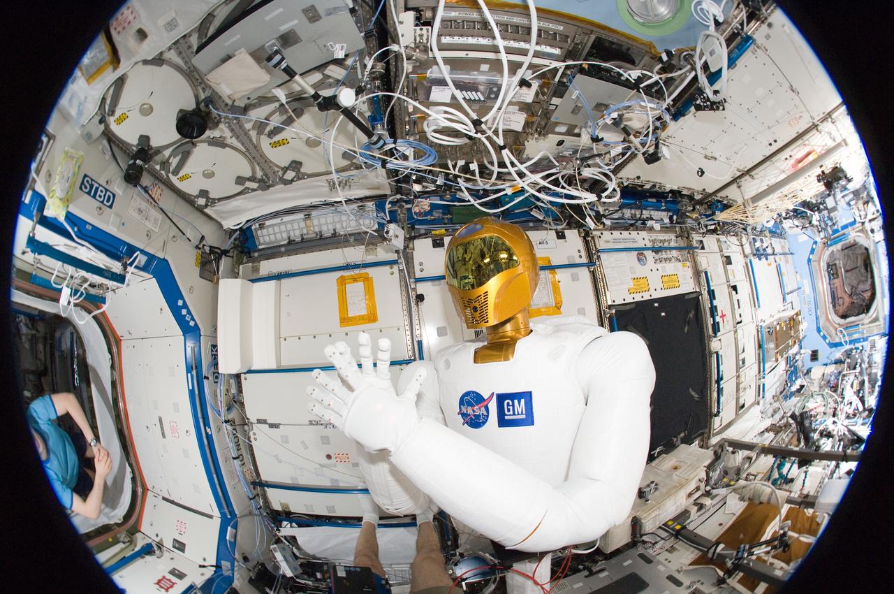
ISS030-E-135185 (13 March 2012) --- A fisheye lens attached to an electronic still camera was used to capture this image of Robonaut 2 humanoid robot during another system checkout in the Destiny laboratory of the International Space Station. Teams on the ground commanded Robonaut through a series of dexterity tests as it spelled out ?Hello world? in sign language.
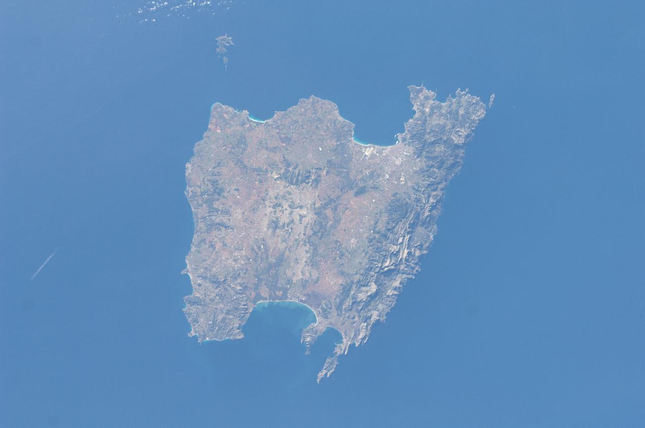
STS084-714-007 (15-24 May 1997) --- This 70mm image of the island of Corsica was photographed from the Space Shuttle Atlantis during the STS-84 mission. Birthplace of Napoleon Bonaparte, Corsica is the fourth largest island (after Sicily, Sardinia, and Cyprus) in the Mediterranean. Two-thirds of the island is mountainous with the majority of the population (1990-249, 737) living on the east coast (the "handle on the island points north). French is the official language.
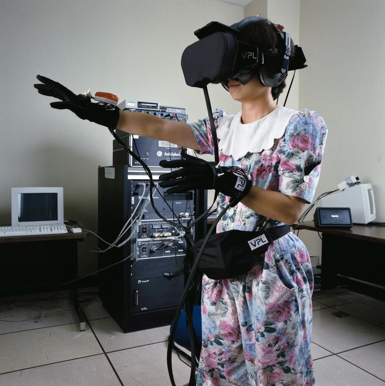
S91-50404 (1 Nov 1991) --- Bebe Ly of the Information Systems Directorate's (ISD) Software Technology Branch at the Johnson Space Center (JSC) gives virtual reality a try. The stereo video goggles and head[phones allow her to see and hear in a computer-generated world and the gloves allow her to move around and grasp objects. Ly is a member of the team that developed the C Language Integrated production System (CLIPS) which has been instrumental in developing several of the systems to be demonstrated in an upcoming Software Technology Exposition at JSC.
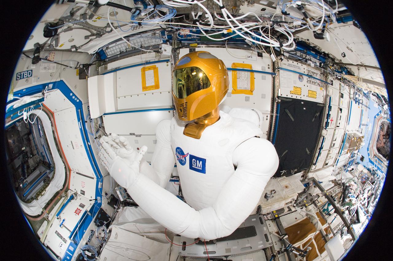
ISS030-E-135187 (13 March 2012) --- A fisheye lens attached to an electronic still camera was used to capture this image of Robonaut 2 humanoid robot during another system checkout in the Destiny laboratory of the International Space Station. Teams on the ground commanded Robonaut through a series of dexterity tests as it spelled out ?Hello world? in sign language.
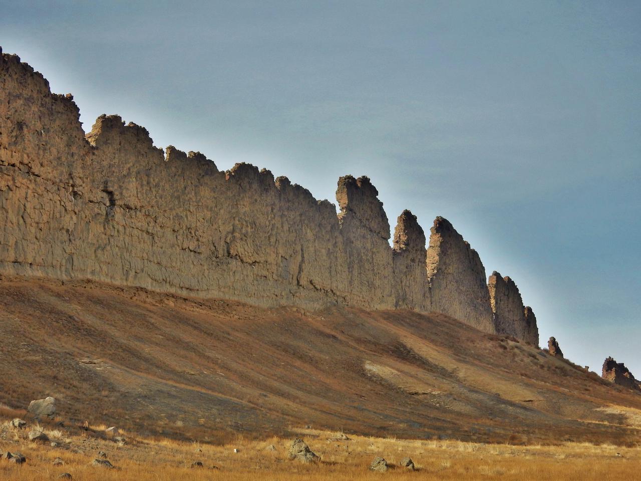
This photograph from northwestern New Mexico shows a ridge roughly 30 feet about 10 meters tall that formed from lava filling an underground fracture then resisting erosion better than the material around it did. The dike extends from a volcanic peak (out of view here) called Shiprock in English and Tsé Bit'a'í, meaning "rock with wings," in the Navajo language. It offers an Earth analog for some larger hardened-lava walls on Mars http://photojournal.jpl.nasa.gov/catalog/PIA21266

Melinda French Gates, of the Bill & Melinda Gates Foundation speaks at an event at the National Press Club in Washington, Tuesday, Feb. 23, 2010. NASA is working with Univision Communications Inc. to develop a partnership in support of the Spanish-language media outlet's initiative to improve high school graduation rates, prepare Hispanic students for college, and encourage them to pursue careers in science, technology, engineering and mathematics, or STEM, disciplines. Photo Credit: (NASA/Bill Ingalls)
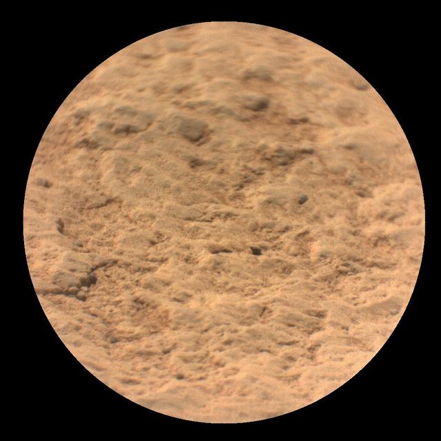
This image shows a close-up view of the rock target named "Máaz" from the SuperCam instrument on NASA's Perseverance Mars rover. It was taken by SuperCam's Remote Micro-Imager (RMI) on March 2, 2021 (the 12th Martian day, or "sol," Perseverance's mission on Mars). "Máaz" means Mars in the Navajo language. Analysis of SuperCam data shows that Máaz has a basaltic composition. It is either an igneous rock or consists of fine grains of igneous material that were cemented together in a watery environment. The target was 10.4 feet (3.17 meters) from the rover. The image field of view is 2.3 inches (6.0 centimeters) in diameter. A key objective for Perseverance's mission on Mars is astrobiology, including the search for signs of ancient microbial life. The rover will characterize the planet's geology and past climate, pave the way for human exploration of the Red Planet, and be the first mission to collect and cache Martian rock and regolith (broken rock and dust). Subsequent NASA missions, in cooperation with ESA (European Space Agency), would send spacecraft to Mars to collect these sealed samples from the surface and return them to Earth for in-depth analysis. The Mars 2020 Perseverance mission is part of NASA's Moon to Mars exploration approach, which includes Artemis missions to the Moon that will help prepare for human exploration of the Red Planet. https://photojournal.jpl.nasa.gov/catalog/PIA24493
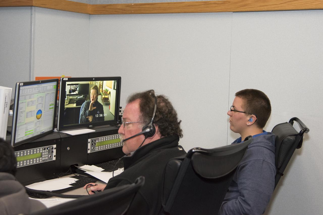
Johanna Lucht, observing data from the Mission Control Center at NASA’s Armstrong Flight Research Center in California, received flight communications from an interpreter, seen on Lucht’s monitor, through American Sign Language. Two-way visual communication was established between Lucht and the interpreter, located at NASA’s Langley Research Center in Virginia, for the flight. Interpreting technical terminology often requires cooperation to develop specific signs to ease communication. Using a familiar interpreter who is adept or practiced in the technical terminology of a NASA flight was beneficial, Lucht says.
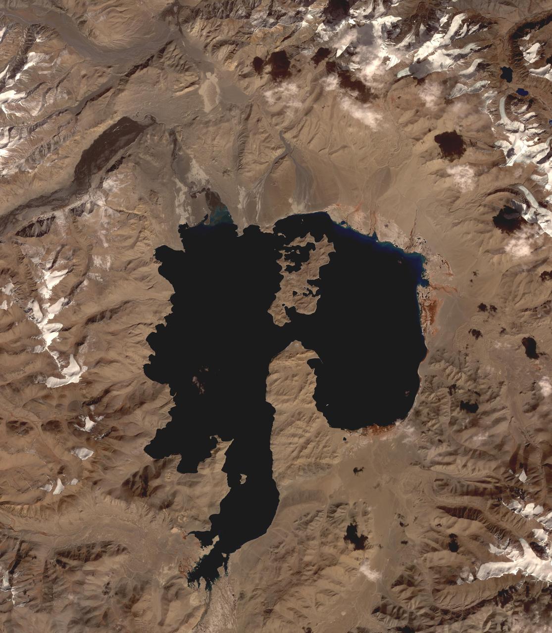
Lake Karakul in northeast Tajikistan is a hypersaline lake with no external drainage, receiving less than 3 cm precipitation per year. It is on the highest part of the fabled Pamir highway at 3900 m. In the local Kyrgyz language, the lake is called "The Black Lake". Recently, Russian scientists have suggested that the lake occupies a 200 million year old meteor impact crater. The image was acquired October 16, 2016, covers an area of 48 by 55 km, and is located at 39 degrees north, 73.4 degrees east. https://photojournal.jpl.nasa.gov/catalog/PIA23102
Paula Crawford (assisted by an American Sign Language interpreter) lectures students about materials science research in space during the U.S. Microgravity Payload-4 mission (STS-87, Nov. 19 - Dec. 5, 1997) in the visitor's center set up by the Isothermal Dendritic Growth Experiment (IDGE) team at Rensselaer Polytechnic Institute (RPI) in Troy, NY. IDGE, flown on three Space Shuttle mission, is yielding new insights into virtually all industrially relevant metal and alloy forming operation. Photo credit: Rensselaer Polytechnic Institute (RPI)
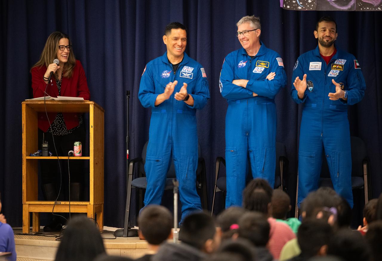
María-José Viñas, NASA’s Spanish language communications lead, left, introduces NASA astronauts Frank Rubio, second from left, and Stephen Bowen and UAE (United Arab Emirates) astronaut Sultan Alneyadi as the trio visited Rolling Terrance Elementary School to speak to students, Friday, March 22, 2024, in Takoma Park, Maryland. Bowen and Alneyadi spent 186 days aboard the International Space Station as part of Expedition 69; while Rubio set a new record for the longest single spaceflight by a U.S. astronaut, spending 371 days in orbit on an extended mission spanning Expeditions 68 and 69. Photo Credit: (NASA/Joel Kowsky)
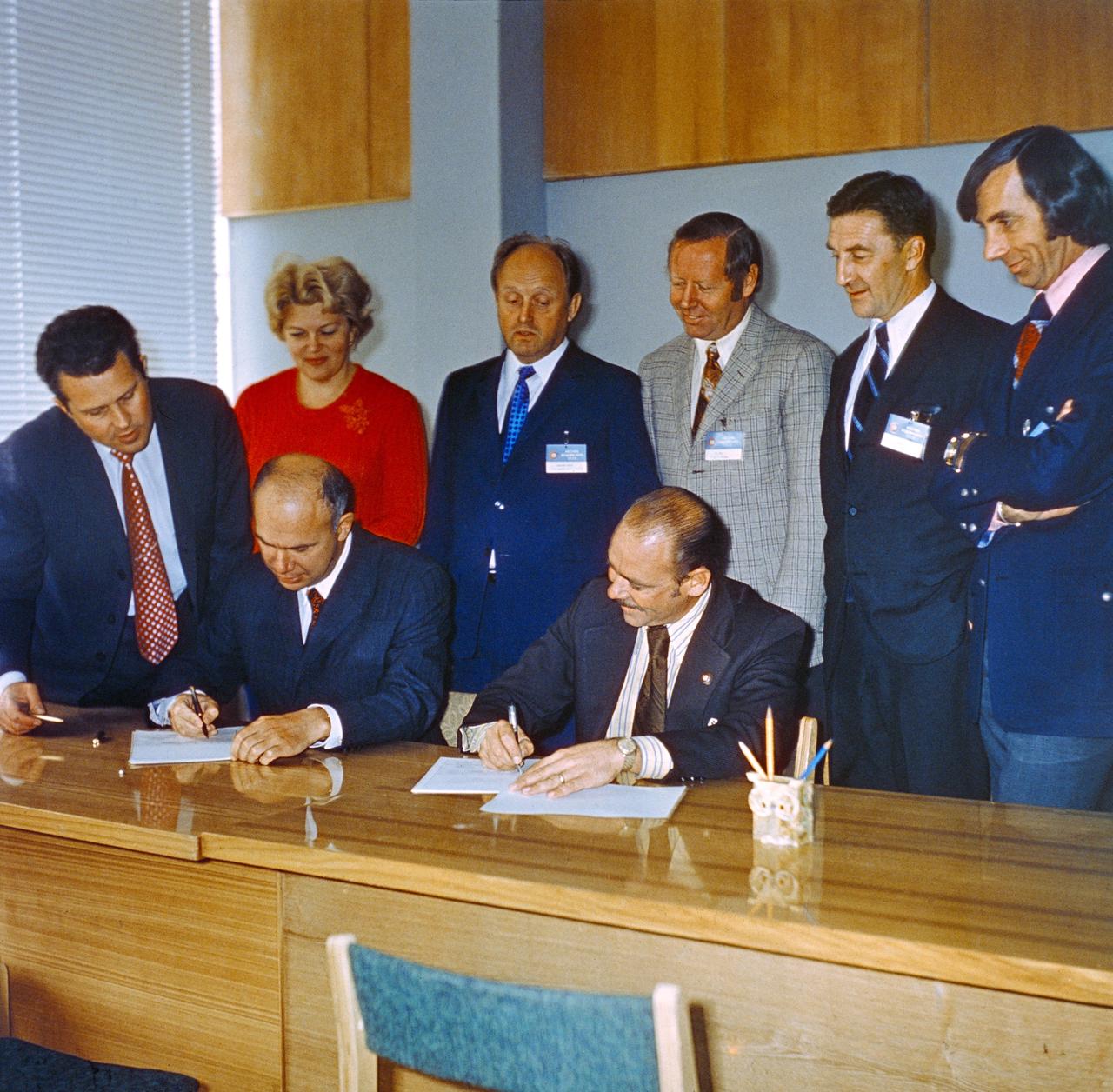
S74-29896 (September 1974) --- John P. Donnelly (seated right), NASA Assistant Administrator for Public Affairs, and Vladen S. Vereshchetin (seated left), Vice Chairman of Intercosmos, USSR Academy of Sciences, initial an agreement on information policy for the joint U.S.-USSR Apollo-Soyuz Test Project mission during ceremonies in Moscow in September 1974. Other members of the joint public affairs delegation looking on are, standing left to right, Vladimir A. Denissenko, Tatyana Klotchkovsaya, Igor P. Rumyantsev, John W. King, Nicholas Timacheff, and Robert Shafer. King is the Public Affairs Officer at the Johnson Space Center. Timacheff is the language officer with the JSC ASTP office. Shafer is NASA Deputy Assistant Administrator for Public Affairs (Television).
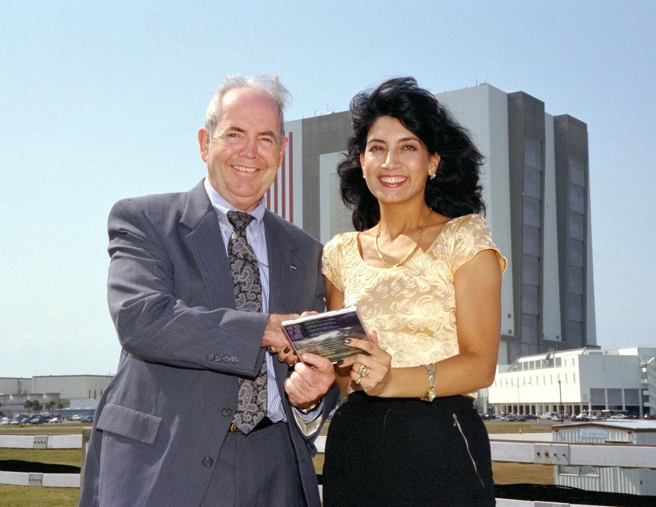
KENNEDY SPACE CENTER, FLA. -- David Dickinson, the acting director of the National Aeronautics and Space Administration (NASA) Public Affairs Office at Kennedy Space Center, accepts a copy of Bulgarian singer Dyana Dafova's latest compact disc (CD) from her on behalf of NASA. The 525-foot tall Vehicle Assembly Building, where Space Shuttle orbiters are mated to their external tank/solid rocket booster stacks, looms in the background. Dyana is touring the United States to promote her CD, entitled "Sounds of the Earth," and was an invited guest of NASA for the launch of Columbia on STS-90, the Neurolab mission, earlier in the day. Columbia lifted off from Launch Pad 39B at 2:19 p.m. EDT. Dyana characterized the music on her CD as a new sound, incorporating jazz and new age classics, sung in a newly created language comprised of Bulgarian, English, Sanskrit, Aramski and Hebrew
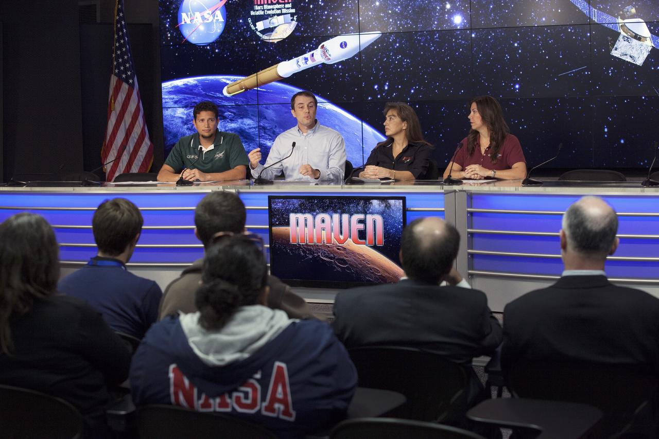
CAPE CANAVERAL, Fla. – During a Spanish language news conference at NASA's Kennedy Space Center in Florida, agency officials discussed preparations for the launch of the Mars Atmosphere and Volatile EvolutioN, or MAVEN, mission. Participating in the briefing, from the left, are Andres Adorno of NASA Public Affairs, Jared Espley, project scientist at Goddard Space Flight Center in Greenbelt, Md., Sandra Cauffman, deputy project manager at Goddard and Diana Calero, launch integration engineer in NASA's Launch Services Program at Kennedy. MAVEN is being prepared for its scheduled launch on Nov 18, 2013 from Cape Canaveral Air Force Station, Fla. atop a United Launch Alliance Atlas V rocket. Positioned in an orbit above the Red Planet, MAVEN will study the upper atmosphere of Mars in unprecedented detail. For information on the MAVEN mission, visit: http://www.nasa.gov/mission_pages/maven/main/index.html. Photo credit: NASA/Kim Shiflett
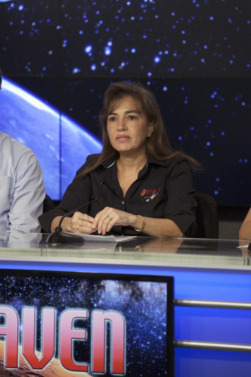
CAPE CANAVERAL, Fla. – During a Spanish language news conference at NASA's Kennedy Space Center in Florida, agency officials discussed preparations for the launch of the Mars Atmosphere and Volatile EvolutioN, or MAVEN, mission. Participating in the briefing is Sandra Cauffman, deputy project manager at the Goddard Space Flight Center in Greenbelt, Md. MAVEN is being prepared for its scheduled launch on Nov 18, 2013 from Cape Canaveral Air Force Station, Fla. atop a United Launch Alliance Atlas V rocket. Positioned in an orbit above the Red Planet, MAVEN will study the upper atmosphere of Mars in unprecedented detail. For information on the MAVEN mission, visit: http://www.nasa.gov/mission_pages/maven/main/index.html. Photo credit: NASA/Kim Shiflett
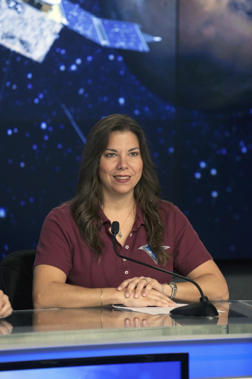
CAPE CANAVERAL, Fla. – During a Spanish language news conference at NASA's Kennedy Space Center in Florida, agency officials discussed preparations for the launch of the Mars Atmosphere and Volatile EvolutioN, or MAVEN, mission. Participating in the briefing is Diana Calero, launch integration engineer in NASA's Launch Services Program at Kennedy. MAVEN is being prepared for its scheduled launch on Nov 18, 2013 from Cape Canaveral Air Force Station, Fla. atop a United Launch Alliance Atlas V rocket. Positioned in an orbit above the Red Planet, MAVEN will study the upper atmosphere of Mars in unprecedented detail. For information on the MAVEN mission, visit: http://www.nasa.gov/mission_pages/maven/main/index.html. Photo credit: NASA/Kim Shiflett
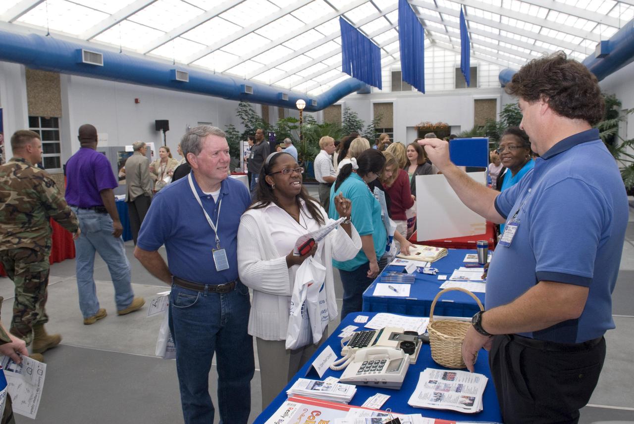
Using American sign language, Greg Crapo, right, director of de l'Ep e Deaf Center Inc. in Biloxi , Miss., helps Shanda Bennett of the Environmental Protection Agency at NASA's John C. Stennis Space Center spell out her name. Bennett is joined by colleague Charles Kennedy during a tour of charitable organization displays for the kickoff of the Stennis portion of the 2009 Combined Federal Campaign emphasis on Oct. 29. The CFC is the world's largest annual workplace charity effort. Contributions to the campaign support organizations providing health and human service benefits throughout the world. Stennis employees give tens of thousands of dollars through the campaign each year, including a $198,000 in gifts in 2008. This year, the Stennis goal is $200,000. For the kickoff, a number of charitable organizations provided displays at Stennis, providing employees an opportunity to see - and choose - where their contributions can be directed.

CAPE CANAVERAL, Fla. – During a Spanish language news conference at NASA's Kennedy Space Center in Florida, agency officials discussed preparations for the launch of the Mars Atmosphere and Volatile EvolutioN, or MAVEN, mission. Participating in the briefing is Jared Espley, project scientist at Goddard Space Flight Center in Greenbelt, Md. MAVEN is being prepared for its scheduled launch on Nov 18, 2013 from Cape Canaveral Air Force Station, Fla. atop a United Launch Alliance Atlas V rocket. Positioned in an orbit above the Red Planet, MAVEN will study the upper atmosphere of Mars in unprecedented detail. For information on the MAVEN mission, visit: http://www.nasa.gov/mission_pages/maven/main/index.html. Photo credit: NASA/Kim Shiflett
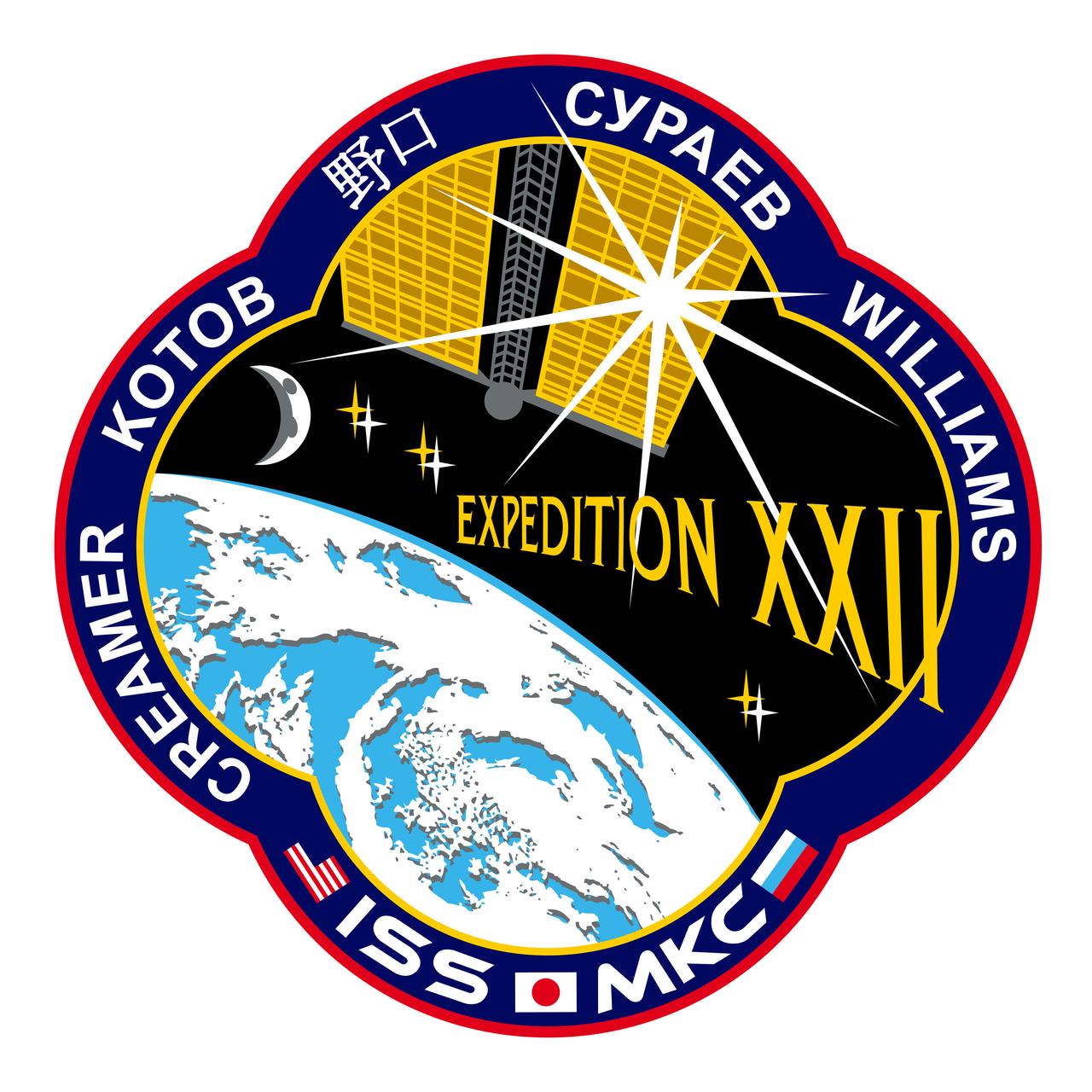
ISS022-S-001 (February 2009) --- The 22nd Expedition to the International Space Station is dedicated to the final stages of assembly and the transition to full utilization as an orbiting laboratory. The sun, providing power and life support to the space station, shines through one of the solar arrays as the ISS orbits above Earth. The oceans and atmosphere, providing life support to Earth, are shown in all their beauty. The moon hovers in the distance as the goal of the next era of exploration. The six stars illustrate the increased capability of the crew complement. In the border are the national flags of the crew members as well as their surnames in their native languages. Expedition XXII continues the effort to acquire the knowledge necessary to extend the reach of exploration from Earth, to the moon and beyond. The insignia design for ISS flights is reserved for use by the astronauts and cosmonauts and for other official use as the NASA Administrator and NASA's international partners may authorize. Public availability has been approved only in the form of illustrations by the various news media. When and if there is any change in this policy, which we do not anticipate, it will be publicly announced
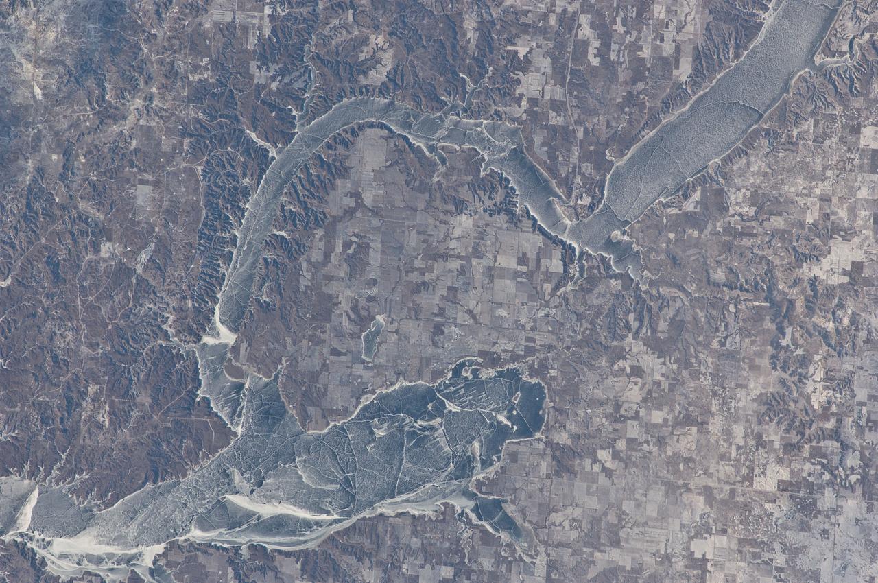
ISS030-E-059433 (19 Jan. 2012) --- Ice cover on Lake Sakakawea in North Dakota is featured in this image photographed by an Expedition 30 crew member on the International Space Station. This striking photograph illustrates the harsh winter conditions frequently experienced in North Dakota. Ice covers the surface of northwestern Lake Sakakawea, a reservoir on the Missouri River in west-central North Dakota. A local weather station near New Town, ND reported an air temperature of approximately -24 °C (-11 °F), with a wind chill of approximately -32 °C (-25 °F) at 10:36 local time – six minutes before the image was taken. In addition to the grey ice on the lake, a dusting of white snow highlights agricultural fields to the north and northeast, as well as fissures and irregularities in the ice surfaces. For a sense of scale, the arms of the lake to either side of New Town are approximately 10 kilometers (6 miles) apart. Lake Sakakawea is named—in the Hidatsa language—for the Shoshone woman generally known as Sacagawea, or “Bird Woman”. She accompanied the Lewis and Clark Expedition in 1805–1806 as an interpreter and guide. The lake was created following the completion of Garrison Dam (not shown) on the Missouri River in 1954. With a surface area of approximately 148,924 hectares (368,000 acres) and length of 286 kilometers (178 miles), Lake Sakakawea is one of the largest artificial reservoirs in the USA.

This is a Hubble Space Telescope view of a very massive cluster of galaxies, MACS J0416.1-2403, located roughly 4 billion light-years away and weighing as much as a million billion suns. The cluster's immense gravitational field magnifies the image of galaxies far behind it, in a phenomenon called gravitational lensing. The inset is an image of an extremely faint and distant galaxy that existed only 400 million years after the big bang. It was discovered by Hubble and NASA's Spitzer Space Telescope. The gravitational lens makes the galaxy appear 20 times brighter than normal. The galaxy is comparable in size to the Large Magellanic Cloud (LMC), a diminutive satellite galaxy of our Milky Way. It is rapidly making stars at a rate ten times faster than the LMC. This might be the growing core of what was to eventually evolve into a full-sized galaxy. The research team has nicknamed the object Tayna, which means "first-born" in Aymara, a language spoken in the Andes and Altiplano regions of South America. http://photojournal.jpl.nasa.gov/catalog/PIA20054
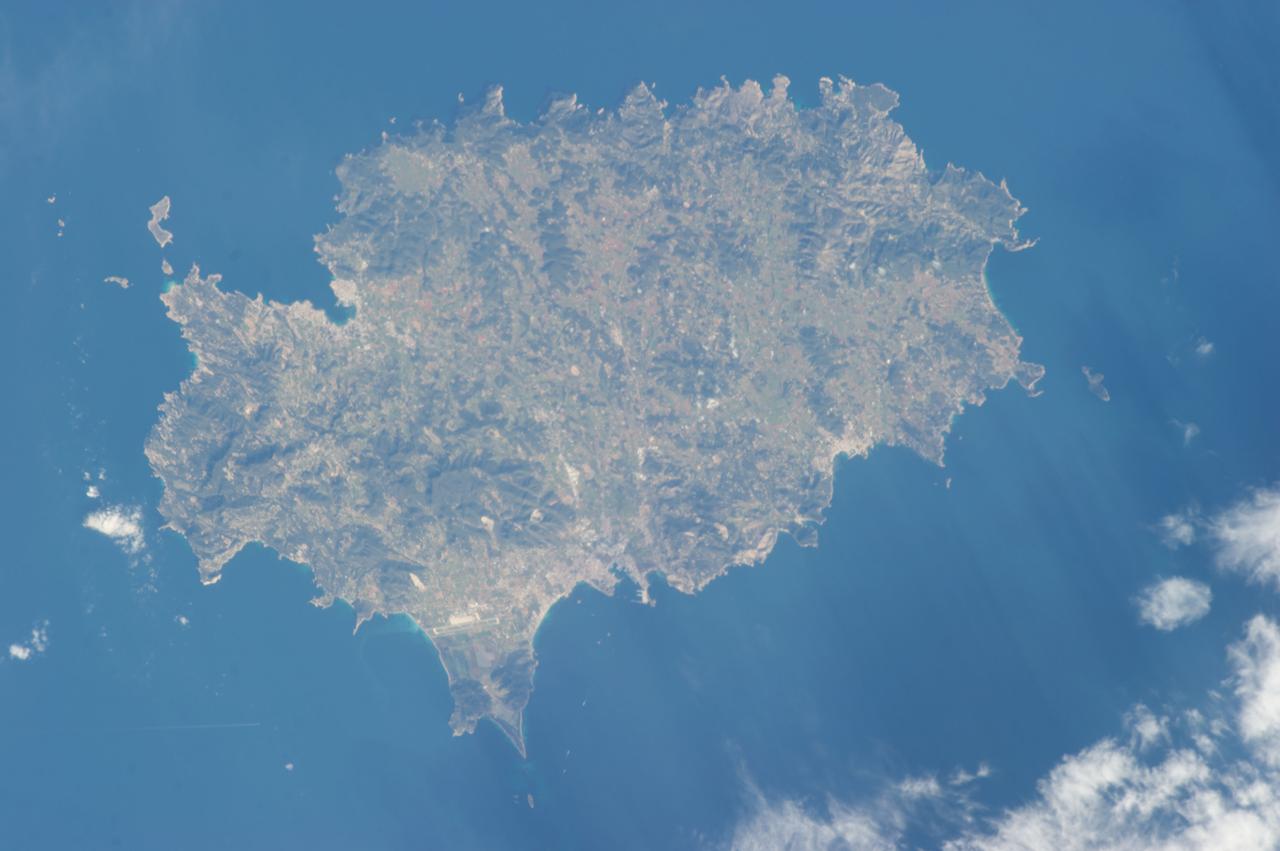
ISS030-E-030290 (31 Dec. 2011) --- Majorca in the Balearic Islands (Spain) is featured in this image photographed by an Expedition 30 crew member aboard the International Space Station. The Balearic Islands are an archipelago located to the southwest of Spain in the Mediterranean Sea. Catalan – the native tongue – and Spanish are the official languages. The islands are an autonomous community and province of Spain, located approximately midway between the southeastern coastline of Spain and the northern coastline of Algeria. This photograph highlights the large island of Majorca (approximately 5,400 square kilometers; also known as Mallorca in Spanish) on which the capital city of Palma is located (center). The small island of Cabrera to the southwest of Majorca (upper left) hosts the Parc Nacional de l’Arxipelag de Cabrera (site mainly in Spanish). Like the other Balearic Islands, Majorca is a popular holiday destination for the European community with tourism forming a major part of the island’s economy. The island’s physiography offers many recreational opportunities – mountainous regions are present along the northwest coastline and eastern third, while much of the central part of the island is flat. Diving is also a popular activity. The central region includes agricultural lands (tan, light brown, and green, center), forested patches and corridors (dark green, center), and urban centers (gray). In addition to Majorca, the other major islands of the archipelago include Ibiza, Formentera, and Minorca.
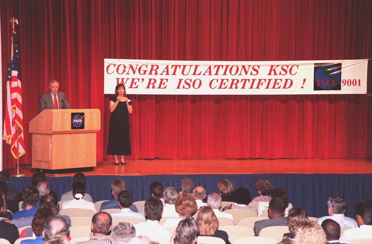
Center Director Roy Bridges speaks to KSC employees at the ISO certification ceremony held at the Training Auditorium. Bridges was presented an ISO 9001 certificate and plaque awarded to KSC by Det Norske Veritas (DNV), Inc., an international ISO certification organization. ISO 9001 comprises the most detailed, comprehensive set of standard requirements for quality programs established by the International Standards Organization. The presentation followed a successful independent audit by DNV of the KSC Management System in May of this year. The third-party auditors examined about 20 elements of KSC's system, including management responsibility, design control, documentation, test and inspection, and corrective action procedures. DNV found that KSC met or exceeded the stringent quality standards in all areas. KSC will use this certification as a tool to improve an already worldclass team. All NASA centers are required by NASA Administrator Daniel S. Goldin to be ISO 9001 registered by September 1999. NASA is the first federal agency to seek the quality certification. Next to Bridges is Heidi Hollingsworth, with the Center for Independent Living, who uses American Sign Language for any hearing-impaired employees in the audience

CAPE CANAVERAL, Fla. -- In the KSC Training Auditorium at NASA's Kennedy Space Center in Florida, Dr. Mary Frances Berry, on stage, addresses the audience gathered for a special event marking the 50th anniversary of the Civil Rights Act of 1964, supported by a sign-language interpreter. Berry served as the assistant secretary for education in the U.S. Department of Health, Education and Welfare HEW between 1977 and 1980. From 1980 to 2004, she was a member of the U.S. Commission on Civil Rights, serving as chair from 1993 to 2004. Among Berry's many honors are the NAACP's Roy Wilkins Award, the Rosa Parks Award of the Southern Christian Leadership Conference, and the Ebony Magazine Black Achievement Award. She is one of 75 women featured in the book "I Dream a World: Portraits of Black Women Who Changed America." Sienna College Research Institute and the Women's Hall of Fame also designated her one of "America's Women of the Century." The event was presented by Kennedy's Office of Diversity and Equal Opportunity. For more information about Kennedy Space Center, visit http://www.nasa.gov/kennedy. Photo credit: NASA/Kim Shiflett
ISS035-E-027431 (23 April 2013) --- This oblique Expedition 35 image from the International Space Station shows parts of Mexico, California and Nevada. The Los Angeles Basin can be easily delineated at left center. If the nomenclature for the body of water in the upper right quadrant of the image were the subject of a trivia question, the answer might be "all the above," as it is recognized by a number of names. They include the Gulf of California, Sea of Cortez, Sea of Cortes, Vermilion Sea as well as its local designations in the Spanish language as Mar de Cortes or Mar Bermejo or Golfo de California. It serves to separate the Baja California Peninsula from the Mexican mainland. It is bordered by the states of Baja California, Baja California Sur, Sonora, and Sinaloa (some of which are out of the frame) with a coastline of approximately 4,000 kilometers (2,500 miles). Rivers which flow into the Gulf of California include the Colorado, Fuerte, Mayo, Sinaloa, Sonora and the Yaqui. The gulf's surface area is about 160,000 square kilometers (62,000 square miles). A mass of clouds sits just off the Pacific coast of Baja California and southern California.

ISS033-E-020288 (13 Nov. 2012) --- A nighttime view of Riyadh, Saudi Arabia is featured in this image photographed by an Expedition 33 crew member on the International Space Station. The population of Riyadh, the capital city of Saudi Arabia, has risen dramatically in the last half century, from 150,000 in 1960 to an estimated 5.4 million in 2012. The city appears as a brightly colored patchwork in this nighttime photograph. The brightest lights, apart from those on the old Riyadh Airbase at center (the new international airport is far outside the city and not shown here), follow the commercial districts along King Abdullah Road and King Fahd Branch Road. Many of the darker patches within the built area are city parks. University sectors stand out with different street and light patterns, as seen in the King Saud University campus which houses the Arabic Language Institute, and the Princess Nora Bint Abdul Rahman University which is the largest all-female university in the world. Highways and various ring roads also stand out in night imagery due to bright regular lighting. Lighted developments beyond the ring roads mark the growth of the city. Newer neighborhoods, set further from the city center, are recognizable by blue-gray lightning.
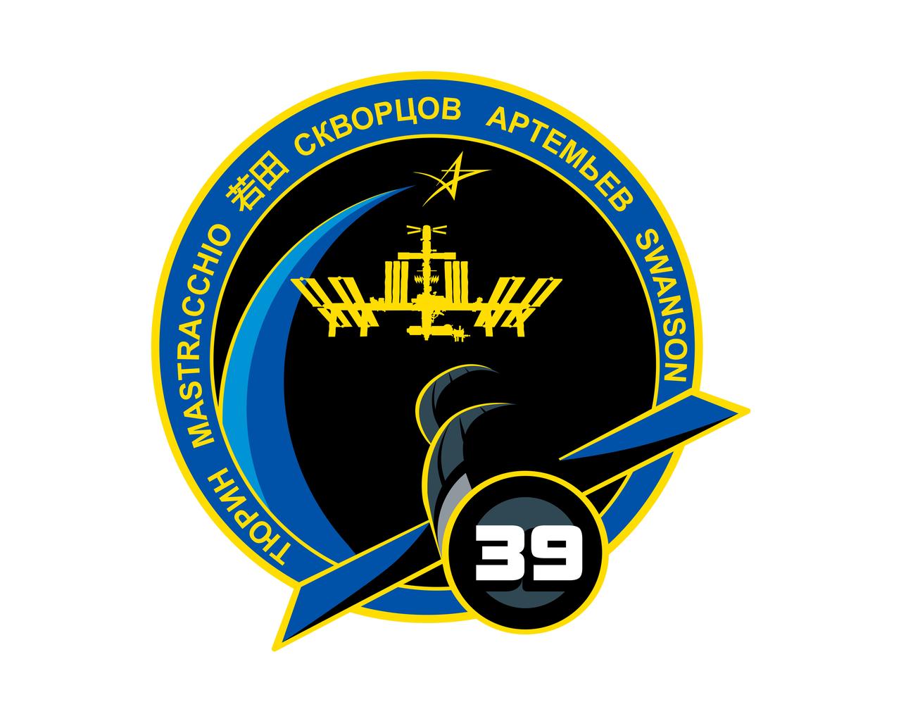
ISS039-S-001 (April 2013) --- Increment 39 of the International Space Station Program marks the 15th year of operation since the start of the space laboratory assembly. Today, the U.S., Russia, Japan, Canada and the European Space Agency are partnering in the operation of the largest ever orbital outpost managed by humankind. The names of the six crew members are depicted in their native languages. For Expedition 39, the Soyuz spacecraft serves as transport vehicle for the crew members to and from the station. During this expedition, the ISS will serve as a platform for scientific research, Earth and astronomical observation, education, as well as a stage for the development of new technologies used for the exploration beyond low Earth orbit. The star above the complex signifies human space exploration towards new frontiers. The crew members added these words: "The crew of Expedition 39 is proud to serve the international community in furthering our scientific knowledge and in expanding human presence in space." Photo credit: NASA The NASA insignia design for shuttle and space station flights is reserved for use by the astronauts and for other official use as the NASA Administrator may authorize. Public availability has been approved only in the form of illustrations by the various news media. When and if there is any change in this policy, which is not anticipated, it will be publicly announced.
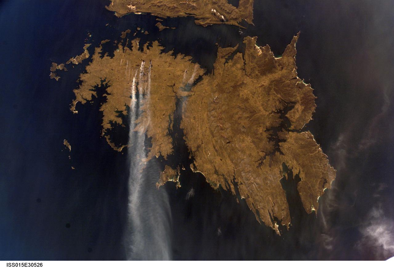
ISS015-E-30526 (25 Sept. 2007) --- Fires in East Falkland Island in the South Atlantic Ocean are featured in this image photographed by an Expedition 15 crewmember on the International Space Station. The Falkland Islands are an overseas territory of the United Kingdom, referred to by Argentina (which also claims the islands) as the Islas Malvinas. The main islands of East Falkland and West Falkland are separated by Falkland Sound (12 kilometers) wide at the narrow point. Together they total about the same area as the State of Connecticut or Northern Ireland. The islands lie almost 500 kilometers from the Argentine coast and less than 1,000 kilometers from Antarctica. The first air links to these remote islands were only put in place in 1971. The capital city of Stanley lies on the eastern tip of East Falkland. The local inhabitants are mainly English speakers, and interestingly, the islands have become a center of English-language learning for students from South America. The windy and relatively dry climate has given rise to natural vegetation comprised of treeless grassland with scattered bogs. The grasslands are ideal for sheep rearing which was the dominant occupation until recent decades, when fishing (mainly squid to Spain) and tourism became the mainstay of the economy. These expanses of grassland provide ready fuel for fires, as indicated by the several long smoke plumes visible in this image.
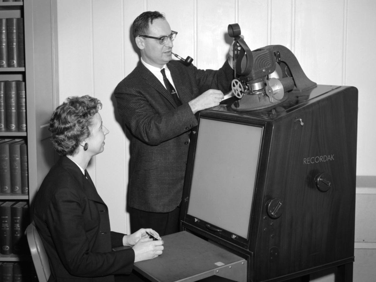
Jean Neidengard and George Mandel operate a Kodak Recordak microfilm reader in the library at the National Aeronautics and Space Administration (NASA) Lewis Research Center. The library was located in the Administration Building until the mid-1960s. It was then moved to the Propulsion Systems Laboratory Office Building. In 2008 the library was moved once again, to the Research Analysis Center. At the time of this photograph, the Lewis library claimed to possess “One of the most complete aero-technical collections in the world.” It was doing a brisk business in the early 1960s. During 1960 alone the library acquired 19,000 new documents and provided 100,000 documents to customers. The library’s eleven-person staff provided reference services, archived technical reports, and supplied periodicals. The staff also included Sam Reiss, a full-time translator who could read 30 languages. He translated technical reports from all over the world for the Lewis research staff. Jean Neidengard oversaw the secret Atomic Energy Commission (AEC) documents in the collection. NASA was partnering with the AEC at the time on Nuclear Engine for Rocket Vehicle Application (NERVA) program. NASA Lewis was the agency’s lead center in the NERVA program. Neidengard’s husband Bill was the head mechanic in the Propulsion Systems Laboratory. George Mandel led the library staff from 1955 to 1968.
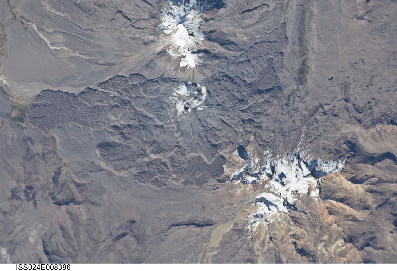
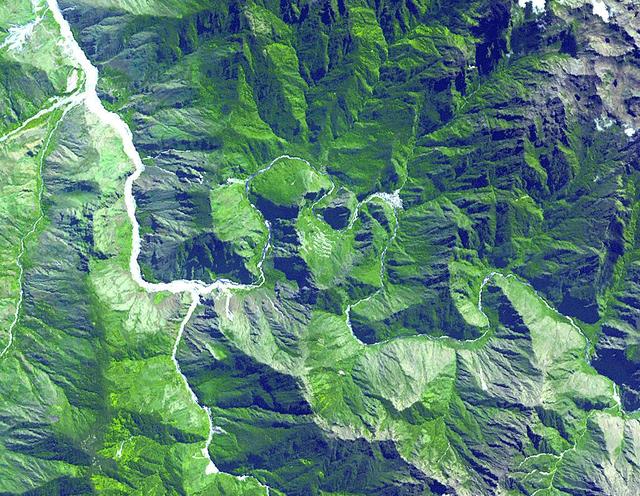
ISS024-E-008396 (15 July 2010) --- Sabancaya volcano in Peru is featured in this image photographed by an Expedition 24 crew member on the International Space Station. The 5,967-meter-high Sabancaya stratovolcano (or Nevado Sabancaya) is located in southern Peru approximately 70 kilometers to the northwest of the city of Arequipa. The name Sabancaya means ?tongue of fire? in the Quechua Indian language. Sabancaya is part of a volcanic complex that includes two other nearby (and older) volcanoes, neither of which has been active historically; in this detailed photograph, Nevado Ampato is visible to the south (top center) and the lower flanks of Nevado Hualca Hualca are visible to the north (bottom right). The snowy peaks of the three volcanoes provide a stark contrast to the surrounding desert of the Puna Plateau. Sabancaya?s first historical record of an eruption dates to 1750. The most recent eruptive activity at the volcano occurred in July 2003 and deposited ash on the volcano?s summit and northeastern flank. Volcanism at Sabancaya is fueled by magma generated at the subduction zone between the Nazca and South American tectonic plates. Magma can erupt to the surface and form lava flows through the volcano?s summit (frequently forming a crater) but can also erupt from lava domes and flank vents along the volcano?s sides. Lava has issued from all of these points at Sabancaya, forming numerous gray to dark brown lobate flows that extend in all directions except southwards (center).
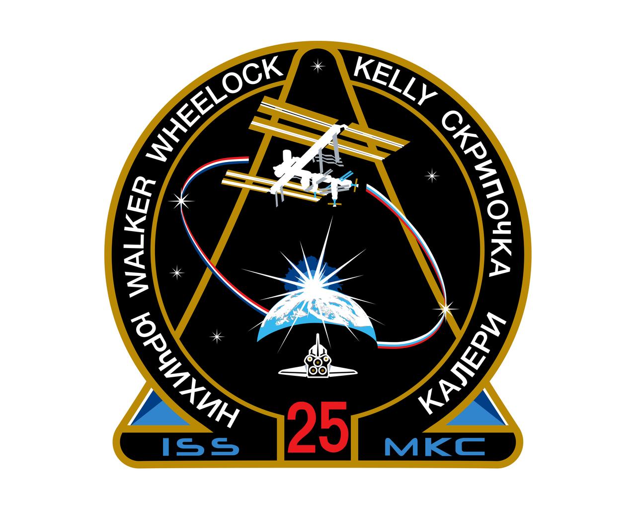
ISS025-S-001 (June 2010) --- The mission patch design for the 25th Expedition to the International Space Station (ISS) pays tribute to the rich history of innovation and bold engineering in the quest for knowledge, exploration and discovery in space. The patch highlights the symbolic passing of the torch to the ISS, as the vehicle that will carry us into the future of space exploration. The Space Shuttle Program emblem is the foundation of the patch and forms the Greek letter Omega?, paying tribute to the culmination of the Space Shuttle Program. The mission designation 25? and the Earth crescent, the orbiter is shown returning to Earth on its final journey, during the Expedition 25 mission. Above Earth and the breaking dawn, the ISS takes center-stage, completed and fully equipped to carry us beyond this new dawn to new voyages and discoveries. The orbit connecting the ISS and the Earth is drawn in the colors of the United States and Russian flags; paying tribute to the blended heritage of the crew. The two largest stars in the field represent the arrival and departure of the crews in separate Russian Soyuz vehicles. The six stars in the field represent the six crew members. The International Space Station abbreviation MKC? ? in English and Russian, respectively- flank the mission number designation, and the names of the crew members in their native languages border the ISS symbol. The NASA insignia design for shuttle and space station flights is reserved for use by the astronauts and for other official use as the NASA Administrator may authorize. Public availability has been approved only in the form of illustrations by the various news media. When and if there is any change in this policy, which is not anticipated, it will be publicly announced.
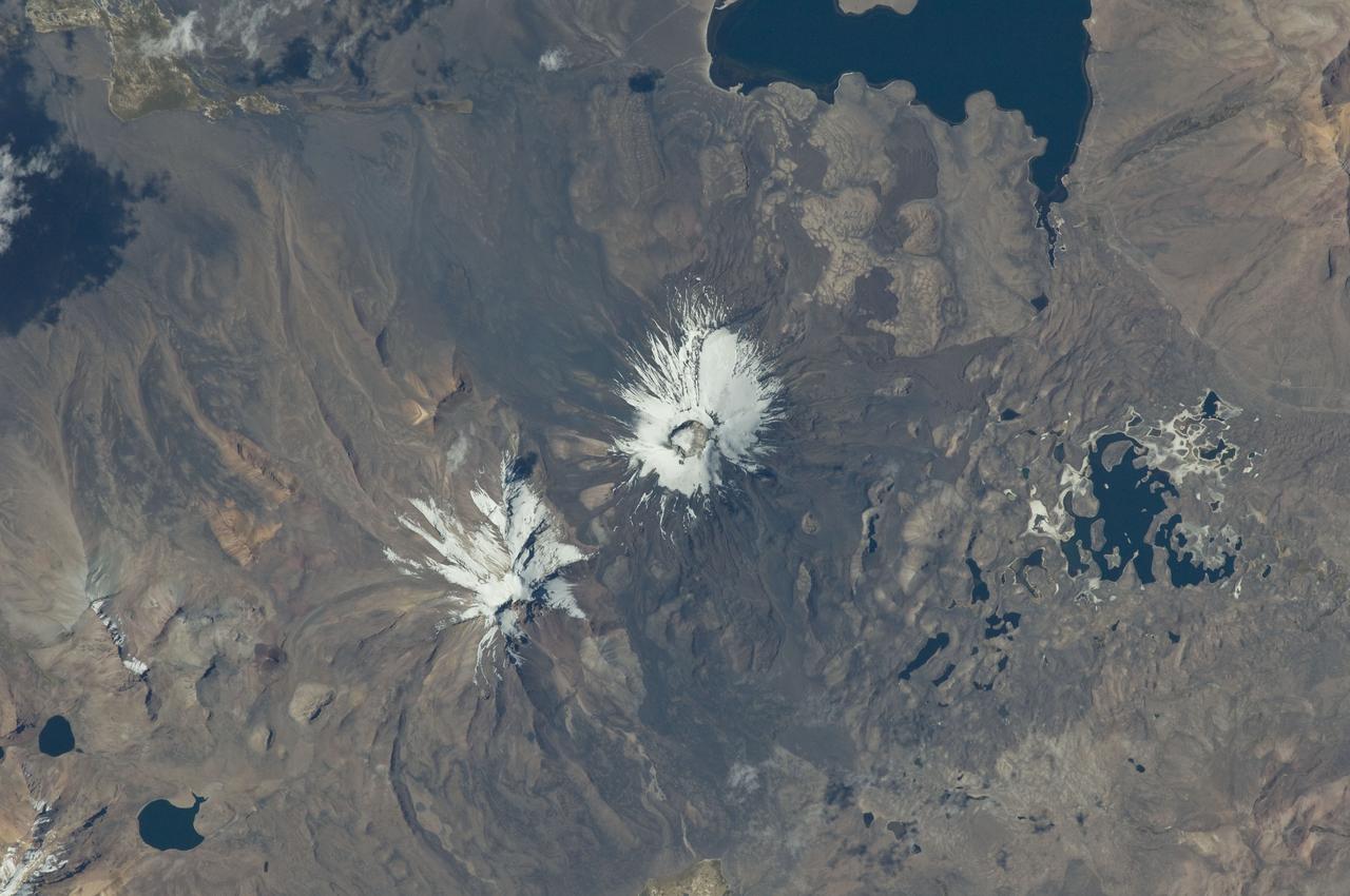
ISS029-E-020003 (7 Oct. 2011) --- Parinacota Volcano in the Chile-Bolivia border region, South America is featured in this image photographed by an Expedition 29 crew member on the International Space Station. Volcan Parinacota (?flamingo lake? in the regional Aymara language) is a potentially active stratovolcano located on the Altiplano, a high plateau situated within the Andes Mountains of west-central South America. While no direct observations of eruptive activity are recorded, surface exposure age-dating of lava flows suggests that activity occurred as recently as 290 AD approximately 300 years, according to scientists. Local Aymara stories also suggest that the volcano has erupted during the past 1,000 years. This detailed photograph highlights the symmetrical cone of Parinacota, with its well-developed summit crater (elevation 6,348 meters above sea level) at center. Dark brown to dark gray surfaces to the east and west of the summit include lava flows, pyroclastic deposits, and ash. A companion volcano, Pomerape, is located across a low saddle to the north ? scientists believe this volcano last erupted during the Pleistocene Epoch (extending from approximately 3 million to 12,000 years ago). The summits of both volcanoes are covered by white permanent snowpack and small glaciers. Together, the two volcanoes form the Nevados de Payachata volcanic area. Eruptive activity at Parinacota has directly influenced development of the local landscape beyond the emplacement of volcanic deposits ? approximately 8,000 years ago the western flank of the volcano collapsed, creating a debris avalanche that traveled 22 kilometers to the west. This debris avalanche blocked drainages, leading to the formation of Lake Chungara to the south (upper right). The uneven, hummocky surface of the debris avalanche deposit provides ample catchments for water, as evidenced by the numerous small ponds and Cotacotani Lake to the west.
The ruins of Machu Picchu, rediscovered in 1911 by Hiram Bingham, are one of the most beautiful and enigmatic ancient sites in the world. While the Inca people utilized the Andean mountain top (2800 m elevation), erecting massive stone structures from the early 1400's, legends and myths indicate that Machu Picchu (meaning "Old Peak" in the Quechua language) was revered as a sacred place from a far earlier time. The Inca turned the site into a small (12 square kilometers) but extraordinary city. Invisible from the Urubamba River valley below and completely self-contained, surrounded by agricultural terraces sufficient to feed the population, and watered by natural springs, Machu Picchu seems to have been utilized by the Inca as a secret ceremonial city. The Spaniards never found Machu Picchu, even though they suspected its existence. The mountain top sanctuary fell into disuse and was abandoned some forty years after the Spanish took Cuzco in 1533. Supply lines linking the many Inca social centers were disrupted and the great empire came to an end. This image was acquired on June 25, 2001 by the Advanced Spaceborne Thermal Emission and Reflection Radiometer (ASTER) on NASA's Terra satellite. With its 14 spectral bands from the visible to the thermal infrared wavelength region, and its high spatial resolution of 15 to 90 meters (about 50 to 300 feet), ASTER will image Earth for the next 6 years to map and monitor the changing surface of our planet. http://photojournal.jpl.nasa.gov/catalog/PIA03853
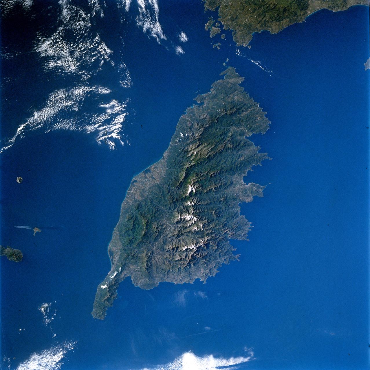
ISS035-E-007431 (22 March 2013) --- One of the Expedition 35 crew members aboard the Earth-orbiting International Space Station used a digital camera equipped with a 400 millimeter lens to capture this image of the island of Ibiza (Eivissa in the native Catalan language), located off of the southeastern coast of Spain. Ibiza is part of the Balearic archipelago. Together with the neighboring island of Formentera (not shown), it comprises the Pine Islands of the western archipelago. The largest cities on the island, Ibiza Town, Sant Antoni de Portmany, and Santa Eularia des Riu, appear as white to pink regions near coastal bays in the image. Much of the lowland interior of the island is covered with green to light brown agricultural fields; some are still in active production for such crops as wheat, olives, and grapes but many fields are inactive and experiencing regrowth of native trees such as pine (Pinus halpensis) and savine (Juniperus phoenicea). The northern and southwestern coastlines are hilly (grey-brown regions), with the highest peak (Sa Talaia, 475 meters above sea level) located in the southwestern region. Like many of the Balearic Islands, the major industry of Ibiza is European tourism, and it is particularly well known for the nightlife of Ibiza Town and Sant Antoni de Portmany. Ships near Ibiza Town and a ship wake off the southwestern coastline are visible at image lower left. The island hosts a large variety of birds and lizards; however no large land fauna are present. The Mediterranean Sea to the southeast of the island appears dark in the image due to shadowing by clouds, just visible at the lower right corner of the image.
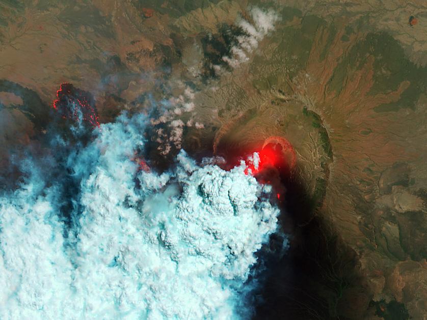
NASA image acquired June 24, 2011 Since it began erupting on June 12, 2011, emissions from Eritrea’s Nabro Volcano have drifted over much of East Africa and the Middle East. Ash has displaced residents living near the volcano and disrupted flights in the region. Despite the volcano’s widespread effects, little is known about the eruption. Nabro is located in an isolated region along the border between Eritrea and Ethiopia, and few English-language reports have been published. Satellite remote sensing is currently the only reliable way to monitor the ongoing eruption. This satellite image is among the first detailed pictures of the erupting vent and lava flows. They were acquired by the Advanced Land Imager (ALI) aboard the Earth Observing-1 (EO-1) satellite on June 24, 2011. The bright red portions of the false-color image (top) indicate hot surfaces. Hot volcanic ash glows above the vent, located in the center of Nabro’s caldera. To the west of the vent, portions of an active lava flow (particularly the front of the flow) are also hot. The speckled pattern on upstream portions of the flow are likely due to the cool, hardened crust splitting and exposing fluid lava as the flow advances. The bulbous blue-white cloud near the vent is likely composed largely of escaping water vapor that condensed as the plume rose and cooled. The whispy, cyan clouds above the lava flow are evidence of degassing from the lava. NASA Earth Observatory image by Robert Simmon, using EO-1 ALI data. Caption by Robert Simmon. Instrument: EO-1 - ALI To download the high res go here: <a href="http://earthobservatory.nasa.gov/IOTD/view.php?id=51216" rel="nofollow">earthobservatory.nasa.gov/IOTD/view.php?id=51216</a> <b><a href="http://www.nasa.gov/centers/goddard/home/index.html" rel="nofollow">NASA Goddard Space Flight Center</a></b> enables NASA’s mission through four scientific endeavors: Earth Science, Heliophysics, Solar System Exploration, and Astrophysics. Goddard plays a leading role in NASA’s accomplishments by contributing compelling scientific knowledge to advance the Agency’s mission. <b>Follow us on <a href="http://twitter.com/NASA_GoddardPix" rel="nofollow">Twitter</a></b> <b>Like us on <a href="http://www.facebook.com/pages/Greenbelt-MD/NASA-Goddard/395013845897?ref=tsd" rel="nofollow">Facebook</a></b> <b>Find us on <a href="http://web.stagram.com/n/nasagoddard/?vm=grid" rel="nofollow">Instagram</a></b>
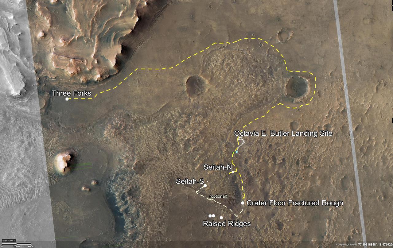
This annotated image of Mars' Jezero Crater depicts the route NASA's Perseverance rover will take during its first science campaign – as well as its path to the location of its second science campaign. The image was provided by the High Resolution Imaging Experiment (HiRISE) aboard NASA's Mars Reconnaissance orbiter. Perseverance's first science campaign sends the rover south and west of the Octavia E. Butler Landing Site to investigate and sample several of the deepest, and potentially oldest, accessible geologic units in Jezero Crater – the "Séítah" unit (which in Navajo language means "amidst the sand"), and the "Cratered Floor Fractured Rough." At the completion of the science campaign, Perseverance will return to the "Octavia E. Butler" landing site on its way north, then head west toward the location where its second science campaign will begin. The first science campaign (depicted with yellow hash marks) begins with the rover performing an arching drive southward from its landing site to Séítah-North (Séítah-N). At that point the rover will travel west a short distance to an overlook where it can view much of the Séítah unit. The "Séítah-N Overlook" could also become an area of scientific interest – with Perseverance performing a "toe dip" into the unit to collect remote-sensing measurements of geologic targets. Once its time at the Séítah-N Overlook is complete, Perseverance will head east, then south toward a spot where the science team can study the Crater Floor Fractured Rough in greater detail. The first core sample collected by the mission will also take place at this location. After Cratered Floor Fractured Rough, the Perseverance rover team will evaluate whether additional exploration (depicted with light-yellow hash marks) farther south – and then west – is warranted. Whether Perseverance travels beyond the Cratered Floor Fractured Rough during this first science campaign, the rover will eventually retrace its steps. As Perseverance passes the Octavia B. Butler landing site, the first science campaign will conclude. At that point, several months of travel lay ahead as Perseverance makes its way to "Three Forks," where the second science campaign will begin. From Three Forks, Perseverance can access geologic locations at the base of the ancient delta (the fan-shaped remains of the confluence of an ancient river and a lake), as well as ascend the delta by driving up a valley wall to the northwest. https://photojournal.jpl.nasa.gov/catalog/PIA24596
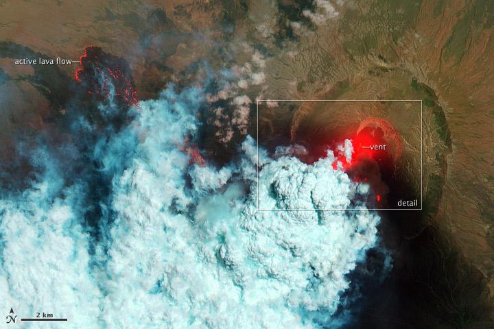
NASA image acquired June 24, 2011 Since it began erupting on June 12, 2011, emissions from Eritrea’s Nabro Volcano have drifted over much of East Africa and the Middle East. Ash has displaced residents living near the volcano and disrupted flights in the region. Despite the volcano’s widespread effects, little is known about the eruption. Nabro is located in an isolated region along the border between Eritrea and Ethiopia, and few English-language reports have been published. Satellite remote sensing is currently the only reliable way to monitor the ongoing eruption. This satellite image is among the first detailed pictures of the erupting vent and lava flows. They were acquired by the Advanced Land Imager (ALI) aboard the Earth Observing-1 (EO-1) satellite on June 24, 2011. The bright red portions of the false-color image (top) indicate hot surfaces. Hot volcanic ash glows above the vent, located in the center of Nabro’s caldera. To the west of the vent, portions of an active lava flow (particularly the front of the flow) are also hot. The speckled pattern on upstream portions of the flow are likely due to the cool, hardened crust splitting and exposing fluid lava as the flow advances. The bulbous blue-white cloud near the vent is likely composed largely of escaping water vapor that condensed as the plume rose and cooled. The whispy, cyan clouds above the lava flow are evidence of degassing from the lava. NASA Earth Observatory image by Robert Simmon, using EO-1 ALI data. Caption by Robert Simmon. Instrument: EO-1 - ALI To download the high res go here: <a href="http://earthobservatory.nasa.gov/IOTD/view.php?id=51216" rel="nofollow">earthobservatory.nasa.gov/IOTD/view.php?id=51216</a> <b><a href="http://www.nasa.gov/centers/goddard/home/index.html" rel="nofollow">NASA Goddard Space Flight Center</a></b> enables NASA’s mission through four scientific endeavors: Earth Science, Heliophysics, Solar System Exploration, and Astrophysics. Goddard plays a leading role in NASA’s accomplishments by contributing compelling scientific knowledge to advance the Agency’s mission. <b>Follow us on <a href="http://twitter.com/NASA_GoddardPix" rel="nofollow">Twitter</a></b> <b>Like us on <a href="http://www.facebook.com/pages/Greenbelt-MD/NASA-Goddard/395013845897?ref=tsd" rel="nofollow">Facebook</a></b> <b>Find us on <a href="http://web.stagram.com/n/nasagoddard/?vm=grid" rel="nofollow">Instagram</a></b>