A Look from LEISA
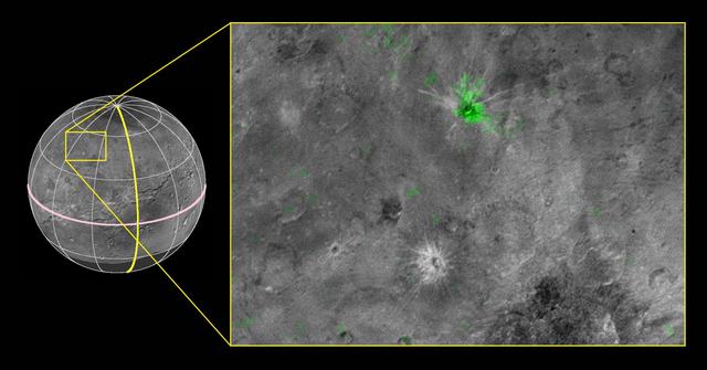
NASA's New Horizons scientists have discovered a striking contrast between one of the fresh craters on Pluto's largest moon Charon and a neighboring crater dotting the moon's Pluto-facing hemisphere. The crater, informally named Organa, caught scientists' attention as they were studying New Horizons' highest-resolution infrared compositional scan of Charon. Organa and portions of the surrounding material ejected from it show infrared absorption at wavelengths of about 2.2 microns, indicating that the crater is rich in frozen ammonia -- and, from what scientists have seen so far, unique on Pluto's largest moon. The infrared spectrum of nearby Skywalker crater, for example, is similar to the rest of Charon's craters and surface, with features dominated by ordinary water ice. This composite image is based on observations from the New Horizons Ralph/LEISA instrument made at 10:25 UT (6:25 a.m. EDT) on July 14, 2015, when New Horizons was 50,000 miles (81,000 kilometers) from Charon. The spatial resolution is 3 miles (5 kilometers) per pixel. The LEISA data were downlinked Oct. 1-4, 2015, and processed into a map of Charon's 2.2 micron ammonia-ice absorption band. Long Range Reconnaissance Imager (LORRI) panchromatic images used as the background in this composite were taken about 8:33 UT (4:33 a.m. EDT) July 14 at a resolution of 0.6 miles (0.9 kilometers) per pixel and downlinked Oct. 5-6. The ammonia absorption map from LEISA is shown in green on the LORRI image. The region covered by the yellow box is 174 miles across (280 kilometers). http://photojournal.jpl.nasa.gov/catalog/PIA20036
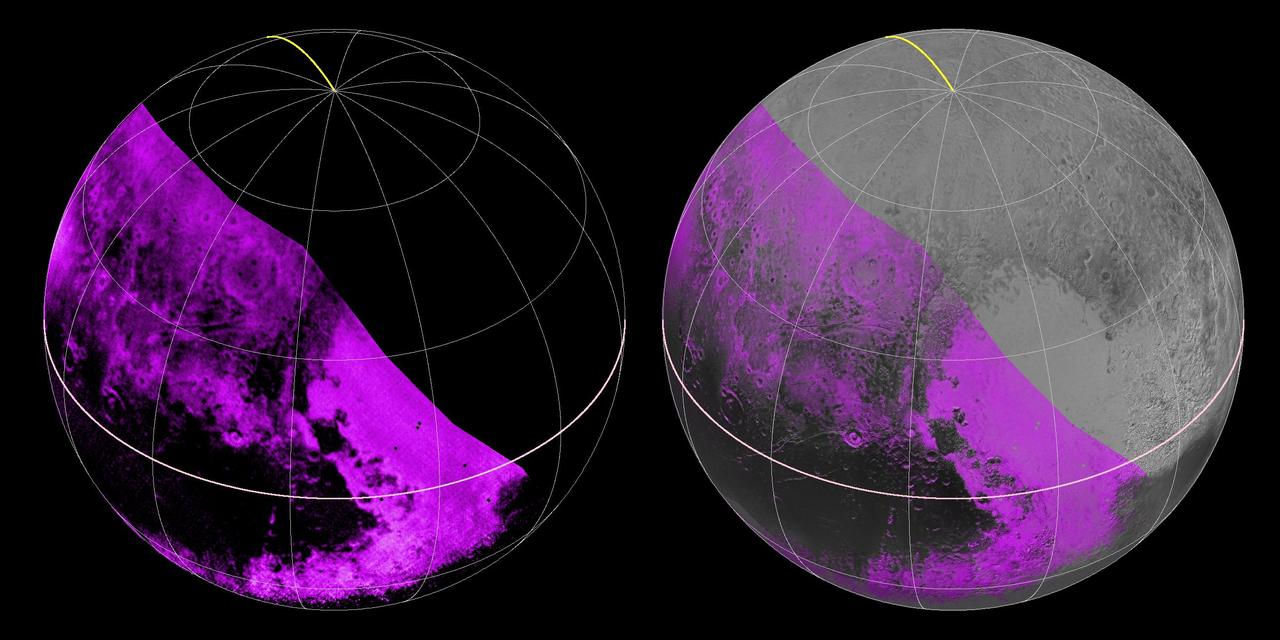
The Ralph/LEISA infrared spectrometer on NASA's New Horizons spacecraft mapped compositions across Pluto's surface as it flew past the planet on July 14, 2015. On the left, a map of methane ice abundance shows striking regional differences, with stronger methane absorption indicated by the brighter purple colors, and lower abundances shown in black. Data have only been received so far for the left half of Pluto's disk. At right, the methane map is merged with higher-resolution images from the spacecraft's Long Range Reconnaissance Imager (LORRI). http://photojournal.jpl.nasa.gov/catalog/PIA19953
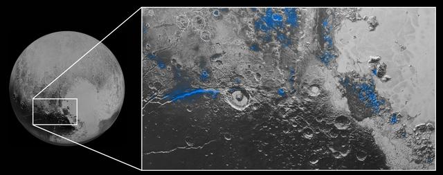
Regions with exposed water ice are highlighted in blue in this composite image from New Horizons' Ralph instrument, combining visible imagery from the Multispectral Visible Imaging Camera (MVIC) with infrared spectroscopy from the Linear Etalon Imaging Spectral Array (LEISA). The strongest signatures of water ice occur along Virgil Fossa, just west of Elliot crater on the left side of the inset image, and also in Viking Terra near the top of the frame. A major outcrop also occurs in Baré Montes towards the right of the image, along with numerous much smaller outcrops, mostly associated with impact craters and valleys between mountains. The scene is approximately 280 miles (450 kilometers) across. Note that all surface feature names are informal. http://ppj2:8080/catalog/PIA19963
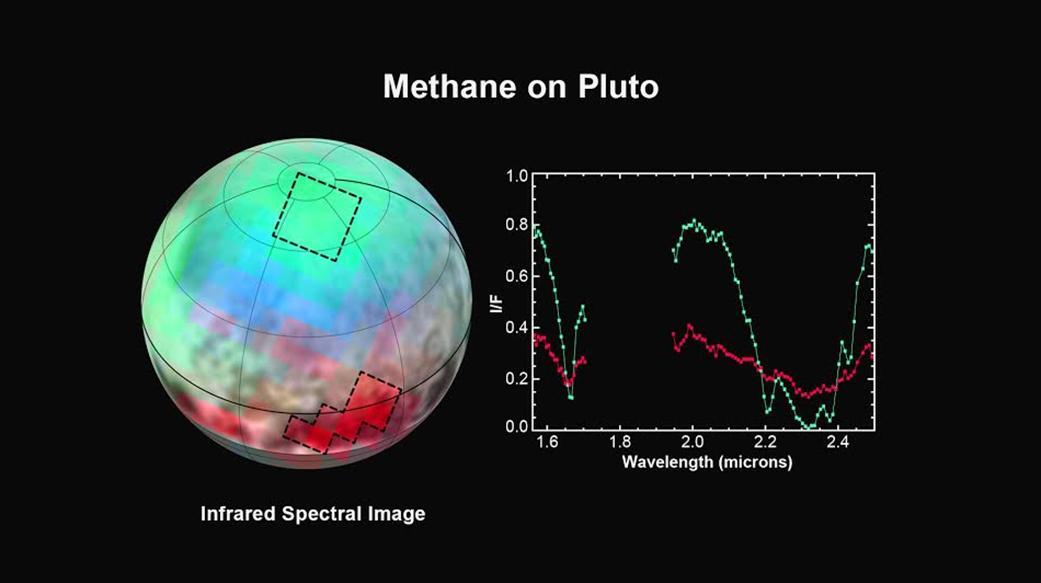
The latest spectra from New Horizons Ralph instrument reveal an abundance of methane ice, but with striking differences from place to place across the frozen surface of Pluto. In the north polar cap, methane ice is diluted in a thick, transparent slab of nitrogen ice resulting in strong absorption of infrared light. In one of the visually dark equatorial patches, the methane ice has shallower infrared absorptions indicative of a very different texture. An Earthly example of different textures of a frozen substance: a fluffy bank of clean snow is bright white, but compacted polar ice looks blue. New Horizons' surface composition team has begun the intricate process of analyzing Ralph data to determine the detailed compositions of the distinct regions on Pluto. This is the first detailed image of Pluto from the Linear Etalon Imaging Spectral Array, part of the Ralph instrument on New Horizons. The observations were made at three wavelengths of infrared light, which are invisible to the human eye. In this picture, blue corresponds to light of wavelengths 1.62 to 1.70 micrometers, a channel covering a medium-strong absorption band of methane ice, green (1.97 to 2.05 micrometers) represents a channel where methane ice does not absorb light, and red (2.30 to 2.33 micrometers) is a channel where the light is very heavily absorbed by methane ice. The two areas outlined on Pluto show where Ralph observations obtained the spectral traces at the right. Note that the methane absorptions (notable dips) in the spectrum from the northern region are much deeper than the dips in the spectrum from the dark patch. The Ralph data were obtained by New Horizons on July 12, 2015. http://photojournal.jpl.nasa.gov/catalog/PIA19712
This high-resolution swat of Pluto sweeps over the cratered plains at the west of the New Horizons' encounter hemisphere and across numerous prominent faults, skimming the eastern margin of the dark, forbidding region informally known as Cthulhu Regio, and finally passing over the mysterious, possibly cryovolcanic edifice Wright Mons, before reaching the terminator or day-night line. Among the many notable details shown are the overlapping and infilling relationships between units of the relatively smooth, bright volatile ices from Sputnik Planum (at the edge of the mosaic) and the dark edge or "shore" of Cthulhu. The pictures in this mosaic were taken by the Long Range Reconnaissance Imager (LORRI) in "ride-along" mode with the LEISA spectrometer, which accounts for the 'zigzag' or step pattern. Taken shortly before New Horizons' July 14 closest approach to Pluto, details as small as 500 yards (500 meters) can be seen. http://photojournal.jpl.nasa.gov/catalog/PIA20286
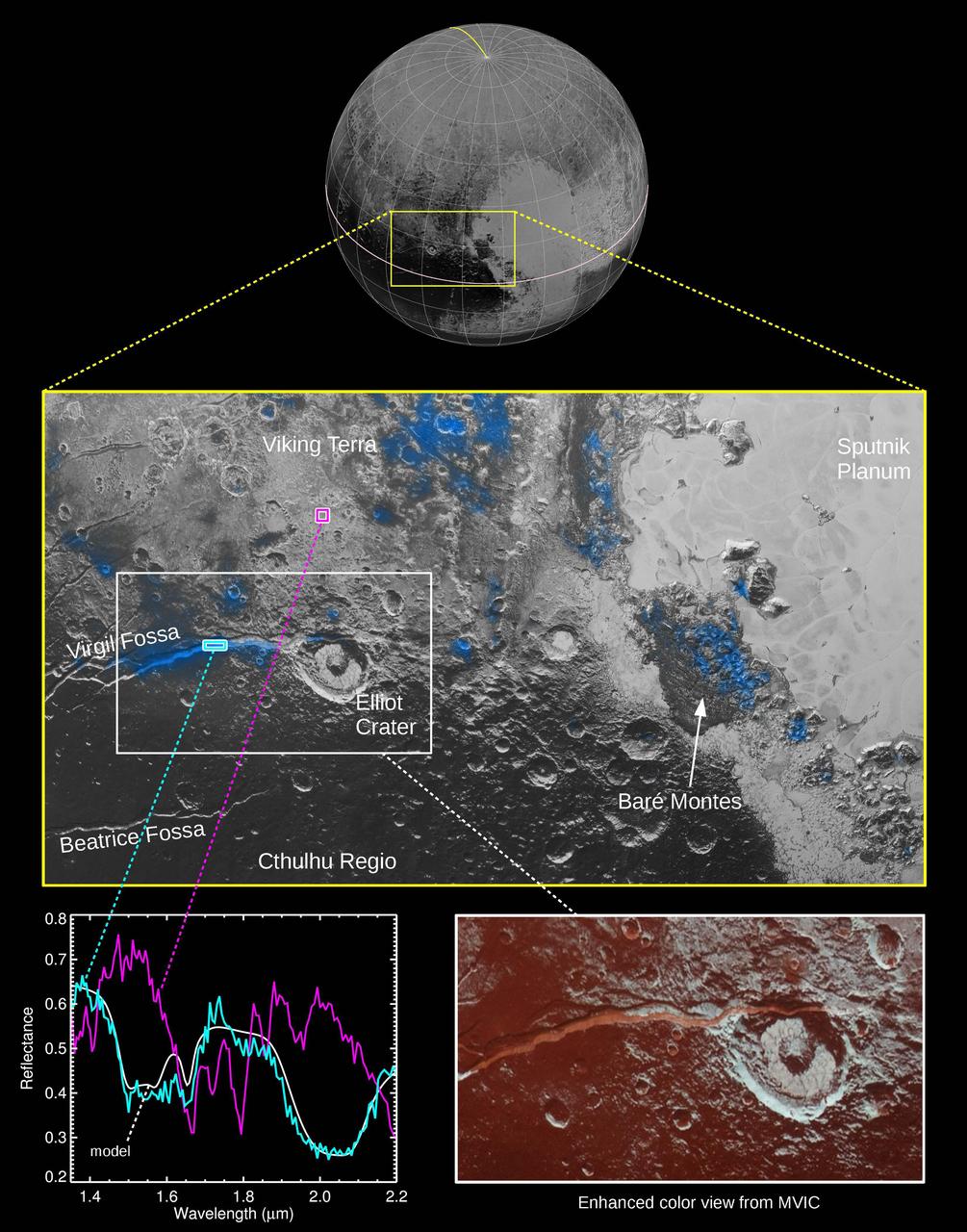
The Ralph instrument on NASA's New Horizons spacecraft detected water ice on Pluto's surface, picking up on the ice's near-infrared spectral characteristics. (See featured image from Oct. 8, 2015.) The middle panel shows a region west of Pluto's "heart" feature -- which the mission team calls Tombaugh Regio -- about 280 miles (450 kilometers) across. It combines visible imagery from Ralph's Multispectral Visible Imaging Camera (MVIC) with infrared spectroscopy from the Linear Etalon Imaging Spectral Array (LEISA). Areas with the strongest water ice spectral signature are highlighted in blue. Major outcrops of water ice occur in regions informally called Viking Terra, along Virgil Fossa west of Elliot crater, and in Baré Montes. Numerous smaller outcrops are associated with impact craters and valleys between mountains. In the lower left panel, LEISA spectra are shown for two regions indicated by cyan and magenta boxes. The white curve is a water ice model spectrum, showing similar features to the cyan spectrum. The magenta spectrum is dominated by methane ice absorptions. The lower right panel shows an MVIC enhanced color view of the region in the white box, with MVIC's blue, red and near-infrared filters displayed in blue, green and red channels, respectively. The regions showing the strongest water ice signature are associated with terrains that are actually a lighter shade of red. http://photojournal.jpl.nasa.gov/catalog/PIA20030
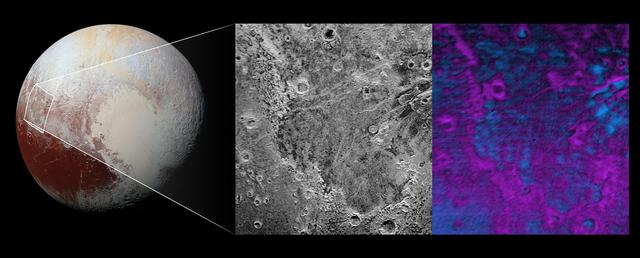
Scientists on NASA's New Horizons mission have discovered what looks like a giant bite-mark on the planet's surface. In this image, north is up. The southern portion of the left inset above shows the cratered plateau uplands informally named Vega Terra (note that all feature names are informal). This terrain is separated from the young, nearly uncratered, mottled plains of Piri Planitia in the center of the image by a generally north-facing jagged scarp called Piri Rupes. The scarp breaks up into isolated mesas in several places. Cutting diagonally across Piri Planitia is the long extensional fault of Inanna Fossa, which stretches eastward 370 miles (600 kilometers) from here to the western edge of the great nitrogen ice plains of Sputnik Planum. Compositional data from the New Horizons spacecraft's Ralph/Linear Etalon Imaging Spectral Array (LEISA) instrument, shown in the right inset, indicate that the plateau uplands south of Piri Rupes are rich in methane ice (shown in false color as purple). Scientists speculate that sublimation of methane may be causing the plateau material to erode along the face of the scarp cliffs, causing them to retreat south and leave the plains of Piri Planitia in their wake. Compositional data also show that the surface of Piri Planitia is more enriched in water ice (shown in false color as blue) than the plateau uplands, which may indicate that Piri Planitia's surface is made of water ice bedrock, on top of which the layer of retreating methane ice had been sitting. Because the surface of Pluto is so cold, the water ice behaves like rock and is immobile. The light/dark mottled pattern of Piri Planitia in the left inset is reflected in the composition map, with the lighter areas corresponding to areas richer in methane – these may be remnants of methane that have not yet sublimated away entirely. The inset at left shows about 650 feet (200 meters) per pixel; the image measures approximately 280 miles (450 kilometers) long by 255 miles (410 kilometers) wide. It was obtained by New Horizons at a range of approximately 21,100 miles (33,900 kilometers) from Pluto, about 45 minutes before the spacecraft's closest approach to Pluto on July 14, 2015.The LEISA data at right was gathered when the spacecraft was about 29,000 miles (47,000 kilometers) from Pluto; best resolution is 1.7 miles (2.7 kilometers) per pixel. http://photojournal.jpl.nasa.gov/catalog/PIA20531