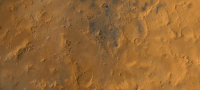
A Regional View of the Libya Montes
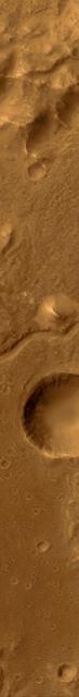
A Valley in the Libya Montes
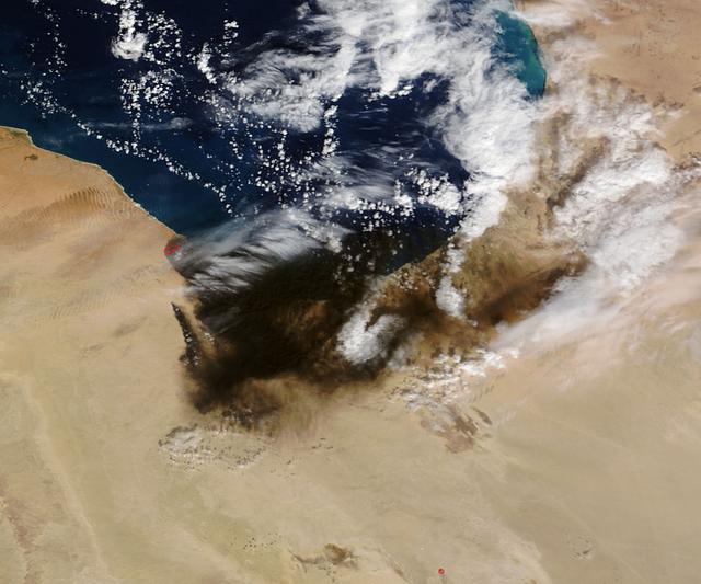
The oil refinery fires in Libya that were started by attacks on oil terminals in Libya in very early January continue. The stream of black smoke that emanates from the refinery has grown tremendously as the fires caused by the initial shelling have spread to giant storage tanks. These fires are reported to be raging in Sidra, on the coast between Sirte and Benghazi. Actively burning areas, detected by MODIS’s thermal bands, are outlined in red. The initial image of the fires taken on January 07, 2016 can be found here for comparison: <a href="http://www.nasa.gov/image-feature/goddard/2016/terra-captures-images-of-oil-fires-in-libya" rel="nofollow">www.nasa.gov/image-feature/goddard/2016/terra-captures-im...</a> NASA image courtesy Jeff Schmaltz, MODIS Rapid Response Team <b><a href="http://www.nasa.gov/audience/formedia/features/MP_Photo_Guidelines.html" rel="nofollow">NASA image use policy.</a></b> <b><a href="http://www.nasa.gov/centers/goddard/home/index.html" rel="nofollow">NASA Goddard Space Flight Center</a></b> enables NASA’s mission through four scientific endeavors: Earth Science, Heliophysics, Solar System Exploration, and Astrophysics. Goddard plays a leading role in NASA’s accomplishments by contributing compelling scientific knowledge to advance the Agency’s mission. <b>Follow us on <a href="http://twitter.com/NASAGoddardPix" rel="nofollow">Twitter</a></b> <b>Like us on <a href="http://www.facebook.com/pages/Greenbelt-MD/NASA-Goddard/395013845897?ref=tsd" rel="nofollow">Facebook</a></b> <b>Find us on <a href="http://instagrid.me/nasagoddard/?vm=grid" rel="nofollow">Instagram</a></b>
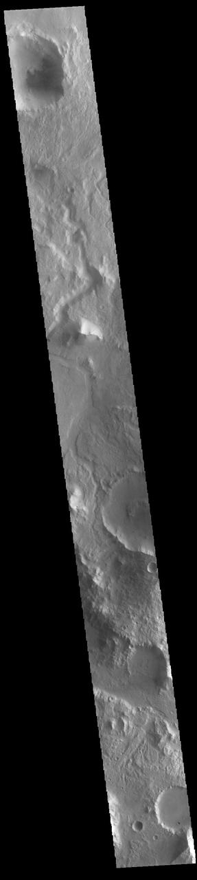
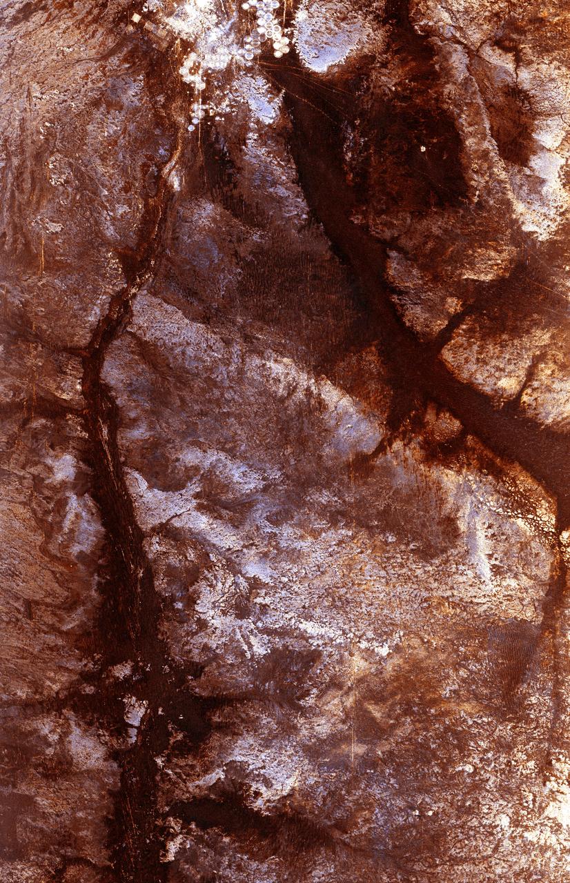
Today's VIS image shows an unnamed channel in Libya Montes. Libya Montes are south of Isidis Planitia, and are remnants of the crater rim created by the Isidis meteor impact. Orbit Number: 85899 Latitude: 2.26071 Longitude: 84.8385 Instrument: VIS Captured: 2021-04-26 05:34 https://photojournal.jpl.nasa.gov/catalog/PIA24886
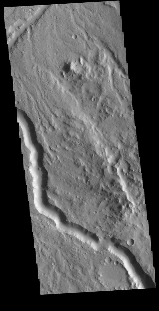
Today's VIS image shows a section of unnamed channel in Libya Montes. Libya Montes are south of Isidis Planitia, and are remnants of the crater rim created by the Isidis meteor impact. Orbit Number: 80795 Latitude: 0.708331 Longitude: 89.3586 Instrument: VIS Captured: 2020-03-01 23:28 https://photojournal.jpl.nasa.gov/catalog/PIA23904

AST-02-130 (20 July 1975) --- An oblique view of a portion of Libya and the Arab Republic of Egypt, as photographed from the Apollo spacecraft in Earth orbit during the joint U.S.-USSR Apollo-Soyuz Test Project mission. The geological features are the Jebel Uweinat and Jebel Arkenu basaltic mountains in the Libyan sand sea. This picture was taken with a 70mm Hasselblad camera using medium-speed Ektachrome QX-807 type film. The spacecraft was at an altitude of 219 kilometers (136 statute miles).
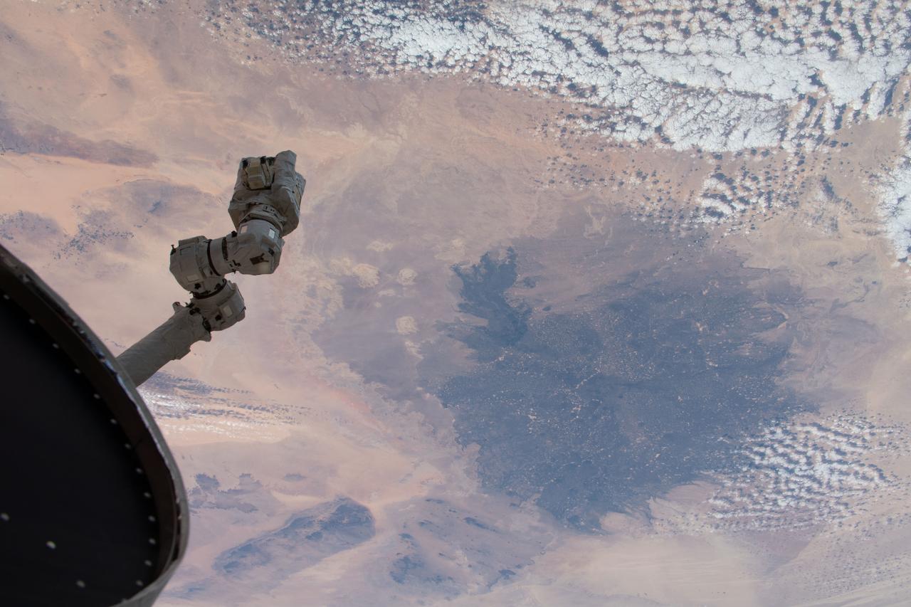
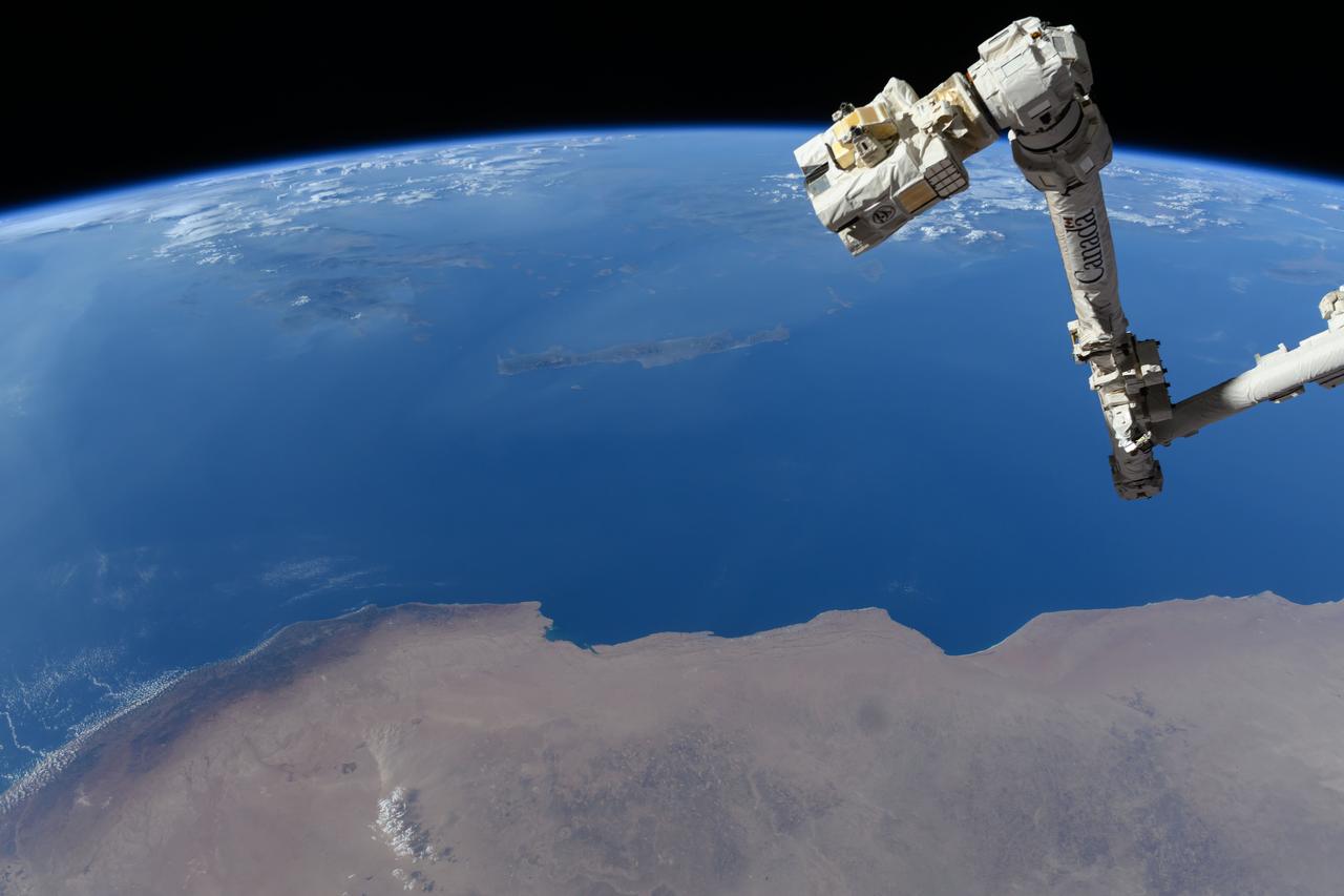
iss058e000174 (Dec. 23, 2018) --- The International Space Station's robotic arm, Canadarm2, seemingly reaches out to the North African nation of Libya and the Sahara 251 miles below.
STS054-152-189 (13-19 Jan. 1993) --- This near-vertical color photograph shows the very diverse landscape that is part of the great Sahara Desert of north Africa. Specifically, the vast expanse of sand dunes, located in the extreme southwestern corner of Libya, is known as the Murzuk Sand Sea. Close inspection of this photograph shows the agricultural village of Murzuk as evidenced by the numerous center pivot irrigation patterns at the edge of the Murzuk Sand Sea. The very rugged, dissected terrain to the west of this sand sea is the eastern tip of the Tassili N'ajjer Mountains and the Tadrart Plateau that are in neighboring Algeria. Several smaller areas of sand dunes are interspersed between the major areas of rock outcrops. The photograph was taken with a Linhof camera.
This image by NASA Mars Odyssey spacecraft shows the rugged cratered highland region of Libya Montes, which forms part of the rim of an ancient impact basin called Isidis. This region of the highlands is fairly dissected with valley networks. There is still debate within the scientific community as to how valley networks themselves form: surface runoff (rainfall/snowmelt) or headward erosion via groundwater sapping. The degree of dissection here in this region suggests surface runoff rather than groundwater sapping. Small dunes are also visible on the floors of some of these channels. http://photojournal.jpl.nasa.gov/catalog/PIA04008

In the far southeast corner of Libya, in the Libyan Desert, lie the uplifted massifs of Jebel Awenat and Jebel Arkenu. Both expose ancient Precambrian rocks, intruded by granites, and then overlain with sandstones. Folding and doming have produced these interesting shapes, rising above the surrounding sand sea. Presently, the area receives less than one inch of rain per year. Thousands of years ago, rainfall was more plentiful, and the Jebels were occupied by people, as attested by the numerous rock drawings. The images were acquired July 19, 2012, and July 31, 2013, cover an area of 66 by 67 kilometers, and are located at 22.1 degrees north, 24.8 degrees east. https://photojournal.jpl.nasa.gov/catalog/PIA22283
iss071e384199 (July 17, 2024) --- The Canadarm2 robotic arm's latching end effector, or LEE, is used to grapple fixtures on the International Space Station, as well as capture the approaching Cygnus cargo craft from Northrop Grumman and attach it to the Unity module for cargo transfer operations. 256 miles below the outpost is the Mediterranean coast of Libya and Egypt and the Greek island of Crete.
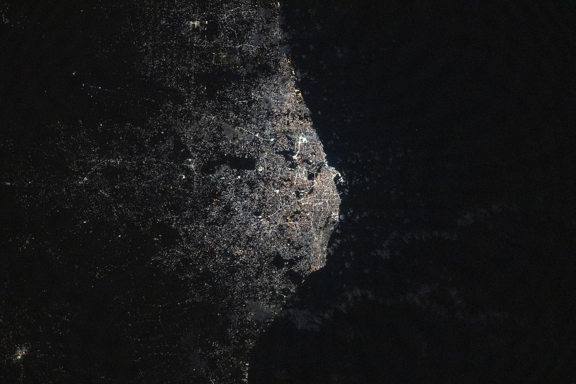
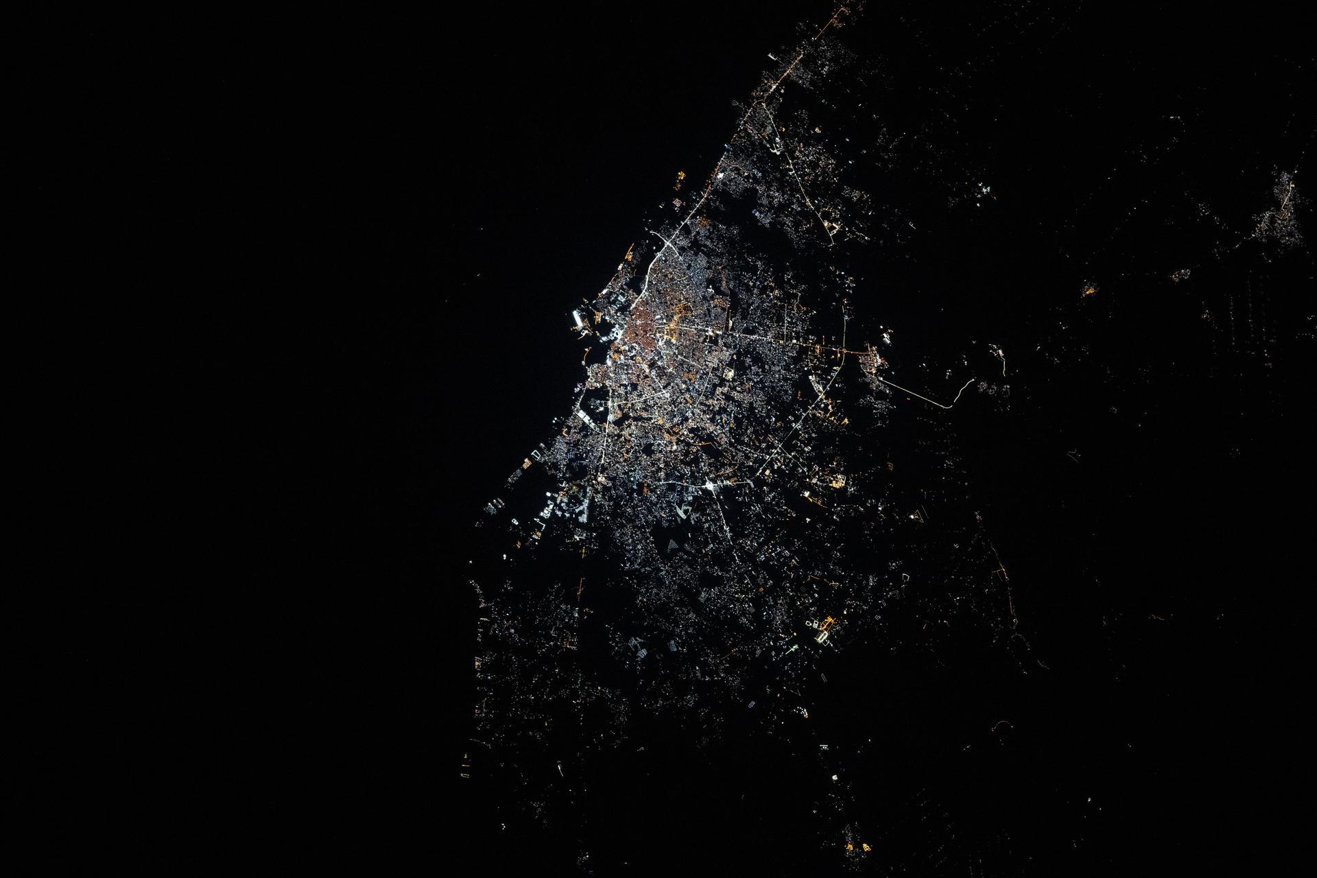
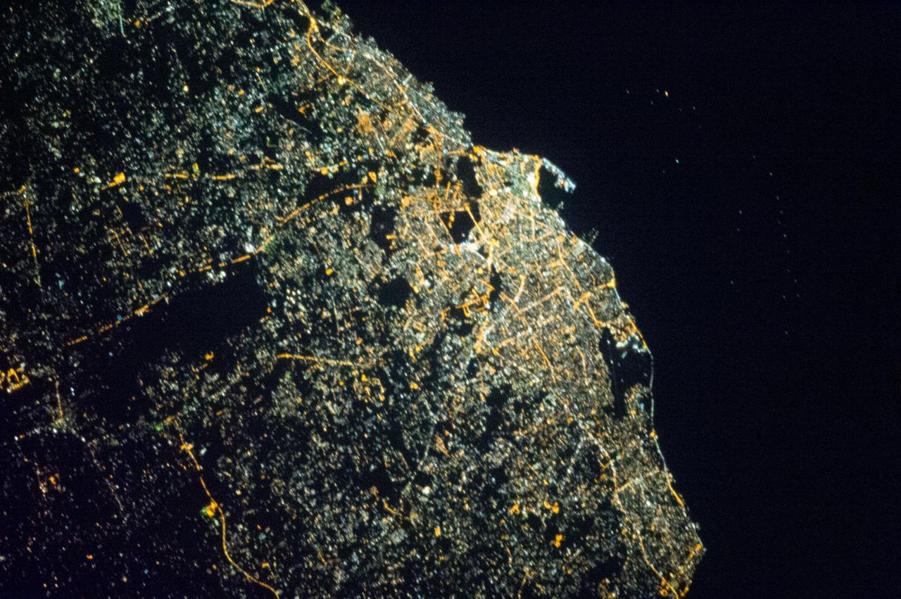
iss073e1047001 (Nov. 2, 2025) --- Tripoli, Libya—a city founded approximately 2,700 years ago on the Mediterranean Sea coast—is pictured at about 11:10 p.m. local time from the International Space Station as it orbited 259 miles above the African nation. The city’s modern, cool white lights reflect a major transition to LED and solar-powered LED lighting, part of efforts to modernize urban design, enhance safety, and support tourism infrastructure.
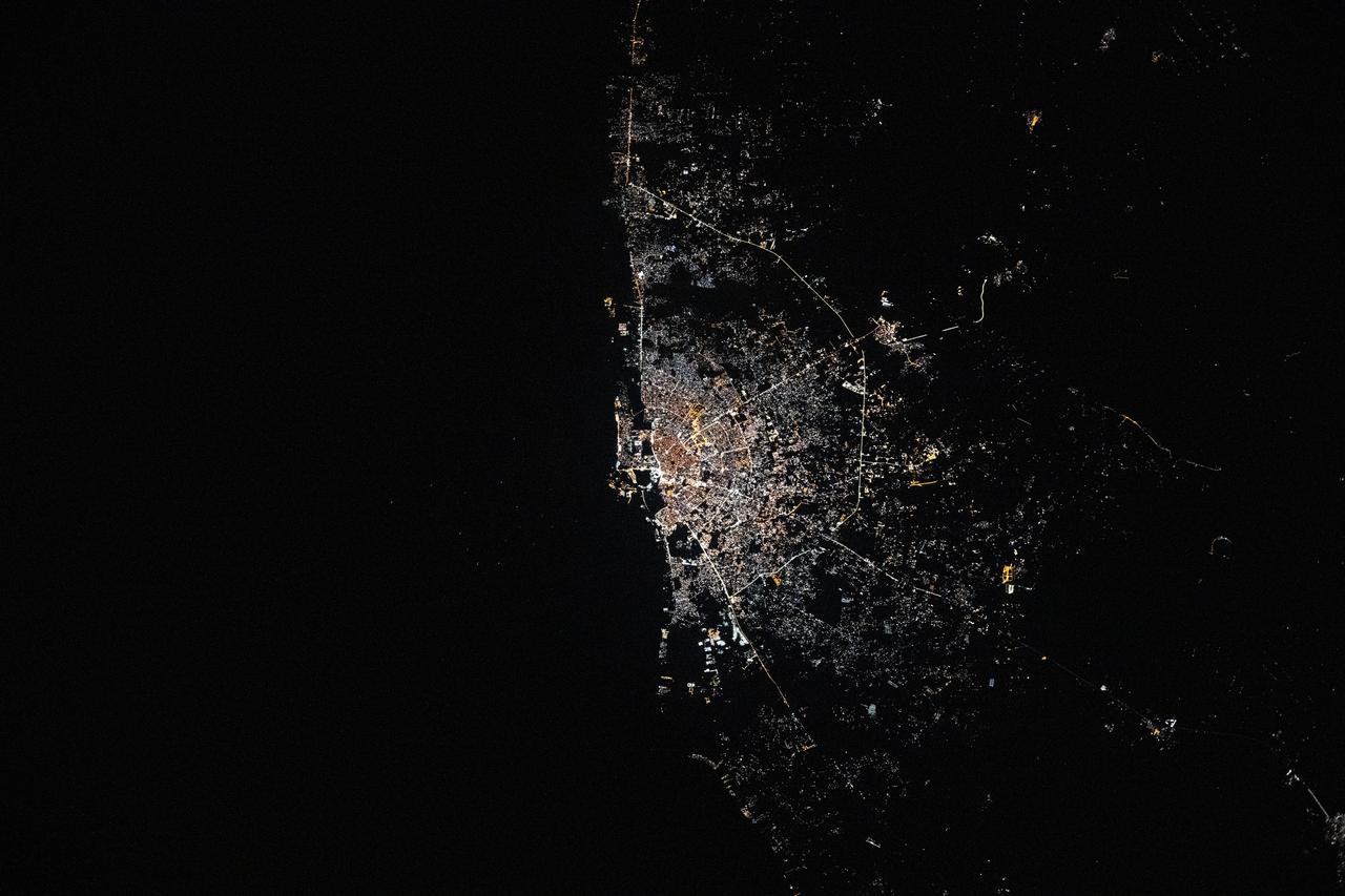
iss073e0120318 (May 18, 2025) --- Benghazi, Libya, the north African nation's second most-populous city on the Mediterranean coast with a population of about 859,000, is pictured at approximately 12:49 a.m. local time from the International Space Station as it orbited 260 miles above.
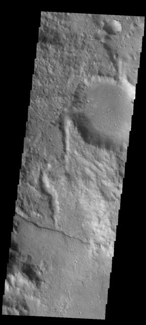
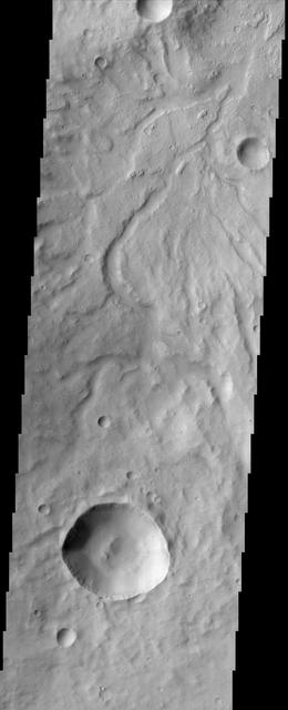
This image captured by NASA 2001 Mars Odyssey spacecraft shows a channel entering a crater in the region called Libya Montes.
iss074e0149410 (Jan. 17, 2026) --- Benghazi, Libya’s second-largest city, with a metropolitan population of over 890,000, shines with bright, modern city lights that trace its urban landscape on the country’s Mediterranean coastline. The International Space Station was orbiting 262 miles above at approximately 12:37 a.m. local time when this photograph was taken. Credit: NASA/Chris Williams
The ability of a sophisticated radar instrument to image large regions of the world from space, using different frequencies that can penetrate dry sand cover, produced the discovery in this image: a previously unknown branch of an ancient river, buried under thousands of years of windblown sand in a region of the Sahara Desert in North Africa. This area is near the Kufra Oasis in southeast Libya, centered at 23.3 degrees north latitude, 22.9 degrees east longitude. The image was acquired by the Spaceborne Imaging Radar-C/X-band Synthetic Aperture (SIR-C/X-SAR) imaging radar when it flew aboard the space shuttle Endeavour on its 60th orbit on October 4, 1994. This SIR-C image reveals a system of old, now inactive stream valleys, called "paleodrainage systems, http://photojournal.jpl.nasa.gov/catalog/PIA01310
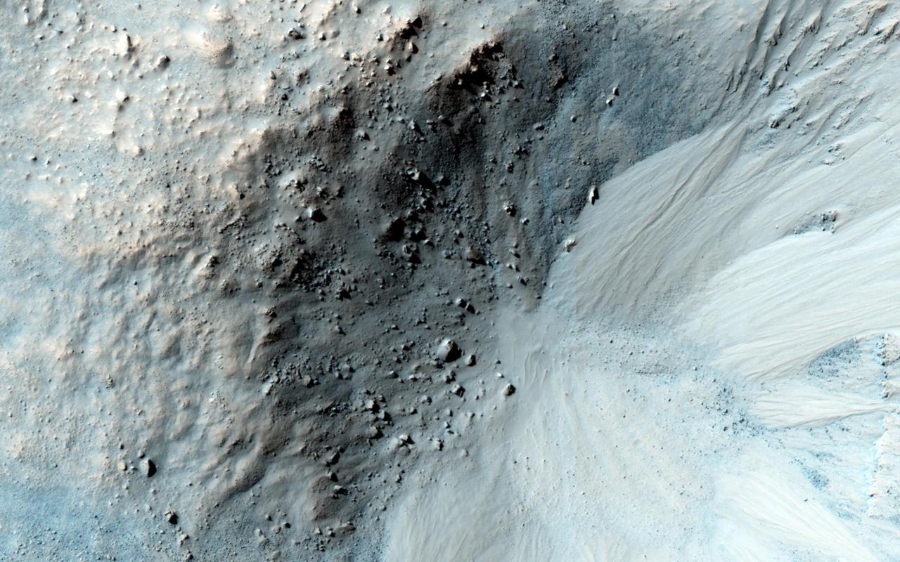
This impact crater in the region of Mars called Libya Montes, observed by NASA Mars Reconnaissance Orbiter, shows typical gullies with alcoves at the top, channels, and depositional fans at the bottom.
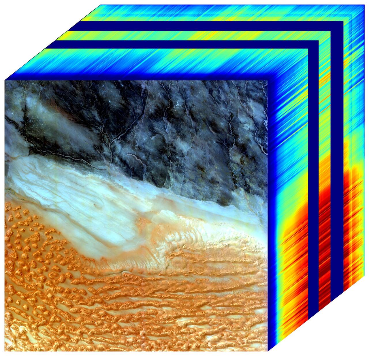
The front panel of this image cube features the true-color view of an area in southwest Libya observed by NASA's Earth Surface Mineral Dust Source Investigation (EMIT) imaging spectrometer, which orbits the planet aboard the International Space Station. The side panels depict the spectral fingerprint for every point in the image, which shows an area about 500 miles (800 kilometers) south of Tripoli. The instrument works by measuring reflected solar energy from Earth across hundreds of wavelengths, from the visible to the infrared range of the spectrum. The intensity of the reflected light varies by wavelength based on the material. Scientists use these patterns, called spectral fingerprints, to identify surface minerals and pinpoint their locations on a map. The cube is among the first created by scientists with EMIT data. Analysis of the patterns indicated that the surface contains kaolinite, a light-colored clay mineral, and goethite and hematite, two varieties of iron oxide, which is darker. When dust from the kaolinite-dominated areas is lofted into the atmosphere, the particles tend to scatter sunlight and reflect it back to space, cooling the air. The opposite effect occurs with airborne particles of iron oxide, which tend to absorb heat and warm the surrounding air. Over the course of its 12-month mission, EMIT will collect measurements of 10 important surface minerals – kaolinite, hematite, goethite, illite, vermiculite, calcite, dolomite, montmorillonite, chlorite, and gypsum – in arid regions between 50-degree south and north latitudes in Africa, Asia, North and South America, and Australia. The data EMIT collects will help scientists better understand the role of airborne dust particles in heating and cooling Earth's atmosphere on global and regional scales. https://photojournal.jpl.nasa.gov/catalog/PIA25430
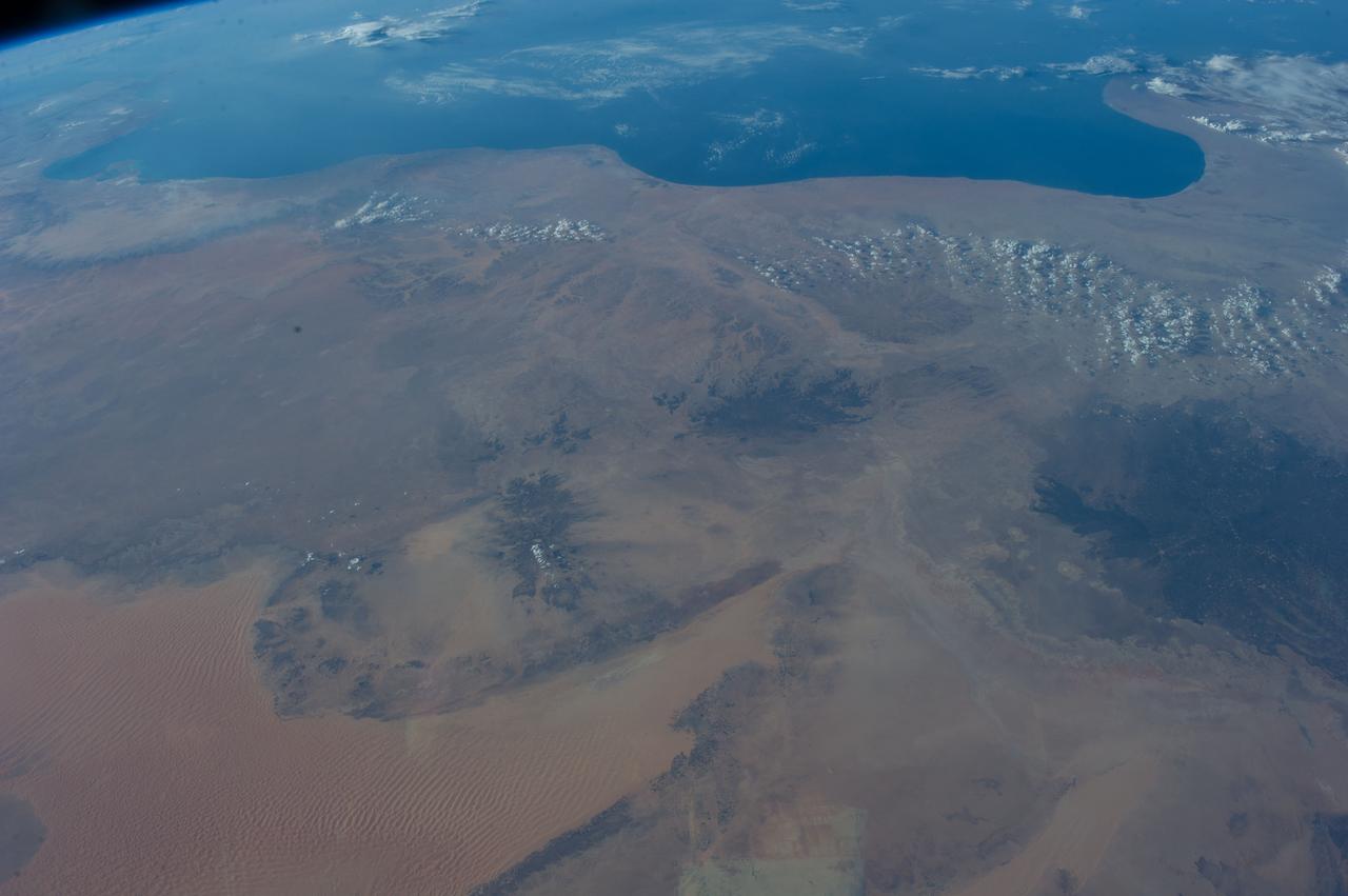
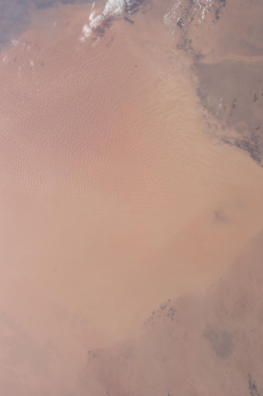
Earth observation taken during a day pass by the Expedition 37 crew. Per Twitter message: Southwest Libya to the Mediterranean coast.
Earth observation taken during a day pass by the Expedition 40 crew aboard the International Space Station. File identifies it as: Sahara, and Libya.
Earth observation taken during a day pass by the Expedition 40 crew aboard the International Space Station. File identifies it as: Sahara, and Libya.
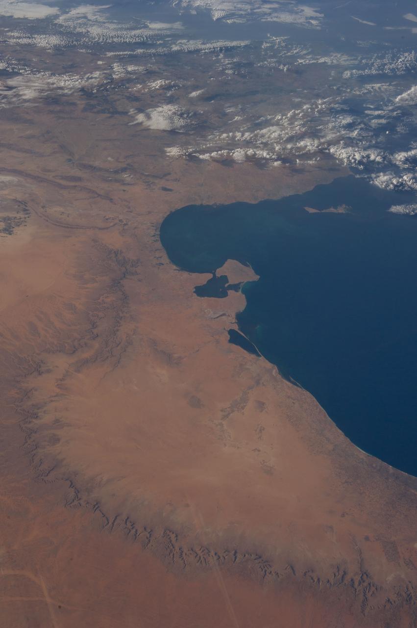
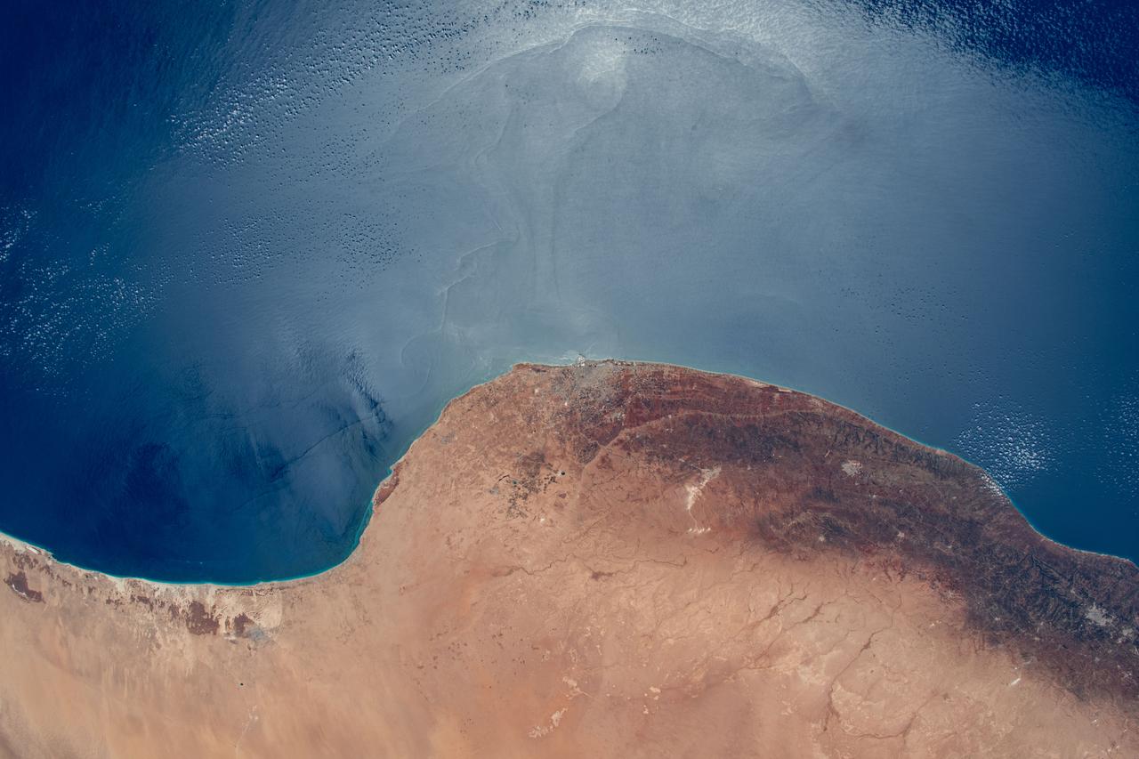
iss066e137420 (Feb. 7, 2022) --- The northwest coast of the African nation of Libya is pictured from the International Space Station as it orbited 259 miles above the Mediterranean Sea.
Earth observation taken during a day pass by the Expedition 40 crew aboard the International Space Station. File identifies it as: Sahara, and Libya.
Earth observation taken during a day pass by the Expedition 40 crew aboard the International Space Station. File identifies it as: Sahara, and Libya.
iss064e029454 (Feb. 5, 2021) --- The International Space Station was flying 261 miles above the Sahara Desert when this photograph was taken of the Murzuq District in central Libya.
Earth observation taken during a day pass by the Expedition 40 crew aboard the International Space Station. File identifies it as: Sahara, and Libya.
Earth observation taken during a day pass by the Expedition 37 crew. Per Twitter message: Mediterranean coast of Tunisia & northwest Libya.
Earth observation taken during a day pass by the Expedition 40 crew aboard the International Space Station. File identifies it as: Sahara, and Libya.
Earth observation taken during day pass by an Expedition 36 crew member on board the International Space Station (ISS). Per Twitter message: Looking southwest over northern Africa. Libya, Algeria, Niger.
ISS043E182380 (05/08/2015) --- NASA astronaut Scott Kelly aboard the International Space Station captured this desert scene in northern Africa on May 8th, 2015. The area shown is the Calanscio Sand Sea, in northeastern Libya.
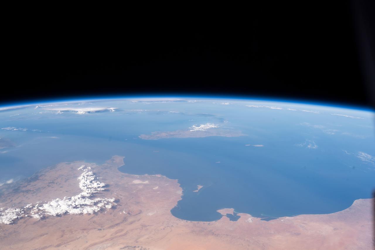
iss060e014848 (July 26, 2019) --- The Mediterranean coasts of Tunisia and Libya and the Italian island of Sicily across the sea are pictured as the International Space Station orbited 260 miles above north Africa.
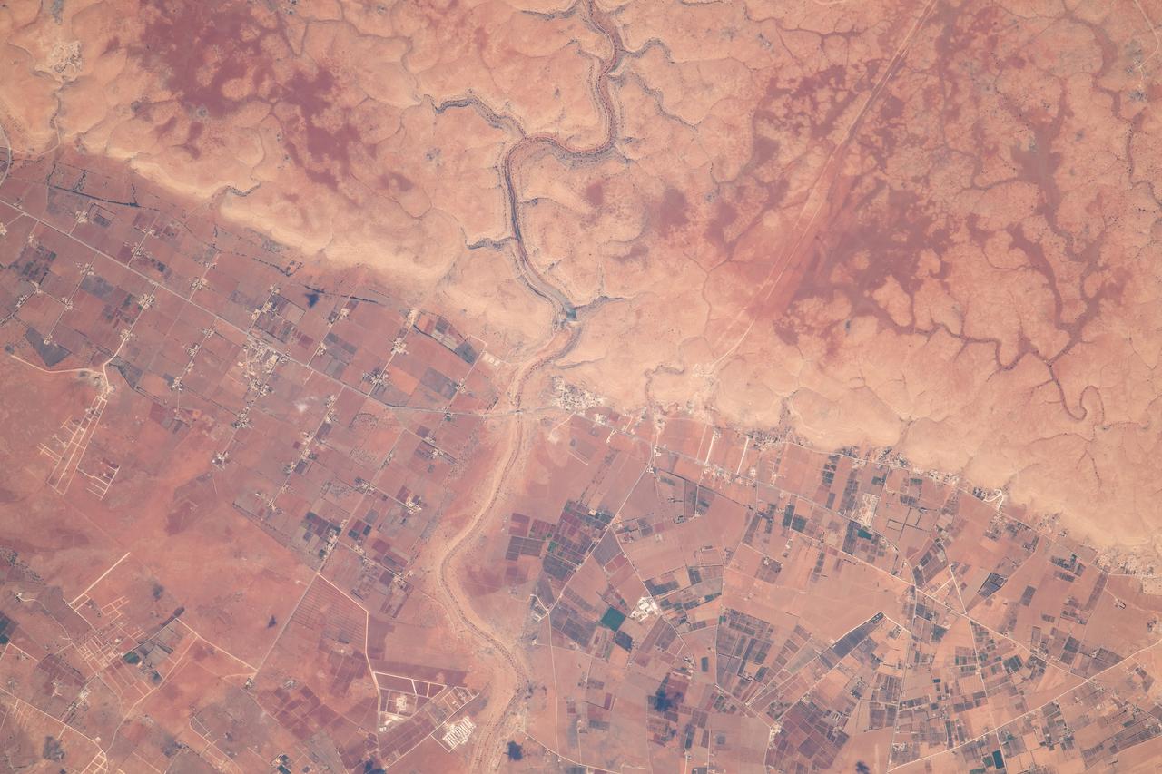
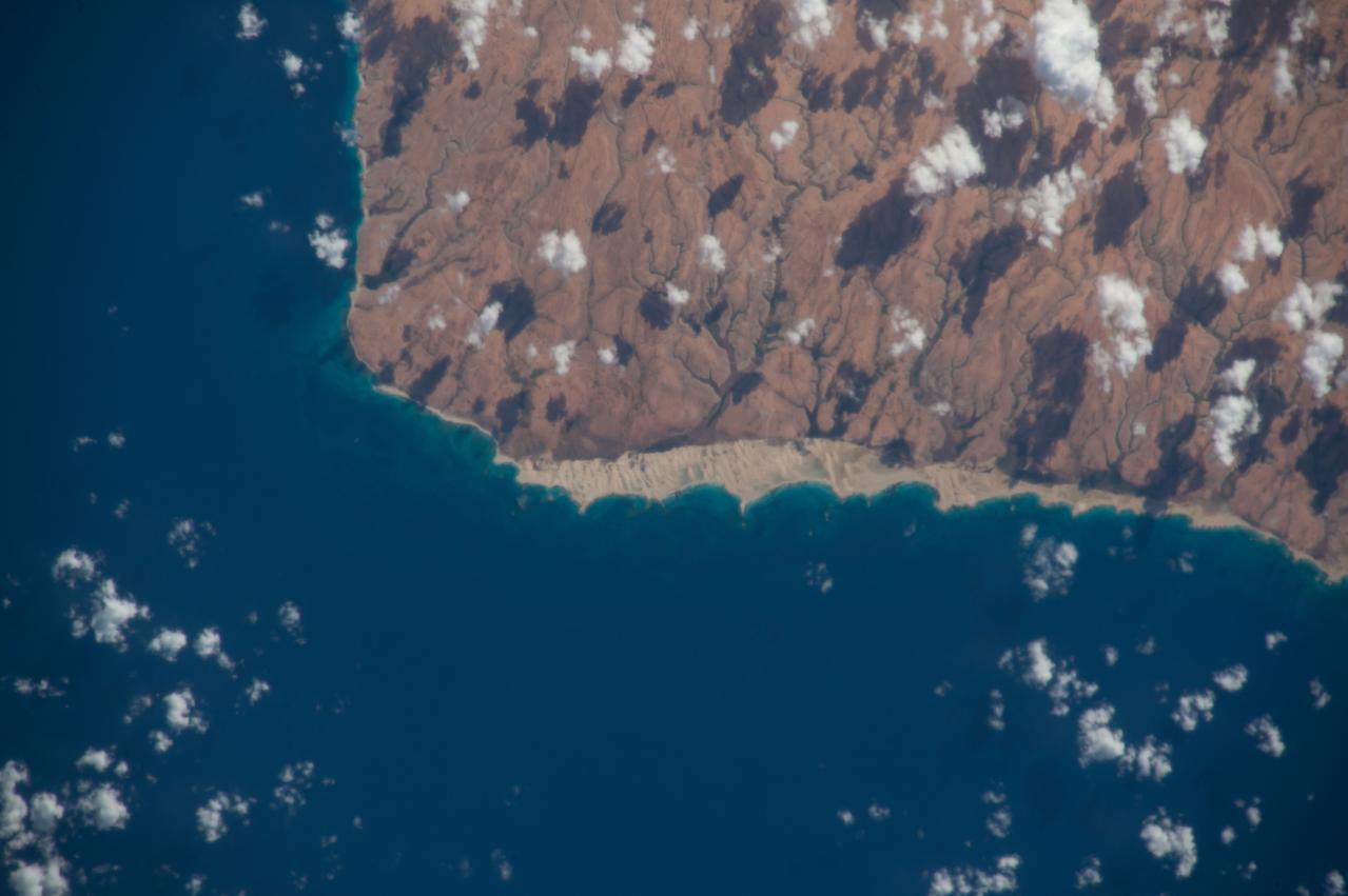
iss069e061443 (Aug. 17, 2023) --- Wadi al Qattarah, containing an agricultural zone, grazing land, and a dam, is located southeast of Benghazi, Libya, in this photograph from the International Space Station as it orbited 263 miles above the Mediterranean Sea.
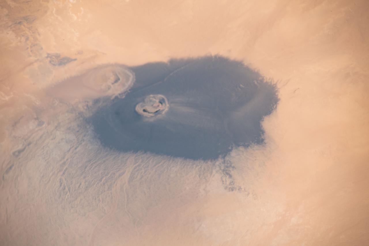
iss065e009516 (April 29, 2021) --- The isolated volcanic crater Waw an Namus in Libya with three small saltwater lakes is pictured from the International Space Station as it orbited 263 miles above the Sahara Desert.
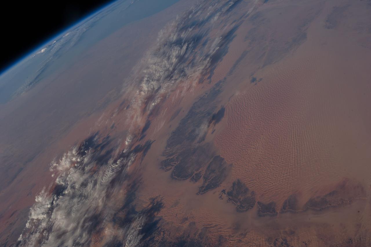
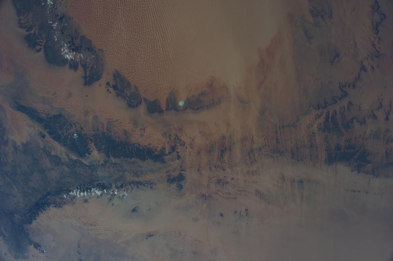
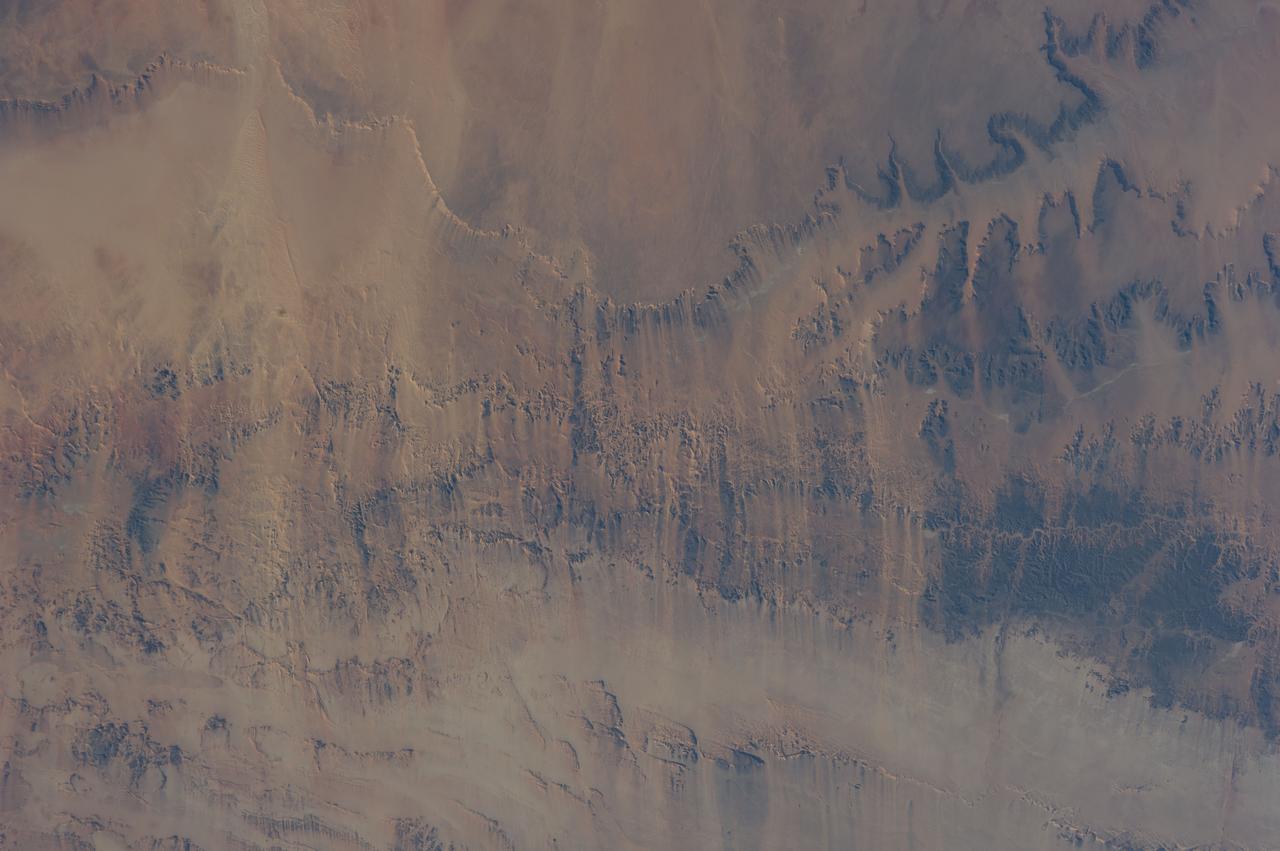
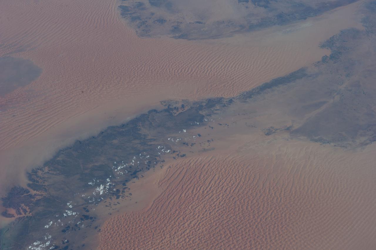
iss067e141205 (June 19, 2022) --- This portion of the Western Desert is an area of the Sahara where the borders of Egypt, Libya, and Sudan meet. The International Space Station was orbiting 259 miles above north Africa at the time of this photograph.
iss067e123244 (June 10, 2022) --- A portion of the Sahara in Libya's northwestern district of Nalut is pictured from the International Space Station as it orbited 260 miles above the north African nation.
iss072e065377 (Oct. 17, 2024) --- The borders of three African nations, Libya, Sudan, and Egypt, meet in the eastern portion of the Sahara in this photograph from the International Space Station as it orbited 258 miles above.
iss065e009521 (April 29, 2021) --- Mount Arkanu in southeast Libya, near the border with Egypt and Sudan, is pictured from the International Space Station as it orbited 262 miles above the Sahara Desert.
Earth Observation taken during a day pass by the Expedition 37 crew aboard the International Space Station (ISS). Per Twitter message: Northern Chad, looking north across Libya.
ISS042E275158 (02/15/2015) --- US Astronaut Terry Virts tweeted this earth observation from the International Space Station on Feb. 15, 2015. Virts described the image as "#EarthArt northeast #Libya.
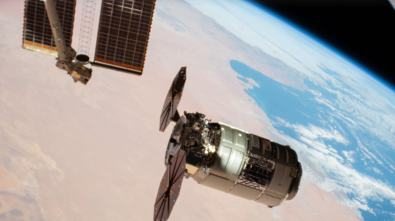
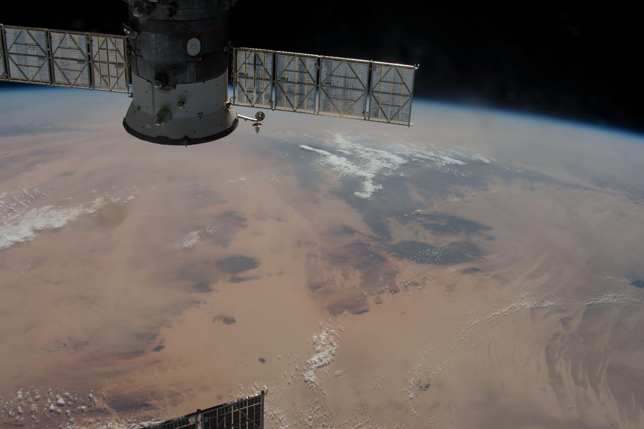
iss070e085743 (Feb. 1, 2024) --- Northrop Grumman's Cygnus space freighter, packed with more than 8,200 pounds of science experiments, crew supplies, and station hardware, arrives at its capture point for installation to the International Space Station's Unity module. Both spacecraft were orbiting 260 miles above the Libya at the time of this photograph.
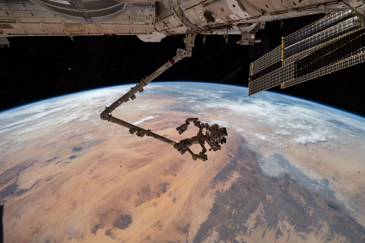
iss073e0546366 (Aug. 27, 2025) --- The International Space Station's 57.7-foot-long robotic arm, Canadarm2, with its fine-tuned robotic hand, Dextre, attached is pictured extending from the International Space Station's Harmony module. The orbital outpost was soaring 260 miles above the Saharan Desert in Libya at the time of this photograph.
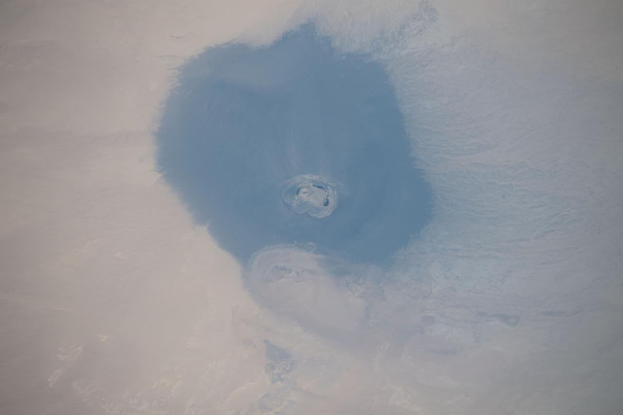
iss059e119235 (June 20, 2019) --- The International Space Station was orbiting 256 miles above the north African country of Libya when an Expedition 59 crewmember photographed the isolated volcanic crater of Waw an Namus, which is composed of dark ash and features three small saltwater lakes.

iss059e006519 (March 31, 2019) --- The Soyuz MS-12 spacecraft is pictured docked to the International Space Station's Rassvet module as the orbital complex flew 256 miles above the Aegean Sea. This view looks from northeast to southwest, from Greece across the Mediterranean Sea to Libya.
ISS042E243192 (02/11/2015) --- This huge Desert in northern Africa is an image tweeted by NASA astronaut Terry Virts on Feb. 11, 2015 from the International Space Station. He wanted to share with his Twitter fans the enormous size of the " Murzuq Desert #Libya #Africa".
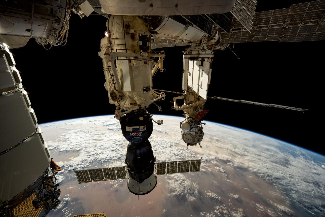
iss072e032692 (Oct. 8, 2024) --- The Soyuz MS-26 crew ship (foreground) from Roscosmos is pictured docked to the International Space Station's Rassvet module. In the background, the Prichal docking module is pictured attached to the Nauka science module with the European robotic arm connected to it. 261 miles below the orbiting laboratory is the African nation of Libya.
ISS042E275153 (02/15/2015) --- Expedition 42 Flight Engineer Terry Virts on the International Space Station tweeted his followers this earth observation image on Feb. 15, 2015. He commented that it was "Extensive #Africa desert of #Libya and #Chad".
iss073e0178560 (June 14, 2025) --- The leaf-shaped Faiyum Oasis, fed by a channel of the River Nile and bordered on the west by the saltwater Qarum Lake with the Wadi El Rayan nature reserve to its southwest, is pictured from the International Space Station as it orbited 260 miles above the Libya-Egypt border.
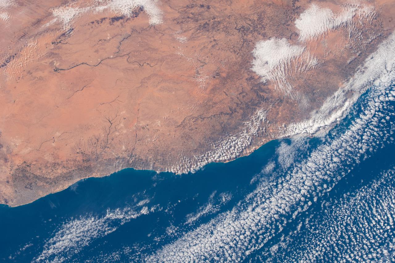
iss069e053975 (Aug. 4, 2023) --- The sun's glint and the deep blue waters of the Mediterranean Sea stand in stark contrast to the desert coast of Libya in this photograph from the International Space Station as it orbited 260 miles above. Benghazi, a city of 1.2 million people, is at center in the African nation's arid region in between its desert and temperate climates.
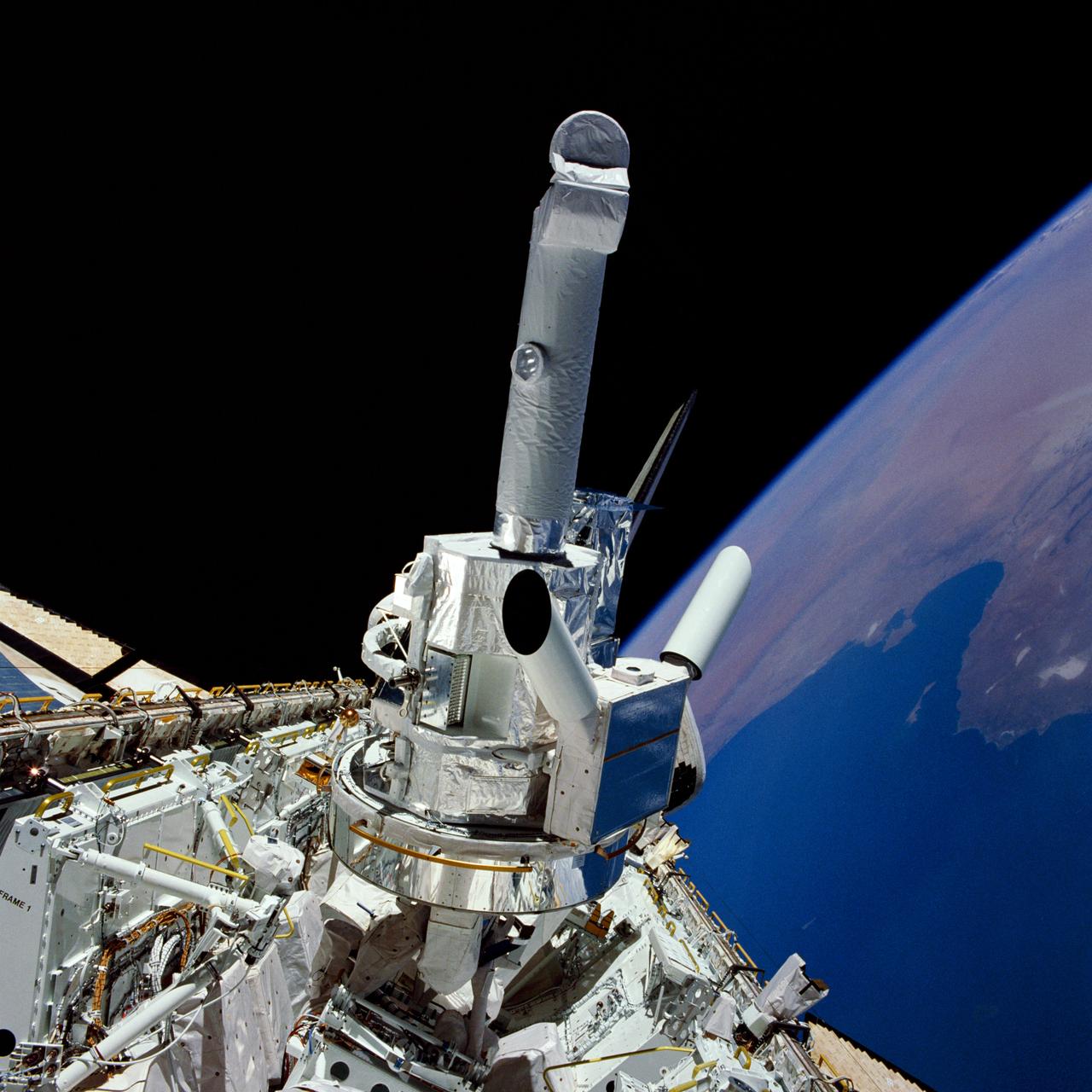
51F-33-005 (29 July - 6 August 1985) --- Experiments and the instrument pointing system (IPS) for Spacelab 2 are backdropped against the Libya/Tunisia Mediterranean coast and black space in this 70mm view photographed through the aft flight deck windows of the Space Shuttle Challenger. Also partially visible among the cluster of Spacelab 2 hardware are the solar optical universal polarimeter (SOUP) experiment and the coronal helium abundance experiment (CHASE).
iss073e0312086 (May 22, 2025) --- At top left, the city lights of Benghazi, Libya, arc downward toward the glow of civilization on Egypt's Nile Delta outlining Africa's Mediterranean Sea coast. Israel's metropolitan lights then round north and east into Istanbul, Turkey (far right), and Athens, Greece, and their surrounding suburbs in southern Europe. Resting in the center of the Mediterranean's darkness is the Greek island of Crete.
ISS035-E-023422 (18 April 2013) --- One of the Expedition 35 crew members aboard the Earth-orbiting International Space Station photographed this night image of Tripoli, Libya on April 18, 2013. The spacecraft was orbiting approximately 215 miles above a point centered at 32.3 degrees north latitude and 11.8 degrees east longitude.
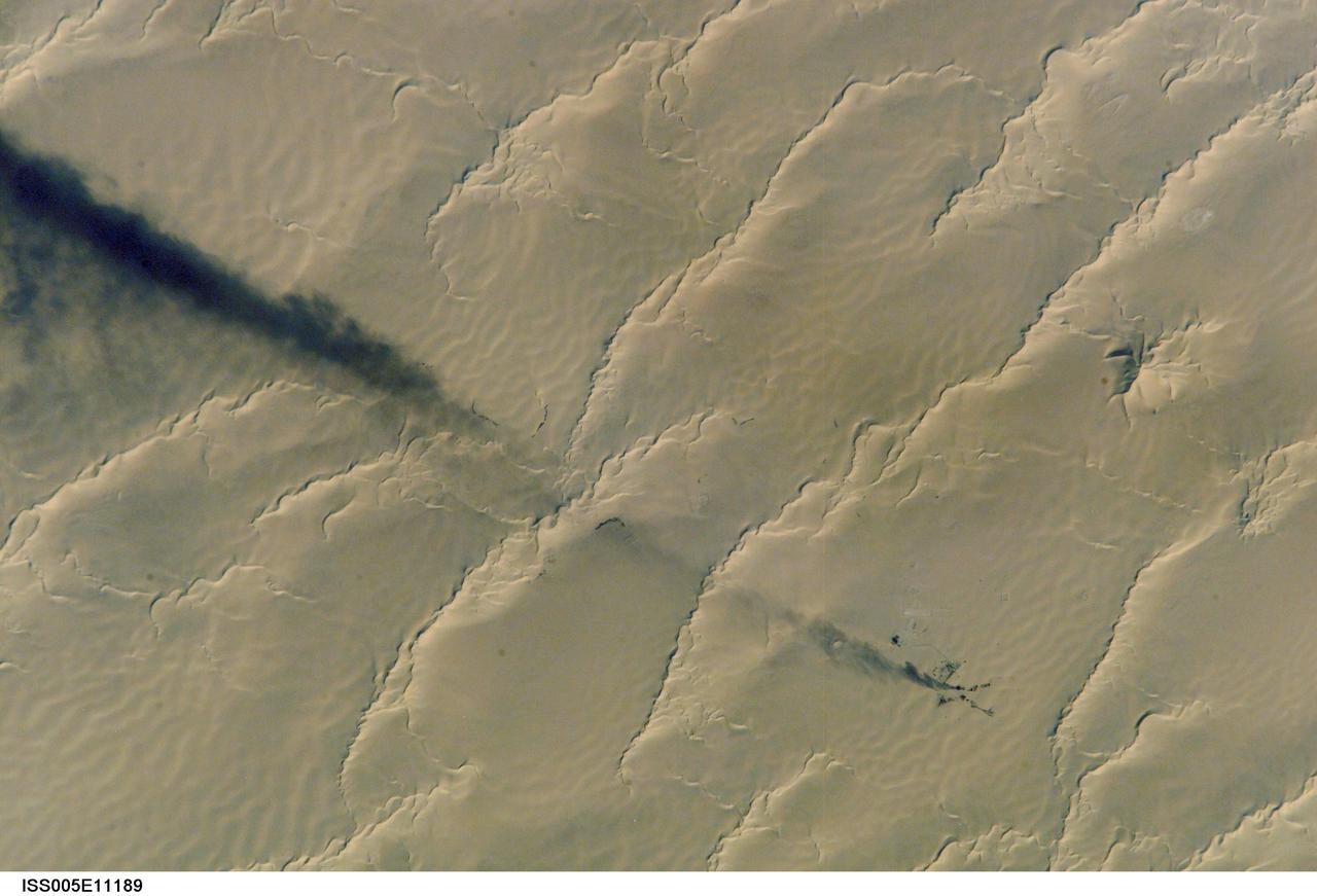
ISS005-E-11189 (25 August 2002) --- Calanscio Sand Sea, Libya is featured in this digital image photographed by an Expedition 5 crewmember on the International Space Station (ISS). A plume of black smoke blowing westward is silhouetted against yellow linear dunes in the great sand sea of northeast Libya. Smoke from flares at remote well heads is commonly seen by astronauts flying over the Sahara Desert. NASA scientists studying the Station imagery had the following observations about the image. The plume dispersal pattern visible at the left edge of the image may be due to upper-level winds or gravitational settling of heavier particulates. The regular pattern of linear dunes is generated by two major winds: the dominant north wind (north is towards the top right) determines the orientation of the sand dunes. Gentler easterly winds, as were blowing when this view was taken, make the dunes asymmetric, with a gentle windward (west) slope and an over steeped downwind slope. Some over steepened slopes even cast shadows in the early morning light. One mound of sand (top right), due north of the well head, does not fit the pattern of linear dunes. This type is known as a star dune.
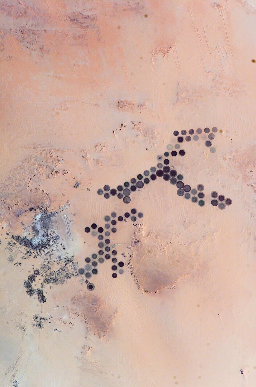
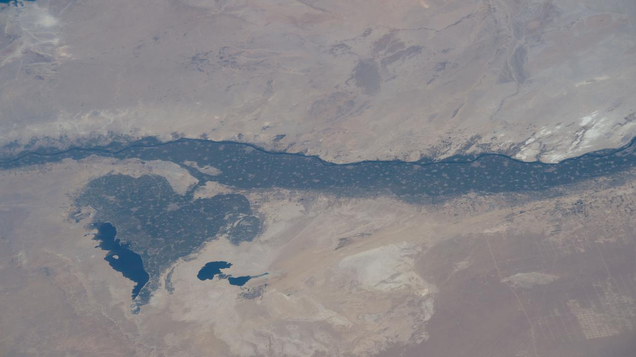
ISS010-E-05266 (28 October 2004) --- The Al Khufrah Oasis is featured in this image photographed by an Expedition 10 crewmember on the International Space Station (ISS). Green circles in the desert frequently indicate tracts of agriculture supported by center-pivot irrigation. The Al Khufrah Oasis in southeastern Libya (near the Egyptian border) is one of Libya’s largest agricultural projects, and is an easy-to-recognize landmark for orbiting crewmembers aboard the Station. The center-pivot irrigation system pumps water under pressure into a gantry or tubular arm from a central source. Anchored by a central pivot, the gantry slowly rotates over the area to be irrigated, thereby producing the circular patterns. Although the field diameters vary, these fields are approximately 0.6 mile (1 kilometer) in diameter. Darker colors indicate fields where such crops as wheat and alfalfa are grown. Lighter colors can indicate a variety of agricultural processes: fields that have been harvested recently; fields that are lying fallow; fields that have just been planted; or fields that have been taken out of production.
iss071e414023 (Aug. 2, 2024) --- The sun's glint beams off the Gulf of Gabes on the coast of Tunisia with Sharqi Island in the Mediterranean Sea in this photograph taken from the International Space Station as it orbited 262 miles above the African nation.
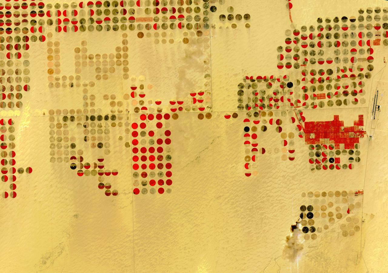
The Nubian Sandstone Aquifer System is the world's largest fossil water aquifer system. It covers an estimated area of 2.6 million square kilometers, including parts of Sudan, Chad, Libya, and most of Egypt. In the southwestern part of Egypt, the East Oweinat development project uses central pivot irrigation to mine the fossil water for extensive agricultural development. Crops include wheat and potatoes; they are transported via the airport on the eastern side. The image was acquired October 12, 2015, covers an area of 33.3 by 47.2 km, and is located near 22.6 degrees north, 28.5 degrees east. https://photojournal.jpl.nasa.gov/catalog/PIA24616
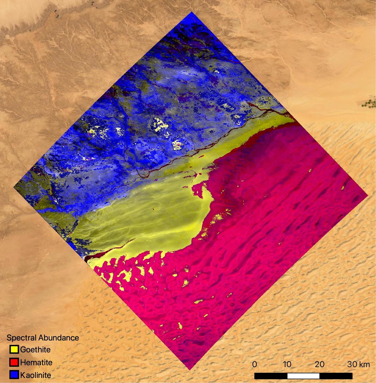
The mineral map shows an area of southwestern Libya in the Sahara Desert observed by NASA's Earth Surface Mineral Dust Source Investigation (EMIT) mission as it maps the world's mineral dust sources, gathering information about surface composition as the instrument, designed at NASA's Jet Propulsion Laboratory in Southern California, orbits aboard the International Space Station. The instrument works by measuring reflected solar energy from Earth across hundreds of wavelengths from the visible to the infrared range of the spectrum. The intensity of the reflected light varies by wavelength based on the material. Scientists are using these patterns, called spectral fingerprints, to identify surface minerals and pinpoint their locations on a map. The map is among the first produced by scientists with EMIT data. Analysis of the patterns indicate that the surface contains kaolinite, a light-colored clay mineral, and goethite and hematite, two varieties of iron oxide, which is darker. When dust from the kaolinite-dominated areas is lofted into the atmosphere, the particles tend to scatter sunlight and reflect it back to space, cooling the air. The opposite effect occurs with airborne particles of iron oxide, which tend to absorb heat and warm the surrounding air. Over the course of its 12-month mission, EMIT will collect measurements of 10 important surface minerals – kaolinite, hematite, goethite, illite, vermiculite, calcite, dolomite, montmorillonite, chlorite, and gypsum – in arid regions between 50-degree south and north latitudes in Africa, Asia, North and South America, and Australia. The data EMIT collects will help scientists better understand the role of airborne dust particles in heating and cooling Earth's atmosphere on global and regional scales. EMIT was developed at NASA's Jet Propulsion Laboratory, which is managed for the agency by Caltech in Pasadena, California. It launched to the space station in July 2022. https://photojournal.jpl.nasa.gov/catalog/PIA25424
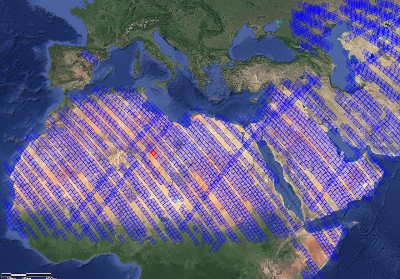
This image shows locations in parts of North Africa, Europe, the Middle East, and Central Asia observed by NASA's Earth Surface Mineral Dust Source Investigation (EMIT). Each blue box is a "scene" the instrument, which is aboard the International Space Station, has captured. The red box indicates where the instrument recently gathered data on three minerals in a location in southwest Libya, in the Sahara Desert. Installed on the space station in July 2022, EMIT orbits Earth about once every 90 minutes to map the world's mineral-dust sources, gathering information about surface composition as the instrument completes about 16 orbits per day. Over the course of its 12-month mission, EMIT will collect measurements of 10 important surface minerals – kaolinite, hematite, goethite, illite, vermiculite, calcite, dolomite, montmorillonite, chlorite, and gypsum – in arid regions between 50-degree south and north latitudes in Africa, Asia, North and South America, and Australia. The data EMIT collects will help scientists better understand the role of airborne dust particles in heating and cooling Earth's atmosphere on global and regional scales. https://photojournal.jpl.nasa.gov/catalog/PIA25429
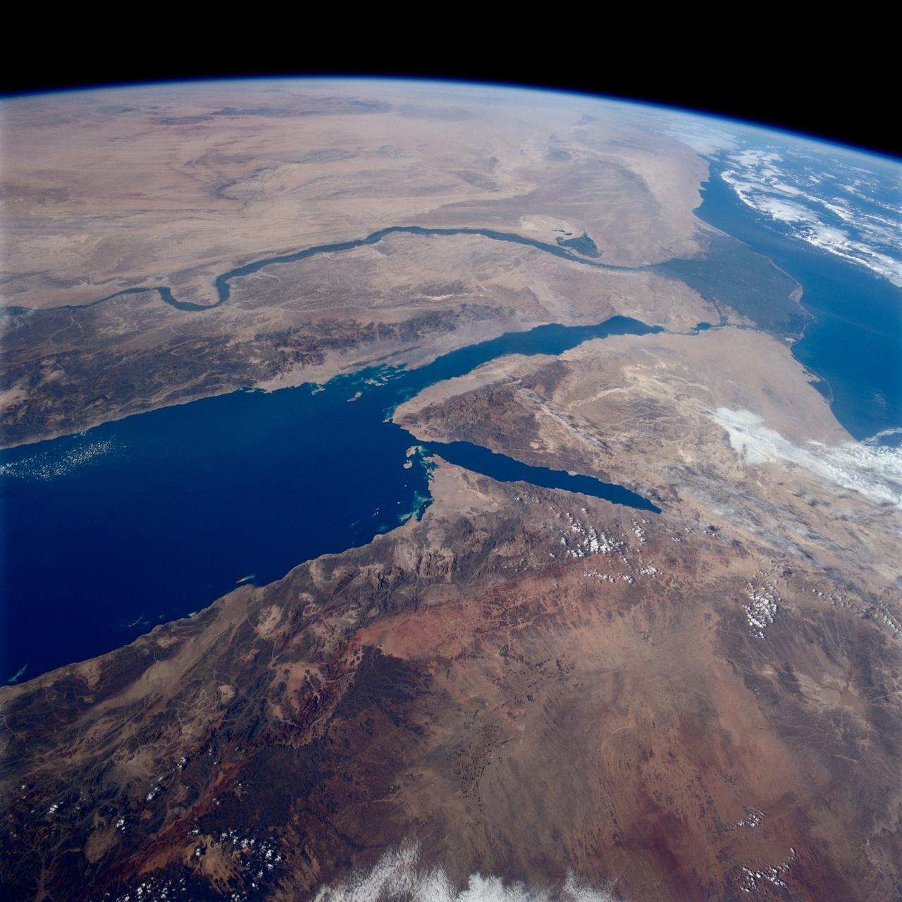
STS080-745-004 (19 Nov.-7 Dec. 1996) --- A view to the west showing Asia in the foreground and Africa in the background, as photographed by the space shuttle Columbia crewmembers. The Mediterranean Sea is to the upper right and the Red Sea to the lower left (holding photograph with NASA numbers on left). Sinai Peninsula is between the two with the Gulf of Suez above and the Gulf of Aqaba below. The Suez Canal connects the Gulf of Suez with the Mediterranean Sea. The triangular shaped dark area beyond is the Nile River Delta. The thin green fertile valley of the Nile crosses the photograph from a point at Cairo (near dark triangle area) past the great bend at Luxor with Thebes and the Valley of the Kings, and on the left into the Nubian Desert with the Aswan High Dam at the very left edge of the photograph. To the horizon is the Western Desert of Egypt and Libya. The foreground is the northwest portion of Saudi Arabia, an area known as the Hejaz with the southern portions of Israel and Jordan to the lower right.
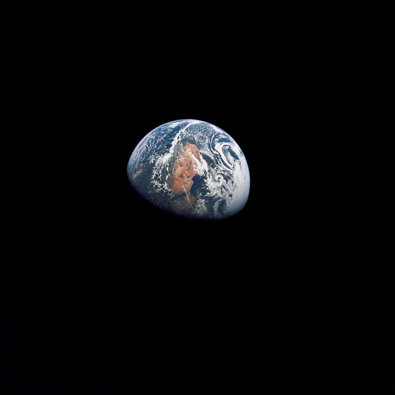
AS10-34-5026 (18-26 May 1969) --- An Apollo 10 photograph of Earth taken from 100,000 miles away. Visible are many areas of Europe and Africa. Among the features and countries identifiable are Portugal, Spain, Italy, the Mediterranean Sea, Greece, Turkey, Bulgaria, the Black Sea, Libya, Egypt, Saudi Arabia, the Sinai Peninsula, the Nile Delta, Lake Chad, and South Africa. The crew members for Apollo 10 are astronauts Thomas P. Stafford, commander; John W. Young, command module pilot; and Eugene E. Cernan, lunar module pilot. Astronaut Young remained in lunar orbit, in the Command and Service Modules (CSM) "Charlie Brown", while astronauts Stafford and Cernan descended to within nine miles of the lunar surface, in the Lunar Module (LM) "Snoopy".

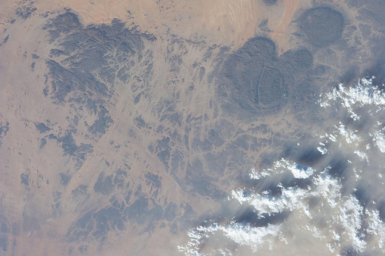
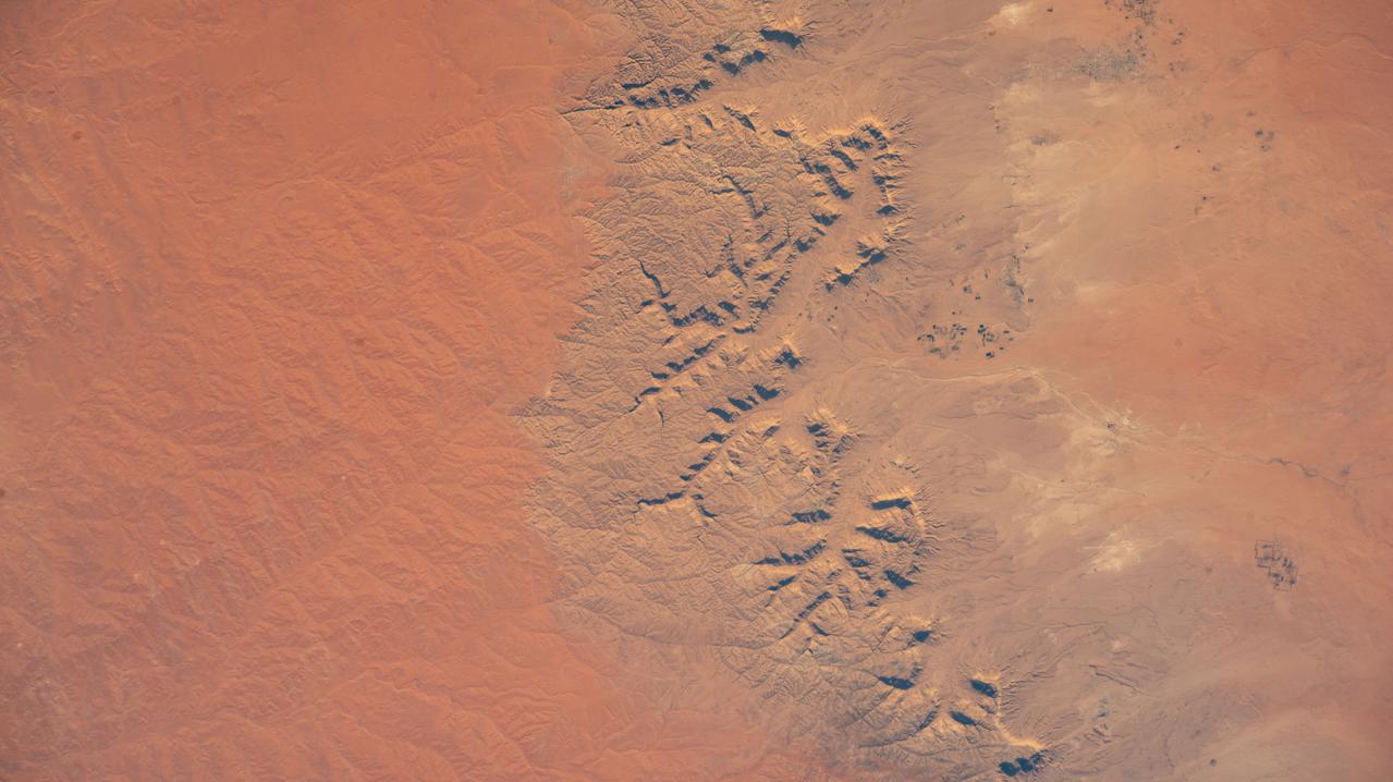
ISS017-E-013789 (19 Aug. 2008) --- Desert erosion in Libya is featured in this image photographed by an Expedition 17 crewmember on the International Space Station. This detailed view (covering 13 kilometers) shows the classic patterns of an erosional desert landscape located 300 kilometers south of Libya's Mediterranean coast. Widespread indented patterns are low escarpments and stream terraces generated by stream erosion -- on those few occasions in any decade when enough rain falls for streams to flow. The only areas with active sediment deposition are the stream beds which appear in this image as sinuous zones with a distinct component of black minerals, resulting in a darker coloration than adjacent low escarpments. Sediment is transported into the area from a volcanic landscape immediately upstream to the west. Other stream-generated features are several relict stream banks, one of which even shows both of the original parallel banks. According to scientists, the ancient stream banks are preserved from erosion by various hardening cements (mainly calcium carbonate and gypsum) introduced by the streams when they were active, probably during wetter climates in the past two million years. Relict stream courses show prior positions of streams, and also provide Earth analogs for similar features on Mars. The lack of vegetation is the first indication of the great aridity of the region, but sand dunes also appear as sinuous lines oriented perpendicular to the dominant northeasterly wind direction (transverse dunes). Assuming the dominant wind direction remains the same, these transverse dunes are expected to move further to the southwest over time. Some of the dunes cross the river courses, showing how seldom the river flows.
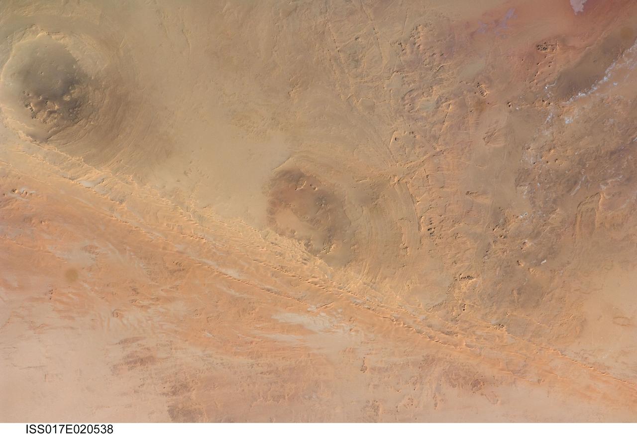
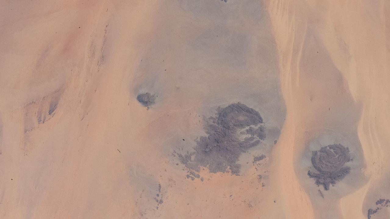
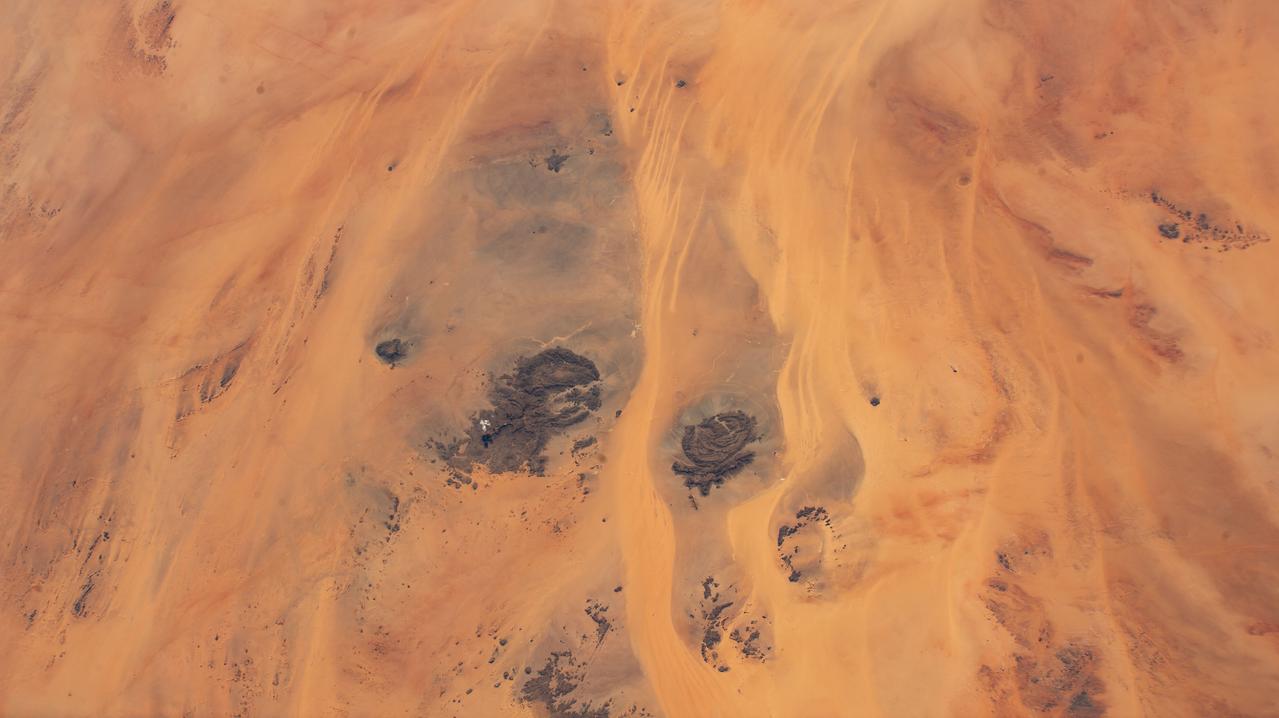
ISS017-E-020538 (21 Oct. 2008) --- Arkenu Craters 1 and 2 in Libya are featured in this image photographed by an Expedition 17 crewmember on the International Space Station. Geologists often study features on Earth, such as impact craters, to gain insight into processes that occur on other planets. On Earth, more than 150 impact craters have been identified on the continents, but only a few of these are classified as double impact craters. One such example, the Arkenu Craters in northern Africa, is shown in this image. Arkenu 1 and 2 are double impact structures located in eastern Libya (22.04 degrees north latitude and 23.45 degrees east longitude) in the Sahara desert, with diameters of approximately 6.8 kilometers and 10.3 kilometers, respectively. The craters are unusual in that they both exhibit concentric annular ridge structures (gray circles in the image indicate the position of the outermost visible ridges). In many terrestrial complex craters these features are highly eroded and no longer visible. While the circular structure of these features had been noted, the impact origin hypothesis was strengthened in December 2003 when a field team observed shatter cones -- conical-shaped features in rocks created by the high shock pressures generated during impact. Large outcrops of impact breccias -- a jumble of rock fragments generated at the impact site that are now cemented together into an identifiable rock layer -- were also observed by the field team. Two impactors, each approximately 500 meters in diameter, are thought to have created the craters. According to scientists, the age of the impact event has been dated as occurring less than 140 million years ago. While the presence of shatter cones and impact breccias is generally considered to be strong evidence for meteor impact, some scientists now question the interpretation of these features observed at the Arkenu structures and suggest that they were caused by erosive and volcanic processes. At present, both craters are being crossed by linear dunes extending northeast-southwest -- the superposition of the dunes across the annular ridges indicates that they are much younger than the craters.
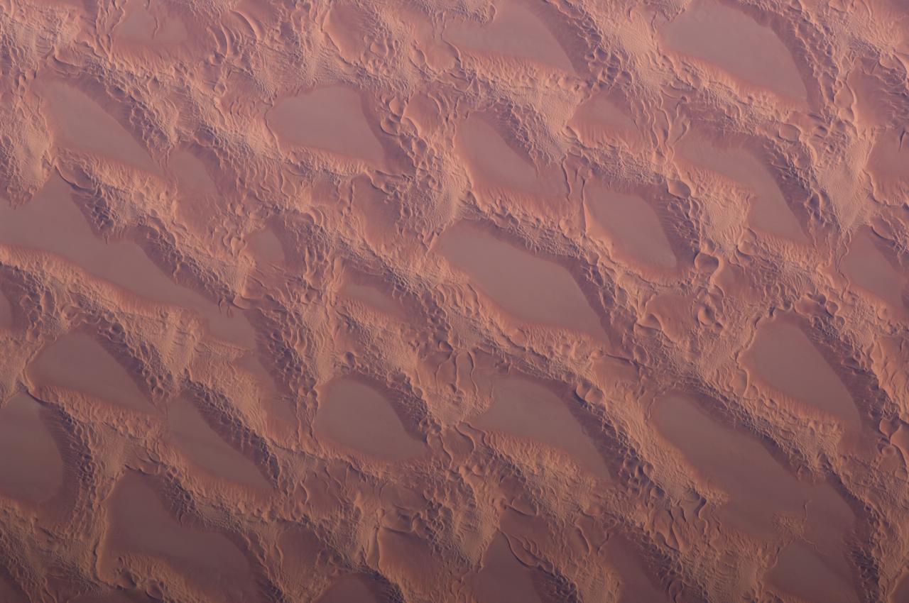
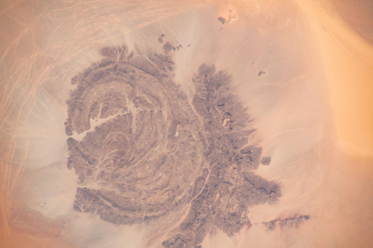
ISS018-E-014770 (20 Dec. 2008) --- Sand dunes in the Marzuq Sand Sea, southwest Libya are featured in this image photographed by an Expedition 18 crewmember on the International Space Station. This detailed view, taken from low Earth orbit, shows classic large and small sand masses of the Central Sahara where wind is a more powerful land-forming agent than water. ?Draa? dunes (from the Arabic for ?arm?) are very large masses of sand and appear here as the broad network of yellow-orange sand masses (the image covers a region approximately 9.4 kilometers wide), with smooth-floored, almost sand-free basins between them. These sand masses lie in the western part of Libya?s vast Marzuq Sand Sea (greater than 60,000 square kilometers, centered at 24.5N 12W). Geologists think that the draa of the Marzuq have probably been formed by winds different from the dominant north/northeast winds of today. Numerous smaller dunes can be seen developed on the backs of the draa. Three distinct dune types can be identified: longitudinal dunes (formed essentially parallel with formative winds from the north); transverse dunes, usually more curved, formed at right angles to the formative wind; and star dunes, in which several linear arms converge towards a single peak. The upwind side of the sand masses appears smoother than the more rippled downwind side. Wind is moving sand grains almost all the time. This means that the draa and the dunes are all moving -- as sand is added on the upwind side and blown off the downwind side. It is well known that small sand masses move much faster than large sand masses. This means that the draa are almost stationary, but that the smaller dunes are moving relatively quickly across their backs. When the dunes reach the downwind side of the draa they are obliterated, their sand being blown across the basins as individual grains.
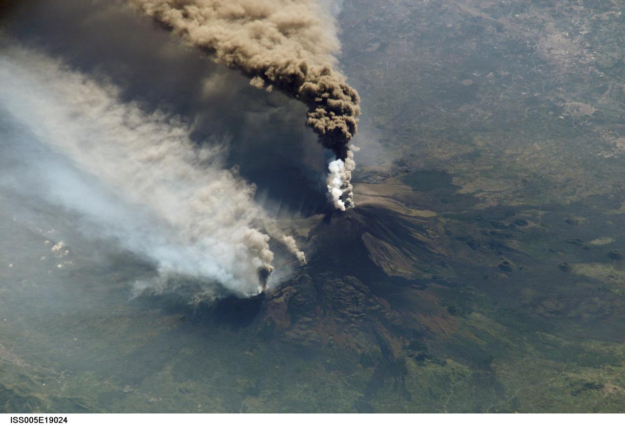
ISS005-E-19024 (30 October 2002) --- The three-member crew of the Expedition Five mission onboard the International Space Station was able to observe Mt. Etna’s spectacular eruption, and photograph the details of the eruption plume and smoke from fires triggered by the lava as it flowed down the 11,000 ft mountain. This image and a second image (ISS005-E-19016) are looking obliquely to the southeast over the island of Sicily. The wider view (ISS005-E-19024) shows the ash plume curving out toward the horizon, caught first by low-level winds blowing to the southeast, and to the south toward Africa at higher altitudes. Ashfall was reported in Libya, more than 350 miles away. The lighter-colored plumes downslope and north of the summit seen in this frame are produced by forest fires set by lava flowing into the pine forests on the slope of the mountain. This image provides a more three-dimensional profile of the eruption plume. This eruption was one of Etna’s most vigorous in years, volcanologists reported this week. The eruption was triggered by a series of earthquakes on October 27, 2002, they said. These images were taken on October 30. Although schools were closed and air traffic was diverted because of the ash, no towns or villages were reported to have been threatened by the lava flow.
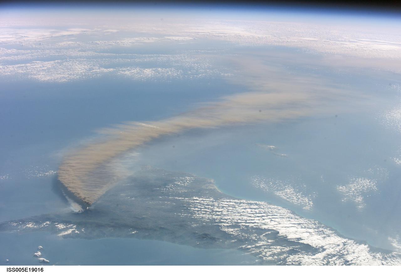
ISS005-E-19016 (30 October 2002) --- The three-member crew of the Expedition Five mission onboard the International Space Station was able to observe Mt. Etna’s spectacular eruption, and photograph the details of the eruption plume and smoke from fires triggered by the lava as it flowed down the 11,000 ft mountain. This image and a second image (ISS005-E-19024) are looking obliquely to the southeast over the island of Sicily. This wide view shows the ash plume curving out toward the horizon, caught first by low-level winds blowing to the southeast, and to the south toward Africa at higher altitudes. Ashfall was reported in Libya, more than 350 miles away. The lighter-colored plumes downslope and north of the summit (see detailed view taken the same day, ISS005-E-19024) are produced by forest fires set by lava flowing into the pine forests on the slope of the mountain. The detailed image provides a more three-dimensional profile of the eruption plume. This eruption was one of Etna’s most vigorous in years, volcanologists reported this week. The eruption was triggered by a series of earthquakes on October 27, 2002, they said. These images were taken on October 30. Although schools were closed and air traffic was diverted because of the ash, no towns or villages were reported to have been threatened by the lava flow.
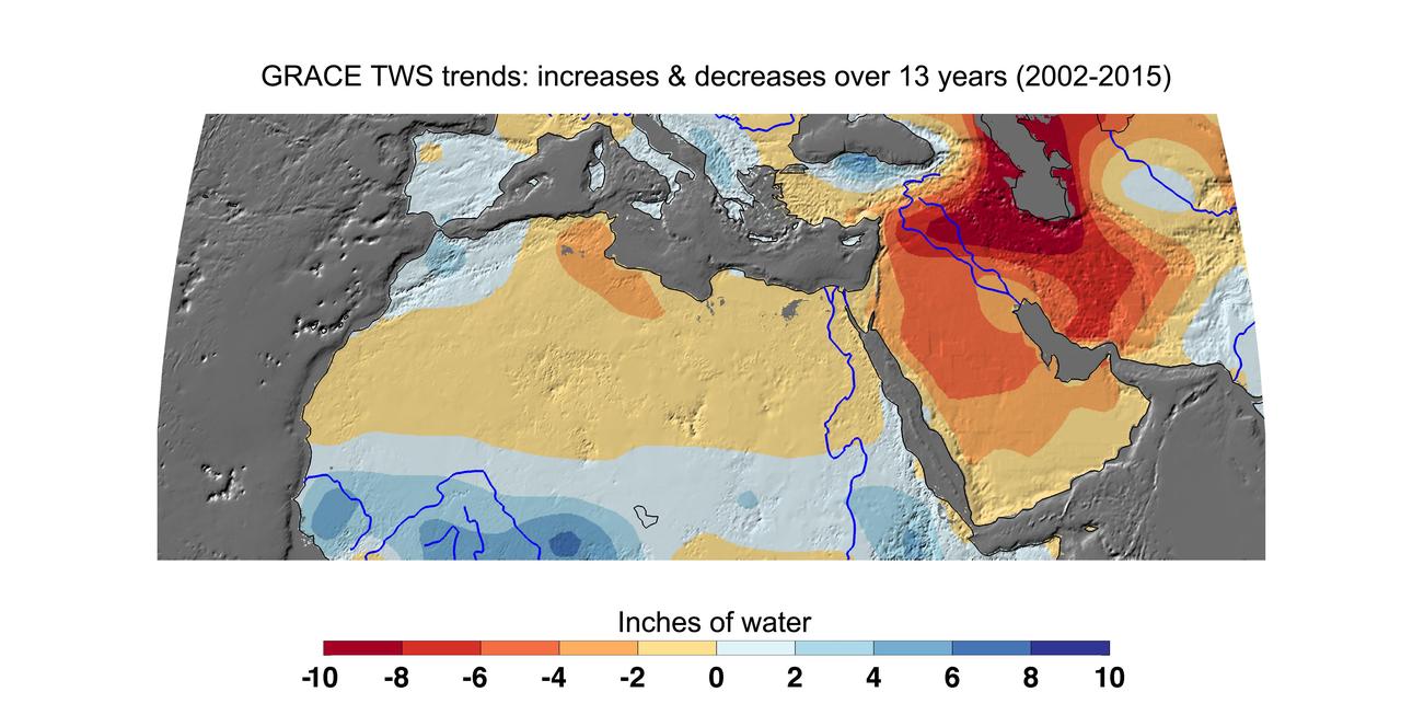
Cumulative total freshwater losses in North Africa and the Middle East from 2002 to 2015 (in inches) observed by NASA's Gravity Recovery and Climate Experiment (GRACE) mission. Total water refers to all of the snow, surface water, soil water and groundwater combined. Groundwater depletion in Turkey, Syria, Iraq and Iran, and along the Arabian Peninsula, are leading to large changes in total water storage in the region. Likewise, drought and groundwater pumping is contributing to the drying of the Caspian Sea Region. The Northwest Sahara Aquifer System, which underlies Tunisia and Libya, is also experiencing increasing water stress as shown in the map. Image updated from Voss et al., 2013. Citation of Record: Voss, K. A., J. S. Famiglietti, M. Lo, C. R. de Linage, M. Rodell and S. C. Swenson, Groundwater depletion in the Middle East from GRACE with Implications for Transboundary Water Management in the Tigris-Euphrates-Western Iran Region, Wat. Resour. Res., 49(2), 904-914, DOI: 10.1002/wrcr.20078. http://photojournal.jpl.nasa.gov/catalog/PIA20207