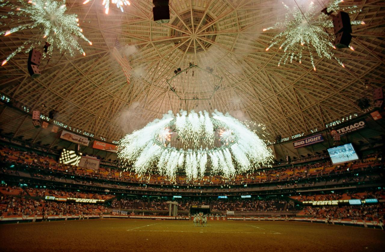
Overall view of the Houston Astrodome during a fireworks display at the 1997 Houston Livestock Show and Rodeo. The event was attended by NASA and Russian Space Agency dignitaries.

iss074e0623368 (May 30, 2026) --- The Red Deer River runs through central Alberta, Canada, where the landscape transitions from rugged valleys to open prairie and supports a variety of agricultural and livestock activities. The International Space Station was orbiting 261 miles above North America at the time of this photograph. Credit: NASA/Chris Williams
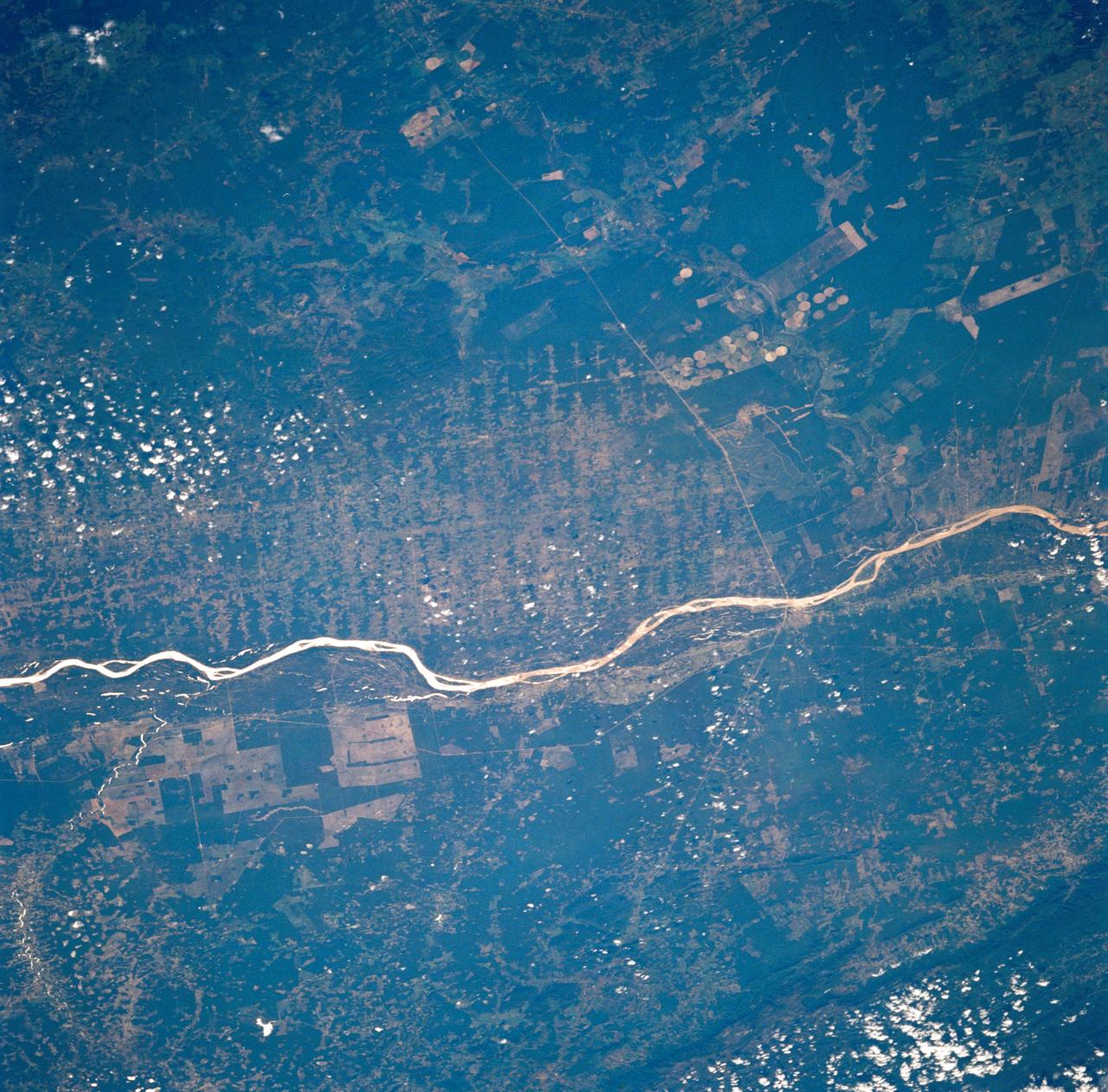
STS035-73-082 (2-10 Dec 1990) --- This agricultural and ranching area, Rio Sao Francisco, Brazil (13.0S, 43.5W) has been under study for several years. See scene STS-31-92-045 for comparison. This area has many small single family subsistence farms, large square and rectangular commercial farms and pastures for livestock grazing. Over the several years of observation, the number and size of farms has increased and center-pivot, swing-arm irrigation systems have been installed.

From left, Russian Space Agency Academician Vladimir Utkin, a TechTrans International interpreter and Johnson Space Center Director George Abbey wave from a vehicle in the Houston Livestock Show and Rodeo Grand Entry parade at the Astrodome. Utkin and Abbey wear cowboy hats. Appears in Space News Roundup Vol.36 No.9, February 28, 1997 issue.
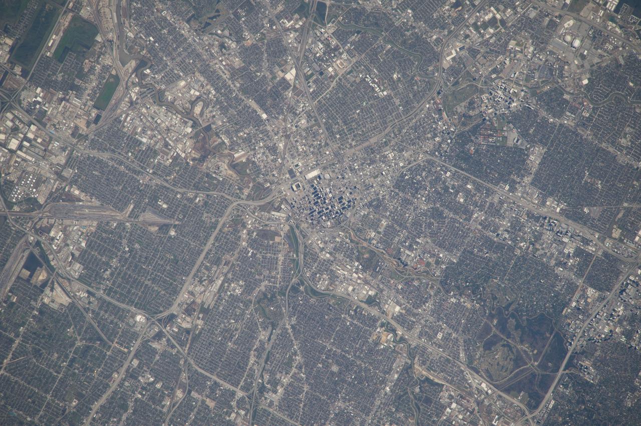
ISS039-E-000663 (12 March 2014) --- As in the case of this picture, when an astronaut in space uses an 800mm focal length, it is impossible to get the entire body of Houston, the nation's fourth most populous city, in one frame. This photo was taken by one of the Expedition 39 crew members from the International Space Station on March 12, 2014. The large lens and the clear spring like weather provide a better than usual aerial study of the city. The downtown business district is in the center of the frame. The Relaint Stadium complex, home to the Houston Livestock and Rodeo, currently in progress, can be seen in the upper right portion of the photo.
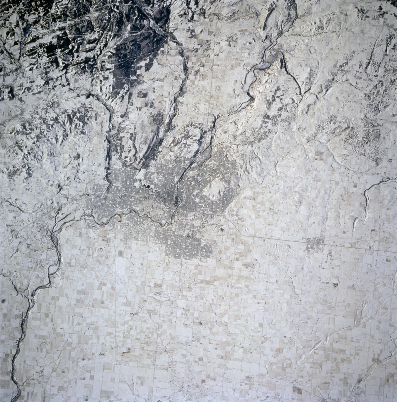
STS074-714-002 (12-20 Nov 1995) --- The late fall season is tell-tale in this nadir view of Calgary, Alberta, Canada as photographed from the Space Shuttle Atlantis. The ground cover makes it easier to identify geographic and man-made features in the scene. A gateway to the Canadian Rocky Mountains (lower left corner of the photo), Calgary, with a 1994 population listed at 710,677 is noted for its livestock and summer rodeos. It is located on the Bow River, easily traced as it meanders through the city. The Calgary International Airport is easily seen north east of the city.

STS030-10-008 (4-8 May 1989) --- Since the beginning manned space travel, astronauts have taken with them items of personal sentiment. In case of Mark C. Lee, STS-30 mission specialist, a picture of a cow testifies to his background as one reared on a Wisconsin farm. The scene, through a flight deck aft window, also shows Earth some 160 nautical miles away.
In northern Argentina's Salta province, the chaco forests, made up of shrubs and hardwood trees, once thrived in the region. In the past 30 years, large-scale farming and ranch operators have cleared broad areas of the chaco, and replaced with industrial-scale raising of crops and livestock. The December 1, 1989 Landsat TM image is dominiated by traditional puestos, settlements consisting of a few dwellings and small-scale crops located near a well. The November 19, 2019 ASTER image shows large fields arranged in a grid pattern. The chaco forest has almost disappeared. The images cover an area of 22.2 by 27.8 km, and are located at 24.9 degrees south, 63.5 degrees west. https://photojournal.jpl.nasa.gov/catalog/PIA23756
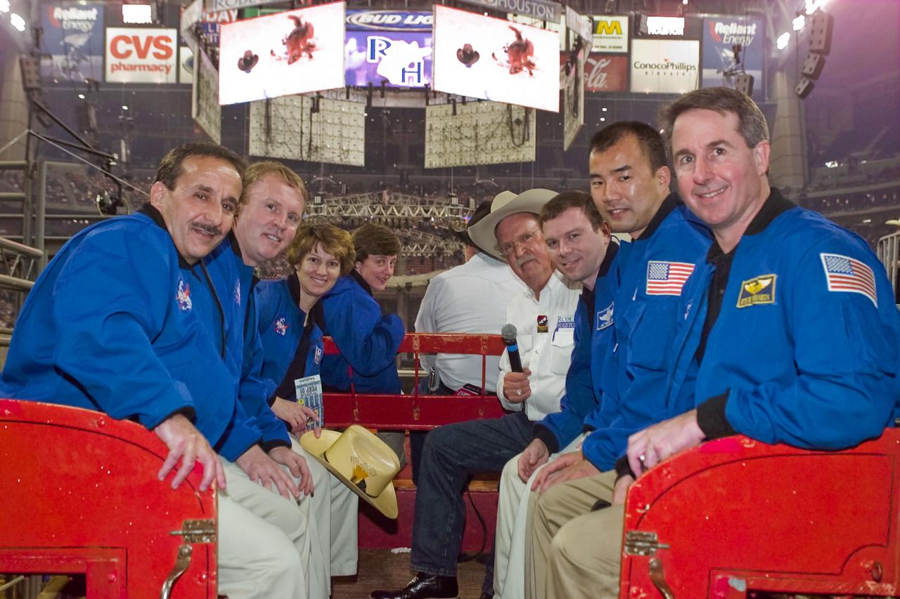
The STS-114 crew was treated with true Southern hospitality and a standing ovation as they were introduced to rodeo fans on opening night of the Houston Livestock Show and Rodeo on March 2, 2004. Views include Astronaut Charles Camarda and a rodeo goer(11078); Astronaut Camarda and a rodeo going family(11079); The STS-114 crew poses with rodeo goers(11080); Astronaut Eileen Collins with a young fan(11081); Astronaut Collins poses with a rodeo goer(11082); The STS-114 crew poses for a photograph(11083); The STS-114 crew poses with young fans for a photograph(11084) Young fans pose for a photograph(11085); Astronaut Wendy Lawrence addresses a crowd(11086); Astronaut James Kelly and STS-114 crew aboard a wagon at the Houston Livestock Show and Rodeo(11087);Young fansat the Rodeo(11088); The STS-114 crew rides around Reliant Stadium as the Rodeo salutes them(11089); The STS-114 crew rides around Reliant Stadium(11090); The STS-114 crew rides around Reliant Stadium(11091); The STS-114 Crew rides around Reliant Stadium(11092); A young fan at the Rodeo(11093); A young fan at the Rodeo(11094); A young fan at the Rodeo(11095); The Jumbotron at Reliant Stadium salutes the STS-114(11096); Young fans at the Houston Rodeo(11097); The STS-114 crew poses with a dignitary(11098); Astronaut Eileen Collins at the Houston Rodeo(11099); The STS-114 crew rides around the stadium(11100); Astronaut Eileen Collins adresses the Rodeo crowd(11101); Astronaut Collins and the STS-114 crew rides around the stadium(11102); Astronauts Eileen Collins and Andrew Thomas at the Rodeo(11103); Astronauts Stephen Robinson, Soichi Noguchi, Andrew Thomas and James Kelly at the Rodeo(11104); Kelly,Noguchi,Thomas and Robinson at the Rodeo(11105); The STS-114 crew at the Rodeo(11106); The STS-114 crew at the Rodeo(11107); The STS-114 crew rides around the stadium(11108); The STS-114 crew salutes the crowd(11109); The astronauts on the Jumbotron at the Rodeo(11110); Fireworks going off at the Rodeo saluting the astronauts(11111); The STS-114 crew poses for a photograph(11112); Reliant Stadium alit with lasers saluting the STS-114 crew(11113); Young fans pose for a photograph at the Houston Rodeo(11114).
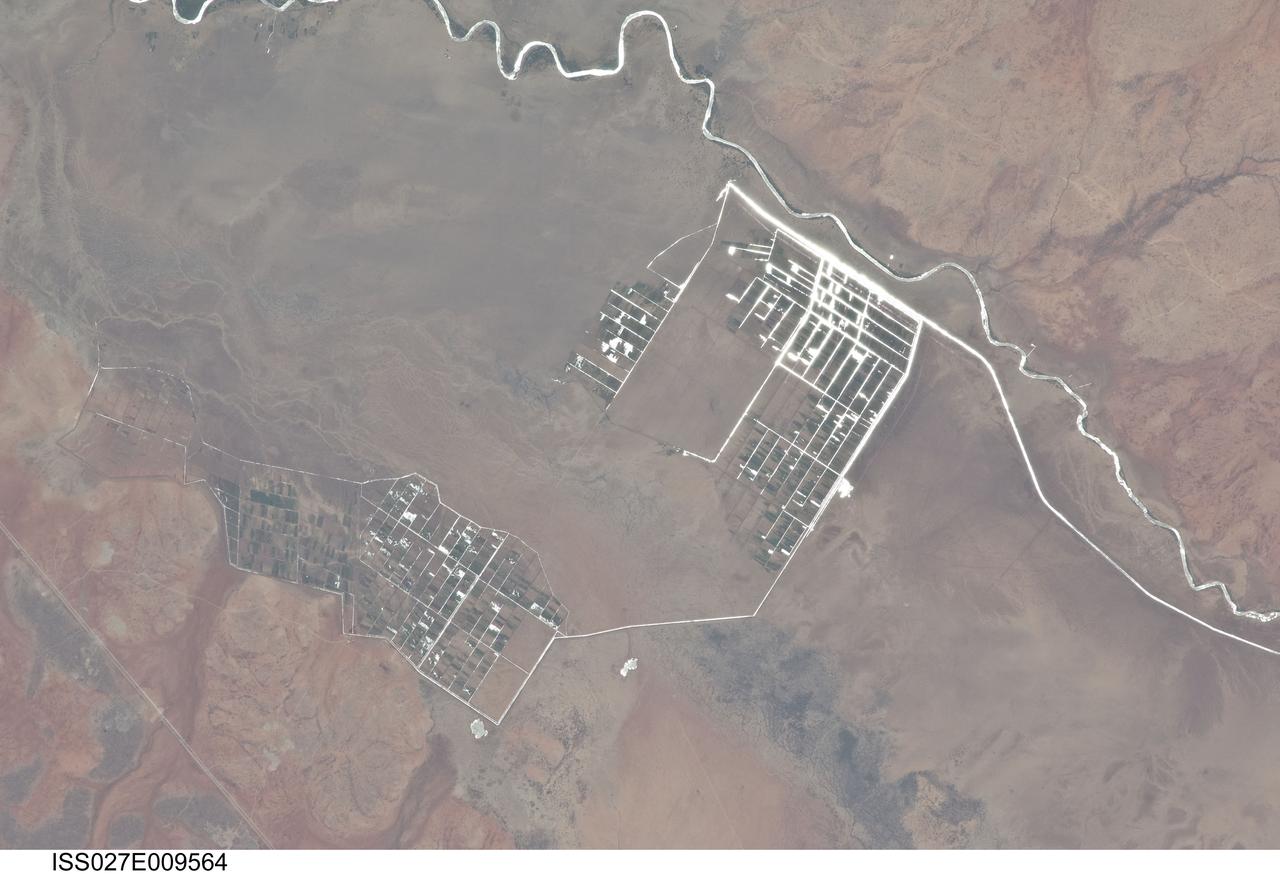
ISS027-E-009564 (31 March 2011) --- Agricultural fields along the Shebelle River in Ethiopia are featured in this image photographed by an Expedition 27 crew member on the International Space Station. The Shebelle River supports limited agricultural development within the arid to semi-arid Ogaden Plateau region of southeastern Ethiopia. This detailed photograph illustrates a network of irrigation canals and fields located approximately 42 kilometers to the west-northwest of the city of Gode, Ethiopia. Floodplain sediments and soils are dark brown to gray (center), and contrast with reddish rocks and soils of the adjacent plateau. Water in the Shebelle River, and the irrigation canals, has a bright, mirror-like appearance due to sunglint, or light reflecting off the water surface back towards the observer on the space station. Vegetation in the floodplain (bottom center) and agricultural fields is dark green. The river water supports a variety of crops?the most common being sorghum and maize?as well as grazing for livestock (cattle, sheep, goats, and camels). The Shebelle River has its headwaters in the Ethiopian Highlands, and transports water and sediment 1,000 kilometers to the southeast across Ethiopia, continuing an additional 130 kilometers into neighboring Somalia. The Shebelle River does not reach the Indian Ocean during most years, but disappears into the sands near the coast in Somalia. During periods of heavy rainfall and flooding however, the Shebelle can reach the Indian Ocean.
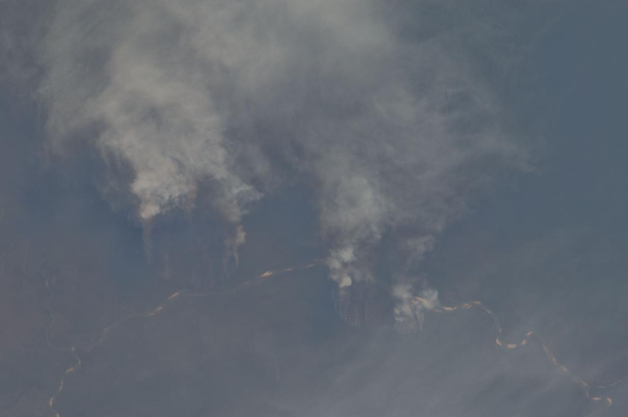
ISS029-E-008032 (17 Sept. 2011) --- Fires along the Rio Xingu, Brazil are featured in this image photographed by an Expedition 29 crew member on the International Space Station. The rain forest of South America, also known as ?Amazonia??the largest such forest on Earth?has been undergoing a continual and accelerated land use conversion process into farmlands (including pasture for livestock) since the early 1960s. This process has typically been achieved by clearing of the forest using fire ? ?slash and burn? ? followed by planting of crops. The generally infertile soils of the region make sustainable farming difficult; this drives more forest conversion into new farmland. The area of clearing can be considerable, and as the deforested regions are easily identifiable and measurable from space the rate of deforestation is likewise easy to track. This detailed photograph illustrates slash-and-burn forest clearing along the Xingu River (Rio) in the northeast of the state of Matto Grasso, Brazil. The perspective of this image allows for a striking visualization of both the horizontal position and extent of the fire lines next to the river, as well as providing a sense of the vertical structure of the smoke plumes due to the viewing angle and shadowing. Light colored areas within the river channel are sand bars, which show that the river is in its annual low-flow/ low water stage. For a sense of scale, the Xingu River channel within the view is approximately 63 kilometers long. Rivers in Amazonia are its natural highways, which may explain why the burning is occurring right next to the Xingu River, one of Amazonia?s largest. In recent years, preservation has gained traction in the region as a result of such considerations as new valuation of the ecosystem services provided by the forest, concerns about the impact of widespread burning on global climate change, and greater sensitivity to the ethnic and biological heritage of Amazonia.

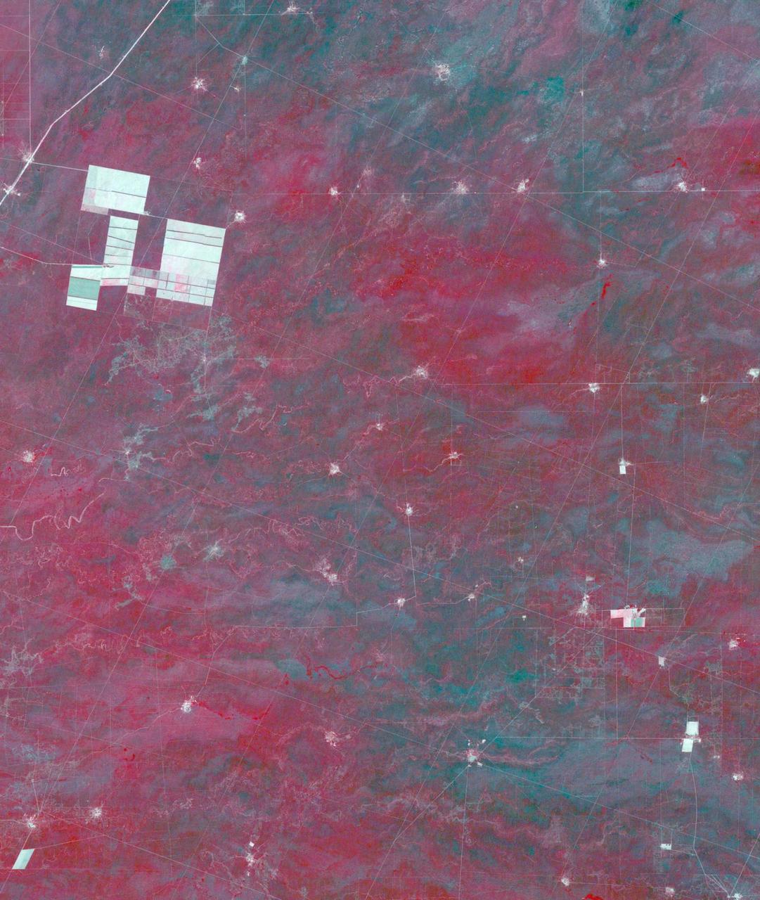
ISS034-E-057550 (28 Feb. 2013) --- One of the Expedition 34 crew members aboard the Earth-orbiting International Space Station photographed this image featuring the Southern High Plains of northwestern Texas, directly south of the city of Amarillo (off the image to the north). At first glance the picture appears more like a map than an actual photo. The winter of 2012-2013 has been marked by powerful snowstorms with record-setting snowfall throughout much of the Midwestern United States The snowstorm that passed through this area left a record snowfall of approximately 43 centimeters (17 inches). Snow blankets the city of Canyon, Texas. Urban street grids and stream channels appear etched into the landscape by the snow, a result of both melting and street clearing in the urban regions and of the incised nature of stream channels in the surrounding plains. Agricultural fields are easily identified due to the even snow cover broken only by roadways between the fields. Palo Duro Canyon is largely free of snow along the Prairie Dog Town Fork of the Red River channel and at lower elevations, allowing the red sedimentary rocks of the canyon walls to be visible. Lake Tanglewood, a reservoir to the northeast of Canyon, appears dark due to a lack of ice cover. Another dark region to the northwest of Canyon is a feed yard for cattle; any snowfall in this area has been removed by the actions of the livestock. The image was recorded with a digital camera using a 400 millimeter lens,
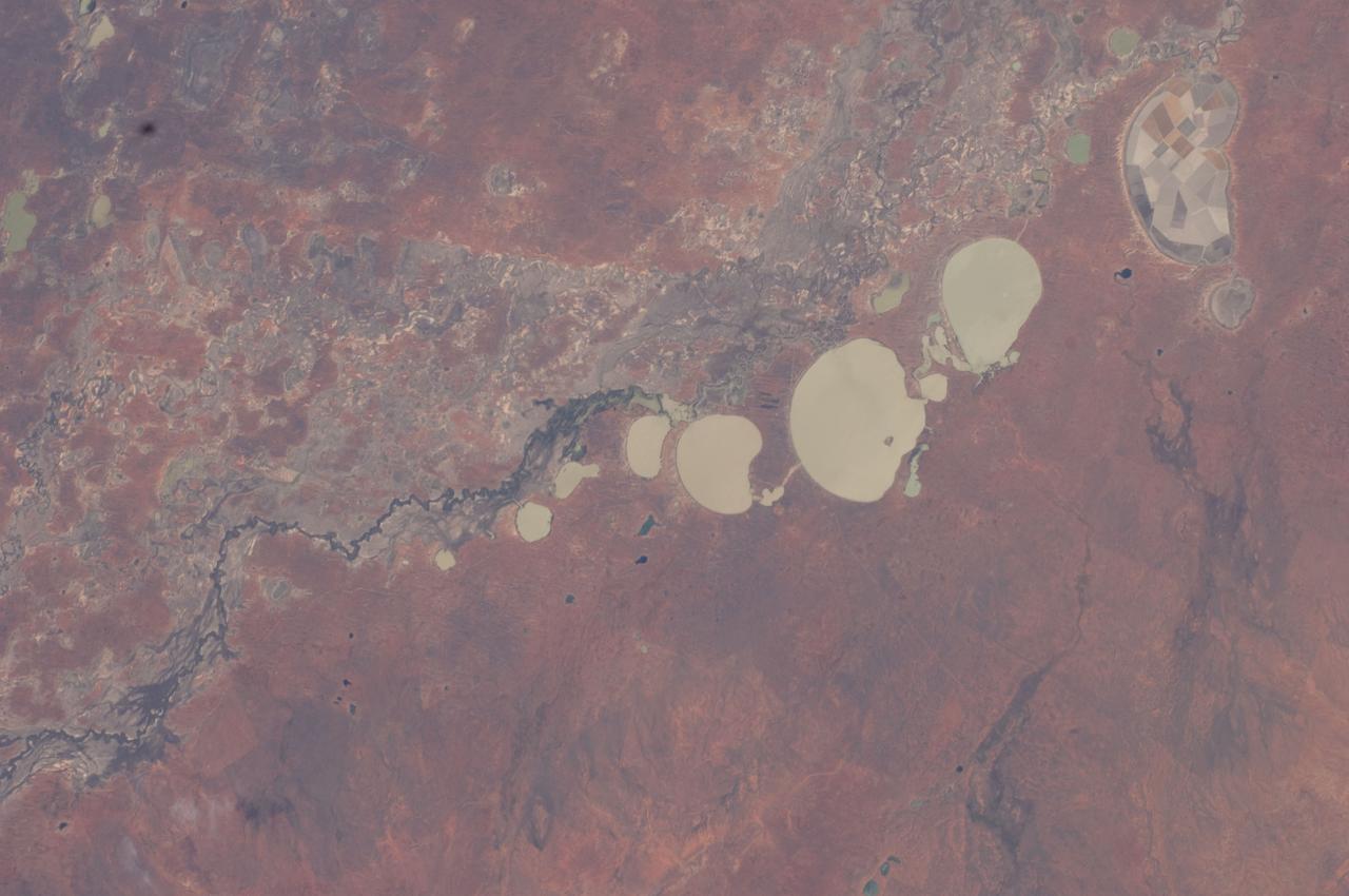
ISS030-E-009186 (3 Dec. 2011) --- The Menindee Lakes, New South Wales, Australia are featured in this image photographed by an Expedition 30 crew member on the International Space Station. The Menindee Lakes comprise a system of ephemeral, freshwater lakes fed by the Darling River when it floods. The lakes lie in the far west of New South Wales, Australia, near the town of Menindee. The longest is Lake Tandou (18.6 kilometers north?south dimension), visible at the upper right of this photograph. The lakes appear to have a small amount of water flooding them. The Darling River itself was flowing, as indicated by the dark water and blackened mud along its course (left). The Darling River flows southwest in tortuous fashion (bottom left to upper right). In the flat landscapes of this part of Australia, the river has created several inland deltas in its course to the sea, with characteristic diverging channel patterns, marked by younger sediments, which appear grayer than the surrounding ancient red soils and rocks. One such inland delta appears at right where minor channels wind across the countryside. The apex of another inland delta appears at upper right. Some of the Menindee Lakes have been incorporated in an artificially regulated overflow system providing for flood control, water storage for domestic use and livestock, as well as downstream irrigation. The lakes are also important as wetlands supporting a rich diversity of birds. The floor of one lake, Lake Tandou, is also used as prime agricultural land, as can be seen by its patchwork of irrigated fields, and is protected from flooding.
September 22, the autumnal equinox, marks the beginning of fall in the Northern Hemisphere, but the fall harvest begins early in the harsh continental climate of eastern Kazakhstan. By September 9, 2013, when the Operational Land Imager (OLI) on the Landsat 8 satellite acquired this image, several fields were already harvested and bare. Others were dark green with pasture grasses or ripening crops. The fields fill the contours of the land, running long and narrow down mountain valleys and spreading in large squares over the plains. Agriculture is an important segment of the economy in Kazakhstan: the country’s dry climate is ideal for producing high quality wheat for export. However, 61 percent of the country’s agricultural land is pasture for livestock. The area shown in this image, far eastern Kazakhstan near the Chinese border, is a minor wheat-growing region and may also produce sunflowers, barley, and other food crops. An artifact of Soviet-era collective farms, most of the farms in Kazakhstan are large, covering more than 5,000 hectares (12,500 acres). Some of the larger fields in the image reflect the big business side of agriculture. However, family farms and small agriculture businesses account for 35 percent of the country’s agricultural production, and some of these are visible as well, particularly in the uneven hills and mountains. Nearly all agriculture in Kazakhstan is rain fed. Farmers in this region have designed their fields to take advantage of rain flowing down hills, allowing the natural shape of the land to channel water to crops. The effect is a mosaic of green and tan with tones matching the natural vegetation in the mountains to the north. NASA Earth Observatory image by Jesse Allen using Landsat data from the U.S. Geological Survey. Caption by Holli Riebeek. Instrument: Landsat 8 - OLI More info: <a href="http://1.usa.gov/16IZ047" rel="nofollow">1.usa.gov/16IZ047</a> <b><a href="http://www.nasa.gov/audience/formedia/features/MP_Photo_Guidelines.html" rel="nofollow">NASA image use policy.</a></b> <b><a href="http://www.nasa.gov/centers/goddard/home/index.html" rel="nofollow">NASA Goddard Space Flight Center</a></b> enables NASA’s mission through four scientific endeavors: Earth Science, Heliophysics, Solar System Exploration, and Astrophysics. Goddard plays a leading role in NASA’s accomplishments by contributing compelling scientific knowledge to advance the Agency’s mission. <b>Follow us on <a href="http://twitter.com/NASA_GoddardPix" rel="nofollow">Twitter</a></b> <b>Like us on <a href="http://www.facebook.com/pages/Greenbelt-MD/NASA-Goddard/395013845897?ref=tsd" rel="nofollow">Facebook</a></b> <b>Find us on <a href="http://instagram.com/nasagoddard?vm=grid" rel="nofollow">Instagram</a></b>