
LORRI Takes an Even Closer Look at the Little Red Spot
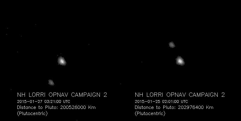
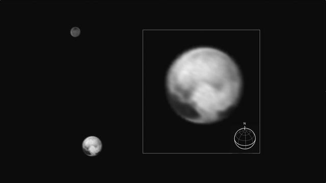
Pluto and Charon, the largest of Pluto five known moons, seen Jan. 25 and 27, 2015, through the telescopic Long-Range Reconnaissance Imager LORRI on NASA New Horizons spacecraft.
This color version of NASA's New Horizons Long Range Reconnaissance Imager (LORRI) picture of Pluto taken July 3, 2015, was created by adding color data from the Ralph instrument gathered earlier in the mission. The LORRI image was taken from a range of 7.8 million miles (12.5 million km), with a central longitude of 19°. http://photojournal.jpl.nasa.gov/catalog/PIA19699
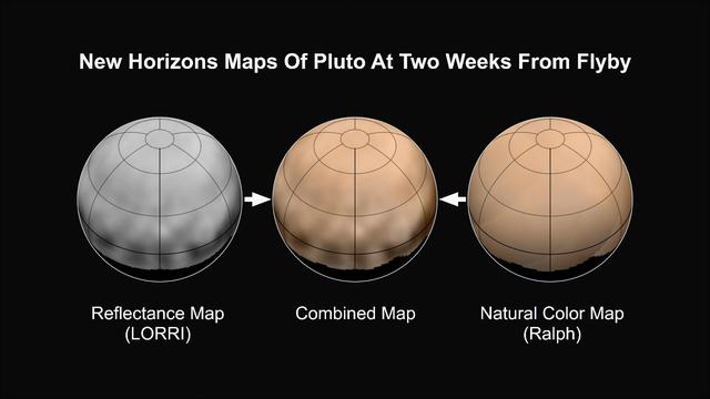
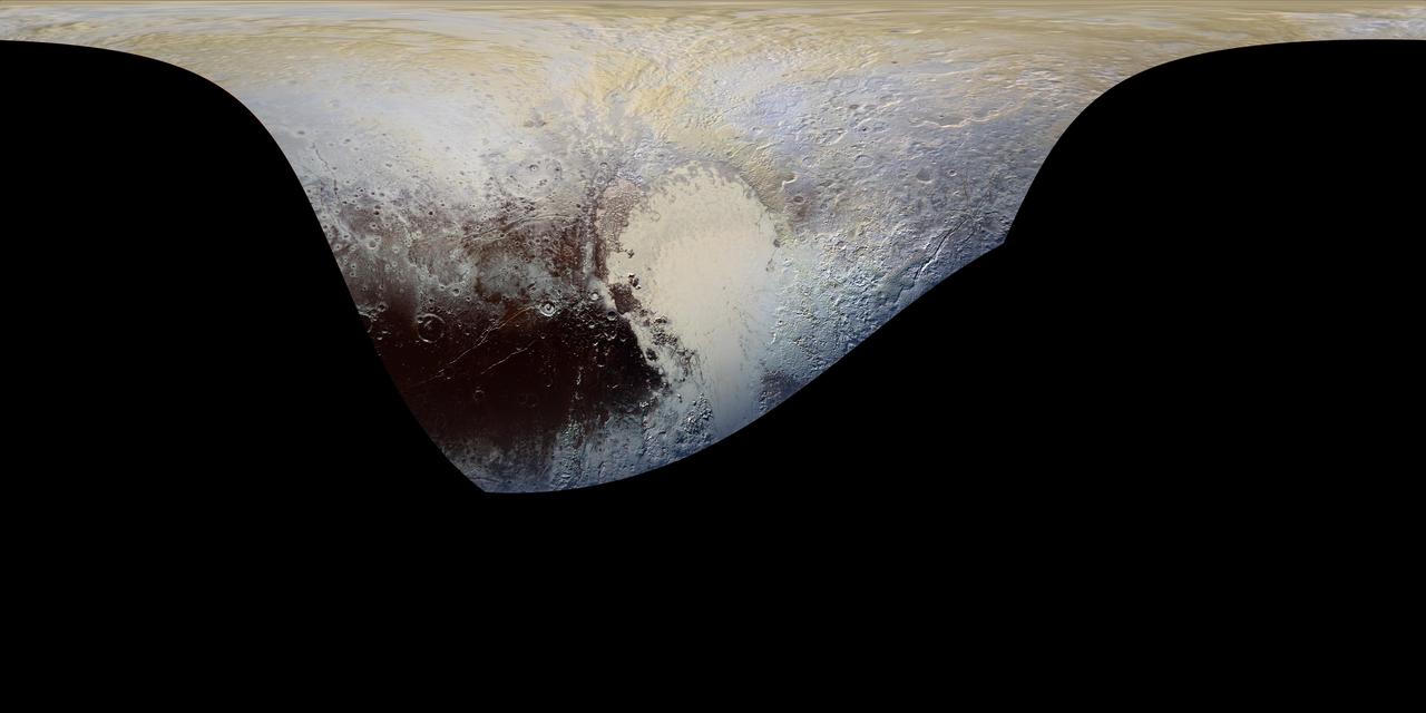
What color is Pluto? The answer, revealed in the first maps made from New Horizons data, turns out to be shades of reddish brown. The mission's first map of Pluto is in approximate true color -- that is, the color you would see if you were riding on New Horizons. At left, a map of Pluto's northern hemisphere composed using high-resolution black-and-white images from New Horizons LORRI instrument. At right is a map of Pluto's colors created using data from the Ralph instrument. In the center is the combined map, produced by merging the LORRI and Ralph data. http://photojournal.jpl.nasa.gov/catalog/PIA19697
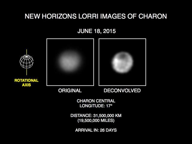
These recent images show the discovery of significant surface details on Pluto's largest moon, Charon. They were taken by the New Horizons Long Range Reconnaissance Imager (LORRI) on June 18, 2015. The image on the left is the original image, displayed at four times the native LORRI image size. After applying a technique that sharpens an image called deconvolution, details become visible on Charon, including a distinct dark pole. Deconvolution can occasionally introduce "false" details, so the finest details in these pictures will need to be confirmed by images taken from closer range in the next few weeks. http://photojournal.jpl.nasa.gov/catalog/PIA19690

These images, taken by NASA's New Horizons' Long Range Reconnaissance Imager (LORRI), show four different "faces" of Pluto as it rotates about its axis with a period of 6.4 days. All the images have been rotated to align Pluto's rotational axis with the vertical direction (up-down) on the figure, as depicted schematically in the upper left. From left to right, the images were taken when Pluto's central longitude was 17, 63, 130, and 243 degrees, respectively. The date of each image, the distance of the New Horizons spacecraft from Pluto, and the number of days until Pluto closest approach are all indicated in the figure.These images show dramatic variations in Pluto's surface features as it rotates. When a very large, dark region near Pluto's equator appears near the limb, it gives Pluto a distinctly, but false, non-spherical appearance. Pluto is known to be almost perfectly spherical from previous data. These images are displayed at four times the native LORRI image size, and have been processed using a method called deconvolution, which sharpens the original images to enhance features on Pluto. Deconvolution can occasionally introduce "false" details, so the finest details in these pictures will need to be confirmed by images taken from closer range in the next few weeks. All of the images are displayed using the same brightness scale. http://photojournal.jpl.nasa.gov/catalog/PIA19686

This image of Kerberos was created by combining four individual Long Range Reconnaissance Imager (LORRI) pictures taken on July 14, 2015, approximately seven hours before NASA's New Horizons' closest approach to Pluto, at a range of 245,600 miles (396,100 km) from Kerberos. The image was deconvolved to recover the highest possible spatial resolution and oversampled by a factor of eight to reduce pixilation effects. Kerberos appears to have a double-lobed shape, approximately 7.4 miles (12 kilometers) across in its long dimension and 2.8 miles (4.5 kilometers) in its shortest dimension. http://photojournal.jpl.nasa.gov/catalog/PIA20034

These images, taken by NASA's New Horizons' Long Range Reconnaissance Imager (LORRI), show numerous large-scale features on Pluto's surface. The distance to Pluto ranges from 47 million kilometers (about 29 million miles) on June 5 to 31 million kilometers (19 million miles) on June 18. When various large, dark and bright regions appear near limbs, they give Pluto a distinct, but false, non-spherical appearance. Pluto is known to be almost perfectly spherical from previous data. These images are displayed at four times the native LORRI image size, and have been processed using a method called deconvolution, which sharpens the original images to enhance features on Pluto. http://photojournal.jpl.nasa.gov/catalog/PIA19691
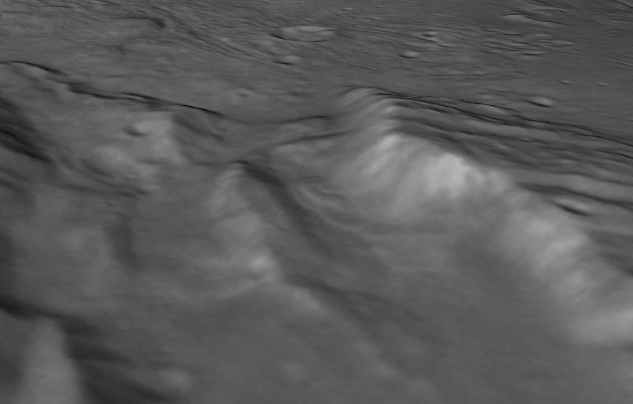
perspective view of Charon's informally named "Serenity Chasm" consists of topography generated from stereo reconstruction of images taken by New Horizons' Long Range Reconnaissance Imager (LORRI) and Multispectral Visible Imaging Camera (MVIC), supplemented by a "shape-from-shading" algorithm. The topography is then overlain with the PIA21128 image mosaic and the perspective view is rendered. The MVIC image was taken from a distance of 45,458 miles (73,159 kilometers) while the LORRI picture was taken from 19,511 miles (31,401 kilometers) away, both on July 14, 2015. http://photojournal.jpl.nasa.gov/catalog/PIA21129

Pluto nearly fills the frame in this image from the Long Range Reconnaissance Imager (LORRI) aboard New Horizons, taken on July 13, 2015, when the spacecraft was 476,000 miles (768,000 kilometers) from the surface. This is the last and most detailed image sent to Earth before the spacecraft's closest approach to Pluto on July 14. The color image has been combined with lower-resolution color information from the Ralph instrument that was acquired earlier on July 13. http://photojournal.jpl.nasa.gov/catalog/PIA20291
This illustration shows some of the final images used to determine that the coast was clear for New Horizons' flight through the Pluto system. These images show the difference between two sets of 48 combined 10-second exposures with the Long Range Reconnaissance Imager (LORRI), taken June 26, 2015, from a range of 21.5 million kilometers (approximately 13 million miles) to Pluto. http://photojournal.jpl.nasa.gov/catalog/PIA20293

Since its discovery in 2005, Pluto's moon Hydra has been known only as a fuzzy dot of uncertain shape, size, and reflectivity. Imaging obtained during NASA's New Horizons' historic transit of the Pluto-Charon system and transmitted to Earth early this morning has definitively resolved these fundamental properties of Pluto's outermost moon. Long Range Reconnaissance Imager (LORRI) observations revealed an irregularly shaped body characterized by significant brightness variations over the surface. With a resolution of 2 miles (3 kilometers) per pixel, the LORRI image shows the tiny potato-shaped moon measures 27 miles (43 kilometers) by 20 miles (33 kilometers). Like that of Charon, Hydra's surface is probably covered with water ice, the most abundant ice in the universe. Observed within Hydra's bright regions is a darker circular structure with a diameter of approximately 6 miles (10 kilometers). Hydra's reflectivity (the percentage of incident light reflected from the surface) is intermediate between that of Pluto and Charon. Hydra was approximately 400,000 miles away from New Horizons when this image was acquired. http://photojournal.jpl.nasa.gov/catalog/PIA19711
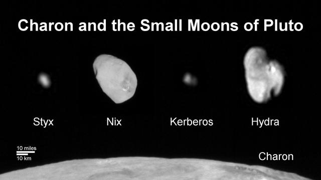
This composite image shows a sliver of Pluto large moon, Charon, and all four of Pluto small moons, as resolved by the Long Range Reconnaissance Imager (LORRI) on the New Horizons spacecraft. All the moons are displayed with a common intensity stretch and spatial scale (see scale bar). Charon is by far the largest of Pluto's moons, with a diameter of 751 miles (1,212 kilometers). Nix and Hydra have comparable sizes, approximately 25 miles (40 kilometers) across in their longest dimension above. Kerberos and Styx are much smaller and have comparable sizes, roughly 6-7 miles (10-12 kilometers) across in their longest dimension. All four small moons have highly elongated shapes, a characteristic thought to be typical of small bodies in the Kuiper Belt. http://photojournal.jpl.nasa.gov/catalog/PIA20033
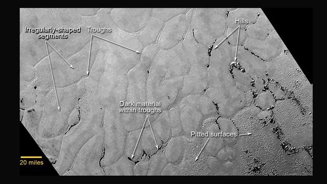
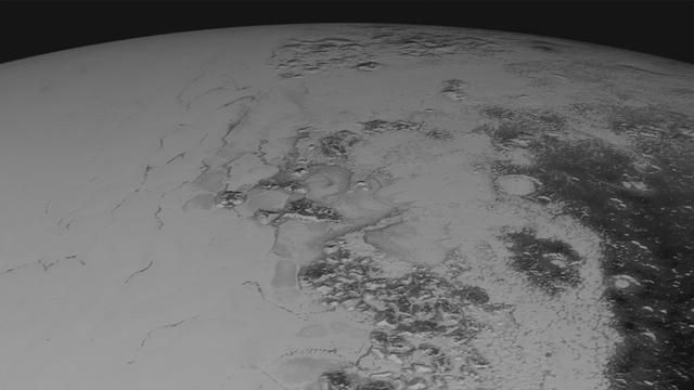
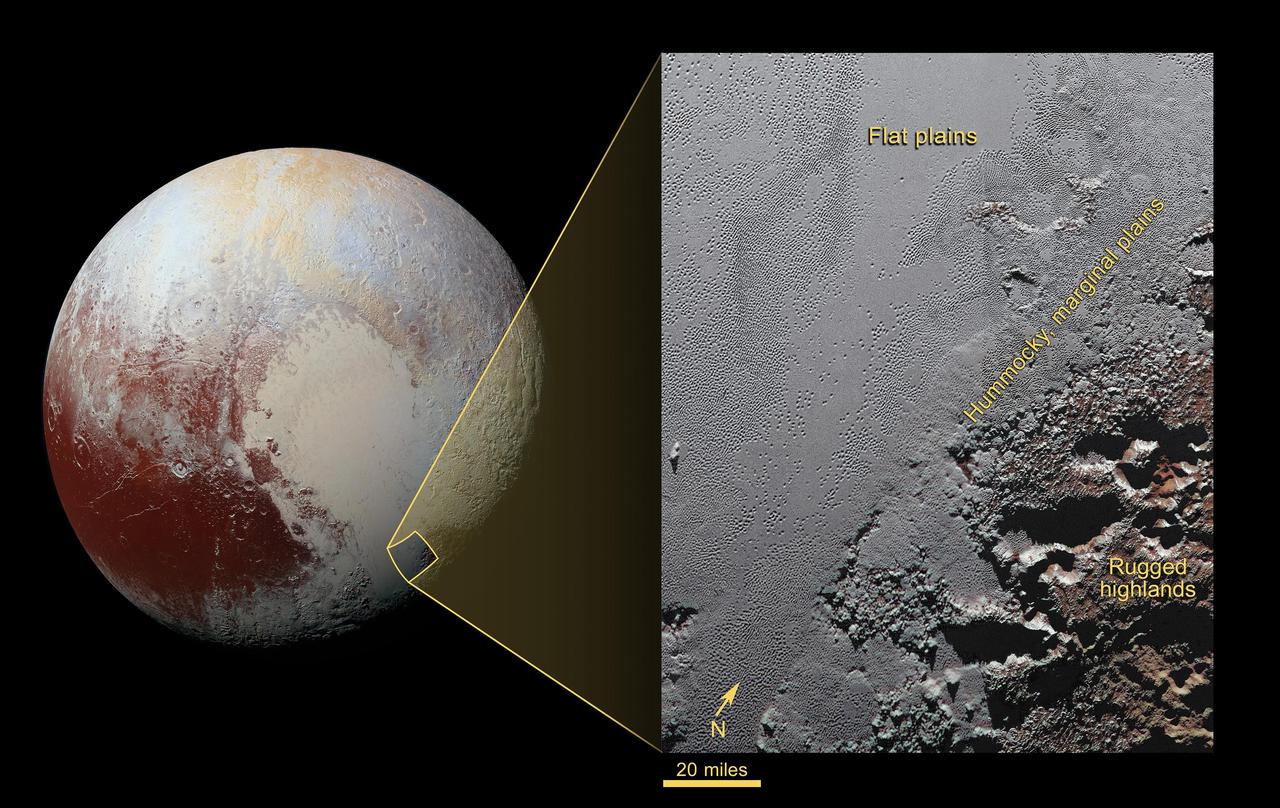
This annotated view of a portion of Pluto's Sputnik Planum (Sputnik Plain), named for Earth's first artificial satellite, shows an array of enigmatic features. The surface appears to be divided into irregularly shaped segments that are ringed by narrow troughs, some of which contain darker materials. Features that appear to be groups of mounds and fields of small pits are also visible. This image was acquired by the Long Range Reconnaissance Imager (LORRI) on July 14 from a distance of 48,000 miles (77,000 kilometers). Features as small as a half-mile (1 kilometer) across are visible. The blocky appearance of some features is due to compression of the image. http://photojournal.jpl.nasa.gov/catalog/PIA19714
Images downloaded from NASA's New Horizons spacecraft (through Sept. 11, 2015) were stitched together and rendered on a sphere to make a flyover "movie." The animation, made with images from New Horizons' Long Range Reconnaissance Imager (LORRI), begins with a low-altitude look at the informally named Norgay Montes, flies northward over the boundary between informally named Sputnik Planum and Cthulhu Regio, turns, and drifts slowly east. During the animation, the altitude of the observer rises until it is about 10 times higher to show about 80% of the hemisphere New Horizons flew closest to on July 14, 2015. http://photojournal.jpl.nasa.gov/catalog/PIA19951
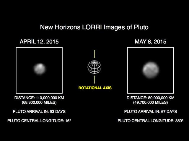
This image of Pluto is part of series of New Horizons Long Range Reconnaissance Imager LORRI photos taken May 8-12, 2015; the image at left shows LORRI view of Pluto just one month earlier.
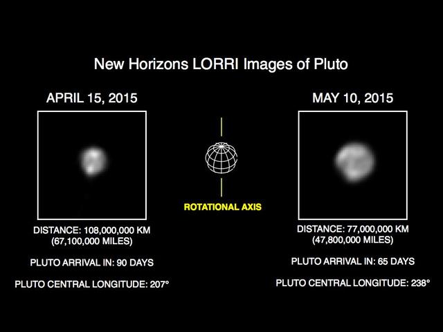
This image of Pluto is part of series of New Horizons Long Range Reconnaissance Imager LORRI photos taken May 8-12, 2015; the image at left shows LORRI view of Pluto just one month earlier.
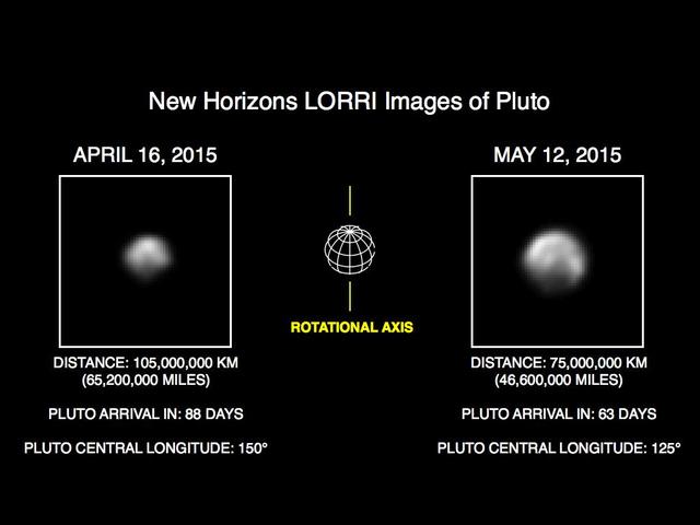
This image of Pluto is part of series of New Horizons Long Range Reconnaissance Imager LORRI photos taken May 8-12, 2015; the image at left shows LORRI view of Pluto just one month earlier.
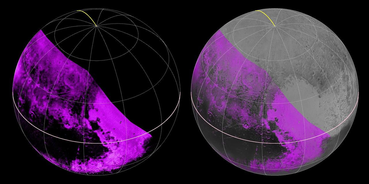
The Ralph/LEISA infrared spectrometer on NASA's New Horizons spacecraft mapped compositions across Pluto's surface as it flew past the planet on July 14, 2015. On the left, a map of methane ice abundance shows striking regional differences, with stronger methane absorption indicated by the brighter purple colors, and lower abundances shown in black. Data have only been received so far for the left half of Pluto's disk. At right, the methane map is merged with higher-resolution images from the spacecraft's Long Range Reconnaissance Imager (LORRI). http://photojournal.jpl.nasa.gov/catalog/PIA19953
High-resolution images of Charon were taken by the Long Range Reconnaissance Imager (LORRI) on NASA's New Horizons spacecraft, shortly before closest approach on July 14, 2015, and overlaid with enhanced color from the Ralph/Multispectral Visual Imaging Camera (MVIC). Charon's cratered uplands at the top are broken by series of canyons, and replaced on the bottom by the rolling plains of the informally named Vulcan Planum. The scene covers Charon's width of 754 miles (1,214 kilometers) and resolves details as small as 0.5 miles (0.8 kilometers). http://photojournal.jpl.nasa.gov/catalog/PIA19967
Scientists from NASA's New Horizons mission have spotted signs of long run-out landslides on Pluto's largest moon, Charon. This image of Charon's informally named "Serenity Chasma" was taken by New Horizons' Long Range Reconnaissance Imager (LORRI) on July 14, 2015, from a distance of 48,912 miles (78,717 kilometers). An annotated image shows arrows in the annotated figure mark indications of landslide activity at http://photojournal.jpl.nasa.gov/catalog/PIA21128

This is a frame from the first movie created by New Horizons to reveal color surface features of Pluto and its largest moon, Charon. "It's a bit unusual to see so much surface detail at this distance," said New Horizons co-investigator William McKinnon, a member of the mission's Geology and Geophysics Investigation team, from Washington University in Saint Louis. "What's especially noteworthy is the level of detail in both bodies. It's certainly whetting our appetite for what's to come." The images were taken between June 23 and June 29, 2015, as New Horizons' distance to Pluto decreased from a distance of 15 million to 11 million miles (24 million to 18 million kilometers). Six high-resolution black-and-white images from New Horizons' Long-Range Reconnaissance Imager (LORRI) instrument were combined with color data from the Ralph instrument to produce the movie. http://photojournal.jpl.nasa.gov/catalog/PIA19696
At center left of Pluto vast heart-shaped feature "Tombaugh Regio" -- lies a vast, craterless plain that appears to be no more than 100 million years old, and is possibly still being shaped by geologic processes as seen by NASA New Horizons spacecraft. This frozen region is north of Pluto's icy mountains and has been informally named Sputnik Planum (Sputnik Plain), after Earth's first artificial satellite. The surface appears to be divided into irregularly-shaped segments that are ringed by narrow troughs. Features that appear to be groups of mounds and fields of small pits are also visible. This image was acquired by the Long Range Reconnaissance Imager (LORRI) on July 14 from a distance of 48,000 miles (77,000 kilometers). Features as small as one-half mile (1 kilometer) across are visible. The blocky appearance of some features is due to compression of the image. http://photojournal.jpl.nasa.gov/catalog/PIA19841

This high-resolution swat of Pluto sweeps over the cratered plains at the west of the New Horizons' encounter hemisphere and across numerous prominent faults, skimming the eastern margin of the dark, forbidding region informally known as Cthulhu Regio, and finally passing over the mysterious, possibly cryovolcanic edifice Wright Mons, before reaching the terminator or day-night line. Among the many notable details shown are the overlapping and infilling relationships between units of the relatively smooth, bright volatile ices from Sputnik Planum (at the edge of the mosaic) and the dark edge or "shore" of Cthulhu. The pictures in this mosaic were taken by the Long Range Reconnaissance Imager (LORRI) in "ride-along" mode with the LEISA spectrometer, which accounts for the 'zigzag' or step pattern. Taken shortly before New Horizons' July 14 closest approach to Pluto, details as small as 500 yards (500 meters) can be seen. http://photojournal.jpl.nasa.gov/catalog/PIA20286
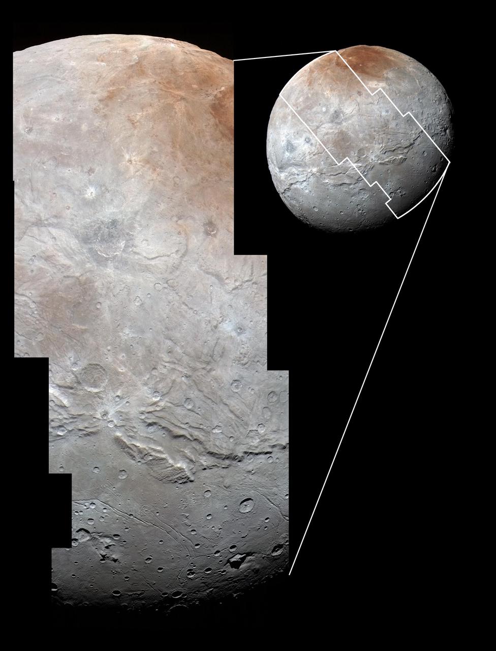
This image of an area on Pluto's largest moon Charon has a captivating feature -- a depression with a peak in the middle, shown here in the upper left corner of the inset. The image shows an area approximately 240 miles (390 kilometers) from top to bottom, including few visible craters. This image gives a preview of what the surface of this large moon will look like in future close-ups from NASA's New Horizons spacecraft. This image is heavily compressed; sharper versions are anticipated when the full-fidelity data from New Horizons' Long Range Reconnaissance Imager (LORRI) are returned to Earth. The rectangle superimposed on the global view of Charon shows the approximate location of this close-up view. The image was taken at approximately 6:30 a.m. EDT (10:30 UTC) on July 14, 2015, about 1.5 hours before closest approach to Pluto, from a range of 49,000 miles (79,000 kilometers). http://photojournal.jpl.nasa.gov/catalog/PIA19713

In the early morning hours of July 8, 2015, mission scientists received this new view of Pluto -- the most detailed yet returned by the Long Range Reconnaissance Imager (LORRI) aboard New Horizons. The image was taken on July 7, when the NASA spacecraft was just under 5 million miles (8 million kilometers) from Pluto, and is the first to be received since the July 4 anomaly that sent the spacecraft into safe mode. This view is centered roughly on the area that will be seen close-up during New Horizons' July 14 closest approach. This side of Pluto is dominated by three broad regions of varying brightness. Most prominent are an elongated dark feature at the equator, informally known as "the whale," and a large heart-shaped bright area measuring some 1,200 miles (2,000 kilometers) across on the right. Above those features is a polar region that is intermediate in brightness. http://photojournal.jpl.nasa.gov/catalog/PIA19702
Scientists with NASA New Horizons mission have assembled the highest-resolution color view of one of two potential cryovolcanoes spotted on the surface of the distant planet by the passing New Horizons spacecraft in July 2015. At about 90 miles (150 kilometers) across and 2.5 miles (4 kilometers) high, the feature -- informally named Wright Mons -- is enormous. If it is in fact a volcano, as suspected, it would be the largest such feature discovered in the outer solar system. Mission scientists are intrigued by the sparse distribution of red material in the image and wonder why it is not more widespread. Also perplexing is that there is only one identified impact crater on Wright Mons itself, telling scientists that the surface (as well as some of the crust underneath) was created relatively recently. This is turn may indicate that Wright Mons was volcanically active late in Pluto's history. This composite image includes pictures taken by the New Horizons spacecraft's Long Range Reconnaissance Imager (LORRI) on July 14, 2015, from a range of about 30,000 miles (48,000 kilometers), showing features as small as 1,500 feet (450 meters) across. Sprinkled across the LORRI mosaic is enhanced color data from the Ralph/Multispectral Visible Imaging Camera (MVIC) gathered about 20 minutes after the LORRI snapshots were taken, from a range of 21,000 miles (34,000 kilometers) and at a resolution of about 2,100 feet (650 meters) per pixel. The entire scene is 140 miles (230 kilometers) across. http://photojournal.jpl.nasa.gov/catalog/PIA20361
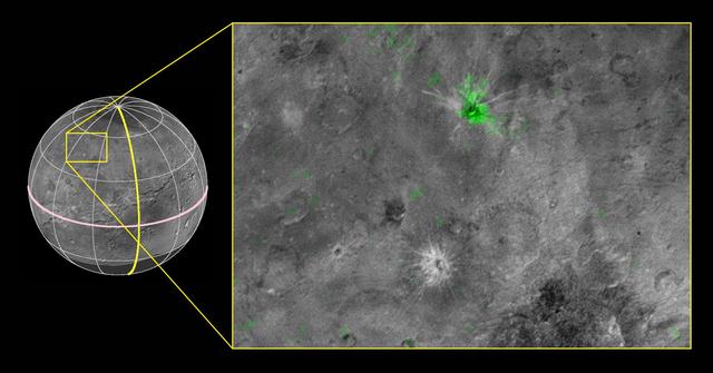
NASA's New Horizons scientists have discovered a striking contrast between one of the fresh craters on Pluto's largest moon Charon and a neighboring crater dotting the moon's Pluto-facing hemisphere. The crater, informally named Organa, caught scientists' attention as they were studying New Horizons' highest-resolution infrared compositional scan of Charon. Organa and portions of the surrounding material ejected from it show infrared absorption at wavelengths of about 2.2 microns, indicating that the crater is rich in frozen ammonia -- and, from what scientists have seen so far, unique on Pluto's largest moon. The infrared spectrum of nearby Skywalker crater, for example, is similar to the rest of Charon's craters and surface, with features dominated by ordinary water ice. This composite image is based on observations from the New Horizons Ralph/LEISA instrument made at 10:25 UT (6:25 a.m. EDT) on July 14, 2015, when New Horizons was 50,000 miles (81,000 kilometers) from Charon. The spatial resolution is 3 miles (5 kilometers) per pixel. The LEISA data were downlinked Oct. 1-4, 2015, and processed into a map of Charon's 2.2 micron ammonia-ice absorption band. Long Range Reconnaissance Imager (LORRI) panchromatic images used as the background in this composite were taken about 8:33 UT (4:33 a.m. EDT) July 14 at a resolution of 0.6 miles (0.9 kilometers) per pixel and downlinked Oct. 5-6. The ammonia absorption map from LEISA is shown in green on the LORRI image. The region covered by the yellow box is 174 miles across (280 kilometers). http://photojournal.jpl.nasa.gov/catalog/PIA20036

New Horizons' Long Range Reconnaissance Imager (LORRI) obtained these three images of Pluto between July 1-3 ,2015, as the spacecraft closed in on its July 14 encounter with the dwarf planet and its moons. The left image shows, on the right side of the disk, a large bright area on the hemisphere opposite Charon; this is the side of Pluto that will be seen in close-up by New Horizons on July 14. The three images together show the full extent of a continuous swath of dark terrain that wraps around Pluto's equatorial region between longitudes 40° and 160°. The western end of the swath, west of longitude 40°, breaks up into a series of striking dark regularly-spaced spots on the anti-Charon hemisphere (right image) that were first noted in New Horizons images taken on Pluto's previous rotation. Intriguing details are beginning to emerge in the bright material north of the dark region, in particular a series of bright and dark patches that are conspicuous just below the center of the disk in the right-hand image. In all three black-and-white views, the apparent jagged bottom edge of Pluto is the result of image processing. http://photojournal.jpl.nasa.gov/catalog/PIA19698
This map of Pluto, created from images taken from June 27-July 3, 2015, by the Long Range Reconnaissance Imager (LORRI) on New Horizons, was combined with lower-resolution color data from the spacecraft's Ralph instrument. The center of the map corresponds to the side of Pluto that will be seen close-up during New Horizons' July 14 flyby. This map gives mission scientists an important tool to decipher the complex and intriguing pattern of bright and dark markings on Pluto's surface. Features from all sides of Pluto can now be seen at a glance and from a consistent perspective, making it much easier to compare their shapes and sizes. The elongated dark area informally known as "the whale," along the equator on the left side of the map, is one of the darkest regions visible to New Horizons. It measures some 1,860 miles (3,000 kilometers) in length. Directly to the right of the whale's "snout" is the brightest region visible on the planet, which is roughly 990 miles (1,600 kilometers) across. This may be a region where relatively fresh deposits of frost -- perhaps including frozen methane, nitrogen and/or carbon monoxide -- form a bright coating. http://photojournal.jpl.nasa.gov/catalog/PIA19700

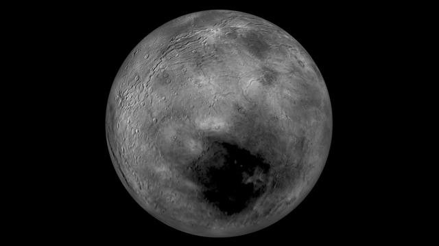
This image of Charon was taken by New Horizons' Long Range Reconnaissance Imager (LORRI) at 4:23 UT on July 9, 2015, from a range of 3.9 million miles (6.3 million kilometers). It reveals fascinating detail, never before seen, on the surface of Pluto's giant moon, which has a diameter of 750 miles (1208 kilometers). The dark north polar region, which has been seen for several weeks on approach, is still prominent, but numerous bright spots, scattered over Charon's surface, are now also visible. It is possible that many of these spots are bright icy material excavated from Charon's subsurface by impact craters, but whether this is true will become clearer in the next few days. Three consecutive images were combined and sharpened, using a process called deconvolution, to create this view. Deconvolution enhances real detail but can also generate spurious features, including the bright margin seen on the upper edge of the disk. The wireframe globe shows the orientation of Charon in the image -- thicker lines indicate the equator and the prime meridian (the direction facing Pluto). Central longitude on Charon is 266°. http://photojournal.jpl.nasa.gov/catalog/PIA19704

This image of Pluto was taken by New Horizons' Long Range Reconnaissance Imager (LORRI) at 4:18 UT on July 9, 2015, from a range of 3.9 million miles (6.3 million kilometers). It reveals new details on the surface of Pluto, including complex patterns in the transition between the very dark equatorial band (nicknamed "the whale"), which occupies the lower part of the image, and the brighter northern terrain. The bright arc at the bottom of the disk shows that there is more bright terrain beyond the southern margin of the "whale." The side of Pluto that will be studied in great detail during the close encounter on July 14 is now rotating off the visible disk on the right hand side, and will not be seen again until shortly before closest approach. Three consecutive images were combined and sharpened, using a process called deconvolution, to create this view. Deconvolution enhances real detail but can also generate spurious features, including the bright edge seen on the upper and left margins of the disk (though the bright margin on the bottom of the disk is real). The wireframe globe shows the orientation of Pluto in the image: thicker lines indicate the equator and the prime meridian (the direction facing Charon). Central longitude on Pluto is 86°. http://photojournal.jpl.nasa.gov/catalog/PIA19705
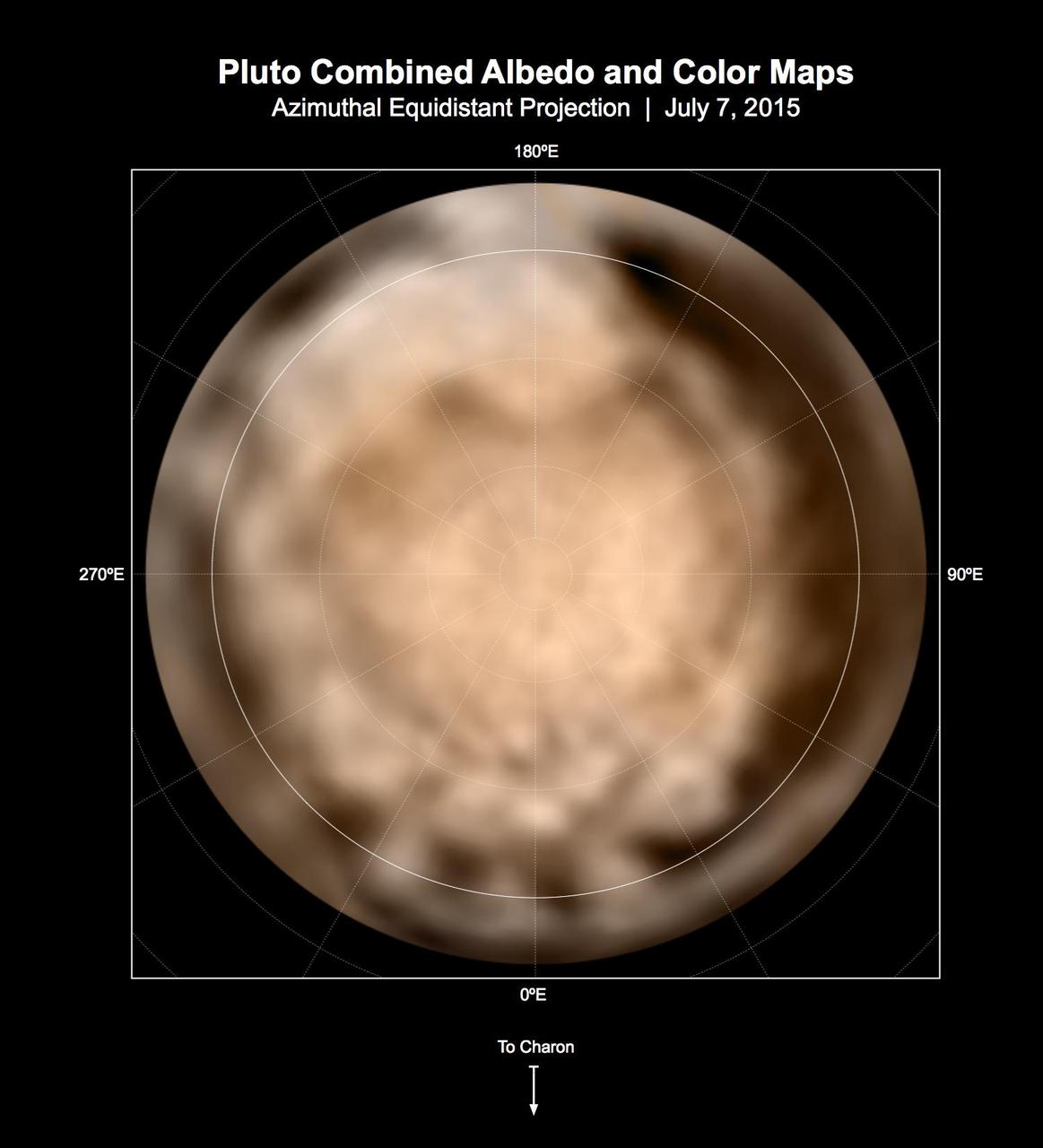
These circular maps shows the distribution of Pluto's dark and bright terrains as revealed by NASA's New Horizons mission prior to July 4, 2015. Each map is an azimuthal equidistant projection centered on the north pole, with latitude and longitude indicated. Both a gray-scale and color version are shown. The gray-scale version is based on 7 days of panchromatic imaging from the Long Range Reconnaissance Imager (LORRI), whereas the color version uses the gray-scale base and incorporates lower-resolution color information from the Multi-spectral Visible Imaging Camera (MVIC), part of the Ralph instrument. The color version is also shown in a simple cylindrical projection in PIA19700. In these maps, the polar bright terrain is surrounded by a somewhat darker polar fringe, one whose latitudinal position varies strongly with longitude. Especially striking are the much darker regions along the equator. A broad dark swath ("the whale") stretches along the equator from approximately 20 to 160 degrees of longitude. Several dark patches appear in a regular sequence centered near 345 degrees of longitude. A spectacular bright region occupies Pluto's mid-latitudes near 180 degrees of longitude, and stretches southward over the equator. New Horizons' closest approach to Pluto will occur near this longitude, which will permit high-resolution visible imaging and compositional mapping of these various regions. http://photojournal.jpl.nasa.gov/catalog/PIA19706
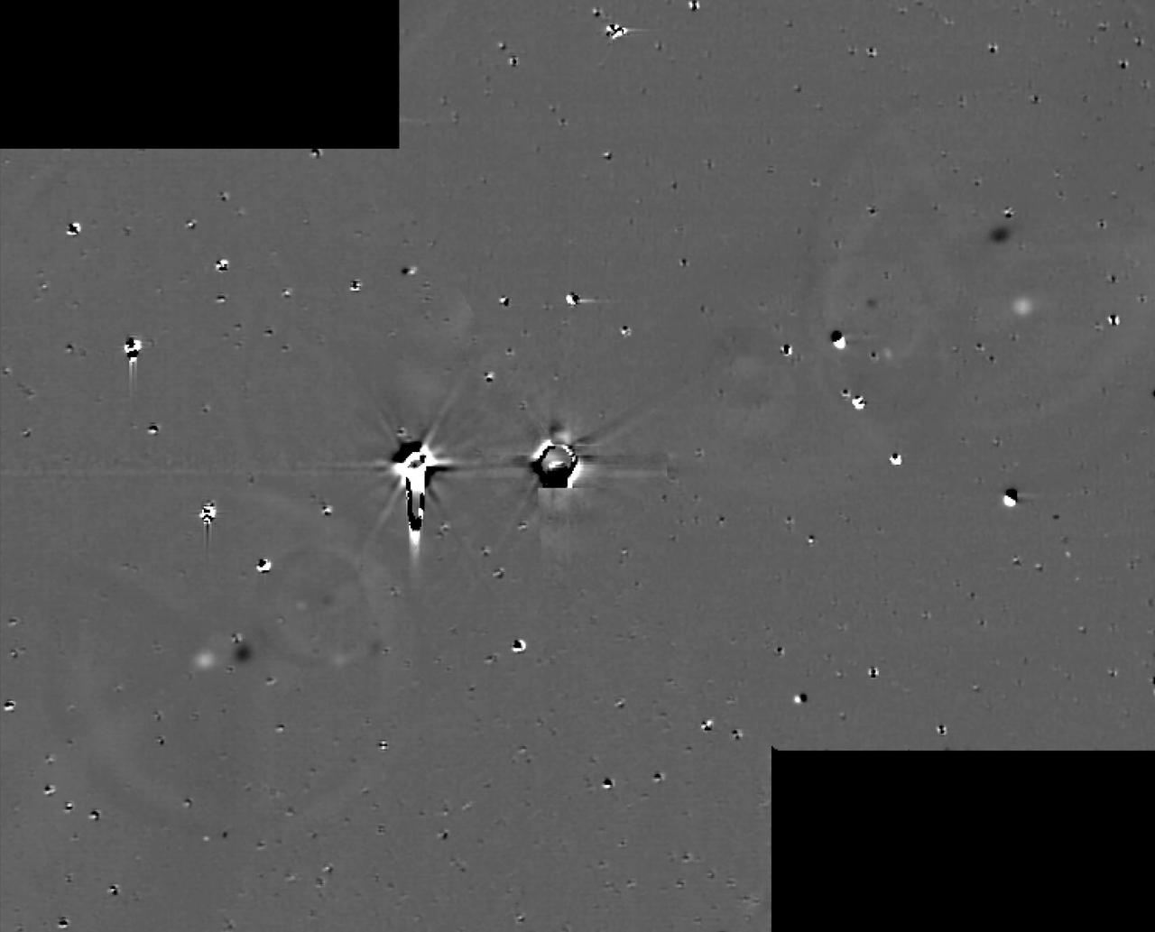
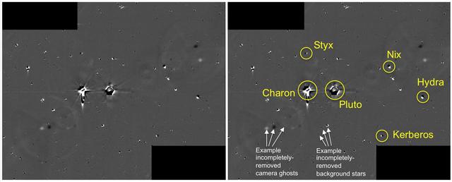
This illustration shows some of the final images used to determine that the coast is clear for New Horizons' flight through the Pluto system. These images show the difference between two sets of 48 combined 10-second exposures with New Horizons Long Range Reconnaissance Imager (LORRI) camera, taken at 8:40 UTC and 10:25 UTC on June 26, 2015, from a range of 21.5 million kilometers (approximately 13 million miles) to Pluto. The known small moons, Nix, Hydra, Kerberos and Styx, are visible as adjacent bright and dark pairs of dots, due to their motion in the 105 minutes between the two image sets. The images have been extensively processed to remove the glare and "ghosts" (i.e., lens flare) from Pluto and Charon, and also to remove background stars, though many of the brighter stars are imperfectly removed and appear as irregular bright and dark blobs. These and other similar sets of images demonstrate that there are no previously unknown moons brighter than 15 times fainter than Styx (the faintest known moon) in the region outside of Charon's orbit, or brighter than five times fainter than Styx in the region between Charon's orbit and a few thousand kilometers above Pluto's surface. http://photojournal.jpl.nasa.gov/catalog/PIA19695
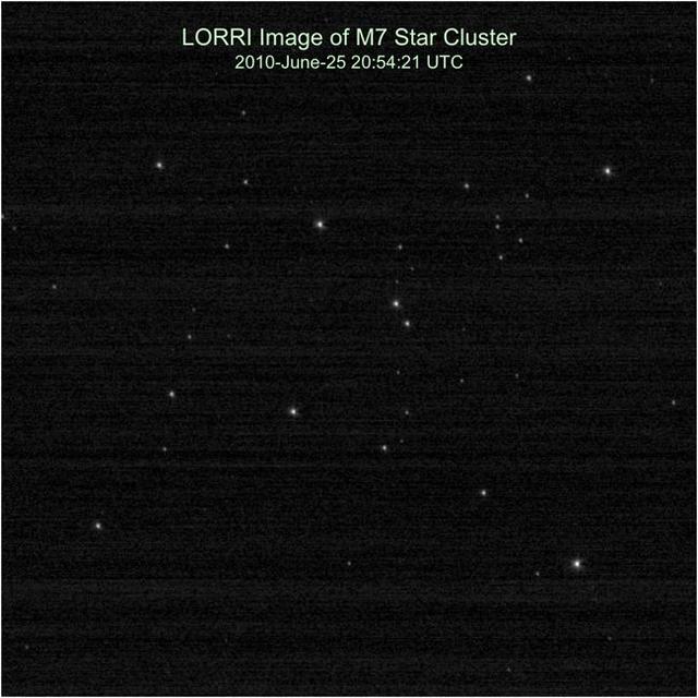
NASA New Horizons team calibrates the Long Range Reconnaissance Imager LORRI by taking pictures of the open star cluster M7.

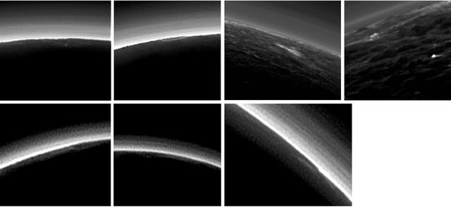
This processed image is the highest-resolution color look yet at the haze layers in Pluto's atmosphere. Shown in approximate true color, the picture was constructed from a mosaic of four panchromatic images from the Long Range Reconnaissance Imager (LORRI) splashed with Ralph/Multispectral Visible Imaging Camera (MVIC) four-color filter data, all acquired by NASA's New Horizons spacecraft on July 14, 2015. The resolution is 1 kilometer (0.6 miles) per pixel; the sun illuminates the scene from the right. Scientists believe the haze is a photochemical smog resulting from the action of sunlight on methane and other molecules in Pluto's atmosphere, producing a complex mixture of hydrocarbons such as acetylene and ethylene. These hydrocarbons accumulate into small particles, a fraction of a micrometer in size, and scatter sunlight to make the bright blue haze seen in this image. As they settle down through the atmosphere, the haze particles form numerous intricate, horizontal layers, some extending for hundreds of miles around Pluto. The haze layers extend to altitudes of over 200 kilometers (120 miles). Adding to the stark beauty of this image are mountains on Pluto's limb (on the right, near the 4 o'clock position), surface features just within the limb to the right, and crepuscular rays (dark finger-like shadows to the left) extending from Pluto's topographic features. http://photojournal.jpl.nasa.gov/catalog/PIA20362
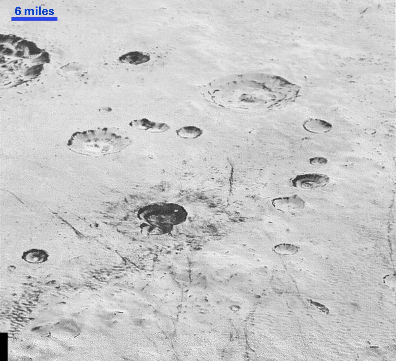
This single frame from a four-frame movie shows New Horizons' final deep search for hazardous material around Pluto, obtained on July 1, 2015. These data allow a highly sensitive search for any new moons. The images were taken with the spacecraft's Long Range Reconnaissance Imager (LORRI) over a 100-minute period, and were the final observations in the series of dedicated searches for hazards in the Pluto system which began on May 11. The images show all five known satellites of Pluto moving in their orbits around the dwarf planet, but analysis of these data has so far not revealed the existence of any additional moons. This means that any undiscovered Plutonian moons further than a few thousand miles from Pluto must be smaller than about 1 mile (1.6 kilometers) in diameter, if their surfaces have similar brightness to Pluto's big moon Charon. For comparison, Pluto's faintest known moon, Styx, which is conspicuous in the lower left quadrant of these images, is about 4 miles (7 kilometers) across, assuming the same surface brightness. The absence of additional moons, and also the absence of detectable rings in the hazard search data, imply that the spacecraft is very unlikely to be damaged by collisions with rings, or dust particles ejected from moons, during its high-speed passage through the Pluto system. The four movie frames were taken at 16:28, 16:38, 17:52, and 18:04 UTC on July 1, from a range of 9.4 million miles (15.2 million kilometers). Each frame is a mosaic of four sets of overlapping images, with a total exposure time of 120 seconds. The images have been heavily processed to remove the glare of Pluto and Charon, and the dense background of stars, though blemishes remain at the locations of many of the brighter stars. The "tails" extending to the right or downward from Pluto and Charon are camera artifacts caused by the extreme overexposure of both objects. Pluto and its five moons Charon, Styx, Nix, Kerberos and Hydra are identified by their initials, and their orbits around the center of gravity of the system (which is located just outside Pluto itself) are also shown. http://photojournal.jpl.nasa.gov/catalog/PIA19701

Remarkable new details of Pluto's largest moon Charon are revealed in this image from New Horizons' Long Range Reconnaissance Imager (LORRI), taken late on July 13, 2015 from a distance of 289,000 miles (466,000 kilometers). A swath of cliffs and troughs stretches about 600 miles (1,000 kilometers) from left to right, suggesting widespread fracturing of Charon's crust, likely a result of internal processes. At upper right, along the moon's curving edge, is a canyon estimated to be 4 to 6 miles (7 to 9 kilometers) deep. Mission scientists are surprised by the apparent lack of craters on Charon. South of the moon's equator, at the bottom of this image, terrain is lit by the slanting rays of the sun, creating shadows that make it easier to distinguish topography. Even here, however, relatively few craters are visible, indicating a relatively young surface that has been reshaped by geologic activity. In Charon's north polar region, a dark marking prominent in New Horizons' approach images is now seen to have a diffuse boundary, suggesting it is a thin deposit of dark material. Underlying it is a distinct, sharply bounded, angular feature; higher resolution images still to come are expected to shed more light on this enigmatic region. The image has been compressed to reduce its file size for transmission to Earth. In high-contrast areas of the image, features as small as 3 miles (5 kilometers) across can be seen. Some lower-contrast detail is obscured by the compression of the image, which may make some areas appear smoother than they really are. The uncompressed version still resides in New Horizons' computer memory and is scheduled to be transmitted at a later date. The image has been combined with color information obtained by New Horizons' Ralph instrument on July 13. New Horizons traveled more than three billion miles over nine-and-a-half years to reach the Pluto system. http://photojournal.jpl.nasa.gov/catalog/PIA19709
This image of Pluto and its big moon Charon was taken by NASA's New Horizons spacecraft at 04:15 (UTC) on July 1, 2015, and shows the clearest view yet of the sides of Pluto and Charon that will be studied in great detail during New Horizons' closest approach to the dwarf planet on July 14, 2015. There will be just two more rotations of Pluto and Charon, and two more orbits about their mutual center of gravity, between the time of this image and closest approach (the rotation period of the system is 6.4 days). The image, which has been sharpened by the image processing technique known as deconvolution, shows details as small as about 160 kilometers (100 miles). The highest-resolution images of this side of Pluto, taken on July 14, will show details that are 1,000 times smaller. New Horizons is revealing Pluto to be a world that, at this point, looks like no other in the solar system. Its equatorial regions are occupied by a discontinuous band of very dark material, which is interrupted on this hemisphere by a very bright region which appears sharp-edged at the resolution of the image. The north polar region is blander, but shows a distinctive darker southern boundary where it meets the higher-contrast equatorial regions. The origin of these remarkable features is still unknown, though some of them might be related to seasonal movement of frost across Pluto's surface. Charon, in contrast, still shows few details other than the dark polar region. The image was taken by New Horizons' Long Range Reconnaissance Imager (LORRI ) at a distance from Pluto of 15.8 million kilometers (9.8 million miles) and has a central longitude of 177 degrees on Pluto and 357 degrees on Charon. The inset shows the orientation of Pluto- the solid lines mark the equator and the prime meridian, which is defined to be the longitude that always faces Charon. http://photojournal.jpl.nasa.gov/catalog/PIA19694

This pair of approximately true color images of Pluto and its big moon Charon, taken by NASA's New Horizons spacecraft, highlight the dramatically different appearance of different sides of the dwarf planet, and reveal never-before-seen details on Pluto's varied surface. The views were made by combining high-resolution black-and-white images from the Long Range Reconnaissance Imager (LORRI) with color information from the lower-resolution color camera that is part of the Ralph instrument. The left-hand image shows the side of Pluto that always faces away from Charon -- this is the side that will be seen at highest resolution by New Horizons when it makes its close approach to Pluto on July 14th. This hemisphere is dominated by a very dark region that extends along the equator and is redder than its surroundings, alongside a strikingly bright, paler-colored region which straddles the equator on the right-hand side of the disk. The opposite hemisphere, the side that faces Charon, is seen in the right-hand image. The most dramatic feature on this side of Pluto is a row of dark dots arranged along the equator. The origin of all these features is still mysterious, but may be revealed in the much more detailed images that will be obtained as the spacecraft continues its approach to Pluto. In both images, Charon shows a darker and grayer color than Pluto, and a conspicuous dark polar region. The left-hand image was obtained at 5:37 UT on June 25th 2015, at a distance from Pluto of 22.9 million kilometers (14.3 million miles) and has a central longitude of 152 degrees. The right-hand image was obtained at 23:15 UT on June 27th 2015, at a distance from Pluto of 19.7 million kilometers (12.2 million miles) with a central longitude of 358 degrees. Insets show the orientation of Pluto in each image -- the solid lines mark the equator and the prime meridian, which is defined to be the longitude that always faces Charon. The smallest visible features are about 200 km (120 miles) across. http://photojournal.jpl.nasa.gov/catalog/PIA19693
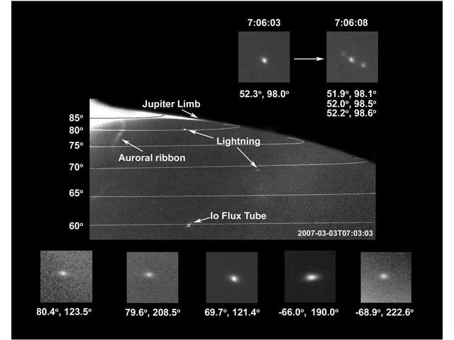
Images taken by the New Horizons Long-Range Reconnaissance Imager LORRI of Jupiter night side showed lightning strikes. Each trike is probably the cumulative brightness of multiple strikes.
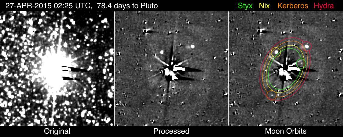
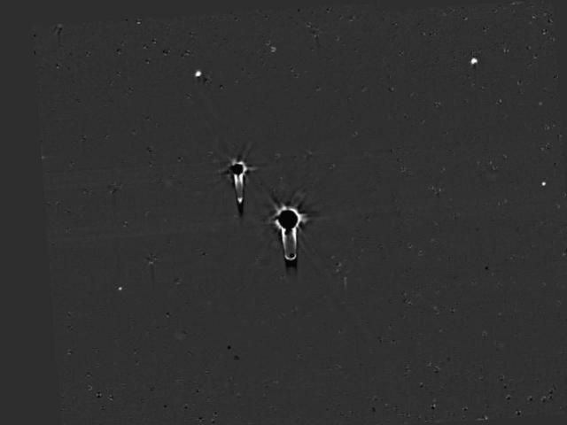
The images detecting Kerberos and Styx shown here were taken with NASA New Horizons most sensitive camera, the Long Range Reconnaissance Imager LORRI, from April 25-May 1, 2015.
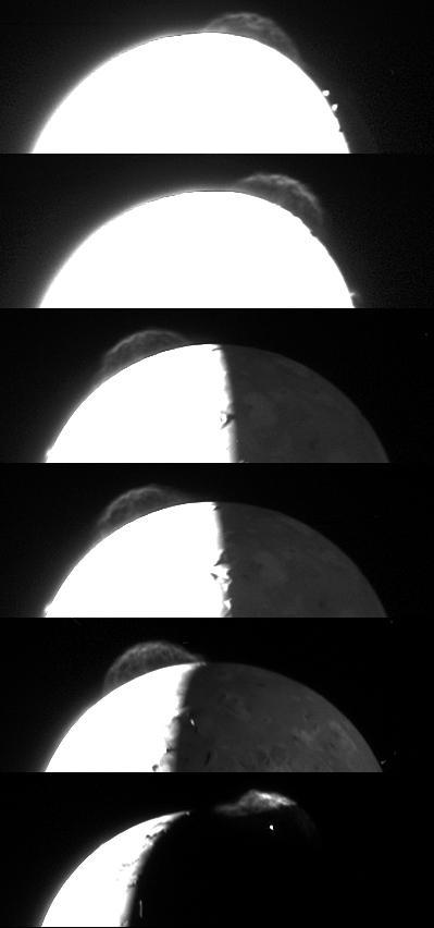
Variations in the appearance of the giant plume from the Tvashtar volcano on Jupiter moon Io are seen in this composite of the best photos taken by the New Horizons Long Range Reconnaissance Imager LORRI during its Jupiter flyby in late February.

A global map of Jupiter moon Io derived from eight images taken by the Long Range Reconnaissance Imager LORRI on the New Horizons spacecraft, as it passed Jupiter on its way to Pluto in late February 2007.

NASA New Horizons Long Range Reconnaissance Imager LORRI observed Neptune on June 23, apl2010, as part of a test of the critical optical navigation Annual Checkout ACO-4.
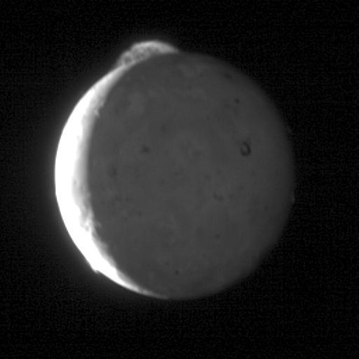
This five-frame sequence of New Horizons images captures the giant plume from Io Tvashtar volcano. These were snapped by the probe Long Range Reconnaissance Imager LORRI as the spacecraft flew past Jupiter earlier this year.

Four images from New Horizons Long Range Reconnaissance Imager LORRI were combined with color data from the spacecraft Ralph instrument to create this enhanced color global view of Pluto.
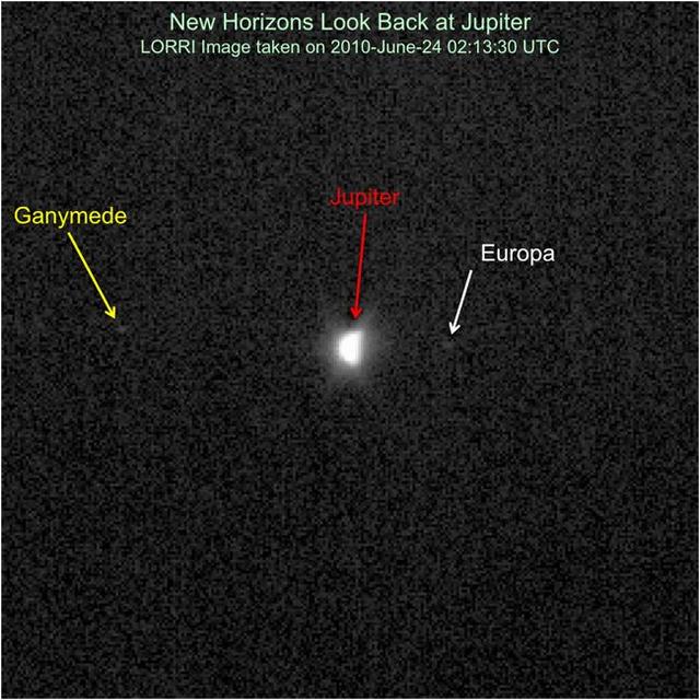
NASA New Horizons had an exciting flyby encounter with Jupiter in early 2007, and the spacecraft has been rapidly moving away from the giant planet ever since.
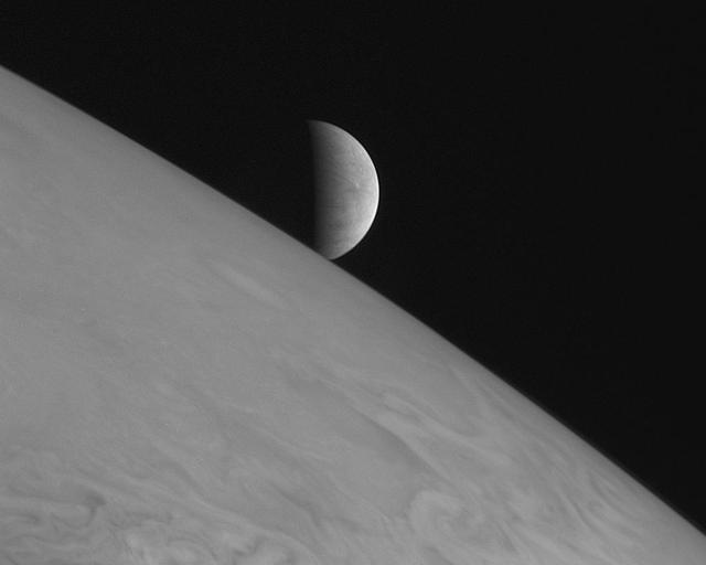
New Horizons took this image of the icy moon Europa rising above Jupiter cloud tops with its Long Range Reconnaissance Imager LORRI at 11:48 Universal Time on February 28, 2007, six hours after the spacecraft closest approach to Jupiter.
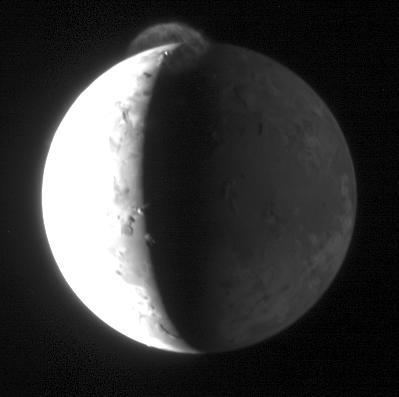
New Horizons took this image of Jupiter volcanic moon Io with its Long Range Reconnaissance Imager LORRI at 15:15 Universal Time on February 28, 2007, nearly 10 hours after the spacecraft closest approach to Jupiter.
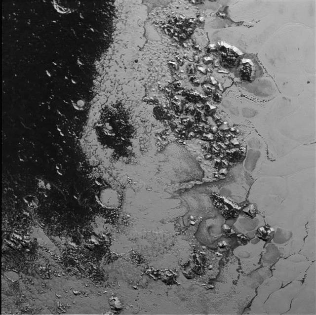
In the center of this 300-mile (470-kilometer) wide image of Pluto from NASA's New Horizons spacecraft is a large region of jumbled, broken terrain on the northwestern edge of the vast, icy plain informally called Sputnik Planum, to the right. The smallest visible features are 0.5 miles (0.8 kilometers) in size. This image was taken as New Horizons flew past Pluto on July 14, 2015, from a distance of 50,000 miles (80,000 kilometers). http://photojournal.jpl.nasa.gov/catalog/PIA19934

This synthetic perspective view of Pluto, based on the latest high-resolution images to be downlinked from NASA's New Horizons spacecraft, shows what you would see if you were approximately 1,100 miles (1,800 kilometers) above Pluto's equatorial area, looking northeast over the dark, cratered, informally named Cthulhu Regio toward the bright, smooth, expanse of icy plains informally called Sputnik Planum. The entire expanse of terrain seen in this image is 1,100 miles (1,800 kilometers) across. The images were taken as New Horizons flew past Pluto on July 14, 2015, from a distance of 50,000 miles (80,000 kilometers). http://photojournal.jpl.nasa.gov/catalog/PIA19937

This image of Pluto's largest moon Charon, taken by NASA's New Horizons spacecraft 10 hours before its closest approach to Pluto on July 14, 2015 from a distance of 290,000 miles (470,000 kilometers), is a recently downlinked, much higher quality version of a Charon image released on July 15. Charon, which is 750 miles (1,200 kilometers) in diameter, displays a surprisingly complex geological history, including tectonic fracturing; relatively smooth, fractured plains in the lower right; several enigmatic mountains surrounded by sunken terrain features on the right side; and heavily cratered regions in the center and upper left portion of the disk. There are also complex reflectivity patterns on Charon's surface, including bright and dark crater rays, and the conspicuous dark north polar region at the top of the image. The smallest visible features are 2.9 miles 4.6 kilometers) in size. http://photojournal.jpl.nasa.gov/catalog/PIA19932

Mosaic of high-resolution images of Pluto, transmitted by NASA's New Horizons spacecraft from Sept. 5 to 7, 2015. The image is dominated by the informally-named icy plain Sputnik Planum, the smooth, bright region across the center. This image also features a tremendous variety of other landscapes surrounding Sputnik. The smallest visible features are 0.5 miles (0.8 kilometers) in size, and the mosaic covers a region roughly 1,000 miles (1,600 kilometers) wide. The image was taken as New Horizons flew past Pluto on July 14, 2015, from a distance of 50,000 miles (80,000 kilometers). The two white rectangles show the locations of the two closeup views by New Horizons, released separately. http://photojournal.jpl.nasa.gov/catalog/PIA19935
This image of Pluto from NASA's New Horizons spacecraft, processed in two different ways, shows how Pluto's bright, high-altitude atmospheric haze produces a twilight that softly illuminates the surface before sunrise and after sunset, allowing the sensitive cameras on New Horizons to see details in nighttime regions that would otherwise be invisible. The right-hand version of the image has been greatly brightened to bring out faint details of rugged haze-lit topography beyond Pluto's terminator, which is the line separating day and night. The image was taken as New Horizons flew past Pluto on July 14, 2015, from a distance of 50,000 miles (80,000 kilometers). http://photojournal.jpl.nasa.gov/catalog/PIA19931

These two images of Pluto and Charon were collected separately by NASA New Horizons during approach on July 13 and July 14, 2015. The relative reflectivity, size, separation, and orientations, and colors are approximated in this composite image, and they are shown in approximate true color. http://photojournal.jpl.nasa.gov/catalog/PIA19717
This 220-mile (350-kilometer) wide view of Pluto from NASA's New Horizons spacecraft illustrates the incredible diversity of surface reflectivities and geological landforms on the dwarf planet. The image includes dark, ancient heavily cratered terrain; bright, smooth geologically young terrain; assembled masses of mountains; and an enigmatic field of dark, aligned ridges that resemble dunes; its origin is under debate. The smallest visible features are 0.5 miles (0.8 kilometers) in size. This image was taken as New Horizons flew past Pluto on July 14, 2015, from a distance of 50,000 miles (80,000 kilometers). http://photojournal.jpl.nasa.gov/catalog/PIA19933
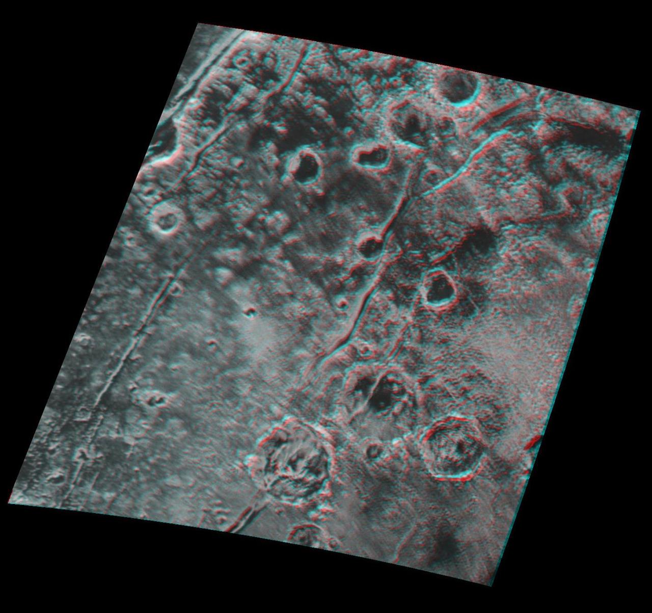
Global stereo mapping of Pluto surface is now possible, as images taken from multiple directions are downlinked from NASA New Horizons spacecraft. Stereo images will eventually provide an accurate topographic map of most of the hemisphere of Pluto seen by New Horizons during the July 14 flyby, which will be key to understanding Pluto's geological history. This example, which requires red/blue stereo glasses for viewing, shows a region 180 miles (300 kilometers) across, centered near longitude 130 E, latitude 20 N (the red square in the global context image). North is to the upper left. The image shows an ancient, heavily cratered region of Pluto, dotted with low hills and cut by deep fractures, which indicate extension of Pluto's crust. Analysis of these stereo images shows that the steep fracture in the upper left of the image is about 1 mile (1.6 kilometers) deep, and the craters in the lower right part of the image are up to 1.3 miles (2.1 km) deep. Smallest visible details are about 0.4 miles (0.6 kilometers) across. You will need 3D glasses to view this image showing an ancient, heavily cratered region of Pluto. http://photojournal.jpl.nasa.gov/catalog/PIA20032
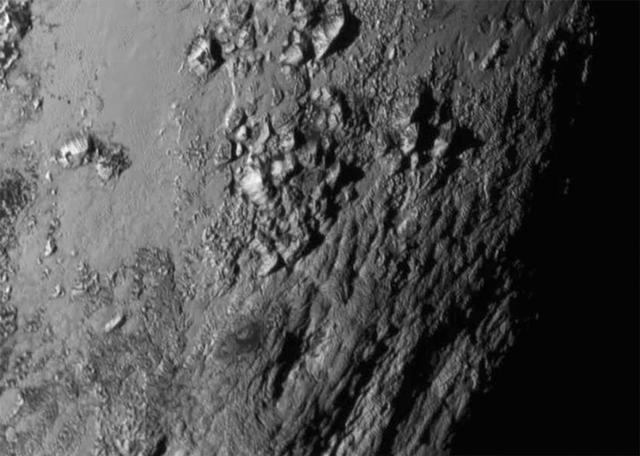
New close-up images of a region near Pluto's equator reveal a giant surprise: a range of youthful mountains rising as high as 11,000 feet (3,500 meters) above the surface of the icy body. The mountains likely formed no more than 100 million years ago -- mere youngsters relative to the 4.56-billion-year age of the solar system -- and may still be in the process of building. That suggests the close-up region, which covers less than one percent of Pluto's surface, may still be geologically active today. The youthful age estimate is based on the lack of craters in this scene. Like the rest of Pluto, this region would presumably have been pummeled by space debris for billions of years and would have once been heavily cratered -- unless recent activity had given the region a facelift, erasing those pockmarks. Unlike the icy moons of giant planets, Pluto cannot be heated by gravitational interactions with a much larger planetary body. Some other process must be generating the mountainous landscape. The mountains are probably composed of Pluto's water-ice "bedrock." Although methane and nitrogen ice covers much of the surface of Pluto, these materials are not strong enough to build the mountains. Instead, a stiffer material, most likely water-ice, created the peaks. The close-up image was taken about 1.5 hours before New Horizons closest approach to Pluto, when the craft was 47,800 miles (770,000 kilometers) from the surface of the planet. The image easily resolves structures smaller than a mile across. http://photojournal.jpl.nasa.gov/catalog/PIA19710

Mosaic of high-resolution images of Pluto, sent back from NASA's New Horizons spacecraft from Sept. 5 to 7, 2015. The image is dominated by the informally-named icy plain Sputnik Planum, the smooth, bright region across the center. This image also features a tremendous variety of other landscapes surrounding Sputnik. The smallest visible features are 0.5 miles (0.8 kilometers) in size, and the mosaic covers a region roughly 1,000 miles (1600 kilometers) wide. The image was taken as New Horizons flew past Pluto on July 14, 2015, from a distance of 50,000 miles (80,000 kilometers). http://photojournal.jpl.nasa.gov/catalog/PIA19936
High-resolution images of Pluto taken by NASA's New Horizons spacecraft just before closest approach on July 14, 2015, are the sharpest images to date of Pluto's varied terrain-revealing details down to scales of 270 meters. In this 75-mile (120-kilometer) section taken from the larger, high-resolution mosaic, the textured surface of the plain surrounds two isolated ice mountains. http://photojournal.jpl.nasa.gov/catalog/PIA19954

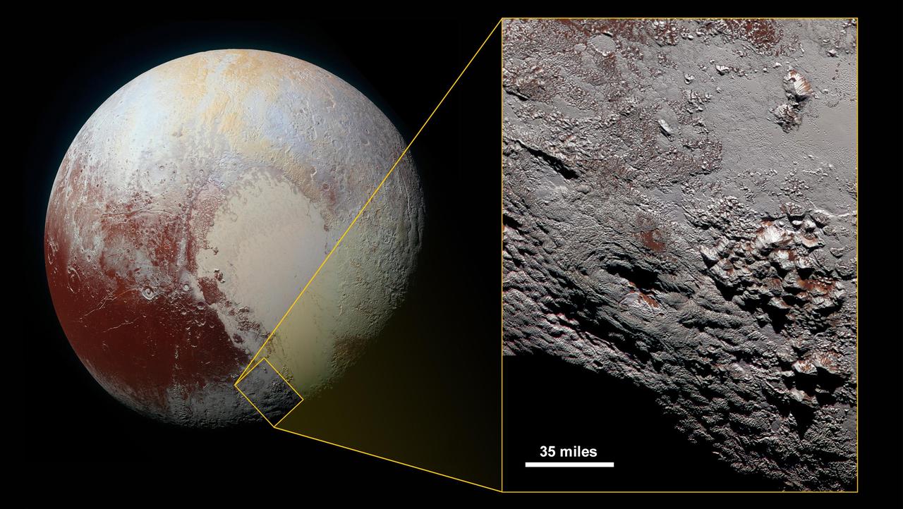
A composite of enhanced color images of Pluto (lower right) and Charon (upper left), taken by NASA's New Horizons spacecraft as it passed through the Pluto system on July 14, 2015. This image highlights the striking differences between Pluto and Charon. The color and brightness of both Pluto and Charon have been processed identically to allow direct comparison of their surface properties, and to highlight the similarity between Charon's polar red terrain and Pluto's equatorial red terrain. Pluto and Charon are shown with approximately correct relative sizes, but their true separation is not to scale. The image combines blue, red and infrared images taken by the spacecraft's Ralph/Multispectral Visual Imaging Camera (MVIC). http://photojournal.jpl.nasa.gov/catalog/PIA19966
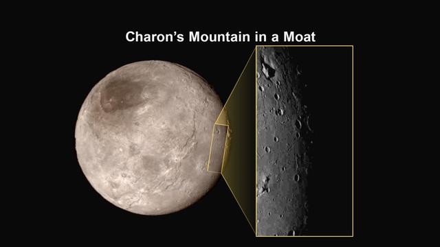
Images from NASA New Horizons spacecraft were used to create a flyover video (PIA19965) of Pluto largest moon, Charon. The flight starts with the informally named Mordor dark region near Charon north pole. In the video, the camera then moves south to a vast chasm, descending from 1,100 miles (1,800 kilometers) to just 40 miles (60 kilometers) above the surface to fly through the canyon system. From there it's a turn to the south to view the plains and "moat mountain," informally named Kubrick Mons, a prominent peak surrounded by a topographic depression. http://photojournal.jpl.nasa.gov/catalog/PIA19965
Pluto's present, hazy atmosphere is almost entirely free of clouds, though scientists from NASA's New Horizons mission have identified some cloud candidates after examining images taken by the New Horizons Long Range Reconnaissance Imager and Multispectral Visible Imaging Camera, during the spacecraft's July 2015 flight through the Pluto system. All are low-lying, isolated small features -- no broad cloud decks or fields -- and while none of the features can be confirmed with stereo imaging, scientists say they are suggestive of possible, rare condensation clouds. http://photojournal.jpl.nasa.gov/catalog/PIA21127

What would it be like to actually land on Pluto? This image is one of more than 100 images taken by NASA's New Horizons spacecraft over six weeks of approach and close flyby in the summer of 2015. A video offers a trip down onto the surface of Pluto -- starting with a distant view of Pluto and its largest moon, Charon -- and leading up to an eventual ride in for a "landing" on the shoreline of Pluto's informally named Sputnik Planitia. After a 9.5-year voyage covering more than three billion miles, New Horizons flew through the Pluto system on July 14, 2015, coming within 7,800 miles (12,500 kilometers) of Pluto. Carrying powerful telescopic cameras that could spot features smaller than a football field, New Horizons sent back hundreds of images of Pluto and its moons that show how dynamic and fascinating their surfaces are. Movies are available at http://photojournal.jpl.nasa.gov/catalog/PIA11709

Four images from NASA's New Horizons' Long Range Reconnaissance Imager (LORRI) were combined with color data from the Ralph instrument to create this global view of Pluto. (The lower right edge of Pluto in this view currently lacks high-resolution color coverage.) The images, taken when the spacecraft was 280,000 miles (450,000 kilometers) away, show features as small as 1.4 miles (2.2 kilometers), twice the resolution of the single-image view taken on July 13. http://photojournal.jpl.nasa.gov/catalog/PIA19857

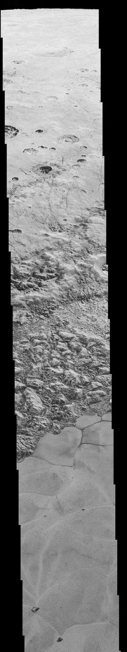
This frame from a movie, which extends across the hemisphere that faced New Horizons spacecraft as it flew past Pluto on July 14, 2015, includes all of the highest-resolution images taken by the NASA probe. With a resolution of about 260 feet (80 meters) per pixel, the movie affords New Horizons scientists and the public the best opportunity to examine the fine details of the various types of terrain the mosaic covers, and determine the processes that formed and shaped them. The view extends from the "limb" of Pluto at the top of the strip, almost to the "terminator" (or day/night line) in the southeast of the encounter hemisphere, seen at the bottom of the strip. The width of the strip ranges from more than 55 miles (90 kilometers) at its northern end to about 45 miles (75 kilometers) at its southern end. The perspective changes greatly along the strip: at its northern end, the view looks out horizontally across the surface, while at its southern end, the view looks straight down onto the surface. This movie pans down the mosaic from top to bottom, offering new views of many of Pluto's distinct landscapes along the way. Starting with hummocky, cratered uplands at top, the view crosses over parallel ridges of the "washboard" terrain; chaotic and angular mountain ranges; the craterless, cellular plains; coarsely "pitted" areas of sublimating nitrogen ice; zones of thin nitrogen ice draped over the topography below; and rugged, dark, mountainous highlands scarred by deep pits. The frames in the movie were obtained by New Horizons' Long Range Reconnaissance Imager (LORRI) approximately 9,850 miles (15,850 kilometers) from Pluto, about 23 minutes before New Horizons' closest approach. LORRI is only capable of obtaining black-and-white images; all color images are made by the Ralph instrument, which has somewhat lower resolution than LORRI. Movies are available at http://photojournal.jpl.nasa.gov/catalog/PIA14457
This cylindrical projection map of Pluto, in enhanced, extended color, is the most detailed color map of Pluto ever made by NASA New Horizons. It uses recently returned color imagery from the New Horizons Ralph camera, which is draped onto a base map of images from the NASA's spacecraft's Long Range Reconnaissance Imager (LORRI). The map can be zoomed in to reveal exquisite detail with high scientific value. Color variations have been enhanced to bring out subtle differences. Colors used in this map are the blue, red, and near-infrared filter channels of the Ralph instrument. http://photojournal.jpl.nasa.gov/catalog/PIA19956
A newly discovered mountain range lies near the southwestern margin of Pluto heart-shaped Tombaugh Regio Tombaugh Region, situated between bright, icy plains and dark, heavily-cratered terrain. This image was acquired by NASA's New Horizons' Long Range Reconnaissance Imager (LORRI) on July 14, 2015, from a distance of 48,000 miles (77,000 kilometers) and sent back to Earth on July 20. Features as small as a half-mile (1 kilometer) across are visible. These frozen peaks are estimated to be one-half mile to one mile (1-1.5 kilometers) high, about the same height as the United States' Appalachian Mountains. The Norgay Montes (Norgay Mountains) discovered by New Horizons on July 15 more closely approximate the height of the taller Rocky Mountains The names of features on Pluto have all been given on an informal basis by the New Horizons team. http://photojournal.jpl.nasa.gov/catalog/PIA19842
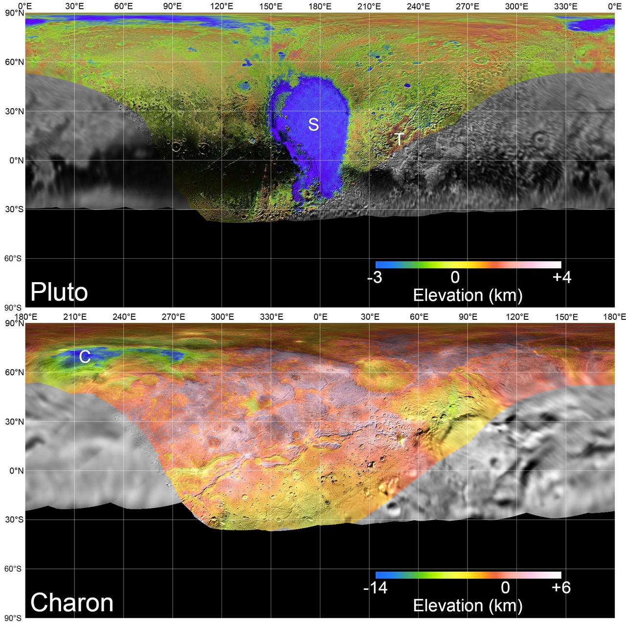
Global mosaics of Pluto and Charon projected at 300 meters (985 feet) per pixel that have been assembled from most of the highest resolution images obtained by the Long-Range Reconnaissance Imager (LORRI) and the Multispectral Visible Imaging Camera (MVIC) onboard New Horizons. Transparent, colorized stereo topography data generated for the encounter hemispheres of Pluto and Charon have been overlain on the mosaics. Terrain south of about 30°S on Pluto and Charon was in darkness leading up to and during the flyby, so is shown in black. "S" and "T" respectively indicate Sputnik Planitia and Tartarus Dorsa on Pluto, and "C" indicates Caleuche Chasma on Charon. All feature names on Pluto and Charon are informal. https://photojournal.jpl.nasa.gov/catalog/PIA21862

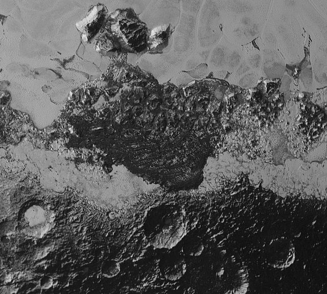
In addition to transmitting new high-resolution images and other data on the familiar close-approach hemispheres of Pluto and Charon, NASA's New Horizons spacecraft is also returning images -- such as this one -- to improve maps of other regions. This image was taken by the New Horizons Long Range Reconnaissance Imager (LORRI) on the morning of July 13, 2015, from a range of 1.03 million miles (1.7 million kilometers) and has a resolution of 5.1 miles (8.3 kilometers) per pixel. It provides fascinating new details to help the science team map the informally named Krun Macula (the prominent dark spot at the bottom of the image) and the complex terrain east and northeast of Pluto's "heart" (Tombaugh Regio). Pluto's north pole is on the planet's disk at the 12 o'clock position of this image. http://photojournal.jpl.nasa.gov/catalog/PIA20037

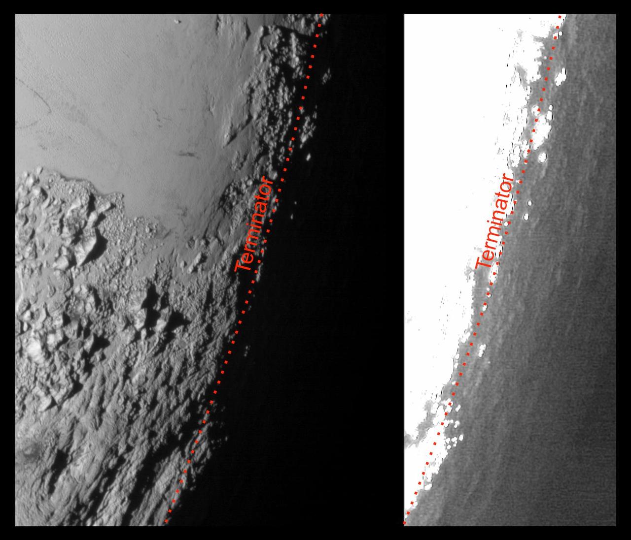
This is the highest-resolution color departure shot of Pluto's receding crescent from NASA's New Horizons spacecraft, taken when the spacecraft was 120,000 miles (200,000 kilometers) away from Pluto. Shown in approximate true color, the picture was constructed from a mosaic of six black-and-white images from the Long Range Reconnaissance Imager (LORRI), with color added from a lower resolution Ralph/Multispectral Visible Imaging Camera (MVIC) color image, all acquired between 15:20 and 15:45 UT -- about 3.5 hours after closest approach to Pluto -- on July 14, 2015. The resolution of the LORRI images is about 0.6 miles (1 kilometer) per pixel; the sun illuminates the scene from the other side of Pluto and somewhat toward the top of this image. The image is dominated by spectacular layers of blue haze in Pluto's atmosphere. Scientists believe the haze is a photochemical smog resulting from the action of sunlight on methane and other molecules in Pluto's atmosphere, producing a complex mixture of hydrocarbons such as acetylene and ethylene. These hydrocarbons accumulate into small haze particles, a fraction of a micrometer in size, which preferentially scatter blue sunlight -- the same process that can make haze appear bluish on Earth. As they settle down through the atmosphere, the haze particles form numerous intricate, horizontal layers, some extending for hundreds of miles around large portions of the limb of Pluto. The haze layers extend to altitudes of over 120 miles (200 kilometers). Pluto's circumference is 4,667 miles (7,466 kilometers). Adding to the beauty of this picture are mountains and other topographic features on Pluto's surface that are silhouetted against the haze near the top of the image. Sunlight casts dramatic and beautiful finger-like shadows from many of these features onto the haze (especially on the left, near the 11 o'clock position), forming crepuscular rays like those often seen in Earth's atmosphere near sunrise or sunset. https://photojournal.jpl.nasa.gov/catalog/PIA21590
This mosaic is composed of the sharpest views of Pluto that NASA's New Horizons spacecraft obtained during its flyby of the distant planet on July 14, 2015. The pictures are part of a sequence taken near New Horizons' closest approach to Pluto, with resolutions of about 250-280 feet (77-85 meters) per pixel -- revealing features smaller than half a city block on Pluto's diverse surface. The images include a wide variety of spectacular, cratered, mountainous and glacial terrains -- giving scientists and the public alike a breathtaking, super-high resolution window on Pluto's geology. The images form a strip 50 miles (80 kilometers) wide trending from Pluto's jagged horizon about 500 miles (800 kilometers) northwest of the informally named Sputnik Planum, across the al-Idrisi mountains, onto the shoreline of Sputnik Planum and then across its icy plains. They were made with the telescopic Long Range Reconnaissance Imager (LORRI) aboard New Horizons, over a timespan of about a minute centered on 11:36 UT on July 14 -- just about 15 minutes before New Horizons' closest approach to Pluto -- from a range of just 10,000 miles (17,000 kilometers). They were obtained with an unusual observing mode; instead of working in the usual "point and shoot," LORRI snapped pictures every three seconds while the Ralph/Multispectral Visual Imaging Camera (MVIC) aboard New Horizons was scanning the surface. This mode requires unusually short exposures to avoid blurring the images. http://photojournal.jpl.nasa.gov/catalog/PIA20201
This highest-resolution image from NASA's New Horizons spacecraft shows how erosion and faulting has sculpted this portion of Pluto's icy crust into rugged badlands. The prominent 1.2-mile-high cliff at the top, running from left to upper right, is part of a great canyon system that stretches for hundreds of miles across Pluto's northern hemisphere. New Horizons team members think that the mountains in the middle are made of water ice, but have been modified by the movement of nitrogen or other exotic ice glaciers over long periods of time, resulting in a muted landscape of rounded peaks and intervening sets of short ridges. At the bottom of this 50-mile-wide image, the terrain transforms dramatically into a fractured and finely broken up floor at the northwest margin of the giant ice plain informally called Sputnik Planum. The top of the image is to Pluto's northwest. These images were made with the telescopic Long Range Reconnaissance Imager (LORRI) aboard New Horizons, in a timespan of about a minute centered on 11:36 UT on July 14 -- just about 15 minutes before New Horizons' closest approach to Pluto -- from a range of just 10,000 miles (17,000 kilometers). They were obtained with an unusual observing mode; instead of working in the usual "point and shoot," LORRI snapped pictures every three seconds while the Ralph/Multispectral Visual Imaging Camera (MVIC) aboard New Horizons was scanning the surface. This mode requires unusually short exposures to avoid blurring the images. http://photojournal.jpl.nasa.gov/catalog/PIA20199
This enhanced color mosaic combines some of the sharpest views of Pluto that NASA's New Horizons spacecraft obtained during its July 14 flyby. The pictures are part of a sequence taken near New Horizons' closest approach to Pluto, with resolutions of about 250-280 feet (77-85 meters) per pixel -- revealing features smaller than half a city block on Pluto's surface. Lower resolution color data (at about 2,066 feet, or 630 meters, per pixel) were added to create this new image. The images form a strip 50 miles (80 kilometers) wide, trending (top to bottom) from the edge of "badlands" northwest of the informally named Sputnik Planum, across the al-Idrisi mountains, onto the shoreline of Pluto's "heart" feature, and just into its icy plains. They combine pictures from the telescopic Long Range Reconnaissance Imager (LORRI) taken approximately 15 minutes before New Horizons' closest approach to Pluto, with -- from a range of only 10,000 miles (17,000 kilometers) -- with color data (in near-infrared, red and blue) gathered by the Ralph/Multispectral Visible Imaging Camera (MVIC) 25 minutes before the LORRI pictures. The wide variety of cratered, mountainous and glacial terrains seen here gives scientists and the public alike a breathtaking, super-high-resolution color window into Pluto's geology. e border between the relatively smooth Sputnik Planum ice sheet and the pitted area, with a series of hills forming slightly inside this unusual "shoreline." http://photojournal.jpl.nasa.gov/catalog/PIA20213

This frame from a movie is composed of the sharpest views of Pluto that NASA's New Horizons spacecraft obtained during its flyby of the distant planet on July 14, 2015. The pictures are part of a sequence taken near New Horizons' closest approach to Pluto, with resolutions of about 250-280 feet (77-85 meters) per pixel -- revealing features smaller than half a city block on Pluto's diverse surface. The images include a wide variety of spectacular, cratered, mountainous and glacial terrains -- giving scientists and the public alike a breathtaking, super-high resolution window on Pluto's geology. The images form a strip 50 miles (80 kilometers) wide trending from Pluto's jagged horizon about 500 miles (800 kilometers) northwest of the informally named Sputnik Planum, across the al-Idrisi mountains, onto the shoreline of Sputnik Planum and then across its icy plains. They were made with the telescopic Long Range Reconnaissance Imager (LORRI) aboard New Horizons, over a timespan of about a minute centered on 11:36 UT on July 14 -- just about 15 minutes before New Horizons' closest approach to Pluto -- from a range of just 10,000 miles (17,000 kilometers). They were obtained with an unusual observing mode; instead of working in the usual "point and shoot," LORRI snapped pictures every three seconds while the Ralph/Multispectral Visual Imaging Camera (MVIC) aboard New Horizons was scanning the surface. This mode requires unusually short exposures to avoid blurring the images. http://photojournal.jpl.nasa.gov/catalog/PIA20202
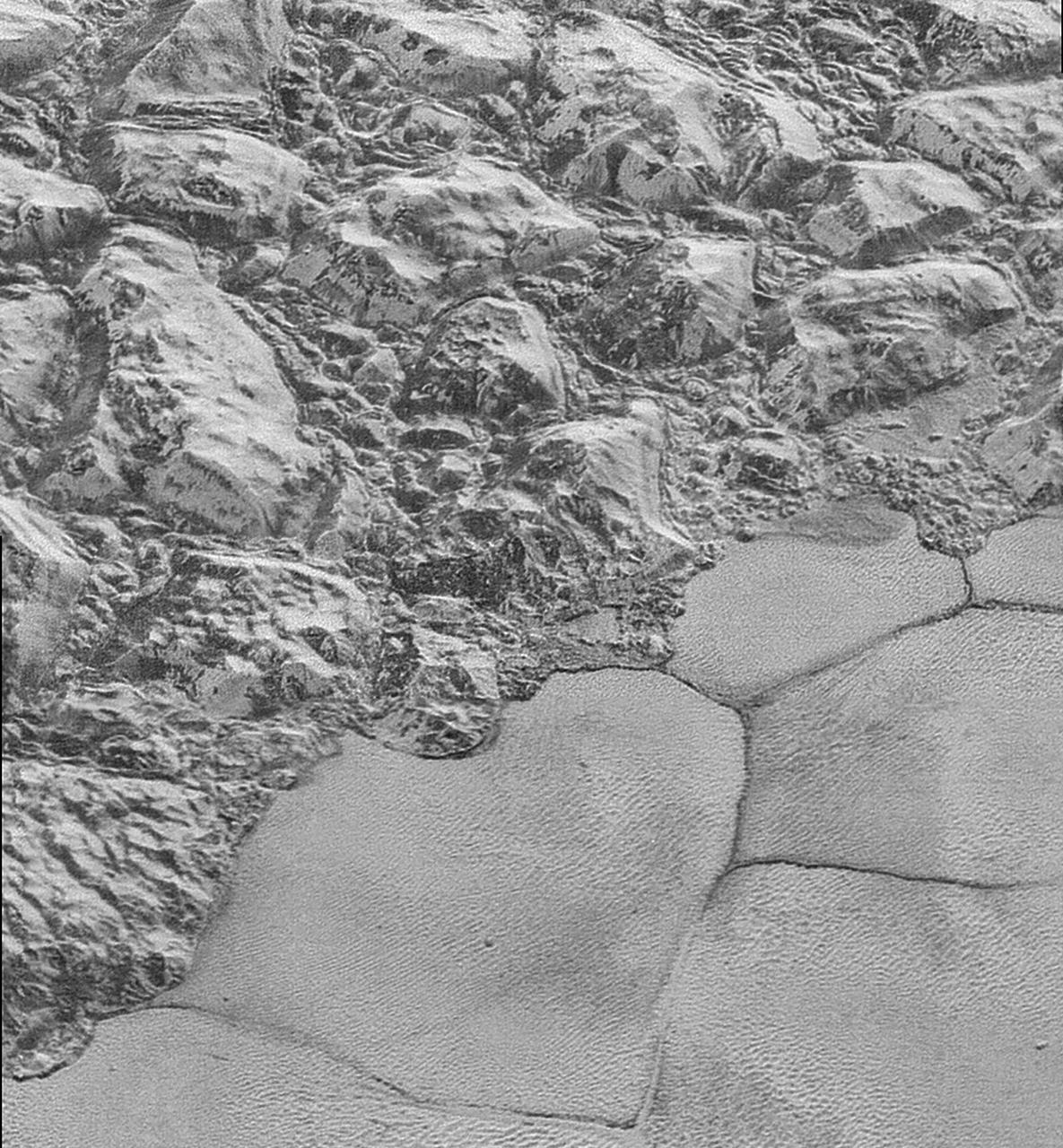
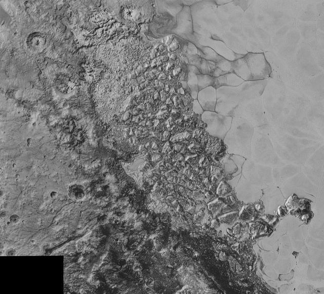
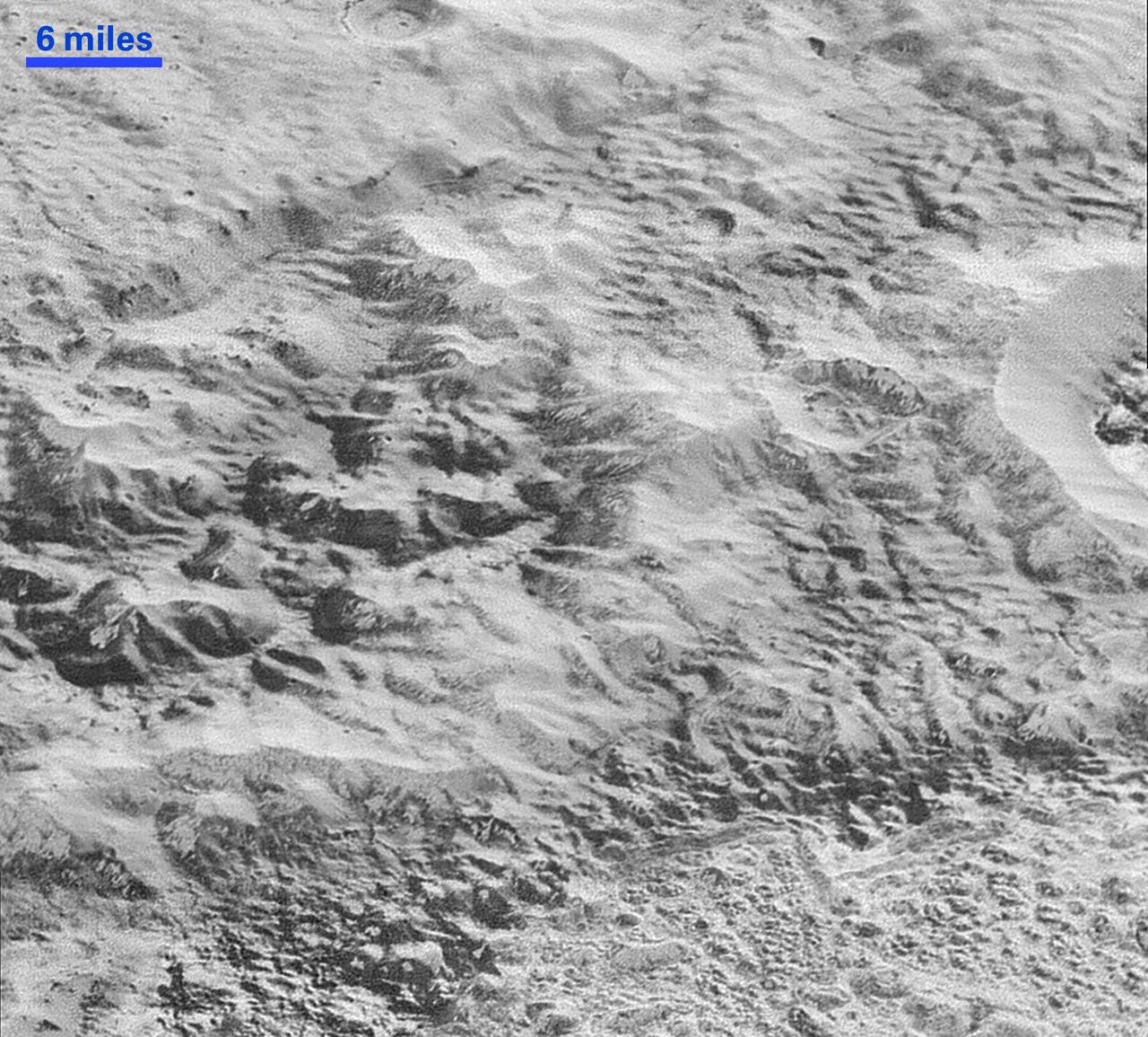
In this highest-resolution image from NASA's New Horizons spacecraft, great blocks of Pluto's water-ice crust appear jammed together in the informally named al-Idrisi mountains. Some mountain sides appear coated in dark material, while other sides are bright. Several sheer faces appear to show crustal layering, perhaps related to the layers seen in some of Pluto's crater walls. Other materials appear crushed between the mountains, as if these great blocks of water ice, some standing as much as 1.5 miles high, were jostled back and forth. The mountains end abruptly at the shoreline of the informally named Sputnik Planum, where the soft, nitrogen-rich ices of the plain form a nearly level surface, broken only by the fine trace work of striking, cellular boundaries and the textured surface of the plain's ices (which is possibly related to sunlight-driven ice sublimation). This view is about 50 miles wide. The top of the image is to Pluto's northwest. These images were made with the telescopic Long Range Reconnaissance Imager (LORRI) aboard New Horizons, in a timespan of about a minute centered on 11:36 UT on July 14 -- just about 15 minutes before New Horizons' closest approach to Pluto -- from a range of just 10,000 miles (17,000 kilometers). They were obtained with an unusual observing mode; instead of working in the usual "point and shoot," LORRI snapped pictures every three seconds while the Ralph/Multispectral Visual Imaging Camera (MVIC) aboard New Horizons was scanning the surface. This mode requires unusually short exposures to avoid blurring the images. http://photojournal.jpl.nasa.gov/catalog/PIA20198
This highest-resolution image from NASA's New Horizons spacecraft reveals new details of Pluto's rugged, icy cratered plains. Notice the layering in the interior walls of many craters (the large crater at upper right is a good example) -- layers in geology usually mean an important change in composition or event but at the moment New Horizons team members do not know if they are seeing local, regional or global layering. The darker crater in the lower center is apparently younger than the others, because dark material ejected from within -- its "ejecta blanket" -- have not been erased and can still be made out. The origin of the many dark linear features trending roughly vertically in the bottom half of the image is under debate, but may be tectonic. Most of the craters seen here lie within the 155-mile (250-kilometer)-wide Burney Basin, whose outer rim or ring forms the line of hills or low mountains at bottom. The basin is informally named after Venetia Burney, the English schoolgirl who first proposed the name "Pluto" for the newly discovered planet in 1930. The top of the image is to Pluto's northwest. These images were made with the telescopic Long Range Reconnaissance Imager (LORRI) aboard New Horizons, in a timespan of about a minute centered on 11:36 UT on July 14 -- just about 15 minutes before New Horizons' closest approach to Pluto-- from a range of just 10,000 miles (17,000 kilometers). They were obtained with an unusual observing mode; instead of working in the usual "point and shoot," LORRI snapped pictures every three seconds while the Ralph/Multispectral Visual Imaging Camera (MVIC) aboard New Horizons was scanning the surface. This mode requires unusually short exposures to avoid blurring the images. http://photojournal.jpl.nasa.gov/catalog/PIA20200

This enhanced color view from NASA's New Horizons spacecraft zooms in on the southeastern portion of Pluto's great ice plains, where at lower right the plains border rugged, dark highlands informally named Krun Macula. Krun Macula -- Krun is the lord of the underworld in the Mandaean religion, and a macula is a dark feature on a planetary surface -- is believed to get its dark red color from tholins, complex molecules found across Pluto. Krun Macula rises 1.5 miles (2.5 kilometers) above the surrounding plain -- informally named Sputnik Planum -- and is scarred by clusters of connected, roughly circular pits that typically reach between 5 and 8 miles (8 and 13 kilometers) across, and up to 1.5 miles (2.5 kilometers) deep. At the boundary with Sputnik Planum, these pits form deep valleys reaching more than 25 miles (40 kilometers) long, 12.5 miles (20 kilometers) wide and almost 2 miles (3 kilometers) deep (almost twice as deep as the Grand Canyon in Arizona), and have floors covered with nitrogen ice. New Horizons scientists think these pits may have formed through surface collapse, although what may have prompted such a collapse is a mystery. This scene was created using three separate observations made by New Horizons in July 2015. The right half of the image is composed of 260 feet- (80 meter-) per-pixel data from the Long Range Reconnaissance Imager (LORRI), obtained at 9,850 miles (15,850 kilometers) from Pluto, about 23 minutes before New Horizons' closest approach. The left half is composed of 410 feet- (125 meter-) per-pixel LORRI data, obtained about six minutes earlier, with New Horizons 15,470 miles (24,900 kilometers) from Pluto. These data respectively represent portions of the highest- and second-highest-resolution observations obtained by New Horizons in the Pluto system. The entire scene was then colorized using 2230 feet- (680 meter-) per-pixel data from New Horizons' Ralph/Multispectral Visual Imaging Camera (MVIC), obtained at 21,100 miles (33,900 kilometers) from Pluto, about 45 minutes before closest approach. http://photojournal.jpl.nasa.gov/catalog/PIA20732
This enhanced color view from NASA's New Horizons spacecraft zooms in on the southeastern portion of Pluto's great ice plains, where at lower right the plains border rugged, dark highlands informally named Krun Macula. Krun Macula -- Krun is the lord of the underworld in the Mandaean religion, and a macula is a dark feature on a planetary surface -- is believed to get its dark red color from tholins, complex molecules found across Pluto. Krun Macula rises 1.5 miles (2.5 kilometers) above the surrounding plain -- informally named Sputnik Planum -- and is scarred by clusters of connected, roughly circular pits that typically reach between 5 and 8 miles (8 and 13 kilometers) across, and up to 1.5 miles (2.5 kilometers) deep. At the boundary with Sputnik Planum, these pits form deep valleys reaching more than 25 miles (40 kilometers) long, 12.5 miles (20 kilometers) wide and almost 2 miles (3 kilometers) deep (almost twice as deep as the Grand Canyon in Arizona), and have floors covered with nitrogen ice. New Horizons scientists think these pits may have formed through surface collapse, although what may have prompted such a collapse is a mystery. This scene was created using three separate observations made by New Horizons in July 2015. The right half of the image is composed of 260 feet- (80 meter-) per-pixel data from the Long Range Reconnaissance Imager (LORRI), obtained at 9,850 miles (15,850 kilometers) from Pluto, about 23 minutes before New Horizons' closest approach. The left half is composed of 410 feet- (125 meter-) per-pixel LORRI data, obtained about six minutes earlier, with New Horizons 15,470 miles (24,900 kilometers) from Pluto. These data respectively represent portions of the highest- and second-highest-resolution observations obtained by New Horizons in the Pluto system. The entire scene was then colorized using 2230 feet- (680 meter-) per-pixel data from New Horizons' Ralph/Multispectral Visual Imaging Camera (MVIC), obtained at 21,100 miles (33,900 kilometers) from Pluto, about 45 minutes before closest approach. http://photojournal.jpl.nasa.gov/catalog/PIA20733
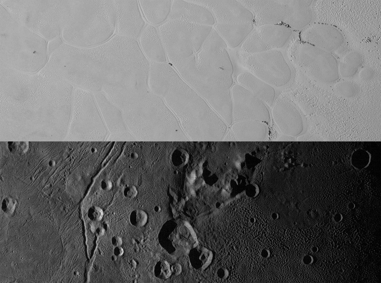
New Horizons views of the informally named Sputnik Planum on Pluto (top) and the informally named Vulcan Planum on Charon (bottom). Both scale bars measure 20 miles (32 kilometers) long; illumination is from the left in both instances. The Sputnik Planum view is centered at 11°N, 180°E, and covers the bright, icy, geologically cellular plains. Here, the cells are defined by a network of interconnected troughs that crisscross these nitrogen-ice plains. At right, in the upper image, the cellular plains yield to pitted plains of southern Sputnik Planum. This observation was obtained by the Ralph/Multispectral Visible Imaging Camera (MVIC) at a resolution of 1,050 feet (320 meters) per pixel. The Vulcan Planum view in the bottom panel is centered at 4°S, 4°E, and includes the "moated mountain" Clarke Mons just above the center of the image. As well as featuring impact craters and sinuous troughs, the water ice-rich plains display a range of surface textures, from smooth and grooved at left, to pitted and hummocky at right. This observation was obtained by the Long Range Reconnaissance Imager (LORRI) at a resolution of 525 feet (160 meters) per pixel. http://photojournal.jpl.nasa.gov/catalog/PIA20535
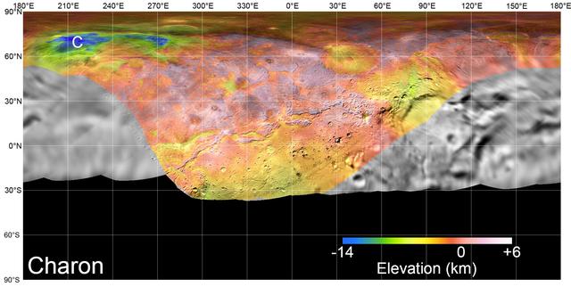
On July 14, 2015, NASA's New Horizons spacecraft made its historic flight through the Pluto system. This detailed, high-quality global mosaic of Pluto's largest moon, Charon, was assembled from nearly all of the highest-resolution images obtained by the Long-Range Reconnaissance Imager (LORRI) and the Multispectral Visible Imaging Camera (MVIC) on New Horizons. The mosaic is the most detailed and comprehensive global view yet of Charon's surface using New Horizons data. It includes topography data of the hemisphere visible to New Horizons during the spacecraft's closest approach. The topography is derived from digital stereo-image mapping tools that measure the parallax -- or the difference in the apparent relative positions -- of features on the surface obtained at different viewing angles during the encounter. Scientists use these parallax displacements of high and low terrain to estimate landform heights. The global mosaic has been overlain with transparent, colorized topography data wherever on the surface stereo data is available. Terrain south of about 30°S was in darkness leading up to and during the flyby, so is shown in black. All feature names on Pluto and Charon are informal. The global mosaic has been overlain with transparent, colorized topography data wherever on their surfaces stereo data is available. Standing out on Charon is the Caleuche Chasma ("C") in the far north, an enormous trough at least 350 kilometers (nearly 220 miles) long, and reaching 14 kilometers (8.5 miles) deep -- more than seven times as deep as the Grand Canyon. https://photojournal.jpl.nasa.gov/catalog/PIA21860

Pluto nearly fills the frame in this image from the Long Range Reconnaissance Imager (LORRI) aboard NASA’s New Horizons spacecraft, taken on July 13, 2015, when the spacecraft was 476,000 miles (768,000 kilometers) from the surface. This is the last and most detailed image sent to Earth before the spacecraft’s closest approach to Pluto on July 14. The color image has been combined with lower-resolution color information from the Ralph instrument that was acquired earlier on July 13. This view is dominated by the large, bright feature informally named the “heart,” which measures approximately 1,000 miles (1,600 kilometers) across. The heart borders darker equatorial terrains, and the mottled terrain to its east (right) are complex. However, even at this resolution, much of the heart’s interior appears remarkably featureless—possibly a sign of ongoing geologic processes. CREDIT: NASA/APL/SwRI <b><a href="http://go.nasa.gov/1L5NU1J" rel="nofollow">NASA image use policy.</a></b> <b><a href="http://go.nasa.gov/1L5NU1L" rel="nofollow">NASA Goddard Space Flight Center</a></b> enables NASA’s mission through four scientific endeavors: Earth Science, Heliophysics, Solar System Exploration, and Astrophysics. Goddard plays a leading role in NASA’s accomplishments by contributing compelling scientific knowledge to advance the Agency’s mission. <b>Follow us on <a href="http://go.nasa.gov/1L5NU1N" rel="nofollow">Twitter</a></b> <b>Like us on <a href="http://go.nasa.gov/1L5NWqt" rel="nofollow">Facebook</a></b> <b>Find us on <a href="http://go.nasa.gov/1L5NWGJ" rel="nofollow">Instagram</a></b> <b><a href="http://go.nasa.gov/1L5NWGN" rel="nofollow">Credit: NOAA/NASA GOES Project</a></b>
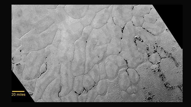
NASA's New Horizons spacecraft continues to transmit the sharpest views of Pluto that it obtained (and recorded) during its flyby of the distant planet on July 14, 2015. The newest image, returned on Dec. 24, 2015, extends New Horizons' highest-resolution swath of Pluto to the very center of the informally named Sputnik Planum, and nearly completes the set of highest-resolution images taken by New Horizons last July. The pictures are part of a sequence taken near New Horizons' closest approach to Pluto, with resolutions of about 250-280 feet (77-85 meters) per pixel -- revealing features smaller than half a city block on Pluto's surface. The images shown here form a strip 50 miles (80 kilometers) wide and more than 400 miles (700 kilometers) long, trending from the northwestern shoreline of Sputnik Planum and out across its icy plains. The images illustrate the polygonal or cellular pattern of the plains, which are thought to result from the convective churning of a deep layer solid, but mobile, nitrogen ice. The surface of Sputnik Planum appears darker toward the shore (at top), possibly implying a change in composition or surface texture. The occasional raised, darker blocks at the cell edges are probably dirty water "icebergs" floating in denser solid nitrogen. The pictures were taken with the telescopic Long Range Reconnaissance Imager (LORRI) aboard New Horizons, from a range of approximately 10,000 miles (17,000 kilometers) over a timespan of about a minute centered on 11:36 UT on July 14 -- just about 15 minutes before New Horizons' closest approach to Pluto. http://photojournal.jpl.nasa.gov/catalog/PIA20336
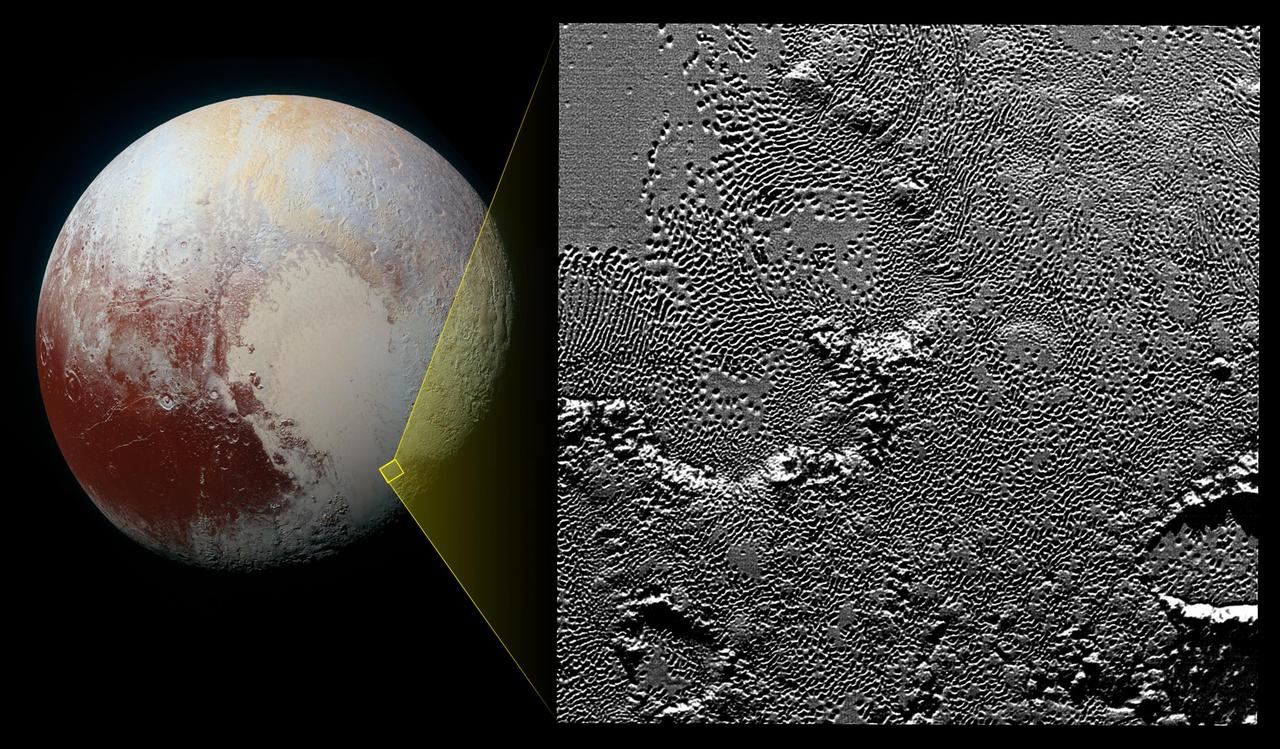
On July 14, 2015, the telescopic camera on NASA's New Horizons spacecraft took the highest resolution images ever obtained of the intricate pattern of "pits" across a section of Pluto's prominent heart-shaped region, informally named Tombaugh Regio. Mission scientists believe these mysterious indentations may form through a combination of ice fracturing and evaporation. The scarcity of overlying impact craters in this area also leads scientists to conclude that these pits -- typically hundreds of yards across and tens of yards deep -- formed relatively recently. Their alignment provides clues about the ice flow and the exchange of nitrogen and other volatile materials between the surface and the atmosphere. The image is part of a sequence taken by New Horizons' Long Range Reconnaissance Imager (LORRI) as the spacecraft passed within 9,550 miles (15,400 kilometers) of Pluto's surface, just 13 minutes before the time of closest approach. The small box on the global view shows the section of the region imaged in the southeast corner of the giant ice sheet informally named Sputnik Planum. The magnified view is 50-by-50 miles (80-by-80 kilometers) across. The large ring-like structure near the bottom right of the magnified view -- and the smaller one near the bottom left -- may be remnant craters. The upper-left quadrant of the image shows the border between the relatively smooth Sputnik Planum ice sheet and the pitted area, with a series of hills forming slightly inside this unusual "shoreline." http://photojournal.jpl.nasa.gov/catalog/PIA20212
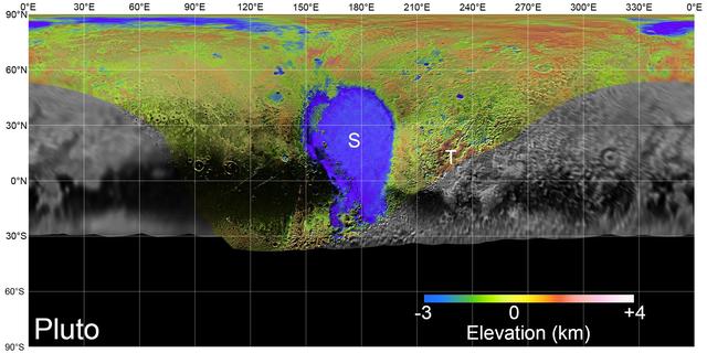
On July 14, 2015, NASA's New Horizons spacecraft made its historic flight through the Pluto system. This detailed, high-quality global mosaic of Pluto was assembled from nearly all of the highest-resolution images obtained by the Long-Range Reconnaissance Imager (LORRI) and the Multispectral Visible Imaging Camera (MVIC) on New Horizons. The mosaic is the most detailed and comprehensive global view yet of Pluto's surface using New Horizons data. It includes topography data of the hemisphere visible to New Horizons during the spacecraft's closest approach. The topography is derived from digital stereo-image mapping tools that measure the parallax -- or the difference in the apparent relative positions -- of features on the surface obtained at different viewing angles during the encounter. Scientists use these parallax displacements of high and low terrain to estimate landform heights. The global mosaic has been overlain with transparent, colorized topography data wherever on the surface stereo data is available. Terrain south of about 30°S was in darkness leading up to and during the flyby, so is shown in black. Examples of large-scale topographic features on Pluto include the vast expanse of very flat, low-elevation nitrogen ice plains of Sputnik Planitia ("P") -- note that all feature names in the Pluto system are informal -- and, on the eastern edge of the encounter hemisphere, the aligned, high-elevation ridges of Tartarus Dorsa ("T") that host the enigmatic bladed terrain, mountains, possible cryovolcanos, canyons, craters and more. https://photojournal.jpl.nasa.gov/catalog/PIA21861
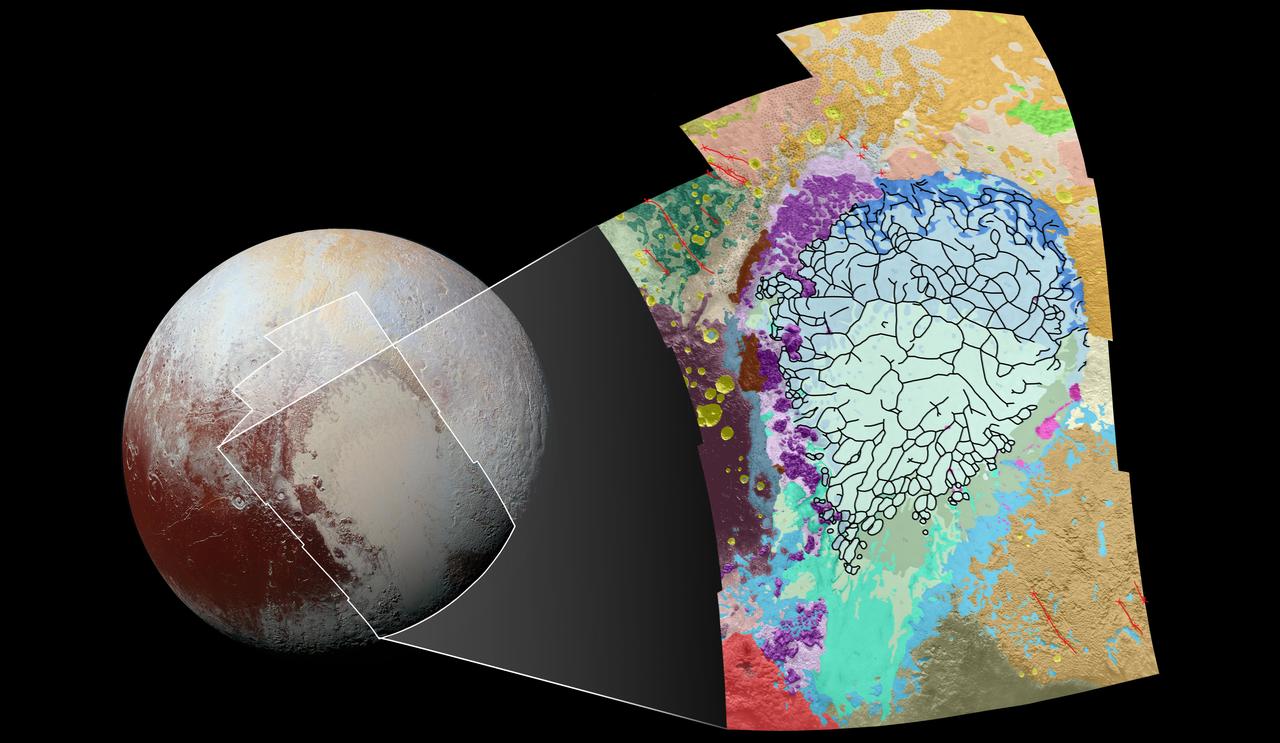
This geological map covers a portion of Pluto's surface that measures 1,290 miles (2,070 kilometers) from top to bottom, and includes the vast nitrogen-ice plain informally named Sputnik Planum and surrounding terrain. The map is overlain with colors that represent different geological terrains. Each terrain, or unit, is defined by its texture and morphology -- smooth, pitted, craggy, hummocky or ridged, for example. How well a unit can be defined depends on the resolution of the images that cover it. All of the terrain in this map has been imaged at a resolution of approximately 1,050 feet (320 meters) per pixel or better, meaning scientists can map units with relative confidence. The various blue and greenish units that fill the center of the map represent different textures seen across Sputnik Planum, from the cellular terrain in the center and north, to the smooth and pitted plains in the south. The black lines represent the troughs that mark the boundaries of cellular regions in the nitrogen ice. The purple unit represents the chaotic, blocky mountain ranges that line Sputnik's western border, and the pink unit represents the scattered, floating hills at its eastern edge. The possible cryovolcanic feature informally named Wright Mons is mapped in red in the southern corner of the map. The rugged highlands of the informally named Cthulhu Regio is mapped in dark brown along the western edge, and is pockmarked by many large impact craters, mapped in yellow. The base map for this geologic map is a mosaic of 12 images obtained by the Long Range Reconnaissance Imager (LORRI) at a resolution of 1,280 feet (about 390 meters) per pixel. The mosaic was obtained at a range of approximately 48,000 miles (77,300 kilometers) from Pluto, about an hour and 40 minutes before New Horizons' closest approach on July 14, 2015. http://photojournal.jpl.nasa.gov/catalog/PIA20465
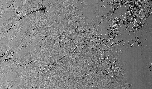
This image was taken by the Long Range Reconnaissance Imager (LORRI) on NASA's New Horizons spacecraft shortly before closest approach to Pluto on July 14, 2015; it resolves details as small as 270 yards (250 meters). The scene shown is about 130 miles (210 kilometers) across. The sun illuminates the scene from the left, and north is to the upper left. Credits: NASA/JHUAPL/SwRI It seems that the more we see of Pluto, the more fascinating it gets. With its prominent heart-shaped feature, icy mountains, and “snakeskin” terrain, Pluto has already surprised New Horizons scientists with the variety and complexity of its surface features. Now this latest image, from the heart of Pluto’s heart feature, show the plains’ enigmatic cellular pattern (at left) as well as unusual clusters of small pits and troughs (from lower left to upper right). Scientists believe that this area, informally known as Sputnik Planum, is composed of volatile ices such as solid nitrogen. They theorize that the pits and troughs – typically hundreds of meters across and tens of meters deep – are possibly formed by sublimation or evaporation of these ices. However, the reasons for the striking shapes and alignments of these features are a mystery. Adding to the intrigue is that even at this resolution, no impact craters are seen, testifying to the extreme geologic youth of Sputnik Planum. “Pluto is weird, in a good way,” said Hal Weaver, New Horizons project scientist with Johns Hopkins Applied Physics Laboratory in Laurel, Maryland. “The pits, and the way they’re aligned, provide clues about the ice flow and the exchange of volatiles between the surface and atmosphere, and the science team is working hard to understand what physical processes are at play here.” <b><a href="http://www.nasa.gov/audience/formedia/features/MP_Photo_Guidelines.html" rel="nofollow">NASA image use policy.</a></b> <b><a href="http://www.nasa.gov/centers/goddard/home/index.html" rel="nofollow">NASA Goddard Space Flight Center</a></b> enables NASA’s mission through four scientific endeavors: Earth Science, Heliophysics, Solar System Exploration, and Astrophysics. Goddard plays a leading role in NASA’s accomplishments by contributing compelling scientific knowledge to advance the Agency’s mission. <b>Follow us on <a href="http://twitter.com/NASAGoddardPix" rel="nofollow">Twitter</a></b> <b>Like us on <a href="http://www.facebook.com/pages/Greenbelt-MD/NASA-Goddard/395013845897?ref=tsd" rel="nofollow">Facebook</a></b> <b>Find us on <a href="http://instagrid.me/nasagoddard/?vm=grid" rel="nofollow">Instagram</a></b>