
On June 26, 1959, then-Langley-research Francis Rogallo examined the Rogallo wing in the 7x10 FT Tunnel. Originally conceived as a means of bringing manned spacecraft to controlled, soft landings, Rogallo's concept was avidly embraced by later generations of hang-gliding enthusiasts. -- Photograph published in Winds of Change, 75th Anniversary NASA publication (page 18), by James Schultz.
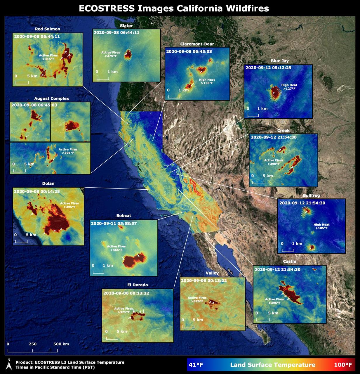
Throughout the month of September 2020, NASA's ECOsystem Spaceborne Thermal Radiometer Experiment on Space Station (ECOSTRESS) imaged multiple wildfires across the state of California. The image above shows the ECOSTRESS land surface temperature of California. Multiple insets highlight a fraction of the multiple fires that have impacted California, with effects seen throughout the U.S. and beyond. The dark red spots show areas of high heat, with arrows pointing out the active fires. The contiguous California image was stitched together from multiple evening (10 p.m.-6 a.m. PDT) ECOSTRESS images from Sept 6 to 12, 2020, to generate a cloud-free statewide map. NASA's Jet Propulsion Laboratory in Southern California built and manages the ECOSTRESS mission for the Earth Science Division in the Science Mission Directorate at NASA Headquarters in Washington. ECOSTRESS is an Earth Venture Instrument mission; the program is managed by NASA's Earth System Science Pathfinder program at NASA's Langley Research Center in Hampton, Virginia. Future studies could use ECOSTRESS data products in a similar fashion as LST was used to assess the fires pictured above. https://photojournal.jpl.nasa.gov/catalog/PIA23721

On September 19, 2021 volcanic activity permanently altered the coastline of the small island of La Palma, located off the coast of northwestern Africa. Within seven hours of the initial eruption, the lava flow traveled about 6km to the Atlantic Coast where it continues to extend the coastline out into the ocean. This image taken by the ECOSTRESS module aboard the International Space Station captured the initial Laval flow several hours after the eruption. Dark spots along the coastline represent locations where lava flowed into the ocean, increasing the surface temperature. ECOSTRESS's primary mission is to detect small changes in the temperature of plants to measure evapotranspiration rates. It can use the same instrumentation to detect changes in surface temperature associated with events such as volcanic eruptions. ECOSTRESS observations have a spatial resolution of about 70x70 meters, which enables researchers to study surface-temperature conditions down to the size of a football field. The mission can acquire images of the same region at different times of the day. This is advantageous when monitoring plant stress in the same area throughout the day, for example. https://photojournal.jpl.nasa.gov/catalog/PIA24916