Eratosthenes Crater and the Lunar Timescale
Copernicus Crater and The Lunar Timescale
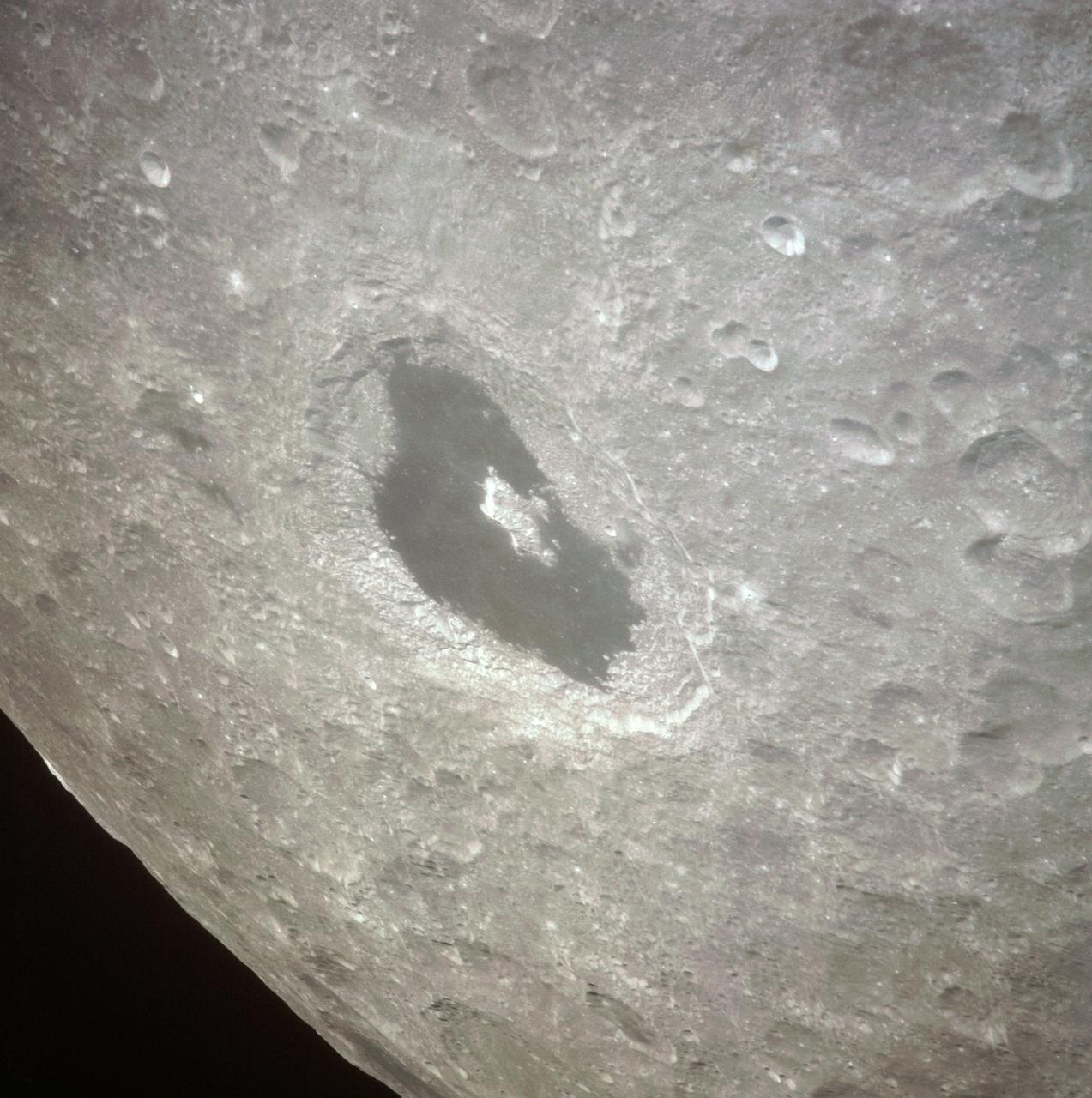
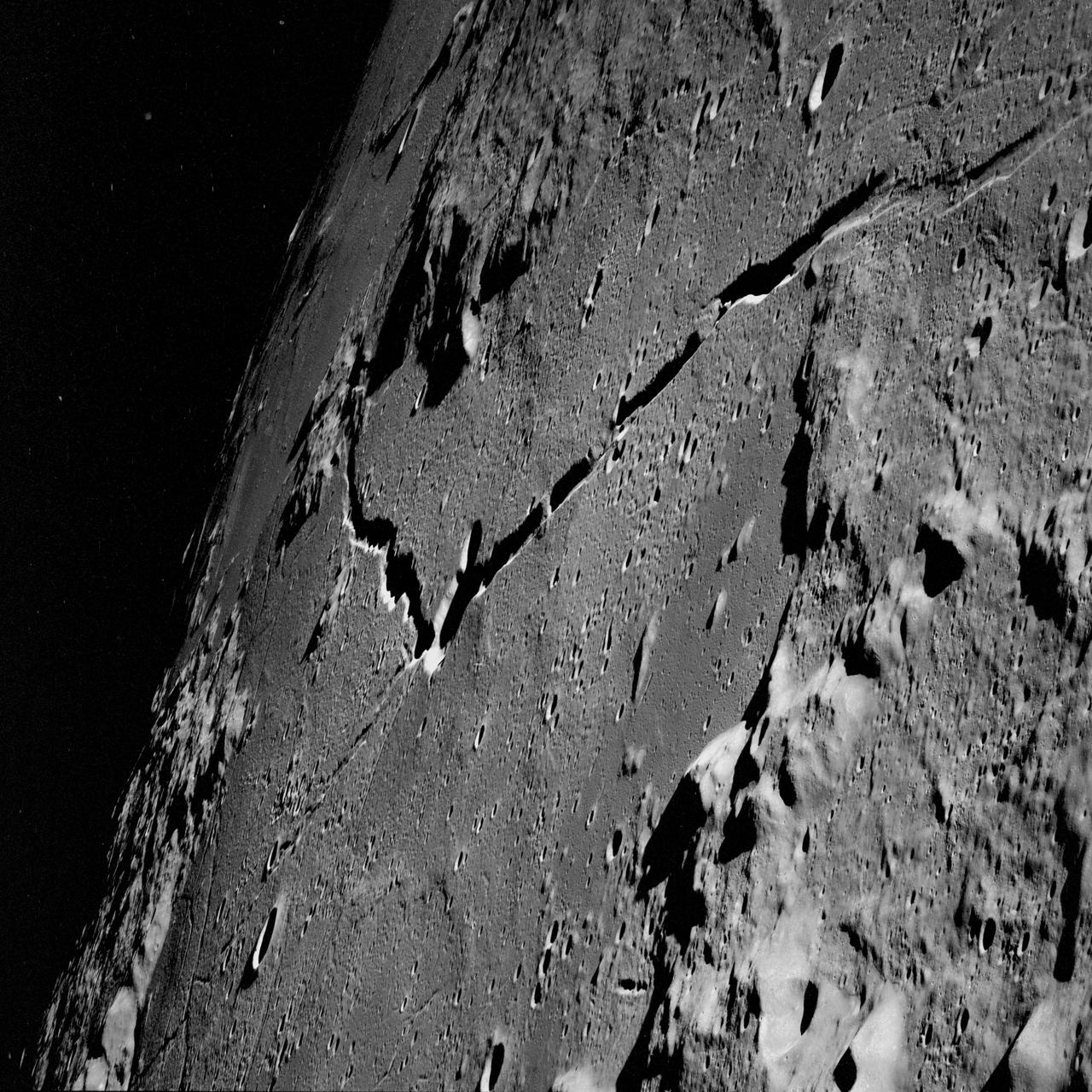
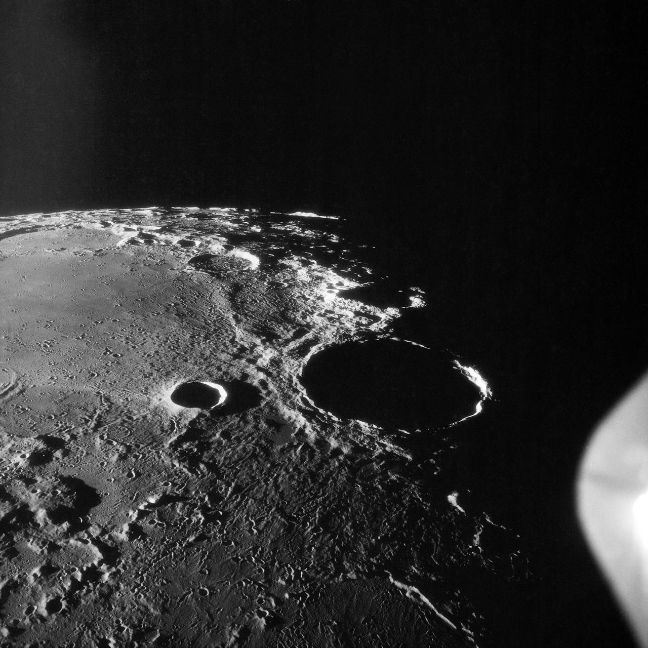
AS16-121-19407 (April 1972) --- An oblique view of a rim of Guyot Crater on the lunar farside, as photographed from the Apollo 16 spacecraft in lunar orbit. The coordinates of the center of Guyot Crater are 116.5 degrees east longitude and 10.5 degrees north latitude. Note the black coloration which appears to be lava flow down the side of the crater rim. While astronauts John W. Young, commander; and Charles M. Duke Jr., lunar module pilot; descended in the Apollo 16 Lunar Module (LM) "Orion" to explore the Descartes highlands site on the moon, astronaut Thomas K. Mattingly II, command module pilot, remained with the Command and Service Modules (CSM) "Casper" in lunar orbit.
AS13-60-8675 (April 1970) --- This bright-rayed crater on the lunar farside was photographed from the Apollo 13 spacecraft during its pass around the moon. This area is northeast of Mare Marginus. The bright-rayed crater is located at about 105 degrees east longitude and 45 degrees north latitude. The crater Joliot-Curie is located between Mare Marginus and the rayed crater. This view is looking generally toward the northeast.
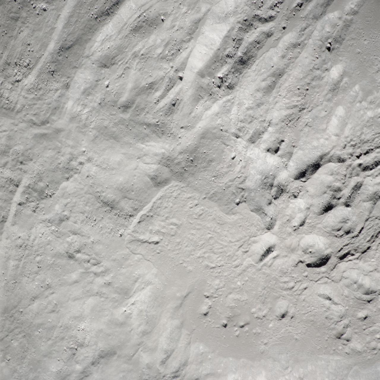
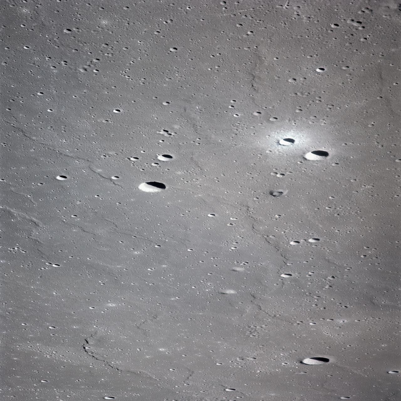
AS14-72-9975 (February 1971) --- A near vertical view of the inner wall of King Crater located on the lunar farside, as photographed from the Apollo 14 spacecraft in lunar orbit. The coordinates of the center of King Crater are 120.7 degrees east longitude and 14.3 degrees north latitude.
AS15-97-13160 (31 July-2 Aug. 1971) --- A view of a portion of the crater Tsiolkovsky located in the highlands on the farside of the moon, as photographed from the Apollo 15 Command and Service Modules (CSM) by astronaut Alfred M. Worden, command module pilot. Note the dark, flat crater floor surrounding the very prominent central mountains. The mountains are in the northeastern corner of the photograph. The other upland area comprises part of the southwestern edge of the crater. While astronauts David R. Scott, commander, and James B. Irwin, lunar module pilot, descended in the Lunar Module (LM) "Falcon" to explore the moon, astronaut Worden remained with the CSM in lunar orbit.
AS11-42-6285 (July 1969) --- An Apollo 11 view of a bright rayed crater on the lunar farside. The crater is unnamed. The center of this photograph is located at 100 degrees southeast longitude and 4 degrees 30 minutes north latitude. This area is just east of Smyth's Sea.
S71-44670 (31 July 1971) --- A near vertical view of the crater Tsiolkovsky on the lunar farside, as photographed by the Fairchild metric camera in the Scientific Instrument Module (SIM) bay of the Apollo 15 Command and Service Modules (CSM) in lunar orbit. This view is looking northerly. The coordinates of the crater's central peaks are 128 degrees east longitude and 20 degrees south latitude. The mare area measured from east to west is approximately 145 kilometers (90 statute miles) across. The three-inch mapping camera was one of eight lunar orbital science experiments mounted in the SIM bay.
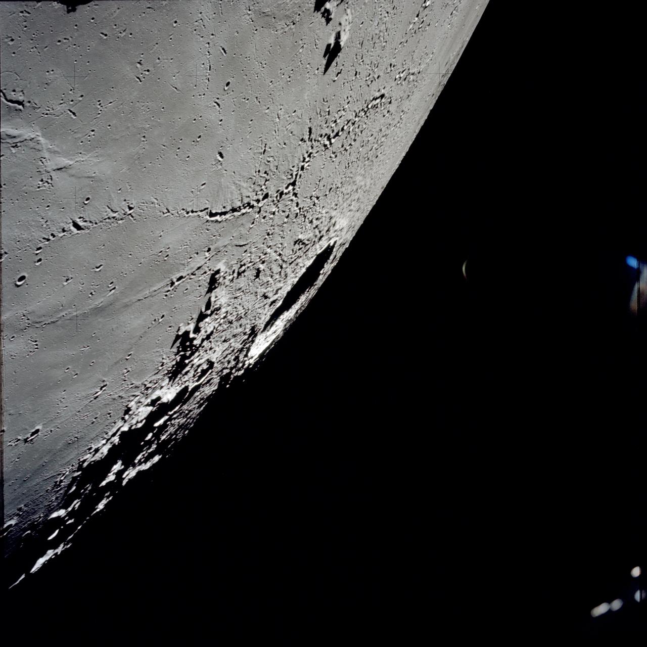
AS13-60-8659 (14 April 1970) --- Excellent view of the lunar farside showing the crater Tsiolkovsky, as photographed by the crew of the Apollo 13 mission during their lunar pass. The view is looking southeast toward the lunar horizon. The approximate coordinates of Tsiolkovsky are 128.5 degrees east longitude and 20.5 degrees south latitude. The Apollo 13 crew members were forced to cancel their scheduled lunar landing because of an apparent explosion of oxygen tank number two in the Service Module (SM).
AS15-97-13168 (31 July-2 Aug. 1971) --- A view of the flow structure on the rim and edge of the crater Tsiolkovsky in the highlands of the lunar farside, as photographed from lunar orbit by astronaut Alfred M. Worden in the Apollo 15 Command and Service Module (CSM). Note the scarp at the edge of the flow and elongated grooves on the flow surface. While astronauts David R. Scott and James B. Irwin descended in the Lunar Module (LM) "Falcon" to explore the moon's Hadley-Apennine landing site, Worden remained with the CSM in lunar orbit.
AS10-34-5173 (18-26 May 1969) --- An Apollo 10 photograph of the lunar farside showing an area in the vicinity of International Astronomical Union (I.A.U.) crater No. 300, taken from the Command and Service Modules. This view is looking south over typical rugged lunar terrain. I.A.U. crater No. 300 is located at 155 degrees east longitude and 10 degrees south latitude.
AS11-43-6412 (July 1969) --- This is a northeasterly, low-oblique view of an unmanned crater and highland area on the lunar farside, as photographed from Apollo 11. The center of the picture is located at the 167 degrees east longitude and 6 degrees north latitude. This area of the moon lies just east of International Astronomical Union crater No. 220.
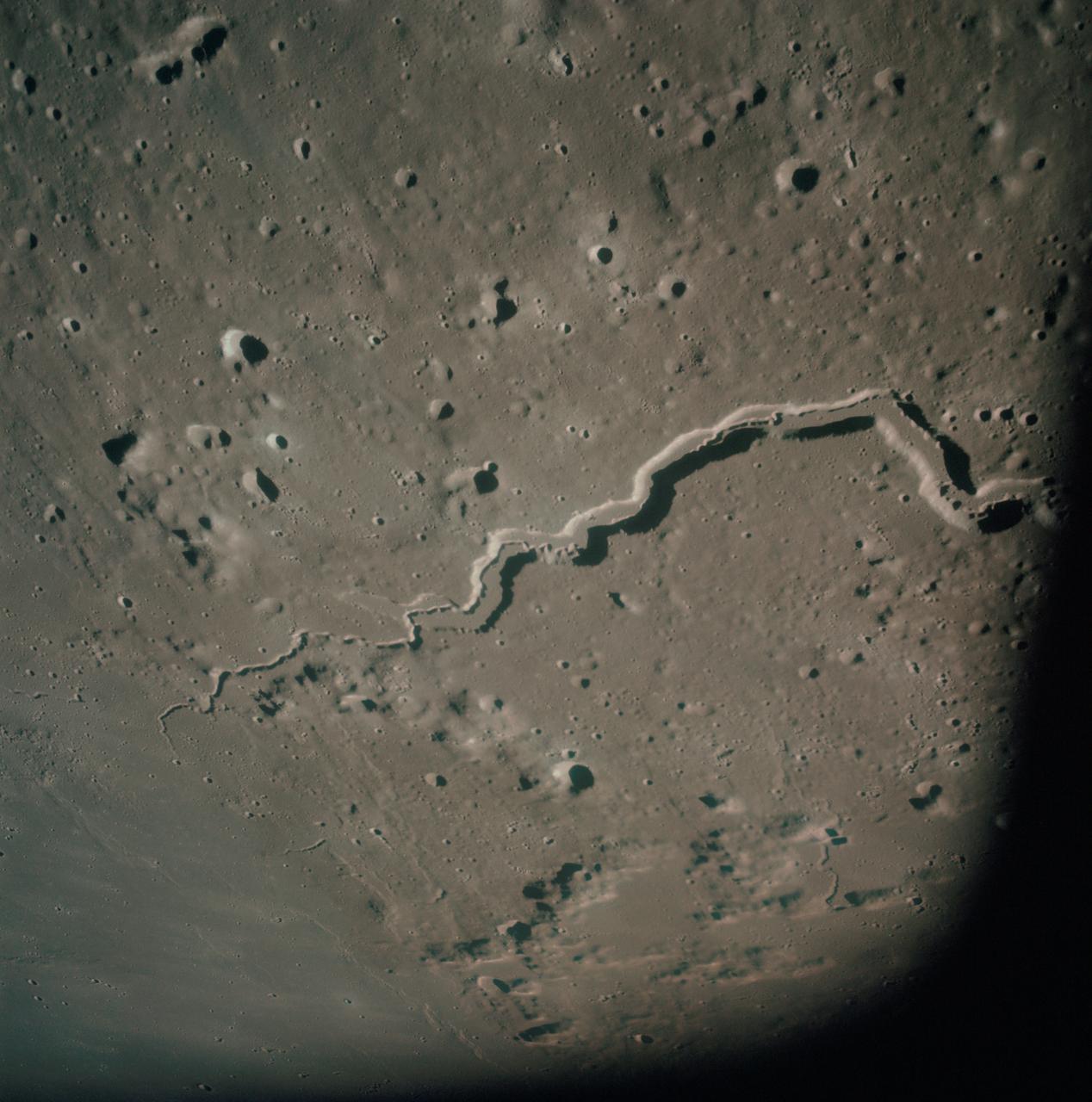
AS10-31-4650 (18-26 May 1969) --- This Apollo 10 oblique telephoto view of the lunar nearside is centered on the crater Hyginus located at 6.3 degrees north latitude, near the northeast margin of Central Bay. HOLD PICTURE WITH SKY AT TOP. The crater is about 10 kilometers (6.5 statue miles) in diameter. From the crater the prominent Hyginus Rille extends east-southeast toward the camera and northwest toward the Sea of Vapors. The rille is about 3 kilometers (2 statue miles) wide and more than 200 kilometers (130 statue miles) long. The horizon is not visible in this photograph, taken from the Command and Service Modules. The sunrise terminator is between the spacecraft and the horizon. At the time this picture was taken Apollo 10 was 325 kilometers (200 statute miles) southeast of Hyginus.

This image from NASA Mars Reconnaissance Orbiter is one of the rare examples of a fresh lunar-like crater on Mars. The impact crater formed in the Tharsis region.
AS11-42-6248 (July 1969) --- An Apollo 11 oblique view of the lunar farside in the area of International Astronomical Union crater No. 312, which is about 30 statute miles in diameter. The center of the photograph is located at 164 degrees west longitude and 8 degrees south latitude. The sharp shadows indicate that the picture was taken at a low sun angle.
This image from NASA Mars Reconnaissance Orbiter is of an approximately 5 kilometer approx. 3.1 mile diameter crater that is one of the rare examples of a fresh lunar-like crater on Mars.
art002e012028 (April 6, 2026) - The Artemis II crew captured a close-up snapshot of the near side of the Moon as NASA’s Orion spacecraft approached for the lunar flyby. The near side, characterized by the dark patches of ancient lava, is visible on the top third of the lunar disk. Aristarchus crater is the bright white dot in the midst of a dark grey lava flow at the top of the image. Credit: NASA
AS16-120-19237 (April 1972) --- An oblique view of a portion of the lunar nearside as photographed from the Apollo 16 spacecraft in lunar orbit. The small, bright crater is Lassell D at the northeastern edge of Mare Nubium (Sea of Clouds). The area seen in this picture is immediately west of Lassell C Crater, southwest of Guoricke Crater, and southwest of Davy Crater.
AS17-145-22287 (7-19 Dec. 1972) --- An oblique view of the large crater Copernicus on the lunar nearside, as photographed from the Apollo 17 spacecraft in lunar orbit. This view is looking generally southwest toward the crater on the horizon. The coordinates of the center of Copernicus are approximately 20 degrees west longitude and 9.5 degrees north latitude.
AS15-88-12002 (31 July-2 Aug. 1971) --- An oblique view of a portion of the lunar nearside located near the northeast edge of the Ocean of Storms (Oceanus Procellarum), photographed by astronaut Alfred M. Worden, command module pilot, from the Apollo 15 spacecraft in lunar orbit, showing the bright-appearing crater Aristarchus on the left, the crater Herodotus on the right, and Schroter's Valley at lower right. This view is looking southward. Aristarchus the head of Schroter's Valley, a sinuous rille in the Aristarchus Plateau, is called Cobra Head. The coordinates of the center of Aristarchus crater are 47.5 degrees west longitude and 23.6 degrees north latitude. While Worden remained in the Command and Service Modules (CSM) in lunar orbit, astronauts David R. Scott, commander; and James B. Irwin, lunar module pilot, descended in the Lunar Module (LM) "Falcon" to explore the moon.
AS16-116-18599 (21 April 1972) --- A close-up view of Buster Crater, which was visited by the two moon-exploring crew men of the Apollo 16 lunar landing mission, during the first extravehicular activity (EVA), April 21, 1972. Astronaut Charles M. Duke Jr. said the crater appeared to be larger than 50 meters, and he called it a very spectacular crater. This was the second stop for astronauts John W. Young and Duke on the mission's first EVA. Young exposed this view with his 70mm Hasselblad camera. While astronauts Young, commander; and Duke, lunar module pilot; descended in the Apollo 16 Lunar Module (LM) "Orion" to explore the Descartes highlands landing site on the moon, astronaut Thomas K. Mattingly II, command module pilot, remained with the Command and Service Modules (CSM) "Casper" in lunar orbit.
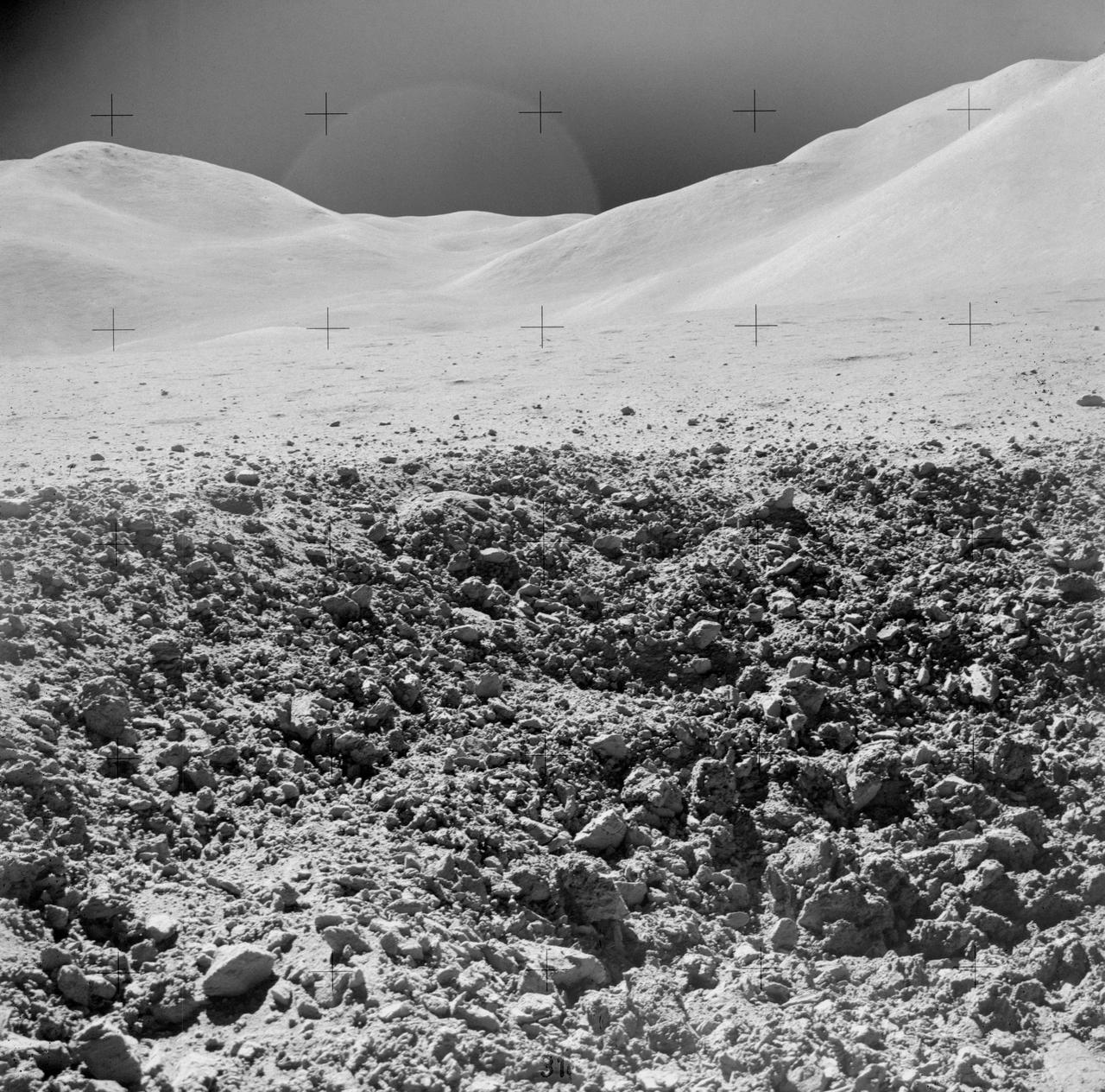
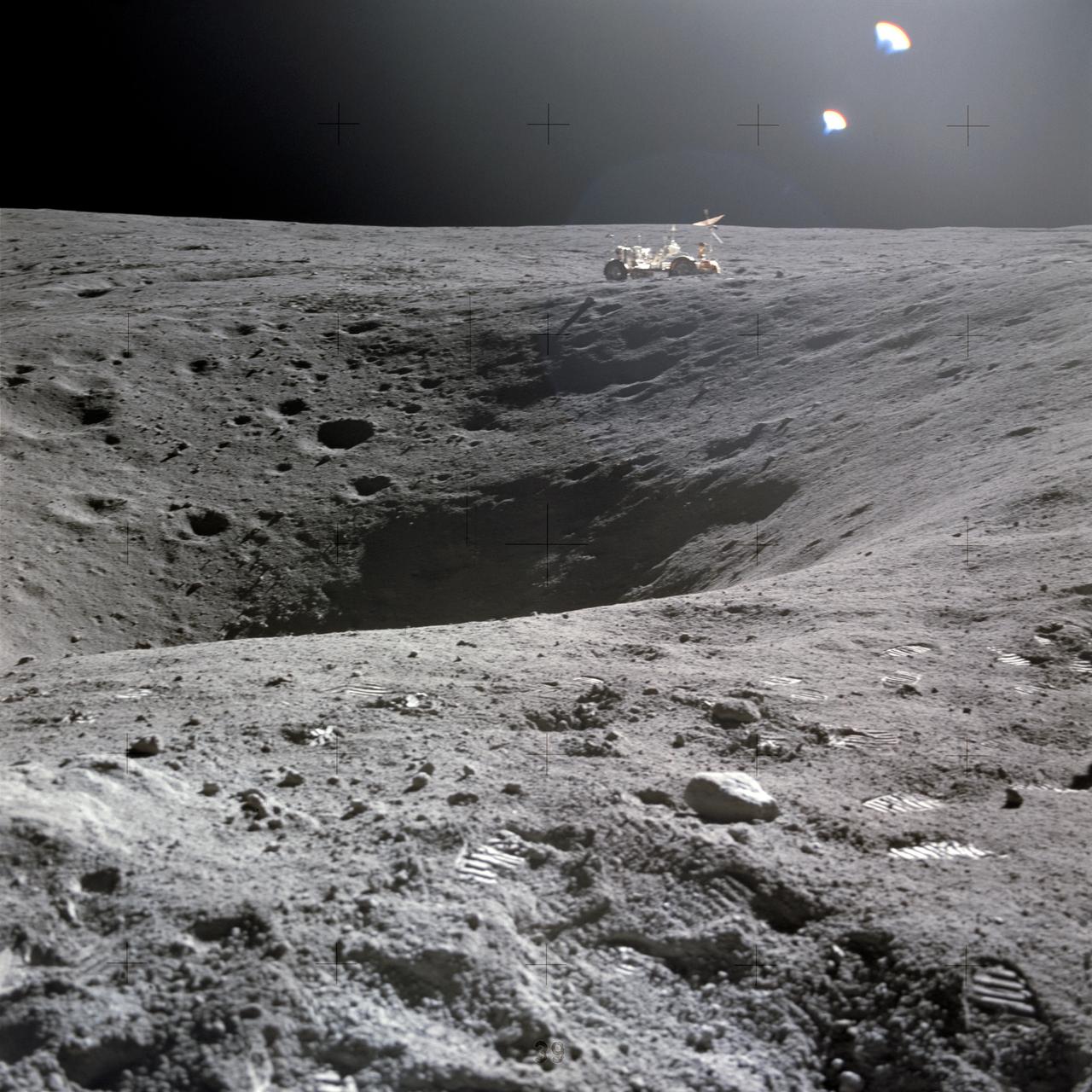
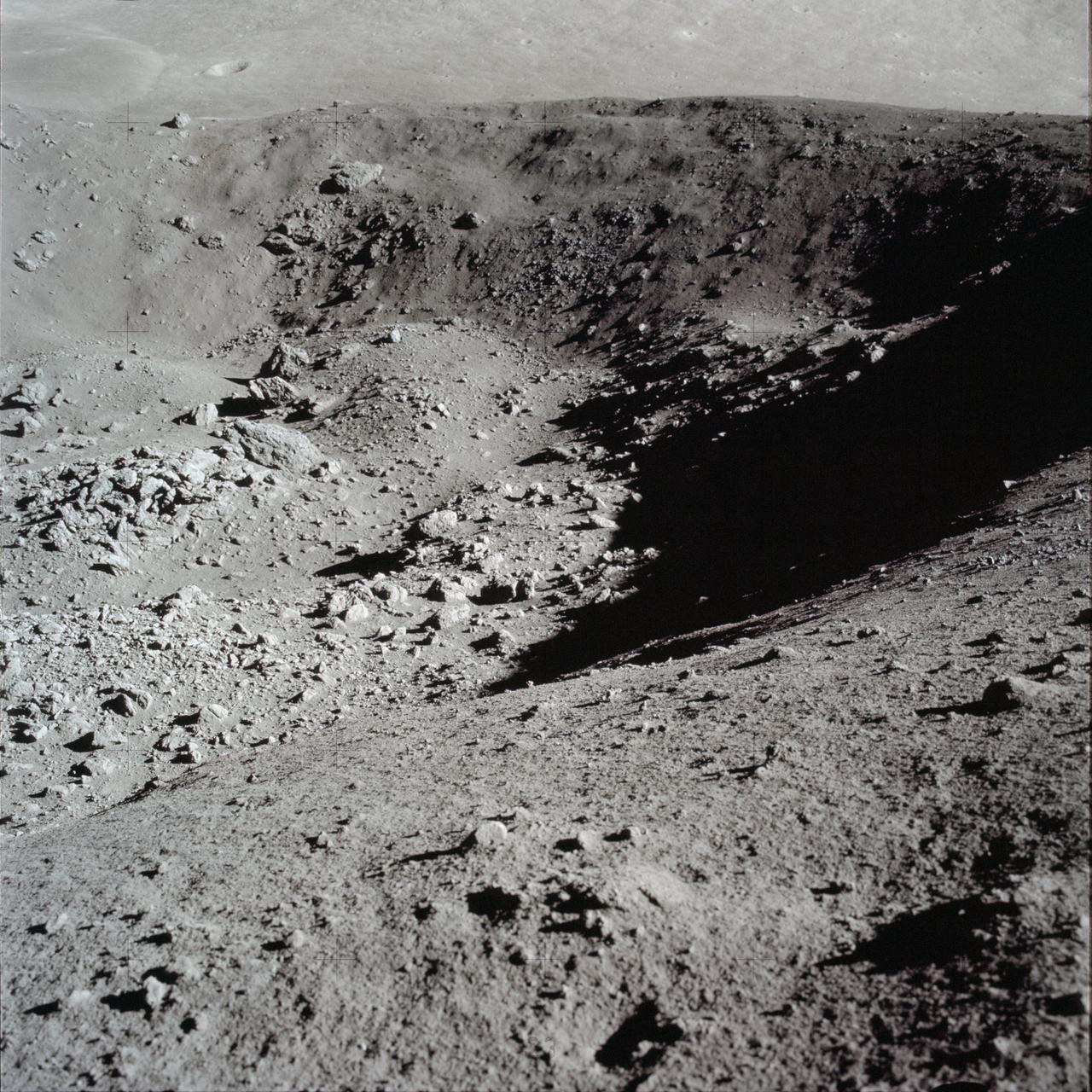
AS15-82-11082 (2 Aug. 1971) --- A close-up view of a portion of a "relatively fresh" crater, looking southeast, as photographed during the third Apollo 15 lunar surface extravehicular activity (EVA), on Aug. 2, 1971, at EVA Station No. 9, near Scarp Crater. The crater pictured is unnamed. The Apennine Front is in the background, and Hadley Delta Mountain is in the right background. While astronauts David R. Scott, commander, and James B. Irwin, lunar module pilot, descended in the Lunar Module (LM) "Falcon" to explore the moon, astronaut Alfred M. Worden, command module pilot, remained with the Command and Service Modules (CSM) in lunar orbit.
art002e012261 (April 6, 2026) - Multiple lunar landmarks come into view in this image, many of which were highlighted during the Artemis II crew’s observation call. Visible features include Ohm crater, Oceanus Procellarum, Grimaldi crater, Pierazzo crater, the newly proposed Carroll crater, and the expansive Hertzsprung Basin—together illustrating a range of geologic terrains, from dark volcanic plains to heavily cratered highlands and the remnants of ancient impact basins.
art002e009282 (April 6, 2026) - A close-up view taken by the Artemis II crew of Vavilov Crater on the rim of the older and larger Hertzsprung basin. The right portion of the image shows the transition from smooth material within an inner ring of mountains to more rugged terrain around the rim. Vavilov and other craters and their ejecta are accentuated by long shadows at the terminator, the boundary between lunar day and night. The image was captured with a handheld camera at a focal length of 400 mm, as the crew flew around the far side of the Moon.
AS15-91-12366 (31 July-2 Aug. 1971) --- The crater Posidonius at the northeastern edge of the Sea of Serenity, was photographed with a 70mm handheld Hasselblad from the Command and Service Module (CSM) by astronaut Alfred M. Worden, command module pilot, in lunar orbit. While Worden remained with the CSM in lunar orbit, astronauts David R. Scott and James B. Irwin descended in the Lunar Module (LM) "Falcon" to explore the lunar surface.
art002e012114 (April 6, 2026) - A diverse set of lunar features is visible in this view, including the brightly colored Aristarchus crater, whose high reflectivity stands out against the surrounding terrain. Nearby, the Marius Hills region reveals a field of volcanic domes and cones, evidence of past lunar volcanism. The sinuous Reiner Gamma swirl contrasts with the darker mare surface, while rays from Glushko crater streak across the plains. At the bottom of the frame, the dark-floored Grimaldi crater anchors the scene.
art002e012090 (April 6, 2026) - In this view of the Moon, the Artemis II crew captured an intricate snapshot of the rings of the Orientale basin, one of the Moon’s youngest and best-preserved large impact craters on his first shift during the lunar flyby observation period. Credit: NASA
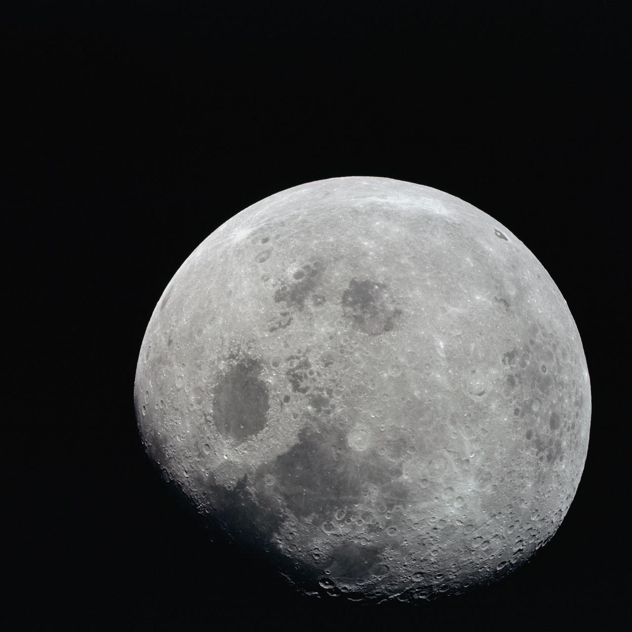
AS08-14-2506 (21-27 Dec. 1968) --- This photograph of a nearly full moon was taken from the Apollo 8 spacecraft at a point above 70 degrees east longitude. (Hold picture with moon's dark portion at left). Mare Crisium, the circular, dark-colored area near the center, is near the eastern edge of the moon as viewed from Earth. Mare Nectaris is the circular mare near the terminator. The large, irregular maira are Tranquillitatis and Fecunditatis. The terminator at left side of picture crosses Mare Tranquillitatis and highlands to the south. Lunar farside features occupy most of the right half of the picture. The large, dark-colored crater Tsiolkovsky is near the limb at the lower right. Conspicuous bright rays radiate from two large craters, one to the north of Tsiolkovsky, the other near the limb in the upper half of the picture. These rayed craters were not conspicuous in Lunar Orbiter photography due to the low sun elevations when the Lunar Orbiter photography was made. The crater Langrenus is near the center of the picture at the eastern edge of Mare Fecunditatis. The lunar surface probably has less pronounced color that indicated by this print.
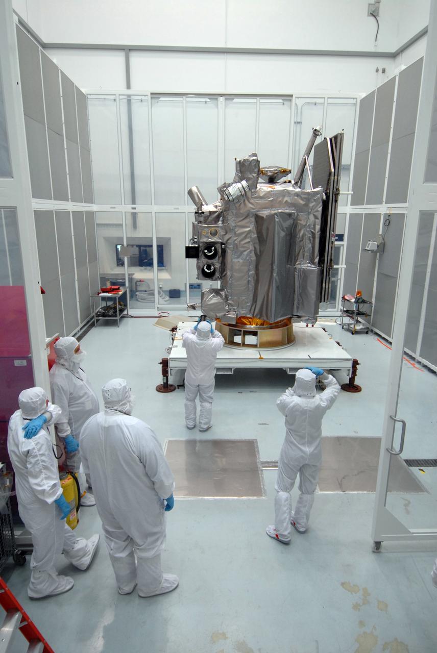
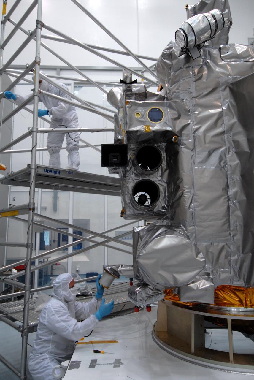
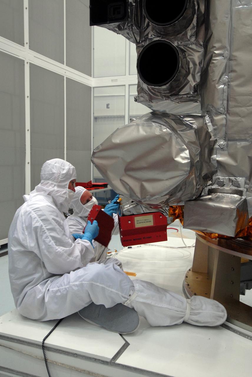
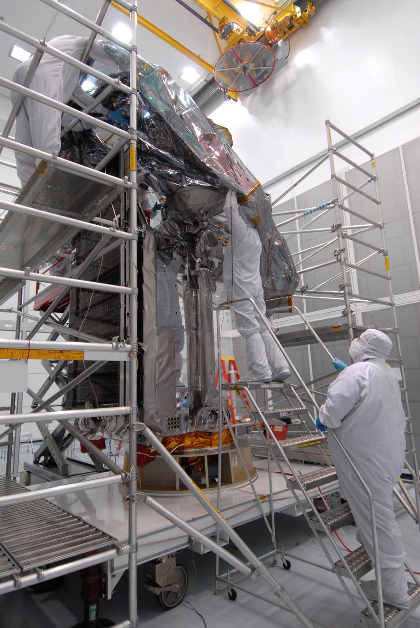
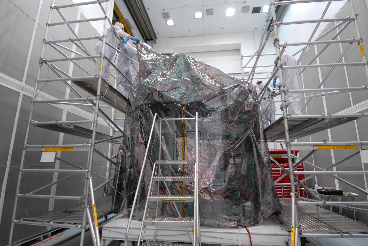
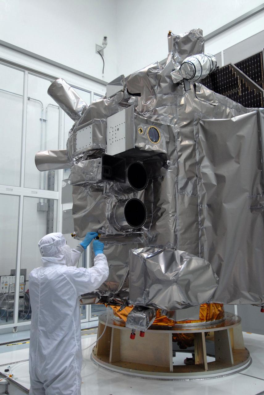
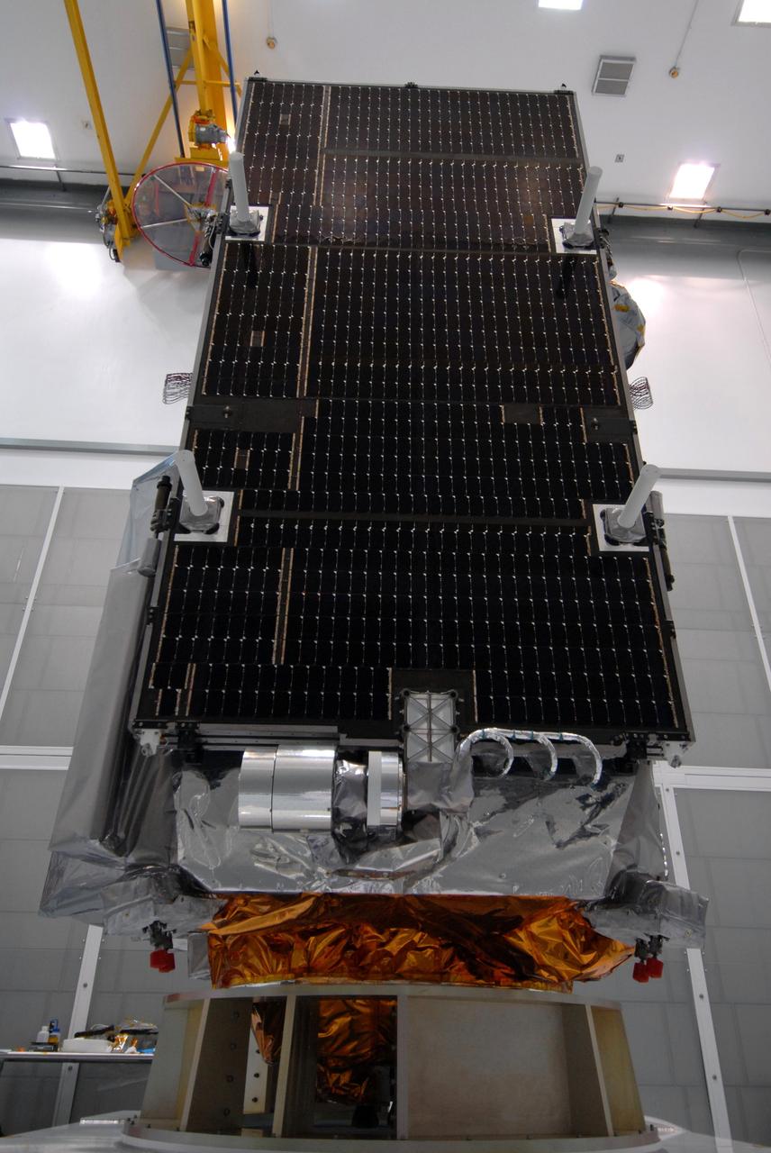
CAPE CANAVERAL, Fla. – At Astrotech Space Operations in Titusville, Fla., technicians photograph the Lunar Reconnaissance Orbiter, or LRO, during closeout before its mating with NASA's Lunar CRater Observation and Sensing Satellite, known as LCROSS, spacecraft. Instruments on the LRO include the LEND that will measure the flux of neutrons from the moon; the LROC, a narrow angle camera that will provide panchromatic images; the LOLA, which will provide a precise global lunar topographic model and geodetic grid; and top right, the DIVINER, which will measure lunar surface temperatures at scales that provide essential information for future surface operations and exploration; and at top, the CRaTER, which will characterize the global lunar radiation environment and its biological impacts. At right is the solar panel. The satellite's primary mission is to search for water ice on the moon in a permanently shadowed crater near one of the lunar poles. LCROSS is a low-cost, accelerated-development, companion mission to NASA's Lunar Reconnaissance Orbiter, or LRO. LCROSS and LRO are the first missions in NASA's plan to return humans to the moon and begin establishing a lunar outpost by 2020. Launch is targeted for no earlier than June 2 from Cape Canaveral Air Force Station in Florida. Photo credit: NASA/Jack Pfaller
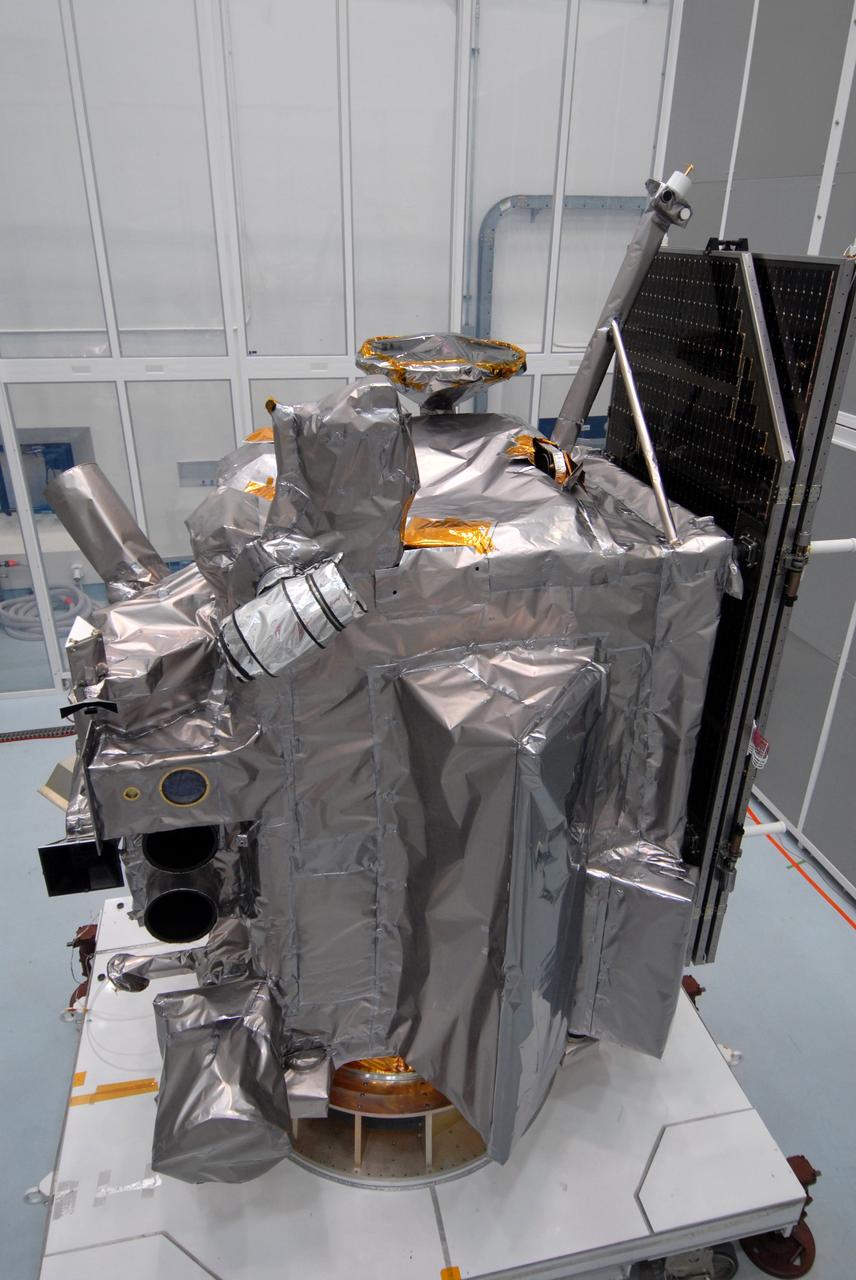
CAPE CANAVERAL, Fla. – Another view of the Lunar Reconnaissance Orbiter, or LRO, at Astrotech Space Operations in Titusville, Fla., during closeout before its mating with NASA's Lunar CRater Observation and Sensing Satellite, known as LCROSS, spacecraft. Instruments seen, at left, are (from bottom) the LEND that will measure the flux of neutrons from the moon; the LROC, a narrow angle camera that will provide panchromatic images; the LOLA, which will provide a precise global lunar topographic model and geodetic grid; and top right, the DIVINER, which will measure lunar surface temperatures at scales that provide essential information for future surface operations and exploration; and at top, the CRaTER, which will characterize the global lunar radiation environment and its biological impacts. At right is the solar panel. The satellite's primary mission is to search for water ice on the moon in a permanently shadowed crater near one of the lunar poles. LCROSS is a low-cost, accelerated-development, companion mission to NASA's Lunar Reconnaissance Orbiter, or LRO. LCROSS and LRO are the first missions in NASA's plan to return humans to the moon and begin establishing a lunar outpost by 2020. Launch is targeted for no earlier than June 2 from Cape Canaveral Air Force Station in Florida. Photo credit: NASA/Jack Pfaller
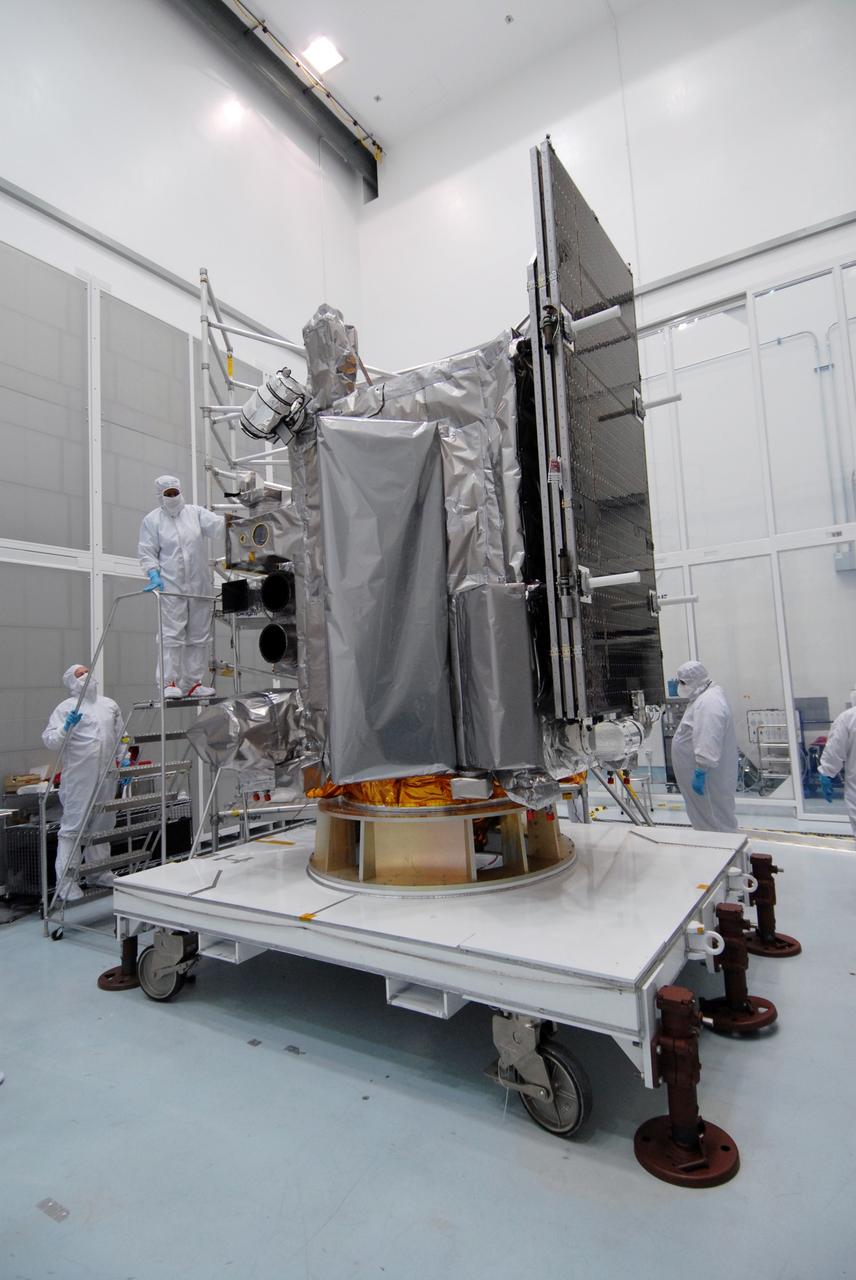
CAPE CANAVERAL, Fla. – At Astrotech Space Operations in Titusville, Fla., technicians are closing out the Lunar Reconnaissance Orbiter, or LRO, before its mating with NASA's Lunar CRater Observation and Sensing Satellite, known as LCROSS, spacecraft. Instruments seen at far left are (from bottom), the LEND that will measure the flux of neutrons from the moon; the LROC, a narrow angle camera that will provide panchromatic images; the LOLA, which will provide a precise global lunar topographic model and geodetic grid; and top right, the DIVINER, which will measure lunar surface temperatures at scales that provide essential information for future surface operations and exploration; and at top, the CRaTER, which will characterize the global lunar radiation environment and its biological impacts. The satellite's primary mission is to search for water ice on the moon in a permanently shadowed crater near one of the lunar poles. LCROSS is a low-cost, accelerated-development, companion mission to NASA's Lunar Reconnaissance Orbiter, or LRO. LCROSS and LRO are the first missions in NASA's plan to return humans to the moon and begin establishing a lunar outpost by 2020. Launch is targeted for no earlier than June 2 from Cape Canaveral Air Force Station in Florida. Photo credit: NASA/Jack Pfaller
CAPE CANAVERAL, Fla. – At Astrotech Space Operations in Titusville, Fla., technicians begin closeout on the Lunar Reconnaissance Orbiter, or LRO, before its mating with NASA's Lunar CRater Observation and Sensing Satellite, known as LCROSS, spacecraft. Instruments seen are (from bottom), the LEND that will measure the flux of neutrons from the moon; the LROC, a narrow angle camera that will provide panchromatic images; the LOLA, which will provide a precise global lunar topographic model and geodetic grid; and top right, the DIVINER, which will measure lunar surface temperatures at scales that provide essential information for future surface operations and exploration; and at top, the CRaTER, which will characterize the global lunar radiation environment and its biological impacts. The satellite's primary mission is to search for water ice on the moon in a permanently shadowed crater near one of the lunar poles. LCROSS is a low-cost, accelerated-development, companion mission to NASA's Lunar Reconnaissance Orbiter, or LRO. LCROSS and LRO are the first missions in NASA's plan to return humans to the moon and begin establishing a lunar outpost by 2020. Launch is targeted for no earlier than June 2 from Cape Canaveral Air Force Station in Florida. Photo credit: NASA/Jack Pfaller
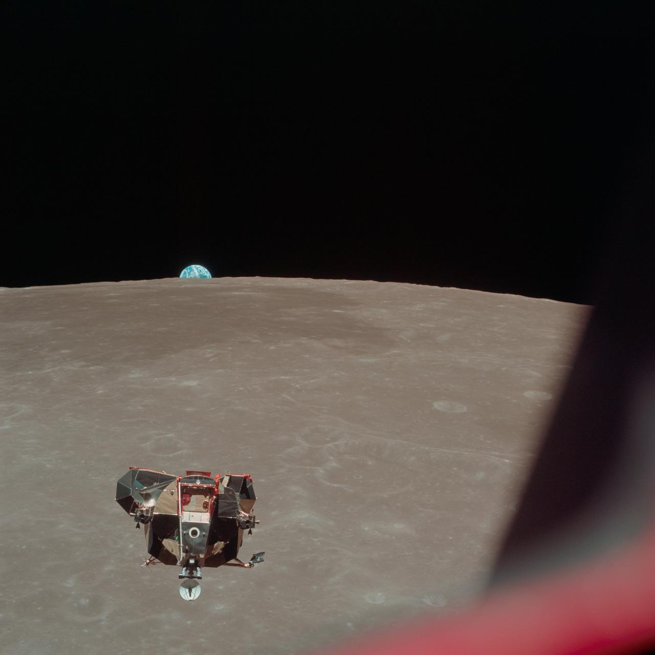
AS12-51-7507 (19 Nov. 1969) --- The Apollo 12 Lunar Module (LM), in a lunar landing configuration, is photographed in lunar orbit from the Command and Service Modules (CSM). The coordinates of the center of the lunar surface shown in picture are 4.5 degrees west longitude and 7 degrees south latitude. The largest crater in the foreground is Ptolemaeus; and the second largest is Herschel. Aboard the LM were astronauts Charles Conrad Jr., commander; and Alan L. Bean, lunar module pilot. Astronaut Richard R. Gordon Jr., command module pilot, remained with the CSM in lunar orbit while Conrad and Bean descended in the LM to explore the surface of the moon. Photo credit: NASA
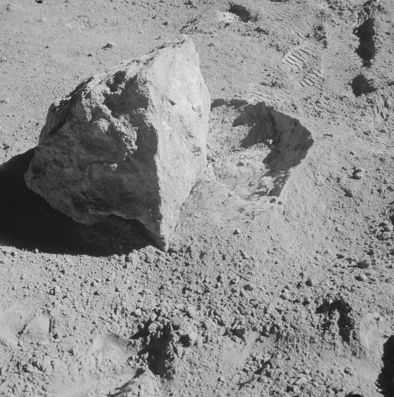
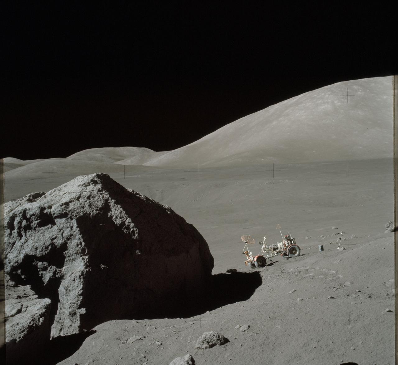
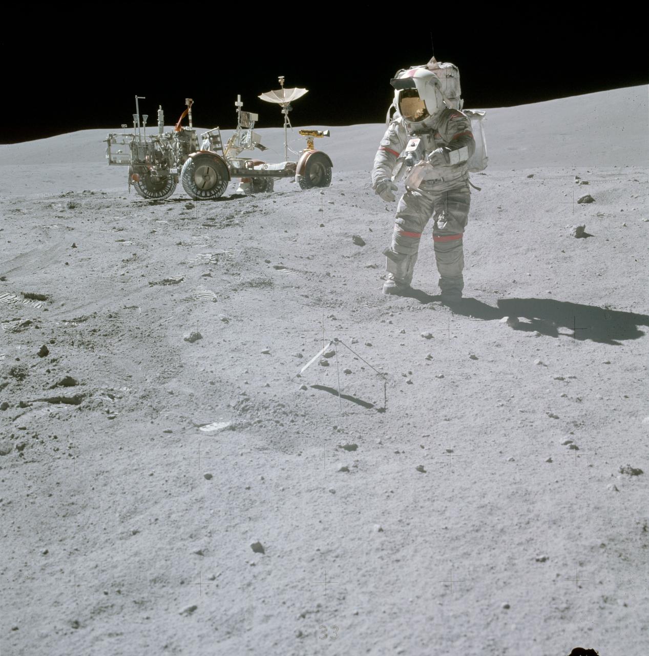
AS16-107-17573 (22 April 1972) --- A close-up view of a block (about 1/2 meter long) found by the two moon-exploring crewmembers of the Apollo 16 lunar landing mission. The block had been rolled over only moments earlier during this Apollo 16 second extravehicular activity (EVA) near South Ray Crater. Astronaut John W. Young, commander, said at the post-mission press conference, "The block has been sitting there evidently since South Ray Crater was formed." While astronauts Young and Charles M. Duke Jr., lunar module pilot; descended in the Apollo 16 Lunar Module (LM) "Orion" to explore the Descartes highlands landing site on the moon, astronaut Thomas K. Mattingly II, command module pilot, remained with the Command and Service Modules (CSM) "Casper" in lunar orbit.
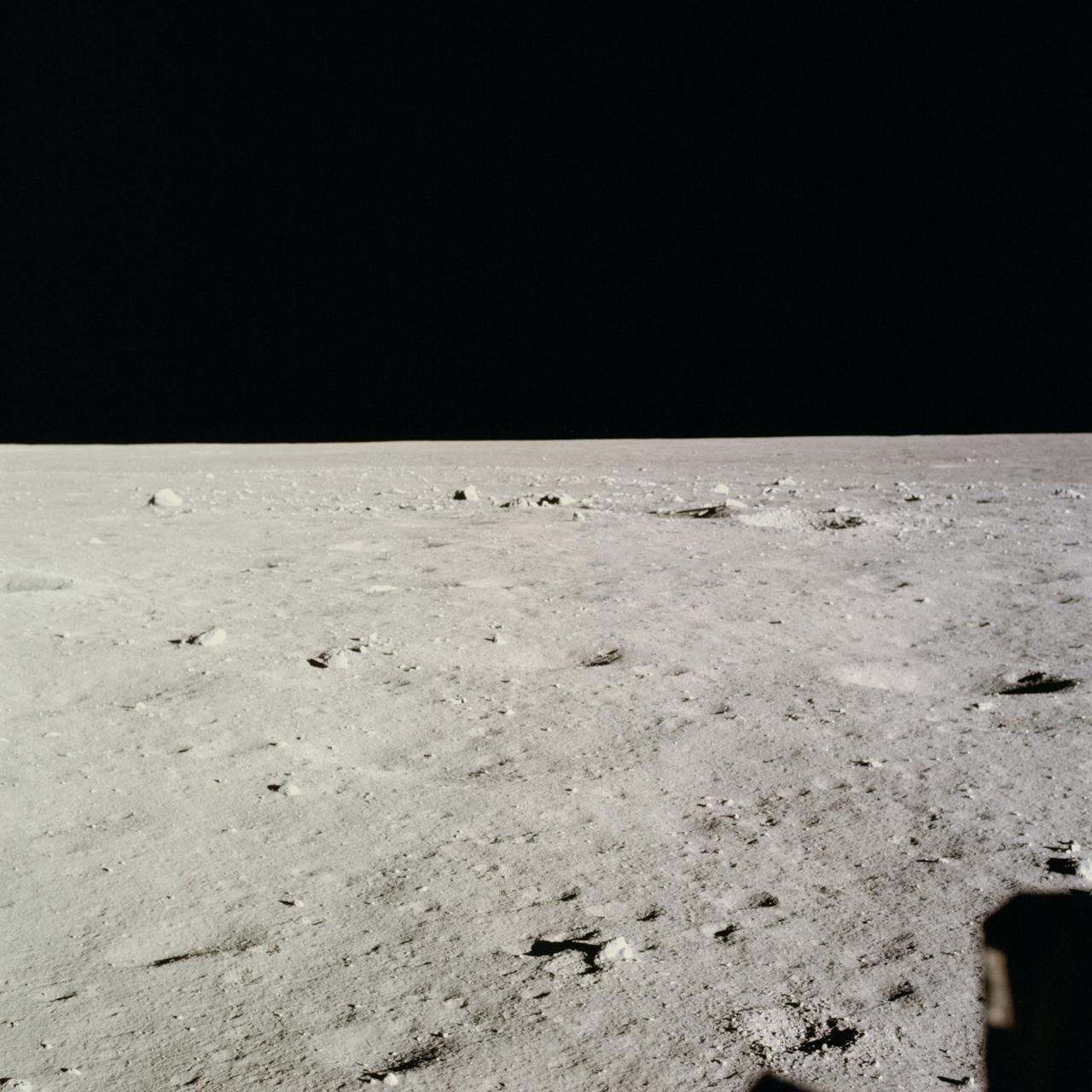
AS11-37-5458 (20 July 1969) --- This excellent view from the right-hand window of the Apollo 11 Lunar Module (LM) shows the surface of the moon in the vicinity of where the LM touched down. Numerous small rocks and craters can be seen between the LM and the lunar horizon. Astronaut Michael Collins, command module pilot, remained with the Command and Service Modules (CSM) in lunar orbit while astronauts Neil A. Armstrong, commander; and Edwin E. Aldrin Jr., lunar module pilot, descended in the LM to the lunar surface.
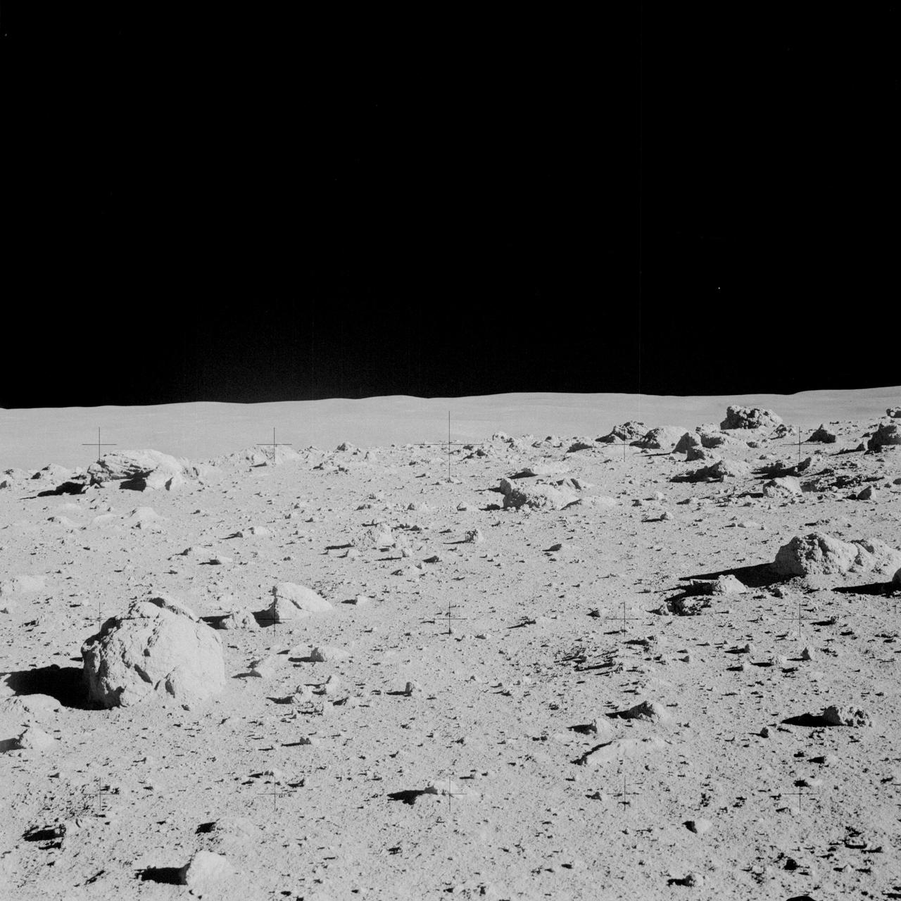
AS14-64-9103 (6 Feb. 1971) --- Astronaut Alan B. Shepard Jr., commander, photographed this overall view of a field of boulders on the flank of Cone Crater during the second extravehicular activity (EVA) on the lunar surface. Astronaut Edgar D. Mitchell, lunar module pilot, joined Shepard in exploring the moon, while astronaut Stuart A. Roosa, command module pilot, remained with the Command and Service Modules (CSM) in lunar orbit.
AS16-114-18422 (21 April 1972) --- A view of Plum Crater, which was visited by the two moon-exploring crewmen of the Apollo 16 lunar landing mission, on their first extravehicular activity (EVA) traverse, April 21, 1972. The Lunar Roving Vehicle (LRV) is parked on the far side of the crater, which measures approximately 40 meters in diameter. While astronauts John W. Young, commander; and Charles M. Duke Jr., lunar module pilot; descended in the Apollo 16 Lunar Module (LM) "Orion" to explore the Descartes highlands landing site on the moon, astronaut Thomas K. Mattingly II, command module pilot, remained with the Command and Service Modules (CSM) "Casper" in lunar orbit.
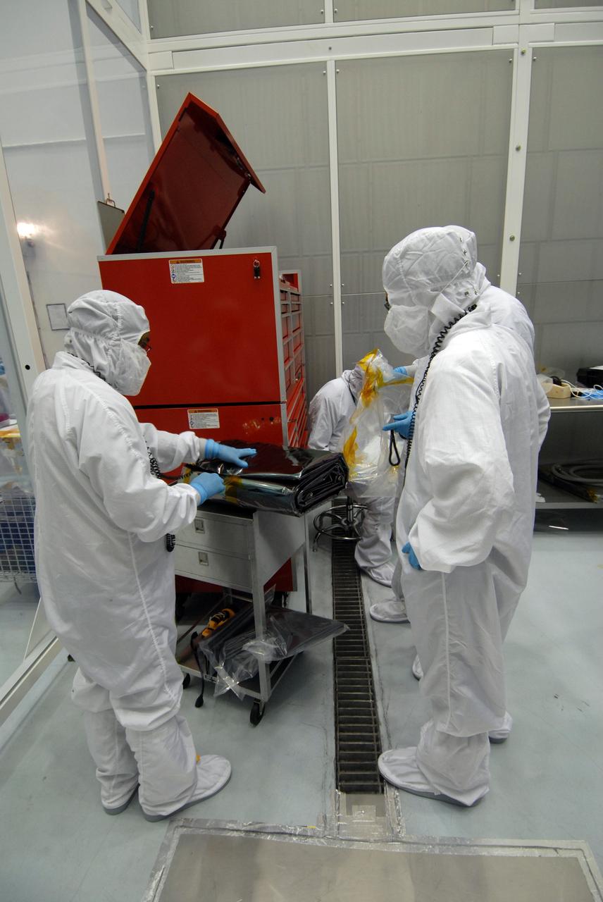
CAPE CANAVERAL, Fla. – At Astrotech Space Operations in Titusville, Fla., technicians remove red-tag items from the Lunar Reconnaissance Orbiter, or LRO, before flight. The LRO will be mated with NASA's Lunar CRater Observation and Sensing Satellite, known as LCROSS, spacecraft. Instruments on the LRO seen here are the LEND (bottom) that will measure the flux of neutrons from the moon and the LROC (above it), a narrow angle camera that will provide panchromatic images. The satellite's primary mission is to search for water ice on the moon in a permanently shadowed crater near one of the lunar poles. LCROSS is a low-cost, accelerated-development, companion mission to NASA's Lunar Reconnaissance Orbiter, or LRO. LCROSS and LRO are the first missions in NASA's plan to return humans to the moon and begin establishing a lunar outpost by 2020. Launch is targeted for no earlier than June 2 from Cape Canaveral Air Force Station in Florida. Photo credit: NASA/Jack Pfaller
CAPE CANAVERAL, Fla. – At Astrotech Space Operations in Titusville, Fla., technicians begin placing the protective bag around the Lunar Reconnaissance Orbiter, or LRO, before it is mated with NASA's Lunar CRater Observation and Sensing Satellite, known as LCROSS, spacecraft. The satellite's primary mission is to search for water ice on the moon in a permanently shadowed crater near one of the lunar poles. LCROSS is a low-cost, accelerated-development, companion mission to NASA's Lunar Reconnaissance Orbiter, or LRO. LCROSS and LRO are the first missions in NASA's plan to return humans to the moon and begin establishing a lunar outpost by 2020. Launch is targeted for no earlier than June 2 from Cape Canaveral Air Force Station in Florida. Photo credit: NASA/Jack Pfaller
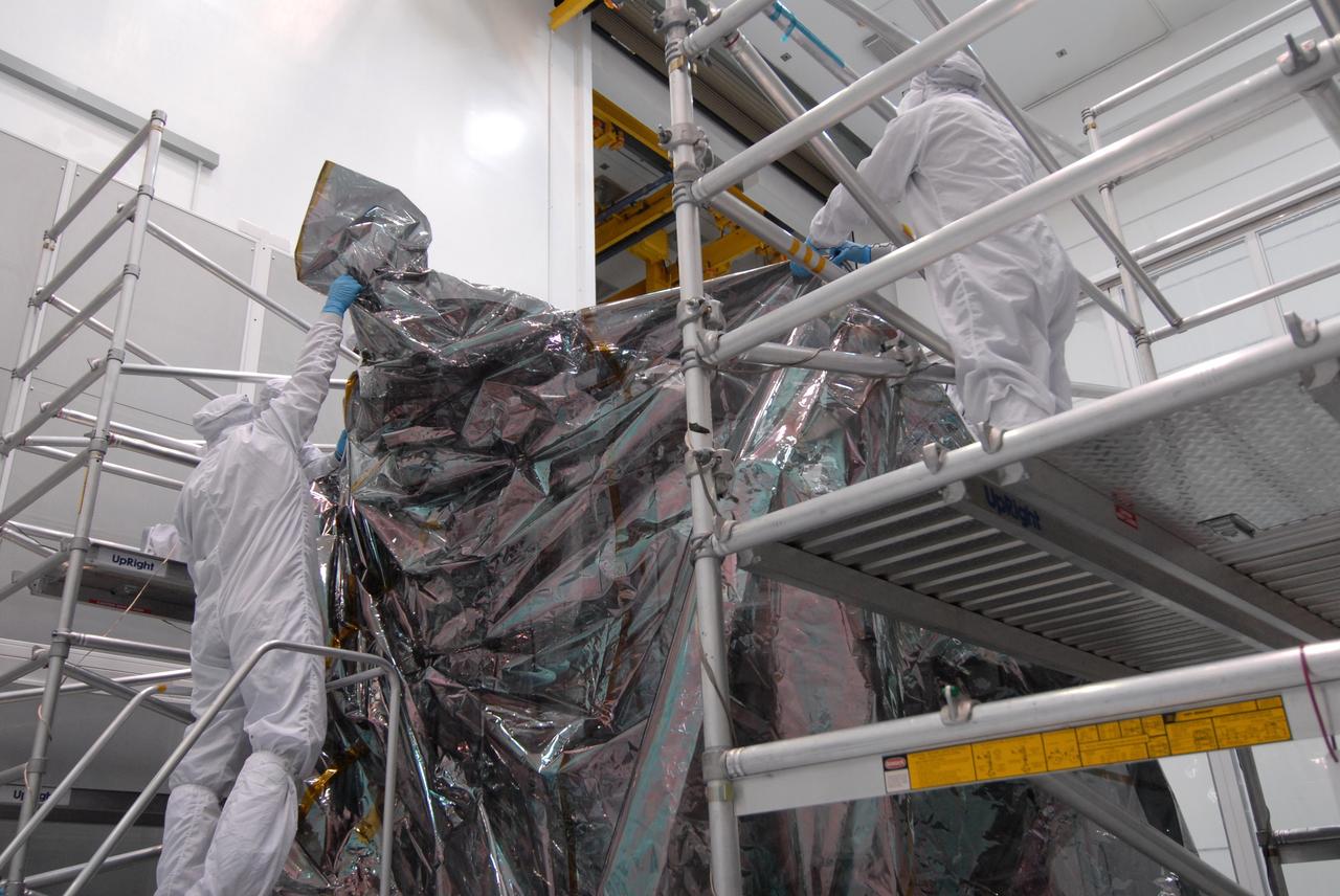
CAPE CANAVERAL, Fla. – At Astrotech Space Operations in Titusville, Fla., technicians place the protective bag around the Lunar Reconnaissance Orbiter, or LRO, before it is mated with NASA's Lunar CRater Observation and Sensing Satellite, known as LCROSS, spacecraft. The satellite's primary mission is to search for water ice on the moon in a permanently shadowed crater near one of the lunar poles. LCROSS is a low-cost, accelerated-development, companion mission to NASA's Lunar Reconnaissance Orbiter, or LRO. LCROSS and LRO are the first missions in NASA's plan to return humans to the moon and begin establishing a lunar outpost by 2020. Launch is targeted for no earlier than June 2 from Cape Canaveral Air Force Station in Florida. Photo credit: NASA/Jack Pfaller
CAPE CANAVERAL, Fla. – At Astrotech Space Operations in Titusville, Fla., technicians remove the bag that will be placed over the Lunar Reconnaissance Orbiter, or LRO, before it is mated with NASA's Lunar CRater Observation and Sensing Satellite, known as LCROSS, spacecraft. The satellite's primary mission is to search for water ice on the moon in a permanently shadowed crater near one of the lunar poles. LCROSS is a low-cost, accelerated-development, companion mission to NASA's Lunar Reconnaissance Orbiter, or LRO. LCROSS and LRO are the first missions in NASA's plan to return humans to the moon and begin establishing a lunar outpost by 2020. Launch is targeted for no earlier than June 2 from Cape Canaveral Air Force Station in Florida. Photo credit: NASA/Jack Pfaller
CAPE CANAVERAL, Fla. – At Astrotech Space Operations in Titusville, Fla., technicians complete placing the protective bag around the Lunar Reconnaissance Orbiter, or LRO, before it is mated with NASA's Lunar CRater Observation and Sensing Satellite, known as LCROSS, spacecraft. The satellite's primary mission is to search for water ice on the moon in a permanently shadowed crater near one of the lunar poles. LCROSS is a low-cost, accelerated-development, companion mission to NASA's Lunar Reconnaissance Orbiter, or LRO. LCROSS and LRO are the first missions in NASA's plan to return humans to the moon and begin establishing a lunar outpost by 2020. Launch is targeted for no earlier than June 2 from Cape Canaveral Air Force Station in Florida. Photo credit: NASA/Jack Pfaller
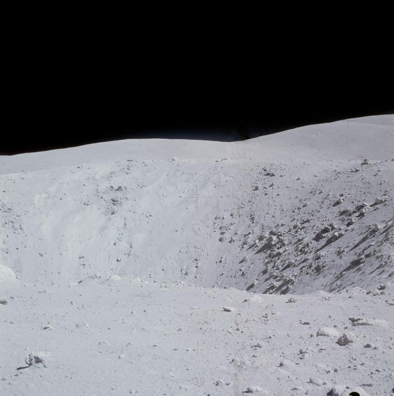
AS14-64-9118 (6 Feb. 1971) --- Astronaut Alan B. Shepard Jr., commander, photographed this overall view of a field of boulders on the flank of Cone Crater, during the second extravehicular activity (EVA), on Feb. 6, 1971. The view is looking south across the lunar valley through which the Apollo 14 moon-explorers flew their Lunar Module (LM) during the final approach to the landing. Astronaut Edgar D. Mitchell, lunar module pilot, joined Shepard in exploring the moon, while astronaut Stuart A. Roosa, command module pilot, remained with the Command and Service Modules (CSM) in lunar orbit.
AS16-116-18649 (23 April 1972) --- Astronaut Charles M. Duke Jr., lunar module pilot of the Apollo 16 lunar landing mission, examines closely the surface of a large boulder at North Ray Crater during the third Apollo 16 extravehicular activity (EVA) at the Descartes landing site. This picture was taken by astronaut John W. Young, commander. Note the chest-mounted 70mm Hasselblad camera. While astronauts Young and Duke descended in the Apollo 16 Lunar Module (LM) "Orion" to explore the Descartes highlands landing site on the moon, astronaut Thomas K. Mattingly II, command module pilot, remained with the Command and Service Modules (CSM) "Casper" in lunar orbit.
AS11-43-6439 (July 1969) --- An Apollo 11 oblique view of the lunar farside. The linear group of small craters is located within the large International Astronomical Union crater No. IX, and is centered at 139.5 degrees east longitude and 7 degrees north latitude. The absence of shadows is due to the high sun angle. The crater chain is approximately 34 statute miles in length, and the large crater adjacent to the crater is 10.5 statute miles in diameter.

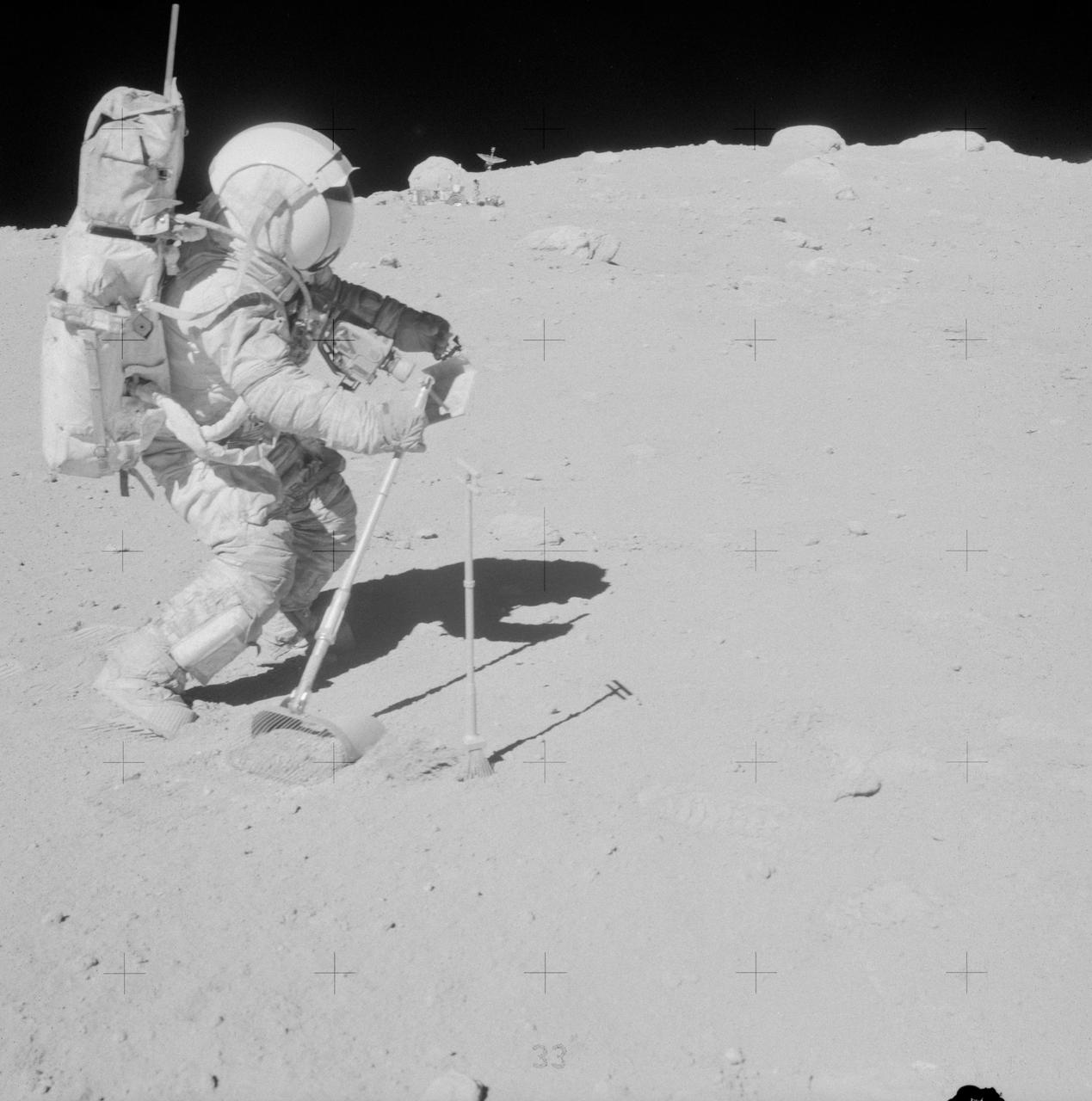
AS16-114-18423 (21 April 1972) --- Astronaut Charles M. Duke Jr., lunar module pilot, is photographed collecting lunar samples at Station No. 1, during the first Apollo 16 extravehicular activity (EVA), at the Descartes landing site. This picture, looking eastward, was taken by astronaut John W. Young, commander. Duke is standing at the rim of Plum Crater. The parked Lunar Roving Vehicle (LRV) can be seen in the left background. While astronauts Young and Duke descended in the Lunar Module (LM) "Orion" to explore the Descartes highlands region of the moon, astronaut Thomas K. Mattingly II, command module pilot, remained with the Command and Service Modules (CSM) "Casper" in lunar orbit.

AS11-37-5445 (20 July 1969) --- The Apollo 11 Command and Service Modules (CSM) are photographed from the Lunar Module (LM) in lunar orbit during the Apollo 11 lunar landing mission. The lunar surface below is in the north central Sea of Fertility. The coordinates of the center of the picture are 51 degrees east longitude and 1 degree north latitude. About half of the crater Taruntius G is visible in the lower left corner of the picture. Part of Taruntius H can be seen at lower right.

CAPE CANAVERAL, Fla. – At Astrotech Space Operations in Titusville, Fla., technicians perform black light inspection on the Lunar Reconnaissance Orbiter, or LRO, looking for possible contamination. Instruments on the LRO include the LEND that will measure the flux of neutrons from the moon; the LROC, a narrow angle camera that will provide panchromatic images; the LOLA, which will provide a precise global lunar topographic model and geodetic grid; and top right, the DIVINER, which will measure lunar surface temperatures at scales that provide essential information for future surface operations and exploration; and at top, the CRaTER, which will characterize the global lunar radiation environment and its biological impacts. The satellite's primary mission is to search for water ice on the moon in a permanently shadowed crater near one of the lunar poles. LCROSS is a low-cost, accelerated-development, companion mission to NASA's Lunar Reconnaissance Orbiter, or LRO. LCROSS and LRO are the first missions in NASA's plan to return humans to the moon and begin establishing a lunar outpost by 2020. Launch is targeted for no earlier than June 2 from Cape Canaveral Air Force Station in Florida. Photo credit: NASA/Jack Pfaller

CAPE CANAVERAL, Fla. – At Astrotech Space Operations in Titusville, Fla., technicians perform black light inspection on the Lunar Reconnaissance Orbiter, or LRO, looking for possible contamination. Instruments on the LRO include the LEND that will measure the flux of neutrons from the moon; the LROC, a narrow angle camera that will provide panchromatic images; the LOLA, which will provide a precise global lunar topographic model and geodetic grid; and top right, the DIVINER, which will measure lunar surface temperatures at scales that provide essential information for future surface operations and exploration; and at top, the CRaTER, which will characterize the global lunar radiation environment and its biological impacts. The satellite's primary mission is to search for water ice on the moon in a permanently shadowed crater near one of the lunar poles. LCROSS is a low-cost, accelerated-development, companion mission to NASA's Lunar Reconnaissance Orbiter, or LRO. LCROSS and LRO are the first missions in NASA's plan to return humans to the moon and begin establishing a lunar outpost by 2020. Launch is targeted for no earlier than June 2 from Cape Canaveral Air Force Station in Florida. Photo credit: NASA/Jack Pfaller
CAPE CANAVERAL, Fla. – At Astrotech Space Operations in Titusville, Fla., a technician checks the thermal blanket around the LROC narrow angle camera during closeout on the Lunar Reconnaissance Orbiter, or LRO, before its mating with NASA's Lunar CRater Observation and Sensing Satellite, known as LCROSS, spacecraft. Above the LROC is the LOLA, which will provide a precise global lunar topographic model and geodetic grid; and top right, the DIVINER, which will measure lunar surface temperatures at scales that provide essential information for future surface operations and exploration. The satellite's primary mission is to search for water ice on the moon in a permanently shadowed crater near one of the lunar poles. LCROSS is a low-cost, accelerated-development, companion mission to NASA's Lunar Reconnaissance Orbiter, or LRO. LCROSS and LRO are the first missions in NASA's plan to return humans to the moon and begin establishing a lunar outpost by 2020. Launch is targeted for no earlier than June 2 from Cape Canaveral Air Force Station in Florida. Photo credit: NASA/Jack Pfaller
AS11-42-6237 (20 July 1969) --- An Apollo 11 oblique view of the large crater Theophilus located at the northwest edge of the Sea of Nectar on the lunar nearside. Theophilus is about 60 statute miles in diameter. The smooth area is Mare Nectaris. The smaller crater Madler, about 14 statute miles in diameter, is located to the east of Theophilus. Visible in the background are the large crater Fracastorius and the smaller crater Beaumont. The coordinates of the center of this photograph are 29 degrees east longitude and 11 degrees south latitude.
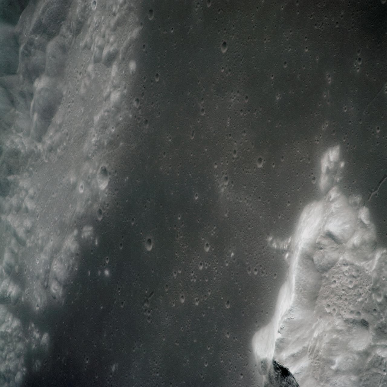
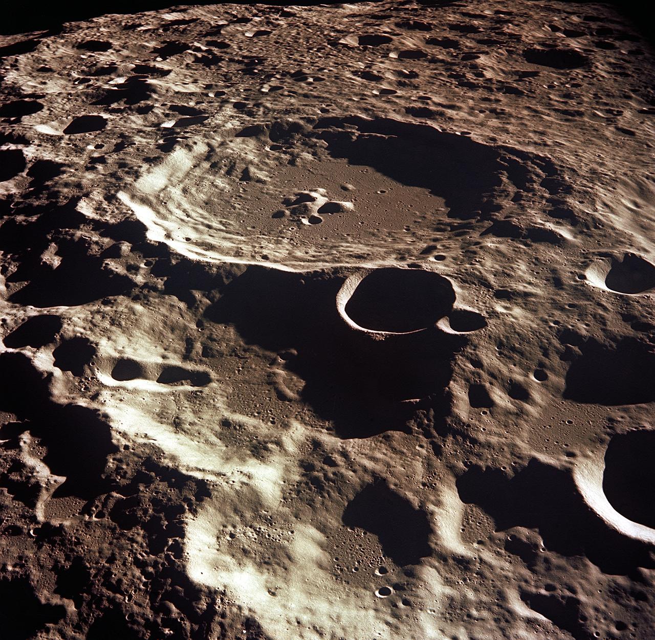
S71-44672 (30 July 1971) --- A near vertical view of the crater Paracelsus (formerly called I.A.U. Crater 365) on the lunar farside, as photographed by the Fairchild metric camera in the Scientific Instrumentation Module (SIM) bay of the Apollo 15 Command and Service Modules (CSM) in lunar orbit. Note mountain peak in center of Paracelsus. The coordinates of the center of Paracelsus are 163 degrees east longitude and 23 degrees south latitude. The second largest crater in the picture is identified as number 364 by the I.A.U. North will be at the top of the picture if held with Paracelsus at top center. The three-inch mapping camera was one of eight lunar orbital science experiments mounted in the SIM bay.
AS11-44-6609 (16-24 July 1969) --- An oblique of the Crater Daedalus on the lunar farside as seen from the Apollo 11 spacecraft in lunar orbit. The view looks southwest. Daedalus (formerly referred to as I.A.U. Crater No. 308) is located at 179 degrees east longitude and 5.5 degrees south latitude. Daedalus has a diameter of about 50 statute miles. This is a typical scene showing the rugged terrain on the farside of the moon. While astronauts Neil A. Armstrong, commander, and Edwin E. Aldrin Jr., lunar module pilot, descended in the Lunar Module (LM) "Eagle" to explore the Sea of Tranquility region of the moon, astronaut Michael Collins, command module pilot, remained with the Command and Service Modules (CSM) "Columbia" in lunar orbit.
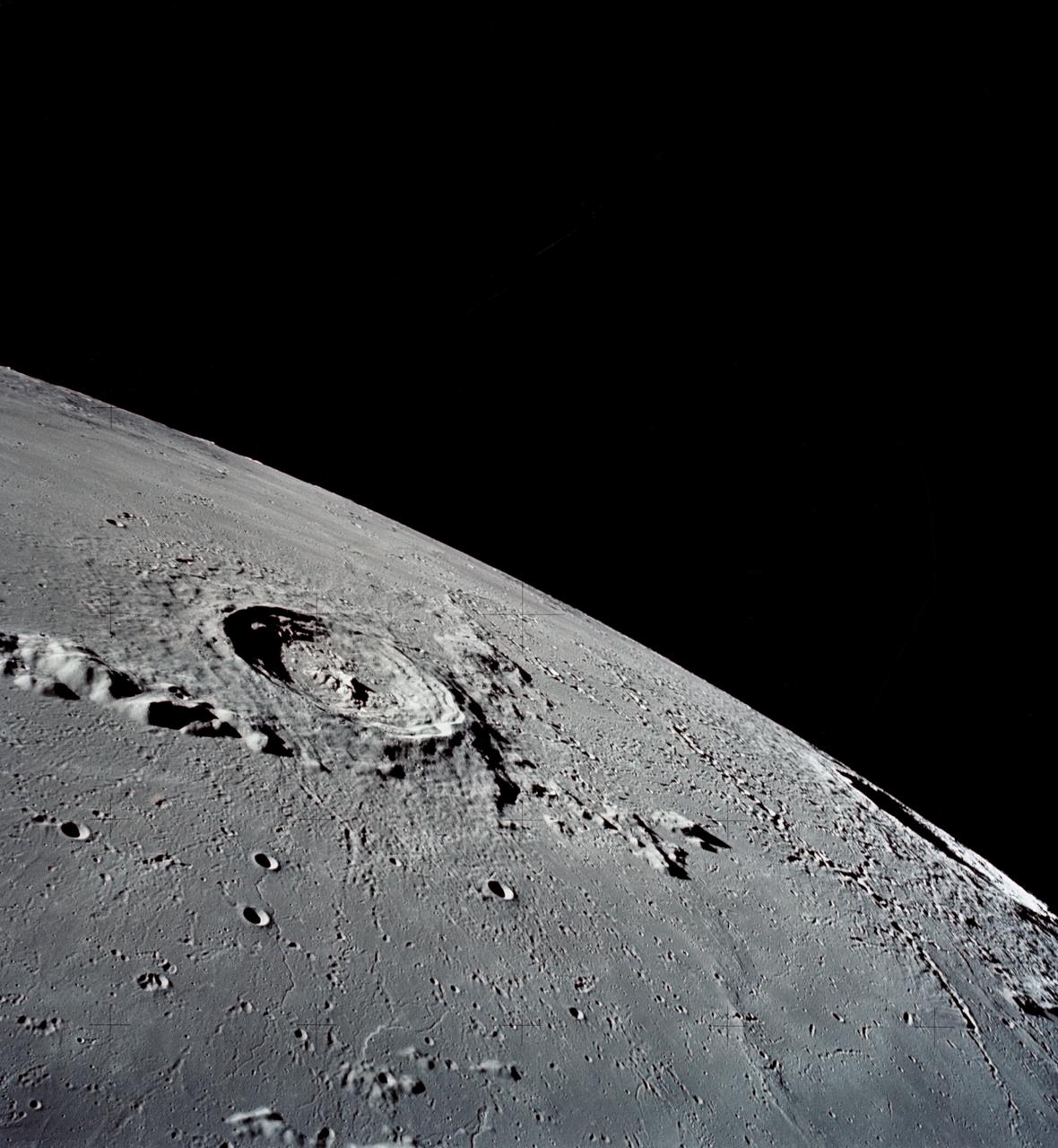
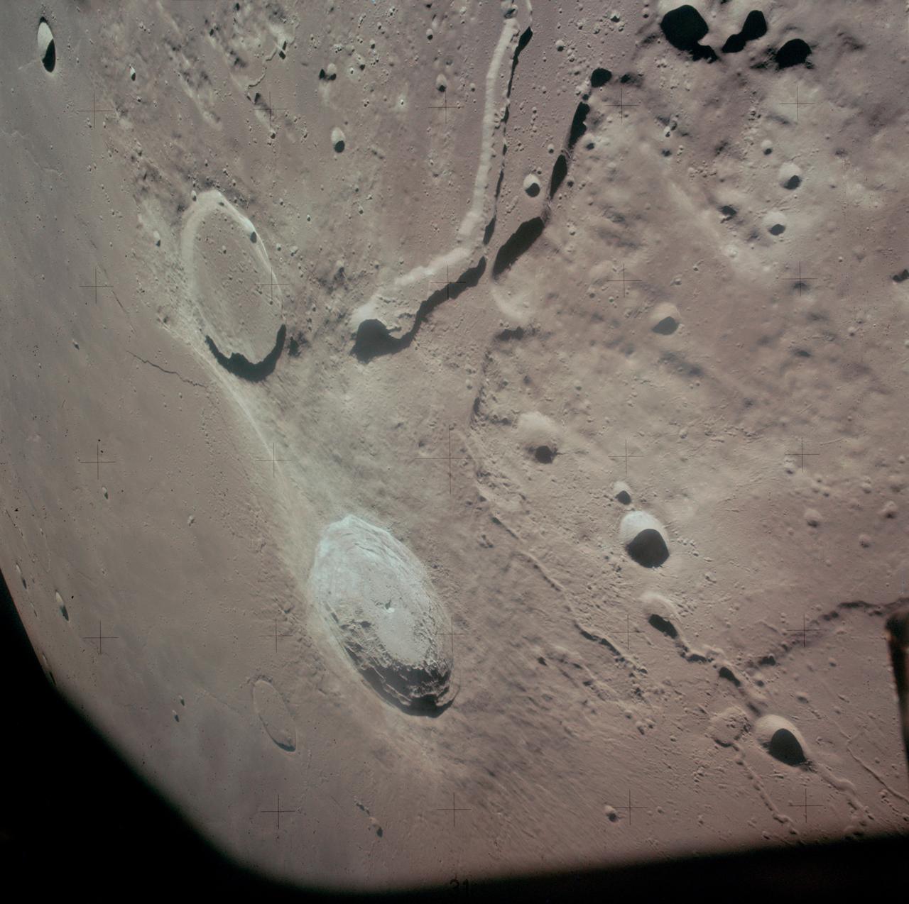
AS17-145-22285 (7-19 Dec. 1972) --- This is a view of the Eratosthenes Crater, taken looking southward from the Command and Service Module (CSM), being piloted by astronaut Ronald E. Evans. Copernicus is on the horizon. The other astronauts are Eugene A. Cernan, commander; and Harrison H. Schmitt, lunar module pilot.
AS17-137-20992 (12 Dec. 1972) --- A view looking into Shorty Crater, taken at Station 4, showing the orange soil. Astronaut Harrison H. Schmitt found the orange soil on the moon during the second Apollo 17 extravehicular activity (EVA) at the Taurus-Littrow landing site. While astronauts Eugene A. Cernan, commander, and Schmitt, lunar module pilot, descended in the Lunar Module (LM) "Challenger" to explore the Taurus-Littrow region of the moon, astronaut Ronald E. Evans, command module pilot, remained with the Command and Service Modules (CSM) "America" in lunar orbit.
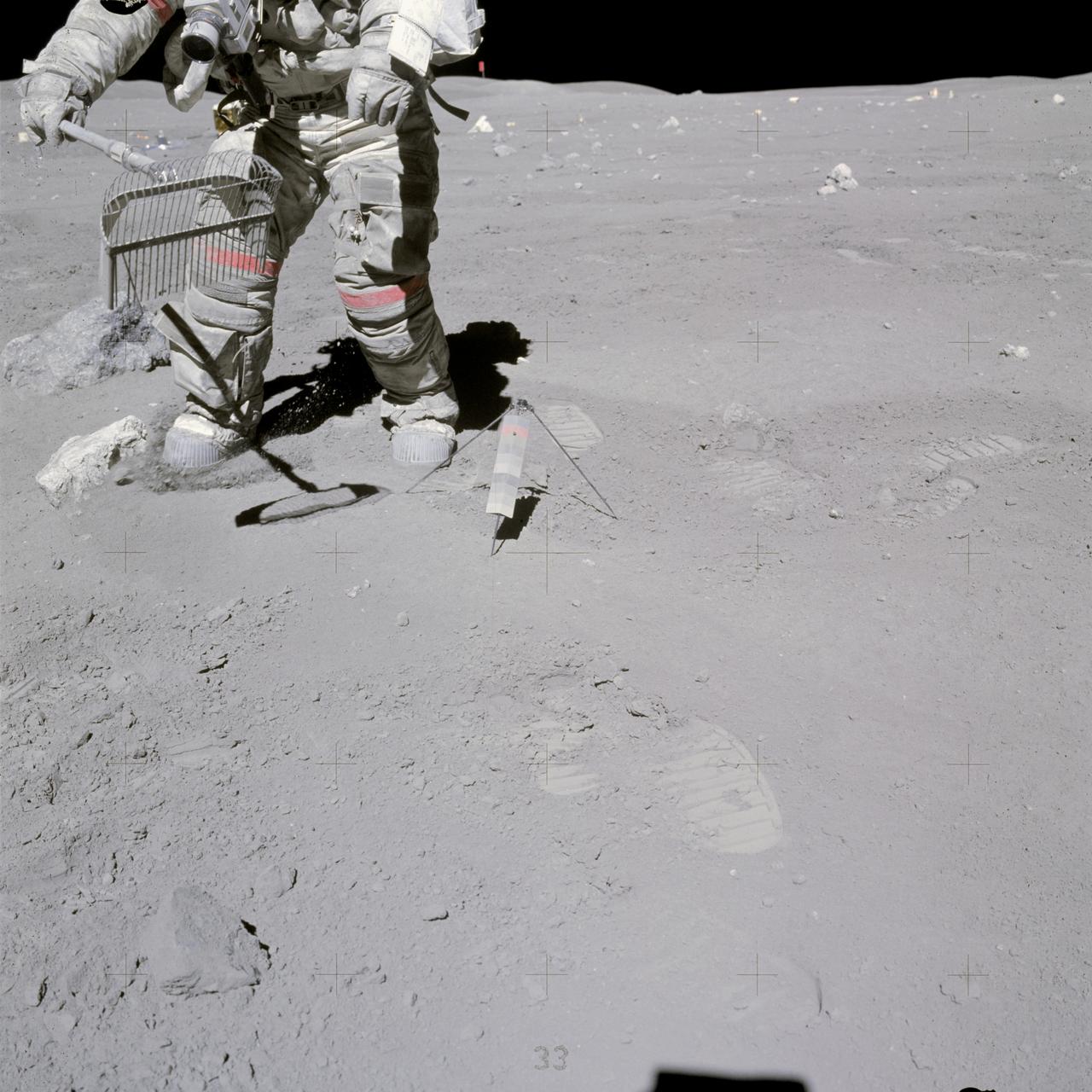
AS17-137-20990 (12 Dec. 1972) --- A view of the area at Station 4 (Shorty Crater) showing the now highly-publicized orange soil which the Apollo 17 crew members found on the moon during the second Apollo 17 extravehicular activity (EVA) at the Taurus-Littrow landing site. The tripod-like object is the gnomon and photometric chart assembly which is used as a photographic reference to establish local vertical sun angle, scale and lunar color. The gnomon is one of the Apollo lunar geology hand tools. While astronauts Eugene A. Cernan, commander, and Harrison H. Schmitt, lunar module pilot, descended in the Lunar Module (LM) "Challenger" to explore the Taurus-Littrow region of the moon, astronaut Ronald E. Evans, command module pilot, remained with the Command and Service Modules (CSM) "America" in lunar orbit. Schmitt was the crew man who first spotted the orange soil.
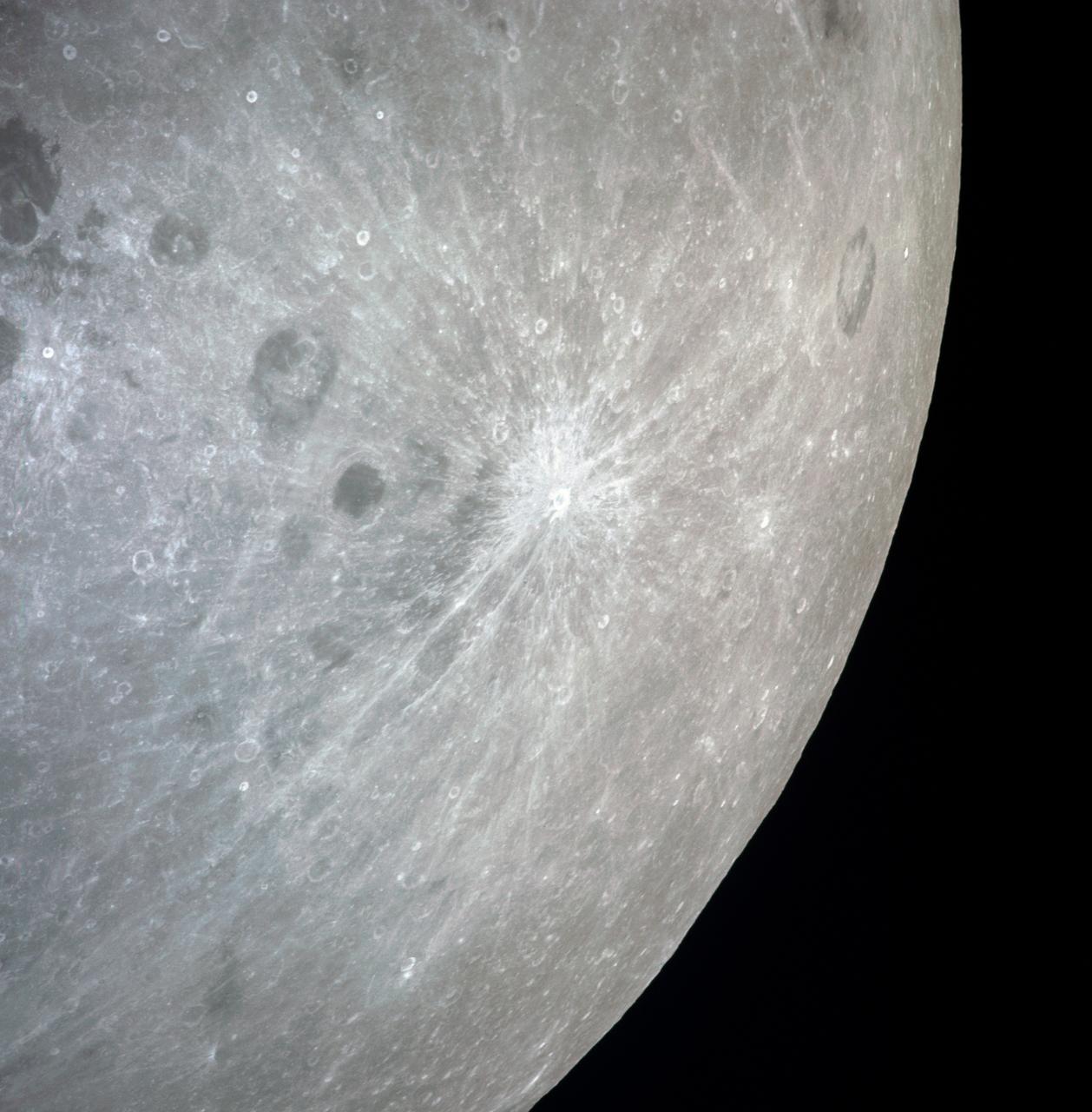
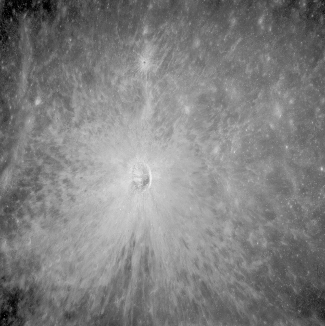
AS08-13-2327 (21-27 Dec. 1968) --- A brightly-rayed crater on the farside of the moon near the sub solar point, where the sun was directly overhead, as seen from the Apollo 8 spacecraft. (HOLD PICTURE WITH THE CRATER SLIGHTLY TO THE UPPER RIGHT). Brightly-rayed craters are numerous on the lunar front side; however, they have not been previously observed in such detail on the farside.
CAPE CANAVERAL, Fla. – One of three solar panels is seen during closeout of the Lunar Reconnaissance Orbiter, or LRO, at Astrotech Space Operations in Titusville, Fla. The satellite's primary mission is to search for water ice on the moon in a permanently shadowed crater near one of the lunar poles. LCROSS is a low-cost, accelerated-development, companion mission to NASA's Lunar Reconnaissance Orbiter, or LRO. LCROSS and LRO are the first missions in NASA's plan to return humans to the moon and begin establishing a lunar outpost by 2020. Launch is targeted for no earlier than June 2 from Cape Canaveral Air Force Station in Florida. Photo credit: NASA/Jack Pfaller
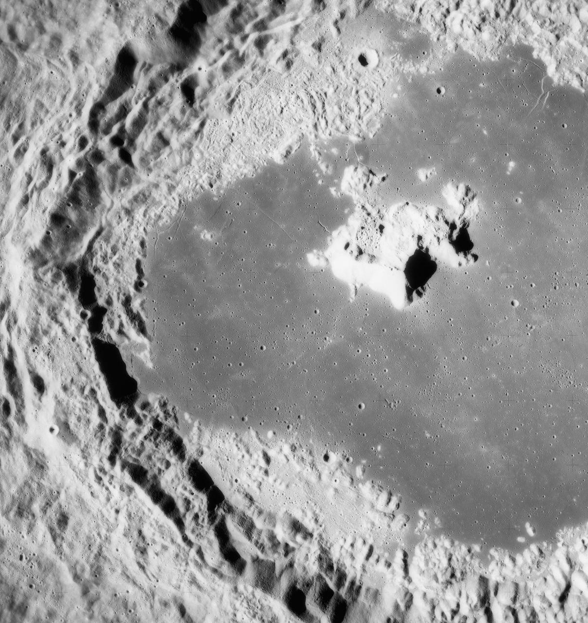
AS10-32-4845 (18-26 May 1969) --- An Apollo 10 southwest oblique view of the crater Censorinus which is located in the highland terrain bordering the Sea of Tranquility. HOLD PICUTRE WITH WINDOW FRAME AT LOWER LEFT. Censorinus is the bright crater in the lower left of the photograph. Censorinus is about 5 kilometers (about 3 statute miles) in diameter. Immediately to the left of Censorinus is the larger crater Censorinus A. The Sea of Tranquility is to the lower right of the photograph, which was taken from the Command and Service Modules. Censorinus is one of the brighter craters on the lunar surface.
AS11-43-6422 (July 1969) --- An Apollo 11 oblique view of the lunar farside. These two odd-shaped craters are located midway between International Astronomical Union craters 218 and 220, and are centered at 155 degrees east longitude and 3 degrees north latitude. The craters total approximately 13.5 statute miles in length and 7.5 statute miles in width at their widest point.
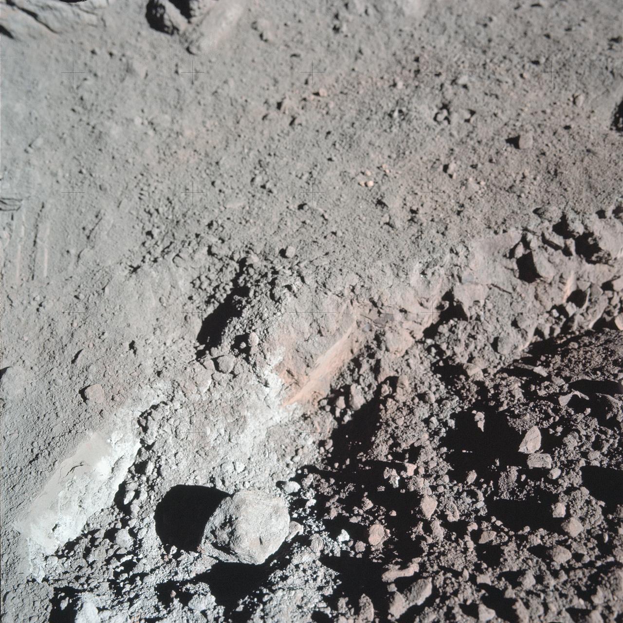
AS17-137-20989 (12 Dec. 1972) --- A close-up view of the much-publicized orange soil which the Apollo 17 crewmen found at Station 4 (Shorty Crater) during the second Apollo 17 extravehicular activity (EVA) at the Taurus-Littrow landing site. The orange soil was first spotted by scientist-astronaut Harrison H. Schmitt. While astronauts Schmitt and Eugene A. Cernan descended in the Lunar Module (LM) "Challenger" to explore the lunar surface, astronaut Ronald E. Evans remained with the Apollo 17 Command and Service Modules (CSM) in lunar orbit. The orange soil was never seen by the crewmen of the other lunar landing missions - Apollo 11 (Sea of Tranquility); Apollo 12 (Ocean of Storms); Apollo 14 (Fra Mauro); Apollo 15 (Hadley-Apennines); and Apollo 16 (Descartes).
AS15-93-12628 (31 July 1971) --- The snake-like rille feature in this 70mm frame, photographed from the lunar-orbiting Apollo 15 Command and Service Modules (CSM) by astronaut Alfred M. Worden, command module pilot, is Schroter's Valley. The long feature is located not far from the crater Aristarcus (out of frame) on the western side of the moon. Center coordinates of the area pictured are located at 25 degrees north latitude and 52.5 degrees west longitude. While astronauts David R. Scott, commander, and James B. Irwin, lunar module pilot, descended in the Lunar Module (LM) "Falcon" to explore the Hadley-Apennine area of the moon, astronaut Worden remained with the CSM in lunar orbit.

AS17-134-20454 (13 Dec. 1972) --- Scientist-astronaut Harrison H. Schmitt is photographed seated in the Lunar Roving Vehicle (LRV) at Station 9 (Van Serg Crater) during the third Apollo 17 extravehicular activity (EVA) at the Taurus-Littrow landing site. This photograph was taken by astronaut Eugene A. Cernan, commander. Schmitt, lunar module pilot, and Cernan explored the moon while astronaut Ronald E. Evans, command module pilot, remained with the Command and Service Modules in lunar orbit.
AS17-140-21494 (13 Dec. 1972) --- This view shows the Lunar Roving Vehicle (LRV) parked by an outcrop of rocks by astronauts Eugene A. Cernan and Harrison H. (Jack) Schmitt during their visit to extravehicular activity Station 6 (Henry Crater).

AS10-27-3873 (22 May 1969) --- The Apollo 10 Command and Service Modules (CSM) are photographed from the Lunar Module (LM) after CSM/LM separation in lunar orbit. The CSM was about 175 statute miles east of Smyth's Sea and was above the rough terrain which is typical of the lunar far side. The eastward oblique view of the lunar surface is centered near 105 degrees east longitude and 1 degree north latitude. The horizon is approximately 600 kilometers (374 statute miles) away. Numerous bright craters and the absence of shadows show that the sun was almost directly overhead when this photograph was taken.
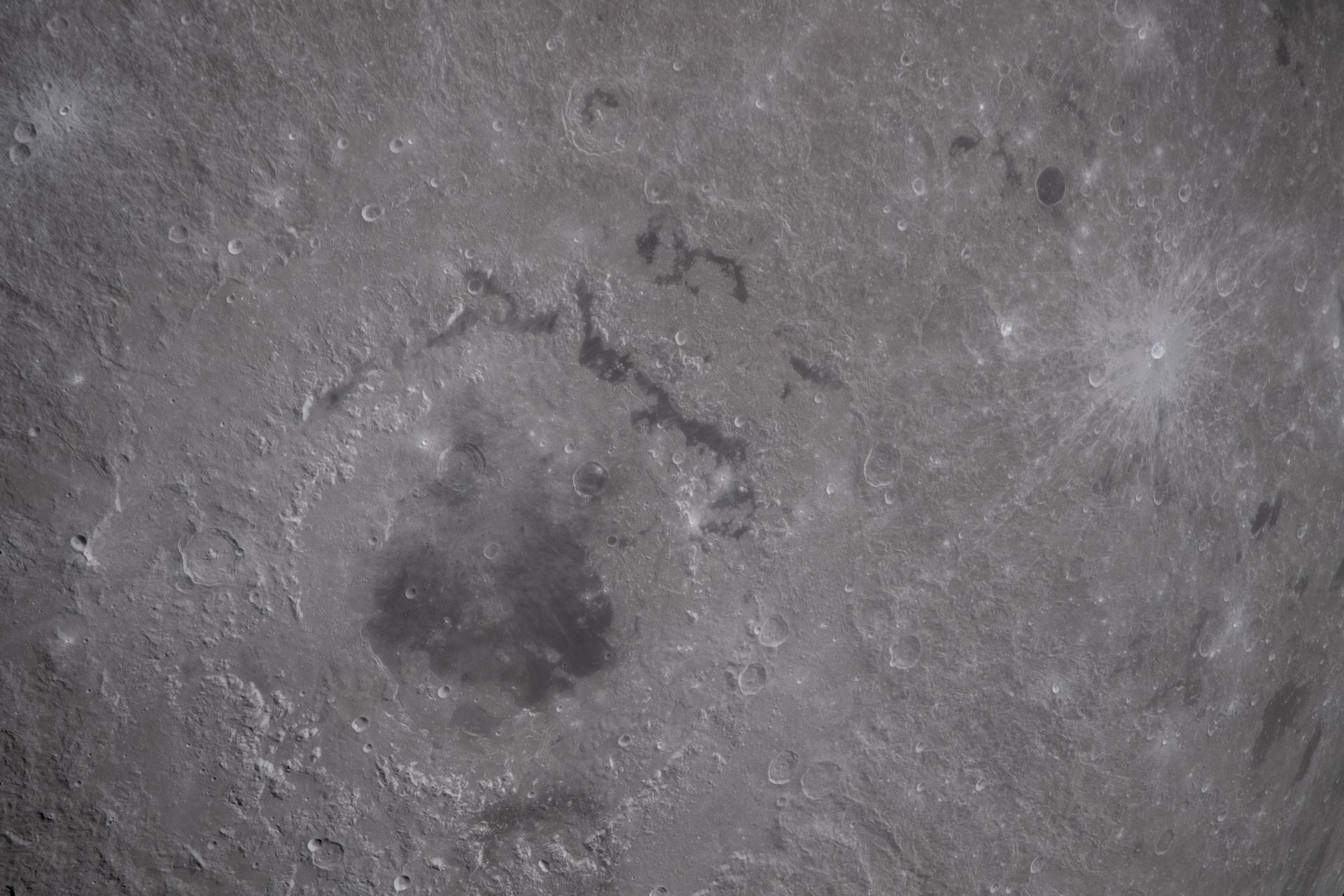
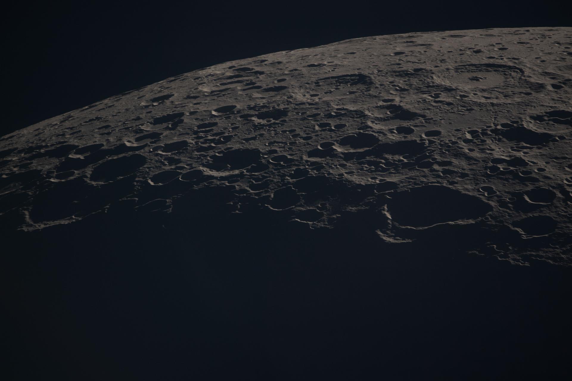
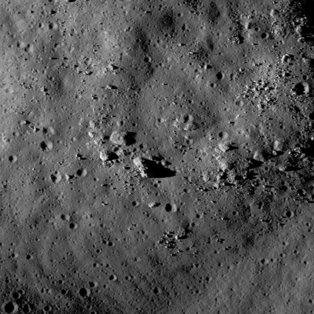
art002e010399 (April 6, 2026) During a lunar flyby observation period, the Artemis II crew captures craters dotting the surface of the Moon, revealing its rugged, ancient surface. This scarred landscape reflects a long history of cosmic collisions.
AS16-106-17340 (23 April 1972) --- Astronaut John W. Young, commander of the Apollo 16 lunar landing mission, is photographed collecting lunar samples near North Ray Crater during the third Apollo 16 extravehicular activity (EVA) at the Descartes landing site. This picture was taken by astronaut Charles M. Duke Jr., lunar module pilot. Young is using the lunar surface rake and a set of tongs. The Lunar Roving Vehicle (LRV) is parked in the field of large boulders in the background. While astronauts Young and Duke descended in the Lunar Module (LM) "Orion" to explore the moon, astronaut Thomas K. Mattingly II, command module pilot, remained with the Command and Service Modules (CSM) in lunar orbit.
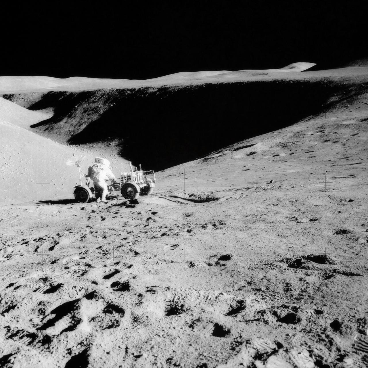
AS15-85-11451 (31 July 1971) --- Astronaut David R. Scott, mission commander, performs a task at the Lunar Roving Vehicle parked on the edge of Hadley Rille during the first Apollo 15 lunar surface extravehicular activity (EVA). This photograph was taken by astronaut James B. Irwin, lunar module pilot, from the flank of St. George Crater. The view is looking north along the rille.
AS16-116-18607 (23 April 1972) --- Astronaut Charles M. Duke Jr. works at the front of the Lunar Roving Vehicle (LRV) parked in this rock field at a North Ray Crater geological site during the mission's third extravehicular activity (EVA) on April 23, 1972. Astronaut John W. Young took this picture with a 70mm Hasselblad camera. While astronauts Young, commander; and Duke, lunar module pilot; descended in the Apollo 16 Lunar Module (LM) "Orion" to explore the Descartes highlands landing site on the moon, astronaut Thomas K. Mattingly II, command module pilot, remained with the Command and Service Modules (CSM) "Casper" in lunar orbit.
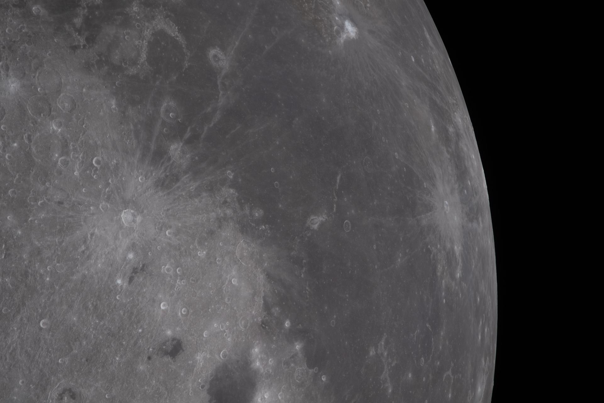
art002e012183 (April 6, 2026) - On the first shift during the lunar flyby observation period, the Artemis II crew captured more than two-thirds of the Moon showcasing the intricate features of the nearside. The 600-mile-wide impact crater, Orientale basin, lies along the transition between the near and far sides and is sometimes partly visible from Earth. The round black spot northeast of Orientale is Grimaldi crater, known for its exceptionally dark mare lava floor and heavily degraded rim. Credit: NASA
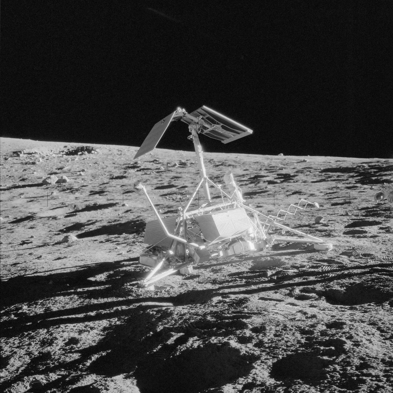
AS12-48-7121 (20 Nov. 1969) --- An excellent view of the unmanned Surveyor 3 spacecraft which was photographed during the Apollo 12 second extravehicular activity (EVA) on the surface of the moon. The Apollo 12 Lunar Module (LM), with astronauts Charles Conrad Jr., commander, and Alan L. Bean, lunar module pilot, aboard landed within 600 feet of Surveyor 3 in the Ocean of Storms. The television camera and several other pieces were taken from Surveyor 3 and brought back to Earth for scientific examination. Surveyor 3 landed on the side of this small crater in the Ocean of Storms on April 19, 1967. Astronaut Richard F. Gordon Jr., command module pilot, remained with the Apollo 12 Command and Service Modules (CSM) in lunar orbit while Conrad and Bean descended to explore the moon.
AS14-64-9099 (6 Feb. 1971) --- An Apollo 14 crew member (note shadow) photographs this field of boulders located on the flank of Cone Crater during the second extravehicular activity (EVA). This view is looking just north of west. While astronauts Alan B. Shepard Jr., commander, and Edgar D. Mitchell, lunar module pilot, were exploring the moon, astronaut Stuart A. Roosa, command module pilot, was maneuvering the Apollo 14 Command and Service Modules (CSM) in lunar orbit.
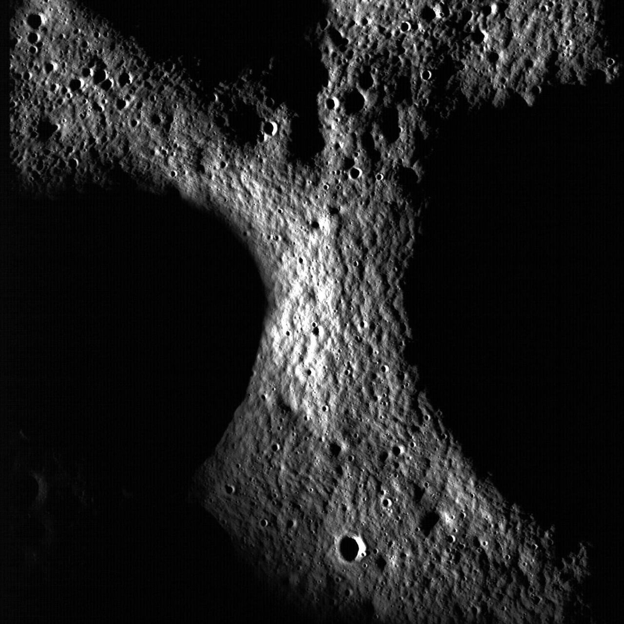
art002e012702 (April 6, 2026) – Poynting crater and Keeler crater are visible side by side in the lower right portion of this image of the Moon’s far side highlands. Poynting, positioned above, is a large impact crater with a well-defined rim and relatively smooth interior, indicative of material that has settled following the initial impact. Just below it, Keeler crater appears slightly smaller, with a sharply outlined rim and a more textured interior shaped by subsequent impacts and ejecta. Both features lie within the densely cratered far side highlands, preserving a record of ancient impacts that have shaped the lunar surface over billions of years.
AS10-27-3908 (18-26 May 1969) --- An Apollo 10 photograph of the lunar nearside looking westward across Apollo Landing Site 3 in Central Bay. Bruce, the prominent crater in the lower right corner, is about 3.7 statute miles in diameter. Topographic features on the surface of Central Bay are accentuated by the low sun angle.
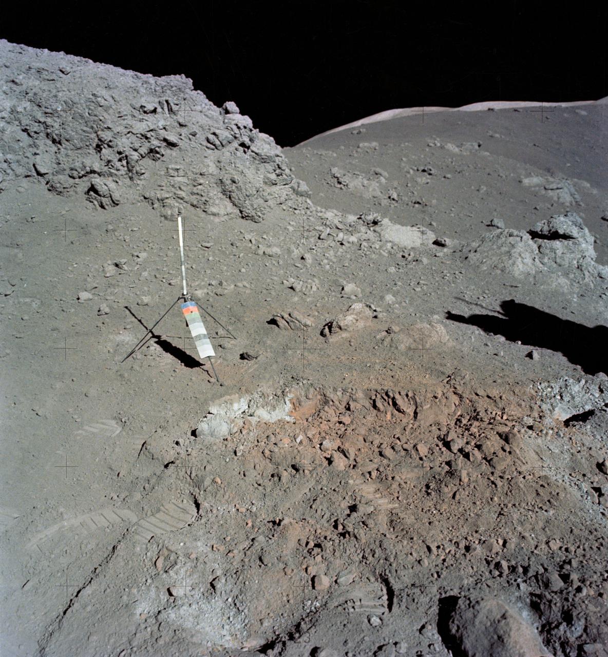
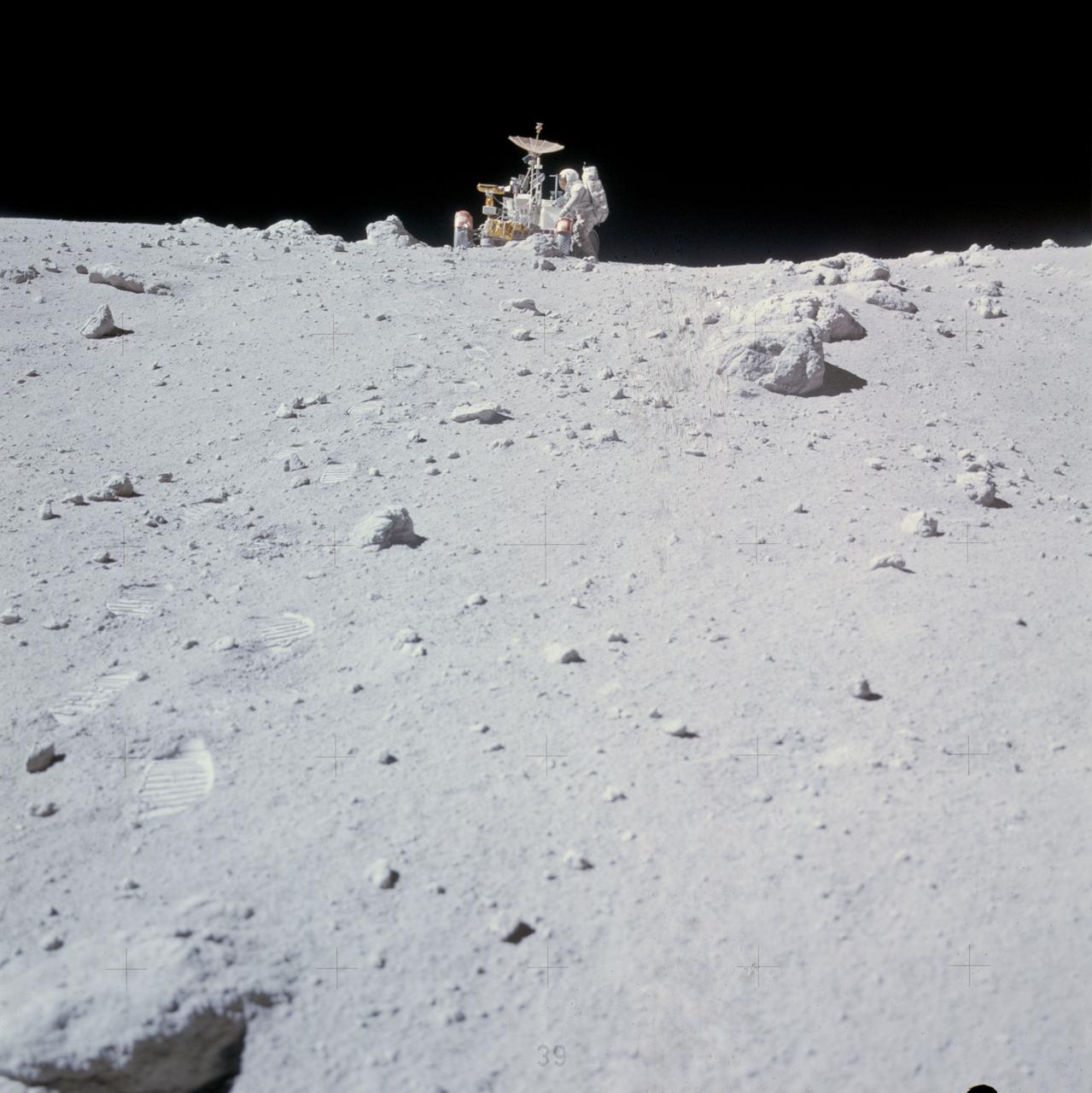
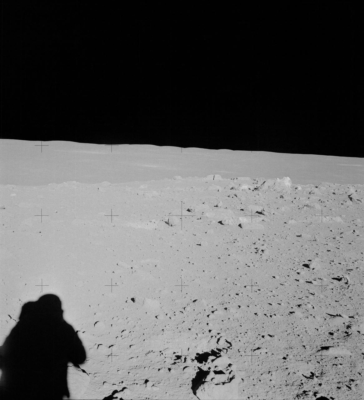
AS15-82-11057 (2 Aug. 1971) --- The Lunar Module (LM) "Falcon" is photographed against the barren lunarscape during the third Apollo 15 lunar surface extravehicular activity (EVA) at the Hadley-Apennine landing site on the lunar nearside. This view is looking southeast. The Apennine Front is in the left background; and Hadley Delta Mountain is in the right background. The object next to the United States flag is the Solar Wind Composition (SWC) experiment. Last Crater is to the right of the LM. Note bootprints and tracks of the Lunar Roving Vehicle (LRV). The light spherical object at the top is a reflection in the lens of the camera. While astronauts David R. Scott and James B. Irwin descended in the LM to explore the moon, astronaut Alfred M. Worden remained with the Command and Service Modules (CSM) in lunar orbit.
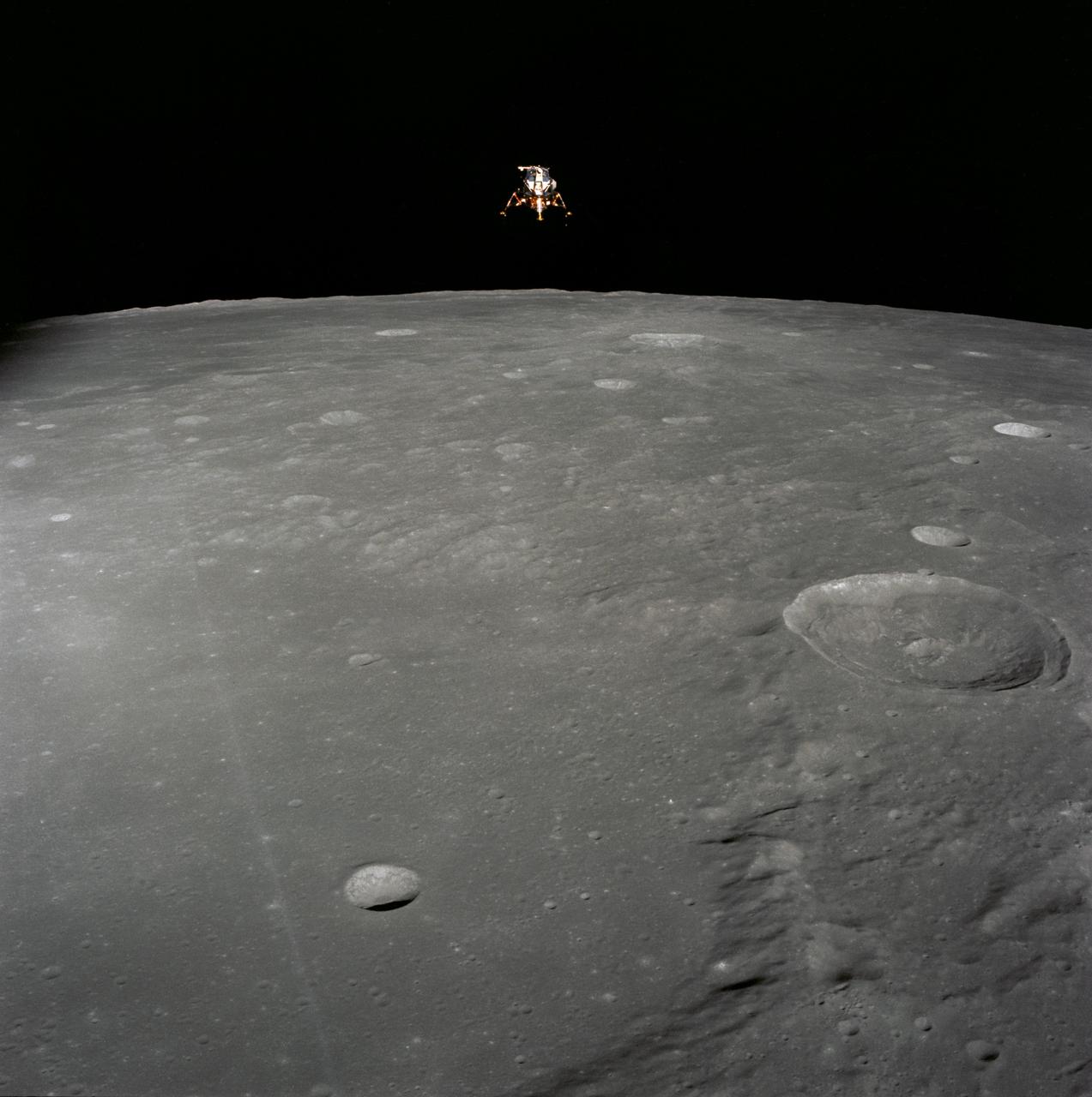
AS11-44-6634 (21 July 1969) --- The Apollo 11 Lunar Module (LM) ascent stage, with astronauts Neil A. Armstrong and Edwin E. Aldrin Jr. onboard, is photographed from the Command and Services Modules (CSM) in lunar orbit. This view is looking west with the Earth rising above the lunar horizon. Astronaut Michael Collins remained with the CSM in lunar orbit while Armstrong and Aldrin explored the moon. The LM is approaching from below. The maze area in the background is Smyth's Sea. At right center is International Astronomical Union crater No. 189.
AS10-31-4537 (18-26 May 1969) --- This near vertical photograph taken from the Apollo 10 Command and Service Modules shows features typical of the Sea of Tranquility near Apollo Landing Site 2. HOLD PICTURE WITH PRONOUNCED LINEAR FEATURE PARALLEL TO LEFT MARGIN. The proposed landing area for Apollo 11 (Lunar Landing Site 2) is a relatively smooth maria area in the upper right quadrant of the photographed area. Apollo 10 traveled from the bottom to the top of the picture. The prominent linear feature at left is Hypatia Rille (called "U.S. 1" by the Apollo 10 crew). The prominent crater centered in Hypatia Rille at top left is Moltke AC (code name "Chuck Hole"). Moltke, the prominent crater to the right of Hypatia Rille, is centered near 24.2 degrees east longitude, and 0.6 degrees south latitude.
art002e010014 (April 6, 2026) – A bright portion of the Moon is visible in this image. If you look closely, you can see linear, pitted features known as “crater chains” radiating from the Orientale basin, an impact crater with a patch of ancient lava at its center, visible in the bottom center of the image. These crater chains formed about 3.8 billion years ago, when rocks spewed from the collision that formed Orientale landed in lines extending away from the crater. These chains are found near other large craters on the Moon, but we don’t get to see them on Earth because our planet’s crust has been turned over so many times through plate tectonics and largely erased by rain, wind, and ice. In the upper left corner of the Moon disk is a line called the terminator, the boundary between lunar day and night. Here, low-angle sunlight skims the surface, casting dramatic shadows that expose the area’s topography — or the shape of its surface. Glushko crater is the bright spot just to the left of the dark mare, or “sea” of ancient lava flows on the near side of the Moon. It’s identifiable by the bright rays that shoot across the mare, some hundreds of miles away. These rays are made of ejected material after the collision that formed Glushko. Glushko and its rays are brighter than the surrounding area because that younger has experienced less weathering from radiation and impacts. Oceanus Procellarum, the largest lava-filled region on the Moon, spans the horizon. The Aristarchus crater, the bright spot in the sea of lava, creeps toward the right edge of the Moon.
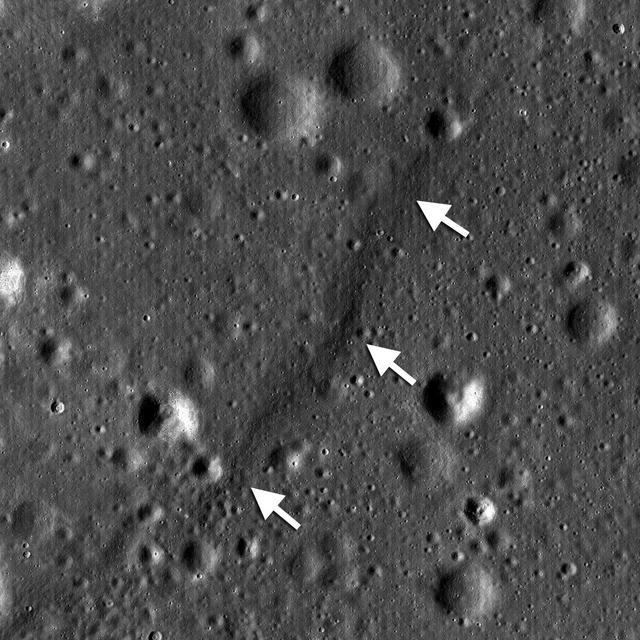
A junction between the rims of three craters on the floor of Peary crater near the lunar north pole is evident in this image taken by NASA Lunar Reconnaissance Orbiter.
art002e014055 (April 6, 2026) - A close-up view of the Moon along the terminator—the boundary between lunar day and night—captured by the crew during the Artemis II mission. The low-angle sunlight on this specific day casts long shadows across the surface, revealing the shape and depth of craters in striking detail. Since the early days of the telescope, astronomers used observations along the terminator to map the Moon’s terrain, taking advantage of the contrast between light and shadow to distinguish surface features. While modern imaging has advanced significantly, this lighting still provides valuable insight into the Moon’s topography.
Distinctive asymmetrical ejecta surrounding a 140 meter diameter crater in the lunar highlands as seen by NASA Lunar Reconnaissance Orbiter. Crater is located on the northeastern rim of the eroded pre-Nectarian crater Hommel.
S71-44669 (31 July-2 Aug. 1971) --- An oblique view of the rayed crater Proclus on the lunar nearside, as photographed by the Fairchild metric camera in the SIM bay of the Apollo 15 Command and Service Modules (CSM) in lunar orbit. This view is looking north. The Sea of Crisis is at upper right. Proclus, which is 28 kilometers (16.58 statute miles) in diameter, is located at 47 degrees east longitude and 16 degrees north latitude. The Marsh of Sleep is at lower left. A small portion of the Sea of Tranquility can be seen at upper left. The crater Macrobius is located at upper left. The three-inch mapping camera was one of eight lunar orbital science experiments mounted in the SIM bay.
art002e012093 (April 6, 2026) - Hertzsprung Basin comes into view with its distinctive two concentric rings of mountains, revealing the scale of this ancient impact structure. Near the lower left, Vavilov crater—identified by its central peak—stands out, a feature often described by the Artemis II crew during their lunar flyby. Credit: NASA
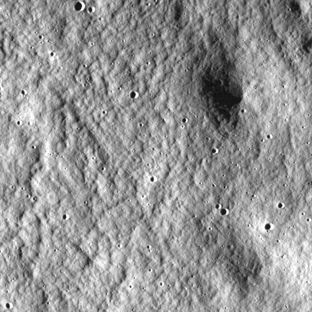
Close-up view of the lunar highlands, northeast of Clavius crater, taken by NASA Lunar Reconnaissance Orbiter.
NASA Lunar Reconnaissance Orbiter shows a lobate scarp in the mare basalts of Aitken crater on the lunar farside arrows.
AS16-117-18826 (23 April 1972) --- Astronaut John W. Young collects samples at the North Ray Crater geological site during the mission's third and final Apollo 16 extravehicular activity (EVA). He has a rake in his hand, and the gnomon is near his foot. Note how soiled Young's Extravehicular Mobility Unit (EMU) is. While astronauts Young, commander; and Charles M. Duke Jr., lunar module pilot; descended in the Apollo 16 Lunar Module (LM) "Orion" to explore the Descartes highlands landing site on the moon, astronaut Thomas K. Mattingly II, command module pilot, remained with the Command and Service Modules (CSM) "Casper" in lunar orbit.
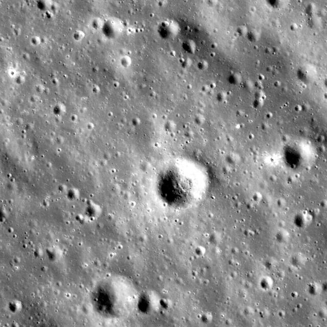
NASA Lunar Reconnaissance Orbiter takes a look at a fresh crater on the southwest rim of Metius B crater.
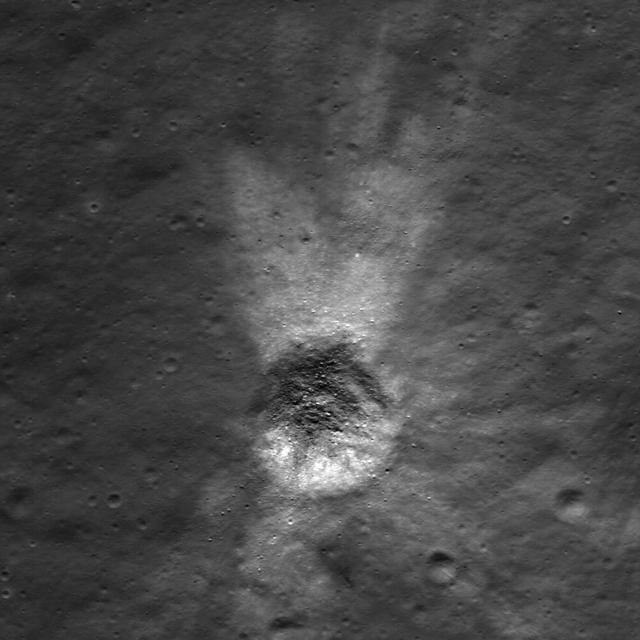
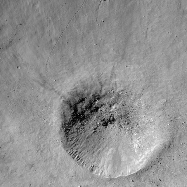
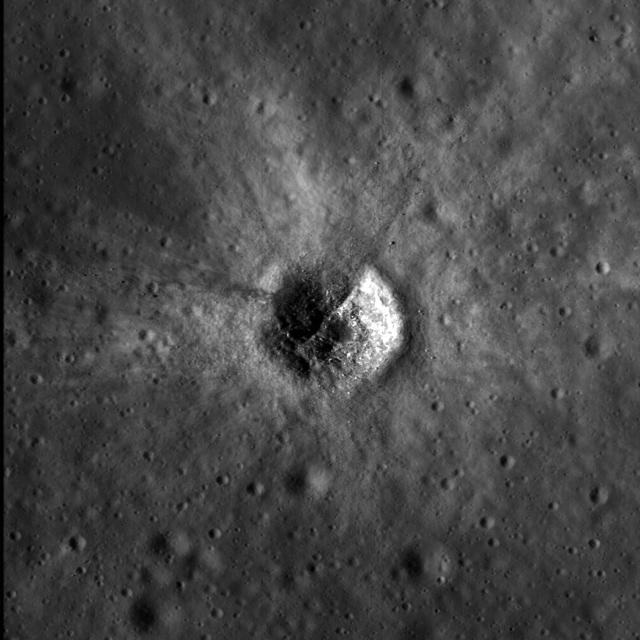
NASA Lunar Reconnaissance Orbiter showing a string of secondary craters from an impact crater to the north, probably Giordano Bruno.
NASA Lunar Reconnaissance Orbiter sees bright crater rays and boulders.

NASA Lunar Reconnaissance Orbiter looks at a terraced wall in Burg Crater.
NASA Lunar Reconnaissance Orbiter captured this image of the floor of a crater in the Mare Frigoris.
NASA Lunar Reconnaissance Orbiter shows highlands terrain inside the Dante Crater.
AS16-117-18825 (23 April 1972) --- Astronaut John W. Young, Apollo 16 commander, with a sample bag in his left hand, moves toward the bottom part of the gnomon (center) while collecting samples at the North Ray Crater geological site. Note how soiled Young's Extravehicular Mobility Unit (EMU) is during this the third and final Apollo 16 extravehicular activity (EVA). The Lunar Roving Vehicle (LRV) is parked at upper left.
NASA image release May 14, 2010 Einstein and Einstein A: A Study in Crater Morphology Located on the western limb of the Moon, Einstein and Einstein A craters (16.3oN, 271.3oE ) are only visible to Earth-based observers during certain lunar lighting and orientation conditions. Einstein A is younger than Einstein, as indicated by the fact that it lies squarely in the middle of the floor of Einstein. When viewed in topographic data, these two craters reveal much about the relative age and shape of an impact crater. To understand further, let's first take a look at Einstein. Einstein is a fairly large crater that spans 198 km across. A crater's size alone however cannot reveal much about age. ÊEinstein's relative age can be determined by examining the frequency and distribution of impact craters overprinted on its rim and floor. Younger craters have had fewer impacts, which enables them to retain their original morphology. Einstein A reveals most of its original structure, including a raised rim and ejecta blanket, and is therefore a relatively young crater as compared to Einstein, whose original structure has been somewhat degraded over time by smaller impacts. The Einstein craters were named after famed physicist, philosopher, and scientist Albert Einstein (1879-1955). To learn more go to: <a href="http://www.nasa.gov/mission_pages/LRO/multimedia/lroimages/lola-20100514-einstein.html" rel="nofollow">www.nasa.gov/mission_pages/LRO/multimedia/lroimages/lola-...</a> <b><a href="http://www.nasa.gov/centers/goddard/home/index.html" rel="nofollow">NASA Goddard Space Flight Center</a></b> is home to the nation's largest organization of combined scientists, engineers and technologists that build spacecraft, instruments and new technology to study the Earth, the sun, our solar system, and the universe.
The unusual shapes of craters at the Flamsteed Constellation region of interest provide information about the thickness of the lunar regolith in this region in this image taken by NASA Lunar Reconnaissance Orbiter.
NASA Lunar Reconnaissance Orbiter looks near the northeast edge of the unusually large melt pond adjacent to the lunar far side crater King.

Karma Snyder, a project manager at NASA's John C. Stennis Space Center, was a senior design engineer on the RL10 liquid rocket engine that powered the Centaur, the upper stage of the rocket used in NASA's Lunar CRater Observation and Sensing Satellite (LCROSS) mission in October 2009. Part of the LCROSS mission was to search for water on the moon by striking the lunar surface with a rocket stage, creating a plume of debris that could be analyzed for water ice and vapor. Snyder's work on the RL10 took place from 1995 to 2001 when she was a senior design engineer with Pratt & Whitney Rocketdyne. Years later, she sees the project as one of her biggest accomplishments in light of the LCROSS mission. 'It's wonderful to see it come into full service,' she said. 'As one of my co-workers said, the original dream was to get that engine to the moon, and we're finally realizing that dream.'
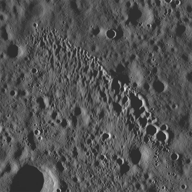
NASA Lunar Reconnaissance Orbiter sees hummocks and blocks on the ejecta blanket of Tsiolkovskiy crater.
This image taken by NASA Lunar Reconnaissance Orbiter shows a wide variety of geologic features on northwest of Plato crater.
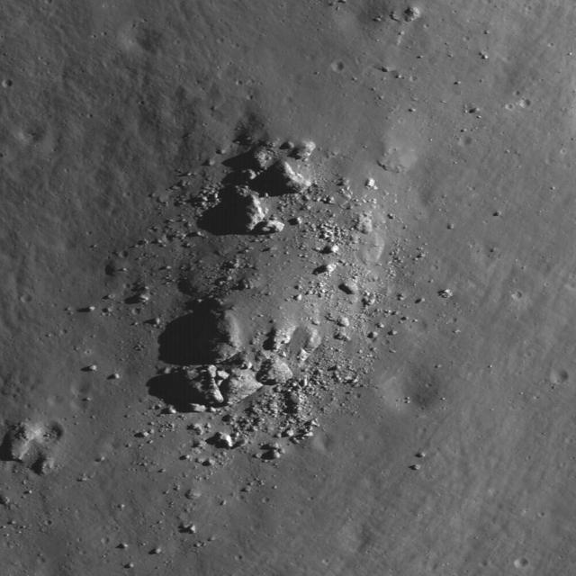
This image from NASA Lunar Reconnaissance Orbiter shows a view of boulders, on the floor of Rutherfurd crater, about to disappear into the shadows of dusk.