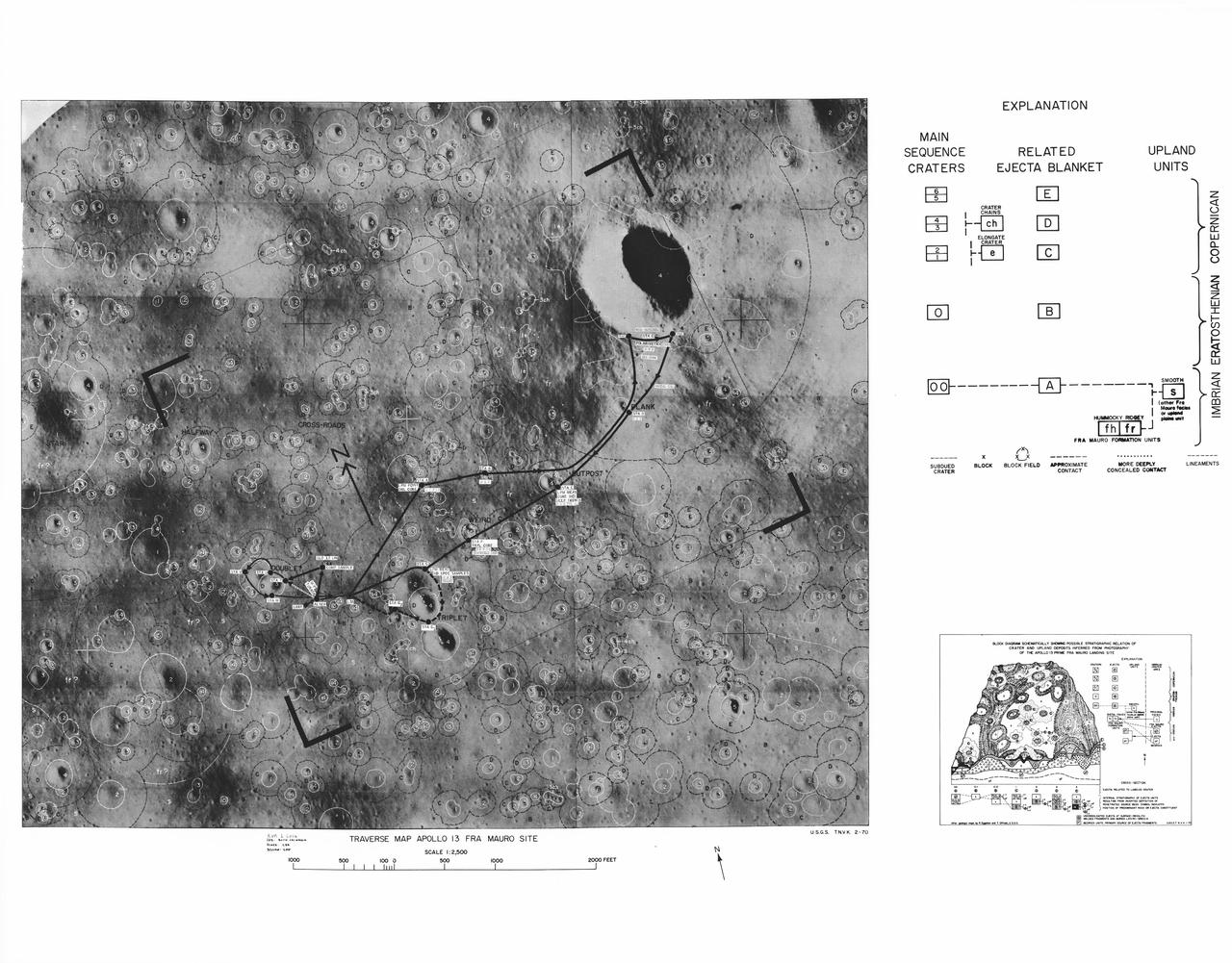
This lunar map shows the traverse plans for the Apollo 14 lunar landing mission. Areas marked include Lunar module landing site, areas for the Apollo Lunar Surface Experiment Package (ALSEP) and areas for gathering of core samples.

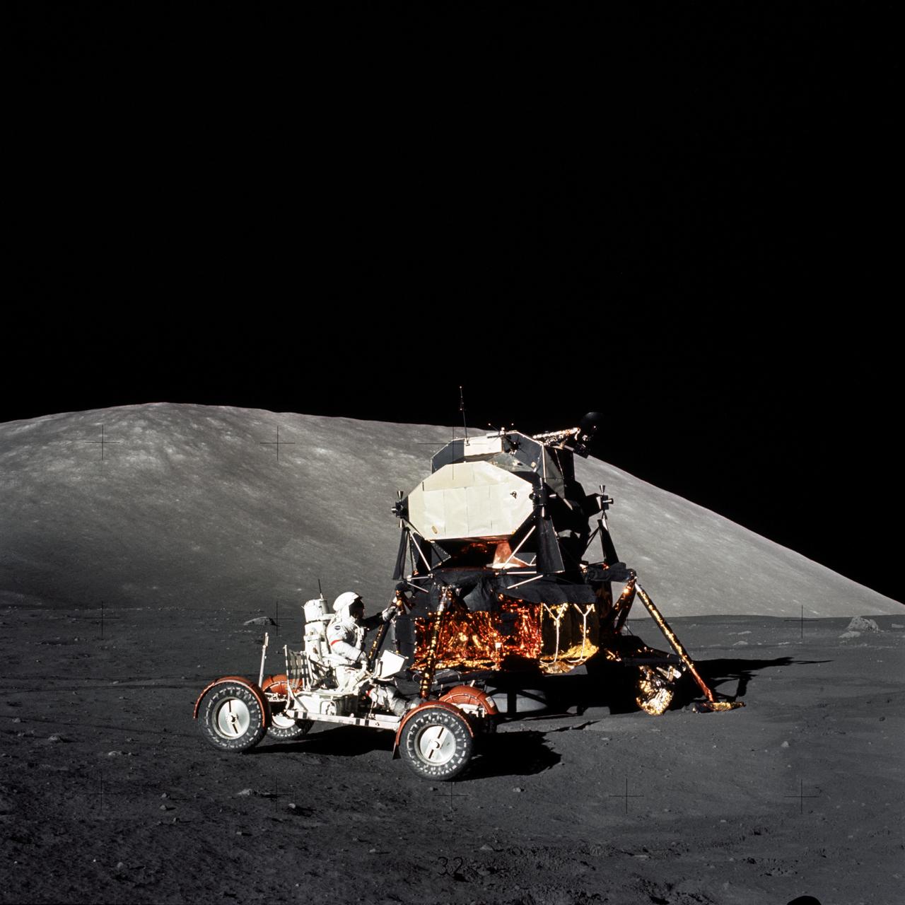
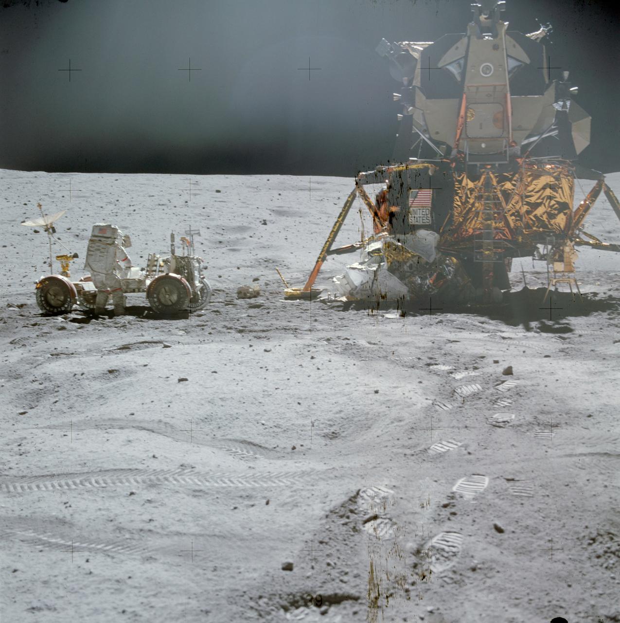
AS16-107-17436 (21 April 1972) --- An excellent view of the Lunar Module (LM) "Orion" and Lunar Roving Vehicle (LRV), as photographed by astronaut Charles M. Duke Jr., lunar module pilot, during the first Apollo 16 extravehicular activity (EVA) at the Descartes landing site. Astronaut John W. Young, commander, can be seen directly behind the LRV. The lunar surface feature in the left background is Stone Mountain. While astronauts Young and Duke descended in the LM to explore the Descartes highlands landing site on the moon, astronaut Thomas K. Mattingly II, command module pilot, remained with the Command and Service Modules (CSM) "Casper" in lunar orbit.
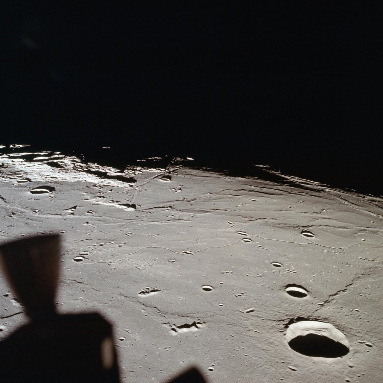
This 70mm frame, showintg the Apollo 17 Command/Service Modules (CSM) backdropped against the Taurus-Littrow landing site, was exposed from the lunar module (LM) prior to the LM's touchdown on the lunar surface.
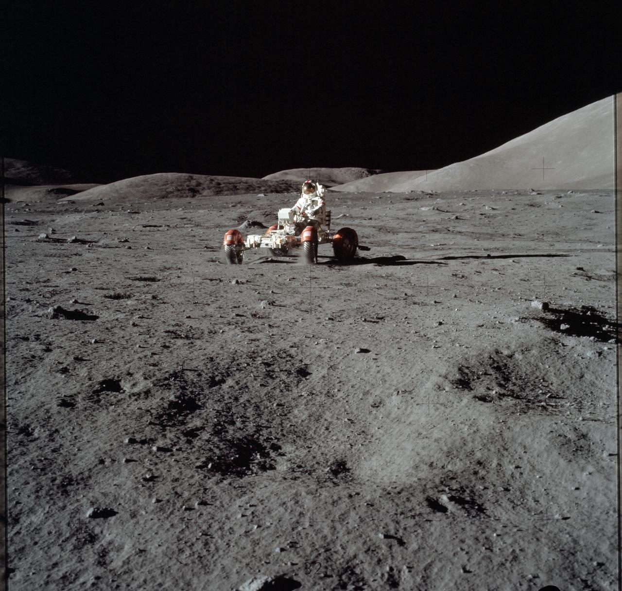
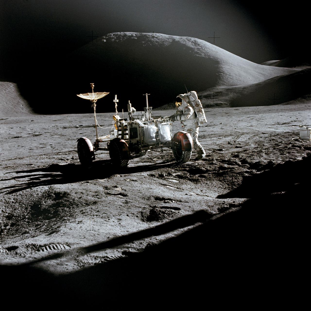
AS15-88-11901 (31 July-2 Aug. 1971) --- The Lunar Roving Vehicle (LRV) is photographed alone against the desolate lunar background during the third Apollo 15 lunar surface extravehicular activity (EVA) at the Hadley-Apennine landing site. This view is looking north. The west edge of Mount Hadley is at the upper right edge of the picture. Mount Hadley rises approximately 4,500 meters (about 4,765 feet) above the plain. The most distant lunar feature visible is approximately 25 kilometers (about 15.5 statute miles) away. While astronauts David R. Scott, commander; and James B. Irwin, lunar module pilot, descended in the Lunar Module (LM) "Falcon" to explore the moon, astronaut Alfred M. Worden, command module pilot, remained with the Command and Service Modules (CSM) in lunar orbit.

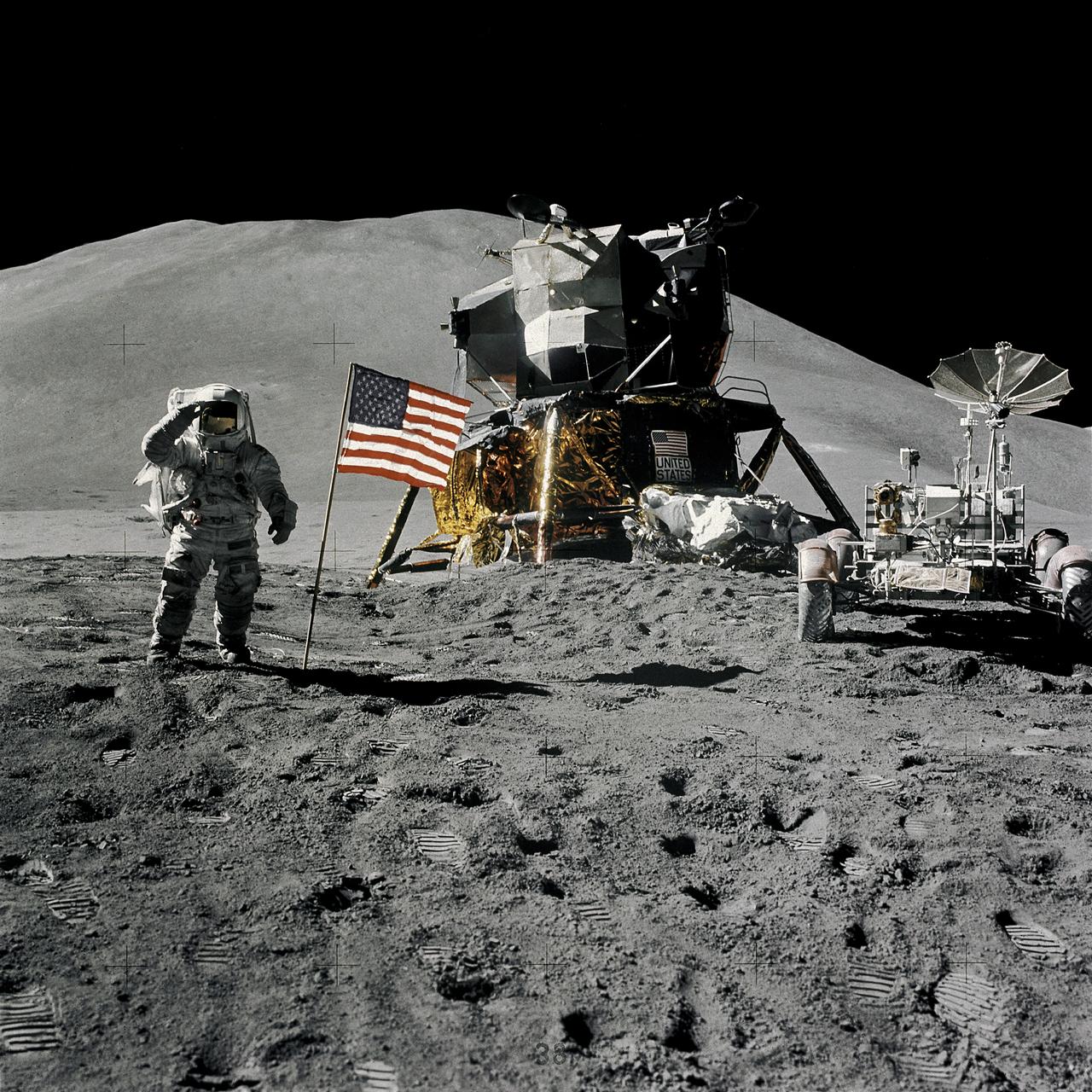
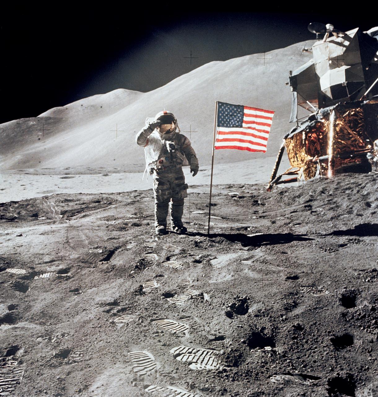
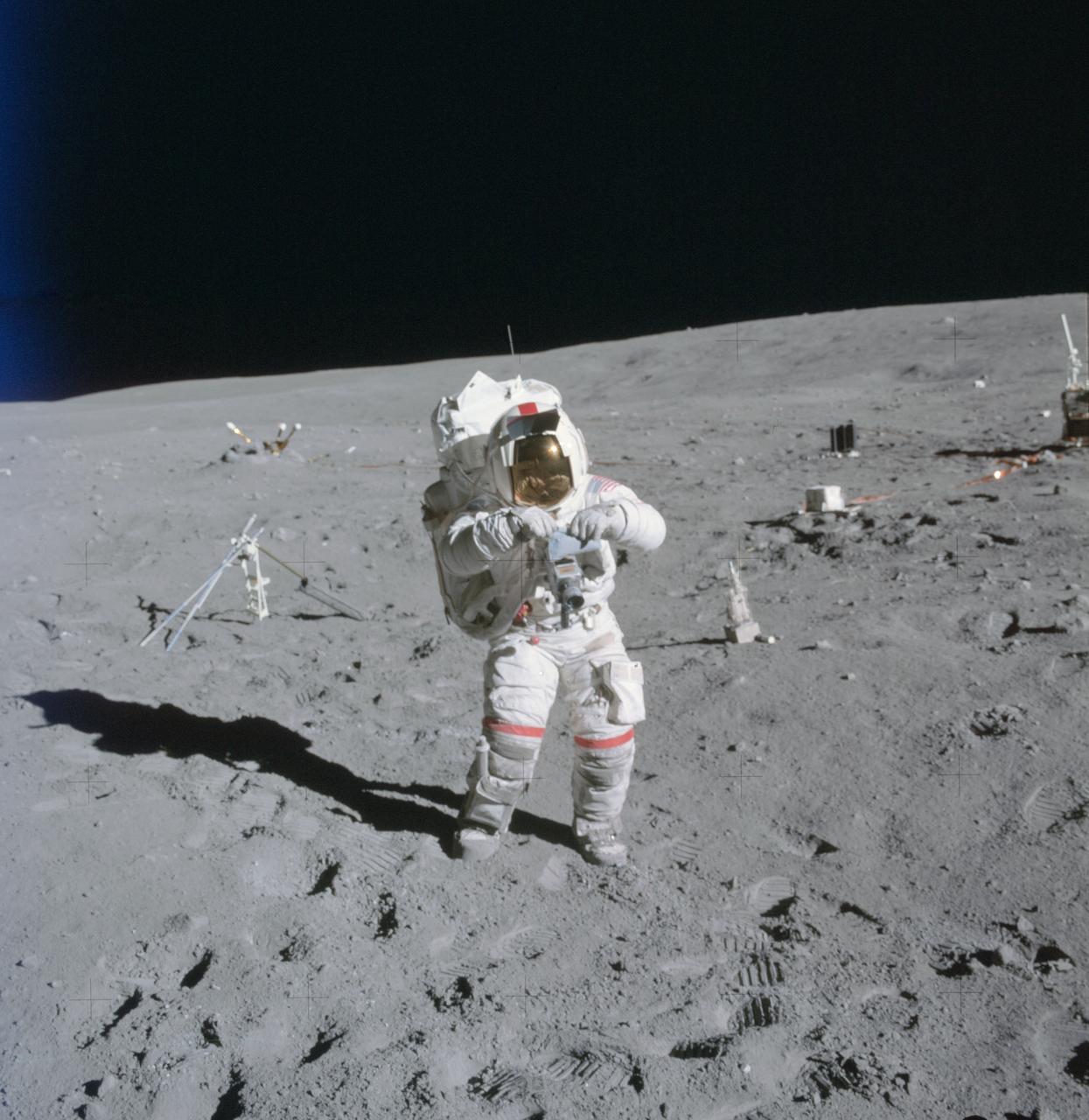
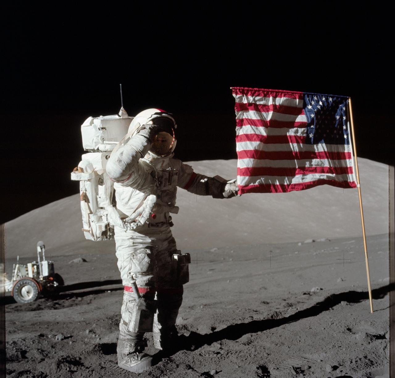
AS16-113-18339 (21 April 1972) --- Astronaut John W. Young, commander of the Apollo 16 lunar landing mission, leaps from the lunar surface as he salutes the United States flag at the Descartes landing site during the first Apollo 16 extravehicular activity (EVA). Astronaut Charles M. Duke Jr., lunar module pilot, took this picture. The Lunar Module (LM) "Orion" is on the left. The Lunar Roving Vehicle (LRV) is parked beside the LM. The object behind Young (in the shade of the LM) is the Far Ultraviolet Camera/Spectrograph (FUC/S). Stone Mountain dominates the background in this lunar scene. While astronauts Young and Duke descended in the LM to explore the Descartes highlands landing site on the moon, astronaut Thomas K. Mattingly II, command module pilot, remained with the Command and Service Modules (CSM) "Casper" in lunar orbit.
AS08-17-2821 (21-27 Dec. 1968) --- This oblique view of the lunar surface taken from the Apollo 8 spacecraft looking westward across the Sea of Tranquility shows Apollo Landing Site East 2 illuminated by a sun that is six to eight degrees above the eastern horizon. The landing site is on the dark gray, smooth surface of the Sea of Tranquility and north (to the right) of the bright highland terrain at the lower left corner of the photograph. The landing site is about four tenths of the distance from the left to right margin of the photograph.
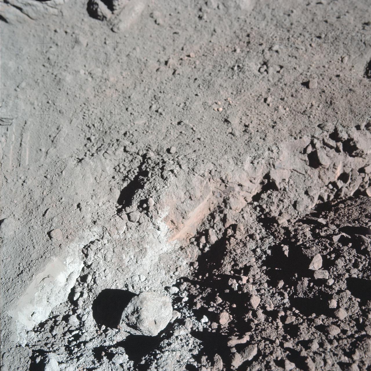
AS17-137-20989 (12 Dec. 1972) --- A close-up view of the much-publicized orange soil which the Apollo 17 crewmen found at Station 4 (Shorty Crater) during the second Apollo 17 extravehicular activity (EVA) at the Taurus-Littrow landing site. The orange soil was first spotted by scientist-astronaut Harrison H. Schmitt. While astronauts Schmitt and Eugene A. Cernan descended in the Lunar Module (LM) "Challenger" to explore the lunar surface, astronaut Ronald E. Evans remained with the Apollo 17 Command and Service Modules (CSM) in lunar orbit. The orange soil was never seen by the crewmen of the other lunar landing missions - Apollo 11 (Sea of Tranquility); Apollo 12 (Ocean of Storms); Apollo 14 (Fra Mauro); Apollo 15 (Hadley-Apennines); and Apollo 16 (Descartes).
AS15-88-11866 (1 Aug. 1971) --- Astronaut James B. Irwin, lunar module pilot, gives a military salute while standing beside the deployed United States flag during the Apollo 15 lunar surface extravehicular activity (EVA) at the Hadley-Apennine landing site. The flag was deployed toward the end of EVA-2. The Lunar Module (LM) "Falcon" is in the center. On the right is the Lunar Roving Vehicle (LRV). This view is looking almost due south. Hadley Delta in the background rises approximately 4,000 meters (about 13,124 feet) above the plain. The base of the mountain is approximately 5 kilometers (about 3 statute miles) away. This photograph was taken by astronaut David R. Scott, Apollo 15 commander. While astronauts Scott and Irwin descended in the LM to explore the moon, astronaut Alfred M. Worden, command module pilot, remained with the Command and Service Modules (CSM) in lunar orbit.
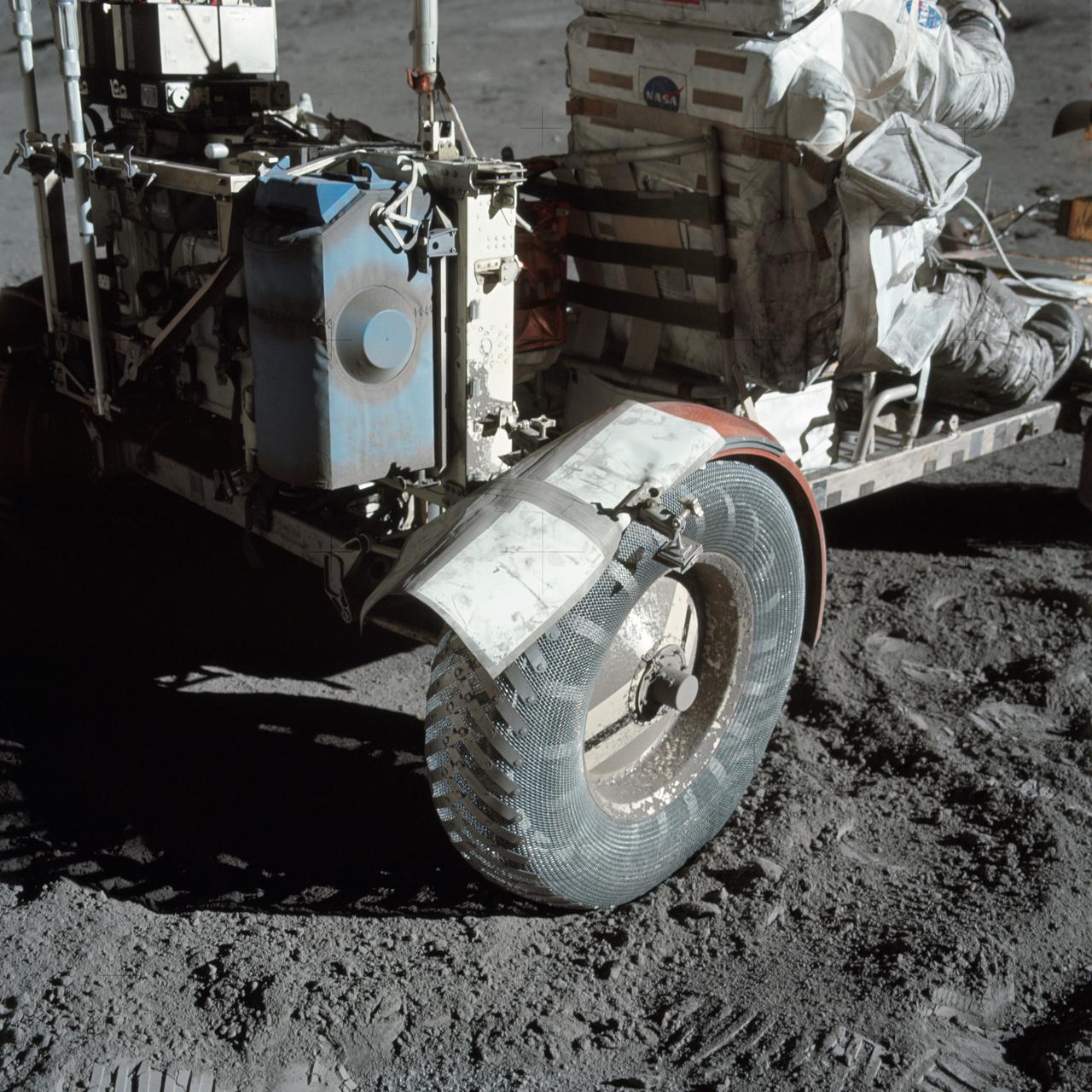
AS17-137-20979 (12 Dec. 1972) --- A close-up view of the lunar roving vehicle (LRV) at the Taurus-Littrow landing site photographed during Apollo 17 lunar surface extravehicular activity. Note the makeshift repair arrangement on the right rear fender of the LRV. During EVA-1 a hammer got underneath the fender and a part of it was knocked off. Astronauts Eugene A. Cernan and Harrison H. Schmitt were reporting a problem with lunar dust because of the damage fender. Following a suggestion from astronaut John W. Young in the Mission Control Center at Houston the crewmen repaired the fender early in EVA-2 using lunar maps and clamps from the optical alignment telescope lamp. Schmitt is seated in the rover. Cernan took this picture.
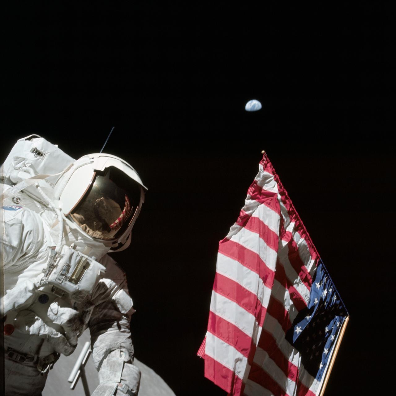
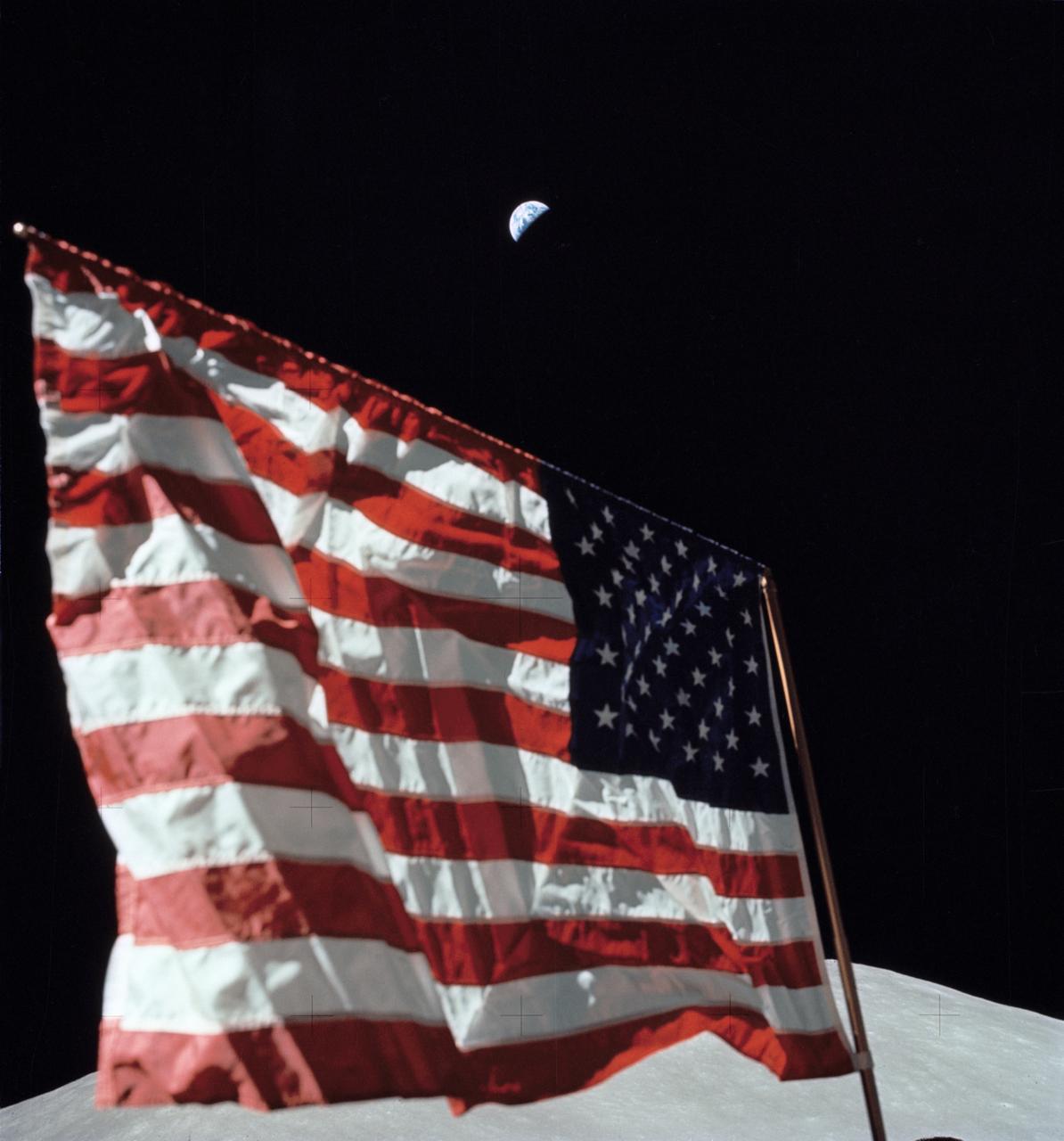
AS17-134-20384 (7-19 Dec. 1972) --- Scientist-astronaut Harrison H. Schmitt, lunar module pilot, is photographed next to the deployed United States flag during lunar surface extravehicular activity (EVA) at the Taurus-Littrow landing site. The highest part of the flag appears to point toward our planet Earth in the distant background. This picture was taken by astronaut Eugene A. Cernan, Apollo 17 commander. While astronauts Cernan and Schmitt descended in the Lunar Module (LM) to explore the moon, astronaut Ronald E. Evans, command module pilot, remained with the Command and Service Modules (CSM) in lunar orbit.
AS16-107-17442 (22 April 1972) --- A close-up view of the Apollo 16 Cosmic Ray Detector (CRD) experiment deployed at the +Y strut of the Lunar Module (LM). The crewmembers moved it to this position from near the deployment site of the Apollo Lunar Surface Experiments Package (ALSEP) because, in the words of astronaut John W. Young, commander, "The panels were getting a little warm." Note that the LM did not skid upon landing, as evidenced by the landing contact probe's folded back (neatly) position and the lack of skid marks. While astronauts Young, and Charles M. Duke Jr., lunar module pilot; descended in the Apollo 16 Lunar Module (LM) "Orion" to explore the Descartes highlands landing site on the moon, astronaut Thomas K. Mattingly II, command module pilot, remained with the Command and Service Modules (CSM) "Casper" in lunar orbit.
AS15-88-11863 (1 Aug. 1971) --- Astronaut David R. Scott, commander, gives a military salute while standing beside the deployed United States flag during the Apollo 15 lunar surface extravehicular activity (EVA) at the Hadley-Apennine landing site. The flag was deployed toward the end of EVA-2. The Lunar Module (LM), "Falcon," is partially visible on the right. Hadley Delta in the background rises approximately 4,000 meters (about 13,124 feet) above the plain. The base of the mountain is approximately 5 kilometers (about three statue miles) away. This photograph was taken by astronaut James B. Irwin, lunar module pilot. While astronauts Scott and Irwin descended in the LM to explore the moon, astronaut Alfred M. Worden, command module pilot, remained in lunar orbit in the Command and Service Modules (CSM).
AS08-17-2814 (21-27 Dec. 1968) --- This oblique view of the lunar surface taken from the Apollo 8 spacecraft looking westward across the Sea of Fertility into the Sea of Tranquility shows the terrain the astronauts will see as the approach Apollo Landing Site East 2. The landing site is at the horizon about one-third of the distance from the left to the right photograph margin. The prominent crater in the highlands near the center of the picture is Secchi, about 25 kilometers (15 statute miles) in diameter.
AS10-27-3908 (18-26 May 1969) --- An Apollo 10 photograph of the lunar nearside looking westward across Apollo Landing Site 3 in Central Bay. Bruce, the prominent crater in the lower right corner, is about 3.7 statute miles in diameter. Topographic features on the surface of Central Bay are accentuated by the low sun angle.
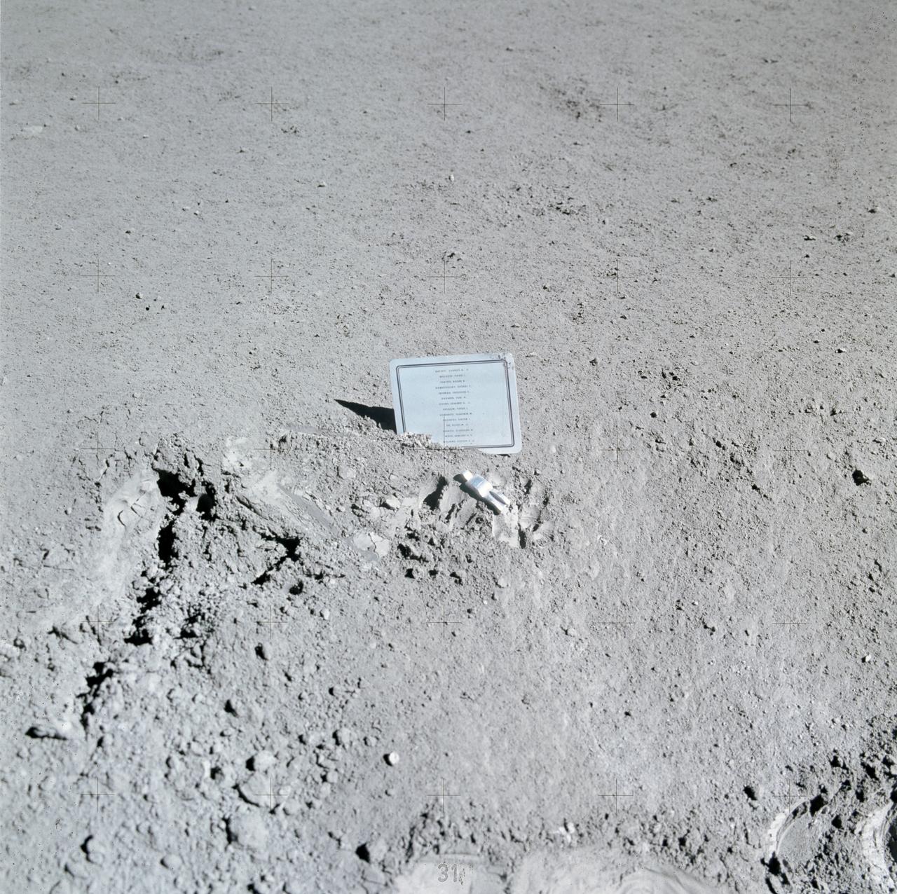
AS15-88-11894 (31 July-2 Aug. 1971) --- A close-up view of a commemorative plaque left on the moon at the Hadley-Apennine landing site in memory of 14 NASA astronauts and USSR cosmonauts, now deceased. Their names are inscribed in alphabetical order on the plaque. The plaque was stuck in the lunar soil by astronauts David R. Scott, commander, and James B. Irwin, lunar module pilot, during their Apollo 15 lunar surface extravehicular activity (EVA). The names on the plaque are Charles A. Bassett II, Pavel I. Belyayev, Roger B. Chaffee, Georgi Dobrovolsky, Theodore C. Freeman, Yuri A. Gagarin, Edward G. Givens Jr., Virgil I. Grissom, Vladimir Komarov, Viktor Patsayev, Elliot M. See Jr., Vladislav Volkov, Edward H. White II, and Clifton C. Williams Jr. The tiny, man-like object represents the figure of a fallen astronaut/cosmonaut. While astronauts Scott and Irwin descended in the Lunar Module (LM) "Falcon" to explore the Hadley-Apennine area of the moon, astronaut Alfred M. Worden, command module pilot, remained with the Command and Service Modules (CSM) in lunar orbit.
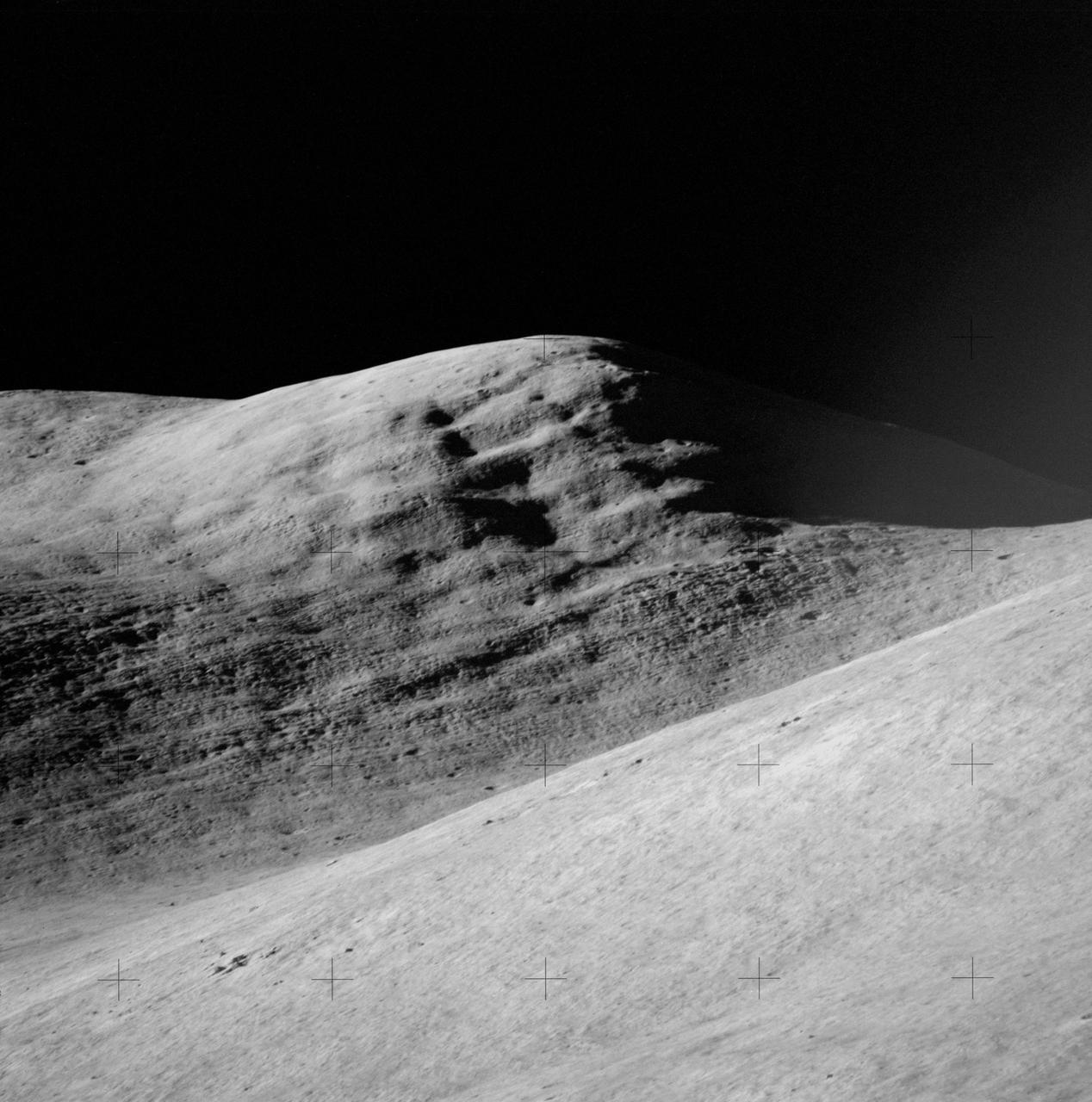
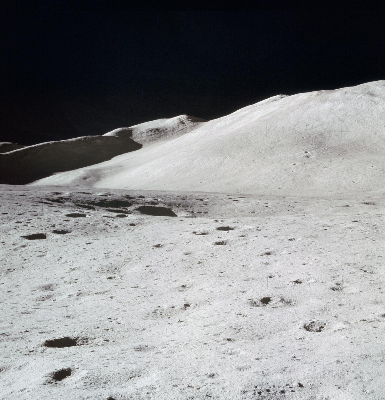
AS15-84-11250 (31 July-2 Aug. 1971) --- A telephoto lens view of the prominent feature called Silver Spur in the Hadley Delta region, photographed during the Apollo 15 lunar surface extravehicular activity (EVA) at the Hadley-Apennine landing site. The distance from the camera to the spur is about 10 miles. The field of view across the bottom is about one mile. Structural formations in the mountain are clearly visible. There are two major units. The upper unit is characterized by massive subunits, each one of which is approximately 200 feet deep. The lower major unit is characterized by thinner bedding and cross bedding.
jsc2004e20304 - Panorama view of Apollo 17 lunar surface photos for Station 5 at the Taurus-Littrow landing site taken during the second moonwalk of the mission by Apollo 17 commander Eugene Cernan and lunar module pilot Harrison (Jack) Schmitt. The panoramas were built by combining Apollo 17 images starting with frame AS17-145-22159 through end frame AS17-145-22181. The panoramic images received minimal retouching by NASA imagery specialists, including the removal of lens flares that were problematic in stitching together the individual frames and blacking out the sky to the lunar horizon. These adjustments were made based on observations of the Moon walkers who reported that there are no stars visible in the sky due to the bright lunar surface reflection of the Sun.
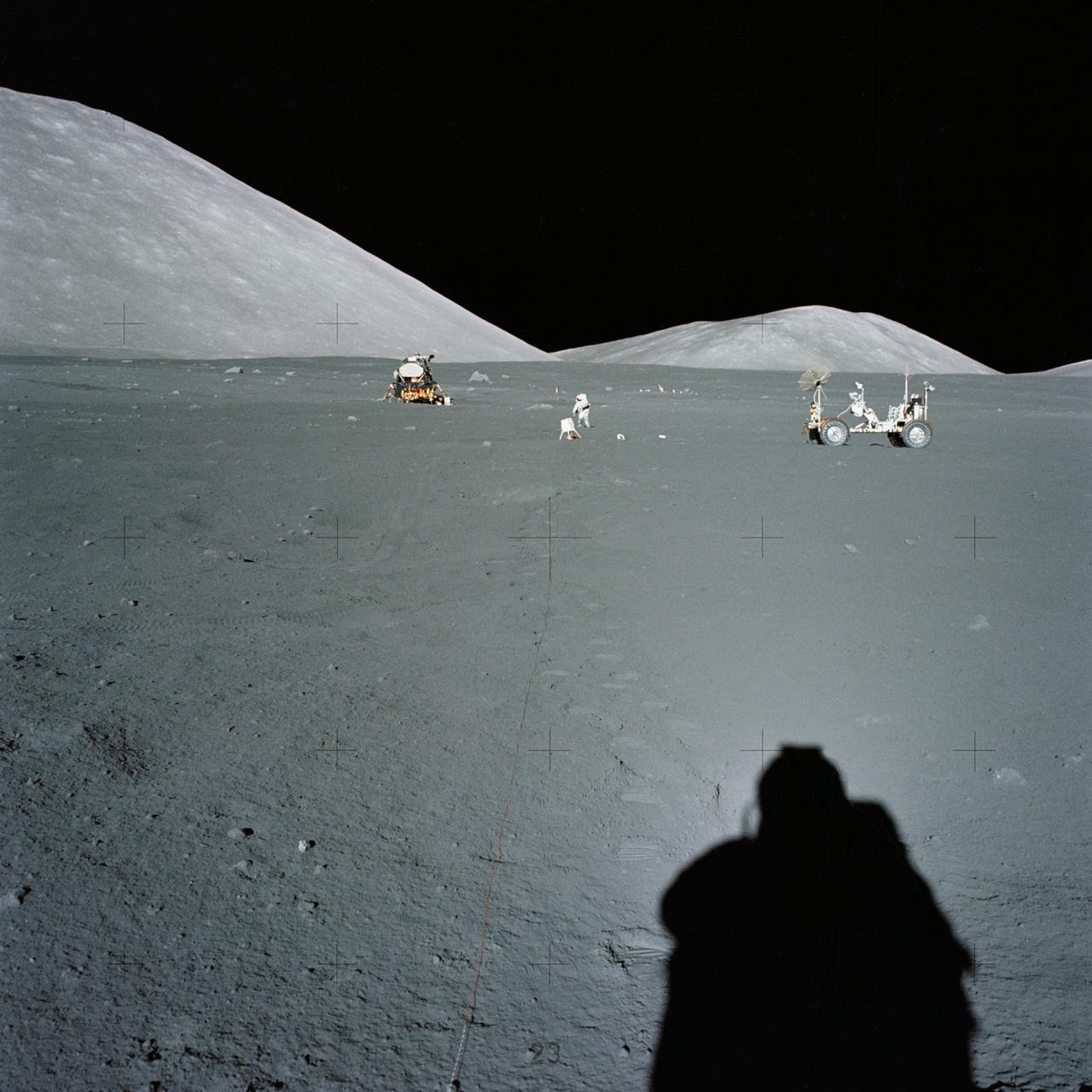
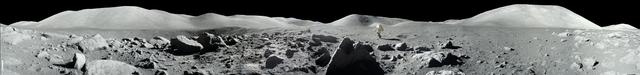
AS17-134-20435 (10 Dec. 1972) --- Wide-angle view of the Apollo 17 Taurus-Littrow lunar landing site. To the left in the background is the Lunar Module. To the right in the background is the Lunar Roving vehicle. An Apollo 17 crewmember is photographed between the two points. The shadow of the astronaut taking the photograph can be seen in the right foreground.
AS11-37-5437 (20 July 1969) --- The approach to Apollo Landing Site 2 in southwestern Sea of Tranquility is seen in this photograph taken from the Apollo 11 Lunar Module (LM) in lunar orbit. When this picture was made, the LM was still docked to the Command and Service Modules (CSM). Site 2 is located just right of center at the edge of the darkness. The crater Maskelyne is the large one at the lower right. Hypatia Rille (U.S. 1) is at upper left, with the crater Moltke just to the right (north) of it. Sidewinder Rille and Diamondback Rille extend from left to right across the center of the picture. This view looks generally west.
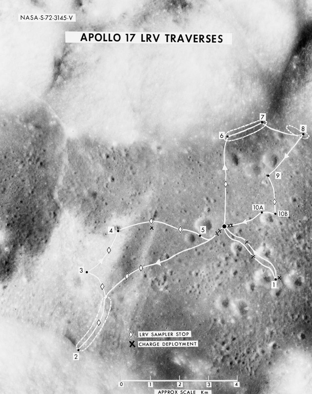
S72-03145 (October 1972) --- A vertical view of the Apollo 17 Taurus-Littrow site with an overlay to illustrate the three planned Apollo 17 traverses using the Lunar Roving Vehicle (LRV). The EVA-1 traverse has a single station (1); the EVA-2 traverse has four stations (2,3,4,5); and the EVA-3 traverse has five stations (6,7,8,9,10). Stations 10-A and 10-B are alternate locations for Station 10. In addition to the major stations mentioned above, brief stops are planned for sampling between stations using the LRV sampler tool (note diamond-shaped figures), and for deploying explosive charges associated with the Lunar Seismic Profiling Experiment (LSPE - note black x-marks).
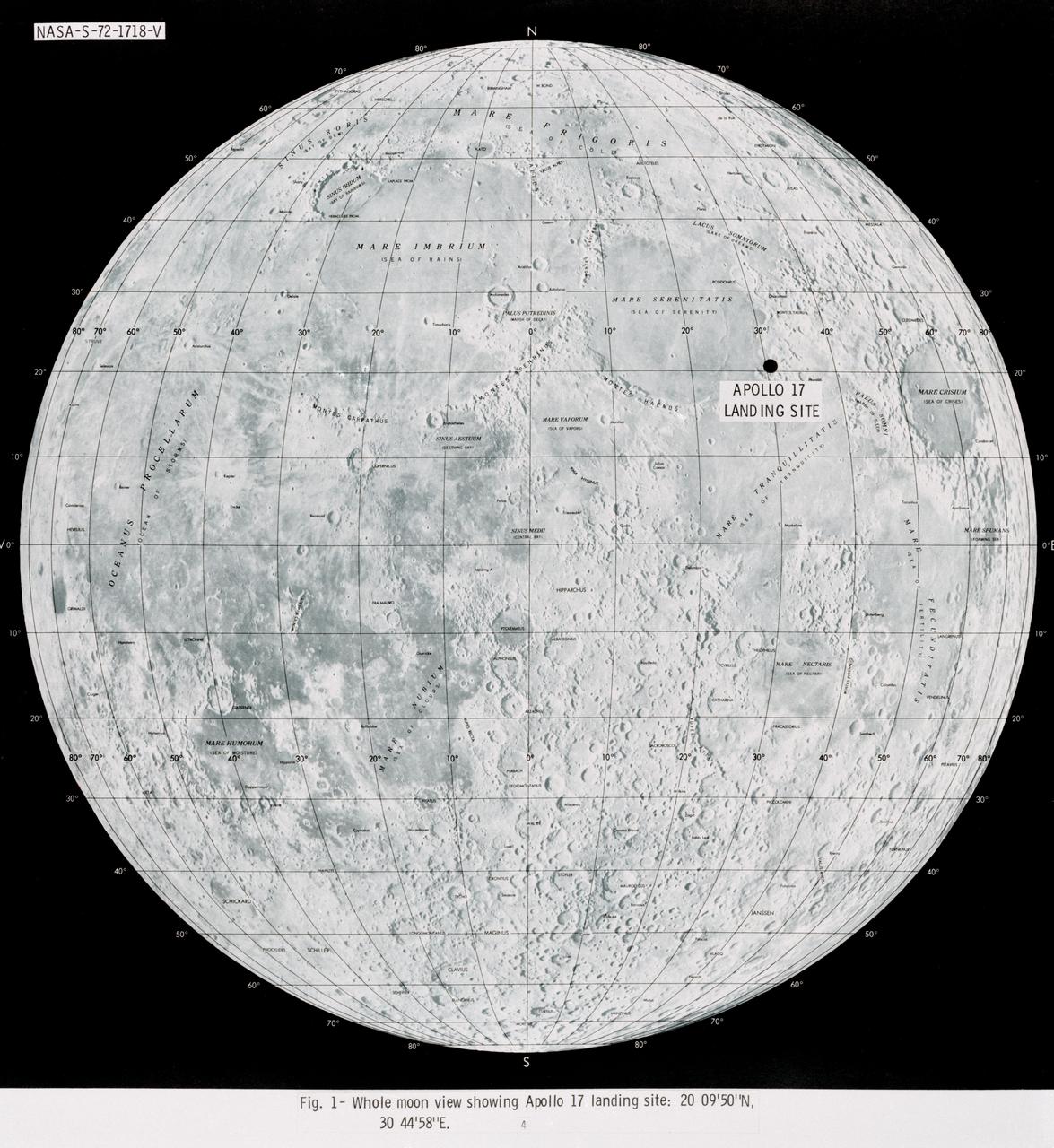
S72-01718 (July 1972) --- A photographic illustration of a full moon showing the location of the Apollo 17 landing site on the lunar nearside. The black dot pinpointing the landing site is in the Taurus-Littrow area at the southeastern edge of the Sea of Serenity. The coordinates of the landing point are 30 degrees 44 minutes 58 seconds east longitude and 20 degrees 9 minutes 50 seconds north latitude.
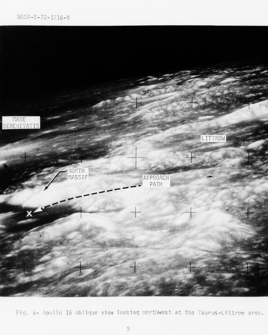
S72-01716 (July 1972) --- An oblique view of the Taurus-Littrow area on the lunar nearside, as photographed from the Apollo 15 spacecraft in lunar orbit. This is an enlarged view. The "X" marks the landing site of the scheduled Apollo 17 lunar landing mission. The overlay points out several features in the photograph. The coordinates of the Apollo 17 touchdown point are 30 degrees 44 minutes 58 seconds east longitude and 20 degrees 9 minutes 50 seconds north latitude.
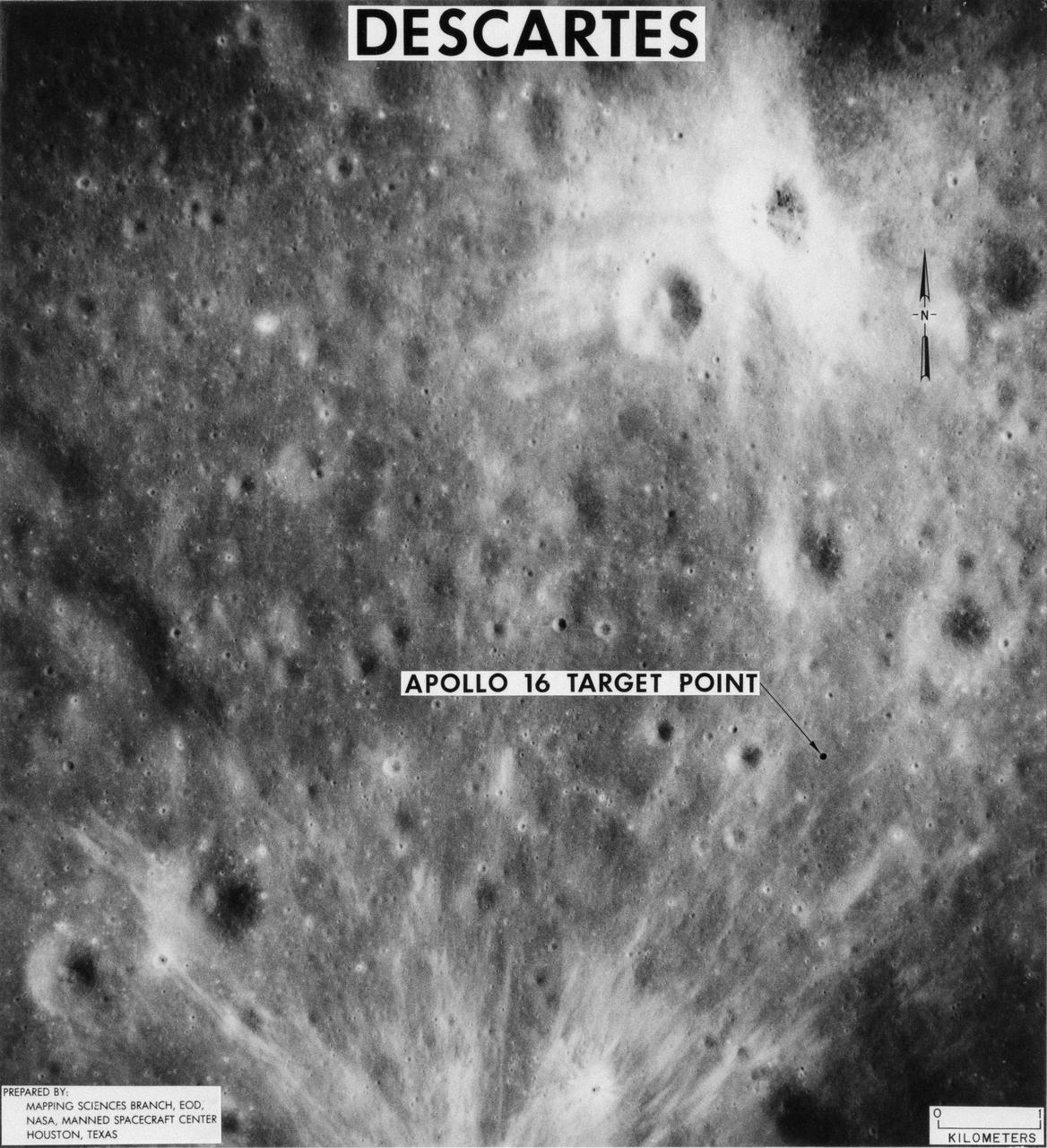
S71-44150 (February 1971) --- A vertical view of the Apollo 16 landing site located in the Descartes area on the lunar nearside. The overlay indicates the location of the proposed touchdown point for the Apollo 16 Lunar Module (LM). Descartes is located west of the Sea of Nectar and southwest of the Sea of Tranquility. This photograph was taken with a 500mm lens camera from lunar orbit by the Apollo 16 crew. Astronauts John W. Young, commander; and Charles M. Duke Jr., lunar module pilot; descended in the Apollo 16 LM "Orion" to explore the Descartes highlands landing site on the moon. Astronaut Thomas K. Mattingly II, command module pilot, remained with the Command and Service Modules (CSM) "Casper" in lunar orbit.
AS17-147-22523 (11 Dec. 1972) --- Astronaut Eugene A. Cernan is seen test driving the "stripped down" Lunar Rover Vehicle (LRV) prior to loading the LRV up. Equipment later loaded onto the LRV included the ground controlled television assembly, the lunar communications relay unit, the hi-gain antenna, the low-gain antenna, aft tool pallet, and lunar tools and scientific gear.
AS17-147-22526 (11 Dec. 1972) --- Astronaut Eugene A. Cernan, commander, makes a short checkout of the Lunar Roving Vehicle (LRV) during the early part of the first Apollo 17 extravehicular activity (EVA) at the Taurus-Littrow landing site. This view of the "stripped down" LRV is prior to loading up. Equipment later loaded onto the LRV included the ground-controlled television assembly, the lunar communications relay unit, hi-gain antenna, low-gain antenna, aft tool pallet, lunar tools and scientific gear. This photograph was taken by scientist-astronaut Harrison H. Schmitt, lunar module pilot. The mountain in the right background is the east end of South Massif. While astronauts Cernan and Schmitt descended in the Lunar Module (LM) "Challenger" to explore the moon, astronaut Ronald E. Evans, command module pilot, remained with the Command and Service Modules (CSM) "America" in lunar orbit.
AS10-31-4537 (18-26 May 1969) --- This near vertical photograph taken from the Apollo 10 Command and Service Modules shows features typical of the Sea of Tranquility near Apollo Landing Site 2. HOLD PICTURE WITH PRONOUNCED LINEAR FEATURE PARALLEL TO LEFT MARGIN. The proposed landing area for Apollo 11 (Lunar Landing Site 2) is a relatively smooth maria area in the upper right quadrant of the photographed area. Apollo 10 traveled from the bottom to the top of the picture. The prominent linear feature at left is Hypatia Rille (called "U.S. 1" by the Apollo 10 crew). The prominent crater centered in Hypatia Rille at top left is Moltke AC (code name "Chuck Hole"). Moltke, the prominent crater to the right of Hypatia Rille, is centered near 24.2 degrees east longitude, and 0.6 degrees south latitude.
AS17-137-20992 (12 Dec. 1972) --- A view looking into Shorty Crater, taken at Station 4, showing the orange soil. Astronaut Harrison H. Schmitt found the orange soil on the moon during the second Apollo 17 extravehicular activity (EVA) at the Taurus-Littrow landing site. While astronauts Eugene A. Cernan, commander, and Schmitt, lunar module pilot, descended in the Lunar Module (LM) "Challenger" to explore the Taurus-Littrow region of the moon, astronaut Ronald E. Evans, command module pilot, remained with the Command and Service Modules (CSM) "America" in lunar orbit.
AS17-137-20990 (12 Dec. 1972) --- A view of the area at Station 4 (Shorty Crater) showing the now highly-publicized orange soil which the Apollo 17 crew members found on the moon during the second Apollo 17 extravehicular activity (EVA) at the Taurus-Littrow landing site. The tripod-like object is the gnomon and photometric chart assembly which is used as a photographic reference to establish local vertical sun angle, scale and lunar color. The gnomon is one of the Apollo lunar geology hand tools. While astronauts Eugene A. Cernan, commander, and Harrison H. Schmitt, lunar module pilot, descended in the Lunar Module (LM) "Challenger" to explore the Taurus-Littrow region of the moon, astronaut Ronald E. Evans, command module pilot, remained with the Command and Service Modules (CSM) "America" in lunar orbit. Schmitt was the crew man who first spotted the orange soil.
AS10-27-3907 (18-26 May 1969) --- Apollo 10 westward view across Apollo Landing Site 3 in the Central Bay. Apollo Landing Site 3 is in the middle distance at the left margin of the pronounced ridge in the left half of the photograph. Bruce, the prominent crater, near the bottom of the scene, is about 6 kilometers (3.7 statute miles) in diameter. Topographic features on the surface of the Central Bay are accentuated by the low sun angle. Sun angles range from near 6 degrees at the bottom of the photograph to less than one degree at the top.
AS10-31-4650 (18-26 May 1969) --- This Apollo 10 oblique telephoto view of the lunar nearside is centered on the crater Hyginus located at 6.3 degrees north latitude, near the northeast margin of Central Bay. HOLD PICTURE WITH SKY AT TOP. The crater is about 10 kilometers (6.5 statue miles) in diameter. From the crater the prominent Hyginus Rille extends east-southeast toward the camera and northwest toward the Sea of Vapors. The rille is about 3 kilometers (2 statue miles) wide and more than 200 kilometers (130 statue miles) long. The horizon is not visible in this photograph, taken from the Command and Service Modules. The sunrise terminator is between the spacecraft and the horizon. At the time this picture was taken Apollo 10 was 325 kilometers (200 statute miles) southeast of Hyginus.
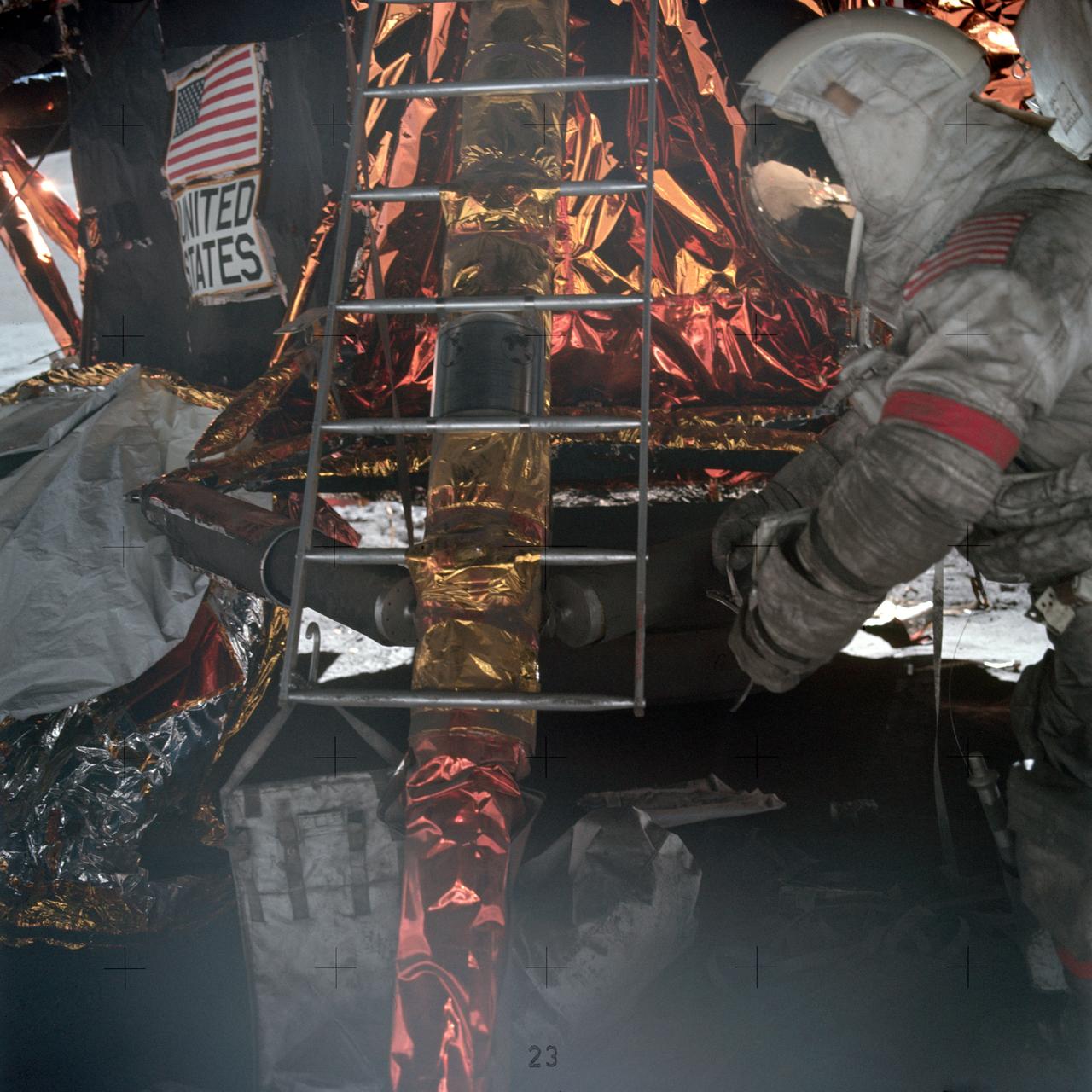
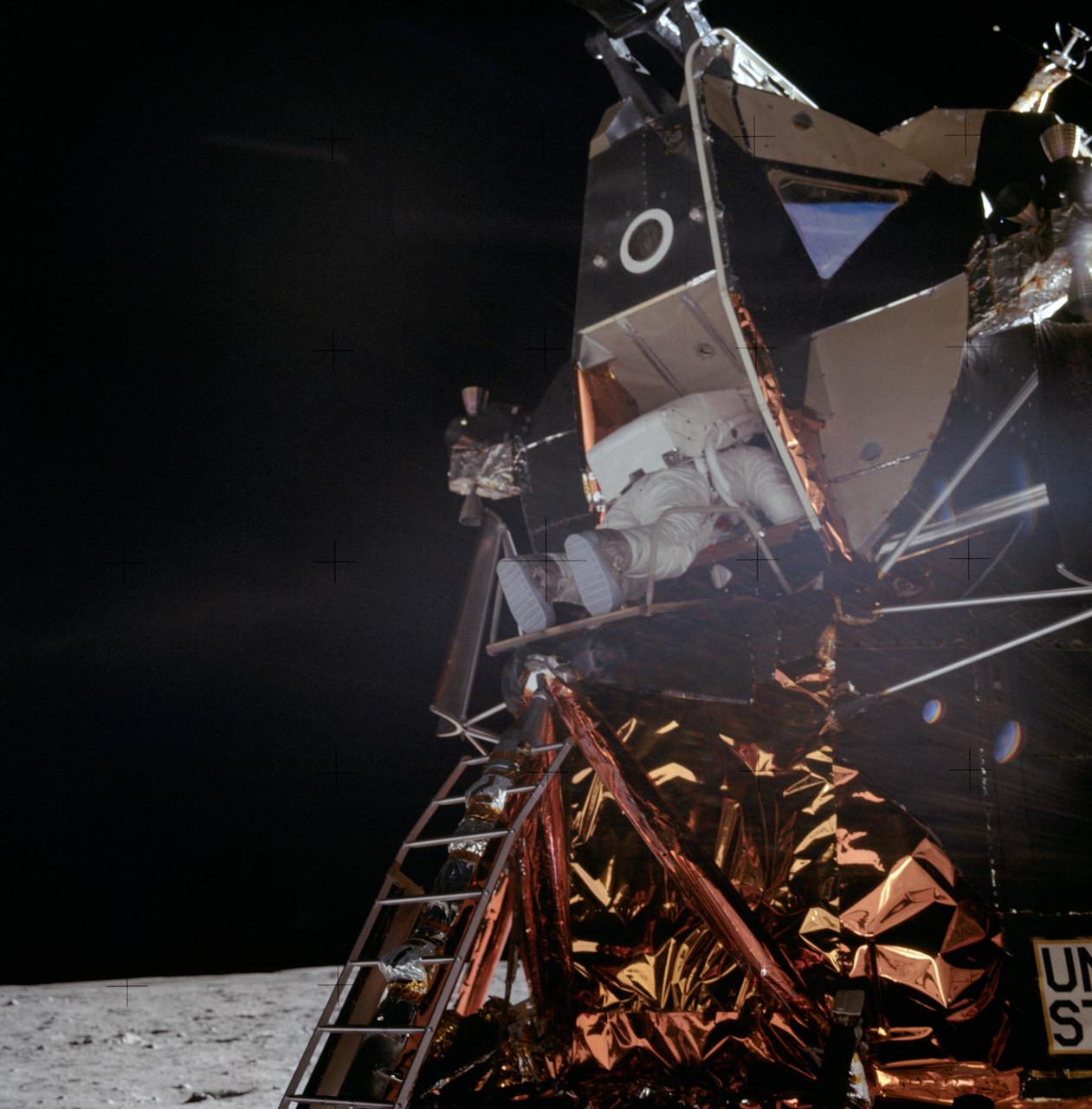
Astronaut Eugene A. Cernan, Apollo 17 commander, prepares to mount ladder to lunar module ascent stage. Note the plaque attached to the ladder which will be left with the descent stage when the mission lifts off from the lunar surface.
AS10-29-4321 (18-26 May 1969) --- An Apollo 10 oblique view of the western portion of the Sea of Tranquility. The area in the picture is located approximately 70 nautical miles east-southeast of Apollo Landing Site 2. The flat terrain pitted by moderate-sized craters is typical of this portion of Mare Tranquillitatis.
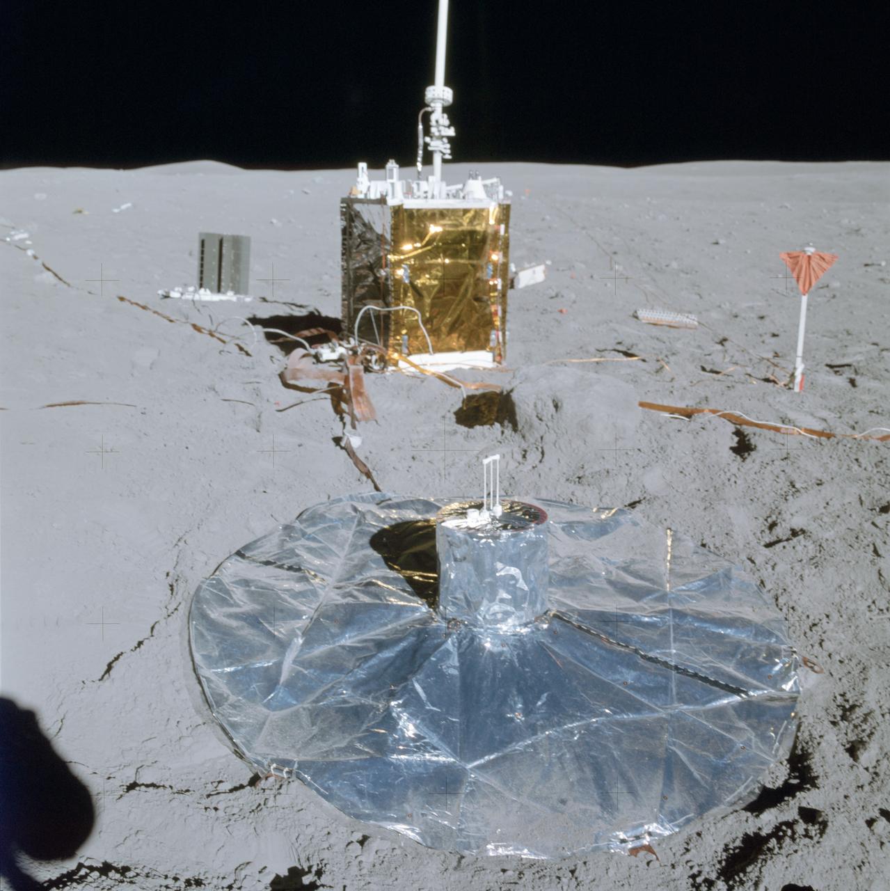
Apollo Crew landing site showing deployment of ALSEP (Apollo Lunar Surface expeiments package)
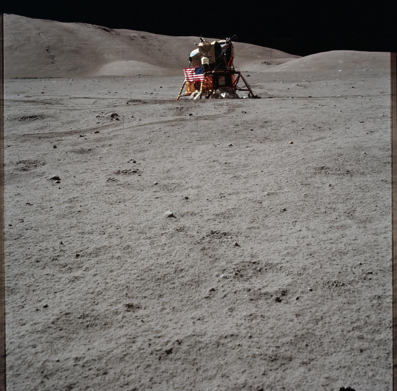
AS15-86-11600 (31 July 1971) --- A view of the Lunar Module (LM) "Falcon" taken early in the first Apollo 15 lunar surface extravehicular activity (EVA) at the Hadley-Apennine landing site prior to deployment of lunar surface equipment. Hadley Delta Mountain is in the background. While astronauts David R. Scott, commander and James B. Irwin, lunar module pilot, descended in the LM to explore the moon, astronaut Alfred M. Worden, command module pilot, remained with the Command and Service Modules (CSM) in lunar orbit.
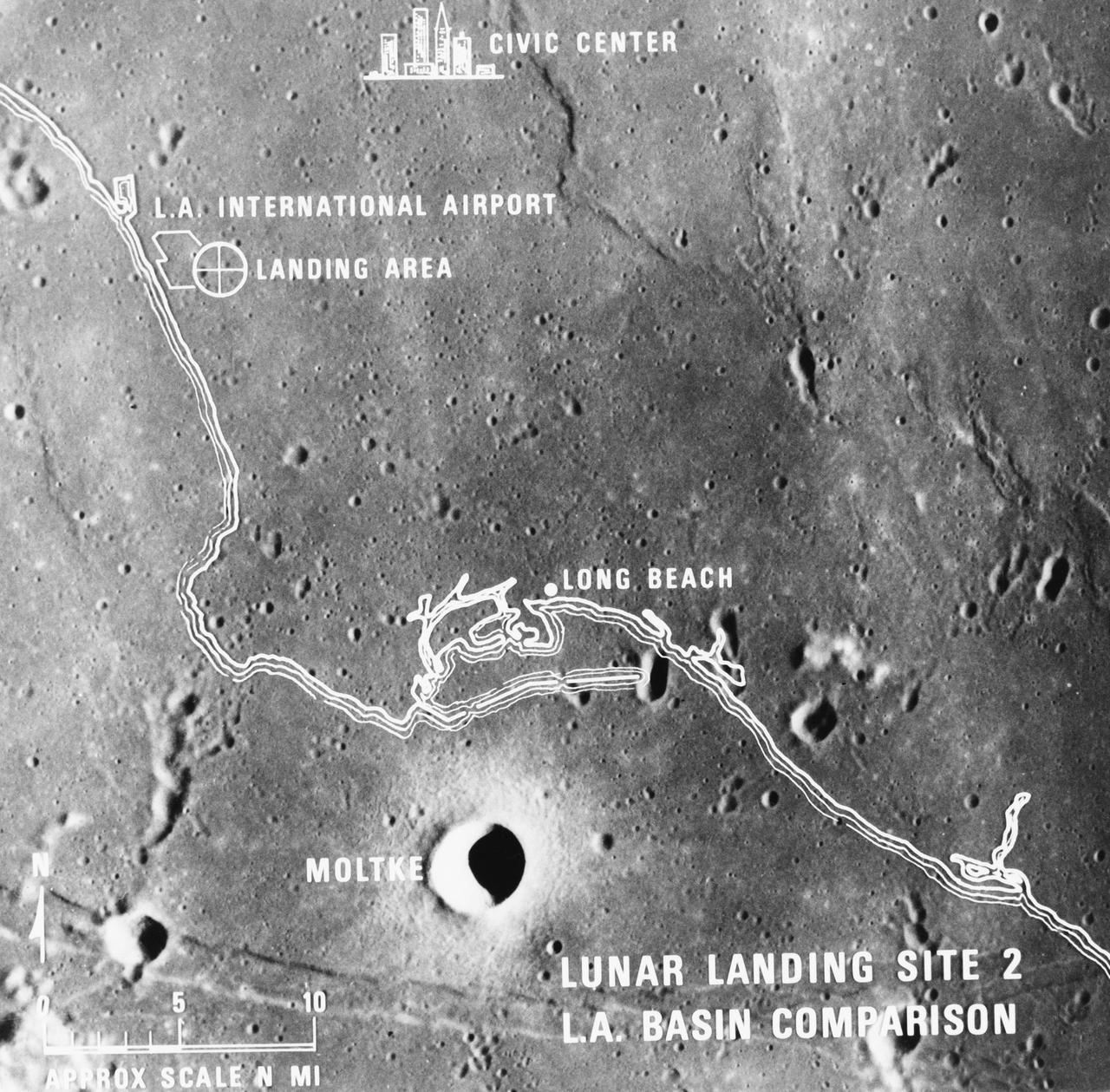
S69-38670 (July 1969) --- A photographic illustration comparing the size of Apollo Landing Site 2 with that of the metropolitan Los Angeles, California area. Site 2 is one of three Apollo 11 lunar landing sites. This will be the landing site if Apollo 11 is launched on July 16, 1969, as scheduled. Site 2 is located at 23 degrees 42 minutes 28 seconds east longitude and 0 degrees 42 minutes 50 seconds north latitude in southwestern Mare Tranquillitatis (Sea of Tranquility). (The white overlay is printed over a lunar surface photograph taken from Apollo 10 during its lunar orbit mission and is numbered AS10-31-4537.)
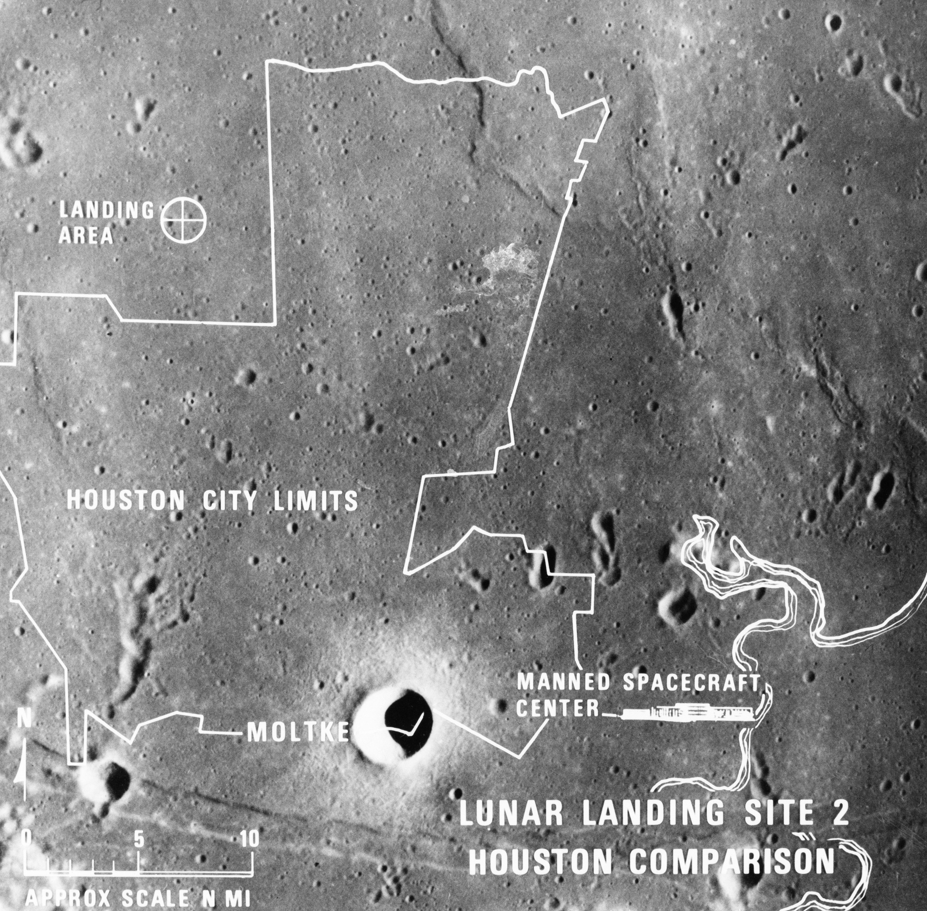
S69-38671 (July 1969) --- A photographic illustration comparing the size of Apollo Landing Site 2 with that of the metropolitan Houston, Texas area. Site 2 is one of three Apollo 11 lunar landing sites. This will be the landing site if Apollo 11 is launched on July 16, 1969, as scheduled. Site 2 is located at 23 degrees 42 minutes 28 seconds east longitude and 0 degrees 42 minutes 50 seconds north latitude in southwestern Mare Tranquillitatis (Sea of Tranquility). (The white overlay is printed over a lunar surface photograph taken from Apollo 10 during its lunar orbit mission and is numbered AS10-31-4537.)
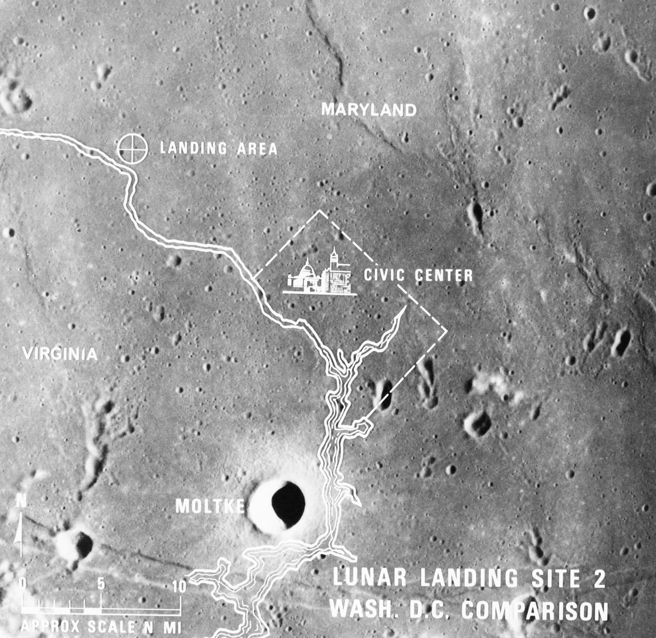
S69-38667 (July 1969) --- A photographic illustration comparing the size of Apollo Landing Site 2 with that of the metropolitan Washington, D.C. area. Site 2 is one of three Apollo 11 lunar landing sites. This will be the landing site if Apollo 11 is launched on July 16, 1969, as scheduled. Site 2 is located at 23 degrees 42 minutes 28 seconds east longitude and 0 degrees 42 minutes 50 seconds north latitude in southwestern Mare Tranquillitatis (Sea of Tranquility). (The white overlay is printed over a lunar surface photograph taken from Apollo 10 during its lunar orbit mission and is numbered AS10-31-4537.)
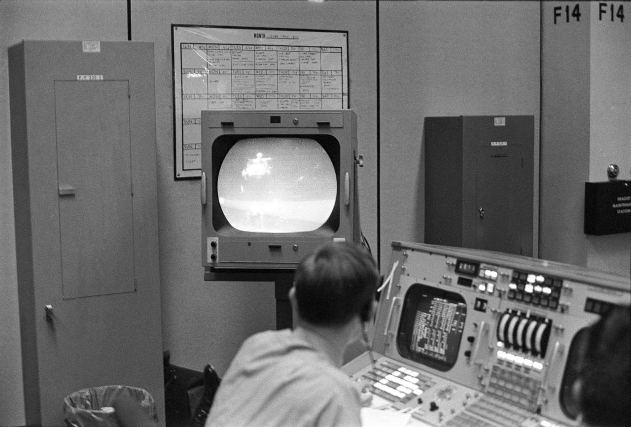
View of a photograph of the television (TV) monitor in the MCC showing a picture being transmitted from the color TV camera mounted on the parked Lunar Roving Vehicle (LRV) at the Hadley-Apennine Landing Site showing the liftoff of the Apollo 15 Lunar Module (LM) Ascent Stage from the Lunar surface. MSC, Houston, TX

AS16-114-18423 (21 April 1972) --- Astronaut Charles M. Duke Jr., lunar module pilot, is photographed collecting lunar samples at Station No. 1, during the first Apollo 16 extravehicular activity (EVA), at the Descartes landing site. This picture, looking eastward, was taken by astronaut John W. Young, commander. Duke is standing at the rim of Plum Crater. The parked Lunar Roving Vehicle (LRV) can be seen in the left background. While astronauts Young and Duke descended in the Lunar Module (LM) "Orion" to explore the Descartes highlands region of the moon, astronaut Thomas K. Mattingly II, command module pilot, remained with the Command and Service Modules (CSM) "Casper" in lunar orbit.
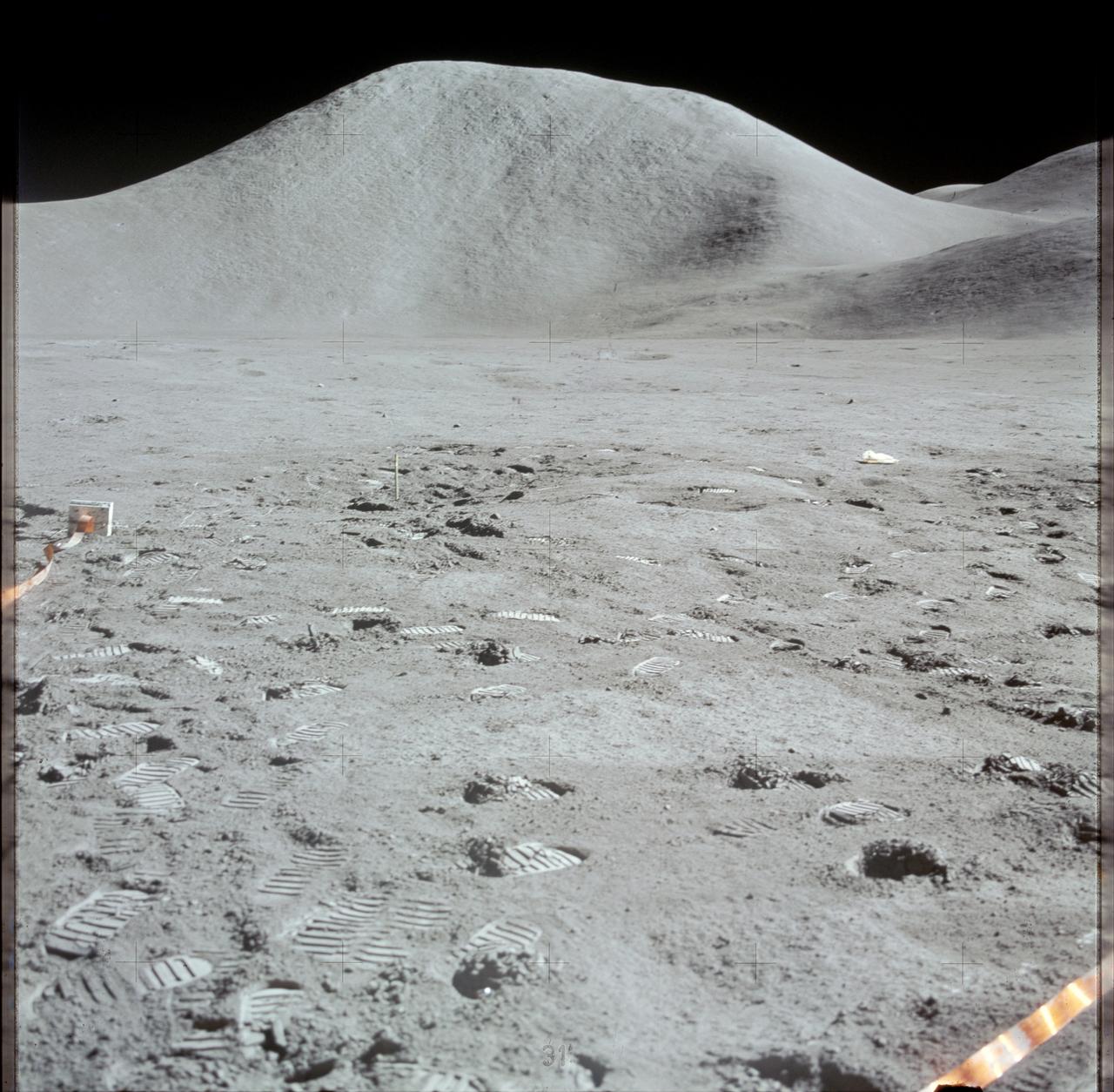
AS15-87-11748 (31 July 1971) --- A view of Hadley Delta, looking southeasterly, as photographed from the top hatch of the Apollo 15 Lunar Module (LM) by astronaut David R. Scott, commander, during his stand-up extravehicular activity (EVA) just after the LM "Falcon" touched down at the Hadley-Apennine landing site. The prominent feature on the horizon in the center of the picture was called Silver Spur by the Apollo 15 crew men. Hadley Delta Mountain rises approximately 4,000 meters (about 13,124 feet) above the plain. While astronauts Scott and James B. Irwin, lunar module pilot, descended in the LM to explore the moon, astronaut Alfred M. Worden, command module pilot, remained with the Command and Service Module's (CSM) in lunar orbit.
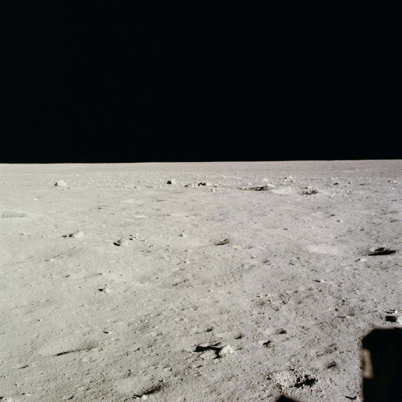
AS11-37-5458 (20 July 1969) --- This excellent view from the right-hand window of the Apollo 11 Lunar Module (LM) shows the surface of the moon in the vicinity of where the LM touched down. Numerous small rocks and craters can be seen between the LM and the lunar horizon. Astronaut Michael Collins, command module pilot, remained with the Command and Service Modules (CSM) in lunar orbit while astronauts Neil A. Armstrong, commander; and Edwin E. Aldrin Jr., lunar module pilot, descended in the LM to the lunar surface.
AS15-87-11849 (31 July-2 Aug. 1971) --- An excellent view of Mount Hadley, fully lighted, showing abundant linear features, as photographed during the Apollo 15 lunar surface extravehicular activity (EVA). This view is looking north from the Apollo Lunar Surface Experiments Package (ALSEP) site. Mount Hadley rises about 4,500 meters (approximately 14,765 feet) above the plain. While astronauts David R. Scott, commander, and James B. Irwin, lunar module pilot, descended in the Apollo 15 Lunar Module (LM) "Falcon" to explore the Hadley-Apennine area of the moon, astronaut Alfred M. Worden, command module pilot, remained with the Command and Service Modules (CSM) in lunar orbit.
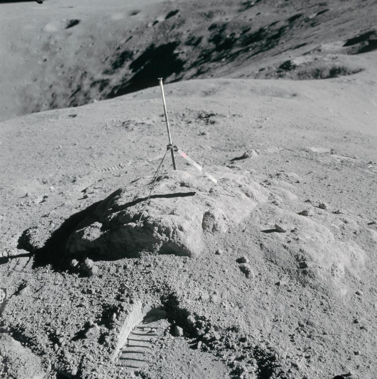
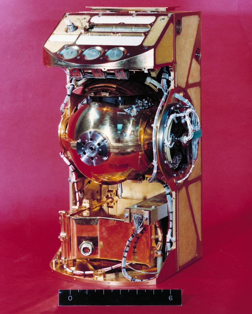
S72-53950 (November 1972) --- The transmitter of the Surface Electrical Properties Experiment (S-204) in a deployed configuration. This experiment will be deployed at the Taurus-Littrow landing site by the Apollo 17 crewmen. The purpose of the SEP experiment is to obtain data about the electromagnetic energy transmission, absorption and reflection characteristics of the lunar surface and subsurface for use in the development of a geological model of the upper layers of the moon. The experiment is designed to determine layering in the lunar surface, to search for the presence of water below the surface, and to measure electrical properties of the lunar material in situ.
AS17-147-22527 (11 Dec. 1972) --- Astronaut Eugene A. Cernan, Apollo 17 mission commander, makes a short checkout of the Lunar Roving Vehicle during the early part of the first Apollo 17 extravehicular activity (EVA) at the Taurus-Littrow landing site. The Lunar Module is in the background. This photograph was taken by scientist-astronaut Harrison H. Schmitt, lunar module pilot.
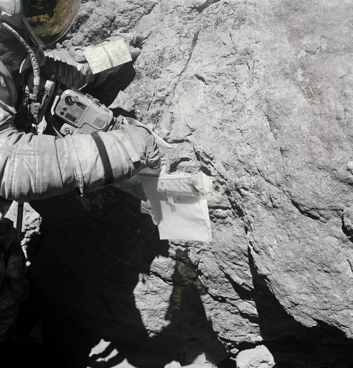
AS16-116-18649 (23 April 1972) --- Astronaut Charles M. Duke Jr., lunar module pilot of the Apollo 16 lunar landing mission, examines closely the surface of a large boulder at North Ray Crater during the third Apollo 16 extravehicular activity (EVA) at the Descartes landing site. This picture was taken by astronaut John W. Young, commander. Note the chest-mounted 70mm Hasselblad camera. While astronauts Young and Duke descended in the Apollo 16 Lunar Module (LM) "Orion" to explore the Descartes highlands landing site on the moon, astronaut Thomas K. Mattingly II, command module pilot, remained with the Command and Service Modules (CSM) "Casper" in lunar orbit.
AS16-114-18388 (21 April 1972) --- Astronaut John W. Young, commander of the Apollo 16 lunar landing mission, stands at the Apollo Lunar Surface Experiments Package (ALSEP) deployment site during the first Apollo 16 extravehicular activity (EVA) at the Descartes landing site. The components of the ALSEP are in the background. The lunar surface drill is just behind and to the right of astronaut Young. The drill's rack and bore stems are to the left. The three-sensor Lunar Surface Magnetometer is beyond the rack. The dark object in the right background is the Radioisotope Thermoelectric Generator (RTG). Between the RTG and the drill is the Heat Flow Experiment. A part of the Central Station is at the right center edge of the picture. This photograph was taken by astronaut Charles M. Duke Jr., lunar module pilot.
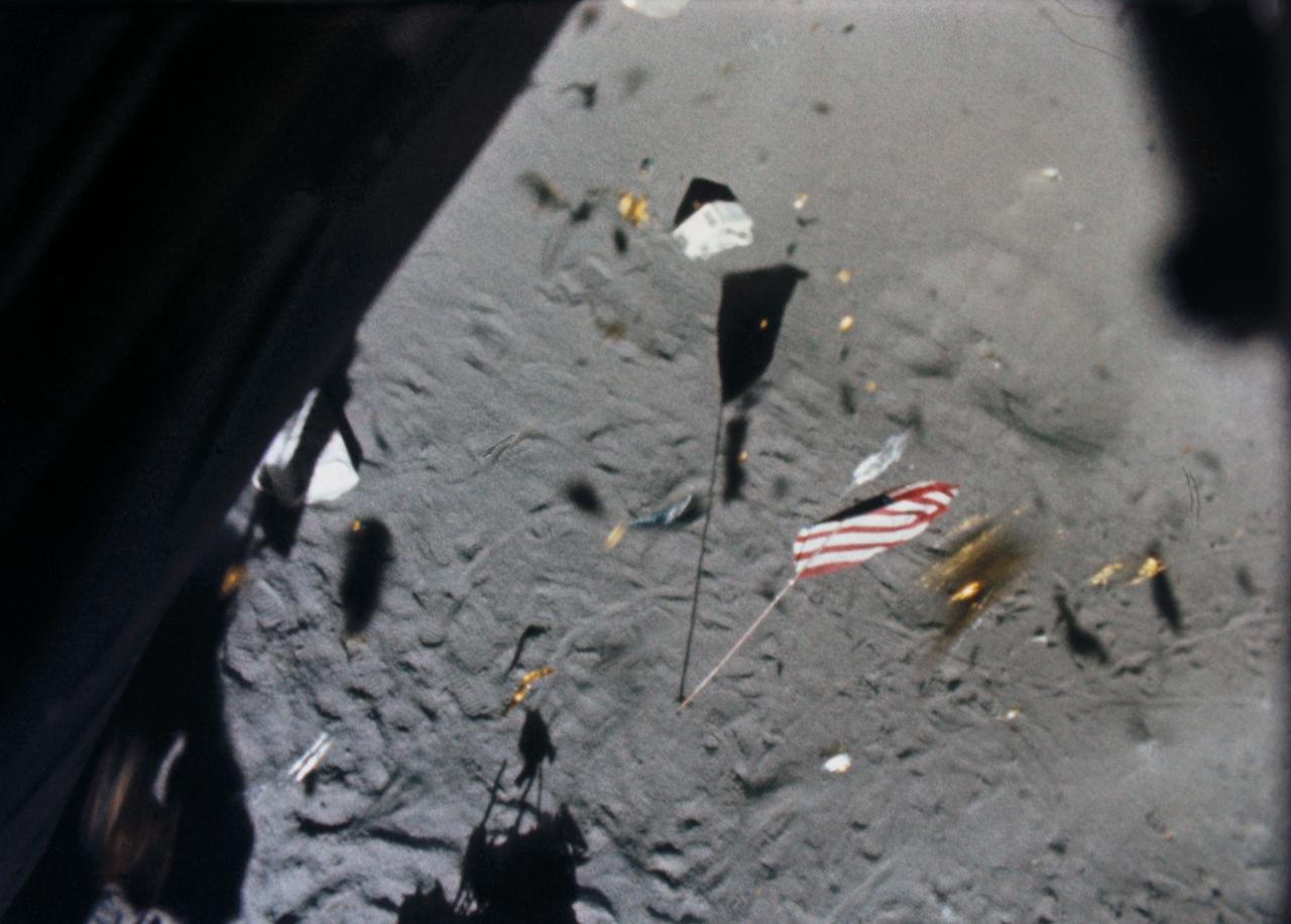
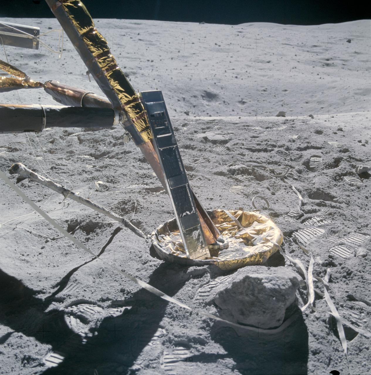
S71-19500 (6 Feb. 1971) --- The Apollo 14 Lunar Module (LM) ascent stage lifts off the lunar surface and the powerful LM engine causes a brief force of wind which scatters gold-colored foil, covering the LM, and disturbs the U.S. flag. This picture was taken from film exposed by the 16mm data acquisition camera - which was mounted inside the LM.
AS14-69-9560 (February 1971) --- This 500mm vertical frame taken from the Apollo 14 spacecraft is of the Apollo 16 proposed landing site "Descartes". The actual location of the target area is near the upper left. This photograph was taken with a 56 degree sun angle. The large bright crater is approximately one kilometer in diameter and has a distinctive ray pattern which serves as an excellent landmark.
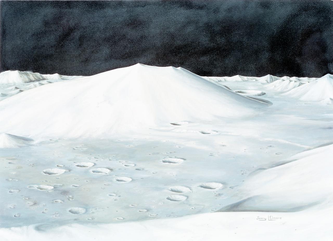
S72-49761 (October 1972) --- An artist's concept illustrating the topographical layout of the Taurus-Littrow landing site of the Apollo 17 lunar landing mission. The Lunar Module touchdown point is in the center of the smooth area in the middle of the picture. The imposing mountain in the center is South Massif. A portion of North Massif is in the lower right corner of the photograph. Note the ridge-like feature extending from South Massif to North Massif. The southern portion of the ridge is called Lee Scarp and the northerly portion Lincoln Scarp. (This concept is by JSC artist Jerry Elmore).
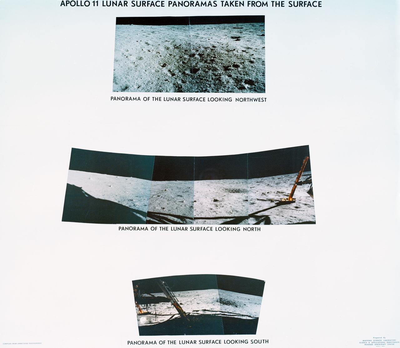
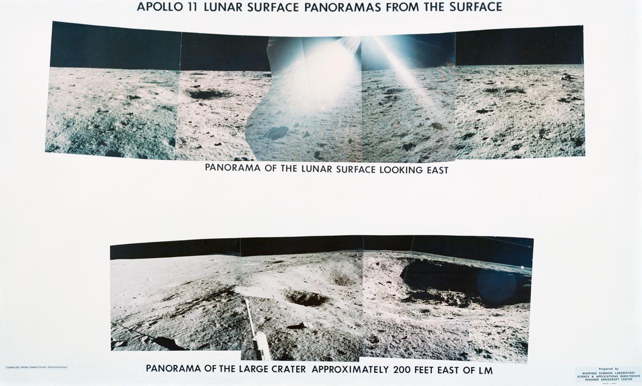
S69-44463 (July 1969) --- Astronaut Neil A. Armstrong took this series of pictures of the landing site of Apollo 11's Lunar Module (LM) Eagle on the lunar surface. These panoramic views of the lunar surface reveal the surface near where the LM touched down, in the southeastern Sea of Tranquility. Foot pads and shadows of the LM are visible in the two of the three panoramic views.
AS12-48-7160 (19-20 Nov. 1969) --- This view of the lunar surface was taken by one of the two astronauts on the Apollo 12 mission during their extravehicular activity. Seen in this view are the U.S. flag, several astronaut footprints, and a small crater near their Lunar Module landing site. Astronaut Charles Conrad Jr., commander, and Alan L. Bean, lunar module pilot, descended in the Lunar Module to explore the lunar surface. Astronaut Richard F. Gordon Jr., command module pilot, remained with Command and Service Modules in lunar orbit.
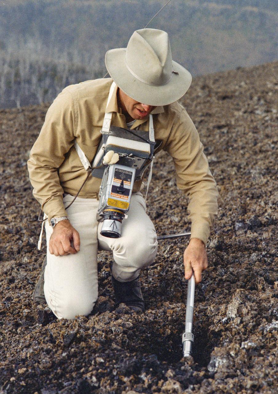
S70-20272 (December 1969) --- Astronaut James A. Lovell Jr., commander of the upcoming Apollo 13 lunar landing mission, uses a scoop from the Apollo Lunar Hand Tools (ALHT) during a simulated lunar surface traverse at the Kapoho, Hawaii training site. While at the Hawaii training sites, Lovell and Haise are participating in thorough rehearsals of their extravehicular activity (EVA). Photo credit: NASA
S72-55064 (11 Dec. 1972) --- Astronaut Eugene A. Cernan operates the Apollo Lunar Surface Drill during the first Apollo 17 extravehicular activity (EVA) at the Taurus-Littrow landing site, in this black and white reproduction taken from a color television transmission made by the RCA color TV camera mounted on the Lunar Roving Vehicle. Cernan is the commander of the Apollo 17 lunar landing mission. Astronaut Ronald E. Evans, command module pilot, remained with the Apollo 17 Command and Service Modules in lunar orbit while astronaut Cernan and scientist-astronaut Harrison H. Schmitt, lunar module pilot, descended in the Lunar Module to explore the moon.
S69-44464 (July 1969) --- Astronaut Neil A. Armstrong took this series of pictures of the landing site of Apollo 11's Lunar Module (LM) Eagle on the lunar surface. Glare in the middle of the top frames is the result of the Hasselblad being aimed toward the sun.
AS17-145-22162 (7-19 Dec. 1972) --- One of the Apollo 17 crew photographed this view during lunar surface extravehicular activities (EVA) at the Taurus-Littrow landing site. The Lunar Rover Vehicle (LRV), which was used extensively by astronauts Eugene A. Cernan and Harrison H. Schmitt, is visible in the background.
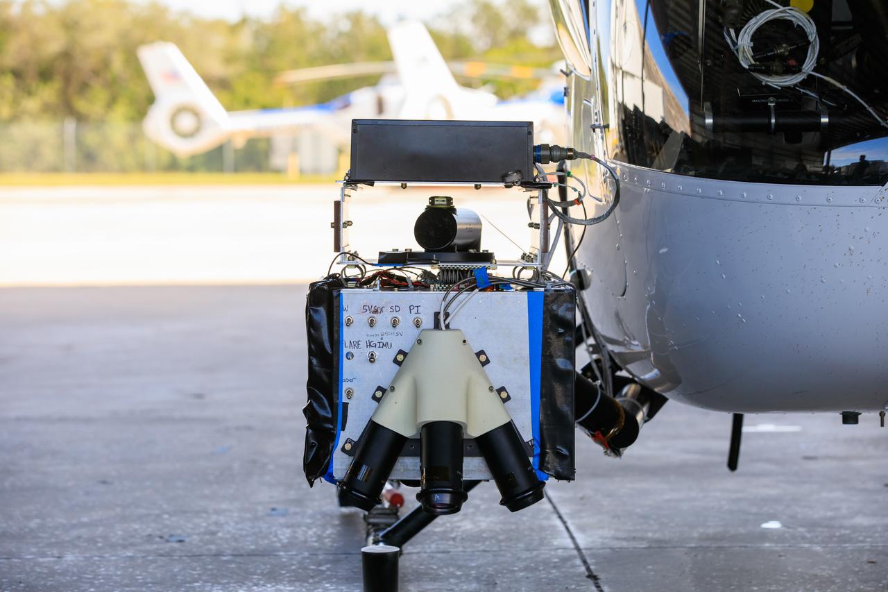
Seen here is a close-up view of Intuitive Machines’ navigation pod sensors for the company’s Nova-C lunar lander ahead of testing done at NASA’s Kennedy Space Center in Florida on Nov. 18, 2022. The test involved flying the sensors over a simulated lunar surface at the Launch and Landing Facility on a private helicopter. Intuitive Machines is scheduled to launch two missions to the Moon in 2023 – one of which will carry NASA’s Mass Spectrometer observing lunar operations (MSolo) instrument that will help analyze the chemical makeup of landing sites on the Moon, as well as study water on the lunar surface. Through NASA’s Commercial Lunar Payload Services initiative, the agency selected Intuitive Machines to deliver science and technology demonstration payloads to the Moon, contributing to NASA’s goal of establishing a sustainable human presence on the lunar surface.
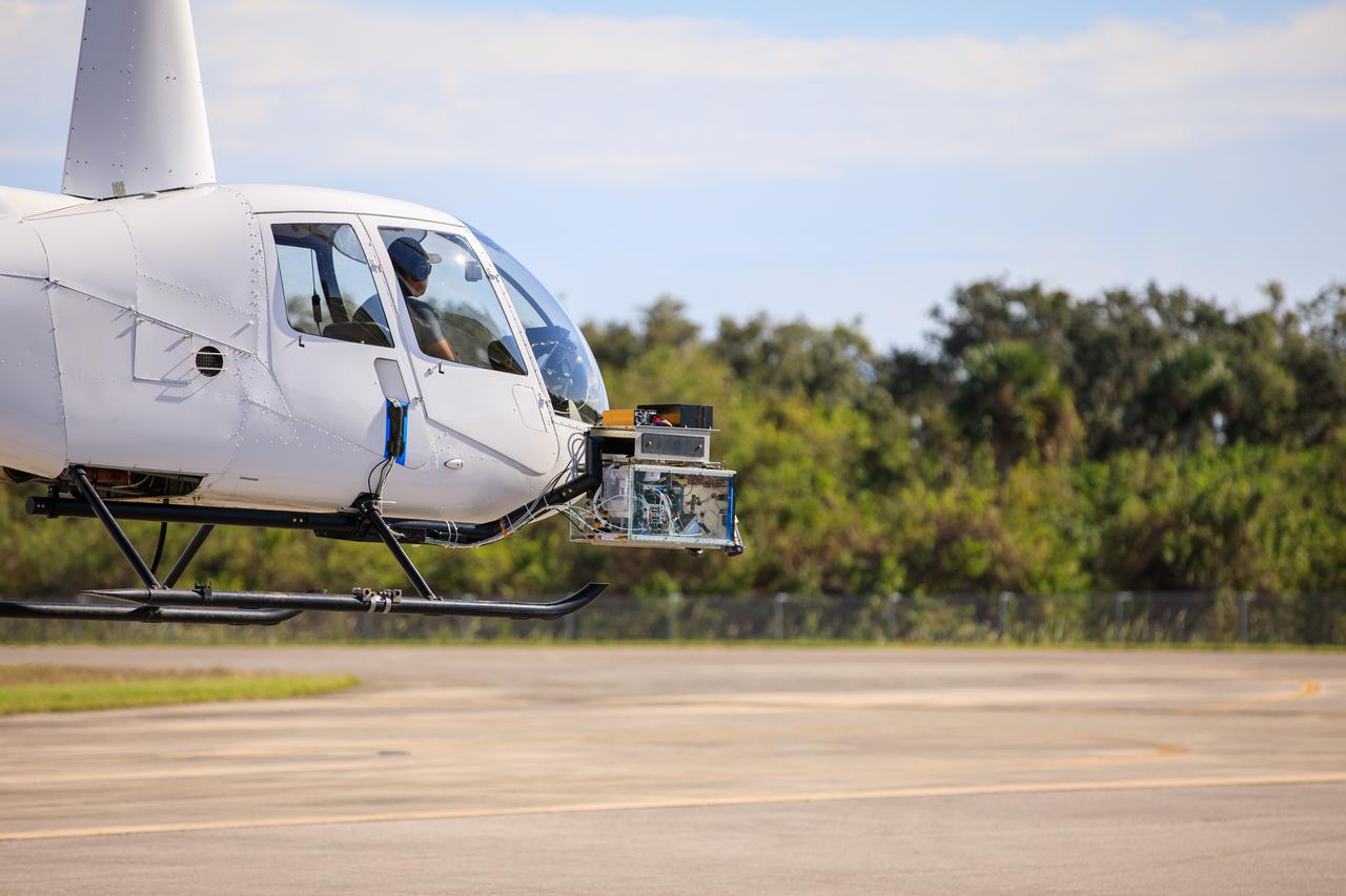
Testing of navigation pod sensors for Intuitive Machines’ Nova-C lunar lander is underway at NASA’s Kennedy Space Center in Florida on Nov. 18, 2022. The test involved flying the sensors over a simulated lunar surface at the Launch and Landing Facility on a private helicopter. Intuitive Machines is scheduled to launch two missions to the Moon in 2023 – one of which will carry NASA’s Mass Spectrometer observing lunar operations (MSolo) instrument that will help analyze the chemical makeup of landing sites on the Moon, as well as study water on the lunar surface. Through NASA’s Commercial Lunar Payload Services initiative, the agency selected Intuitive Machines to deliver science and technology demonstration payloads to the Moon, contributing to NASA’s goal of establishing a sustainable human presence on the lunar surface.
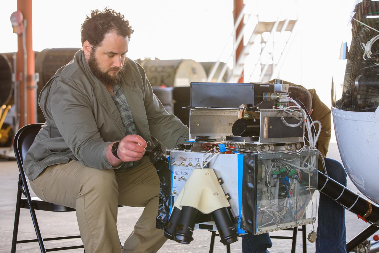
Two Intuitive Machines employees ready navigation pod sensors for the company’s Nova-C lunar lander in preparation for testing at NASA’s Kennedy Space Center in Florida on Nov. 18, 2022. The test involved flying the sensors over a simulated lunar surface at the Launch and Landing Facility on a private helicopter. Intuitive Machines is scheduled to launch two missions to the Moon in 2023 – one of which will carry NASA’s Mass Spectrometer observing lunar operations (MSolo) instrument that will help analyze the chemical makeup of landing sites on the Moon, as well as study water on the lunar surface. Through NASA’s Commercial Lunar Payload Services initiative, the agency selected Intuitive Machines to deliver science and technology demonstration payloads to the Moon, contributing to NASA’s goal of establishing a sustainable human presence on the lunar surface.
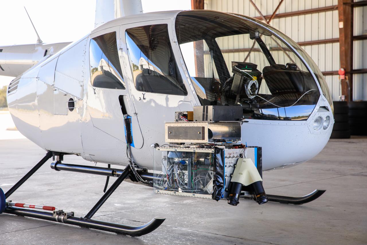
Seen here is Intuitive Machines’ navigation pod sensors for the company’s Nova-C lunar lander ahead of testing done at NASA’s Kennedy Space Center in Florida on Nov. 18, 2022. The test involved flying the sensors over a simulated lunar surface at the Launch and Landing Facility on a private helicopter. Intuitive Machines is scheduled to launch two missions to the Moon in 2023 – one of which will carry NASA’s Mass Spectrometer observing lunar operations (MSolo) instrument that will help analyze the chemical makeup of landing sites on the Moon, as well as study water on the lunar surface. Through NASA’s Commercial Lunar Payload Services initiative, the agency selected Intuitive Machines to deliver science and technology demonstration payloads to the Moon, contributing to NASA’s goal of establishing a sustainable human presence on the lunar surface.
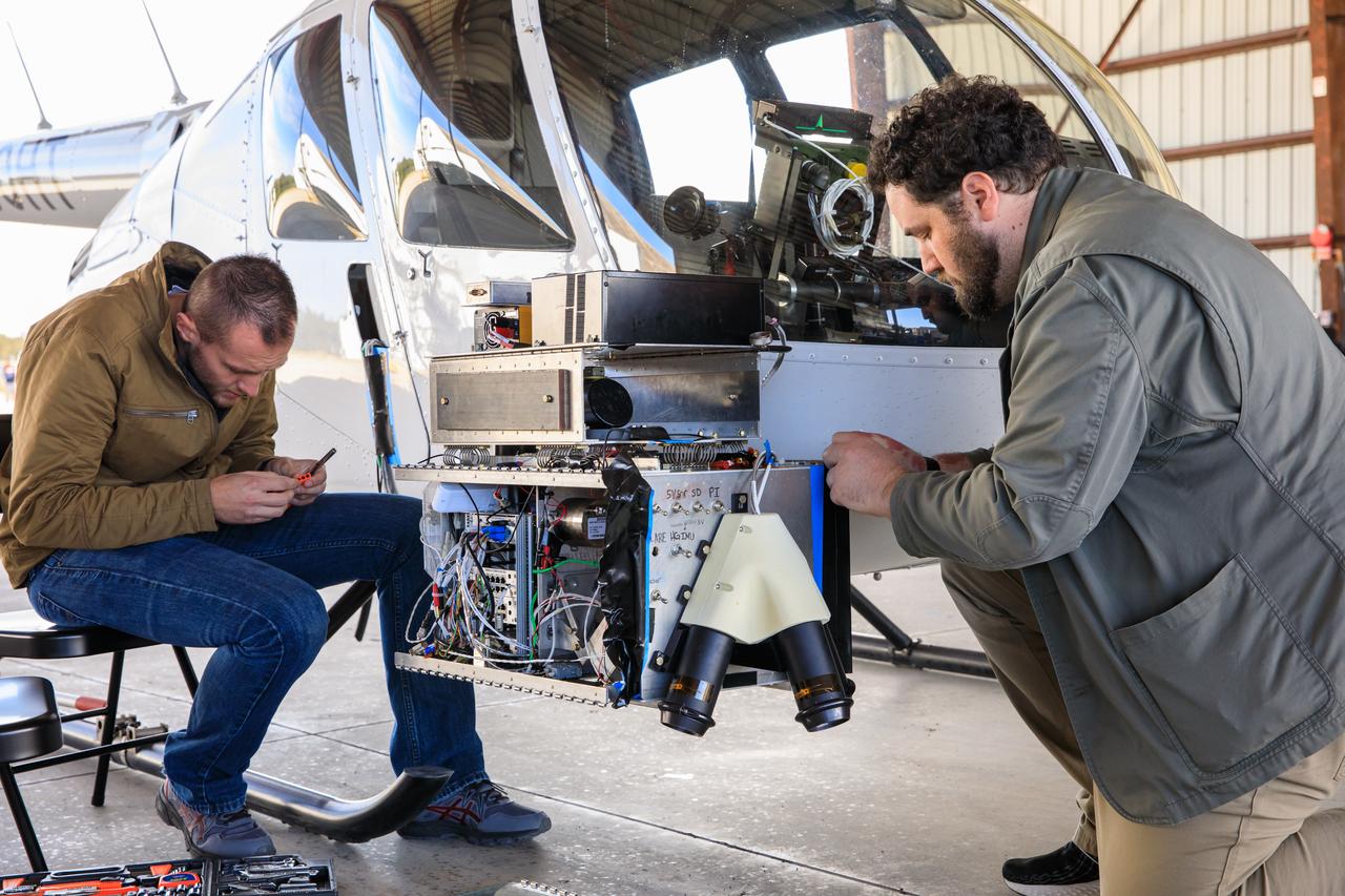
Two Intuitive Machines employees ready navigation pod sensors for the company’s Nova-C lunar lander in preparation for testing at NASA’s Kennedy Space Center in Florida on Nov. 18, 2022. The test involved flying the sensors over a simulated lunar surface at the Launch and Landing Facility on a private helicopter. Intuitive Machines is scheduled to launch two missions to the Moon in 2023 – one of which will carry NASA’s Mass Spectrometer observing lunar operations (MSolo) instrument that will help analyze the chemical makeup of landing sites on the Moon, as well as study water on the lunar surface. Through NASA’s Commercial Lunar Payload Services initiative, the agency selected Intuitive Machines to deliver science and technology demonstration payloads to the Moon, contributing to NASA’s goal of establishing a sustainable human presence on the lunar surface.

Testing of navigation pod sensors for Intuitive Machines’ Nova-C lunar lander is underway at NASA’s Kennedy Space Center in Florida on Nov. 18, 2022. The test involved flying the sensors over a simulated lunar surface at the Launch and Landing Facility on a private helicopter. Intuitive Machines is scheduled to launch two missions to the Moon in 2023 – one of which will carry NASA’s Mass Spectrometer observing lunar operations (MSolo) instrument that will help analyze the chemical makeup of landing sites on the Moon, as well as study water on the lunar surface. Through NASA’s Commercial Lunar Payload Services initiative, the agency selected Intuitive Machines to deliver science and technology demonstration payloads to the Moon, contributing to NASA’s goal of establishing a sustainable human presence on the lunar surface.
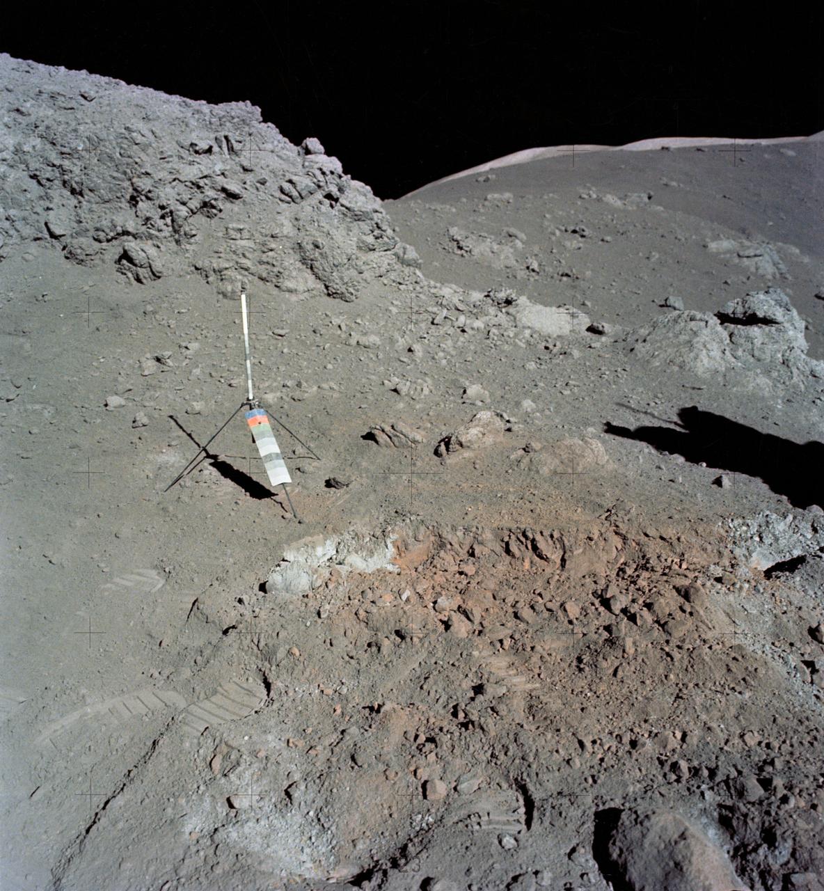
AS16-114-18412 (16-27 April 1972) --- The gnomon and color patch, one of the Apollo Lunar Hand Tools (ALHT), is deployed atop a lunar rock, in this photograph taken by one of the Apollo 16 astronauts during their lunar surface extravehicular activity (EVA) at the Descartes landing site. The gnomon is used as a photographic reference to establish local vertical sun angle, scale, and lunar color. The color patch, mounted on one of the legs of the tripod, provides a larger target for accurately determining colors in color photography. A portion of Flag Crater can be seen in the background. While astronauts John W. Young, commander; and Charles M. Duke Jr., lunar module pilot; descended in the Apollo 16 Lunar Module (LM) "Orion" to explore the Descartes highlands landing site on the moon, astronaut Thomas K. Mattingly II, command module pilot, remained with the Command and Service Modules (CSM) "Casper" in lunar orbit.

S71-40085 (July 1971) --- An enlarged Lunar Orbiter photograph of the Apollo 15 landing area in the Hadley-Apennine region on the nearside of the moon. The overlay indicates the location of the numerous informally-named surface features. These names will facilitate understanding the verbal descriptions from the astronauts during their lunar surface extravehicular activity (EVA). This is an August 1967, Lunar Orbiter V photograph of Site 26.1.

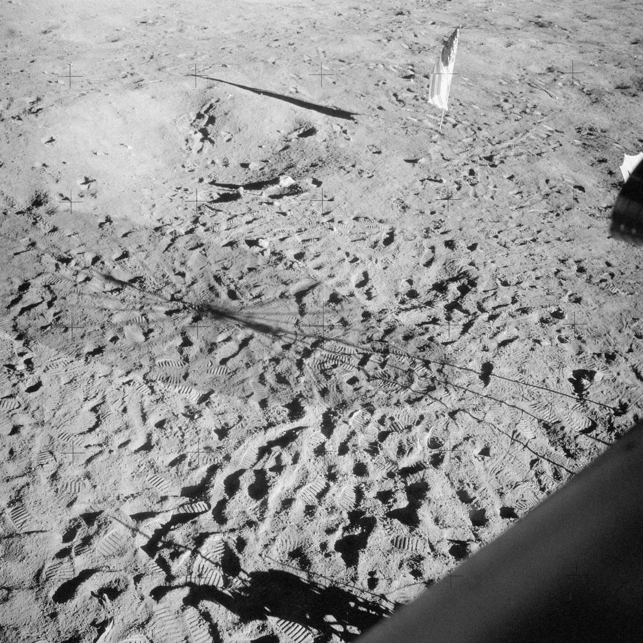
AS11-40-5875 (20 July 1969) --- Astronaut Edwin E. Aldrin Jr., lunar module pilot of the first lunar landing mission, poses for a photograph beside the deployed United States flag during an Apollo 11 extravehicular activity (EVA) on the lunar surface. The Lunar Module (LM) is on the left, and the footprints of the astronauts are clearly visible in the soil of the moon. Astronaut Neil A. Armstrong, commander, took this picture with a 70mm Hasselblad lunar surface camera. While astronauts Armstrong and Aldrin descended in the LM, the "Eagle", to explore the Sea of Tranquility region of the moon, astronaut Michael Collins, command module pilot, remained with the Command and Service Modules (CSM) "Columbia" in lunar orbit. Photo credit: NASA
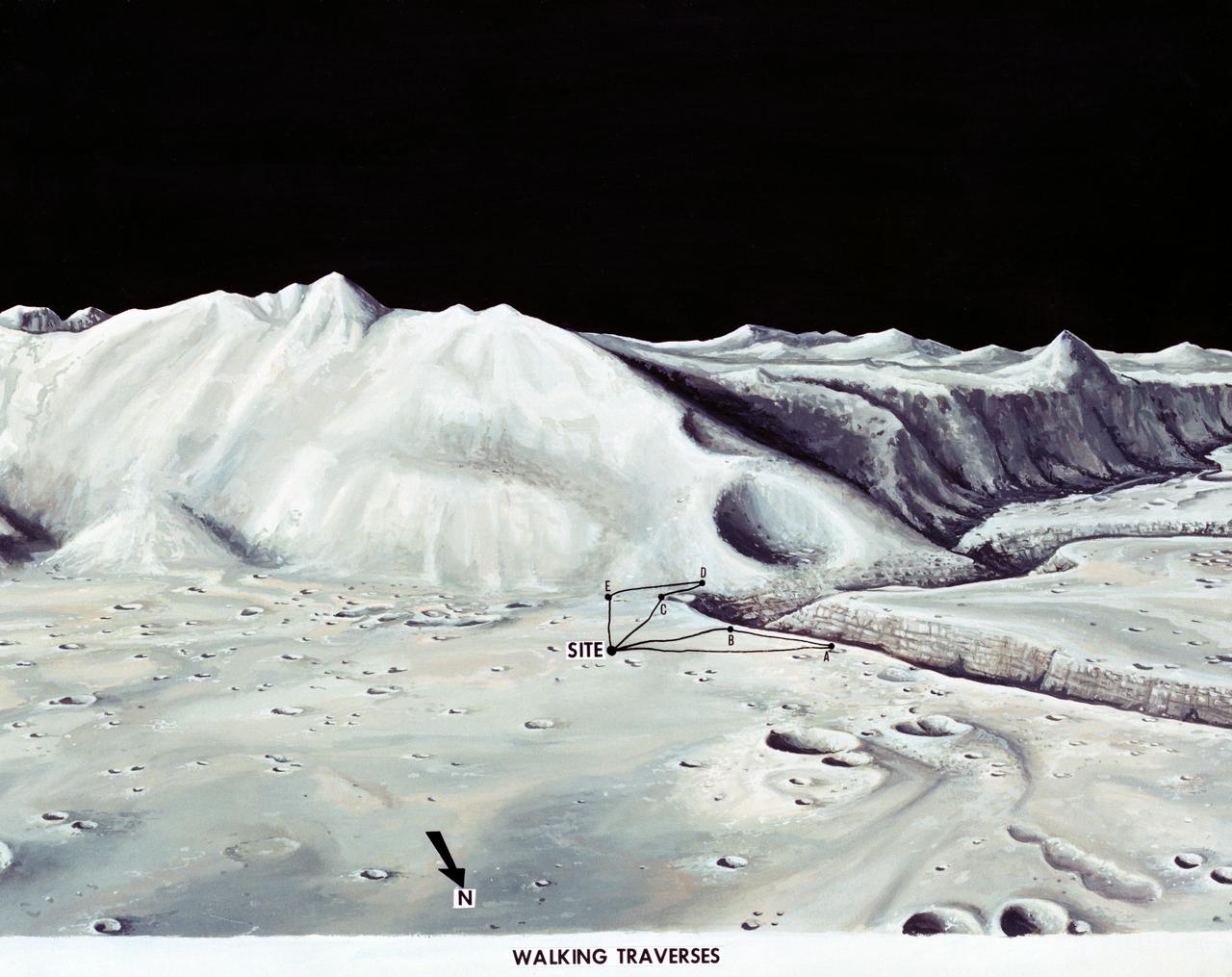
S71-33432 (1 July 1971) --- These alternative traverses can be carried out on foot. They will be used if the Lunar Roving Vehicle (LRV) becomes inoperative. This artist's concept showing part of the Hadley Rille and several of the Apennine Mountains was excerpted from "On the Moon with Apollo 15: A Guidebook to the Hadley-Apennine Region," by Gene Simmons. Artwork by Jerry Elmore.
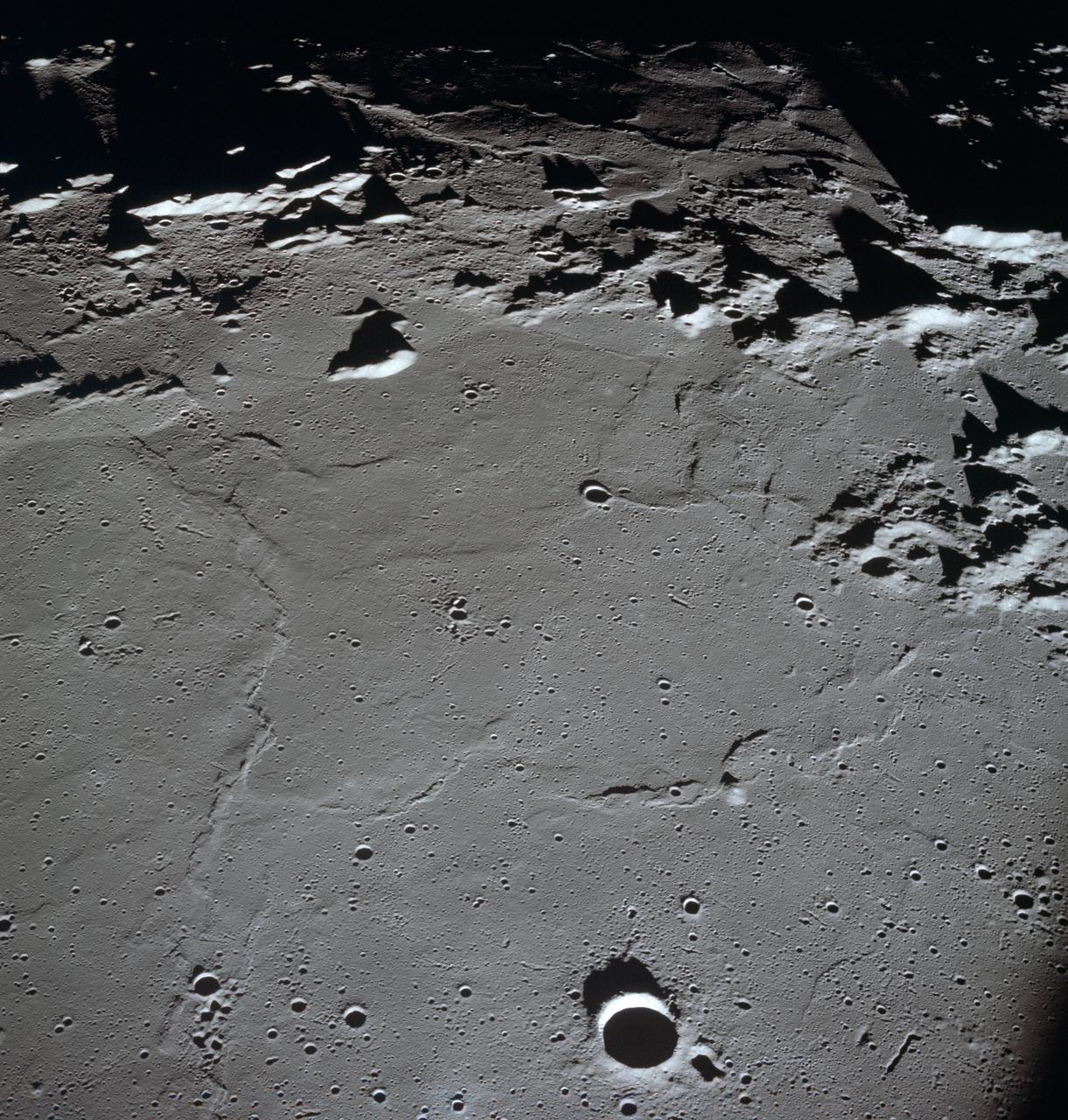
AS15-97-13168 (31 July-2 Aug. 1971) --- A view of the flow structure on the rim and edge of the crater Tsiolkovsky in the highlands of the lunar farside, as photographed from lunar orbit by astronaut Alfred M. Worden in the Apollo 15 Command and Service Module (CSM). Note the scarp at the edge of the flow and elongated grooves on the flow surface. While astronauts David R. Scott and James B. Irwin descended in the Lunar Module (LM) "Falcon" to explore the moon's Hadley-Apennine landing site, Worden remained with the CSM in lunar orbit.
S72-53949 (November 1972) --- The upper and bottom sections of the Lunar Neutron Probe Experiment (S-229), in a stowed configuration, which will be used at the Taurus-Littrow landing site by the Apollo 17 crewmen. The purpose of this experiment is to measure neutron capture rates in the lunar regolith, measure variation of neutron capture rates as a function of depth beneath the lunar surface, and gain information on the lunar neutron energy spectrum.
AS15-86-11603 (31 July 1971) --- Astronaut James B. Irwin, lunar module pilot, works at the Lunar Roving Vehicle during the first Apollo 15 lunar surface extravehicular activity (EVA) at the Hadley-Apennine landing site. The shadow of the Lunar Module "Falcon" is in the foreground. This view is looking northeast, with Mount Hadley in the background. This photograph was taken by astronaut David R. Scott, commander.
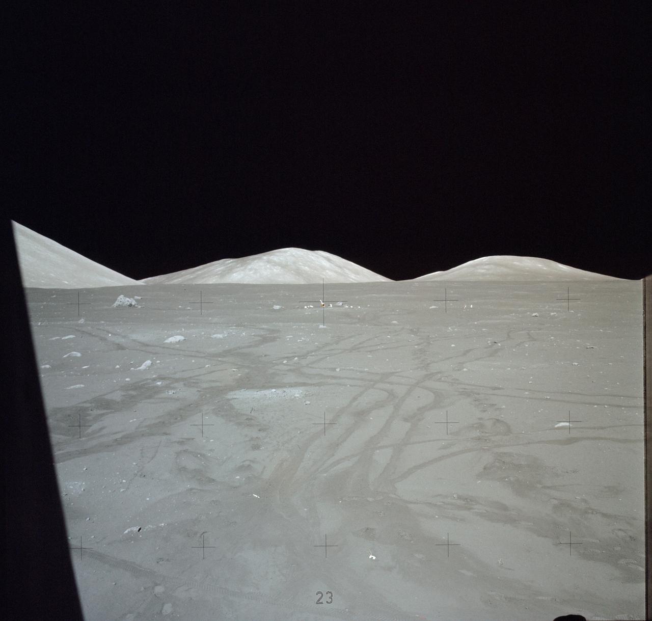
AS17-140-21355 (7-19 Dec. 1972) --- This picture of the lunar surface was taken from the window of the lunar module at the Taurus-Littrow landing site. Astronauts Eugene A. Cernan and Harrison H. Schmitt were inside the lunar module preparing for the mission's third spacewalk. Tracks made by lunar roving vehicle (LRV) and the astronauts' bootprints from earlier spacewalks are seen in the foreground.
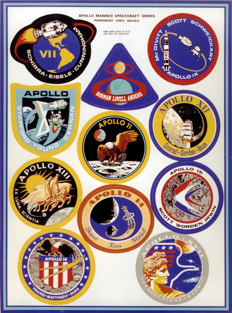
This montage depicts the flight crew patches for the manned Apollo 7 thru Apollo 17 missions. The Apollo 7 through 10 missions were basically manned test flights that paved the way for lunar landing missions. Primary objectives met included the demonstration of the Command Service Module (CSM) crew performance; crew/space vehicle/mission support facilities performance and testing during a manned CSM mission; CSM rendezvous capability; translunar injection demonstration; the first manned Apollo docking, the first Apollo Extra Vehicular Activity (EVA), performance of the first manned flight of the lunar module (LM); the CSM-LM docking in translunar trajectory, LM undocking in lunar orbit, LM staging in lunar orbit, and manned LM-CSM docking in lunar orbit. Apollo 11 through 17 were lunar landing missions with the exception of Apollo 13 which was forced to circle the moon without landing due to an onboard explosion. The craft was,however, able to return to Earth safely. Apollo 11 was the first manned lunar landing mission and performed the first lunar surface EVA. Landing site was the Sea of Tranquility. A message for mankind was delivered, the U.S. flag was planted, experiments were set up and 47 pounds of lunar surface material was collected for analysis back on Earth. Apollo 12, the 2nd manned lunar landing mission landed in the Ocean of Storms and retrieved parts of the unmanned Surveyor 3, which had landed on the Moon in April 1967. The Apollo Lunar Surface Experiments Package (ALSEP) was deployed, and 75 pounds of lunar material was gathered. Apollo 14, the 3rd lunar landing mission landed in Fra Mauro. ALSEP and other instruments were deployed, and 94 pounds of lunar materials were gathered, using a hand cart for first time to transport rocks. Apollo 15, the 4th lunar landing mission landed in the Hadley-Apennine region. With the first use of the Lunar Roving Vehicle (LRV), the crew was bale to gather 169 pounds of lunar material. Apollo 16, the 5th lunar landing mission, landed in the Descartes Highlands for the first study of highlands area. Selected surface experiments were deployed, the ultraviolet camera/spectrograph was used for first time on the Moon, and the LRV was used for second time for a collection of 213 pounds of lunar material. The Apollo program came to a close with Apollo 17, the 6th and final manned lunar landing mission that landed in the Taurus-Littrow highlands and valley area. This mission hosted the first scientist-astronaut, Schmitt, to land on the Moon. The 6th automated research station was set up, and 243 ponds of lunar material was gathered using the LRV.
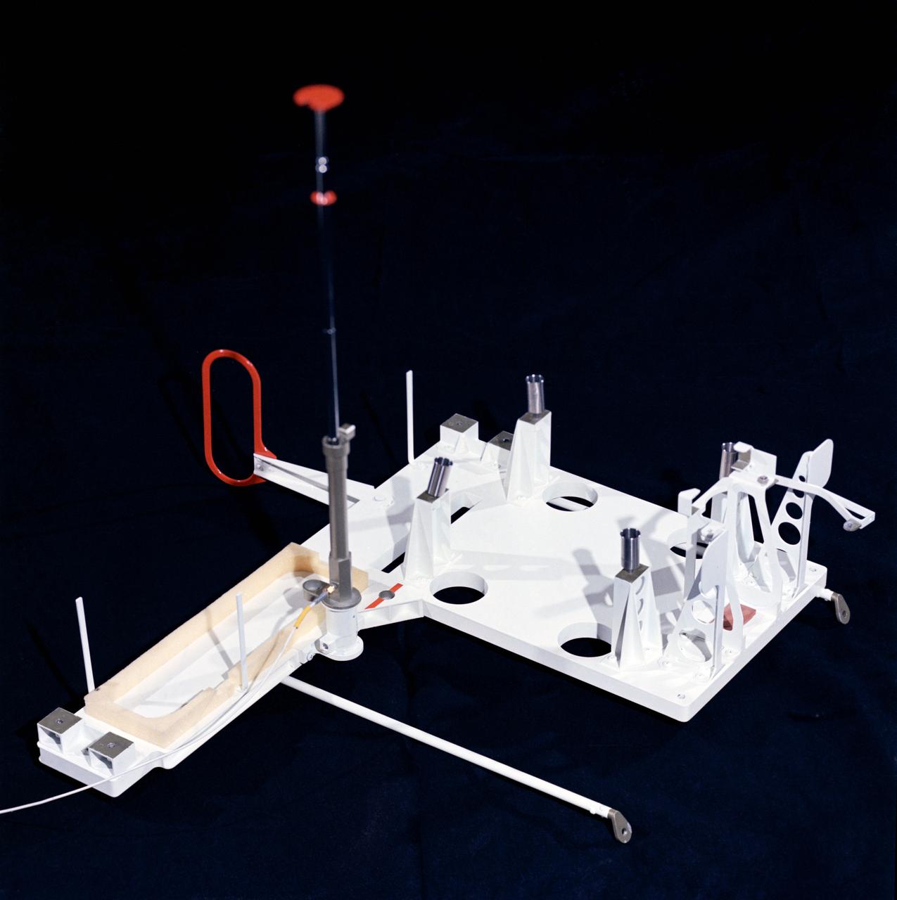
S72-53952 (November 1972) --- The Traverse Gravimeter Experiment (S-199), with cover removed, which will be used by the Apollo 17 crewmen at the Taurus-Littrow landing site. The purposes of this experiment are to make a high accuracy relative survey of the lunar gravitational field in the lunar landing area and to make an Earth-moon gravity tie. Specific experiment objectives related to these purposes are to: (1) measure the value of gravity, relative to the value at a lunar base station, at selected known locations along the lunar traverse; (2) measure the value of gravity at a known point on the lunar surface (base station) relative to the value of gravity at a known point on Earth.
AS17-134-20466 (7-19 Dec. 1972) --- A close-up view of the U.S. flag deployed on the moon at the Taurus-Littrow landing site by the crewmen of the Apollo 17 lunar landing mission. The crescent Earth can be seen in the far distant background above the flag. The lunar feature in the near background is South Massif. While astronauts Eugene A. Cernan and Harrison H. Schmitt descended in the Lunar Module "Challenger" to explore the lunar surface, astronaut Ronald E. Evans remained with the Apollo 17 Command and Service Modules in lunar orbit.
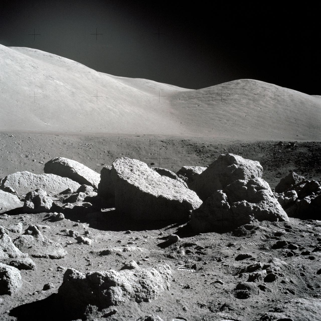
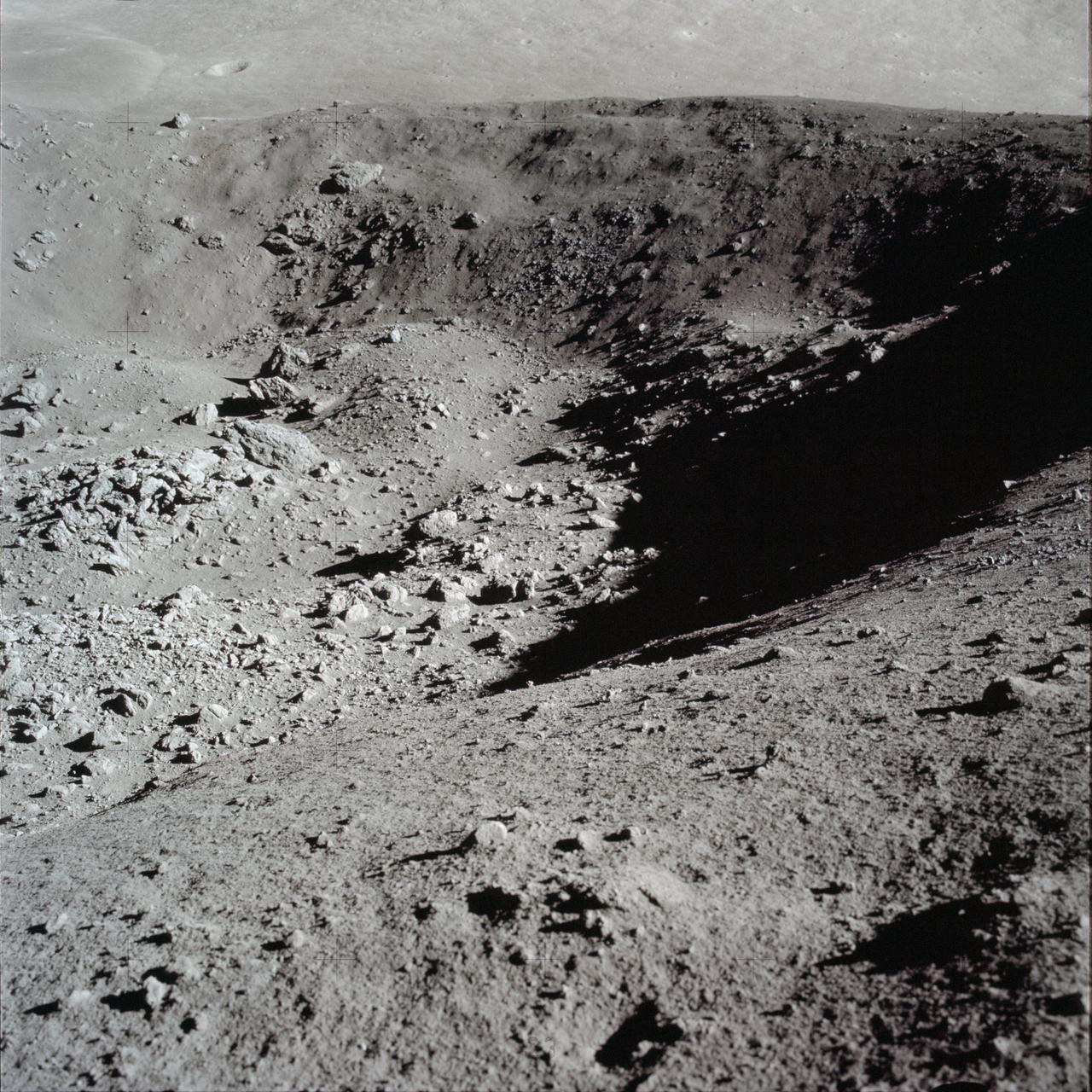
AS17-145-22183 (7-19 Dec. 1972) --- One of the Apollo 17 crew took this picture of a large boulder field during lunar surface extravehicular activity (EVA) at the Taurus-Littrow landing site. This view is looking northeast. Apollo 17 was the final lunar landing mission in NASA's Apollo Program. While astronauts Eugene A. Cernan, commander, and Harrison H. Schmitt, lunar module pilot, descended in the Lunar Module (LM) "Challenger" to explore the Taurus-Littrow region of the moon, astronaut Ronald E. Evans, command module pilot, remained with the Command and Service Modules (CSM) "America" in lunar orbit.
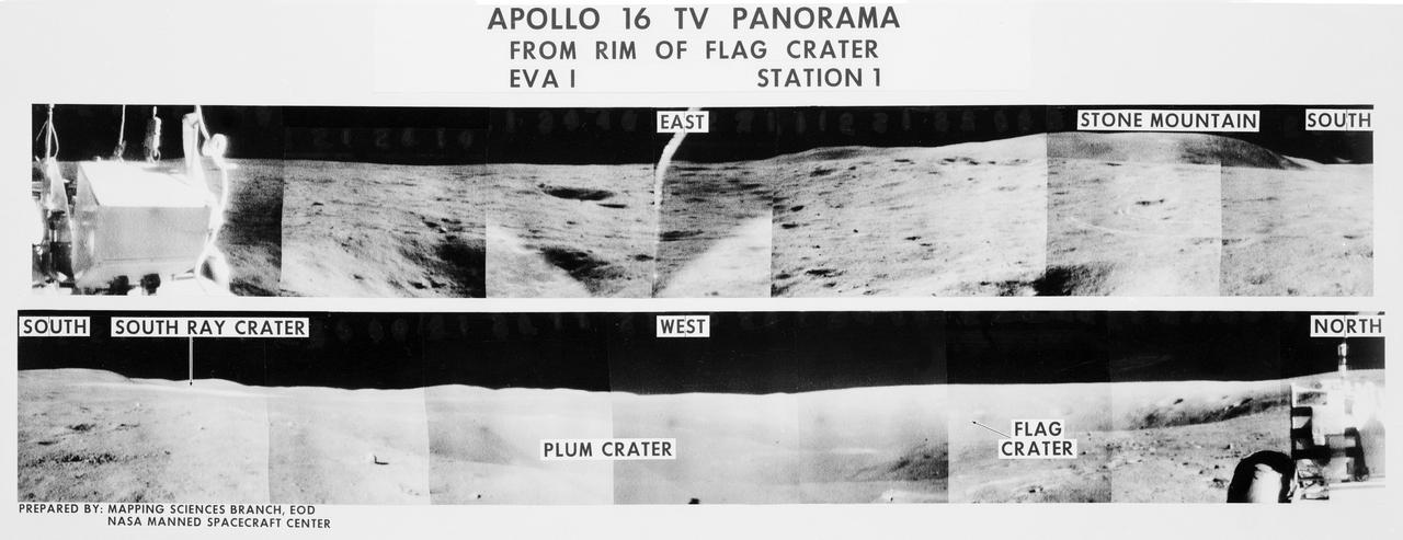
S72-35970 (21 April 1972) --- A 360-degree field of view of the Apollo 16 Descartes landing site area composed of individual scenes taken from color transmission made by the color RCA TV camera mounted on the Lunar Roving Vehicle (LRV). This panorama was made while the LRV was parked at the rim of Flag Crater (Station 1) during the first Apollo 16 lunar surface extravehicular activity (EVA) by astronauts John W. Young and Charles M. Duke Jr. The overlay identifies the directions and the key lunar terrain features. The camera panned across the rear portion of the LRV in its 360-degree sweep. Astronauts Young, commander; and Duke, lunar module pilot; descended in the Apollo 16 Lunar Module (LM) "Orion" to explore the Descartes highlands landing site on the moon. Astronaut Thomas K. Mattingly II, command module pilot, remained with the Command and Service Modules (CSM) "Casper" in lunar orbit.
S72-55065 (11 Dec. 1972) --- Scientist-astronaut Harrison H. Schmitt is seen anchoring the geophone module with a flag during the first Apollo 17 extravehicular activity (EVA) at the Taurus-Littrow landing site, in the black and white reproduction taken from a color television transmission made by the color RCA TV camera mounted on the Lunar Roving Vehicle. Schmitt is the lunar module mounted on the Lunar Roving Vehicle. Schmitt is the lunar module pilot of the Apollo 17 lunar landing mission. Astronaut Ronald E. Evans, command module pilot, remained with the Apollo 17 Command and Service Modules in lunar orbit while astronauts Schmitt and Eugene A. Cernan, commander, descended in the Lunar Module to explore the moon. The geophone module is part of the Lunar Seismic Profiling Experiment (S-203), a component of the Apollo Lunar Surface Experiments Package (ALSEP). Other ALSEP components are visible in the picture.
AS12-46-6795 (19-20 Nov. 1969) --- A view of the lunar surface in the vicinity of the Apollo 12 lunar landing site, photographed during the extravehicular activity (EVA) of astronauts Charles Conrad Jr., commander, and Alan L. Bean, lunar module pilot. Conrad and Bean encountered the odd, anthill-shaped mound during their lunar traverse. The two descended in the Apollo 12 Lunar Module (LM) to explore the moon, while astronaut Richard F. Gordon Jr., command module pilot, remained with the Command and Service Modules (CSM) in lunar orbit.
Small light colored area within the crater is Surveyor 1 on lunar surface photographed by Lunar Orbiter III. Published in the book "A Century at Langley" by Joseph Chambers. pg. 93 Moon Lunar Orbiter-Lunar Orbiter III: The hidden or dark side of the Moon was taken by Lunar Orbiter III During its mission to photograph potential lunar-landing sites for Apollo missions. -- Photograph published in Winds of Change, 75th Anniversary NASA publication (page 94), by James Schultz. Photo Number:67-H-328 is 1967-L-04026
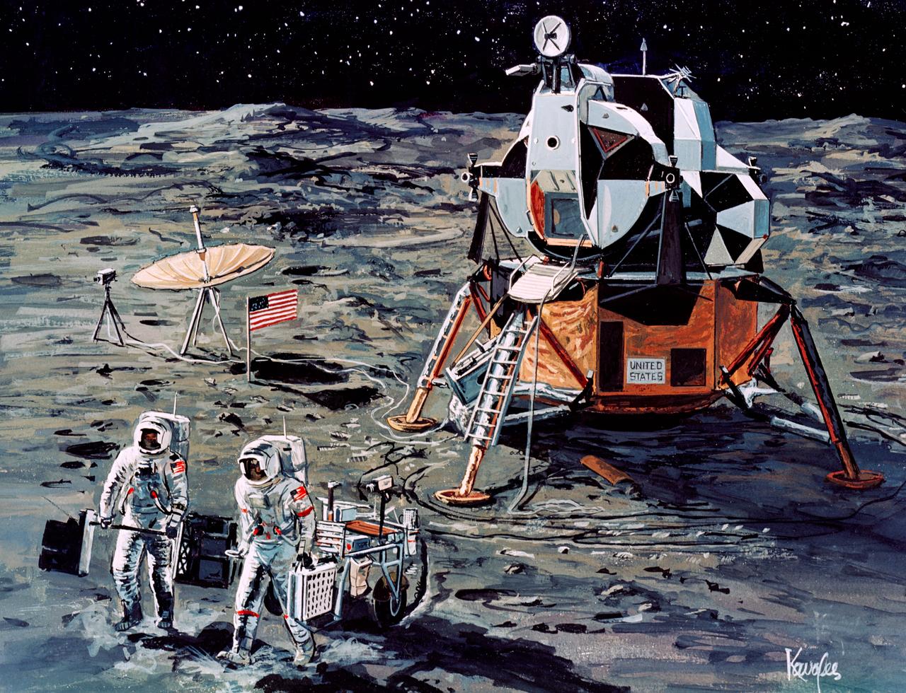
S71-16101 (January 1971) --- A Grumman Aerospace Corporation artist's concept of Apollo 14 crewmen, astronauts Alan B. Shepard Jr., commander, and Edgar D. Mitchell, lunar module pilot, as they set out on their first traverse. Shepard is pulling the Modularized Equipment Transporter (MET) which contains cameras, lunar sample bags, tools and other paraphernalia. Shepard has the Laser Ranging Retro-Reflector (LR-3) in his other hand. Mitchell is carrying the Apollo Lunar Surface Experiments Package (ALSEP) barbell mode.
S71-16574 (11 Jan. 1971) --- An artist's concept depicting the Apollo 14 Command and Service Modules (CSM) circling the moon as the Lunar Module (LM) heads toward a lunar landing. While astronaut Stuart A. Roosa, command module pilot, remains with the CSM in lunar orbit, astronauts Alan B. Shepard Jr., commander; and Edgar D. Mitchell, lunar module pilot, will descend in the LM to explore an area in the rugged Fra Mauro highlands.

AS11-40-5868 (20 July 1969) --- Astronaut Edwin E. Aldrin Jr., lunar module pilot, descends the steps of the Lunar Module (LM) ladder as he prepares to walk on the moon. He had just egressed the LM. This photograph was taken by astronaut Neil A. Armstrong, commander, with a 70mm lunar surface camera during the Apollo 11 extravehicular activity (EVA). While Armstrong and Aldrin descended in the LM "Eagle" to explore the moon, astronaut Michael Collins, command module pilot, remained with the Command and Service Modules (CSM) in lunar orbit.
AS11-40-5863 (20 July 1969) --- Astronaut Edwin E. Aldrin Jr., lunar module pilot, is photographed egressing the Lunar Module (LM) during the Apollo 11 extravehicular activity (EVA) on the moon. This photograph was taken by astronaut Neil A. Armstrong, commander, with a 70mm lunar surface camera. While astronauts Armstrong and Aldrin descended in the Lunar Module (LM) "Eagle" to explore the Sea of Tranquility region of the moon, astronaut Michael Collins, command module pilot, remained with the Command and Service Modules (CSM) "Columbia" in lunar orbit.
AS17-134-20513 (11 Dec. 1972) --- The Lunar Module (LM) is in the background of this view of the Taurus-Littrow landing site. This was one of the last photographs taken on the lunar surface. The Apollo 17 crewmembers were astronauts Eugene A. Cernan, commander; Ronald E. Evans, command and service module pilot; and Harrison H. Schmitt, lunar module pilot.
KENNEDY SPACE CENTER, FLA. - The Apollo 15 astronauts that will be involved in the first time use of the Lunar Roving Vehicle, participate in a Crew Fit and Functional Test in the Manned Spacecraft Operations Building. Commander James B. Irwin and Command Module Pilot Alfred M. Worden, Jr., will drive the Lunar Roving Vehicle for the first time on the Moon's surface. The landing site for the Lunar Module is the Hadley-Apennine area of the Moon.

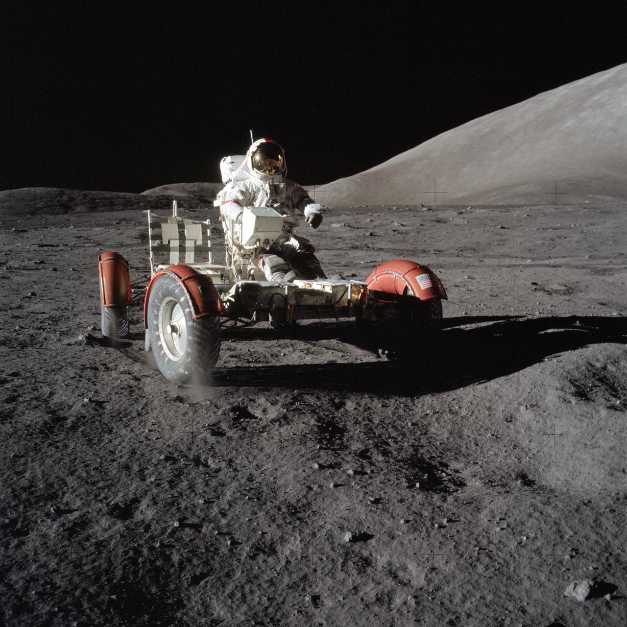
AS15-85-11471 (31 July 1971) --- Astronaut David R. Scott, commander, is seated in the Lunar Roving Vehicle (LRV) during the first Apollo 15 lunar surface extravehicular activity (EVA) at the Hadley-Apennine landing site. This photograph was taken by astronaut James B. Irwin, lunar module pilot. While astronauts Scott and Irwin descended in the Lunar Module (LM) "Falcon" to explore the Hadley-Apennine area of the moon, astronaut Alfred M. Worden, command module pilot, remained with the Command and Service Modules (CSM) in lunar orbit.
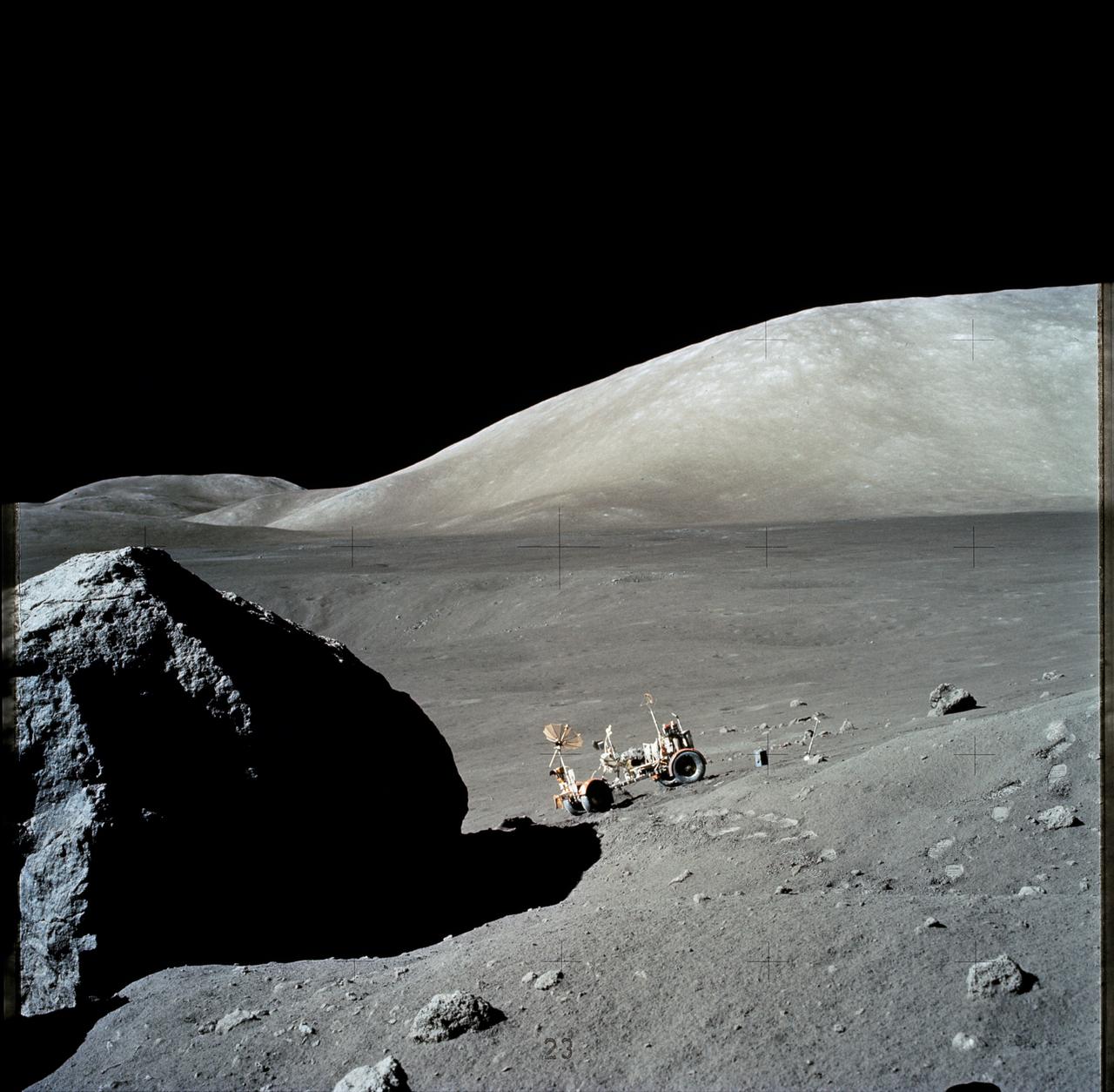
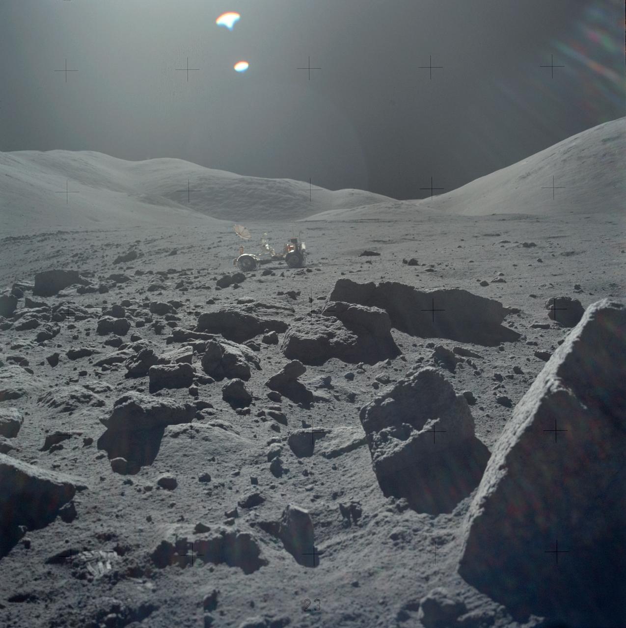
AS17-140-21493 (13 Dec. 1972) --- The Apollo 17 Lunar Roving Vehicle (LRV) is photographed near a large lunar boulder during the third Apollo 17 extravehicular activity (EVA) at the Taurus-Littrow landing site. About half of the boulder is captured in this scene, photographed by astronaut Eugene A. Cernan, mission commander. While astronauts Cernan and Harrison H. Schmitt descended in the Lunar Module (LM) "Challenger" to explore the lunar surface, astronaut Ronald E. Evans, command module pilot, remained with the Command and Service Modules (CSM) in lunar orbit.
AS15-85-11363 (31 July 1971) --- A 70mm handheld Hasselblad was aimed through the viewing port of the Apollo 15 Lunar Module (LM) to record this image of the lunar surface in the vicinity of the Hadley-Apennine landing site. Later, astronauts David R. Scott, commander, and James B. Irwin, lunar module pilot, made the mission's first moon walk. The pair had descended from lunar orbit in the LM to explore the moon while astronaut Alfred M. Worden, command module pilot, remained with the Command and Service Modules (CSM) in lunar orbit.
AS16-106-17340 (23 April 1972) --- Astronaut John W. Young, commander of the Apollo 16 lunar landing mission, is photographed collecting lunar samples near North Ray Crater during the third Apollo 16 extravehicular activity (EVA) at the Descartes landing site. This picture was taken by astronaut Charles M. Duke Jr., lunar module pilot. Young is using the lunar surface rake and a set of tongs. The Lunar Roving Vehicle (LRV) is parked in the field of large boulders in the background. While astronauts Young and Duke descended in the Lunar Module (LM) "Orion" to explore the moon, astronaut Thomas K. Mattingly II, command module pilot, remained with the Command and Service Modules (CSM) in lunar orbit.
AS16-107-17561 (16-27 April 1972) --- One of the Apollo 16 astronauts scoops up lunar soil at the base of a small boulder at Station No. 9 during the second Apollo 16 extravehicular activity (EVA) at the Descartes landing site. Depressions to the right of the scoop were made when a surface sample was taken. This photograph was taken just before the boulder was rolled over. While astronauts John W. Young, commander; and Charles M. Duke Jr., lunar module pilot; descended in the Apollo 16 Lunar Module (LM) "Orion" to explore the Descartes highlands landing site on the moon, astronaut Thomas K. Mattingly II, command module pilot, remained with the Command and Service Modules (CSM) "Casper" in lunar orbit.
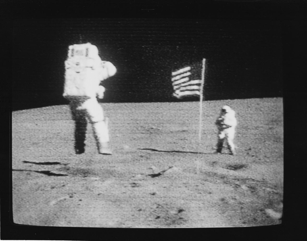
S72-35594 (21 April 1972) --- Astronaut John W. Young, commander of the Apollo 16 lunar landing mission, leaps from the lunar surface as he salutes the United States flag during the first Apollo 16 extravehicular activity (EVA) on the moon, as seen in this black & white reproduction taken from a color television transmission made by the color TV camera mounted on the Lunar Roving Vehicle (LRV). Astronaut Charles M. Duke Jr., lunar module pilot, stands beside the flag. While astronauts Young and Duke descended in the Apollo 16 Lunar Module (LM) "Orion" to explore the Descartes highlands landing site on the moon, astronaut Thomas K. Mattingly II, command module pilot, remained with the Command and Service Modules (CSM) "Casper" in lunar orbit.
AS16-116-18578 (21 April 1972) --- Astronaut John W. Young, commander of the Apollo 16 lunar landing mission, works at the Lunar Roving Vehicle (LRV) just prior to deployment of the Apollo Lunar Surface Experiments Package (ALSEP) during the first extravehicular activity (EVA) on April 21, 1972. Note the Ultraviolet (UV) Camera/Spectrometer to the right of the Lunar Module (LM) ladder. Also, note the pile of protective/thermal foil under the U.S. flag on the LM which the astronauts pulled away to get to the Modular Equipment Storage Assembly (MESA) bay. While astronauts Young and Charles M. Duke Jr., lunar module pilot; descended in the Apollo 16 LM "Orion" to explore the Descartes highlands landing site on the moon, astronaut Thomas K. Mattingly II, command module pilot, remained with the Command and Service Modules (CSM) "Casper" in lunar orbit.
AS16-120-19332 (April 1972) --- This picture of the lunar surface was photographed from lunar orbit during the Apollo 16 lunar landing mission. Mersenius C Crater, dozens of smaller craters and several small rille features can be seen in the frame. Center point coordinates are located at 19.5 degrees south latitude and 45 degrees west longitude. While astronauts John W. Young, commander; and Charles M. Duke Jr., lunar module pilot; descended in the Apollo 16 Lunar Module (LM) "Orion" to explore the Descartes highlands landing site on the moon, astronaut Thomas K. Mattingly II, command module pilot, remained with the Command and Service Modules (CSM) "Casper" in lunar orbit.
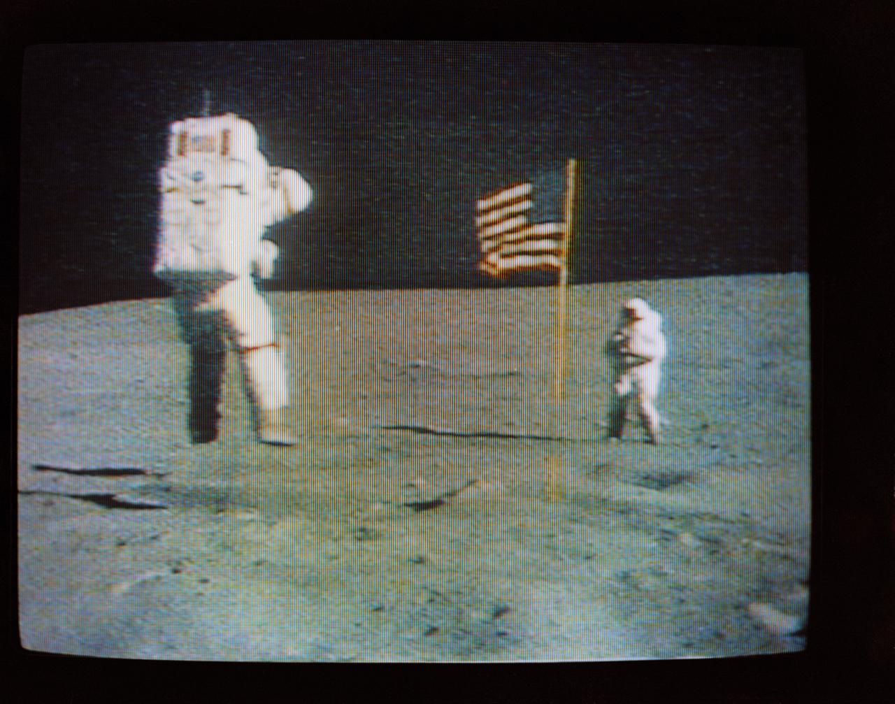
S72-35611 (21 April 1972) --- Astronaut John W. Young, commander of the Apollo 16 lunar landing mission, leaps from the lunar surface as he salutes the U.S. flag, during the first Apollo 16 extravehicular activity (EVA) on the moon, as seen in this reproduction taken from a color television transmission made by the color television camera mounted on the Lunar Roving Vehicle (LRV). Astronaut Charles M. Duke Jr., lunar module pilot, is standing in the background. While astronauts Young and Duke descended in the Apollo 16 Lunar Module (LM) "Orion" to explore the Descartes highlands landing site on the moon, astronaut Thomas K. Mattingly II, command module pilot, remained with the Command and Service Modules (CSM) "Casper" in lunar orbit.
AS17-134-20386 (7-19 Dec. 1972) --- Astronaut Eugene A. Cernan, Apollo 17 commander, is photographed next to the deployed United States flag during lunar surface extravehicular activity (EVA) at the Taurus-Littrow landing site. The highest part of the flag appears to point toward our planet Earth in the distant background. This picture was taken by scientist-astronaut Harrison H. Schmitt, lunar module pilot. While astronauts Cernan and Schmitt descended in the Lunar Module (LM) to explore the moon, astronaut Ronald E. Evans, command module pilot, remained with the Command and Service Modules (CSM) in lunar orbit.
AS16-114-18421 (16-27 April 1972) --- This picture of the lunar surface was photographed by astronaut John W. Young during Apollo 16's first extravehicular activity (EVA) at EVA Station No 1. The instrument near the small crater's edge (foreground) is a gnomon. While astronauts Young, commander; and Charles M. Duke Jr., lunar module pilot; descended in the Apollo 16 Lunar Module (LM) "Orion" to explore the Descartes highlands landing site on the moon, astronaut Thomas K. Mattingly II, command module pilot, remained with the Command and Service Modules (CSM) "Casper" in lunar orbit.
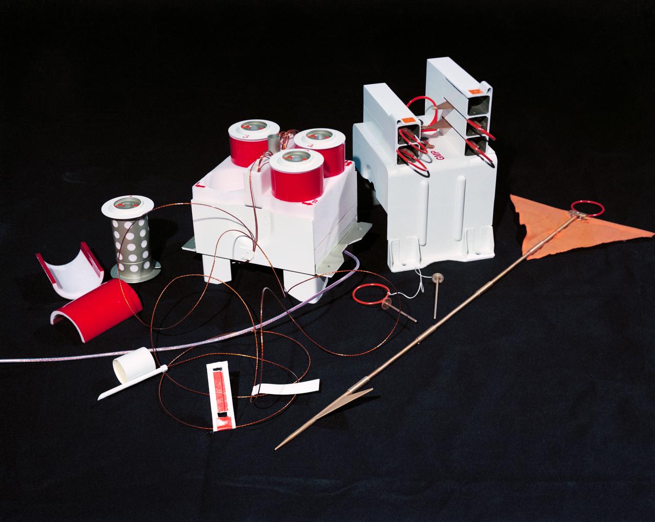
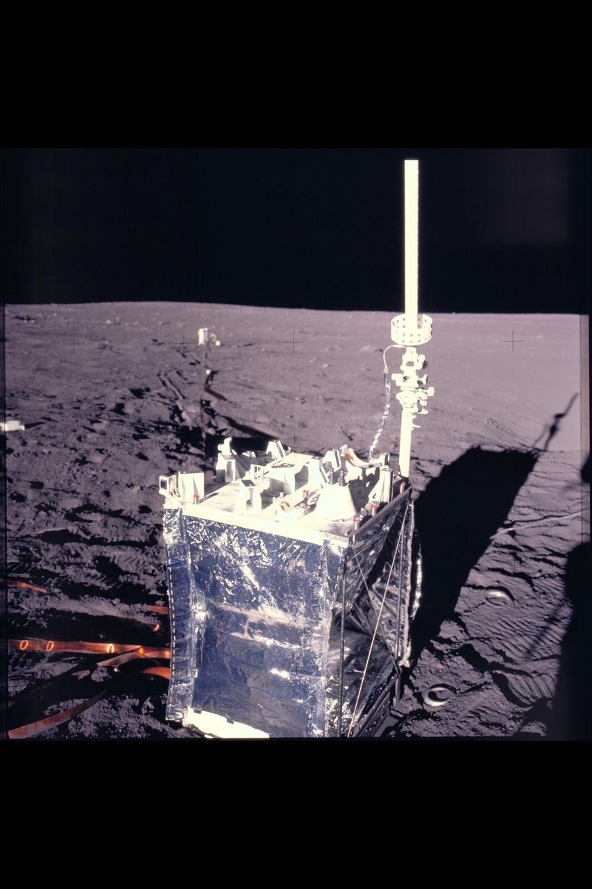
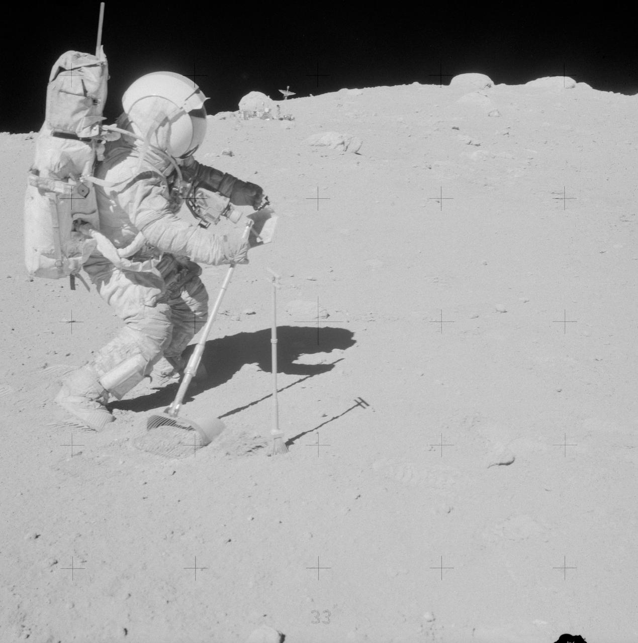
S72-37259 (November 1972) --- The Geophone Module and Cable Reels of the Lunar Seismic Profiling Experiment (S-203), a component of the Apollo Lunar Surface Experiments Package which will be carried on the Apollo 17 lunar landing mission. LSPE components are four geophones similar to those used in an earlier active seismic experiment, an electronics package in the ALSEP central station, and eight explosive packages which will be deployed during the geology traverse. The four geophones will be placed one in the center and one at each corner of a 90-meter equilateral triangle. Explosive charges placed on the surface will generate seismic waves of varying strengths to provide data on the structural profile of the landing site. After the charges have been fired by ground command, the experiment will settle down into a passive listening mode, detecting moonquakes, meteorite impacts and the thump caused by the Lunar Module ascent stage impact.
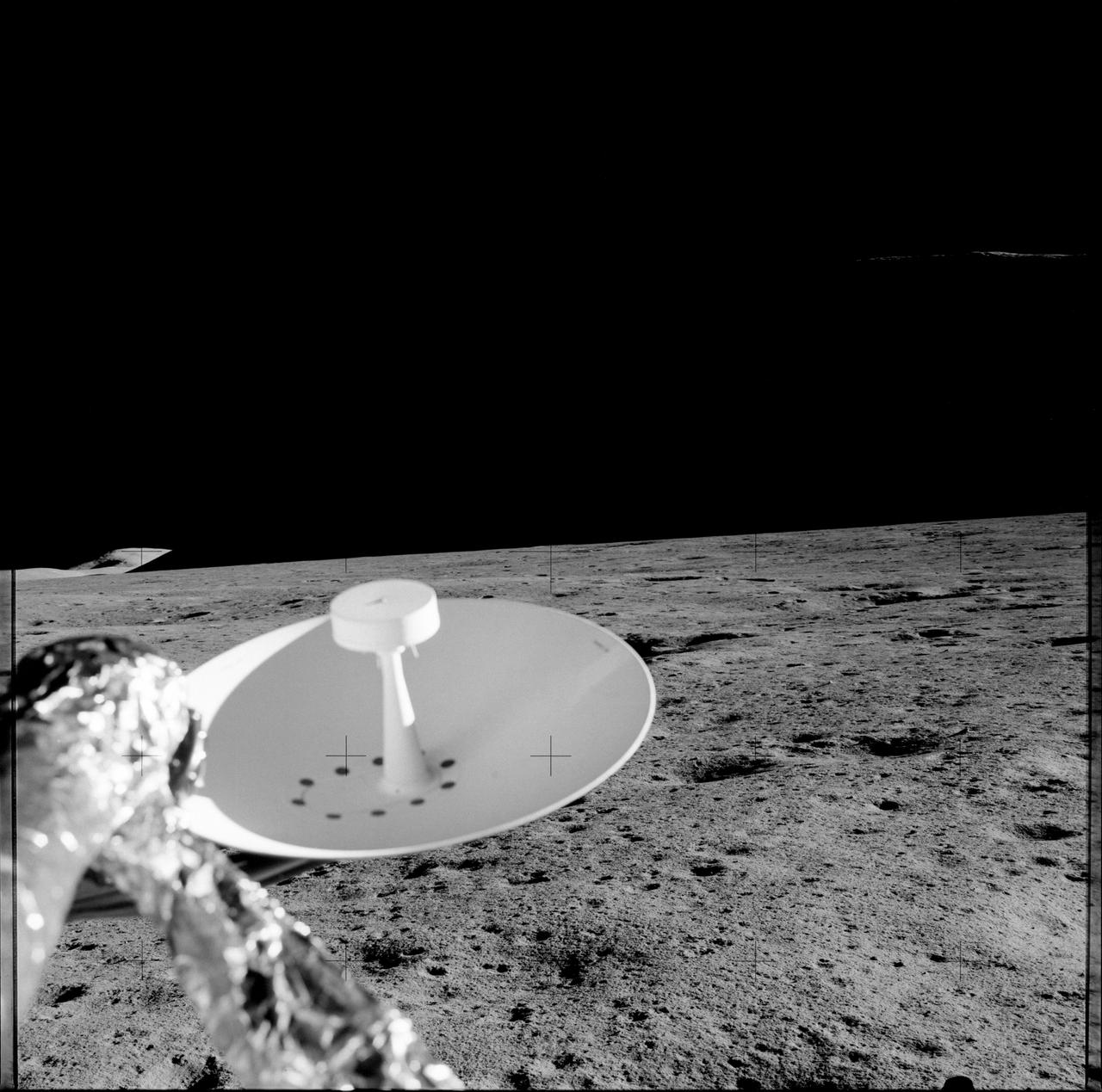
S72-37260 (November 1972) --- The remote antenna for the Lunar Seismic Profiling Experiment, Numbered S-203, a component of the Apollo Lunar Surface Experiments Package which will be carried on the Apollo 17 lunar landing mission. LSPE components are four geophones similar to those used in earlier active seismic experiments an electronics package in the ALSEP central station, and eight explosive packages which will be deployed during the geology traverse. The four geophones will be placed one in the center and at each corner of a 90-meter equilateral triangle. Explosive charges placed on the surface will generate seismic waves of varying strengths to provide data on the structural profile of the landing site. After the charges have been fired by ground command, the experiment will settle down into a passive listening mode, detecting moonquakes, meteorite impacts and the thump caused by the Lunar Module ascent stage impact. The antenna is of the telescoping type.
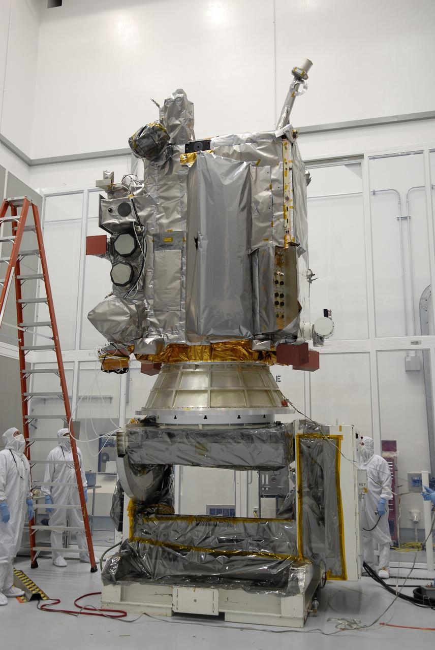
CAPE CANAVERAL, Fla. – At the Astrotech facility in Titusville, Fla., NASA's Lunar Reconnaissance Orbiter, or LRO, has been rotated to vertical on the Aronson stand. A crane will be attached to move it to another stand. The orbiter will carry seven instruments to provide scientists with detailed maps of the lunar surface and enhance our understanding of the moon's topography, lighting conditions, mineralogical composition and natural resources. Information gleaned from LRO will be used to select safe landing sites, determine locations for future lunar outposts and help mitigate radiation dangers to astronauts. The polar regions of the moon are the main focus of the mission because continuous access to sunlight may be possible and water ice may exist in permanently shadowed areas of the poles. Accompanying LRO on its journey to the moon will be the Lunar CRater Observation and Sensing Satellite, or LCROSS, a mission that will impact the lunar surface in its search for water ice. Launch of LRO is targeted for May 20. Photo credit: NASA/Kim Shiflett
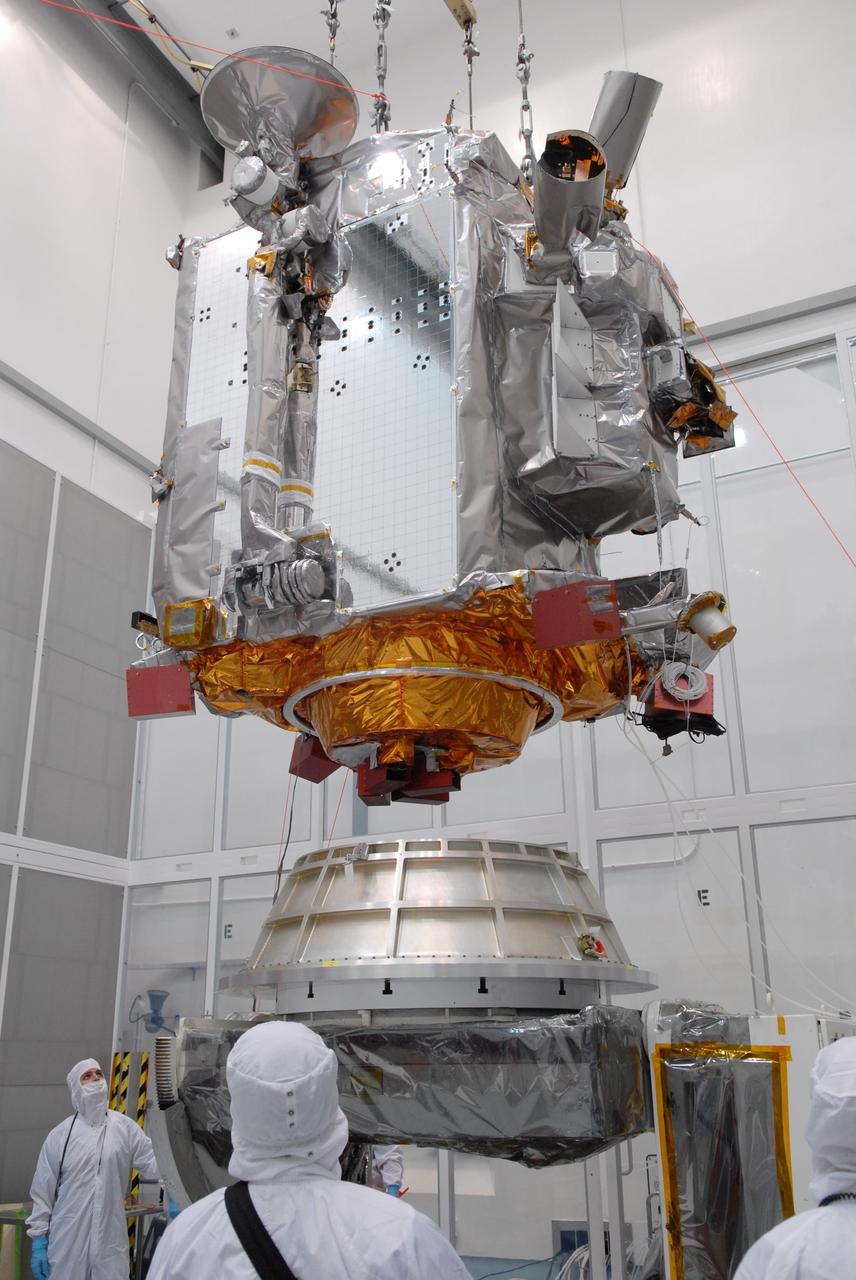
CAPE CANAVERAL, Fla. – At Astrotech in Titusville, Fla., an overhead crane lowers NASA's Lunar Reconnaissance Orbiter, or LRO, toward the Aronson table. The orbiter will be rotated on the table to provide proper access for processing. The orbiter will carry seven instruments to provide scientists with detailed maps of the lunar surface and enhance our understanding of the moon's topography, lighting conditions, mineralogical composition and natural resources. Information gleaned from LRO will be used to select safe landing sites, determine locations for future lunar outposts and help mitigate radiation dangers to astronauts. The polar regions of the moon are the main focus of the mission because continuous access to sunlight may be possible and water ice may exist in permanently shadowed areas of the poles. Accompanying LRO on its journey to the moon will be the Lunar CRater Observation and Sensing Satellite, or LCROSS, a mission that will impact the lunar surface in its search for water ice. Launch of LRO is targeted for May 20. Photo credit: NASA/Jack Pfaller
AS16-113-18347 (21 April 1972) --- A partial view of the Apollo 16 Apollo Lunar Surface Experiments Package (ALSEP) in deployed configuration on the lunar surface as photographed during the mission's first extravehicular activity (EVA), on April 21, 1972. The Passive Seismic Experiment (PSE) is in the foreground center; Central Station (C/S) is in center background, with the Radioisotope Thermoelectric Generator (RTG) to the left. One of the anchor flags for the Active Seismic Experiment (ASE) is at right. While astronauts John W. Young, commander; and Charles M. Duke Jr., lunar module pilot; descended in the Apollo 16 Lunar Module (LM) "Orion" to explore the Descartes highlands landing site on the moon, astronaut Thomas K. Mattingly II, command module pilot, remained with the Command and Service Modules (CSM) "Casper" in lunar orbit.
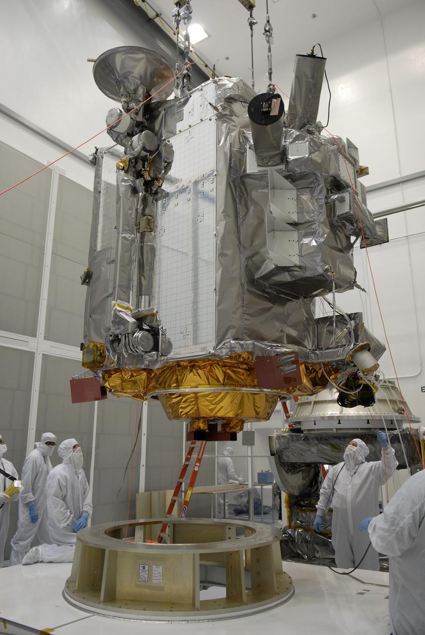
CAPE CANAVERAL, Fla. – At the Astrotech facility in Titusville, Fla., a crane moves NASA's Lunar Reconnaissance Orbiter, or LRO, toward a stand in the foreground. The orbiter will carry seven instruments to provide scientists with detailed maps of the lunar surface and enhance our understanding of the moon's topography, lighting conditions, mineralogical composition and natural resources. Information gleaned from LRO will be used to select safe landing sites, determine locations for future lunar outposts and help mitigate radiation dangers to astronauts. The polar regions of the moon are the main focus of the mission because continuous access to sunlight may be possible and water ice may exist in permanently shadowed areas of the poles. Accompanying LRO on its journey to the moon will be the Lunar CRater Observation and Sensing Satellite, or LCROSS, a mission that will impact the lunar surface in its search for water ice. Launch of LRO is targeted for May 20. Photo credit: NASA/Kim Shiflett