This lunar map shows the traverse plans for the Apollo 14 lunar landing mission. Areas marked include Lunar module landing site, areas for the Apollo Lunar Surface Experiment Package (ALSEP) and areas for gathering of core samples.
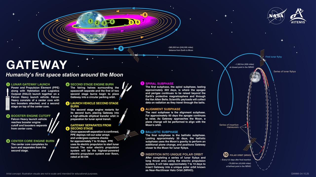
The Lunar Gateway Launch, mapped. Gateway's first elements, the Power and Propulsion Element and HALO (Habitation and Logistics Outpost), will launch together to lunar orbit, where they’ll set the stage for Artemis IV: the first Gateway assembly mission. During this milestone mission, the Artemis IV crew will deliver the European Space Agency's Lunar I-Hab, dock it to HALO, and enter the space station for the very first time. NASA is currently targeting a 2027 launch for HALO and the Power and Propulsion Element. This timeline allows for the roughly year-long journey to lunar orbit and ensures everything is in place ahead of Artemis IV.
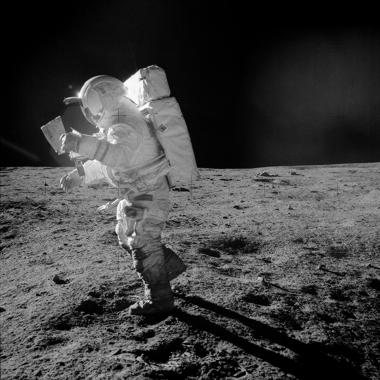
AS14-64-9089 (5-6 Feb. 1971) --- Astronaut Edgar D. Mitchell, lunar module pilot, moves across the lunar surface as he looks over a traverse map during an extravehicular activity (EVA). Lunar dust can be seen clinging to the boots and legs of the space suit. Astronauts Alan B. Shepard Jr., commander, and Mitchell explored the lunar surface while astronaut Stuart A. Roosa, command module pilot, orbited the moon in the Command and Service Modules (CSM).
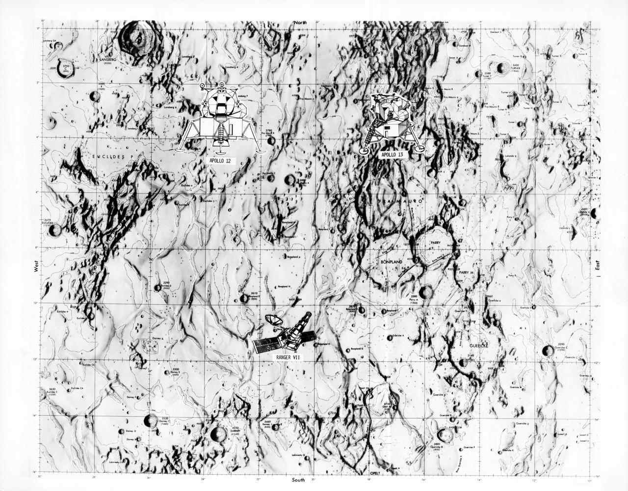
S70-28115 (January 1970) --- This overlay map of terrain on the lunar nearside shows the area of the landing site of the upcoming Apollo 13 mission, in relation to two previous NASA landings. The proposed Apollo 13 landing site is located in the highlands north of Fra Mauro. The coordinates of the planned site are 17.550 degrees west longitude and 3.617 degrees south latitude. The landing site of the Apollo 12 mission, which was highlighted by a lunar landing on Nov. 19, 1969, is located approximately 105 nautical miles west of the Apollo 13 site. The landing site of the unmanned Ranger 7 space vehicle, which impacted on the moon on July 31, 1964, at 10.74 degrees south latitude and 20.7 degrees west longitude, is approximately 130 nautical miles south-southwest of the Apollo 13 site, and approximately 140 nautical miles south-southeast of the Apollo 12 site.
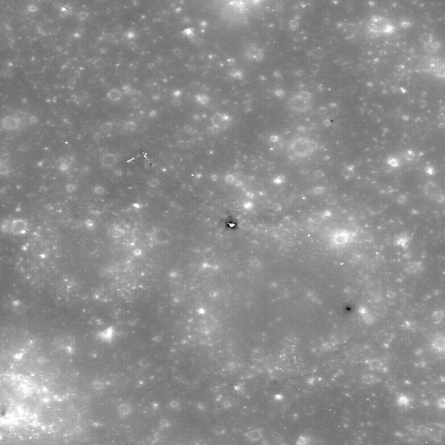
New view of the Apollo 12 landing site in Oceanus Procellarum imaged from NASA Lunar Reconnaissance Orbiter mapping orbit.
NASA is scheduled to launch the Lunar Reconnaissance Orbiter, an unmanned mission to comprehensively map the entire moon, on June 18, 2009.

NASA Voyager 2 spacecraft flew by Triton, a moon of Neptune, in the summer of 1989. Dr. Paul Schenk, a scientist at the Lunar and Planetary Institute in Houston, used Voyager data to construct the best-ever global color map of Triton.
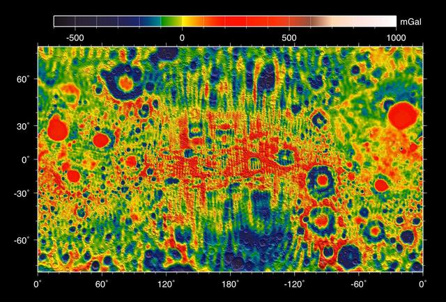
This map shows the gravity field of the moon from the Lunar Prospector mission. The viewing perspective, known as a Mercator projection, shows the far side of the moon in the center and the nearside as viewed from Earth at either side.
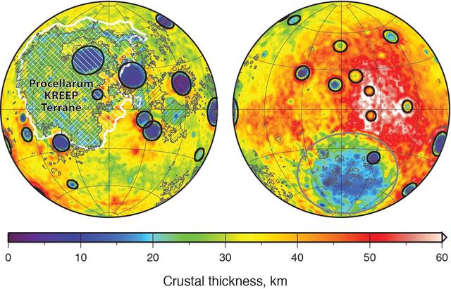
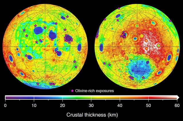
Global map of crustal thickness of the moon derived from gravity data obtained by NASA GRAIL spacecraft. The lunar near side is represented on the left hemisphere. The far side is represented in the right hemisphere.

This graphic depicting the bulk density of the lunar highlands on the near and far sides of the moon was generated using gravity data from NASA GRAIL mission and topography data from NASA Lunar Reconnaissance Orbiter.
This graphic depicting the bulk density of the lunar highlands on the near and far sides of the moon was generated using gravity data from NASA GRAIL mission and topography data from NASA Lunar Reconnaissance Orbiter.
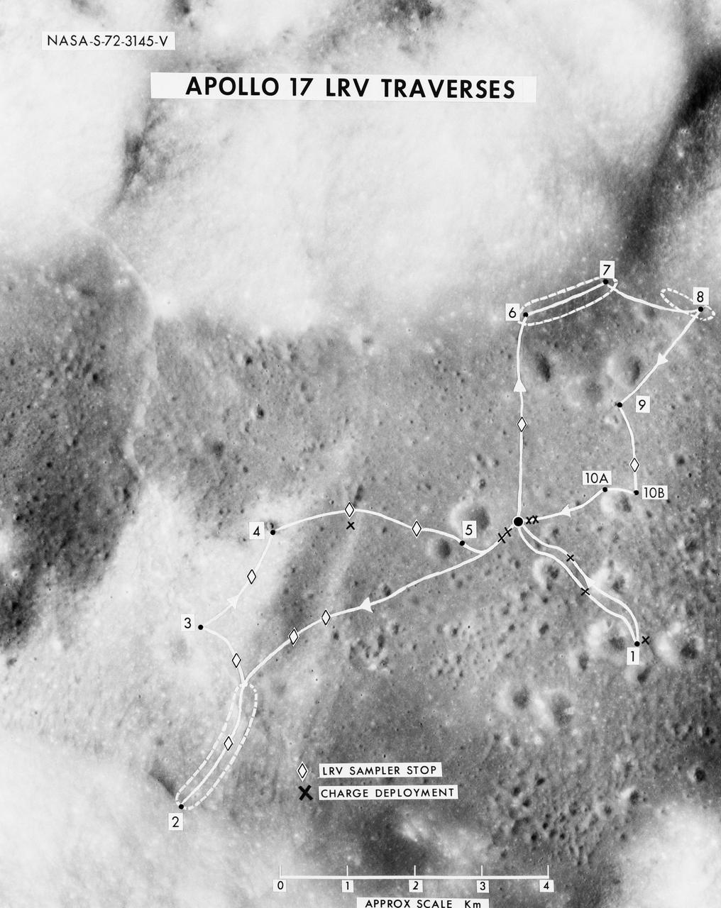
S72-03145 (October 1972) --- A vertical view of the Apollo 17 Taurus-Littrow site with an overlay to illustrate the three planned Apollo 17 traverses using the Lunar Roving Vehicle (LRV). The EVA-1 traverse has a single station (1); the EVA-2 traverse has four stations (2,3,4,5); and the EVA-3 traverse has five stations (6,7,8,9,10). Stations 10-A and 10-B are alternate locations for Station 10. In addition to the major stations mentioned above, brief stops are planned for sampling between stations using the LRV sampler tool (note diamond-shaped figures), and for deploying explosive charges associated with the Lunar Seismic Profiling Experiment (LSPE - note black x-marks).
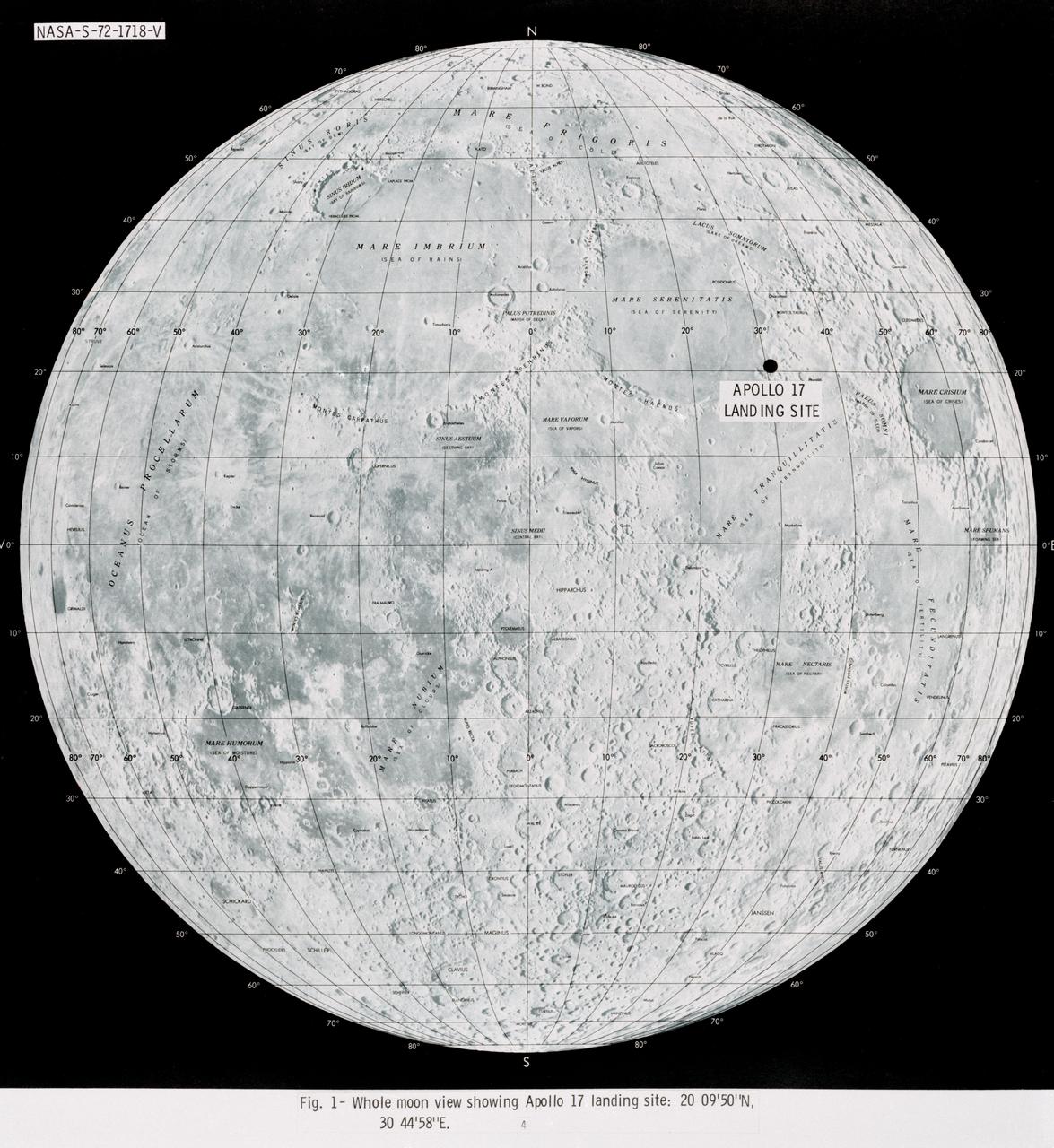
S72-01718 (July 1972) --- A photographic illustration of a full moon showing the location of the Apollo 17 landing site on the lunar nearside. The black dot pinpointing the landing site is in the Taurus-Littrow area at the southeastern edge of the Sea of Serenity. The coordinates of the landing point are 30 degrees 44 minutes 58 seconds east longitude and 20 degrees 9 minutes 50 seconds north latitude.
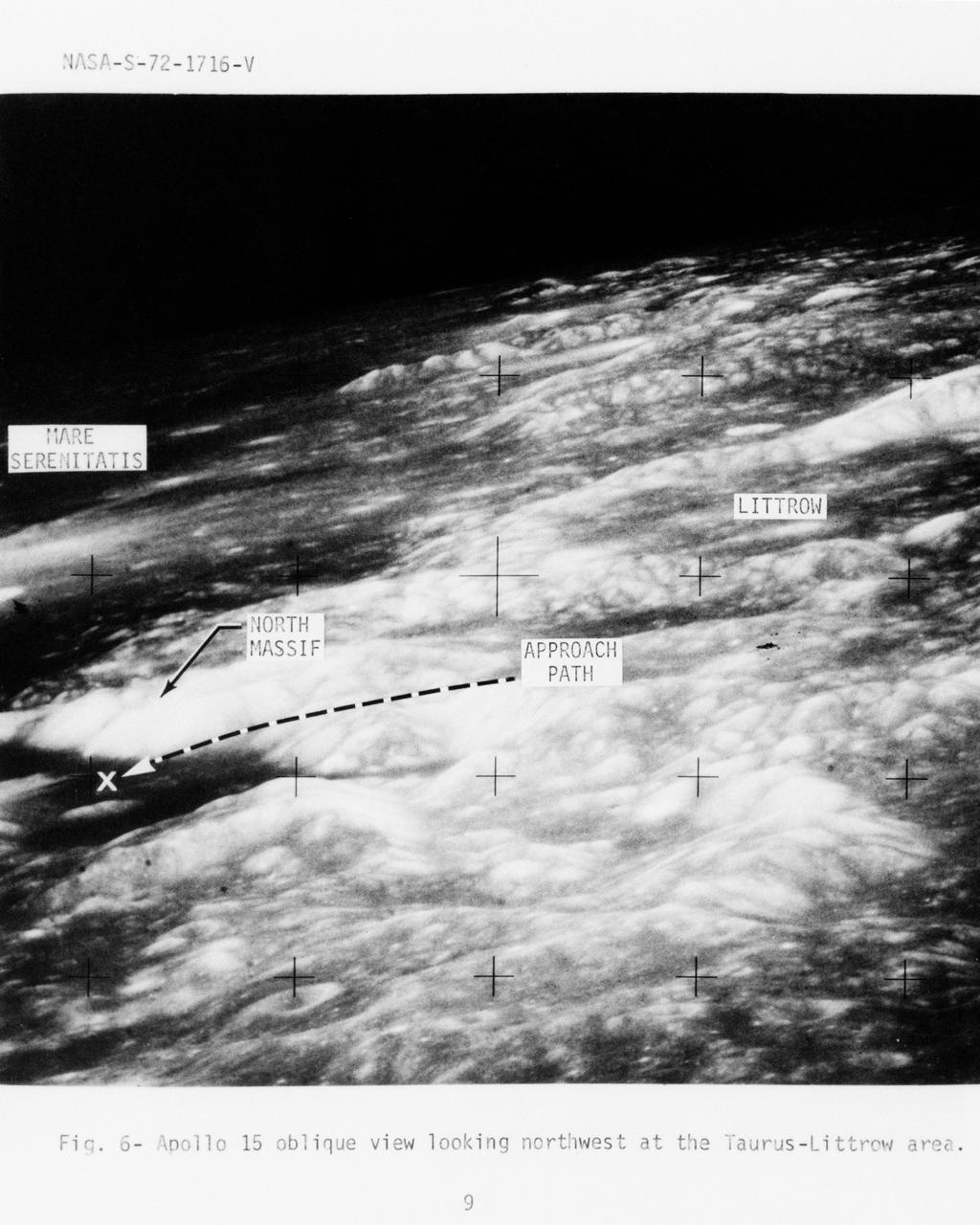
S72-01716 (July 1972) --- An oblique view of the Taurus-Littrow area on the lunar nearside, as photographed from the Apollo 15 spacecraft in lunar orbit. This is an enlarged view. The "X" marks the landing site of the scheduled Apollo 17 lunar landing mission. The overlay points out several features in the photograph. The coordinates of the Apollo 17 touchdown point are 30 degrees 44 minutes 58 seconds east longitude and 20 degrees 9 minutes 50 seconds north latitude.

S71-44150 (February 1971) --- A vertical view of the Apollo 16 landing site located in the Descartes area on the lunar nearside. The overlay indicates the location of the proposed touchdown point for the Apollo 16 Lunar Module (LM). Descartes is located west of the Sea of Nectar and southwest of the Sea of Tranquility. This photograph was taken with a 500mm lens camera from lunar orbit by the Apollo 16 crew. Astronauts John W. Young, commander; and Charles M. Duke Jr., lunar module pilot; descended in the Apollo 16 LM "Orion" to explore the Descartes highlands landing site on the moon. Astronaut Thomas K. Mattingly II, command module pilot, remained with the Command and Service Modules (CSM) "Casper" in lunar orbit.
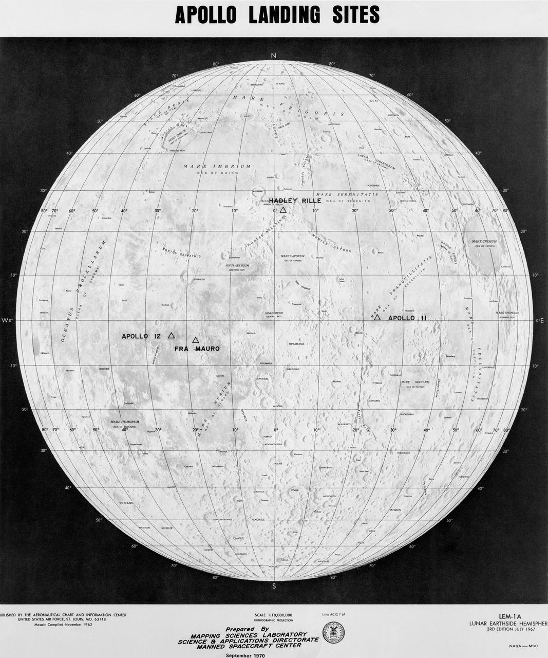
S70-50761 (September 1970) --- This map prepared by Mapping Sciences Laboratory, Science & Applications Directorate at the Manned Spacecraft Center, shows the projected Apollo landing sites. Apollo 11 completed a successful lunar landing mission in the Sea of Tranquility in July 1969. Apollo 12 completed a successful lunar landing mission in the Ocean of Storms in November 1969.
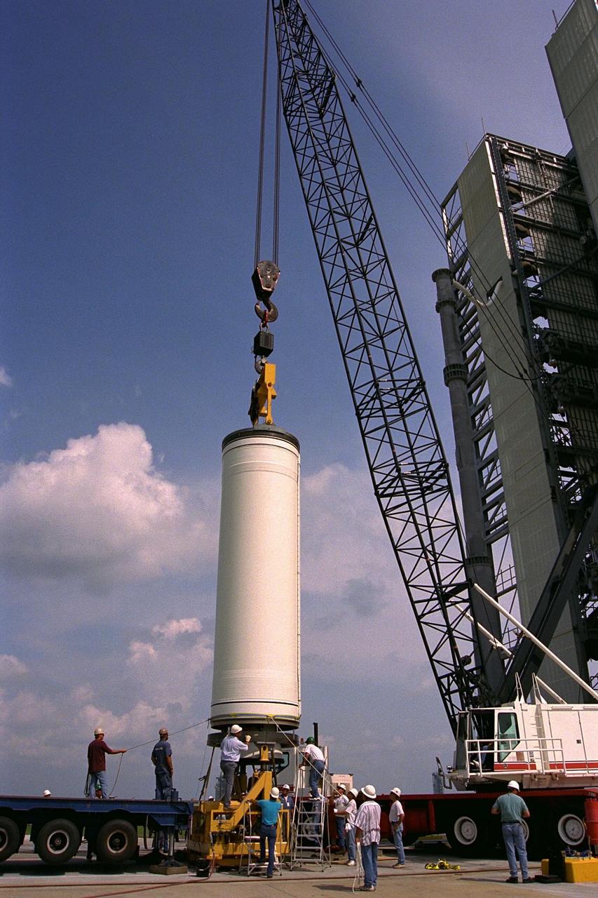
Workers erect the first stage of a Lockheed Martin Launch Vehicle-2 (LMLV-2) at Launch Complex 46 at Cape Canaveral Air Station, Fla. The Lunar Prospector spacecraft is scheduled to launch aboard the LMLV-2 in October for an 18-month mission that will orbit the Earth’s Moon to collect data from the lunar surface. Designed for a low polar orbit investigation of the Moon, the Lunar Prospector will map the Moon’s surface composition and possible polar ice deposits, measure magnetic and gravity fields, and study lunar outgassing events

Workers erect the first stage of a Lockheed Martin Launch Vehicle-2 (LMLV-2) at Launch Complex 46 at Cape Canaveral Air Station, Fla. The Lunar Prospector spacecraft is scheduled to launch aboard the LMLV-2 in October for an 18-month mission that will orbit the Earth’s Moon to collect data from the lunar surface. Designed for a low polar orbit investigation of the Moon, the Lunar Prospector will map the Moon’s surface composition and possible polar ice deposits, measure magnetic and gravity fields, and study lunar outgassing events
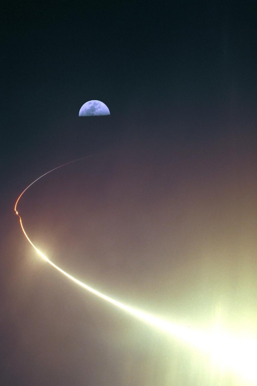
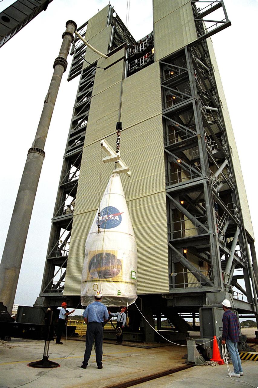
KENNEDY SPACE CENTER, FLA. - NASA's Lunar Prospector spacecraft launched successfully on its way to the Moon from Launch Complex 46 (LC46) at Cape Canaveral Air Station on Jan. 6 at 9:38 p.m. EST. It was the inaugural launch of Lockheed Martin's Athena II launch vehicle and the first launch from LC46, operated by Spaceport Florida Authority. Lunar Prospector, built for the NASA Ames Research Center by Lockheed Martin, is a spin-stabilized spacecraft designed to provide NASA with the first global maps of the Moon's surface and its gravitational magnetic fields, as well as look for the possible presence of ice near the lunar poles. It will orbit the Moon at an altitude of approximately 63 miles during a one-year mission.
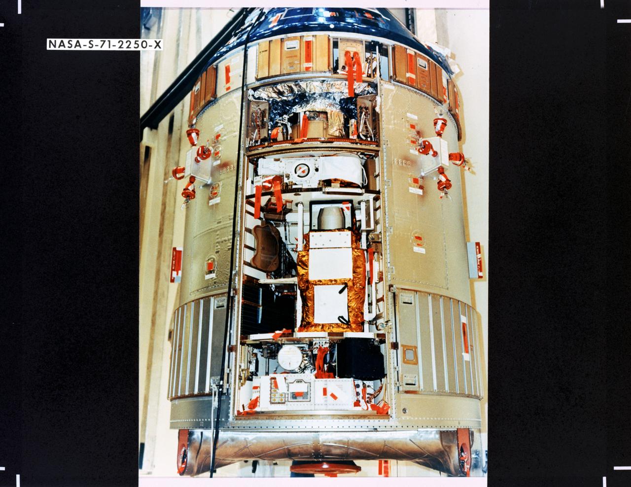
S71-2250X (June 1971) --- A close-up view of the Scientific Instrument Module (SIM) to be flown for the first time on the Apollo 15 lunar landing mission. Mounted in a previously vacant sector of the Apollo Service Module (SM), the SIM carries specialized cameras and instrumentation for gathering lunar orbit scientific data. SIM equipment includes a laser altimeter for accurate measurement of height above the lunar surface; a large-format panoramic camera for mapping, correlated with a metric camera and the laser altimeter for surface mapping; a gamma ray spectrometer on a 25-feet extendible boom; a mass spectrometer on a 21-feet extendible boom; X-ray and alpha particle spectrometers; and a subsatellite which will be injected into lunar orbit carrying a particle and magnetometer, and the S-Band transponder.

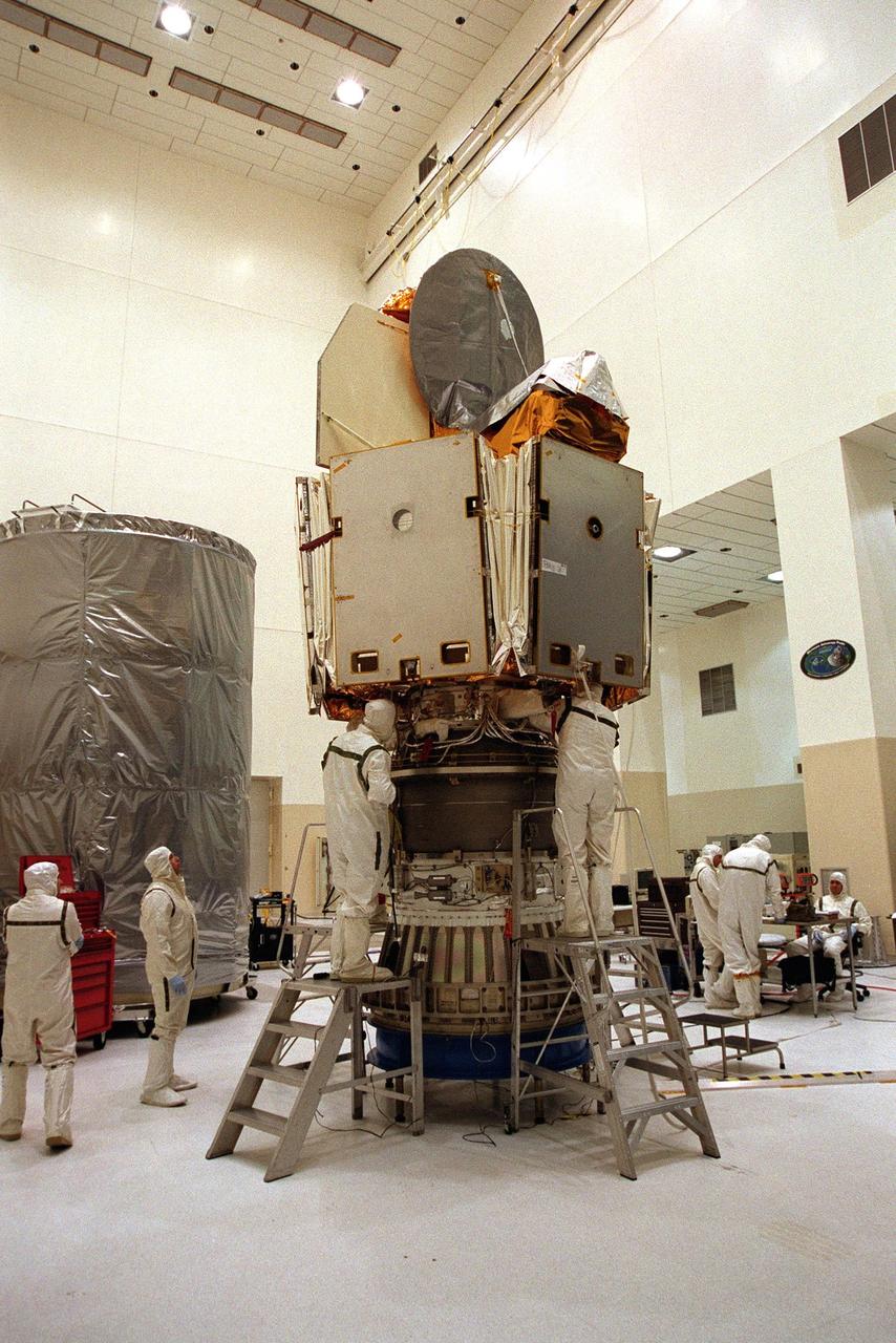
KENNEDY SPACE CENTER, Fla. -- The Microwave Anisotropy Probe (MAP) is mated to the upper stage of the Boeing Delta II rocket. The rocket is scheduled to launch the MAP instrument June 30 into a lunar-assisted trajectory to the Sun-Earth for a 27-month mission. MAP will measure small fluctuations in the temperature of the cosmic microwave background radiation to an accuracy of one millionth of a degree. These measurements should reveal the size, matter content, age, geometry and fate of the universe. They will also reveal the primordial structure that grew to form galaxies and will test ideas about the origins of these primordial structures. The MAP instrument will be continuously shaded from the Sun, Earth, and Moon by the spacecraft. It is a product of Goddard Space Flight Center in partnership with Princeton University
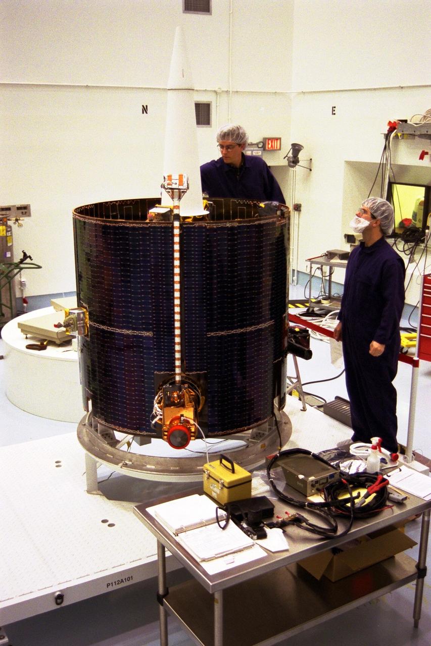
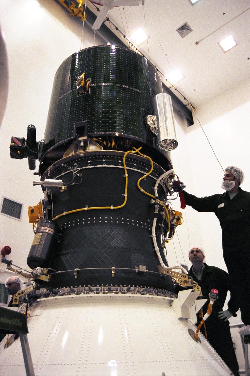
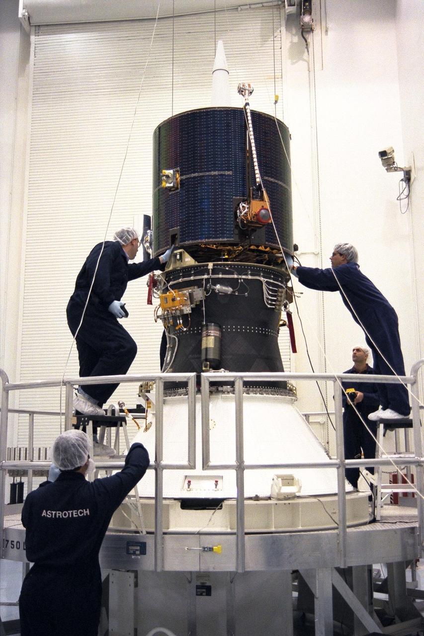
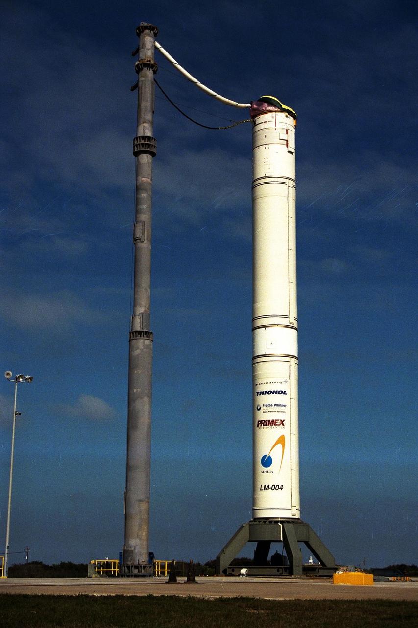
Lockheed Martin Missile Systems technicians prepare NASA’s Lunar Prospector spacecraft for mating to the Trans Lunar Injection Module of the spacecraft at Astrotech, a commercial payload processing facility, in Titusville, Fla. The small robotic spacecraft, to be launched for NASA on an Athena II launch vehicle by Lockheed Martin, is designed to provide the first global maps of the Moon’s surface compositional elements and its gravitational and magnetic fields. The launch of Lunar Prospector is scheduled for Jan. 5, 1998 at 8:31 p.m
NASA’s Lunar Prospector is prepared for mating to the Trans Lunar Injection Module of the spacecraft, seen in the background, at Astrotech, a commercial payload processing facility, in Titusville, Fla. The small robotic spacecraft, to be launched for NASA on an Athena II launch vehicle by Lockheed Martin, is designed to provide the first global maps of the Moon’s surface compositional elements and its gravitational and magnetic fields. The launch of Lunar Prospector is scheduled for Jan. 5, 1998 at 8:31 p.m
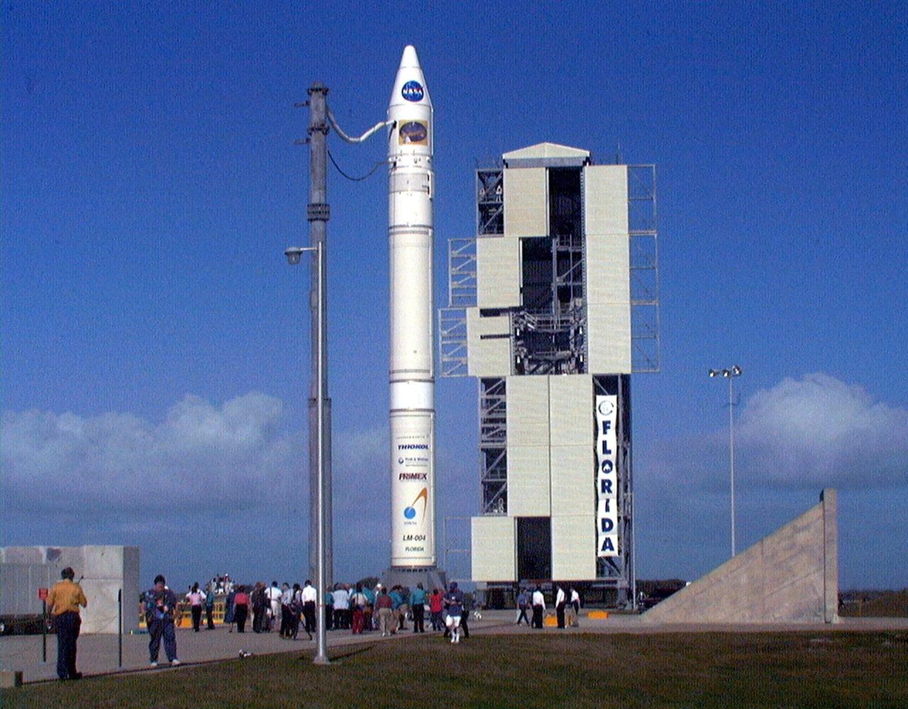
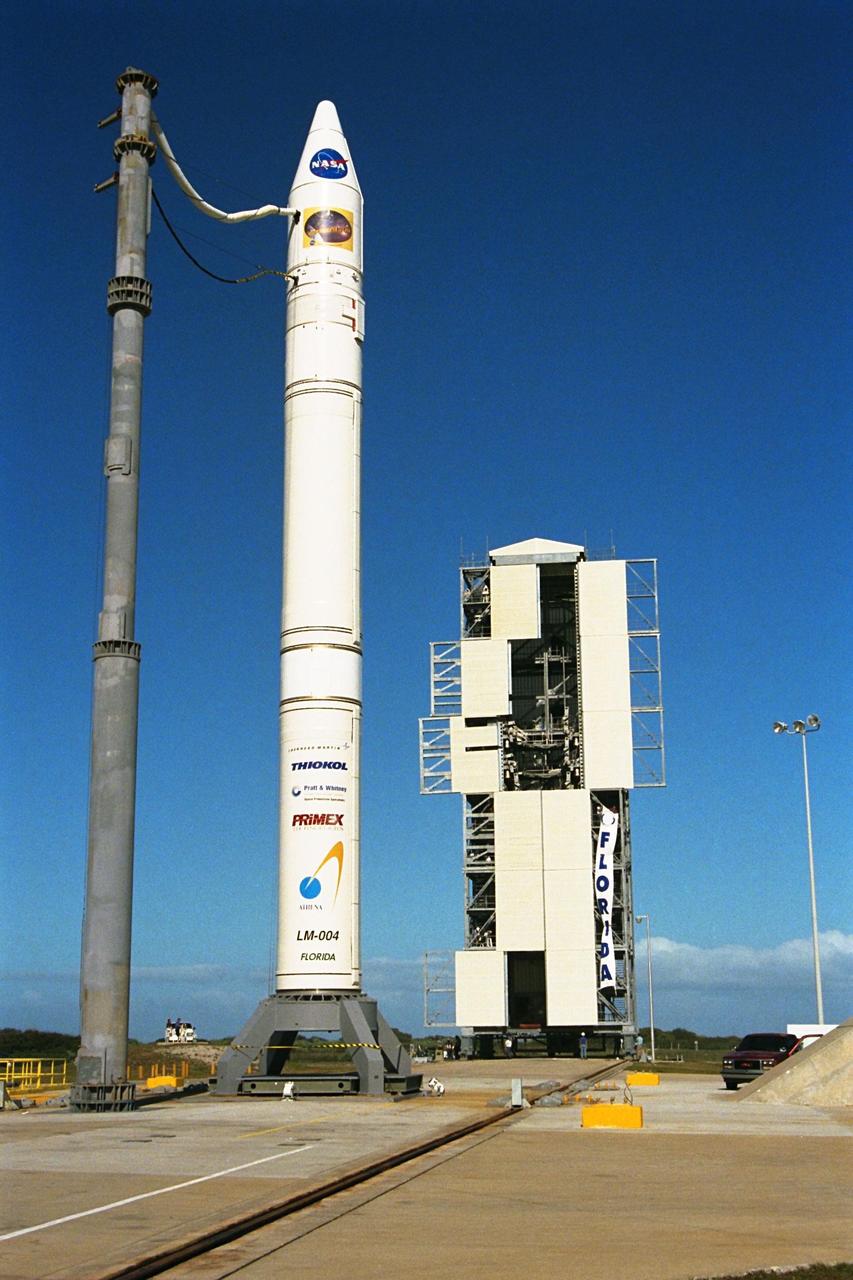
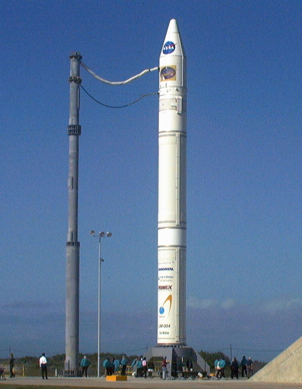
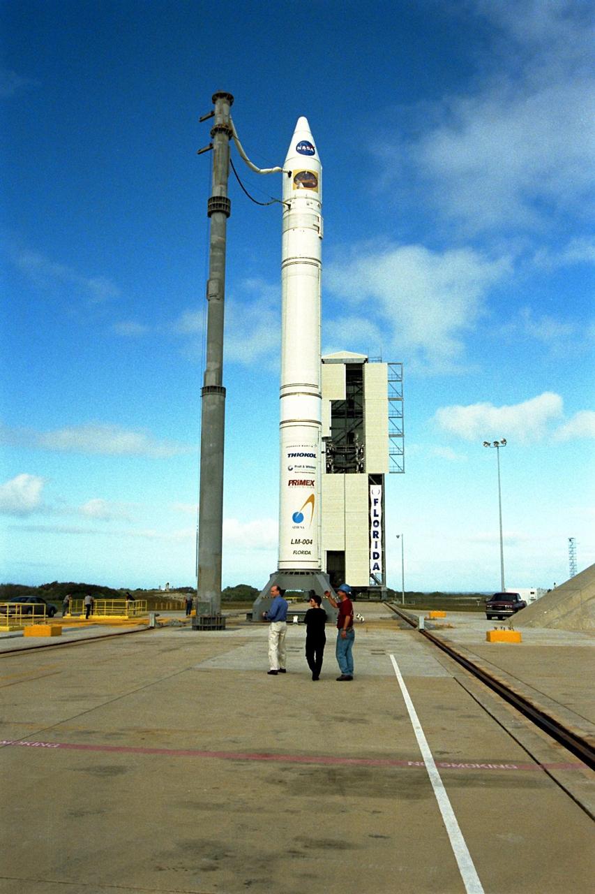
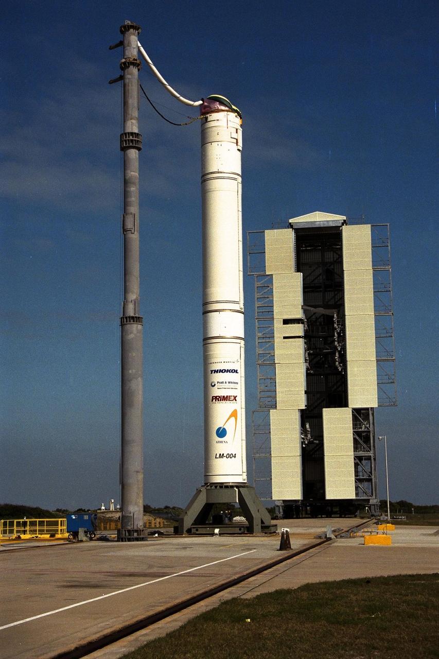
NASA’s Lunar Prospector is prepared for mating to a Lockheed Martin Athena II launch vehicle at Cape Canaveral Air Station’s Launch Complex 46. Lunar Prospector, built for the NASA Ames Research Center by Lockheed Martin, is a spin-stabilized spacecraft designed to provide NASA the first global maps of the Moon’s surface and its gravitational magnetic fields. It will orbit the Moon at an altitude of approximately 63 miles during a one-year mission. The launch of Lunar Prospector is scheduled for Jan. 5, 1998 at 8:31 p.m. EST
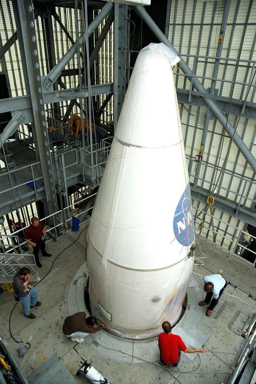
NASA’s Lunar Prospector is mated to a Lockheed Martin Athena II launch vehicle at Cape Canaveral Air Station’s Launch Complex 46. Lunar Prospector, built for the NASA Ames Research Center by Lockheed Martin, is a spin-stabilized spacecraft designed to provide NASA the first global maps of the Moon’s surface and its gravitational magnetic fields. It will orbit the Moon at an altitude of approximately 63 miles during a one-year mission. The launch of Lunar Prospector is scheduled for Jan. 5, 1998 at 8:31 p.m. EST
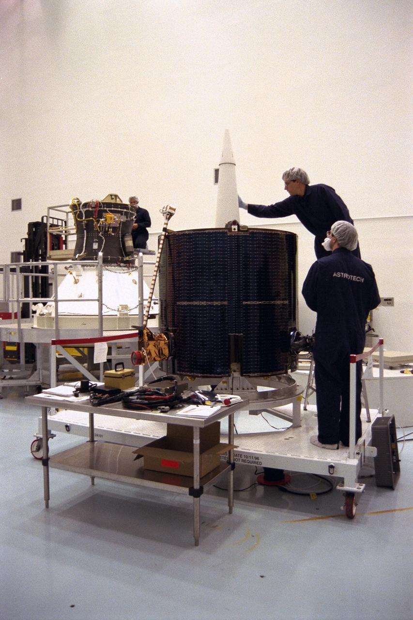
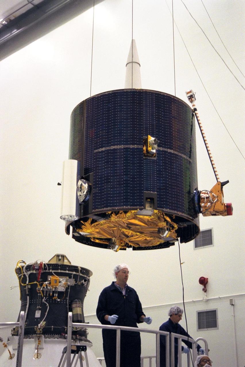
Lockheed Martin Missile Systems integration and test staff join NASA’s Lunar Prospector spacecraft atop the Trans Lunar Injection Module of the spacecraft at Astrotech, a commercial payload processing facility, in Titusville, Fla. The small robotic spacecraft, to be launched on an Athena II launch vehicle by Lockheed Martin, is designed to provide the first global maps of the Moon’s surface compositional elements and its gravitational and magnetic fields. The launch of Lunar Prospector is scheduled for Jan. 5, 1998 at 8:31 p.m
NASA’s Lunar Prospector is prepared for mating to a Lockheed Martin Athena II launch vehicle at Cape Canaveral Air Station’s Launch Complex 46. Lunar Prospector, built for the NASA Ames Research Center by Lockheed Martin, is a spin-stabilized spacecraft designed to provide NASA the first global maps of the Moon’s surface and its gravitational magnetic fields. It will orbit the Moon at an altitude of approximately 63 miles during a one-year mission. The launch of Lunar Prospector is scheduled for Jan. 5, 1998 at 8:31 p.m. EST
Lockheed Martin Missile Systems integration and test staff prepare NASA’s Lunar Prospector spacecraft for mating to the Trans Lunar Injection Module of the spacecraft at Astrotech, a commercial payload processing facility, in Titusville, Fla. The small robotic spacecraft, to be launched for NASA on an Athena II launch vehicle by Lockheed Martin, is designed to provide the first global maps of the Moon’s surface compositional elements and its gravitational and magnetic fields. The launch of Lunar Prospector is scheduled for Jan. 5, 1998 at 8:31 p.m
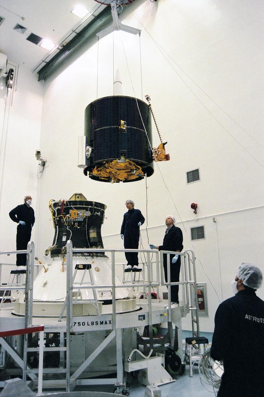
Lockheed Martin Missile Systems integration and test staff move NASA’s Lunar Prospector spacecraft over the Trans Lunar Injection Module of the spacecraft at Astrotech, a commercial payload processing facility, in Titusville, Fla. The small robotic spacecraft, to be launched on an Athena II launch vehicle by Lockheed Martin, is designed to provide the first global maps of the Moon’s surface compositional elements and its gravitational and magnetic fields. The launch of Lunar Prospector is scheduled for Jan. 5, 1998 at 8:31 p.m
Lockheed Martin Missile Systems integration and test staff join NASA’s Lunar Prospector spacecraft to the Trans Lunar Injection Module of the spacecraft at Astrotech, a commercial payload processing facility, in Titusville, Fla. The small robotic spacecraft, to be launched on an Athena II launch vehicle by Lockheed Martin, is designed to provide the first global maps of the Moon’s surface compositional elements and its gravitational and magnetic fields. The launch of Lunar Prospector is scheduled for Jan. 5, 1998 at 8:31 p.m

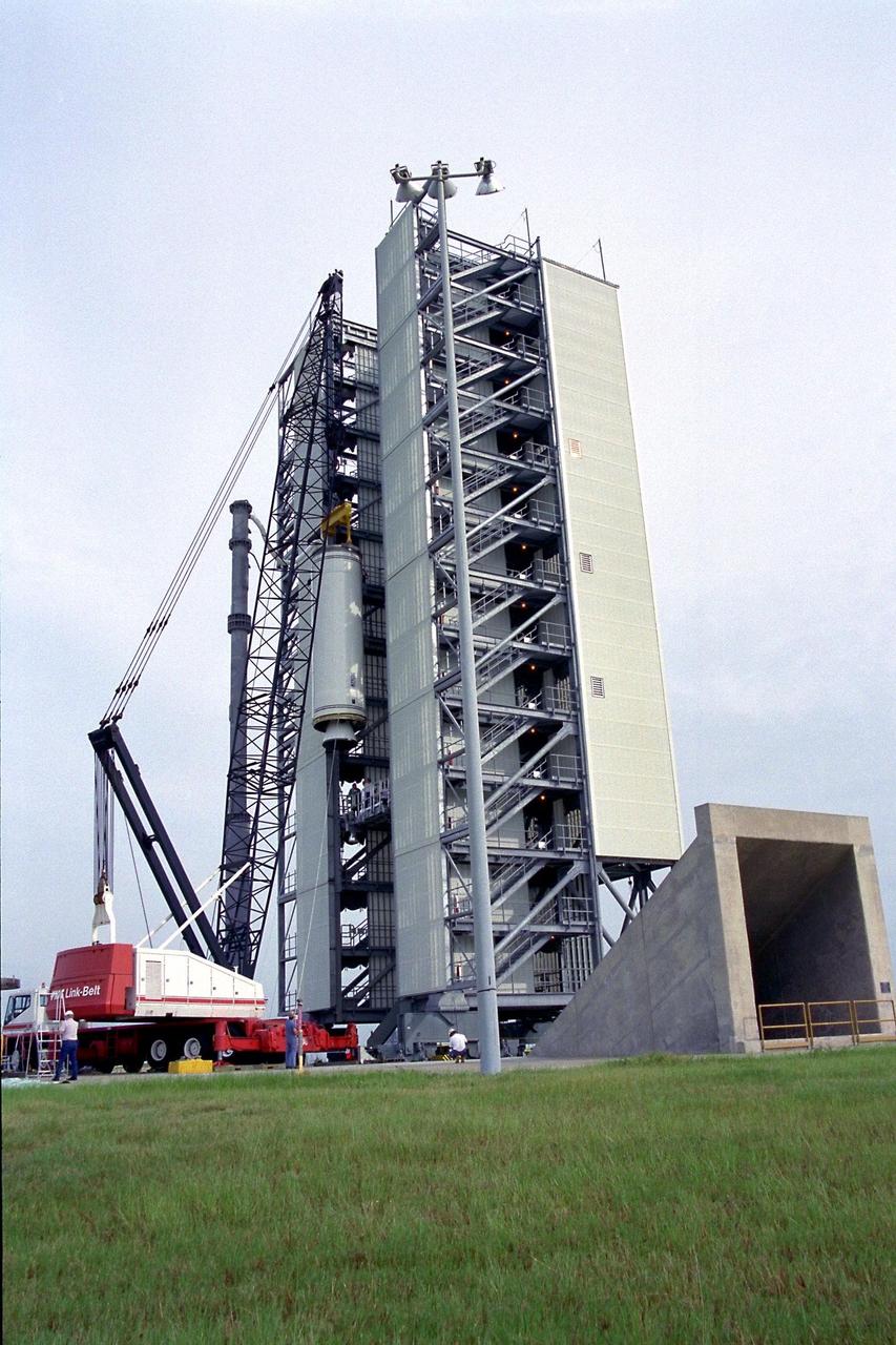
NASA’s Lunar Prospector is lifted at Cape Canaveral Air Station’s Launch Complex 46 before mating to a Lockheed Martin Athena II launch vehicle. Lunar Prospector, built for the NASA Ames Research Center by Lockheed Martin, is a spin-stabilized spacecraft designed to provide NASA the first global maps of the Moon’s surface and its gravitational magnetic fields. It will orbit the Moon at an altitude of approximately 63 miles during a one-year mission. The launch of Lunar Prospector is scheduled for Jan. 5, 1998 at 8:31 p.m. EST

S71-40085 (July 1971) --- An enlarged Lunar Orbiter photograph of the Apollo 15 landing area in the Hadley-Apennine region on the nearside of the moon. The overlay indicates the location of the numerous informally-named surface features. These names will facilitate understanding the verbal descriptions from the astronauts during their lunar surface extravehicular activity (EVA). This is an August 1967, Lunar Orbiter V photograph of Site 26.1.
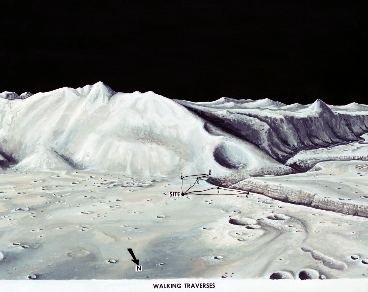
S71-33432 (1 July 1971) --- These alternative traverses can be carried out on foot. They will be used if the Lunar Roving Vehicle (LRV) becomes inoperative. This artist's concept showing part of the Hadley Rille and several of the Apennine Mountains was excerpted from "On the Moon with Apollo 15: A Guidebook to the Hadley-Apennine Region," by Gene Simmons. Artwork by Jerry Elmore.
The sixth marned lunar landing mission, the Apollo 16 (SA-511), carrying three astronauts: Mission commander John W. Young, Command Module pilot Thomas K. Mattingly II, and Lunar Module pilot Charles M. Duke, lifted off on April 16, 1972. The Apollo 16 continued the broad-scale geological, geochemical, and geophysical mapping of the Moon's crust, begun by the Apollo 15, from lunar orbit. This mission marked the first use of the Moon as an astronomical observatory by using the ultraviolet camera/spectrograph. It photographed ultraviolet light emitted by Earth and other celestial objects. The Lunar Roving Vehicle was also used. The mission ended on April 27, 1972.
NASA’s Lunar Prospector is readied for launch as its gantry-like service tower is rolled back at Cape Canaveral Air Station’s Launch Complex 46. Lunar Prospector, built for the NASA Ames Research Center by Lockheed Martin, is a spin-stabilized spacecraft designed to provide NASA with the first global maps of the Moon’s surface and its gravitational magnetic fields, as well as look for the possible presence of ice near the lunar poles. It will orbit the Moon at an altitude of approximately 63 miles during a one-year mission. The launch of Lunar Prospector is scheduled for Jan. 5, 1998 at 8:31 p.m. EST
NASA’s Lunar Prospector is readied for launch as its gantry-like service tower is rolled back at Cape Canaveral Air Station’s Launch Complex 46. Lunar Prospector, built for the NASA Ames Research Center by Lockheed Martin, is a spin-stabilized spacecraft designed to provide NASA with the first global maps of the Moon’s surface and its gravitational magnetic fields, as well as look for the possible presence of ice near the lunar poles. It will orbit the Moon at an altitude of approximately 63 miles during a one-year mission. The launch of Lunar Prospector is scheduled for Jan. 5, 1998 at 8:31 p.m. EST
NASA’s Lunar Prospector is readied for launch as its gantry-like service tower is rolled back at Cape Canaveral Air Station’s Launch Complex 46. Lunar Prospector, built for the NASA Ames Research Center by Lockheed Martin, is a spin-stabilized spacecraft designed to provide NASA with the first global maps of the Moon’s surface and its gravitational magnetic fields, as well as look for the possible presence of ice near the lunar poles. It will orbit the Moon at an altitude of approximately 63 miles during a one-year mission. The launch of Lunar Prospector is scheduled for Jan. 5, 1998 at 8:31 p.m. EST
NASA’s Lunar Prospector is readied for launch as its gantry-like service tower is rolled back at Cape Canaveral Air Station’s Launch Complex 46. Lunar Prospector, built for the NASA Ames Research Center by Lockheed Martin, is a spin-stabilized spacecraft designed to provide NASA with the first global maps of the Moon’s surface and its gravitational magnetic fields, as well as look for the possible presence of ice near the lunar poles. It will orbit the Moon at an altitude of approximately 63 miles during a one-year mission. The launch of Lunar Prospector is scheduled for Jan. 5, 1998 at 8:31 p.m. EST
The second stage of the Lockheed Martin Launch Vehicle-2 (LMLV-2) is hoisted into position at Launch Pad 46 at Cape Canaveral Air Station for mating to the rocket’s first stage, which is out of camera view. The LMLV-2 will carry the Lunar Prospector spacecraft, scheduled to launch in October for an 18-month mission that will orbit the Earth’s moon to collect data from the lunar surface. Designed for a low polar orbit investigation of the moon, the Lunar Prospector will map the moon’s surface composition and possible polar ice deposits, measure magnetic and gravity fields, and study lunar outgassing events

KENNEDY SPACE CENTER, Fla. -- Photographers gather in the Spacecraft Assembly and Encapsulation Facility -2 for a media showing of the Microwave Anisotropy Probe (MAP). The MAP is mated to the upper stage of the Boeing Delta II rocket. The rocket is scheduled to launch the MAP instrument June 30 into a lunar-assisted trajectory to the Sun-Earth for a 27-month mission. MAP will measure small fluctuations in the temperature of the cosmic microwave background radiation to an accuracy of one millionth of a degree. These measurements should reveal the size, matter content, age, geometry and fate of the universe. They will also reveal the primordial structure that grew to form galaxies and will test ideas about the origins of these primordial structures. The MAP instrument will be continuously shaded from the Sun, Earth, and Moon by the spacecraft. It is a product of Goddard Space Flight Center in partnership with Princeton University
KENNEDY SPACE CENTER, Fla. -- Workers in the Spacecraft Assembly and Encapsulation Facility -2 prepare the Microwave Anisotropy Probe (MAP) for a media showing. The MAP is mated to the upper stage of the Boeing Delta II rocket. The rocket is scheduled to launch the MAP instrument June 30 into a lunar-assisted trajectory to the Sun-Earth for a 27-month mission. MAP will measure small fluctuations in the temperature of the cosmic microwave background radiation to an accuracy of one millionth of a degree. These measurements should reveal the size, matter content, age, geometry and fate of the universe. They will also reveal the primordial structure that grew to form galaxies and will test ideas about the origins of these primordial structures. The MAP instrument will be continuously shaded from the Sun, Earth, and Moon by the spacecraft. It is a product of Goddard Space Flight Center in partnership with Princeton University

KENNEDY SPACE CENTER, Fla. -- Workers in the Spacecraft Assembly and Encapsulation Facility -2 prepare the Microwave Anisotropy Probe (MAP) for a media showing. The MAP is mated to the upper stage of the Boeing Delta II rocket. The rocket is scheduled to launch the MAP instrument June 30 into a lunar-assisted trajectory to the Sun-Earth for a 27-month mission. MAP will measure small fluctuations in the temperature of the cosmic microwave background radiation to an accuracy of one millionth of a degree. These measurements should reveal the size, matter content, age, geometry and fate of the universe. They will also reveal the primordial structure that grew to form galaxies and will test ideas about the origins of these primordial structures. The MAP instrument will be continuously shaded from the Sun, Earth, and Moon by the spacecraft. It is a product of Goddard Space Flight Center in partnership with Princeton University
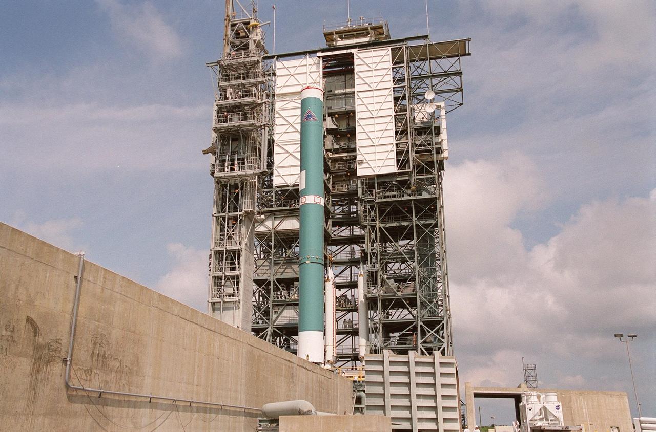
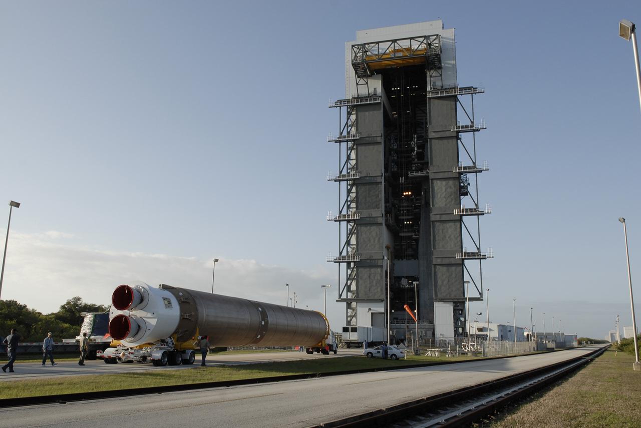
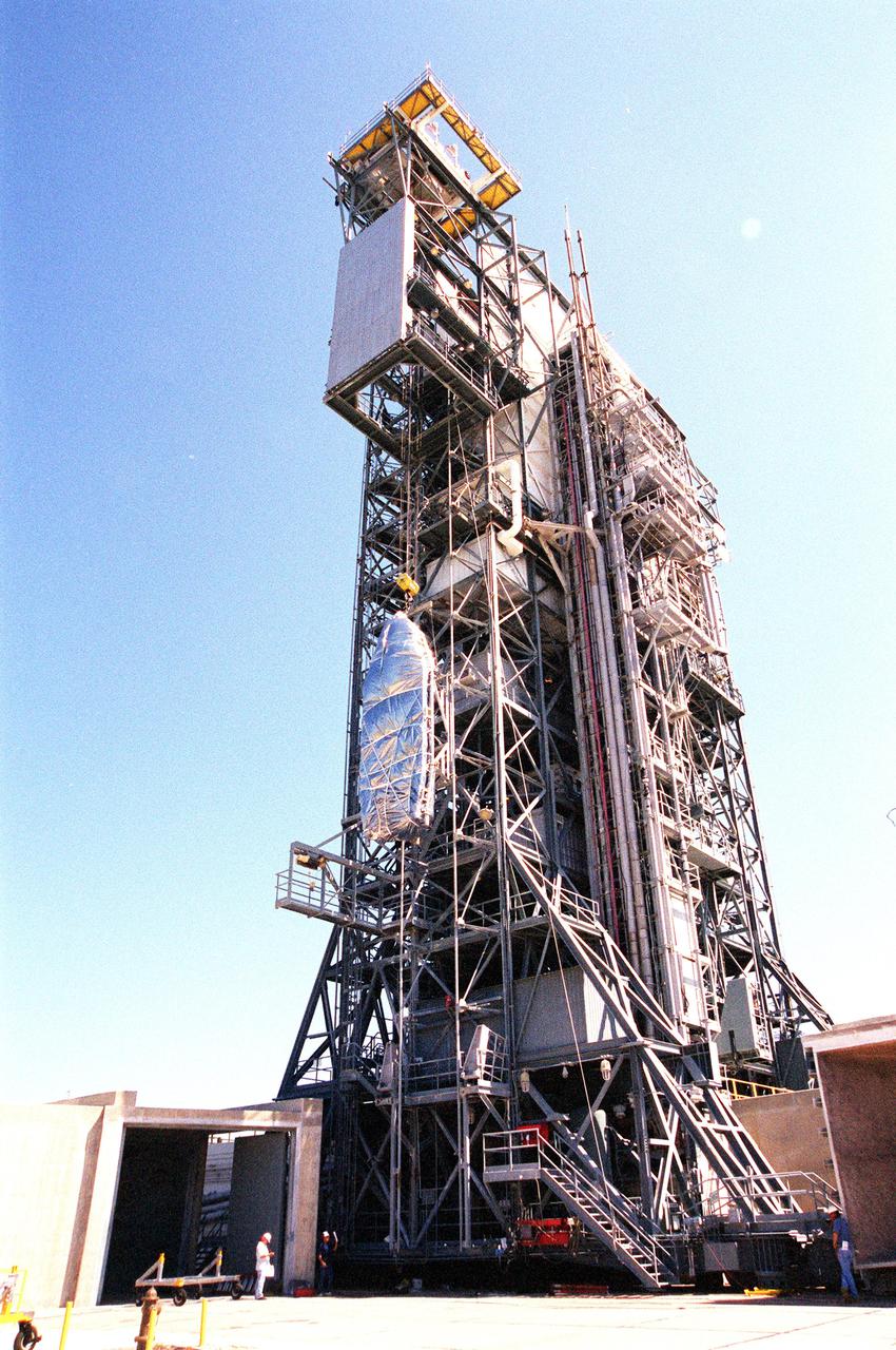
KENNEDY SPACE CENTER, FLA. -- On Launch Complex 17-B, Cape Canaveral Air Force Station, the Delta II rocket waits to be mated to four solid rocket boosters (behind the Delta). The rocket will launch the MAP instrument into a lunar-assisted trajectory to the Sun-Earth for a 27-month mission. The MAP mission will examine conditions in the early universe by measuring temperature differences in cosmic microwave background radiation, which is the radiant heat left over from the Big Bang. The properties of this radiation directly reflect conditions in the early universe. MAP is scheduled to launch June 30 at 3:46:46 p.m. EDT
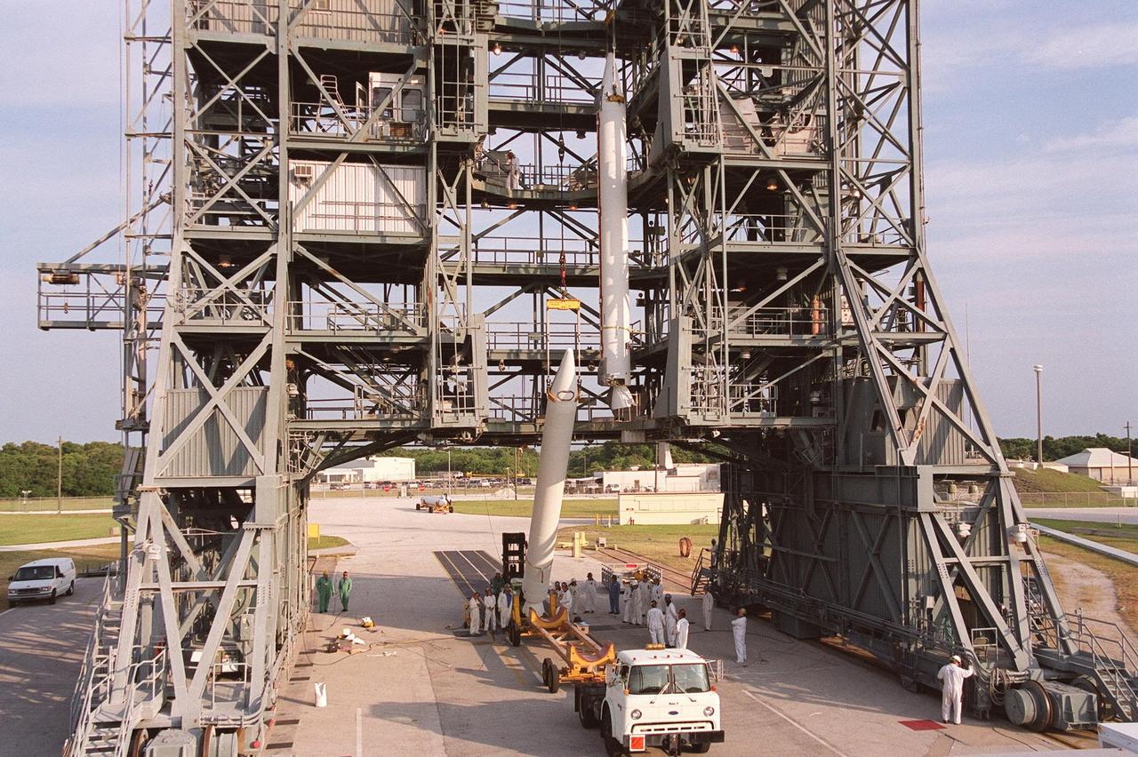
KENNEDY SPACE CENTER, FLA. -- A second solid rocket booster is lifted up the gantry at Launch Complex 17-B, Cape Canaveral Air Force Station. The SRBs will be mated to the Delta II rocket that will launch the MAP instrument into a lunar-assisted trajectory to the Sun-Earth for a 27-month mission. The MAP mission will examine conditions in the early universe by measuring temperature differences in cosmic microwave background radiation, which is the radiant heat left over from the Big Bang. The properties of this radiation directly reflect conditions in the early universe. MAP is scheduled to launch June 30 at 3:46:46 p.m. EDT

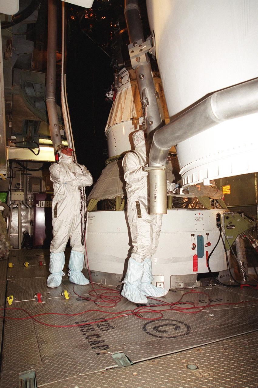
KENNEDY SPACE CENTER, Fla. -- At Launch Complex 17-B, Cape Canaveral Air Force Station, the canister is removed from the Microwave Anisotropy Probe (MAP). Launch of MAP via a Boeing Delta II rocket is scheduled for June 30. The launch will place MAP into a lunar-assisted trajectory to the Sun-Earth for a 27-month mission. The probe will measure small fluctuations in the temperature of the cosmic microwave background radiation to an accuracy of one millionth of a degree. These measurements should reveal the size, matter content, age, geometry and fate of the universe. They will also reveal the primordial structure that grew to form galaxies and will test ideas about the origins of these primordial structures
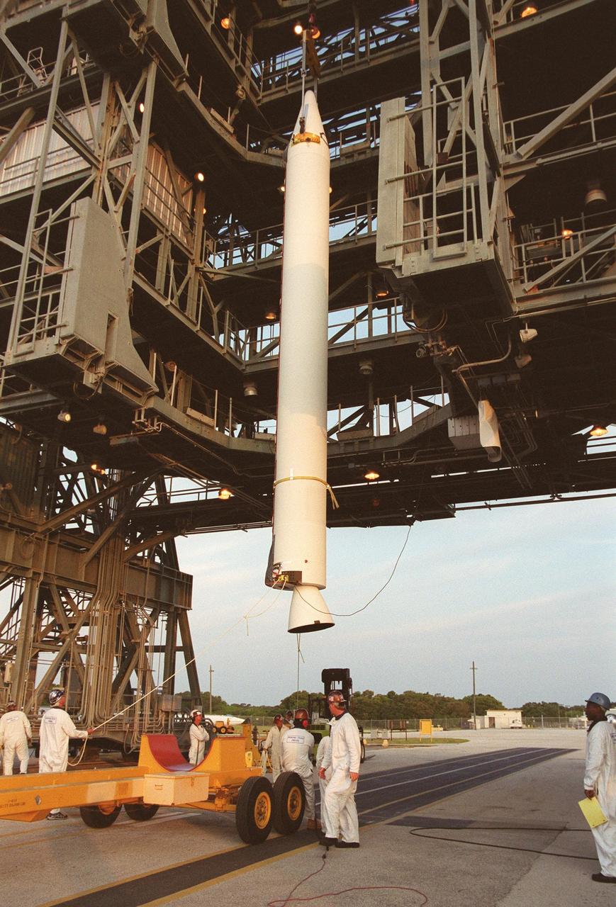
KENNEDY SPACE CENTER, FLA. -- A solid rocket booster is lifted up the gantry at Launch Complex 17-B, Cape Canaveral Air Force Station. The SRB will be mated to the Delta II rocket that will launch the MAP instrument into a lunar-assisted trajectory to the Sun-Earth for a 27-month mission. The MAP mission will examine conditions in the early universe by measuring temperature differences in cosmic microwave background radiation, which is the radiant heat left over from the Big Bang. The properties of this radiation directly reflect conditions in the early universe. MAP is scheduled to launch June 30 at 3:46:46 p.m. EDT
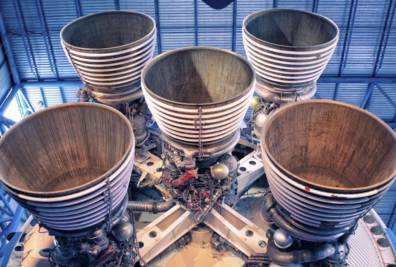
CAPE CANAVERAL, Fla. – As seen on Google Maps, the massive F-1 engines of the Saturn V's first stage on display inside the Apollo/Saturn V Center at the Kennedy Space Center Visitor Complex. Each engine stands 19 feet tall with a diameter of more than 12 feet. The five engines on the first stage produced 7.5 million pounds of thrust at liftoff. The Saturn V was used to launch NASA's Apollo missions to the moon which saw 12 astronauts land and work on the lunar surface. Google precisely mapped Kennedy Space Center and some of its historical facilities for the company's map page. Photo credit: Google/Wendy Wang

KENNEDY SPACE CENTER, Fla. -- Workers at Launch Complex 17-B, Cape Canaveral Air Force Station, place protective covers around the Microwave Anisotropy Probe (MAP) spacecraft. Launch of MAP via a Boeing Delta II rocket is scheduled for June 30. The launch will place MAP into a lunar-assisted trajectory to the Sun-Earth for a 27-month mission. The probe will measure small fluctuations in the temperature of the cosmic microwave background radiation to an accuracy of one millionth of a degree. These measurements should reveal the size, matter content, age, geometry and fate of the universe. They will also reveal the primordial structure that grew to form galaxies and will test ideas about the origins of these primordial structures
KENNEDY SPACE CENTER, FLA. -- Four solid rocket boosters are lifted up the gantry at Launch Complex 17-B, Cape Canaveral Air Force Station. The SRBs will be mated to the Delta II rocket that will launch the MAP instrument into a lunar-assisted trajectory to the Sun-Earth for a 27-month mission. The MAP mission will examine conditions in the early universe by measuring temperature differences in cosmic microwave background radiation, which is the radiant heat left over from the Big Bang. The properties of this radiation directly reflect conditions in the early universe. MAP is scheduled to launch June 30 at 3:46:46 p.m. EDT

KENNEDY SPACE CENTER, Fla. -- At Launch Complex 17-B, Cape Canaveral Air Force Station, workers place a cover over the Microwave Anisotropy Probe (MAP) spacecraft. Launch of MAP via a Boeing Delta II rocket is scheduled for June 30. The launch will place MAP into a lunar-assisted trajectory to the Sun-Earth for a 27-month mission. The probe will measure small fluctuations in the temperature of the cosmic microwave background radiation to an accuracy of one millionth of a degree. These measurements should reveal the size, matter content, age, geometry and fate of the universe. They will also reveal the primordial structure that grew to form galaxies and will test ideas about the origins of these primordial structures

KENNEDY SPACE CENTER, Fla. -- Workers at Launch Complex 17-B, Cape Canaveral Air Force Station, place protective covers around the Microwave Anisotropy Probe (MAP) spacecraft. Launch of MAP via a Boeing Delta II rocket is scheduled for June 30. The launch will place MAP into a lunar-assisted trajectory to the Sun-Earth for a 27-month mission. The probe will measure small fluctuations in the temperature of the cosmic microwave background radiation to an accuracy of one millionth of a degree. These measurements should reveal the size, matter content, age, geometry and fate of the universe. They will also reveal the primordial structure that grew to form galaxies and will test ideas about the origins of these primordial structures
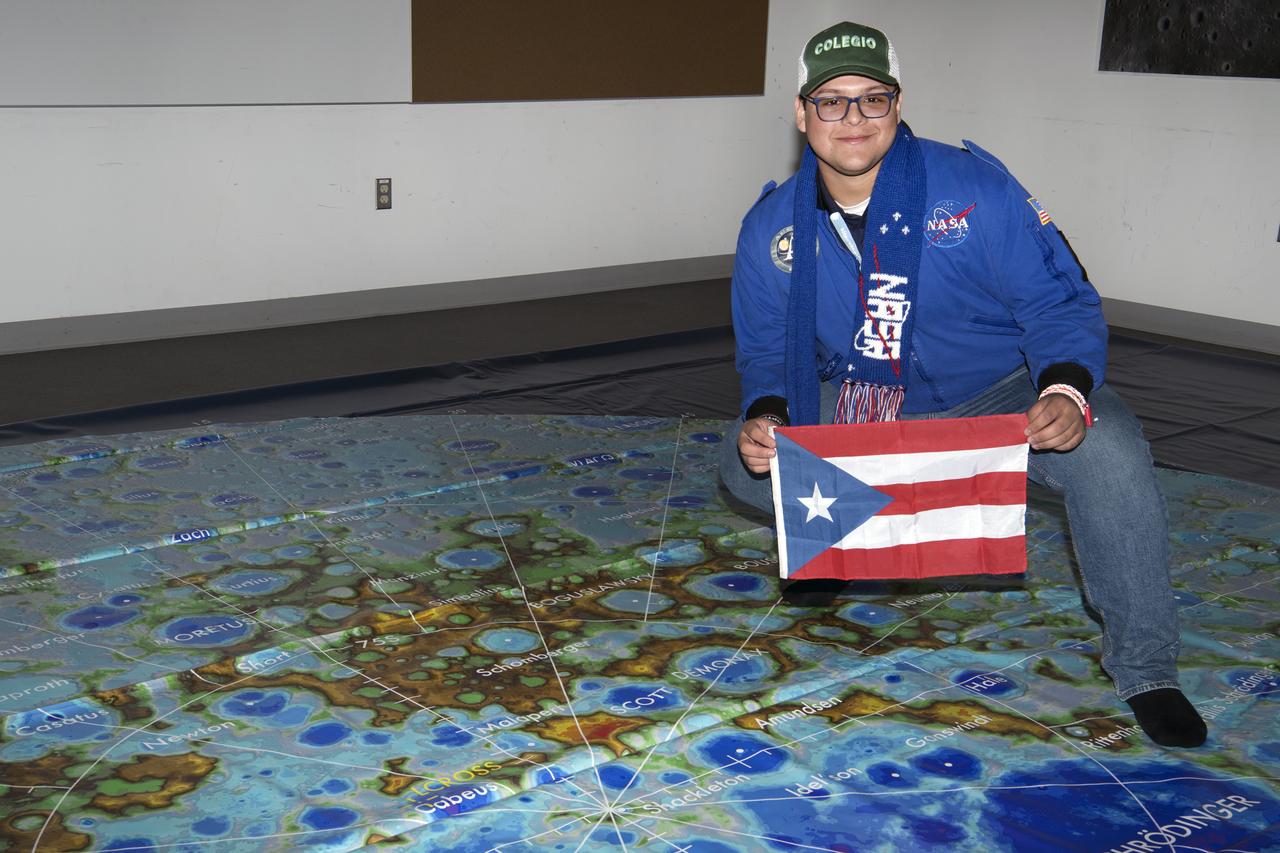
Social media followers visited GSFC Feb 10, 2020 learning role of Artemis, LRO Lunar Reconnaisssance Orbiter, and spoke with science experts while touring center Here student holds Puerto Rico flag over map
Workers hoist the first stage of a Lockheed Martin Launch Vehicle-2 (LMLV-2) for placement at Launch Complex 46 at Cape Canaveral Air Station (CCAS), Fla. The Lunar Prospector spacecraft is scheduled to launch aboard the LMLV-2 from CCAS in October for an 18-month mission that will orbit the Earth’s Moon to collect data from the lunar surface. Information gathered during the mission will allow construction of a detailed map of the surface composition of the Moon and will improve our understanding of its origin, evolution, current state, and resources
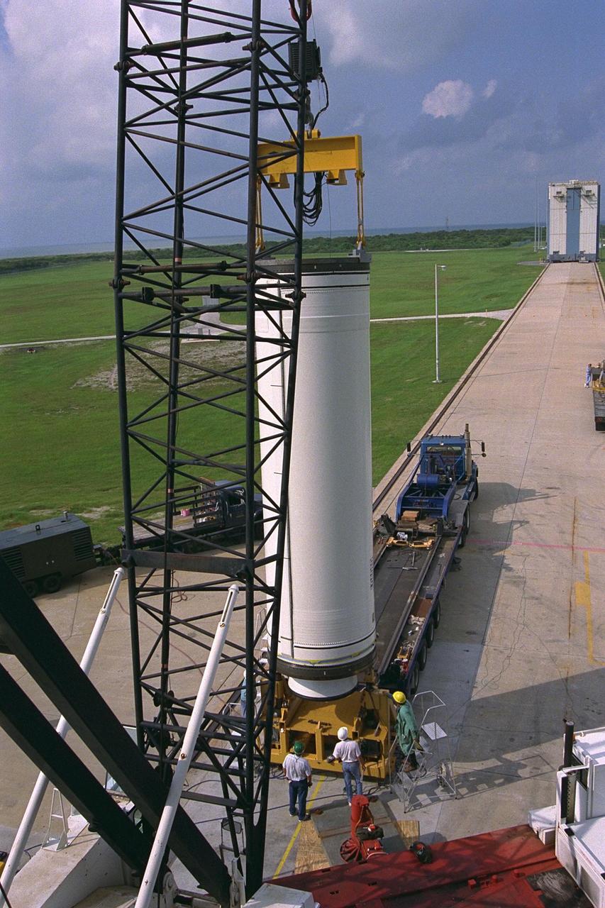
Workers hoist the first stage of a Lockheed Martin Launch Vehicle-2 (LMLV-2) for placement at Launch Complex 46 at Cape Canaveral Air Station (CCAS), Fla. The Lunar Prospector spacecraft is scheduled to launch aboard the LMLV-2 from CCAS in October for an 18-month mission that will orbit the Earth’s Moon to collect data from the lunar surface. Information gathered during the mission will allow construction of a detailed map of the surface composition of the Moon and will improve our understanding of its origin, evolution, current state, and resources
S71-44668 (31 July-2 Aug. 1971) --- An oblique view of the crater Humboldt, as photographed by the Fairchild metric camera in the Scientific Instrument Module (SIM) bay of the Apollo 15 Command and Service Modules (CSM) in lunar orbit. This view is looking southerly. Humboldt, which is 200 kilometers (124 statute miles) in diameter, is located at 81 degrees east longitude and 27 degrees south latitude. The three-inch mapping camera was one of eight lunar orbital science experiments located in the SIM bay.
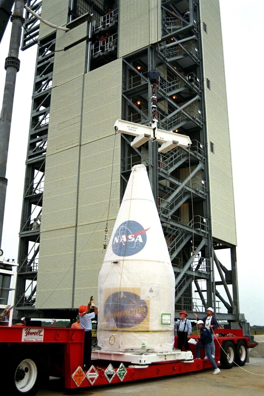
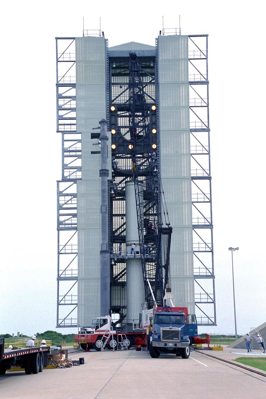
The access tower around the Athena II rocket for the Lunar Prospector spacecraft, to be launched for NASA by Lockheed Martin, was rolled back today at Launch Complex 46 at Cape Canaveral Air Station for final prelaunch preparations. The small robotic spacecraft is designed to provide the first global maps of the Moon's surface compositional elements and its gravitational and magnetic fields. The launch of Lunar Prospector is currently scheduled for Jan. 5, 1998 at 8:31 p.m

S72-32719 (March 1972) --- With four of the six planned lunar missions completed, this chart has been prepared to show the various areas of the lunar "nearside" to be visited by astronauts representing the NASA Apollo program. Apollo's 11, 12, 14 and 15 are shown at their respective landing points. Apollo 16 and Apollo 17, planned for later this year at Descartes and Taurus Littrow, respectively, also are depicted on the map.
The second stage of the Lockheed Martin Launch Vehicle-2 (LMLV-2) is mated to its first stage at Launch Complex 46 at Cape Canaveral Air Station. The LMLV-2 will carry the Lunar Prospector spacecraft, scheduled to launch in October for an 18-month mission that will orbit the Earth’s moon to collect data from the lunar surface. Information gathered during the mission will allow construction of a detailed map of the surface composition of the moon and will improve our understanding of its origin, evolution, current state, and resources
The access tower around the Athena II rocket for the Lunar Prospector spacecraft, to be launched for NASA by Lockheed Martin, was rolled back today at Launch Complex 46 at Cape Canaveral Air Station for final prelaunch preparations. The small robotic spacecraft is designed to provide the first global maps of the Moon's surface compositional elements and its gravitational and magnetic fields. The launch of Lunar Prospector is currently scheduled for Jan. 5, 1998 at 8:31 p.m
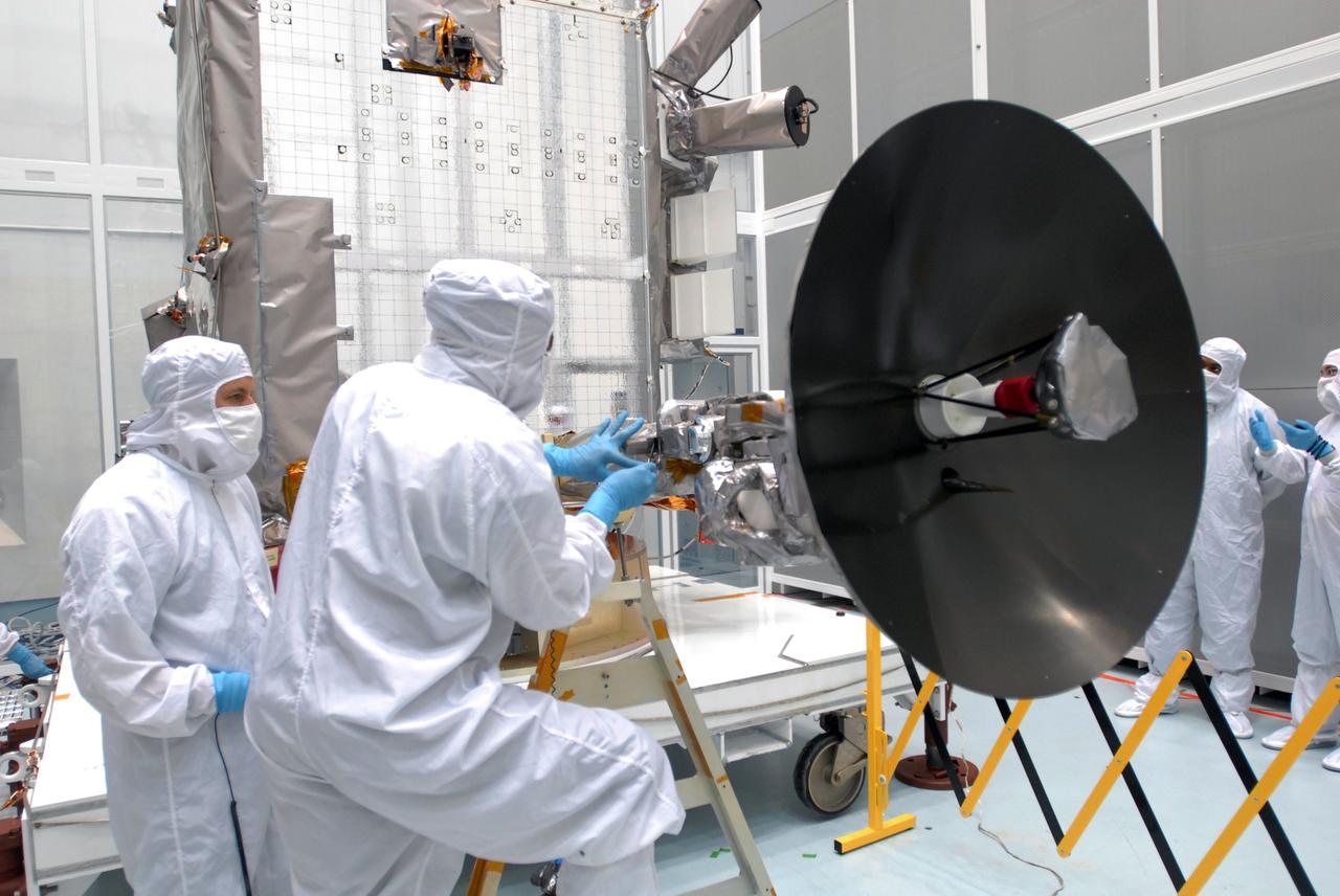
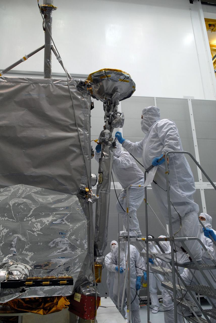
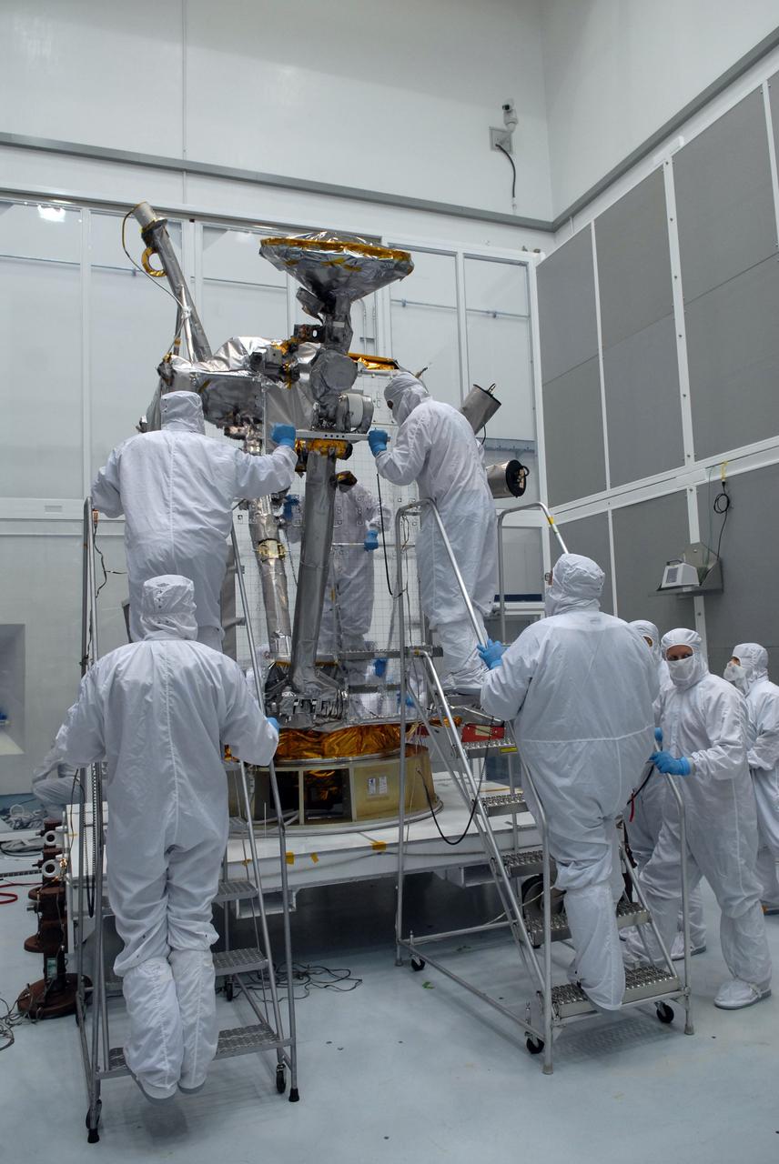
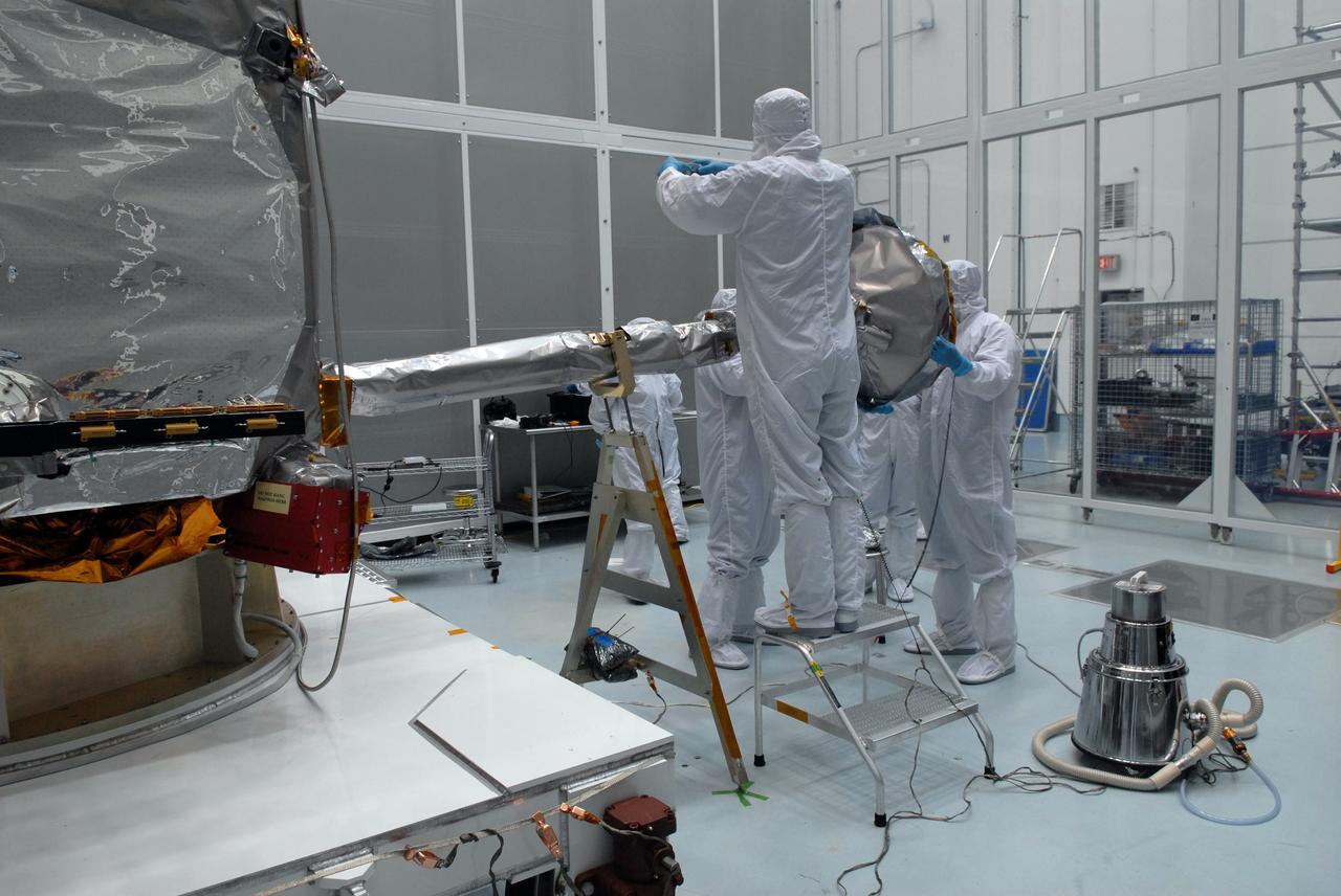
CAPE CANAVERAL, Fla. – At Astrotech Space Operations in Titusville, Fla., technicians are testing the range of motion on the high-gain antenna for the Lunar Reconnaissance Orbiter. The orbiter will carry seven instruments to provide scientists with detailed maps of the lunar surface and enhance our understanding of the moon's topography, lighting conditions, mineralogical composition and natural resources. Information gleaned from LRO will be used to select safe landing sites, determine locations for future lunar outposts and help mitigate radiation dangers to astronauts. Launch of LRO is targeted no earlier than June 2. Photo credit: NASA/Jim Grossmann
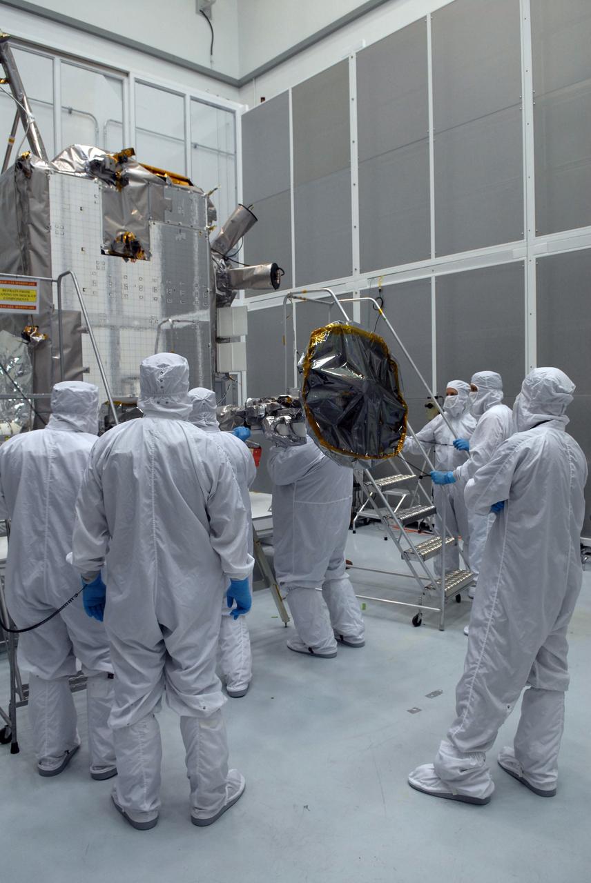
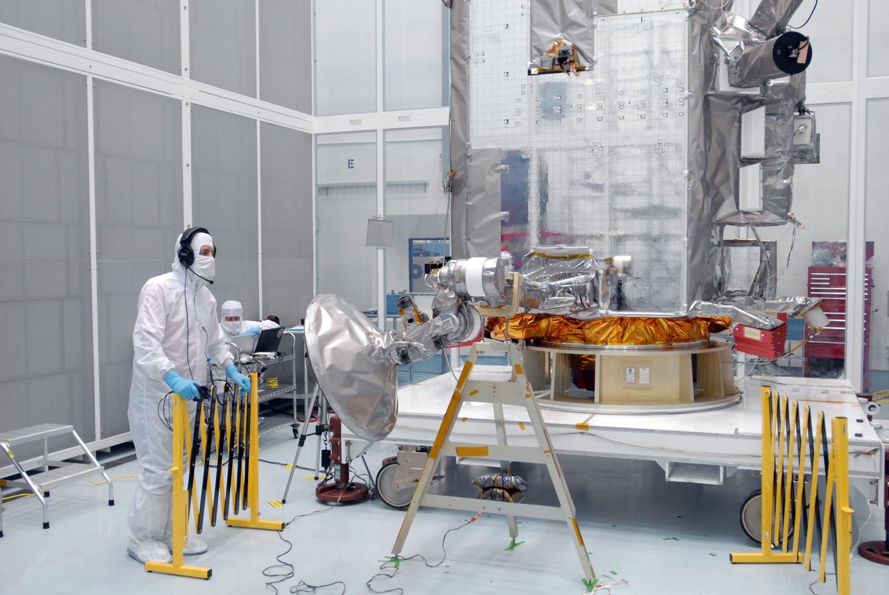
CAPE CANAVERAL, Fla. – At Astrotech Space Operations in Titusville, Fla., technicians begin stowing NASA's Lunar Reconnaissance Orbiter's high-gain antenna. The antenna completed a range of motion test. The orbiter will carry seven instruments to provide scientists with detailed maps of the lunar surface and enhance our understanding of the moon's topography, lighting conditions, mineralogical composition and natural resources. Information gleaned from LRO will be used to select safe landing sites, determine locations for future lunar outposts and help mitigate radiation dangers to astronauts. Launch of LRO is targeted no earlier than June 2. Photo credit: NASA/Jack Pfaller
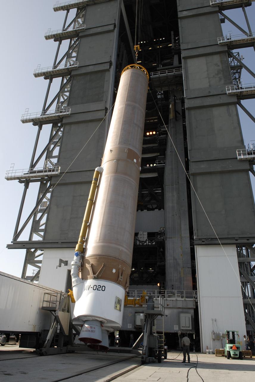
CAPE CANAVERAL, Fla. –– When the Atlas V first stage is raised to vertical, it will be lifted into the Vertical Integration Facility on Cape Canaveral Air Force Station's Launch Complex 41. The Atlas V/Centaur is the launch vehicle for the Lunar Reconnaissance Orbiter, or LRO. The orbiter will carry seven instruments to provide scientists with detailed maps of the lunar surface and enhance our understanding of the moon's topography, lighting conditions, mineralogical composition and natural resources. Information gleaned from LRO will be used to select safe landing sites, determine locations for future lunar outposts and help mitigate radiation dangers to astronauts. Launch of LRO is targeted no earlier than June 2. Photo credit: NASA/Kim Shiflett
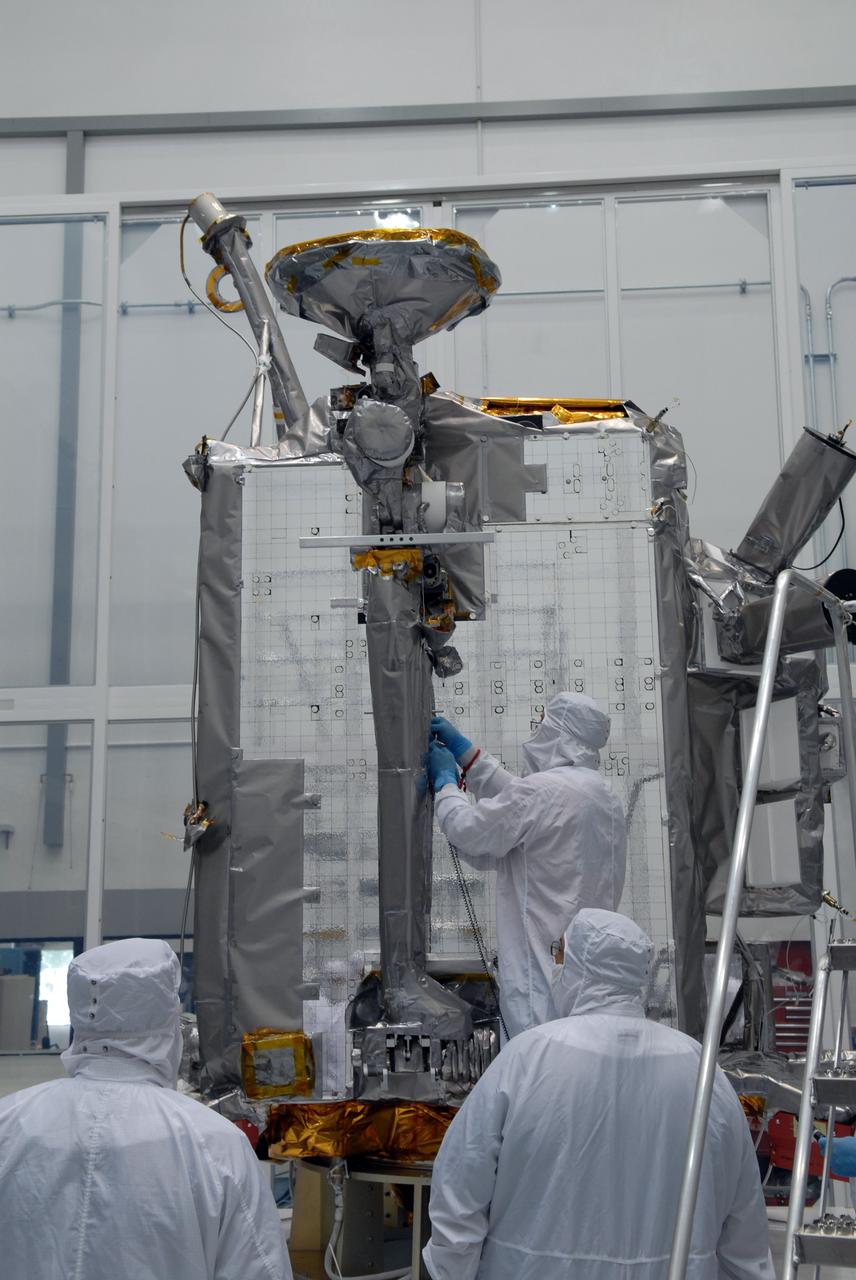
CAPE CANAVERAL, Fla. – At Astrotech Space Operations in Titusville, Fla., technicians secure NASA's Lunar Reconnaissance Orbiter's high-gain antenna into place for stowage. The antenna completed a range of motion test. The orbiter will carry seven instruments to provide scientists with detailed maps of the lunar surface and enhance our understanding of the moon's topography, lighting conditions, mineralogical composition and natural resources. Information gleaned from LRO will be used to select safe landing sites, determine locations for future lunar outposts and help mitigate radiation dangers to astronauts. Launch of LRO is targeted no earlier than June 2. Photo credit: NASA/Jack Pfaller
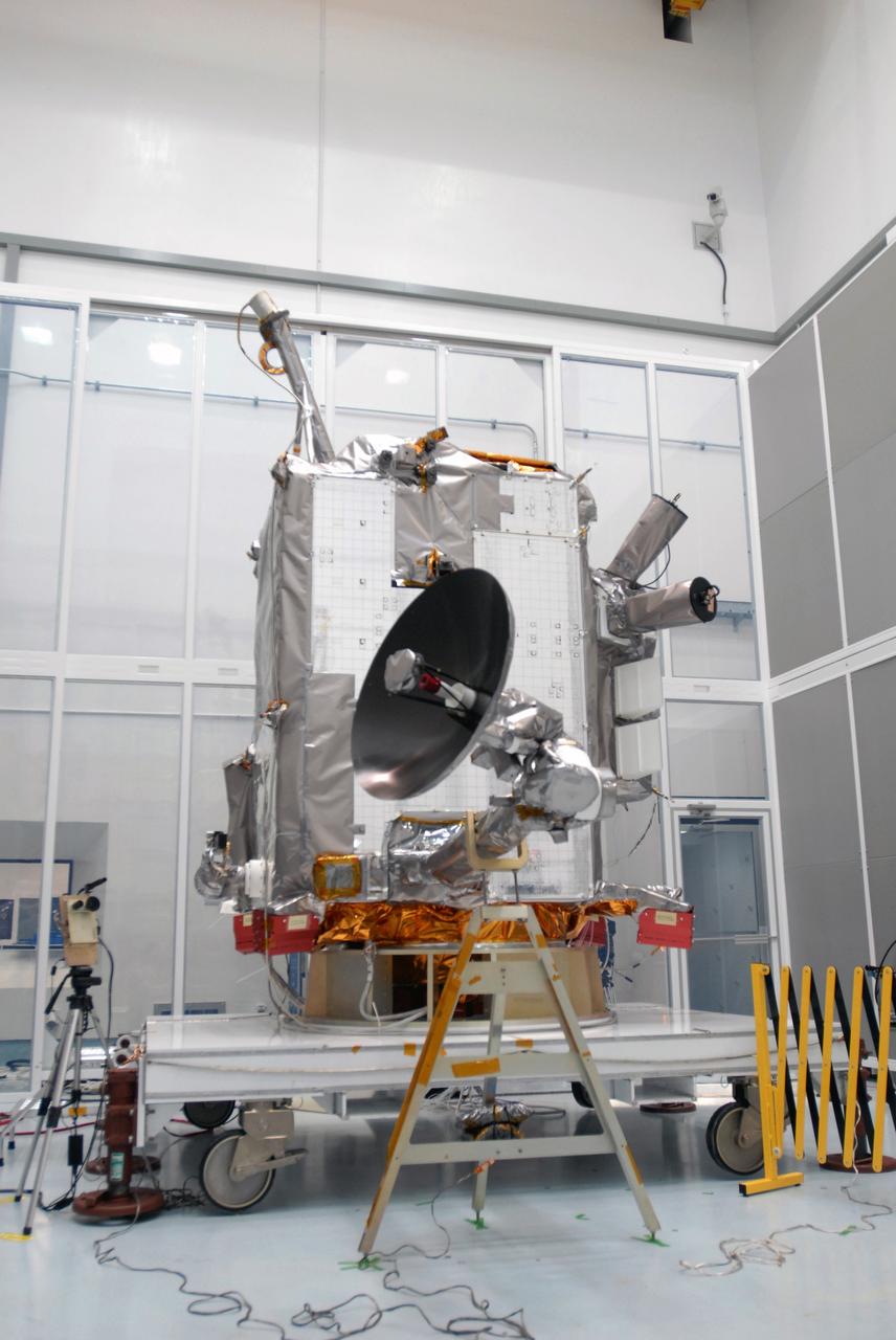
CAPE CANAVERAL, Fla. – At Astrotech Space Operations in Titusville, Fla., the range of motion is tested on the high-gain antenna for the Lunar Reconnaissance Orbiter. The orbiter will carry seven instruments to provide scientists with detailed maps of the lunar surface and enhance our understanding of the moon's topography, lighting conditions, mineralogical composition and natural resources. Information gleaned from LRO will be used to select safe landing sites, determine locations for future lunar outposts and help mitigate radiation dangers to astronauts. Launch of LRO is targeted no earlier than June 2. Photo credit: NASA/Jim Grossmann
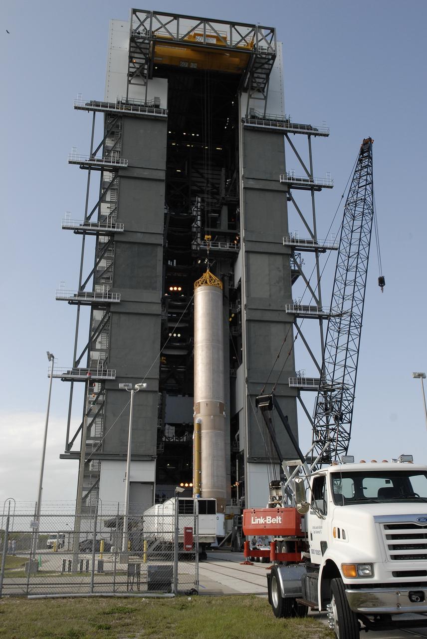
CAPE CANAVERAL, Fla. –– On Cape Canaveral Air Force Station's Launch Complex 41, the Atlas V first stage is being moved into the Vertical Integration Facility. The Atlas V/Centaur is the launch vehicle for the Lunar Reconnaissance Orbiter, or LRO. The orbiter will carry seven instruments to provide scientists with detailed maps of the lunar surface and enhance our understanding of the moon's topography, lighting conditions, mineralogical composition and natural resources. Information gleaned from LRO will be used to select safe landing sites, determine locations for future lunar outposts and help mitigate radiation dangers to astronauts. Launch of LRO is targeted no earlier than June 2. Photo credit: NASA/Kim Shiflett
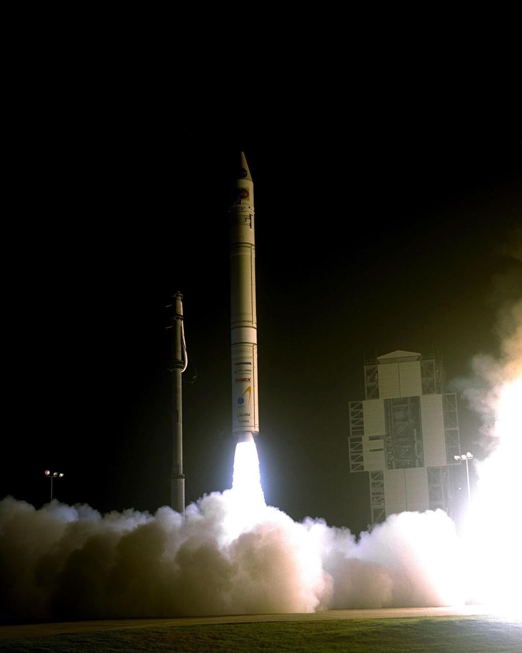
NASA’s Lunar Prospector spacecraft launched successfully on its way to the moon from Launch Complex 46 (LC46) at Cape Canaveral Air Station on Jan. 6 at 9:28 p.m. EST. It was the inaugural launch of Lockheed Martin's Athena II launch vehicle and the first launch from LC46, operated by Spaceport Florida Authority. Lunar Prospector, built for the NASA Ames Research Center by Lockheed Martin, is a spin-stabilized spacecraft designed to provide NASA with the first global maps of the moon’s surface and its gravitational magnetic fields, as well as look for the possible presence of ice near the lunar poles. It will orbit the Moon at an altitude of approximately 63 miles during a one-year mission
CAPE CANAVERAL, Fla. – At Astrotech Space Operations in Titusville, Fla., technicians maneuver NASA's Lunar Reconnaissance Orbiter's high-gain antenna into place for stowage. The antenna completed a range of motion test. The orbiter will carry seven instruments to provide scientists with detailed maps of the lunar surface and enhance our understanding of the moon's topography, lighting conditions, mineralogical composition and natural resources. Information gleaned from LRO will be used to select safe landing sites, determine locations for future lunar outposts and help mitigate radiation dangers to astronauts. Launch of LRO is targeted no earlier than June 2. Photo credit: NASA/Jack Pfaller
CAPE CANAVERAL, Fla. – At Astrotech Space Operations in Titusville, Fla., technicians maneuver NASA's Lunar Reconnaissance Orbiter's high-gain antenna into place for stowage. The antenna completed a range of motion test. The orbiter will carry seven instruments to provide scientists with detailed maps of the lunar surface and enhance our understanding of the moon's topography, lighting conditions, mineralogical composition and natural resources. Information gleaned from LRO will be used to select safe landing sites, determine locations for future lunar outposts and help mitigate radiation dangers to astronauts. Launch of LRO is targeted no earlier than June 2. Photo credit: NASA/Jack Pfaller
CAPE CANAVERAL, Fla. – At Astrotech Space Operations in Titusville, Fla., technicians prepare NASA's Lunar Reconnaissance Orbiter's high-gain antenna for stowage. The antenna completed a range of motion test. The orbiter will carry seven instruments to provide scientists with detailed maps of the lunar surface and enhance our understanding of the moon's topography, lighting conditions, mineralogical composition and natural resources. Information gleaned from LRO will be used to select safe landing sites, determine locations for future lunar outposts and help mitigate radiation dangers to astronauts. Launch of LRO is targeted no earlier than June 2. Photo credit: NASA/Jack Pfaller
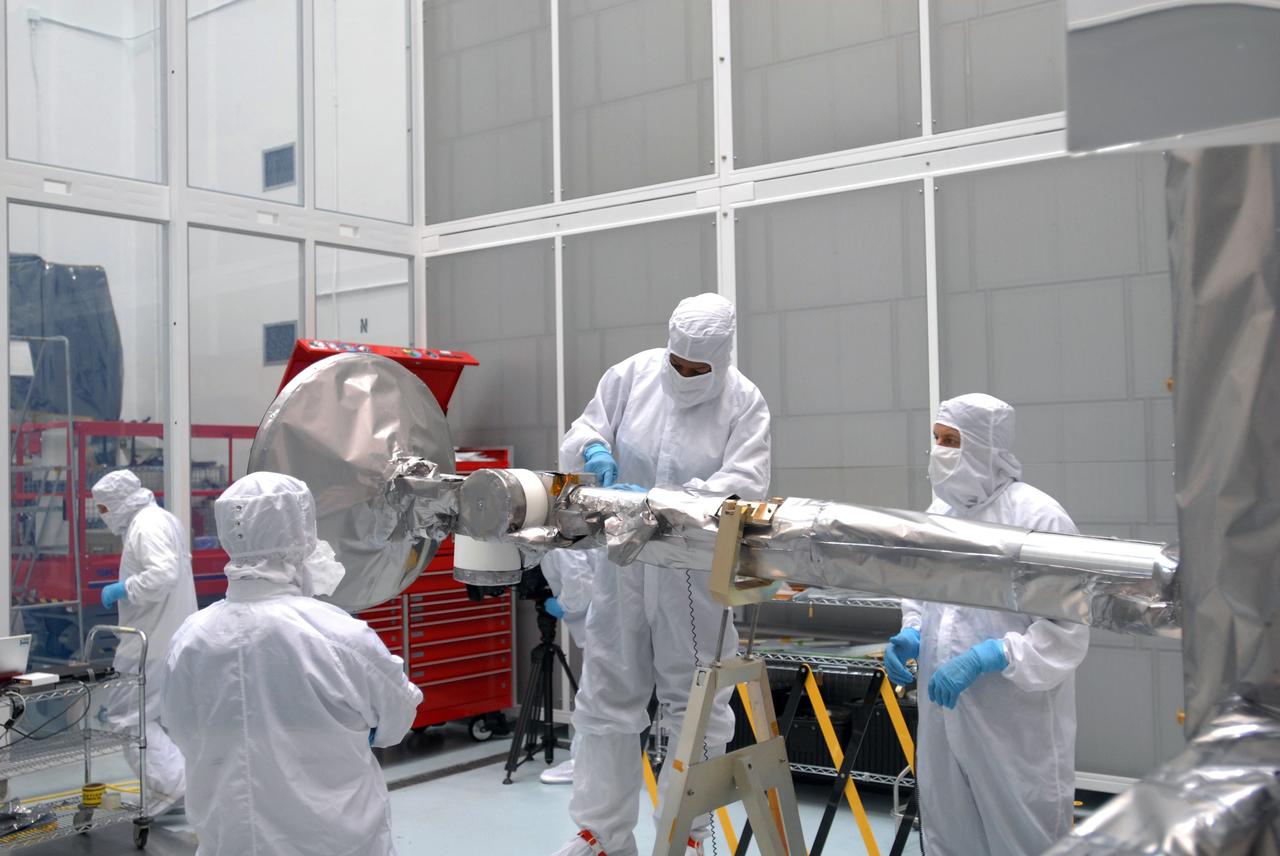
CAPE CANAVERAL, Fla. – At Astrotech Space Operations in Titusville, Fla., technicians are testing the range of motion on the high-gain antenna for the Lunar Reconnaissance Orbiter. The orbiter will carry seven instruments to provide scientists with detailed maps of the lunar surface and enhance our understanding of the moon's topography, lighting conditions, mineralogical composition and natural resources. Information gleaned from LRO will be used to select safe landing sites, determine locations for future lunar outposts and help mitigate radiation dangers to astronauts. Launch of LRO is targeted no earlier than June 2. Photo credit: NASA/Jim Grossmann
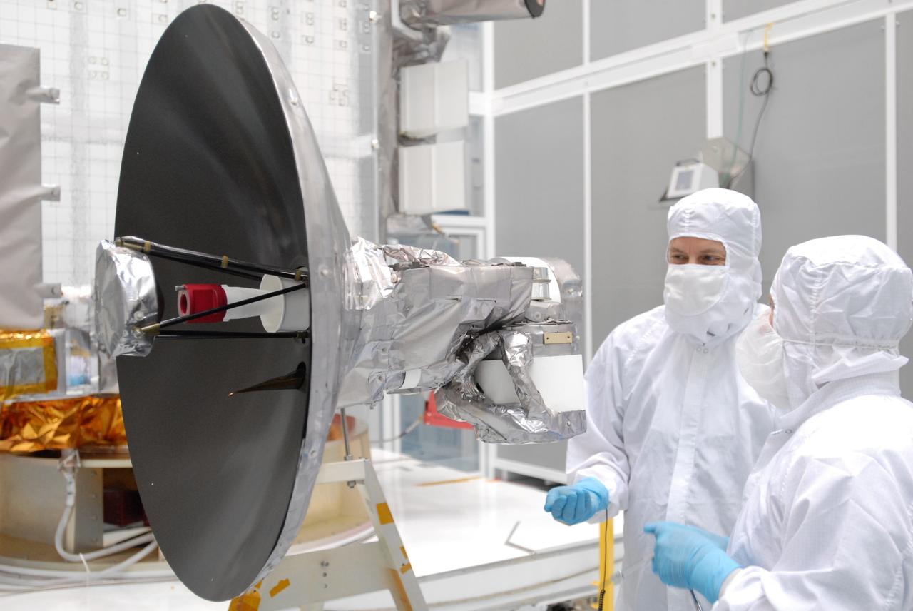
CAPE CANAVERAL, Fla. – At Astrotech Space Operations in Titusville, Fla., technicians are testing the range of motion on the high-gain antenna for the Lunar Reconnaissance Orbiter. The orbiter will carry seven instruments to provide scientists with detailed maps of the lunar surface and enhance our understanding of the moon's topography, lighting conditions, mineralogical composition and natural resources. Information gleaned from LRO will be used to select safe landing sites, determine locations for future lunar outposts and help mitigate radiation dangers to astronauts. Launch of LRO is targeted no earlier than June 2. Photo credit: NASA/Jim Grossmann
CAPE CANAVERAL, Fla. – At Astrotech Space Operations in Titusville, Fla., technicians are testing the range of motion on the high-gain antenna for the Lunar Reconnaissance Orbiter. The orbiter will carry seven instruments to provide scientists with detailed maps of the lunar surface and enhance our understanding of the moon's topography, lighting conditions, mineralogical composition and natural resources. Information gleaned from LRO will be used to select safe landing sites, determine locations for future lunar outposts and help mitigate radiation dangers to astronauts. Launch of LRO is targeted no earlier than June 2. Photo credit: NASA/Jim Grossmann
S71-44669 (31 July-2 Aug. 1971) --- An oblique view of the rayed crater Proclus on the lunar nearside, as photographed by the Fairchild metric camera in the SIM bay of the Apollo 15 Command and Service Modules (CSM) in lunar orbit. This view is looking north. The Sea of Crisis is at upper right. Proclus, which is 28 kilometers (16.58 statute miles) in diameter, is located at 47 degrees east longitude and 16 degrees north latitude. The Marsh of Sleep is at lower left. A small portion of the Sea of Tranquility can be seen at upper left. The crater Macrobius is located at upper left. The three-inch mapping camera was one of eight lunar orbital science experiments mounted in the SIM bay.
CAPE CANAVERAL, Fla. –– The Atlas V first stage arrives at the Vertical Integration Facility on Cape Canaveral Air Force Station's Launch Complex 41. The Atlas V/Centaur is the launch vehicle for the Lunar Reconnaissance Orbiter, or LRO. The orbiter will carry seven instruments to provide scientists with detailed maps of the lunar surface and enhance our understanding of the moon's topography, lighting conditions, mineralogical composition and natural resources. Information gleaned from LRO will be used to select safe landing sites, determine locations for future lunar outposts and help mitigate radiation dangers to astronauts. Launch of LRO is targeted no earlier than June 2. Photo credit: NASA/Kim Shiflett
S71-44672 (30 July 1971) --- A near vertical view of the crater Paracelsus (formerly called I.A.U. Crater 365) on the lunar farside, as photographed by the Fairchild metric camera in the Scientific Instrumentation Module (SIM) bay of the Apollo 15 Command and Service Modules (CSM) in lunar orbit. Note mountain peak in center of Paracelsus. The coordinates of the center of Paracelsus are 163 degrees east longitude and 23 degrees south latitude. The second largest crater in the picture is identified as number 364 by the I.A.U. North will be at the top of the picture if held with Paracelsus at top center. The three-inch mapping camera was one of eight lunar orbital science experiments mounted in the SIM bay.
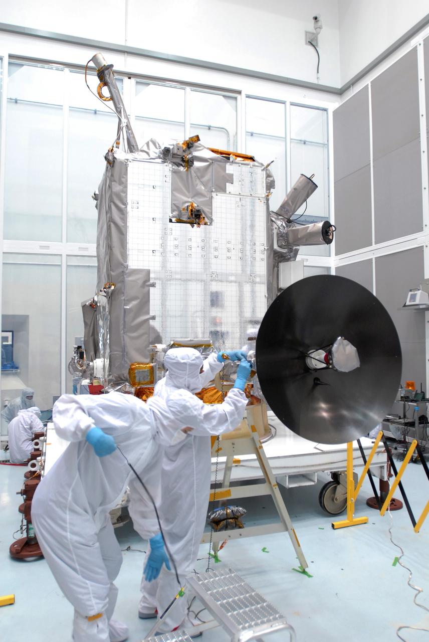
CAPE CANAVERAL, Fla. – At Astrotech Space Operations in Titusville, Fla., technicians are testing the range of motion on the high-gain antenna for the Lunar Reconnaissance Orbiter. The orbiter will carry seven instruments to provide scientists with detailed maps of the lunar surface and enhance our understanding of the moon's topography, lighting conditions, mineralogical composition and natural resources. Information gleaned from LRO will be used to select safe landing sites, determine locations for future lunar outposts and help mitigate radiation dangers to astronauts. Launch of LRO is targeted no earlier than June 2. Photo credit: NASA/Jim Grossmann
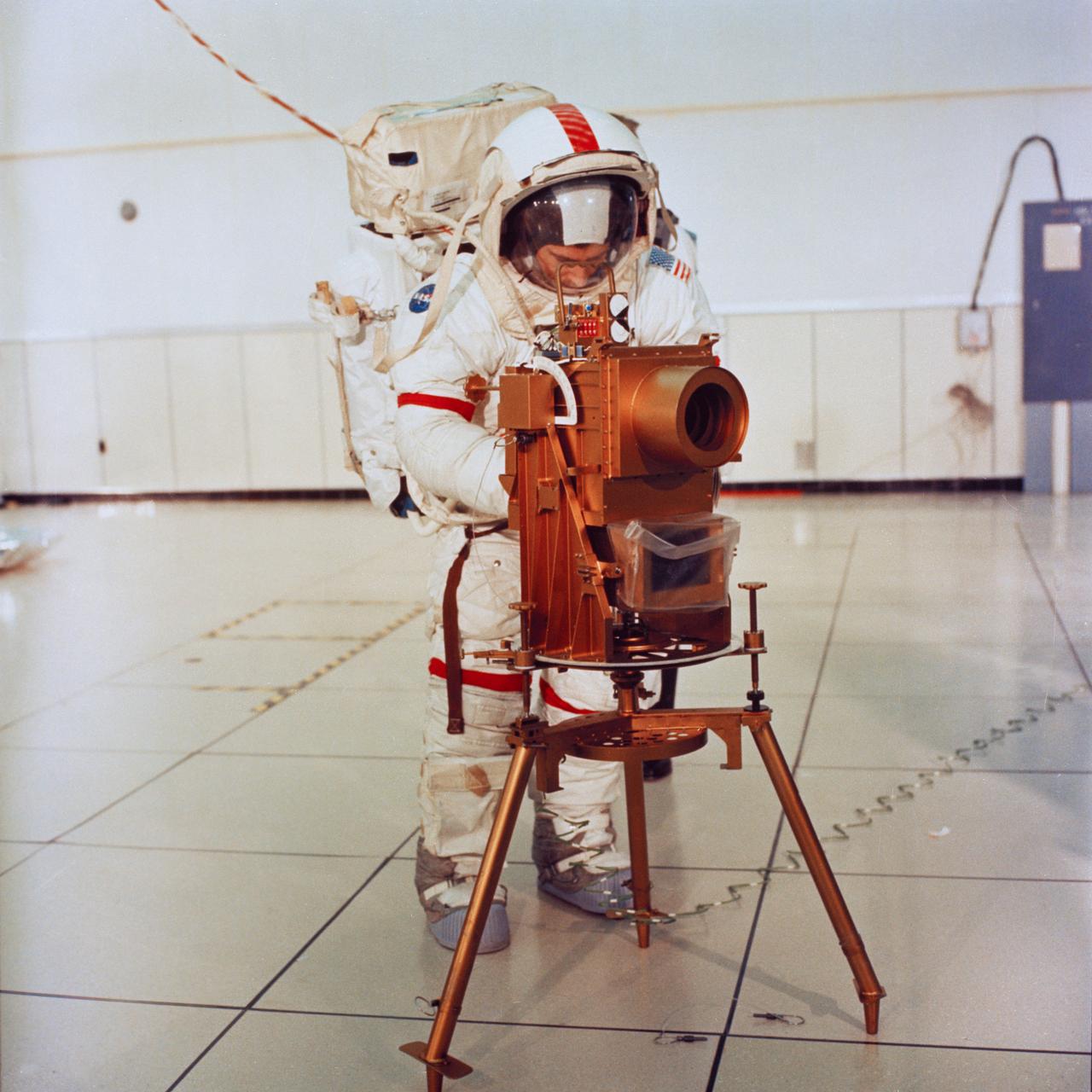
S72-19739 (22 Dec. 1972) --- Astronaut John W. Young, commander of the Apollo 16 lunar landing mission, participates in lunar surface extravehicular activity (EVA) training in the Flight Crew Training Building at the Kennedy Space Center (KSC). Young adjusts a training model of a Far Ultraviolet Camera/Spectroscope, an instrument which will be emplaced on the moon during the Apollo 16 EVA. Deep-space sources of hydrogen in interplanetary, interstellar and intergalactic regions will be mapped by this instrument which gathers both photographic images and spectroscope data in the far ultraviolet spectrum. This experiment will be the first such astronomical observation emplaced on the lunar surface.
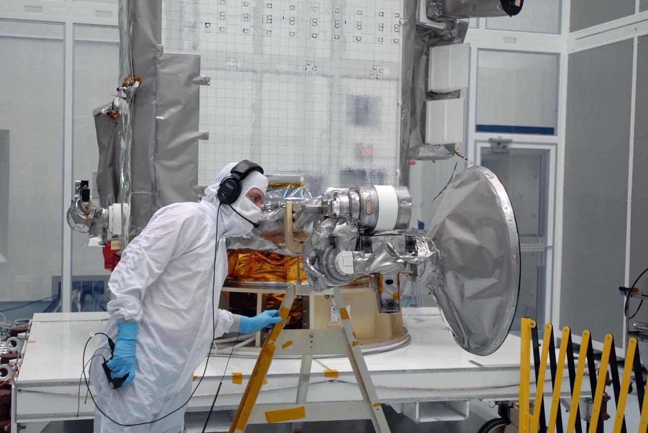
CAPE CANAVERAL, Fla. – At Astrotech Space Operations in Titusville, Fla., technicians check data (left) as the range of motion is tested on the high-gain antenna (foreground) for the Lunar Reconnaissance Orbiter. The orbiter will carry seven instruments to provide scientists with detailed maps of the lunar surface and enhance our understanding of the moon's topography, lighting conditions, mineralogical composition and natural resources. Information gleaned from LRO will be used to select safe landing sites, determine locations for future lunar outposts and help mitigate radiation dangers to astronauts. Launch of LRO is targeted no earlier than June 2. Photo credit: NASA/Jim Grossmann
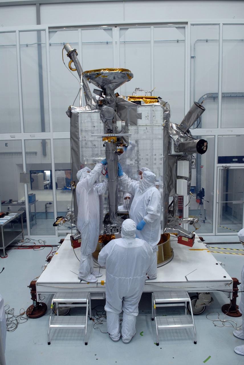
CAPE CANAVERAL, Fla. – At Astrotech Space Operations in Titusville, Fla., technicians secure NASA's Lunar Reconnaissance Orbiter's high-gain antenna into place for stowage. The antenna completed a range of motion test. The orbiter will carry seven instruments to provide scientists with detailed maps of the lunar surface and enhance our understanding of the moon's topography, lighting conditions, mineralogical composition and natural resources. Information gleaned from LRO will be used to select safe landing sites, determine locations for future lunar outposts and help mitigate radiation dangers to astronauts. Launch of LRO is targeted no earlier than June 2. Photo credit: NASA/Jack Pfaller
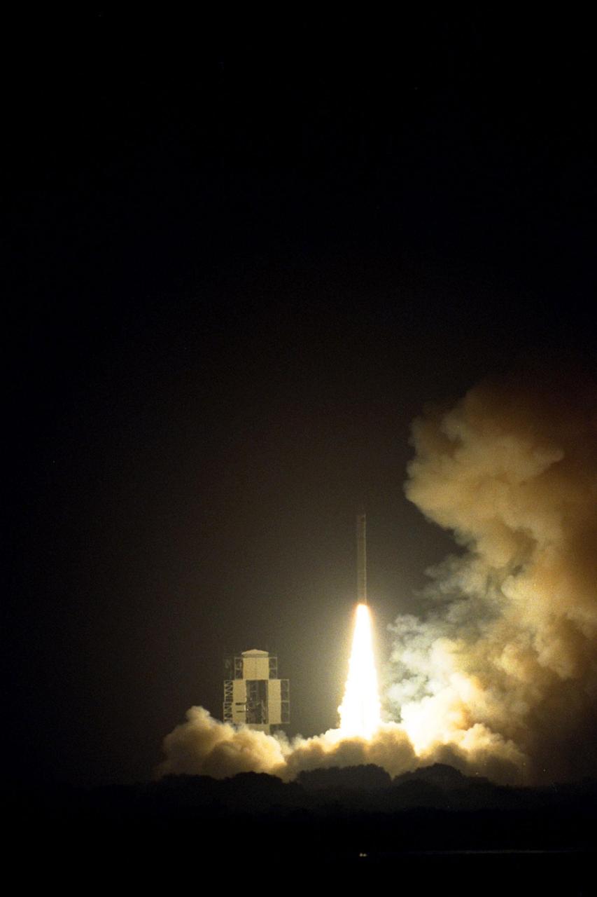
NASA’s Lunar Prospector spacecraft launched successfully on its way to the moon from Launch Complex 46 (LC46) at Cape Canaveral Air Station on Jan. 6 at 9:28 p.m. EST. It was the inaugural launch of Lockheed Martin's Athena II launch vehicle and the first launch from LC46, operated by Spaceport Florida Authority. Lunar Prospector, built for the NASA Ames Research Center by Lockheed Martin, is a spin-stabilized spacecraft designed to provide NASA with the first global maps of the moon’s surface and its gravitational magnetic fields, as well as look for the possible presence of ice near the lunar poles. It will orbit the Moon at an altitude of approximately 63 miles during a one-year mission
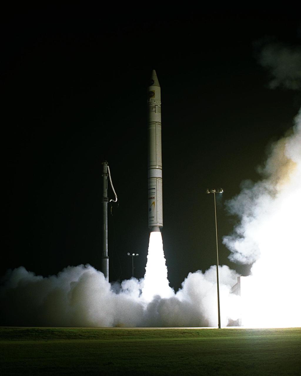
NASA’s Lunar Prospector spacecraft launched successfully on its way to the moon from Launch Complex 46 (LC46) at Cape Canaveral Air Station on Jan. 6 at 9:28 p.m. EST. It was the inaugural launch of Lockheed Martin's Athena II launch vehicle and the first launch from LC46, operated by Spaceport Florida Authority. Lunar Prospector, built for the NASA Ames Research Center by Lockheed Martin, is a spin-stabilized spacecraft designed to provide NASA with the first global maps of the moon’s surface and its gravitational magnetic fields, as well as look for the possible presence of ice near the lunar poles. It will orbit the Moon at an altitude of approximately 63 miles during a one-year mission
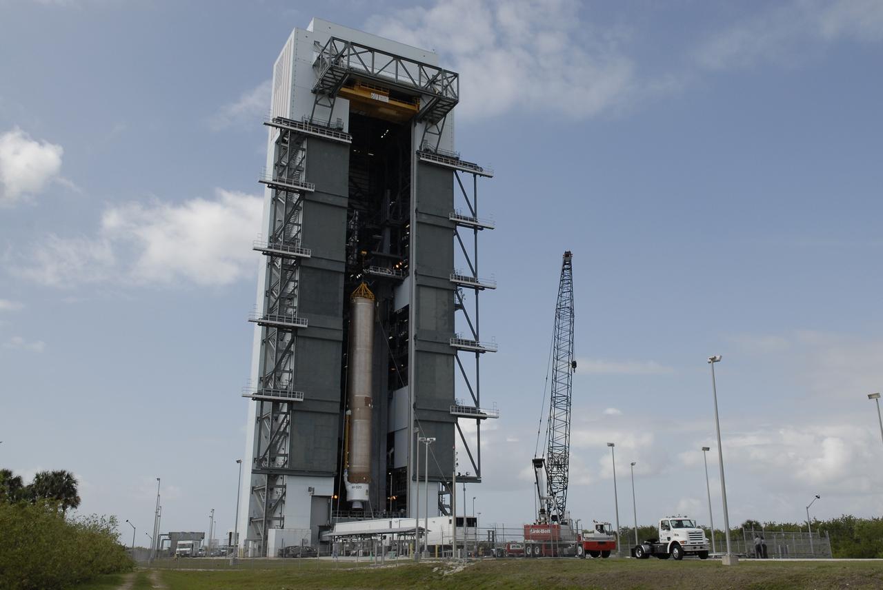
CAPE CANAVERAL, Fla. –– On Cape Canaveral Air Force Station's Launch Complex 41, the Atlas V first stage is being moved into the Vertical Integration Facility. The Atlas V/Centaur is the launch vehicle for the Lunar Reconnaissance Orbiter, or LRO. The orbiter will carry seven instruments to provide scientists with detailed maps of the lunar surface and enhance our understanding of the moon's topography, lighting conditions, mineralogical composition and natural resources. Information gleaned from LRO will be used to select safe landing sites, determine locations for future lunar outposts and help mitigate radiation dangers to astronauts. Launch of LRO is targeted no earlier than June 2. Photo credit: NASA/Kim Shiflett
CAPE CANAVERAL, Fla. –– The Atlas V first stage arrives at the Vertical Integration Facility on Cape Canaveral Air Force Station's Launch Complex 41. The Atlas V/Centaur is the launch vehicle for the Lunar Reconnaissance Orbiter, or LRO. The orbiter will carry seven instruments to provide scientists with detailed maps of the lunar surface and enhance our understanding of the moon's topography, lighting conditions, mineralogical composition and natural resources. Information gleaned from LRO will be used to select safe landing sites, determine locations for future lunar outposts and help mitigate radiation dangers to astronauts. Launch of LRO is targeted no earlier than June 2. Photo credit: NASA/Kim Shiflett
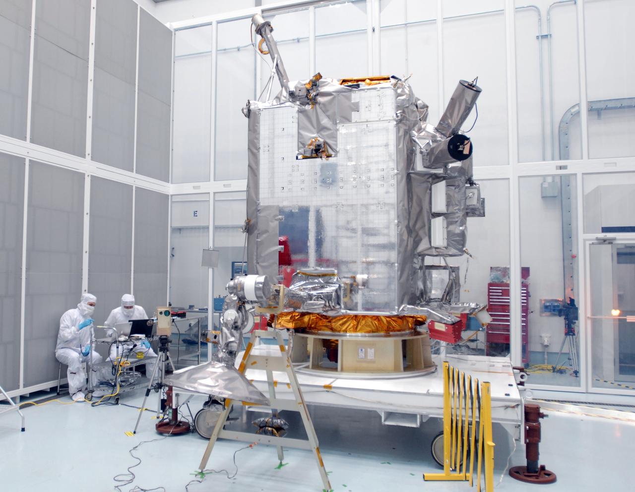
CAPE CANAVERAL, Fla. – At Astrotech Space Operations in Titusville, Fla., technicians check data (left) as the range of motion is tested on the high-gain antenna (foreground) for the Lunar Reconnaissance Orbiter. The orbiter will carry seven instruments to provide scientists with detailed maps of the lunar surface and enhance our understanding of the moon's topography, lighting conditions, mineralogical composition and natural resources. Information gleaned from LRO will be used to select safe landing sites, determine locations for future lunar outposts and help mitigate radiation dangers to astronauts. Launch of LRO is targeted no earlier than June 2. Photo credit: NASA/Jim Grossmann
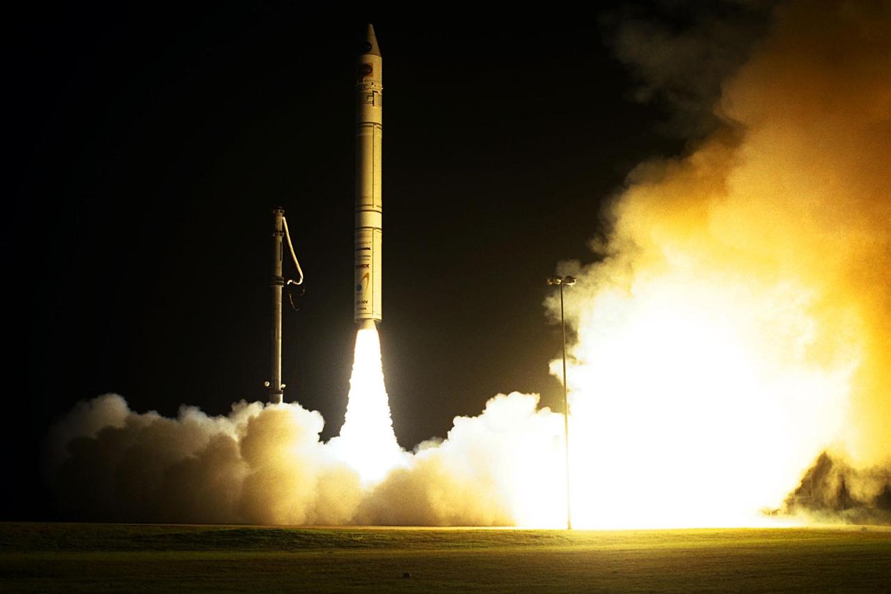
NASA’s Lunar Prospector spacecraft launched successfully on its way to the moon from Launch Complex 46 (LC46) at Cape Canaveral Air Station on Jan. 6 at 9:28 p.m. EST. It was the inaugural launch of Lockheed Martin's Athena II launch vehicle and the first launch from LC46, operated by Spaceport Florida Authority. Lunar Prospector, built for the NASA Ames Research Center by Lockheed Martin, is a spin-stabilized spacecraft designed to provide NASA with the first global maps of the moon’s surface and its gravitational magnetic fields, as well as look for the possible presence of ice near the lunar poles. It will orbit the Moon at an altitude of approximately 63 miles during a one-year mission
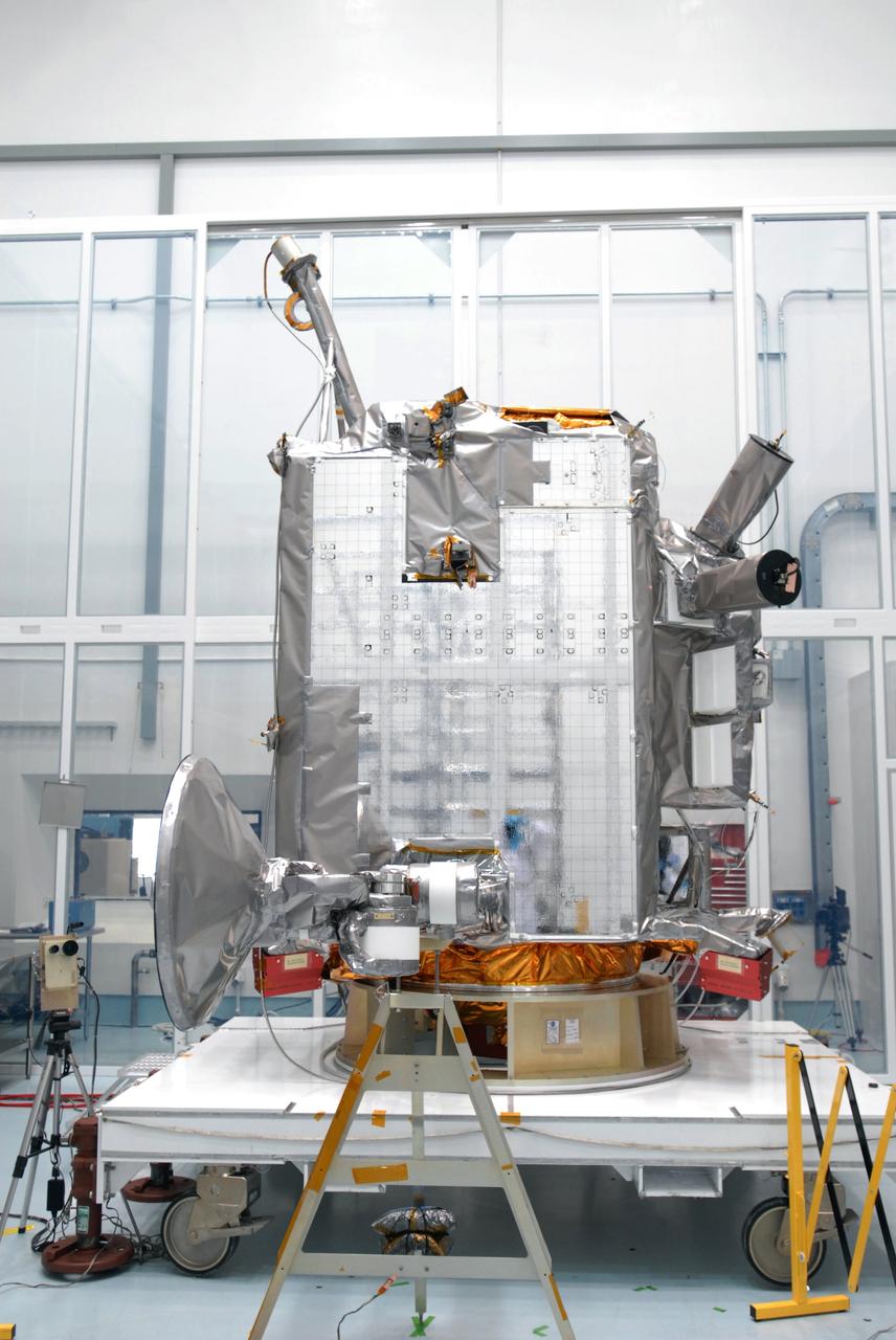
CAPE CANAVERAL, Fla. – At Astrotech Space Operations in Titusville, Fla., the range of motion is being tested on the high-gain antenna for the Lunar Reconnaissance Orbiter. The orbiter will carry seven instruments to provide scientists with detailed maps of the lunar surface and enhance our understanding of the moon's topography, lighting conditions, mineralogical composition and natural resources. Information gleaned from LRO will be used to select safe landing sites, determine locations for future lunar outposts and help mitigate radiation dangers to astronauts. Launch of LRO is targeted no earlier than June 2. Photo credit: NASA/Jim Grossmann
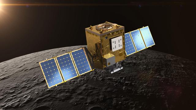
Peering into the Moon's permanently shadowed regions, Lunar Trailblazer will detect signatures of water ice in reflected light, and it will pinpoint the locations of micro-cold traps less than a football field in size. The small satellite will collect measurements at multiple times of day over sunlit regions, helping scientists understand if the water signature on the illuminated surface changes as the lunar surface temperature changes by hundreds of degrees over the course of a lunar day. The goal is to produce high-resolution maps to locate water ice in support of NASA's Artemis Program, which aims to establish a sustainable human presence on the Moon and prepare for future missions to Mars. https://photojournal.jpl.nasa.gov/catalog/PIA24161
S71-44670 (31 July 1971) --- A near vertical view of the crater Tsiolkovsky on the lunar farside, as photographed by the Fairchild metric camera in the Scientific Instrument Module (SIM) bay of the Apollo 15 Command and Service Modules (CSM) in lunar orbit. This view is looking northerly. The coordinates of the crater's central peaks are 128 degrees east longitude and 20 degrees south latitude. The mare area measured from east to west is approximately 145 kilometers (90 statute miles) across. The three-inch mapping camera was one of eight lunar orbital science experiments mounted in the SIM bay.
CAPE CANAVERAL, Fla. –– On Cape Canaveral Air Force Station's Launch Complex 41, the Atlas V first stage is being moved into the Vertical Integration Facility. The Atlas V/Centaur is the launch vehicle for the Lunar Reconnaissance Orbiter, or LRO. The orbiter will carry seven instruments to provide scientists with detailed maps of the lunar surface and enhance our understanding of the moon's topography, lighting conditions, mineralogical composition and natural resources. Information gleaned from LRO will be used to select safe landing sites, determine locations for future lunar outposts and help mitigate radiation dangers to astronauts. Launch of LRO is targeted no earlier than June 2. Photo credit: NASA/Kim Shiflett
NASA’s Lunar Prospector spacecraft launched successfully on its way to the moon from Launch Complex 46 (LC46) at Cape Canaveral Air Station on Jan. 6 at 9:28 p.m. EST. It was the inaugural launch of Lockheed Martin's Athena II launch vehicle and the first launch from LC46, operated by Spaceport Florida Authority. Lunar Prospector, built for the NASA Ames Research Center by Lockheed Martin, is a spin-stabilized spacecraft designed to provide NASA with the first global maps of the moon’s surface and its gravitational magnetic fields, as well as look for the possible presence of ice near the lunar poles. It will orbit the Moon at an altitude of approximately 63 miles during a one-year mission

KENNEDY SPACE CENTER, Fla. -- Workers at Launch Complex 17-B, Cape Canaveral Air Force Station, oversee the fairing installation on the Microwave Anisotropy Probe (MAP) spacecraft. MAP is scheduled for launch on June 30 aboard a Boeing Delta II rocket. The launch will place MAP into a lunar-assisted trajectory to the Sun-Earth for a 27-month mission. The probe will measure small fluctuations in the temperature of the cosmic microwave background radiation to an accuracy of one millionth of a degree. These measurements should reveal the size, matter content, age, geometry and fate of the universe. They will also reveal the primordial structure that grew to form galaxies and will test ideas about the origins of these primordial structures. The MAP instrument will be continuously shaded from the Sun, Earth, and Moon by the spacecraft
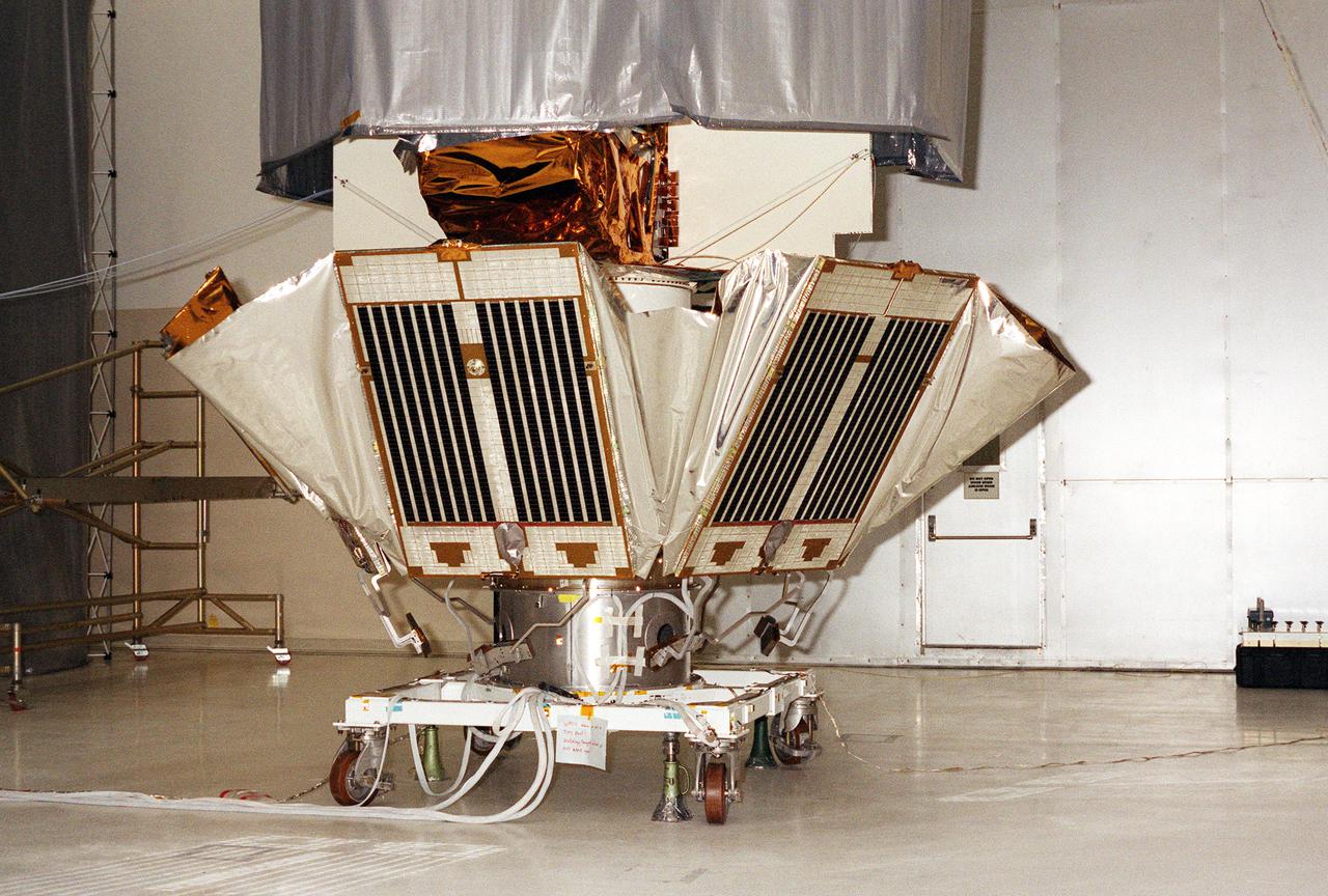
KENNEDY SPACE CENTER, FLA. -- Solar panels on the Microwave Anisotropy Probe (MAP) spacecraft begin deployment in the Spacecraft Assembly and Encapsulation Facility 2. MAP is scheduled for launch on June 30 aboard a Boeing Delta II rocket. The launch will place MAP into a lunar-assisted trajectory to the Sun-Earth for a 27-month mission. The probe will measure small fluctuations in the temperature of the cosmic microwave background radiation to an accuracy of one millionth of a degree. These measurements should reveal the size, matter content, age, geometry and fate of the universe. They will also reveal the primordial structure that grew to form galaxies and will test ideas about the origins of these primordial structures. The MAP instrument will be continuously shaded from the Sun, Earth, and Moon by the spacecraft. The probe is a product of Goddard Space Flight Center in partnership with Princeton University
KENNEDY SPACE CENTER, FLA. -- On Complex 17-A, Cape Canaveral Air Force Station, the fairing for the Microwave Anisotropy Probe (MAP) spacecraft is lifted up the gantry to the White Room. There it will wait for the arrival of the spacecraft. MAP is scheduled for launch on June 30 aboard a Boeing Delta II rocket. The launch will place MAP into a lunar-assisted trajectory to the Sun-Earth for a 27-month mission. The probe will measure small fluctuations in the temperature of the cosmic microwave background radiation to an accuracy of one millionth of a degree. These measurements should reveal the size, matter content, age, geometry and fate of the universe. They will also reveal the primordial structure that grew to form galaxies and will test ideas about the origins of these primordial structures. The MAP instrument will be continuously shaded from the Sun, Earth, and Moon by the spacecraft. The probe is a product of Goddard Space Flight Center in partnership with Princeton University

KENNEDY SPACE CENTER, Fla. -- In the Spacecraft Assembly and Encapsulation Facility -2, the Microwave Anisotropy Probe (MAP) is lifted for moving to the upper stage of the Boeing Delta II rocket. The rocket is scheduled to launch the MAP instrument June 30 into a lunar-assisted trajectory to the Sun-Earth for a 27-month mission. MAP will measure small fluctuations in the temperature of the cosmic microwave background radiation to an accuracy of one millionth of a degree. These measurements should reveal the size, matter content, age, geometry and fate of the universe. They will also reveal the primordial structure that grew to form galaxies and will test ideas about the origins of these primordial structures. The MAP instrument will be continuously shaded from the Sun, Earth, and Moon by the spacecraft. It is a product of Goddard Space Flight Center in partnership with Princeton University
KENNEDY SPACE CENTER, Fla. -- Workers at Launch Complex 17-B, Cape Canaveral Air Force Station, oversee the fairing installation on the Microwave Anisotropy Probe (MAP) spacecraft. MAP is scheduled for launch on June 30 aboard a Boeing Delta II rocket. The launch will place MAP into a lunar-assisted trajectory to the Sun-Earth for a 27-month mission. The probe will measure small fluctuations in the temperature of the cosmic microwave background radiation to an accuracy of one millionth of a degree. These measurements should reveal the size, matter content, age, geometry and fate of the universe. They will also reveal the primordial structure that grew to form galaxies and will test ideas about the origins of these primordial structures. The MAP instrument will be continuously shaded from the Sun, Earth, and Moon by the spacecraft
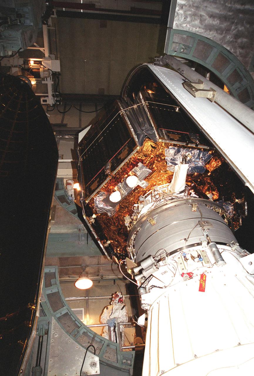
KENNEDY SPACE CENTER, Fla. -- At Launch Complex 17-B, Cape Canaveral Air Force Station, the Microwave Anisotropy Probe (MAP) spacecraft is encapsulated with the fairing. With one half already in place (right), the second half (left) moves into position. MAP is scheduled for launch on June 30 aboard a Boeing Delta II rocket. The launch will place MAP into a lunar-assisted trajectory to the Sun-Earth for a 27-month mission. The probe will measure small fluctuations in the temperature of the cosmic microwave background radiation to an accuracy of one millionth of a degree. These measurements should reveal the size, matter content, age, geometry and fate of the universe. They will also reveal the primordial structure that grew to form galaxies and will test ideas about the origins of these primordial structures. The MAP instrument will be continuously shaded from the Sun, Earth, and Moon by the spacecraft
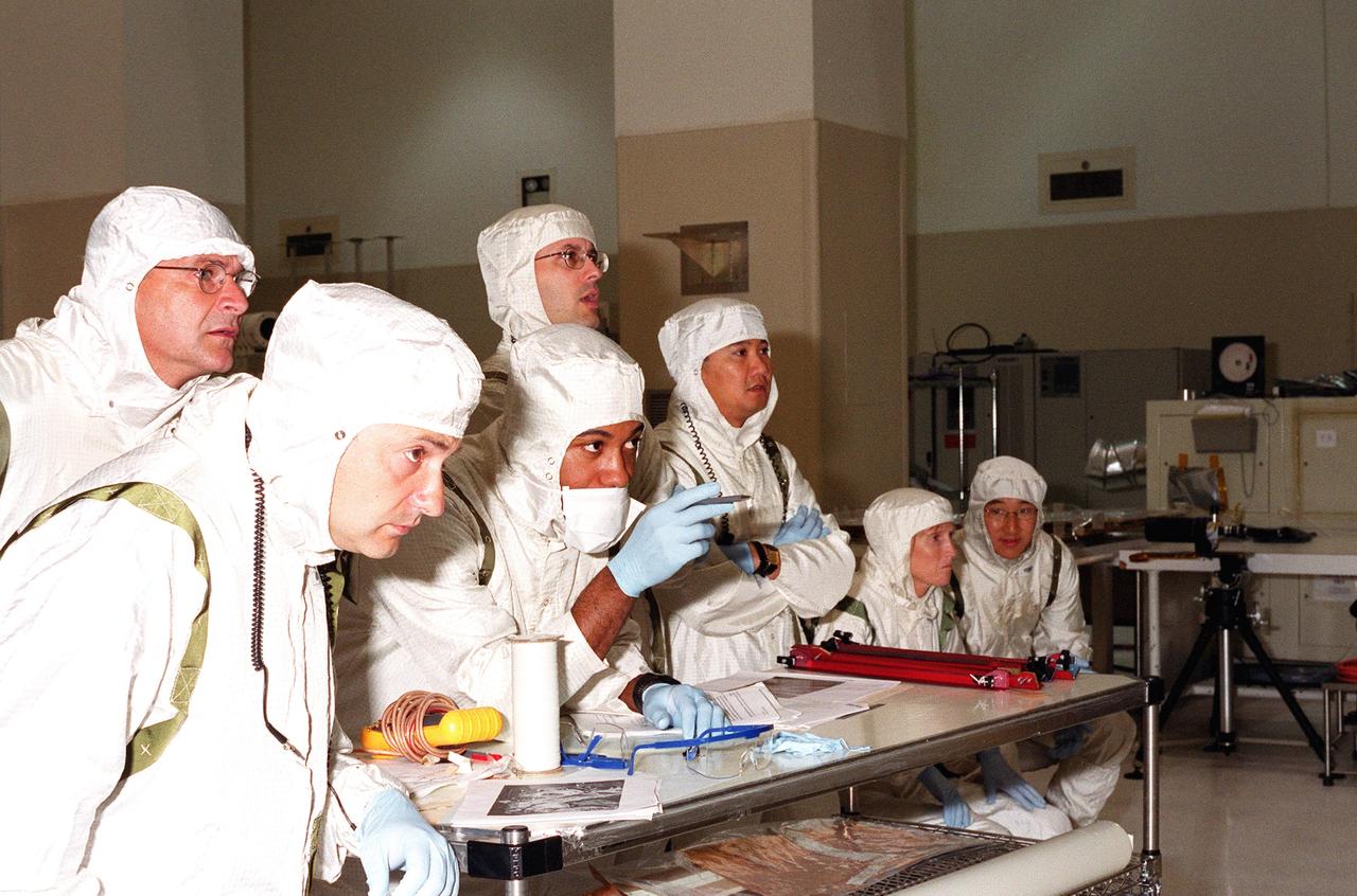
KENNEDY SPACE CENTER, FLA. -- Scientists and other workers watch as the solar panels on the Microwave Anisotropy Probe (MAP) spacecraft are deployed in the Spacecraft Assembly and Encapsulation Facility 2. MAP is scheduled for launch on June 30 aboard a Boeing Delta II rocket. The launch will place MAP into a lunar-assisted trajectory to the Sun-Earth for a 27-month mission. The probe will measure small fluctuations in the temperature of the cosmic microwave background radiation to an accuracy of one millionth of a degree. These measurements should reveal the size, matter content, age, geometry and fate of the universe. They will also reveal the primordial structure that grew to form galaxies and will test ideas about the origins of these primordial structures. The MAP instrument will be continuously shaded from the Sun, Earth, and Moon by the spacecraft. The probe is a product of Goddard Space Flight Center in partnership with Princeton University
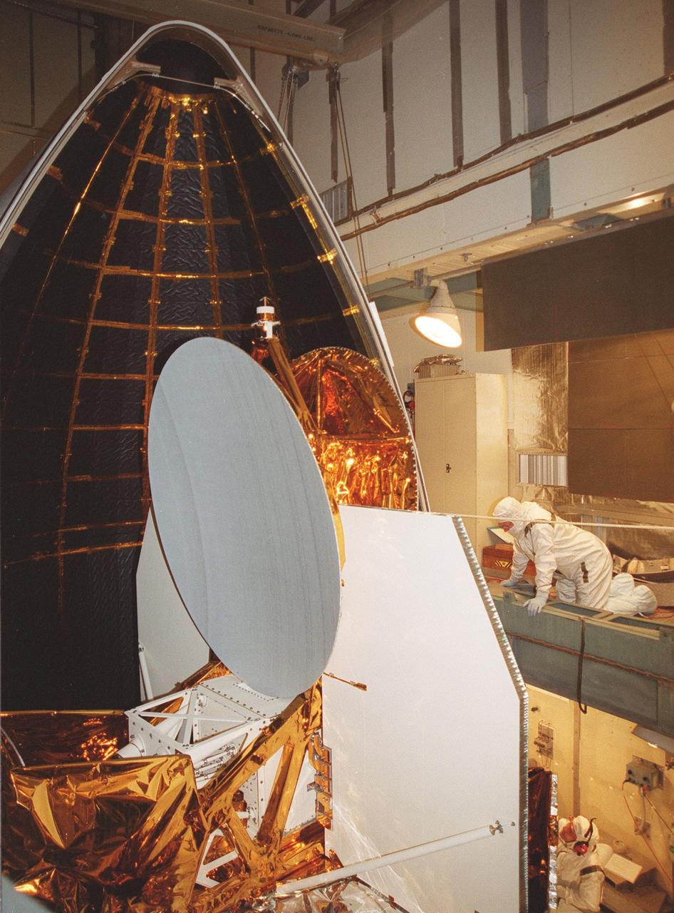
KENNEDY SPACE CENTER, Fla. -- At Launch Complex 17-B, Cape Canaveral Air Force Station, the fairing is moved into position around the Microwave Anisotropy Probe (MAP) spacecraft. MAP is scheduled for launch on June 30 aboard a Boeing Delta II rocket. The launch will place MAP into a lunar-assisted trajectory to the Sun-Earth for a 27-month mission. The probe will measure small fluctuations in the temperature of the cosmic microwave background radiation to an accuracy of one millionth of a degree. These measurements should reveal the size, matter content, age, geometry and fate of the universe. They will also reveal the primordial structure that grew to form galaxies and will test ideas about the origins of these primordial structures. The MAP instrument will be continuously shaded from the Sun, Earth, and Moon by the spacecraft
KENNEDY SPACE CENTER, Fla. -- The fairing closes around the Microwave Anisotropy Probe (MAP) spacecraft at Launch Complex 17-B, Cape Canaveral Air Force Station. MAP is scheduled for launch on June 30 aboard a Boeing Delta II rocket. The launch will place MAP into a lunar-assisted trajectory to the Sun-Earth for a 27-month mission. The probe will measure small fluctuations in the temperature of the cosmic microwave background radiation to an accuracy of one millionth of a degree. These measurements should reveal the size, matter content, age, geometry and fate of the universe. They will also reveal the primordial structure that grew to form galaxies and will test ideas about the origins of these primordial structures. The MAP instrument will be continuously shaded from the Sun, Earth, and Moon by the spacecraft
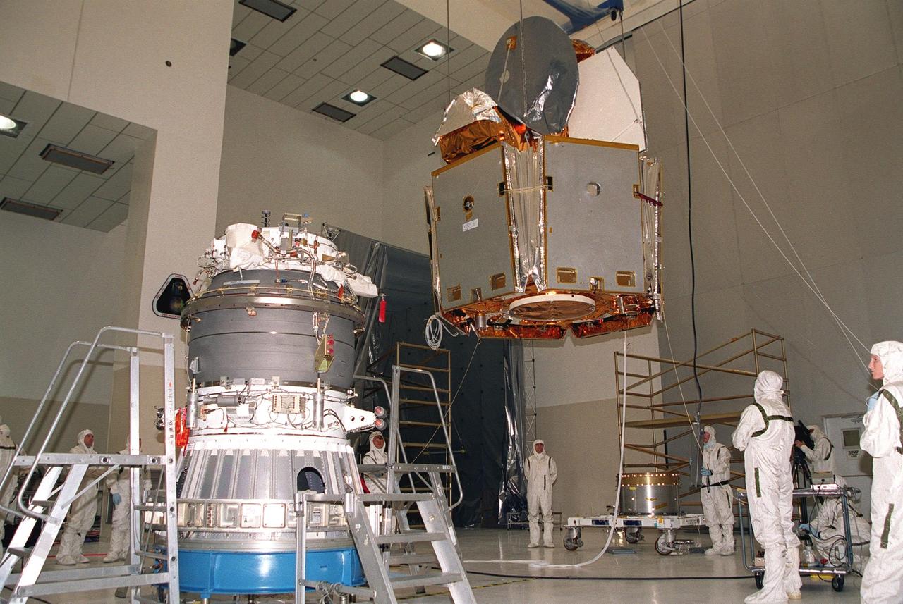
KENNEDY SPACE CENTER, Fla. -- In the Spacecraft Assembly and Encapsulation Facility -2, the Microwave Anisotropy Probe (MAP), suspended by a crane, crosses the facility to the upper stage of the Boeing Delta II rocket. The rocket is scheduled to launch the MAP instrument June 30 into a lunar-assisted trajectory to the Sun-Earth for a 27-month mission. MAP will measure small fluctuations in the temperature of the cosmic microwave background radiation to an accuracy of one millionth of a degree. These measurements should reveal the size, matter content, age, geometry and fate of the universe. They will also reveal the primordial structure that grew to form galaxies and will test ideas about the origins of these primordial structures. The MAP instrument will be continuously shaded from the Sun, Earth, and Moon by the spacecraft. It is a product of Goddard Space Flight Center in partnership with Princeton University