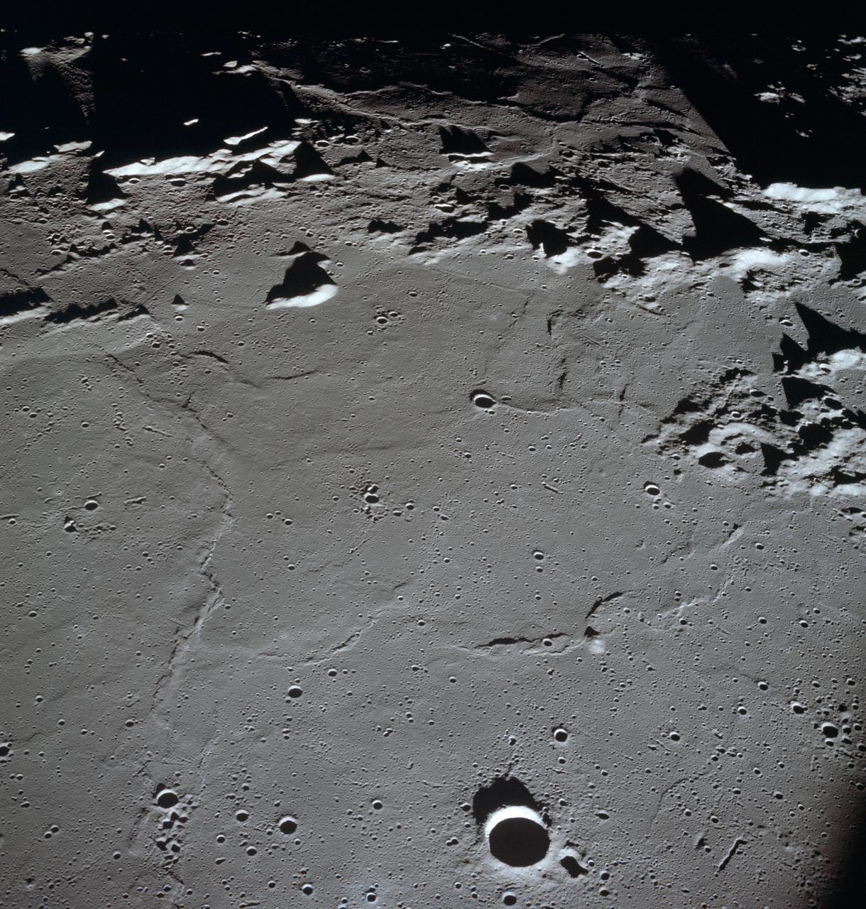
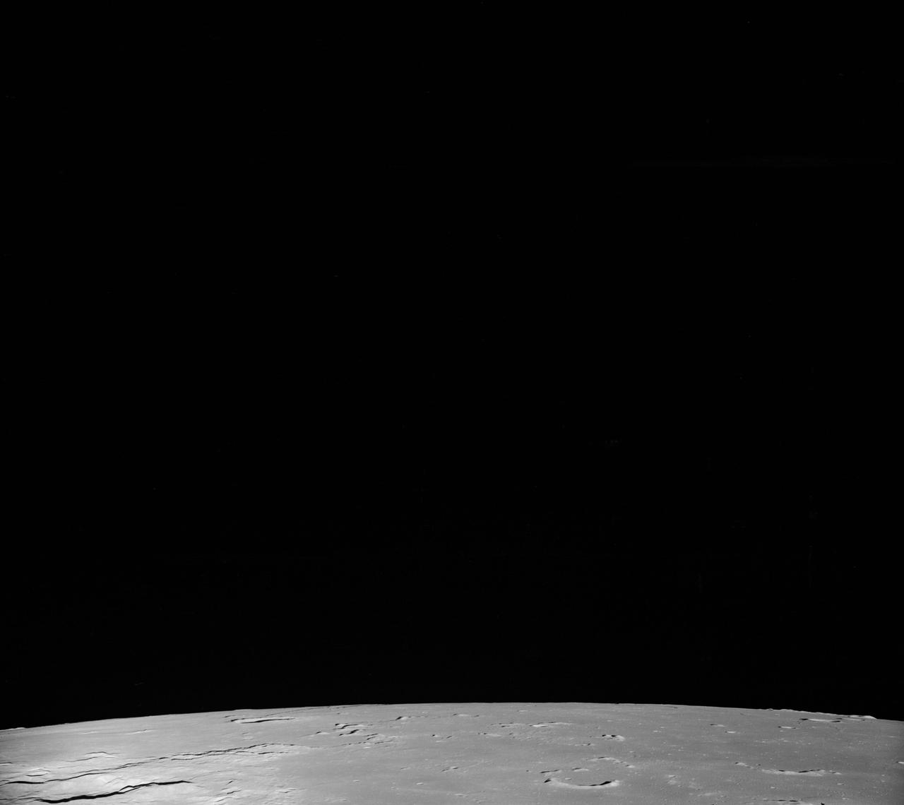
AS11-37-5437 (20 July 1969) --- The approach to Apollo Landing Site 2 in southwestern Sea of Tranquility is seen in this photograph taken from the Apollo 11 Lunar Module (LM) in lunar orbit. When this picture was made, the LM was still docked to the Command and Service Modules (CSM). Site 2 is located just right of center at the edge of the darkness. The crater Maskelyne is the large one at the lower right. Hypatia Rille (U.S. 1) is at upper left, with the crater Moltke just to the right (north) of it. Sidewinder Rille and Diamondback Rille extend from left to right across the center of the picture. This view looks generally west.
This photo was taken by Lunar Orbiter IV. In it's mission to photograph areas on the new and far side of the Moon and supplemental photography of suggested Apollo landing sites.
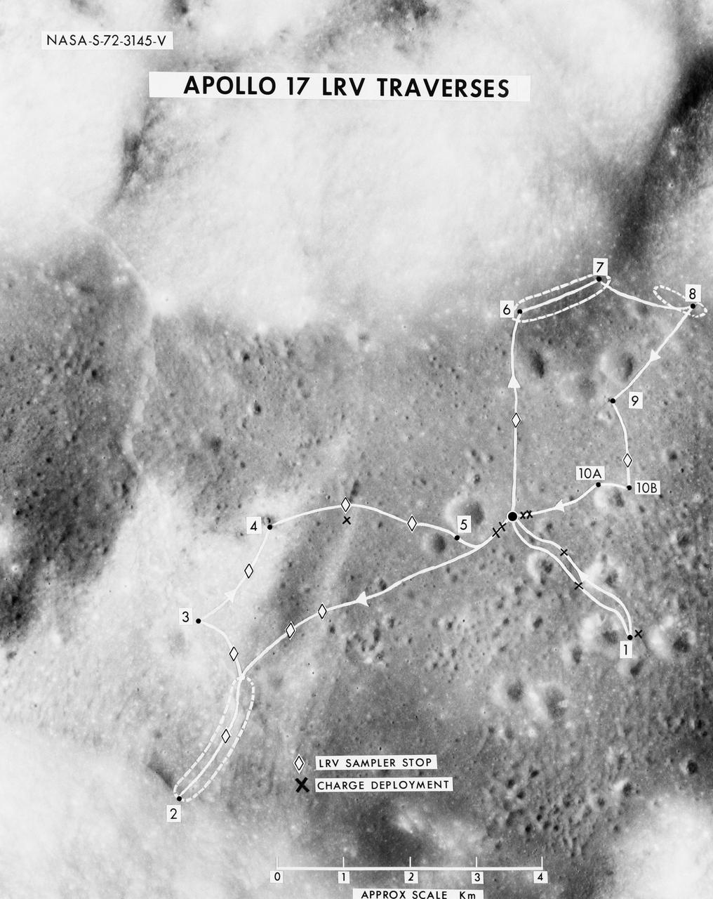
S72-03145 (October 1972) --- A vertical view of the Apollo 17 Taurus-Littrow site with an overlay to illustrate the three planned Apollo 17 traverses using the Lunar Roving Vehicle (LRV). The EVA-1 traverse has a single station (1); the EVA-2 traverse has four stations (2,3,4,5); and the EVA-3 traverse has five stations (6,7,8,9,10). Stations 10-A and 10-B are alternate locations for Station 10. In addition to the major stations mentioned above, brief stops are planned for sampling between stations using the LRV sampler tool (note diamond-shaped figures), and for deploying explosive charges associated with the Lunar Seismic Profiling Experiment (LSPE - note black x-marks).
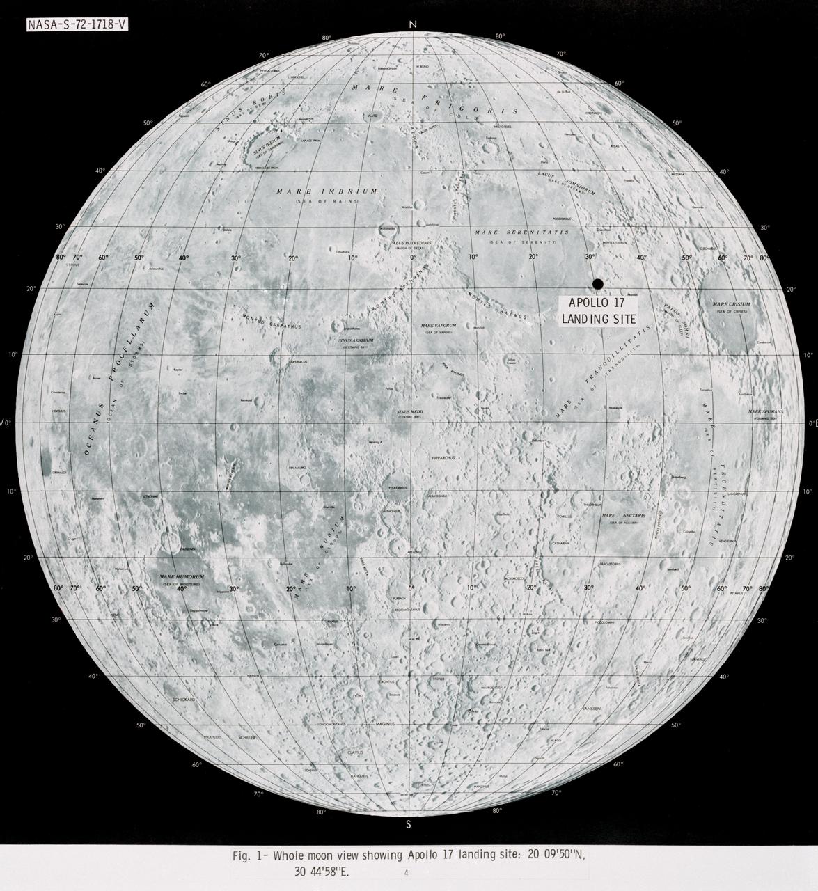
S72-01718 (July 1972) --- A photographic illustration of a full moon showing the location of the Apollo 17 landing site on the lunar nearside. The black dot pinpointing the landing site is in the Taurus-Littrow area at the southeastern edge of the Sea of Serenity. The coordinates of the landing point are 30 degrees 44 minutes 58 seconds east longitude and 20 degrees 9 minutes 50 seconds north latitude.
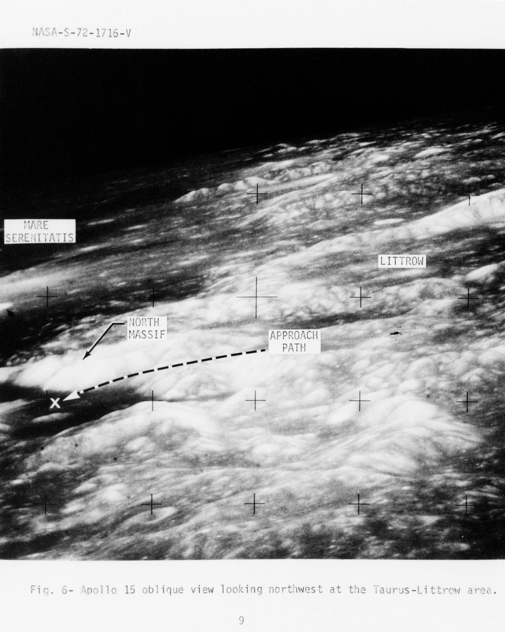
S72-01716 (July 1972) --- An oblique view of the Taurus-Littrow area on the lunar nearside, as photographed from the Apollo 15 spacecraft in lunar orbit. This is an enlarged view. The "X" marks the landing site of the scheduled Apollo 17 lunar landing mission. The overlay points out several features in the photograph. The coordinates of the Apollo 17 touchdown point are 30 degrees 44 minutes 58 seconds east longitude and 20 degrees 9 minutes 50 seconds north latitude.
AS11-37-5458 (20 July 1969) --- This excellent view from the right-hand window of the Apollo 11 Lunar Module (LM) shows the surface of the moon in the vicinity of where the LM touched down. Numerous small rocks and craters can be seen between the LM and the lunar horizon. Astronaut Michael Collins, command module pilot, remained with the Command and Service Modules (CSM) in lunar orbit while astronauts Neil A. Armstrong, commander; and Edwin E. Aldrin Jr., lunar module pilot, descended in the LM to the lunar surface.
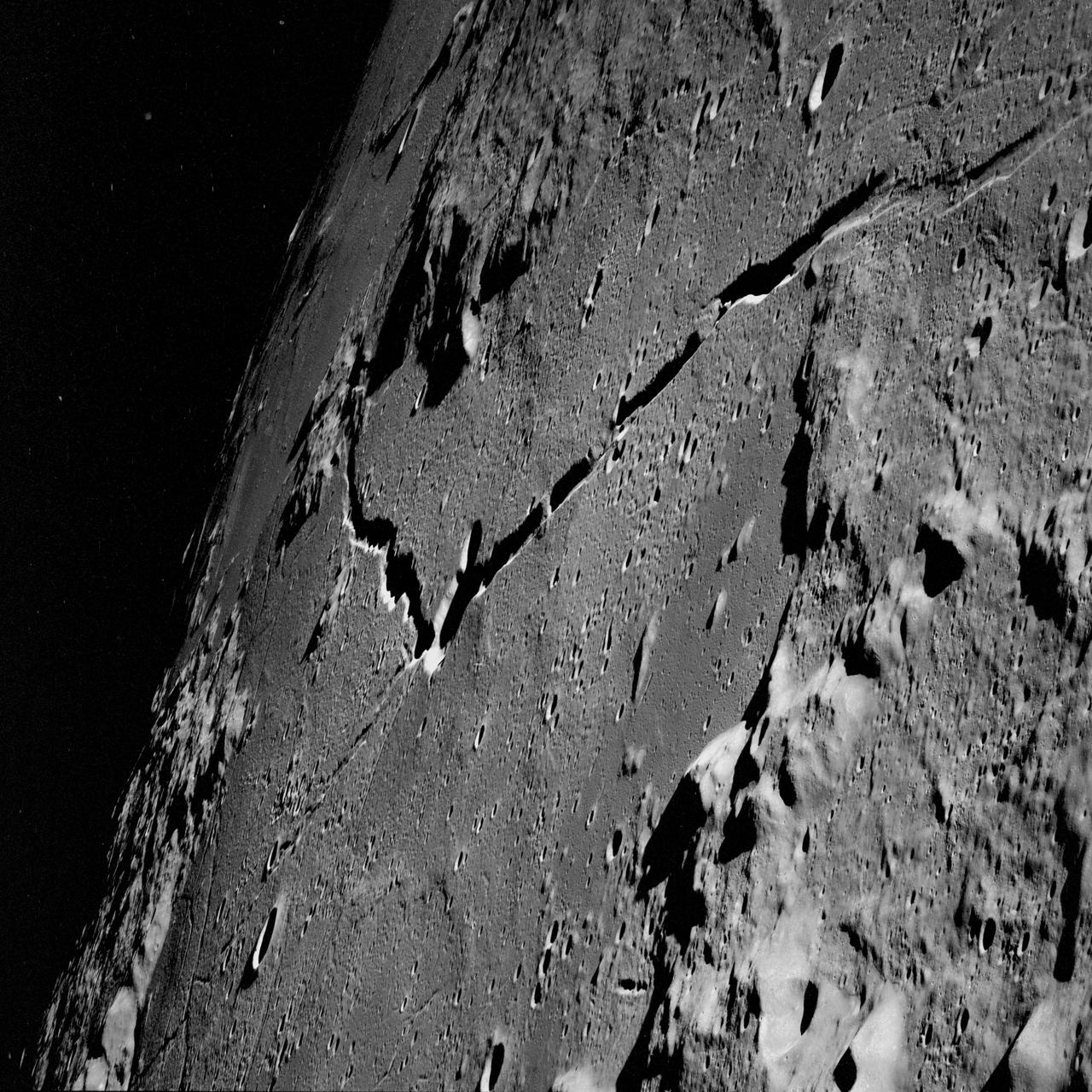
AS10-31-4537 (18-26 May 1969) --- This near vertical photograph taken from the Apollo 10 Command and Service Modules shows features typical of the Sea of Tranquility near Apollo Landing Site 2. HOLD PICTURE WITH PRONOUNCED LINEAR FEATURE PARALLEL TO LEFT MARGIN. The proposed landing area for Apollo 11 (Lunar Landing Site 2) is a relatively smooth maria area in the upper right quadrant of the photographed area. Apollo 10 traveled from the bottom to the top of the picture. The prominent linear feature at left is Hypatia Rille (called "U.S. 1" by the Apollo 10 crew). The prominent crater centered in Hypatia Rille at top left is Moltke AC (code name "Chuck Hole"). Moltke, the prominent crater to the right of Hypatia Rille, is centered near 24.2 degrees east longitude, and 0.6 degrees south latitude.
AS10-27-3908 (18-26 May 1969) --- An Apollo 10 photograph of the lunar nearside looking westward across Apollo Landing Site 3 in Central Bay. Bruce, the prominent crater in the lower right corner, is about 3.7 statute miles in diameter. Topographic features on the surface of Central Bay are accentuated by the low sun angle.
AS10-27-3907 (18-26 May 1969) --- Apollo 10 westward view across Apollo Landing Site 3 in the Central Bay. Apollo Landing Site 3 is in the middle distance at the left margin of the pronounced ridge in the left half of the photograph. Bruce, the prominent crater, near the bottom of the scene, is about 6 kilometers (3.7 statute miles) in diameter. Topographic features on the surface of the Central Bay are accentuated by the low sun angle. Sun angles range from near 6 degrees at the bottom of the photograph to less than one degree at the top.
AS10-31-4650 (18-26 May 1969) --- This Apollo 10 oblique telephoto view of the lunar nearside is centered on the crater Hyginus located at 6.3 degrees north latitude, near the northeast margin of Central Bay. HOLD PICTURE WITH SKY AT TOP. The crater is about 10 kilometers (6.5 statue miles) in diameter. From the crater the prominent Hyginus Rille extends east-southeast toward the camera and northwest toward the Sea of Vapors. The rille is about 3 kilometers (2 statue miles) wide and more than 200 kilometers (130 statue miles) long. The horizon is not visible in this photograph, taken from the Command and Service Modules. The sunrise terminator is between the spacecraft and the horizon. At the time this picture was taken Apollo 10 was 325 kilometers (200 statute miles) southeast of Hyginus.
AS10-29-4321 (18-26 May 1969) --- An Apollo 10 oblique view of the western portion of the Sea of Tranquility. The area in the picture is located approximately 70 nautical miles east-southeast of Apollo Landing Site 2. The flat terrain pitted by moderate-sized craters is typical of this portion of Mare Tranquillitatis.
AS16-114-18412 (16-27 April 1972) --- The gnomon and color patch, one of the Apollo Lunar Hand Tools (ALHT), is deployed atop a lunar rock, in this photograph taken by one of the Apollo 16 astronauts during their lunar surface extravehicular activity (EVA) at the Descartes landing site. The gnomon is used as a photographic reference to establish local vertical sun angle, scale, and lunar color. The color patch, mounted on one of the legs of the tripod, provides a larger target for accurately determining colors in color photography. A portion of Flag Crater can be seen in the background. While astronauts John W. Young, commander; and Charles M. Duke Jr., lunar module pilot; descended in the Apollo 16 Lunar Module (LM) "Orion" to explore the Descartes highlands landing site on the moon, astronaut Thomas K. Mattingly II, command module pilot, remained with the Command and Service Modules (CSM) "Casper" in lunar orbit.
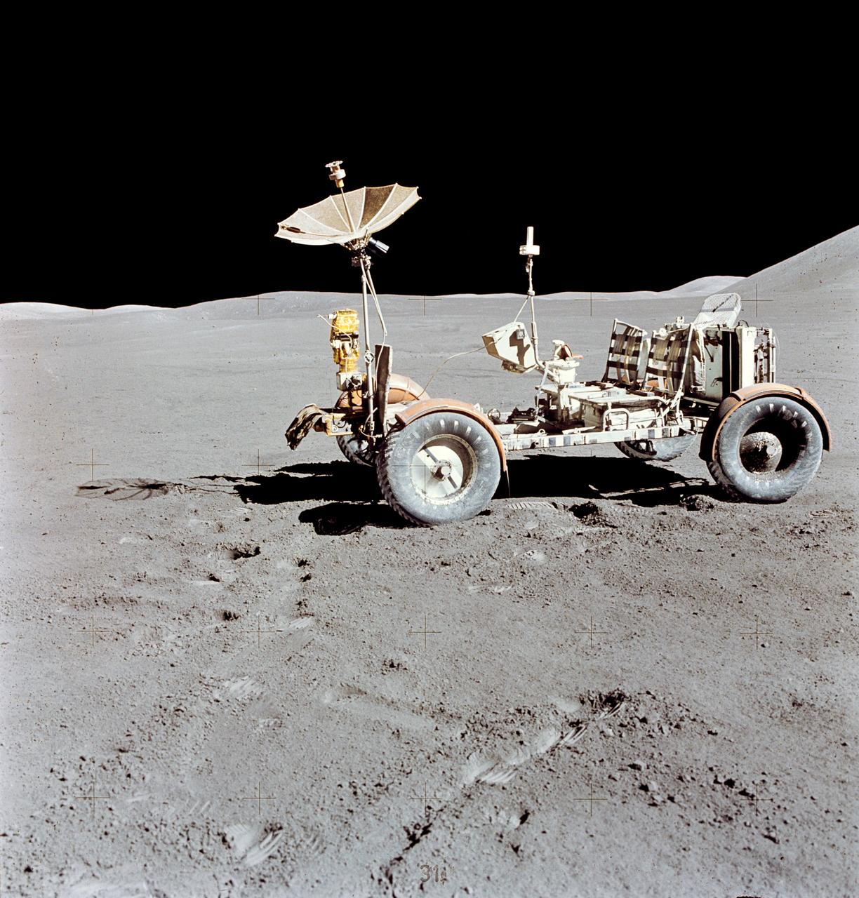
AS15-88-11901 (31 July-2 Aug. 1971) --- The Lunar Roving Vehicle (LRV) is photographed alone against the desolate lunar background during the third Apollo 15 lunar surface extravehicular activity (EVA) at the Hadley-Apennine landing site. This view is looking north. The west edge of Mount Hadley is at the upper right edge of the picture. Mount Hadley rises approximately 4,500 meters (about 4,765 feet) above the plain. The most distant lunar feature visible is approximately 25 kilometers (about 15.5 statute miles) away. While astronauts David R. Scott, commander; and James B. Irwin, lunar module pilot, descended in the Lunar Module (LM) "Falcon" to explore the moon, astronaut Alfred M. Worden, command module pilot, remained with the Command and Service Modules (CSM) in lunar orbit.

AS11-40-5875 (20 July 1969) --- Astronaut Edwin E. Aldrin Jr., lunar module pilot of the first lunar landing mission, poses for a photograph beside the deployed United States flag during an Apollo 11 extravehicular activity (EVA) on the lunar surface. The Lunar Module (LM) is on the left, and the footprints of the astronauts are clearly visible in the soil of the moon. Astronaut Neil A. Armstrong, commander, took this picture with a 70mm Hasselblad lunar surface camera. While astronauts Armstrong and Aldrin descended in the LM, the "Eagle", to explore the Sea of Tranquility region of the moon, astronaut Michael Collins, command module pilot, remained with the Command and Service Modules (CSM) "Columbia" in lunar orbit. Photo credit: NASA
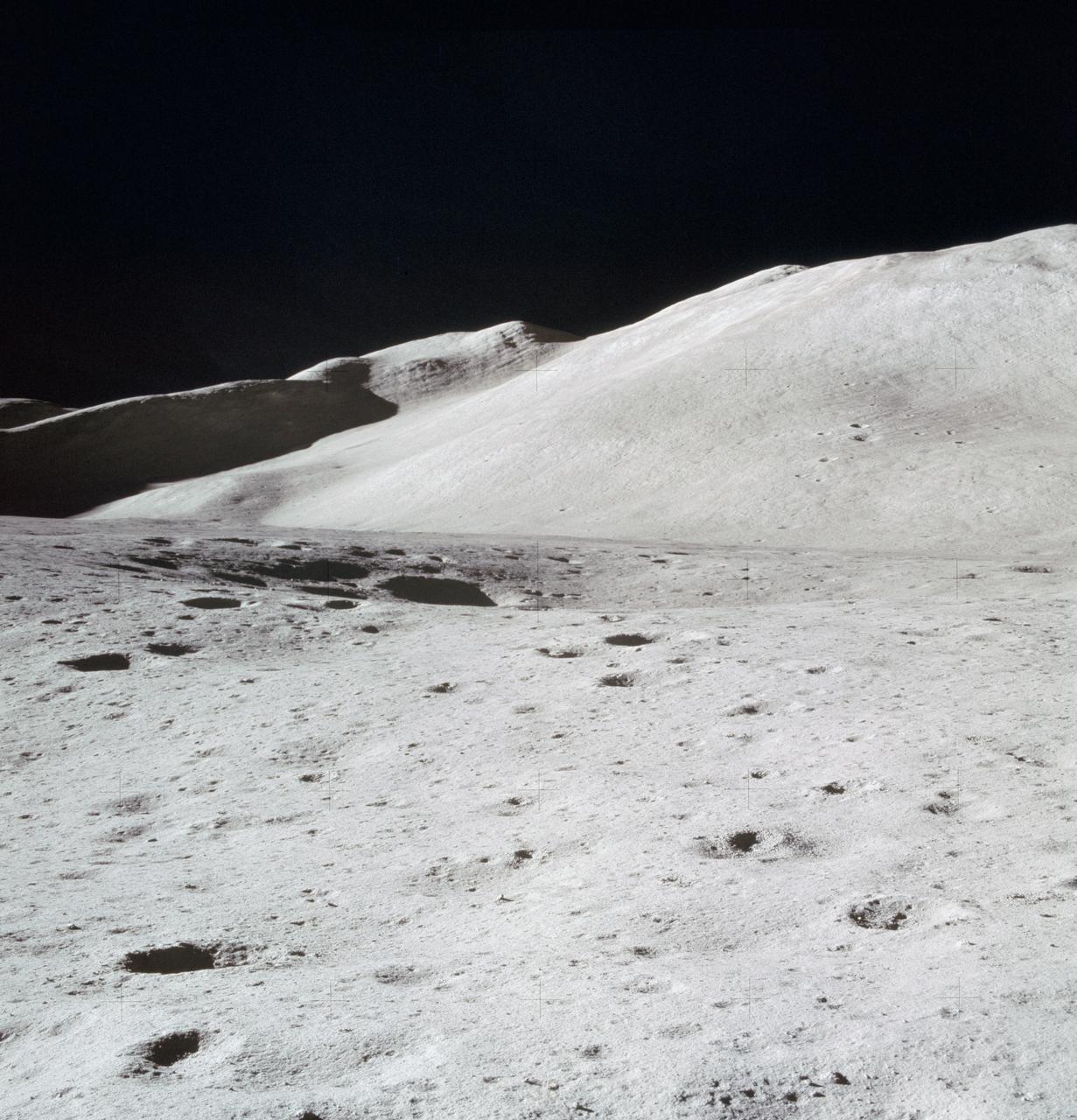
AS15-87-11748 (31 July 1971) --- A view of Hadley Delta, looking southeasterly, as photographed from the top hatch of the Apollo 15 Lunar Module (LM) by astronaut David R. Scott, commander, during his stand-up extravehicular activity (EVA) just after the LM "Falcon" touched down at the Hadley-Apennine landing site. The prominent feature on the horizon in the center of the picture was called Silver Spur by the Apollo 15 crew men. Hadley Delta Mountain rises approximately 4,000 meters (about 13,124 feet) above the plain. While astronauts Scott and James B. Irwin, lunar module pilot, descended in the LM to explore the moon, astronaut Alfred M. Worden, command module pilot, remained with the Command and Service Module's (CSM) in lunar orbit.
AS08-17-2814 (21-27 Dec. 1968) --- This oblique view of the lunar surface taken from the Apollo 8 spacecraft looking westward across the Sea of Fertility into the Sea of Tranquility shows the terrain the astronauts will see as the approach Apollo Landing Site East 2. The landing site is at the horizon about one-third of the distance from the left to the right photograph margin. The prominent crater in the highlands near the center of the picture is Secchi, about 25 kilometers (15 statute miles) in diameter.
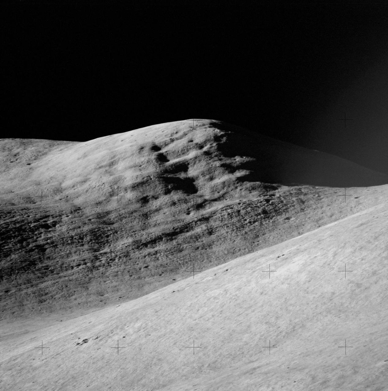
AS15-84-11250 (31 July-2 Aug. 1971) --- A telephoto lens view of the prominent feature called Silver Spur in the Hadley Delta region, photographed during the Apollo 15 lunar surface extravehicular activity (EVA) at the Hadley-Apennine landing site. The distance from the camera to the spur is about 10 miles. The field of view across the bottom is about one mile. Structural formations in the mountain are clearly visible. There are two major units. The upper unit is characterized by massive subunits, each one of which is approximately 200 feet deep. The lower major unit is characterized by thinner bedding and cross bedding.
AS08-17-2821 (21-27 Dec. 1968) --- This oblique view of the lunar surface taken from the Apollo 8 spacecraft looking westward across the Sea of Tranquility shows Apollo Landing Site East 2 illuminated by a sun that is six to eight degrees above the eastern horizon. The landing site is on the dark gray, smooth surface of the Sea of Tranquility and north (to the right) of the bright highland terrain at the lower left corner of the photograph. The landing site is about four tenths of the distance from the left to right margin of the photograph.
AS15-87-11849 (31 July-2 Aug. 1971) --- An excellent view of Mount Hadley, fully lighted, showing abundant linear features, as photographed during the Apollo 15 lunar surface extravehicular activity (EVA). This view is looking north from the Apollo Lunar Surface Experiments Package (ALSEP) site. Mount Hadley rises about 4,500 meters (approximately 14,765 feet) above the plain. While astronauts David R. Scott, commander, and James B. Irwin, lunar module pilot, descended in the Apollo 15 Lunar Module (LM) "Falcon" to explore the Hadley-Apennine area of the moon, astronaut Alfred M. Worden, command module pilot, remained with the Command and Service Modules (CSM) in lunar orbit.

AS11-40-5868 (20 July 1969) --- Astronaut Edwin E. Aldrin Jr., lunar module pilot, descends the steps of the Lunar Module (LM) ladder as he prepares to walk on the moon. He had just egressed the LM. This photograph was taken by astronaut Neil A. Armstrong, commander, with a 70mm lunar surface camera during the Apollo 11 extravehicular activity (EVA). While Armstrong and Aldrin descended in the LM "Eagle" to explore the moon, astronaut Michael Collins, command module pilot, remained with the Command and Service Modules (CSM) in lunar orbit.
AS11-40-5863 (20 July 1969) --- Astronaut Edwin E. Aldrin Jr., lunar module pilot, is photographed egressing the Lunar Module (LM) during the Apollo 11 extravehicular activity (EVA) on the moon. This photograph was taken by astronaut Neil A. Armstrong, commander, with a 70mm lunar surface camera. While astronauts Armstrong and Aldrin descended in the Lunar Module (LM) "Eagle" to explore the Sea of Tranquility region of the moon, astronaut Michael Collins, command module pilot, remained with the Command and Service Modules (CSM) "Columbia" in lunar orbit.
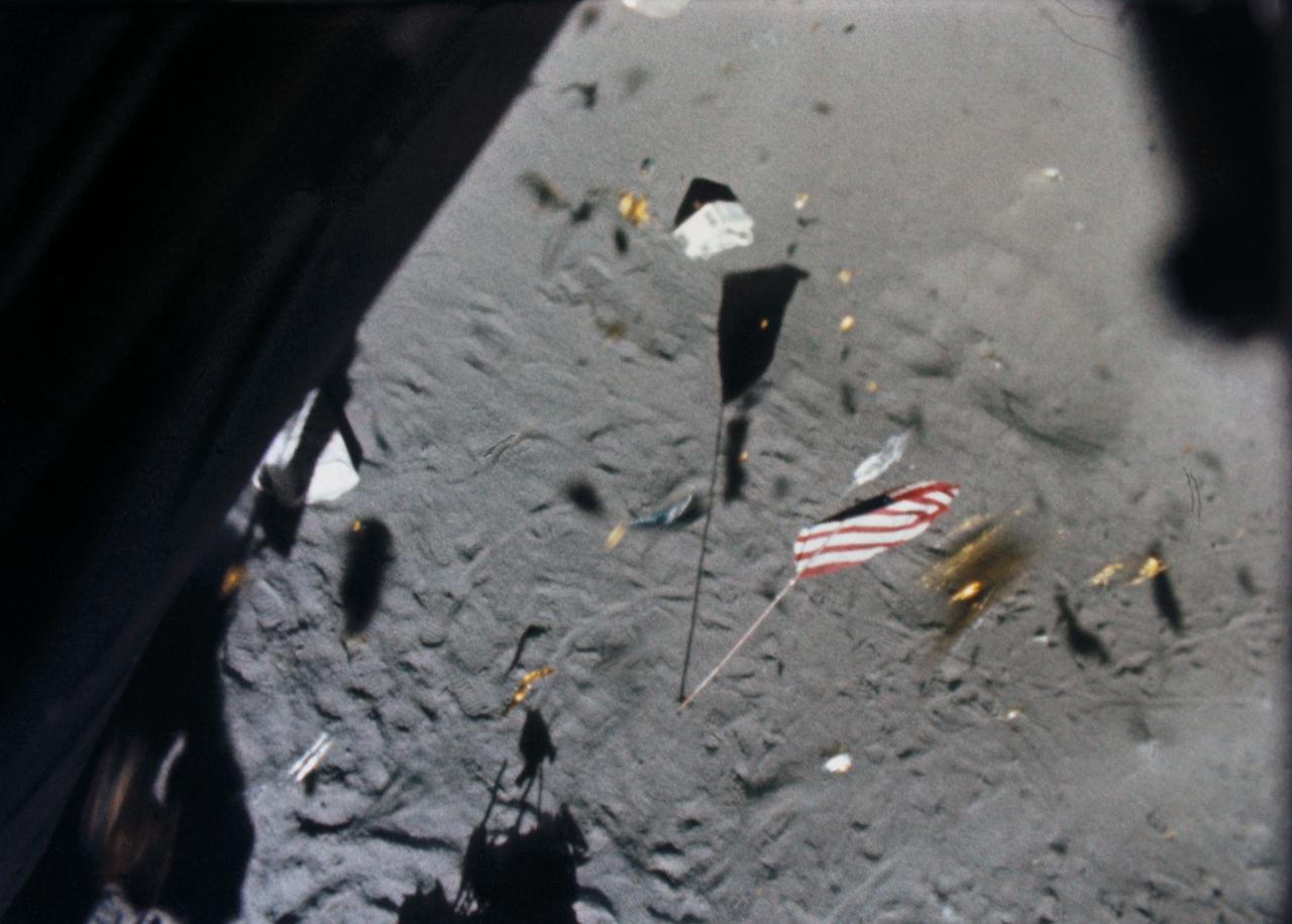
S71-19500 (6 Feb. 1971) --- The Apollo 14 Lunar Module (LM) ascent stage lifts off the lunar surface and the powerful LM engine causes a brief force of wind which scatters gold-colored foil, covering the LM, and disturbs the U.S. flag. This picture was taken from film exposed by the 16mm data acquisition camera - which was mounted inside the LM.
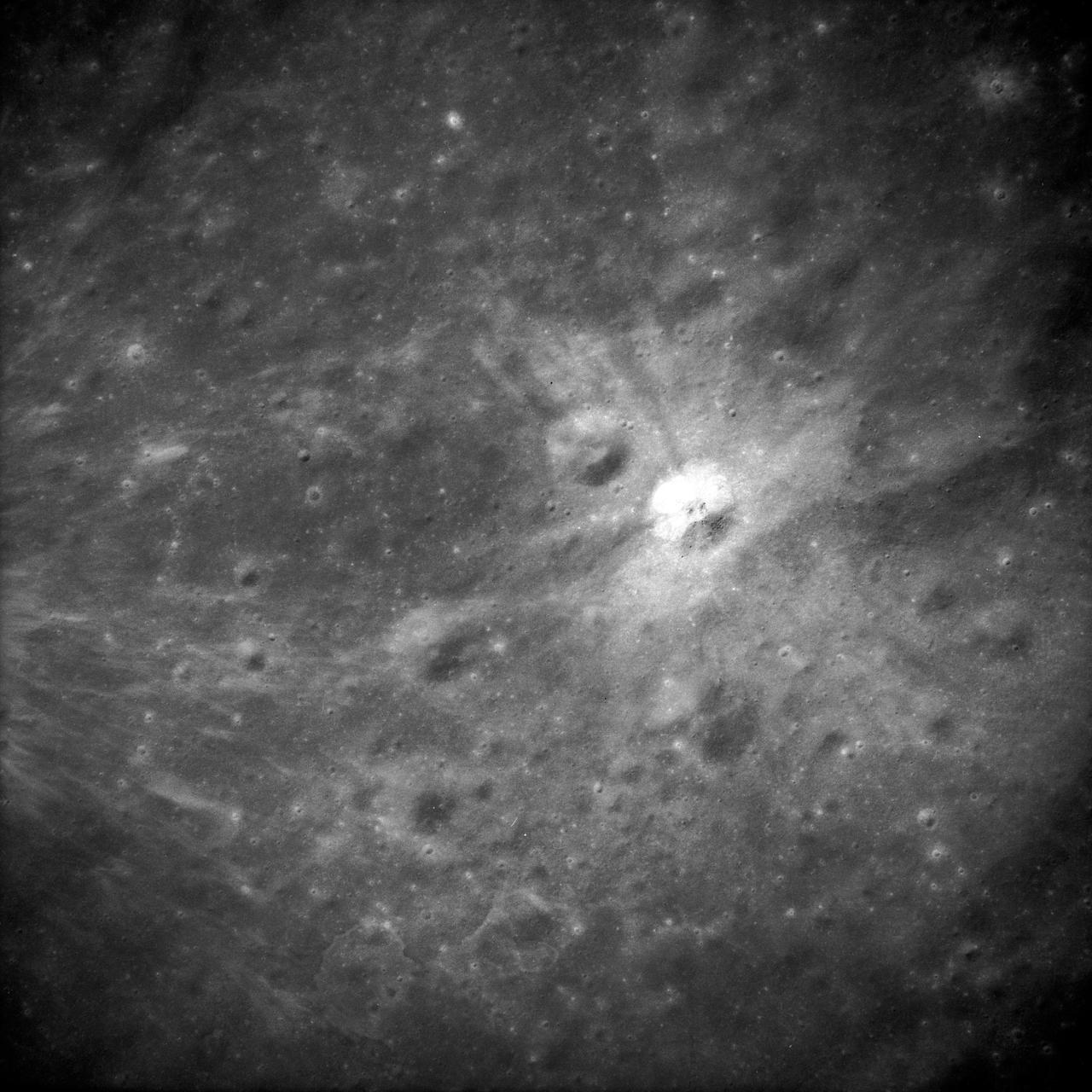
AS14-69-9560 (February 1971) --- This 500mm vertical frame taken from the Apollo 14 spacecraft is of the Apollo 16 proposed landing site "Descartes". The actual location of the target area is near the upper left. This photograph was taken with a 56 degree sun angle. The large bright crater is approximately one kilometer in diameter and has a distinctive ray pattern which serves as an excellent landmark.
AS10-27-3956 (24 May 1969) --- This photograph of the moon was taken after trans-Earth insertion when the Apollo 10 spacecraft was high above the lunar equator near 27 degrees east longitude. North is about 20 degrees left of the top of the photograph. Apollo Landing Site 3 is on the lighted side of the terminator in a dark area just north of the equator. Apollo Landing Site 2 is near the lower left margin of the Sea of Tranquility (Mare Tranquillitatis), which is the large, dark area near the center of the photograph.

AS16-107-17436 (21 April 1972) --- An excellent view of the Lunar Module (LM) "Orion" and Lunar Roving Vehicle (LRV), as photographed by astronaut Charles M. Duke Jr., lunar module pilot, during the first Apollo 16 extravehicular activity (EVA) at the Descartes landing site. Astronaut John W. Young, commander, can be seen directly behind the LRV. The lunar surface feature in the left background is Stone Mountain. While astronauts Young and Duke descended in the LM to explore the Descartes highlands landing site on the moon, astronaut Thomas K. Mattingly II, command module pilot, remained with the Command and Service Modules (CSM) "Casper" in lunar orbit.

AS16-113-18339 (21 April 1972) --- Astronaut John W. Young, commander of the Apollo 16 lunar landing mission, leaps from the lunar surface as he salutes the United States flag at the Descartes landing site during the first Apollo 16 extravehicular activity (EVA). Astronaut Charles M. Duke Jr., lunar module pilot, took this picture. The Lunar Module (LM) "Orion" is on the left. The Lunar Roving Vehicle (LRV) is parked beside the LM. The object behind Young (in the shade of the LM) is the Far Ultraviolet Camera/Spectrograph (FUC/S). Stone Mountain dominates the background in this lunar scene. While astronauts Young and Duke descended in the LM to explore the Descartes highlands landing site on the moon, astronaut Thomas K. Mattingly II, command module pilot, remained with the Command and Service Modules (CSM) "Casper" in lunar orbit.
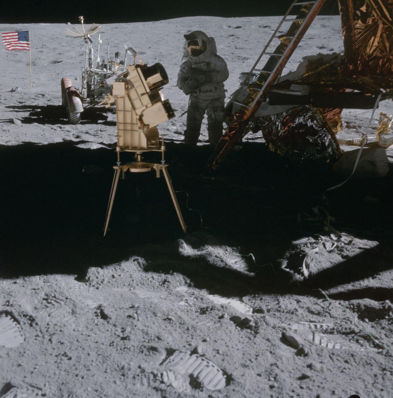
AS16-114-18439 (22 April 1972) --- Astronaut Charles M. Duke Jr., lunar module pilot, stands in the shadow of the Lunar Module (LM) behind the ultraviolet (UV) camera which is in operation. This photograph was taken by astronaut John W. Young, commander, during the mission's second extravehicular activity (EVA). The UV camera's gold surface is designed to maintain the correct temperature. The astronauts set the prescribed angles of azimuth and elevation (here 14 degrees for photography of the large Magellanic Cloud) and pointed the camera. Over 180 photographs and spectra in far-ultraviolet light were obtained showing clouds of hydrogen and other gases and several thousand stars. The United States flag and Lunar Roving Vehicle (LRV) are in the left background. While astronauts Young and Duke descended in the Apollo 16 Lunar Module (LM) "Orion" to explore the Descartes highlands landing site on the moon, astronaut Thomas K. Mattingly II, command module pilot, remained with the Command and Service Modules (CSM) "Casper" in lunar orbit.

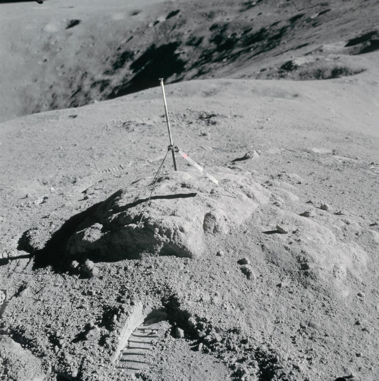
AS17-145-22157 (12 Dec. 1972) --- Scientist-astronaut Harrison Schmitt, Apollo 17 lunar module pilot, uses an adjustable sampling scoop to retrieve lunar samples during the second Apollo 17 extravehicular activity (EVA), at Station 5 at the Taurus-Littrow landing site. A gnomon is atop the large rock in the foreground. The gnomon is a stadia rod mounted on a tripod, and serves as an indicator of the gravitational vector and provides accurate vertical reference and calibrated length for determining size and position of objects in near-field photographs. The color scale of blue, orange and green is used to accurately determine color for photography. The rod of it is 18 inches long. The scoop Dr. Schmitt is using is 11 3/4 inches long and is attached to a tool extension which adds a potential 30 inches of length to the scoop. The pan portion, obscured in this view, has a flat bottom, flanged on both sides with a partial cover on the top. It is used to retrieve sand, dust and lunar samples too small for the tongs, another geological tool used by the astronauts. The pan and the adjusting mechanism are made of stainless steel and the handle is made of aluminum. Within the foreground of this scene, three lunar samples were taken--numbers 75060, 75075 and 75080. Astronaut Eugene A. Cernan, crew commander, was using a 60mm lens on the 70mm Hasselblad camera and type SO-368 film to take this photograph.