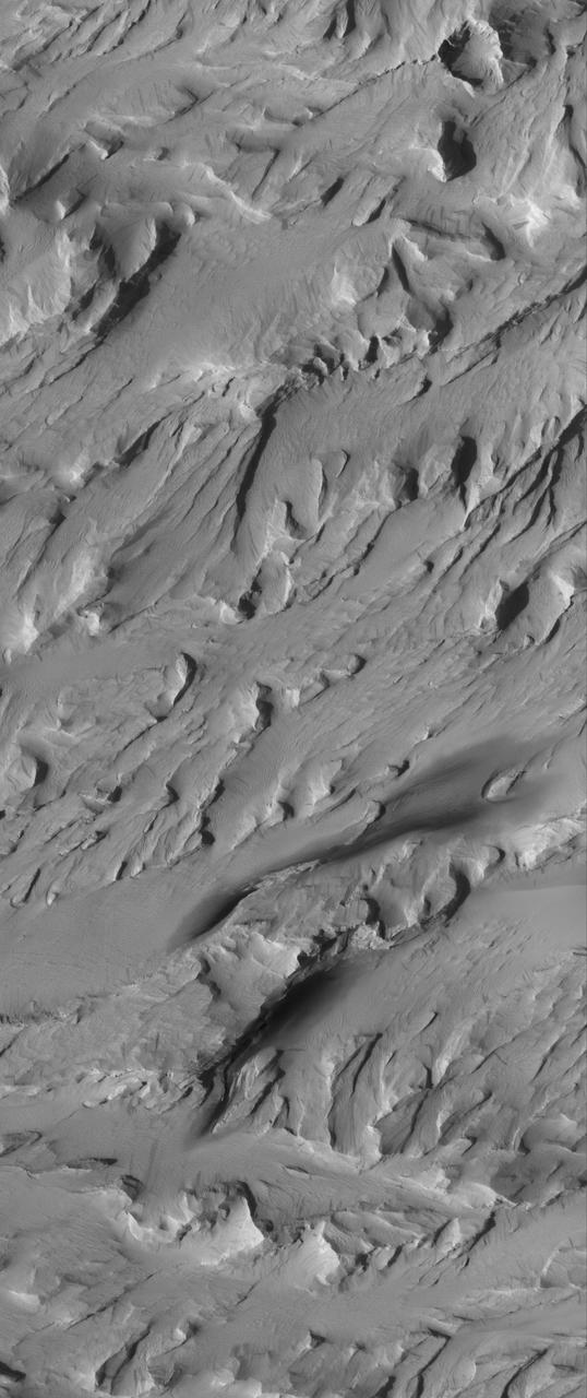
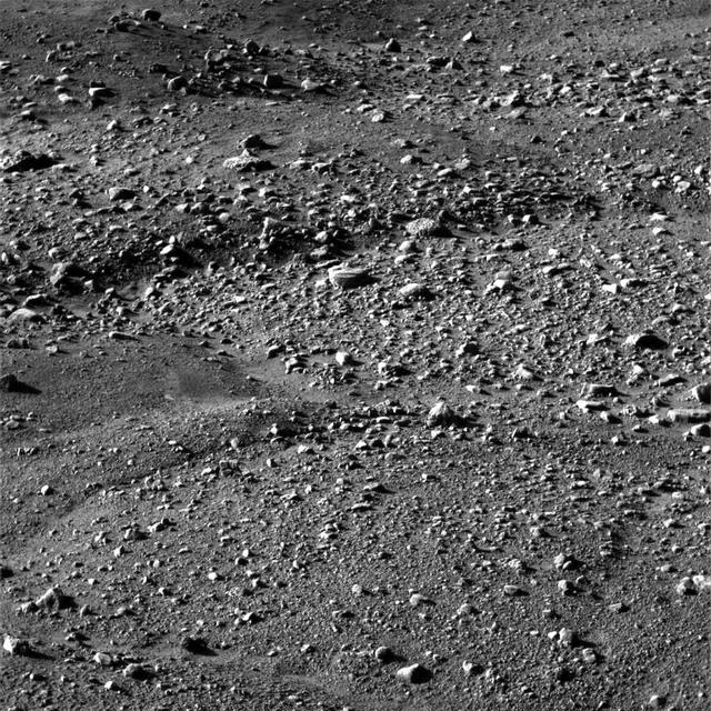
A Curious Landscape
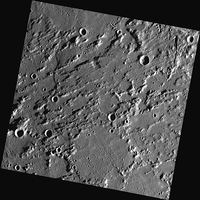
Northeast Hellas Landscape
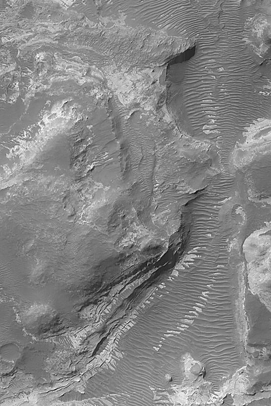
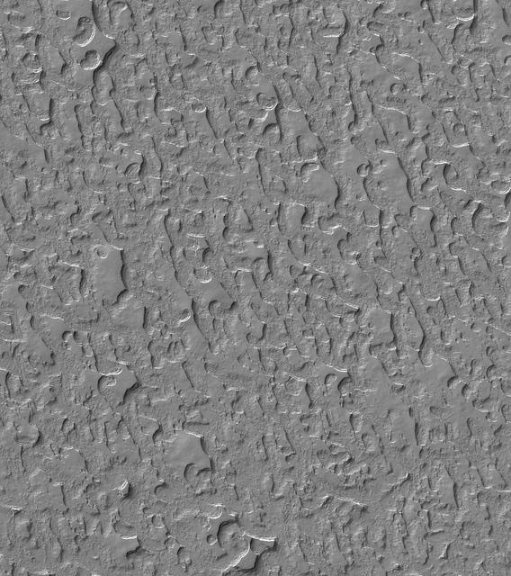
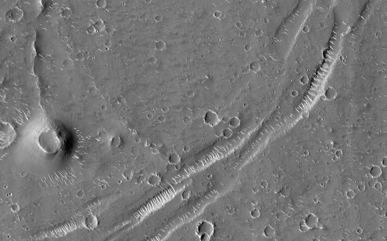
Wind-Eroded Landscape
A Rugged Landscape Outside of Caloris
Arctic Landscape Within Reach
Carbon Dioxide Landscape

Various Landscapes and Features on Europa
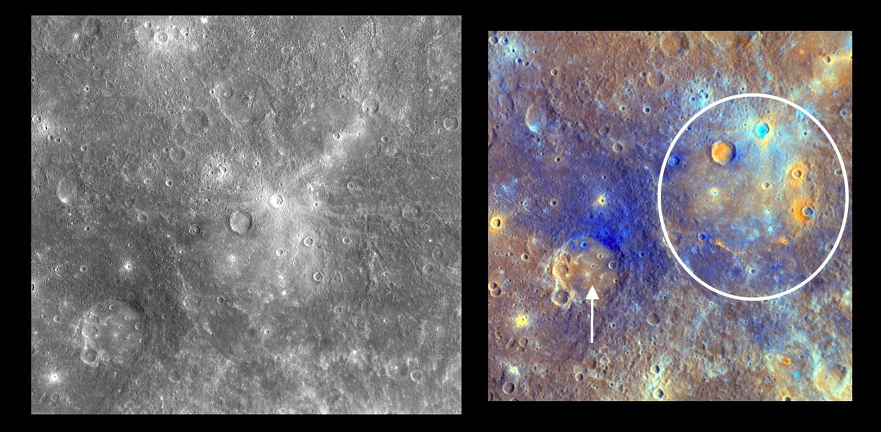
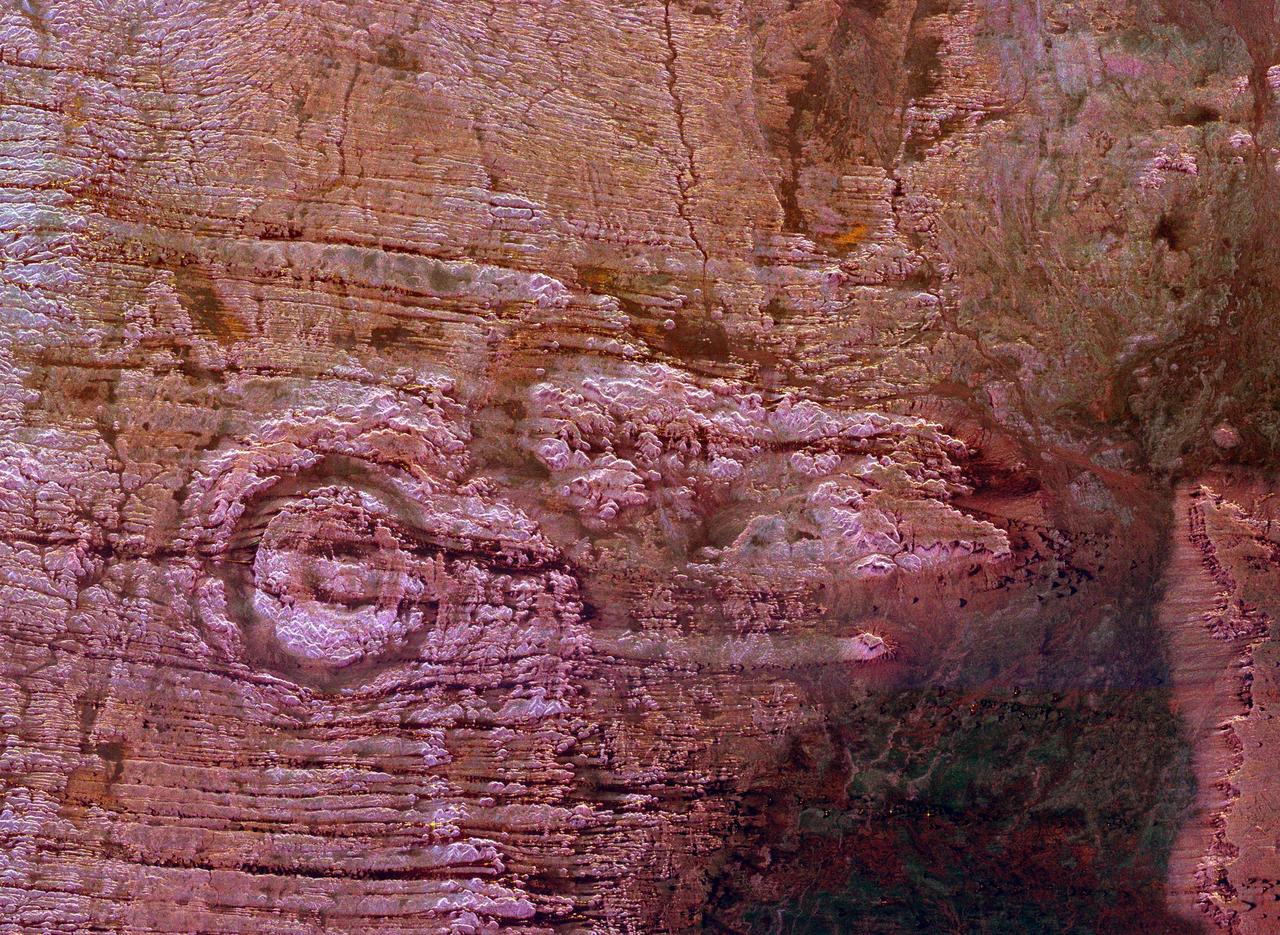
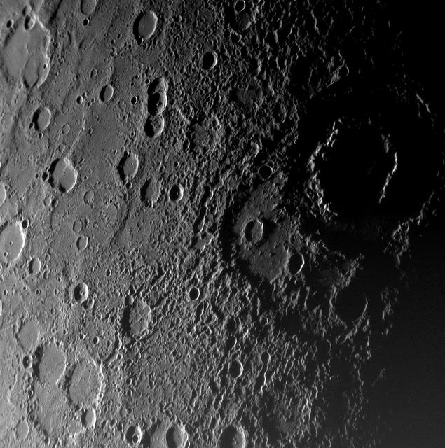
Dominici Colors Mercury Landscape
Callisto Varied Crater Landscape
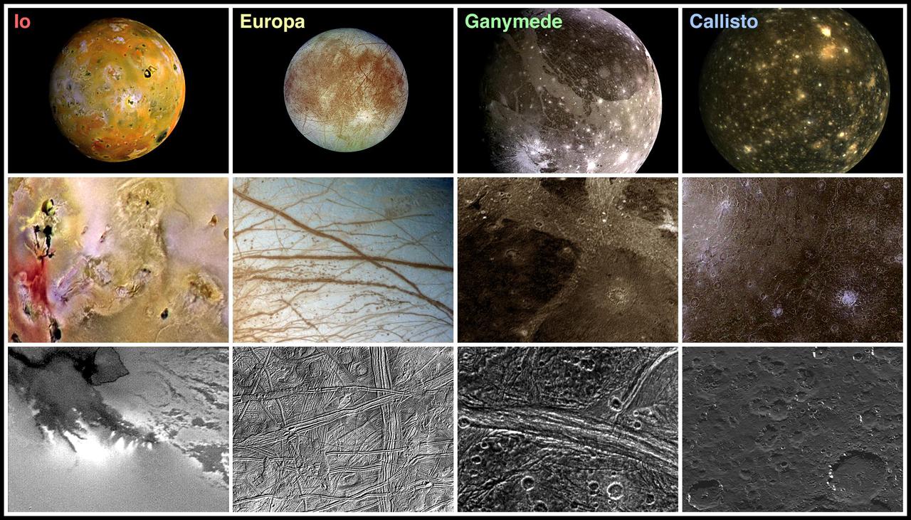
Landscape Comparisons - Galilean Satellites
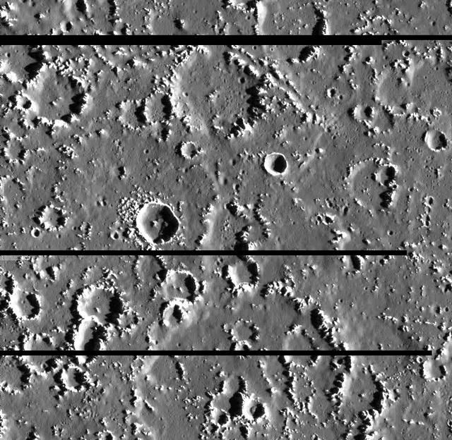
Landscape Northeast of Halley Crater
Carbon Dioxide Landscape
Signs of Landscape Modifications at Martian Crater
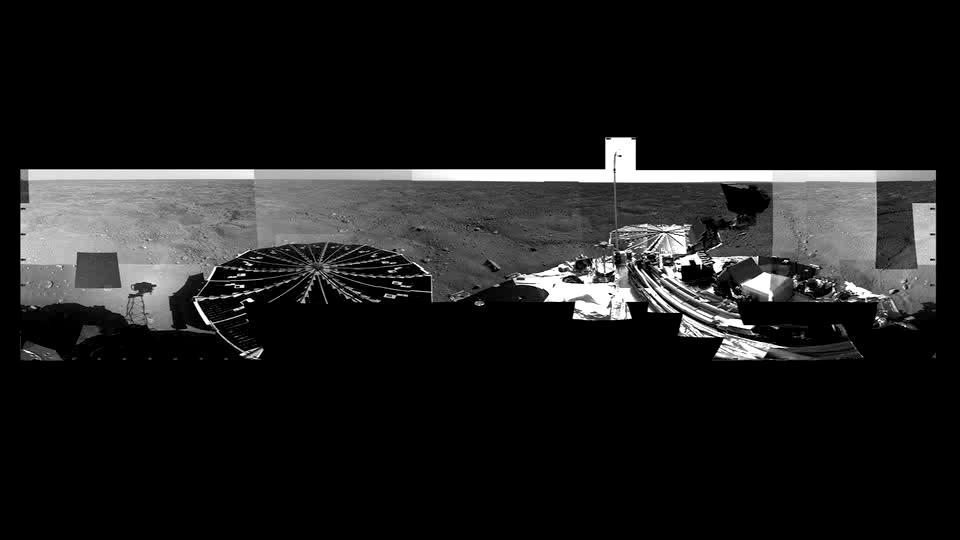
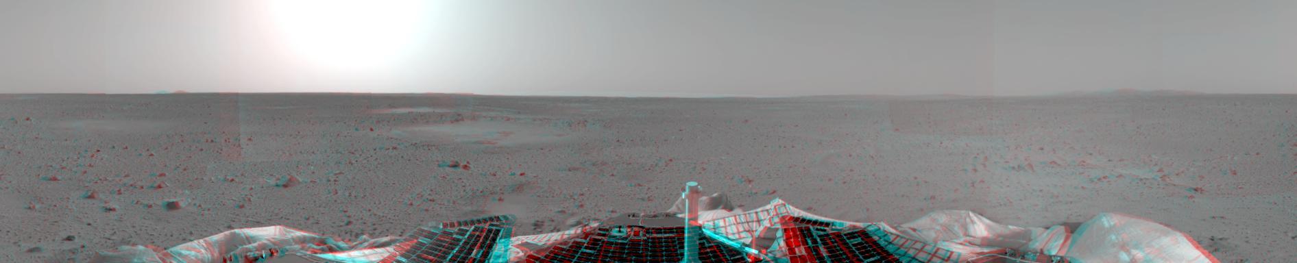
Martian Arctic Landscape Panorama Video
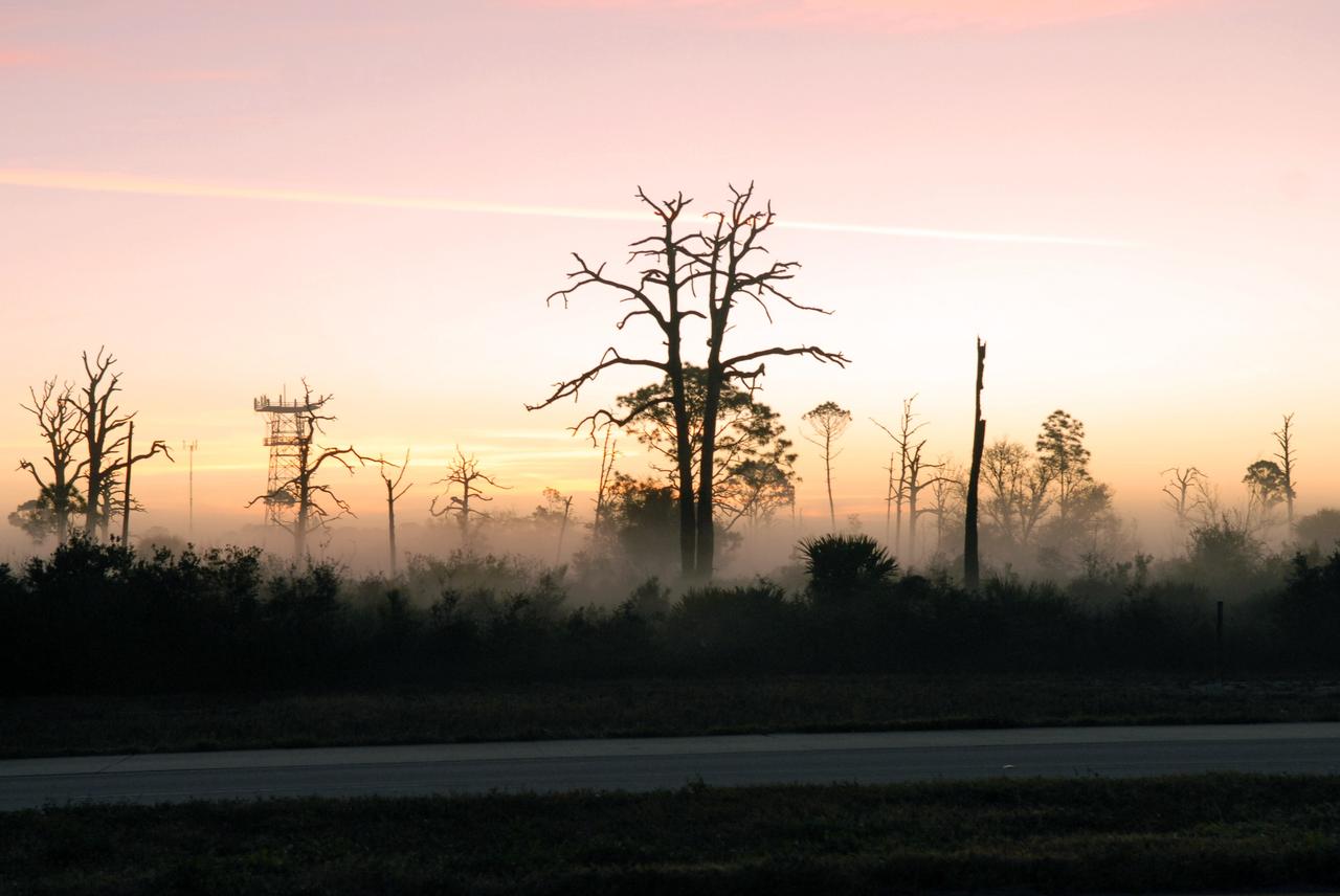
CAPE CANAVERAL, Fla. -- Fog blankets the woods near a road in the Merritt Island National Wildlife Refuge at NASA's Kennedy Space Center in Florida. The center shares a boundary with the refuge that includes salt-water estuaries, brackish marshes, hardwood hammocks and pine flatwoods. The diverse landscape provides habitat for more than 310 species of birds, 25 mammals, 117 fishes and 65 amphibians and reptiles. Photo credit: NASA/Jack Pfaller
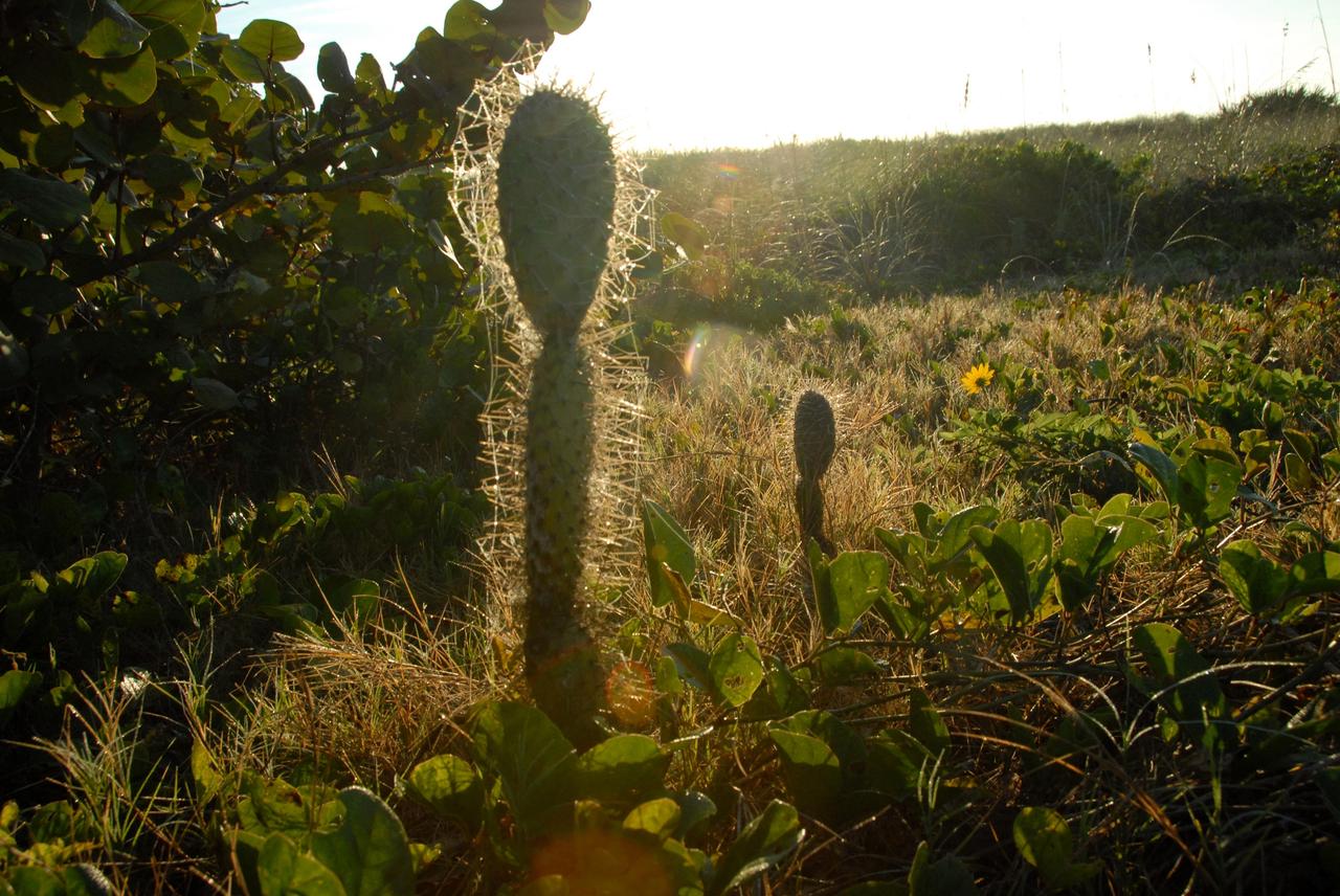
CAPE CANAVERAL, Fla. -- Morning light sculpts a cactus on the roadside at NASA's Kennedy Space Center in Florida. The center shares a boundary with the Merritt Island National Wildlife Refuge that includes salt-water estuaries, brackish marshes, hardwood hammocks and pine flatwoods. The diverse landscape provides habitat for more than 310 species of birds, 25 mammals, 117 fishes and 65 amphibians and reptiles. Photo credit: NASA/Jack Pfaller
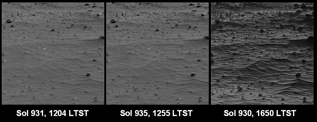
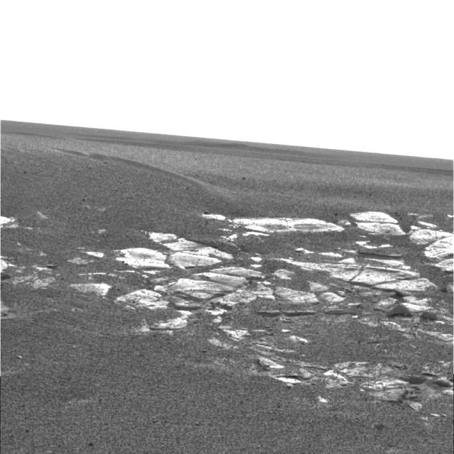
Shadows Draw Attention to Features of Mars Landscape Sand Ripples
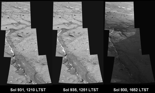
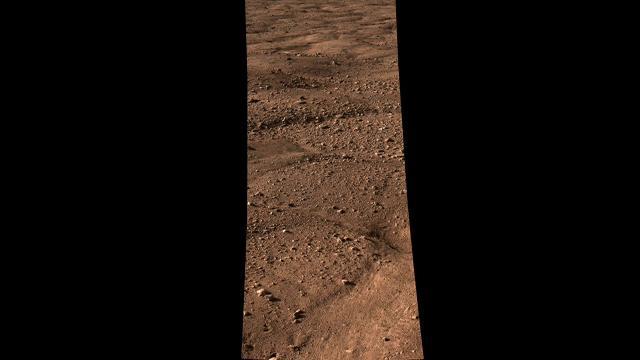
Shadows Draw Attention to Features of Mars Landscape Rover Tracks

The concept of urban air mobility involves multiple aircraft safely operating within a city. (Yellow circles are vehicles with passengers; pink circles are vehicles without passengers.)
Many Martian landscapes contain features that are familiar to ones we find on Earth, like river valleys, cliffs, glaciers and volcanos. However, Mars has an exotic side too, with landscapes that are alien to Earthlings. This image shows one of these exotic locales at the South Pole. The polar cap is made from carbon dioxide (dry ice), which does not occur naturally on the Earth. The circular pits are holes in this dry ice layer that expand by a few meters each Martian year. New dry ice is constantly being added to this landscape by freezing directly out of the carbon dioxide atmosphere or falling as snow. Freezing out the atmosphere like this limits how cold the surface can get to the frost point at -130 degrees Celsius (-200 F). Nowhere on Mars can ever get any colder this, making this this coolest landscape on Earth and Mars combined. http://photojournal.jpl.nasa.gov/catalog/PIA21216
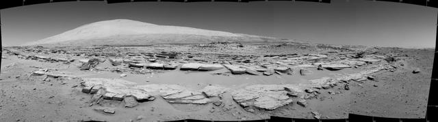
A landscape scene from NASA Curiosity Mars rover shows rock rows at Junda forming striations in the foreground, with Mount Sharp on the horizon.

NASA image release April 22, 2010 NASA's Hubble Space Telescope captured this billowing cloud of cold interstellar gas and dust rising from a tempestuous stellar nursery located in the Carina Nebula, 7,500 light-years away in the southern constellation Carina. This pillar of dust and gas serves as an incubator for new stars and is teeming with new star-forming activity. Hot, young stars erode and sculpt the clouds into this fantasy landscape by sending out thick stellar winds and scorching ultraviolet radiation. The low-density regions of the nebula are shredded while the denser parts resist erosion and remain as thick pillars. In the dark, cold interiors of these columns new stars continue to form. In the process of star formation, a disk around the proto-star slowly accretes onto the star's surface. Part of the material is ejected along jets perpendicular to the accretion disk. The jets have speeds of several hundreds of miles per second. As these jets plow into the surround nebula, they create small, glowing patches of nebulosity, called Herbig-Haro (HH) objects. Long streamers of gas can be seen shooting in opposite directions off the pedestal on the upper right-hand side of the image. Another pair of jets is visible in a peak near the top-center of the image. These jets (known as HH 901 and HH 902, respectively) are common signatures of the births of new stars. This image celebrates the 20th anniversary of Hubble's launch and deployment into an orbit around Earth. Hubble's Wide Field Camera 3 observed the pillar on Feb. 1-2, 2010. The colors in this composite image correspond to the glow of oxygen (blue), hydrogen and nitrogen (green), and sulfur (red). Object Names: HH 901, HH 902 Image Type: Astronomical Credit: NASA, ESA, and M. Livio and the Hubble 20th Anniversary Team (STScI) To read learn more about this image go to: <a href="http://www.nasa.gov/mission_pages/hubble/science/hubble20th-img.html" rel="nofollow">www.nasa.gov/mission_pages/hubble/science/hubble20th-img....</a> <b><a href="http://www.nasa.gov/centers/goddard/home/index.html" rel="nofollow">NASA Goddard Space Flight Center</a></b> is home to the nation's largest organization of combined scientists, engineers and technologists that build spacecraft, instruments and new technology to study the Earth, the sun, our solar system, and the universe.
This view of the landscape to the north of NASA Mars rover Curiosity acquired by the Mars Hand Lens Imager on the afternoon of the first day of landing. In the distance, the image shows the north wall and rim of Gale Crater.
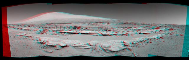
A stereo landscape scene from NASA Curiosity Mars rover shows rock rows at Junda forming striations in the foreground, with Mount Sharp on the horizon. You need 3D glasses to view this image.
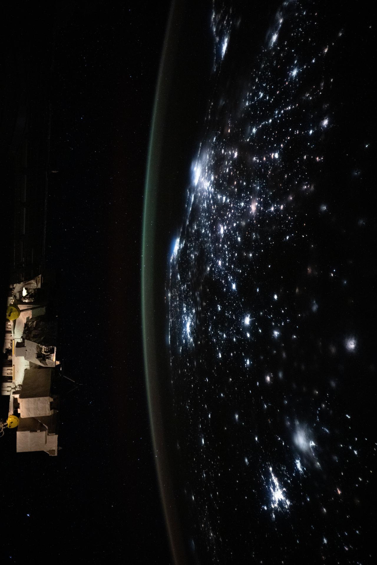
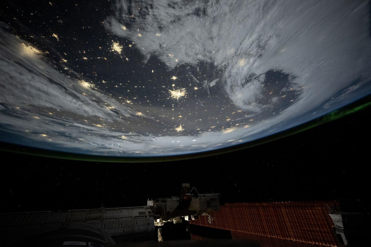
iss073e0855854 (Sept. 21, 2025) --- City lights dot the Brazilian landscape and trace a path to Rio de Janeiro and São Paulo (center) on the Atlantic coast in this photograph taken at approximately 2:17 a.m. local from the International Stace Station as it orbited 263 miles above.
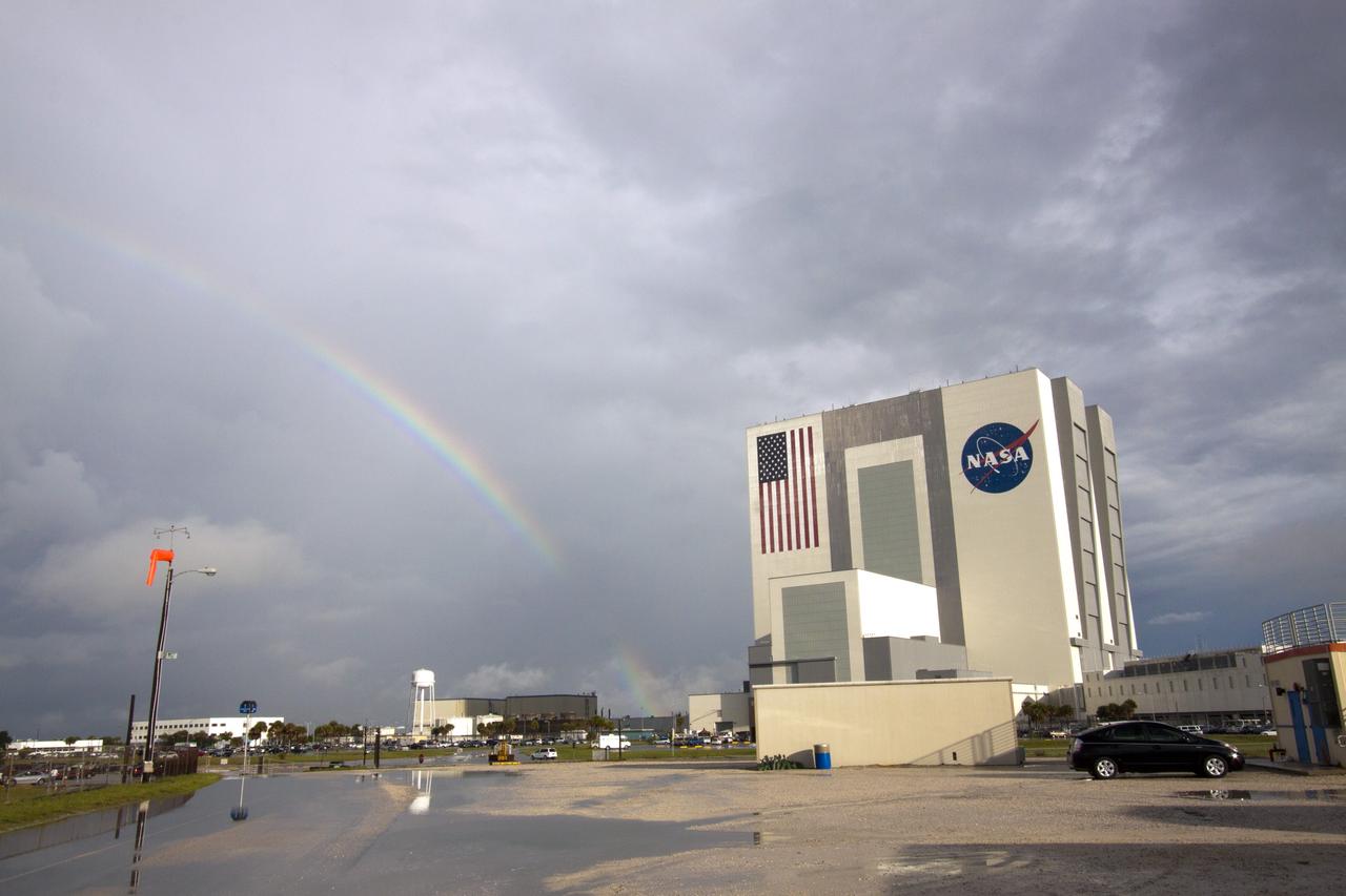
CAPE CANAVERAL, Fla. -- As the sun was rising over NASA's Kennedy Space Center in Florida, an early morning rain shower caused a meteorological and optical rainbow show next to the Vehicle Assembly Building. Florida's Space Coast often is the scene of showers and thunderstorms during the summer months. Photo credit: NASA/Jack Pfaller
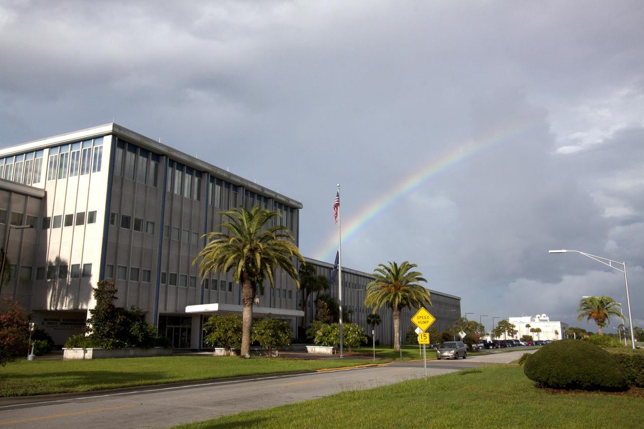
CAPE CANAVERAL, Fla. -- As the sun was rising over NASA's Kennedy Space Center in Florida, an early morning rain shower caused a meteorological and optical rainbow show over the Headquarters building. Florida's Space Coast often is the scene of showers and thunderstorms during the summer months. Photo credit: NASA/Jack Pfaller
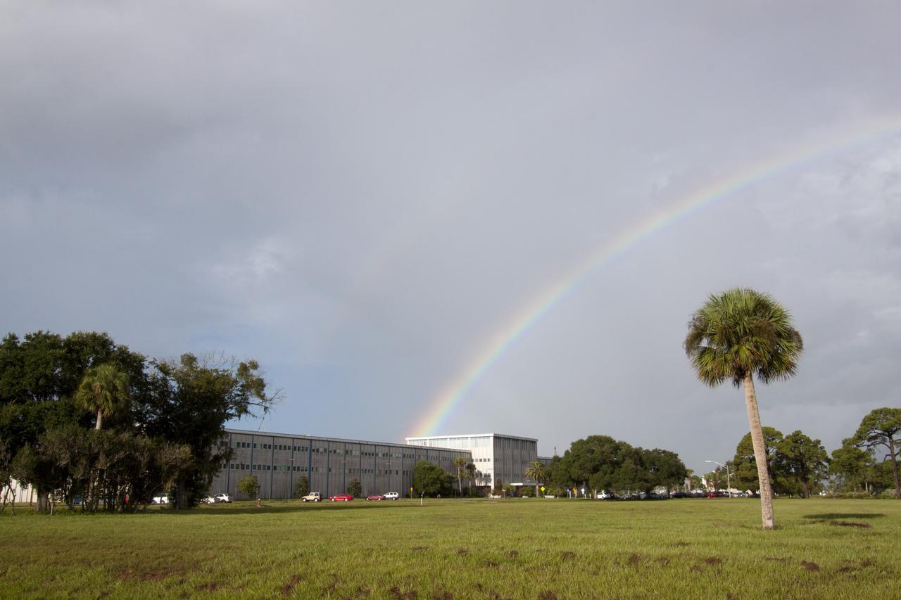
CAPE CANAVERAL, Fla. -- As the sun was rising over NASA's Kennedy Space Center in Florida, an early morning rain shower caused a meteorological and optical rainbow show over the Headquarters building. Florida's Space Coast often is the scene of showers and thunderstorms during the summer months. Photo credit: NASA/Jack Pfaller

iss073e0148982 (May 21, 2025) --- City lights dot the U.S. landscape looking southeast from 261 miles above Omaha, Nebraska, toward the southern Atlantic coast of the United States in this photograph taken at approximately 11:56 p.m. local time from the International Space Station. Pictured in the foreground, is a set of the orbital outpost's main solar arrays (lower left) and a partially obscured SpaceX Dragon crew spacecraft (lower center) docked to the Harmony module's forward port.

iss072e725406 (March 5, 2025) --- City lights dot the Canadian landscape underneath an atmospheric glow and an aurora borealis in this photograph taken from the International Space Station 262 miles above North America at approximately 12:15 a.m. local time.
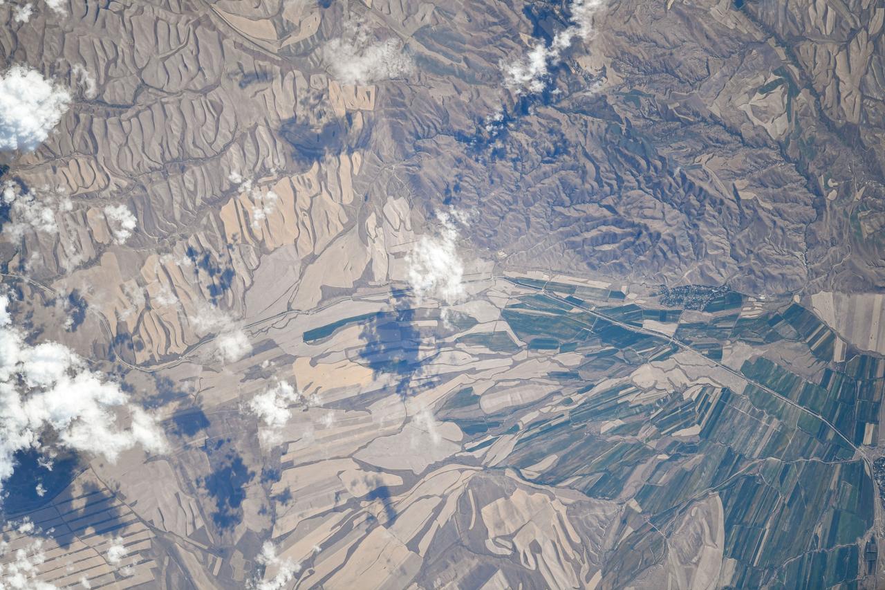
iss073e0510447 (Aug. 19, 2025) --- Agricultural activities in the diverse landscape of Kazakhstan's Jetisu region, near the Chinese border and once a key corridor of the ancient Silk Road, are pictured from the International Space Station as it orbited 263 miles above the Central Asian nation. Credit: Roscosmos

iss073e0149171 (May 21, 2025) --- City lights dot the southern United States' landscape from Louisiana (upper left), to Florida (lower center), to South Carolina (right), in this photograph from the International Space Station as it orbited 260 miles above Georgia at approximately 12:59 a.m. local time.

The Gateway space station hosts the Orion spacecraft in a polar orbit around the Moon, supporting scientific discovery on the lunar surface during the Artemis IV mission.

iss074e0209280 (Jan. 28, 2026) --- The wintry landscape from Delaware to Rhode Island is seen from the International Space Station as it orbited 259 miles above the Atlantic coast of the United States. Temperatures in New York City ranged from a low of about 14 degrees Fahrenheit to a high of around 23 degrees when this photograph was taken.
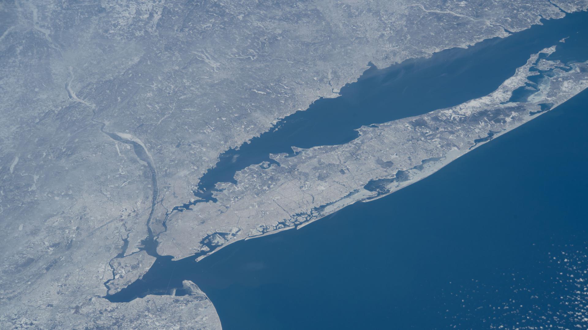
iss074e0209281 (Jan. 28, 2026) --- The wintry landscape of New Jersey, New York, and Connecticut is seen from the International Space Station as it orbited 259 miles above the Atlantic coast of the United States. Temperatures in New York City ranged from a low of about 14 degrees Fahrenheit to a high of around 23 degrees when this photograph was taken.

iss074e0300237 (Feb. 2, 2026) --- The wintry landscape from New Jersey to Massachusetts is seen from the International Space Station as it orbited 262 miles above the northeastern United States. Temperatures in New York City (lower left) ranged from a low of about 18 degrees Fahrenheit to a high of around 30 degrees when this photograph was taken.
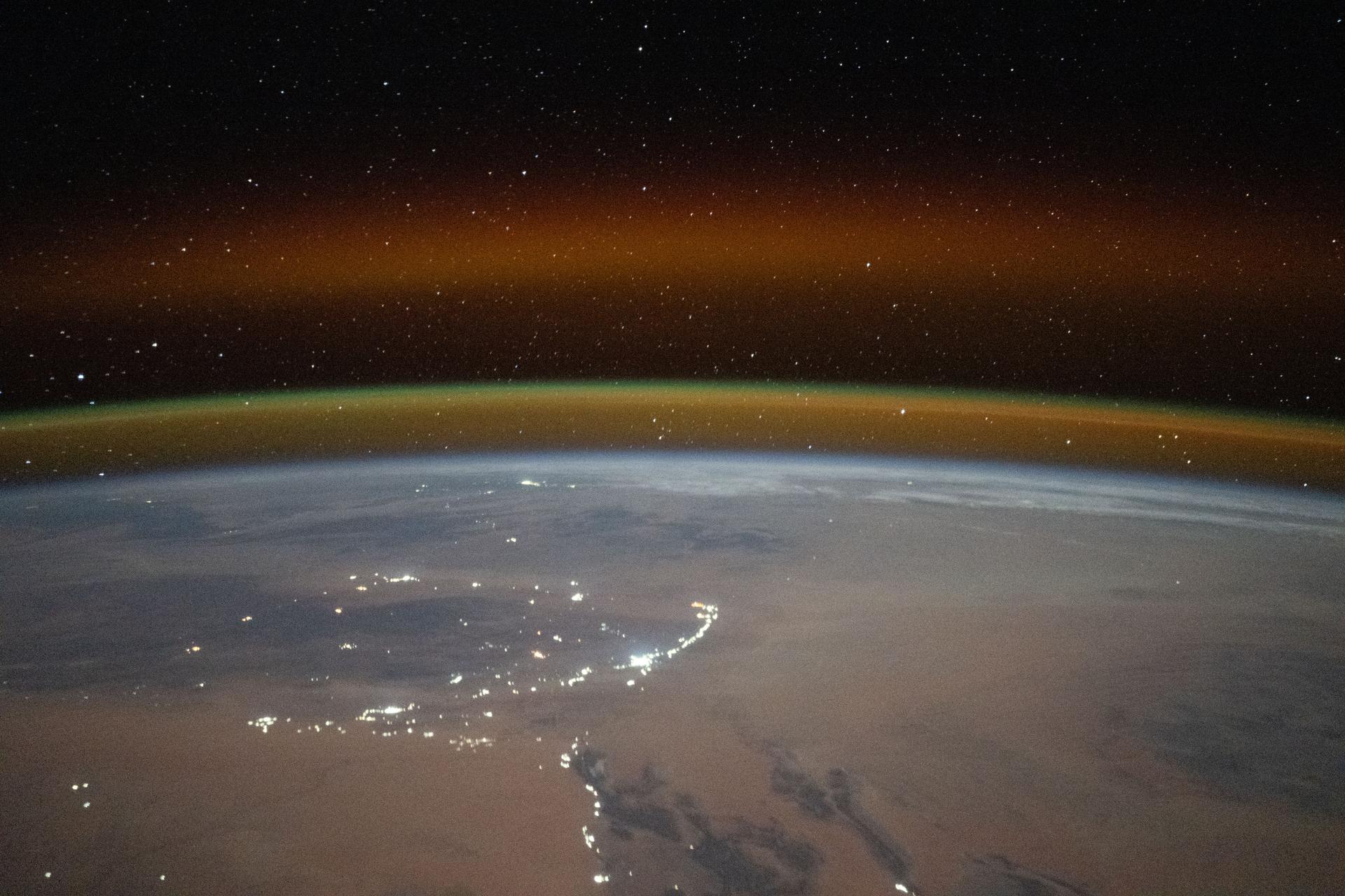
iss073e1198938 (Nov. 28, 2025) --- A yellow-red airglow blankets Earth's horizon as village lights dot the Saharan landscape of Algeria in this photograph taken at approximately 8:50 p.m. local time from the International Space Station as it orbited 261 miles above north Africa.

iss074e0300243 (Feb. 2, 2026) --- The wintry landscape of the southern New England region of the United States is seen from the International Space Station as it orbited 262 miles above North America. Temperatures in Boston, Massachusetts, ranged from a low of about 23 degrees Fahrenheit to a high of around 35 degrees when this photograph was taken.
iss072e842757 (March 15, 2025) --- City lights dot the cloudy, midwestern landscape of the United States with a wispy aurora above Earth's horizon in this photograph from the International Space Station as it orbited 261 miles above the Sunflower State of Kansas. In the bottom foreground, is the Kibo laboratory module's Exposed Facility, an external research platform, and the orbital outpost's main solar arrays.
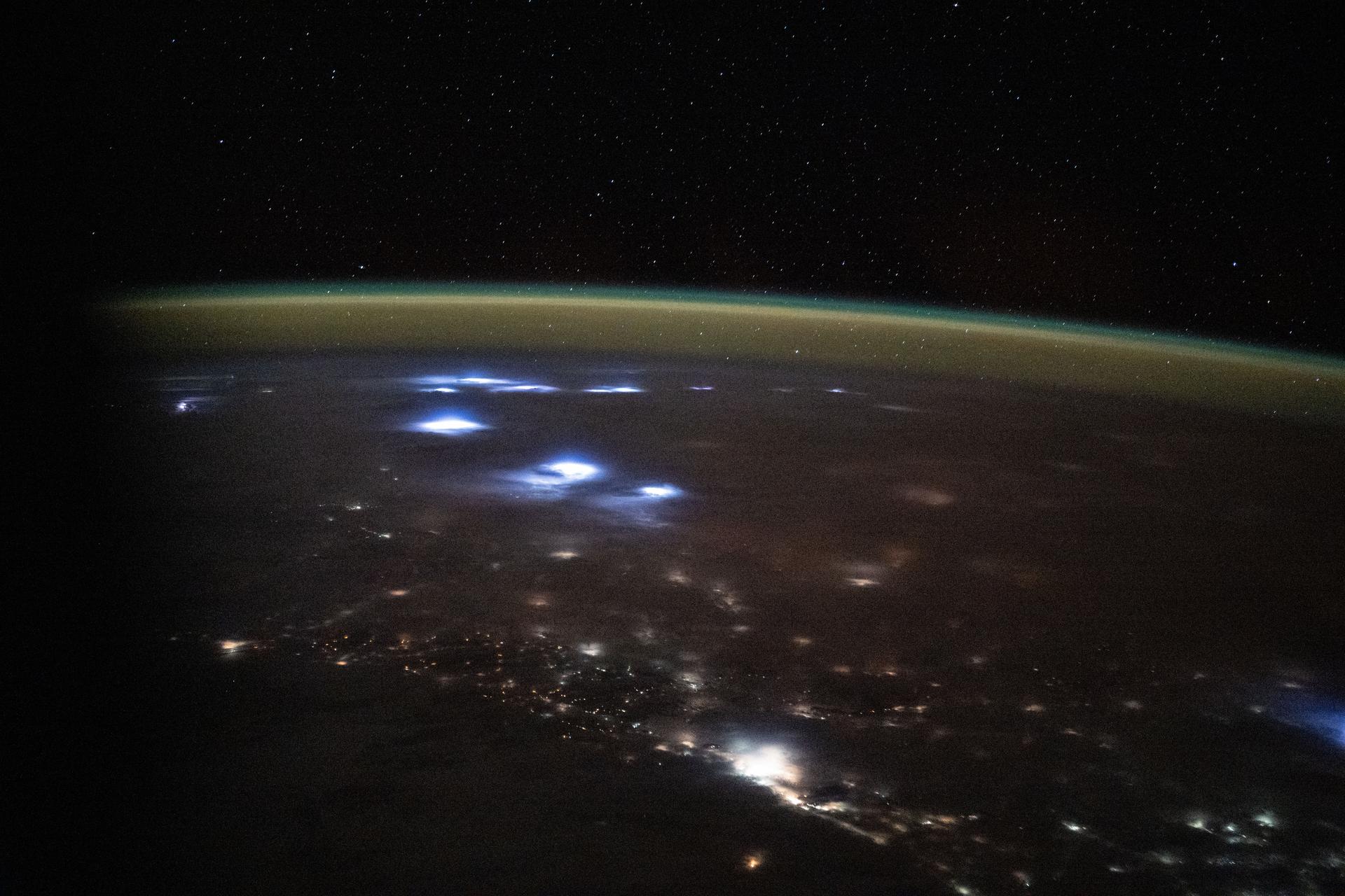
iss073e0817052 (Sept. 27, 2025) --- Warm, diffuse city lights and bright lightning storms illuminate the cloudy nighttime landscape of western Africa in this image captured from the International Space Station. A soft yellow-green atmospheric glow, created by atoms and molecules releasing energy absorbed from solar radiation earlier in the day, blankets Earth’s horizon. The orbital outpost was soaring 260 miles above the Atlantic Ocean at approximately 11:05 p.m. local time when this photograph was taken.
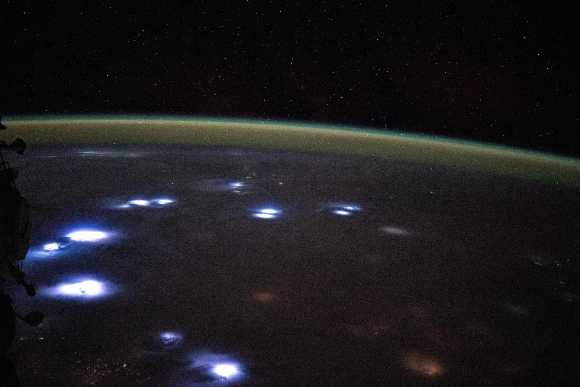
iss073e0816985 (Sept. 27, 2025) --- Bright lightning storms illuminate the cloudy landscape of western Africa in this image captured from the International Space Station. A soft yellow-green atmospheric glow, created by atoms and molecules releasing energy absorbed from solar radiation earlier in the day, blankets Earth’s horizon. The orbital outpost was soaring 260 miles above the Atlantic coast of Ghana at approximately 11:04 p.m. local time when this photograph was taken.

iss074e0044122 (Jan. 3, 2026) --- The city lights of Barnaul in Siberia, Russia, contrast with the extreme winter landscape. The darkened strip of land jutting out from the center of the city is part of the Ob River floodplain and terrace system, which is ideal for farming crops like wheat, barley, and sunflowers. The International Space Station was orbiting 265 miles above Earth at approximately 1:20 a.m. local time when this photograph was taken. Credit: JAXA/Kimiya Yui
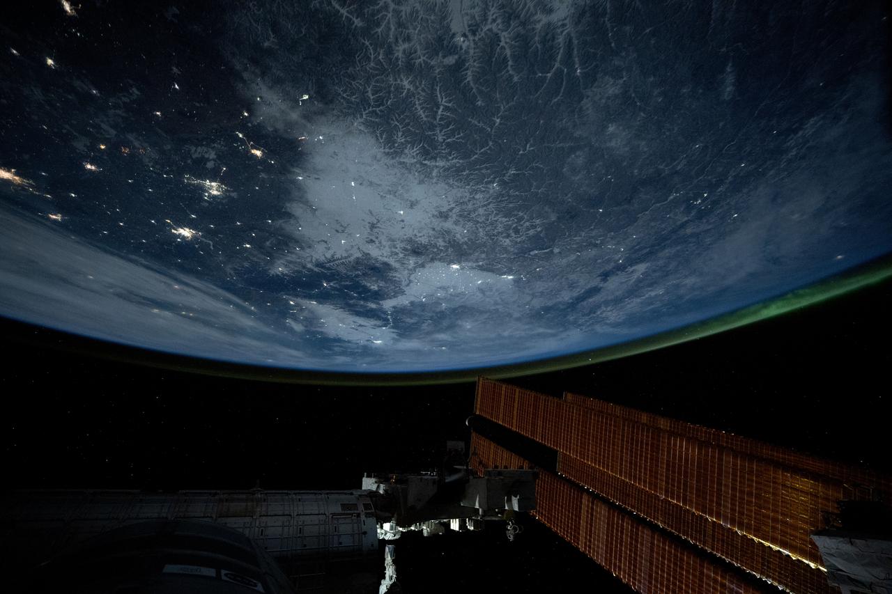
iss072e843309 (March 15, 2025) --- City lights dot the northeastern landscape of China with a wispy aurora above Earth's horizon in this photograph from the International Space Station as it orbited 262 miles above Asia. In the bottom foreground, is the Kibo laboratory module's Exposed Facility, an external research platform, and the orbital outpost's main solar arrays.
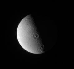
Dione leading hemisphere appears relatively smooth and placid here, compared to the fractured landscape on its trailing hemisphere
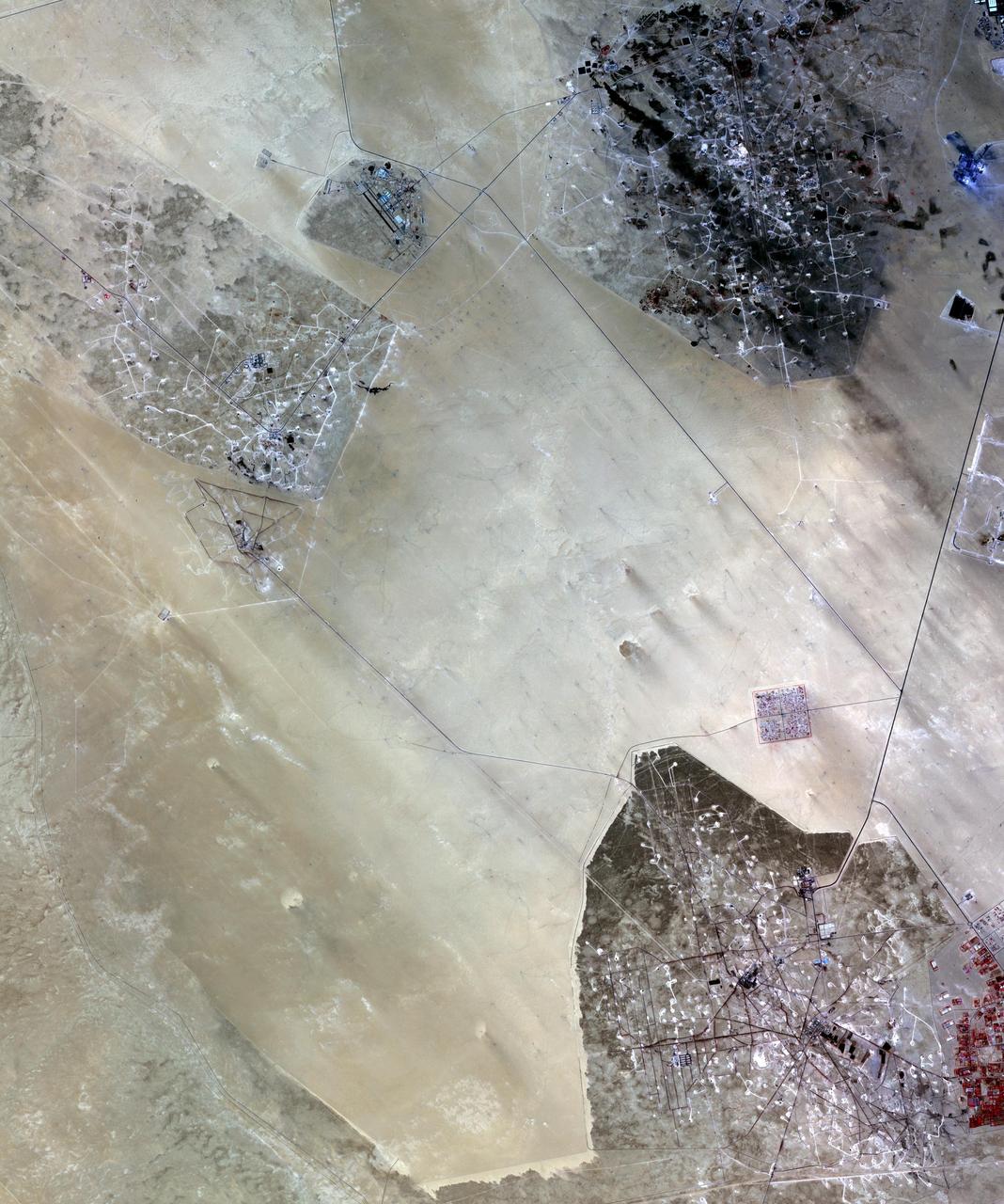
In the desert of southern Kuwait, three oil fields spread out across the empty landscape as seen by NASA Terra spacecraft.
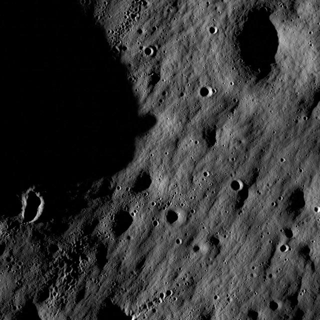
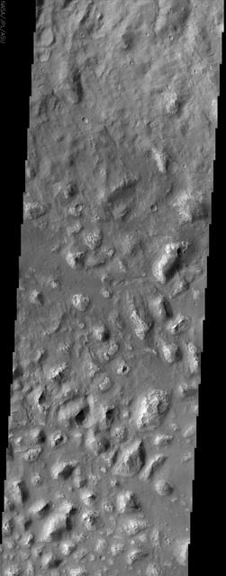
Full resolution detail from one of the first LROC NAC images. At this scale and lighting, impact craters dominate the landscape.
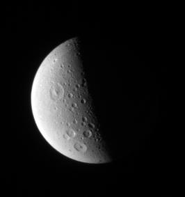
Craters of all sizes litter the landscape on Dione. The larger craters in this view display prominent central peak
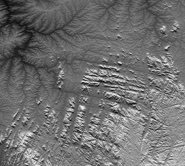
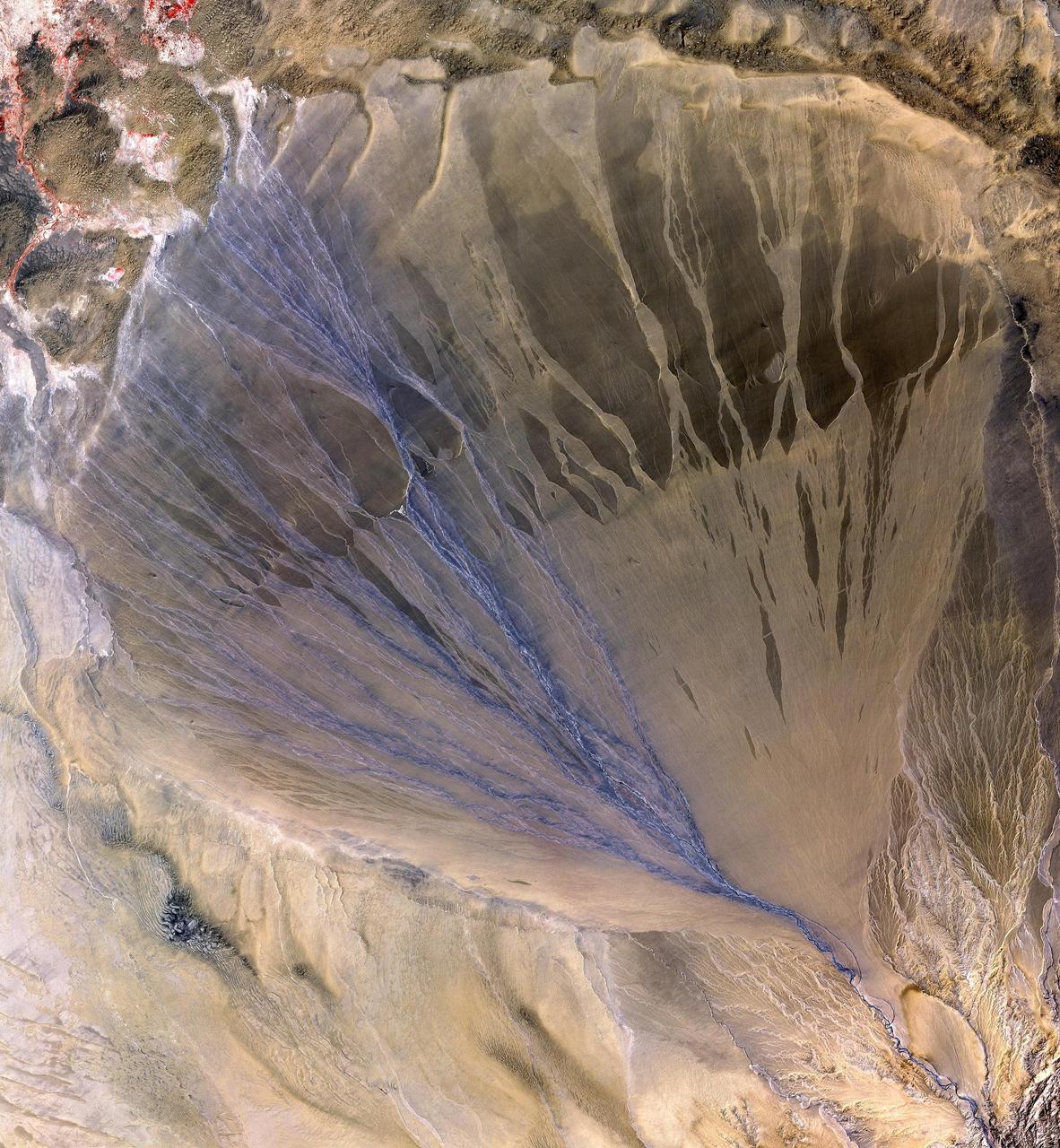
River drainage patterns provide clues to the rock types and erosional processes involved in landscape evolution.
The Cydonia region on Mars, seen in this image from NASA Mars Odyssey spacecraft, straddles the boundary between the bright, dusty, cratered highlands to the southeast and the dark, relatively dust-free, lowland plains to the west.
This MOC image shows a contact between a dust-covered plain and a dust-mantled, textured upland in the Memnonia Sulci region of Mars
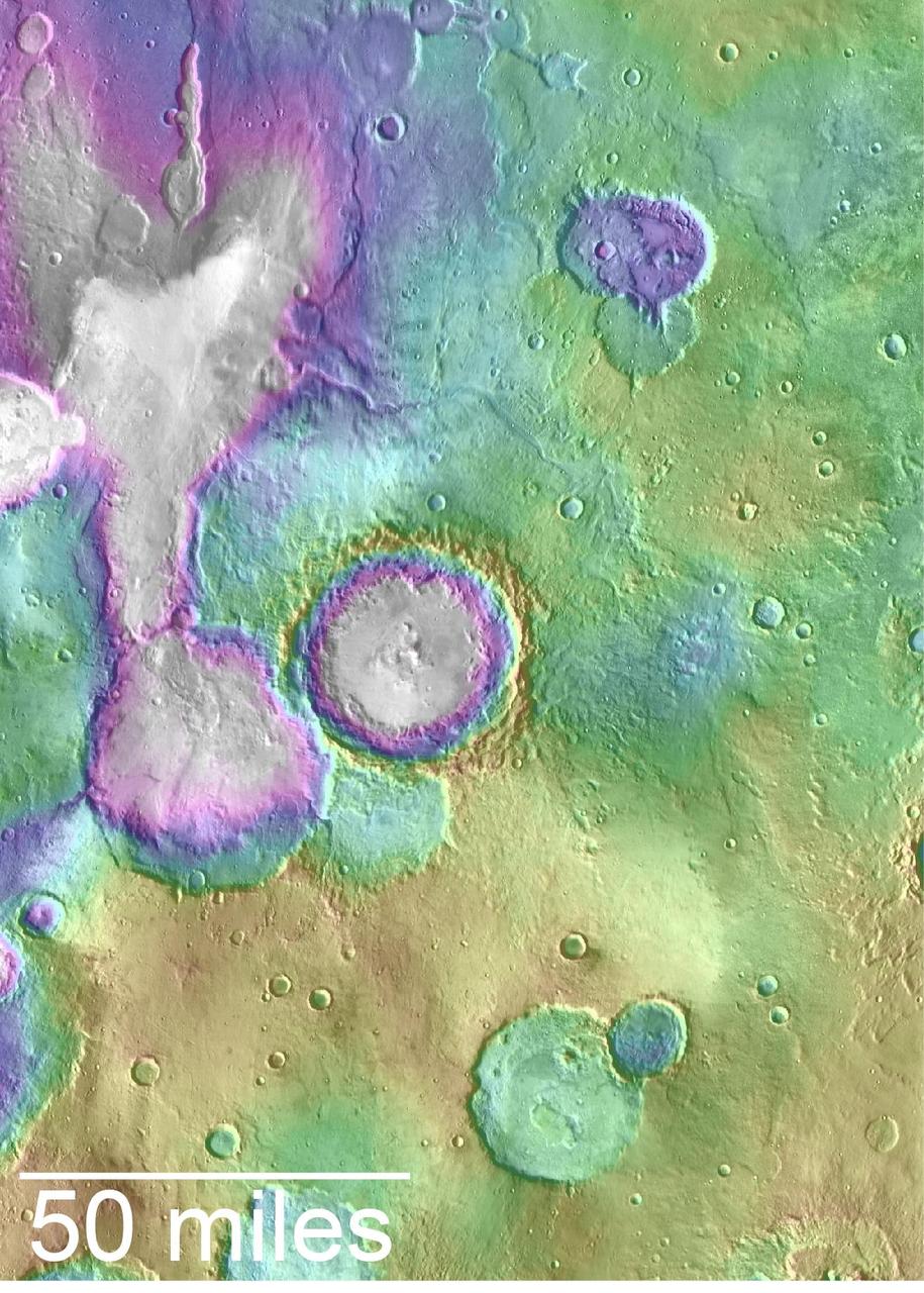
Valleys younger than better-known ancient valley networks on Mars are evident on the landscape in the northern Arabia Terra region of Mars, particularly in the area mapped here with color-coded topographical information overlaid onto a photo mosaic. The area includes a basin informally named "Heart Lake" at upper left (northwest). Data from the Mars Orbiter Laser Altimeter (MOLA) on NASA's Mars Global Surveyor orbiter are coded here as white and purple for lower elevations, yellow for higher elevation. The elevation information is combined with a mosaic of images from the Thermal Emission Imaging System (THEMIS) camera on NASA's Mars Odyssey orbiter, covering an area about 120 miles (about 190 kilometers) wide. The mapped area is centered near 35.91 degrees north latitude, 1 degree east longitude on Mars. These lakes and streams held water several hundred million years after better-known ancient lake environments on Mars, according to 2016 findings. http://photojournal.jpl.nasa.gov/catalog/PIA20838
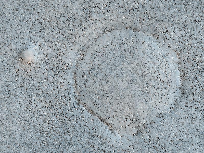
Sometimes we see circles on the Martian landscape with no apparent cause, such as in this picture of Utopia Planitia. Landscapes have rich histories, and what's happening here is likely the result of a long sequence of events. Impact craters are common throughout Mars' history. This area of Utopia Planitia has been buried by material and some of these craters have been buried with it. Loose material compacts over time and if there was the same thickness of material everywhere, then the surface would drop in height by the same amount everywhere. However, there's more of this material inside the buried craters than outside, so there's more compaction and dropdown of the surface in the circular area above the buried crater. This stretches the surface and causes the cracks to appear around the edge. The crater may be long lost from view, but it's still affecting the landscape today. https://photojournal.jpl.nasa.gov/catalog/PIA24698

Observations at large scales, such as panoramas of Martian landscapes, help researchers identify smaller-scale features of special interest for examination in more detail.
In this stereo image, a rock outcrop with a view of the surrounding landscape beckons NASA Mars Exploration Rover Spirit on sol 203. 3D glasses are necessary to view this image.
NASA Mars Exploration Rover Spirit used its microscopic imager to capture this spectacular, jagged mini-landscape on a rock called GongGong.

An astonishing diversity of geological features, ecological systems and human landscapes across North America is indicated within this image from NASA Terra spacecraft.
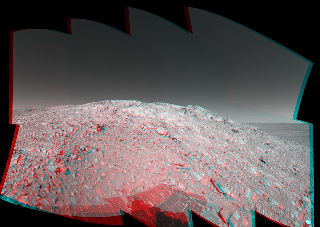
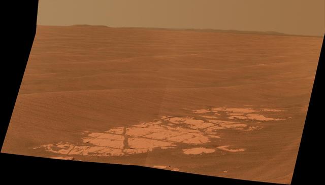
This stereo view shows the landscape surrounding NASA Mars Exploration Rover Opportunity at the edge of Erebus Crater. 3D glasses are necessary to view this image.
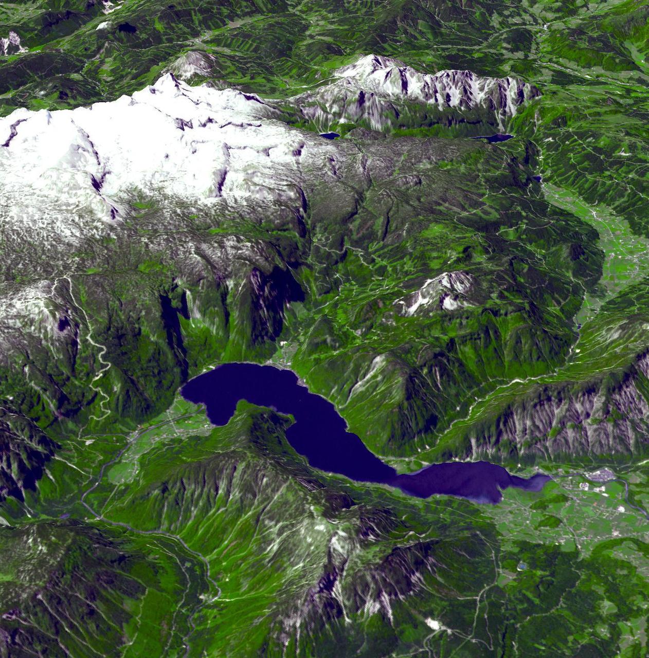
This perspective view from the Advanced Spaceborne Thermal Emission and Reflection Radiometer instrument aboard NASA Terra spacecraft shows the magnificent natural landscape of Salzkammergut, Austria.

This radar image shows the dramatic landscape in the Phang Hoei Range of north central Thailand, about 40 kilometers 25 miles northeast of the city of Lom Sak.
This image from NASA Mars Reconnaissance Orbiter shows some of the weirdest and least-understood landscapes on Mars are on the floor of the deep Hellas impact basin.

Cassini whizzed past Dione on Aug. 16, 2006, capturing this slightly motion-blurred view of the moon fractured and broken landscape in reflected light from Saturn
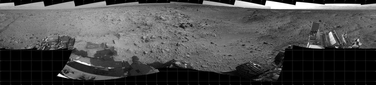
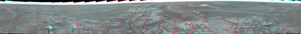
This full-circle panorama of the landscape surrounding NASA Curiosity Mars rover on July 31, 2014, offers a view into sandy lower terrain called Hidden Valley
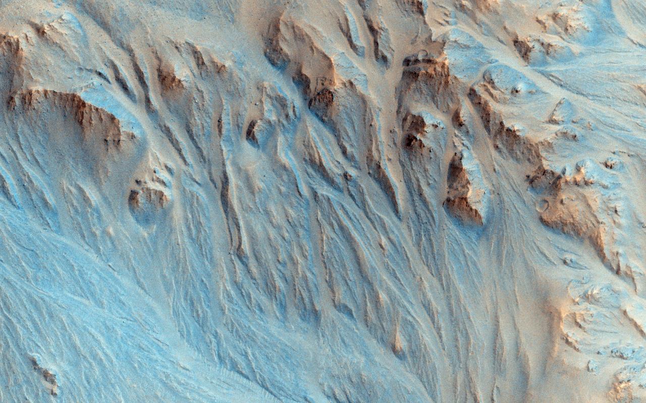
This image was taken in the mid-latitudes of Mars' southern hemisphere near the giant Argyre impact basin. It is located just to the west of a prominent scarp known as Bosporos Rupes. The left side of the image shows cratered plains. Some of the craters are heavily mantled and indistinct, whereas others exhibit sharp rims and dramatic topography. The largest crater in this half of the image is about 2.5 kilometers (1.5 miles) wide. Mounds and ridges, which may be remnants of an ice-rich deposit, are visible on its floor. Three sinuous valleys occupy the center of the image. Valleys such as these were first observed in data returned by the NASA Mariner 9 spacecraft, which reached Mars in 1971. The right side of the image shows part of an impact crater that is approximately 20 kilometers (12 miles) in diameter. The furrowed appearance of the crater's inner wall suggests that it has been extensively modified, perhaps by landslides and flowing water. Like other craters in the area, the floor of this crater has a rough and dissected texture that is often attributed to the loss of ice-rich material. This image was taken by the High Resolution Imaging Science Experiment (HiRISE) camera onboard NASA's Mars Reconnaissance Orbiter spacecraft on March 24, 2006. The image is centered at 40.64 degrees south latitude, 303.49 degrees east longitude. The image is oriented such that north is 7 degrees to the left of up. The range to the target was 2,044 kilometers (1,270 miles). At this distance the image scale is 2.04 meters (6.69 feet) per pixel, so objects as small as 6.1 meters (20 feet) are resolved. In total this image is 40.90 kilometers (25.41 miles) or 20,081 pixels wide and 11.22 kilometers (6.97 miles) or 5,523 pixels high. The image was taken at a local Mars time of 07:30 and the scene is illuminated from the upper right with a solar incidence angle of 81.4 degrees, thus the sun was about 8.6 degrees above the horizon. At an Ls of 29 degrees (with Ls an indicator of Mars' position in its orbit around the sun), the season on Mars is southern autumn. http://photojournal.jpl.nasa.gov/catalog/PIA08047
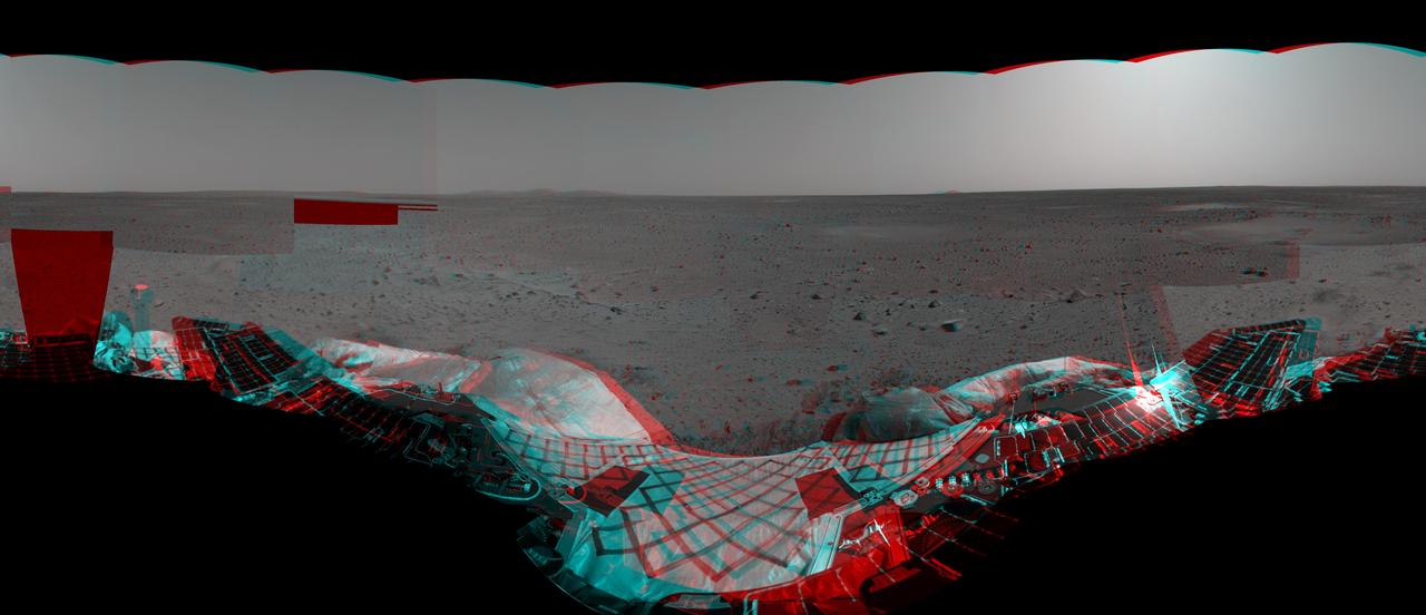
This anaglyph from NASA Mars Exploration Rover, Spirit, shows the rover lander and, in the background, the surrounding martian terrain. 3D glasses are necessary to view this image.
This picture from NASA Curiosity rover puts a color view obtained by the rover in the context of a computer simulation derived from images acquired from orbiting spacecraft. The view looks north, showing the distant ridge of Gale Crater.
Ultracold hydrocarbon lakes and seas dark shapes near the north pole of Saturn moon Titan can be seen embedded in some kind of bright surface material in this infrared mosaic from NASA Cassini mission.
Karst topography is a geological formation shaped by the dissolution of layers of soluble rock such as limestone. A good example is found in Guangxi Province in southeast China, as seen by NASA Terra spacecraft.
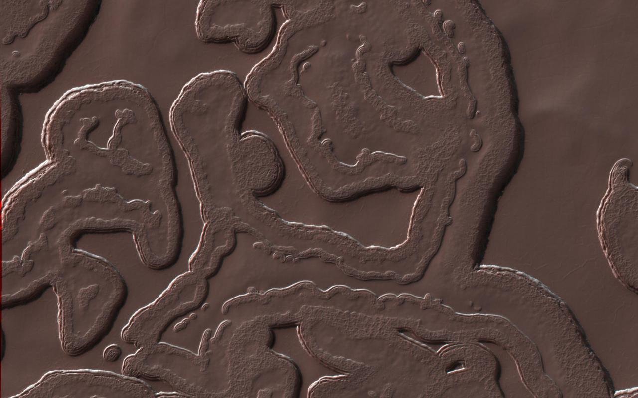
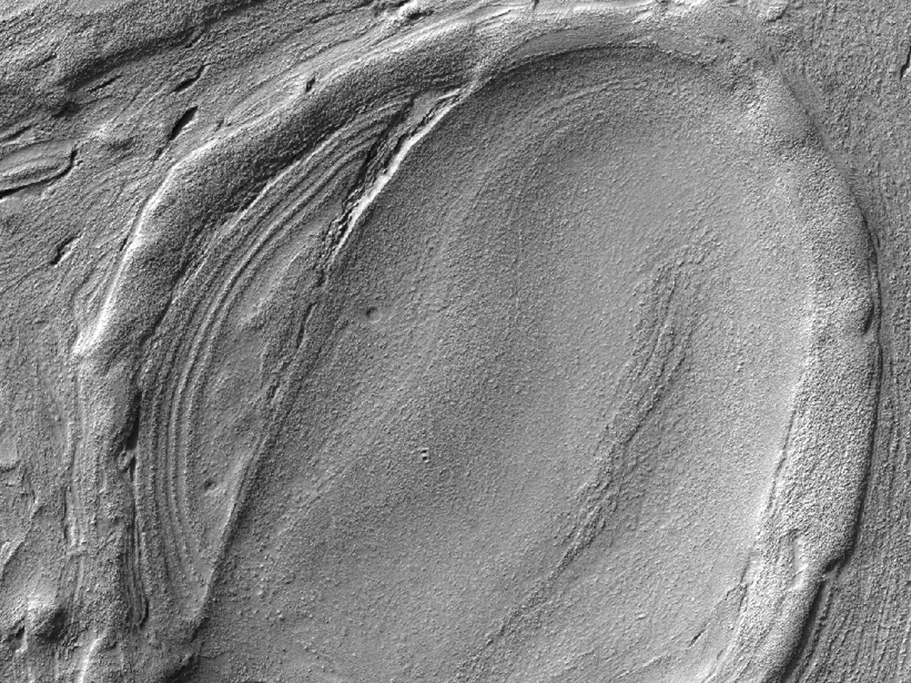
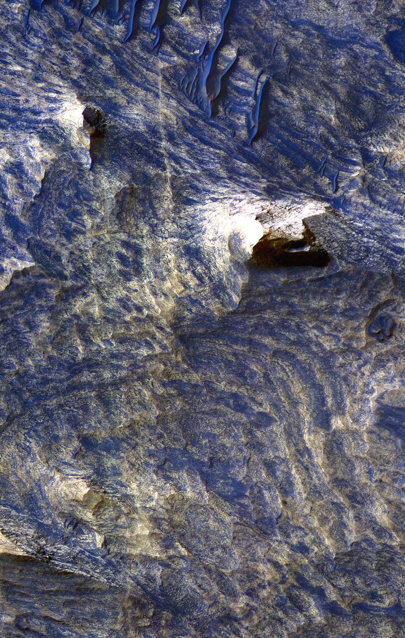
The arc of hills in this image from NASA Mars Reconnaissance Orbiter spacecraft is the rim of an old and infilled impact crater. The sediments that were deposited within the crater have since formed polygonal cracks due to repeated cycles of freezing and thawing. The process of polygon formation is common at these polar latitudes, but polygons are not always as striking as they are here. In this image, the polygons have been highlighted by persistent frost in the cracks. The crater rim constrains the polygon formation within the crater close to the rim, creating a spoke and ring pattern of cracks. This leads to more rectangular polygons than those near the center of the crater. The polygons close to the center of the crater display a more typical pattern. A closer look shows some of these central polygons, which have smaller polygons within them, and smaller polygons within those smaller polygons, which makes for a natural fractal. http://photojournal.jpl.nasa.gov/catalog/PIA20289
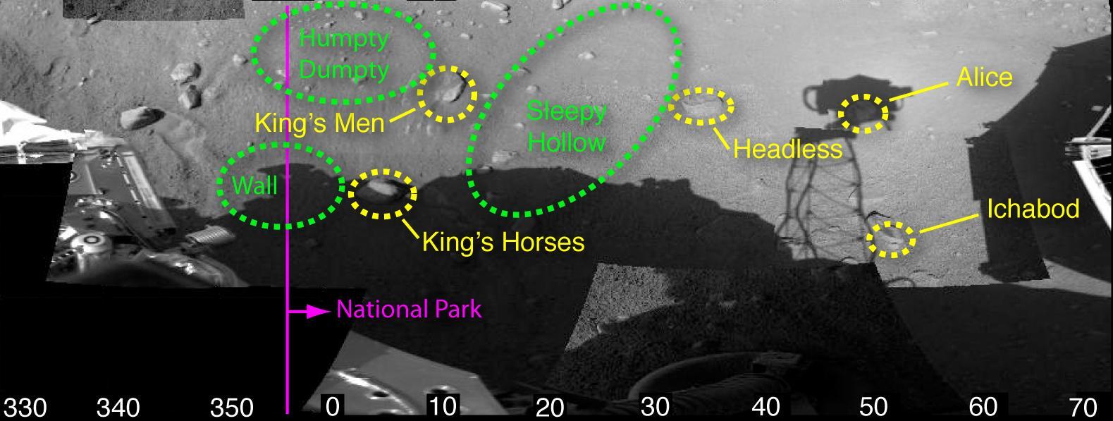
Fun, fairy-tale nicknames have been assigned to features in this animated view of the workspace reachable by the robotic arm of NASA Phoenix Mars Lander. For example, Sleepy Hollow denotes a trench and Headless designates a rock.
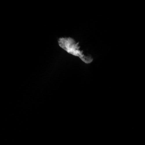
Sunlight illuminates the bowling-pin shaped nucleus from directly below comet Borrelly as seen by NASA Deep Space 1. At this distance, many features become vivid on the surface of the nucleus, including a jagged line between day and night on the comet.
This image from NASA Mars Odyssey shows a portion of Aureum Chaos located just south of the Martian equator. This fractured landscape contains canyons and mesas with two large impact craters in the upper left.

This image shows the Mars Hand Lens Imager MAHLI on NASA Curiosity rover, with the Martian landscape in the background. The image was taken by Curiosity Mast Camera on the 32nd Martian day, or sol, of operations on the surface.
This image taken by NASA Mars Reconnaissance Orbiter in the Cydnus Rupes region, shows that the northern plains of Mars are rock and boulder strewn landscapes otherwise devoid of major features except a few impact craters.
This image from NASA Dawn spacecraft shows impact ejecta deposits dominating asteroid Vesta landscape. This impact ejecta material was ejected from an impact crater located outside the imaged area.
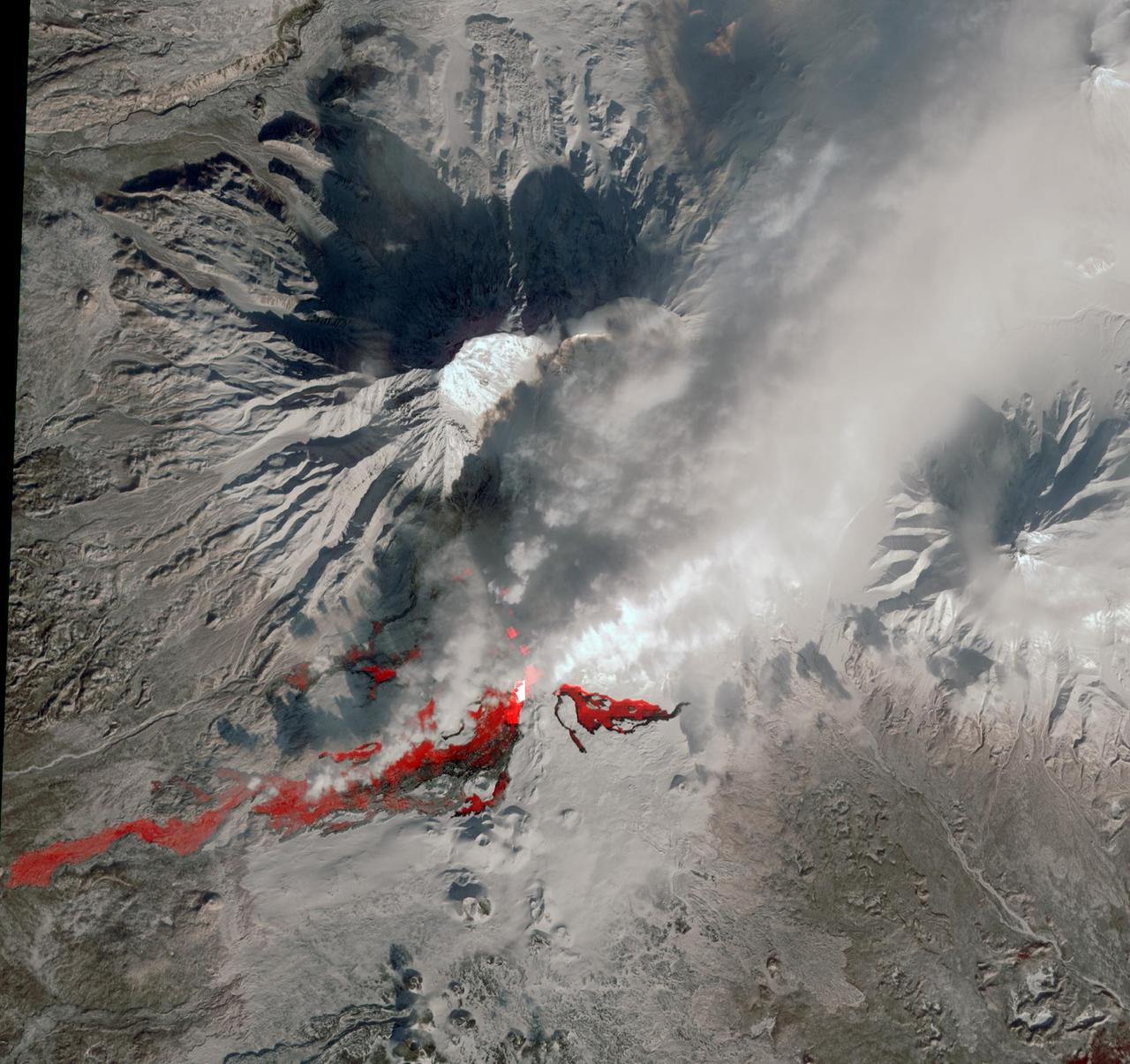
NASA Terra spacecraft reveals the still-active lava flows in the snowy winter landscape of Plosky Tolbachik volcano, which erupted for the first time in 35 years on Nov. 27, 2012, in Russia far eastern Kamchatka Peninsula.
This perspective view acquired by NASA Shuttle Radar Topography Mission SRTM from data collected in the year 2000 shows Patagonia, Argentina, a spectacular landscape formed by volcanoes, rivers, and wind.
The impact of an asteroid or comet several hundred million years ago left scars in the landscape that are still visible in this spaceborne radar image of an area in the Sahara Desert of northern Chad.
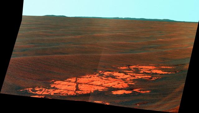
NASA Mars Exploration Rover Opportunity used its panoramic camera Pancam to capture this false-color view of the rim of Endeavour crater, the rover destination in a multi-year traverse along the sandy Martian landscape.
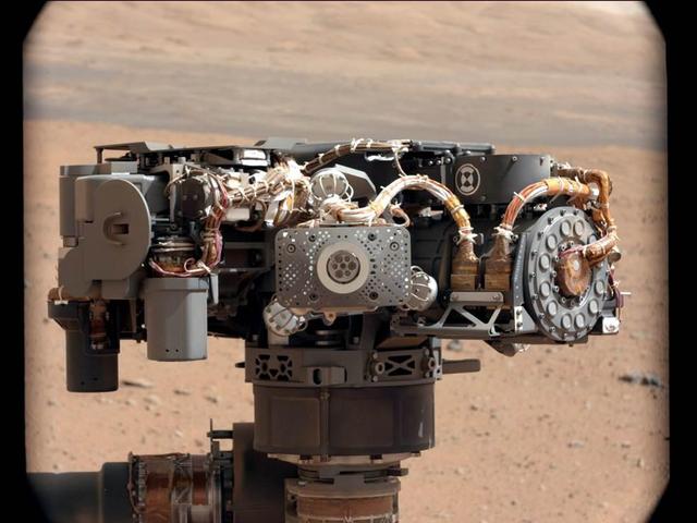
This image shows the Alpha Particle X-Ray Spectrometer APXS on NASA Curiosity rover, with the Martian landscape in the background. This image let researchers know that the APXS instrument had not become caked with dust during Curiosity landing.
This image shows the vast plains of the northern polar region of Mars, as seen by NASA Phoenix Mars Lander shortly after touching down on the Red Planet. The flat landscape is strewn with tiny pebbles and shows polygonal cracking.
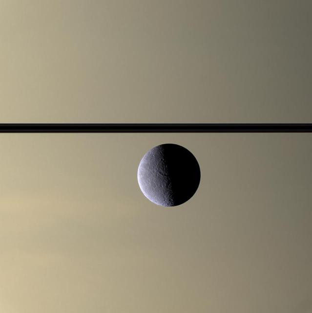
The Cassini spacecraft looks toward Rhea cratered, icy landscape with the dark line of Saturn ringplane and the planet murky atmosphere as a background. Rhea is Saturn second-largest moon, at 1,528 kilometers 949 miles across.

A family of dormant volcanoes dominates the landscape in this radar image of the Andes Mountains in northern Ecuador. The city of Otavalo, shown in pink, and Lake Otavalo lie within the triangle formed by three volcanoes in the upper part of the image.
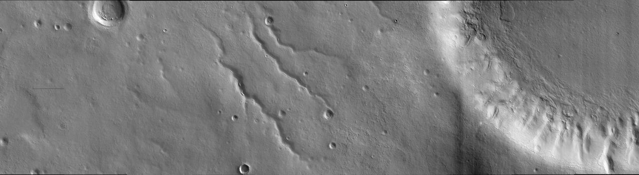
The ancient, catastrophic floods on Mars, whose origins remain a mystery, produced a channeled and scoured landscape like this one, which is called Tiu Valles and was imaged by NASA Mars Odyssey spacecraft. http://photojournal.jpl.nasa.gov/catalog/PIA04013

This infrared image from NASA Spitzer Space Telescope shows a swirling landscape of stars known as the North America nebula. Clusters of young stars about one million years old can be found throughout the image.
This NASA Mars Odyssey image shows a region in northern Arabia Terra where knobby or cabby plains units that mantle and modify a pre-existing cratered surface dominate the unusual landscape.
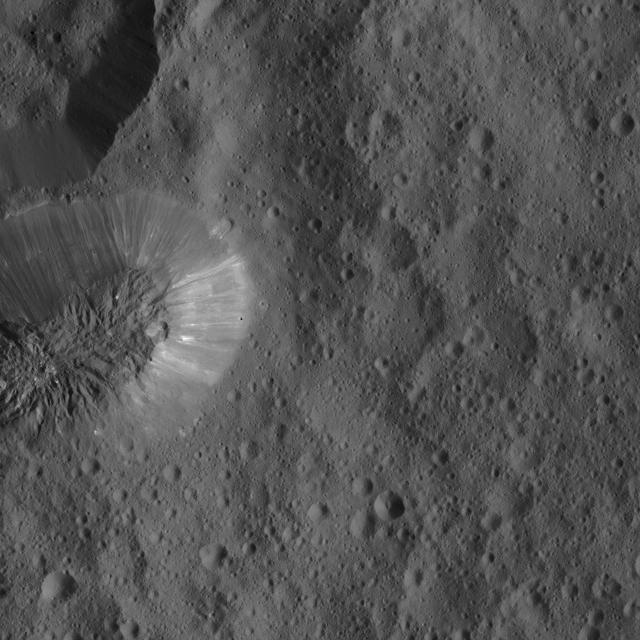
Ceres densely cratered landscape is revealed in this image taken by the framing camera aboard NASA Dawn spacecraft. The craters show various degrees of degradation. The youngest craters have sharp rims.
This sprawling look at the martian landscape surrounding the Mars Exploration Rover Spirit is the first 3-D stereo image from the rover navigation camera. Sleepy Hollow can be seen to center left of the image. 3D glasses are necessary.

In the high northern latitudes northwest of Alba Patera, a smooth mantle of material that covers the landscape appears chipped away from the rim of a large crater, as observed in this image from NASA Mars Odyssey spacecraft.
This enhanced-color image from the HiRISE camera on NASA Mars Reconnaissance Orbiter shows a landscape of sand dunes and buttes among a background of light-toned bands and dark-toned bands in the Candor Chasma region
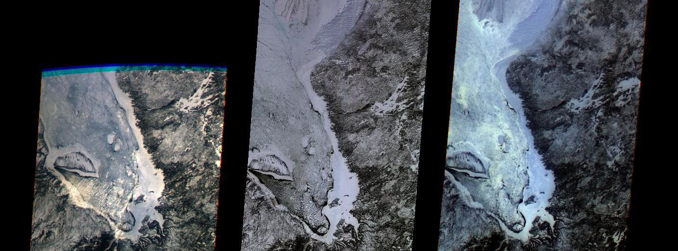
The first images taken by NASA Multi-angle Imaging SpectroRadiometer MISR on February 24, 2000, show the winter landscape of James Bay, Ontario, Canada from three of the instrument nine cameras.
This image from NASA Mars Reconnaissance Orbiter shows a landscape that is pervasively eroded, right up to the tops of the ridges, with channels extending down into depositional fans much like alluvial fans in the Mojave Desert.
The impact of an asteroid or comet several hundred million years ago left scars in the landscape that are still visible in this spaceborne radar image of an area in the Sahara Desert of northern Chad.

An unusual geological feature resembling a giant spider sprawls across Pluto icy landscape in this enhanced color image was obtained by NASA New Horizons spacecraft on July 14, 2015.
Among the many varied landscapes on Mars the term chaos is applied to those places that have a jumbled, blocky appearance, like in this image from NASA Mars Odyssey spacecraft.
NASA Terra spacecraft shows vast alluvial fan blossoms across the desolate landscape between two mountain ranges that form the southern border of the Taklimakan Desert in China XinJiang Province.
NASA Mars Exploration Rover Opportunity used its panoramic camera Pancam to capture this view approximately true-color view of the rim of Endeavour crater, the rover destination in a multi-year traverse along the sandy Martian landscape.

This topographic image acquired by NASA Shuttle Radar Topography Mission SRTM from data collected on February 15, 2000, of Patagonia, Argentina shows a spectacular landscape formed by volcanoes, rivers, and wind.
As NASA MESSENGER approached Mercury on January 14, 2008, the spacecraft Narrow-Angle Camera on the Mercury Dual Imaging System MDIS instrument captured this view of the planet rugged, cratered landscape illuminated obliquely by the Sun.

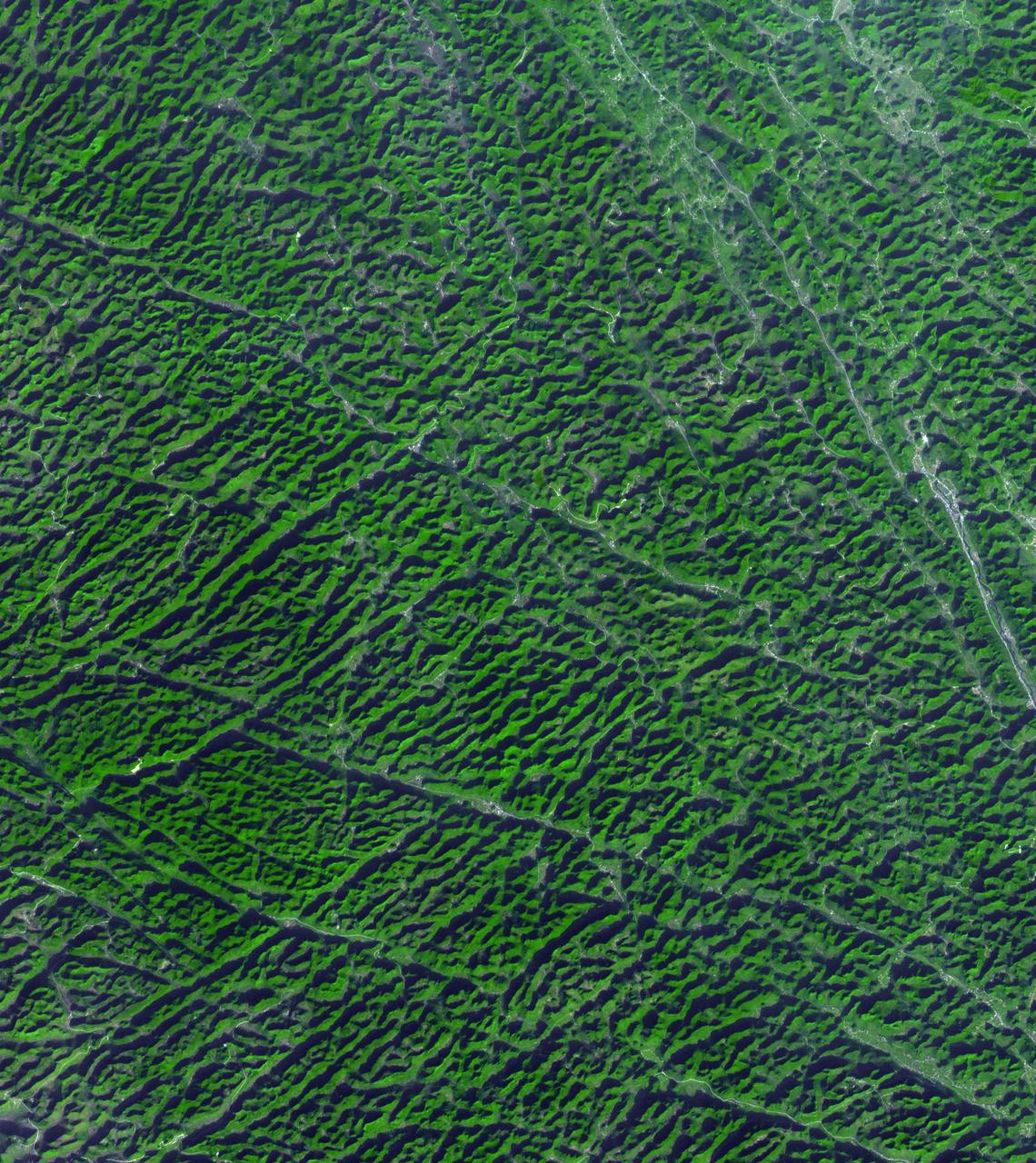
Logging operations have left a striking checkerboard pattern in the landscape along the Idaho-Montana border, sandwiched between Clearwater and Bitterroot National Forests as seen in this image acquired by NASA Terra spacecraft.
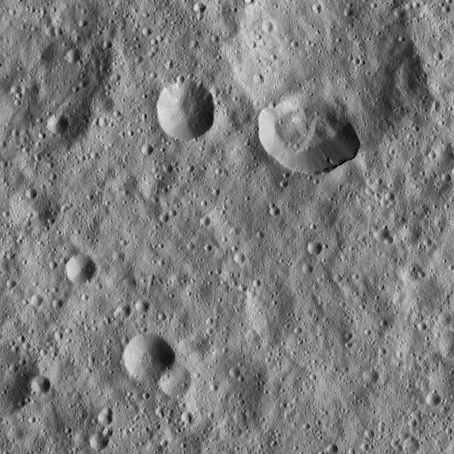
Ceres densely cratered landscape is revealed in this image taken by the framing camera aboard NASA Dawn spacecraft. The craters show various degrees of degradation. The youngest craters have sharp rims.