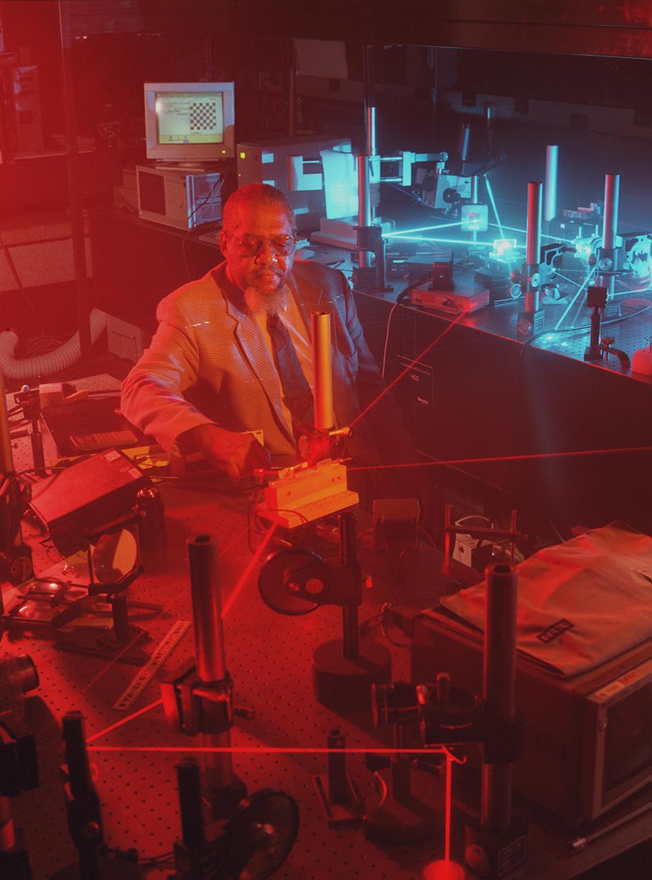
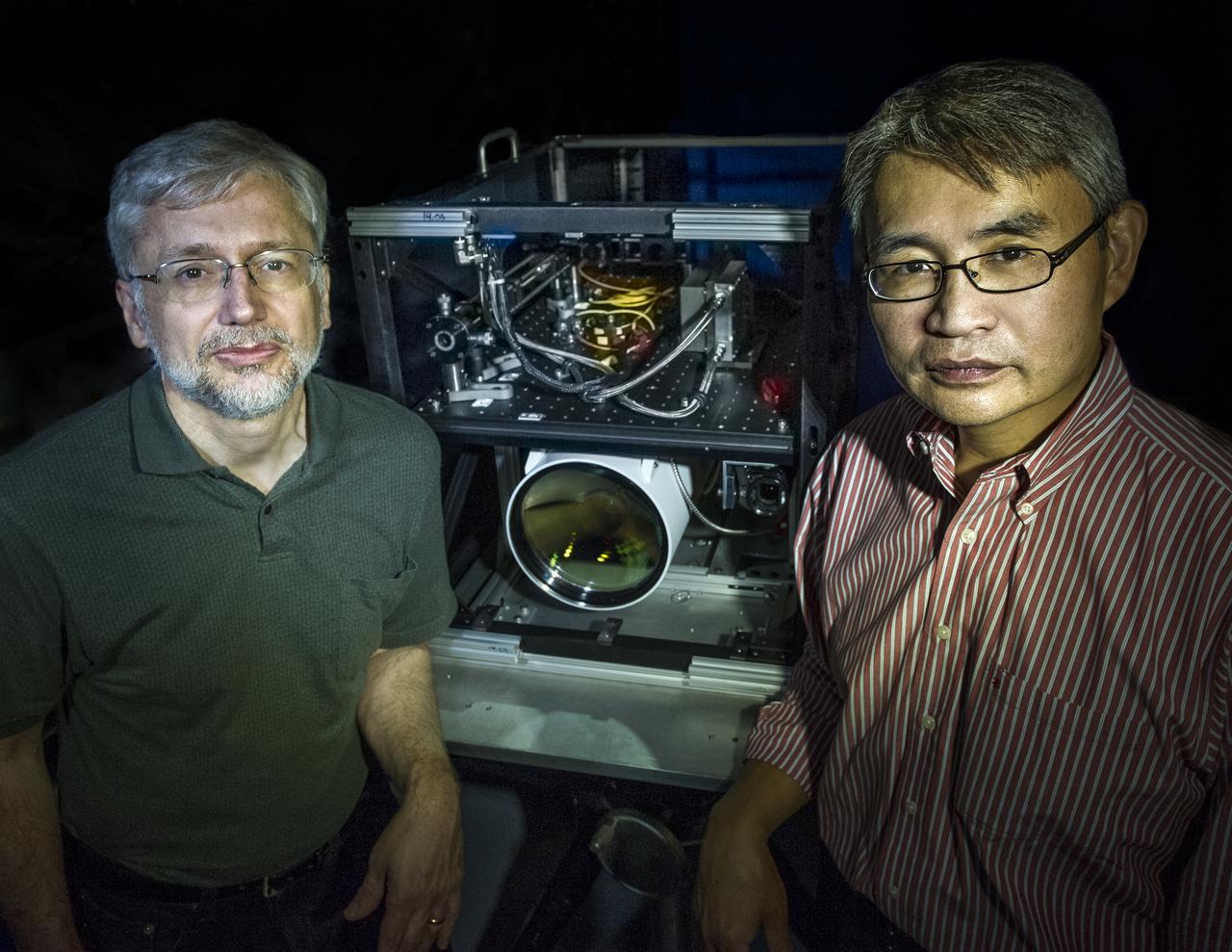
Dr. Donald Frazier works with a laser imaging system designed by Dr. Hossin Abdeldayem for pattern recognition applications. Photo credit: NASA/Marshall Space Flight Center (MSFC)

Two sets of laser pulses transmitted from Earth to a spacecraft over a distance of 1.4 million kilometers 870,000 miles in a communications experiment are shown in this long-exposure image made by NASA’s Galileo spacecraft imaging system. http://photojournal.jpl.nasa.gov/catalog/PIA00230
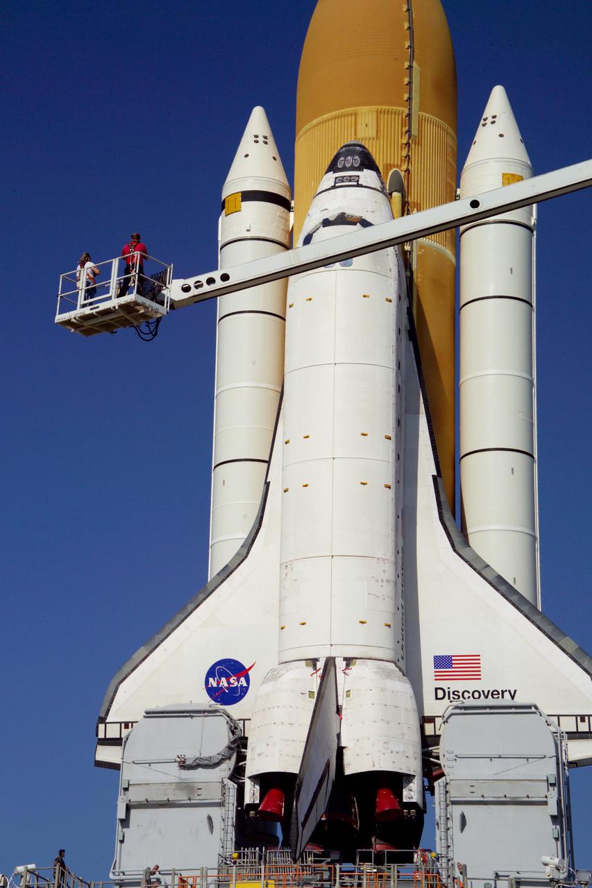
STS121-319-004 (5 July 2006) --- The Laser Dynamic Range Imager (LDRI), Intensified Television Camera (ITVC) and Laser Camera System (LCS), located on the end of Space Shuttle Discovery's Remote Manipulator System/Orbiter Boom Sensor System (RMS/OBSS), is featured in this image photographed during STS-121 Flight Day 2 survey activities. The inspection included an examination of Discovery's nose cap and the reinforced carbon-carbon panels along the leading edge of the port and starboard wings, looking for any evidence of damage.
This image taken by NASA Mars Reconnaissance Orbite on May 19, 2010, shows an impact crater that had not existed when the same location on Mars was previously observed in March 2008.
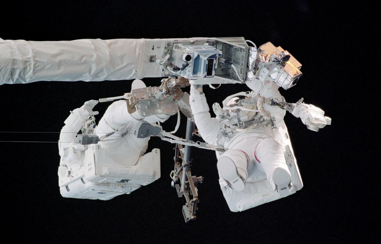
STS121-323-011 (8 July 2006) --- Astronauts Piers J. Sellers and Michael E. Fossum, STS-121 mission specialists, work in tandem on Space Shuttle Discovery's Remote Manipulator System/Orbiter Boom Sensor System (RMS/OBSS) during the mission's first scheduled session of extravehicular activity (EVA). Also visible on the OBSS are the Laser Dynamic Range Imager (LDRI), Intensified Television Camera (ITVC) and Laser Camera System (LCS).
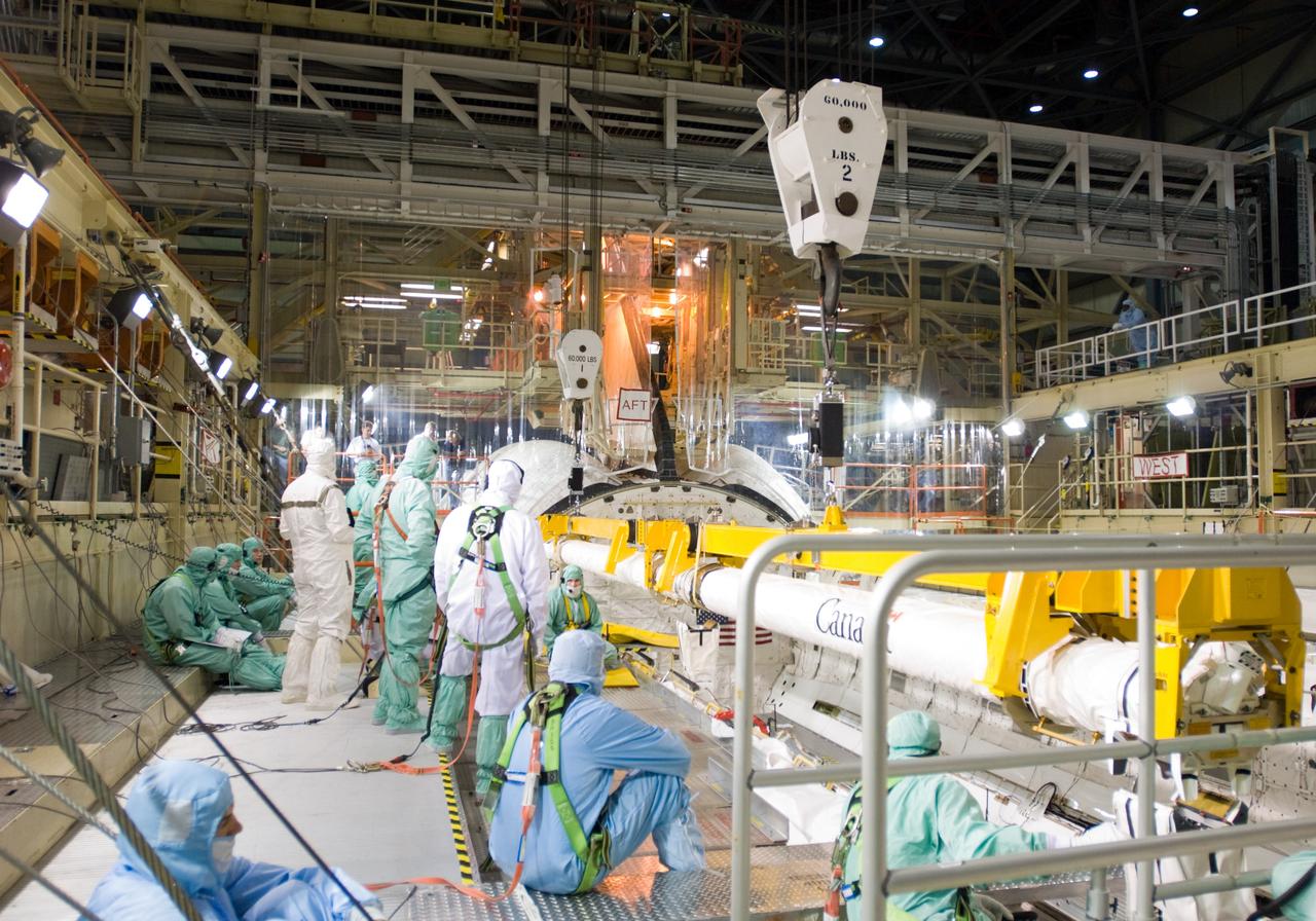
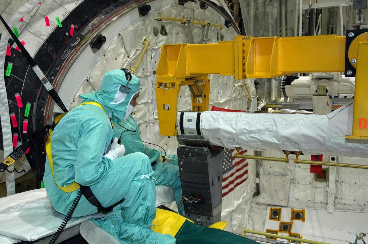
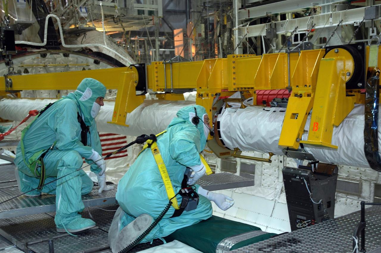
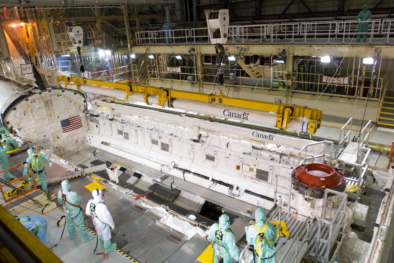
KENNEDY SPACE CENTER, FLA. - In the Orbiter Processing Facility's bay 1, workers prepare the orbiter boom sensor system for installation on the starboard side of Atlantis's payload bay for mission STS-117. The 50-foot-long boom attaches to the shuttle arm and provides equipment to inspect the shuttle's heat shield while in space. It contains an intensified television camera (ITVC) and a laser dynamic range imager, which are mounted on a pan and tilt unit, and a laser camera system (LCS) mounted on a stationary bracket. Mission STS-117 will carry the S3/S4 arrays for installation on the International Space Station. Launch of Space Shuttle Atlantis is scheduled for March. Photo credit: NASA/Jack Pfaller
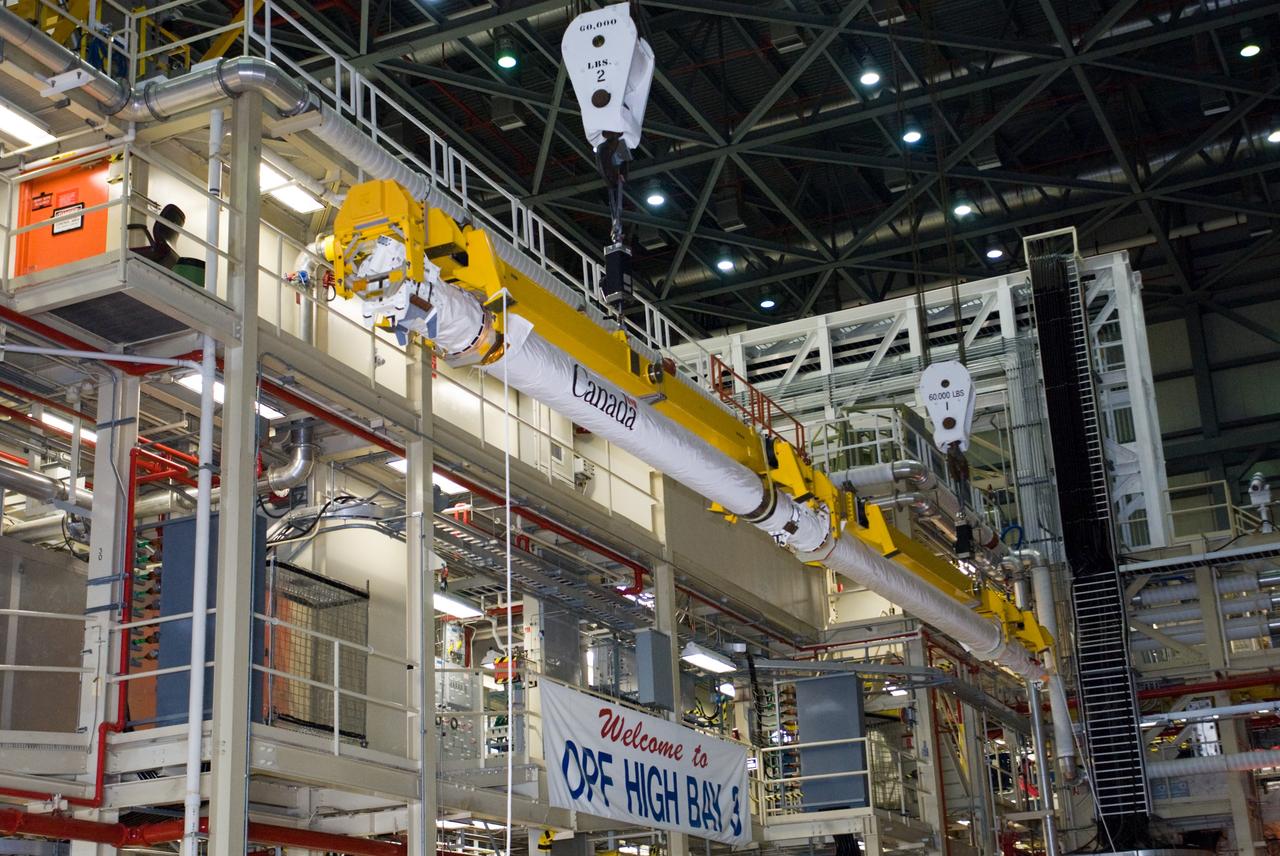
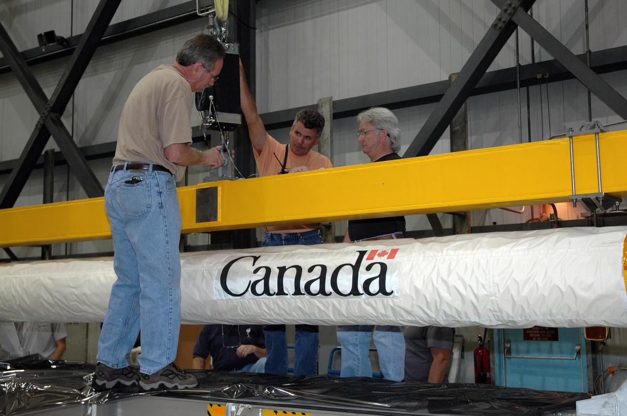
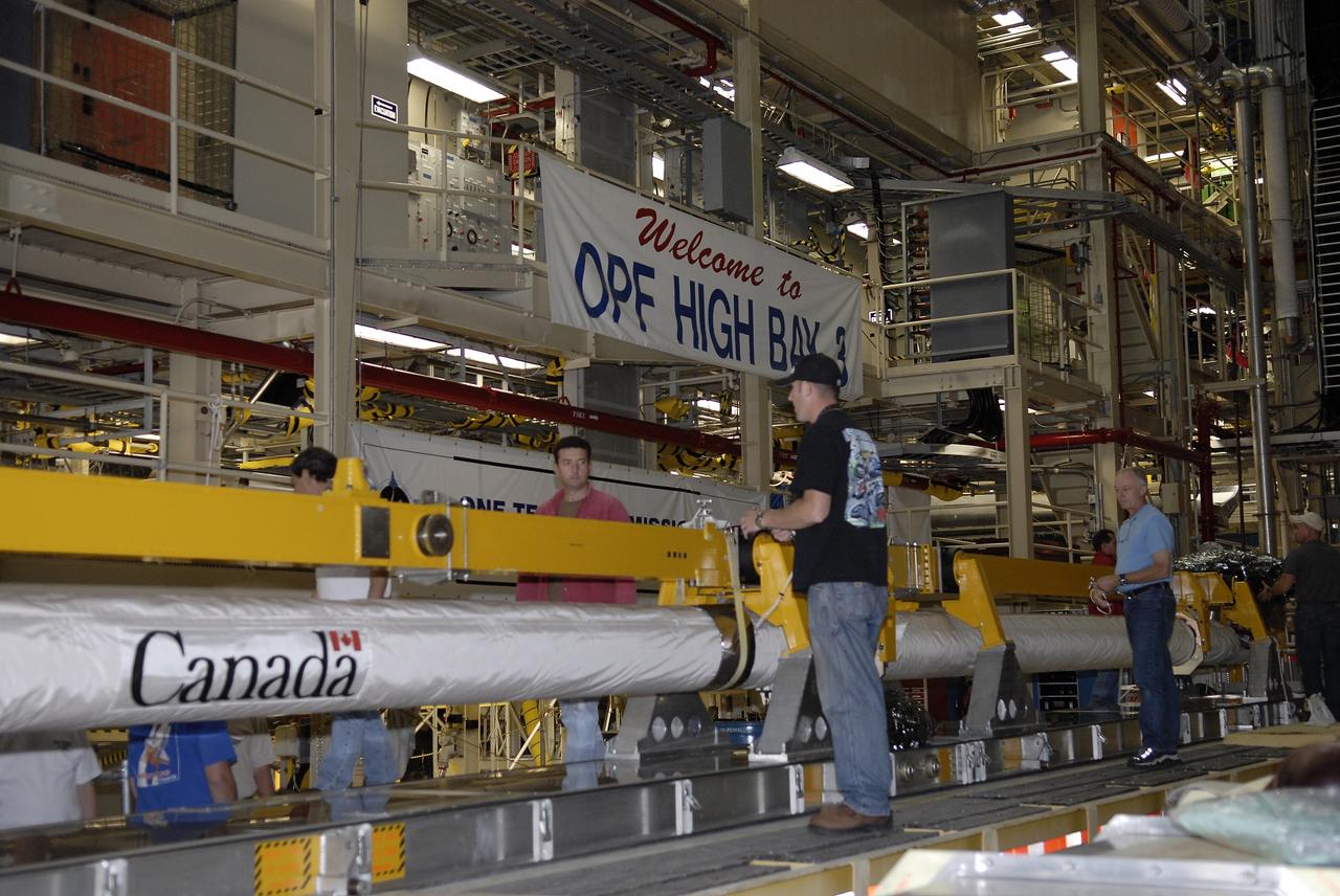
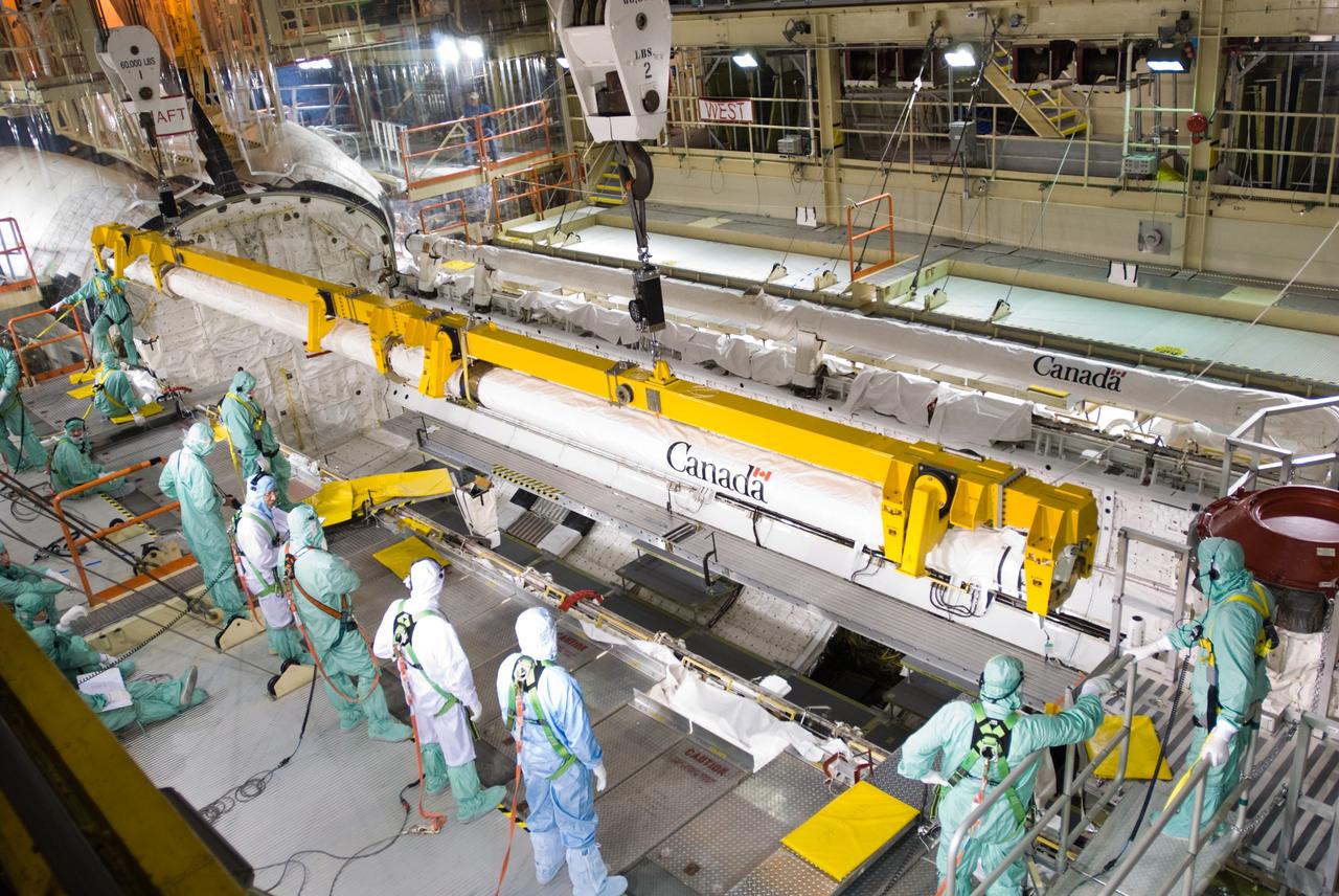
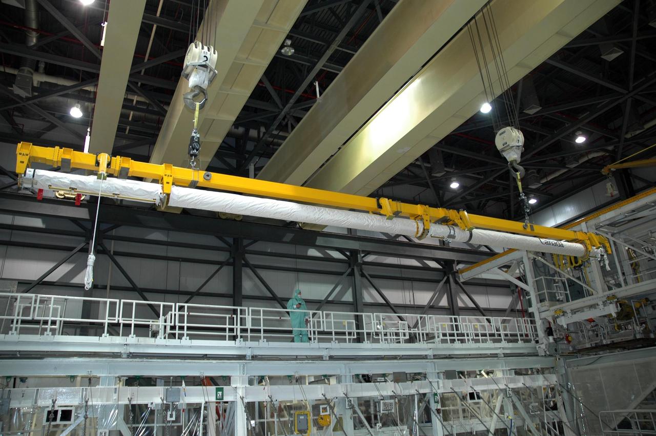
CAPE CANAVERAL, Fla. – In the Orbiter Processing Facility’s bay 3, the orbiter boom sensor system is lifted by a crane for installation in space shuttle Discovery’s payload bay for mission STS-128. The 50-foot-long boom attaches to the shuttle arm and provides equipment to inspect the shuttle's heat shield while in space. It contains an intensified television camera (ITVC) and a laser dynamic range imager, which are mounted on a pan and tilt unit, and a laser camera system (LCS) mounted on a stationary bracket. The STS-128 flight will carry science and storage racks to the International Space Station on space shuttle Discovery. Launch of Discovery is targeted for Aug. 6. Photo credit: NASA/Jim Grossmann
CAPE CANAVERAL, Fla. – In the Orbiter Processing Facility’s bay 3, workers prepare to install the orbiter boom sensor system in the payload bay of space shuttle Discovery to support mission STS-128. The 50-foot-long boom attaches to the shuttle arm and provides equipment to inspect the shuttle's heat shield while in space. It contains an intensified television camera (ITVC) and a laser dynamic range imager, which are mounted on a pan and tilt unit, and a laser camera system (LCS) mounted on a stationary bracket. The STS-128 flight will carry science and storage racks to the International Space Station on space shuttle Discovery. Launch of Discovery is targeted for Aug. 6. Photo credit: NASA/Kim Shiflett
CAPE CANAVERAL, Fla. – In the Orbiter Processing Facility’s bay 3, the orbiter boom sensor system is lowered by a crane into the payload bay of space shuttle Discovery for installation to support mission STS-128. The 50-foot-long boom attaches to the shuttle arm and provides equipment to inspect the shuttle's heat shield while in space. It contains an intensified television camera (ITVC) and a laser dynamic range imager, which are mounted on a pan and tilt unit, and a laser camera system (LCS) mounted on a stationary bracket. The STS-128 flight will carry science and storage racks to the International Space Station on space shuttle Discovery. Launch of Discovery is targeted for Aug. 6. Photo credit: NASA/Jim Grossmann
CAPE CANAVERAL, Fla. – In the Orbiter Processing Facility’s bay 3, workers install the orbiter boom sensor system in the payload bay of space shuttle Discovery to support mission STS-128. The 50-foot-long boom attaches to the shuttle arm and provides equipment to inspect the shuttle's heat shield while in space. It contains an intensified television camera (ITVC) and a laser dynamic range imager, which are mounted on a pan and tilt unit, and a laser camera system (LCS) mounted on a stationary bracket. The STS-128 flight will carry science and storage racks to the International Space Station on space shuttle Discovery. Launch of Discovery is targeted for Aug. 6. Photo credit: NASA/Jim Grossmann

CAPE CANAVERAL, Fla. – In the Orbiter Processing Facility’s bay 3, space shuttle Discovery’s payload bay is readied for installation of the orbiter boom sensor system to support mission STS-128. The 50-foot-long boom attaches to the shuttle arm and provides equipment to inspect the shuttle's heat shield while in space. It contains an intensified television camera (ITVC) and a laser dynamic range imager, which are mounted on a pan and tilt unit, and a laser camera system (LCS) mounted on a stationary bracket. The STS-128 flight will carry science and storage racks to the International Space Station on space shuttle Discovery. Launch of Discovery is targeted for Aug. 6. Photo credit: NASA/Jim Grossmann
KENNEDY SPACE CENTER, FLA. - In the Orbiter Processing Facility’s bay 1, the orbiter boom sensor system is lifted by a crane for installation on the starboard side of Atlantis’s payload bay for mission STS-117. The 50-foot-long boom attaches to the shuttle arm and provides equipment to inspect the shuttle's heat shield while in space. It contains an intensified television camera (ITVC) and a laser dynamic range imager, which are mounted on a pan and tilt unit, and a laser camera system (LCS) mounted on a stationary bracket. Mission STS-117 will carry the S3/S4 arrays for installation on the International Space Station. Launch of Space Shuttle Atlantis is scheduled for March. Photo credit: NASA/Jack Pfaller
KENNEDY SPACE CENTER, FLA. - In the Orbiter Processing Facility’s bay 1, the orbiter boom sensor system is lifted by a crane for installation on the starboard side of Atlantis’s payload bay for mission STS-117. The 50-foot-long boom attaches to the shuttle arm and provides equipment to inspect the shuttle's heat shield while in space. It contains an intensified television camera (ITVC) and a laser dynamic range imager, which are mounted on a pan and tilt unit, and a laser camera system (LCS) mounted on a stationary bracket. Mission STS-117 will carry the S3/S4 arrays for installation on the International Space Station. Launch of Space Shuttle Atlantis is scheduled for March. Photo credit: NASA/Jack Pfaller
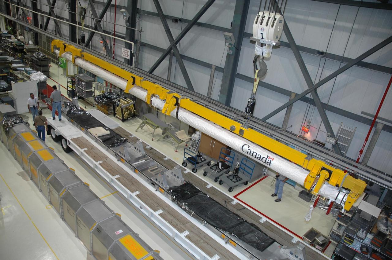
CAPE CANAVERAL, Fla. – In the Orbiter Processing Facility’s bay 3, the orbiter boom sensor system is lifted by a crane for installation in space shuttle Discovery’s payload bay for mission STS-128. The 50-foot-long boom attaches to the shuttle arm and provides equipment to inspect the shuttle's heat shield while in space. It contains an intensified television camera (ITVC) and a laser dynamic range imager, which are mounted on a pan and tilt unit, and a laser camera system (LCS) mounted on a stationary bracket. The STS-128 flight will carry science and storage racks to the International Space Station on space shuttle Discovery. Launch of Discovery is targeted for Aug. 6. Photo credit: NASA/Jim Grossmann
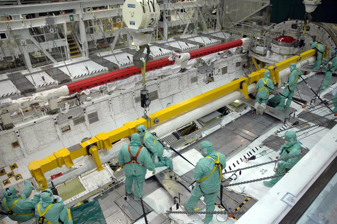
KENNEDY SPACE CENTER, FLA. - In the Orbiter Processing Facility’s bay 1, workers are ready to secure the orbiter boom sensor system on the starboard side of Atlantis’s payload bay for mission STS-117. The 50-foot-long boom attaches to the shuttle arm and provides equipment to inspect the shuttle's heat shield while in space. It contains an intensified television camera (ITVC) and a laser dynamic range imager, which are mounted on a pan and tilt unit, and a laser camera system (LCS) mounted on a stationary bracket. Mission STS-117 will carry the S3/S4 arrays for installation on the International Space Station. Launch of Space Shuttle Atlantis is scheduled for March. Photo credit: NASA/Jack Pfaller
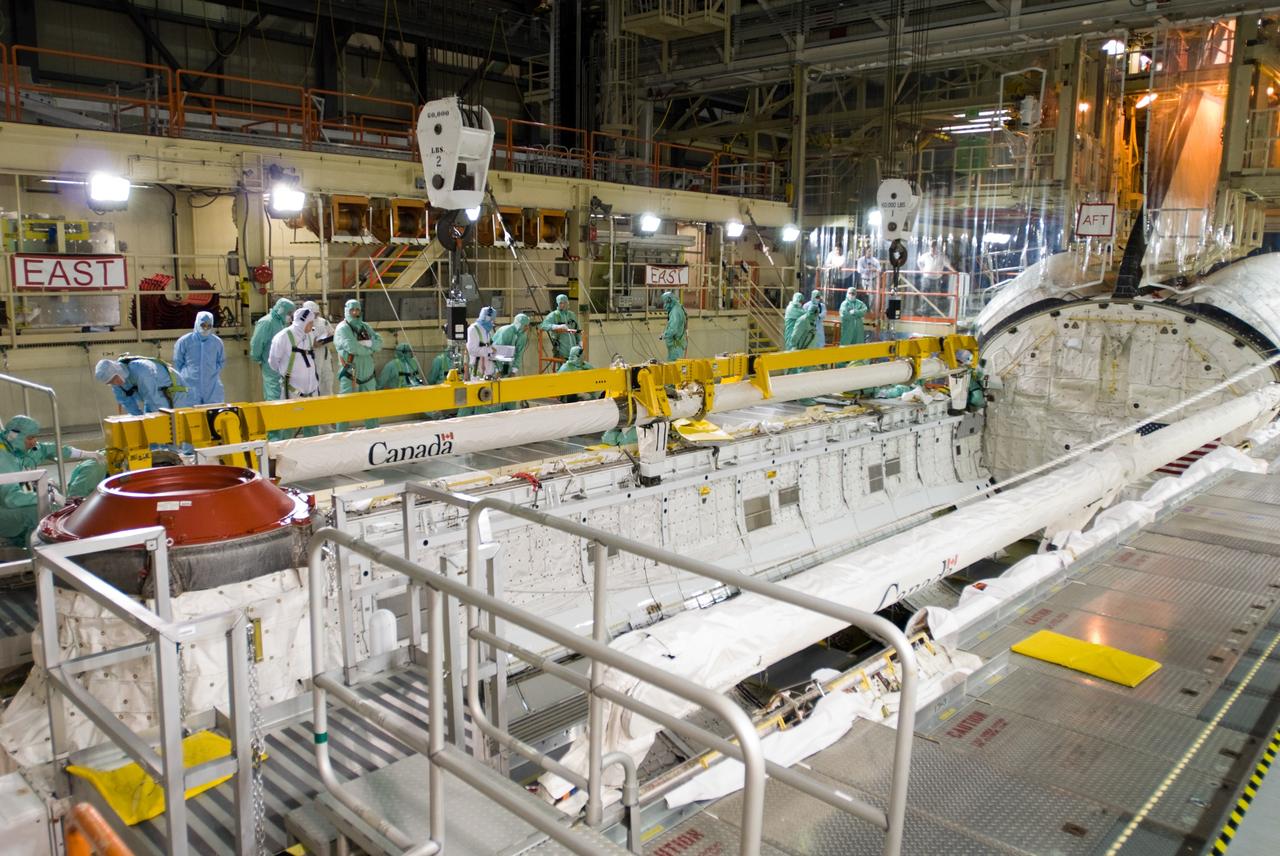
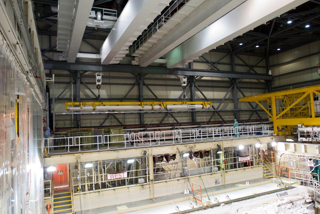
CAPE CANAVERAL, Fla. – In the Orbiter Processing Facility’s bay 3, the orbiter boom sensor system is installed in the payload bay of space shuttle Discovery to support mission STS-128. The 50-foot-long boom attaches to the shuttle arm and provides equipment to inspect the shuttle's heat shield while in space. It contains an intensified television camera (ITVC) and a laser dynamic range imager, which are mounted on a pan and tilt unit, and a laser camera system (LCS) mounted on a stationary bracket. The STS-128 flight will carry science and storage racks to the International Space Station on space shuttle Discovery. Launch of Discovery is targeted for Aug. 6. Photo credit: NASA/Jim Grossmann
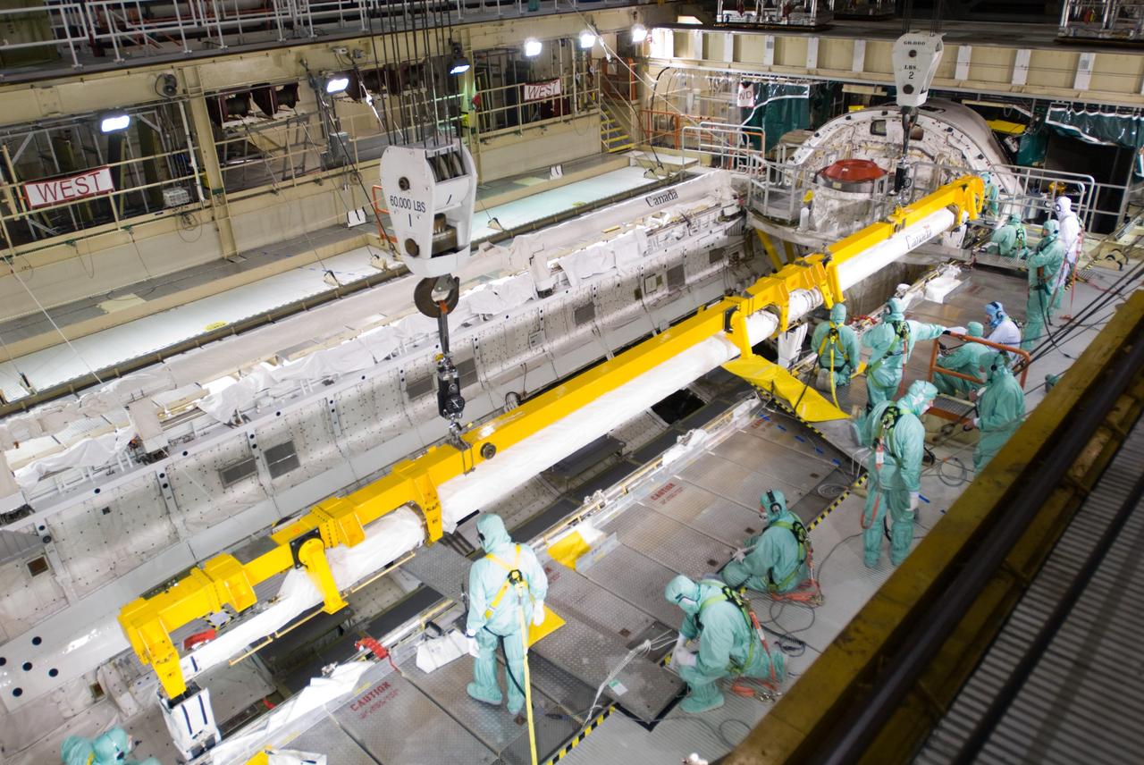
CAPE CANAVERAL, Fla. – In the Orbiter Processing Facility’s bay 3, workers prepare to install the orbiter boom sensor system in the payload bay of space shuttle Discovery to support mission STS-128. The 50-foot-long boom attaches to the shuttle arm and provides equipment to inspect the shuttle's heat shield while in space. It contains an intensified television camera (ITVC) and a laser dynamic range imager, which are mounted on a pan and tilt unit, and a laser camera system (LCS) mounted on a stationary bracket. The STS-128 flight will carry science and storage racks to the International Space Station on space shuttle Discovery. Launch of Discovery is targeted for Aug. 6. Photo credit: NASA/Jim Grossmann
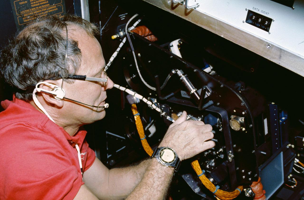
STS042-05-006 (22-30 Jan 1992) --- Astronaut Norman E. Thagard, payload commander, performs the Fluids Experiment System (FES) in the International Microgravity Laboratory (IML-1) science module. The FES is a NASA-developed facility that produces optical images of fluid flows during the processing of materials in space. The system's sophisticated optics consist of a laser to make holograms of samples and a video camera to record images of flows in and around samples. Thagard was joined by six fellow crewmembers for eight days of scientific research aboard Discovery in Earth-orbit. Most of their on-duty time was spent in this IML-1 science module, positioned in the cargo bay and attached via a tunnel to Discovery's airlock.
KENNEDY SPACE CENTER, FLA. - In the Orbiter Processing Facility’s bay 1, workers watch closely as the orbiter boom sensor system is lowered into place on the starboard side of Atlantis’s payload bay for mission STS-117. The 50-foot-long boom attaches to the shuttle arm and provides equipment to inspect the shuttle's heat shield while in space. It contains an intensified television camera (ITVC) and a laser dynamic range imager, which are mounted on a pan and tilt unit, and a laser camera system (LCS) mounted on a stationary bracket. Mission STS-117 will carry the S3/S4 arrays for installation on the International Space Station. Launch of Space Shuttle Atlantis is scheduled for March. Photo credit: NASA/Jack Pfaller
KENNEDY SPACE CENTER, FLA. - In the Orbiter Processing Facility’s bay 1, workers watch closely as the orbiter boom sensor system is lowered into place on the starboard side of Atlantis’s payload bay for mission STS-117. The 50-foot-long boom attaches to the shuttle arm and provides equipment to inspect the shuttle's heat shield while in space. It contains an intensified television camera (ITVC) and a laser dynamic range imager, which are mounted on a pan and tilt unit, and a laser camera system (LCS) mounted on a stationary bracket. Mission STS-117 will carry the S3/S4 arrays for installation on the International Space Station. Launch of Space Shuttle Atlantis is scheduled for March. Photo credit: NASA/Jack Pfaller
CAPE CANAVERAL, Fla. – In the Orbiter Processing Facility’s bay 3, the orbiter boom sensor system is moved into position by a crane over space shuttle Discovery for installation in its payload bay to support mission STS-128. The 50-foot-long boom attaches to the shuttle arm and provides equipment to inspect the shuttle's heat shield while in space. It contains an intensified television camera (ITVC) and a laser dynamic range imager, which are mounted on a pan and tilt unit, and a laser camera system (LCS) mounted on a stationary bracket. The STS-128 flight will carry science and storage racks to the International Space Station on space shuttle Discovery. Launch of Discovery is targeted for Aug. 6. Photo credit: NASA_Jim Grossmann

CAPE CANAVERAL, Fla. – In the Orbiter Processing Facility’s bay 3, workers attach a crane to the orbiter boom sensor system that will be installed in the payload bay of space shuttle Discovery to support mission STS-128. The 50-foot-long boom attaches to the shuttle arm and provides equipment to inspect the shuttle's heat shield while in space. It contains an intensified television camera (ITVC) and a laser dynamic range imager, which are mounted on a pan and tilt unit, and a laser camera system (LCS) mounted on a stationary bracket. The STS-128 flight will carry science and storage racks to the International Space Station on space shuttle Discovery. Launch of Discovery is targeted for Aug. 6. Photo credit: NASA/Kim Shiflett
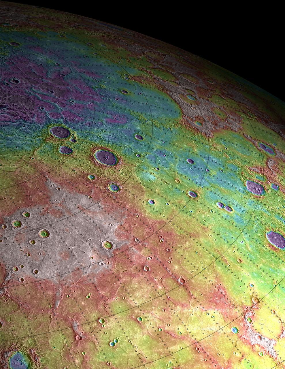
In today's image, Mercury's horizon cuts a striking edge against the stark blackness of space. On the right, sunlight harshly brings the landscape into relief while on the left, the surface is shrouded in the darkness of night. This image was acquired as part of MDIS's limb imaging campaign. Once per week, MDIS captures images of Mercury's limb, with an emphasis on imaging the southern hemisphere limb. These limb images provide information about Mercury's shape and complement measurements of topography made by the Mercury Laser Altimeter (MLA) of Mercury's northern hemisphere. Date acquired: January 20, 2015 Image Mission Elapsed Time (MET): 64084239 Image ID: 7831084 Instrument: Wide Angle Camera (WAC) of the Mercury Dual Imaging System (MDIS) WAC filter: 7 (748 nanometers) Center Latitude: -54.45° Center Longitude: 90.52° E Center Resolution: 401 meters/pixel http://photojournal.jpl.nasa.gov/catalog/PIA19192
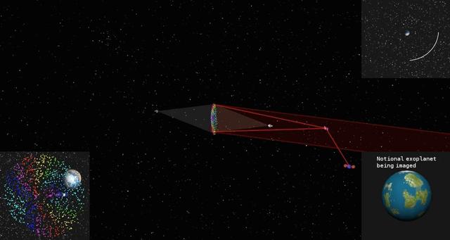
This simulated image shows how a cloud of glitter in geostationary orbit would be illuminated and controlled by two laser beams. As the cloud orbits Earth, grains scatter the sun's light at different angles like many tiny prisms, similar to how rainbows are produced from light being dispersed by water droplets. That is why the project concept is called "Orbiting Rainbows." The cloud functions like a reflective surface, allowing the exoplanet (displayed in the bottom right) to be imaged. The orbit path is shown in the top right. On the bottom left, Earth's image is seen behind the cloud. To image an exoplanet, the cloud would need to have a diameter of nearly 98 feet (30 meters). This simulation confines the cloud to a 3.3 x 3.3 x 3.3 foot volume (1 x 1 x 1 meter volume) to simplify the computations. The elements of the orbiting telescope are not to scale. Orbiting Rainbows is currently in Phase II development through the NASA Innovative Advanced Concepts (NIAC) Program. It was one of five technology proposals chosen for continued study in 2014. In the current phase, Orbiting Rainbows researchers are conducting small-scale ground experiments to demonstrate how granular materials can be manipulated using lasers and simulations of how the imaging system would behave in orbit. http://photojournal.jpl.nasa.gov/catalog/PIA19318
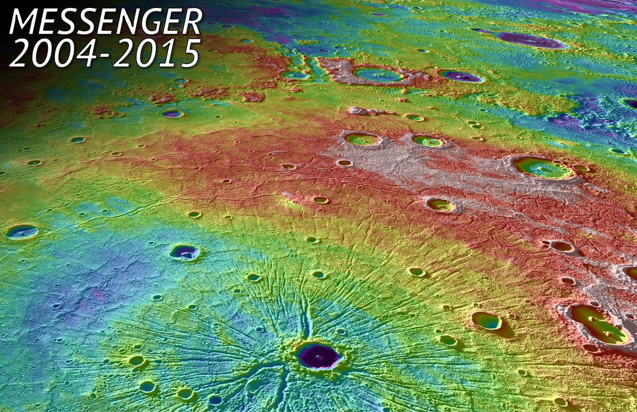
In this perspective view, NASA MESSENGER spacecraft looked northwest over the Caloris Basin, a depression about 1500 km in diameter formed several billion years ago by the impact of a large projectile into the surface of Mercury. The mountain range at the edge of the basin can be seen as an arc in the background. In the foreground, we see a set of tectonic troughs, known as Pantheon Fossae, radiating from the center of the basin outward toward the edge of the basin interior. A 41-km-diameter impact crater, Apollodorus, is superposed just slightly off from the center of Pantheon Fossae. White and red are high topography, and greens and blues are low topography, with a total height differences of roughly 4 km. The MESSENGER spacecraft was launched in 2004 and ended it's orbital operations yesterday, April 30, 2015, by impacting Mercury's surface. Background image texture is provided by the Mercury Dual Imaging System (MDIS) instrument while color corresponds to surface elevation data obtained from the Mercury Laser Altimeter (MLA) experiment, with both draped over a digital elevation model derived from MLA altimetric data. Instrument: Mercury Dual Imaging System (MDIS) and Mercury Laser Altimeter (MLA) Approximate Center Latitude: 33.7° N Approximate Center Longitude: 158.7° E Scale: Apollodorus crater is approximately 41 km (25 miles) in diameter http://photojournal.jpl.nasa.gov/catalog/PIA19450
A new NASA-developed, laser-based space communication system will enable higher rates of satellite communications similar in capability to high-speed fiber optic networks on Earth. The space terminal for the Lunar Laser Communication Demonstration (LLCD), NASA's first high-data-rate laser communication system, was recently integrated onto the Lunar Atmosphere and Dust Environment Explorer (LADEE) spacecraft. LLCD will demonstrate laser communications from lunar orbit to Earth at six times the rate of the best modern-day advanced radio communication systems. Credit: NASA ----- What is LADEE? The Lunar Atmosphere and Dust Environment Explorer (LADEE) is designed to study the Moon's thin exosphere and the lunar dust environment. An "exosphere" is an atmosphere that is so thin and tenuous that molecules don't collide with each other. Studying the Moon's exosphere will help scientists understand other planetary bodies with exospheres too, like Mercury and some of Jupiter's bigger moons. The orbiter will determine the density, composition and temporal and spatial variability of the Moon's exosphere to help us understand where the species in the exosphere come from and the role of the solar wind, lunar surface and interior, and meteoric infall as sources. The mission will also examine the density and temporal and spatial variability of dust particles that may get lofted into the atmosphere. The mission also will test several new technologies, including a modular spacecraft bus that may reduce the cost of future deep space missions and demonstrate two-way high rate laser communication for the first time from the Moon. LADEE now is ready to launch when the window opens on Sept. 6, 2013. Read more: <a href="http://www.nasa.gov/ladee" rel="nofollow">www.nasa.gov/ladee</a> <b><a href="http://www.nasa.gov/audience/formedia/features/MP_Photo_Guidelines.html" rel="nofollow">NASA image use policy.</a></b> <b><a href="http://www.nasa.gov/centers/goddard/home/index.html" rel="nofollow">NASA Goddard Space Flight Center</a></b> enables NASA’s mission through four scientific endeavors: Earth Science, Heliophysics, Solar System Exploration, and Astrophysics. Goddard plays a leading role in NASA’s accomplishments by contributing compelling scientific knowledge to advance the Agency’s mission. <b>Follow us on <a href="http://twitter.com/NASA_GoddardPix" rel="nofollow">Twitter</a></b> <b>Like us on <a href="http://www.facebook.com/pages/Greenbelt-MD/NASA-Goddard/395013845897?ref=tsd" rel="nofollow">Facebook</a></b> <b>Find us on <a href="http://instagram.com/nasagoddard?vm=grid" rel="nofollow">Instagram</a></b>
KENNEDY SPACE CENTER, FLA. - At Launch Pad 39B, the Orbiter Boom Sensor System (OBSS) sensor package is viewed before the orbiter's payload bay doors are closed for launch. Payload bay door closure is a significant milestone in the preparations of Discovery for the first Return to Flight mission, STS-114. This sensor package will provide surface area and depth defect inspection for all the surfaces of the orbiter. It includes an intensified television camera (ITVC) and a laser dynamic range imager, which are mounted on a pan and tilt unit, and a laser camera system (LCS) mounted on a stationary bracket. The package is part of the new safety measures added for all future Space Shuttle missions. During its 12-day mission, Discovery’s seven-person crew will test new hardware and techniques to improve Shuttle safety, as well as deliver supplies to the International Space Station. Discovery’s payloads include the Multi-Purpose Logistics Module Raffaello, the Lightweight Multi-Purpose Experiment Support Structure Carrier (LMC), and the External Stowage Platform-2 (ESP-2). Raffaello will deliver supplies to the International Space Station including food, clothing and research equipment. The LMC supports a replacement Control Moment Gyroscope and a tile repair sample box. The ESP-2 is outfitted with replacement parts. Launch of mission STS-114 was set for July 13 at the conclusion of the Flight Readiness Review yesterday.
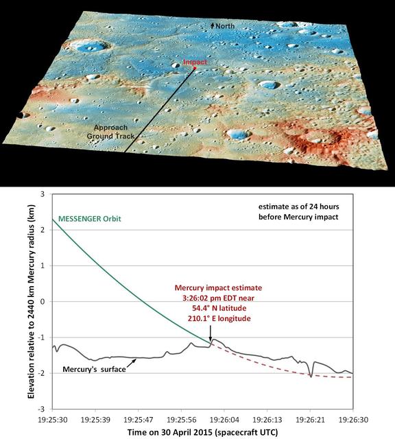
These graphics show the current best prediction of the location and time of NASA MESSENGER impact on Mercury surface. These current best estimates are: Date: 30 April 2015 Time: 3:26:02 pm EDT 19:26:02 UTC Latitude: 54.4° N Longitude: 210.1° E. Traveling at 3.91 kilometers per second (over 8,700 miles per hour), the MESSENGER spacecraft will collide with Mercury's surface, creating a crater estimated to be 16 meters (52 feet) in diameter. View this image to learn about the named features and geology of this region on Mercury. Instruments: Mercury Dual Imaging System (MDIS) and Mercury Laser Altimeter (MLA) Top Image Latitude Range: 49°-59° N Top Image Longitude Range: 204°-217° E Topography in Top Image: Exaggerated by a factor of 5.5. Colors in Top Image: Coded by topography. The tallest regions are colored red and are roughly 3 kilometers (1.9 miles) higher than low-lying areas such as the floors of impact craters, colored blue. Scale in Top Image: The large crater on the left side of the image is Janacek, with a diameter of 48 kilometers (30 miles) http://photojournal.jpl.nasa.gov/catalog/PIA19443
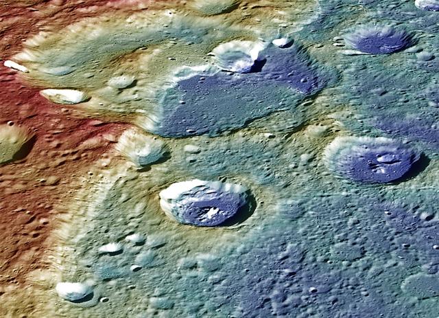
This image from NASA MESSENGER spacecraft provides a perspective view of the center portion of Carnegie Rupes, a large tectonic landform, which cuts through Duccio crater. The image shows the terrain (variations in topography) as measured by the MLA instrument and surface mapped by the MDIS instrument. The image was color-coded to highlight the variations in topography (red = high standing terrain, blue = low lying terrain). Tectonic landforms such as Carnegie Rupes form on Mercury as a response to interior planetary cooling, resulting in the overall shrinking of the planet. To make this graphic, 48 individual MDIS images were used as part of the mosaic. Instruments: Mercury Dual Imaging System (MDIS) and Mercury Laser Altimeter (MLA) Latitude: 57.1° Longitude: 304.0° E Scale: Duccio crater has a diameter of roughly 105 kilometers (65 miles) Height: Portions of Carnegie Rupes are nearly 2 kilometers (1.2 miles) in height Orientation: North is roughly to the left of the image http://photojournal.jpl.nasa.gov/catalog/PIA19422
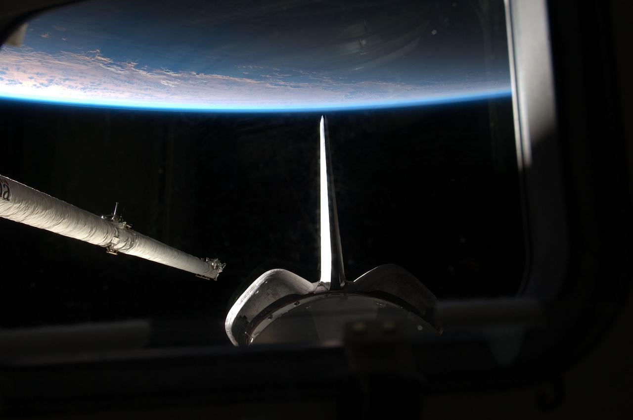
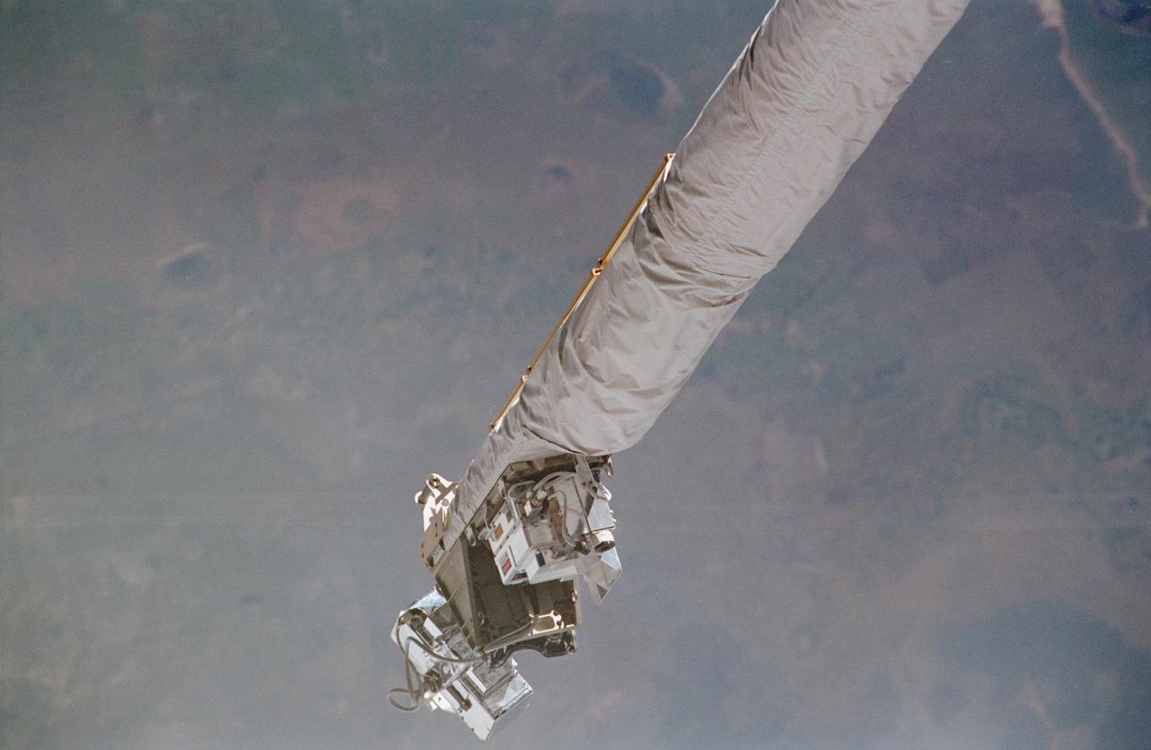
S135-E-006361 (9 July 2011) --- One of the four STS-135 crewmembers took this photo from space shuttle Atlantis' aft flight deck during the mission's second day of activities in Earth orbit. Earth's horizon and aft sections of the shuttle frame the orbiter boom sensor system (OBSS) on the starboard side of the spacecraft shortly before it was remotely maneuvered into position to start survey of the spacecraft's thermal protection system (TPS). The various sensor packages on the OBSS, which include a high-resolution still camera, a laser range imager and a video camera, later swept over the critical surfaces of the TPS, looking for signs of any damage that might have been caused by ascent debris or anything that might endanger the shuttle's ability to return to Earth safely. Photo credit: NASA
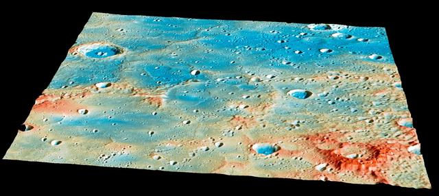
On April 30th, this region of Mercury's surface will have a new crater! Traveling at 3.91 kilometers per second (over 8,700 miles per hour), the MESSENGER spacecraft will collide with Mercury's surface, creating a crater estimated to be 16 meters (52 feet) in diameter. The large, 400-kilometer-diameter (250-mile-diameter), impact basin Shakespeare occupies the bottom left quarter of this image. Shakespeare is filled with smooth plains material, likely due to extensive lava flooding the basin in the past. As of 24 hours before the impact, the current best estimates predict that the spacecraft will strike a ridge slightly to the northeast of Shakespeare. View this image to see more details of the predicted impact site and time. Instrument: Mercury Dual Imaging System (MDIS) and Mercury Laser Altimeter (MLA) Latitude Range: 49°-59° N Longitude Range: 204°-217° E Topography: Exaggerated by a factor of 5.5. Colors: Coded by topography. The tallest regions are colored red and are roughly 3 kilometers (1.9 miles) higher than low-lying areas such as the floors of impact craters, colored blue. Scale: The large crater on the left side of the image is Janacek, with a diameter of 48 kilometers (30 miles) http://photojournal.jpl.nasa.gov/catalog/PIA19444

In this image, Mercury's horizon cuts a striking edge against the stark blackness of space. On the right, sunlight harshly brings the landscape into relief while on the left, the surface is shrouded in the darkness of night. This image was acquired as part of MDIS's limb imaging campaign. Once per week, MDIS captures images of Mercury's limb, with an emphasis on imaging the southern hemisphere limb. These limb images provide information about Mercury's shape and complement measurements of topography made by the Mercury Laser Altimeter (MLA) of Mercury's northern hemisphere. The MESSENGER spacecraft is the first ever to orbit the planet Mercury, and the spacecraft's seven scientific instruments and radio science investigation are unraveling the history and evolution of the Solar System's innermost planet. In the mission's more than three years of orbital operations, MESSENGER has acquired over 250,000 images and extensive other data sets. MESSENGER is capable of continuing orbital operations until early 2015. Credit: NASA/Johns Hopkins University Applied Physics Laboratory/Carnegie Institution of Washington <b><a href="http://www.nasa.gov/audience/formedia/features/MP_Photo_Guidelines.html" rel="nofollow">NASA image use policy.</a></b> <b><a href="http://www.nasa.gov/centers/goddard/home/index.html" rel="nofollow">NASA Goddard Space Flight Center</a></b> enables NASA’s mission through four scientific endeavors: Earth Science, Heliophysics, Solar System Exploration, and Astrophysics. Goddard plays a leading role in NASA’s accomplishments by contributing compelling scientific knowledge to advance the Agency’s mission. <b>Follow us on <a href="http://twitter.com/NASAGoddardPix" rel="nofollow">Twitter</a></b> <b>Like us on <a href="http://www.facebook.com/pages/Greenbelt-MD/NASA-Goddard/395013845897?ref=tsd" rel="nofollow">Facebook</a></b> <b>Find us on <a href="http://instagram.com/nasagoddard?vm=grid" rel="nofollow">Instagram</a></b>
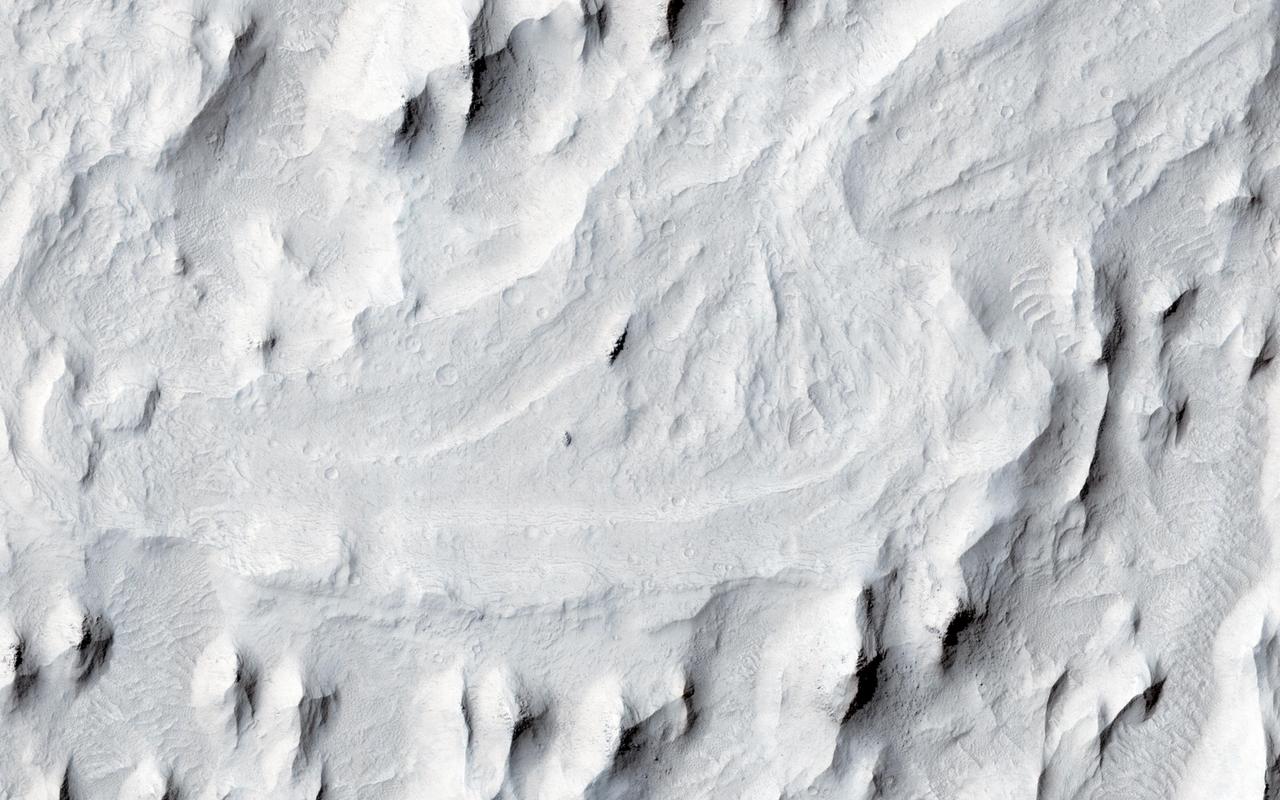
In this image from NASA Mars Reconnaissance Orbiter spacecraft, an ancient sinuous meandering river system is surrounded by features called yardangs. The yardangs are the ridge-like landforms that align approximately north-south. These features were created as the wind scoured and eroded the bedrock. The raised relief of the meandering river suggests inverted topography, likely due to lithification and cementation of the riverbed sediment. The cemented channel deposits were resistant, and thus less susceptible to erosion over time. However, the area surrounding the riverbed suggests that this area was a floodplain of weaker lithology that was subsequently eroded and shaped to the yardangs. The main meandering inverted riverbed within the image has a length of about 13 kilometers. The elevation of the channel at the top of the image is on the order of 113 meters higher than the bottom, based on Mars Orbiter Laser Altimeter (MOLA) data. This elevation difference and the increase in sinuosity of the channel shape in the southerly direction implies that the flow of the ancient river may have been heading south-southwest. http://photojournal.jpl.nasa.gov/catalog/PIA20047
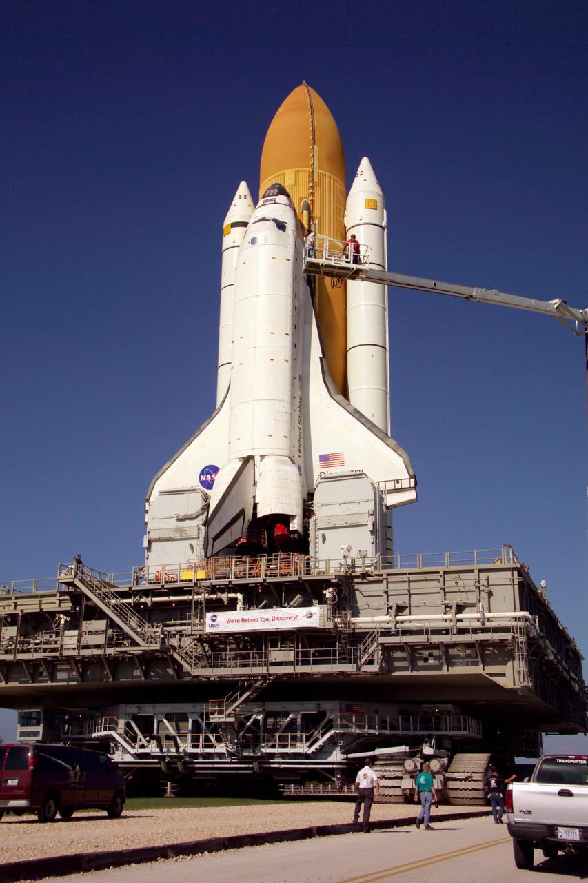
KENNEDY SPACE CENTER, FLA. - Technicians photograph the exterior of Space Shuttle Discovery on its journey to Launch Pad 39B to support the Baseline Configuration Imaging (BCI) project. BCI will be collected on each orbiter prior to every mission, beginning with STS-114. The photos will be compiled into a database available for comparison, if the need arises, to photos taken on orbit from the Shuttle's Orbital Boom Sensor System (OBSS). The 50-foot-long OBSS attaches to the Remote Manipulator System, or Shuttle robotic arm, and is one of the new safety measures for Return to Flight, equipping the orbiter with cameras and laser systems to inspect the Shuttle’s Thermal Protection System while in space. Discovery was hard down on the pad at 1:16 a.m. EDT April 7. Launch of Discovery on its Return to Flight mission, STS-114, is targeted for May 15 with a launch window that extends to June 3. During its 12-day mission, Discovery’s seven-member crew will test new hardware and techniques to improve Shuttle safety, as well as deliver supplies to the International Space Station.
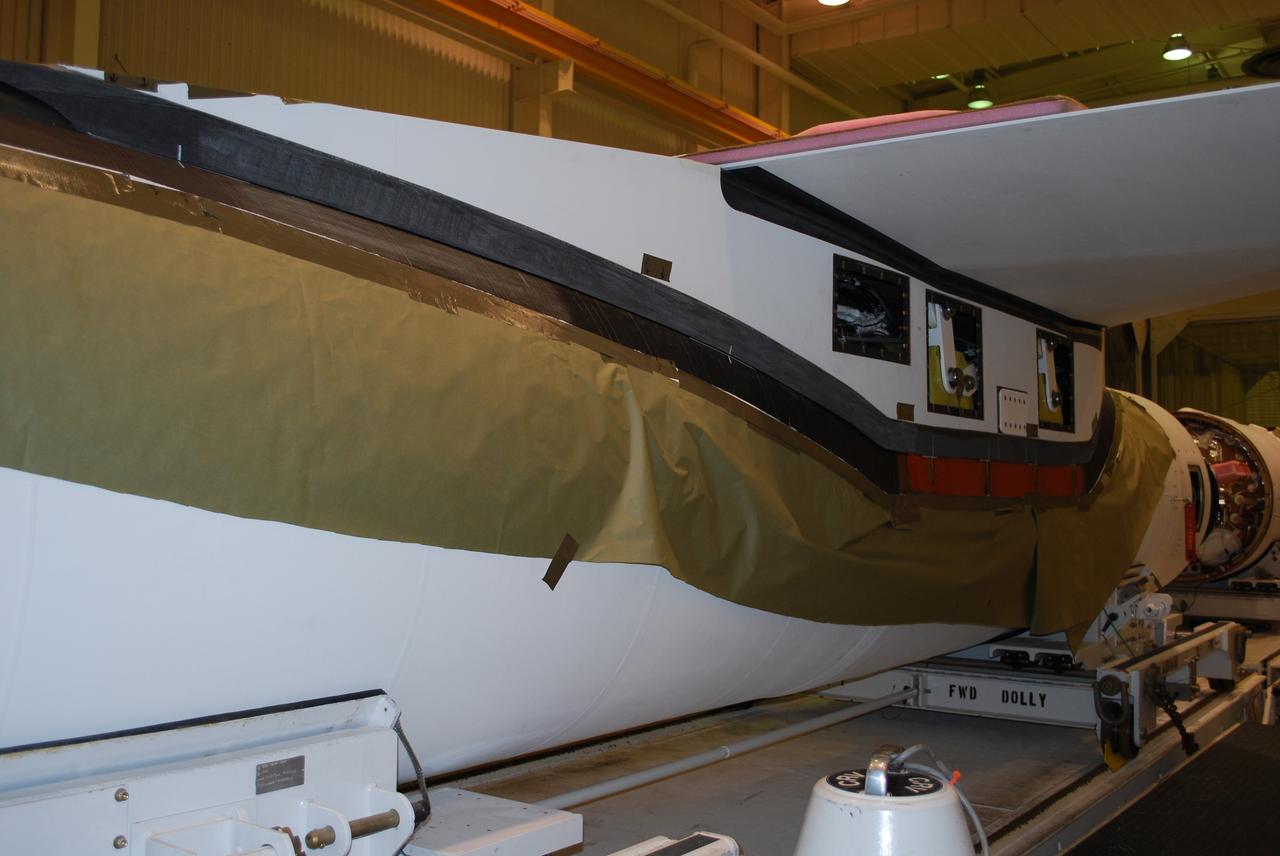
VANDENBERG AIR FORCE BASE, Calif. -- Avionics shelf flatness and fillet gap measurements are conducted on the wing of a Pegasus rocket in Building 1555 at Vandenberg AFB. The testing was performed by workers from Advanced Digital Measuring Works using an API laser tracker. The Pegasus will launch NASA's Interstellar Boundary Explorer Mission, or IBEX, satellite from Kwajalein Island in the Marshall Islands, South Pacific. IBEX will make the first map of the boundary between the solar system and interstellar space. IBEX is the first mission designed to detect the edge of the solar system. As the solar wind from the sun flows out beyond Pluto, it collides with the material between the stars, forming a shock front. IBEX contains two neutral atom imagers designed to detect particles from the termination shock at the boundary between the solar system and interstellar space. IBEX also will study galactic cosmic rays, energetic particles from beyond the solar system that pose a health and safety hazard for humans exploring beyond Earth orbit. IBEX will make these observations from a highly elliptical orbit that takes it beyond the interference of the Earth's magnetosphere. IBEX is targeted for launch in October 2008. Photo credit: NASA/Randy Beaudoin
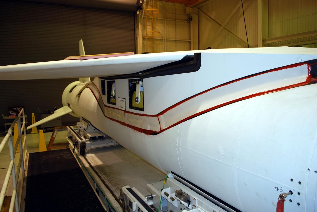
VANDENBERG AIR FORCE BASE, Calif. -- Avionics shelf flatness and fillet gap measurements are conducted on the wing of a Pegasus rocket in Building 1555 at Vandenberg AFB. The testing was performed by workers from Advanced Digital Measuring Works using an API laser tracker. The Pegasus will launch NASA's Interstellar Boundary Explorer Mission, or IBEX, satellite from Kwajalein Island in the Marshall Islands, South Pacific. IBEX will make the first map of the boundary between the solar system and interstellar space. IBEX is the first mission designed to detect the edge of the solar system. As the solar wind from the sun flows out beyond Pluto, it collides with the material between the stars, forming a shock front. IBEX contains two neutral atom imagers designed to detect particles from the termination shock at the boundary between the solar system and interstellar space. IBEX also will study galactic cosmic rays, energetic particles from beyond the solar system that pose a health and safety hazard for humans exploring beyond Earth orbit. IBEX will make these observations from a highly elliptical orbit that takes it beyond the interference of the Earth's magnetosphere. IBEX is targeted for launch in October 2008. Photo credit: NASA/Randy Beaudoin
KENNEDY SPACE CENTER, FLA. - Technicians photograph the exterior of Space Shuttle Discovery on its journey to Launch Pad 39B to support the Baseline Configuration Imaging (BCI) project. BCI will be collected on each orbiter prior to every mission, beginning with STS-114. The photos will be compiled into a database available for comparison, if the need arises, to photos taken on orbit from the Shuttle's Orbital Boom Sensor System (OBSS). The 50-foot-long OBSS attaches to the Remote Manipulator System, or Shuttle robotic arm, and is one of the new safety measures for Return to Flight, equipping the orbiter with cameras and laser systems to inspect the Shuttle’s Thermal Protection System while in space. Discovery was hard down on the pad at 1:16 a.m. EDT April 7. Launch of Discovery on its Return to Flight mission, STS-114, is targeted for May 15 with a launch window that extends to June 3. During its 12-day mission, Discovery’s seven-member crew will test new hardware and techniques to improve Shuttle safety, as well as deliver supplies to the International Space Station.
Scale: The width of this image is about 250 kilometers (150 miles) Topographic information from the Mercury Laser Altimeter (MLA) is used to colorize a image mosaic of Goethe basin, located in Mercury's northern region. The purple colors are low and white is the highest; the total range of heights shown in this view is about 1 kilometer. Goethe basin is home to a variety of interesting features, including ghost craters with graben, wrinkle ridges that outline the basin, and dark craters that host radar-bright materials. The MESSENGER spacecraft is the first ever to orbit the planet Mercury, and the spacecraft's seven scientific instruments and radio science investigation are unraveling the history and evolution of the Solar System's innermost planet. Visit the Why Mercury? section of this website to learn more about the key science questions that the MESSENGER mission is addressing. During the one-year primary mission, MDIS acquired 88,746 images and extensive other data sets. MESSENGER is now in a yearlong extended mission, during which plans call for the acquisition of more than 80,000 additional images to support MESSENGER’s science goals. Credit: NASA/Johns Hopkins University Applied Physics Laboratory/Carnegie Institution of Washington/Brown University <b><a href="http://www.nasa.gov/audience/formedia/features/MP_Photo_Guidelines.html" rel="nofollow">NASA image use policy.</a></b> <b><a href="http://www.nasa.gov/centers/goddard/home/index.html" rel="nofollow">NASA Goddard Space Flight Center</a></b> enables NASA’s mission through four scientific endeavors: Earth Science, Heliophysics, Solar System Exploration, and Astrophysics. Goddard plays a leading role in NASA’s accomplishments by contributing compelling scientific knowledge to advance the Agency’s mission. <b>Follow us on <a href="http://twitter.com/NASA_GoddardPix" rel="nofollow">Twitter</a></b> <b>Like us on <a href="http://www.facebook.com/pages/Greenbelt-MD/NASA-Goddard/395013845897?ref=tsd" rel="nofollow">Facebook</a></b> <b>Find us on <a href="http://instagrid.me/nasagoddard/?vm=grid" rel="nofollow">Instagram</a></b>
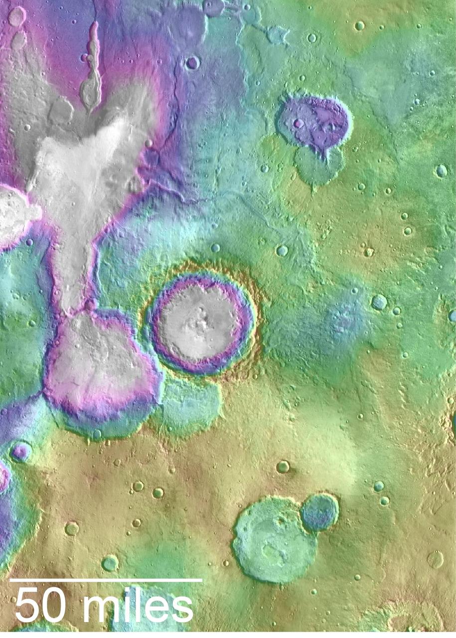
Valleys younger than better-known ancient valley networks on Mars are evident on the landscape in the northern Arabia Terra region of Mars, particularly in the area mapped here with color-coded topographical information overlaid onto a photo mosaic. The area includes a basin informally named "Heart Lake" at upper left (northwest). Data from the Mars Orbiter Laser Altimeter (MOLA) on NASA's Mars Global Surveyor orbiter are coded here as white and purple for lower elevations, yellow for higher elevation. The elevation information is combined with a mosaic of images from the Thermal Emission Imaging System (THEMIS) camera on NASA's Mars Odyssey orbiter, covering an area about 120 miles (about 190 kilometers) wide. The mapped area is centered near 35.91 degrees north latitude, 1 degree east longitude on Mars. These lakes and streams held water several hundred million years after better-known ancient lake environments on Mars, according to 2016 findings. http://photojournal.jpl.nasa.gov/catalog/PIA20838
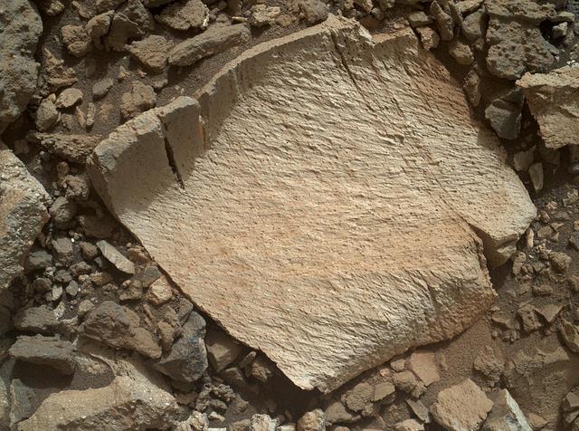
A rock fragment dubbed "Lamoose" is shown in this picture taken by the Mars Hand Lens Imager (MAHLI) on NASA's Curiosity rover. Like other nearby rocks in a portion of the "Marias Pass" area of Mt. Sharp, Mars, it has unusually high concentrations of silica. The high silica was first detected in the area by the Chemistry & Camera (ChemCam) laser spectrometer. This rock was targeted for follow-up study by the MAHLI and the arm-mounted Alpha Particle X-ray Spectrometer (APXS). Silica is a rock-forming compound containing silicon and oxygen, commonly found on Earth as quartz. High levels of silica could indicate ideal conditions for preserving ancient organic material, if present, so the science team wants to take a closer look. The rock is about 4 inches (10 centimeters) across. It is fine-grained, perhaps finely layered, and etched by the wind. The image was taken on the 1,041st Martian day, or sol, of the mission (July 11, 2015). MAHLI was built by Malin Space Science Systems, San Diego. NASA's Jet Propulsion Laboratory, a division of the California Institute of Technology in Pasadena, manages the Mars Science Laboratory Project for the NASA Science Mission Directorate, Washington. JPL designed and built the project's Curiosity rover. http://photojournal.jpl.nasa.gov/catalog/PIA19828
Goddard scientist David Harding and Goddard technologist Tony Yu are developing a lidar system that could meet an ambitious requirement of the proposed LIST mission. ---------- In 2007, the National Research Council threw down a challenge: Design a space-based laser altimeter that could measure the height of Earth's surface everywhere to within a mere 10 centimeters — all at 5-meter resolution. To this day, some believe it can't be done. Goddard scientist Dave Harding begs to differ. He and his team have embraced the challenge and are developing a laser altimeter that could provide the data from a berth onboard the NRC-proposed Lidar Surface Topography, or LIST, mission. It would generate highly detailed maps of topography and vegetation that scientists could use to forecast and respond to natural hazards and study carbon storage in forests. Read more: <a href="http://1.usa.gov/17N3Bql" rel="nofollow">1.usa.gov/17N3Bql</a> <b><a href="http://www.nasa.gov/audience/formedia/features/MP_Photo_Guidelines.html" rel="nofollow">NASA image use policy.</a></b> <b><a href="http://www.nasa.gov/centers/goddard/home/index.html" rel="nofollow">NASA Goddard Space Flight Center</a></b> enables NASA’s mission through four scientific endeavors: Earth Science, Heliophysics, Solar System Exploration, and Astrophysics. Goddard plays a leading role in NASA’s accomplishments by contributing compelling scientific knowledge to advance the Agency’s mission. <b>Follow us on <a href="http://twitter.com/NASA_GoddardPix" rel="nofollow">Twitter</a></b> <b>Like us on <a href="http://www.facebook.com/pages/Greenbelt-MD/NASA-Goddard/395013845897?ref=tsd" rel="nofollow">Facebook</a></b> <b>Find us on <a href="http://instagram.com/nasagoddard?vm=grid" rel="nofollow">Instagram</a></b> Credit: Bill Hrybck/NASA
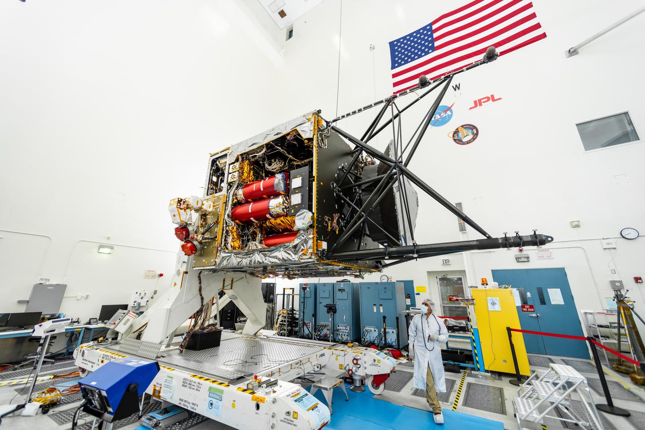
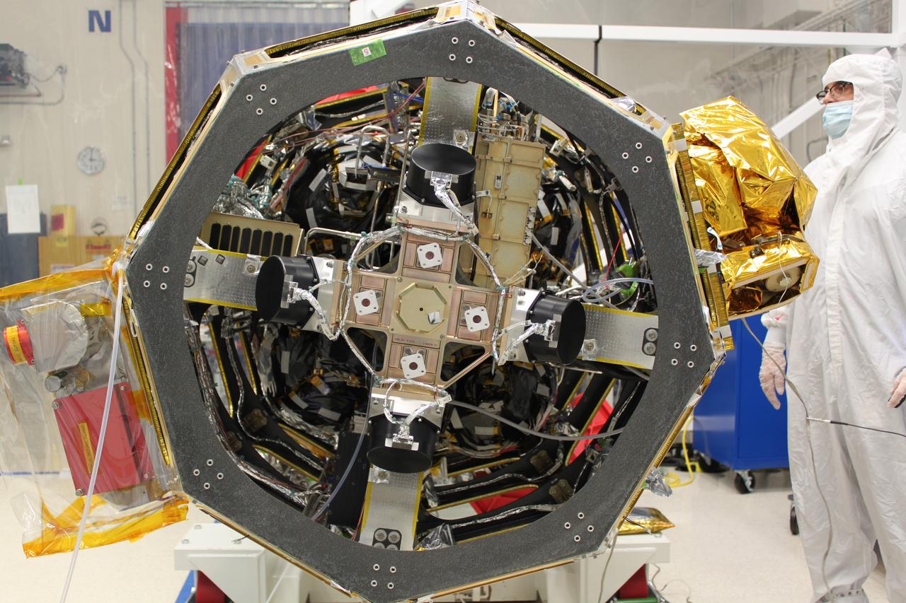
NASA's Psyche spacecraft is captured here on August 18, 2021, in a clean room at the agency's Jet Propulsion Laboratory in Southern California – in the midst of system integration and test. The mission's launch period opens August 1, 2022. The nitrogen tanks are visible in the center of the spacecraft chassis, encased in red protective "remove before flight" covers. Mounted on the right is the strut tower, which will host the sensors for two of the science instruments – the magnetometer and the Gamma Ray and Neutron Spectrometer (GRNS). By spring of 2022, the fully assembled Psyche spacecraft will ship from JPL to NASA's Kennedy Space Center for launch. In early 2026, the spacecraft will arrive at its target, an asteroid of the same name in the main asteroid belt between Mars and Jupiter. Scientists believe asteroid Psyche, which is about 140 miles (226 kilometers) wide, is made largely of iron and nickel and could be the core of an early planet. The spacecraft will spend 21 months orbiting the asteroid and gathering science data. Besides the magnetometer and the GRNS, Psyche will carry a multispectral imager. The mission also will test a sophisticated new laser communications technology, recently completed by JPL, called Deep Space Optical Communications (DSOC). The technology demonstration will focus on using lasers to enhance communications speeds and prepare for data-intensive transmissions, which could potentially include livestream videos for future missions. Arizona State University leads the mission. JPL is responsible for the mission's overall management, system engineering, integration and testing, and mission operations. Maxar Technologies is providing a high-power solar electric propulsion spacecraft chassis. Psyche is the 14th mission selected as part of NASA's Discovery Program. https://photojournal.jpl.nasa.gov/catalog/PIA24787
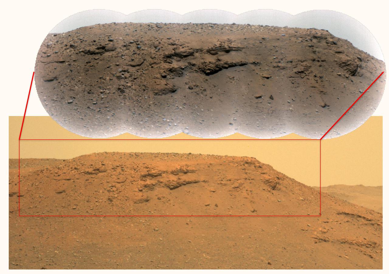
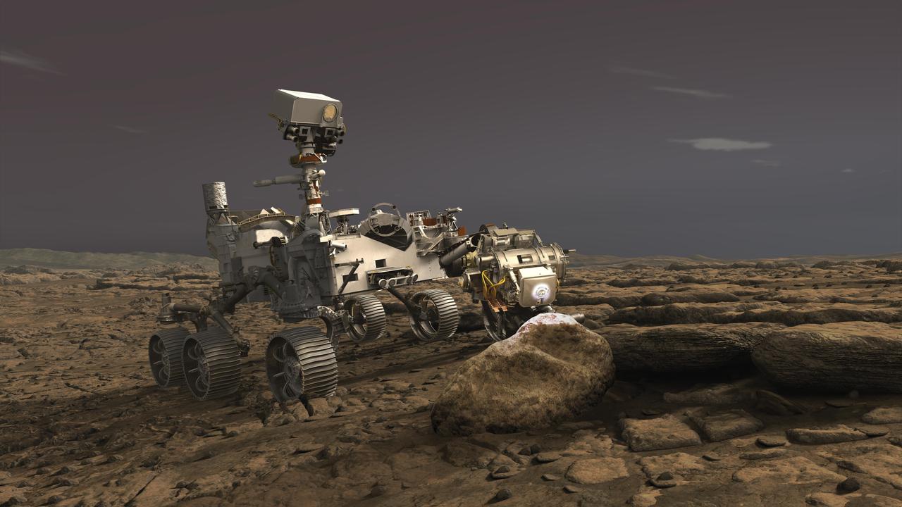
This composite image of the "Delta Scarp" in Mars' Jezero Crater was generated using data from two imagers aboard NASA's Perseverance rover. Taken by the rover's Mastcam-Z, the bottom image shows both the base and plateau of the escarpment. The inset above, created from a mosaic of five Remote Microscopic Imager (RMI) pictures, zooms in on a 377-foot-wide (115-meter-wide) portion of the scarp, allowing closer inspection of some of its intriguing geologic features. Part of the rover's SuperCam instrument, the RMI is able to spot an object the size of a softball from nearly a mile away, allowing scientists to take images of details from a long distance. It also provides fine details of nearby targets zapped by SuperCam's laser. SuperCam is led by Los Alamos National Laboratory in New Mexico, where the instrument's Body Unit was developed. That part of the instrument includes several spectrometers, control electronics and software. The Mast Unit was developed and built by several laboratories of the CNRS (French National Centre for Scientific Research) and French universities under the contracting authority of CNES. Arizona State University in Tempe leads the operations of the Mastcam-Z instrument, working in collaboration with Malin Space Science Systems in San Diego. A key objective for Perseverance's mission on Mars is astrobiology, including the search for signs of ancient microbial life. The rover will characterize the planet's geology and past climate, pave the way for human exploration of the Red Planet, and be the first mission to collect and cache Martian rock and regolith (broken rock and dust). Subsequent NASA missions, in cooperation with ESA (European Space Agency), would send spacecraft to Mars to collect these sealed samples from the surface and return them to Earth for in-depth analysis. The Mars 2020 Perseverance mission is part of NASA's Moon to Mars exploration approach, which includes Artemis missions to the Moon that will help prepare for human exploration of the Red Planet. https://photojournal.jpl.nasa.gov/catalog/PIA24684
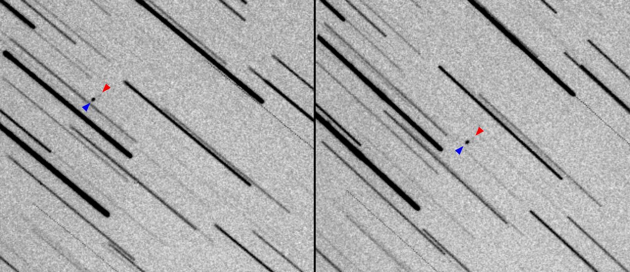
These images show two observations of NASA's Lunar Flashlight and the private ispace HAKUTO-R Mission 1 as the two spacecraft, seen as a pair of dots, journey to the Moon. In Figure A, the images have been joined sequentially to create an animated GIF. The larger HAKUTO-R lunar lander appears as a large black dot, whereas the smaller Lunar Flashlight, which is about the size of a briefcase, appears as a fuzzy grouping of gray pixels. Stars appear as long trails. Both missions launched on Dec. 11, 2022, aboard a SpaceX Falcon 9 rocket, with Lunar Flashlight and HAKUTO-R spacecraft subsequently deploying from it. Astronomer Vishnu Reddy and graduate student Adam Battle, both from University of Arizona's Lunar and Planetary Laboratory and Space4 Center, used a remote 0.5-meter (1.6-foot) telescope in Australia to track the small spacecraft. They used data from the Horizons System at NASA's Jet Propulsion Laboratory in Southern California to find their position in the sky. These images were acquired about 39 hours after launch, when the two spacecraft were 145,000 miles (235,000 kilometers) from Earth. Black and white in the images have been inverted so that the brighter the object, the darker it is. To detect the faint reflected light from both spacecraft, they stacked 80 images, each from a 10-second exposure (for a total exposure time of 800 seconds), based on the rate of motion and direction of the spacecraft. This method resulted in stars appearing as long trails and the two spacecraft appearing as dots. Lunar Flashlight is a small satellite mission planning to use lasers to seek out surface water ice inside permanently shadowed craters at the Moon's South Pole. The small satellite is expected to reach its science orbit around the Moon in April 2023. Movie available at https://photojournal.jpl.nasa.gov/catalog/PIA25257
In this illustration, NASA's Perseverance rover uses its Planetary Instrument for X-ray Lithochemistry (PIXL) instrument to analyze a rock on the surface of Mars. PIXL uses a focused X-ray beam to analyze the chemistry of features as small as a grain of sand. The tiny but powerful beam causes rocks to fluoresce, or produce a glow. While the glow is invisible to the human eye, it is detectable by the instrument and varies according to the rock's elemental chemistry. PIXL scan the beam across the surface of the rock to produce a postage-stamp-sized map of the rock's chemistry at the end of an overnight scan. PIXL also has an optical fiducial system (OFS) that includes white "flood lights" — seen on the rock in this artist's concept — that is used together with a pattern of red lasers to illuminate the rock while its camera captures images of the mapped area. The pictures are used for multiple purposes: PIXL analyzes them on board to work out where the target is — in 3D — and move itself into the right position for science collection and the safety of the instrument. The pictures are also downlinked to Earth so scientists can see exactly where each measurement was taken. This allows scientists to tie chemistry accurately to rock texture, which helps them to determine how these features formed and whether they were biological in nature. https://photojournal.jpl.nasa.gov/catalog/PIA23719
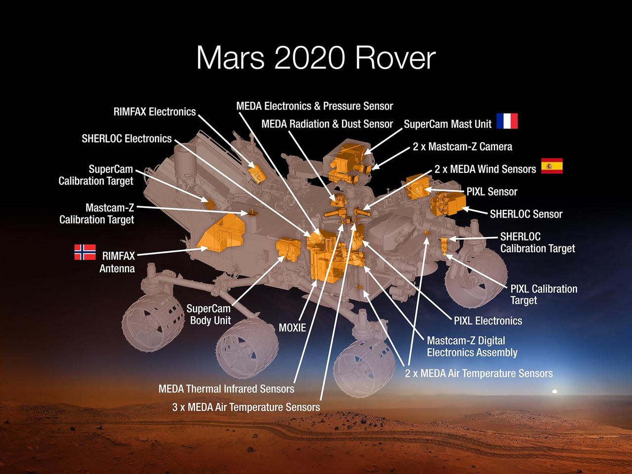
This 2015 diagram shows components of the investigations payload for NASA's Mars 2020 rover mission. Mars 2020 will re-use the basic engineering of NASA's Mars Science Laboratory to send a different rover to Mars, with new objectives and instruments, launching in 2020. The rover will carry seven instruments to conduct its science and exploration technology investigations. They are: Mastcam-Z, an advanced camera system with panoramic and stereoscopic imaging capability and the ability to zoom. The instrument also will determine mineralogy of the Martian surface and assist with rover operations. The principal investigator is James Bell, Arizona State University in Tempe. SuperCam, an instrument that can provide imaging, chemical composition analysis, and mineralogy. The instrument will also be able to detect the presence of organic compounds in rocks and regolith from a distance. The principal investigator is Roger Wiens, Los Alamos National Laboratory, Los Alamos, New Mexico. This instrument also has a significant contribution from the Centre National d'Etudes Spatiales, Institut de Recherche en Astrophysique et Planétologie (CNES/IRAP) France. Planetary Instrument for X-ray Lithochemistry (PIXL), an X-ray fluorescence spectrometer that will also contain an imager with high resolution to determine the fine-scale elemental composition of Martian surface materials. PIXL will provide capabilities that permit more detailed detection and analysis of chemical elements than ever before. The principal investigator is Abigail Allwood, NASA's Jet Propulsion Laboratory, Pasadena, California. Scanning Habitable Environments with Raman & Luminescence for Organics and Chemicals (SHERLOC), a spectrometer that will provide fine-scale imaging and uses an ultraviolet (UV) laser to determine fine-scale mineralogy and detect organic compounds. SHERLOC will be the first UV Raman spectrometer to fly to the surface of Mars and will provide complementary measurements with other instruments in the payload. SHERLOC includes a high-resolution color camera for microscopic imaging of Mars' surface. The principal investigator is Luther Beegle, JPL. The Mars Oxygen ISRU Experiment (MOXIE), an exploration technology investigation that will produce oxygen from Martian atmospheric carbon dioxide. The principal investigator is Michael Hecht, Massachusetts Institute of Technology, Cambridge, Massachusetts. Mars Environmental Dynamics Analyzer (MEDA), a set of sensors that will provide measurements of temperature, wind speed and direction, pressure, relative humidity and dust size and shape. The principal investigator is Jose Rodriguez-Manfredi, Centro de Astrobiologia, Instituto Nacional de Tecnica Aeroespacial, Spain. The Radar Imager for Mars' Subsurface Experiment (RIMFAX), a ground-penetrating radar that will provide centimeter-scale resolution of the geologic structure of the subsurface. The principal investigator is Svein-Erik Hamran, the Norwegian Defence Research Establishment, Norway. http://photojournal.jpl.nasa.gov/catalog/PIA19672
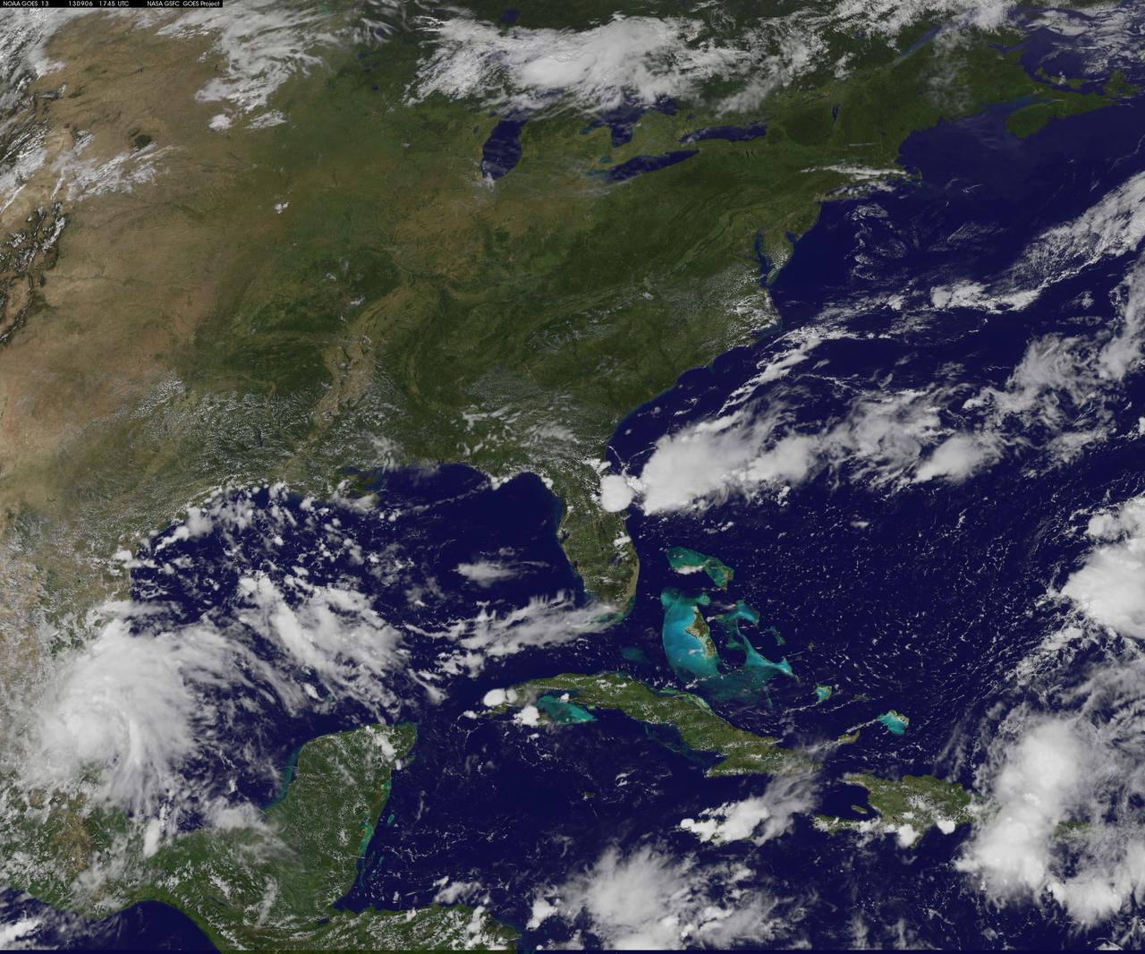
NASA's Wallops Flight Facility is located on Wallops Island, Va. and is the site of tonight's moon mission launch. Satellite imagery from NOAA's GOES-East satellite shows that high pressure remains in control over the Mid-Atlantic region, providing an almost cloud-free sky. This visible image of the Mid-Atlantic was captured by NOAA's GOES-East satellite at 17:31 UTC/1:31 p.m. EDT and shows some fair weather clouds over the Delmarva Peninsula (which consists of the state of Delaware and parts of Maryland and Virginia - which together is "Delmarva") and eastern Virginia and North Carolina. Most of the region is cloud-free, making for a perfect viewing night to see a launch. NOAA operates GOES-East and NASA's GOES Project at the NASA Goddard Space Flight Center in Greenbelt, Md. creates images and animations from the data. NOAA's National Weather Service forecast for tonight, Sept. 6 calls for winds blowing from the east to 11 mph, with clear skies and overnight temperatures dropping to the mid-fifties. The Lunar Atmosphere and Dust Environment Explorer, known as LADEE (pronounced like "laddie"), launches tonight at 11:27 p.m. EDT from Pad 0B at the Mid-Atlantic Regional Spaceport, at NASA Wallops and will be visible along the Mid-Atlantic with tonight's perfect weather conditions. LADEE is managed by NASA's Ames Research Center in Moffett Field, Calif. This will be the first launch to lunar orbit from NASA Wallops and the first launch of a Minotaur V rocket – the biggest ever launched from Wallops. NASA's LADEE is a robotic mission that will orbit the moon to gather detailed information about the lunar atmosphere, conditions near the surface and environmental influences on lunar dust. A thorough understanding of these characteristics will address long-standing unknowns, and help scientists understand other planetary bodies as well. LADEE also carries an important secondary payload, the Lunar Laser Communication Demonstration, or LLCD, which will help us open a new era of space communications by becoming NASA's first high rate, two-way, space laser system. Live coverage of the launch can be seen beginning at 9:30 p.m. EDT on NASA-TV at: <a href="http://www.nasa.gov/ntv" rel="nofollow">www.nasa.gov/ntv</a> For more information about LADEE, visit: <a href="http://www.nasa.gov/ladee" rel="nofollow">www.nasa.gov/ladee</a> <b><a href="http://www.nasa.gov/audience/formedia/features/MP_Photo_Guidelines.html" rel="nofollow">NASA image use policy.</a></b> <b><a href="http://www.nasa.gov/centers/goddard/home/index.html" rel="nofollow">NASA Goddard Space Flight Center</a></b> enables NASA’s mission through four scientific endeavors: Earth Science, Heliophysics, Solar System Exploration, and Astrophysics. Goddard plays a leading role in NASA’s accomplishments by contributing compelling scientific knowledge to advance the Agency’s mission. <b>Follow us on <a href="http://twitter.com/NASA_GoddardPix" rel="nofollow">Twitter</a></b> <b>Like us on <a href="http://www.facebook.com/pages/Greenbelt-MD/NASA-Goddard/395013845897?ref=tsd" rel="nofollow">Facebook</a></b> <b>Find us on <a href="http://instagram.com/nasagoddard?vm=grid" rel="nofollow">Instagram</a></b>
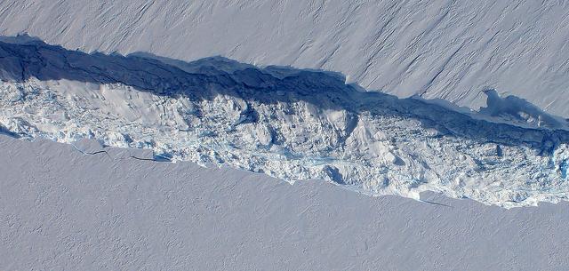
A close-up image of the crack spreading across the ice shelf of Pine Island Glacier shows the details of the boulder-like blocks of ice that fell into the rift when it split. For most of the 18-mile stretch of the crack that NASA’s DC-8 flew over on Oct. 26, 2011, it stretched about 240 feet wide, as roughly seen here. The deepest points ranged from about 165 to 190 feet, roughly equal to the top of the ice shelf down to sea level. Scientists expect the crack to propagate and the ice shelf to calve an iceberg of more than 300 square miles in the coming months. This image was captured by the Digital Mapping System (DMS) aboard the DC-8. Credit: NASA/DMS NASA's Operation IceBridge returns to a base camp of Punta Arenas, Chile for the third year of flights over Antarctica's changing sea ice, glaciers and ice sheets. NASA's DC-8, outfitted with seven remote-sensing instruments, and a Gulfstream 5 operated by the National Science Foundation and National Center for Atmospheric Research and outfitted with a high-altitude laser-ranging mapper, will fly from Chile over Antarctica in October and November. The mission is designed to record changes to Antarctica's ice sheets and give scientists insight into what is driving those changes. Follow the progress of the mission: Campaign News site: <a href="http://www.nasa.gov/mission_pages/icebridge/index.html" rel="nofollow">www.nasa.gov/mission_pages/icebridge/index.html</a> IceBridge blog: <a href="http://blogs.nasa.gov/cm/newui/blog/viewpostlist.jsp?blogname=icebridge" rel="nofollow">blogs.nasa.gov/cm/newui/blog/viewpostlist.jsp?blogname=ic...</a> Twitter: @nasa_ice <b><a href="http://www.nasa.gov/audience/formedia/features/MP_Photo_Guidelines.html" rel="nofollow">NASA image use policy.</a></b> <b><a href="http://www.nasa.gov/centers/goddard/home/index.html" rel="nofollow">NASA Goddard Space Flight Center</a></b> enables NASA’s mission through four scientific endeavors: Earth Science, Heliophysics, Solar System Exploration, and Astrophysics. Goddard plays a leading role in NASA’s accomplishments by contributing compelling scientific knowledge to advance the Agency’s mission. <b>Follow us on <a href="http://twitter.com/NASA_GoddardPix" rel="nofollow">Twitter</a></b> <b>Like us on <a href="http://www.facebook.com/pages/Greenbelt-MD/NASA-Goddard/395013845897?ref=tsd" rel="nofollow">Facebook</a></b> <b>Find us on <a href="http://instagrid.me/nasagoddard/?vm=grid" rel="nofollow">Instagram</a></b>
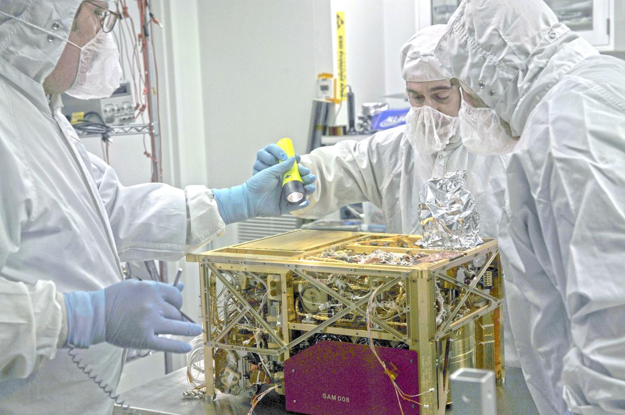
On Saturday, November 26, NASA is scheduled to launch the Mars Science Laboratory (MSL) mission featuring Curiosity, the largest and most advanced rover ever sent to the Red Planet. The Curiosity rover bristles with multiple cameras and instruments, including Goddard's Sample Analysis at Mars (SAM) instrument suite. By looking for evidence of water, carbon, and other important building blocks of life in the Martian soil and atmosphere, SAM will help discover whether Mars ever had the potential to support life. Curiosity will be delivered to Gale crater, a 96-mile-wide crater that contains a record of environmental changes in its sedimentary rock, in August 2012. ----- NASA image November 18, 2010 The Sample Analysis at Mars (SAM) instrument is considered one of the most complicated instruments ever to land on the surface of another planet. Equipped with a gas chromatograph, a quadruple mass spectrometer, and a tunable laser spectrometer, SAM will carry out the initial search for organic compounds when the Mars Science Laboratory (MSL) rover lands in 2012. Credit: NASA/GSFC/Ed Campion <b><a href="http://www.nasa.gov/audience/formedia/features/MP_Photo_Guidelines.html" rel="nofollow">NASA image use policy.</a></b> <b><a href="http://www.nasa.gov/centers/goddard/home/index.html" rel="nofollow">NASA Goddard Space Flight Center</a></b> enables NASA’s mission through four scientific endeavors: Earth Science, Heliophysics, Solar System Exploration, and Astrophysics. Goddard plays a leading role in NASA’s accomplishments by contributing compelling scientific knowledge to advance the Agency’s mission. <b>Follow us on <a href="http://twitter.com/NASA_GoddardPix" rel="nofollow">Twitter</a></b> <b>Like us on <a href="http://www.facebook.com/pages/Greenbelt-MD/NASA-Goddard/395013845897?ref=tsd" rel="nofollow">Facebook</a></b> <b>Find us on <a href="http://instagrid.me/nasagoddard/?vm=grid" rel="nofollow">Instagram</a></b>
<b>Share YOUR pink moon and/or partial lunar eclipse images in our Flickr Group here: <a href="http://www.flickr.com/groups/pinkmoon/">www.flickr.com/groups/pinkmoon/</a> </b> TimeThursday, April 25, 2013, 21:00 UT Phase 100.0% Diameter - 1962.6 arcseconds Distance - 365185 km (28.66 Earth diameters There is a special lunar name for every full moon in a year. The April 25 full moon is known as the “Full Pink Moon” because of the grass pink – or wild ground phlox – flower, which is one of the earliest widespread flowers to bloom in the spring. This month’s full moon is also known as the Sprouting Grass moon and the Egg moon. The first lunar eclipse of 2013 occurs at the Moon's ascending node in southern Virgo about 12° east of Spica (mv = +1.05). It is visible primarily from the Eastern Hemisphere. This event will not be visible in North America, it will only be visible from Eastern Europea, Africa, Asia, and Western Australia. April’s full moon, which is set to rise tonight, is known as a pink moon. And this year it coincides with the partial lunar eclipse. This NASA animation shows elevation measurements by the Lunar Orbiter Laser Altimeter (LOLA) aboard the Lunar Reconnaissance Orbiter (LRO). Credit: NASA/Goddard Space Flight Center Scientific Visualization Studio <b><a href="http://www.nasa.gov/audience/formedia/features/MP_Photo_Guidelines.html" rel="nofollow">NASA image use policy.</a></b> <b><a href="http://www.nasa.gov/centers/goddard/home/index.html" rel="nofollow">NASA Goddard Space Flight Center</a></b> enables NASA’s mission through four scientific endeavors: Earth Science, Heliophysics, Solar System Exploration, and Astrophysics. Goddard plays a leading role in NASA’s accomplishments by contributing compelling scientific knowledge to advance the Agency’s mission. <b>Follow us on <a href="http://twitter.com/NASA_GoddardPix" rel="nofollow">Twitter</a></b> <b>Like us on <a href="http://www.facebook.com/pages/Greenbelt-MD/NASA-Goddard/395013845897?ref=tsd" rel="nofollow">Facebook</a></b> <b>Find us on <a href="http://instagram.com/nasagoddard?vm=grid" rel="nofollow">Instagram</a></b>
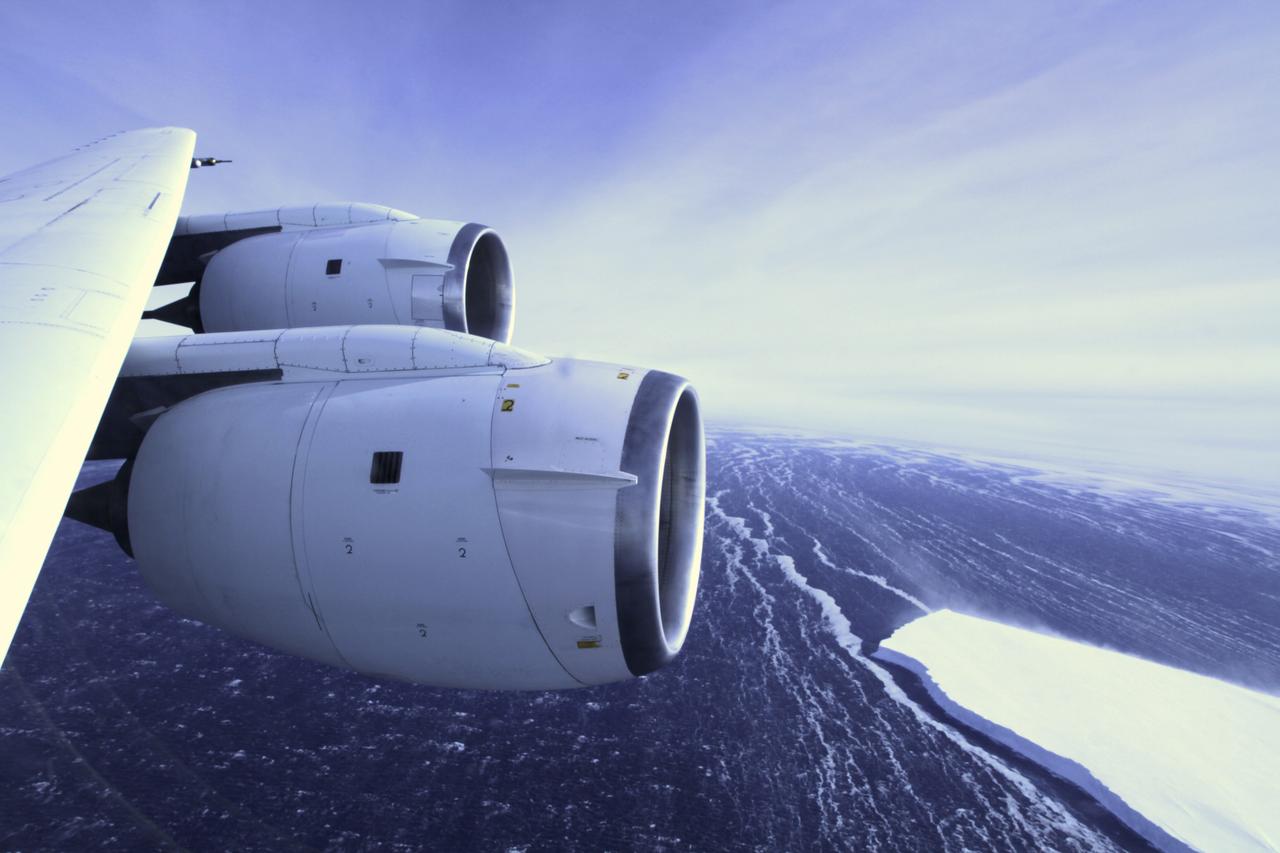
During a flight over the Pine Island Glacier ice shelf, the DC-8 banks over the Amundsen Sea and the clean edge of the ice shelf front. The shelf drops about 200 feet from its surface to sea level. This image was taken on Oct. 26, 2011. Credit: NASA/GSFC/Jefferson Beck NASA's Operation IceBridge returns to a base camp of Punta Arenas, Chile for the third year of flights over Antarctica's changing sea ice, glaciers and ice sheets. NASA's DC-8, outfitted with seven remote-sensing instruments, and a Gulfstream 5 operated by the National Science Foundation and National Center for Atmospheric Research and outfitted with a high-altitude laser-ranging mapper, will fly from Chile over Antarctica in October and November. The mission is designed to record changes to Antarctica's ice sheets and give scientists insight into what is driving those changes. Follow the progress of the mission: Campaign News site: <a href="http://www.nasa.gov/mission_pages/icebridge/index.html" rel="nofollow">www.nasa.gov/mission_pages/icebridge/index.html</a> IceBridge blog: <a href="http://blogs.nasa.gov/cm/newui/blog/viewpostlist.jsp?blogname=icebridge" rel="nofollow">blogs.nasa.gov/cm/newui/blog/viewpostlist.jsp?blogname=ic...</a> Twitter: @nasa_ice <b><a href="http://www.nasa.gov/audience/formedia/features/MP_Photo_Guidelines.html" rel="nofollow">NASA image use policy.</a></b> <b><a href="http://www.nasa.gov/centers/goddard/home/index.html" rel="nofollow">NASA Goddard Space Flight Center</a></b> enables NASA’s mission through four scientific endeavors: Earth Science, Heliophysics, Solar System Exploration, and Astrophysics. Goddard plays a leading role in NASA’s accomplishments by contributing compelling scientific knowledge to advance the Agency’s mission. <b>Follow us on <a href="http://twitter.com/NASA_GoddardPix" rel="nofollow">Twitter</a></b> <b>Like us on <a href="http://www.facebook.com/pages/Greenbelt-MD/NASA-Goddard/395013845897?ref=tsd" rel="nofollow">Facebook</a></b> <b>Find us on <a href="http://instagrid.me/nasagoddard/?vm=grid" rel="nofollow">Instagram</a></b>
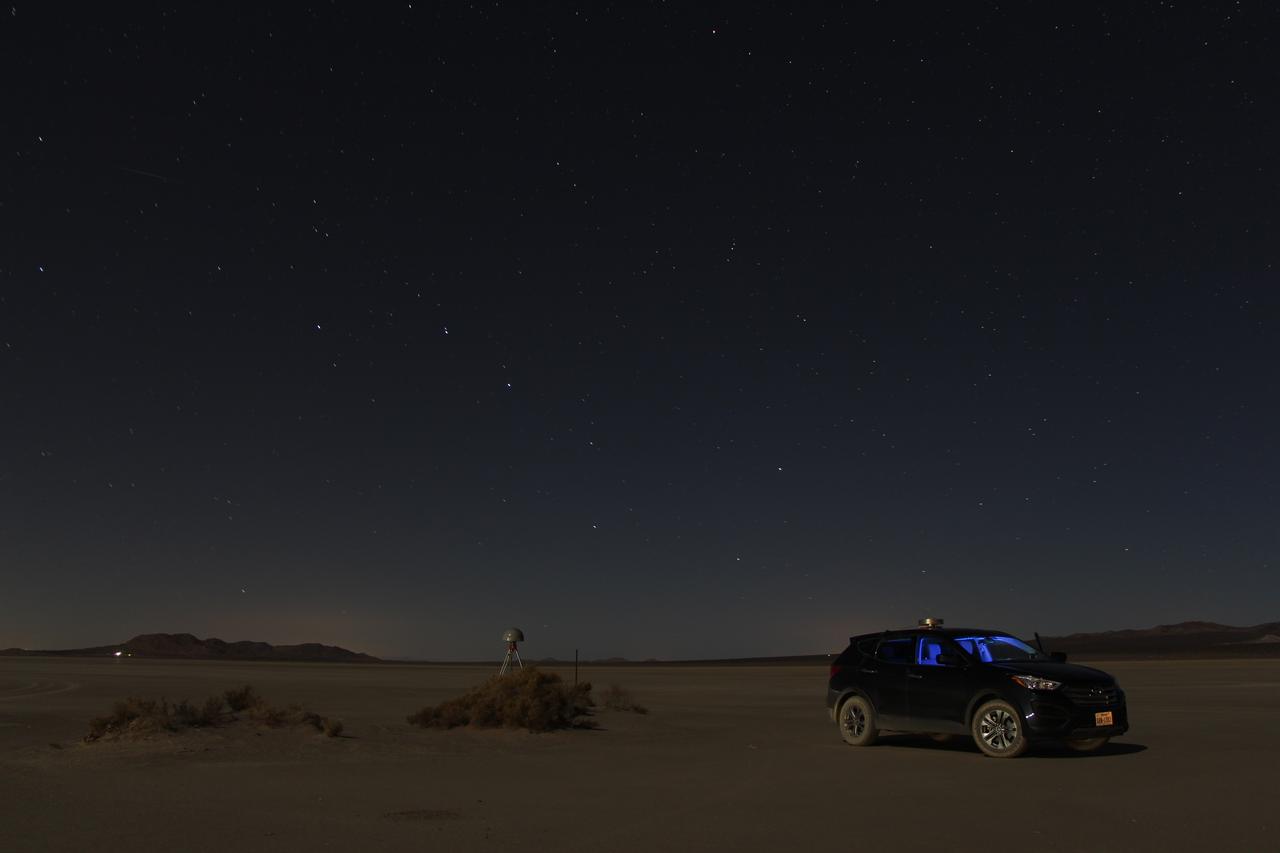
At first glance a dry lake bed in the southern California desert seems like the last place to prepare to study ice. But on Oct. 2, 2014, NASA’s Operation IceBridge carried out a ground-based GPS survey of the El Mirage lake bed in California’s Mojave Desert. Members of the IceBridge team are currently at NASA’s Armstrong Flight Research Center, preparing instruments aboard the DC-8 research aircraft for flights over Antarctica. Part of this preparation involves test flights over the desert, where researchers verify their instruments are working properly. El Mirage serves as a prime location for testing the mission’s laser altimeter, the Airborne Topographic Mapper, because the lake bed has a flat surface and reflects light similarly to snow and ice. This photo, taken shortly after the survey, shows the GPS-equipped survey vehicle and a stationary GPS station (left of the vehicle) on the lake bed with the constellation Ursa Major in the background. By driving the vehicle in parallel back and forth lines over a predefined area and comparing those GPS elevation readings with measurements from the stationary GPS, researchers are able to build an elevation map that will be used to precisely calibrate the laser altimeter for ice measurements. Credit: NASA/John Sonntag Operation IceBridge is scheduled to begin research flights over Antarctica on Oct. 15, 2014. The mission will be based out of Punta Arenas, Chile, until Nov. 23. For more information about IceBridge, visit: <a href="http://www.nasa.gov/icebridge" rel="nofollow">www.nasa.gov/icebridge</a> <b><a href="http://www.nasa.gov/audience/formedia/features/MP_Photo_Guidelines.html" rel="nofollow">NASA image use policy.</a></b> <b><a href="http://www.nasa.gov/centers/goddard/home/index.html" rel="nofollow">NASA Goddard Space Flight Center</a></b> enables NASA’s mission through four scientific endeavors: Earth Science, Heliophysics, Solar System Exploration, and Astrophysics. Goddard plays a leading role in NASA’s accomplishments by contributing compelling scientific knowledge to advance the Agency’s mission. <b>Follow us on <a href="http://twitter.com/NASAGoddardPix" rel="nofollow">Twitter</a></b> <b>Like us on <a href="http://www.facebook.com/pages/Greenbelt-MD/NASA-Goddard/395013845897?ref=tsd" rel="nofollow">Facebook</a></b> <b>Find us on <a href="http://instagram.com/nasagoddard?vm=grid" rel="nofollow">Instagram</a></b>
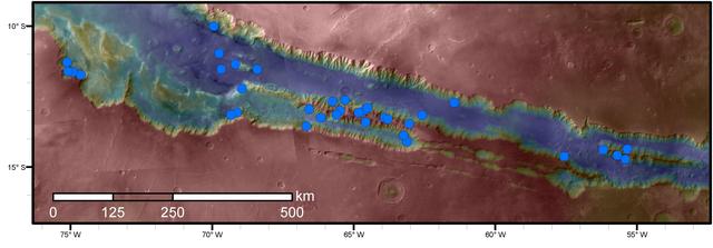
Blue dots on this map indicate sites of recurring slope lineae (RSL) in part of the Valles Marineris canyon network on Mars. RSL are seasonal dark streaks regarded as the strongest evidence for the possibility of liquid water on the surface of modern Mars. The area mapped here has the highest density of known RSL on the Red Planet. The RSL were identified by repeated observations of the sites using the High Resolution Imaging Science Experiment (HiRISE) camera on NASA's Mars Reconnaissance Orbiter. Map colors represent elevation, where red is high and blue is low. Valles Marineris is the largest canyon system in the solar system. The region shown here includes Melas Chasma and Coprates Chasma, in the central and eastern portions of Valles Marineris. The mapped area extends about 1,500 miles (2,400 kilometers) east to west and about 280 miles (450 kilometers) north to south, at latitudes from 9 to 17 degrees south of Mars' equator. The base map uses data from the Mars Orbiter Camera and Mars Orbiter Laser Altimeter of NASA's Mars Global Surveyor mission. RSL extend downslope during a warm season, fade in the colder part of the year, and repeat the process in a subsequent Martian year. A study of 41 RSL sites in this canyon area, published July 7, 2016, provides support for the notion that significant amounts of near-surface water can be found on modern Mars, though the work also indicates that puzzles remain unsolved in understanding how these seasonal features form. Each site includes anywhere from a few to more than 1,000 individual "lineae." http://photojournal.jpl.nasa.gov/catalog/PIA20756
The High-Spectral Resolution Lidar (HSRL) is a powerful laser used to characterize clouds and small particles in the atmosphere called aerosols. --- The <b><a href="http://naames.larc.nasa.gov/" rel="nofollow">North Atlantic Aerosols and Marine Ecosystems Study </a></b> (NAAMES) is a five year investigation to resolve key processes controlling ocean system function, their influences on atmospheric aerosols and clouds and their implications for climate. Michael Starobin joined the NAAMES field campaign on behalf of Earth Expeditions and NASA Goddard Space Flight Center’s Office of Communications. He presented stories about the important, multi-disciplinary research being conducted by the NAAMES team, with an eye towards future missions on the NASA drawing board. This is a NAAMES photo essay put together by Starobin, a collection of 49 photographs and captions. Photo and Caption Credit: Michael Starobin <b><a href="http://www.nasa.gov/audience/formedia/features/MP_Photo_Guidelines.html" rel="nofollow">NASA image use policy</a></b> <b><a href="http://www.nasa.gov/centers/goddard/home/index.html" rel="nofollow">NASA Goddard Space Flight Center</a></b> enables NASA’s mission through four scientific endeavors: Earth Science, Heliophysics, Solar System Exploration, and Astrophysics. Goddard plays a leading role in NASA’s accomplishments by contributing compelling scientific knowledge to advance the Agency’s mission. <b>Follow us on <a href="http://twitter.com/NASAGoddardPix" rel="nofollow">Twitter</a></b> <b>Like us on <a href="http://www.facebook.com/pages/Greenbelt-MD/NASA-Goddard/395013845897?ref=tsd" rel="nofollow">Facebook</a></b> <b>Find us on <a href="https://www.instagram.com/nasagoddard/?hl=en" rel="nofollow">Instagram</a></b>
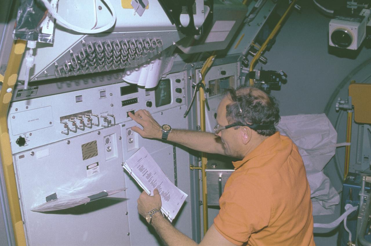
The IML-1 mission was the first in a series of Shuttle flights dedicated to fundamental materials and life sciences research with the international partners. The participating space agencies included: NASA, the 14-nation European Space Agency (ESA), the Canadian Space Agency (CSA), The French National Center of Space Studies (CNES), the German Space Agency and the German Aerospace Research Establishment (DAR/DLR), and the National Space Development Agency of Japan (NASDA). Dedicated to the study of life and materials sciences in microgravity, the IML missions explored how life forms adapt to weightlessness and investigated how materials behave when processed in space. Both life and materials sciences benefited from the extended periods of microgravity available inside the Spacelab science module in the cargo bay of the Space Shuttle Orbiter. This photograph shows Astronaut Norman Thagard performing the fluid experiment at the Fluid Experiment System (FES) facility inside the laboratory module. The FES facility had sophisticated optical systems for imaging fluid flows during materials processing, such as experiments to grow crystals from solution and solidify metal-modeling salts. A special laser diagnostic technique recorded the experiments, holograms were made for post-flight analysis, and video was used to view the samples in space and on the ground. Managed by the Marshall Space Flight Center (MSFC), the IML-1 mission was launched on January 22, 1992 aboard the Shuttle Orbiter Discovery (STS-42).
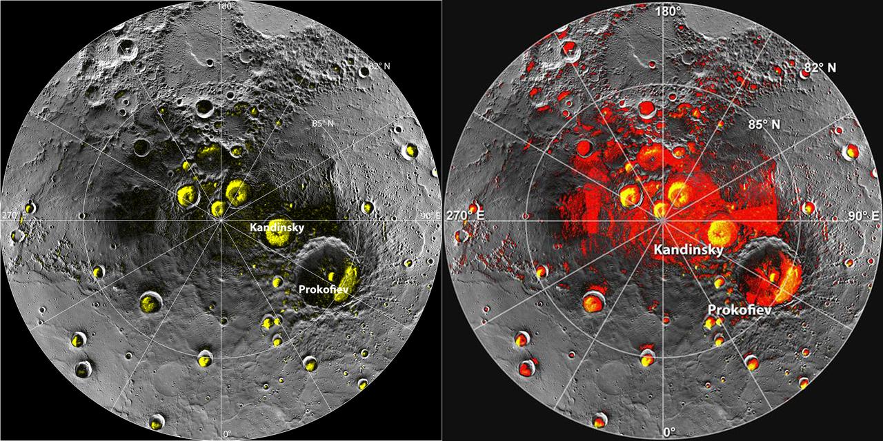
New observations by the MESSENGER spacecraft provide compelling support for the long-held hypothesis that Mercury harbors abundant water ice and other frozen volatile materials in its permanently shadowed polar craters. Three independent lines of evidence support this conclusion: the first measurements of excess hydrogen at Mercury's north pole with MESSENGER's Neutron Spectrometer, the first measurements of the reflectance of Mercury's polar deposits at near-infrared wavelengths with the Mercury Laser Altimeter (MLA), and the first detailed models of the surface and near-surface temperatures of Mercury's north polar regions that utilize the actual topography of Mercury's surface measured by the MLA. These findings are presented in three papers published online today in Science Express. Given its proximity to the Sun, Mercury would seem to be an unlikely place to find ice. But the tilt of Mercury's rotational axis is almost zero — less than one degree — so there are pockets at the planet's poles that never see sunlight. Scientists suggested decades ago that there might be water ice and other frozen volatiles trapped at Mercury's poles. The idea received a boost in 1991, when the Arecibo radio telescope in Puerto Rico detected unusually radar-bright patches at Mercury's poles, spots that reflected radio waves in the way one would expect if there were water ice. Many of these patches corresponded to the location of large impact craters mapped by the Mariner 10 spacecraft in the 1970s. But because Mariner saw less than 50 percent of the planet, planetary scientists lacked a complete diagram of the poles to compare with the images. MESSENGER's arrival at Mercury last year changed that. Images from the spacecraft's Mercury Dual Imaging System taken in 2011 and earlier this year confirmed that radar-bright features at Mercury's north and south poles are within shadowed regions on Mercury's surface, findings that are consistent with the water-ice hypothesis. To read more go to: <a href="http://1.usa.gov/TtNwM2" rel="nofollow">1.usa.gov/TtNwM2</a> Image Credit: NASA/Johns Hopkins University Applied Physics Laboratory/Carnegie Institution of Washington/National Astronomy and Ionosphere Center, Arecibo Observatory <b><a href="http://www.nasa.gov/audience/formedia/features/MP_Photo_Guidelines.html" rel="nofollow">NASA image use policy.</a></b> <b><a href="http://www.nasa.gov/centers/goddard/home/index.html" rel="nofollow">NASA Goddard Space Flight Center</a></b> enables NASA’s mission through four scientific endeavors: Earth Science, Heliophysics, Solar System Exploration, and Astrophysics. Goddard plays a leading role in NASA’s accomplishments by contributing compelling scientific knowledge to advance the Agency’s mission. <b>Follow us on <a href="http://twitter.com/NASA_GoddardPix" rel="nofollow">Twitter</a></b> <b>Like us on <a href="http://www.facebook.com/pages/Greenbelt-MD/NASA-Goddard/395013845897?ref=tsd" rel="nofollow">Facebook</a></b> <b>Find us on <a href="http://instagram.com/nasagoddard?vm=grid" rel="nofollow">Instagram</a></b>

In May 2014, two new studies concluded that a section of the land-based West Antarctic ice sheet had reached a point of inevitable collapse. Meanwhile, fresh observations from September 2014 showed sea ice around Antarctica had reached its greatest extent since the late 1970s. To better understand such dynamic and dramatic differences in the region's land and sea ice, researchers are travelling south to Antarctica this month for the sixth campaign of NASA’s Operation IceBridge. The airborne campaign, which also flies each year over Greenland, makes annual surveys of the ice with instrumented research aircraft. Instruments range from lasers that map the elevation of the ice surface, radars that "see" below it, and downward looking cameras to provide a natural-color perspective. The Digital Mapping System (DMS) camera acquired the above photo during the mission’s first science flight on October 16, 2009. At the time of the image, the DC-8 aircraft was flying at an altitude of 515 meters (1,700 feet) over heavily compacted first-year sea ice along the edge of the Amundsen Sea. Since that first flight, much has been gleaned from IceBridge data. For example, images from an IceBridge flight in October 2011 revealed a massive crack running about 29 kilometers (18 miles) across the floating tongue of Antarctica's Pine Island Glacier. The crack ultimately led to a 725-square-kilometer (280-square-mile) iceberg. In 2012, IceBridge data was a key part of a new map of Antarctica called Bedmap2. By combining surface elevation, ice thickness, and bedrock topography, Bedmap2 gives a clearer picture of Antarctica from the ice surface down to the land surface. Discoveries have been made in Greenland, too, including the identification of a 740-kilometer-long (460-mile-long) mega canyon below the ice sheet. Repeated measurements of land and sea ice from aircraft extend the record of observations once made by NASA’s Ice, Cloud, and Land Elevation Satellite, or ICESat, which stopped functioning in 2009. In addition to extending the ICESat record, IceBridge also sets the stage for ICESat-2, which is scheduled for launch in 2017. Credit: IceBridge DMS L0 Raw Imagery courtesy of the Digital Mapping System (DMS) team/NASA DAAC at the National Snow and Ice Data Center More info: <a href="http://earthobservatory.nasa.gov/IOTD/view.php?id=84549" rel="nofollow">earthobservatory.nasa.gov/IOTD/view.php?id=84549</a> <a href="http://earthobservatory.nasa.gov/IOTD/view.php?id=84549" rel="nofollow">earthobservatory.nasa.gov/IOTD/view.php?id=84549</a>
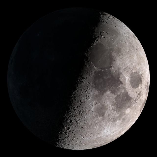
First quarter. Visible high in the southern sky in early evening. NASA's Lunar Reconnaissance Orbiter (LRO) has been in orbit around the Moon since the summer of 2009. Its laser altimeter (LOLA) and camera (LROC) are recording the rugged, airless lunar terrain in exceptional detail, making it possible to visualize the Moon with unprecedented fidelity. This is especially evident in the long shadows cast near the terminator, or day-night line. The pummeled, craggy landscape thrown into high relief at the terminator would be impossible to recreate in the computer without global terrain maps like those from LRO. To download, learn more about this visualization, or to see what the Moon will look like at any hour in 2015, visit <a href="http://svs.gsfc.nasa.gov/goto?4236" rel="nofollow">svs.gsfc.nasa.gov/goto?4236</a> <b><a href="http://www.nasa.gov/audience/formedia/features/MP_Photo_Guidelines.html" rel="nofollow">NASA image use policy.</a></b> <b><a href="http://www.nasa.gov/centers/goddard/home/index.html" rel="nofollow">NASA Goddard Space Flight Center</a></b> enables NASA’s mission through four scientific endeavors: Earth Science, Heliophysics, Solar System Exploration, and Astrophysics. Goddard plays a leading role in NASA’s accomplishments by contributing compelling scientific knowledge to advance the Agency’s mission. <b>Follow us on <a href="http://twitter.com/NASAGoddardPix" rel="nofollow">Twitter</a></b> <b>Like us on <a href="http://www.facebook.com/pages/Greenbelt-MD/NASA-Goddard/395013845897?ref=tsd" rel="nofollow">Facebook</a></b> <b>Find us on <a href="http://instagram.com/nasagoddard?vm=grid" rel="nofollow">Instagram</a></b>
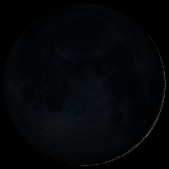
New Moon. By the modern definition, New Moon occurs when the Moon and Sun are at the same geocentric ecliptic longitude. The part of the Moon facing us is completely in shadow then. Pictured here is the traditional New Moon, the earliest visible waxing crescent, which signals the start of a new month in many lunar and lunisolar calendars. NASA's Lunar Reconnaissance Orbiter (LRO) has been in orbit around the Moon since the summer of 2009. Its laser altimeter (LOLA) and camera (LROC) are recording the rugged, airless lunar terrain in exceptional detail, making it possible to visualize the Moon with unprecedented fidelity. This is especially evident in the long shadows cast near the terminator, or day-night line. The pummeled, craggy landscape thrown into high relief at the terminator would be impossible to recreate in the computer without global terrain maps like those from LRO. To download, learn more about this visualization, or to see what the Moon will look like at any hour in 2015, visit <a href="http://svs.gsfc.nasa.gov/goto?4236" rel="nofollow">svs.gsfc.nasa.gov/goto?4236</a> <b><a href="http://www.nasa.gov/audience/formedia/features/MP_Photo_Guidelines.html" rel="nofollow">NASA image use policy.</a></b> <b><a href="http://www.nasa.gov/centers/goddard/home/index.html" rel="nofollow">NASA Goddard Space Flight Center</a></b> enables NASA’s mission through four scientific endeavors: Earth Science, Heliophysics, Solar System Exploration, and Astrophysics. Goddard plays a leading role in NASA’s accomplishments by contributing compelling scientific knowledge to advance the Agency’s mission. <b>Follow us on <a href="http://twitter.com/NASAGoddardPix" rel="nofollow">Twitter</a></b> <b>Like us on <a href="http://www.facebook.com/pages/Greenbelt-MD/NASA-Goddard/395013845897?ref=tsd" rel="nofollow">Facebook</a></b> <b>Find us on <a href="http://instagram.com/nasagoddard?vm=grid" rel="nofollow">Instagram</a></b>

This visualization shows the Moon's phase and libration at hourly intervals throughout 2015, as viewed from the northern hemisphere. Each frame represents one hour. Lunar Reconnaissance Orbiter (LRO) has been in orbit around the Moon since the summer of 2009. Its laser altimeter (LOLA) and camera (LROC) are recording the rugged, airless lunar terrain in exceptional detail, making it possible to visualize the Moon with unprecedented fidelity. This is especially evident in the long shadows cast near the terminator, or day-night line. The pummeled, craggy landscape thrown into high relief at the terminator would be impossible to recreate in the computer without global terrain maps like those from LRO. To download, learn more about this visualization, or to see what the Moon will look like at any hour in 2015, visit <a href="http://svs.gsfc.nasa.gov/goto?4236" rel="nofollow">svs.gsfc.nasa.gov/goto?4236</a> <b><a href="http://www.nasa.gov/audience/formedia/features/MP_Photo_Guidelines.html" rel="nofollow">NASA image use policy.</a></b> <b><a href="http://www.nasa.gov/centers/goddard/home/index.html" rel="nofollow">NASA Goddard Space Flight Center</a></b> enables NASA’s mission through four scientific endeavors: Earth Science, Heliophysics, Solar System Exploration, and Astrophysics. Goddard plays a leading role in NASA’s accomplishments by contributing compelling scientific knowledge to advance the Agency’s mission. <b>Follow us on <a href="http://twitter.com/NASAGoddardPix" rel="nofollow">Twitter</a></b> <b>Like us on <a href="http://www.facebook.com/pages/Greenbelt-MD/NASA-Goddard/395013845897?ref=tsd" rel="nofollow">Facebook</a></b> <b>Find us on <a href="http://instagram.com/nasagoddard?vm=grid" rel="nofollow">Instagram</a></b>
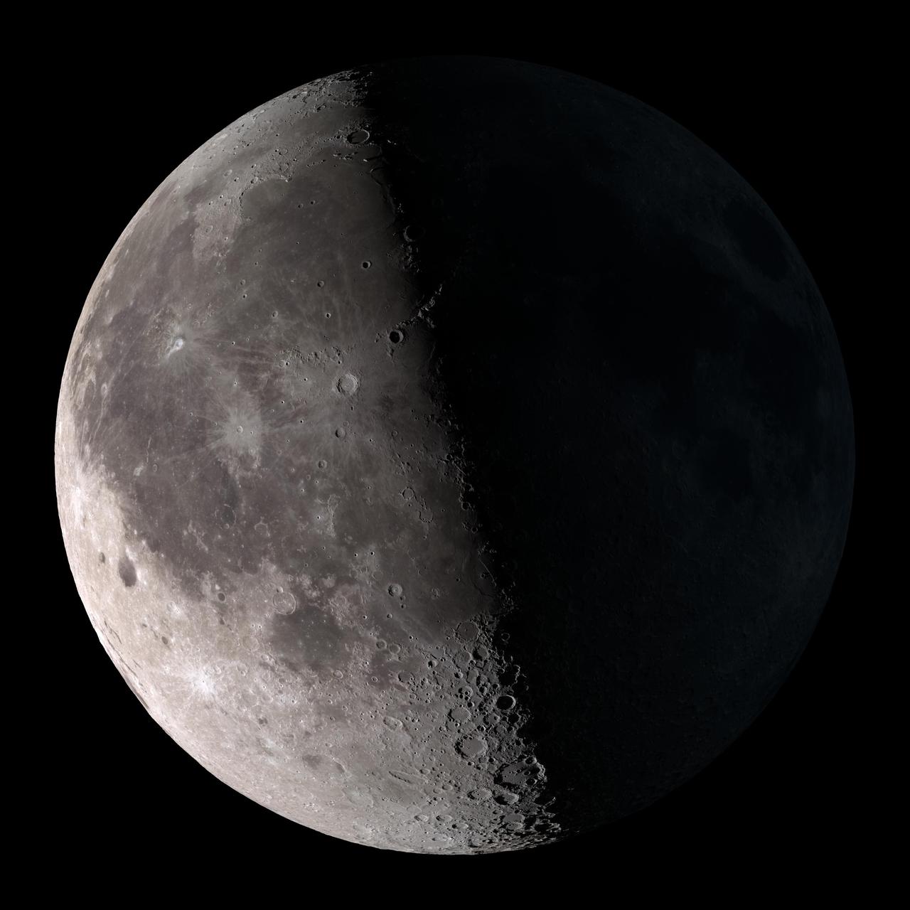
Third quarter. Rises around midnight, visible to the south after sunrise. NASA's Lunar Reconnaissance Orbiter (LRO) has been in orbit around the Moon since the summer of 2009. Its laser altimeter (LOLA) and camera (LROC) are recording the rugged, airless lunar terrain in exceptional detail, making it possible to visualize the Moon with unprecedented fidelity. This is especially evident in the long shadows cast near the terminator, or day-night line. The pummeled, craggy landscape thrown into high relief at the terminator would be impossible to recreate in the computer without global terrain maps like those from LRO. To download, learn more about this visualization, or to see what the Moon will look like at any hour in 2015, visit <a href="http://svs.gsfc.nasa.gov/goto?4236" rel="nofollow">svs.gsfc.nasa.gov/goto?4236</a> <b><a href="http://www.nasa.gov/audience/formedia/features/MP_Photo_Guidelines.html" rel="nofollow">NASA image use policy.</a></b> <b><a href="http://www.nasa.gov/centers/goddard/home/index.html" rel="nofollow">NASA Goddard Space Flight Center</a></b> enables NASA’s mission through four scientific endeavors: Earth Science, Heliophysics, Solar System Exploration, and Astrophysics. Goddard plays a leading role in NASA’s accomplishments by contributing compelling scientific knowledge to advance the Agency’s mission. <b>Follow us on <a href="http://twitter.com/NASAGoddardPix" rel="nofollow">Twitter</a></b> <b>Like us on <a href="http://www.facebook.com/pages/Greenbelt-MD/NASA-Goddard/395013845897?ref=tsd" rel="nofollow">Facebook</a></b> <b>Find us on <a href="http://instagram.com/nasagoddard?vm=grid" rel="nofollow">Instagram</a></b>

Caption: Mike Krainak (left) and Diego Janches recently won NASA follow-on funding to advance a spaceborne sodium lidar needed to probe Earth’s poorly understood mesosphere. Credits: NASA/W. Hrybyk More: A team of NASA scientists and engineers now believes it can leverage recent advances in a greenhouse-detecting instrument to build the world’s first space-based sodium lidar to study Earth’s poorly understood mesosphere. Scientist Diego Janches and laser experts Mike Krainak and Tony Yu, all of whom work at NASA’s Goddard Space Flight Center in Greenbelt, Maryland, are leading a research-and-development effort to further advance the sodium lidar, which the group plans to deploy on the International Space Station if it succeeds in proving its flightworthiness. Read more: <a href="https://go.nasa.gov/2rcGpSM" rel="nofollow">go.nasa.gov/2rcGpSM</a> <b><a href="http://www.nasa.gov/audience/formedia/features/MP_Photo_Guidelines.html" rel="nofollow">NASA image use policy.</a></b> <b><a href="http://www.nasa.gov/centers/goddard/home/index.html" rel="nofollow">NASA Goddard Space Flight Center</a></b> enables NASA’s mission through four scientific endeavors: Earth Science, Heliophysics, Solar System Exploration, and Astrophysics. Goddard plays a leading role in NASA’s accomplishments by contributing compelling scientific knowledge to advance the Agency’s mission. <b>Follow us on <a href="http://twitter.com/NASAGoddardPix" rel="nofollow">Twitter</a></b> <b>Like us on <a href="http://www.facebook.com/pages/Greenbelt-MD/NASA-Goddard/395013845897?ref=tsd" rel="nofollow">Facebook</a></b> <b>Find us on <a href="http://instagrid.me/nasagoddard/?vm=grid" rel="nofollow">Instagram</a></b>
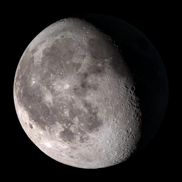
Waning gibbous. Rises after sunset, high in the sky after midnight, visible to the southwest after sunrise. NASA's Lunar Reconnaissance Orbiter (LRO) has been in orbit around the Moon since the summer of 2009. Its laser altimeter (LOLA) and camera (LROC) are recording the rugged, airless lunar terrain in exceptional detail, making it possible to visualize the Moon with unprecedented fidelity. This is especially evident in the long shadows cast near the terminator, or day-night line. The pummeled, craggy landscape thrown into high relief at the terminator would be impossible to recreate in the computer without global terrain maps like those from LRO. To download, learn more about this visualization, or to see what the Moon will look like at any hour in 2015, visit <a href="http://svs.gsfc.nasa.gov/goto?4236" rel="nofollow">svs.gsfc.nasa.gov/goto?4236</a> <b><a href="http://www.nasa.gov/audience/formedia/features/MP_Photo_Guidelines.html" rel="nofollow">NASA image use policy.</a></b> <b><a href="http://www.nasa.gov/centers/goddard/home/index.html" rel="nofollow">NASA Goddard Space Flight Center</a></b> enables NASA’s mission through four scientific endeavors: Earth Science, Heliophysics, Solar System Exploration, and Astrophysics. Goddard plays a leading role in NASA’s accomplishments by contributing compelling scientific knowledge to advance the Agency’s mission. <b>Follow us on <a href="http://twitter.com/NASAGoddardPix" rel="nofollow">Twitter</a></b> <b>Like us on <a href="http://www.facebook.com/pages/Greenbelt-MD/NASA-Goddard/395013845897?ref=tsd" rel="nofollow">Facebook</a></b> <b>Find us on <a href="http://instagram.com/nasagoddard?vm=grid" rel="nofollow">Instagram</a></b>
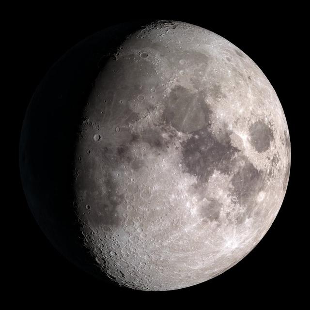
Waxing gibbous. Visible to the southeast in early evening, up for most of the night. NASA's Lunar Reconnaissance Orbiter (LRO) has been in orbit around the Moon since the summer of 2009. Its laser altimeter (LOLA) and camera (LROC) are recording the rugged, airless lunar terrain in exceptional detail, making it possible to visualize the Moon with unprecedented fidelity. This is especially evident in the long shadows cast near the terminator, or day-night line. The pummeled, craggy landscape thrown into high relief at the terminator would be impossible to recreate in the computer without global terrain maps like those from LRO. To download, learn more about this visualization, or to see what the Moon will look like at any hour in 2015, visit <a href="http://svs.gsfc.nasa.gov/goto?4236" rel="nofollow">svs.gsfc.nasa.gov/goto?4236</a> <b><a href="http://www.nasa.gov/audience/formedia/features/MP_Photo_Guidelines.html" rel="nofollow">NASA image use policy.</a></b> <b><a href="http://www.nasa.gov/centers/goddard/home/index.html" rel="nofollow">NASA Goddard Space Flight Center</a></b> enables NASA’s mission through four scientific endeavors: Earth Science, Heliophysics, Solar System Exploration, and Astrophysics. Goddard plays a leading role in NASA’s accomplishments by contributing compelling scientific knowledge to advance the Agency’s mission. <b>Follow us on <a href="http://twitter.com/NASAGoddardPix" rel="nofollow">Twitter</a></b> <b>Like us on <a href="http://www.facebook.com/pages/Greenbelt-MD/NASA-Goddard/395013845897?ref=tsd" rel="nofollow">Facebook</a></b> <b>Find us on <a href="http://instagram.com/nasagoddard?vm=grid" rel="nofollow">Instagram</a></b>
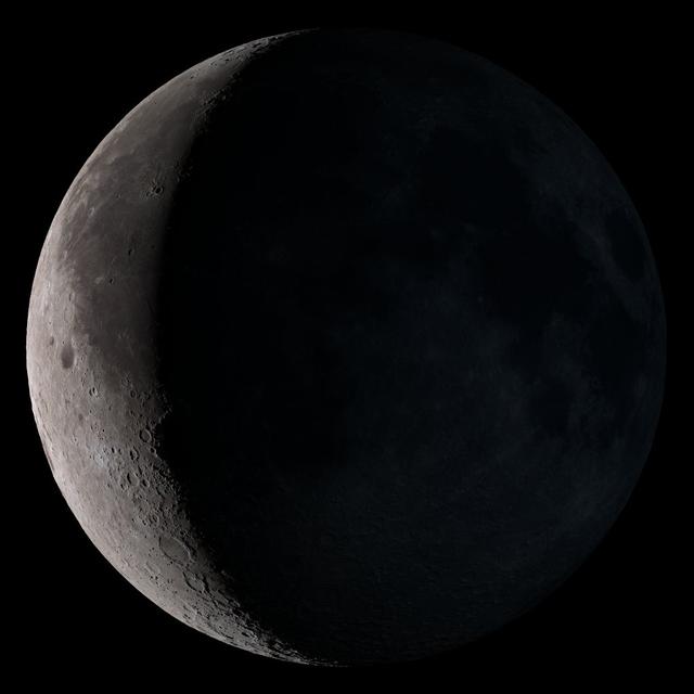
Waning crescent. Low to the east before sunrise. NASA's Lunar Reconnaissance Orbiter (LRO) has been in orbit around the Moon since the summer of 2009. Its laser altimeter (LOLA) and camera (LROC) are recording the rugged, airless lunar terrain in exceptional detail, making it possible to visualize the Moon with unprecedented fidelity. This is especially evident in the long shadows cast near the terminator, or day-night line. The pummeled, craggy landscape thrown into high relief at the terminator would be impossible to recreate in the computer without global terrain maps like those from LRO. To download, learn more about this visualization, or to see what the Moon will look like at any hour in 2015, visit <a href="http://svs.gsfc.nasa.gov/goto?4236" rel="nofollow">svs.gsfc.nasa.gov/goto?4236</a> <b><a href="http://www.nasa.gov/audience/formedia/features/MP_Photo_Guidelines.html" rel="nofollow">NASA image use policy.</a></b> <b><a href="http://www.nasa.gov/centers/goddard/home/index.html" rel="nofollow">NASA Goddard Space Flight Center</a></b> enables NASA’s mission through four scientific endeavors: Earth Science, Heliophysics, Solar System Exploration, and Astrophysics. Goddard plays a leading role in NASA’s accomplishments by contributing compelling scientific knowledge to advance the Agency’s mission. <b>Follow us on <a href="http://twitter.com/NASAGoddardPix" rel="nofollow">Twitter</a></b> <b>Like us on <a href="http://www.facebook.com/pages/Greenbelt-MD/NASA-Goddard/395013845897?ref=tsd" rel="nofollow">Facebook</a></b> <b>Find us on <a href="http://instagram.com/nasagoddard?vm=grid" rel="nofollow">Instagram</a></b>
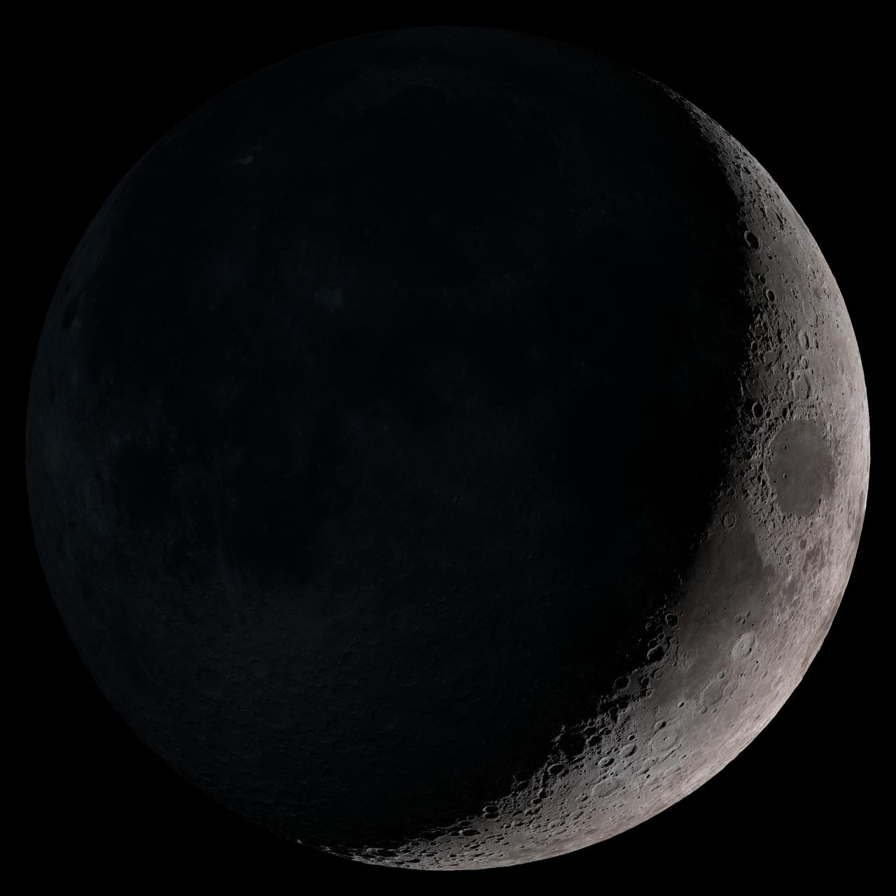
Waxing crescent. Visible toward the southwest in early evening. NASA's Lunar Reconnaissance Orbiter (LRO) has been in orbit around the Moon since the summer of 2009. Its laser altimeter (LOLA) and camera (LROC) are recording the rugged, airless lunar terrain in exceptional detail, making it possible to visualize the Moon with unprecedented fidelity. This is especially evident in the long shadows cast near the terminator, or day-night line. The pummeled, craggy landscape thrown into high relief at the terminator would be impossible to recreate in the computer without global terrain maps like those from LRO. To download, learn more about this visualization, or to see what the Moon will look like at any hour in 2015, visit <a href="http://svs.gsfc.nasa.gov/goto?4236" rel="nofollow">svs.gsfc.nasa.gov/goto?4236</a> <b><a href="http://www.nasa.gov/audience/formedia/features/MP_Photo_Guidelines.html" rel="nofollow">NASA image use policy.</a></b> <b><a href="http://www.nasa.gov/centers/goddard/home/index.html" rel="nofollow">NASA Goddard Space Flight Center</a></b> enables NASA’s mission through four scientific endeavors: Earth Science, Heliophysics, Solar System Exploration, and Astrophysics. Goddard plays a leading role in NASA’s accomplishments by contributing compelling scientific knowledge to advance the Agency’s mission. <b>Follow us on <a href="http://twitter.com/NASAGoddardPix" rel="nofollow">Twitter</a></b> <b>Like us on <a href="http://www.facebook.com/pages/Greenbelt-MD/NASA-Goddard/395013845897?ref=tsd" rel="nofollow">Facebook</a></b> <b>Find us on <a href="http://instagram.com/nasagoddard?vm=grid" rel="nofollow">Instagram</a></b>
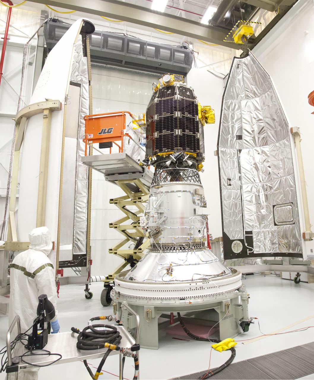
Engineers at NASA's Wallops Flight Facility in Virginia prepare to encapsulate the LADEE spacecraft into the fairing of the Minotaur V launch vehicle nose-cone. Credit: NASA/Wallops/Terry Zaperach ----- What is LADEE? The Lunar Atmosphere and Dust Environment Explorer (LADEE) is designed to study the Moon's thin exosphere and the lunar dust environment. An "exosphere" is an atmosphere that is so thin and tenuous that molecules don't collide with each other. Studying the Moon's exosphere will help scientists understand other planetary bodies with exospheres too, like Mercury and some of Jupiter's bigger moons. The orbiter will determine the density, composition and temporal and spatial variability of the Moon's exosphere to help us understand where the species in the exosphere come from and the role of the solar wind, lunar surface and interior, and meteoric infall as sources. The mission will also examine the density and temporal and spatial variability of dust particles that may get lofted into the atmosphere. The mission also will test several new technologies, including a modular spacecraft bus that may reduce the cost of future deep space missions and demonstrate two-way high rate laser communication for the first time from the Moon. LADEE now is ready to launch when the window opens on Sept. 6, 2013. Read more: <a href="http://www.nasa.gov/ladee" rel="nofollow">www.nasa.gov/ladee</a> <b><a href="http://www.nasa.gov/audience/formedia/features/MP_Photo_Guidelines.html" rel="nofollow">NASA image use policy.</a></b> <b><a href="http://www.nasa.gov/centers/goddard/home/index.html" rel="nofollow">NASA Goddard Space Flight Center</a></b> enables NASA’s mission through four scientific endeavors: Earth Science, Heliophysics, Solar System Exploration, and Astrophysics. Goddard plays a leading role in NASA’s accomplishments by contributing compelling scientific knowledge to advance the Agency’s mission. <b>Follow us on <a href="http://twitter.com/NASA_GoddardPix" rel="nofollow">Twitter</a></b> <b>Like us on <a href="http://www.facebook.com/pages/Greenbelt-MD/NASA-Goddard/395013845897?ref=tsd" rel="nofollow">Facebook</a></b> <b>Find us on <a href="http://instagram.com/nasagoddard?vm=grid" rel="nofollow">Instagram</a></b>
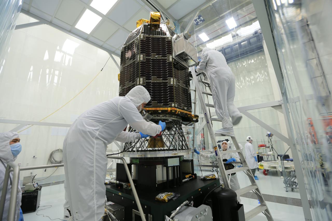
NASA's Lunar Atmosphere and Dust Environment Explorer (LADEE) spacecraft being prepared in the clean room at Wallops Flight Facility. Credit: NASA ----- What is LADEE? The Lunar Atmosphere and Dust Environment Explorer (LADEE) is designed to study the Moon's thin exosphere and the lunar dust environment. An "exosphere" is an atmosphere that is so thin and tenuous that molecules don't collide with each other. Studying the Moon's exosphere will help scientists understand other planetary bodies with exospheres too, like Mercury and some of Jupiter's bigger moons. The orbiter will determine the density, composition and temporal and spatial variability of the Moon's exosphere to help us understand where the species in the exosphere come from and the role of the solar wind, lunar surface and interior, and meteoric infall as sources. The mission will also examine the density and temporal and spatial variability of dust particles that may get lofted into the atmosphere. The mission also will test several new technologies, including a modular spacecraft bus that may reduce the cost of future deep space missions and demonstrate two-way high rate laser communication for the first time from the Moon. LADEE now is ready to launch when the window opens on Sept. 6, 2013. Read more: <a href="http://www.nasa.gov/ladee" rel="nofollow">www.nasa.gov/ladee</a> <b><a href="http://www.nasa.gov/audience/formedia/features/MP_Photo_Guidelines.html" rel="nofollow">NASA image use policy.</a></b> <b><a href="http://www.nasa.gov/centers/goddard/home/index.html" rel="nofollow">NASA Goddard Space Flight Center</a></b> enables NASA’s mission through four scientific endeavors: Earth Science, Heliophysics, Solar System Exploration, and Astrophysics. Goddard plays a leading role in NASA’s accomplishments by contributing compelling scientific knowledge to advance the Agency’s mission. <b>Follow us on <a href="http://twitter.com/NASA_GoddardPix" rel="nofollow">Twitter</a></b> <b>Like us on <a href="http://www.facebook.com/pages/Greenbelt-MD/NASA-Goddard/395013845897?ref=tsd" rel="nofollow">Facebook</a></b> <b>Find us on <a href="http://instagram.com/nasagoddard?vm=grid" rel="nofollow">Instagram</a></b>
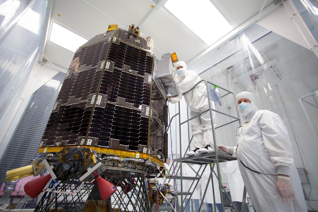
Engineers at NASA's Ames Research Center, Moffett Field, Calif., prepare NASA's Lunar Atmosphere and Dust Environment Explorer (LADEE) Observatory for acoustic environmental testing. Credit: NASA/Ames ----- What is LADEE? The Lunar Atmosphere and Dust Environment Explorer (LADEE) is designed to study the Moon's thin exosphere and the lunar dust environment. An "exosphere" is an atmosphere that is so thin and tenuous that molecules don't collide with each other. Studying the Moon's exosphere will help scientists understand other planetary bodies with exospheres too, like Mercury and some of Jupiter's bigger moons. The orbiter will determine the density, composition and temporal and spatial variability of the Moon's exosphere to help us understand where the species in the exosphere come from and the role of the solar wind, lunar surface and interior, and meteoric infall as sources. The mission will also examine the density and temporal and spatial variability of dust particles that may get lofted into the atmosphere. The mission also will test several new technologies, including a modular spacecraft bus that may reduce the cost of future deep space missions and demonstrate two-way high rate laser communication for the first time from the Moon. LADEE now is ready to launch when the window opens on Sept. 6, 2013. Read more: <a href="http://www.nasa.gov/ladee" rel="nofollow">www.nasa.gov/ladee</a> <b><a href="http://www.nasa.gov/audience/formedia/features/MP_Photo_Guidelines.html" rel="nofollow">NASA image use policy.</a></b> <b><a href="http://www.nasa.gov/centers/goddard/home/index.html" rel="nofollow">NASA Goddard Space Flight Center</a></b> enables NASA’s mission through four scientific endeavors: Earth Science, Heliophysics, Solar System Exploration, and Astrophysics. Goddard plays a leading role in NASA’s accomplishments by contributing compelling scientific knowledge to advance the Agency’s mission. <b>Follow us on <a href="http://twitter.com/NASA_GoddardPix" rel="nofollow">Twitter</a></b> <b>Like us on <a href="http://www.facebook.com/pages/Greenbelt-MD/NASA-Goddard/395013845897?ref=tsd" rel="nofollow">Facebook</a></b> <b>Find us on <a href="http://instagram.com/nasagoddard?vm=grid" rel="nofollow">Instagram</a></b>
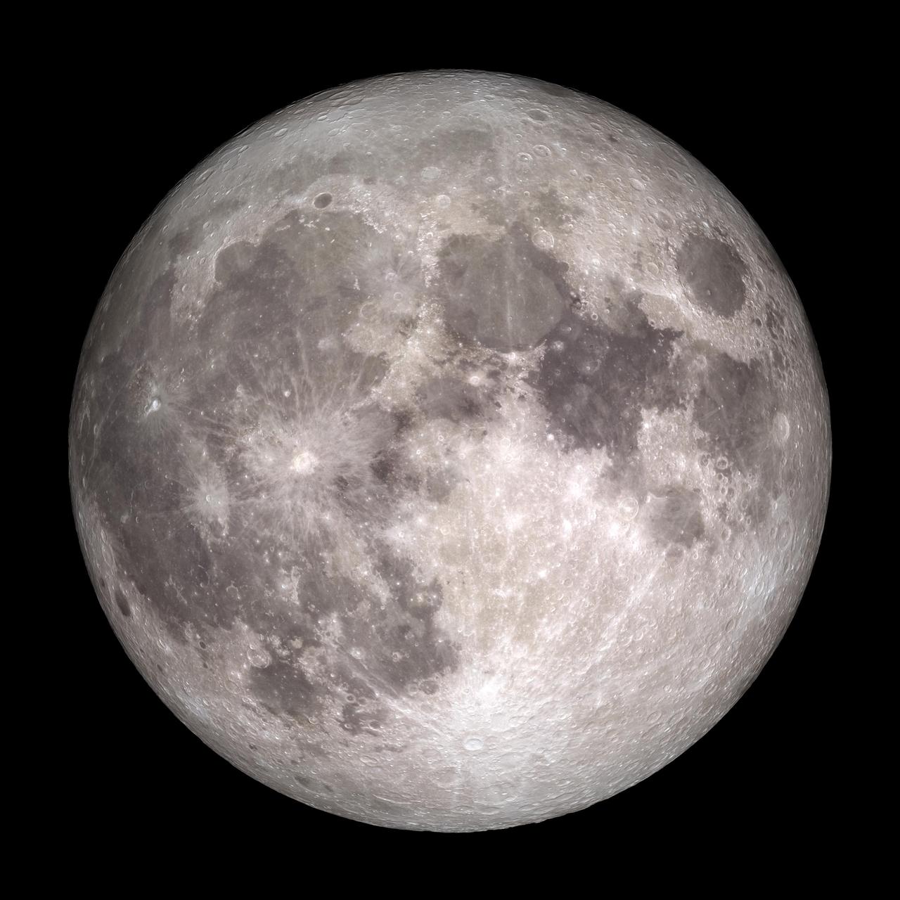
Full Moon. Rises at sunset, high in the sky around midnight. Visible all night. NASA's Lunar Reconnaissance Orbiter (LRO) has been in orbit around the Moon since the summer of 2009. Its laser altimeter (LOLA) and camera (LROC) are recording the rugged, airless lunar terrain in exceptional detail, making it possible to visualize the Moon with unprecedented fidelity. This is especially evident in the long shadows cast near the terminator, or day-night line. The pummeled, craggy landscape thrown into high relief at the terminator would be impossible to recreate in the computer without global terrain maps like those from LRO. To download, learn more about this visualization, or to see what the Moon will look like at any hour in 2015, visit <a href="http://svs.gsfc.nasa.gov/goto?4236" rel="nofollow">svs.gsfc.nasa.gov/goto?4236</a> <b><a href="http://www.nasa.gov/audience/formedia/features/MP_Photo_Guidelines.html" rel="nofollow">NASA image use policy.</a></b> <b><a href="http://www.nasa.gov/centers/goddard/home/index.html" rel="nofollow">NASA Goddard Space Flight Center</a></b> enables NASA’s mission through four scientific endeavors: Earth Science, Heliophysics, Solar System Exploration, and Astrophysics. Goddard plays a leading role in NASA’s accomplishments by contributing compelling scientific knowledge to advance the Agency’s mission. <b>Follow us on <a href="http://twitter.com/NASAGoddardPix" rel="nofollow">Twitter</a></b> <b>Like us on <a href="http://www.facebook.com/pages/Greenbelt-MD/NASA-Goddard/395013845897?ref=tsd" rel="nofollow">Facebook</a></b> <b>Find us on <a href="http://instagram.com/nasagoddard?vm=grid" rel="nofollow">Instagram</a></b>

This new Hubble image is centered on NGC 5793, a spiral galaxy over 150 million light-years away in the constellation of Libra. This galaxy has two particularly striking features: a beautiful dust lane and an intensely bright center — much brighter than that of our own galaxy, or indeed those of most spiral galaxies we observe. NGC 5793 is a Seyfert galaxy. These galaxies have incredibly luminous centers that are thought to be caused by hungry supermassive black holes — black holes that can be billions of times the size of the sun — that pull in and devour gas and dust from their surroundings. This galaxy is of great interest to astronomers for many reasons. For one, it appears to house objects known as masers. Whereas lasers emit visible light, masers emit microwave radiation. The term "masers" comes from the acronym Microwave Amplification by Stimulated Emission of Radiation. Maser emission is caused by particles that absorb energy from their surroundings and then re-emit this in the microwave part of the spectrum. Naturally occurring masers, like those observed in NGC 5793, can tell us a lot about their environment; we see these kinds of masers in areas where stars are forming. In NGC 5793 there are also intense mega-masers, which are thousands of times more luminous than the sun. Credit: NASA, ESA, and E. Perlman (Florida Institute of Technology) <b><a href="http://www.nasa.gov/audience/formedia/features/MP_Photo_Guidelines.html" rel="nofollow">NASA image use policy.</a></b> <b><a href="http://www.nasa.gov/centers/goddard/home/index.html" rel="nofollow">NASA Goddard Space Flight Center</a></b> enables NASA’s mission through four scientific endeavors: Earth Science, Heliophysics, Solar System Exploration, and Astrophysics. Goddard plays a leading role in NASA’s accomplishments by contributing compelling scientific knowledge to advance the Agency’s mission. <b>Follow us on <a href="http://twitter.com/NASAGoddardPix" rel="nofollow">Twitter</a></b> <b>Like us on <a href="http://www.facebook.com/pages/Greenbelt-MD/NASA-Goddard/395013845897?ref=tsd" rel="nofollow">Facebook</a></b> <b>Find us on <a href="http://instagram.com/nasagoddard?vm=grid" rel="nofollow">Instagram</a></b>
This galaxy has a far more exciting and futuristic classification than most — it hosts a megamaser. Megamasers are intensely bright, around 100 million times brighter than the masers found in galaxies like the Milky Way. The entire galaxy essentially acts as an astronomical laser that beams out microwave emission rather than visible light (hence the ‘m’ replacing the ‘l’). A megamaser is a process that involves some components within the galaxy (like gas) that is in the right physical condition to cause the amplification of light (in this case, microwaves). But there are other parts of the galaxy (like stars for example) that aren’t part of the maser process. This megamaser galaxy is named IRAS 16399-0937 and is located over 370 million light-years from Earth. This NASA/ESA Hubble Space Telescope image belies the galaxy’s energetic nature, instead painting it as a beautiful and serene cosmic rosebud. The image comprises observations captured across various wavelengths by two of Hubble’s instruments: the Advanced Camera for Surveys (ACS), and the Near Infrared Camera and Multi-Object Spectrometer (NICMOS). NICMOS’s superb sensitivity, resolution, and field of view gave astronomers the unique opportunity to observe the structure of IRAS 16399-0937 in detail. They found it hosts a double nucleus — the galaxy’s core is thought to be formed of two separate cores in the process of merging. The two components, named IRAS 16399N and IRAS 16399S for the northern and southern parts respectively, sit over 11,000 light-years apart. However, they are both buried deep within the same swirl of cosmic gas and dust and are interacting, giving the galaxy its peculiar structure. The nuclei are very different. IRAS 16399S appears to be a starburst region, where new stars are forming at an incredible rate. IRAS 16399N, however, is something known as a LINER nucleus (Low Ionization Nuclear Emission Region), which is a region whose emission mostly stems from weakly-ionized or neutral atoms of particular gases. The northern nucleus also hosts a black hole with some 100 million times the mass of the sun! Image credit: ESA/Hubble & NASA, Acknowledgement: Judy Schmidt (geckzilla) <b><a href="http://www.nasa.gov/audience/formedia/features/MP_Photo_Guidelines.html" rel="nofollow">NASA image use policy.</a></b> <b><a href="http://www.nasa.gov/centers/goddard/home/index.html" rel="nofollow">NASA Goddard Space Flight Center</a></b> enables NASA’s mission through four scientific endeavors: Earth Science, Heliophysics, Solar System Exploration, and Astrophysics. Goddard plays a leading role in NASA’s accomplishments by contributing compelling scientific knowledge to advance the Agency’s mission. <b>Follow us on <a href="http://twitter.com/NASAGoddardPix" rel="nofollow">Twitter</a></b> <b>Like us on <a href="http://www.facebook.com/pages/Greenbelt-MD/NASA-Goddard/395013845897?ref=tsd" rel="nofollow">Facebook</a></b> <b>Find us on <a href="http://instagrid.me/nasagoddard/?vm=grid" rel="nofollow">Instagram</a></b>
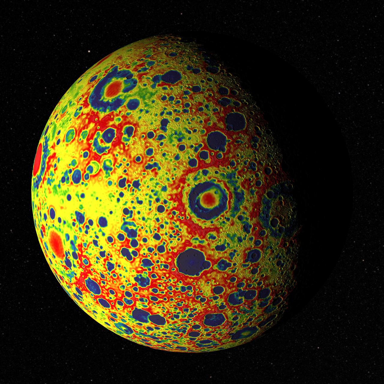
If the Moon were a perfectly smooth sphere of uniform density, the gravity map would be a single, featureless color, indicating that the force of gravity at a given elevation was the same everywhere. But like other rocky bodies in the solar system, including Earth, the Moon has both a bumpy surface and a lumpy interior. Spacecraft in orbit around the Moon experience slight variations in gravity caused by both of these irregularities. The free-air gravity map shows deviations from the mean, the gravity that a cueball Moon would have. The deviations are measured in milliGals, a unit of acceleration. On the map, dark purple is at the low end of the range, at around -400 mGals, and red is at the high end near +400 mGals. Yellow denotes the mean. These views show a part of the Moon's surface that's never visible from Earth. They are centered on lunar coordinates 29°N 142°E. The large, multi-ringed impact feature near the center is Mare Moscoviense. The crater Mendeleev is south of this. The digital elevation model for the terrain is from the Lunar Reconnaissance Orbiter laser altimeter (LOLA). Merely for plausibility, the sun angle and starry background are accurate for specific dates (December 21, 2012, 0:00 UT and January 8, 2013, 14:00 UT, respectively). To see or download more views go to: <a href="http://svs.gsfc.nasa.gov/goto?4041" rel="nofollow">svs.gsfc.nasa.gov/goto?4041</a> Credit: NASA's Goddard Goddard Space Flight Center Scientific Visualization Studio <b><a href="http://www.nasa.gov/audience/formedia/features/MP_Photo_Guidelines.html" rel="nofollow">NASA image use policy.</a></b> <b><a href="http://www.nasa.gov/centers/goddard/home/index.html" rel="nofollow">NASA Goddard Space Flight Center</a></b> enables NASA’s mission through four scientific endeavors: Earth Science, Heliophysics, Solar System Exploration, and Astrophysics. Goddard plays a leading role in NASA’s accomplishments by contributing compelling scientific knowledge to advance the Agency’s mission. <b>Follow us on <a href="http://twitter.com/NASA_GoddardPix" rel="nofollow">Twitter</a></b> <b>Like us on <a href="http://www.facebook.com/pages/Greenbelt-MD/NASA-Goddard/395013845897?ref=tsd" rel="nofollow">Facebook</a></b> <b>Find us on <a href="http://instagram.com/nasagoddard?vm=grid" rel="nofollow">Instagram</a></b>
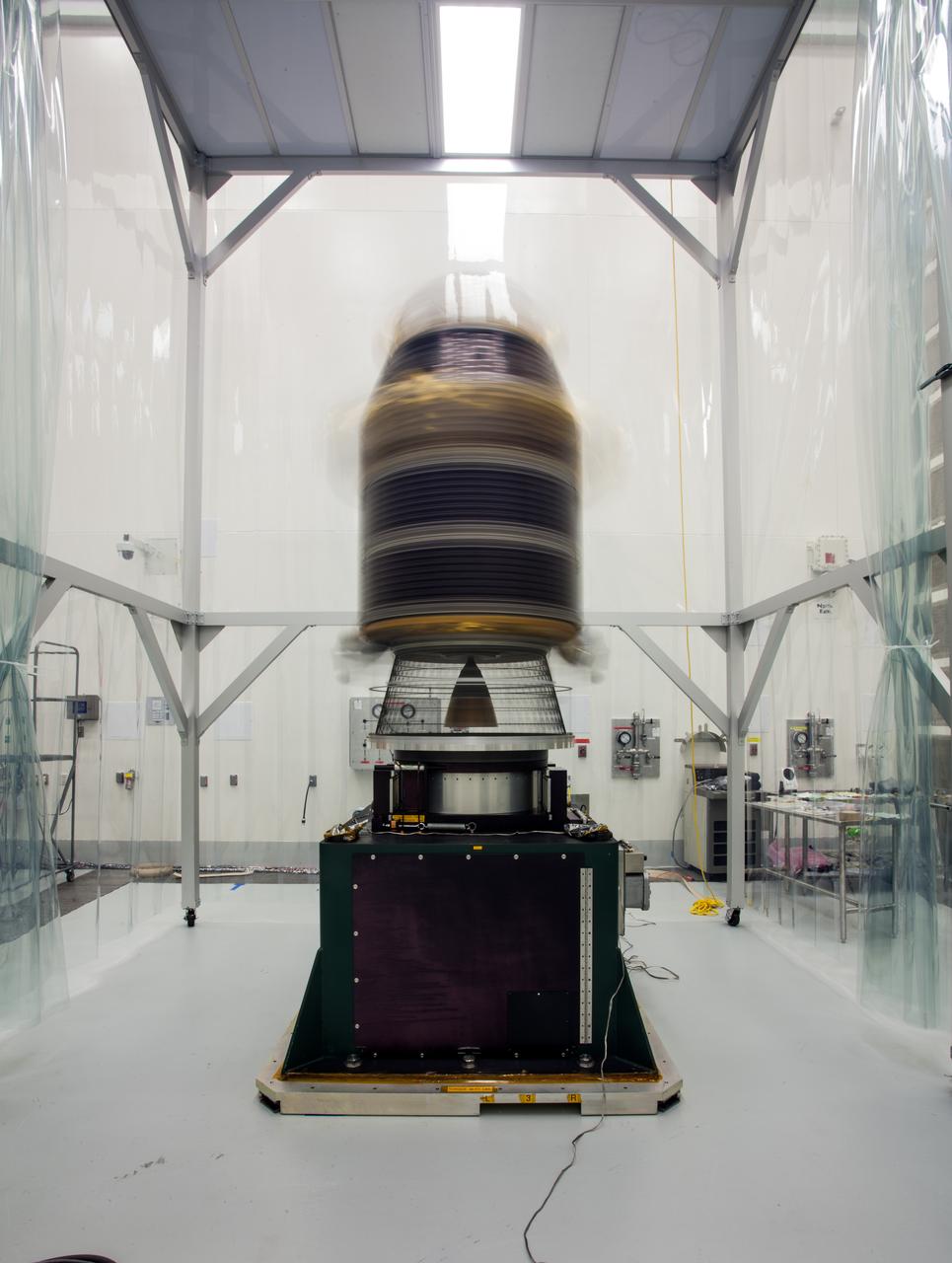
During preparations for NASA's Lunar Atmosphere and Dust Environment Explorer (LADEE) observatory launch on Sept. 6, 2013, the spacecraft went through final preparations and close-outs, which included checking alignment after its cross-country shipment, checking the propulsion system for leaks, inspecting and repairing solar panels, and final electrical tests. After these activities were completed, more challenging portions of the launch preparations began: spin testing and fueling. To make sure that the spacecraft is perfectly balanced for flight, engineers mounted it onto a spin table and rotate it at high speeds, approximately one revolution per second. The team measured any offsets during the spinning, and then added small weights to the spacecraft to balance it. Once the spacecraft was balanced dry, the team loaded the propulsion tanks with fuel, oxidizer, and pressurant. The spin testing was performed again "wet," or with fuel, in order to see if the balance changed with the full fuel tanks. Engineers from NASA's Ames Research Center in Moffett Field, Calif., have now successfully completed launch preparation activities for LADEE, which has been encapsulated into the nose-cone of the Minotaur V rocket at NASA's Wallops Flight Facility in Virginia. LADEE is ready to launch when the window opens on Friday. Image Credit: NASA ----- What is LADEE? The Lunar Atmosphere and Dust Environment Explorer (LADEE) is designed to study the Moon's thin exosphere and the lunar dust environment. An "exosphere" is an atmosphere that is so thin and tenuous that molecules don't collide with each other. Studying the Moon's exosphere will help scientists understand other planetary bodies with exospheres too, like Mercury and some of Jupiter's bigger moons. The orbiter will determine the density, composition and temporal and spatial variability of the Moon's exosphere to help us understand where the species in the exosphere come from and the role of the solar wind, lunar surface and interior, and meteoric infall as sources. The mission will also examine the density and temporal and spatial variability of dust particles that may get lofted into the atmosphere. The mission also will test several new technologies, including a modular spacecraft bus that may reduce the cost of future deep space missions and demonstrate two-way high rate laser communication for the first time from the Moon. LADEE now is ready to launch when the window opens on Sept. 6, 2013. Read more: <a href="http://www.nasa.gov/ladee" rel="nofollow">www.nasa.gov/ladee</a> <b><a href="http://www.nasa.gov/audience/formedia/features/MP_Photo_Guidelines.html" rel="nofollow">NASA image use policy.</a></b> <b><a href="http://www.nasa.gov/centers/goddard/home/index.html" rel="nofollow">NASA Goddard Space Flight Center</a></b> enables NASA’s mission through four scientific endeavors: Earth Science, Heliophysics, Solar System Exploration, and Astrophysics. Goddard plays a leading role in NASA’s accomplishments by contributing compelling scientific knowledge to advance the Agency’s mission. <b>Follow us on <a href="http://twitter.com/NASA_GoddardPix" rel="nofollow">Twitter</a></b> <b>Like us on <a href="http://www.facebook.com/pages/Greenbelt-MD/NASA-Goddard/395013845897?ref=tsd" rel="nofollow">Facebook</a></b> <b>Find us on <a href="http://instagram.com/nasagoddard?vm=grid" rel="nofollow">Instagram</a></b>

Wonders in the Antarctic Sea and Sky NASA aircraft and scientists have returned to the United States after a short ice-surveying mission to #Antarctica. Despite having only a week of flying time, the team returned with crucial scientific data and a trove of spectacular aerial photographs. The flights over Antarctica were part of Operation #IceBridge, a multi-year mission to monitor conditions in Antarctica and the Arctic until a new ice-monitoring satellite, ICESat-2, launches in 2016. ICESat-1 was decommissioned in 2009, and IceBridge aircraft have been flying ever since. Laser altimeter and radar data are the primary products of the mission, but IceBridge project scientist Michael Studinger almost always has his digital camera ready as well. On November 24, 2013, he took this photograph of a multi-layered lenticular cloud hovering near Mount Discovery, a volcano about 70 kilometers (44 miles) southwest of McMurdo. Lenticular #clouds are a type of wave cloud. They usually form when a layer of air near the surface encounters a topographic barrier, gets pushed upward, and flows over it as a series of atmospheric gravity waves. Lenticular clouds form at the crest of the waves, where the air is coolest and water vapor is most likely to condense into cloud droplets. The bulging sea ice in the foreground is a pressure ridge, which formed when separate ice floes collided and piled up on each other. Read more: <a href="http://1.usa.gov/18lXIQS" rel="nofollow">1.usa.gov/18lXIQS</a> Photograph courtesy of Michael Studinger. Caption by Adam Voiland of NASA's Earth Observatory. <b><a href="http://www.nasa.gov/audience/formedia/features/MP_Photo_Guidelines.html" rel="nofollow">NASA image use policy.</a></b> <b><a href="http://www.nasa.gov/centers/goddard/home/index.html" rel="nofollow">NASA Goddard Space Flight Center</a></b> enables NASA’s mission through four scientific endeavors: Earth Science, Heliophysics, Solar System Exploration, and Astrophysics. Goddard plays a leading role in NASA’s accomplishments by contributing compelling scientific knowledge to advance the Agency’s mission. <b>Follow us on <a href="http://twitter.com/NASA_GoddardPix" rel="nofollow">Twitter</a></b> <b>Like us on <a href="http://www.facebook.com/pages/Greenbelt-MD/NASA-Goddard/395013845897?ref=tsd" rel="nofollow">Facebook</a></b> <b>Find us on <a href="http://instagram.com/nasagoddard?vm=grid" rel="nofollow">Instagram</a></b>
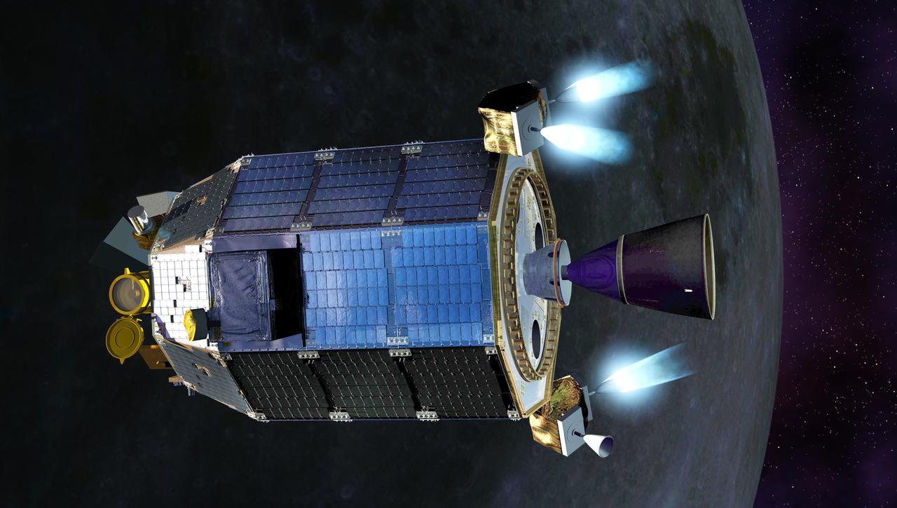
An artist's concept of NASA's Lunar Atmosphere and Dust Environment Explorer (LADEE) spacecraft firing its maneuvering thrusters in order to maintain a safe altitude as it orbits the moon. Credit: NASA Ames / Dana Berry ----- What is LADEE? The Lunar Atmosphere and Dust Environment Explorer (LADEE) is designed to study the Moon's thin exosphere and the lunar dust environment. An "exosphere" is an atmosphere that is so thin and tenuous that molecules don't collide with each other. Studying the Moon's exosphere will help scientists understand other planetary bodies with exospheres too, like Mercury and some of Jupiter's bigger moons. The orbiter will determine the density, composition and temporal and spatial variability of the Moon's exosphere to help us understand where the species in the exosphere come from and the role of the solar wind, lunar surface and interior, and meteoric infall as sources. The mission will also examine the density and temporal and spatial variability of dust particles that may get lofted into the atmosphere. The mission also will test several new technologies, including a modular spacecraft bus that may reduce the cost of future deep space missions and demonstrate two-way high rate laser communication for the first time from the Moon. LADEE now is ready to launch when the window opens on Sept. 6, 2013. Read more: <a href="http://www.nasa.gov/ladee" rel="nofollow">www.nasa.gov/ladee</a> <b><a href="http://www.nasa.gov/audience/formedia/features/MP_Photo_Guidelines.html" rel="nofollow">NASA image use policy.</a></b> <b><a href="http://www.nasa.gov/centers/goddard/home/index.html" rel="nofollow">NASA Goddard Space Flight Center</a></b> enables NASA’s mission through four scientific endeavors: Earth Science, Heliophysics, Solar System Exploration, and Astrophysics. Goddard plays a leading role in NASA’s accomplishments by contributing compelling scientific knowledge to advance the Agency’s mission. <b>Follow us on <a href="http://twitter.com/NASA_GoddardPix" rel="nofollow">Twitter</a></b> <b>Like us on <a href="http://www.facebook.com/pages/Greenbelt-MD/NASA-Goddard/395013845897?ref=tsd" rel="nofollow">Facebook</a></b> <b>Find us on <a href="http://instagram.com/nasagoddard?vm=grid" rel="nofollow">Instagram</a></b>
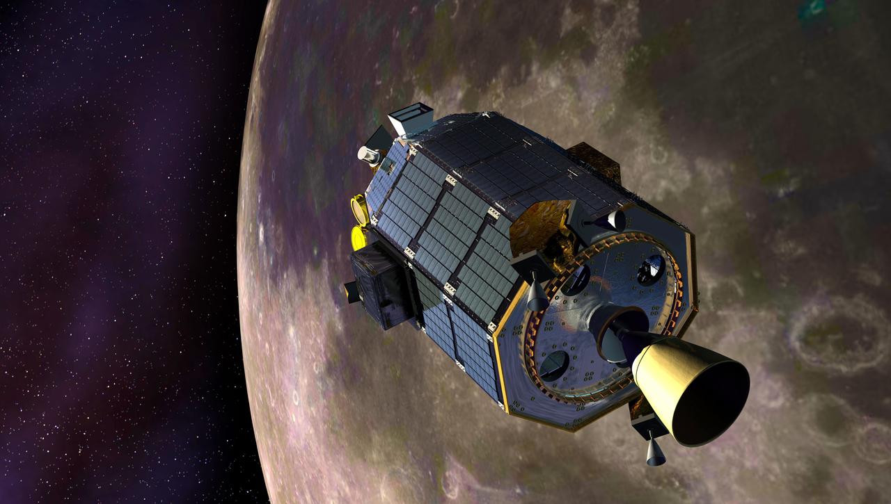
An artist's concept showing the Lunar Atmosphere and Dust Environment Explorer (LADEE) spacecraft is seen orbiting the moon as it prepares to fire its maneuvering thrusters to maintain a safe orbital altitude. Credit: NASA Ames / Dana Berry ----- What is LADEE? The Lunar Atmosphere and Dust Environment Explorer (LADEE) is designed to study the Moon's thin exosphere and the lunar dust environment. An "exosphere" is an atmosphere that is so thin and tenuous that molecules don't collide with each other. Studying the Moon's exosphere will help scientists understand other planetary bodies with exospheres too, like Mercury and some of Jupiter's bigger moons. The orbiter will determine the density, composition and temporal and spatial variability of the Moon's exosphere to help us understand where the species in the exosphere come from and the role of the solar wind, lunar surface and interior, and meteoric infall as sources. The mission will also examine the density and temporal and spatial variability of dust particles that may get lofted into the atmosphere. The mission also will test several new technologies, including a modular spacecraft bus that may reduce the cost of future deep space missions and demonstrate two-way high rate laser communication for the first time from the Moon. LADEE now is ready to launch when the window opens on Sept. 6, 2013. Read more: <a href="http://www.nasa.gov/ladee" rel="nofollow">www.nasa.gov/ladee </a> <b><a href="http://www.nasa.gov/audience/formedia/features/MP_Photo_Guidelines.html" rel="nofollow">NASA image use policy.</a></b> <b><a href="http://www.nasa.gov/centers/goddard/home/index.html" rel="nofollow">NASA Goddard Space Flight Center</a></b> enables NASA’s mission through four scientific endeavors: Earth Science, Heliophysics, Solar System Exploration, and Astrophysics. Goddard plays a leading role in NASA’s accomplishments by contributing compelling scientific knowledge to advance the Agency’s mission. <b>Follow us on <a href="http://twitter.com/NASA_GoddardPix" rel="nofollow">Twitter</a></b> <b>Like us on <a href="http://www.facebook.com/pages/Greenbelt-MD/NASA-Goddard/395013845897?ref=tsd" rel="nofollow">Facebook</a></b> <b>Find us on <a href="http://instagram.com/nasagoddard?vm=grid" rel="nofollow">Instagram</a></b>

Full Moon. Rises at sunset, high in the sky around midnight. Visible all night. This marks the first time that accurate shadows at this level of detail are possible in such a computer simulation. The shadows are based on the global elevation map being developed from measurements by the Lunar Orbiter Laser Altimeter (LOLA) aboard the Lunar Reconnaissance Orbiter (LRO). LOLA has already taken more than 10 times as many elevation measurements as all previous missions combined. The Moon always keeps the same face to us, but not exactly the same face. Because of the tilt and shape of its orbit, we see the Moon from slightly different angles over the course of a month. When a month is compressed into 12 seconds, as it is in this animation, our changing view of the Moon makes it look like it's wobbling. This wobble is called libration. The word comes from the Latin for "balance scale" (as does the name of the zodiac constellation Libra) and refers to the way such a scale tips up and down on alternating sides. The sub-Earth point gives the amount of libration in longitude and latitude. The sub-Earth point is also the apparent center of the Moon's disk and the location on the Moon where the Earth is directly overhead. The Moon is subject to other motions as well. It appears to roll back and forth around the sub-Earth point. The roll angle is given by the position angle of the axis, which is the angle of the Moon's north pole relative to celestial north. The Moon also approaches and recedes from us, appearing to grow and shrink. The two extremes, called perigee (near) and apogee (far), differ by more than 10%. The most noticed monthly variation in the Moon's appearance is the cycle of phases, caused by the changing angle of the Sun as the Moon orbits the Earth. The cycle begins with the waxing (growing) crescent Moon visible in the west just after sunset. By first quarter, the Moon is high in the sky at sunset and sets around midnight. The full Moon rises at sunset and is high in the sky at midnight. The third quarter Moon is often surprisingly conspicuous in the daylit western sky long after sunrise. Celestial north is up in these images, corresponding to the view from the northern hemisphere. The descriptions of the print resolution stills also assume a northern hemisphere orientation. To adjust for southern hemisphere views, rotate the images 180 degrees, and substitute "north" for "south" in the descriptions. Credit: <a href="http://svs.gsfc.nasa.gov/index.html" rel="nofollow">NASA/Goddard Space Flight Center Scientific Visualization Studio</a> <b><a href="http://www.nasa.gov/centers/goddard/home/index.html" rel="nofollow">NASA Goddard Space Flight Center</a></b> enables NASA’s mission through four scientific endeavors: Earth Science, Heliophysics, Solar System Exploration, and Astrophysics. Goddard plays a leading role in NASA’s accomplishments by contributing compelling scientific knowledge to advance the Agency’s mission. <b>Follow us on <a href="http://twitter.com/NASA_GoddardPix" rel="nofollow">Twitter</a></b> <b>Join us on <a href="http://www.facebook.com/pages/Greenbelt-MD/NASA-Goddard/395013845897?ref=tsd" rel="nofollow">Facebook</a></b> <b>Find us on <a href="http://web.stagram.com/n/nasagoddard/?vm=grid" rel="nofollow">Instagram</a></b>
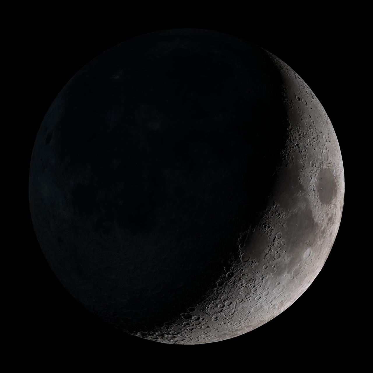
Waxing crescent. Visible toward the southwest in early evening. This marks the first time that accurate shadows at this level of detail are possible in such a computer simulation. The shadows are based on the global elevation map being developed from measurements by the Lunar Orbiter Laser Altimeter (LOLA) aboard the Lunar Reconnaissance Orbiter (LRO). LOLA has already taken more than 10 times as many elevation measurements as all previous missions combined. The Moon always keeps the same face to us, but not exactly the same face. Because of the tilt and shape of its orbit, we see the Moon from slightly different angles over the course of a month. When a month is compressed into 12 seconds, as it is in this animation, our changing view of the Moon makes it look like it's wobbling. This wobble is called libration. The word comes from the Latin for "balance scale" (as does the name of the zodiac constellation Libra) and refers to the way such a scale tips up and down on alternating sides. The sub-Earth point gives the amount of libration in longitude and latitude. The sub-Earth point is also the apparent center of the Moon's disk and the location on the Moon where the Earth is directly overhead. The Moon is subject to other motions as well. It appears to roll back and forth around the sub-Earth point. The roll angle is given by the position angle of the axis, which is the angle of the Moon's north pole relative to celestial north. The Moon also approaches and recedes from us, appearing to grow and shrink. The two extremes, called perigee (near) and apogee (far), differ by more than 10%. The most noticed monthly variation in the Moon's appearance is the cycle of phases, caused by the changing angle of the Sun as the Moon orbits the Earth. The cycle begins with the waxing (growing) crescent Moon visible in the west just after sunset. By first quarter, the Moon is high in the sky at sunset and sets around midnight. The full Moon rises at sunset and is high in the sky at midnight. The third quarter Moon is often surprisingly conspicuous in the daylit western sky long after sunrise. Celestial north is up in these images, corresponding to the view from the northern hemisphere. The descriptions of the print resolution stills also assume a northern hemisphere orientation. To adjust for southern hemisphere views, rotate the images 180 degrees, and substitute "north" for "south" in the descriptions. Credit: <a href="http://svs.gsfc.nasa.gov/index.html" rel="nofollow">NASA/Goddard Space Flight Center Scientific Visualization Studio</a> <b><a href="http://www.nasa.gov/centers/goddard/home/index.html" rel="nofollow">NASA Goddard Space Flight Center</a></b> enables NASA’s mission through four scientific endeavors: Earth Science, Heliophysics, Solar System Exploration, and Astrophysics. Goddard plays a leading role in NASA’s accomplishments by contributing compelling scientific knowledge to advance the Agency’s mission. <b>Follow us on <a href="http://twitter.com/NASA_GoddardPix" rel="nofollow">Twitter</a></b> <b>Join us on <a href="http://www.facebook.com/pages/Greenbelt-MD/NASA-Goddard/395013845897?ref=tsd" rel="nofollow">Facebook</a></b> <b>Find us on <a href="http://web.stagram.com/n/nasagoddard/?vm=grid" rel="nofollow">Instagram</a></b>
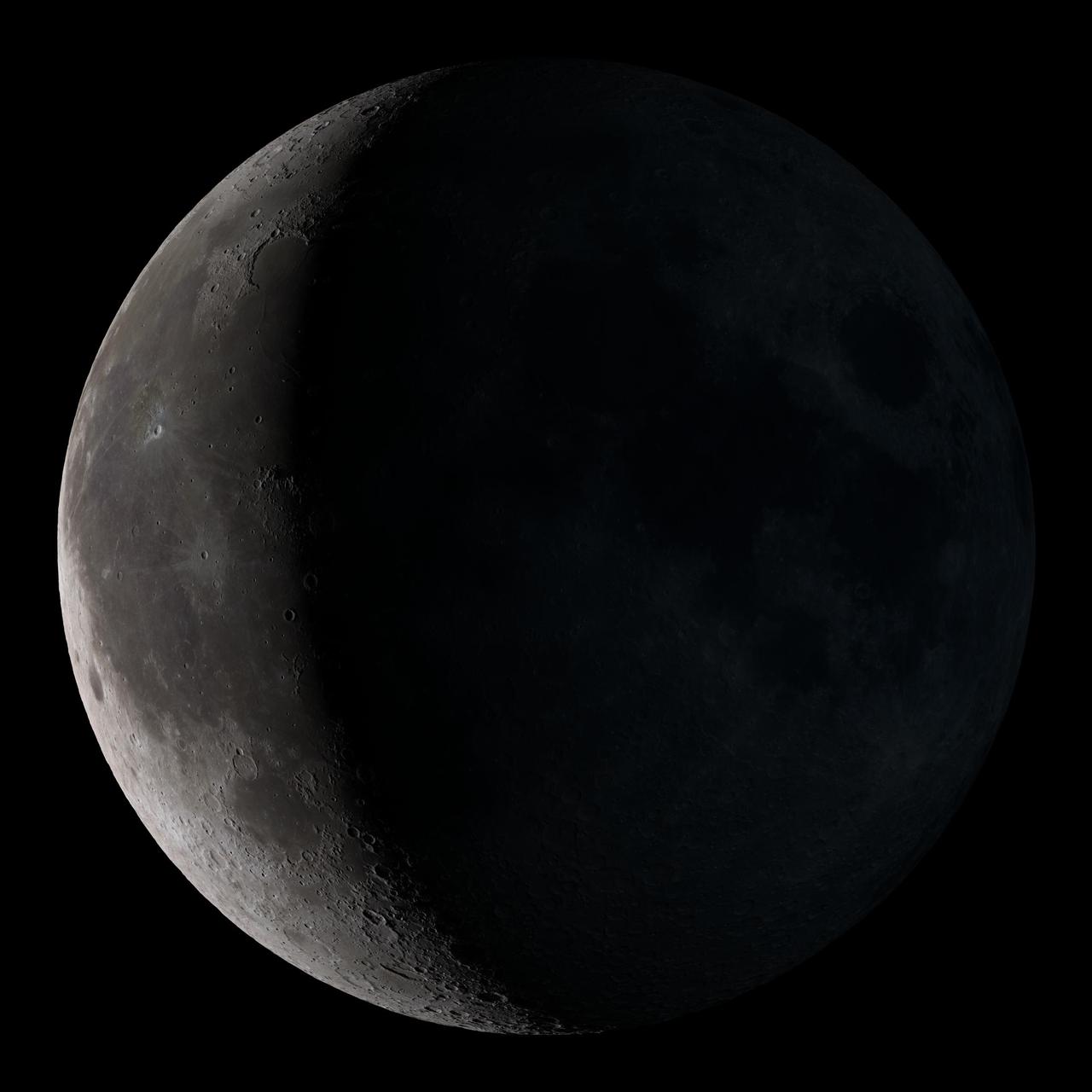
Waning crescent. Low to the east before sunrise. This marks the first time that accurate shadows at this level of detail are possible in such a computer simulation. The shadows are based on the global elevation map being developed from measurements by the Lunar Orbiter Laser Altimeter (LOLA) aboard the Lunar Reconnaissance Orbiter (LRO). LOLA has already taken more than 10 times as many elevation measurements as all previous missions combined. The Moon always keeps the same face to us, but not exactly the same face. Because of the tilt and shape of its orbit, we see the Moon from slightly different angles over the course of a month. When a month is compressed into 12 seconds, as it is in this animation, our changing view of the Moon makes it look like it's wobbling. This wobble is called libration. The word comes from the Latin for "balance scale" (as does the name of the zodiac constellation Libra) and refers to the way such a scale tips up and down on alternating sides. The sub-Earth point gives the amount of libration in longitude and latitude. The sub-Earth point is also the apparent center of the Moon's disk and the location on the Moon where the Earth is directly overhead. The Moon is subject to other motions as well. It appears to roll back and forth around the sub-Earth point. The roll angle is given by the position angle of the axis, which is the angle of the Moon's north pole relative to celestial north. The Moon also approaches and recedes from us, appearing to grow and shrink. The two extremes, called perigee (near) and apogee (far), differ by more than 10%. The most noticed monthly variation in the Moon's appearance is the cycle of phases, caused by the changing angle of the Sun as the Moon orbits the Earth. The cycle begins with the waxing (growing) crescent Moon visible in the west just after sunset. By first quarter, the Moon is high in the sky at sunset and sets around midnight. The full Moon rises at sunset and is high in the sky at midnight. The third quarter Moon is often surprisingly conspicuous in the daylit western sky long after sunrise. Celestial north is up in these images, corresponding to the view from the northern hemisphere. The descriptions of the print resolution stills also assume a northern hemisphere orientation. To adjust for southern hemisphere views, rotate the images 180 degrees, and substitute "north" for "south" in the descriptions. Credit: <a href="http://svs.gsfc.nasa.gov/index.html" rel="nofollow">NASA/Goddard Space Flight Center Scientific Visualization Studio</a> <b><a href="http://www.nasa.gov/centers/goddard/home/index.html" rel="nofollow">NASA Goddard Space Flight Center</a></b> enables NASA’s mission through four scientific endeavors: Earth Science, Heliophysics, Solar System Exploration, and Astrophysics. Goddard plays a leading role in NASA’s accomplishments by contributing compelling scientific knowledge to advance the Agency’s mission. <b>Follow us on <a href="http://twitter.com/NASA_GoddardPix" rel="nofollow">Twitter</a></b> <b>Join us on <a href="http://www.facebook.com/pages/Greenbelt-MD/NASA-Goddard/395013845897?ref=tsd" rel="nofollow">Facebook</a></b> <b>Find us on <a href="http://web.stagram.com/n/nasagoddard/?vm=grid" rel="nofollow">Instagram</a></b>
New Moon. By the modern definition, New Moon occurs when the Moon and Sun are at the same geocentric ecliptic longitude. The part of the Moon facing us is completely in shadow then. Pictured here is the traditional New Moon, the earliest visible waxing crescent, which signals the start of a new month in many lunar and lunisolar calendars. This marks the first time that accurate shadows at this level of detail are possible in such a computer simulation. The shadows are based on the global elevation map being developed from measurements by the Lunar Orbiter Laser Altimeter (LOLA) aboard the Lunar Reconnaissance Orbiter (LRO). LOLA has already taken more than 10 times as many elevation measurements as all previous missions combined. The Moon always keeps the same face to us, but not exactly the same face. Because of the tilt and shape of its orbit, we see the Moon from slightly different angles over the course of a month. When a month is compressed into 12 seconds, as it is in this animation, our changing view of the Moon makes it look like it's wobbling. This wobble is called libration. The word comes from the Latin for "balance scale" (as does the name of the zodiac constellation Libra) and refers to the way such a scale tips up and down on alternating sides. The sub-Earth point gives the amount of libration in longitude and latitude. The sub-Earth point is also the apparent center of the Moon's disk and the location on the Moon where the Earth is directly overhead. The Moon is subject to other motions as well. It appears to roll back and forth around the sub-Earth point. The roll angle is given by the position angle of the axis, which is the angle of the Moon's north pole relative to celestial north. The Moon also approaches and recedes from us, appearing to grow and shrink. The two extremes, called perigee (near) and apogee (far), differ by more than 10%. The most noticed monthly variation in the Moon's appearance is the cycle of phases, caused by the changing angle of the Sun as the Moon orbits the Earth. The cycle begins with the waxing (growing) crescent Moon visible in the west just after sunset. By first quarter, the Moon is high in the sky at sunset and sets around midnight. The full Moon rises at sunset and is high in the sky at midnight. The third quarter Moon is often surprisingly conspicuous in the daylit western sky long after sunrise. Celestial north is up in these images, corresponding to the view from the northern hemisphere. The descriptions of the print resolution stills also assume a northern hemisphere orientation. To adjust for southern hemisphere views, rotate the images 180 degrees, and substitute "north" for "south" in the descriptions. Credit: <a href="http://svs.gsfc.nasa.gov/index.html" rel="nofollow">NASA/Goddard Space Flight Center Scientific Visualization Studio</a> <b><a href="http://www.nasa.gov/centers/goddard/home/index.html" rel="nofollow">NASA Goddard Space Flight Center</a></b> enables NASA’s mission through four scientific endeavors: Earth Science, Heliophysics, Solar System Exploration, and Astrophysics. Goddard plays a leading role in NASA’s accomplishments by contributing compelling scientific knowledge to advance the Agency’s mission. <b>Follow us on <a href="http://twitter.com/NASA_GoddardPix" rel="nofollow">Twitter</a></b> <b>Join us on <a href="http://www.facebook.com/pages/Greenbelt-MD/NASA-Goddard/395013845897?ref=tsd" rel="nofollow">Facebook</a></b> <b>Find us on <a href="http://web.stagram.com/n/nasagoddard/?vm=grid" rel="nofollow">Instagram</a></b>
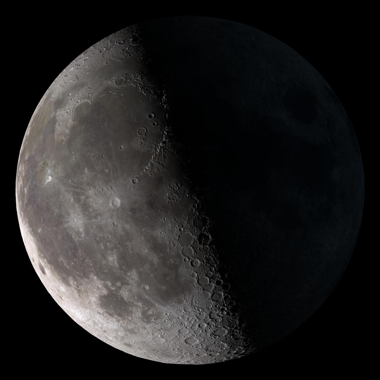
Third quarter. Rises around midnight, visible to the south after sunrise. This marks the first time that accurate shadows at this level of detail are possible in such a computer simulation. The shadows are based on the global elevation map being developed from measurements by the Lunar Orbiter Laser Altimeter (LOLA) aboard the Lunar Reconnaissance Orbiter (LRO). LOLA has already taken more than 10 times as many elevation measurements as all previous missions combined. The Moon always keeps the same face to us, but not exactly the same face. Because of the tilt and shape of its orbit, we see the Moon from slightly different angles over the course of a month. When a month is compressed into 12 seconds, as it is in this animation, our changing view of the Moon makes it look like it's wobbling. This wobble is called libration. The word comes from the Latin for "balance scale" (as does the name of the zodiac constellation Libra) and refers to the way such a scale tips up and down on alternating sides. The sub-Earth point gives the amount of libration in longitude and latitude. The sub-Earth point is also the apparent center of the Moon's disk and the location on the Moon where the Earth is directly overhead. The Moon is subject to other motions as well. It appears to roll back and forth around the sub-Earth point. The roll angle is given by the position angle of the axis, which is the angle of the Moon's north pole relative to celestial north. The Moon also approaches and recedes from us, appearing to grow and shrink. The two extremes, called perigee (near) and apogee (far), differ by more than 10%. The most noticed monthly variation in the Moon's appearance is the cycle of phases, caused by the changing angle of the Sun as the Moon orbits the Earth. The cycle begins with the waxing (growing) crescent Moon visible in the west just after sunset. By first quarter, the Moon is high in the sky at sunset and sets around midnight. The full Moon rises at sunset and is high in the sky at midnight. The third quarter Moon is often surprisingly conspicuous in the daylit western sky long after sunrise. Celestial north is up in these images, corresponding to the view from the northern hemisphere. The descriptions of the print resolution stills also assume a northern hemisphere orientation. To adjust for southern hemisphere views, rotate the images 180 degrees, and substitute "north" for "south" in the descriptions. Credit: <a href="http://svs.gsfc.nasa.gov/index.html" rel="nofollow">NASA/Goddard Space Flight Center Scientific Visualization Studio</a> <b><a href="http://www.nasa.gov/centers/goddard/home/index.html" rel="nofollow">NASA Goddard Space Flight Center</a></b> enables NASA’s mission through four scientific endeavors: Earth Science, Heliophysics, Solar System Exploration, and Astrophysics. Goddard plays a leading role in NASA’s accomplishments by contributing compelling scientific knowledge to advance the Agency’s mission. <b>Follow us on <a href="http://twitter.com/NASA_GoddardPix" rel="nofollow">Twitter</a></b> <b>Join us on <a href="http://www.facebook.com/pages/Greenbelt-MD/NASA-Goddard/395013845897?ref=tsd" rel="nofollow">Facebook</a></b> <b>Find us on <a href="http://web.stagram.com/n/nasagoddard/?vm=grid" rel="nofollow">Instagram</a></b>
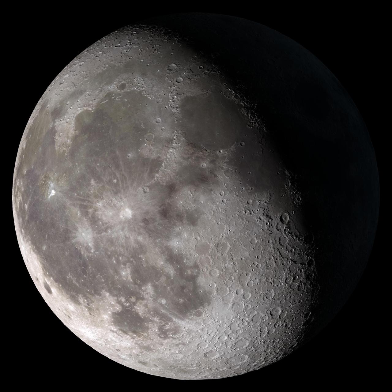
Waning gibbous. Rises after sunset, high in the sky after midnight, visible to the southwest after sunrise. This marks the first time that accurate shadows at this level of detail are possible in such a computer simulation. The shadows are based on the global elevation map being developed from measurements by the Lunar Orbiter Laser Altimeter (LOLA) aboard the Lunar Reconnaissance Orbiter (LRO). LOLA has already taken more than 10 times as many elevation measurements as all previous missions combined. The Moon always keeps the same face to us, but not exactly the same face. Because of the tilt and shape of its orbit, we see the Moon from slightly different angles over the course of a month. When a month is compressed into 12 seconds, as it is in this animation, our changing view of the Moon makes it look like it's wobbling. This wobble is called libration. The word comes from the Latin for "balance scale" (as does the name of the zodiac constellation Libra) and refers to the way such a scale tips up and down on alternating sides. The sub-Earth point gives the amount of libration in longitude and latitude. The sub-Earth point is also the apparent center of the Moon's disk and the location on the Moon where the Earth is directly overhead. The Moon is subject to other motions as well. It appears to roll back and forth around the sub-Earth point. The roll angle is given by the position angle of the axis, which is the angle of the Moon's north pole relative to celestial north. The Moon also approaches and recedes from us, appearing to grow and shrink. The two extremes, called perigee (near) and apogee (far), differ by more than 10%. The most noticed monthly variation in the Moon's appearance is the cycle of phases, caused by the changing angle of the Sun as the Moon orbits the Earth. The cycle begins with the waxing (growing) crescent Moon visible in the west just after sunset. By first quarter, the Moon is high in the sky at sunset and sets around midnight. The full Moon rises at sunset and is high in the sky at midnight. The third quarter Moon is often surprisingly conspicuous in the daylit western sky long after sunrise. Celestial north is up in these images, corresponding to the view from the northern hemisphere. The descriptions of the print resolution stills also assume a northern hemisphere orientation. To adjust for southern hemisphere views, rotate the images 180 degrees, and substitute "north" for "south" in the descriptions. Credit: <a href="http://svs.gsfc.nasa.gov/index.html" rel="nofollow">NASA/Goddard Space Flight Center Scientific Visualization Studio</a> <b><a href="http://www.nasa.gov/centers/goddard/home/index.html" rel="nofollow">NASA Goddard Space Flight Center</a></b> enables NASA’s mission through four scientific endeavors: Earth Science, Heliophysics, Solar System Exploration, and Astrophysics. Goddard plays a leading role in NASA’s accomplishments by contributing compelling scientific knowledge to advance the Agency’s mission. <b>Follow us on <a href="http://twitter.com/NASA_GoddardPix" rel="nofollow">Twitter</a></b> <b>Join us on <a href="http://www.facebook.com/pages/Greenbelt-MD/NASA-Goddard/395013845897?ref=tsd" rel="nofollow">Facebook</a></b> <b>Find us on <a href="http://web.stagram.com/n/nasagoddard/?vm=grid" rel="nofollow">Instagram</a></b>
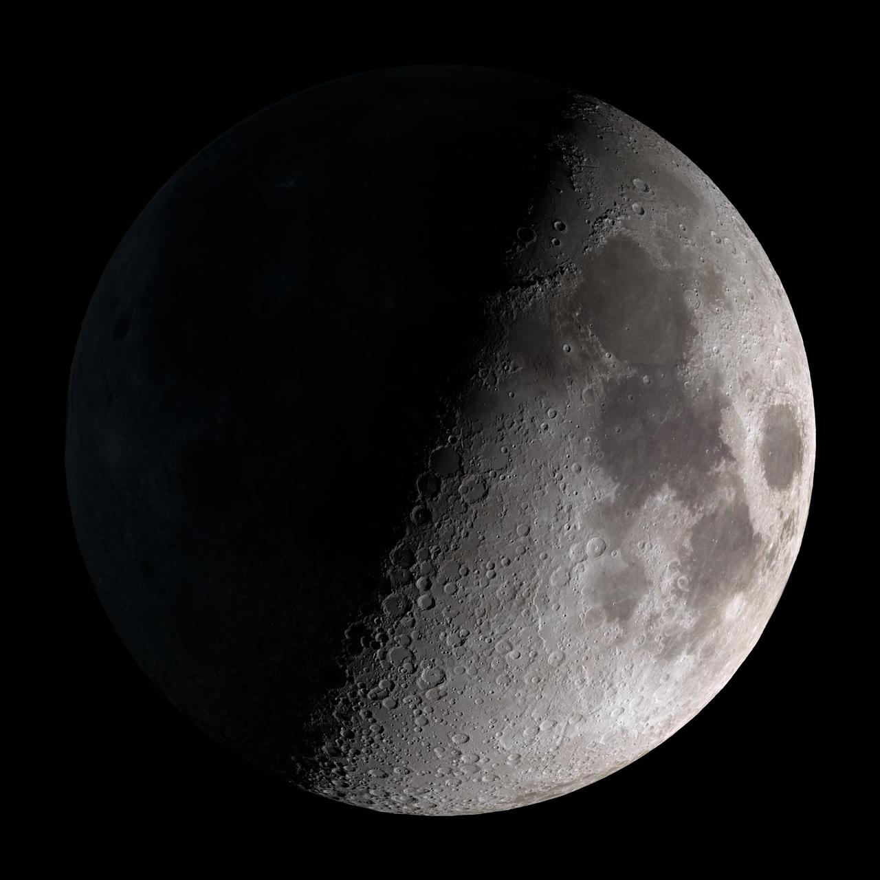
First quarter. Visible high in the southern sky in early evening. This marks the first time that accurate shadows at this level of detail are possible in such a computer simulation. The shadows are based on the global elevation map being developed from measurements by the Lunar Orbiter Laser Altimeter (LOLA) aboard the Lunar Reconnaissance Orbiter (LRO). LOLA has already taken more than 10 times as many elevation measurements as all previous missions combined. The Moon always keeps the same face to us, but not exactly the same face. Because of the tilt and shape of its orbit, we see the Moon from slightly different angles over the course of a month. When a month is compressed into 12 seconds, as it is in this animation, our changing view of the Moon makes it look like it's wobbling. This wobble is called libration. The word comes from the Latin for "balance scale" (as does the name of the zodiac constellation Libra) and refers to the way such a scale tips up and down on alternating sides. The sub-Earth point gives the amount of libration in longitude and latitude. The sub-Earth point is also the apparent center of the Moon's disk and the location on the Moon where the Earth is directly overhead. The Moon is subject to other motions as well. It appears to roll back and forth around the sub-Earth point. The roll angle is given by the position angle of the axis, which is the angle of the Moon's north pole relative to celestial north. The Moon also approaches and recedes from us, appearing to grow and shrink. The two extremes, called perigee (near) and apogee (far), differ by more than 10%. The most noticed monthly variation in the Moon's appearance is the cycle of phases, caused by the changing angle of the Sun as the Moon orbits the Earth. The cycle begins with the waxing (growing) crescent Moon visible in the west just after sunset. By first quarter, the Moon is high in the sky at sunset and sets around midnight. The full Moon rises at sunset and is high in the sky at midnight. The third quarter Moon is often surprisingly conspicuous in the daylit western sky long after sunrise. Celestial north is up in these images, corresponding to the view from the northern hemisphere. The descriptions of the print resolution stills also assume a northern hemisphere orientation. To adjust for southern hemisphere views, rotate the images 180 degrees, and substitute "north" for "south" in the descriptions. Credit: <a href="http://svs.gsfc.nasa.gov/index.html" rel="nofollow">NASA/Goddard Space Flight Center Scientific Visualization Studio</a> <b><a href="http://www.nasa.gov/centers/goddard/home/index.html" rel="nofollow">NASA Goddard Space Flight Center</a></b> enables NASA’s mission through four scientific endeavors: Earth Science, Heliophysics, Solar System Exploration, and Astrophysics. Goddard plays a leading role in NASA’s accomplishments by contributing compelling scientific knowledge to advance the Agency’s mission. <b>Follow us on <a href="http://twitter.com/NASA_GoddardPix" rel="nofollow">Twitter</a></b> <b>Join us on <a href="http://www.facebook.com/pages/Greenbelt-MD/NASA-Goddard/395013845897?ref=tsd" rel="nofollow">Facebook</a></b> <b>Find us on <a href="http://web.stagram.com/n/nasagoddard/?vm=grid" rel="nofollow">Instagram</a></b>

Waxing gibbous. Visible to the southeast in early evening, up for most of the night. This marks the first time that accurate shadows at this level of detail are possible in such a computer simulation. The shadows are based on the global elevation map being developed from measurements by the Lunar Orbiter Laser Altimeter (LOLA) aboard the Lunar Reconnaissance Orbiter (LRO). LOLA has already taken more than 10 times as many elevation measurements as all previous missions combined. The Moon always keeps the same face to us, but not exactly the same face. Because of the tilt and shape of its orbit, we see the Moon from slightly different angles over the course of a month. When a month is compressed into 12 seconds, as it is in this animation, our changing view of the Moon makes it look like it's wobbling. This wobble is called libration. The word comes from the Latin for "balance scale" (as does the name of the zodiac constellation Libra) and refers to the way such a scale tips up and down on alternating sides. The sub-Earth point gives the amount of libration in longitude and latitude. The sub-Earth point is also the apparent center of the Moon's disk and the location on the Moon where the Earth is directly overhead. The Moon is subject to other motions as well. It appears to roll back and forth around the sub-Earth point. The roll angle is given by the position angle of the axis, which is the angle of the Moon's north pole relative to celestial north. The Moon also approaches and recedes from us, appearing to grow and shrink. The two extremes, called perigee (near) and apogee (far), differ by more than 10%. The most noticed monthly variation in the Moon's appearance is the cycle of phases, caused by the changing angle of the Sun as the Moon orbits the Earth. The cycle begins with the waxing (growing) crescent Moon visible in the west just after sunset. By first quarter, the Moon is high in the sky at sunset and sets around midnight. The full Moon rises at sunset and is high in the sky at midnight. The third quarter Moon is often surprisingly conspicuous in the daylit western sky long after sunrise. Celestial north is up in these images, corresponding to the view from the northern hemisphere. The descriptions of the print resolution stills also assume a northern hemisphere orientation. To adjust for southern hemisphere views, rotate the images 180 degrees, and substitute "north" for "south" in the descriptions. Credit: <a href="http://svs.gsfc.nasa.gov/index.html" rel="nofollow">NASA/Goddard Space Flight Center Scientific Visualization Studio</a> <b><a href="http://www.nasa.gov/centers/goddard/home/index.html" rel="nofollow">NASA Goddard Space Flight Center</a></b> enables NASA’s mission through four scientific endeavors: Earth Science, Heliophysics, Solar System Exploration, and Astrophysics. Goddard plays a leading role in NASA’s accomplishments by contributing compelling scientific knowledge to advance the Agency’s mission. <b>Follow us on <a href="http://twitter.com/NASA_GoddardPix" rel="nofollow">Twitter</a></b> <b>Join us on <a href="http://www.facebook.com/pages/Greenbelt-MD/NASA-Goddard/395013845897?ref=tsd" rel="nofollow">Facebook</a></b> <b>Find us on <a href="http://web.stagram.com/n/nasagoddard/?vm=grid" rel="nofollow">Instagram</a></b>
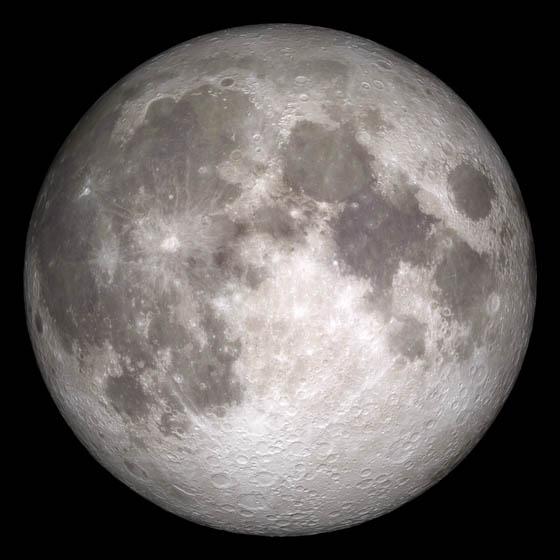
Current moon as viewed on Wednesday, June 15, 2011, 19:00 UT (Phase 100%) This marks the first time that accurate shadows at this level of detail are possible in such a computer simulation. The shadows are based on the global elevation map being developed from measurements by the Lunar Orbiter Laser Altimeter (LOLA) aboard the Lunar Reconnaissance Orbiter (LRO). LOLA has already taken more than 10 times as many elevation measurements as all previous missions combined. The Moon always keeps the same face to us, but not exactly the same face. Because of the tilt and shape of its orbit, we see the Moon from slightly different angles over the course of a month. When a month is compressed into 12 seconds, as it is in this animation, our changing view of the Moon makes it look like it's wobbling. This wobble is called libration. The word comes from the Latin for "balance scale" (as does the name of the zodiac constellation Libra) and refers to the way such a scale tips up and down on alternating sides. The sub-Earth point gives the amount of libration in longitude and latitude. The sub-Earth point is also the apparent center of the Moon's disk and the location on the Moon where the Earth is directly overhead. The Moon is subject to other motions as well. It appears to roll back and forth around the sub-Earth point. The roll angle is given by the position angle of the axis, which is the angle of the Moon's north pole relative to celestial north. The Moon also approaches and recedes from us, appearing to grow and shrink. The two extremes, called perigee (near) and apogee (far), differ by more than 10%. The most noticed monthly variation in the Moon's appearance is the cycle of phases, caused by the changing angle of the Sun as the Moon orbits the Earth. The cycle begins with the waxing (growing) crescent Moon visible in the west just after sunset. By first quarter, the Moon is high in the sky at sunset and sets around midnight. The full Moon rises at sunset and is high in the sky at midnight. The third quarter Moon is often surprisingly conspicuous in the daylit western sky long after sunrise. Celestial north is up in these images, corresponding to the view from the northern hemisphere. The descriptions of the print resolution stills also assume a northern hemisphere orientation. To adjust for southern hemisphere views, rotate the images 180 degrees, and substitute "north" for "south" in the descriptions. Credit: <a href="http://svs.gsfc.nasa.gov/index.html" rel="nofollow">NASA/Goddard Space Flight Center Scientific Visualization Studio</a> <b><a href="http://www.nasa.gov/centers/goddard/home/index.html" rel="nofollow">NASA Goddard Space Flight Center</a></b> enables NASA’s mission through four scientific endeavors: Earth Science, Heliophysics, Solar System Exploration, and Astrophysics. Goddard plays a leading role in NASA’s accomplishments by contributing compelling scientific knowledge to advance the Agency’s mission. <b>Follow us on <a href="http://twitter.com/NASA_GoddardPix" rel="nofollow">Twitter</a></b> <b>Join us on <a href="http://www.facebook.com/pages/Greenbelt-MD/NASA-Goddard/395013845897?ref=tsd" rel="nofollow">Facebook</a></b> <b>Find us on <a href="http://web.stagram.com/n/nasagoddard/?vm=grid" rel="nofollow">Instagram</a></b>