Light and Shadow
Light and Shadow
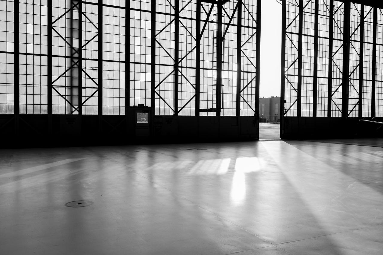
Light and Shadow in the Hangar at Glenn Research Center on February 27, 2024. Photo Credit: (NASA/Sara Lowthian-Hanna)
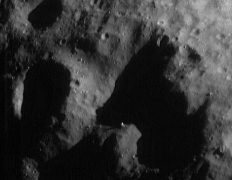
This image from NASA Dawn spacecraft shows an area in Vesta northern hemisphere that has been illuminated by the sun. As asteroid Vesta progresses from its winter to its spring the sunlight is creeping further and further northwards.
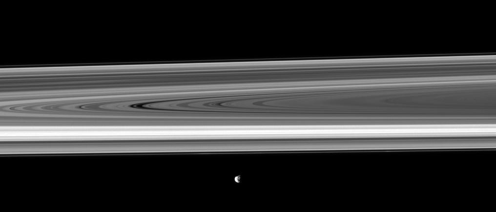
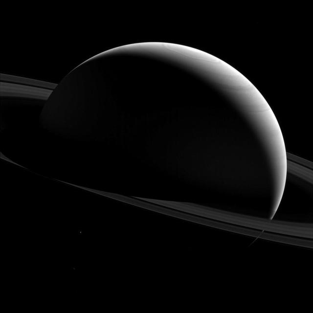
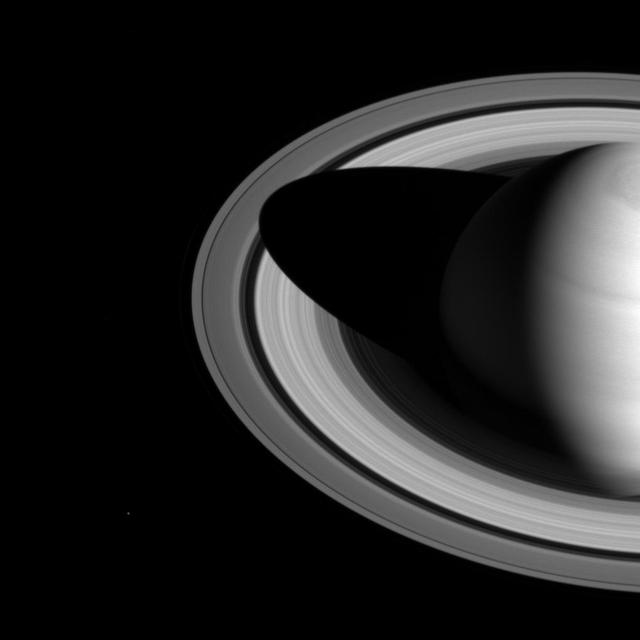
Saturn moon Janus, its rugged surface shown in shadow and light, passes before the planet rings in this image taken by NASA Cassini spacecraft.
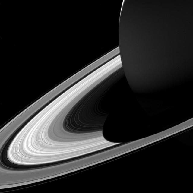
NASA Cassini spacecraft camera looks in near-infrared light at a dramatic view of Saturn, its ringplane and the shadows of a couple of its moons.
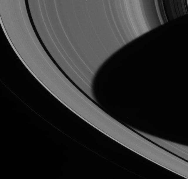
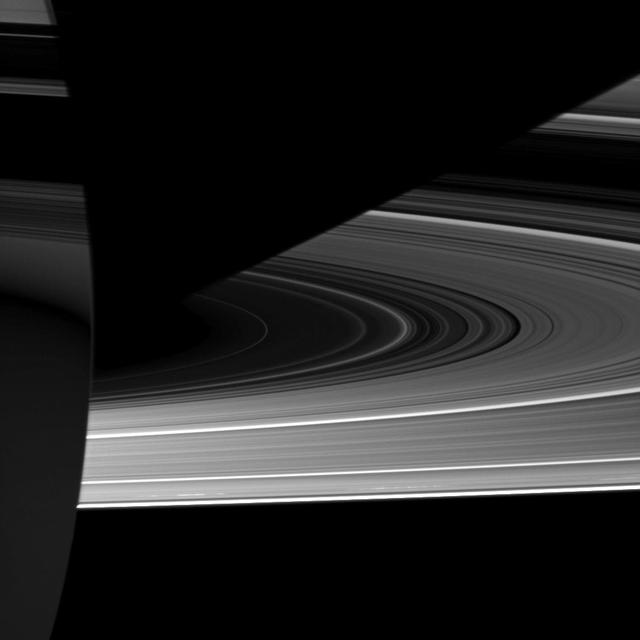
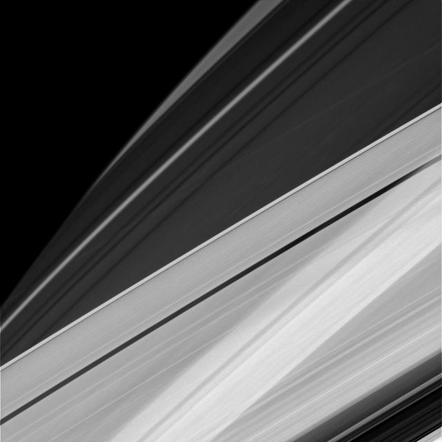
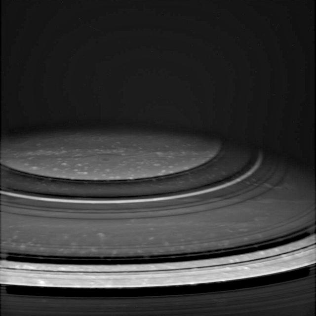
NASA Cassini spacecraft shows Saturn shadow cutting sharply across its rings as the orbits of ring particles carry them suddenly from day to night. With no atmosphere to scatter light, shadows in space are much darker than were used to here on Earth.
This mosaic of the surface of asteroid Vesta was made from images obtained by NASA Dawn spacecraft while the area was entirely in the sun shadow. Light reflecting off of other areas of Vesta provides the only illumination.
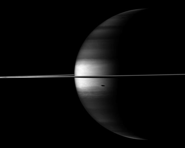
Capturing the interplay between light and shadow, NASA Cassini spacecraft looks toward the night side of Saturn where sunlight reflected off the rings has dimly illuminated what would otherwise be the dark side of the planet.
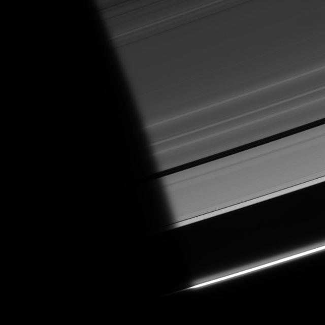
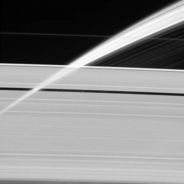
As ring particles emerge from the darkness of Saturn shadow, they pass through a region of twilight. The Sun light, refracted by the planet atmosphere, peeks around the limb, followed shortly by the Sun itself
art002e021296 (April 6, 2026) – As the Artemis II crew flew around the far side of the Moon, they captured key scientific observations, photographs, videos, and records documenting critical observations to help scientists on the ground understand the composition and history of the lunar surface. Near the center of the view lies Hertzsprung basin, an ancient and expansive impact feature described by the Artemis II crew as darker in overall tone compared to surrounding terrain. Crew observations highlight a striking contrast in texture: the interior of Hertzsprung appears unusually smooth, “like a paved road,” while the outer regions transition into rougher, more jagged terrain. Subtle variations in brightness and color across the basin create a patchwork of lighter and darker areas, offering clues to its complex geologic history. Surrounding regions show evidence of ejecta and crater rays, with faint brownish and gray tones radiating across the highlands. Together, these features provide a dynamic view of one of the Moon’s oldest and most intriguing basins. Credit: NASA
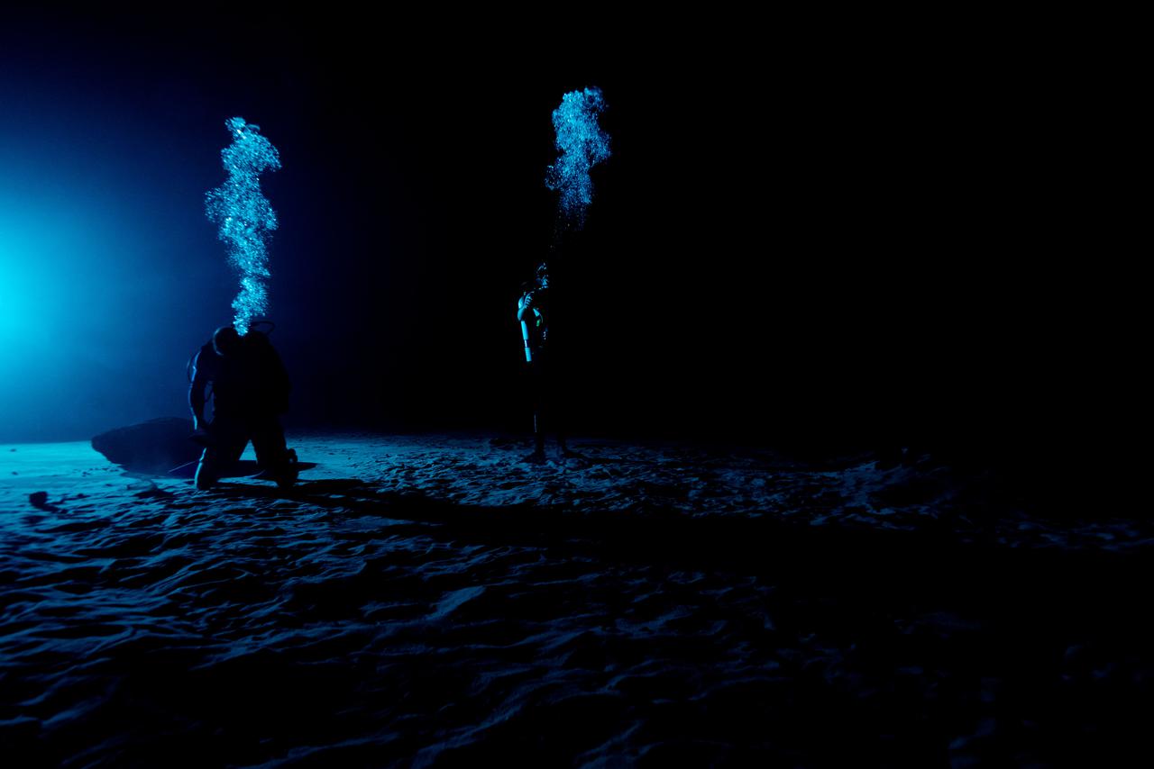
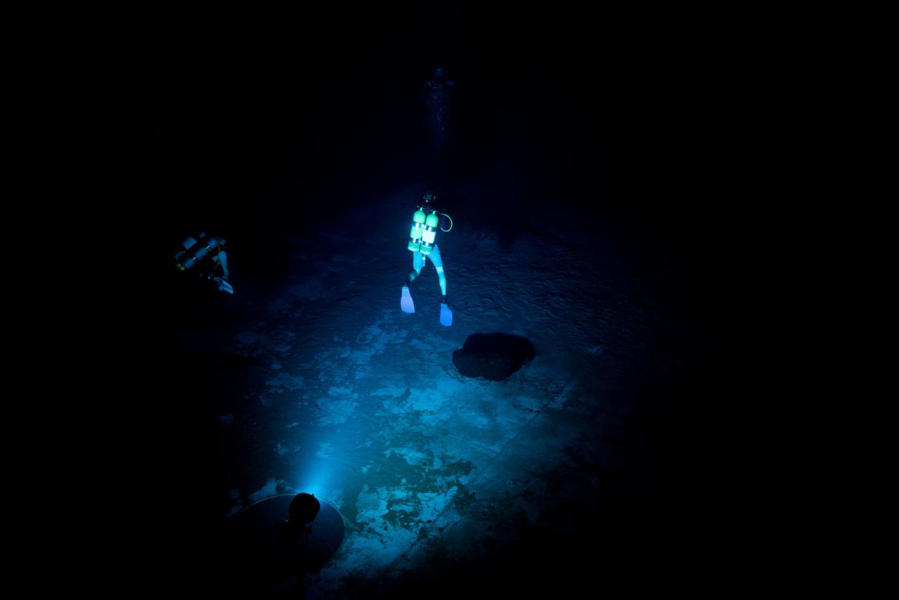
Test subjects performing mission-relevant tasks and evaluating shadow quality during NBL Preliminary Lunar Lighting Evaluation. Divers at the Neutral Buoyancy Laboratory (NBL) in Houston are setting the stage for future Moonwalk training by simulating lunar lighting conditions. At the Lunar South Pole, the Sun will remain no more than a few degrees above the horizon, resulting in extremely long and dark shadows. To prepare astronauts for these challenging lighting conditions, the team at the NBL has begun preliminary evaluations of lunar lighting solutions at the bottom of the 40-foot deep pool. This testing and evaluation involved turning off all the lights in the facility, installing black curtains on the pool walls to minimize reflections, and using a powerful underwater cinematic lamp, to get the conditions just right ahead of upcoming training for astronauts.
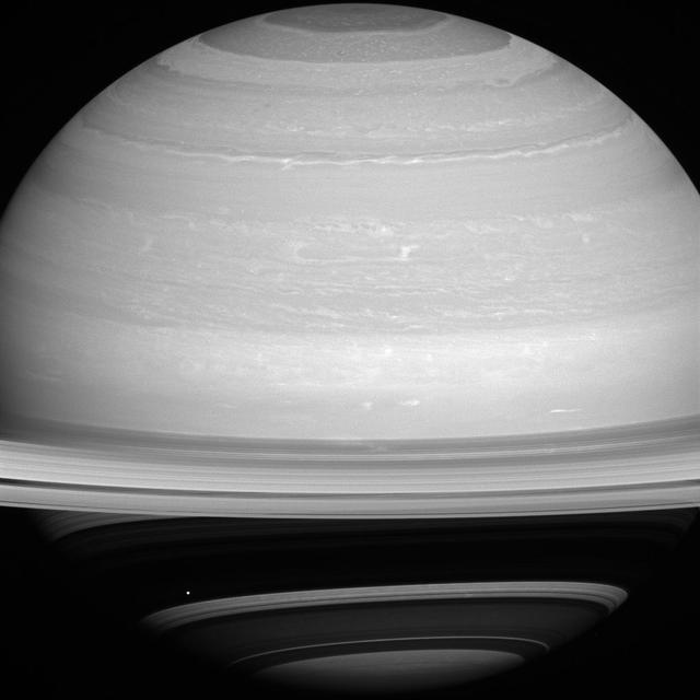
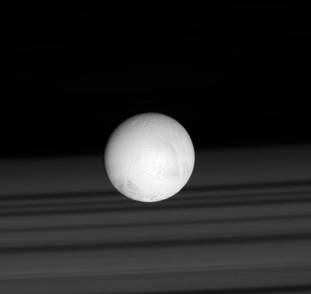
The night sides of Saturn and Tethys are dark places indeed. We know that shadows are darker areas than sunlit areas, and in space, with no air to scatter the light, shadows can appear almost totally black. Tethys (660 miles or 1,062 kilometers across) is just barely seen in the lower left quadrant of this image below the ring plane and has been brightened by a factor of three to increase its visibility. The wavy outline of Saturn's polar hexagon is visible at top center. This view looks toward the sunlit side of the rings from about 10 degrees above the ring plane. The image was taken with the Cassini spacecraft wide-angle camera on Jan. 15, 2015 using a spectral filter which preferentially admits wavelengths of near-infrared light centered at 752 nanometers. The view was obtained at a distance of approximately 1.5 million miles (2.4 million kilometers) from Saturn. Image scale is 88 miles (141 kilometers) per pixel. http://photojournal.jpl.nasa.gov/catalog/PIA18333
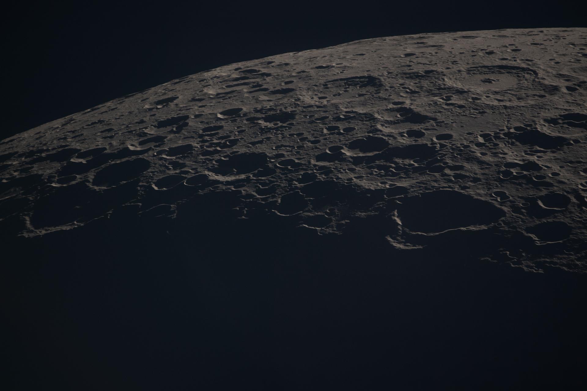
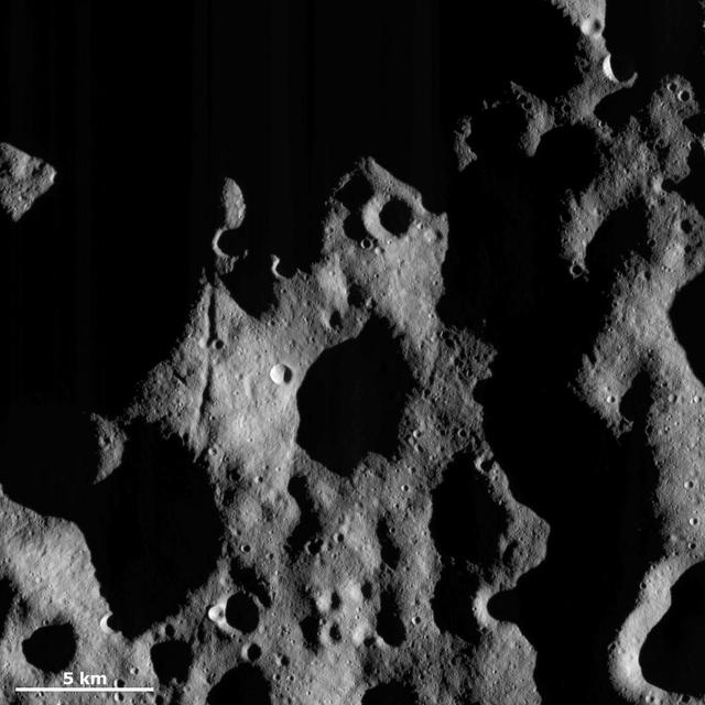
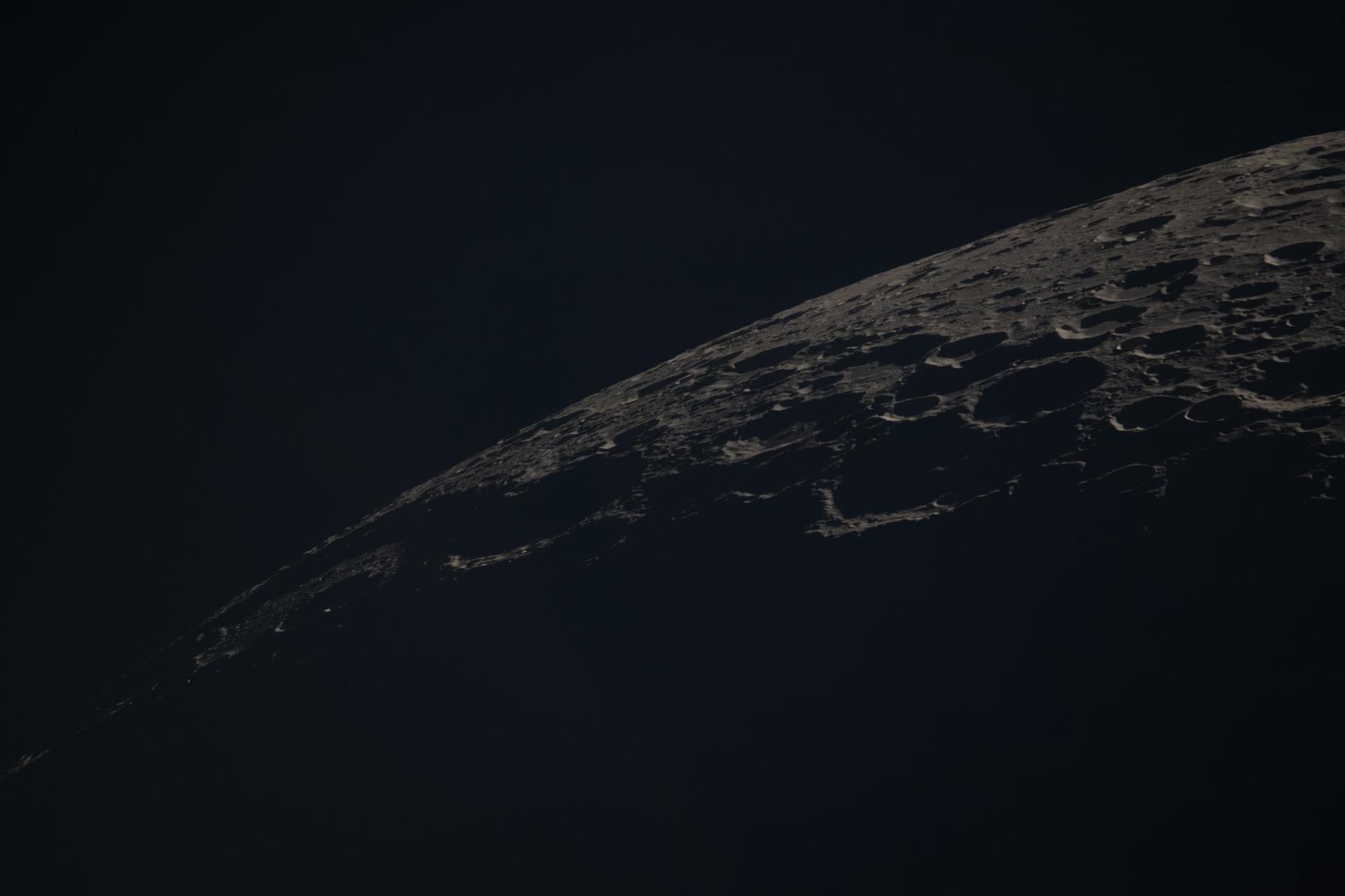
art002e014055 (April 6, 2026) - A close-up view of the Moon along the terminator—the boundary between lunar day and night—captured by the crew during the Artemis II mission. The low-angle sunlight on this specific day casts long shadows across the surface, revealing the shape and depth of craters in striking detail. Since the early days of the telescope, astronomers used observations along the terminator to map the Moon’s terrain, taking advantage of the contrast between light and shadow to distinguish surface features. While modern imaging has advanced significantly, this lighting still provides valuable insight into the Moon’s topography.
The projection of Saturn's shadow on the rings grows shorter as Saturn's season advances toward northern summer, thanks to the planet's permanent tilt as it orbits the sun. This will continue until Saturn's solstice in May 2017. At that point in time, the shadow will extend only as far as the innermost A ring, leaving the middle and outer A ring completely free of the planet's shadow. Over the course of NASA's Cassini mission, the shadow of Saturn first lengthened steadily until equinox in August 2009. Since then, the shadow has been shrinking. This view looks toward the sunlit side of the rings from about 10 degrees above the ring plane. The image was taken in visible light with the Cassini spacecraft wide-angle camera on Feb. 3, 2017. The view was acquired at a distance of approximately 760,000 miles (1.2 million kilometers) from Saturn. Image scale is 46 miles (73 kilometers) per pixel. https://photojournal.jpl.nasa.gov/catalog/PIA21328
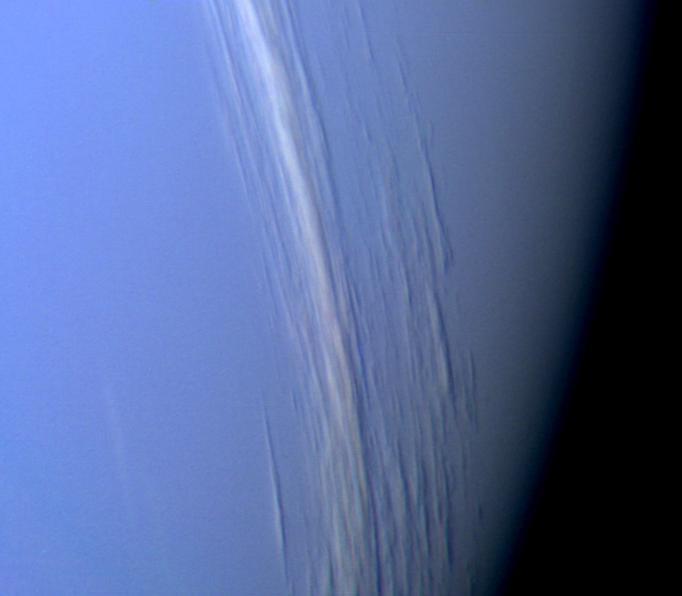
NASA's Voyager 2 high resolution color image, taken 2 hours before closest approach, provides obvious evidence of vertical relief in Neptune's bright cloud streaks. These clouds were observed at a latitude of 29 degrees north near Neptune's east terminator. The linear cloud forms are stretched approximately along lines of constant latitude and the sun is toward the lower left. The bright sides of the clouds which face the sun are brighter than the surrounding cloud deck because they are more directly exposed to the sun. Shadows can be seen on the side opposite the sun. These shadows are less distinct at short wavelengths (violet filter) and more distinct at long wavelengths (orange filter). This can be understood if the underlying cloud deck on which the shadow is cast is at a relatively great depth, in which case scattering by molecules in the overlying atmosphere will diffuse light into the shadow. Because molecules scatter blue light much more efficiently than red light, the shadows will be darkest at the longest (reddest) wavelengths, and will appear blue under white light illumination. The resolution of this image is 11 kilometers (6.8 miles per pixel) and the range is only 157,000 kilometers (98,000 miles). The width of the cloud streaks range from 50 to 200 kilometers (31 to 124 miles), and their shadow widths range from 30 to 50 kilometers (18 to 31 miles). Cloud heights appear to be of the order of 50 kilometers (31 miles). This corresponds to 2 scale heights. http://photojournal.jpl.nasa.gov/catalog/PIA00058
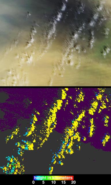
On March 2, 2003, NASA Terra spacecraft saw near-surface winds carrying a large amount of Saharan dust aloft and transported the material westward over the Atlantic Ocean.
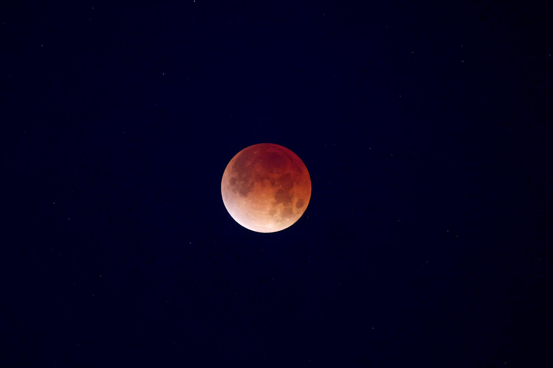
Viewed from Merritt Island, Fla., at 11:25 p.m. EST, the full moon, traveling west to east, is nearly completely in the Earth's shadow, producing a lunar eclipse. Eclipses occur when the Sun, Earth and Moon line up. They are rare because the Moon usually passes above or below the imaginary line connecting Earth and the Sun. The Earth casts a shadow that the Moon can pass through -when it does, it is called a lunar eclipse. They can only occur when the moon is "full." During a total lunar eclipse the Moon takes on a dark red color because it is being lighted slightly by sunlight passing through the Earth's atmosphere and this light has the blue component preferentially scattered out (this is also why the sky appears blue from the surface of the Earth), leaving faint reddish light to illuminate the Moon during the eclipse

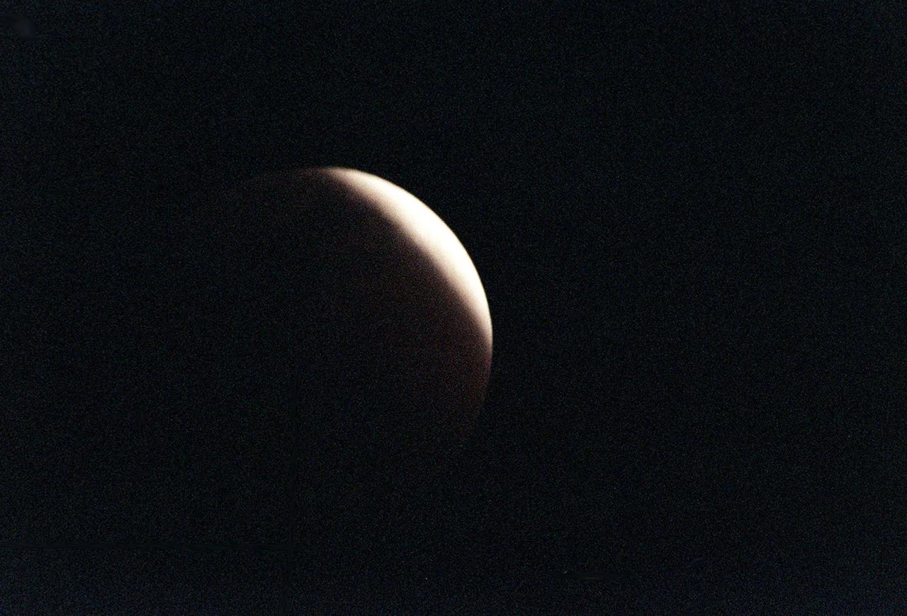
Traveling west to east, the full moon, viewed from Merritt Island, Fla., at 10:18 p.m. EST, begins moving into the Earth's shadow, at the start of a lunar eclipse. Eclipses occur when the Sun, Earth and Moon line up. They are rare because the Moon usually passes above or below the imaginary line connecting Earth and the Sun. The Earth casts a shadow that the Moon can pass through -when it does, it is called a lunar eclipse. They can only occur when the moon is "full." During a total lunar eclipse the Moon takes on a dark red color because it is being lighted slightly by sunlight passing through the Earth's atmosphere and this light has the blue component preferentially scattered out (this is also why the sky appears blue from the surface of the Earth), leaving faint reddish light to illuminate the Moon during the eclipse
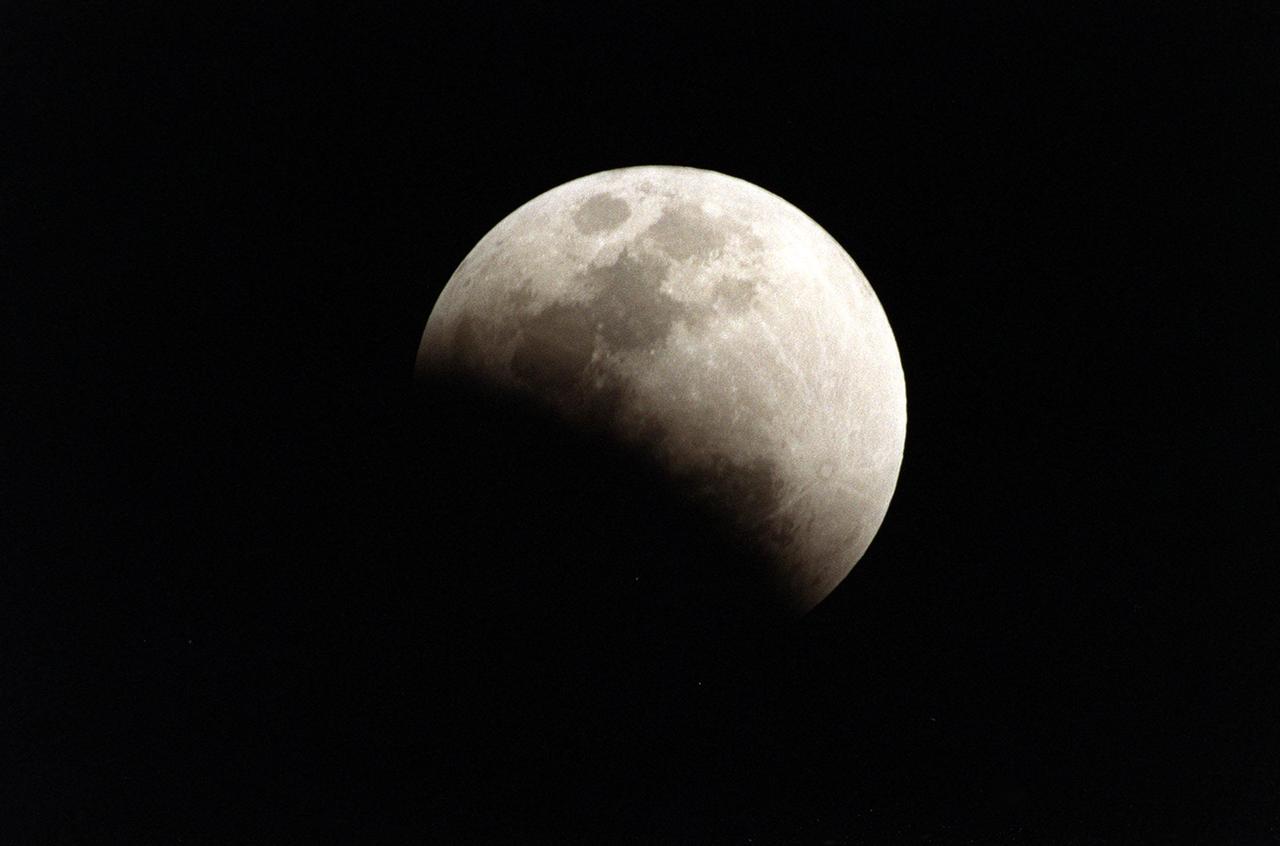
Traveling west to east, the full moon, viewed from Merritt Island, Fla., at 10:35 p.m. EST, moves into the Earth's shadow during a lunar eclipse. Eclipses occur when the Sun, Earth and Moon line up. They are rare because the Moon usually passes above or below the imaginary line connecting Earth and the Sun. The Earth casts a shadow that the Moon can pass through -when it does, it is called a lunar eclipse. They can only occur when the moon is "full." During a total lunar eclipse the Moon takes on a dark red color because it is being lighted slightly by sunlight passing through the Earth's atmosphere and this light has the blue component preferentially scattered out (this is also why the sky appears blue from the surface of the Earth), leaving faint reddish light to illuminate the Moon during the eclipse
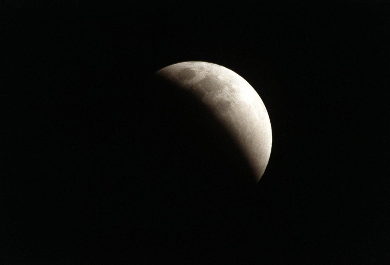
Viewed from Merritt Island, Fla., at 10:59 p.m. EST, the full moon, traveling west to east, is three-quarters of the way into the Earth's shadow during a lunar eclipse. Eclipses occur when the Sun, Earth and Moon line up. They are rare because the Moon usually passes above or below the imaginary line connecting Earth and the Sun. The Earth casts a shadow that the Moon can pass through -when it does, it is called a lunar eclipse. They can only occur when the moon is "full." During a total lunar eclipse the Moon takes on a dark red color because it is being lighted slightly by sunlight passing through the Earth's atmosphere and this light has the blue component preferentially scattered out (this is also why the sky appears blue from the surface of the Earth), leaving faint reddish light to illuminate the Moon during the eclipse
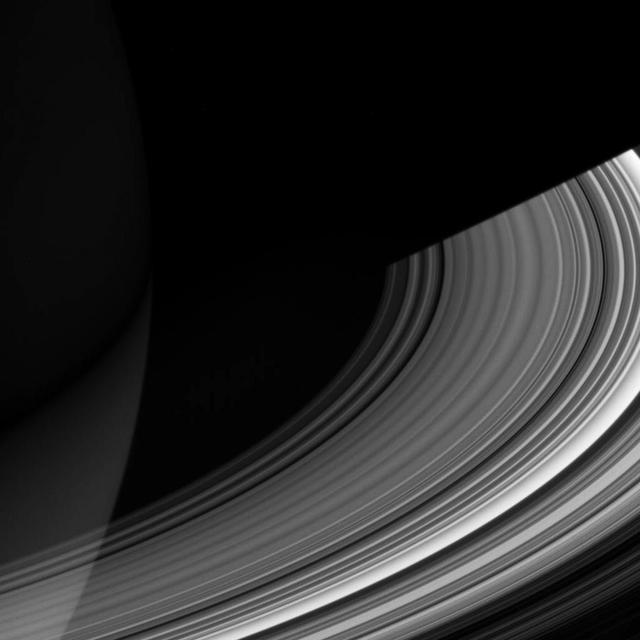
The shadow of Saturn on the rings, which stretched across all of the rings earlier in Cassini's mission (see PIA08362), now barely makes it past the Cassini division. The changing length of the shadow marks the passing of the seasons on Saturn. As the planet nears its northern-hemisphere solstice in May 2017, the shadow will get even shorter. At solstice, the shadow's edge will be about 28,000 miles (45,000 kilometers) from the planet's surface, barely making it past the middle of the B ring. The moon Mimas is a few pixels wide, near the lower left in this image. This view looks toward the sunlit side of the rings from about 35 degrees above the ring plane. The image was taken in visible light with the Cassini spacecraft wide-angle camera on May 21, 2016. The view was obtained at a distance of approximately 2.0 million miles (3.2 million kilometers) from Saturn. Image scale is 120 miles (190 kilometers) per pixel. http://photojournal.jpl.nasa.gov/catalog/PIA20494
Peering into the Moon's permanently shadowed regions, Lunar Trailblazer will detect signatures of water ice in reflected light, and it will pinpoint the locations of micro-cold traps less than a football field in size. The small satellite will collect measurements at multiple times of day over sunlit regions, helping scientists understand if the water signature on the illuminated surface changes as the lunar surface temperature changes by hundreds of degrees over the course of a lunar day. The goal is to produce high-resolution maps to locate water ice in support of NASA's Artemis Program, which aims to establish a sustainable human presence on the Moon and prepare for future missions to Mars. https://photojournal.jpl.nasa.gov/catalog/PIA24161
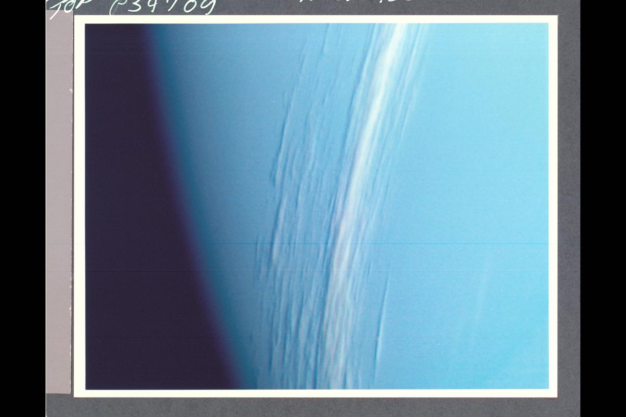
P-34709 Range: 157,000 kilometers (98,000 miles) This Voyager 2 high resolution color image, taken 2 hours before closest approach, provides obvious evidence of vertical relief in Neptune's bright cloud streaks. These clouds were observed at a latitude of 29° N near Neptune's east terminator. The linear cloud forms are stretched approximately along lines of constant latitude and the sun is toward the lower left. The bright sides of the clouds that face the sun are brighter than the surrounding cloud deck because they are more directly exposed to the sun. Shadows can be seen on the side directly opposite the sun. These shadows are less distinct at short wavelengths (violet filter) and more distinct at long wavelengths (orange filter). This can be understood if the underlying cloud deck on which the shadow is cast is at a relatively great depth, in which case scattering by molecules in the overlying atmopsphere will diffuse light into the shadow. Because molecules scatter blue light much more efficiently than red light, the shadows will be darkest at the longest (reddest) wavelengths, and will appear blue under white illumination. The resolution of this image is 11 kilometers (6.8 miles per pixel). The width of the cloud streaks range from 50 to 200 kilometers (31 to 124 miles), and their shadow widths range from 30 to 50 kilometers (18 to 31 miles). Cloud heights appear to be of the order of 50 kilometers (31 miles). This corresponds to 2 scale heights.
art002e014045 (April 6, 2026) - This view of the Moon captures the terminator—the shifting boundary between day and night—where sunlight grazes the surface at a low angle. Taken by the crew during the Artemis II mission, the lighting accentuates the Moon’s rugged terrain, casting long shadows that reveal the depth and structure of craters, ridges, and surrounding highlands.

Saturn's shadow stretched beyond the edge of its rings for many years after Cassini first arrived at Saturn, casting an ever-lengthening shadow that reached its maximum extent at the planet's 2009 equinox. This image captured the moment in 2015 when the shrinking shadow just barely reached across the entire main ring system. The shadow will continue to shrink until the planet's northern summer solstice, at which point it will once again start lengthening across the rings, reaching across them in 2019. Like Earth, Saturn is tilted on its axis. And, just as on Earth, as the sun climbs higher in the sky, shadows get shorter. The projection of the planet's shadow onto the rings shrinks and grows over the course of its 29-year-long orbit, as the angle of the sun changes with respect to Saturn's equator. This view looks toward the sunlit side of the rings from about 11 degrees above the ring plane. The image was taken in visible light with the Cassini spacecraft wide-angle camera on Jan. 16, 2015. The view was obtained at a distance of approximately 1.6 million miles (2.5 million kilometers) from Saturn. Image scale is about 90 miles (150 kilometers) per pixel. http://photojournal.jpl.nasa.gov/catalog/PIA20498
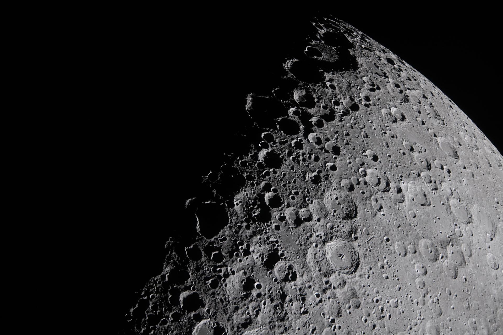
art002e009281 (April 6, 2026) – The Artemis II crew captures a portion of the Moon coming into view along the terminator – the boundary between lunar day and night – where low-angle sunlight casts long, dramatic shadows across the surface. This grazing light accentuates the Moon’s rugged topography, revealing craters, ridges, and basin structures in striking detail. Features along the terminator such as Jule Crater, Birkhoff Crater, Stebbins Crater, and surrounding highlands stand out. From this perspective, the interplay of light and shadow highlights the complexity of the lunar surface in ways not visible under full illumination. The image was captured about three hours into the crew’s lunar observation period, as they flew around the far side of the Moon on the sixth day of the mission.
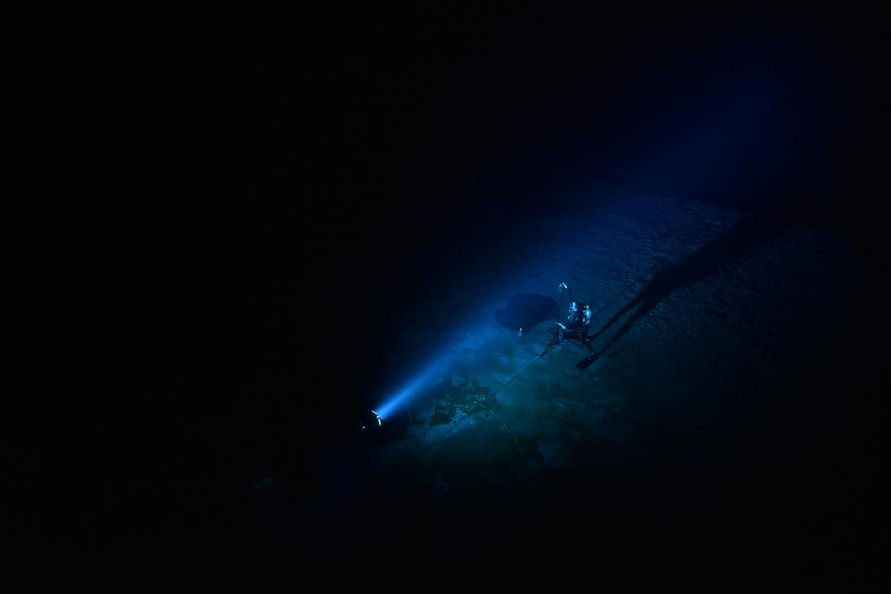
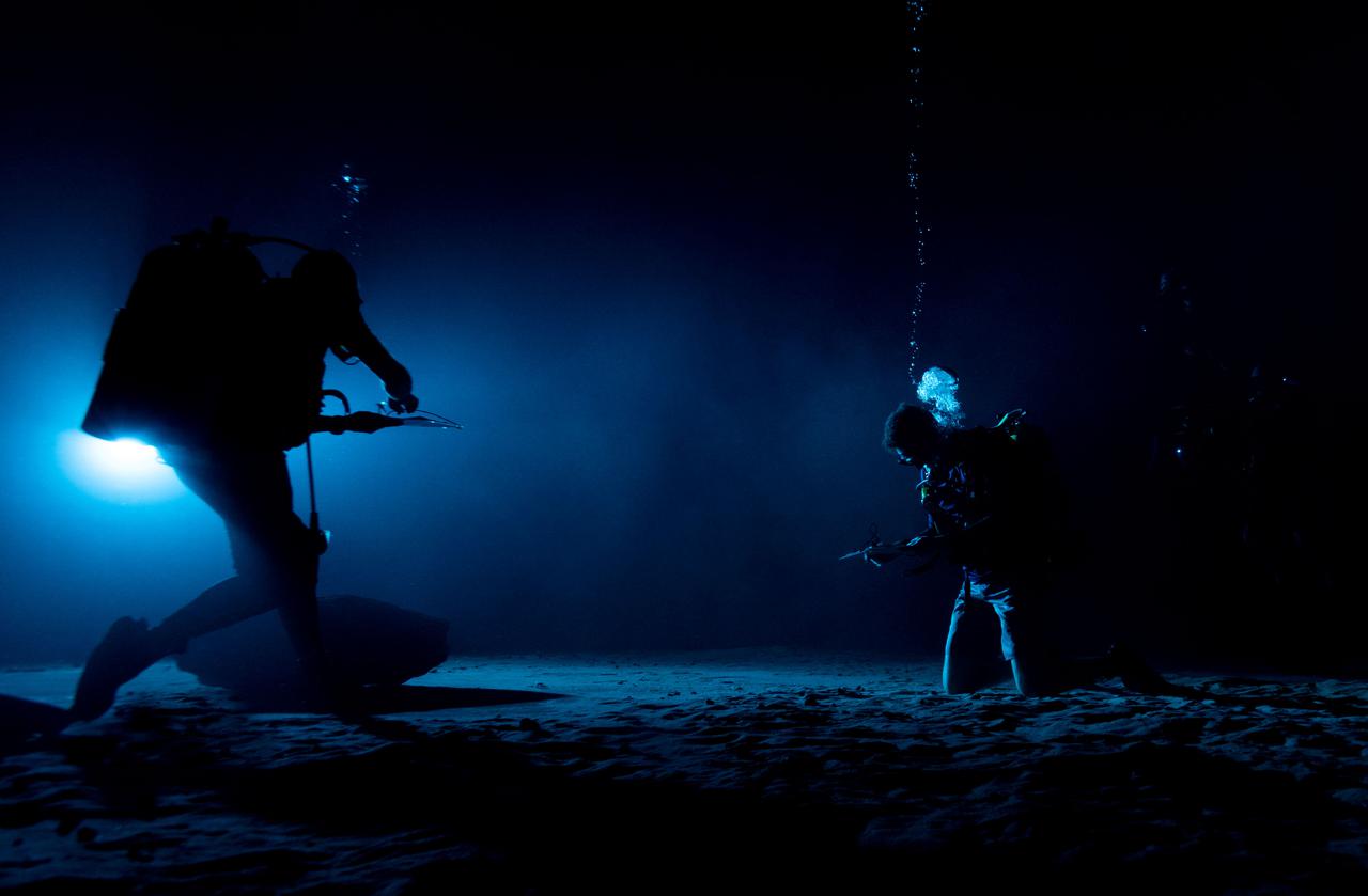
Quantitative evaluation of light source by NBL diver during NBL Preliminary Lunar Lighting Evaluation. Divers at the Neutral Buoyancy Laboratory (NBL) in Houston are setting the stage for future Moonwalk training by simulating lunar lighting conditions. At the Lunar South Pole, the Sun will remain no more than a few degrees above the horizon, resulting in extremely long and dark shadows. To prepare astronauts for these challenging lighting conditions, the team at the NBL has begun preliminary evaluations of lunar lighting solutions at the bottom of the 40-foot deep pool. This testing and evaluation involved turning off all the lights in the facility, installing black curtains on the pool walls to minimize reflections, and using a powerful underwater cinematic lamp, to get the conditions just right ahead of upcoming training for astronauts.
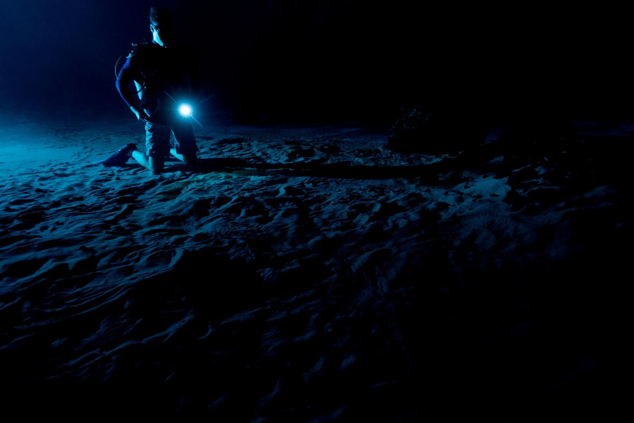
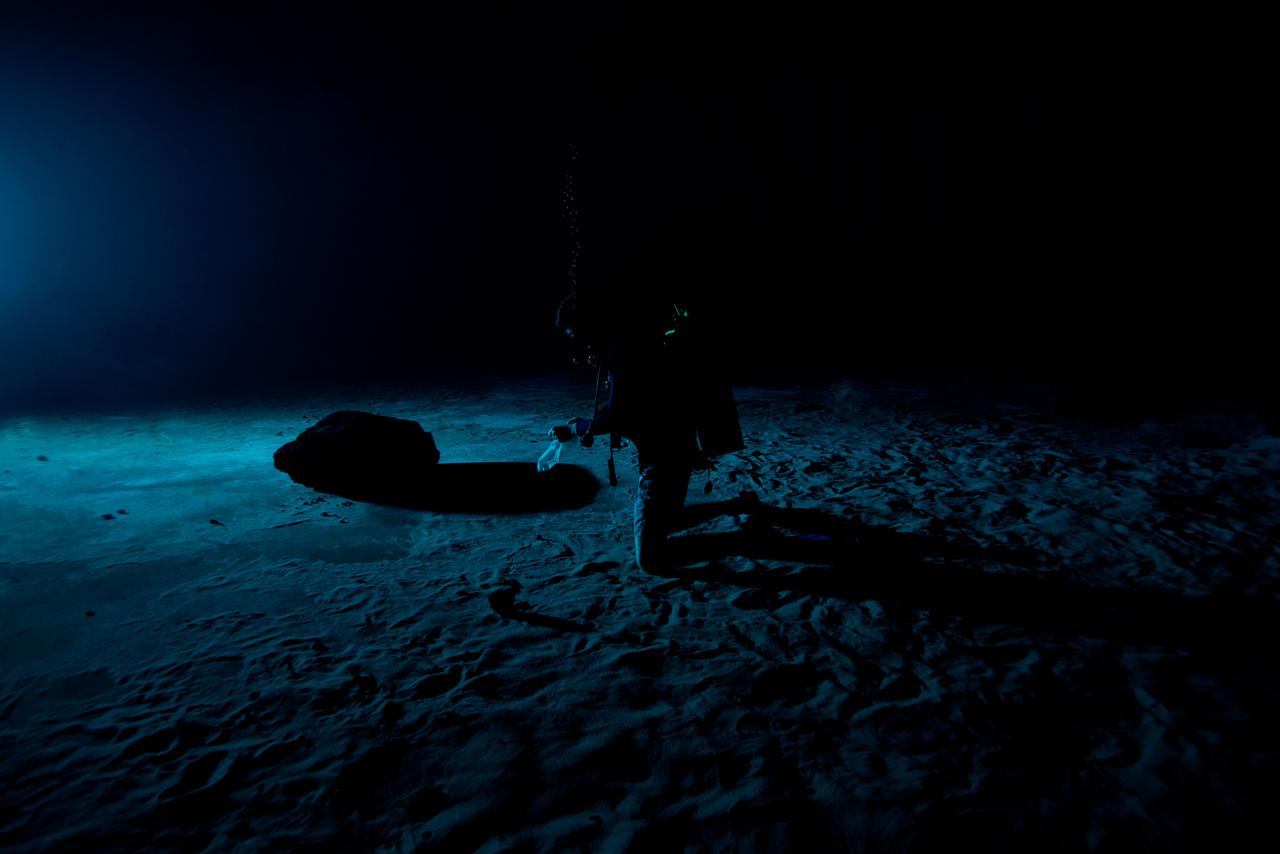
Test subjects performing subjective assessment of supplemental lighting during NBL Preliminary Lunar Lighting Evaluation. Divers at the Neutral Buoyancy Laboratory (NBL) in Houston are setting the stage for future Moonwalk training by simulating lunar lighting conditions. At the Lunar South Pole, the Sun will remain no more than a few degrees above the horizon, resulting in extremely long and dark shadows. To prepare astronauts for these challenging lighting conditions, the team at the NBL has begun preliminary evaluations of lunar lighting solutions at the bottom of the 40-foot deep pool. This testing and evaluation involved turning off all the lights in the facility, installing black curtains on the pool walls to minimize reflections, and using a powerful underwater cinematic lamp, to get the conditions just right ahead of upcoming training for astronauts.
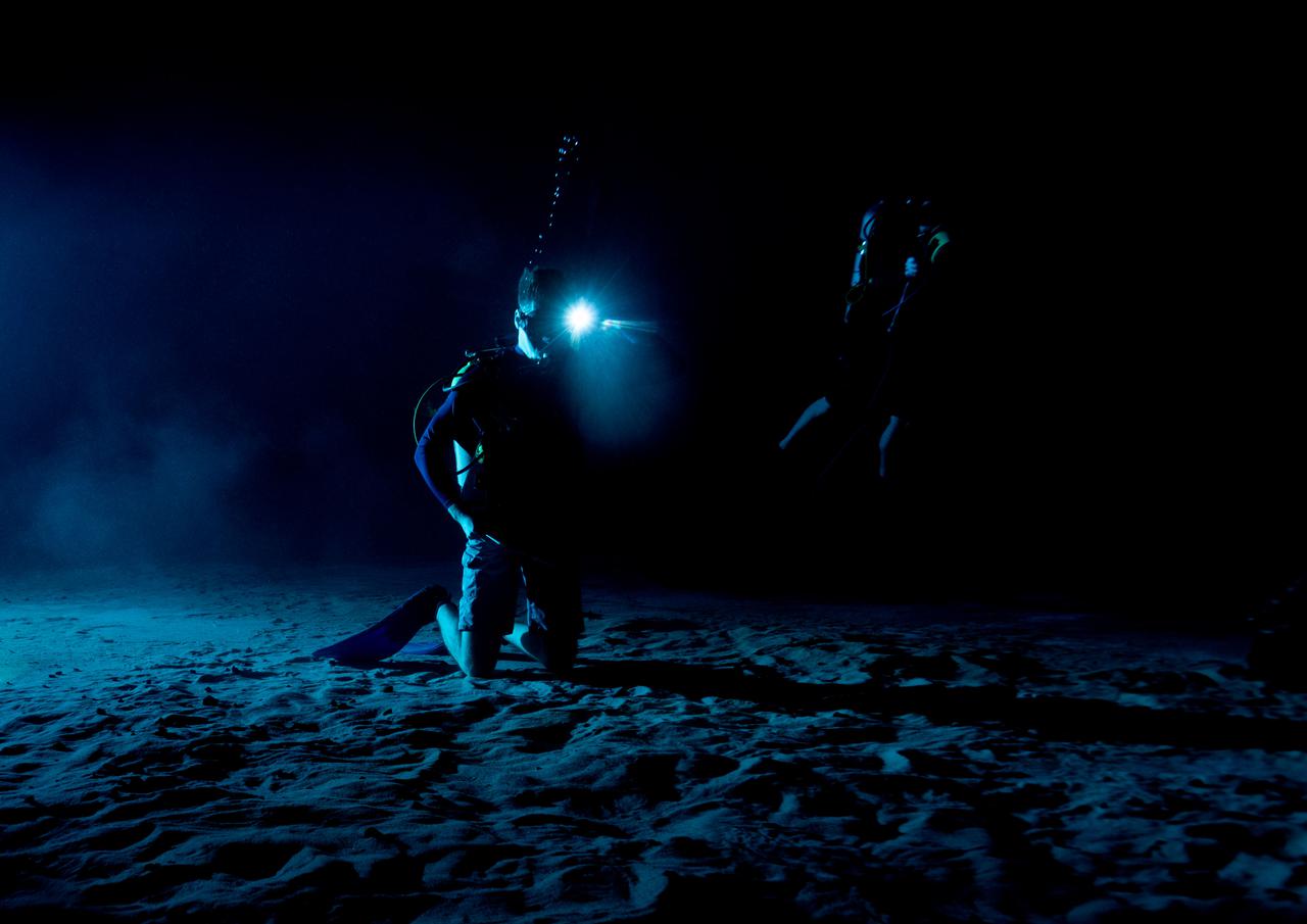
Test subjects performing subjective assessment of supplemental lighting during NBL Preliminary Lunar Lighting Evaluation. Divers at the Neutral Buoyancy Laboratory (NBL) in Houston are setting the stage for future Moonwalk training by simulating lunar lighting conditions. At the Lunar South Pole, the Sun will remain no more than a few degrees above the horizon, resulting in extremely long and dark shadows. To prepare astronauts for these challenging lighting conditions, the team at the NBL has begun preliminary evaluations of lunar lighting solutions at the bottom of the 40-foot deep pool. This testing and evaluation involved turning off all the lights in the facility, installing black curtains on the pool walls to minimize reflections, and using a powerful underwater cinematic lamp, to get the conditions just right ahead of upcoming training for astronauts.
Quantitative evaluation of light source by NBL diver during NBL Preliminary Lunar Lighting Evaluation. Divers at the Neutral Buoyancy Laboratory (NBL) in Houston are setting the stage for future Moonwalk training by simulating lunar lighting conditions. At the Lunar South Pole, the Sun will remain no more than a few degrees above the horizon, resulting in extremely long and dark shadows. To prepare astronauts for these challenging lighting conditions, the team at the NBL has begun preliminary evaluations of lunar lighting solutions at the bottom of the 40-foot deep pool. This testing and evaluation involved turning off all the lights in the facility, installing black curtains on the pool walls to minimize reflections, and using a powerful underwater cinematic lamp, to get the conditions just right ahead of upcoming training for astronauts.

In this lunar eclipse viewed from Merritt Island, Fla., at midnight, the full moon takes on a dark red color because it is being lighted slightly by sunlight passing through the Earth's atmosphere. This light has the blue component preferentially scattered out (this is also why the sky appears blue from the surface of the Earth), leaving faint reddish light to illuminate the Moon during the eclipse. Eclipses occur when the Sun, Earth and Moon line up. They are rare because the Moon usually passes above or below the imaginary line connecting Earth and the Sun. The Earth casts a shadow that the Moon can pass through -when it does, it is called a lunar eclipse

In this lunar eclipse viewed from Merritt Island, Fla., at 11:55 p.m., the full moon takes on a dark red color because it is being lighted slightly by sunlight passing through the Earth's atmosphere. This light has the blue component preferentially scattered out (this is also why the sky appears blue from the surface of the Earth), leaving faint reddish light to illuminate the Moon during the eclipse. Eclipses occur when the Sun, Earth and Moon line up. They are rare because the Moon usually passes above or below the imaginary line connecting Earth and the Sun. The Earth casts a shadow that the Moon can pass through -when it does, it is called a lunar eclipse

In this lunar eclipse viewed from Merritt Island, Fla., the full moon takes on a dark red color because it is being lighted slightly by sunlight passing through the Earth's atmosphere. This light has the blue component preferentially scattered out (this is also why the sky appears blue from the surface of the Earth), leaving faint reddish light to illuminate the Moon. Eclipses occur when the Sun, Earth and Moon line up. They are rare because the Moon usually passes above or below the imaginary line connecting Earth and the Sun. The Earth casts a shadow that the Moon can pass through - when it does, it is called a lunar eclipse.

Saturn's shadow sweeps across the rings in a view captured on Nov. 5, 2006 by NASA's Cassini spacecraft. In the bottom half of the image, the countless icy particles that make up the rings bask in full daylight. In the top half, they move through Saturn's shadow. On the right side of the image, the planet's night side, dimly lit by reflected ringshine, can be seen through gaps in the darkened rings. This view is a mosaic of four visible light images taken with Cassini's narrow-angle camera at a distance of approximately 932,000 miles (1.5 million kilometers) from Saturn. The Cassini spacecraft ended its mission on Sept. 15, 2017. https://photojournal.jpl.nasa.gov/catalog/PIA17199
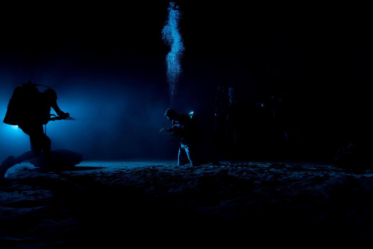
Test subjects performing subjective assessment of underwater lamp source during NBL Preliminary Lunar Lighting Evaluation. Divers at the Neutral Buoyancy Laboratory (NBL) in Houston are setting the stage for future Moonwalk training by simulating lunar lighting conditions. At the Lunar South Pole, the Sun will remain no more than a few degrees above the horizon, resulting in extremely long and dark shadows. To prepare astronauts for these challenging lighting conditions, the team at the NBL has begun preliminary evaluations of lunar lighting solutions at the bottom of the 40-foot deep pool. This testing and evaluation involved turning off all the lights in the facility, installing black curtains on the pool walls to minimize reflections, and using a powerful underwater cinematic lamp, to get the conditions just right ahead of upcoming training for astronauts.
Test subjects performing subjective assessment of underwater lamp source during NBL Preliminary Lunar Lighting Evaluation. Divers at the Neutral Buoyancy Laboratory (NBL) in Houston are setting the stage for future Moonwalk training by simulating lunar lighting conditions. At the Lunar South Pole, the Sun will remain no more than a few degrees above the horizon, resulting in extremely long and dark shadows. To prepare astronauts for these challenging lighting conditions, the team at the NBL has begun preliminary evaluations of lunar lighting solutions at the bottom of the 40-foot deep pool. This testing and evaluation involved turning off all the lights in the facility, installing black curtains on the pool walls to minimize reflections, and using a powerful underwater cinematic lamp, to get the conditions just right ahead of upcoming training for astronauts.
Test subjects performing subjective assessment of underwater lamp source during NBL Preliminary Lunar Lighting Evaluation. Divers at the Neutral Buoyancy Laboratory (NBL) in Houston are setting the stage for future Moonwalk training by simulating lunar lighting conditions. At the Lunar South Pole, the Sun will remain no more than a few degrees above the horizon, resulting in extremely long and dark shadows. To prepare astronauts for these challenging lighting conditions, the team at the NBL has begun preliminary evaluations of lunar lighting solutions at the bottom of the 40-foot deep pool. This testing and evaluation involved turning off all the lights in the facility, installing black curtains on the pool walls to minimize reflections, and using a powerful underwater cinematic lamp, to get the conditions just right ahead of upcoming training for astronauts.
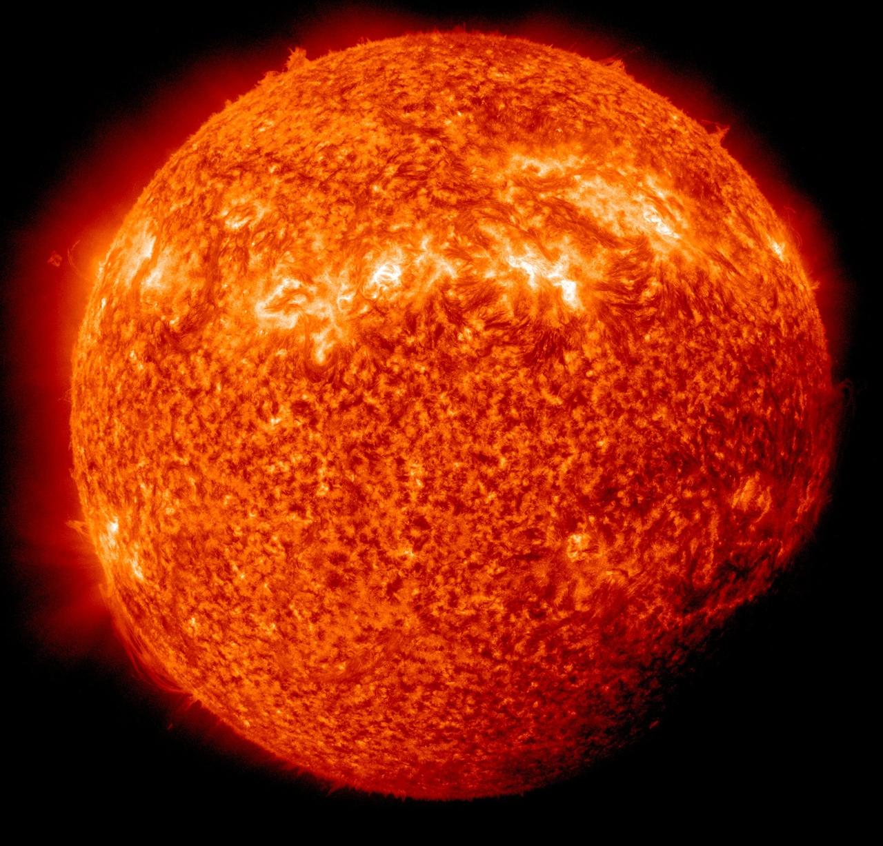
NASA image captured April 3, 2011 Twice a year, SDO enters an eclipse season where the spacecraft slips behind Earth for up to 72 minutes a day. Unlike the crisp shadow one sees on the sun during a lunar eclipse, Earth's shadow has a variegated edge due to its atmosphere, which blocks the sun light to different degrees depending on its density. Also, light from brighter spots on the sun may make it through, which is why some solar features extend low into Earth's shadow. Credit: NASA/GSFC/SDO <b><a href="http://www.nasa.gov/centers/goddard/home/index.html" rel="nofollow">NASA Goddard Space Flight Center</a></b> enables NASA’s mission through four scientific endeavors: Earth Science, Heliophysics, Solar System Exploration, and Astrophysics. Goddard plays a leading role in NASA’s accomplishments by contributing compelling scientific knowledge to advance the Agency’s mission. <b>Follow us on <a href="http://twitter.com/NASA_GoddardPix" rel="nofollow">Twitter</a></b> <b>Join us on <a href="http://www.facebook.com/pages/Greenbelt-MD/NASA-Goddard/395013845897?ref=tsd" rel="nofollow">Facebook</a></b>
Sometimes at Saturn you can see things almost as if from every angle at once, the way a Cubist might imagine things. For example, in this image, we're seeing Saturn's A ring in the lower part of the image and the limb of Saturn in the upper. In addition, the rings cast their shadows onto the portion of the planet imaged here, creating alternating patterns of light and dark. This pattern is visible even through the A ring, which, unlike the core of the nearby B ring, is not completely opaque. The ring shadows on Saturn often appear to cross the surface at confusing angles in close-ups like this one. The visual combination of Saturn's oblateness, the varying opacity of its rings and the shadows cast by those rings, sometimes creates elaborate and complicated patterns from Cassini's perspective. This view looks toward the sunlit side of the rings from about 19 degrees above the ringplane. The image was taken in visible light with the Cassini spacecraft narrow-angle camera on Dec. 5, 2014. The view was obtained at a distance of approximately 1.2 million miles (2 million kilometers) from Saturn. Image scale is 7 miles (11 kilometers) per pixel. http://photojournal.jpl.nasa.gov/catalog/PIA18303
ISS031-E-035310 (15 May 2012) --- Sunglint and clouds off Western South America are featured in this image photographed by an Expedition 31 crew member on the International Space Station. The setting sun highlights cloud patterns above the Pacific Ocean, as well as the ocean surface itself in this impressive image. The space station was located over the Andes Mountains of central Chile at the time. The view is looking towards the Pacific Ocean and the sun setting in the west (towards lower left). Light from the setting sun reflects off the water surface towards the observer on the space station and creates a mirror-like appearance—a phenomenon known as sunglint. Bands of relatively low altitude cumulus clouds appear much like a flotilla of ships with their west-facing sides illuminated by the waning sunlight and the rest in shadow (center). Due to the low sun angle, they cast long and deep shadows over large swaths of the ocean surface. Given the short camera lens used, an individual cloud shadow may extend for miles. Light gray clouds at upper right appear to be at a higher altitude. The cloud cover is likely a remnant of a frontal system that moved inland over South America from the Pacific a day or two prior to the time the image was taken.

NASA image captured April 2, 2011 Twice a year, SDO enters an eclipse season where the spacecraft slips behind Earth for up to 72 minutes a day. Unlike the crisp shadow one sees on the sun during a lunar eclipse, Earth's shadow has a variegated edge due to its atmosphere, which blocks the sun light to different degrees depending on its density. Also, light from brighter spots on the sun may make it through, which is why some solar features extend low into Earth's shadow. Credit: NASA/GSFC/SDO <b><a href="http://www.nasa.gov/centers/goddard/home/index.html" rel="nofollow">NASA Goddard Space Flight Center</a></b> enables NASA’s mission through four scientific endeavors: Earth Science, Heliophysics, Solar System Exploration, and Astrophysics. Goddard plays a leading role in NASA’s accomplishments by contributing compelling scientific knowledge to advance the Agency’s mission. <b>Follow us on <a href="http://twitter.com/NASA_GoddardPix" rel="nofollow">Twitter</a></b> <b>Join us on <a href="http://www.facebook.com/pages/Greenbelt-MD/NASA-Goddard/395013845897?ref=tsd" rel="nofollow">Facebook</a></b>
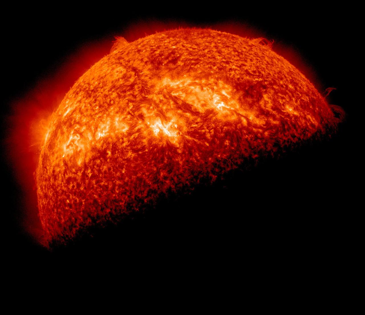
NASA image captured April 1, 2011 Twice a year, SDO enters an eclipse season where the spacecraft slips behind Earth for up to 72 minutes a day. Unlike the crisp shadow one sees on the sun during a lunar eclipse, Earth's shadow has a variegated edge due to its atmosphere, which blocks the sun light to different degrees depending on its density. Also, light from brighter spots on the sun may make it through, which is why some solar features extend low into Earth's shadow. Credit: NASA/GSFC/SDO <b><a href="http://www.nasa.gov/centers/goddard/home/index.html" rel="nofollow">NASA Goddard Space Flight Center</a></b> enables NASA’s mission through four scientific endeavors: Earth Science, Heliophysics, Solar System Exploration, and Astrophysics. Goddard plays a leading role in NASA’s accomplishments by contributing compelling scientific knowledge to advance the Agency’s mission. <b>Follow us on <a href="http://twitter.com/NASA_GoddardPix" rel="nofollow">Twitter</a></b> <b>Join us on <a href="http://www.facebook.com/pages/Greenbelt-MD/NASA-Goddard/395013845897?ref=tsd" rel="nofollow">Facebook</a></b>
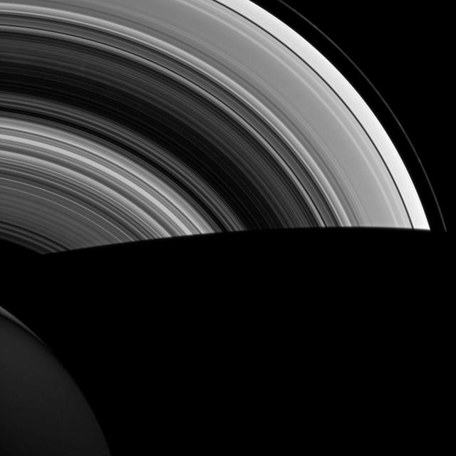
Both luminous and translucent, the C ring sweeps out of the darkness of Saturn's shadow and obscures the planet at lower left. The ring is characterized by broad, isolated bright areas, or "plateaus," surrounded by fainter material. This view looks toward the unlit side of the rings from about 19 degrees above the ringplane. North on Saturn is up. The dark, inner B ring is seen at lower right. The image was taken in visible light with the Cassini spacecraft wide-angle camera on Dec. 15, 2006 at a distance of approximately 632,000 kilometers (393,000 miles) from Saturn and at a Sun-Saturn-spacecraft, or phase, angle of 56 degrees. Image scale is 34 kilometers (21 miles) per pixel. http://photojournal.jpl.nasa.gov/catalog/PIA08855
As Saturn's northern hemisphere summer approaches, the shadows of the rings creep ever southward across the planet. Here, the ring shadows appear to obscure almost the entire southern hemisphere, while the planet's north pole and its six-sided jet stream, known as "the hexagon," are fully illuminated by the sun. When NASA's Cassini spacecraft arrived at Saturn 12 years ago, the shadows of the rings lay far to the north on the planet (see PIA06077). As the mission progressed and seasons turned on the slow-orbiting giant, equinox arrived and the shadows of the rings became a thin line at the equator (see PIA11667). This view looks toward the sunlit side of the rings from about 16 degrees above the ring plane. The image was taken in red light with the Cassini spacecraft wide-angle camera on March 19, 2016. The view was obtained at a distance of approximately 1.7 million miles (2.7 million kilometers) from Saturn and at a Sun-Saturn-spacecraft, or phase, angle of 92 degrees. Image scale is 100 miles (160 kilometers) per pixel. http://photojournal.jpl.nasa.gov/catalog/PIA20486
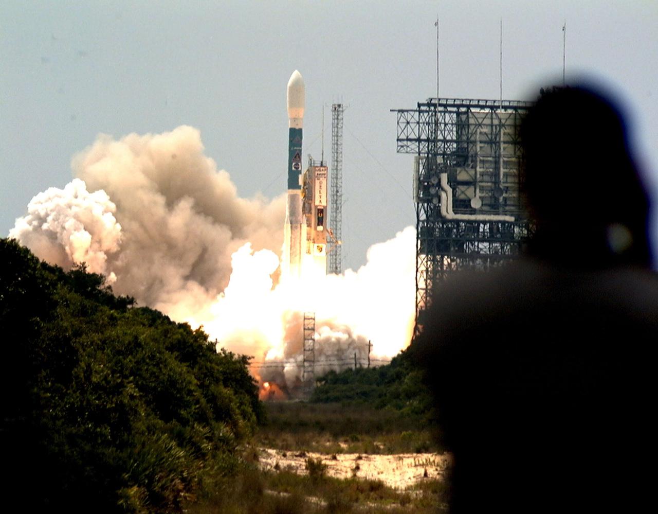
The shadow of a photographer (right) is caught watching the perfect launch of the Boeing Delta II rocket in the background after it lifted off at 11:44 a.m. EDT. The rocket carries NASA's Far Ultraviolet Spectroscopic Explorer (FUSE) satellite, which was developed to investigate the origin and evolution of the lightest elements in the universe hydrogen and deuterium. In addition, the FUSE satellite will examine the forces and process involved in the evolution of the galaxies, stars and planetary systems by investigating light in the far ultraviolet portion of the electromagnetic spectrum
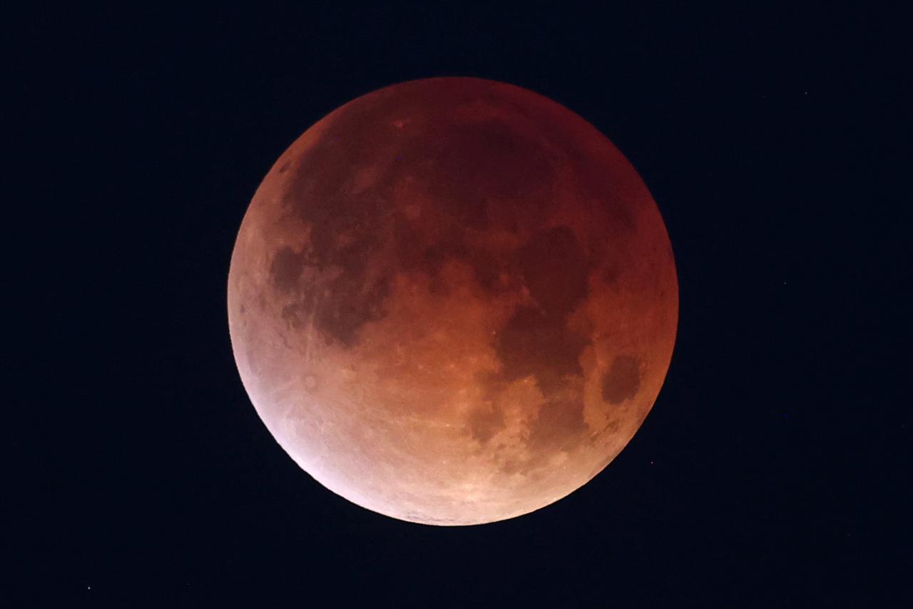
A total lunar eclipse rises over New Orleans, home of NASA’s Michoud Assembly Facility, in the early morning hours of Tuesday, March 3. A lunar eclipse occurs when Earth passes directly between the Sun and Moon, casting a huge shadow across the Moon’s surface. The Moon appears dark red or orange as the Sun’s light filters through Earth’s atmosphere. Image credit: NASA/Michael DeMocker
A total lunar eclipse rises over New Orleans, home of NASA’s Michoud Assembly Facility, in the early morning hours of Tuesday, March 3. A lunar eclipse occurs when Earth passes directly between the Sun and Moon, casting a huge shadow across the Moon’s surface. The Moon appears dark red or orange as the Sun’s light filters through Earth’s atmosphere. Image credit: NASA/Michael DeMocker

A total lunar eclipse rises over New Orleans, home of NASA’s Michoud Assembly Facility, in the early morning hours of Tuesday, March 3. A lunar eclipse occurs when Earth passes directly between the Sun and Moon, casting a huge shadow across the Moon’s surface. The Moon appears dark red or orange as the Sun’s light filters through Earth’s atmosphere. This is a composite of 4 images taken during the eclipse.
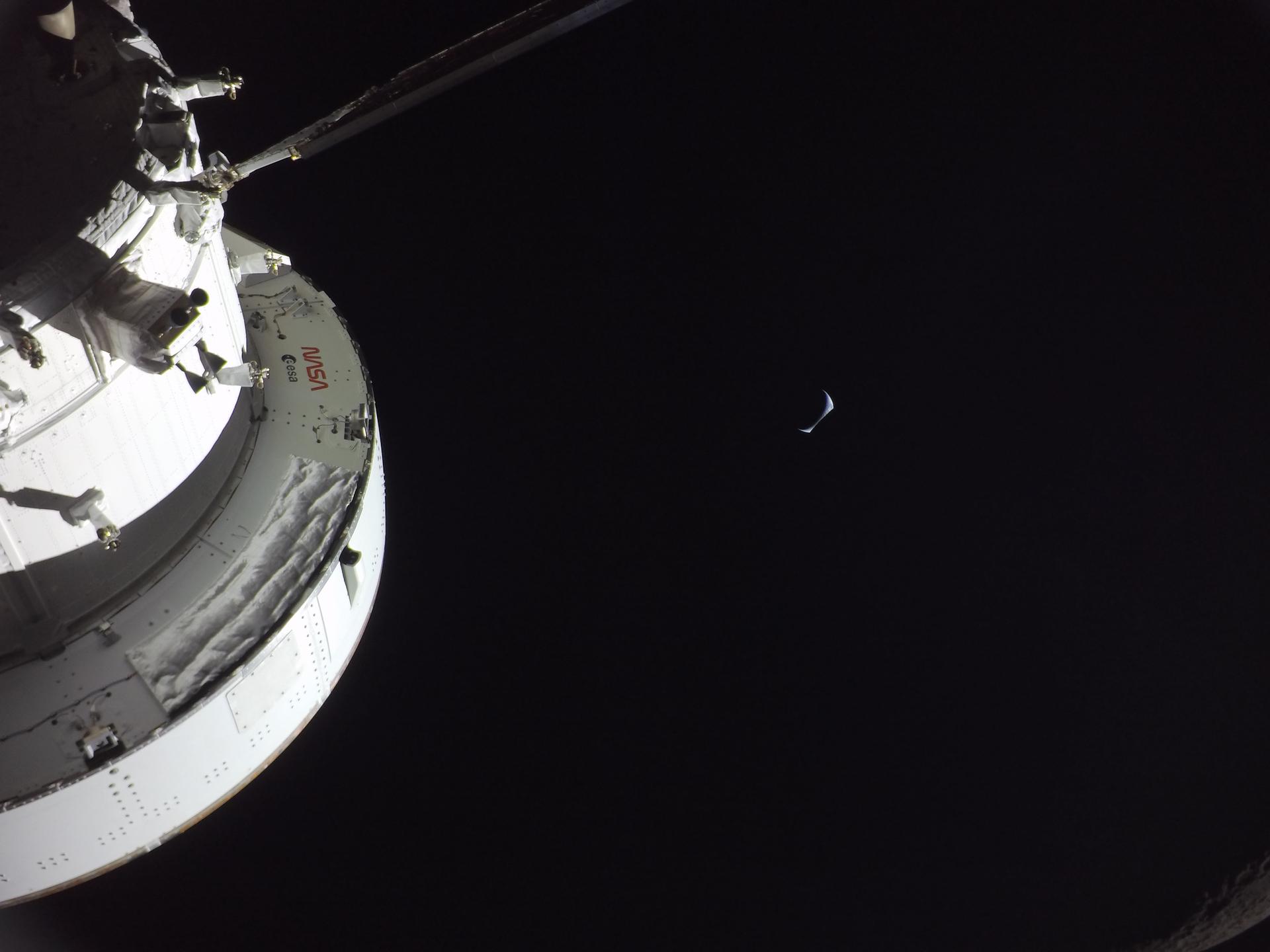
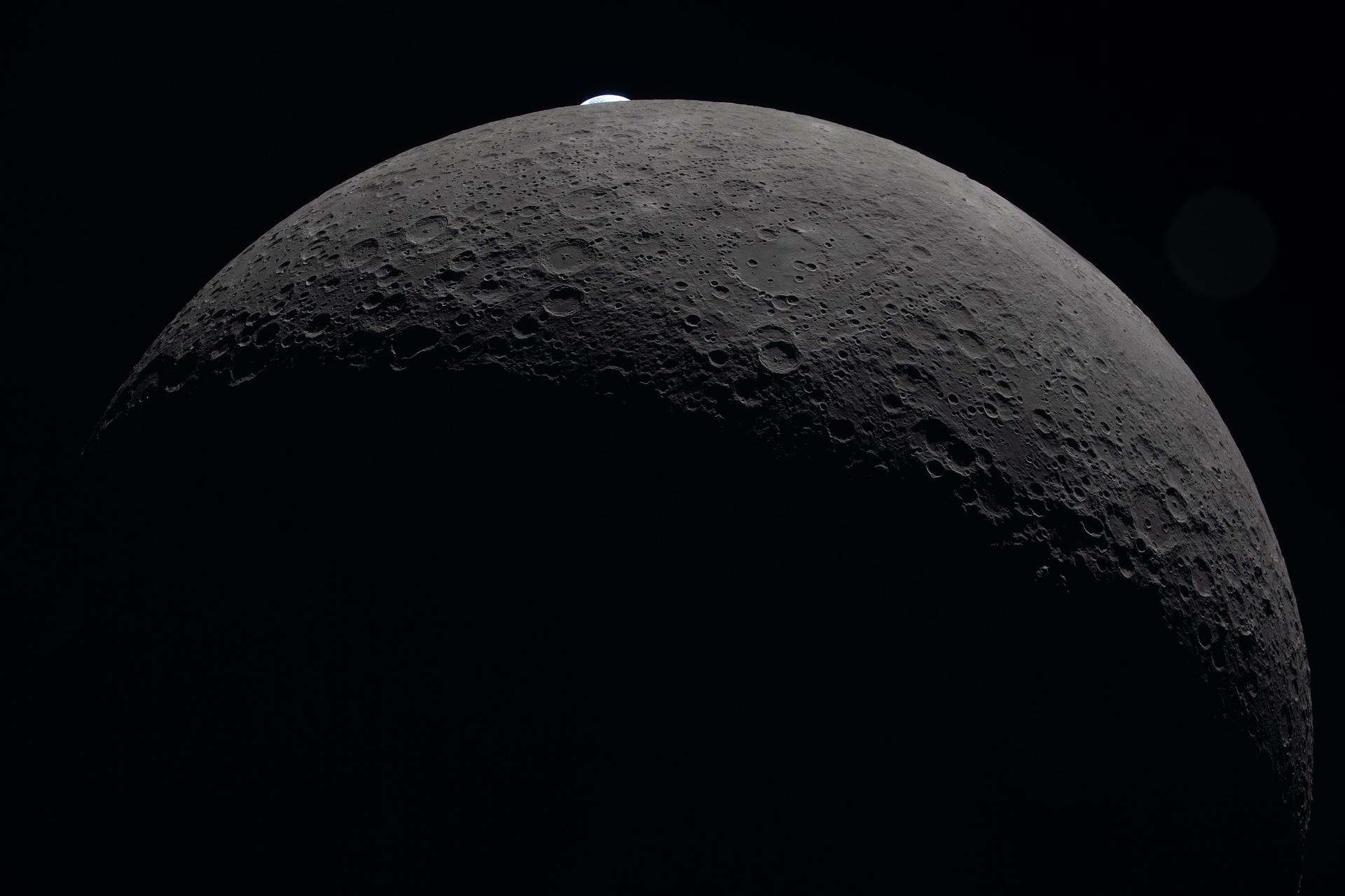
art002e016299 (April 6, 2026) - Earthrise captured from a camera mounted on one of the Orion spacecraft’s solar array wings at 7:22 p.m. ET during the Artemis II crew’s flyby of the Moon’s far side. Earth appears as a delicate sliver - with the portion on the left darkened by shadow and a portion on the right tucking away behind the Moon. A closer look reveals that the Moon occupies the bottom right portion of the photo, identifiable by the edge of it seen in visible light near the bottom corner. Credit: NASA
art002e020686 (April 6, 2026) – A portion of the Moon’s farside is seen along the terminator—the boundary between lunar day and night—where low-angle sunlight casts long shadows across the surface. A section of Orientale Basin is visible along the upper right portion of the lunar disk, its structure subtly revealed under grazing illumination. This lighting enhances contrast across the cratered terrain, highlighting variations in surface features and providing insight into the Moon’s geologic history. Credit: NASA
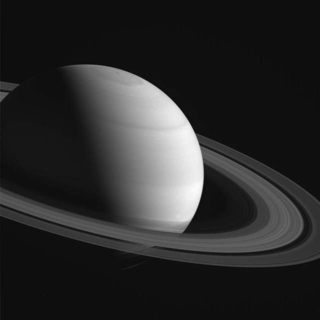
NASA's Cassini spacecraft looks down at the rings of Saturn from above the planet's nightside. The darkened globe of Saturn is seen here at lower right, along with the shadow it casts across the rings. The image shows that even on the planet's night side, the rings remain in sunlight, apart from the portion that lies within Saturn's shadow. The rings also reflect sunlight back onto the night side of the planet, making it appear brighter than it would otherwise appear. Saturn's small moon Prometheus (53 miles or 86 kilometers across) is faintly visible as a speck near upper left. The shadow of Saturn was once long enough to stretch to the orbit of Prometheus. But as northern summer solstice approaches, Saturn's shadow no longer reaches that far (see PIA20498). So Prometheus will not move into the darkness of the planet's shadow until the march of the seasons again causes the shadow to lengthen. This view looks toward the sunlit side of the rings from about 41 degrees above the ring plane. The image was taken in visible light with the Cassini spacecraft wide-angle camera on Aug. 14, 2016. The view was obtained at a distance of approximately 870,000 miles (1.4 million kilometers) from Saturn and at a Sun-Saturn-spacecraft, or phase, angle of 87 degrees. Image scale is 53 miles (86 kilometers) per pixel. Prometheus has been brightened by a factor of two to enhance its visibility. http://photojournal.jpl.nasa.gov/catalog/PIA20505

ISS040-E-124198 (6 Sept. 2014) --- Puget Sound is partly reflecting the sun in this detailed image taken by an Expedition 40 crew member on the International Space Station. Patterns of boat wakes are prominent in the sun’s partial reflection zone. The difference between the boat wakes in this view relates to the speed of the boat and the particular patterns (of several) that happen to be captured in the specific light reflection angles at the time the image was taken. The land areas show parts of Seattle. The darkest areas with rectangular grids are suburbs richly covered with trees. The broadly gray zones of the central city (bottom center) are brighter where structures are lower, as in the harbor zone (Harbor Island), and darker where the shadows of high-rise buildings downtown cast black shadows. Interstate Highway 5 bisects downtown.
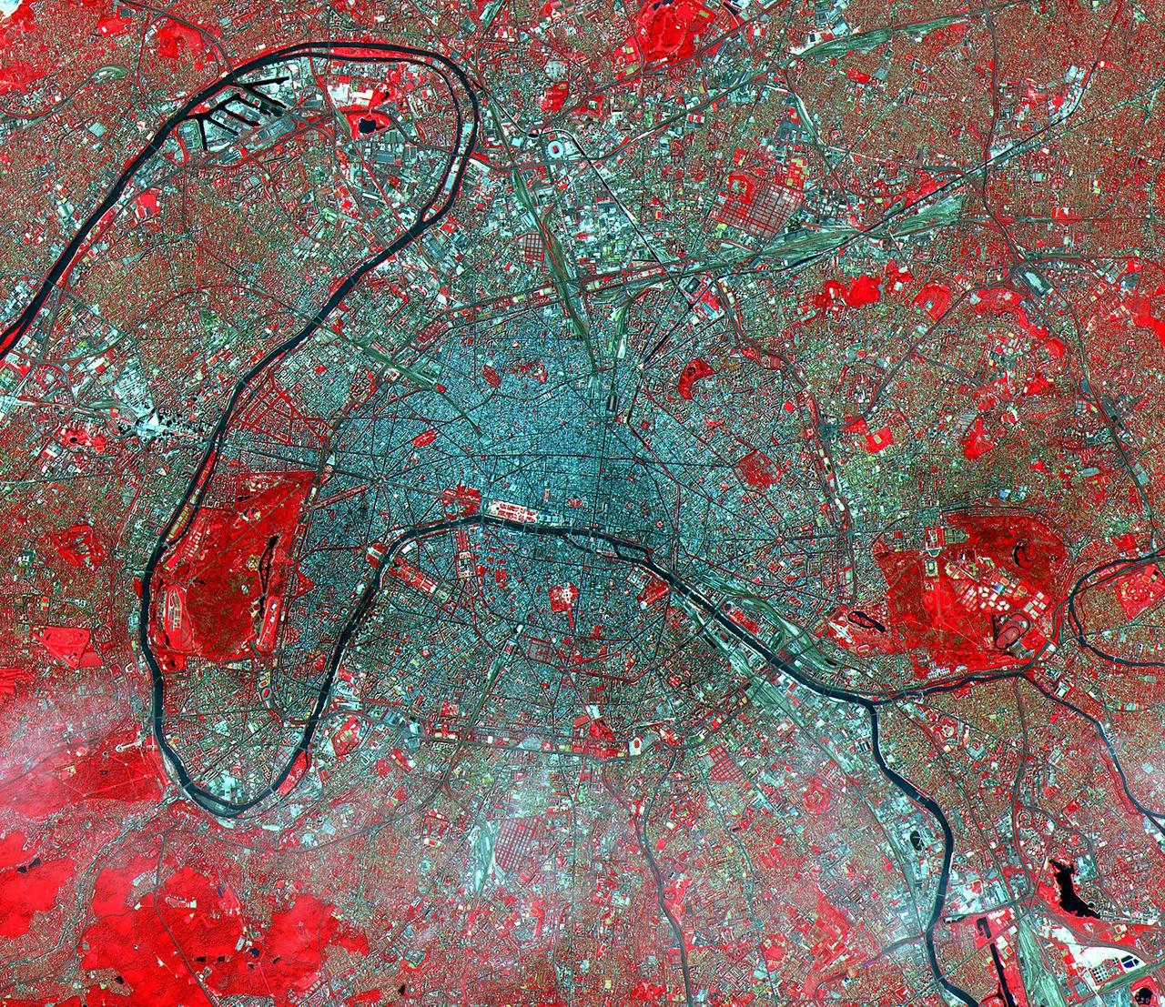
The Eiffel Tower and its shadow can be seen next to the Seine in the left middle of this ASTER image of Paris. Based on the length of the shadow and the solar elevation angle of 59 degrees, we can calculate its height as 324 meters (1,054 feet), compared to its actual height of 303 meters (985 feet). Acquired on July 23, 2000, this image covers an area 23 kilometers (15 miles) wide and 20 kilometers (13 miles) long in three bands of the reflected visible and infrared wavelength region. Known as the City of Light, Paris has been extolled for centuries as one of the great cities of the world. Its location on the Seine River, at a strategic crossroads of land and river routes, has been the key to its expansion since the Parisii tribe first settled here in the 3rd century B.C. http://photojournal.jpl.nasa.gov/catalog/PIA02660
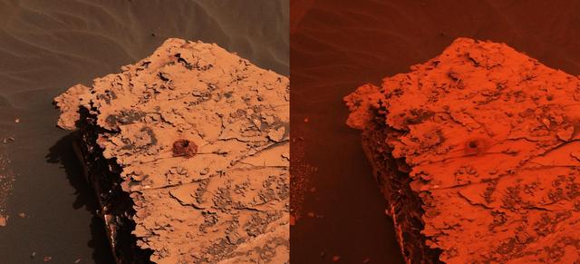
Two images from the Mast Camera (Mastcam) on NASA's Curiosity rover depict the change in the color of light illuminating the Martian surface since a dust storm engulfed Gale Crater. The left image shows the "Duluth" drill site on Sol 2058 (May 21, 2018); the right image is from Sol 2084 (June 17). The cherry red color in the post-storm image is due to a few factors. One difference between the two images is exposure time: the dust over Curiosity creates low-lighting conditions that require longer exposure times for the cameras. The pre-storm image had an exposure time of 7.3 milliseconds, which is normal for the rover; the later image had an exposure time that was 66 milliseconds -- or nine times longer. But a primary factor is red light being filtered through the dust; very little green and essentially no blue light makes it through the dust cloud. It's not unlike the way a forest fire changes the color of light, or a red stage light filters the other colors out. Though the first pre-storm image was taken at an earlier time of day, it has a much deeper shadow than the second image. That is because the whole sky is red and illuminating the rock from all sides. Individual images are available at https://photojournal.jpl.nasa.gov/catalog/PIA22330
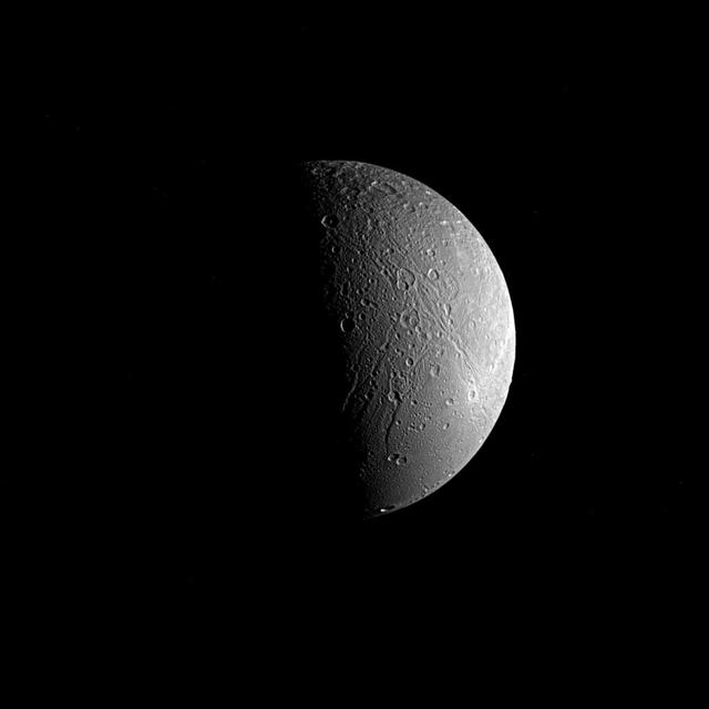
Saturn's moon Dione is captured in this view from NASA's Cassini spacecraft, half in shadow and half in light. Sinuous canyons carve interconnected paths across the moon's icy landscape. Subtle variations in brightness hint at differences in composition, as well as the size and shape of grains in Dione's surface material, or regolith. Cassini spent more than a decade at Saturn studying Dione (698 miles or 1,123 kilometers across) and the planet's many other moons as part of the quest to understand how the moons formed and evolved, and how they are connected. This view looks toward the side of Dione that faces away from Saturn. North is up and rotated 59 degrees to the right. The image was taken in visible light with the Cassini spacecraft narrow-angle camera on June 22, 2017. The view was obtained at a distance of approximately 224,000 miles (360,000 kilometers) from Dione. Image scale is 1.4 mile (2.2 kilometers) per pixel. The Cassini spacecraft ended its mission on Sept. 15, 2017. https://photojournal.jpl.nasa.gov/catalog/PIA21349
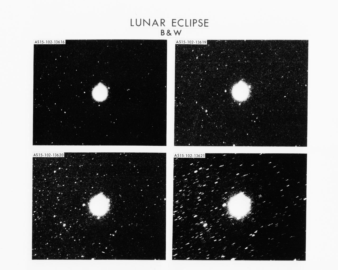
S71-58222 (31 July-2 Aug. 1971) --- During the lunar eclipse that occurred during the Apollo 15 lunar landing mission, astronaut Alfred M. Worden, command module pilot, used a 35mm Nikon camera to obtain a series of 15 photographs while the moon was entering and exiting Earth's umbra. Although it might seem that there should be no light on the moon when it is in Earth's shadow, sunlight is scattered into this region by Earth's atmosphere. This task was an attempt to measure by photographic photometry the amount of scattered light reaching the moon. The four views from upper left to lower right were selected to show the moon as it entered Earth's umbra. The first is a four-second exposure which was taken at the moment when the moon had just entered umbra; the second is a 15-second exposure taken two minutes after entry; the third, a 30-second exposure three minutes after entry; and the fourth is a 60-second exposure four minutes after entry. In all cases the light reaching the moon was so bright on the very high speed film (Eastman Kodak type 2485 emulsion) that the halation obscures the lunar image, which should be about one-third as big as the circle of light. The background star field is clearly evident, and this is very important for these studies. The spacecraft was in full sunlight when these photographs were taken, and it was pointed almost directly away from the sun so that the windows and a close-in portion of the camera's line-of-sight were in shadow. The environment around the vehicle at this time appears to be very "clean" with no light scattering particles noticeable.
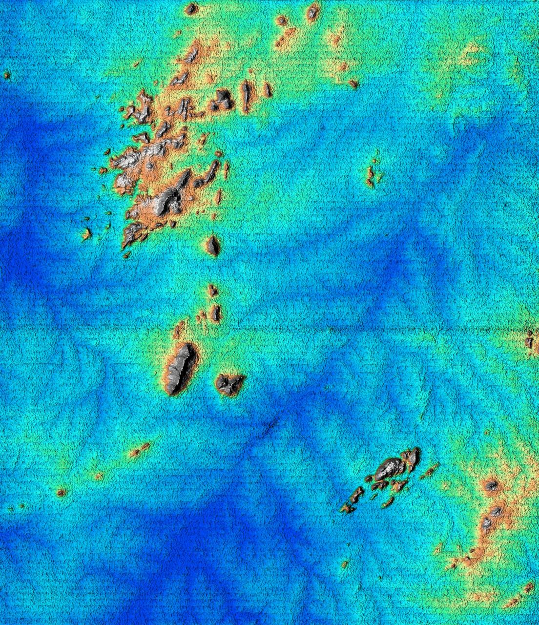
This topographic image acquired by SRTM shows an area south of the Sao Francisco River in Brazil. The scrub forest terrain shows relief of about 400 meters (1300 feet). Areas such as these are difficult to map by traditional methods because of frequent cloud cover and local inaccessibility. This region has little topographic relief, but even subtle changes in topography have far-reaching effects on regional ecosystems. The image covers an area of 57 km x 79 km and represents one quarter of the 225 km SRTM swath. Colors range from dark blue at water level to white and brown at hill tops. The terrain features that are clearly visible in this image include tributaries of the Sao Francisco, the dark-blue branch-like features visible from top right to bottom left, and on the left edge of the image, and hills rising up from the valley floor. The San Francisco River is a major source of water for irrigation and hydroelectric power. Mapping such regions will allow scientists to better understand the relationships between flooding cycles, forestation and human influences on ecosystems. This shaded relief image was generated using topographic data from the Shuttle Radar Topography Mission. A computer-generated artificial light source illuminates the elevation data to produce a pattern of light and shadows. Slopes facing the light appear bright, while those facing away are shaded. On flatter surfaces, the pattern of light and shadows can reveal subtle features in the terrain. Shaded relief maps are commonly used in applications such as geologic mapping and land use planning. http://photojournal.jpl.nasa.gov/catalog/PIA02700
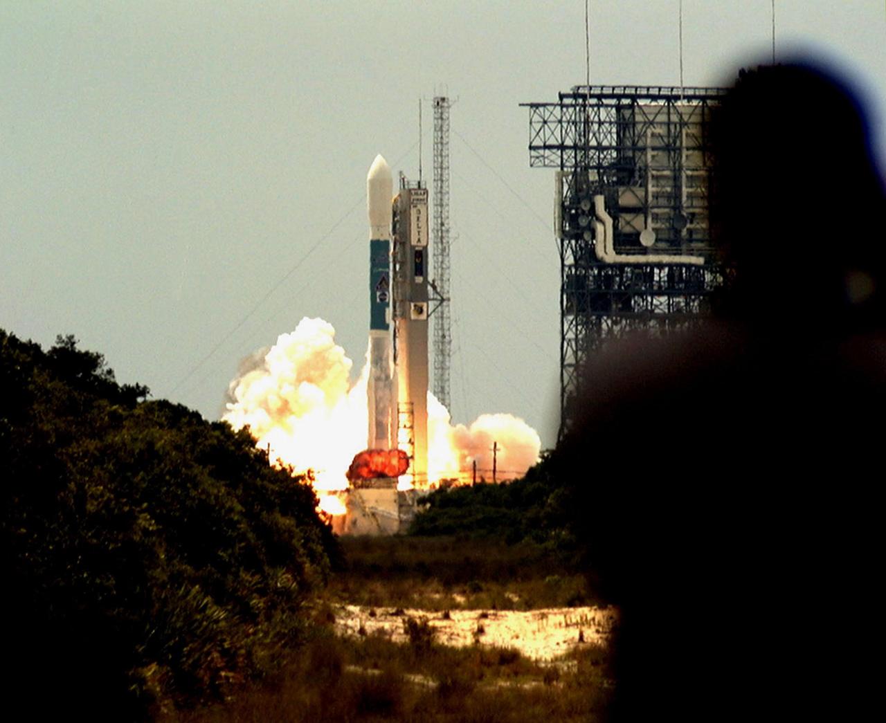
KENNEDY SPACE CENTER, FLA. -- A fireball erupts under the Boeing Delta II rocket, amid clouds of smoke and steam, as it lifts off from Launch Pad 17A, Cape Canaveral Air Station, at 11:44 a.m. EDT. The shadow of a photographer (right) is caught watching the perfect launch. The rocket carries NASA's Far Ultraviolet Spectroscopic Explorer (FUSE) satellite, which was developed to investigate the origin and evolution of the lightest elements in the universe hydrogen and deuterium. In addition, the FUSE satellite will examine the forces and process involved in the evolution of the galaxies, stars and planetary systems by investigating light in the far ultraviolet portion of the electromagnetic spectrum
S90-29047 99Jan 1990) --- At the conclusion of another successful countdown, members of the KSC launch team in Firing Room 1 rivet their eyes on the skies to the east of the Launch Control Center. Their reward was a glimpse of Columbia burning its way upward up from Complex 39's Pad A. The brilliant flame of the boosters hurled shadows and patches of light into the firing room's interior. Launch of the STS-32 mission at 7:35 a.m. EST today marked the beginning of a busy year which could see the launch of as many as 10 missions.
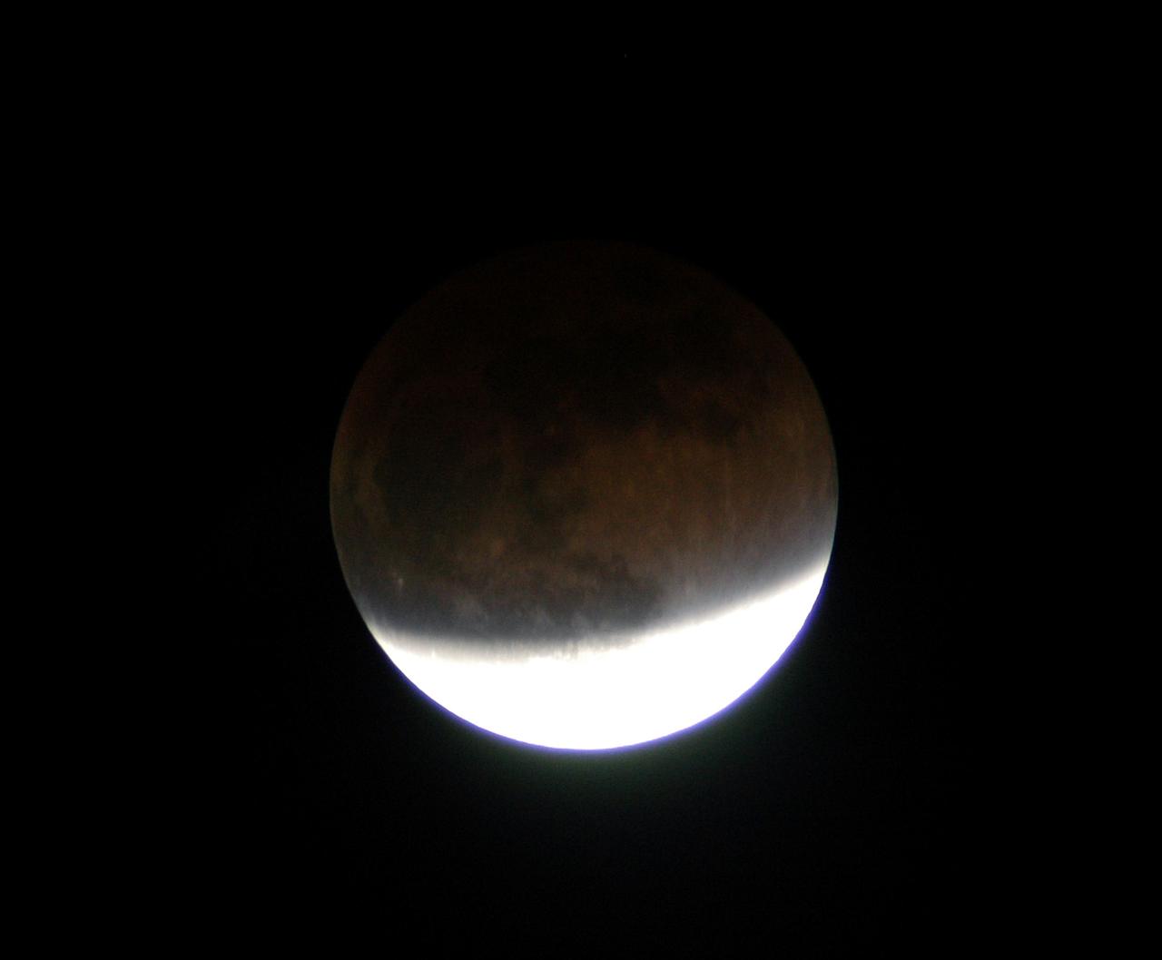
KENNEDY SPACE CENTER, FLA. - In this lunar eclipse viewed from Merritt Island, Fla., the full moon changes color because it is being lighted slightly by sunlight passing through the Earth’s atmosphere. The earlier reddish color is fading but still somewhat visible on the darker, upper portion. Eclipses occur when the Sun, Earth and Moon line up. They are rare because the Moon usually passes above or below the imaginary line connecting Earth and the Sun. The Earth casts a shadow that the Moon can pass through - when it does, it is called a lunar eclipse.
Atmospheric features in Saturn's north polar region are revealed in spectacular detail in this Cassini image, taken in the near infrared spectral region, where methane gas is not very absorbing. The dark shadows of Saturn's rings drape across the planet, creating the illusion of atmospheric bands. Dots of bright clouds give the appearance that this is an active place. The image was taken with the Cassini spacecraft wide angle camera on Dec. 14, 2004, at a distance of 717,800 kilometers (446,100 miles) from Saturn through a filter sensitive to wavelengths of infrared light centered at 939 nanometers. The image scale is about 43 kilometers (27 miles) per pixel. http://photojournal.jpl.nasa.gov/catalog/PIA06567
Saturn's rings, made of countless icy particles, form a translucent veil in this view from NASA's Cassini spacecraft. Saturn's tiny moon Pan, about 17 miles (28 kilometers) across, orbits within the Encke Gap in the A ring. Beyond, we can see the arc of Saturn itself, its cloud tops streaked with dark shadows cast by the rings. This image was taken in visible light with the Cassini spacecraft narrow-angle camera on Feb. 12, 2016, at a distance of approximately 746,000 miles (1.2 million kilometers) from Pan. The Cassini spacecraft ended its mission on Sept. 15, 2017. https://photojournal.jpl.nasa.gov/catalog/PIA21901
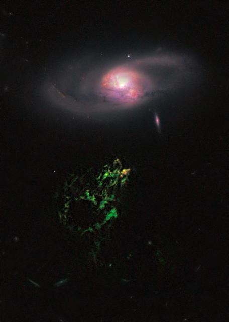
NASA image release January 10, 2011 In this image by NASA's Hubble Space Telescope, an unusual, ghostly green blob of gas appears to float near a normal-looking spiral galaxy. The bizarre object, dubbed Hanny's Voorwerp (Hanny's Object in Dutch), is the only visible part of a 300,000-light-year-long streamer of gas stretching around the galaxy, called IC 2497. The greenish Voorwerp is visible because a searchlight beam of light from the galaxy's core illuminated it. This beam came from a quasar, a bright, energetic object that is powered by a black hole. The quasar may have turned off about 200,000 years ago. This Hubble view uncovers a pocket of star clusters, the yellowish-orange area at the tip of Hanny's Voorwerp. The star clusters are confined to an area that is a few thousand light-years wide. The youngest stars are a couple of million years old. The Voorwerp is the size of our Milky Way galaxy, and its bright green color is from glowing oxygen. Hubble also shows that gas flowing from IC 2497 may have instigated the star birth by compressing the gas in Hanny's Voorwerp. The galaxy is located about 650 million light-years from Earth. What appears to be a gaping hole in Hanny's Voorwerp actually may be a shadow cast by an object in the quasar's light path. The feature gives the illusion of a hole about 20,000 light-years wide. Hubble reveals sharp edges but no other changes in the gas around the apparent opening, suggesting that an object close to the quasar may have blocked some of the light and projected a shadow on the Voorwerp. This phenomenon is similar to a fly on a movie projector lens casting a shadow on a movie screen. An interaction between IC 2497 and another galaxy about a billion years ago may have created Hanny's Voorwerp and fueled the quasar. The Hubble image shows that IC 2497 has been disturbed, with complex dust patches, warped spiral arms, and regions of star formation around its core. These features suggest the aftermath of a galaxy merger. The bright spots in the central part of the galaxy are star-forming regions. The small, pinkish object to the lower right of IC 2497 is an edge-on spiral galaxy in the background. The image was made by combining data from the Advanced Camera for Surveys (ACS) and the Wide Field Camera 3 (WFC3). The ACS exposures were taken April 12, 2010; the WFC3 data, April 4, 2010. Object Names: Hanny's Voorwerp, IC 2497 Image Type: Astronomical Credit: NASA, ESA, W. Keel (University of Alabama), and the Galaxy Zoo Team <b><a href="http://www.nasa.gov/centers/goddard/home/index.html" rel="nofollow">NASA Goddard Space Flight Center</a></b> enables NASA’s mission through four scientific endeavors: Earth Science, Heliophysics, Solar System Exploration, and Astrophysics. Goddard plays a leading role in NASA’s accomplishments by contributing compelling scientific knowledge to advance the Agency’s mission. <b>Follow us on <a href="http://twitter.com/NASA_GoddardPix" rel="nofollow">Twitter</a></b> <b>Join us on <a href="http://www.facebook.com/pages/Greenbelt-MD/NASA-Goddard/395013845897?ref=tsd" rel="nofollow">Facebook</a></b>

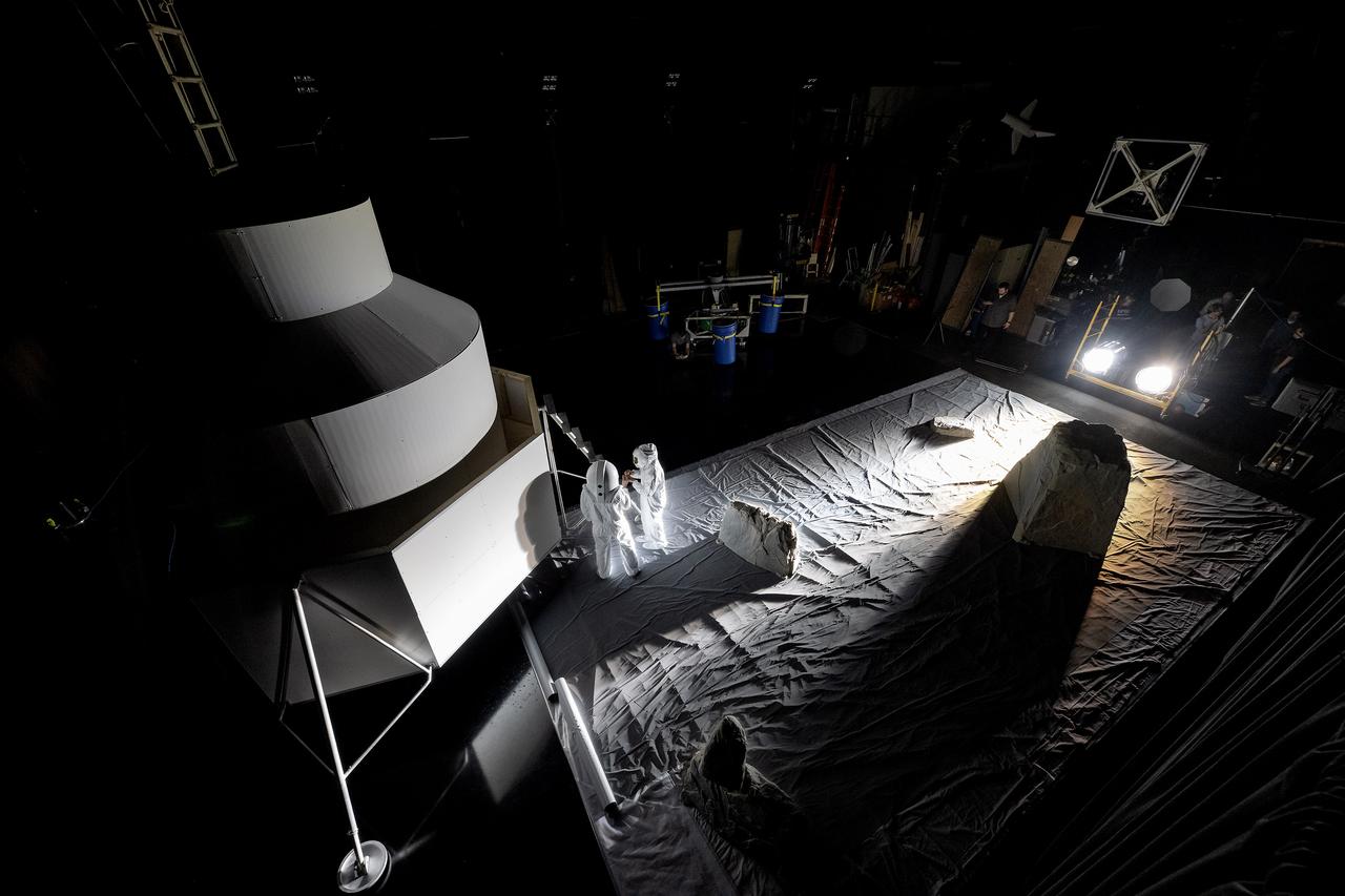
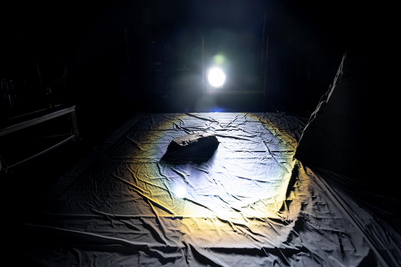
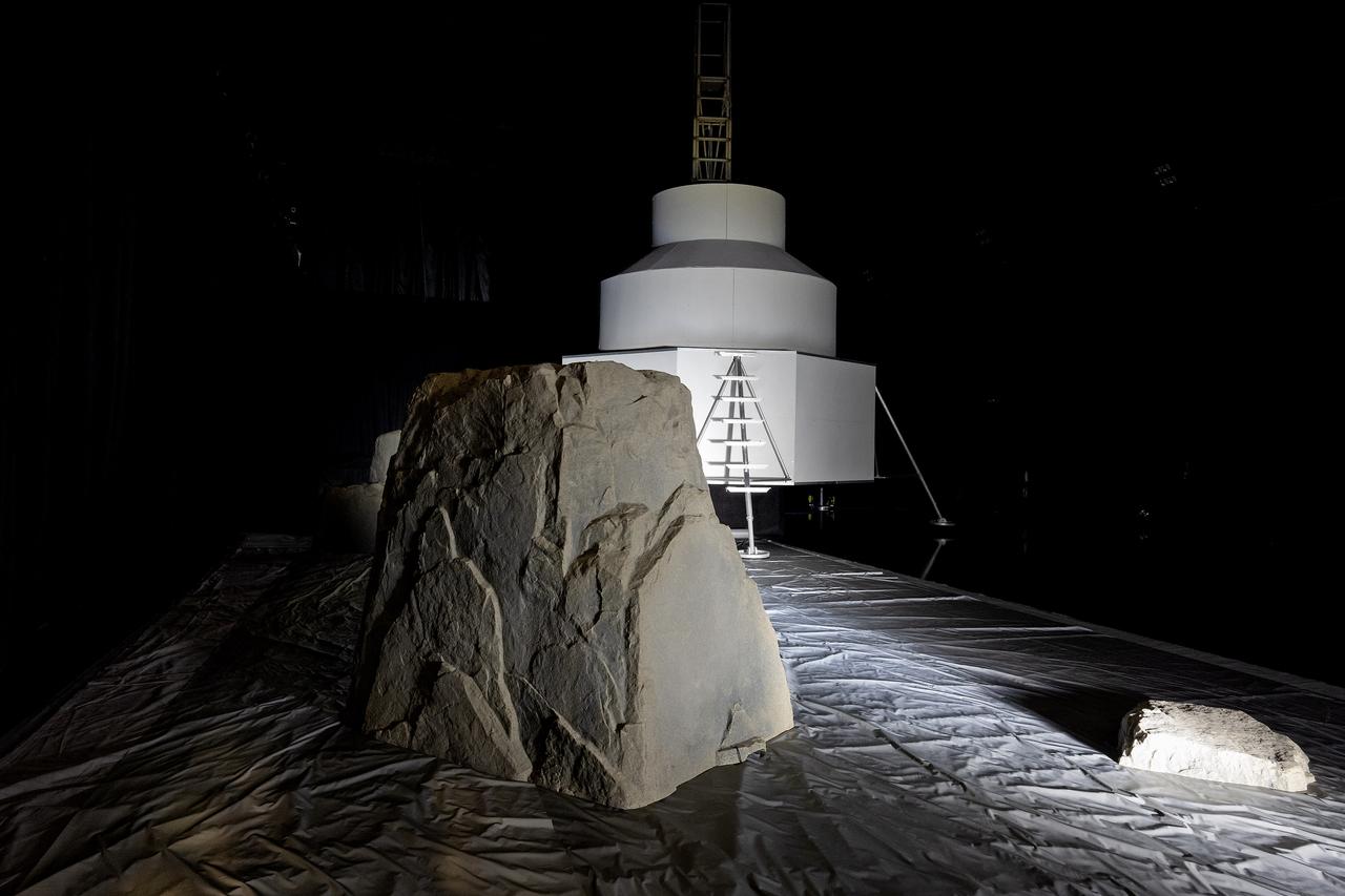
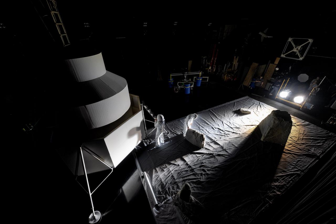
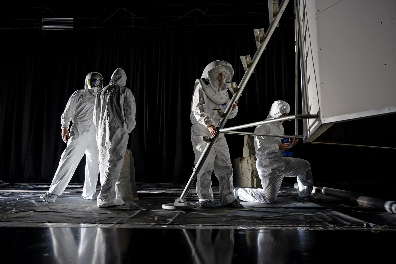
These photos show how teams at NASA’s Marshall Space Flight Center in Huntsville, Alabama, are using the Flat Floor Facility (Building 4619) to understand the lunar lighting environment in preparation for the Artemis III crewed lunar landing mission, slated for 2027. The Flat Floor Facility is an air-bearing floor, providing full-scale simulation capabilities for lunar surface systems by simulating zero gravity in two dimensions. Wearing low-fidelity materials, test engineers can understand how the extreme lighting of the Moon’s South Pole could affect surface operations during Artemis III. High-intensity lights are positioned at a low angle to replicate the strong shadows that are cast across the lunar South Pole by the Sun. Data and analysis from testing at NASA Marshall are improving models Artemis astronauts will use in preparation for lander and surface operations on the Moon during Artemis III. Testing in the facility is also helping cross-agency teams evaluate various tools astronauts may use. NASA Marshall manages the Human Landing System (HLS) Program. For more information, contact NASA Marshall’s Office of Communications at 256-544-0034.
These photos show how teams at NASA’s Marshall Space Flight Center in Huntsville, Alabama, are using the Flat Floor Facility (Building 4619) to understand the lunar lighting environment in preparation for the Artemis III crewed lunar landing mission, slated for 2027. The Flat Floor Facility is an air-bearing floor, providing full-scale simulation capabilities for lunar surface systems by simulating zero gravity in two dimensions. Wearing low-fidelity materials, test engineers can understand how the extreme lighting of the Moon’s South Pole could affect surface operations during Artemis III. High-intensity lights are positioned at a low angle to replicate the strong shadows that are cast across the lunar South Pole by the Sun. Data and analysis from testing at NASA Marshall are improving models Artemis astronauts will use in preparation for lander and surface operations on the Moon during Artemis III. Testing in the facility is also helping cross-agency teams evaluate various tools astronauts may use. NASA Marshall manages the Human Landing System (HLS) Program. For more information, contact NASA Marshall’s Office of Communications at 256-544-0034.
These photos show how teams at NASA’s Marshall Space Flight Center in Huntsville, Alabama, are using the Flat Floor Facility (Building 4619) to understand the lunar lighting environment in preparation for the Artemis III crewed lunar landing mission, slated for 2027. The Flat Floor Facility is an air-bearing floor, providing full-scale simulation capabilities for lunar surface systems by simulating zero gravity in two dimensions. Wearing low-fidelity materials, test engineers can understand how the extreme lighting of the Moon’s South Pole could affect surface operations during Artemis III. High-intensity lights are positioned at a low angle to replicate the strong shadows that are cast across the lunar South Pole by the Sun. Data and analysis from testing at NASA Marshall are improving models Artemis astronauts will use in preparation for lander and surface operations on the Moon during Artemis III. Testing in the facility is also helping cross-agency teams evaluate various tools astronauts may use. NASA Marshall manages the Human Landing System (HLS) Program. For more information, contact NASA Marshall’s Office of Communications at 256-544-0034.
These photos show how teams at NASA’s Marshall Space Flight Center in Huntsville, Alabama, are using the Flat Floor Facility (Building 4619) to understand the lunar lighting environment in preparation for the Artemis III crewed lunar landing mission, slated for 2027. The Flat Floor Facility is an air-bearing floor, providing full-scale simulation capabilities for lunar surface systems by simulating zero gravity in two dimensions. Wearing low-fidelity materials, test engineers can understand how the extreme lighting of the Moon’s South Pole could affect surface operations during Artemis III. High-intensity lights are positioned at a low angle to replicate the strong shadows that are cast across the lunar South Pole by the Sun. Data and analysis from testing at NASA Marshall are improving models Artemis astronauts will use in preparation for lander and surface operations on the Moon during Artemis III. Testing in the facility is also helping cross-agency teams evaluate various tools astronauts may use. NASA Marshall manages the Human Landing System (HLS) Program. For more information, contact NASA Marshall’s Office of Communications at 256-544-0034.
These photos show how teams at NASA’s Marshall Space Flight Center in Huntsville, Alabama, are using the Flat Floor Facility (Building 4619) to understand the lunar lighting environment in preparation for the Artemis III crewed lunar landing mission, slated for 2027. The Flat Floor Facility is an air-bearing floor, providing full-scale simulation capabilities for lunar surface systems by simulating zero gravity in two dimensions. Wearing low-fidelity materials, test engineers can understand how the extreme lighting of the Moon’s South Pole could affect surface operations during Artemis III. High-intensity lights are positioned at a low angle to replicate the strong shadows that are cast across the lunar South Pole by the Sun. Data and analysis from testing at NASA Marshall are improving models Artemis astronauts will use in preparation for lander and surface operations on the Moon during Artemis III. Testing in the facility is also helping cross-agency teams evaluate various tools astronauts may use. NASA Marshall manages the Human Landing System (HLS) Program. For more information, contact NASA Marshall’s Office of Communications at 256-544-0034.

These photos show how teams at NASA’s Marshall Space Flight Center in Huntsville, Alabama, are using the Flat Floor Facility (Building 4619) to understand the lunar lighting environment in preparation for the Artemis III crewed lunar landing mission, slated for 2027. The Flat Floor Facility is an air-bearing floor, providing full-scale simulation capabilities for lunar surface systems by simulating zero gravity in two dimensions. Wearing low-fidelity materials, test engineers can understand how the extreme lighting of the Moon’s South Pole could affect surface operations during Artemis III. High-intensity lights are positioned at a low angle to replicate the strong shadows that are cast across the lunar South Pole by the Sun. Data and analysis from testing at NASA Marshall are improving models Artemis astronauts will use in preparation for lander and surface operations on the Moon during Artemis III. Testing in the facility is also helping cross-agency teams evaluate various tools astronauts may use. NASA Marshall manages the Human Landing System (HLS) Program. For more information, contact NASA Marshall’s Office of Communications at 256-544-0034.
These photos show how teams at NASA’s Marshall Space Flight Center in Huntsville, Alabama, are using the Flat Floor Facility (Building 4619) to understand the lunar lighting environment in preparation for the Artemis III crewed lunar landing mission, slated for 2027. The Flat Floor Facility is an air-bearing floor, providing full-scale simulation capabilities for lunar surface systems by simulating zero gravity in two dimensions. Wearing low-fidelity materials, test engineers can understand how the extreme lighting of the Moon’s South Pole could affect surface operations during Artemis III. High-intensity lights are positioned at a low angle to replicate the strong shadows that are cast across the lunar South Pole by the Sun. Data and analysis from testing at NASA Marshall are improving models Artemis astronauts will use in preparation for lander and surface operations on the Moon during Artemis III. Testing in the facility is also helping cross-agency teams evaluate various tools astronauts may use. NASA Marshall manages the Human Landing System (HLS) Program. For more information, contact NASA Marshall’s Office of Communications at 256-544-0034.
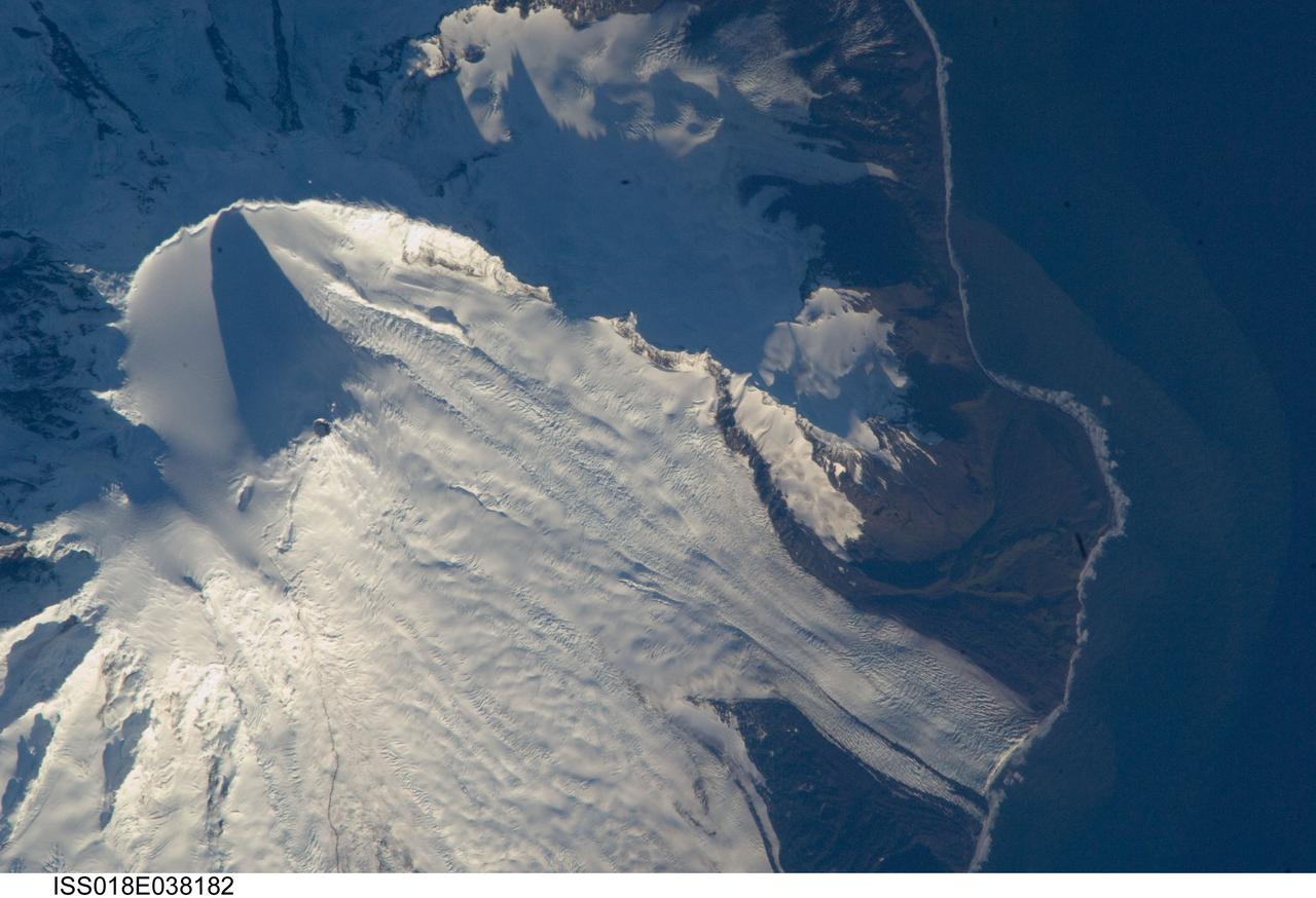
ISS018-E-038182 (28 Feb. 2009) --- Mawson Peak, Heard Island is featured in this image photographed by an Expedition 18 crewmember on the International Space Station. Heard Island is located in the southern Indian Ocean, approximately 1,550 kilometers to the north of Antarctica. The island is a visible part of the Kerguelen Plateau, a submerged feature on the seafloor formed by large amounts of volcanic rock erupted over a geologically short time period within an oceanic tectonic plate ? features like these are termed large igneous provinces by geologists. Most of Heard Island is formed from volcanic rocks associated with the Big Ben stratovolcano. The northeastern slopes of the volcano are visible in shadow at the top left of this detailed astronaut photograph. Recent observed volcanic activity at Heard Island has occurred at 2,745 meters high Mawson Peak, which sits within a breached caldera (collapsed and empty magma chamber beneath a volcano) on the southwestern side of the Big Ben volcano ? the shadow cast by Mawson Peak in the image points directly to the crescent-shaped caldera rim. Detailed geologic study of the Big Ben volcano is made difficult by the presence of several glaciers, including Gotley and Lied Glaciers on the southwestern slopes. This image, taken during Southern Hemisphere summer, also reveals some of the non-glaciated, light to dark brown volcanic rock forming the island on either side of Gotley Glacier.
As if trying to get our attention, Mimas is positioned against the shadow of Saturn's rings, bright on dark. As we near summer in Saturn's northern hemisphere, the rings cast ever larger shadows on the planet. With a reflectivity of about 96 percent, Mimas (246 miles, or 396 kilometers across) appears bright against the less-reflective Saturn. This view looks toward the sunlit side of the rings from about 10 degrees above the ringplane. The image was taken with the Cassini spacecraft wide-angle camera on July 13, 2014 using a spectral filter which preferentially admits wavelengths of near-infrared light centered at 752 nanometers. The view was acquired at a distance of approximately 1.1 million miles (1.8 million kilometers) from Saturn and approximately 1 million miles (1.6 million kilometers) from Mimas. Image scale is 67 miles (108 kilometers) per pixel at Saturn and 60 miles (97 kilometers) per pixel at Mimas. http://photojournal.jpl.nasa.gov/catalog/PIA18282

It's hard to see in the dark. Most HiRISE images are are taken when the sun is at least 15 degrees above the horizon. (If you hold your hand at arm's length with fingers together, it's about five degrees wide on average.) However, to see what's going on in winter, we need to look at times and places where the Sun is just barely over the horizon. This image was taken to look at seasonal frost in gullies during southern winter on Mars, with the Sun only about two degrees over the horizon (just before sunset). To make things more difficult, the gullies are on a steep slope facing away from the sun, so they are in deep shadow. Under these conditions, HiRISE takes what are called "bin 4" images. This means that the image shows less detail, but by adding up the light from 16 pixels (a 4x4 square) we can see details in shadows. Even with the reduced resolution, we can see plenty of detail in the gullies, and learn about the seasonal frost. http://photojournal.jpl.nasa.gov/catalog/PIA20480
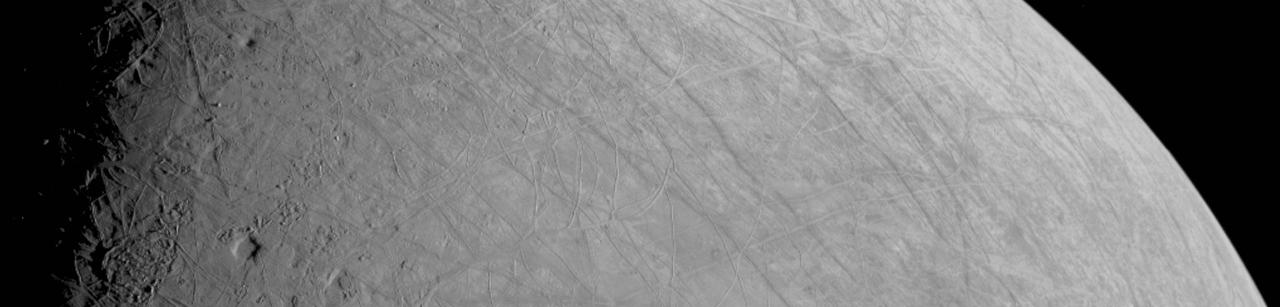
This look at the complex, ice-covered surface of Jupiter's moon Europa came from NASA's Juno mission during a close pass on Sept. 29, 2022. At closest approach, the spacecraft came within a distance of about 219 miles (352 kilometers). Juno's flyby is only the third close pass of the moon in history and the closest look any spacecraft has provided of Europa since Jan. 3, 2000, when NASA's Galileo came within 218 miles (351 kilometers) of the surface. Europa is the sixth-largest moon in the solar system, slightly smaller than Earth's moon. Scientists think a salty ocean lies below a miles-thick ice shell. This segment of the first image of Europa taken during this flyby by the spacecraft's JunoCam (a public-engagement camera) zooms in on a swath of Europa's surface north of the equator. Due to the enhanced contrast between light and shadow seen along the terminator (the nightside boundary, at 10 degrees west longitude), rugged terrain features are easily seen, including tall shadow-casting blocks, while bright and dark ridges and troughs curve across the surface. The oblong pit near the terminator might be a degraded impact crater. The vertical area covered in the image is 155 miles (250 kilometers) tall. The resolution of the image is 0.6 miles (1 kilometer) per pixel. https://photojournal.jpl.nasa.gov/catalog/PIA25330
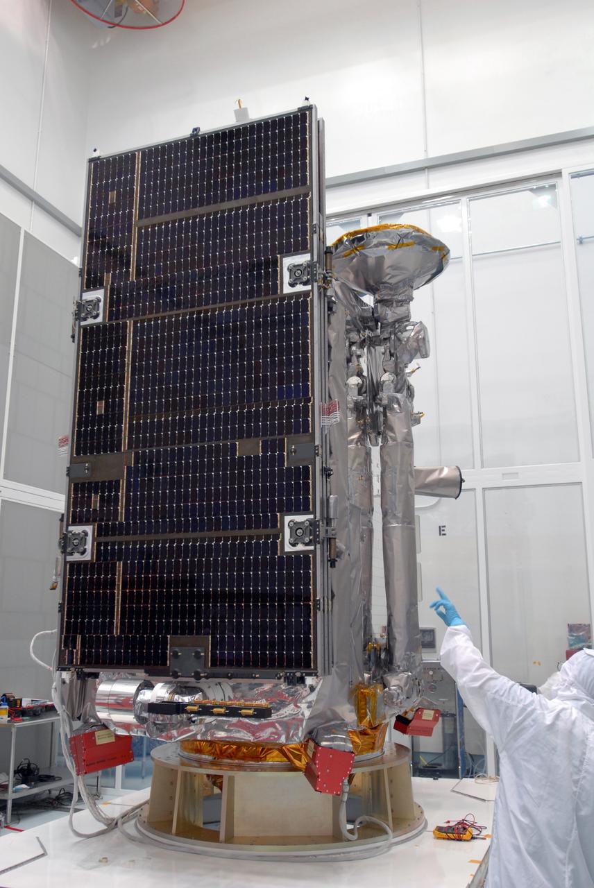
CAPE CANAVERAL, Fla. – At the Astrotech facility in Titusville, Fla., NASA's Lunar Reconnaissance Orbiter, or LRO, has been rotated to vertical on the Aronson stand. A crane will be attached to move it to another stand. The orbiter will carry seven instruments to provide scientists with detailed maps of the lunar surface and enhance our understanding of the moon's topography, lighting conditions, mineralogical composition and natural resources. Information gleaned from LRO will be used to select safe landing sites, determine locations for future lunar outposts and help mitigate radiation dangers to astronauts. The polar regions of the moon are the main focus of the mission because continuous access to sunlight may be possible and water ice may exist in permanently shadowed areas of the poles. Accompanying LRO on its journey to the moon will be the Lunar CRater Observation and Sensing Satellite, or LCROSS, a mission that will impact the lunar surface in its search for water ice. Launch of LRO is targeted for May 20. Photo credit: NASA/Kim Shiflett
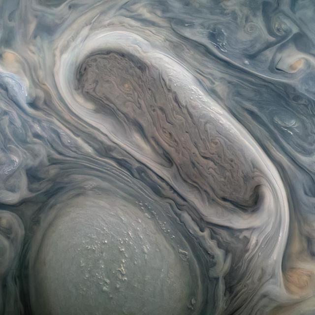
This image shows two of Jupiter's large rotating storms, captured by Juno's visible-light imager, JunoCam, on Juno's 38th perijove pass, on Nov. 29, 2021. This image was acquired at 50 degrees 5 minutes north latitude, at an altitude of 3,815 miles (6,140 kilometers). Atmospheric details as small as 2.5 miles (4 kilometers) can be discerned in the image. Bright "pop-up" clouds are visible above the lower storm, casting shadows on the cloud bank below. Although the pop-up clouds appear small in comparison to the large storm below, such clouds are typically 31 miles (50 kilometers) across. Citizen scientist Kevin M. Gill processed the image to enhance the color and contrast, using raw JunoCam data. https://photojournal.jpl.nasa.gov/catalog/PIA25031
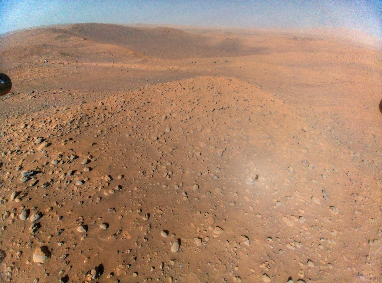
This image of NASA's Perseverance Mars rover at the rim of Belva Crater was taken by the agency's Ingenuity Mars Helicopter during the rotorcraft's 51st flight on April 22, 2023, the 772nd Martian day, or sol, of the rover's mission. At the time the image was taken, the helicopter was at an altitude of about 40 feet (12 meters). The rover is in the upper left of the image, parked at a light-toned rocky outcrop the science team is calling "Echo Creek." Perseverance's tracks can be seen extending from its location to the upper-right side of image. The helicopter's shadow can be seen on the rocky hill in the foreground, just to the right and below the image's center. The hill, designated "Mount Julian" by the science team, is a planned future stop for the rover. A small triangular piece of debris from the rover's entry, descent, and landing system can be seen at the lower center of image. https://photojournal.jpl.nasa.gov/catalog/PIA25884
CAPE CANAVERAL, Fla. –– At Astrotech Space Operations in Titusville, Fla., technicians prepare the solar array panel for installation on the Lunar Reconnaissance Orbiter, or LRO. The orbiter will carry seven instruments to provide scientists with detailed maps of the lunar surface and enhance our understanding of the moon's topography, lighting conditions, mineralogical composition and natural resources. Information gleaned from LRO will be used to select safe landing sites, determine locations for future lunar outposts and help mitigate radiation dangers to astronauts. The polar regions of the moon are the main focus of the mission because continuous access to sunlight may be possible and water ice may exist in permanently shadowed areas of the poles. Launch of LRO is targeted for June 2. Photo credit: NASA/Jim Grossmann
Lonely Mimas swings around Saturn, seeming to gaze down at the planet's splendid rings. The outermost, narrow F ring is visible here and exhibits some clumpy structure near the bottom of the frame. The shadow of Saturn's southern hemisphere stretches almost entirely across the rings. Mimas is 398 kilometers (247 miles) wide. The image was taken with the Cassini spacecraft narrow angle camera on August 15, 2004, at a distance of 8.8 million kilometers (5.5 million miles) from Saturn, through a filter sensitive to visible red light. The image scale is 53 kilometers (33 miles) per pixel. Contrast was slightly enhanced to aid visibility.almost entirely across the rings. Mimas is 398 kilometers (247 miles) wide. http://photojournal.jpl.nasa.gov/catalog/PIA06471
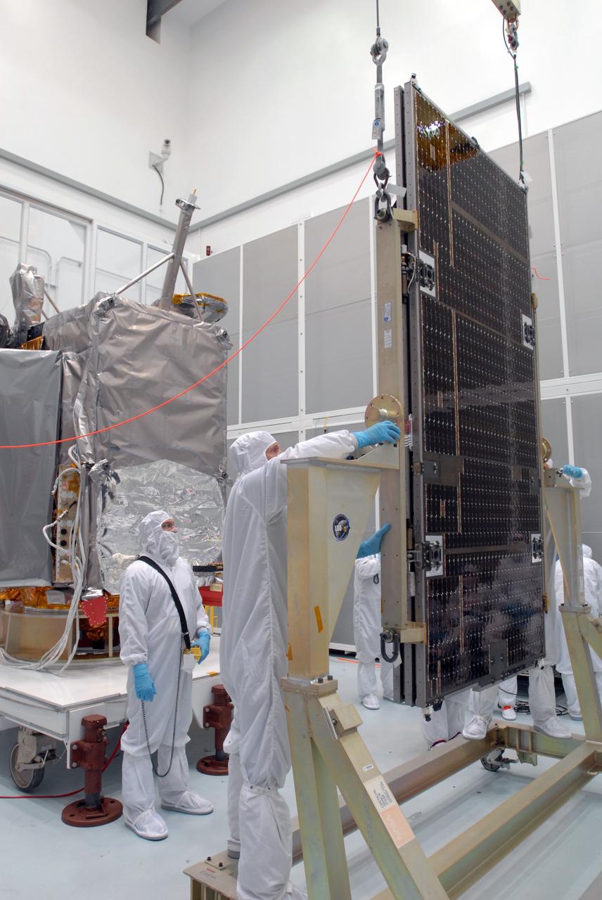
CAPE CANAVERAL, Fla. –– At Astrotech Space Operations in Titusville, Fla., technicians prepare the solar array panel for installation on the Lunar Reconnaissance Orbiter, or LRO, at left. The orbiter will carry seven instruments to provide scientists with detailed maps of the lunar surface and enhance our understanding of the moon's topography, lighting conditions, mineralogical composition and natural resources. Information gleaned from LRO will be used to select safe landing sites, determine locations for future lunar outposts and help mitigate radiation dangers to astronauts. The polar regions of the moon are the main focus of the mission because continuous access to sunlight may be possible and water ice may exist in permanently shadowed areas of the poles. Launch of LRO is targeted for June 2. Photo credit: NASA/Jim Grossmann
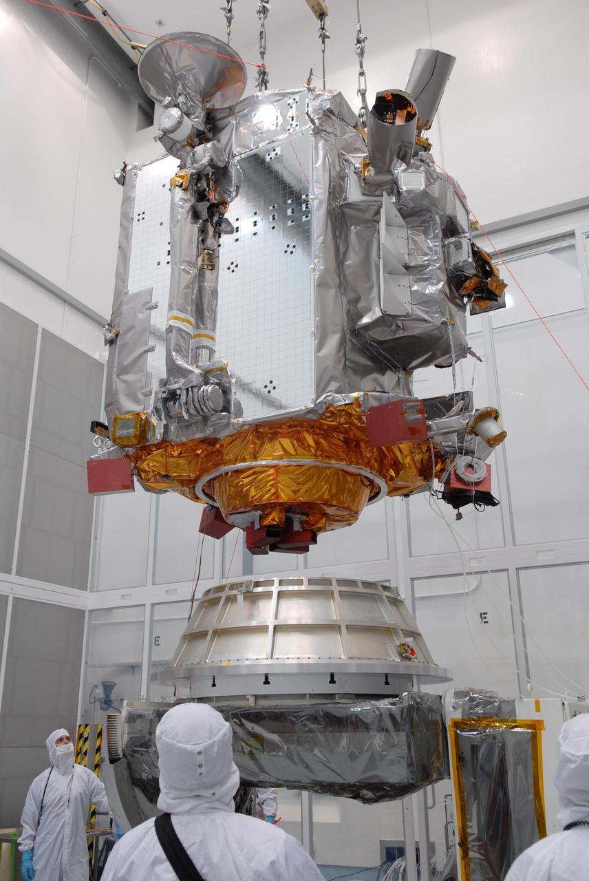
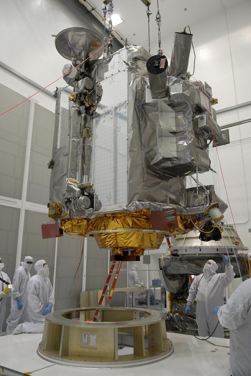
CAPE CANAVERAL, Fla. – At Astrotech in Titusville, Fla., an overhead crane lowers NASA's Lunar Reconnaissance Orbiter, or LRO, toward the Aronson table. The orbiter will be rotated on the table to provide proper access for processing. The orbiter will carry seven instruments to provide scientists with detailed maps of the lunar surface and enhance our understanding of the moon's topography, lighting conditions, mineralogical composition and natural resources. Information gleaned from LRO will be used to select safe landing sites, determine locations for future lunar outposts and help mitigate radiation dangers to astronauts. The polar regions of the moon are the main focus of the mission because continuous access to sunlight may be possible and water ice may exist in permanently shadowed areas of the poles. Accompanying LRO on its journey to the moon will be the Lunar CRater Observation and Sensing Satellite, or LCROSS, a mission that will impact the lunar surface in its search for water ice. Launch of LRO is targeted for May 20. Photo credit: NASA/Jack Pfaller
CAPE CANAVERAL, Fla. –– At Astrotech Space Operations in Titusville, Fla., technicians prepare the Lunar Reconnaissance Orbiter, or LRO, for installation of the solar array panels. The orbiter will carry seven instruments to provide scientists with detailed maps of the lunar surface and enhance our understanding of the moon's topography, lighting conditions, mineralogical composition and natural resources. Information gleaned from LRO will be used to select safe landing sites, determine locations for future lunar outposts and help mitigate radiation dangers to astronauts. The polar regions of the moon are the main focus of the mission because continuous access to sunlight may be possible and water ice may exist in permanently shadowed areas of the poles. Launch of LRO is targeted for June 2. Photo credit: NASA/Jim Grossmann
KENNEDY SPACE CENTER, Fla. -- After the rollback of the Rotating Service Structure on Launch Pad 39A, Space Shuttle Endeavour is marked with shadows from the lights on the Fixed Service Structure. Above the orange external tank is the Gaseous Oxygen Vent Hood, often called the "beanie cap," waiting to be lowered. The hood helps vent gaseous oxygen vapors away from the Space Shuttle until launch, when it is raised and retracted two and a half minutes before liftoff. Endeavour waits for mission STS-99, known as the Shuttle Radar Topography Mission (SRTM), which will chart a new course to produce unrivaled 3-D images of the Earth's surface. The result of the SRTM could be close to 1 trillion measurements of the Earth's topography. The mission is expected to last 11days, with Endeavour landing at KSC Tuesday, Feb. 22, at 4:36 p.m. EST. This is the 97th Shuttle flight and 14th for Shuttle Endeavour
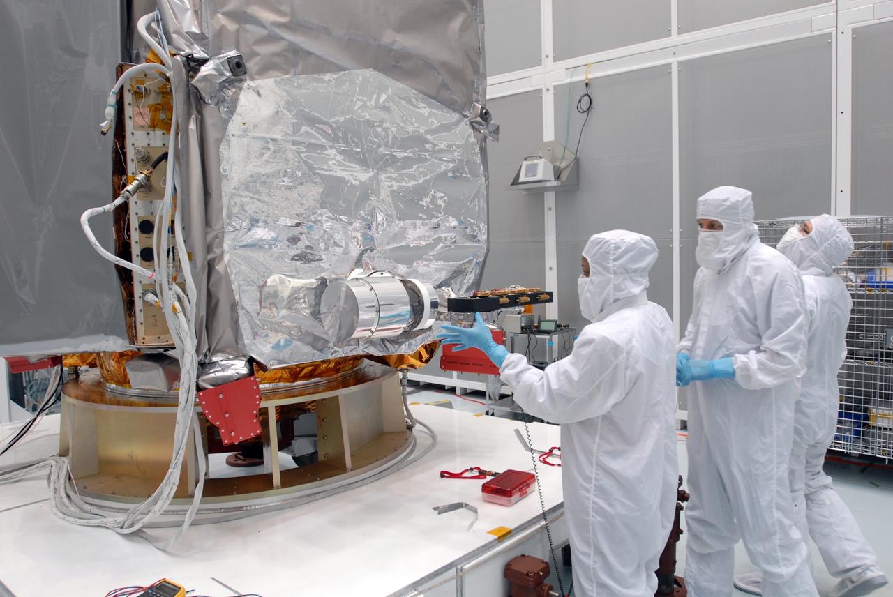
CAPE CANAVERAL, Fla. –– At Astrotech Space Operations in Titusville, Fla., a technician checks the installation of a solar array panel on the Lunar Reconnaissance Orbiter, or LRO. The orbiter will carry seven instruments to provide scientists with detailed maps of the lunar surface and enhance our understanding of the moon's topography, lighting conditions, mineralogical composition and natural resources. Information gleaned from LRO will be used to select safe landing sites, determine locations for future lunar outposts and help mitigate radiation dangers to astronauts. The polar regions of the moon are the main focus of the mission because continuous access to sunlight may be possible and water ice may exist in permanently shadowed areas of the poles. Launch of LRO is targeted for June 2. Photo credit: NASA/Jim Grossmann
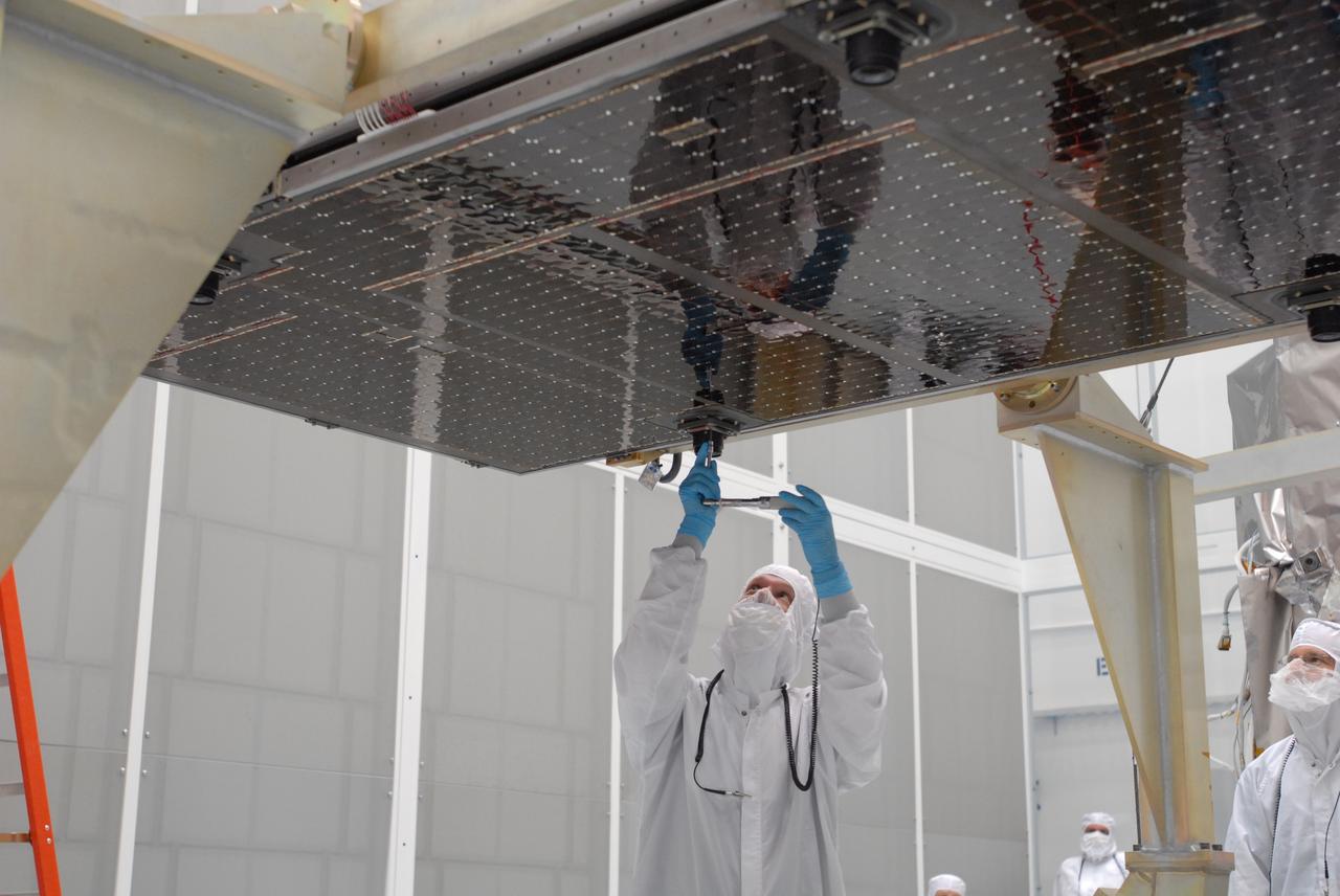
CAPE CANAVERAL, Fla. –– At Astrotech Space Operations in Titusville, Fla., technicians prepare the solar array panel for installation on the Lunar Reconnaissance Orbiter, or LRO. The orbiter will carry seven instruments to provide scientists with detailed maps of the lunar surface and enhance our understanding of the moon's topography, lighting conditions, mineralogical composition and natural resources. Information gleaned from LRO will be used to select safe landing sites, determine locations for future lunar outposts and help mitigate radiation dangers to astronauts. The polar regions of the moon are the main focus of the mission because continuous access to sunlight may be possible and water ice may exist in permanently shadowed areas of the poles. Launch of LRO is targeted for June 2. Photo credit: NASA/Jim Grossmann
CAPE CANAVERAL, Fla. – At the Astrotech facility in Titusville, Fla., a crane moves NASA's Lunar Reconnaissance Orbiter, or LRO, toward a stand in the foreground. The orbiter will carry seven instruments to provide scientists with detailed maps of the lunar surface and enhance our understanding of the moon's topography, lighting conditions, mineralogical composition and natural resources. Information gleaned from LRO will be used to select safe landing sites, determine locations for future lunar outposts and help mitigate radiation dangers to astronauts. The polar regions of the moon are the main focus of the mission because continuous access to sunlight may be possible and water ice may exist in permanently shadowed areas of the poles. Accompanying LRO on its journey to the moon will be the Lunar CRater Observation and Sensing Satellite, or LCROSS, a mission that will impact the lunar surface in its search for water ice. Launch of LRO is targeted for May 20. Photo credit: NASA/Kim Shiflett
CAPE CANAVERAL, Fla. –– At Astrotech Space Operations in Titusville, Fla., a technician prepares for the installation of the solar array panel on the Lunar Reconnaissance Orbiter, or LRO. He stands in front of the fairing that will encapsulate the spacecraft at a later date. The orbiter will carry seven instruments to provide scientists with detailed maps of the lunar surface and enhance our understanding of the moon's topography, lighting conditions, mineralogical composition and natural resources. Information gleaned from LRO will be used to select safe landing sites, determine locations for future lunar outposts and help mitigate radiation dangers to astronauts. The polar regions of the moon are the main focus of the mission because continuous access to sunlight may be possible and water ice may exist in permanently shadowed areas of the poles. Launch of LRO is targeted for June 2. Photo credit: NASA/Jim Grossmann
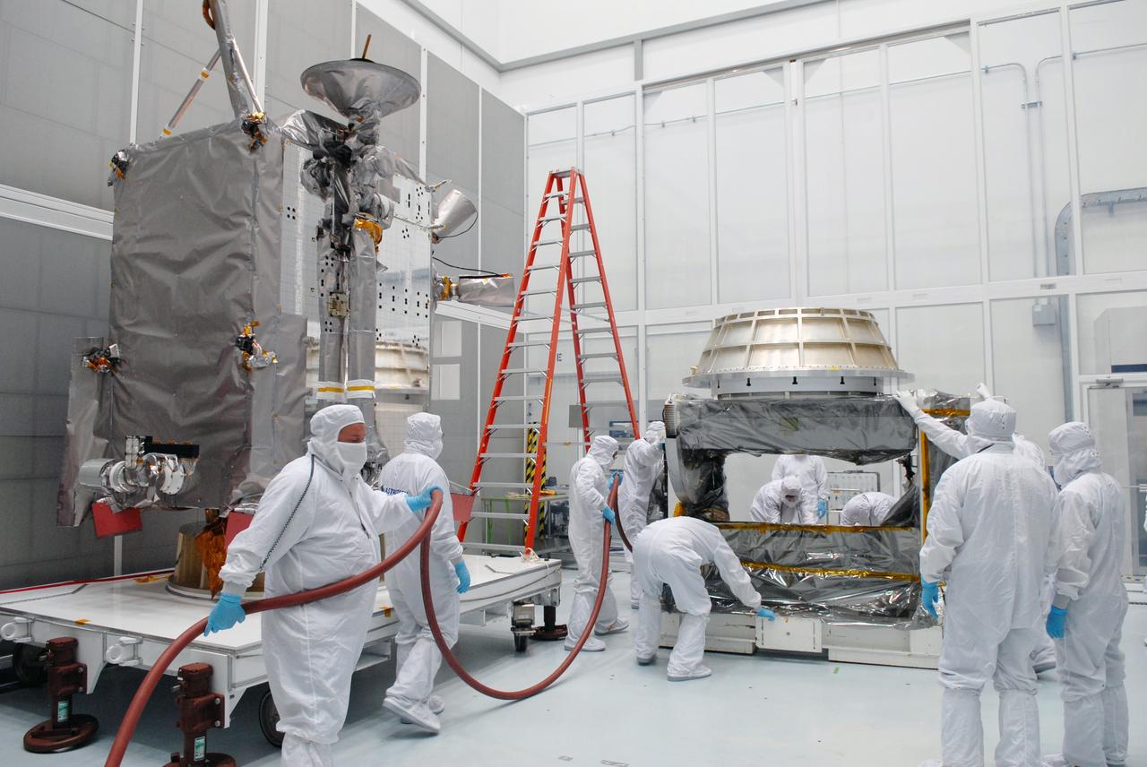
CAPE CANAVERAL, Fla. – At Astrotech in Titusville, Fla., technicians prepare an Aronson table to receive NASA's Lunar Reconnaissance Orbiter, or LRO, at left. The orbiter will be rotated on the table to provide proper access for processing. The orbiter will carry seven instruments to provide scientists with detailed maps of the lunar surface and enhance our understanding of the moon's topography, lighting conditions, mineralogical composition and natural resources. Information gleaned from LRO will be used to select safe landing sites, determine locations for future lunar outposts and help mitigate radiation dangers to astronauts. The polar regions of the moon are the main focus of the mission because continuous access to sunlight may be possible and water ice may exist in permanently shadowed areas of the poles. Accompanying LRO on its journey to the moon will be the Lunar CRater Observation and Sensing Satellite, or LCROSS, a mission that will impact the lunar surface in its search for water ice. Launch of LRO is targeted for May 20. Photo credit: NASA/Jack Pfaller
Saturn's rings cast shadows on the planet's cloud tops, providing a perfect backdrop for the brilliant sphere of Saturn's moon Enceladus. The tiny world's bright white surface results in part from a snow of material originating from the towering plume of icy particles at Enceladus' south pole. This image looks toward the leading side of Enceladus (504 kilometers, or 313 miles across). North is up. The image was taken in visible light with the Cassini spacecraft's narrow-angle camera on June 28, 2007. The view was acquired at a distance of approximately 281,000 kilometers (175,000 miles) from Enceladus. Image scale is about 2 kilometers (1 mile) per pixel. The Cassini spacecraft ended its mission on Sept. 15, 2017 https://photojournal.jpl.nasa.gov/catalog/PIA17216
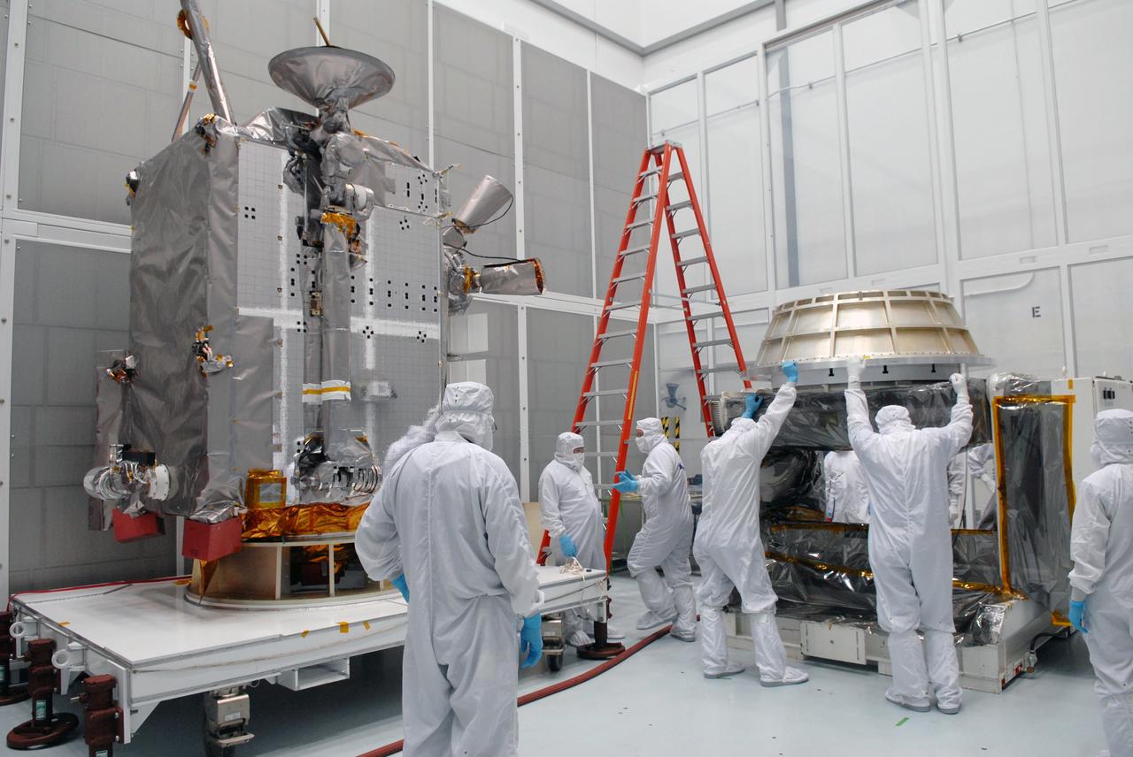
CAPE CANAVERAL, Fla. – At Astrotech in Titusville, Fla., technicians prepare an Aronson table to receive NASA's Lunar Reconnaissance Orbiter, or LRO, at left. The orbiter will be rotated on the table to provide proper access for processing. The orbiter will carry seven instruments to provide scientists with detailed maps of the lunar surface and enhance our understanding of the moon's topography, lighting conditions, mineralogical composition and natural resources. Information gleaned from LRO will be used to select safe landing sites, determine locations for future lunar outposts and help mitigate radiation dangers to astronauts. The polar regions of the moon are the main focus of the mission because continuous access to sunlight may be possible and water ice may exist in permanently shadowed areas of the poles. Accompanying LRO on its journey to the moon will be the Lunar CRater Observation and Sensing Satellite, or LCROSS, a mission that will impact the lunar surface in its search for water ice. Launch of LRO is targeted for May 20. Photo credit: NASA/Jack Pfaller

Saturn's surface is painted with swirls and shadows. Each swirl here is a weather system, reminding us of how dynamic Saturn's atmosphere is. Images taken in the near-infrared (like this one) permit us to peer through Saturn's methane haze layer to the clouds below. Scientists track the clouds and weather systems in the hopes of better understanding Saturn's complex atmosphere - and thus Earth's as well. This view looks toward the sunlit side of the rings from about 17 degrees above the ringplane. The image was taken with the Cassini spacecraft wide-angle camera on Feb. 8, 2015 using a spectral filter which preferentially admits wavelengths of near-infrared light centered at 752 nanometers. The view was obtained at a distance of approximately 794,000 miles (1.3 million kilometers) from Saturn. Image scale is 47 miles (76 kilometers) per pixel. http://photojournal.jpl.nasa.gov/catalog/pia18311
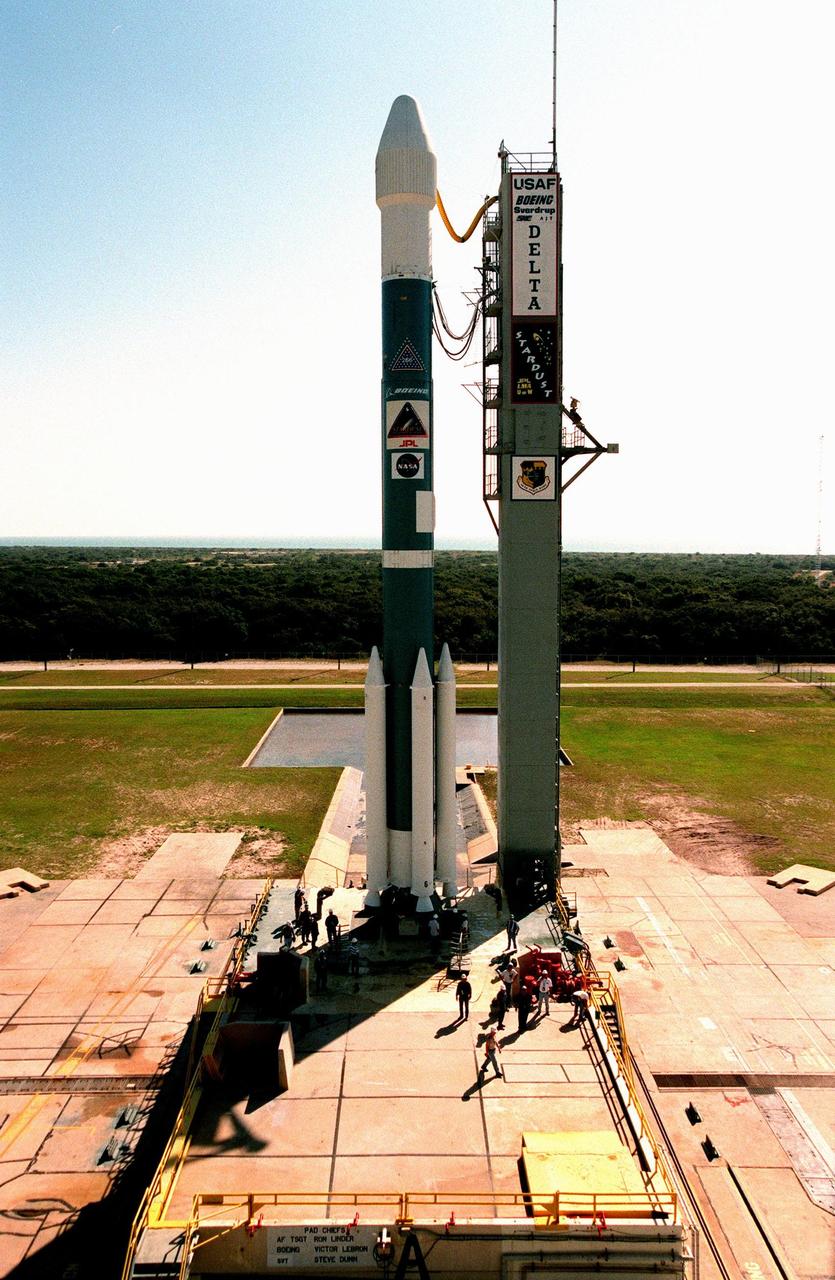
In the late morning light at Launch Pad 17-A, Cape Cananveral Air Station, the fixed utility tower (right) casts a long shadow across the base of the Boeing Delta II rocket (left) waiting to launch the Stardust spacecraft. After a 24-hour scrub, the new targeted launch time is 4:04 p.m. EST. Stardust is destined for a close encounter with the comet Wild 2 in January 2004. Using a silicon-based substance called aerogel, Stardust will capture comet particles flying off the nucleus of the comet. The spacecraft also will bring back samples of interstellar dust. These materials consist of ancient pre-solar interstellar grains and other remnants left over from the formation of the solar system. Scientists expect their analysis to provide important insights into the evolution of the sun and planets and possibly into the origin of life itself. The collected samples will return to Earth in a sample return capsule to be jettisoned as Stardust swings by Earth in January 2006
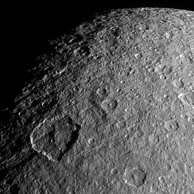
Surface features on Rhea -- mostly impact craters in this image -- are thrown into sharp relief thanks to long shadows. Viewing this terrain near the day/night terminator makes it easier to appreciate just how violent Rhea's geological history has been. The craters on Rhea (949 miles, or 1,527 kilometers across) are the result of 4.6 billion years of bombardment by small bodies. With very little erosion, the scars and craters remain unless they are overwritten by other, newer impacts. This view looks toward the anti-Saturn hemisphere of Rhea. North on Rhea is up and rotated 11 degrees to the right. The image was taken in visible light with the Cassini spacecraft narrow-angle camera on Feb. 10, 2015. The view was acquired at a distance of approximately 47,000 miles (76,000 kilometers) from Rhea. Image scale is 1,500 feet (460 meters) per pixel. http://photojournal.jpl.nasa.gov/catalog/pia18310

CAPE CANAVERAL, Fla. –– At Astrotech Space Operations in Titusville, Fla., technicians prepare for installation of the solar array panels on the Lunar Reconnaissance Orbiter, or LRO. The orbiter will carry seven instruments to provide scientists with detailed maps of the lunar surface and enhance our understanding of the moon's topography, lighting conditions, mineralogical composition and natural resources. Information gleaned from LRO will be used to select safe landing sites, determine locations for future lunar outposts and help mitigate radiation dangers to astronauts. The polar regions of the moon are the main focus of the mission because continuous access to sunlight may be possible and water ice may exist in permanently shadowed areas of the poles. Launch of LRO is targeted for June 2. Photo credit: NASA/Jim Grossmann
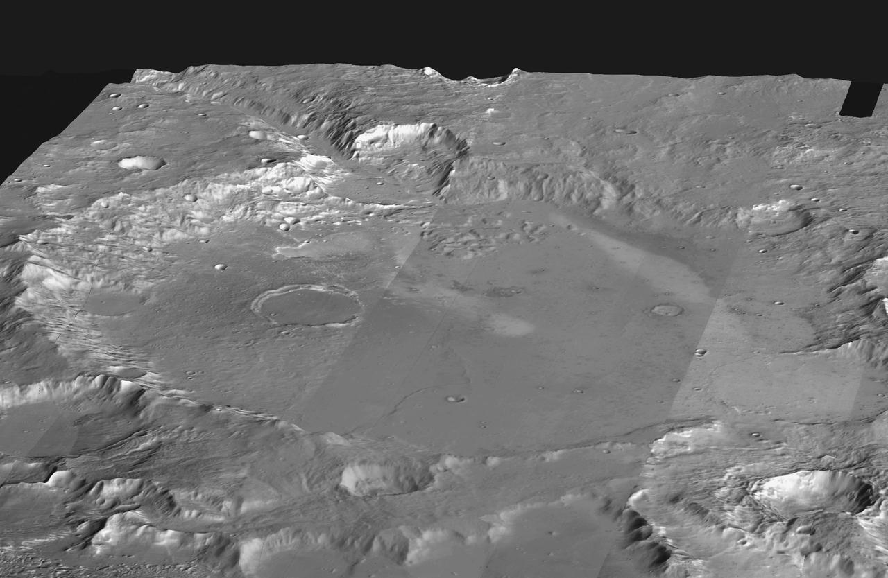
This mosaic of daytime infrared images of Gusev Crater, taken by NASA Mars Odyssey spacecraft, has been draped over topography data obtained by NASA Mars Global Surveyor. The daytime temperatures range from approximately minus 45 degrees C (black) to minus 5 degrees C (white). The temperature differences in these daytime images are due primarily to lighting effects, where sunlit slopes are warm (bright) and shadowed slopes are cool (dark). Gusev crater is a potential landing site for the Mars Exploration Rovers. The large ancient river channel of Ma'Adim that once flowed into Gusev can be seen at the top of the mosaic. This image mosaic covers an area approximately 180 kilometers (110 miles) on each side centered near 14 degrees S, 175 degrees E, looking toward the south in this simulated view. http://photojournal.jpl.nasa.gov/catalog/PIA04260

KENNEDY SPACE CENTER, Fla. -- After the rollback of the Rotating Service Structure on Launch Pad 39A, Space Shuttle Endeavour is marked with shadows from the lights on the Fixed Service Structure. Above the orange external tank is the Gaseous Oxygen Vent Hood, often called the "beanie cap," waiting to be lowered. The hood helps vent gaseous oxygen vapors away from the Space Shuttle until launch, when it is raised and retracted two and a half minutes before liftoff. Endeavour waits for mission STS-99, known as the Shuttle Radar Topography Mission (SRTM), which will chart a new course to produce unrivaled 3-D images of the Earth's surface. The result of the SRTM could be close to 1 trillion measurements of the Earth's topography. The mission is expected to last 11days, with Endeavour landing at KSC Tuesday, Feb. 22, at 4:36 p.m. EST. This is the 97th Shuttle flight and 14th for Shuttle Endeavour
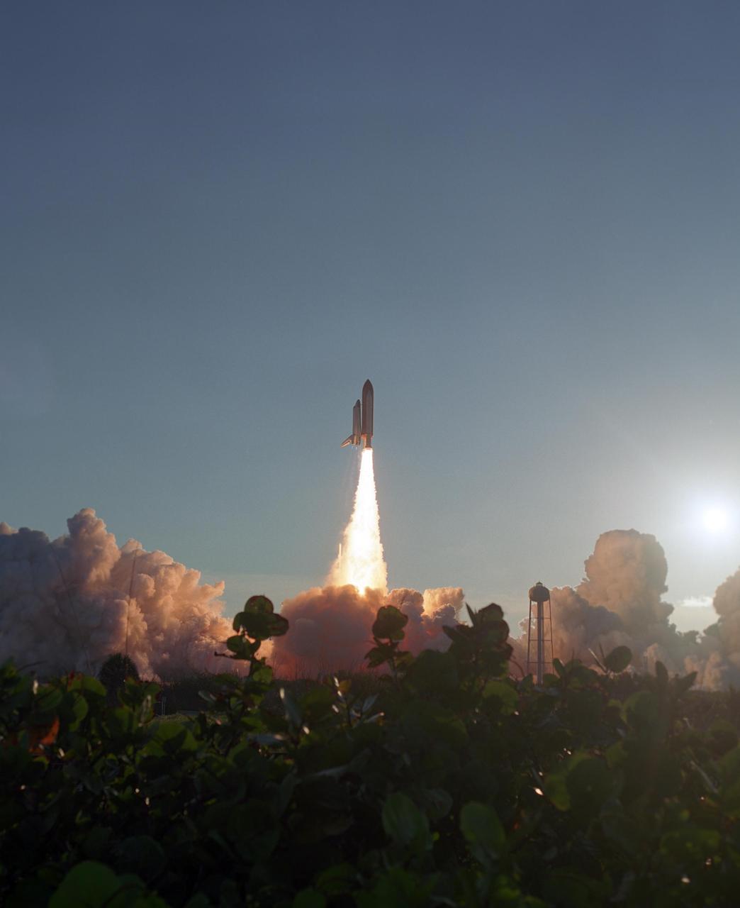
KENNEDY SPACE CENTER, FLA. -- Shrubbery is cast in shadow as the launch of Space Shuttle Atlantis lights up the sky behind it. The liftoff at 7:38:04 p.m. EDT created masses of smoke and steam clouds painted with sunset hues as they roll across Launch Pad 39A. Atlantis launched on time for its mission STS-117 to the International Space Station. The shuttle is delivering a new segment to the starboard side of the International Space Station's backbone, known as the truss. Three spacewalks are planned to install the S3/S4 truss segment, deploy a set of solar arrays and prepare them for operation. STS-117 is the 118th space shuttle flight, the 21st flight to the station, the 28th flight for Atlantis and the first of four flights planned for 2007. Photo credit: NASA/Sandra Joseph & Robert Murray
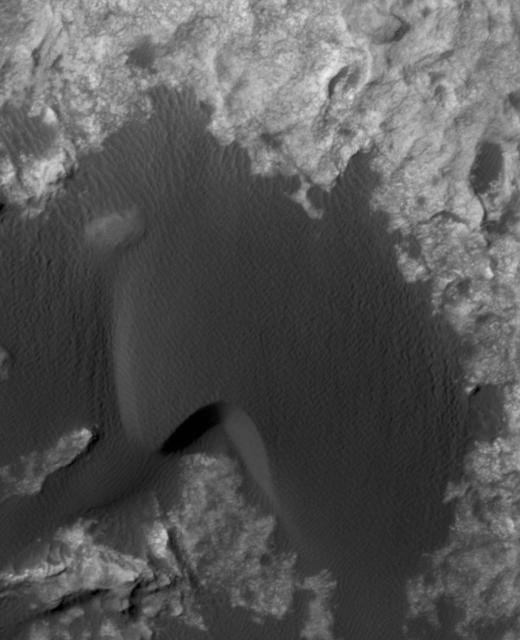
This animation flips back and forth between views taken in 2010 and 2014 of a Martian sand dune at the edge of Mount Sharp, documenting dune activity. The images are from the High Resolution Imaging Science Experiment (HiRISE) camera on NASA's Mars Reconnaissance Orbiter. They cover an area about 740 feet (about 225 meters) wide, showing a site called "Dune 2" in the "Bagnold Dunes" dune field. NASA's Curiosity Mars rover will observe this dune up close on the rover's route up Mount Sharp. North is toward the top. The edge of the dune at the crescent-shaped slip face on the south edge advances slightly during the four-year period between the dates of the images. Figure A is an annotated version with an arrow indicating the location of this change. The lighting angle is different in the two images, resulting in numerous changes in shadows. http://photojournal.jpl.nasa.gov/catalog/PIA20161
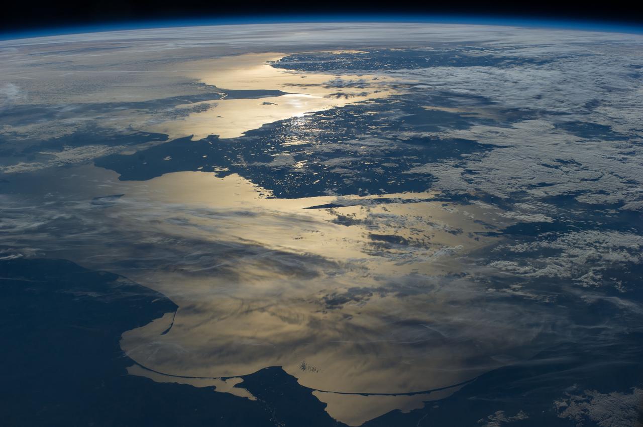
ISS040-E-012110 (15 June 2014) --- Coastlines of the southern Baltic Sea are featured in this image photographed by an Expedition 40 crew member on the International Space Station. The crew photographed this panorama looking aft (back along the orbital path) of the spacecraft as the sun was setting over the North Sea. Seen from the space station, the sun’s reflection point moves quickly across the landscape, momentarily lighting up water bodies. In this fleeting view the coast of southern Norway is outlined near the horizon. The strongest reflection of the sun highlights the narrow sea passage known as the Skagerrak—revealing the thin tip of Denmark. Numerous small lakes in southern Sweden appear at center, and scattered clouds cast complex shadows on the southern Baltic Sea. The sweeping curves of the sand spit on the Polish coast, and the long barrier islands on the Russian coast appear in the foreground at the edge of the sun’s reflection disc.