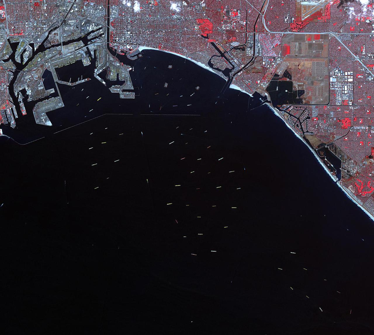
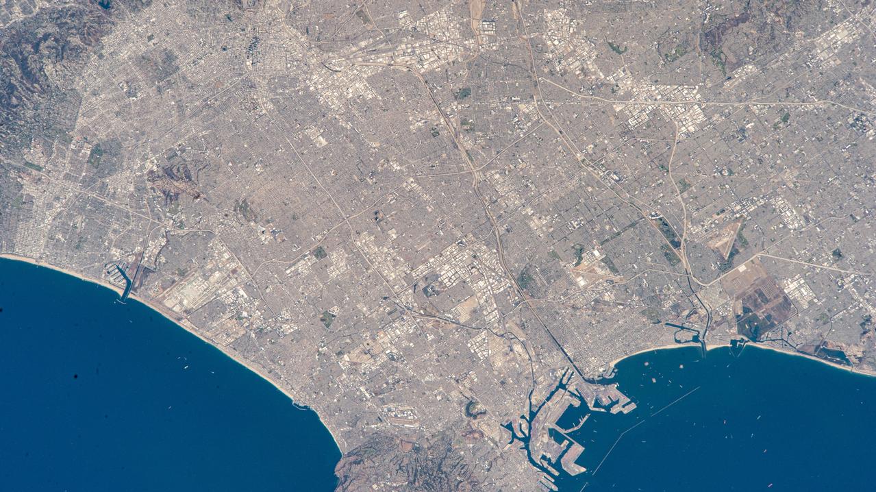
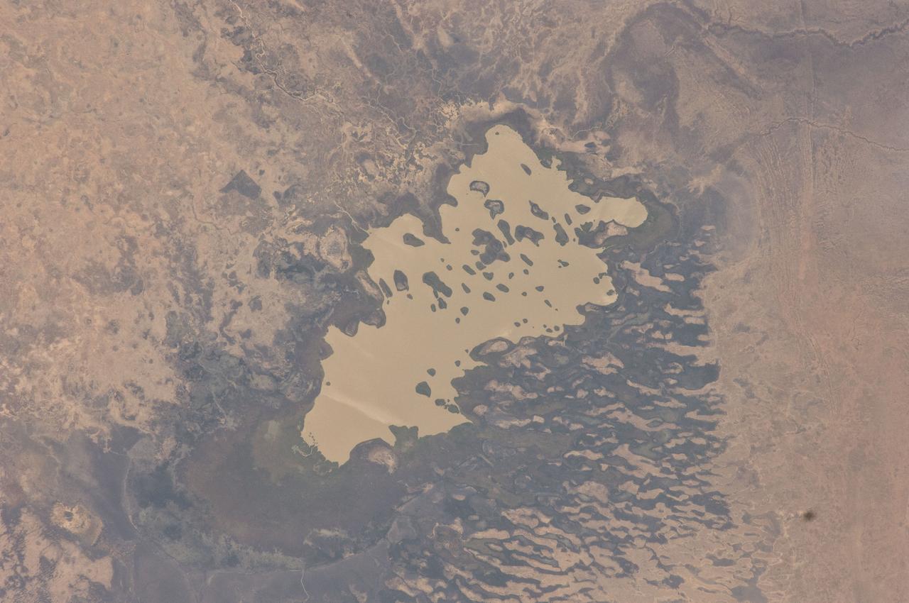
On Oct. 10, 2021, NASA's Advanced Spaceborne Thermal Emission and Reflection Radiometer (ASTER) instrument captured an image of over 70 ships waiting to dock and unload at the ports of Los Angeles and Long Beach, due to a supply-chain crunch. The image covers an area of 14 by 16 miles (23 by 25 kilometers). https://photojournal.jpl.nasa.gov/catalog/PIA24902
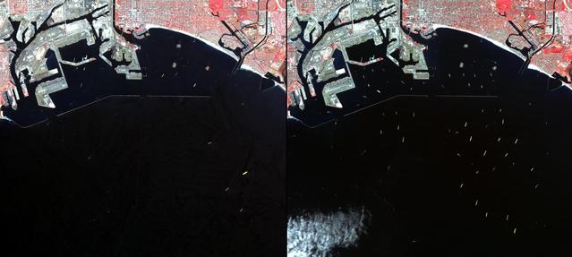
In southern California, the combined ports of Los Angeles and Long Beach account for 33% of the nation containerized imports. This image from NASA Terra spacecraft shows the large backlog of waiting cargo ships being slowly unloaded. The left image was acquired July 4, 2014 during normal operations: 14 ships are being unloaded, while 7 wait their turns near the facilities. The right image was acquired on March 8, 2015: 19 ships are moored at unloading docks, while 47 ships wait their turns. The images cover an area of 16.7 x 18.6 km, and are located at 33.7 degrees north, 118.2 degrees west. http://photojournal.jpl.nasa.gov/catalog/PIA19249

jsc2024e066532 (2/28/2024) --- View of Long Beach, NY student researchers Katrina Casey, Claire Cristallo and Jasmine Davidson-Smith. Their experiment, The Effect of Microgravity on the Germination of Watercress Seeds, is part of the Nanoracks-National Center for Earth and Space Science Education-Surveyor-Student Spaceflight Experiments Program Mission 18 to ISS (Nanoracks-NCESSE-Surveyor-SSEP).
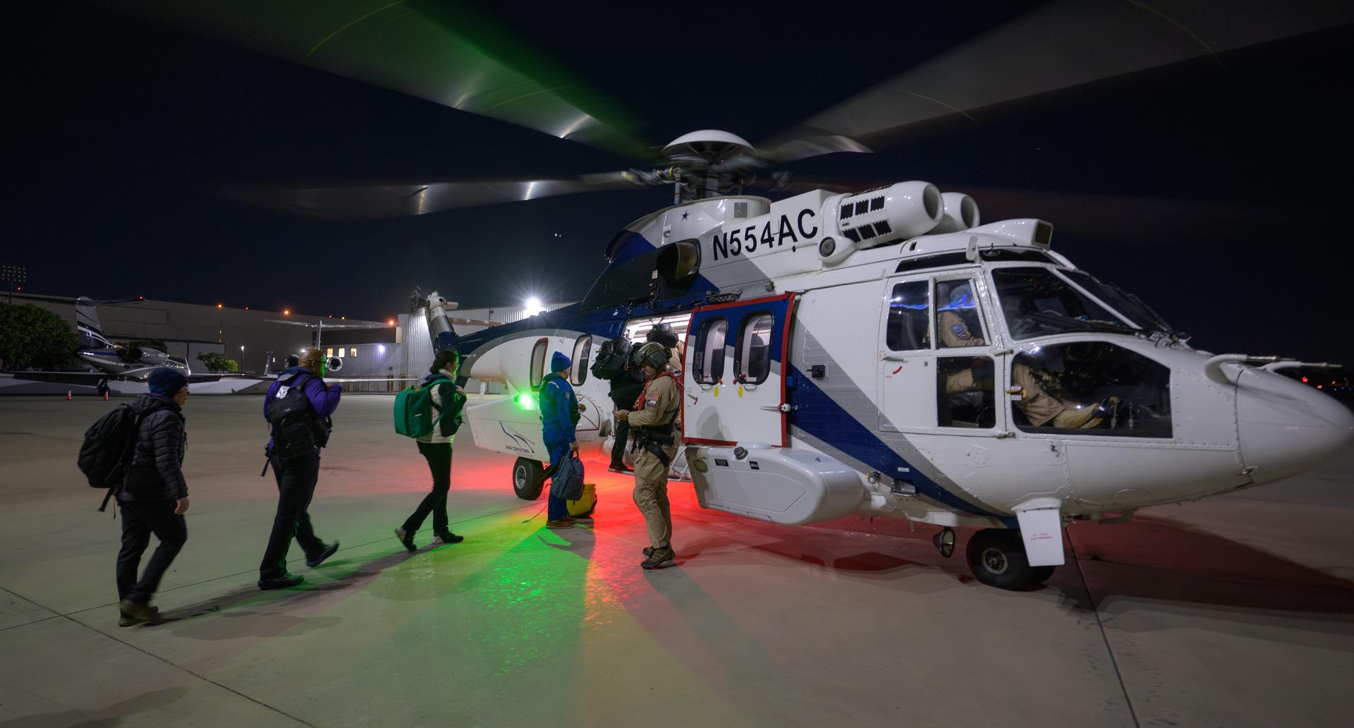
NASA and SpaceX support teams board a helicopter to stage for the landing of the SpaceX Dragon Endeavour spacecraft with NASA astronauts Zena Cardman, Mike Fincke, JAXA (Japan Aerospace Exploration Agency) astronaut Kimiya Yui, and Roscosmos cosmonaut Oleg Platonov aboard, Wednesday, Jan. 14, 2026, in Long Beach, Calif.. Cardman, Fincke, Yui, Platonov are landing in the Pacific Ocean after 167 days in space as part of Expedition 74 aboard the International Space Station. Photo Credit: (NASA/Bill Ingalls)

AS09-22-3436 (March 1969) --- Los Angeles-Long Beach area of southern California, as photographed from the Apollo 9 spacecraft during its 92nd revolution of Earth. Santa Catalina Island is located off the coast. The California coastline is visible from San Clemente northward to Point Dume. Clouds cover most of the San Gabriel Mountains around Los Angeles.
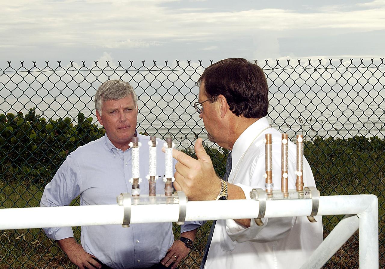
KENNEDY SPACE CENTER, FLA. - Louis MacDowell (right), Testbed manager, explains to Center Director Jim Kennedy the use of astmospheric calibration specimens. Placed at various locations, they can rank the corrosivity of the given environment. The KSC Beach Corrosion Test Site was established in the 1960s and has provided more than 30 years of historical information on the long-term performance of many materials in use at KSC and other locations around the world. Located 100 feet from the Atlantic Ocean approximately 1 mile south of the Space Shuttle launch sites, the test facility includes an atmospheric exposure site, a flowing seawater exposure site, and an on-site electrochemistry laboratory and monitoring station. The beach laboratory is used to conduct real-time corrosion experiments and provides for the remote monitoring of surrounding weather conditions. The newly added flowing seawater immersion facility provides for the immersion testing of materials and devices under controlled conditions.
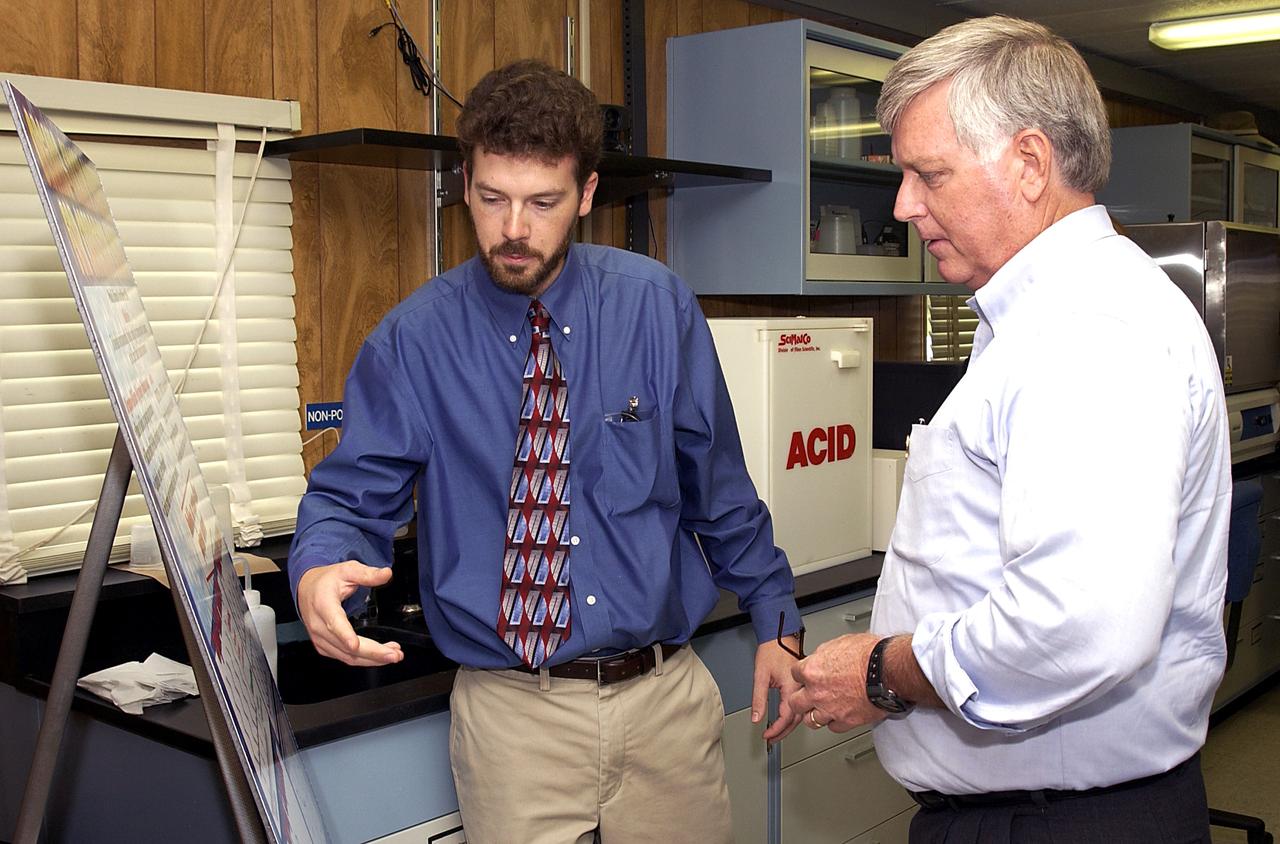
KENNEDY SPACE CENTER, FLA. - Dr. Paul Hintze (left) explains to Center Director Jim Kennedy a project he is working at the KSC Beach Corrosion Test Site. Hitze is doing post-graduate work for the National Research Council. The test facility site was established in the 1960s and has provided more than 30 years of historical information on the long-term performance of many materials in use at KSC and other locations around the world. Located 100 feet from the Atlantic Ocean approximately 1 mile south of the Space Shuttle launch sites, the test facility includes an atmospheric exposure site, a flowing seawater exposure site, and an on-site electrochemistry laboratory and monitoring station. The beach laboratory is used to conduct real-time corrosion experiments and provides for the remote monitoring of surrounding weather conditions. The newly added flowing seawater immersion facility provides for the immersion testing of materials and devices under controlled conditions.
iss073e0075663 (May 20, 2025) --- NASA astronaut Nichole Ayers and JAXA (Japan Aerospace Exploration Agency) astronaut Takuya Onishi, Expedition 73 flight engineer and commander respectively, are pictured together inside the International Space Station's Kibo laboratory module. The astronauts called down to students at Long Beach Middle School in Lido Beach, New York, and answered their questions about living in space.

KENNEDY SPACE CENTER, FLA. - On a tour of the KSC Beach Corrosion Test Site, Testbed Manager Louis MacDowell (foreground) explains to Center Director Jim Kennedy (third from right) about a study being undertaken for the U.S. Navy: nonchrome primers for aircraft. At left is Lead Scientist Dr. Luz Marina Calle and behind MacDowell is Dr. Paul Hintze, who is working on a graduate project for the National Research Council. The KSC Beach Corrosion Test Site was established in the 1960s and has provided more than 30 years of historical information on the long-term performance of many materials in use at KSC and other locations around the world. Located 100 feet from the Atlantic Ocean approximately 1 mile south of the Space Shuttle launch sites, the test facility includes an atmospheric exposure site, a flowing seawater exposure site, and an on-site electrochemistry laboratory and monitoring station. The beach laboratory is used to conduct real-time corrosion experiments and provides for the remote monitoring of surrounding weather conditions. The newly added flowing seawater immersion facility provides for the immersion testing of materials and devices under controlled conditions.
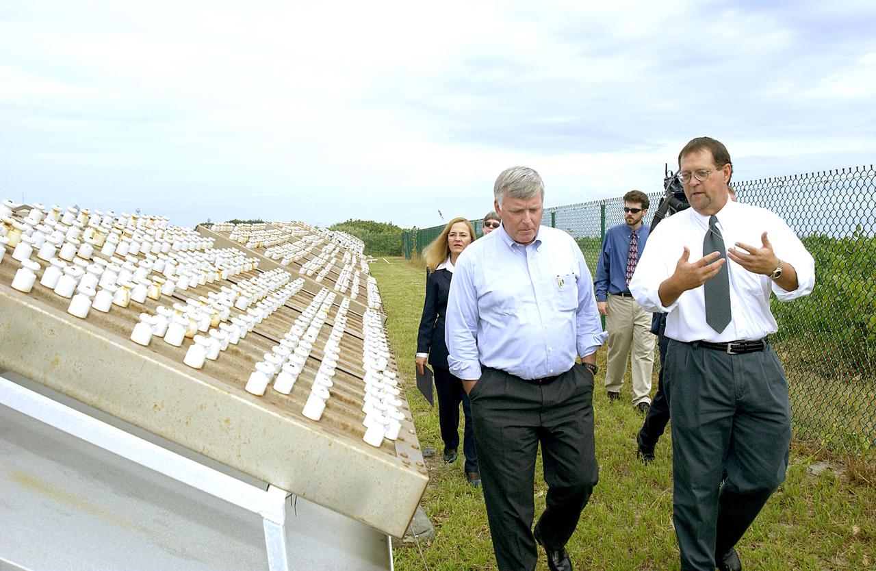
KENNEDY SPACE CENTER, FLA. - On a tour of the KSC Beach Corrosion Test Site, Louis MacDowell (right), Testbed manager, explains to Center Director Jim Kennedy a project being undertaken for the U.S. Navy. At left are nonchrome primers for aircraft being studied. Behind Kennedy is Lead Scientist Dr. Luz Marina Calle. Behind MacDowell is Dr. Paul Hintze, who is working on a graduate project for the National Research Council. The KSC Beach Corrosion Test Site was established in the 1960s and has provided more than 30 years of historical information on the long-term performance of many materials in use at KSC and other locations around the world. Located 100 feet from the Atlantic Ocean approximately 1 mile south of the Space Shuttle launch sites, the test facility includes an atmospheric exposure site, a flowing seawater exposure site, and an on-site electrochemistry laboratory and monitoring station. The beach laboratory is used to conduct real-time corrosion experiments and provides for the remote monitoring of surrounding weather conditions. The newly added flowing seawater immersion facility provides for the immersion testing of materials and devices under controlled conditions.
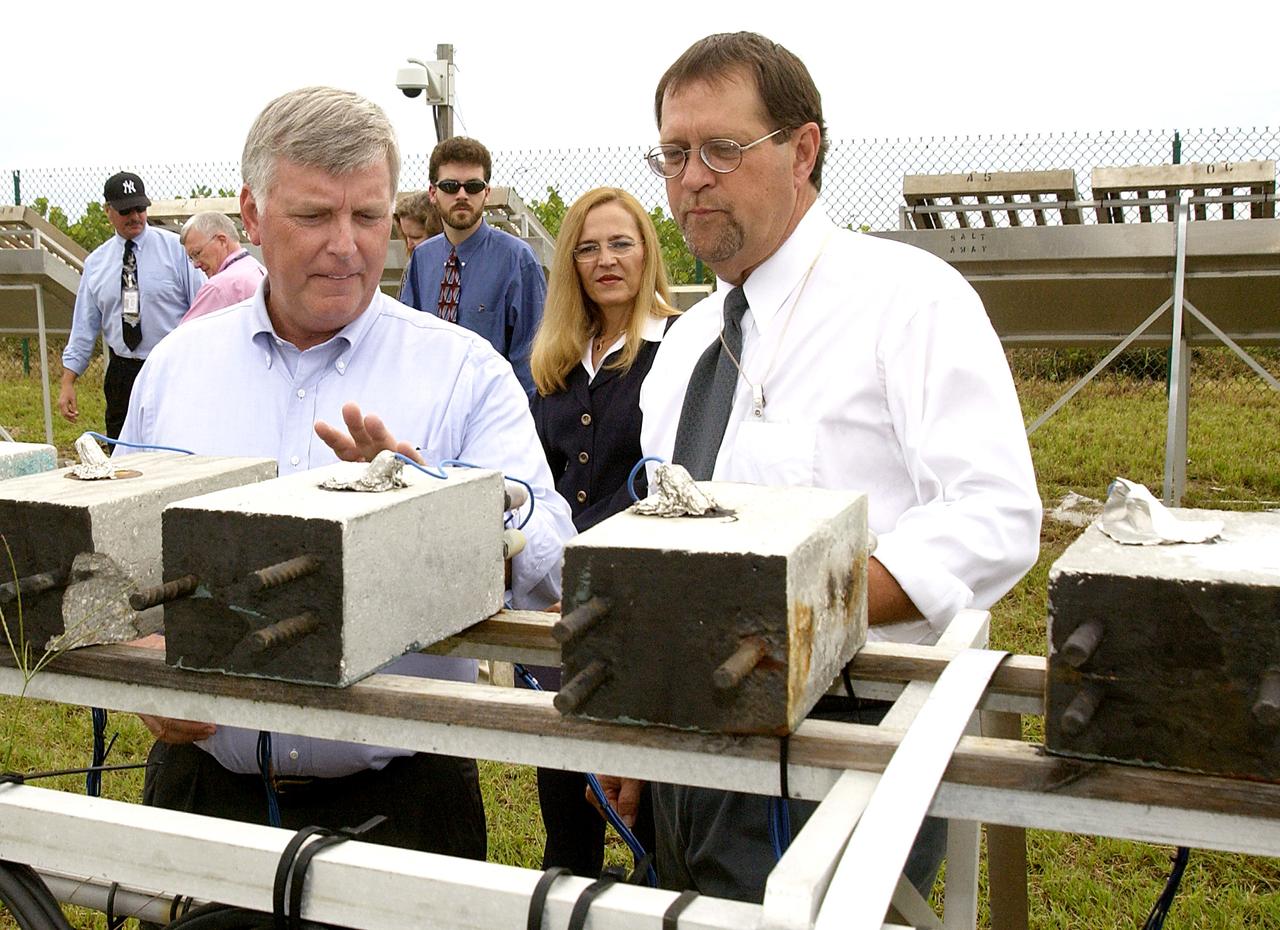
KENNEDY SPACE CENTER, FLA. - On a tour of the KSC Beach Corrosion Test Site, Testbed Manager Louis MacDowell (right) explains to Center Director Jim Kennedy about the test blocks being used to test a newly developed coating to protect steel inside concrete. Between MacDowell and Kennedy are Dr. Paul Hintze and Lead Scientist Dr. Luz Marina Calle. The KSC Beach Corrosion Test Site was established in the 1960s and has provided more than 30 years of historical information on the long-term performance of many materials in use at KSC and other locations around the world. Located 100 feet from the Atlantic Ocean approximately 1 mile south of the Space Shuttle launch sites, the test facility includes an atmospheric exposure site, a flowing seawater exposure site, and an on-site electrochemistry laboratory and monitoring station. The beach laboratory is used to conduct real-time corrosion experiments and provides for the remote monitoring of surrounding weather conditions. The newly added flowing seawater immersion facility provides for the immersion testing of materials and devices under controlled conditions.
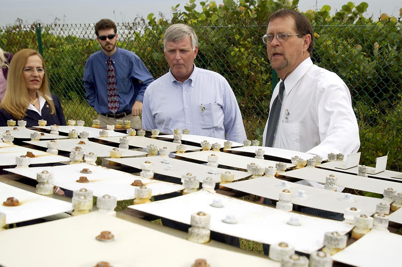
KENNEDY SPACE CENTER, FLA. - On a tour of the KSC Beach Corrosion Test Site, Center Director Jim Kennedy (second from right) learns from Testbed Manager Louis MacDowell (right) about a project being undertaken for the U.S. Navy. Being studied are nonchrome primers for aircraft. At left are Lead Scientist Dr. Luz Marina Calle and Dr. Paul Hintze, who is working on a graduate project for the National Research Council. The KSC Beach Corrosion Test Site was established in the 1960s and has provided more than 30 years of historical information on the long-term performance of many materials in use at KSC and other locations around the world. Located 100 feet from the Atlantic Ocean approximately 1 mile south of the Space Shuttle launch sites, the test facility includes an atmospheric exposure site, a flowing seawater exposure site, and an on-site electrochemistry laboratory and monitoring station. The beach laboratory is used to conduct real-time corrosion experiments and provides for the remote monitoring of surrounding weather conditions. The newly added flowing seawater immersion facility provides for the immersion testing of materials and devices under controlled conditions.

ISS040E112662 (08/30/2014) ---- Cancún, Mexico. A long lens was used by astronauts aboard the International Space Station to take this image, and it highlights many natural and built features. The street pattern of Mexico’s tourist mecca, Cancún, contrasts with the waterways of the marinas that open into the bay and the lagoons. Brilliant blue water over coral reefs contrast with the dark waters of inland lagoons. The reefs are the second largest reef system on Earth, and draw tourists from all over the world. The wide, well developed beach on the gulf coast (image upper right) is the result of vigorous wave energy; the white sand makes the beach easily visible from space. But wave energy is reduced along Cancún’s protected shoreline (image center) and the beaches are thin or non-existant. Fair-weather cumulus clouds are scattered across the image top left. To shoot crisp mages with long lenses, astronaut photographers must learn to brace themselves against the ISS bulkhead to prevent any slight shaking that would blur or “smear” the picture. Counterintuitively, they then need to move the camera carefully retaining the target at the same point in the viewfinder (the landscape moves across the viewfinder quickly with long lenses). This is called tracking the target and requires good coordination by the photographer—again, to prevent blurring. Shorter lenses do not require this skill because the image appears to pass more slowly across the viewfinder.

iss069e032998 (July 19, 2023) --- The city lights of Los Angeles, California, and its surrounding suburbs, are pictured from the International Space Station as it orbited 261 miles above. Terminal Island, an artificial island containing the ports of Los Angeles and Long Beach, is featured prominently at the bottom center of this photograph.
iss065e021010 (May 5, 2021) --- A cloud-covered Terminal Island and Long Beach south of Los Angeles, California, is pictured from the International Space Station as it orbited 263 miles above the Pacific Ocean off the coast of San Diego.

This image of the greater Los Angeles area was taken on March 29, 2019, by ASTERIA, the Arcsecond Space Telescope Enabling Research in Astrophysics satellite. The Port of Long Beach is visible near the center of the image. ASTERIA is a CubeSat, or a small satellite composed of cube units that measure 10 centimeters (4.5 inches) on each side. ASTERIA was designed to demonstrate precision pointing technology in a CubeSat, which could be used to observe planets around other stars. A slight decrease in a star's brightness as detected by ASTERIA could indicate that a planet is orbiting the star and passed in front of the star. This is called a planet transit. After completing its primary mission objectives in January 2018, ASTERIA has continued to operate on an extended mission. The mission team took this image to further test the capabilities of the satellite. https://photojournal.jpl.nasa.gov/catalog/PIA23124
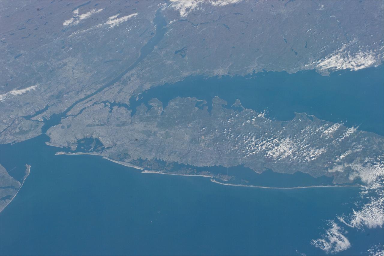
STS073-E-5098 (30 Oct. 1995) --- Long Island, New York stretches across the scene. The New York City metropolitan complex is at the left; Central Park can be seen as a dark rectangle between the Hudson and East Rivers. Sandy beaches of the Long Island barrier islands mark the boundary between Atlantic Ocean and quiet lagoons and marshes. The frame was exposed with the Electronic Still Camera (ESC).
iss073e0513936 (Aug. 22, 2025) --- Los Angeles, California, surrounded by its suburbs including Santa Monica, Marina Del Rey, and Long Beach, is pictured from the International Space Station as it orbited 261 miles above the Golden State. Highlights include Terminal Island (bottom right), an artificial island used mainly for industrial and port-related activities. At left, near Marina Del Rey is Los Angeles International Airport (LAX) connecting over 80 million passengers annually to over 100 domestic and international destinations.
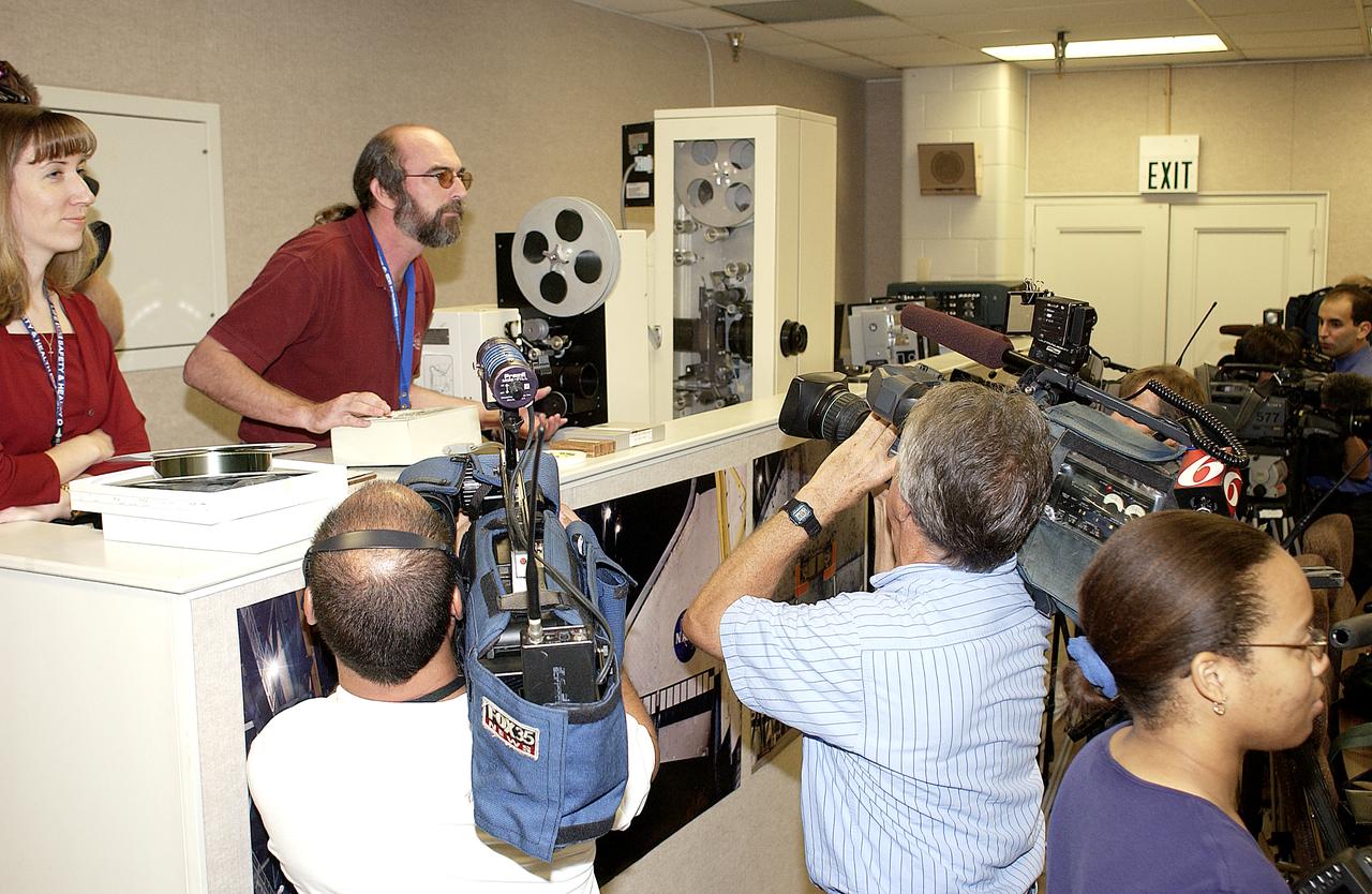
In the Image Analysis Facility in the Vehicle Assembly Building, Brad Lawrence (second from left, standing) participates in a presentation to news media representatives on the improved tracking cameras and long-range optical tracking systems that will be used to capture ascent imagery during the return to flight of the Space Shuttle. The press opportunity also includes tours of the launch pad perimeter camera site at Launch Complex 39B and two Playalinda Beach optical tracking sites at the Cape Canaveral National Seashore and the Merritt Island National Refuge.
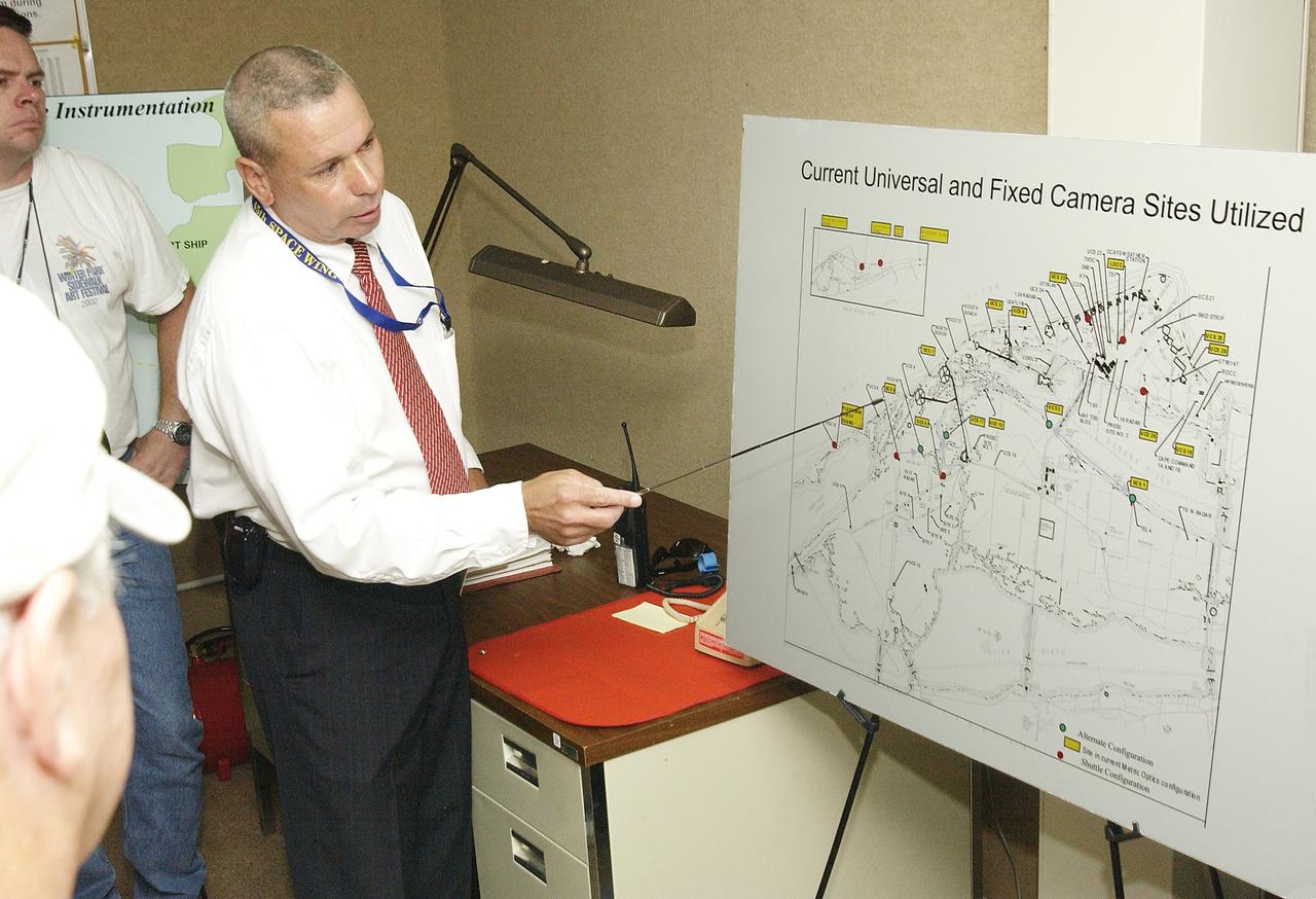
Inside the dome building at Playalinda Beach, Bob Fore points to a map of camera sites during a presentation to the media on the improved tracking cameras and long-range optical tracking systems that will be used to capture ascent imagery during the return to flight of the Space Shuttle. The press opportunity also includes tours of the launch pad perimeter camera site at Launch Complex 39B and the other optical tracking site at the Merritt Island National Refuge.
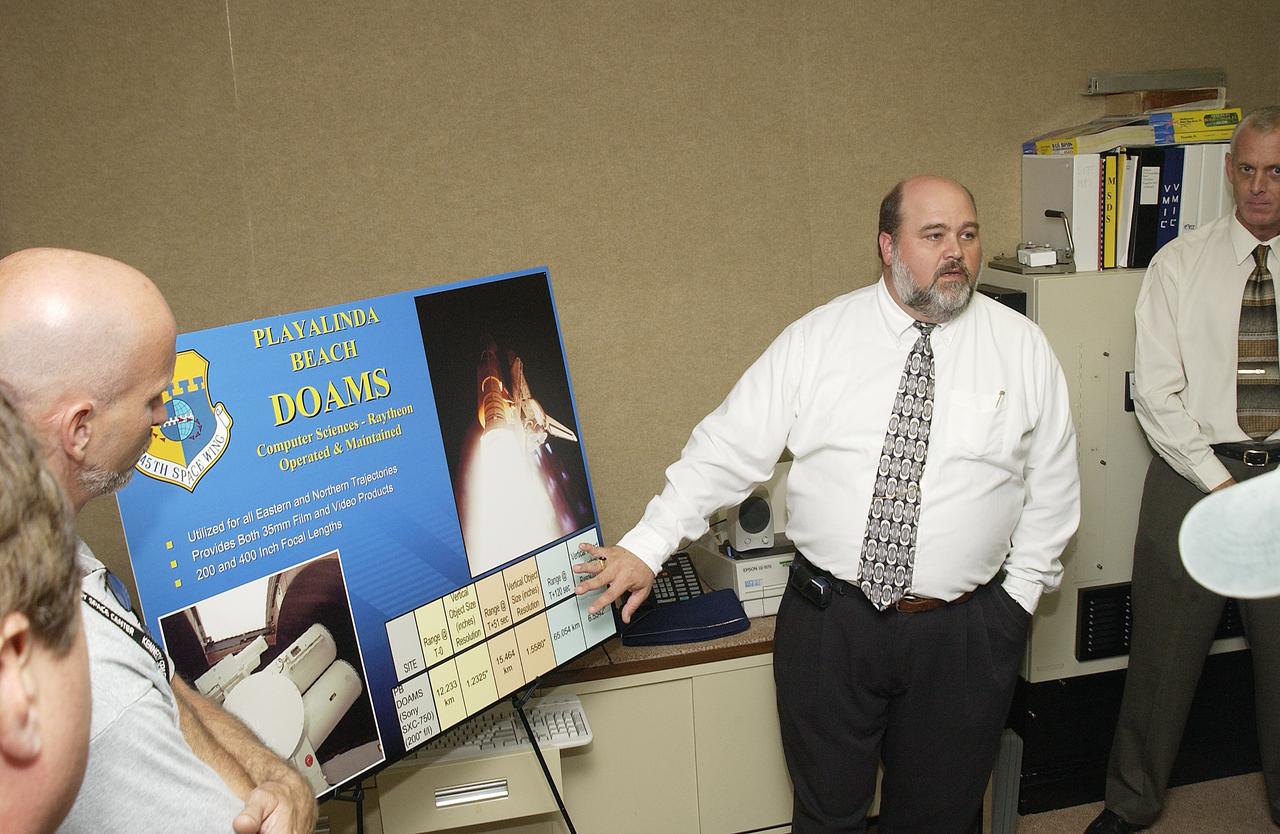
Inside the dome building at Playalinda Beach, Mike Litscher talks to media about the Distant Object Attitude Measurement System (DOAMS), part of the improved tracking cameras and long-range optical tracking systems that will be used to capture ascent imagery during the return to flight of the Space Shuttle. The press opportunity also includes tours of the launch pad perimeter camera site at Launch Complex 39B and the other optical tracking site at the Merritt Island National Refuge.

ISS006-E-36913 (10 March 2003) --- This nighttime view of Los Angeles, California was captured by one of the Expedition Six crewmembers on board the International Space Station (ISS). In the north, Hollywood is nestled against the south side of the Santa Monica Mountains. On the coast, Los Angeles International Airport (LAX) and the port facilities at Long Beach Naval Shipyards are also bright spots. The bright lights of Disneyland in Anaheim are also a standout feature.
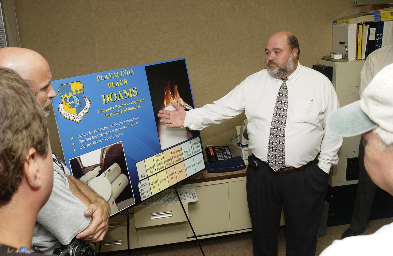
Inside the dome building at Playalinda Beach, Mike Litscher talks to media about the Distant Object Attitude Measurement System (DOAMS), part of the improved tracking cameras and long-range optical tracking systems that will be used to capture ascent imagery during the return to flight of the Space Shuttle. The press opportunity also includes tours of the launch pad perimeter camera site at Launch Complex 39B and the other optical tracking site at the Merritt Island National Refuge.
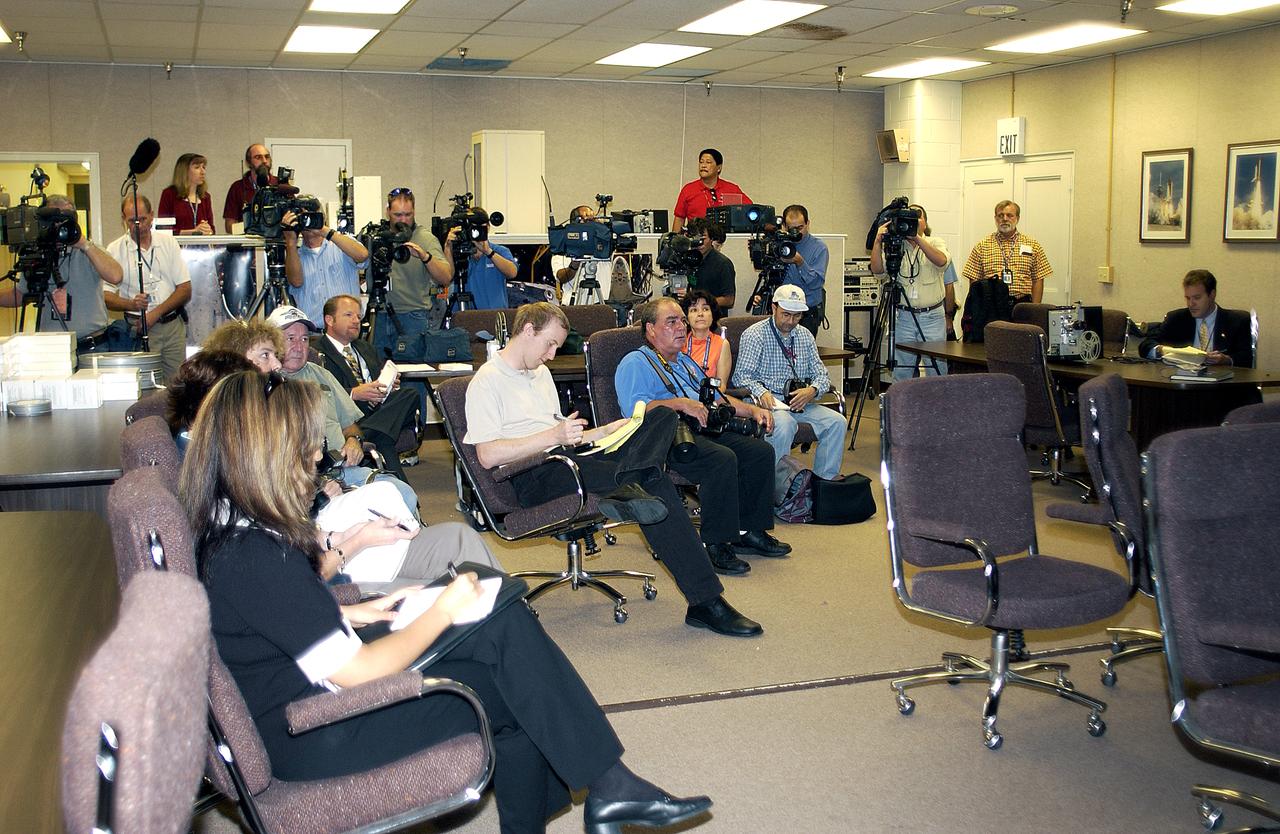
In the Image Analysis Facility in the Vehicle Assembly Building, news media representatives are briefed on the improved tracking cameras and long-range optical tracking systems that will be used to capture ascent imagery during the return to flight of the Space Shuttle. The press opportunity also includes tours of the launch pad perimeter camera site at Launch Complex 39B and two Playalinda Beach optical tracking sites at the Cape Canaveral National Seashore and the Merritt Island National Refuge.
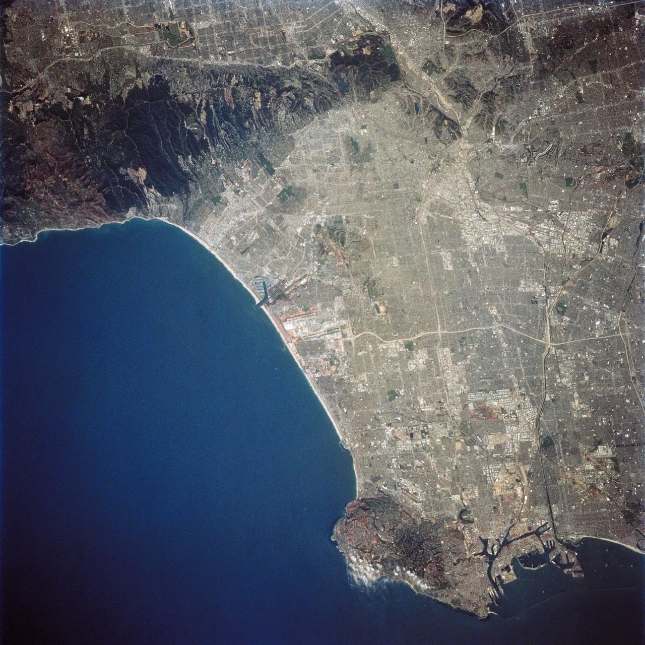
STS059-227-050 (9-20 April 1994) --- A low altitude, and unusually clear air, provided perhaps the most detailed view of Los Angeles, California ever obtained during a shuttle flight. Orient with the bulk of the ocean to the lower left. Then Long Beach is in the lower right, just east of the Palos Verdes Hills that extend into the Pacific Ocean. Marina del Rey is cut into the straight segment of beach, with Los Angeles International Airport (LAX) clearly visible to the southeast. Downtown Los Angeles is the light-toned sprawl in the upper right, with the rectangular grid pattern of Pasadena extending out of the picture. The Santa Monica Mountains to the upper left extend east-west, separating the San Fernando Valley (epicenter of the 1993 earthquake) from the Los Angeles Basin proper. It is impossible to determine by photo interpretation whether or not the de-vegetated scars along the southern edge of the mountains represent man-made features (real-estate development) or wildfires.
ISS032-E-016579 (11 Aug. 2012) --- A strandplain on coastal Peru is featured in this image photographed by an Expedition 32 crew member on the International Space Station. The scale and orientation of landscape features that are difficult to see on the ground often become readily visible from orbit. Numerous subparallel lines (center) along the arid, northern coast of Peru (about five degrees south of the Equator) are close-packed beach ridges, known collectively as a strandplain (for scale, the strandplain is 30 kilometers long). Each ridge shows the position of a prior shoreline. The Chira River delta appears at right, with dark green agricultural fields occupying the delta of the river. A smaller river reaches the sea, without forming a delta, at extreme left. The prominent cape at lower left is Punta Balcones, a region with many oil wells. Strandplains are built by successive additions of beach sand usually from some nearby source. Currents on this coast of South America come from the south, suggesting to scientists that the Chira River delta (right) is the source of the sand. The newest beach is being formed today by the waves?which appear as the thin ragged white line along the strandplain?supplied by the north-flowing current. The regularity of the spacing of the beaches suggests that some episodic influx of sediment controls beach formation. This influx may be determined by floods coming down the Chira River, possibly controlled by the heavy rains of El Nino events which occur irregularly every few years. Two other sets of faint parallel lines can be seen on higher ground inland (between arrows, center and top right), the upper set stretching all the way from the Chira river floodplain. Seen in many places along the coast of Peru, scientists believe these may also be strandplains (i.e. formed at sea level) generated when the land surface was at a lower altitude; both also may have been produced by sand from the Chira River. The land surface is known to be rising along this coast with the rise of the Andes Mts. (outside the top of the image), explaining why the upper shorelines now lie 120 meters above sea level.
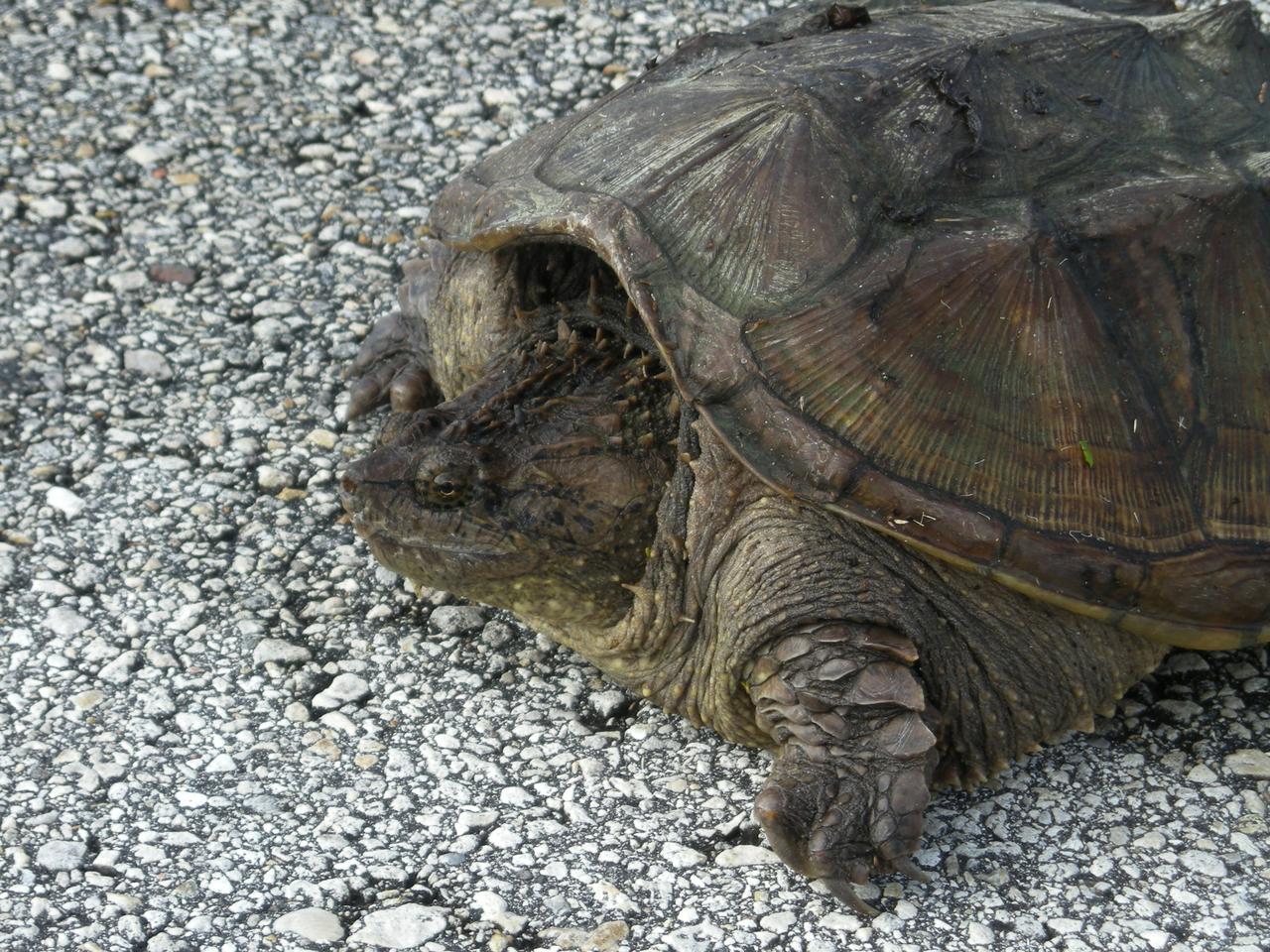
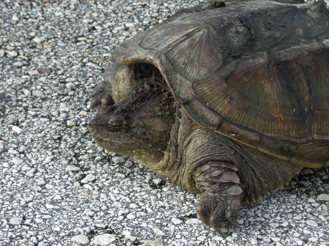
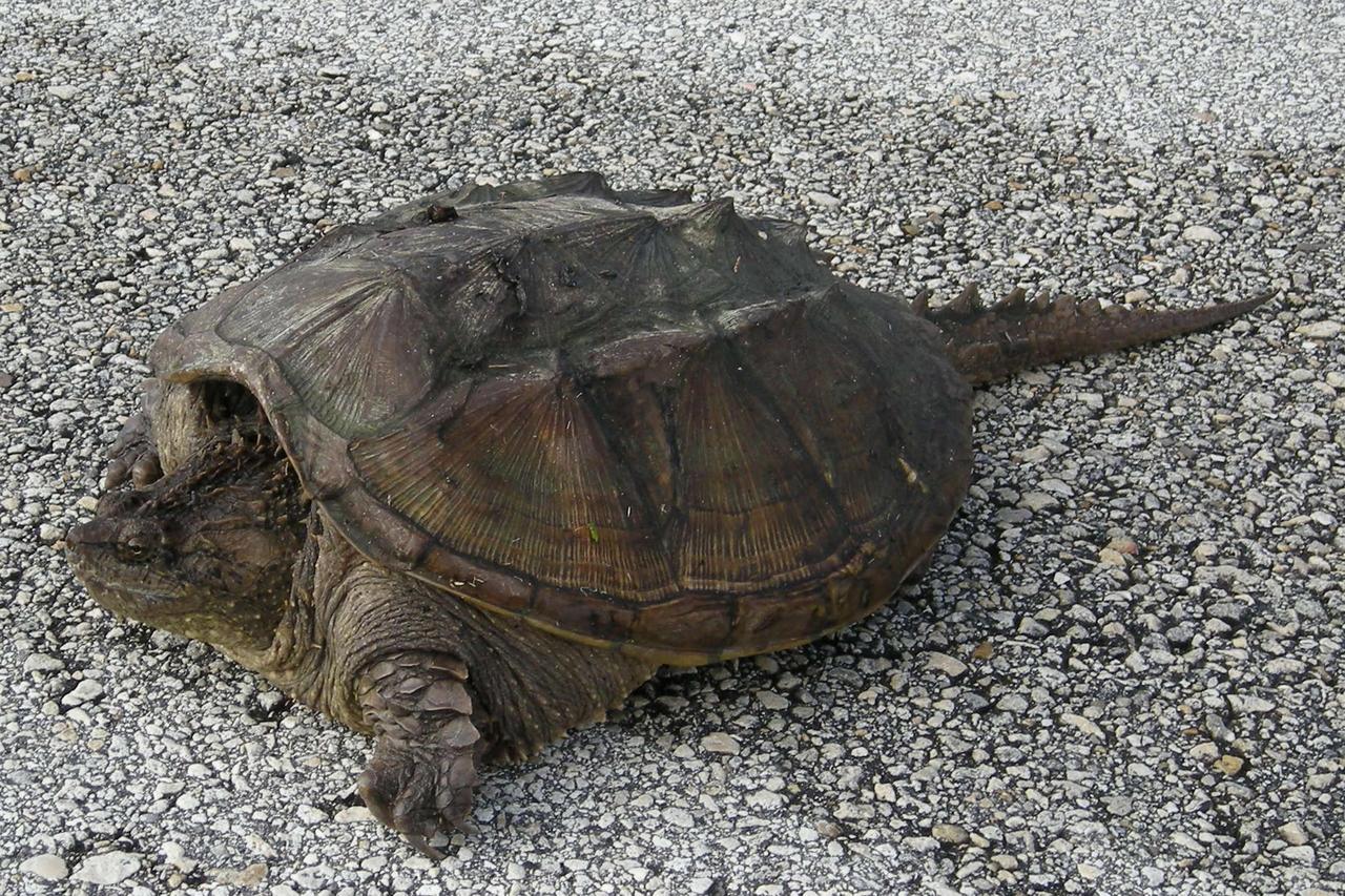
A rare photo of a Florida snapping turtle out in the open on Beach Road, near NASA's Kennedy Space Center. Found only in Florida and Georgia, this species is related to the common snapping turtle. It is considered a dangerous turtle because it can snap very quickly with its extremely strong jaws. Its tail, which is almost as long as its shell, has saw-edges along the top. The shell also has rough points down the middle. The shell is tan to dark brown and may have green algae growing on it. It can grow to 17 inches long and weigh 45 pounds. Snapping turtles usually live in ponds under the shadows and don’t like to rest in the sun like most turtles. They eat almost anything: water bugs, fish, lizards, small birds, mice, plants and even dead animals.

A rare photo of a Florida snapping turtle out in the open on Beach Road, near NASA's Kennedy Space Center. Found only in Florida and Georgia, this species is related to the common snapping turtle. It is considered a dangerous turtle because it can snap very quickly with its extremely strong jaws. Its tail, which is almost as long as its shell, has saw-edges along the top. The shell also has rough points down the middle. The shell is tan to dark brown and may have green algae growing on it. It can grow to 17 inches long and weigh 45 pounds. Snapping turtles usually live in ponds under the shadows and don’t like to rest in the sun like most turtles. They eat almost anything: water bugs, fish, lizards, small birds, mice, plants and even dead animals.
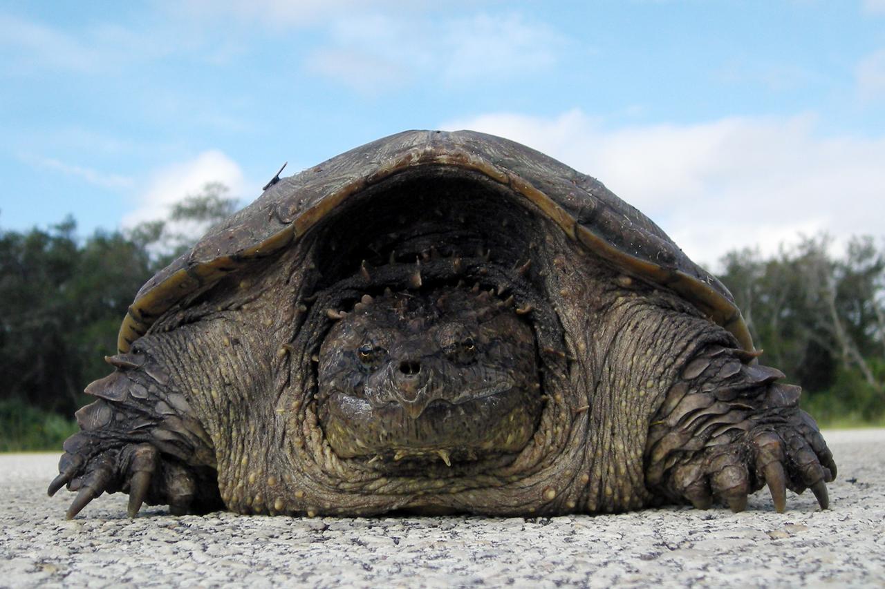
A rare photo of a Florida snapping turtle out in the open on Beach Road, near NASA's Kennedy Space Center. Found only in Florida and Georgia, this species is related to the common snapping turtle. It is considered a dangerous turtle because it can snap very quickly with its extremely strong jaws. Its tail, which is almost as long as its shell, has saw-edges along the top. The shell also has rough points down the middle. The shell is tan to dark brown and may have green algae growing on it. It can grow to 17 inches long and weigh 45 pounds. Snapping turtles usually live in ponds under the shadows and don’t like to rest in the sun like most turtles. They eat almost anything: water bugs, fish, lizards, small birds, mice, plants and even dead animals

KENNEDY SPACE CENTER, FLA. -- A rare photo of a Florida snapping turtle out in the open on Beach Road, near NASA's Kennedy Space Center. Found only in Florida and Georgia, this species is related to the common snapping turtle. It is considered a dangerous turtle because it can snap very quickly with its extremely strong jaws. Its tail, which is almost as long as its shell, has saw-edges along the top. The shell also has rough points down the middle. The shell is tan to dark brown and may have green algae growing on it. It can grow to 17 inches long and weigh 45 pounds. Snapping turtles usually live in ponds under the shadows and don’t like to rest in the sun like most turtles. They eat almost anything: water bugs, fish, lizards, small birds, mice, plants and even dead animals. Photo credit: NASA/Kenny Allen
NASA's X-37 Approach and Landing Test Vehicle is installed is a structural facility at Boeing's Huntington Beach, California plant. Tests, completed in July, were conducted to verify the structural integrity of the vehicle in preparation for atmospheric flight tests. Atmospheric flight tests of the Approach and Landing Test Vehicle are scheduled for 2004 and flight tests of the Orbital Vehicle are scheduled for 2006. The X-37 experimental launch vehicle is roughly 27.5 feet (8.3 meters) long and 15 feet (4.5 meters) in wingspan. It's experiment bay is 7 feet (2.1 meters) long and 4 feet (1.2 meters) in diameter. Designed to operate in both the orbital and reentry phases of flight, the X-37 will increase both safety and reliability, while reducing launch costs from $10,000 per pound to $1,000.00 per pound. The X-37 program is managed by the Marshall Space Flight Center and built by the Boeing Company.
KENNEDY SPACE CENTER, FLA. -- A rare photo of a Florida snapping turtle out in the open on Beach Road, near NASA's Kennedy Space Center. Found only in Florida and Georgia, this species is related to the common snapping turtle. It is considered a dangerous turtle because it can snap very quickly with its extremely strong jaws. Its tail, which is almost as long as its shell, has saw-edges along the top. The shell also has rough points down the middle. The shell is tan to dark brown and may have green algae growing on it. It can grow to 17 inches long and weigh 45 pounds. Snapping turtles usually live in ponds under the shadows and don’t like to rest in the sun like most turtles. They eat almost anything: water bugs, fish, lizards, small birds, mice, plants and even dead animals. Photo credit: NASA/Kenny Allen
KENNEDY SPACE CENTER, FLA. -- A rare photo of a Florida snapping turtle out in the open on Beach Road, near NASA's Kennedy Space Center. Found only in Florida and Georgia, this species is related to the common snapping turtle. It is considered a dangerous turtle because it can snap very quickly with its extremely strong jaws. Its tail, which is almost as long as its shell, has saw-edges along the top. The shell also has rough points down the middle. The shell is tan to dark brown and may have green algae growing on it. It can grow to 17 inches long and weigh 45 pounds. Snapping turtles usually live in ponds under the shadows and don’t like to rest in the sun like most turtles. They eat almost anything: water bugs, fish, lizards, small birds, mice, plants and even dead animals. Photo credit: NASA/Kenny Allen
NASA's X-37 Approach and Landing Test Vehicle is installed is a structural facility at Boeing's Huntington Beach, California plant, where technicians make adjustments to composite panels. Tests, completed in July, were conducted to verify the structural integrity of the vehicle in preparation for atmospheric flight tests. Atmospheric flight tests of the Approach and Landing Test Vehicle are scheduled for 2004 and flight tests of the Orbital Vehicle are scheduled for 2006. The X-37 experimental launch vehicle is roughly 27.5 feet (8.3 meters) long and 15 feet (4.5 meters) in wingspan. It's experiment bay is 7 feet (2.1 meters) long and 4 feet (1.2 meters) in diameter. Designed to operate in both the orbital and reentry phases of flight, the X-37 will increase both safety and reliability, while reducing launch costs from $10,000 per pound to $1,000.00 per pound. The X-37 program is managed by the Marshall Space Flight Center and built by the Boeing Company.
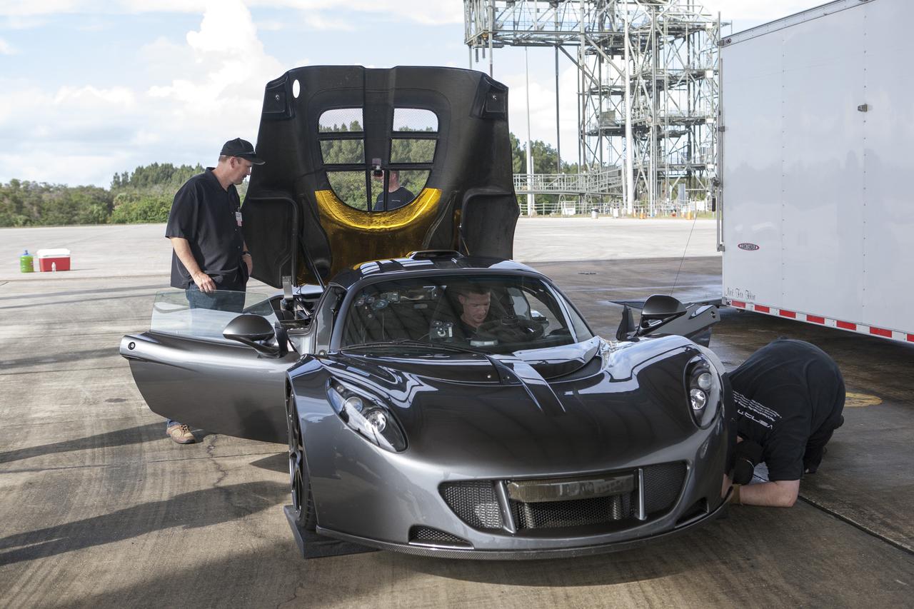
CAPE CANAVERAL, Fla. - Mechanics and engineers ready a Hennessey Venom GT for test runs on the 3.5-mile long runway at the Shuttle Landing Facility at NASA's Kennedy Space Center in Florida. The flat concrete runway is one of the few places in the world where high performance automobiles can be tested for aerodynamic and safety designs. Hennessey Performance of Sealy, Texas, worked with Performance Power Racing in West Palm Beach to arrange use of the NASA facility. Performance Power Racing has conducted numerous engineering tests on the runway with a variety of vehicles. Photo credit: NASA/Kim Shiflett
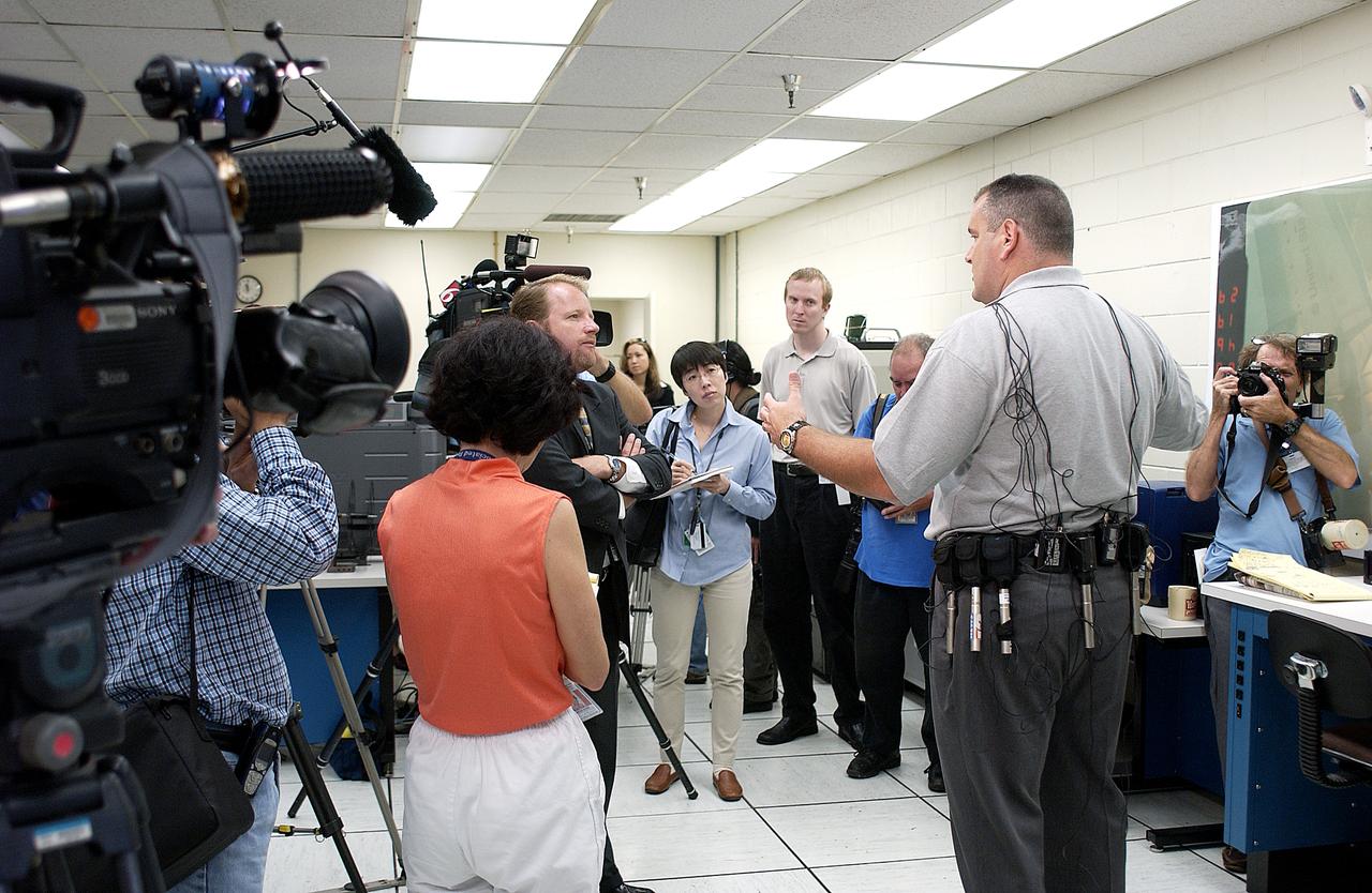
In the Image Analysis Facility in the Vehicle Assembly Building, Armando Oliu (second from right), lead of the KSC Ice and Debris Team, answers questions from news media representatives on the improved tracking cameras and long-range optical tracking systems that will be used to capture ascent imagery during the return to flight of the Space Shuttle. The press opportunity also includes tours of the launch pad perimeter camera site at Launch Complex 39B and two Playalinda Beach optical tracking sites at the Cape Canaveral National Seashore and the Merritt Island National Refuge.
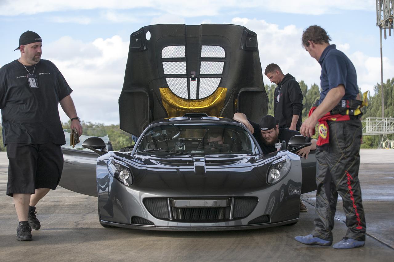
CAPE CANAVERAL, Fla. - Mechanics, engineers and Driver Brian Smith, in jumpsuit, ready a Hennessey Venom GT for test runs on the 3.5-mile long runway at the Shuttle Landing Facility at NASA's Kennedy Space Center in Florida. The flat concrete runway is one of the few places in the world where high performance automobiles can be tested for aerodynamic and safety designs. Hennessey Performance of Sealy, Texas, worked with Performance Power Racing in West Palm Beach to arrange use of the NASA facility. Performance Power Racing has conducted numerous engineering tests on the runway with a variety of vehicles. Photo credit: NASA/Kim Shiflett
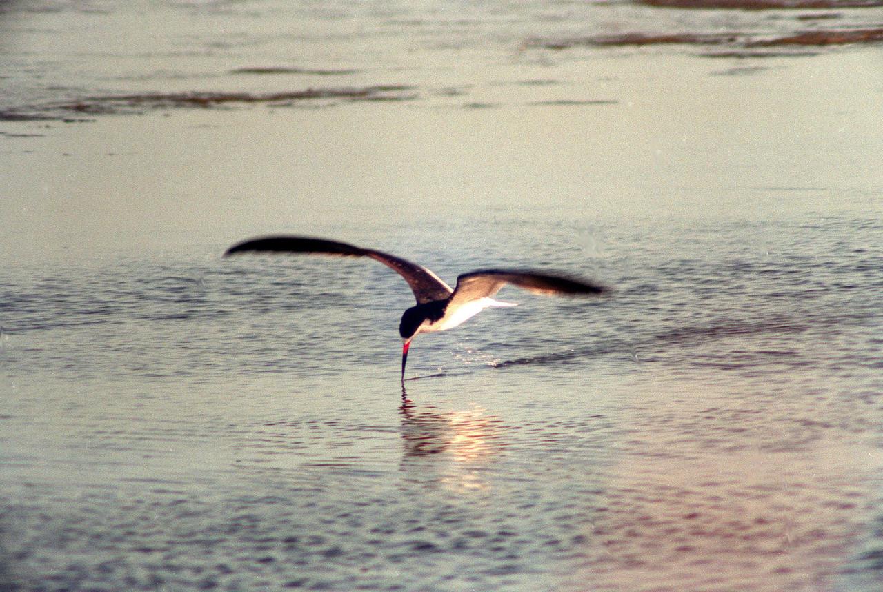
KENNEDY SPACE CENTER, FLA. -- A black skimmer proves its name as it flies low over the water in the Merritt Island National Wildlife Refuge, which shares a boundary with Kennedy Space Center. They skim the surface of the water for fish, with the tip of their lower mandible cutting through the water. They also wade in shallow water, jabbing with their blade-like bills at the fish scattering before them. Skimmers breed chiefly on sandbars and beaches, feeding in shallow bays, inlets and estuaries, such as the Wildlife Refuge. They range from Massachusetts and Long Island to Florida and Texas, and from Mexico to southern South America
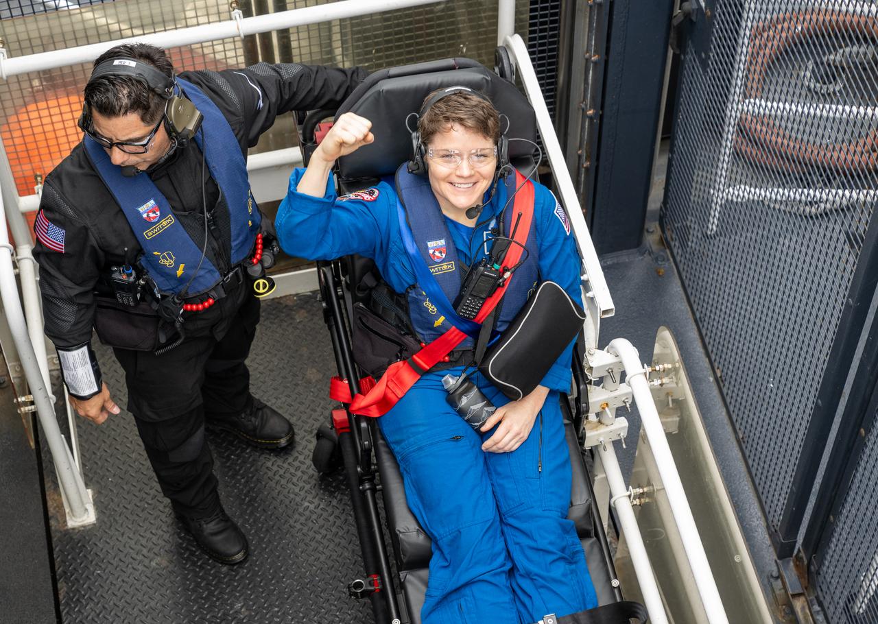
NASA astronaut Anne McClain is seen inside an elevator onboard the SpaceX recovery ship SHANNON that will take her up to a waiting helicopter to fly to Long Beach, Calif. along with NASA astronaut Nichole Ayers, JAXA (Japan Aerospace Exploration Agency) astronaut Takuya Onishi, and Roscosmos cosmonaut Kirill Peskov shortly after they landed in the Pacific Ocean off the coast of San Diego, Calif., Saturday, Aug. 9, 2025. McClain, Ayers, Onishi, and Peskov are returning after 147 days in space as part of Expedition 73 aboard the International Space Station. Photo Credit: (NASA/Keegan Barber)
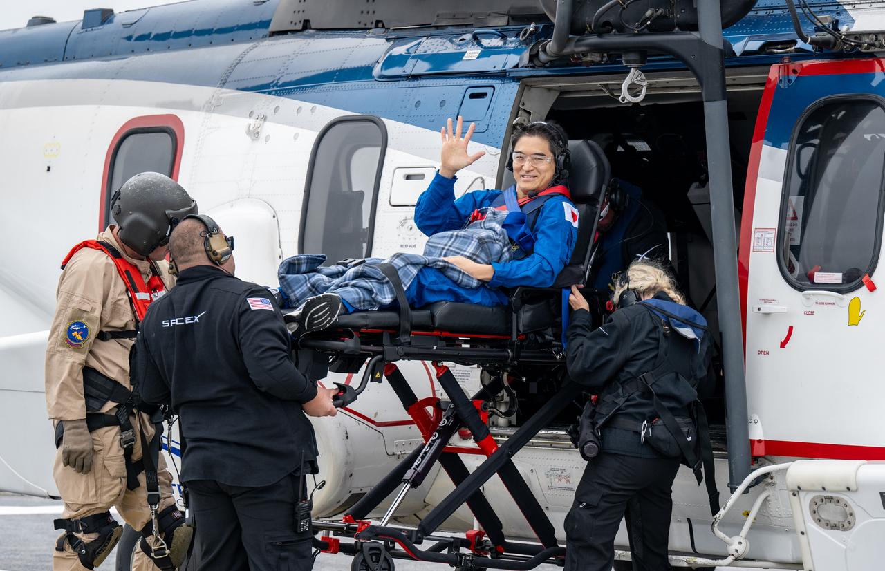
JAXA (Japan Aerospace Exploration Agency) astronaut Takuya Onishi is helped aboard a helicopter on the SpaceX recovery ship SHANNON to fly to Long Beach, Calif. along with NASA astronaut Nichole Ayers, Anne McClain, and Roscosmos cosmonaut Kirill Peskov shortly after they landed in the Pacific Ocean off the coast of San Diego, Calif., Saturday, Aug. 9, 2025. McClain, Ayers, Onishi, and Peskov are returning after 147 days in space as part of Expedition 73 aboard the International Space Station. Photo Credit: (NASA/Keegan Barber)
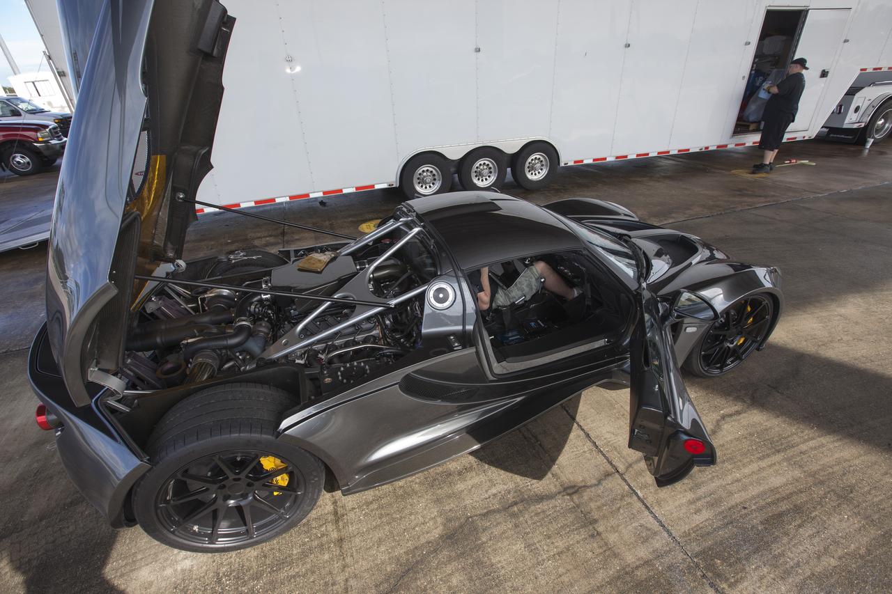
CAPE CANAVERAL, Fla. - An engineer readies a Hennessey Venom GT for test runs on the 3.5-mile long runway at the Shuttle Landing Facility at NASA's Kennedy Space Center in Florida. The flat concrete runway is one of the few places in the world where high performance automobiles can be tested for aerodynamic and safety designs. Hennessey Performance of Sealy, Texas, worked with Performance Power Racing in West Palm Beach to arrange use of the NASA facility. Performance Power Racing has conducted numerous engineering tests on the runway with a variety of vehicles. Photo credit: NASA/Kim Shiflett
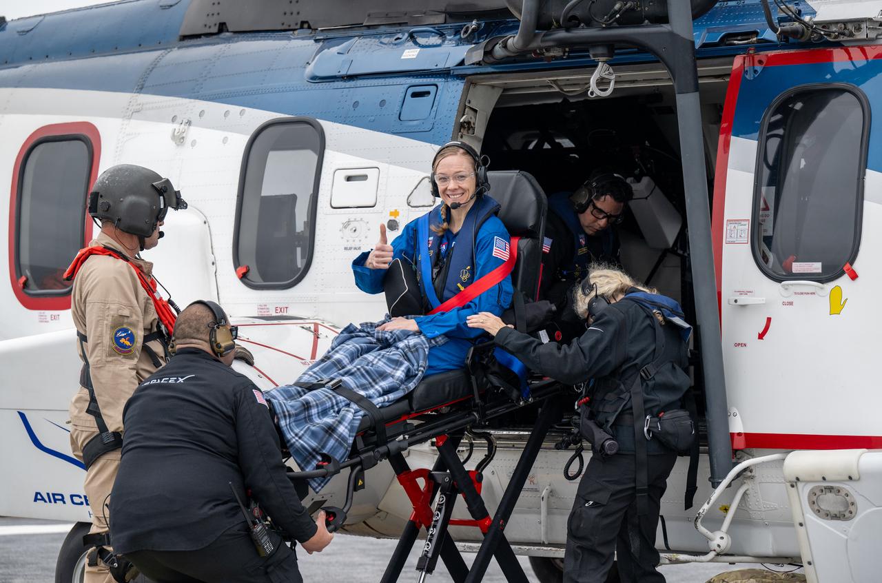
NASA astronaut Nichole Ayers is helped aboard a helicopter on the SpaceX recovery ship SHANNON to fly to Long Beach, Calif. along with NASA astronaut Anne McClain, JAXA (Japan Aerospace Exploration Agency) astronaut Takuya Onishi, and Roscosmos cosmonaut Kirill Peskov shortly after they landed in the Pacific Ocean off the coast of San Diego, Calif., Saturday, Aug. 9, 2025. McClain, Ayers, Onishi, and Peskov are returning after 147 days in space as part of Expedition 73 aboard the International Space Station. Photo Credit: (NASA/Keegan Barber)
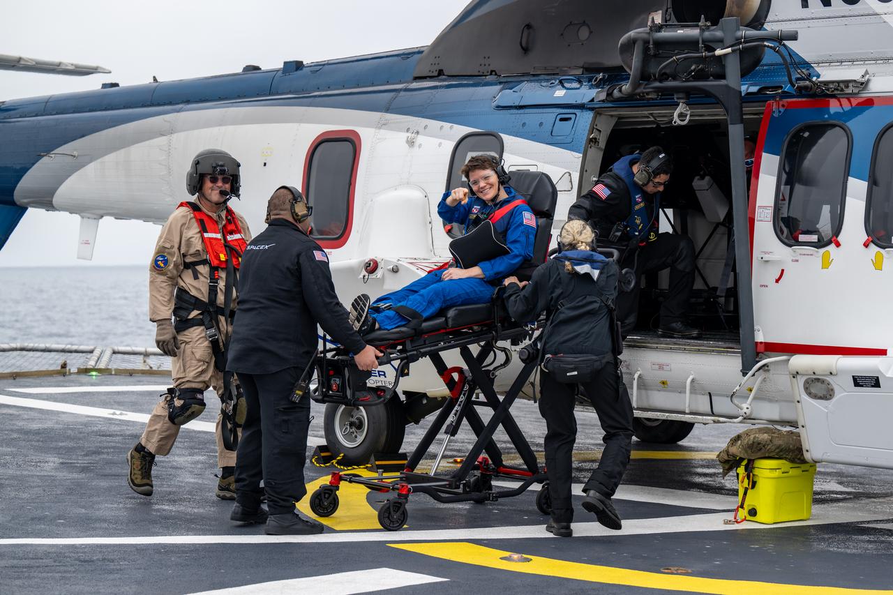
NASA astronaut Anne McClain is helped aboard a helicopter on the SpaceX recovery ship SHANNON to fly to Long Beach, Calif. along with NASA astronaut Nichole Ayers, JAXA (Japan Aerospace Exploration Agency) astronaut Takuya Onishi, and Roscosmos cosmonaut Kirill Peskov shortly after they landed in the Pacific Ocean off the coast of San Diego, Calif., Saturday, Aug. 9, 2025. McClain, Ayers, Onishi, and Peskov are returning after 147 days in space as part of Expedition 73 aboard the International Space Station. Photo Credit: (NASA/Keegan Barber)
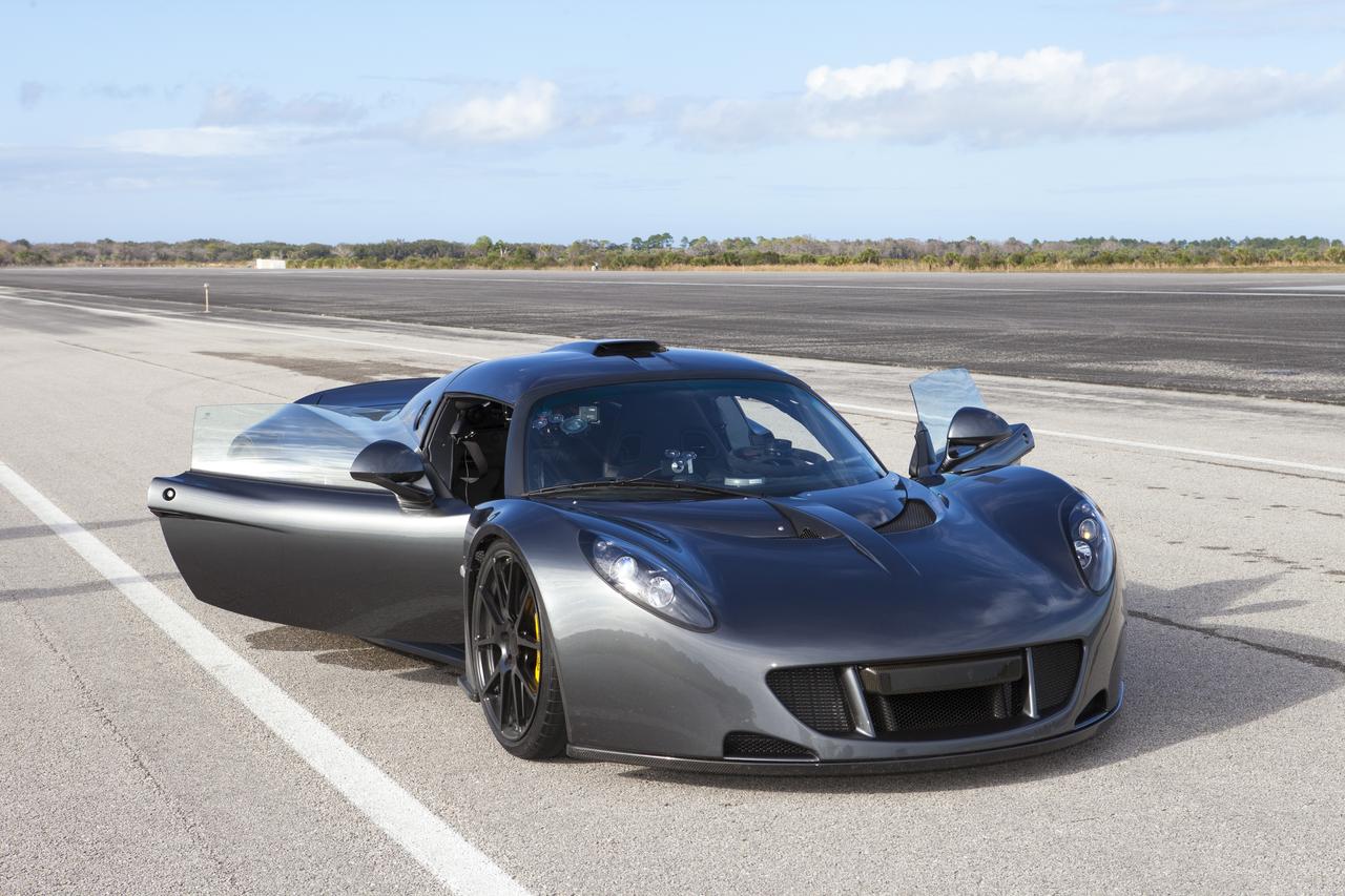
CAPE CANAVERAL, Fla. - A Hennessey Venom GT stands on the 3.5-mile long runway between test runs at the Shuttle Landing Facility at NASA's Kennedy Space Center in Florida. The flat concrete runway is one of the few places in the world where high performance automobiles can be tested for aerodynamic and safety designs. Hennessey Performance of Sealy, Texas, worked with Performance Power Racing in West Palm Beach to arrange use of the NASA facility. Performance Power Racing has conducted numerous engineering tests on the runway with a variety of vehicles. Photo credit: NASA/Kim Shiflett
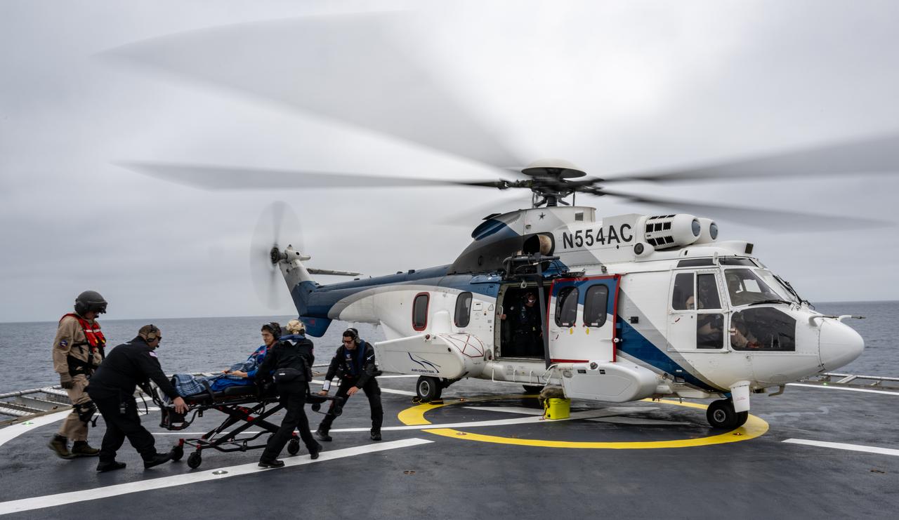
JAXA (Japan Aerospace Exploration Agency) astronaut Takuya Onishi is helped aboard a helicopter on the SpaceX recovery ship SHANNON to fly to Long Beach, Calif. along with NASA astronaut Nichole Ayers, Anne McClain, and Roscosmos cosmonaut Kirill Peskov shortly after they landed in the Pacific Ocean off the coast of San Diego, Calif., Saturday, Aug. 9, 2025. McClain, Ayers, Onishi, and Peskov are returning after 147 days in space as part of Expedition 73 aboard the International Space Station. Photo Credit: (NASA/Keegan Barber)
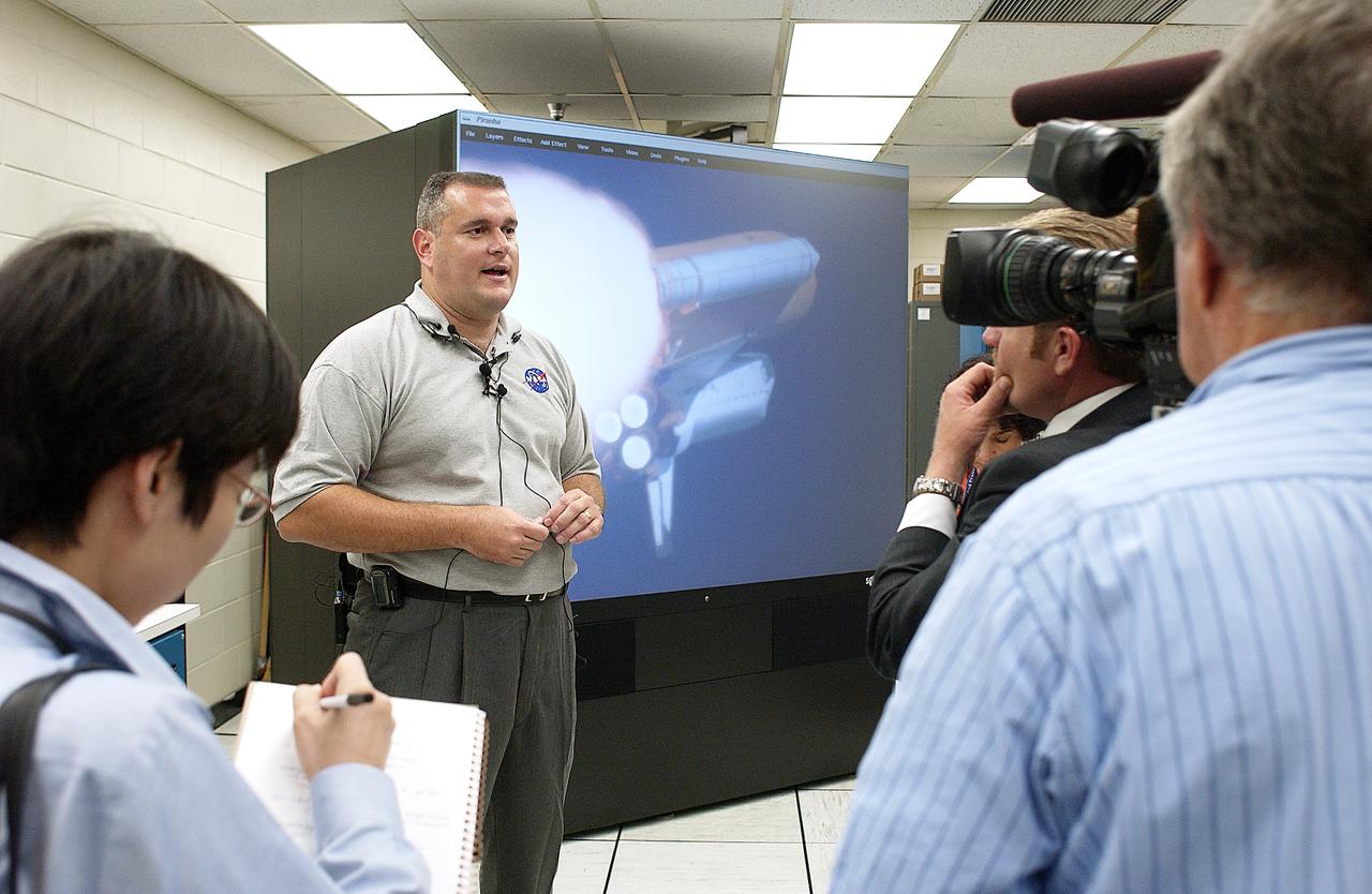
In the Image Analysis Facility in the Vehicle Assembly Building, Armando Oliu (second from left), lead of the KSC Ice and Debris Team, answers questions from news media representatives on the improved tracking cameras and long-range optical tracking systems that will be used to capture ascent imagery during the return to flight of the Space Shuttle. The press opportunity also includes tours of the launch pad perimeter camera site at Launch Complex 39B and two Playalinda Beach optical tracking sites at the Cape Canaveral National Seashore and the Merritt Island National Refuge.

ISS047e141619 (06/06/2016) --- This Earth observation image captured by Expedition 47 members aboard the International Space Station is of Juan de Nova Island, also known as Saint-Christophe. The small French tropical island is in the narrowest part of the Mozambique Channel, about one-third of the way between Madagascar and Mozambique. The Island is 3.7 miles long and 1 mile at its widest. It is a nature reserve surrounded by reefs. Forests cover about half the island and sea turtles nest on the beaches. It is largely uninhabited but the French maintain a weather station on the Island.
Roscosmos cosmonaut Kirill Peskov is seen inside an elevator onboard the SpaceX recovery ship SHANNON that will take him up to a waiting helicopter to fly to Long Beach, Calif. along with NASA astronauts Nichole Ayers, Anne McClain and JAXA (Japan Aerospace Exploration Agency) astronaut Takuya Onishi shortly after they landed in the Pacific Ocean off the coast of San Diego, Calif., Saturday, Aug. 9, 2025. McClain, Ayers, Onishi, and Peskov are returning after 147 days in space as part of Expedition 73 aboard the International Space Station. Photo Credit: (NASA/Keegan Barber)

S129-E-007324 (21 Nov. 2009) --- One of the crew members onboard the space shuttle Atlantis recorded this still image of the Bahamas' lengthy narrow Eleuthra Island. Like most of the Bahama Islands, Eleuthra is composed mainly of limestone and coral, and rises from a vast submarine plateau. The island, 80 miles (133 kilometers) long, about two miles (three kilometers) wide and covering an area of 164 square miles (425 square kilometers), is generally low and flat, has many mangrove swamps, brackish lakes, coral reefs and shoals, and many miles of sandy beaches.

Students from California State University, Long Beach, prepare their robotic miner for its turn to dig in the mining arena during NASA’s LUNABOTICS competition on May 24, 2022, at the Center for Space Education near the Kennedy Space Center Visitor Complex in Florida. More than 35 teams from around the U.S. have designed and built remote-controlled robots for the mining competition. Teams use their autonomous or remote-controlled robots to maneuver and dig in a supersized sandbox filled with rocks and simulated lunar soil, or regolith. The objective of the challenge is to see which team’s robot can collect and deposit the most rocky regolith within a specified amount of time.
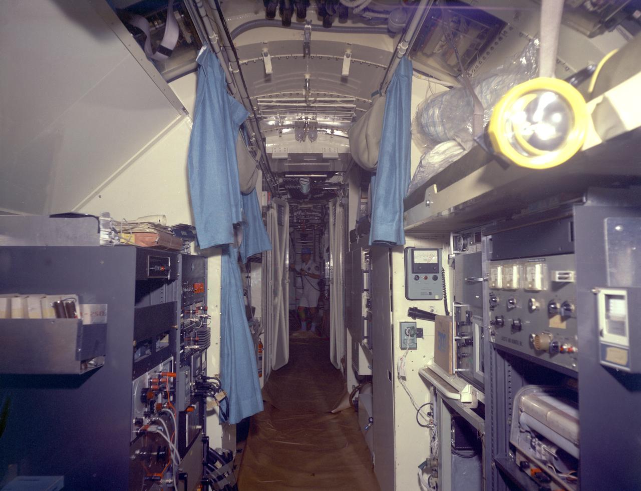
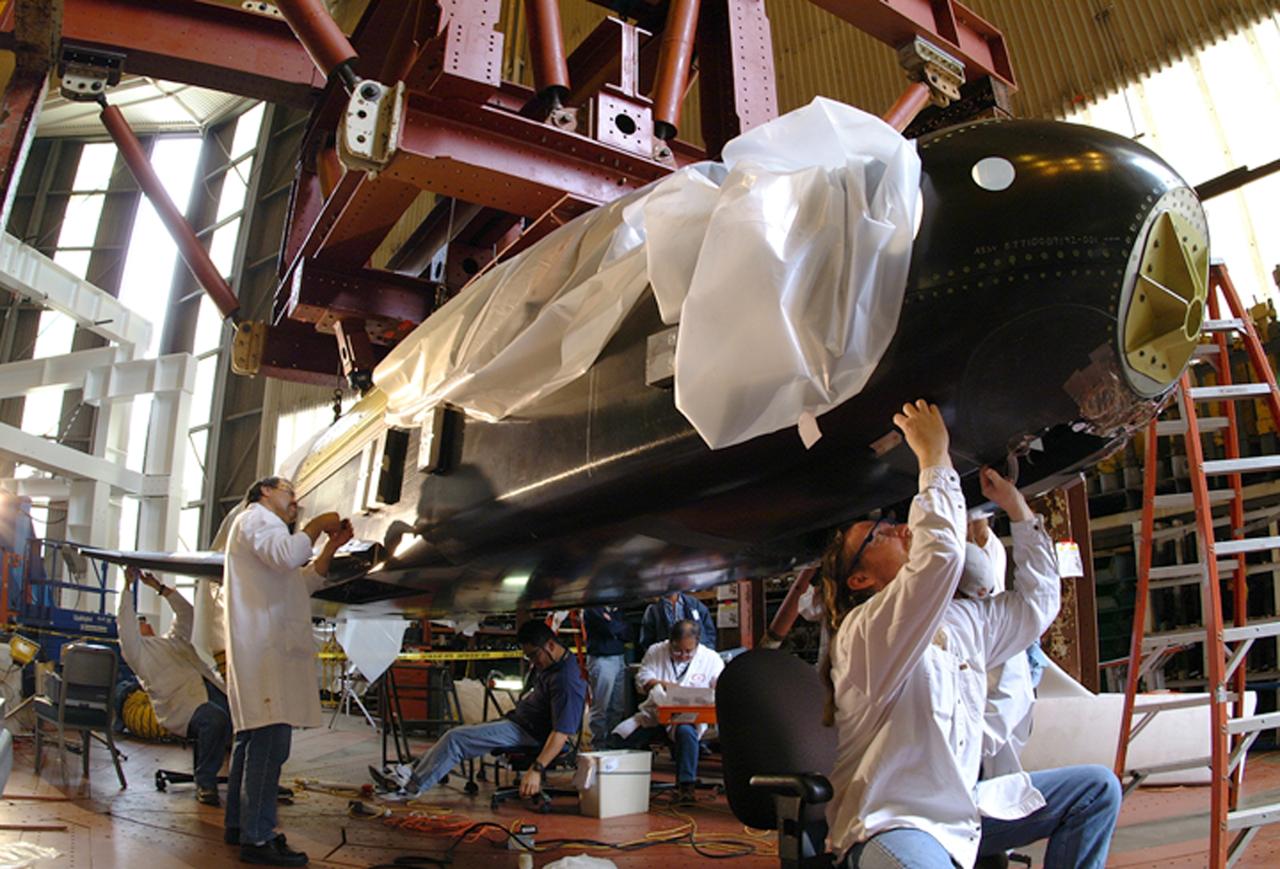
This is an interior view of the living quarters of the deep-sea research submarine "Ben Franklin." Named for American patriot and inventor Ben Franklin, who discovered the Gulf Steam, the 50-foot Ben Franklin was built between 1966 and 1968 in Switzerland for deep- ocean explorer Jacques Piccard and the Grumman Aircraft Engineering Corporation. The submersible made a famous 30-day drift dive off the East Coast of the United States and Canada in 1969 mapping the Gulf Stream's currents and sea life, and also made space exploration history by studying the behavior of aquanauts in a sealed, self-contained, self-sufficient capsule for NASA. On July 14, 1969, the Ben Franklin was towed to the high-velocity center of the Stream off the coast of Palm Beach, Florida. With a NASA observer on board, the sub descended to 1,000 feet off of Riviera Beach, Florida and drifted 1,400 miles north with the current for more than four weeks, reemerging near Maine. During the course of the dive, NASA conducted exhaustive analyses of virtually every aspect of onboard life. They measured sleep quality and patterns, sense of humor and behavioral shifts, physical reflexes, and the effect of a long-term routine on the crew. The submarine's record-shattering dive influenced the design of Apollo and Skylab missions and continued to guide NASA scientists as they devised future marned space-flight missions.
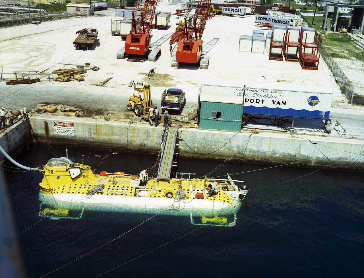
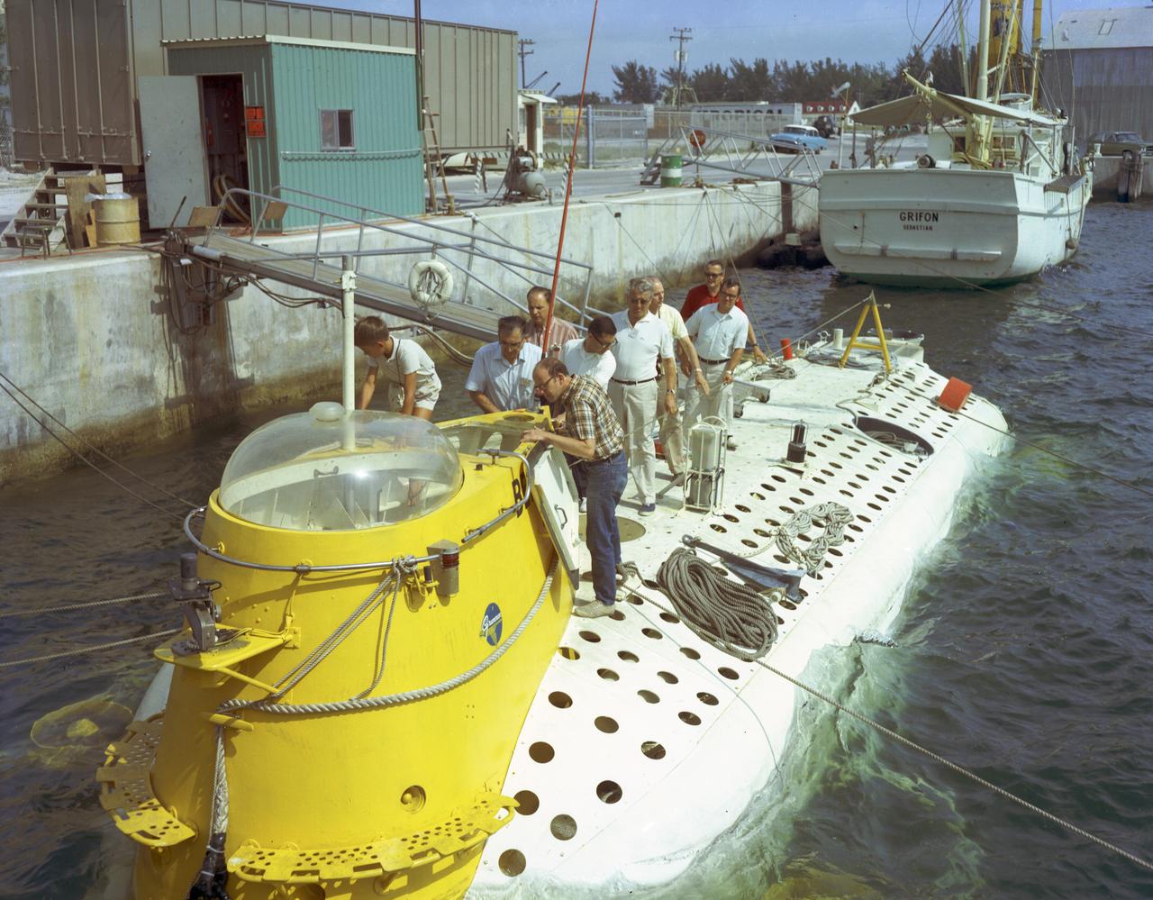
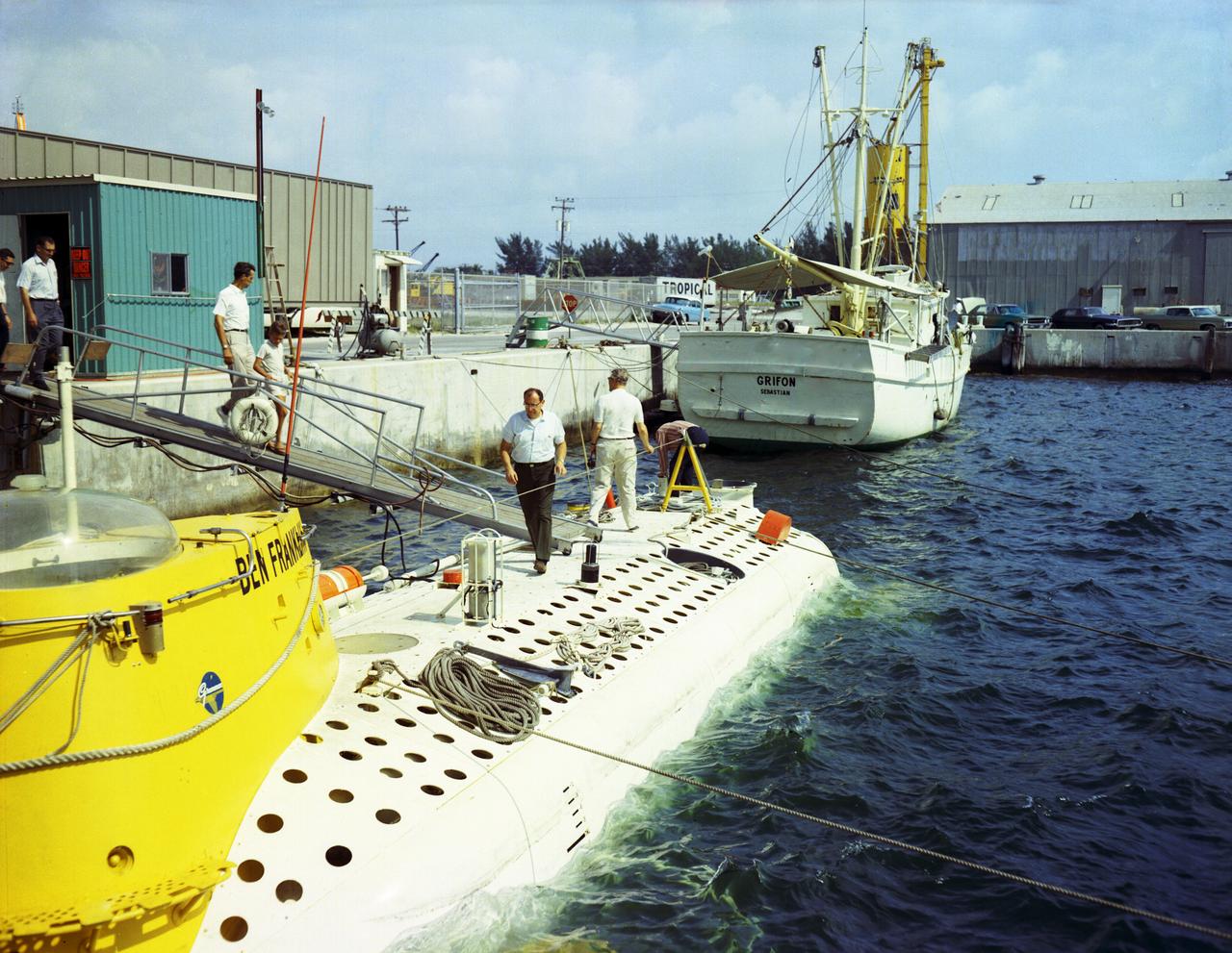
This is an aerial view of the deep-sea research submarine "Ben Franklin" at dock. Named for American patriot and inventor Ben Franklin, who discovered the Gulf Steam, the 50-foot Ben Franklin was built between 1966 and 1968 in Switzerland for deep-ocean explorer Jacques Piccard and the Grumman Aircraft Engineering Corporation. The submersible made a famous 30-day drift dive off the East Coast of the United States and Canada in 1969 mapping the Gulf Stream's currents and sea life, and also made space exploration history by studying the behavior of aquanauts in a sealed, self-contained, self-sufficient capsule for NASA. On July 14, 1969, the Ben Franklin was towed to the high-velocity center of the Stream off the coast of Palm Beach, Florida. With a NASA observer on board, the sub descended to 1,000 feet off of Riviera Beach, Florida and drifted 1,400 miles north with the current for more than four weeks, reemerging near Maine. During the course of the dive, NASA conducted exhaustive analyses of virtually every aspect of onboard life. They measured sleep quality and patterns, sense of humor and behavioral shifts, physical reflexes, and the effects of a long-term routine on the crew. The submarine's record-shattering dive influenced the design of Apollo and Skylab missions and continued to guide NASA scientists as they devised future marned space-flight missions.
“Back home there’s a place called Mākua beach. It’s where I spent so much of my childhood. My grandfather had a little beachside camp area, and every day after school my dad and I would drive to the camp and visit my grandfather, and we’d go out fishing either on a rubber tube or a small fishing boat. There are so many memories of being with my dad and my grandfather and all of my calabash uncles there. My grandmother and my grandfather were both strongly connected to the beach. They actually both passed away on the beach, so that place has a special place in my heart. It’s a beautiful, beautiful quiet little pocket of sand and water, and every time I go back, I think of them and all of those memories. “The Hawaiians have been there for a thousand-plus years. And I have written documents that show my grandfather’s great-grandfather had an association with the area. It was a letter he wrote to a commission voicing his support for Native Hawaiian land rights in the valley. I love to go back every time I go home. Sometimes when it’s low tide, you can even find petroglyphs engraved on the rocks. There’s always something new to discover. “I know fishing is not as plentiful as it was before because of overfishing and likely other factors. Climate change is impacting a lot of coastal areas not just in Hawaii but also around the world, from erosion to coral bleaching. It’s powerful that we continue to learn how everyone and everything on Earth is interconnected. It’s what Native Hawaiians have long understood through our cosmology and approach to resource management. “That’s what makes communicating Earth science meaningful for me—knowing that indigenous Hawaiian wisdom and NASA research both point to the responsible management of and respect for the environment.” Samson Reiny, editor and senior outreach coordinator at NASA Earth Science News, Friday, Feb. 21, 2020, at NASA's Goddard Space Flight Center in Greenbelt, Md. Photo Credit: (NASA/Joel Kowsky)
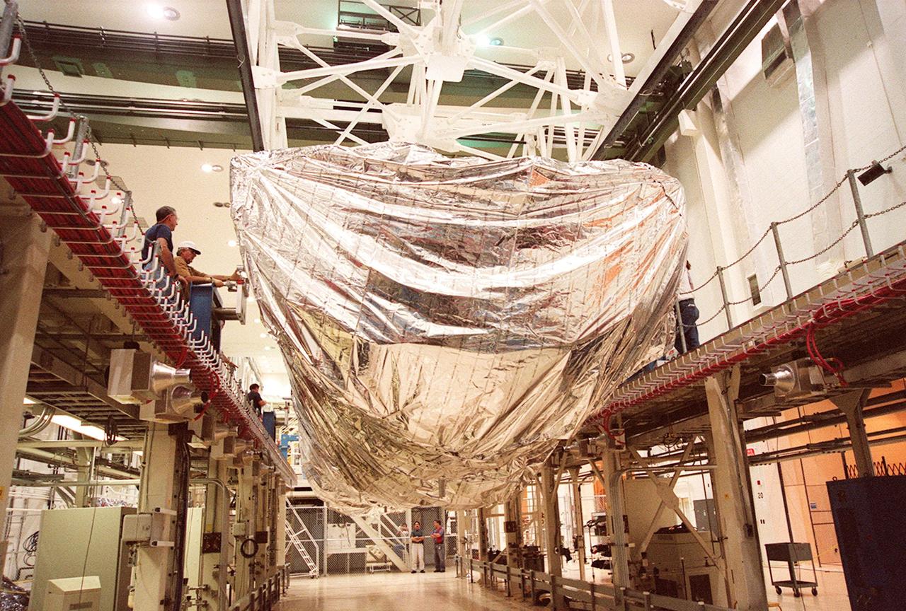
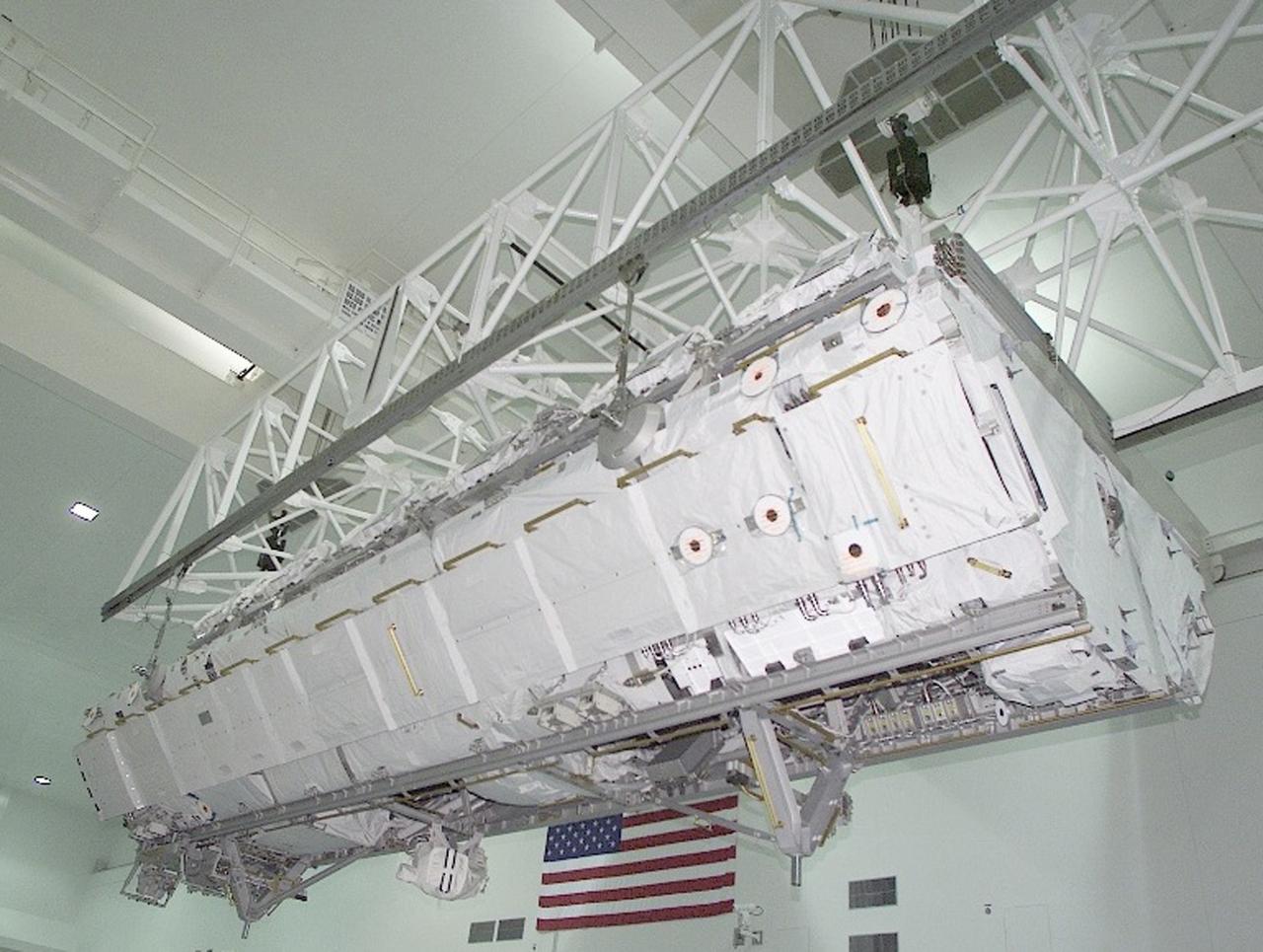
KENNEDY SPACE CENTER, FLA. -- Inside the Operations and Checkout Building, a strongback lifts the S1 truss from the Guppy cargo carrier that protected it during flight and transfer. Manufactured by the Boeing Co. in Huntington Beach, Calif., this component of the International Space Station is the first starboard (right-side) truss segment, whose main job is providing structural support for the orbiting research facility's radiator panels that cool the Space Station's complex power system. The S1 truss segment also will house communications systems, external experiment positions and other subsystems. Primarily constructed of aluminum, the truss segment is 45 feet long, 15 feet wide and 6 feet tall. When fully outfitted, it will weigh 31,137 pounds. The truss is slated for flight in 2001
KENNEDY SPACE CENTER, FLA. -- Inside the Operations and Checkout Building, the top of the Guppy cargo carrier is lifted off the S1 truss (background). Manufactured by the Boeing Co. in Huntington Beach, Calif., this component of the International Space Station is the first starboard (right-side) truss segment, whose main job is providing structural support for the orbiting research facility's radiator panels that cool the Space Station's complex power system. The S1 truss segment also will house communications systems, external experiment positions and other subsystems. Primarily constructed of aluminum, the truss segment is 45 feet long, 15 feet wide and 6 feet tall. When fully outfitted, it will weigh 31,137 pounds. The truss is slated for flight in 2001

KENNEDY SPACE CENTER, FLA. -- A KSC transporter moves the Guppy cargo carrier encasing the S1 truss into the Operations and Checkout Building. Manufactured by the Boeing Co. in Huntington Beach, Calif., this component of the International Space Station is the first starboard (right-side) truss segment, whose main job is providing structural support for the orbiting research facility's radiator panels that cool the Space Station's complex power system. The S1 truss segment also will house communications systems, external experiment positions and other subsystems. Primarily constructed of aluminum, the truss segment is 45 feet long, 15 feet wide and 6 feet tall. When fully outfitted, it will weigh 31,137 pounds. The truss is slated for flight in 2001
KENNEDY SPACE CENTER, FLA. -- Inside the Operations and Checkout Building, the S1 truss, a segment of the International Space Station, is lowered toward workstand number three. Manufactured by the Boeing Co. in Huntington Beach, Calif., this component of the International Space Station is the first starboard (right-side) truss segment, whose main job is providing structural support for the orbiting research facility's radiator panels that cool the Space Station's complex power system. The S1 truss segment also will house communications systems, external experiment positions and other subsystems. Primarily constructed of aluminum, the truss segment is 45 feet long, 15 feet wide and 6 feet tall. When fully outfitted, it will weigh 31,137 pounds. The truss is slated for flight in 2001
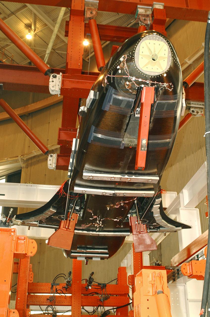
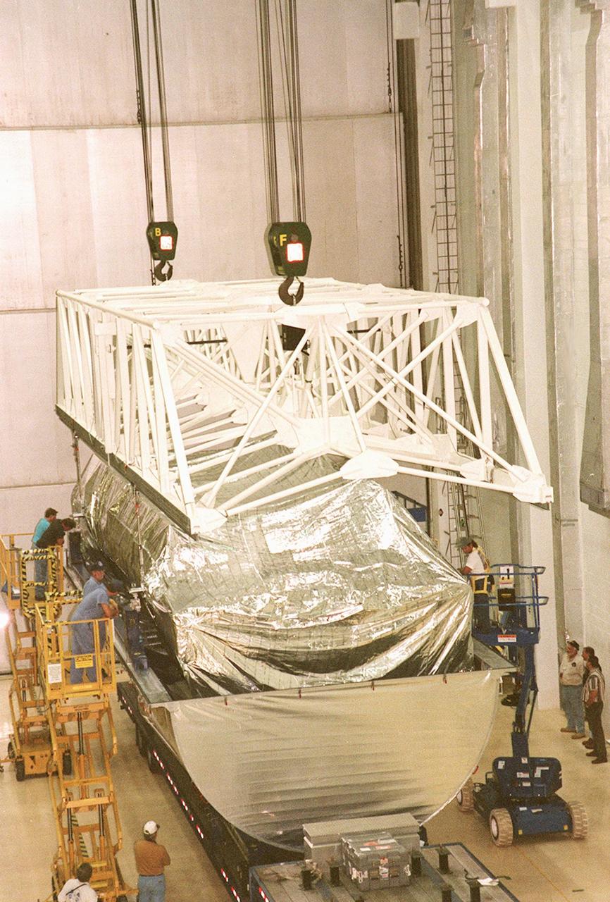
This image shows the Integrated Truss Assembly S-1 (S-One), the Starboard Side Thermal Radiator Truss, for the International Space Station (ISS) undergoing final construction in the Space Station manufacturing facility at the Marshall Space Flight Center. The S1 truss provides structural support for the orbiting research facility's radiator panels, which use ammonia to cool the Station's complex power system. Delivered and installed by the STS-112 mission, the S1 truss, attached to the S0 (S Zero) truss installed by the previous STS-110 mission, flows 637 pounds of anhydrous ammonia through three heat rejection radiators. The truss is 45-feet long, 15-feet wide, 10-feet tall, and weighs approximately 32,000 pounds. Manufactured by the Boeing Company in Huntington Beach, California, the truss primary structure was transferred to the Marshall Space Flight Center in February 1999 for hardware installations and manufacturing acceptance testing.
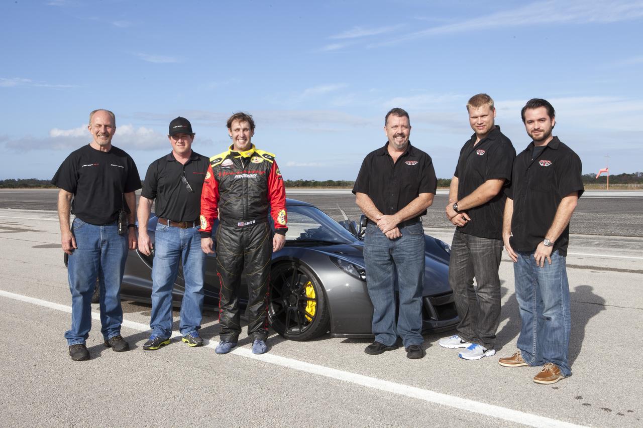
CAPE CANAVERAL, Fla. - The Performance Power Racing and Hennessey Performance teams pose with a Hennessey Venom GT at the 3.5-mile long runway at the Shuttle Landing Facility at NASA's Kennedy Space Center in Florida. The teams are, from left, Hennessey's John Heinricy, John Hennessey, Brian Smith, Performance Power Racing's Johnny Bohmer, Matt Lundy and Jeff McEachran. The flat concrete runway is one of the few places in the world where high performance automobiles can be tested for aerodynamic and safety designs. Hennessey Performance of Sealy, Texas, worked with Performance Power Racing in West Palm Beach to arrange use of the NASA facility. Performance Power Racing has conducted numerous engineering tests on the runway with a variety of vehicles.
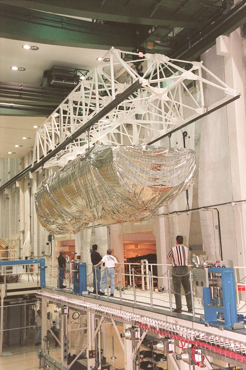
KENNEDY SPACE CENTER, FLA. -- Inside the Operations and Checkout Building, the S1 truss, a segment of the International Space Station, is moved toward workstand number three. Manufactured by the Boeing Co. in Huntington Beach, Calif., this component of the International Space Station is the first starboard (right-side) truss segment, whose main job is providing structural support for the orbiting research facility's radiator panels that cool the Space Station's complex power system. The S1 truss segment also will house communications systems, external experiment positions and other subsystems. Primarily constructed of aluminum, the truss segment is 45 feet long, 15 feet wide and 6 feet tall. When fully outfitted, it will weigh 31,137 pounds. The truss is slated for flight in 2001
KENNEDY SPACE CENTER, FLA. -- Inside the Operations and Checkout Building, a strongback is lowered toward the S1 truss below it in order to lift the truss from the Guppy cargo carrier that protected it during flight and transfer. Manufactured by the Boeing Co. in Huntington Beach, Calif., this component of the International Space Station is the first starboard (right-side) truss segment, whose main job is providing structural support for the orbiting research facility's radiator panels that cool the Space Station's complex power system. The S1 truss segment also will house communications systems, external experiment positions and other subsystems. Primarily constructed of aluminum, the truss segment is 45 feet long, 15 feet wide and 6 feet tall. When fully outfitted, it will weigh 31,137 pounds. The truss is slated for flight in 2001
ISS030-E-059398 (19 Jan. 2012) --- Lake Fitri, Chad is featured in this image photographed by an Expedition 30 crew member on the International Space Station. Lake Fitri is an endorheic, or terminal lake in a desert basin in the southern Sahara Desert. Muddy yellow-brown water marks the center of the depression (center), with a ring of dark brown muds and burnt vegetation on the exposed lake floor to the north. The lake shoreline supports a thin line of reed and floating grass vegetation which appears as dark green in the image. Deserts have so little rainfall that many rivers cannot reach the sea, but end at local low points where they form lakes. Here the usually dry Wadi Batha empties into Lake Fitri. Over time, water flow in Wadi Batha has created a large delta, which occupies the entire top left third of the image—a sense of scale is given by the 23–kilometer length of the lake. The lake has been designated under the Ramsar Convention as a wetland of international importance. Other features visible in the image reveal evidence of significant climate change. The dry part of the present lake shows that the lake has been larger in the last several decades. But, as NASA scientists point out, the lake was once many times larger than its present surface area, as shown by numerous sweeping curves of ancient beaches which are now situated many kilometers from the present shoreline, at higher altitudes (upper right). Inland lakes are highly sensitive to the exact equilibrium between the amount of inflow from contributing rivers like Wadi Batha and evaporation. Each beach ridge therefore shows a different lake level and thus a different balance in the lake-river-climate system. A smaller river enters from the south (top right) and cuts through the beach reaches on its way to the lake. The irregular, elongated, tan patches to the west of the lake are linear dunes aligned parallel to the dominant winds which blow from the northeast. The dunes have all formed on the downwind side (southwest) side of the lake since the lake bed and delta provide the sands which have built the dunes. The dunes indicate that during past climatic phases the lake has been almost or completely dry on repeated occasions—often enough for these great dunes, many kilometers long and several meters high, to form even in the lowest parts of the lake. The islands visible in the center of the lake are likewise remnants of dunes. These dunes are smaller than those on the lake margin, presumably because waves from the lake have eroded them. Villages occupy the points of some major dunes, and some islands, where fishermen can gain easy access to the lake.
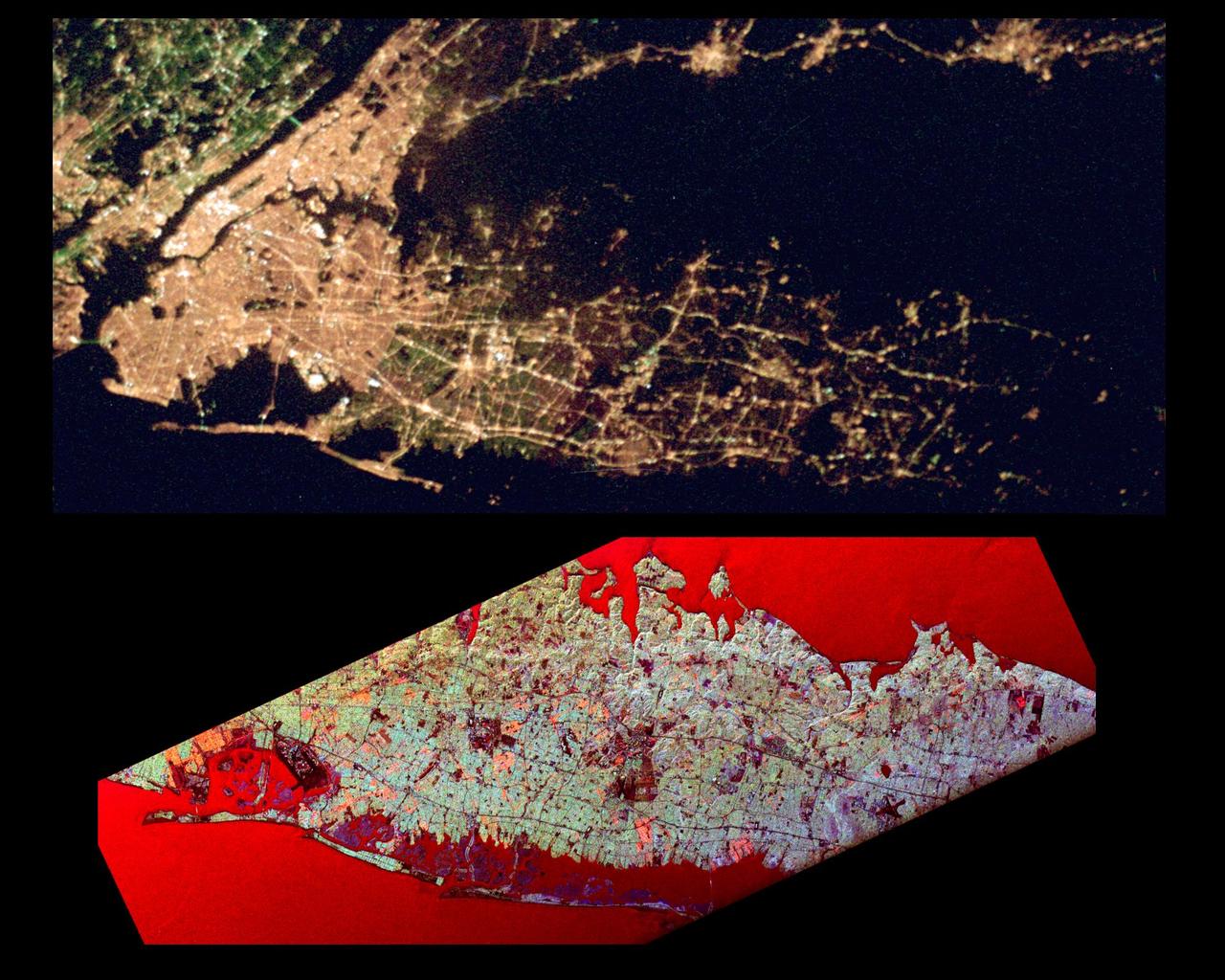
This pair of images of the Long Island, New York region is a comparison of an optical photograph (top) and a radar image (bottom), both taken in darkness in April 1994. The photograph at the top was taken by the Endeavour astronauts at about 3 a.m. Eastern time on April 20, 1994. The image at the bottom was acquired at about the same time four days earlier on April 16,1994 by the Spaceborne Imaging Radar-C/X-Band Synthetic Aperture Radar (SIR-C/X-SAR) system aboard the space shuttle Endeavour. Both images show an area approximately 100 kilometers by 40 kilometers (62 miles by 25 miles) that is centered at 40.7 degrees North latitude and 73.5 degrees West longitude. North is toward the upper right. The optical image is dominated by city lights, which are particularly bright in the densely developed urban areas of New York City located on the left half of the photo. The brightest white zones appear on the island of Manhattan in the left center, and Central Park can be seen as a darker area in the middle of Manhattan. To the northeast (right) of the city, suburban Long Island appears as a less densely illuminated area, with the brightest zones occurring along major transportation and development corridors. Since radar is an active sensing system that provides its own illumination, the radar image shows a great amount of surface detail, despite the night-time acquisition. The colors in the radar image were obtained using the following radar channels: red represents the L-band (horizontally transmitted and received); green represents the L-band (horizontally transmitted and vertically received); blue represents the C-band (horizontally transmitted and vertically received). In this image, the water surface - the Atlantic Ocean along the bottom edge and Long Island Sound shown at the top edge - appears red because small waves at the surface strongly reflect the horizontally transmitted and received L-band radar signal. Networks of highways and railroad lines are clearly visible in the radar image; many of them can also be seen as bright lines i the optical image. The runways of John F. Kennedy International Airport appear as a dark rectangle in Jamaica Bay on the left side of the image. Developed areas appear generally as bright green and orange, while agricultural, protected and undeveloped areas appear darker blue or purple. This contrast can be seen on the barrier islands along the south coast of Long Island, which are heavily developed in the Rockaway and Long Beach areas south and east of Jamaica Bay, but further to the east, the islands are protected and undeveloped. http://photojournal.jpl.nasa.gov/catalog/PIA01785
This photograph depicts Dr. von Braun (fourth from far right) and other NASA officials surveying the deep-sea research submarine "Ben Franklin." Named for American patriot and inventor Ben Franklin, who discovered the Gulf Steam, the 50-foot Ben Franklin was built between 1966 and 1968 in Switzerland for deep-ocean explorer Jacques Piccard and the Grumman Aircraft Engineering Corporation. The submersible made a famous 30-day drift dive off the East Coast of the United States and Canada in 1969 mapping the Gulf Stream's currents and sea life, and also made space exploration history by studying the behavior of aquanauts in a sealed, self-contained, self-sufficient capsule for NASA. On July 14, 1969, the Ben Franklin was towed to the high-velocity center of the Stream off the coast of Palm Beach, Florida. With a NASA observer on board, the sub descended to 1,000 feet off of Riviera Beach, Florida and drifted 1,400 miles north with the current for more than four weeks, reemerging near Maine. During the course of the dive, NASA conducted exhaustive analyses of virtually every aspect of onboard life. They measured sleep quality and patterns, sense of humor and behavioral shifts, physical reflexes, and the effects of a long-term routine on the crew. The submarine's record-shattering dive influenced the design of Apollo and Skylab missions and continued to guide NASA scientists as they devised future marned space-flight missions.
This photograph depicts Dr. von Braun (at right, showing his back) and other NASA officials surveying the deep-sea research submarine "Ben Franklin." Named for American patriot and inventor Ben Franklin, who discovered the Gulf Steam, the 50-foot Ben Franklin was built between 1966 and 1968 in Switzerland for deep-ocean explorer Jacques Piccard and the Grumman Aircraft Engineering Corporation. The submersible made a famous 30-day drift dive off the East Coast of the United States and Canada in 1969 mapping the Gulf Stream's currents and sea life, and also made space exploration history by studying the behavior of aquanauts in a sealed, self-contained, self-sufficient capsule for NASA. On July 14, 1969, the Ben Franklin was towed to the high-velocity center of the Stream off the coast of Palm Beach, Florida. With a NASA observer on board, the sub descended to 1,000 feet off of Riviera Beach, Florida and drifted 1,400 miles north with the current for more than four weeks, reemerging near Maine. During the course of the dive, NASA conducted exhaustive analyses of virtually every aspect of onboard life. They measured sleep quality and patterns, sense of humor and behavioral shifts, physical reflexes, and the effects of a long-term routine on the crew. The submarine's record-shattering dive influenced the design of Apollo and Skylab missions and continued to guide NASA scientists as they devised future marned space-flight missions.
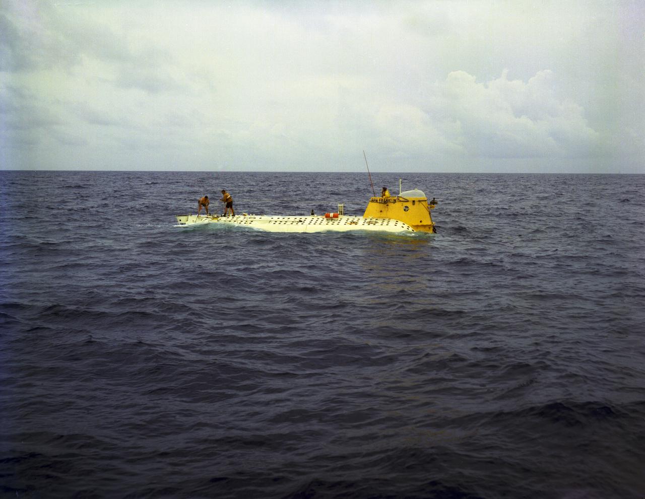
In this photograph, the deep-sea Research Submarine "Ben Franklin" drifts off the East Coast of the United States (U.S.) prior to submerging into the ocean. Named for American patriot and inventor Ben Franklin, who discovered the Gulf Steam, the 50-foot Ben Franklin was built between 1966 and 1968 in Switzerland for deep-ocean explorer Jacques Piccard and the Grumman Aircraft Engineering Corporation. The submersible made a famous 30-day drift dive off the East Coast of the United States and Canada in 1969 mapping the Gulf Stream's currents and sea life, and also made space exploration history by studying the behavior of aquanauts in a sealed, self-contained, self-sufficient capsule for NASA. On July 14, 1969, the Ben Franklin was towed to the high-velocity center of the Stream off the coast of Palm Beach, Florida. With a NASA observer on board, the sub descended to 1,000 feet off of Riviera Beach, Florida and drifted 1,400 miles north with the current for more than four weeks, reemerging near Maine. During the course of the dive, NASA conducted exhaustive analyses of virtually every aspect of onboard life. They measured sleep quality and patterns, sense of humor and behavioral shifts, physical reflexes, and the effects of a long-term routine on the crew. The submarine's record-shattering dive influenced the design of Apollo and Skylab missions and continued to guide NASA scientists as they devised future marned space-flight missions.
KENNEDY SPACE CENTER, FLA. -- Escort vehicles prepare to leave the Shuttle Landing Facility with the S1 truss (at right) on its trek to the Operations and Checkout Building. Manufactured by the Boeing Co. in Huntington Beach, Calif., this component of the ISS is the first starboard (right-side) truss segment, whose main job is providing structural support for the orbiting research facility's radiator panels that cool the Space Station's complex power system. The S1 truss segment also will house communications systems, external experiment positions and other subsystems. Primarily constructed of aluminum, the truss segment is 45 feet long, 15 feet wide and 6 feet tall. When fully outfitted, it will weigh 31,137 pounds. The truss is slated for flight in 2001. The truss arrived at KSC aboard NASA's Super Guppy, seen in the background. The aircraft is uniquely built with a 25-foot diameter fuselage designed to handle oversized loads and a "fold-away" nose that opens 110 degrees for cargo loading. A system of rails in the cargo compartment, used with either Guppy pallets or fixtures designed for specific cargo, makes cargo loading simple and efficient. Rollers mounted in the rails allow pallets or fixtures to be moved by an electric winch mounted beneath the cargo floor. Automatic hydraulic lock pins in each rail secure the pallet for flight
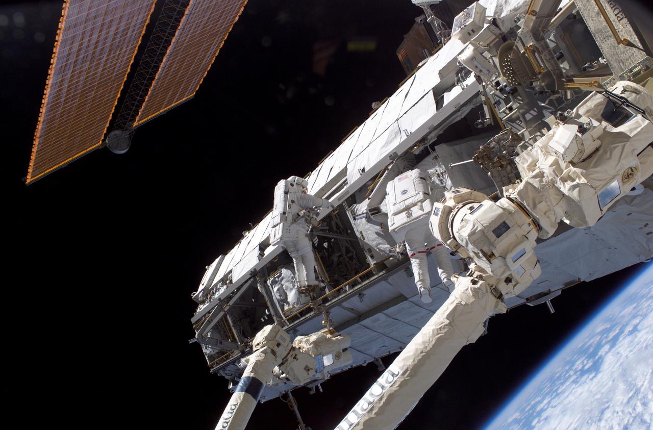
Astronauts Piers J. Sellers (left ) and David A. Wolf work on the newly installed Starboard One (S1) truss to the International Space Station (ISS) during the STS-112 mission. The primary payloads of this mission, ISS Assembly Mission 9A, were the Integrated Truss Assembly S1 (S One), the starboard side thermal radiator truss, and the Crew Equipment Translation Aid (CETA) cart to the ISS. The S1 truss provides structural support for the orbiting research facility's radiator panels, which use ammonia to cool the Station's complex power system. The S1 truss was attached to the S0 (S Zero) truss, which was launched on April 8, 2002 aboard the STS-110, and flows 637 pounds of anhydrous ammonia through three heat-rejection radiators. The truss is 45-feet long, 15-feet wide, 10-feet tall, and weighs approximately 32,000 pounds. The CETA cart was attached to the Mobil Transporter and will be used by assembly crews on later missions. Manufactured by the Boeing Company in Huntington Beach, California, the truss primary structure was transferred to the Marshall Space Flight Center in February 1999 for hardware installations and manufacturing acceptance testing. The launch of the STS-112 mission occurred on October 7, 2002, and its 11-day mission ended on October 18, 2002.
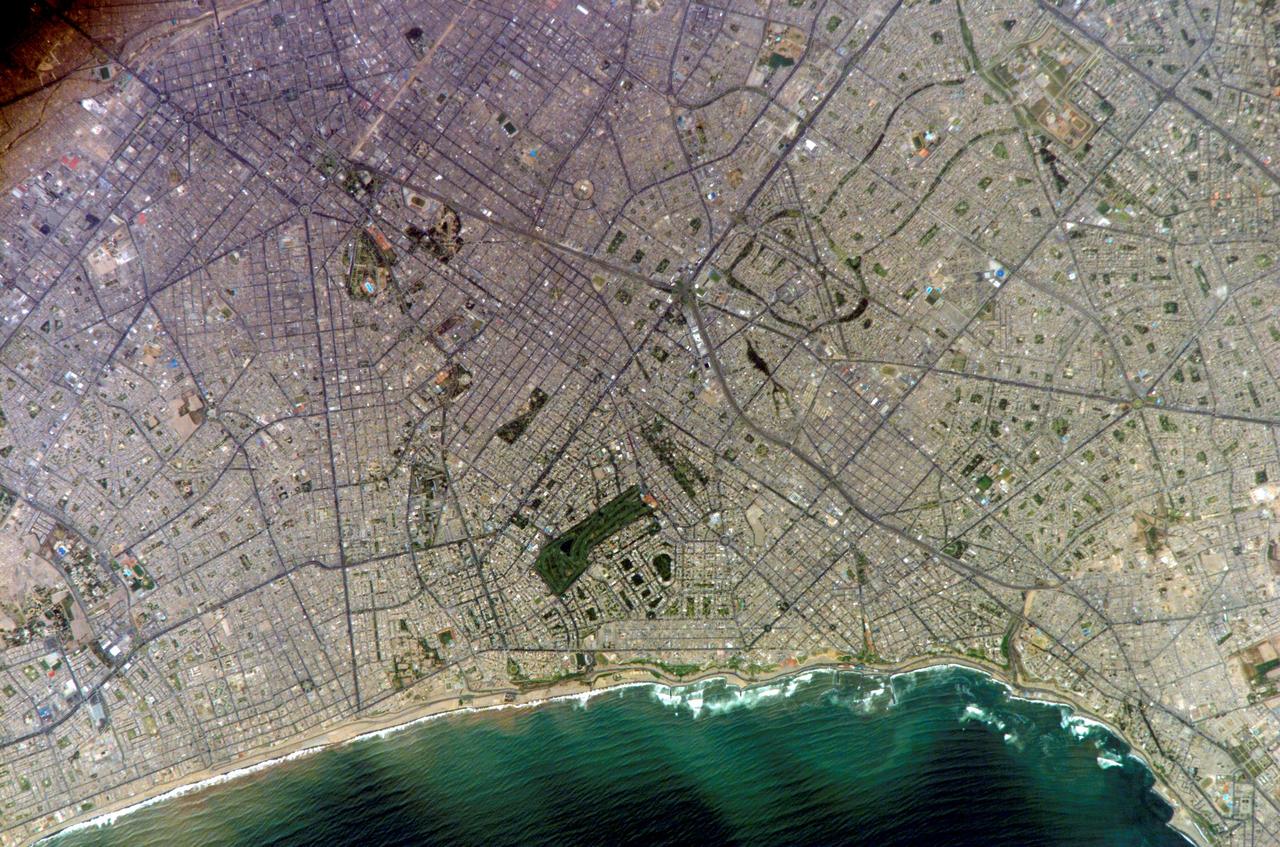
ISS010-E-20111 (15 March 2005) --- Lima, Peru is featured in this image photographed by an Expedition 10 crewmember on the International Space Station (ISS). Located on the broad alluvial fan of the Rimac River, Lima is the capital of Peru and the only mega city (7.7 million inhabitants in 2002) located on the western coastline of South America. The city was established by Francisco Pizarro in 1535 and became an important colonial port linking silver mines of the Altiplano of the high Andes to the east with the burgeoning Spanish empire. During the mid-20th century a significant relocation of people from rural mountain communities into the Lima metropolitan area led to its growth into a mega city. Problems now facing the metropolitan region include development of adequate water resources, control of pollution, and the potential effects of natural hazards such as earthquakes and landslides. This photograph depicts the wealthier San Isidro and Mira Flores quarters of Lima. This part of the metropolitan area is characterized by numerous vegetated parks, golf courses (such as the Lima Golf Course—approximately 1 kilometer long), and greenbelts interspersed with residential and commercial areas. The higher proportion of dark asphalt in the street grid of the residential and commercial areas lends a purple coloration to the left portion of the image (downtown Lima is to the north). Regions with fewer built materials and vegetation are light tan. Wave patterns are visible approaching beaches, popular tourist destinations, in the lower half of the image.
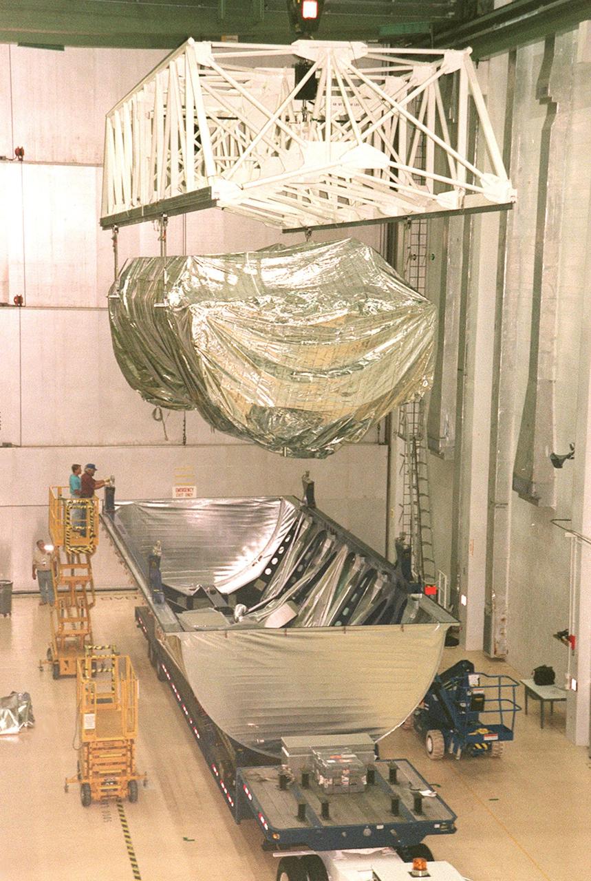
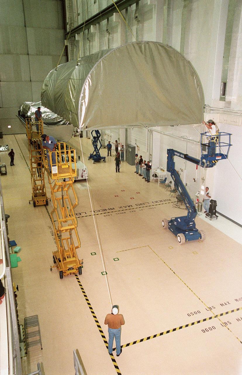
Shown here is the International Space Station (ISS) S1 Truss in preparation for installation in the payload bay of the Space Shuttle Atlantis at NASA's Kennedy Space Center )KSC)in Florida. The truss launched October 7, 2002 on the STS-112 mission and will be attached during three spacewalks. Constructed primarily of aluminum, it measures 45 feet long, 15 feet wide, 10 feet tall, and weighs over 27,000 pounds. It is one of nine similar truss segments that, combined, will serve as the Station's main backbone, measuring 356 feet from end to end upon completion. Manufactured by the Boeing Company in Huntington Beach, California, the truss was flown to the Marshall Space Flight Center, in Huntsville, Alabama where brackets, cable trays, fluid tubing, and other secondary components and outfitting items were added. In Huntsville, it was screened for manufacturing flaws, including pressure and leak checking tubing, and electrical checks for cabling, before being shipped to KSC for final hardware installation and testing. The Space Station's labs, living modules, solar arrays, heat radiators, and other main components will be attached to the truss.
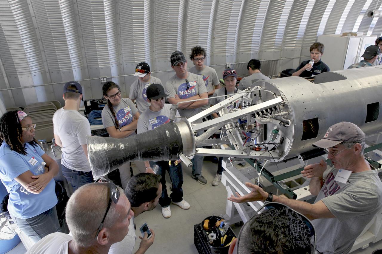
MOJAVE DESERT, Calif. – In the Mojave Desert in California, John Garvey, far right, describes his company's Prospector-18 rocket. Long Beach, Calif.-based Garvey Spacecraft Corp. built the rocket and its engine. Collectively known as CubeSats, the satellites will record shock, vibrations and heat inside the rocket. They will not be released during the test flight, but the results will be used to prove or strengthen their designs before they are carried into orbit in 2014 on a much larger rocket. A new, lightweight carrier is also being tested for use on future missions to deploy the small spacecraft. The flight also is being watched closely as a model for trying out new or off-the-shelf technologies quickly before putting them in the pipeline for use on NASA's largest launchers. Built by several different organizations, including a university, a NASA field center and a high school, the spacecraft are four-inch cubes designed to fly on their own eventually, but will remain firmly attached to the rocket during the upcoming mission. For more information, visit http://www.nasa.gov/mission_pages/smallsats/elana/cubesatlaunchpreview.html Photo credit: NASA/Dimitri Gerondidakis
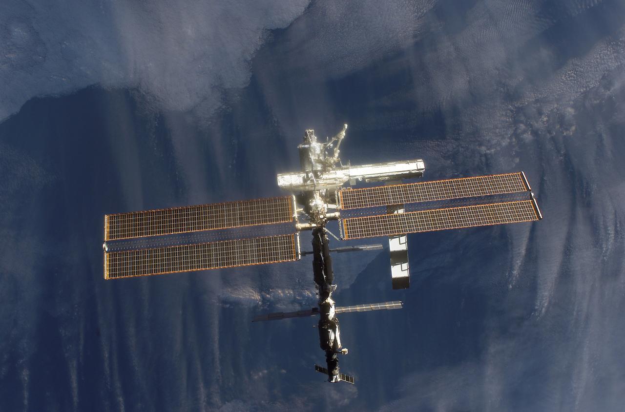
This image of the International Space Station (ISS) was photographed by one of the crewmembers of the STS-112 mission following separation from the Space Shuttle Orbiter Atlantis as the orbiter pulled away from the ISS. The newly added S1 truss is visible in the center frame. The primary payloads of this mission, International Space Station Assembly Mission 9A, were the Integrated Truss Assembly S-1 (S-One), the Starboard Side Thermal Radiator Truss,and the Crew Equipment Translation Aid (CETA) cart to the ISS. The S1 truss provides structural support for the orbiting research facility's radiator panels, which use ammonia to cool the Station's complex power system. The S1 truss was attached to the S0 (S Zero) truss, which was launched on April 8, 2002 aboard the STS-110, and flows 637 pounds of anhydrous ammonia through three heat rejection radiators. The truss is 45-feet long, 15-feet wide, 10-feet tall, and weighs approximately 32,000 pounds. The CETA cart was attached to the Mobil Transporter and will be used by assembly crews on later missions. Manufactured by the Boeing Company in Huntington Beach, California, the truss primary structure was transferred to the Marshall Space Flight Center in February 1999 for hardware installations and manufacturing acceptance testing. The launch of the STS-112 mission occurred on October 7, 2002, and its 11-day mission ended on October 18, 2002.
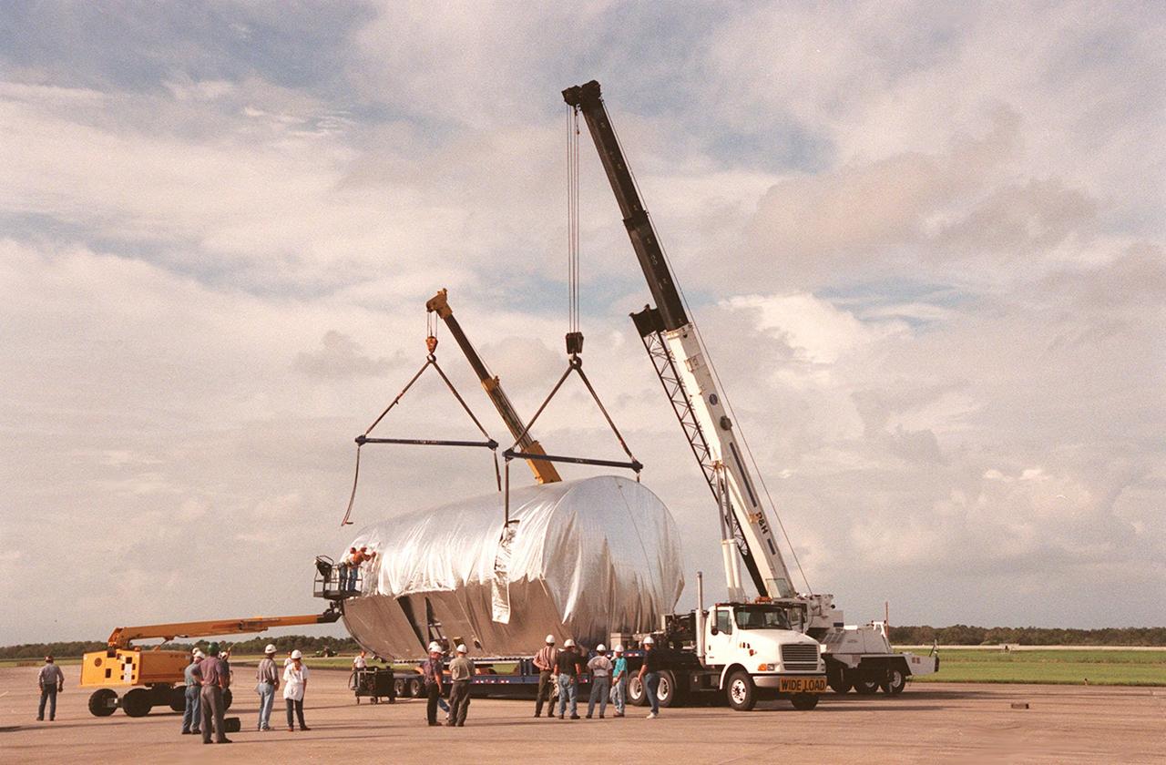
KENNEDY SPACE CENTER, FLA. -- At the Shuttle Landing Facility, workers attach cranes to the S1 truss, a segment of the International Space Station, to lift the truss to a payload transporter for its transfer to the Operations and Checkout Building. Manufactured by the Boeing Co. in Huntington Beach, Calif., this component of the ISS is the first starboard (right-side) truss segment, whose main job is providing structural support for the orbiting research facility's radiator panels that cool the Space Station's complex power system. The S1 truss segment also will house communications systems, external experiment positions and other subsystems. Primarily constructed of aluminum, the truss segment is 45 feet long, 15 feet wide and 6 feet tall. When fully outfitted, it will weigh 31,137 pounds. The truss is slated for flight in 2001. The truss arrived at KSC aboard NASA's Super Guppy, with a 25-foot diameter fuselage designed to handle oversized loads. Loading the Guppy is easy because of the unique "fold-away" nose of the aircraft that opens 110 degrees for cargo loading. A system of rails in the cargo compartment, used with either Guppy pallets or fixtures designed for specific cargo, makes cargo loading simple and efficient. Rollers mounted in the rails allow pallets or fixtures to be moved by an electric winch mounted beneath the cargo floor. Automatic hydraulic lock pins in each rail secure the pallet for flight
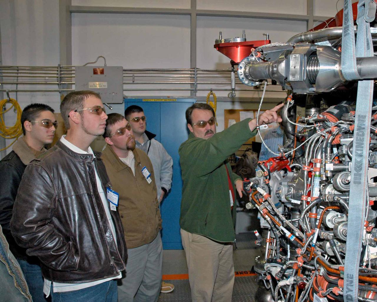
Pratt & Whitney Rocketdyne's Jeff Hansell, right, explains functions of a space shuttle main engine to Pearl River Community College Aviation Maintenance Technology Program students. Christopher Bryon, left, of Bay St. Louis, Ret Tolar of Kiln, Dan Holston of Baxterville and Billy Zugg of Long Beach took a recent tour of the SSME Processing Facility and the E-1 Test Complex at Stennis Space Center in South Mississippi. The students attend class adjacent to the Stennis International Airport tarmac in Kiln, where they get hands-on experience. PRCC's program prepares students to be responsible for the inspection, repair and maintenance of technologically advanced aircraft. A contractor to NASA, Pratt & Whitney Rocketdyne in Canoga Park, Calif., manufactures the space shuttle main engine and its high-pressure turbo pumps. SSC was established in the 1960s to test the huge engines for the Saturn V moon rockets. Now 40 years later, the center tests every main engine for the space shuttle, and is America's largest rocket engine test complex. SSC will soon begin testing the rocket engines that will power spacecraft carrying Americans back to the moon and on to Mars.
This image of the International Space Station (ISS) was photographed by one of the crewmembers of the STS-112 mission following separation from the Space Shuttle Orbiter Atlantis as the orbiter pulled away from the ISS. The primary payloads of this mission, International Space Station Assembly Mission 9A, were the Integrated Truss Assembly S1 (S-One), the Starboard Side Thermal Radiator Truss, and the Crew Equipment Translation Aid (CETA) cart to the ISS. The S1 truss provides structural support for the orbiting research facility's radiator panels, which use ammonia to cool the Station's complex power system. The S1 truss was attached to the S0 (S Zero) truss, which was launched on April 8, 2002 aboard the STS-110, and flows 637 pounds of anhydrous ammonia through three heat-rejection radiators. The truss is 45-feet long, 15-feet wide, 10-feet tall, and weighs approximately 32,000 pounds. The CETA cart was attached to the Mobil Transporter and will be used by assembly crews on later missions. Manufactured by the Boeing Company in Huntington Beach, California, the truss primary structure was transferred to the Marshall Space Flight Center in February 1999 for hardware installations and manufacturing acceptance testing. The launch of the STS-112 mission occurred on October 7, 2002, and its 11-day mission ended on October 18, 2002.
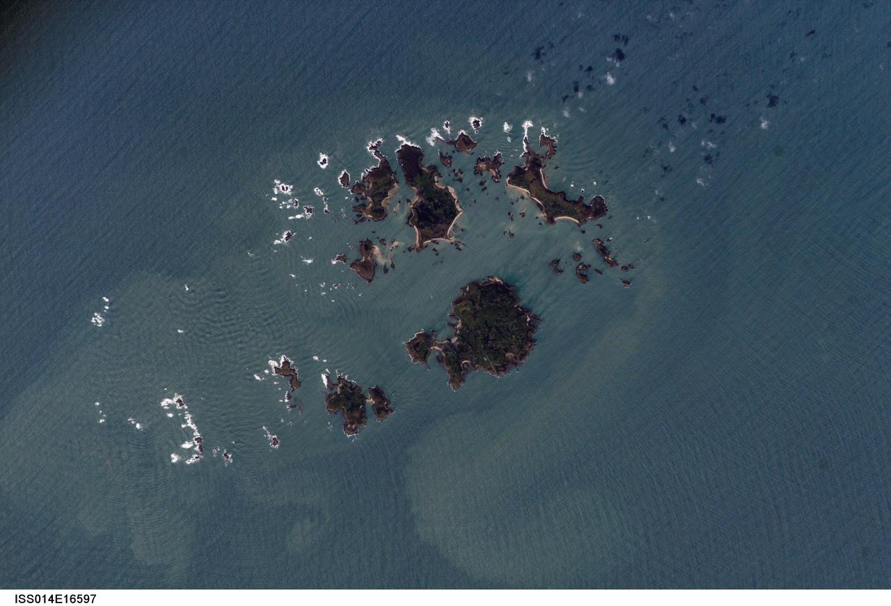
ISS014-E-16597 (10 March 2007) --- Isles of Scilly, United Kingdom is featured in this image photographed by an Expedition 14 crewmember on the International Space Station. The Isles of Scilly, an archipelago of approximately 150 islands, is located some 44 kilometers southwest of the westernmost point of England (Land's End). According to scientists, the islands are an erosional remnant of an ancient granite intrusion, and are notable because they have been inhabited for over 4000 years. Historical and geological evidence cited by NASA scientists on the Isles indicates that many of the islands were larger and/or connected in the recent past--this could be due to local subsidence, rising sea levels, or a combination of both factors. Even today, it is possible to walk between certain islands during low tides. The Isles have been designated a United Kingdom Area of Outstanding Natural Beauty due to their unique landscape, ecology, and historical significance. The potential effect of rising sea level on the Isles is a primary concern for both long-term ecosystem health and human habitability. This image illustrates the geographic configuration of the archipelago, and its effect on ocean wave patterns. Long linear swells oriented northeast-southwest and moving to the southeast (from upper left to lower right) are diffracted (bent) as they approach the coastlines and small shoals of the Isles. The wave diffraction forms complex interacting surface patterns--this is most clearly visible southwest of St. Mary's island (left). The dominant ocean wave pattern resumes to the southeast of St. Mary's, but with an additional northwest-southeast oriented pattern superimposed, possibly due to winds originating in the English channel to the east (not shown). Suspended, tan-colored sediments visible within and around the archipelago are locally derived from continuing wave erosion of the granite forming the islands and remobilization of beach sands. Bright white areas in the photograph are waves breaking on shoals.
ISS018-E-011096 (6 Dec. 2008) --- Santa Barbara, CA metropolitan area, also known as the ?American Riviera?, is featured in this image photographed by an Expedition 18 crewmember on the International Space Station. The geographic setting of the city - between the Santa Barbara Channel to the south and the steep Santa Ynez Mountains to the north. The city was officially founded as a Spanish mission in 1786, and was incorporated into the United States from Mexico in 1848 following the Mexican-American War. The dramatic landscape of the city is the result of tectonic forces ? the Santa Barbara Channel is part of the boundary between the Pacific oceanic and North American continental crustal plates. Movement along the San Andreas Fault ? the actual zone of contact between the two plates ? over geologic time both raised the Santa Ynez range and lowered the seafloor, forming the deep Santa Barbara Channel. The city has experienced two earthquakes, one in 1812 and another in 1925 that caused significant damage. The urban street grid is defined by white and red rooftops at top center; to the southeast lie beaches and the boat slips of a large marina (top right). Two large golf courses, characterized by expanses of green grass, are visible at center. Low east-west trending hills that parallel the coastline are almost completely covered by residential and commercial development, lending a speckled appearance to the hillsides. Immediately offshore, giant kelp beds are the focus of the Santa Barbara Coastal Long Term Ecological Research site, part of the National Science Foundation?s Long Term Ecological Research Network.
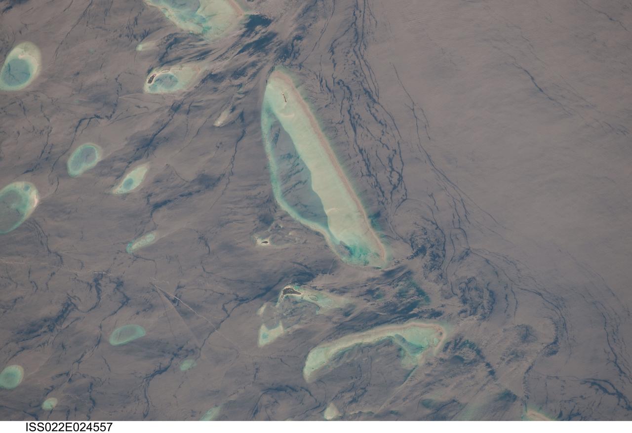
ISS022-E-024557 (12 Jan. 2010) --- Male Atoll and Maldive Islands in the Indian Ocean are featured in this image photographed by an Expedition 22 crew member on the International Space Station. This detailed photograph features one of the numerous atolls in the Maldive Island chain. The Maldives are an island nation, comprised of twenty-six atolls that stretch in a north-to-south chain for almost 900 kilometers southwest of the Indian subcontinent. The silvery, almost pink sheen on the normally blue water of the equatorial Indian Ocean is the result of sunglint. Sunglint occurs when sunlight is reflected off of a water surface directly back towards the observer ? in this case a crew member on the space station. Full sunglint in images typically results in bright silver to white coloration of the water surface. Sunglint images can have different hues depending on the roughness of the water surface and atmospheric conditions. They also can reveal numerous details of water circulation which are otherwise invisible. This image was taken during the Indian Ocean Northeast monsoon season - predominant winds in this area create sinuous surface water patterns on the leeward side, and between, the islets (left). A south-flowing current flows in the deeper water through the Maldives most of the year (right), with fan-shaped surface currents formed by local tides pulsing in and out of the shallow water near the islands (top and bottom). The largest island seen here (center) is 6 kilometers long, and is one of the outer ring of larger islands that make up the 70 kilometers-long, oval-shaped Male Atoll. Shores facing deeper water have well-defined beaches. Numerous small, elliptical coral reef islets are protected within the ring of shallow water to the northeast (left). These islets are mostly awash at high tide, with dry ground appearing in tiny patches only. A small boat was navigating between the islets at the time the image was taken as indicated by its v-shaped wake at bottom left. Images like these illustrate why the Republic of Maldives is one of the most outspoken countries in stressing the dangers of rising sea levels.
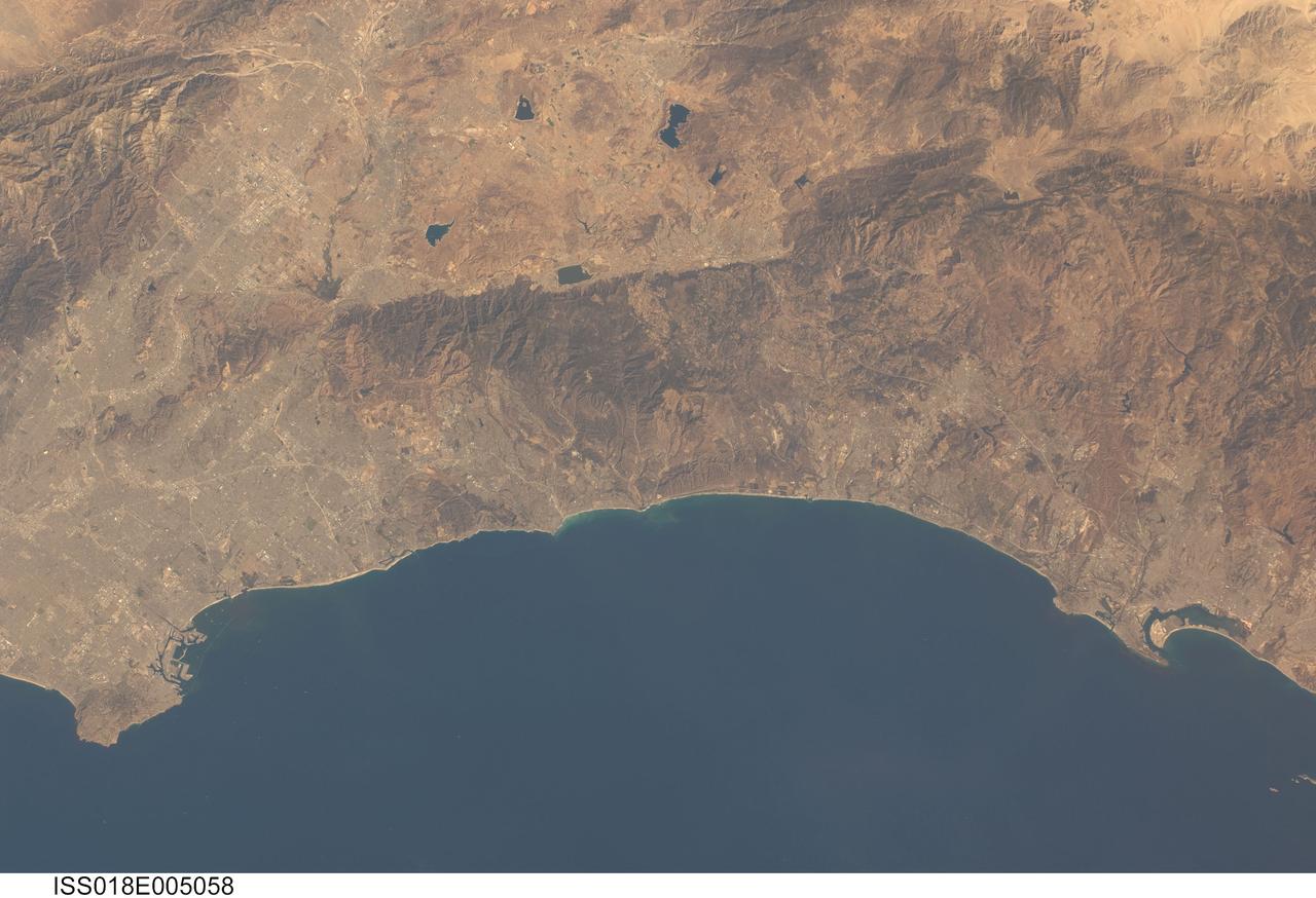
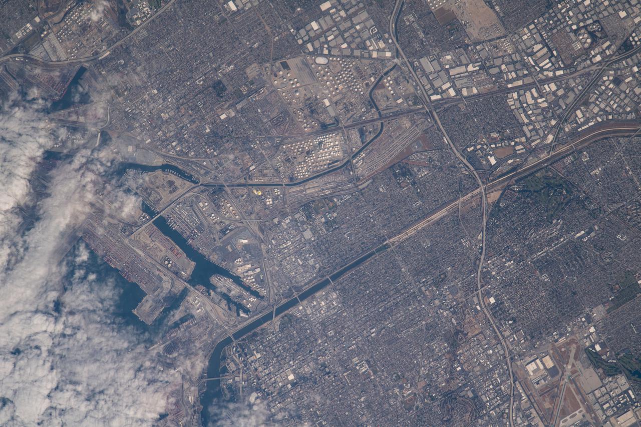
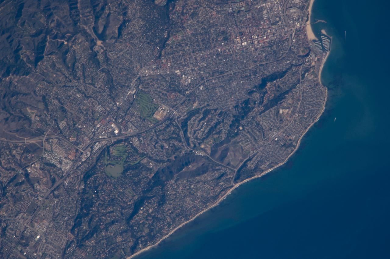
ISS018-E-005058 (24 Oct. 2008) --- Southern California's coastline, from southern Los Angeles to Tijuana in Mexico, a distance of about 225 kilometers, is featured in this image photographed by an Expedition 18 crewmember on the International Space Station. Port facilities of Los Angeles Harbor give much detail to the coastline at the north end and arcuate San Diego Bay is highly recognizable at the south end (right bottom). The image includes much of one of the most densely populated parts of the USA, with approximately 20 million people within the parts of five counties shown here. The dense urban areas appear gray, with the largest conurbation in the north of the view, in the region Long Beach--Los Angeles--San Bernardino. A smaller zone appears around San Diego--Tijuana in the south. Major highways with their associated strip development snake through these dense urban areas. The geography and geomorphology of Southern California is defined by long linear features that are surface traces of large transform faults. These faults, including the Elsinore fault and San Jacinto fault seen here, are generally considered part of the San Andreas system, and make up the broad zone comprising the tectonic plate boundary between North America to the east and the Pacific plate to the west. The Elsinore fault marks the steep eastern scarp of the Santa Ana Mountains, as well as the precipitation boundary between the wetter mountains and the drier deserts to the east. The rainfall difference is reflected in the darker appearance (more vegetation) of the mountains and coastal regions. Inland of the mountains, climates are far drier, and the natural vegetation is scrubby and much less dense which allows brown and yellow soils to show through. However, the entire region is arid; water management is a critical issue for the large urban areas of the state. Several reservoirs that are visible east of the Santa Ana Mountains provide water for both cities and agriculture in southern California.
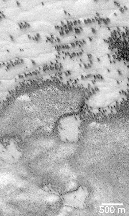
"They look like bushes!" That's what almost everyone says when they see the dark features found in pictures taken of sand dunes in the polar regions as they are beginning to defrost after a long, cold winter. It is hard to escape the fact that, at first glance, these images acquired by the Mars Global Surveyor (MGS) Mars Orbiter Camera (MOC) over both polar regions during the spring and summer seasons, do indeed resemble aerial photographs of sand dune fields on Earth -- complete with vegetation growing on and around them! Of course, this is not what the features are, as we describe below and in related picture captions. Still, don't they look like vegetation to you? Shown here are two views of the same MGS MOC image. On the left is the full scene, on the right is an expanded view of a portion of the scene on the left. The bright, smooth surfaces that are dotted with occasional, nearly triangular dark spots are sand dunes covered by winter frost. The MGS MOC has been used over the past several months (April-August 1999) to monitor dark spots as they form and evolve on polar dune surfaces. The dark spots typically appear first along the lower margins of a dune -- similar to the position of bushes and tufts of grass that occur in and among some sand dunes on Earth. Because the martian air pressure is very low -- 100 times lower than at Sea Level on Earth -- ice on Mars does not melt and become liquid when it warms up. Instead, ice sublimes -- that is, it changes directly from solid to gas, just as "dry ice" does on Earth. As polar dunes emerge from the months-long winter night, and first become exposed to sunlight, the bright winter frost and snow begins to sublime. This process is not uniform everywhere on a dune, but begins in small spots and then over several months it spreads until the entire dune is spotted like a leopard. The early stages of the defrosting process -- as in the picture shown here -- give the impression that something is "growing" on the dunes. The sand underneath the frost is dark, just like basalt beach sand in Hawaii. Once it is exposed to sunlight, the dark sand probably absorbs sunlight and helps speed the defrosting of each sand dune. This picture was taken by MGS MOC on July 21, 1999. The dunes are located in the south polar region and are expected to be completely defrosted by November or December 1999. North is approximately up, and sunlight illuminates the scene from the upper left. The 500 meter scale bar equals 547 yards; the 300 meter scale is also 328 yards. http://photojournal.jpl.nasa.gov/catalog/PIA02300
ISS018-E-018129 (6 Jan. 2009) --- Atafu Atoll in the Southern Pacific Ocean is featured in this image photographed by an Expedition 18 crewmember on the International Space Station. At roughly eight kilometers wide, Atafu Atoll is the smallest of three atolls (with Nukunonu and Fakaofo atolls to the southeast, not shown) comprising the Tokelau Islands group located in the southern Pacific Ocean. Swains Island to the south (not shown) is also considered part of the Tokelau group. The political entity of Tokelau is currently a territory of New Zealand. In recent years, public referendums on independence within the islands have been held, but have not received sufficient support to move forward. The primary settlement on Atafu is a village located at the northwestern corner of the atoll ? indicated by an area of light gray dots in this photograph. The typical ring shape of the atoll is the result of coral reefs building up around a former volcanic island. Over geologic time, the central volcano has subsided beneath the water surface, leaving the fringing reefs and a central lagoon that contains submerged coral reefs. Erosion and soil development on the surfaces of the exposed fringing reefs has lead to formation of tan to light brown beach deposits (southern and western sides of the atoll) and green vegetation cover (northern and eastern sides of the atoll). The Tokelau Islands, including Atafu Atoll, suffered significant inundation and erosion during Tropical Cyclone Percy in 2005. The approximate elevation of Atafu Atoll is only two meters above the tidal high water level. Vulnerability to tropical cyclones and potential sea level rise makes the long-term habitability of the atoll uncertain.
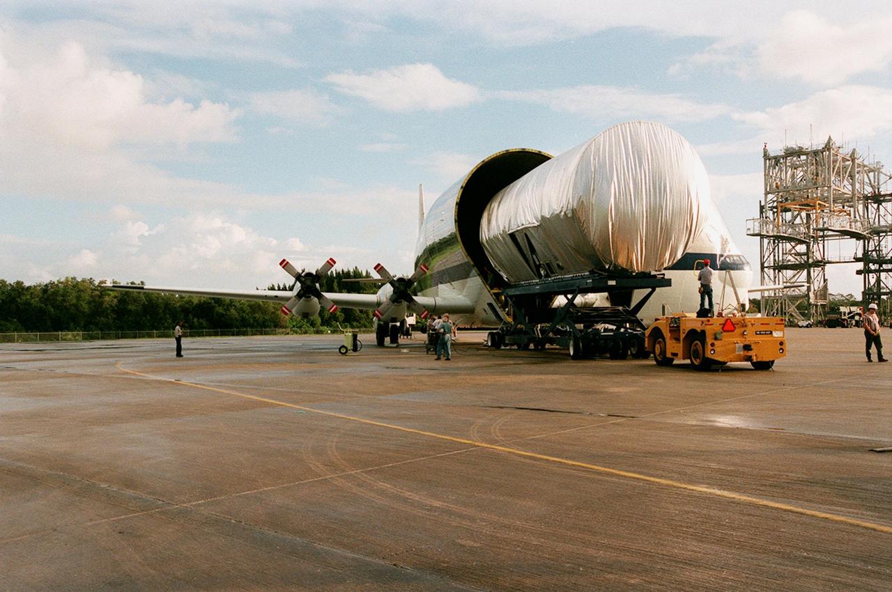
KENNEDY SPACE CENTER, FLA. -- At the Shuttle Landing Facility, the newly arrived S1 truss, a segment of the International Space Station (ISS), is offloaded from NASA's Super Guppy aircraft. Manufactured by the Boeing Co. in Huntington Beach, Calif., this component of the ISS is the first starboard (right-side) truss segment, whose main job is providing structural support for the orbiting research facility's radiator panels that cool the Space Station's complex power system. The S1 truss segment also will house communications systems, external experiment positions and other subsystems. Primarily constructed of aluminum, the truss segment is 45 feet long, 15 feet wide and 6 feet tall. When fully outfitted, it will weigh 31,137 pounds. The truss is slated for flight in 2001. The Super Guppy, with its 25-foot diameter fuselage designed to handle oversized loads, is well prepared to transport the truss and other ISS segments. Loading the Guppy is easy because of the unique "fold-away" nose of the aircraft that opens 110 degrees for cargo loading. A system of rails in the cargo compartment, used with either Guppy pallets or fixtures designed for specific cargo, makes cargo loading simple and efficient. Rollers mounted in the rails allow pallets or fixtures to be moved by an electric winch mounted beneath the cargo floor. Automatic hydraulic lock pins in each rail secure the pallet for flight. The truss is being transferred to the Operations and Checkout Building
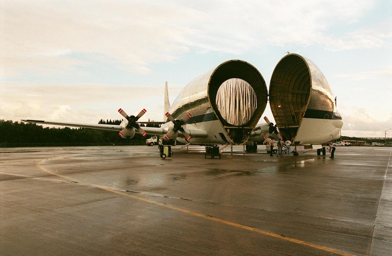
KENNEDY SPACE CENTER, FLA. -- At KSC's Shuttle Landing Facility, NASA's Super Guppy opens to reveal its cargo, the International Space Station's (ISS) S1 truss. Manufactured by the Boeing Co. in Huntington Beach, Calif., this component of the ISS is the first starboard (right-side) truss segment, whose main job is providing structural support for the orbiting research facility's radiator panels that cool the Space Station's complex power system. The S1 truss segment also will house communications systems, external experiment positions and other subsystems. Primarily constructed of aluminum, the truss segment is 45 feet long, 15 feet wide and 6 feet tall. When fully outfitted, it will weigh 31,137 pounds. The truss is slated for flight in 2001. The Super Guppy, with its 25-foot diameter fuselage designed to handle oversized loads, is well prepared to transport the truss and other ISS segments. Loading the Guppy is easy because of the unique "fold-away" nose of the aircraft that opens 110 degrees for cargo loading. A system of rails in the cargo compartment, used with either Guppy pallets or fixtures designed for specific cargo, makes cargo loading simple and efficient. Rollers mounted in the rails allow pallets or fixtures to be moved by an electric winch mounted beneath the cargo floor. Automatic hydraulic lock pins in each rail secure the pallet for flight. The truss is to be transferred to the Operations and Checkout Building
Zoom into the Andromeda galaxy. The largest NASA Hubble Space Telescope image ever assembled, this sweeping view of a portion of the Andromeda galaxy (M31) is the sharpest large composite image ever taken of our galactic neighbor. Though the galaxy is over 2 million light-years away, the Hubble telescope is powerful enough to resolve individual stars in a 61,000-light-year-long section of the galaxy's pancake-shaped disk. It's like photographing a beach and resolving individual grains of sand. And, there are lots of stars in this sweeping view — over 100 million, with some of them in thousands of star clusters seen embedded in the disk. This ambitious photographic cartography of the Andromeda galaxy represents a new benchmark for precision studies of large spiral galaxies which dominate the universe's population of over 100 billion galaxies. Never before have astronomers been able to see individual stars over a major portion of an external spiral galaxy. Most of the stars in the universe live inside such majestic star cities, and this is the first data that reveal populations of stars in context to their home galaxy. Credit: NASA, ESA, and G. Bacon (STScI) <b><a href="http://www.nasa.gov/audience/formedia/features/MP_Photo_Guidelines.html" rel="nofollow">NASA image use policy.</a></b> <b><a href="http://www.nasa.gov/centers/goddard/home/index.html" rel="nofollow">NASA Goddard Space Flight Center</a></b> enables NASA’s mission through four scientific endeavors: Earth Science, Heliophysics, Solar System Exploration, and Astrophysics. Goddard plays a leading role in NASA’s accomplishments by contributing compelling scientific knowledge to advance the Agency’s mission. <b>Follow us on <a href="http://twitter.com/NASAGoddardPix" rel="nofollow">Twitter</a></b> <b>Like us on <a href="http://www.facebook.com/pages/Greenbelt-MD/NASA-Goddard/395013845897?ref=tsd" rel="nofollow">Facebook</a></b> <b>Find us on <a href="http://instagram.com/nasagoddard?vm=grid" rel="nofollow">Instagram</a></b>
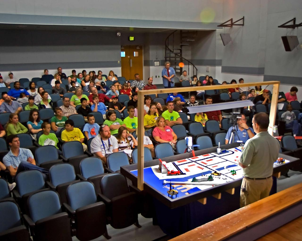
Randall Hicks (right), Jacobs Technology's Education Services manager at NASA John C. Stennis Space Center, answers questions about the playing field for FIRST (For Inspiration and Recognition of Science and Technology) LEGO League's 2007 Challenge, `Power Puzzle.' More than 140 teachers, mentors, parents and students from 15 schools attended the Sept. 15 FLL season kickoff at StenniSphere, the visitor center at SSC. The teams from southern and central Mississippi and Mobile, Ala., who came to SSC heard rules for and asked questions about `Power Puzzle,' and saw robot demonstrations by Gulfport and Picayune high schools' past FIRST Robotics competitions. Using LEGO Mindstorms NXT kits, FLL teams of children ages 9-14 will spend the next three months building and programming robots to perform 'Power Puzzle's' challenge tasks, then pit them in competitions. They also will submit a research project about how energy choices impact the environment and the economy. The season will culminate at the Mississippi Championship Tournament on Dec. 8 at the Mississippi Gulf Coast Community College. FLL, considered the `little league' of the FIRST Robotics Competition, partners FIRST and the LEGO Group. Competitions aim to inspire and celebrate science and technology using real-world context and hands-on experimentation. NASA recognizes FIRST activities as an excellent hands-on method to increase student knowledge of science, engineering, technology and mathematics. Schools represented in this year's kickoff were: Madison Avenue Upper Elementary, the Mississippi Band of Choctaw Indians' Conehatta Elementary, Hattiesburg's Lillie Burney Elementary, Pearl Upper Elementary, Long Beach Middle, Oktibehha Elementary, d'Iberville Middle, Saucier's West Wortham Middle, Picayune's Nicholson Elementary and Roseland Park Baptist Church Academy, Bay St. Louis' St. Stanislaus College and Mobile's Davidson High, as well as two home-school groups from the Jackson area.
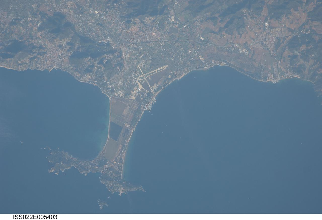
ISS022-E-005403 (2 Dec. 2009) --- Giens Peninsula, France is featured in this image photographed by an Expedition 22 crew member on the International Space Station. This detailed image depicts the Giens Peninsula located along the Mediterranean coastline of France. The peninsula is part of the Cote d?Azur, also known as the French Riviera, the coastal region bounded by the Rhone River to the west, to the north by the Rhone Alps, and the east by the Italian border. The peninsula itself, extended out southwards from the city of Hyeres to the resort community of Giens, is formed from two tombolos. A tombolo is a ridge of beach material (typically sand) built by wave action that connects an island to the mainland. Tombolos, like many coastal features, typically change dramatically over geologic time due to fluctuating sediment supply, coastal currents, sea levels and storm events. The tombolos of the Giens Peninsula have been modified by human activities including sand dune removal, construction of roadways, and replacement of the original sand by other materials. The long-term survival of these tombolos will be determined by the effects of these changes on the natural coastal processes, with potential sea level rise presenting an additional threat. In addition to Giens, three other urban areas are visible in this image; Carqueiranne, Hyeres, and La Londe-les-Maures. The urban areas are recognizable by both light pink rooftops and grey street grids. These contrast with green to brown vegetated areas including agricultural fields (between Hyeres and La Londe-les-Maures, top center) and dark green vegetated hillslopes (between Hyeres and Carqueiranne, top left). Small white dots and streaks in the Mediterranean Sea are actually yachts and other pleasure craft.
This perspective view shows the Strait of Gibraltar, which is the entrance to the Mediterranean Sea from the Atlantic Ocean. Europe (Spain) is on the left. Africa (Morocco) is on the right. The Rock of Gibraltar, administered by Great Britain, is the peninsula in the back left. The Strait of Gibraltar is the only natural gap in the topographic barriers that separate the Mediterranean Sea from the world's oceans. The Sea is about 3700 kilometers (2300 miles) long and covers about 2.5 million square kilometers (one million square miles), while the Strait is only about 13 kilometers (8 miles) wide. Sediment samples from the bottom of the Mediterranean Sea that include evaporite minerals, soils, and fossil plants show that about five million years ago the Strait was topographically blocked and the Sea had evaporated into a deep basin far lower in elevation than the oceans. Consequent changes in the world's hydrologic cycle, including effects upon ocean salinity, likely led to more ice formation in polar regions and more reflection of sunlight back to space, resulting in a cooler global climate at that time. Today, topography plays a key role in our regional climate patterns. But through Earth history, topographic change, even perhaps over areas as small as 13 kilometers across, has also affected the global climate. This image was generated from a Landsat satellite image draped over an elevation model produced by the Shuttle Radar Topography Mission (SRTM). The view is eastward with a 3-times vertical exaggeration to enhance topographic expression. Natural colors of the scene (green vegetation, blue water, brown soil, white beaches) are enhanced by image processing, inclusion of some infrared reflectance (as green) to highlight the vegetation pattern, and inclusion of shading of the elevation model to further highlight the topographic features. Landsat has been providing visible and infrared views of the Earth since 1972. SRTM elevation data matches the 30-meter (99-feet) resolution of most Landsat images and will substantially help in analyses of the large Landsat image archive. Elevation data used in this image was acquired by the Shuttle Radar Topography Mission (SRTM) aboard the Space Shuttle Endeavour, launched on February 11, 2000. http://photojournal.jpl.nasa.gov/catalog/PIA03397
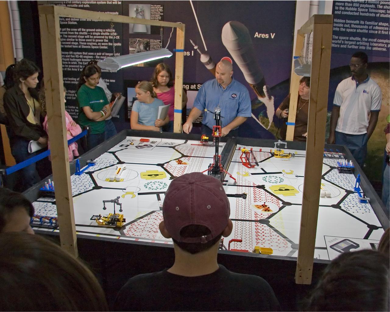
FIRST LEGO League participants listen to Aerospace Education Specialist Chris Copelan explain the playing field for 'Nano Quest' during a recent FLL kickoff event at StenniSphere, the visitor center at NASA Stennis Space Center. The kickoff began the 2006 FLL competition season. Eighty-five teachers, mentors, parents and 9- to 14-year-old students from southern and central Mississippi came to SSC to hear the rules for Nano Quest. The challenge requires teams to spend eight weeks building and programming robots from LEGO Mindstorms kits. They'll battle their creations in local and regional competitions. The Dec. 2 competition at Mississippi Gulf Coast Community College will involve about 200 students. FIRST LEGO League, considered the 'little league' of the FIRST (For Inspiration and Recognition of Science and Technology) Robotics Competition, partners FIRST and the LEGO Group. Competitions aim to inspire and celebrate science and technology using real-world context and hands-on experimentation, and to promote the principles of team play and gracious professionalism. Because NASA advocates robotics and science-technology education, the agency and SSC support FIRST by providing team coaches, mentors and training, as well as competition event judges, referees, audio-visual and other volunteer staff personnel. Two of Mississippi's NASA Explorer Schools, Bay-Waveland Middle and Hattiesburg's Lillie Burney Elementary, were in attendance. The following schools were also represented: Ocean Springs Middle, Pearl Upper Elementary, Long Beach Middle, Jackson Preparatory Academy, North Woolmarket Middle, D'Iberville Middle, West Wortham Middle, Picayune's Roseland Park Baptist Academy and Nicholson Elementary, as well as two home-school groups from McComb and Brandon. Gulfport and Picayune Memorial-Pearl River high schools' FIRST Robotics teams conducted robotics demonstrations for the FLL crowd.
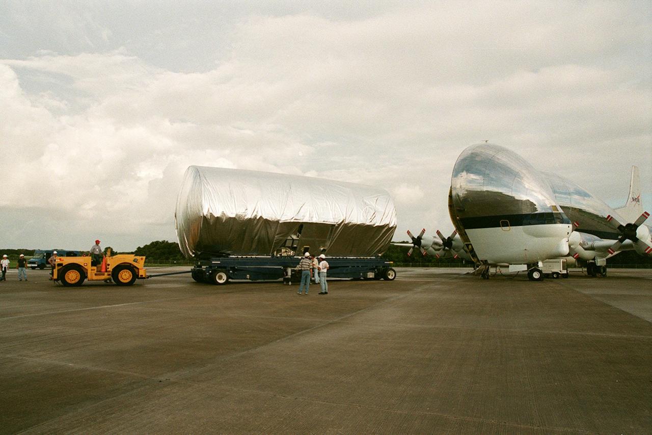
KENNEDY SPACE CENTER, FLA. -- At the Shuttle Landing Facility, the S1 truss, a segment of the International Space Station, is moved away from the Super Guppy that brought it to KSC from Marshall Space Flight Center. Manufactured by the Boeing Co. in Huntington Beach, Calif., this component of the ISS is the first starboard (right-side) truss segment, whose main job is providing structural support for the orbiting research facility's radiator panels that cool the Space Station's complex power system. The S1 truss segment also will house communications systems, external experiment positions and other subsystems. Primarily constructed of aluminum, the truss segment is 45 feet long, 15 feet wide and 6 feet tall. When fully outfitted, it will weigh 31,137 pounds. The truss is slated for flight in 2001. The Super Guppy, with its 25-foot diameter fuselage designed to handle oversized loads, is well prepared to transport the truss and other ISS segments. Loading the Guppy is easy because of the unique "fold-away" nose of the aircraft that opens 110 degrees for cargo loading. A system of rails in the cargo compartment, used with either Guppy pallets or fixtures designed for specific cargo, makes cargo loading simple and efficient. Rollers mounted in the rails allow pallets or fixtures to be moved by an electric winch mounted beneath the cargo floor. Automatic hydraulic lock pins in each rail secure the pallet for flight. The truss is being transferred to the Operations and Checkout Building
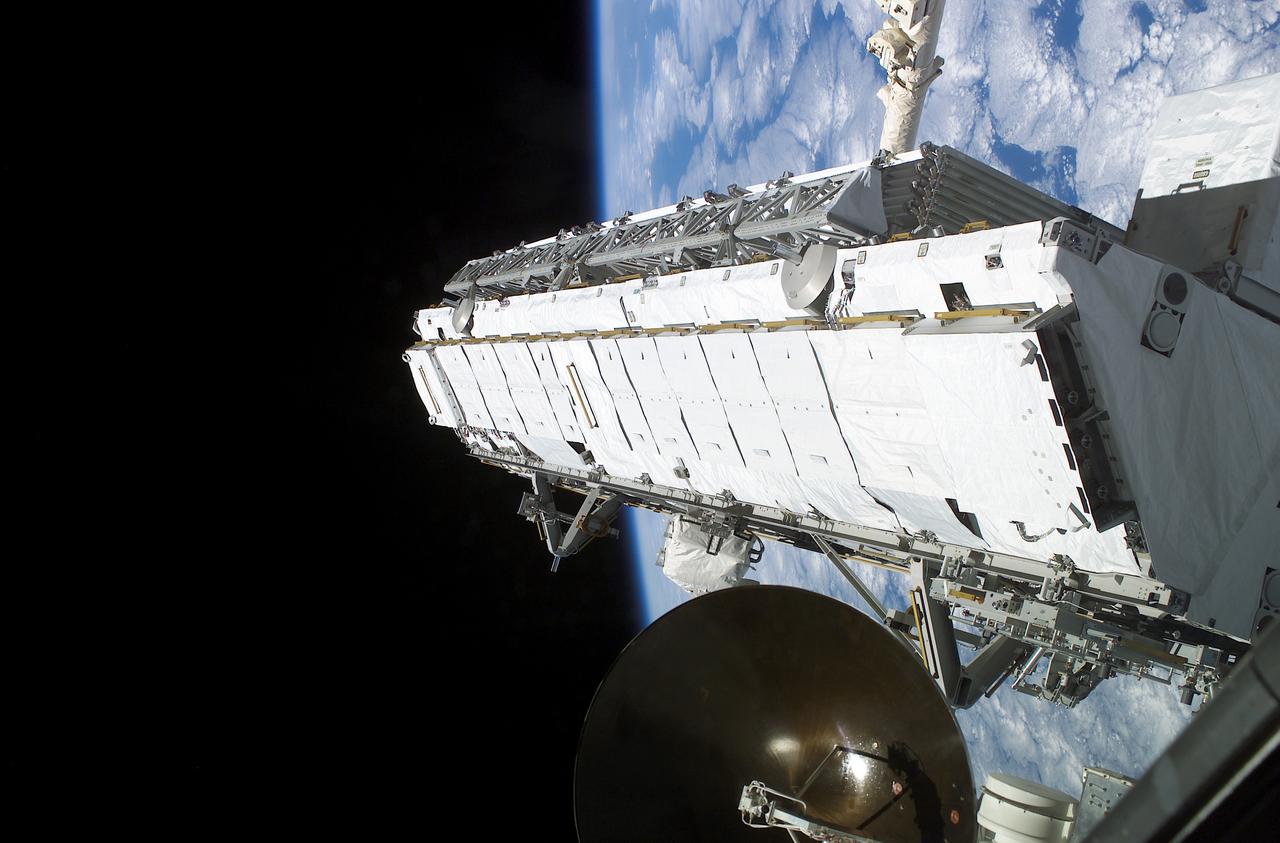
Being attached to the Canadarm2 on the International Space Station (ISS), the Remote Manipulator System arm built by the Canadian Space Agency, the Integrated Truss Assembly (S1) Truss is suspended over the Space Shuttle Orbiter Atlantis' cargo bay. Astronauts Sandra H. Magnus, STS-112 mission specialist, and Peggy A. Whitson, Expedition Five flight engineer, used the Canadarm2 from inside the Destiny laboratory on the ISS to lift the S1 truss out of the orbiter's cargo bay and move it into position prior to its installation on the ISS. The primary payloads of this mission, ISS Assembly Mission 9A, were the Integrated Truss Assembly S1 (S One), the starboard side thermal radiator truss, and the Crew Equipment Translation Aid (CETA) cart to the ISS. The S1 truss provides structural support for the orbiting research facility's radiator panels, which use ammonia to cool the Station's complex power system. The S1 truss was attached to the S0 (S Zero) truss, which was launched on April 8, 2002 aboard the STS-110, and flows 637 pounds of anhydrous ammonia through three heat-rejection radiators. The truss is 45-feet long, 15-feet wide, 10-feet tall, and weighs approximately 32,000 pounds. The CETA cart was attached to the Mobil Transporter and will be used by assembly crews on later missions. Manufactured by the Boeing Company in Huntington Beach, California, the truss primary structure was transferred to the Marshall Space Flight Center in February 1999 for hardware installations and manufacturing acceptance testing. The launch of the STS-112 mission occurred on October 7, 2002, and its 11-day mission ended on October 18, 2002.
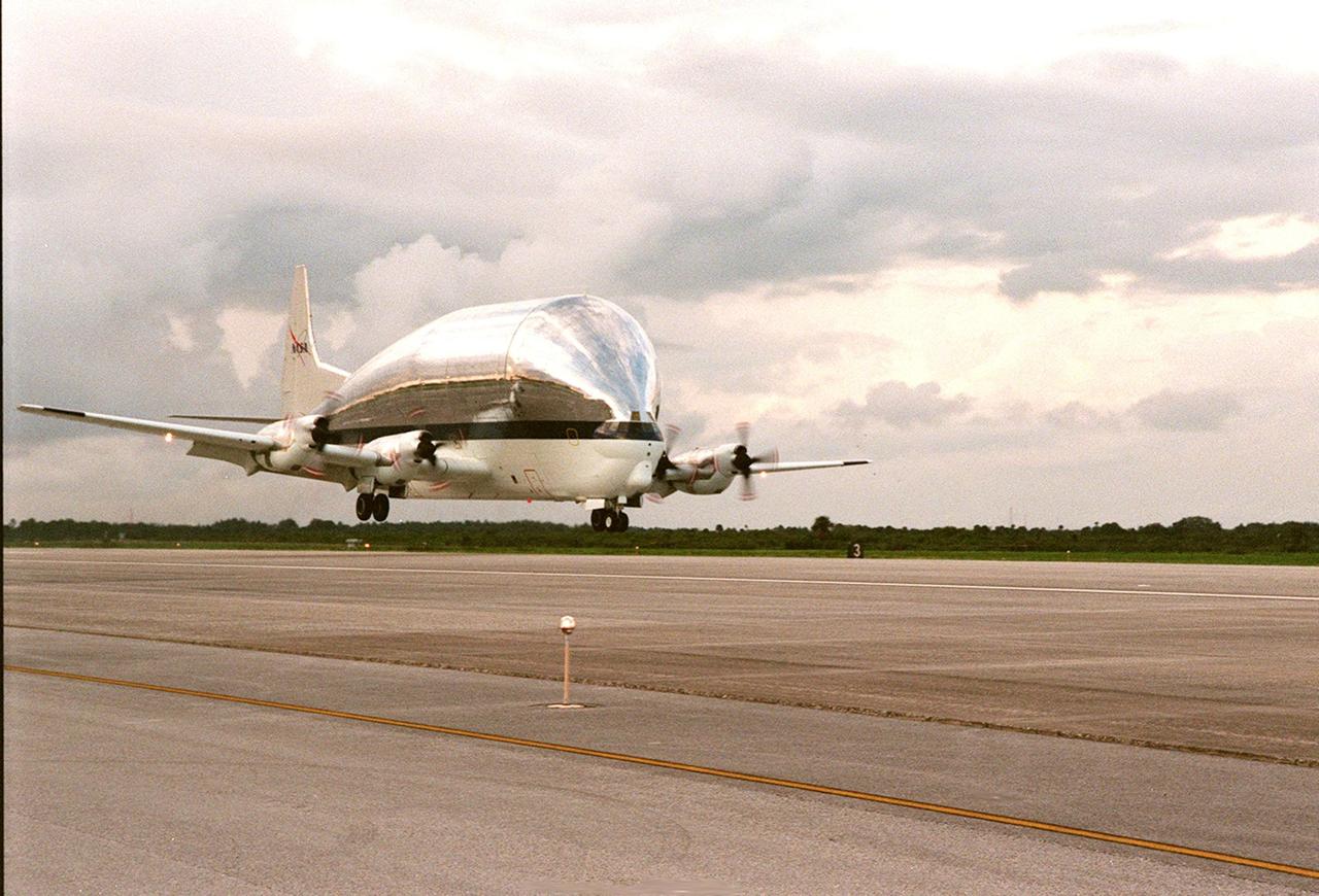
KENNEDY SPACE CENTER, FLA. -- NASA's Super Guppy airplane, with the International Space Station's (ISS) S1 truss aboard, arrives at KSC's Shuttle Landing Facility from Marshall Space Flight Center. Manufactured by the Boeing Co. in Huntington Beach, Calif., this component of the ISS is the first starboard (right-side) truss segment, whose main job is providing structural support for the orbiting research facility's radiator panels that cool the Space Station's complex power system. The S1 truss segment also will house communications systems, external experiment positions and other subsystems. Primarily constructed of aluminum, the truss segment is 45 feet long, 15 feet wide and 6 feet tall. When fully outfitted, it will weigh 31,137 pounds. The truss is slated for flight in 2001. The Super Guppy, with its 25-foot diameter fuselage designed to handle oversized loads, is well prepared to transport the truss and other ISS segments. Loading the Guppy is easy because of the unique "fold-away" nose of the aircraft that opens 110 degrees for cargo loading. A system of rails in the cargo compartment, used with either Guppy pallets or fixtures designed for specific cargo, makes cargo loading simple and efficient. Rollers mounted in the rails allow pallets or fixtures to be moved by an electric winch mounted beneath the cargo floor. Automatic hydraulic lock pins in each rail secure the pallet for flight. The truss is to be moved to the Operations and Checkout Building
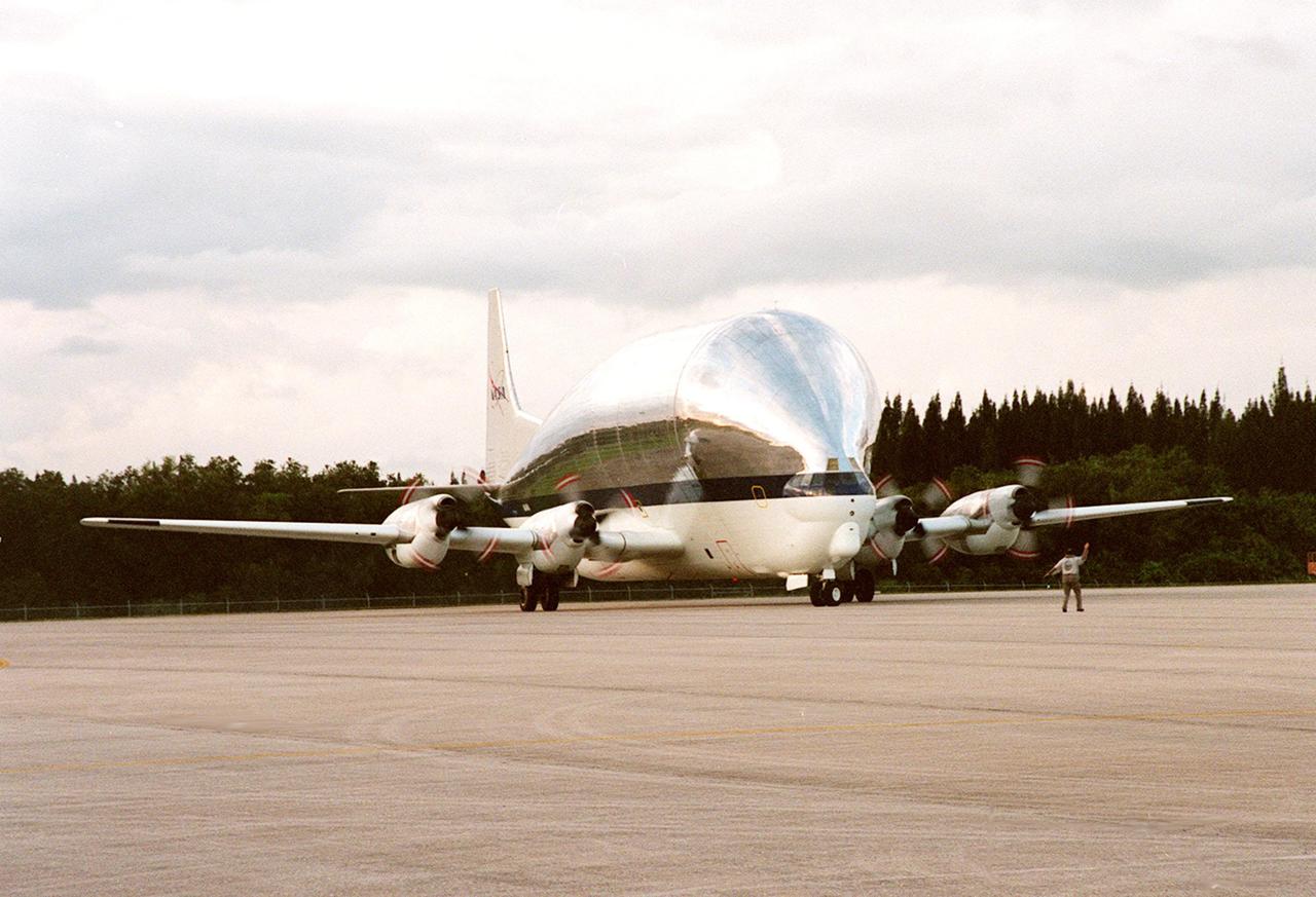
KENNEDY SPACE CENTER, FLA. -- NASA's Super Guppy airplane, with the International Space Station's (ISS) S1 truss aboard, rolls to a stop at KSC's Shuttle Landing Facility. Manufactured by the Boeing Co. in Huntington Beach, Calif., this component of the ISS is the first starboard (right-side) truss segment, whose main job is providing structural support for the orbiting research facility's radiator panels that cool the Space Station's complex power system. The S1 truss segment also will house communications systems, external experiment positions and other subsystems. Primarily constructed of aluminum, the truss segment is 45 feet long, 15 feet wide and 6 feet tall. When fully outfitted, it will weigh 31,137 pounds. The truss is slated for flight in 2001. The Super Guppy, with its 25-foot diameter fuselage designed to handle oversized loads, is well prepared to transport the truss and other ISS segments. Loading the Guppy is easy because of the unique "fold-away" nose of the aircraft that opens 110 degrees for cargo loading. A system of rails in the cargo compartment, used with either Guppy pallets or fixtures designed for specific cargo, makes cargo loading simple and efficient. Rollers mounted in the rails allow pallets or fixtures to be moved by an electric winch mounted beneath the cargo floor. Automatic hydraulic lock pins in each rail secure the pallet for flight. The truss is to be transferred to the Operations and Checkout Building

JANUARY 8, 2013: Astronomers using NASA's Hubble and Spitzer space telescopes have probed the stormy atmosphere of a brown dwarf named 2MASSJ22282889-431026, creating the most detailed "weather map" yet for this class of cool, star-like orbs. The forecast shows wind-driven, planet-sized clouds enshrouding these strange worlds. Brown dwarfs form out of condensing gas, as stars do, but lack the mass to fuse atoms and produce energy. Instead, these objects, which some call failed stars, are more similar to gas planets with their complex, varied atmospheres. The new research is a stepping stone toward a better understanding not only brown dwarfs, but also of the atmospheres of planets beyond our solar system. Hubble and Spitzer simultaneously watched the brown dwarf as its light varied in time, brightening and dimming about every 90 minutes as the body rotated. Astronomers found the timing of this change in brightness depended on whether they looked using different wavelengths of infrared light. The variations are the result of different layers or patches of material swirling around in the brown dwarf in windy storms as large as Earth itself. Spitzer and Hubble see different atmospheric layers because certain infrared wavelengths are blocked by vapors of water and methane high up, while other infrared wavelengths emerge from much deeper layers. Daniel Apai, the principal investigator of the research from the University of Arizona, Tucson, presented the results at the American Astronomical Society meeting on January 8 in Long Beach, Calif. A study describing the results, led by Esther Buenzli, also of the University of Arizona, is published in the Astrophysical Journal Letters. For more information about this study, visit <a href="http://www.nasa.gov/spitzer" rel="nofollow">www.nasa.gov/spitzer</a> . <b><a href="http://www.nasa.gov/audience/formedia/features/MP_Photo_Guidelines.html" rel="nofollow">NASA image use policy.</a></b> <b><a href="http://www.nasa.gov/centers/goddard/home/index.html" rel="nofollow">NASA Goddard Space Flight Center</a></b> enables NASA’s mission through four scientific endeavors: Earth Science, Heliophysics, Solar System Exploration, and Astrophysics. Goddard plays a leading role in NASA’s accomplishments by contributing compelling scientific knowledge to advance the Agency’s mission. <b>Follow us on <a href="http://twitter.com/NASA_GoddardPix" rel="nofollow">Twitter</a></b> <b>Like us on <a href="http://www.facebook.com/pages/Greenbelt-MD/NASA-Goddard/395013845897?ref=tsd" rel="nofollow">Facebook</a></b> <b>Find us on <a href="http://instagram.com/nasagoddard?vm=grid" rel="nofollow">Instagram</a></b>
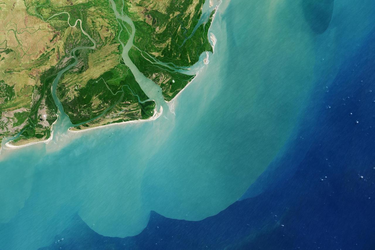
It drains a watershed that spans eight countries and nearly 1.6 million square kilometers 600,000 square miles. The Zambezi also Zambeze is the fourth largest river in Africa, and the largest east-flowing waterway. The Operational Land Imager on the Landsat 8 satellite acquired this natural-color image of the Zambezi Delta on August 29, 2013. Sandbars and barrier spits stretch across the mouths of the delta, and suspended sediment extends tens of kilometers out into the sea. The sandy outflow turns the coastal waters to a milky blue-green compared to the deep blue of open water in the Indian Ocean. The Zambezi Delta includes 230 kilometers of coastline fronting 18,000 square kilometers (7,00 square miles) of swamps, floodplains, and even savannahs (inland). The area has long been prized by subsistence fishermen and farmers, who find fertile ground for crops like sugar and fertile waters for prawns and fish. Two species of endangered cranes and one of the largest concentration of buffalo in Africa -- among many other species of wildlife -- have found a haven in this internationally recognized wetland. However, the past six decades have brought great changes to the Zambezi Delta, which used to pour more water and sediment off of the continent. Hydropower dams upstream-most prominently, the Kariba and the Cahora Bassa-greatly reduce river flows during the wet season; they also trap sediments that would otherwise flow downstream. The result has been less water reaching the delta and the floodplains, which rely on pulses of nutrients and sediments from annual (and mostly benign) natural flooding. The change in the flow of the river affects freshwater availability and quality in the delta. Strong flows push fresh water further out into the sea and naturally keep most of a delta full of fresh (or mostly fresh) water. When that fresh flow eases, the wetlands become drier and more prone to fire. Salt water from the Indian Ocean also can penetrate further into the marsh, upsetting the ecological balance for aquatic plant and animal species. Researchers have found that the freshwater table in the delta has dropped as much as five meters in the 50 years since dams were placed on the river. Less river flow also affects the shape and extent of the delta. Today there is less sediment replenishing the marshes and beaches as they are scoured by ocean waves and tides. "What strikes me in this image is the suspended sediment offshore," said Liviu Giosan, a delta geologist at the Woods Hole Oceanographic Institution. "Sediment appears to be transferred from the delta offshore in plumes that not only originate in active river mouths but also from deactivated former mouths, now tidal channels. This shows the power of tidal scouring contributing to the slow but relentless erosion of the delta." http://photojournal.jpl.nasa.gov/catalog/PIA18155
The largest NASA Hubble Space Telescope image ever assembled, this sweeping bird’s-eye view of a portion of the Andromeda galaxy (M31) is the sharpest large composite image ever taken of our galactic next-door neighbor. Though the galaxy is over 2 million light-years away, The Hubble Space Telescope is powerful enough to resolve individual stars in a 61,000-light-year-long stretch of the galaxy’s pancake-shaped disk. It's like photographing a beach and resolving individual grains of sand. And there are lots of stars in this sweeping view -- over 100 million, with some of them in thousands of star clusters seen embedded in the disk. This ambitious photographic cartography of the Andromeda galaxy represents a new benchmark for precision studies of large spiral galaxies that dominate the universe's population of over 100 billion galaxies. Never before have astronomers been able to see individual stars inside an external spiral galaxy over such a large contiguous area. Most of the stars in the universe live inside such majestic star cities, and this is the first data that reveal populations of stars in context to their home galaxy. Hubble traces densely packed stars extending from the innermost hub of the galaxy seen at the left. Moving out from this central galactic bulge, the panorama sweeps from the galaxy's central bulge across lanes of stars and dust to the sparser outer disk. Large groups of young blue stars indicate the locations of star clusters and star-forming regions. The stars bunch up in the blue ring-like feature toward the right side of the image. The dark silhouettes trace out complex dust structures. Underlying the entire galaxy is a smooth distribution of cooler red stars that trace Andromeda’s evolution over billions of years. Because the galaxy is only 2.5 million light-years from Earth, it is a much bigger target in the sky than the myriad galaxies Hubble routinely photographs that are billions of light-years away. This means that the Hubble survey is assembled together into a mosaic image using 7,398 exposures taken over 411 individual pointings. Read more: <a href="http://1.usa.gov/1y0i3H8" rel="nofollow">1.usa.gov/1y0i3H8</a> Credit: NASA, ESA, J. Dalcanton, B.F. Williams, and L.C. Johnson (University of Washington), the PHAT team, and R. Gendler <b><a href="http://www.nasa.gov/audience/formedia/features/MP_Photo_Guidelines.html" rel="nofollow">NASA image use policy.</a></b> <b><a href="http://www.nasa.gov/centers/goddard/home/index.html" rel="nofollow">NASA Goddard Space Flight Center</a></b> enables NASA’s mission through four scientific endeavors: Earth Science, Heliophysics, Solar System Exploration, and Astrophysics. Goddard plays a leading role in NASA’s accomplishments by contributing compelling scientific knowledge to advance the Agency’s mission. <b>Follow us on <a href="http://twitter.com/NASAGoddardPix" rel="nofollow">Twitter</a></b> <b>Like us on <a href="http://www.facebook.com/pages/Greenbelt-MD/NASA-Goddard/395013845897?ref=tsd" rel="nofollow">Facebook</a></b> <b>Find us on <a href="http://instagram.com/nasagoddard?vm=grid" rel="nofollow">Instagram</a></b>
In orbit above the semi-desert grasslands in Kazakhstan, an astronaut aboard the International Space Station spotted one of the few features that stand out. Lake Tengiz is the only large lake (1590 square kilometers, 615 square miles) in northern Kazakhstan. Through white wisps of cloud, the crew member photographed the 50 kilometer-long eastern shore of the lake, with its thin, winding islands and white beaches. The islands and intervening waterways make a rich habitat for birds in this part of Asia. At least 318 species of birds have been identified at the lake; 22 of them are endangered. It is the northernmost habitat of the pink flamingo. The lake system is Kazakhstan’s first UNESCO World Heritage Site, and it has been declared a RAMSAR wetland site of international importance. Part of the richness of area is its complex hydrology. Fresh water enters the system via the Kulanutpes River, so there are small lakes (lower right) full of fresh water. But in this closed basin, the water in the main lake (top) slowly evaporates, becoming salty. Winds stir up bigger waves on the main lake, dispersing sediment and salt and making the water a cloudier and lighter blue-green. (Another astronaut photograph shows the entire lake system, while this story provides more information.) The strange shape of the islands is not easy to interpret. They may be drowned remnants of delta distributaries of the Kulanutpes River. Westerly winds probably have had a smoothing effect on the shorelines, especially in a shallow lake like Tengiz, which is only about 6 meters (20 feet) deep. The lake has an exciting history for people who follow space exploration. In 1976, a Soyuz spacecraft landed in the lake near the north shore (top right). The capsule crashed through the ice and sank during an October snowstorm when temperatures were -22°C (-8°F). Because of low power, the capsule was unheated and the crew was feared lost. It was many hours before the airtight capsule was located and divers could attach flotation tanks to get the capsule to the surface. It was then dragged ashore across the ice by helicopter. The rescue effort took nine hours before the crew was able to safely exit the capsule. Credit: <b><a href="http://www.earthobservatory.nasa.gov/" rel="nofollow"> NASA Earth Observatory</a></b> <b><a href="http://www.nasa.gov/audience/formedia/features/MP_Photo_Guidelines.html" rel="nofollow">NASA image use policy.</a></b> <b><a href="http://www.nasa.gov/centers/goddard/home/index.html" rel="nofollow">NASA Goddard Space Flight Center</a></b> enables NASA’s mission through four scientific endeavors: Earth Science, Heliophysics, Solar System Exploration, and Astrophysics. Goddard plays a leading role in NASA’s accomplishments by contributing compelling scientific knowledge to advance the Agency’s mission. <b>Follow us on <a href="http://twitter.com/NASAGoddardPix" rel="nofollow">Twitter</a></b> <b>Like us on <a href="http://www.facebook.com/pages/Greenbelt-MD/NASA-Goddard/395013845897?ref=tsd" rel="nofollow">Facebook</a></b> <b>Find us on <a href="http://instagrid.me/nasagoddard/?vm=grid" rel="nofollow">Instagram</a></b>

Image release date September 22, 2010 To view a video of this image go here: <a href="http://www.flickr.com/photos/gsfc/5014452203">www.flickr.com/photos/gsfc/5014452203</a> Caption: A spectacular new NASA/ESA Hubble Space Telescope image reveals the heart of the Lagoon Nebula. Seen as a massive cloud of glowing dust and gas, bombarded by the energetic radiation of new stars, this placid name hides a dramatic reality. The Advanced Camera for Surveys (ACS) on the NASA/ESA Hubble Space Telescope has captured a dramatic view of gas and dust sculpted by intense radiation from hot young stars deep in the heart of the Lagoon Nebula (Messier 8). This spectacular object is named after the wide, lagoon-shaped dust lane that crosses the glowing gas of the nebula. This structure is prominent in wide-field images, but cannot be seen in this close-up. However the strange billowing shapes and sandy texture visible in this image make the Lagoon Nebula’s watery name eerily appropriate from this viewpoint too. Located four to five thousand light-years away, in the constellation of Sagittarius (the Archer), Messier 8 is a huge region of star birth that stretches across one hundred light-years. Clouds of hydrogen gas are slowly collapsing to form new stars, whose bright ultraviolet rays then light up the surrounding gas in a distinctive shade of red. The wispy tendrils and beach-like features of the nebula are not caused by the ebb and flow of tides, but rather by ultraviolet radiation’s ability to erode and disperse the gas and dust into the distinctive shapes that we see. In recent years astronomers probing the secrets of the Lagoon Nebula have found the first unambiguous proof that star formation by accretion of matter from the gas cloud is ongoing in this region. Young stars that are still surrounded by an accretion disc occasionally shoot out long tendrils of matter from their poles. Several examples of these jets, known as Herbig-Haro objects, have been found in this nebula in the last five years, providing strong support for astronomers’ theories about star formation in such hydrogen-rich regions. The Lagoon Nebula is faintly visible to the naked eye on dark nights as a small patch of grey in the heart of the Milky Way. Without a telescope, the nebula looks underwhelming because human eyes are unable to distinguish clearly between colours at low light levels. Charles Messier, the 18th century French astronomer, observed the nebula and included it in his famous astronomical catalogue, from which the nebula’s alternative name comes. But his relatively small refracting telescope would only have hinted at the dramatic structures and colours now visible thanks to Hubble. The Hubble Space Telescope is a project of international cooperation between ESA and NASA. Image credit: NASA, ESA <b><a href="http://www.nasa.gov/audience/formedia/features/MP_Photo_Guidelines.html" rel="nofollow">NASA image use policy.</a></b> <b><a href="http://www.nasa.gov/centers/goddard/home/index.html" rel="nofollow">NASA Goddard Space Flight Center</a></b> enables NASA’s mission through four scientific endeavors: Earth Science, Heliophysics, Solar System Exploration, and Astrophysics. Goddard plays a leading role in NASA’s accomplishments by contributing compelling scientific knowledge to advance the Agency’s mission. <b>Follow us on <a href="http://twitter.com/NASAGoddardPix" rel="nofollow">Twitter</a></b> <b>Like us on <a href="http://www.facebook.com/pages/Greenbelt-MD/NASA-Goddard/395013845897?ref=tsd" rel="nofollow">Facebook</a></b> <b>Find us on <a href="http://instagram.com/nasagoddard?vm=grid" rel="nofollow">Instagram</a></b> To learn more about the Hubble Space Telescope go here: <a href="http://www.nasa.gov/mission_pages/hubble/main/index.html" rel="nofollow">www.nasa.gov/mission_pages/hubble/main/index.html</a>
Acquired February 5, 2013 The Danube River is the largest in the European Union, its watershed draining 801,463 square kilometers (309,447 square miles) of land across 19 countries. Where that great river reaches the Black Sea, a remarkable delta has formed—the “Everglades” of Europe. The Danube Delta is home to more than 300 species of bird and 45 species of freshwater fish. The Danube Delta has been home to human settlements since the end of the Stone Age (the Neolithic Period), and the ancient Greeks, Romans, and Byzantines all built trading ports and military outposts along this coast. Today, the border between Romania and Ukraine cuts through the northern part of the delta. The area is a United Nations World Heritage Site, both for its natural and human history, and for the traditional maritime culture that persists in its marshes. All the while, the landscape has been shaped and re-shaped by nature and man. The image above was acquired on February 5, 2013, by the Advanced Land Imager (ALI) on NASA’s Earth Observing-1 (EO-1) satellite. The Danube Delta has a number of lobes formed over the past several thousand years, and this image is focused largely on the northernmost Chilia (or Kilia) lobe. It is the youngest section of the delta—somewhere between 300 to 400 years old—and lies mostly within Ukraine. Much of the land in the image above is officially considered part of the Danube Biosphere Reserve. Near the center of the image, the small city of Vylkove is known as the “Ukranian Venice,” due to its canals. To the lower left, the older Sulina lobe of the delta stretches to the south and further inland into Romania. White and brown curved lines reveal beach ridges and former shorelines, with the whiter ridges composed almost entirely of pure quartz sand in high dunes. To the east of the ridges, most of the landscape is flat marshland that is mostly brown in the barren days of winter. The Bystroye Canal through the center of the Chilia lobe has been the subject of heated debate over the past two decades. Over the centuries, damming and channeling of the Danube throughout Europe has reduced its water flow and sediment load to roughly 30 percent of what it once was, according to coastal geologist Liviu Giosan of the Woods Hole Oceanographic Institution. In recent years, the Ukrainian government has dredged some delta channels (including Bystroye) and proposed extensive dredging of others in order to provide navigational channels for large ships. Proponents argue for the economic needs of water transportation routes. Opponents note that deeper, faster channels mean less mud and sand is deposited in the delta; in some places, more is carried away by swifter currents. Both affect the sensitive ecosystems and the ability of the delta to restore itself and grow. In a 2012 report led by Giosan, scientists noted that the shape, water chemistry, and biology of Danube Delta was being altered long before the modern Industrial Era. Land use practices—particularly farming and forest clearing—added significant amounts of nutrients into the water and reduced salinity in the Black Sea, changing the dominant species of phytoplankton and sending a ripple of effects through the entire food web. NASA Earth Observatory image by Jesse Allen and Robert Simmon, using EO-1 ALI data provided courtesy of the NASA EO-1 team and the U.S. Geological Survey. Caption by Mike Carlowicz. Instrument: EO-1 - ALI More info: <a href="http://earthobservatory.nasa.gov/IOTD/view.php?id=80459" rel="nofollow">earthobservatory.nasa.gov/IOTD/view.php?id=80459</a> Credit: <b><a href="http://www.earthobservatory.nasa.gov/" rel="nofollow"> NASA Earth Observatory</a></b> <b><a href="http://www.nasa.gov/audience/formedia/features/MP_Photo_Guidelines.html" rel="nofollow">NASA image use policy.</a></b> <b><a href="http://www.nasa.gov/centers/goddard/home/index.html" rel="nofollow">NASA Goddard Space Flight Center</a></b> enables NASA’s mission through four scientific endeavors: Earth Science, Heliophysics, Solar System Exploration, and Astrophysics. Goddard plays a leading role in NASA’s accomplishments by contributing compelling scientific knowledge to advance the Agency’s mission. <b>Follow us on <a href="http://twitter.com/NASA_GoddardPix" rel="nofollow">Twitter</a></b> <b>Like us on <a href="http://www.facebook.com/pages/Greenbelt-MD/NASA-Goddard/395013845897?ref=tsd" rel="nofollow">Facebook</a></b> <b>Find us on <a href="http://instagram.com/nasagoddard?vm=grid" rel="nofollow">Instagram</a></b>
NASA videographer Jacob Shaw and the video team from NASA’s Armstrong Flight Research Center in Edwards, California, prepare to film the launch of NASA’s SPHEREx mission at Vandenberg Space Force Base. The mission, short for Specto-Photometer for the History of the Universe, Epoch of Reionization, and Ices Explorer, launched on March 11, 2025, aboard a SpaceX Falcon 9 rocket, continuing NASA’s exploration of the cosmos – and its commitment to visual storytelling.