
The Lowell Observatory's High-speed Imaging Photometer for Occultation rests on its dolly in the lab prior to installation on the SOFIA airborne observatory.

MSC Flight Crew visit Lowell Observatory at Flagstaff, AZ

MSC Flight Crew visit Lowell Observatory at Flagstaff, AZ
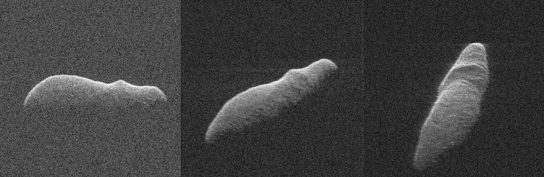
These three radar images of near-Earth asteroid 2003 SD220 were obtained on Dec. 15-17, by coordinating observations with NASA's 230-foot (70-meter) antenna at the Goldstone Deep Space Communications Complex in California and the National Science Foundation's (NSF) 330-foot (100-meter) Green Bank Telescope in West Virginia. The radar image on the left was obtained on Dec. 15 when asteroid 2003 SD220 was 2.8 million miles (4.5 million kilometers) from Earth. The radar image in the middle was generated from data collected on Dec. 16 when the asteroid was 2.5 million miles (4.0 million kilometers) from Earth. The image on the right was obtained on Dec. 17 when 2003 SD220 was 2.2 million miles (3.6 million kilometers) from Earth. The spatial resolution on the images is as fine as 12 feet (3.7 meters) per pixel. The radar images reveal the asteroid is at least one mile (1.6 kilometers) long. Asteroid 2003 SD220 was discovered on Sept. 29, 2003, by astronomers at the Lowell Observatory Near-Earth-Object Search (LONEOS) in Flagstaff, Arizona -- an early Near-Earth Object (NEO) survey project supported by NASA that is no longer in operation. The asteroid will fly safely past Earth on Saturday, Dec. 22, 2018, at a distance of about 1.8 million miles (2.9 million kilometers). This will be the asteroid's closest approach in more than 400 years and the closest until 2070, when the asteroid will safely fly by slightly closer. https://photojournal.jpl.nasa.gov/catalog/PIA22970
Temperature Comparison at Loki
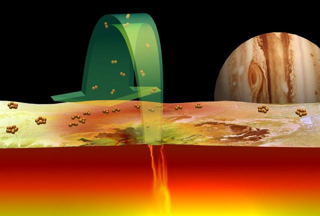
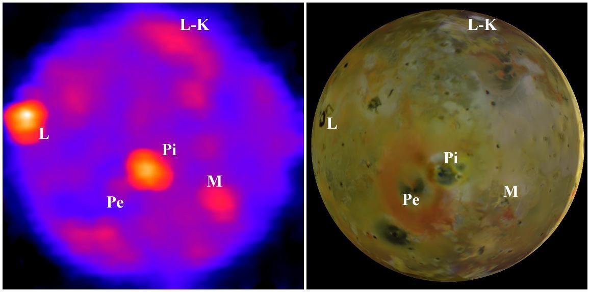
The Role of Sulfur in Io Volcanoes
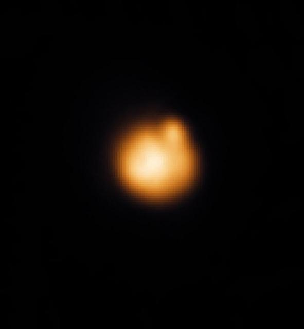
Earth-Based Observations of a Fire Fountain on Io

Nighttime Temperatures on Southern Io
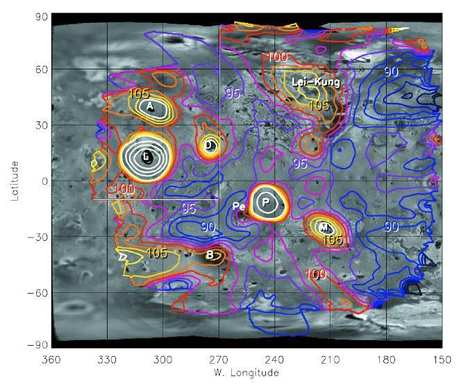
Temperature Map of Io Night Side
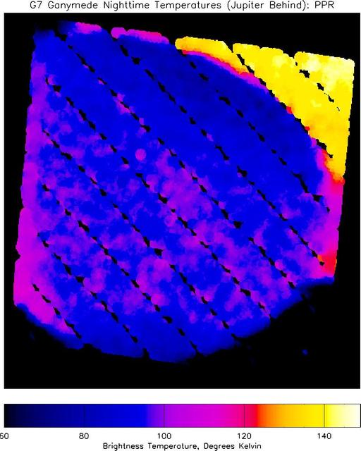
Nighttime Temperatures on Ganymede

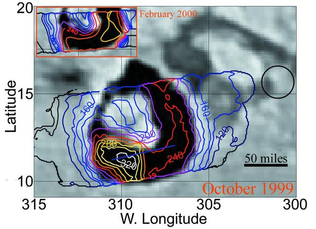
Galileo PPR Temperature Maps of Loki in October 1999
Io Nighttime Heat
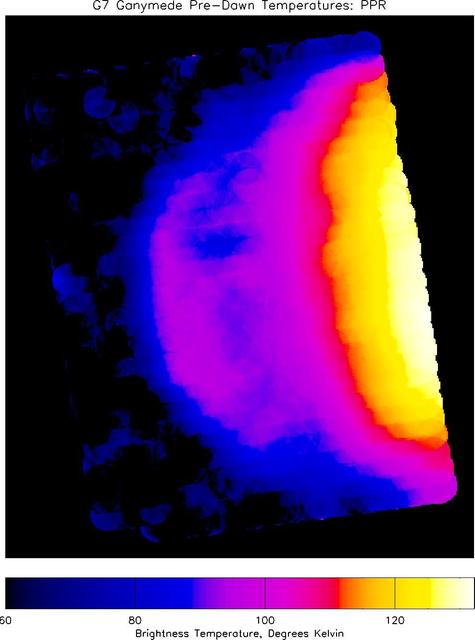
Pre-Dawn Temperatures on Ganymede

Earth-based images of the Fall 1999 Loki Eruption

Daytime Temperatures on Europa
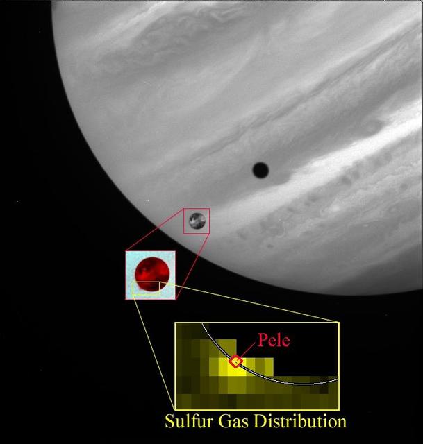
Sulfur Gas in Pele Plume
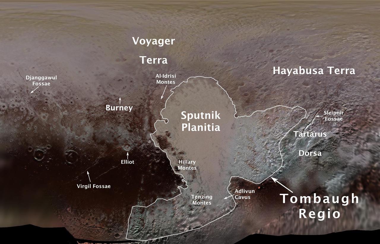
The International Astronomical Union (IAU), the internationally recognized authority for naming celestial bodies and their surface features, approved names of 14 surface features on Pluto in August 2017. The names were proposed by NASA's New Horizons team following the first reconnaissance of Pluto and its moons by the New Horizons spacecraft in 2015. The names, listed below, pay homage to the underworld mythology, pioneering space missions, historic pioneers who crossed new horizons in exploration, and scientists and engineers associated with Pluto and the Kuiper Belt. Tombaugh Regio honors Clyde Tombaugh (1906-1997), the U.S. astronomer who discovered Pluto in 1930 from Lowell Observatory in Arizona. Burney crater honors Venetia Burney (1918-2009), who as an 11-year-old schoolgirl suggested the name "Pluto" for Clyde Tombaugh's newly discovered planet. Later in life she taught mathematics and economics. Sputnik Planitia is a large plain named for Sputnik 1, the first space satellite, launched by the Soviet Union in 1957. Tenzing Montes and Hillary Montes are mountain ranges honoring Tenzing Norgay (1914-1986) and Sir Edmund Hillary (1919-2008), the Indian/Nepali Sherpa and New Zealand mountaineer were the first to reach the summit of Mount Everest and return safely. Al-Idrisi Montes honors Ash-Sharif al-Idrisi (1100-1165/66), a noted Arab mapmaker and geographer whose landmark work of medieval geography is sometimes translated as "The Pleasure of Him Who Longs to Cross the Horizons.†Djanggawul Fossae defines a network of long, narrow depressions named for the Djanggawuls, three ancestral beings in indigenous Australian mythology who traveled between the island of the dead and Australia, creating the landscape and filling it with vegetation. Sleipnir Fossa is named for the powerful, eight-legged horse of Norse mythology that carried the god Odin into the underworld. Virgil Fossae honors Virgil, one of the greatest Roman poets and Dante's fictional guide through hell and purgatory in the Divine Comedy. Adlivun Cavus is a deep depression named for Adlivun, the underworld in Inuit mythology. Hayabusa Terra is a large land mass saluting the Japanese spacecraft and mission (2003-2010) that performed the first asteroid sample return. Voyager Terra honors the pair of NASA spacecraft, launched in 1977, that performed the first "grand tour" of all four giant planets. The Voyager spacecraft are now probing the boundary between the Sun and interstellar space. Tartarus Dorsa is a ridge named for Tartarus, the deepest, darkest pit of the underworld in Greek mythology. Elliot crater recognizes James Elliot (1943-2011), an MIT researcher who pioneered the use of stellar occultations to study the solar system -- leading to discoveries such as the rings of Uranus and the first detection of Pluto's thin atmosphere. https://photojournal.jpl.nasa.gov/catalog/PIA21944
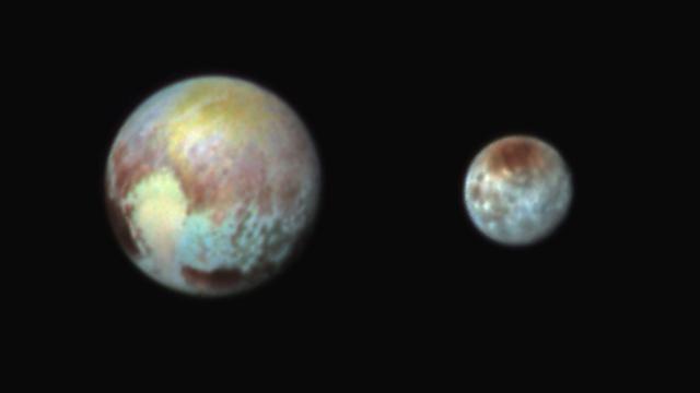
**This image was taken at 3:38 a.m. EDT on July 13, one day before New Horizons’ closest approach to Pluto.** New Horizons has obtained impressive new images of Pluto and its large moon Charon that highlight their compositional diversity. These are not actual color images of Pluto and Charon—they are shown here in exaggerated colors that make it easy to note the differences in surface material and features on each planetary body. The images were obtained using three of the color filters of the “Ralph” instrument on July 13 at 3:38 am EDT. New Horizons has seven science instruments on board the spacecraft—including “Ralph” and “Alice”, whose names are a throwback to the “Honeymooners,” a popular 1950s sitcom. “These images show that Pluto and Charon are truly complex worlds. There's a whole lot going on here,” said New Horizons co-investigator Will Grundy, Lowell Observatory, Flagstaff, Arizona. “Our surface composition team is working as fast as we can to identify the substances in different regions on Pluto and unravel the processes that put them where they are.” The color data helps scientists understand the molecular make-up of ices on the surfaces of Pluto and Charon, as well as the age of geologic features such as craters. They can also tell us about surface changes caused by space “weather,” such as radiation. The new color images reveal that the “heart” of Pluto actually consists of two remarkably different-colored regions. In the false-color image, the heart consists of a western lobe shaped like an ice cream cone that appears peach color in this image. A mottled area on the right (east) side looks bluish. A mid-latitude band appears in shades ranging from pale blue through red. Even within the northern polar cap, in the upper part of the image, various shades of yellow-orange indicate subtle compositional differences. This image was obtained using three of the color filters of the Ralph instrument on July 13 at 3:38 am EDT and received on the ground on at 12:25 pm. Charon is Just as Colorful The surface of Charon is viewed using the same exaggerated color. The red on the dark northern polar cap of Charon is attributed to hydrocarbon and other molecules, a class of chemical compounds called tholins. The mottled colors at lower latitudes point to the diversity of terrains on Charon. This image was obtained using three of the color filters of the Ralph instrument on July 13 at 3:38 am EDT and received on the ground on at 12:25 pm. “We make these color images to highlight the variety of surface environments present in the Pluto system,” said Dennis Reuter, co-investigator with the New Horizons Composition Team. “They show us in an intuitive way that there is much still to learn from the data coming down.” Due to the three-billion-mile distance to Pluto, data takes 4 ½ hours to come to Earth, even at the speed of light. It will take 16 months for all of New Horizons’ science data to be received, and the treasure trove from this mission will be studied for decades to come. Image Caption: Pluto and Charon in False Color Show Compositional Diversity This July 13, 2015, image of Pluto and Charon is presented in false colors to make differences in surface material and features easy to see. It was obtained by the Ralph instrument on NASA's New Horizons spacecraft, using three filters to obtain color information, which is exaggerated in the image. These are not the actual colors of Pluto and Charon, and the apparent distance between the two bodies has been reduced for this side-by-side view. The image reveals that the bright heart-shaped region of Pluto includes areas that differ in color characteristics. The western lobe, shaped like an ice-cream cone, appears peach color in this image. A mottled area on the right (east) appears bluish. Even within Pluto's northern polar cap, in the upper part of the image, various shades of yellow-orange indicate subtle compositional differences. The surface of Charon is viewed using the same exaggerated color. The red on the dark northern polar cap of Charon is attributed to hydrocarbon materials including a class of chemical compounds called tholins. The mottled colors at lower latitudes point to the diversity of terrains on Charon. --- At 7:49 AM EDT on Tuesday, July 14 New Horizons sped past Pluto at 30,800 miles per hour (49,600 kilometers per hour), with a suite of seven science instruments. As planned, New Horizons went incommunicado as it hurtled through the Pluto-Charon system busily gathering data. The New Horizons team will breathe a sigh of relief when New Horizons “phones home” at approximately 9:02 p.m. EDT on July 14. The mission to the icy dwarf planet completes the initial reconnaissance of the solar system. Stay in touch with the New Horizons mission with #PlutoFlyby and on Facebook at: <a href="https://www.facebook.com/new.horizons1" rel="nofollow">www.facebook.com/new.horizons1</a>
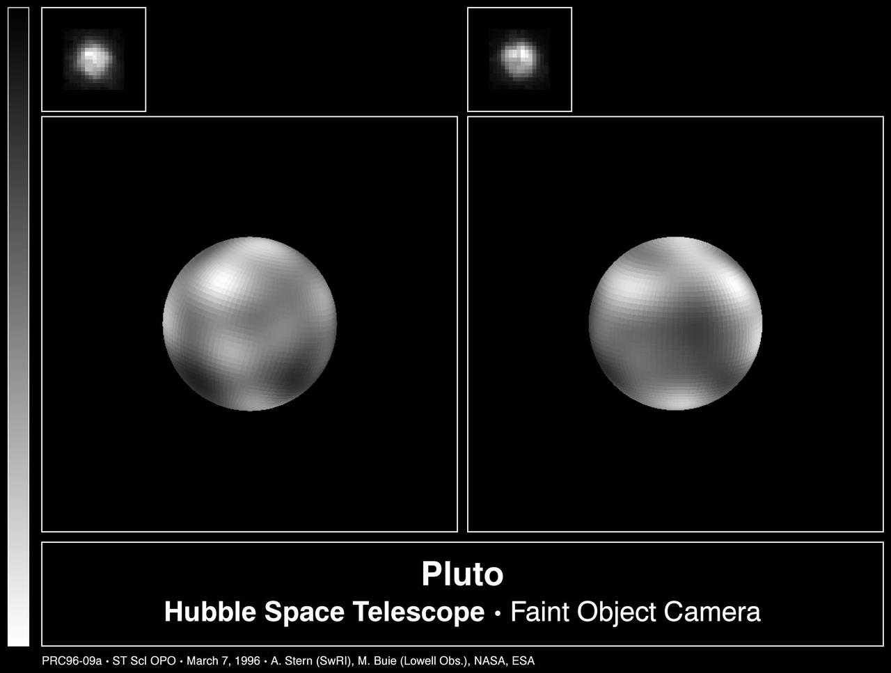
The never-before-seen surface of the distant planet Pluto is resolved in these NASA Hubble Space Telescope pictures, taken with the European Space Agency Faint Object Camera FOC aboard Hubble.
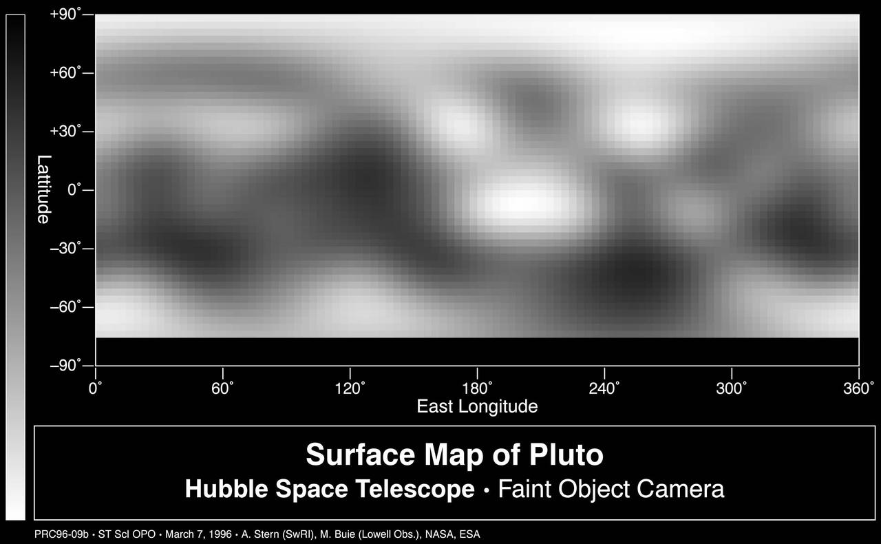
This image-based surface map of Pluto was assembled by computer image processing software from four separate images of Pluto disk taken with the European Space Agency Faint Object Camera aboard NASA Hubble Space Telescope.