Hunting for Ancient Lunar Impact Basins
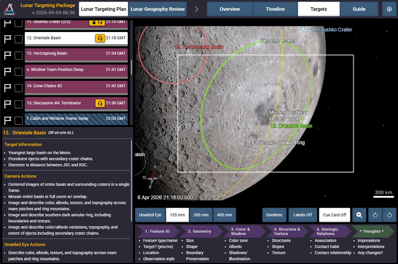
Caption: This is a screen shot of the application the crew sees on their personal computing devices that guides them in the execution of the lunar science observation plan. This custom software was built by the crew lunar observations team, a subset of the Artemis II lunar science team. In this screenshot you can see Orientale basin, target number 12 circled on the bottom right of the Moon, and to its left, target number 13, Hertzsprung basin.
art002e012090 (April 6, 2026) - In this view of the Moon, the Artemis II crew captured an intricate snapshot of the rings of the Orientale basin, one of the Moon’s youngest and best-preserved large impact craters on his first shift during the lunar flyby observation period. Credit: NASA
art002e012093 (April 6, 2026) - Hertzsprung Basin comes into view with its distinctive two concentric rings of mountains, revealing the scale of this ancient impact structure. Near the lower left, Vavilov crater—identified by its central peak—stands out, a feature often described by the Artemis II crew during their lunar flyby. Credit: NASA
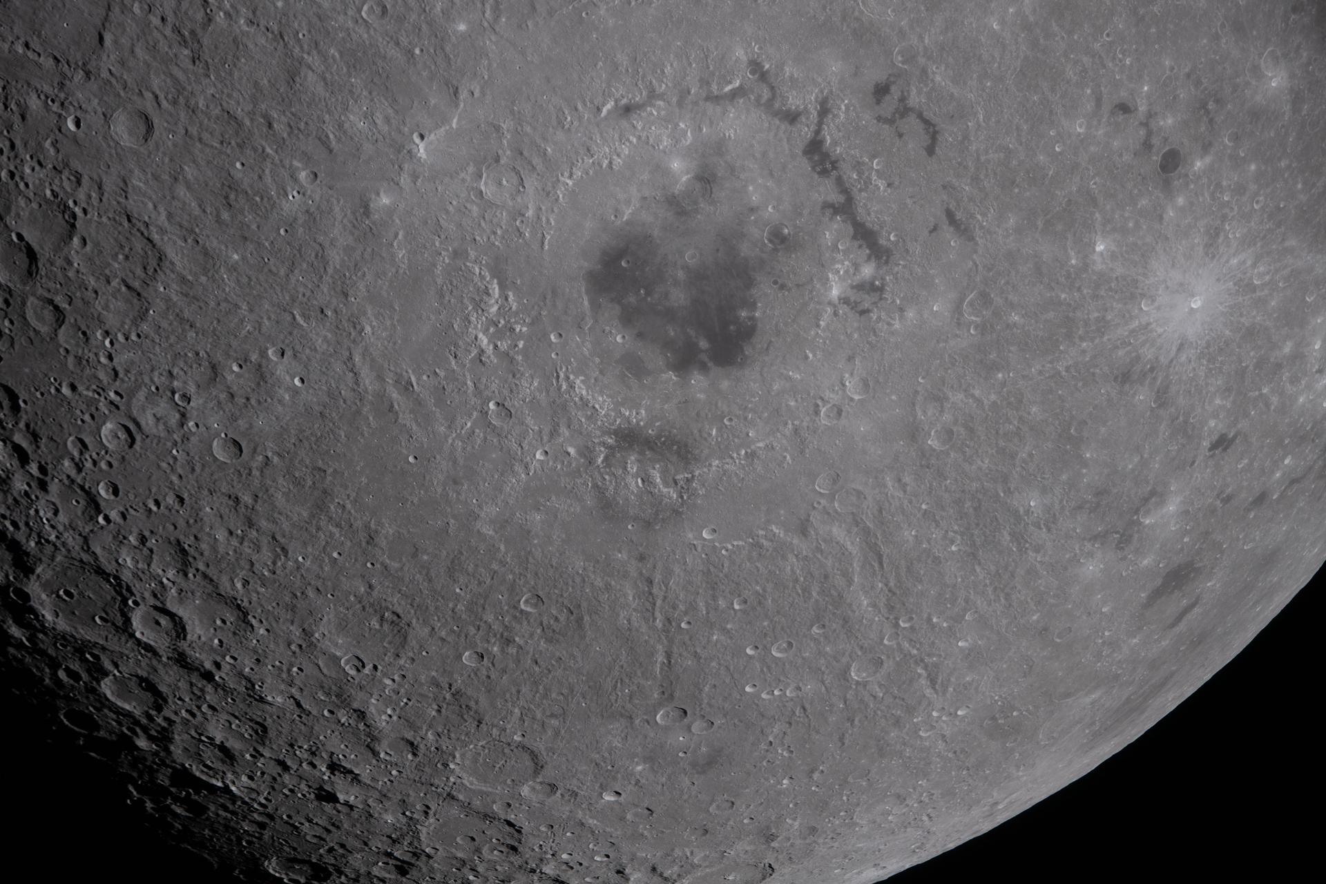
art002e012129 (April 6, 2026) - The lower half of the Moon hangs suspended in time in this photograph from the Artemis II crew during the lunar flyby observation period. In the upper center of the photo, the Orientale basin is the prominent feature, with a black patch of ancient lava in the center that punched through the Moon’s crust in an eruption billions of years ago. Credit: NASA
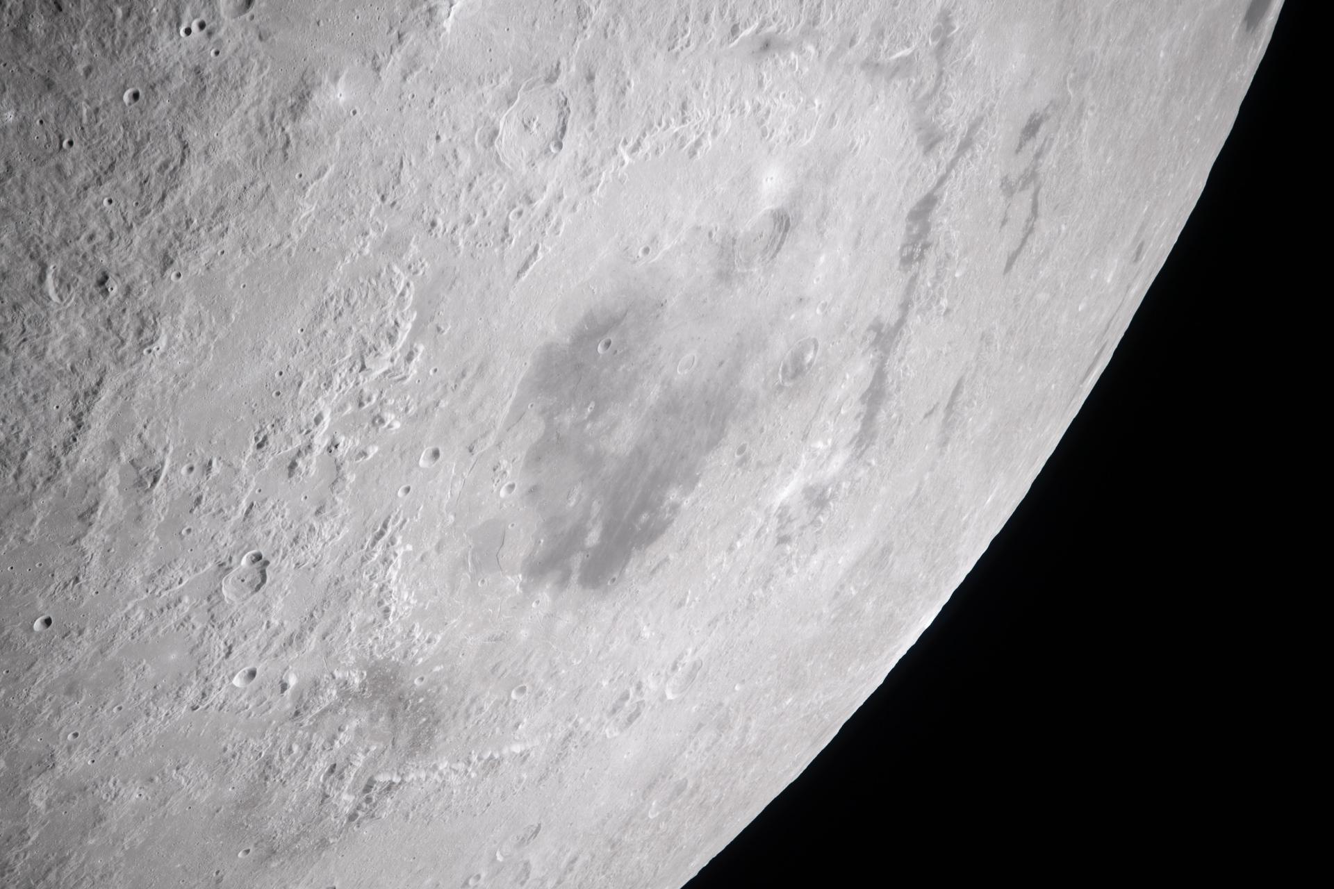
art002e012183 (April 6, 2026) - On the first shift during the lunar flyby observation period, the Artemis II crew captured more than two-thirds of the Moon showcasing the intricate features of the nearside. The 600-mile-wide impact crater, Orientale basin, lies along the transition between the near and far sides and is sometimes partly visible from Earth. The round black spot northeast of Orientale is Grimaldi crater, known for its exceptionally dark mare lava floor and heavily degraded rim. Credit: NASA
art002e020686 (April 6, 2026) – A portion of the Moon’s farside is seen along the terminator—the boundary between lunar day and night—where low-angle sunlight casts long shadows across the surface. A section of Orientale Basin is visible along the upper right portion of the lunar disk, its structure subtly revealed under grazing illumination. This lighting enhances contrast across the cratered terrain, highlighting variations in surface features and providing insight into the Moon’s geologic history. Credit: NASA
art002e012261 (April 6, 2026) - Multiple lunar landmarks come into view in this image, many of which were highlighted during the Artemis II crew’s observation call. Visible features include Ohm crater, Oceanus Procellarum, Grimaldi crater, Pierazzo crater, the newly proposed Carroll crater, and the expansive Hertzsprung Basin—together illustrating a range of geologic terrains, from dark volcanic plains to heavily cratered highlands and the remnants of ancient impact basins.
NASA Lunar Reconnaissance Orbiter spies many boulder trails are found on the lunar crater walls and basin massifs. Some of the trails are smooth and nearly straight while others are curvy or gouge into the surface.
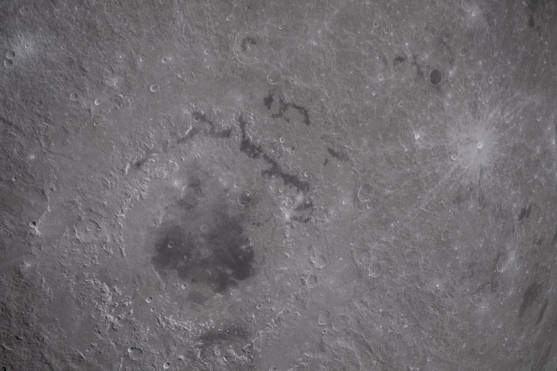
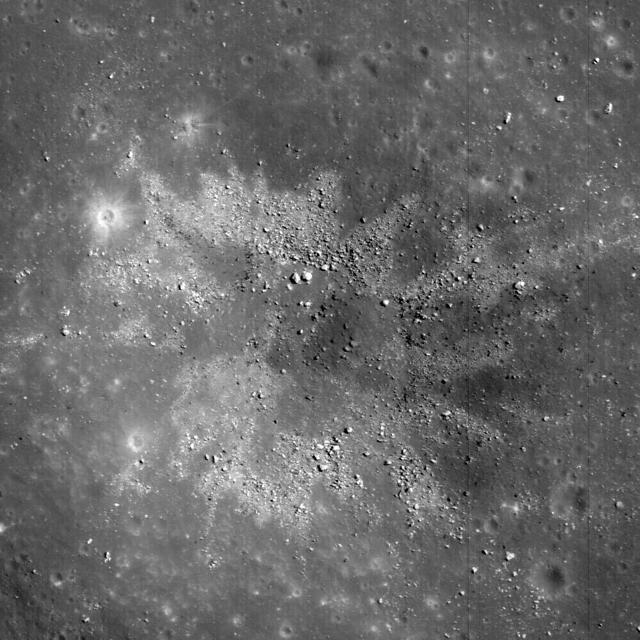
art002e010014 (April 6, 2026) – A bright portion of the Moon is visible in this image. If you look closely, you can see linear, pitted features known as “crater chains” radiating from the Orientale basin, an impact crater with a patch of ancient lava at its center, visible in the bottom center of the image. These crater chains formed about 3.8 billion years ago, when rocks spewed from the collision that formed Orientale landed in lines extending away from the crater. These chains are found near other large craters on the Moon, but we don’t get to see them on Earth because our planet’s crust has been turned over so many times through plate tectonics and largely erased by rain, wind, and ice. In the upper left corner of the Moon disk is a line called the terminator, the boundary between lunar day and night. Here, low-angle sunlight skims the surface, casting dramatic shadows that expose the area’s topography — or the shape of its surface. Glushko crater is the bright spot just to the left of the dark mare, or “sea” of ancient lava flows on the near side of the Moon. It’s identifiable by the bright rays that shoot across the mare, some hundreds of miles away. These rays are made of ejected material after the collision that formed Glushko. Glushko and its rays are brighter than the surrounding area because that younger has experienced less weathering from radiation and impacts. Oceanus Procellarum, the largest lava-filled region on the Moon, spans the horizon. The Aristarchus crater, the bright spot in the sea of lava, creeps toward the right edge of the Moon.
This lunar-like scene, imaged by NASA Mars Odyssey spacecraft, occurs along the southeastern rim of the Isidis Planitia basin, an ancient impact crater some 1200 km across.
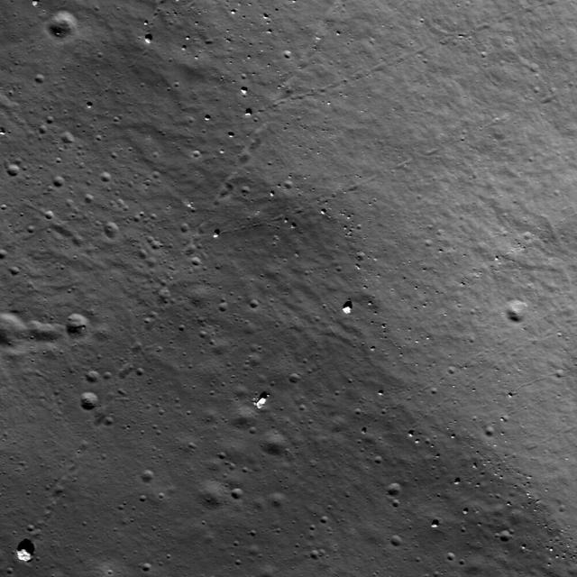
This is a view from NASA Lunar Reconnaissance Orbiter of a very young impact crater in Balmer basin. The dark streamers are impact melt splashes thrown out during the crater formation.
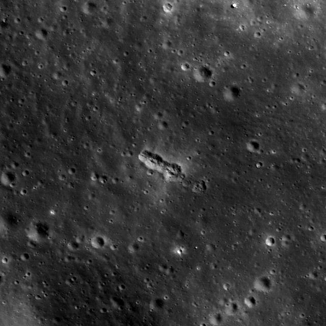
Materials excavated during formation of this ~450 m diameter impact crater have an unusual two-toned character, likely a reflection of heterogeneity in the target materials. This crater occurs in Balmer Basin. This image was taken by NASA Lunar Reconnai
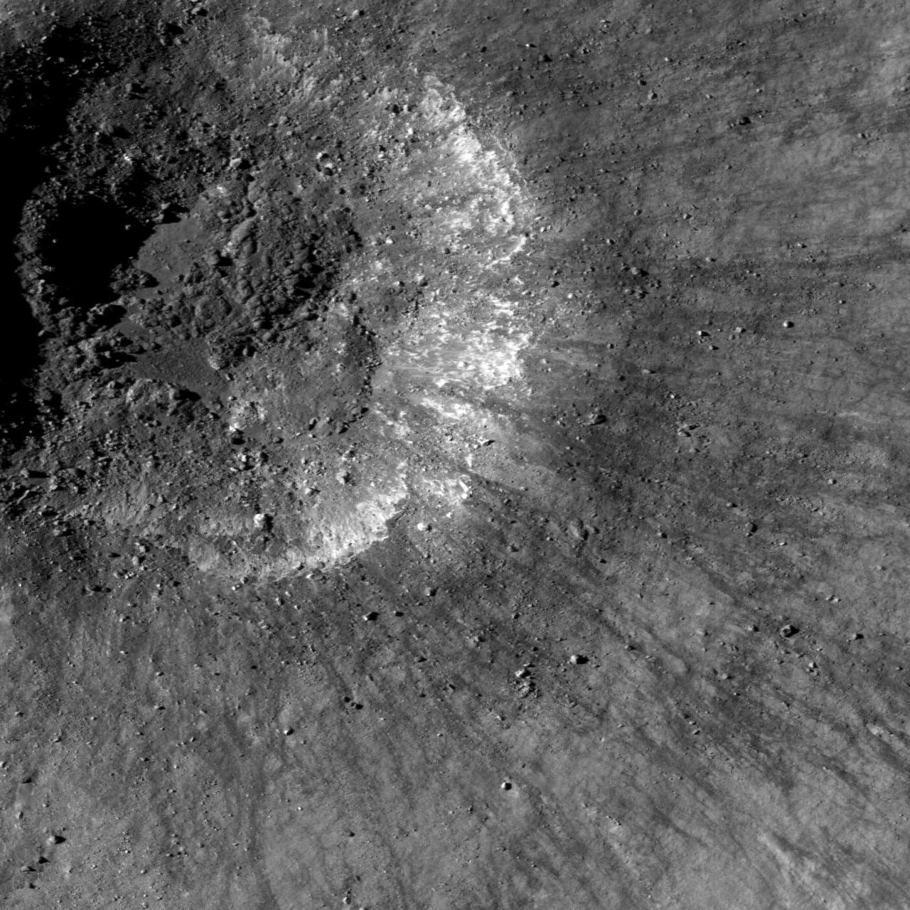
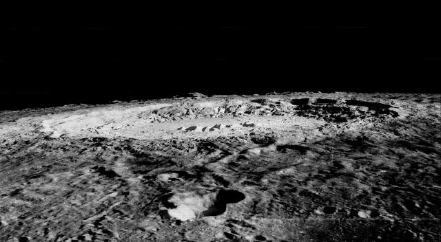
This high resolution image taken by NASA Lunar Reconnaissance Orbiter shows the floor of the Apollo Basin, a large 538 km diameter double-ringed impact crater in the southern hemisphere of the far side.
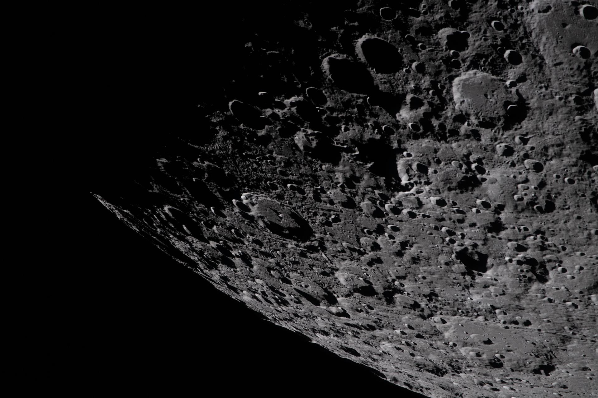
art002e009006 (April 4, 2026) - The Artemis II crew took this photo on day 4 of their journey to the Moon. In it, the Moon is oriented with the South Pole at the top and are beginning to see parts of the lunar far side. Orientale basin is on the right edge of the lunar disk in this image. Artemis II marks the first time that humans have seen the entire basin. The Artemis II crew will continue to observe Orientale from multiple angles as they approach the Moon and throughout the lunar flyby. Orientale is the textbook multi-ring impact basin used as a baseline to compare other impact craters on rocky worlds from Mercury to Pluto.
Copernicus is 93 km wide and is located within the Mare Imbrium Basin, northern nearside of the Moon 10 degrees N., 20 degrees W.. This image from NASA's Lunar Orbiter shows crater floor, floor mounds, rim, and rayed ejecta. http://photojournal.jpl.nasa.gov/catalog/PIA00094
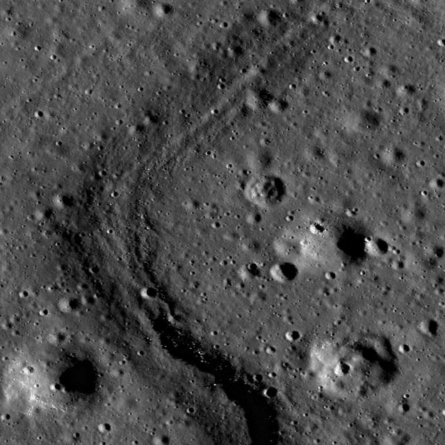
This image taken by NASA Lunar Reconnaissance Orbiter shows a small secondary crater chain near the southwestern margin of Mare Orientale, within the Inner Rook Mountains. The ~125-meter-long chain lies within the Orientale multi-ring basin.
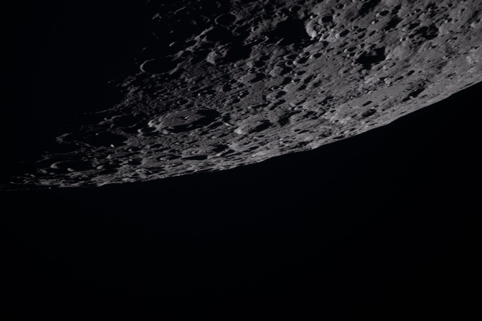
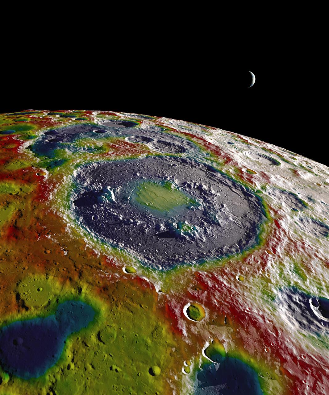
art002e009283 (April 6, 2026) – Captured by the Artemis II crew, the heavily cratered terrain of the eastern edge of the South Pole-Aitken basin is seen with the shadowed terminator – the boundary between lunar day and night – at the top of the image. The South Pole-Aitken basin is the largest and oldest basin on the Moon, providing a glimpse into an ancient geologic history built up over billions of years.

About 50,000 Clementine images were processed to produce the four orthographic views of the Moon. The images show albedo variations (normalized brightness or reflectivity) of the surface at a wavelength of 750 nm (just longward of visible red). The image projection is centered at 0 degree latitude and 180 degrees longitude. Mare Moscoviense (dark albedo feature upper left of image center) and South Pole-Aitken Basin (dark feature at bottom) represent maria regions largely absent on the lunar farside. The Clementine altimeter showed Aitken Basin to consist of a topographic rim about 2500 km in diameter, an inner shelf ranging from 400 to 600 km in width, and an irregular depressed floor about 12 km in depth. http://photojournal.jpl.nasa.gov/catalog/PIA00302
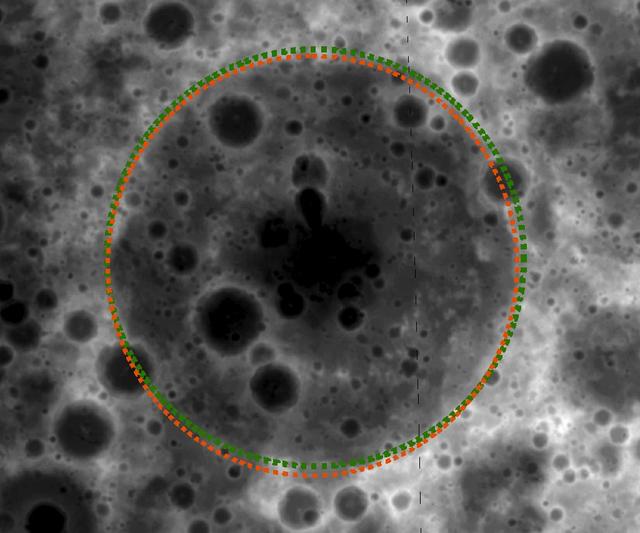
art002e012273 (April 6, 2026) - This view of the southwest portion of Orientale Basin highlights its prominent annular ring—a sweeping arc of mountainous terrain formed by the immense energy of an ancient impact. The ring structure rises above the surrounding surface, tracing the basin’s outer boundary and revealing the layered, multi-ring nature of one of the Moon’s most well-preserved impact features. Apollo-era observers nicknamed this formation “the kiss,” reflecting its distinctive, curved shape.
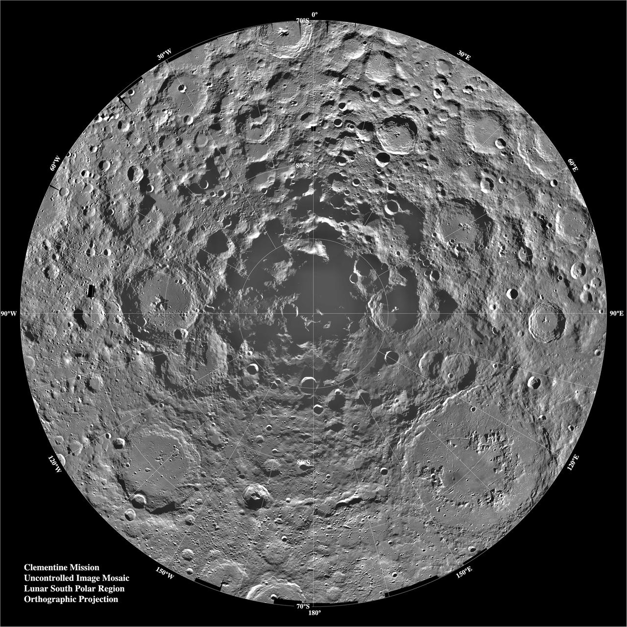
Lunar mosaic of ~1500 Clementine images of the south polar region of the moon. The projection is orthographic, centered on the south pole. The Schrodinger Basin (320 km in diameter) is located in the lower right of the mosaic. Amundsen-Ganswindt is the more subdued circular basin between Schrodinger and the pole. The polar regions of the moon are of special interest because of the postulated occurrence of ice in permanently shadowed areas. The south pole is of greater interest because the area that remains in shadow is much larger than that at the north pole. http://photojournal.jpl.nasa.gov/catalog/PIA00001
art002e010232 (April 6, 2026) – During the lunar flyby observation period, the Artemis II crew captures a detailed image of the Orientale basin, a 600-mile-wide impact crater marked by a dark patch of ancient lava that erupted through the Moon’s crust billions of years ago.
art002e020904 (April 6, 2026) – As the Artemis II crew went around the Moon, during one of the observation periods, the crew captured the details of the lunar terrain, showcasing the rugged craters, deep basins, and the black expanse of space below. Credit: NASA
Range : 350,000 miles This image of the western hemisphere of the Moon was taken through a green filter by Galileo at 9:35 am PST. In the center is the Orientale Basin, 600 miles in diameter, formed about 3.8 billion years ago by the impact of an streroid-size body. Orientale's dark center is a small mare. To the right is the lunar near side with the great, dark Oceanus Procellarum above and the small, circular, dark Mare Humorum Below. Maria are broad plains formed mostly over 3 billion years ago as vast bassaltic lava flows. To the left is the lunar far side with fewer maria, but, at lower left, the South-Pole-Aitken basin, about 1200 miles in diameter, which resemble Orientale but is much older and more weathered and battered by cratering. The intervening cratered highlands of both sides, as well as the maria, are dotted with bright, young craters. This image was 'reprojected' so as to center visibility of small features.
Range : 350,000 miles (JPL Ref: P-37329) This image of the western hemisphere of the Moon was taken through a green filter by Galileo at 9:35 am PST. In the center is the Orientale Basin, 600 miles in diameter, formed about 3.8 billion years ago by the impact of an streroid-size body. Orientale's dark center is a small mare. To the right is the lunar near side with the great, dark Oceanus Procellarum above and the small, circular, dark Mare Humorum Below. Maria are broad plains formed mostly over 3 billion years ago as vast bassaltic lava flows. To the left is the lunar far side with fewer maria, but, at lower left, the South-Pole-Aitken basin, about 1200 miles in diameter, which resemble Orientale but is much older and more weathered and battered by cratering. The intervening cratered highlands of both sides, as well as the maria, are dotted with bright, young craters. This image was 'reprojected' so as to center visibility of small features.
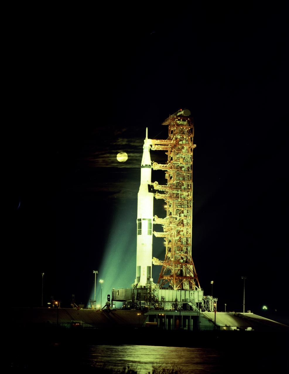
This is a breathtaking moonlit view of Apollo 17 on the Launch Pad at Kennedy Space Flight Center (KSC). The seventh and last manned lunar landing and return to Earth mission, the Apollo 17, carrying a crew of three astronauts: Mission Commander Eugene A. Cernan, Lunar Module pilot Harrison H. Schmitt, and Command Module pilot Ronald E. Evans, lifted off on December 7, 1972. The basic objective of the Apollo 17 mission was to sample basin-rim highland material and adjacent mare material, and investigate the geological evolutionary relationship between these two major units. The mission marked the longest Apollo mission, 504 hours, and the longest lunar surface stay time, 75 hours, which allowed the astronauts to conduct an extensive geological investigation. They collected 257 pounds (117 kilograms) of lunar samples with the use of the Marshall Space Flight Center designed Lunar Roving Vehicle (LRV). The mission ended on December 19, 1972
art002e009279 (April 6, 2026) – During their lunar flyby observation period, the Artemis II crew captured this image at 3:41 p.m. EDT, showing the rings of the Orientale basin, one of the Moon’s youngest and best-preserved large impact craters. These concentric rings offer scientists a rare window into how massive impacts shape planetary surfaces, helping refine models of crater formation and the Moon’s geologic history. At the 10 o’clock position of the Orientale basin, the two smaller craters – which the Artemis II crew has suggested be named Integrity and Carroll – are visible. These features highlight how crew observations can directly support surface feature identification and real-time science.

art002e009287 (April 6, 2026) – Earth sets at 6:41 p.m. EDT, April 6, 2026, over the Moon’s curved limb in this photo captured by the Artemis II crew during their journey around the far side of the Moon. Orientale basin is perched on the edge of the visible lunar surface. Hertzsprung Basin appears as two subtle concentric rings, which are interrupted by Vavilov, a younger crater superimposed over the older structure. The lines of indentations are secondary crater chains formed by ejecta from the massive impact that created Orientale. The dark portion of Earth is experiencing nighttime. On Earth’s day side, swirling clouds are visible over the Australia and Oceania region.

Galileo spacecraft image of the Moon recorded at 9:35 am Pacific Standard Time (PST), 12-09-90, after completing its first Earth Gravity Assist. Western hemisphere of the Moon was taken through a green filter at a range of about 350,000 miles. In the center is Orientale Basin, 600 miles in diameter, formed about 3.8 billion years ago by the impact of an asteroid-size body. Orientale's dark center is a small mare. To the right is the lunar near side with the great, dark Oceanus Procellarum above the small, circular, dark Mare Humorum below. Maria are broad plains formed mostly over 3 billion years ago as vast basaltic lava flows. To the left is the lunar far side with fewer maria, but, at lower left South-Pole-Aitken basin, about 1200 miles in diameter, which resembles Orientale but is much older and more weathered and battered by cratering. The intervening cratered highlands of both sides, as well as the maria, are dotted with bright young craters. This image was "reprojected" so as to center the Orientale Basin, and was filtered to enhance the visibility of small features. The digital image processing was done by DLR, the German Aerospace Research Establishment near Munich, an international collaborator in the Galileo mission. Photo was provided by Jet Propulsion Laboratory (JPL) with alternate number P-37327, 12-19-90.
art002e009281 (April 6, 2026) – The Artemis II crew captures a portion of the Moon coming into view along the terminator – the boundary between lunar day and night – where low-angle sunlight casts long, dramatic shadows across the surface. This grazing light accentuates the Moon’s rugged topography, revealing craters, ridges, and basin structures in striking detail. Features along the terminator such as Jule Crater, Birkhoff Crater, Stebbins Crater, and surrounding highlands stand out. From this perspective, the interplay of light and shadow highlights the complexity of the lunar surface in ways not visible under full illumination. The image was captured about three hours into the crew’s lunar observation period, as they flew around the far side of the Moon on the sixth day of the mission.
art002e009627 (April 6, 2026) – During the first shift of the lunar flyby observation period, the Artemis II crew captured more than two-thirds of the Moon, highlighting surface details on the nearside, including the 600-mile-wide impact crater, Orientale basin, along the boundary between the near and far sides. They also captured the Grimaldi crater, a dark, round feature northeast of Orientale, known for its dark mare lava floor and heavily worn rim.

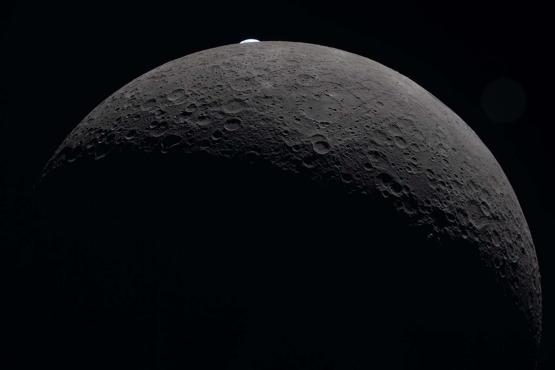
art002e021283 (April 6, 2026) – The Earth appears to be peeking out over the horizon of the Moon,but pictured here is actually an Earthset. During an Earthset, the planet appears to sink below the lunar horizon. In this scene, a partially lit crescent Earth drops behind the Moon as seen by crew on the Orion spacecraft. The image also shows the vast canvas of the Moon’s surface with its overlapping craters and basins. Credit: NASA
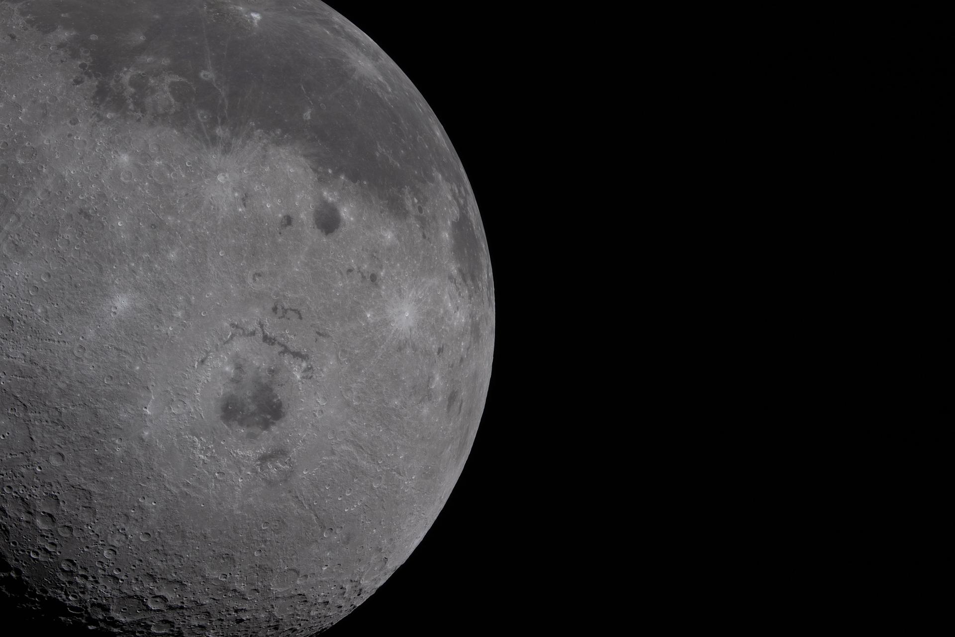
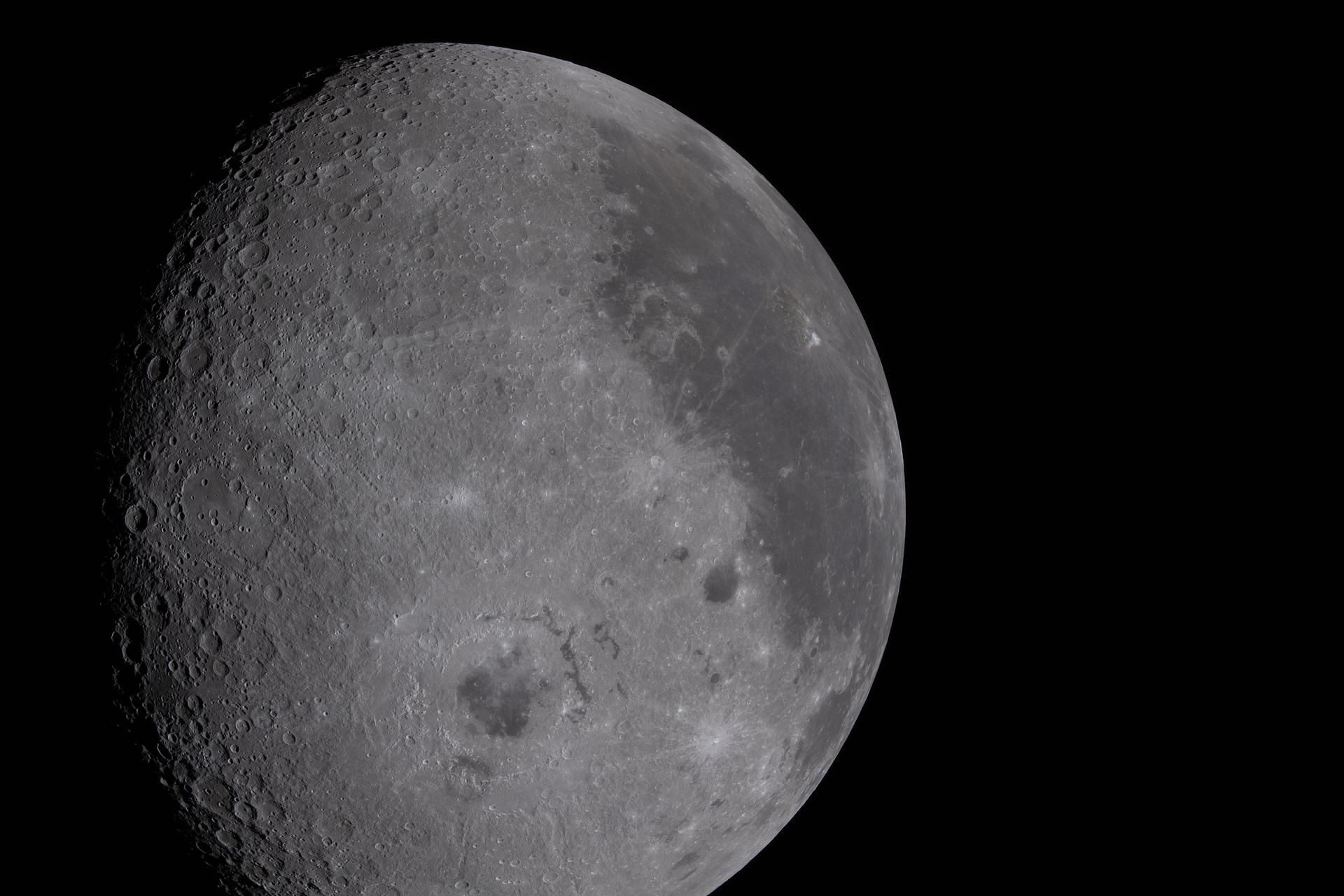
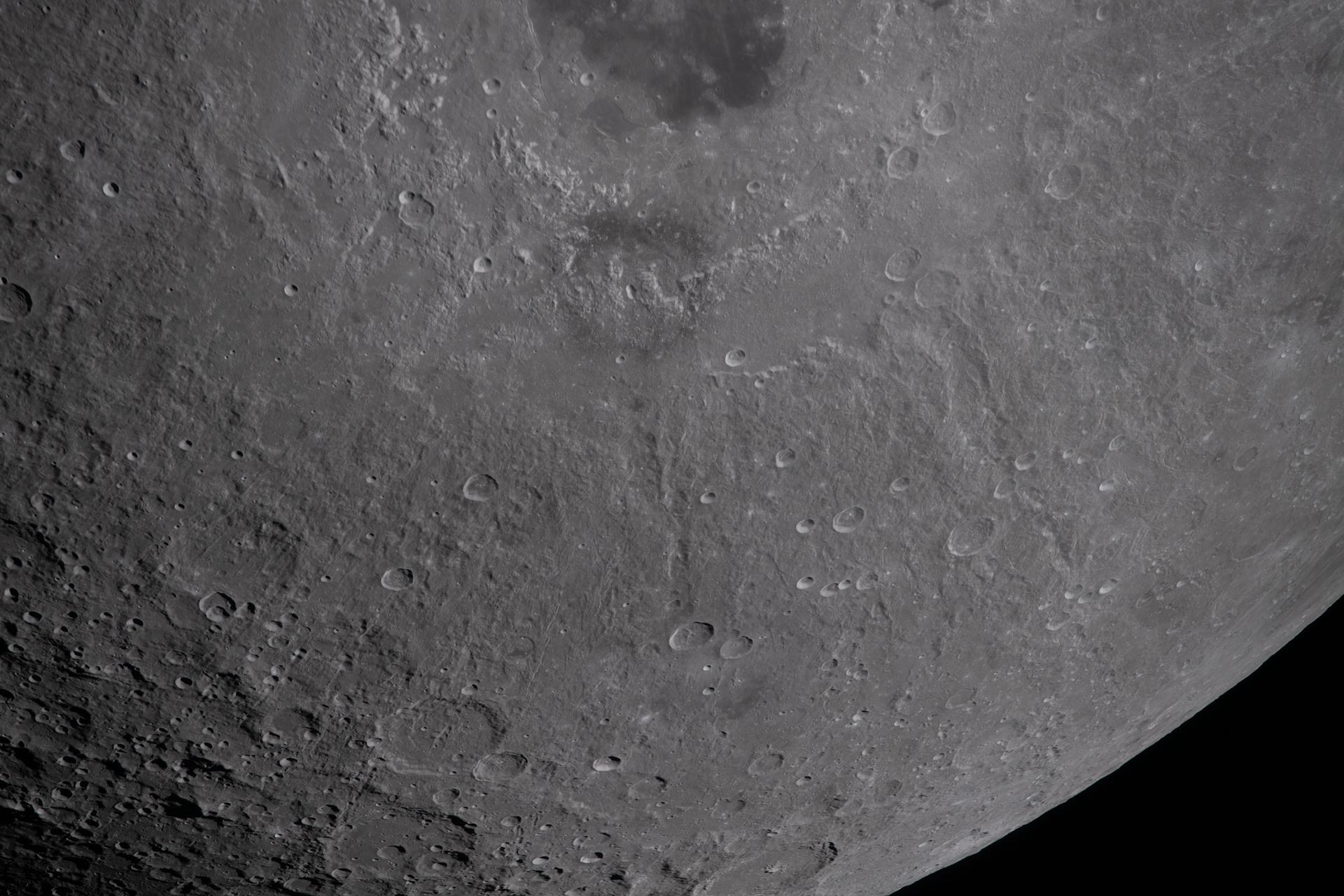
art002e009278 (April 6, 2026) - Just over half of the Moon fills the left half of the image. The near side, characterized by the dark patches of ancient lava, is visible on the top third of the lunar disk. Orientale basin, a round crater in the center with a black patch of ancient lava in the center, is wrapped in rings of mountains. The round black spot northeast of Orientale is Grimaldi crater, and Aristarchus crater is the bright white dot in the midst of a dark grey lava flow at the top of the image.
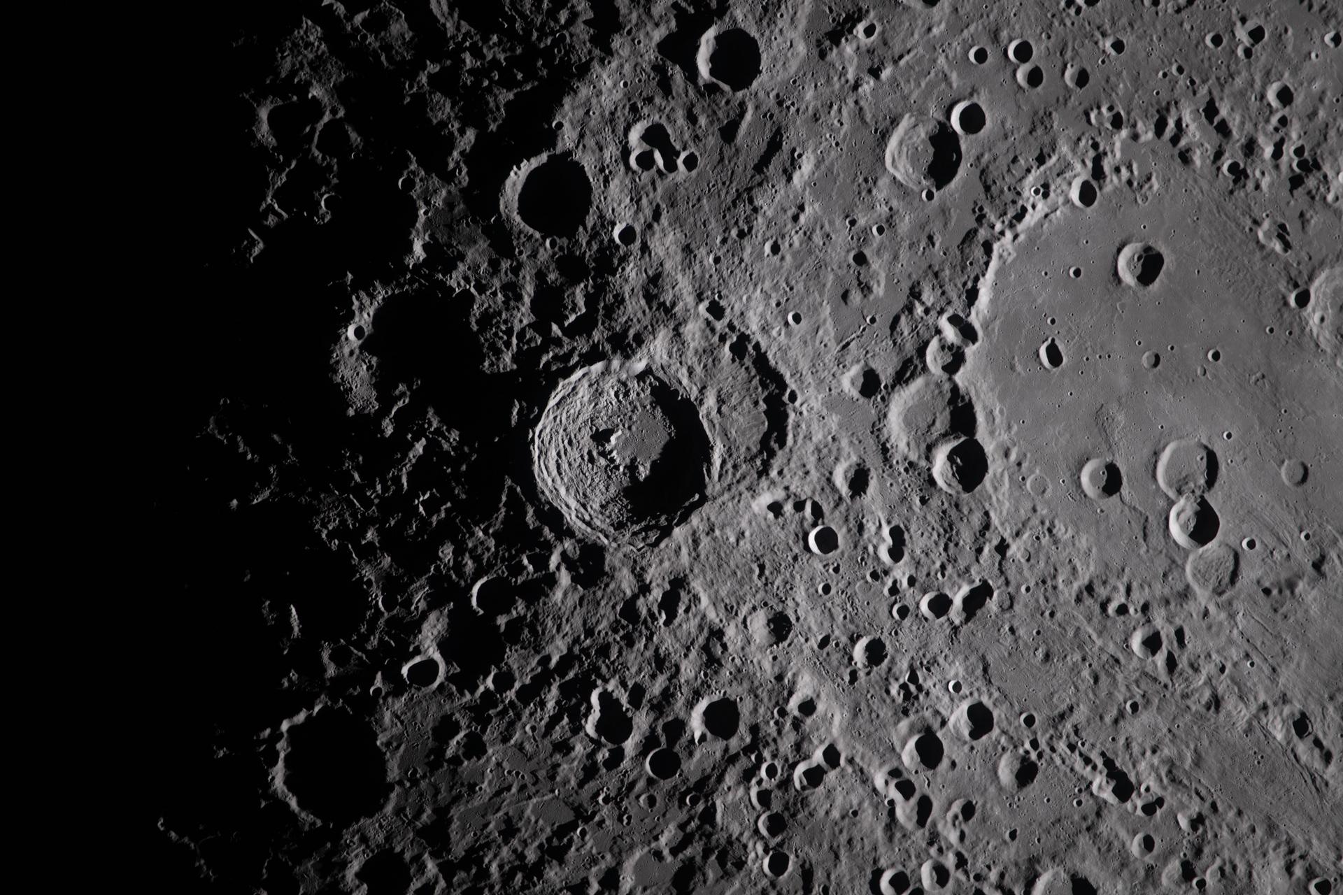
art002e009282 (April 6, 2026) - A close-up view taken by the Artemis II crew of Vavilov Crater on the rim of the older and larger Hertzsprung basin. The right portion of the image shows the transition from smooth material within an inner ring of mountains to more rugged terrain around the rim. Vavilov and other craters and their ejecta are accentuated by long shadows at the terminator, the boundary between lunar day and night. The image was captured with a handheld camera at a focal length of 400 mm, as the crew flew around the far side of the Moon.
About 50,000 Clementine images were processed to produce the four orthographic views of the Moon. The images show albedo variations (normalized brightness or reflectivity) of the surface at a wavelength of 750 nm (just longward of visible red). The image projection is centered at 0 degree latitude and 180 degrees longitude. Mare Moscoviense (dark albedo feature upper left of image center) and South Pole-Aitken Basin (dark feature at bottom) represent maria regions largely absent on the lunar farside. The Clementine altimeter showed Aitken Basin to consist of a topographic rim about 2500 km in diameter, an inner shelf ranging from 400 to 600 km in width, and an irregular depressed floor about 12 km in depth. http://photojournal.jpl.nasa.gov/catalog/PIA00303
About 50,000 Clementine images were processed to produce the four orthographic views of the Moon. The images show albedo variations (normalized brightness or reflectivity) of the surface at a wavelength of 750 nm (just longward of visible red). The image projection is centered at 0 degree latitude and 180 degrees longitude. Mare Moscoviense (dark albedo feature upper left of image center) and South Pole-Aitken Basin (dark feature at bottom) represent maria regions largely absent on the lunar farside. The Clementine altimeter showed Aitken Basin to consist of a topographic rim about 2500 km in diameter, an inner shelf ranging from 400 to 600 km in width, and an irregular depressed floor about 12 km in depth. http://photojournal.jpl.nasa.gov/catalog/PIA00304
About 50,000 Clementine images were processed to produce the four orthographic views of the Moon. The images show albedo variations (normalized brightness or reflectivity) of the surface at a wavelength of 750 nm (just longward of visible red). The image projection is centered at 0 degree latitude and 180 degrees longitude. Mare Moscoviense (dark albedo feature upper left of image center) and South Pole-Aitken Basin (dark feature at bottom) represent maria regions largely absent on the lunar farside. The Clementine altimeter showed Aitken Basin to consist of a topographic rim about 2500 km in diameter, an inner shelf ranging from 400 to 600 km in width, and an irregular depressed floor about 12 km in depth. http://photojournal.jpl.nasa.gov/catalog/PIA00304
art002e021296 (April 6, 2026) – As the Artemis II crew flew around the far side of the Moon, they captured key scientific observations, photographs, videos, and records documenting critical observations to help scientists on the ground understand the composition and history of the lunar surface. Near the center of the view lies Hertzsprung basin, an ancient and expansive impact feature described by the Artemis II crew as darker in overall tone compared to surrounding terrain. Crew observations highlight a striking contrast in texture: the interior of Hertzsprung appears unusually smooth, “like a paved road,” while the outer regions transition into rougher, more jagged terrain. Subtle variations in brightness and color across the basin create a patchwork of lighter and darker areas, offering clues to its complex geologic history. Surrounding regions show evidence of ejecta and crater rays, with faint brownish and gray tones radiating across the highlands. Together, these features provide a dynamic view of one of the Moon’s oldest and most intriguing basins. Credit: NASA
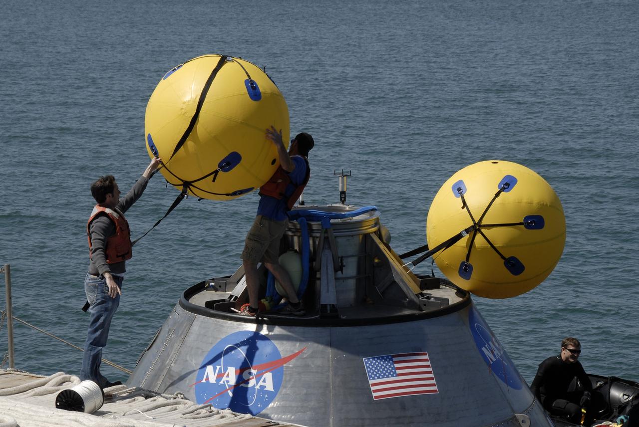
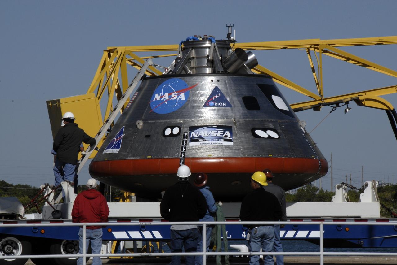
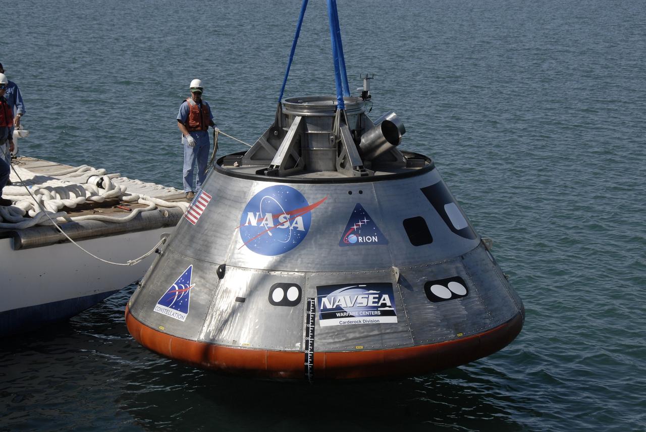
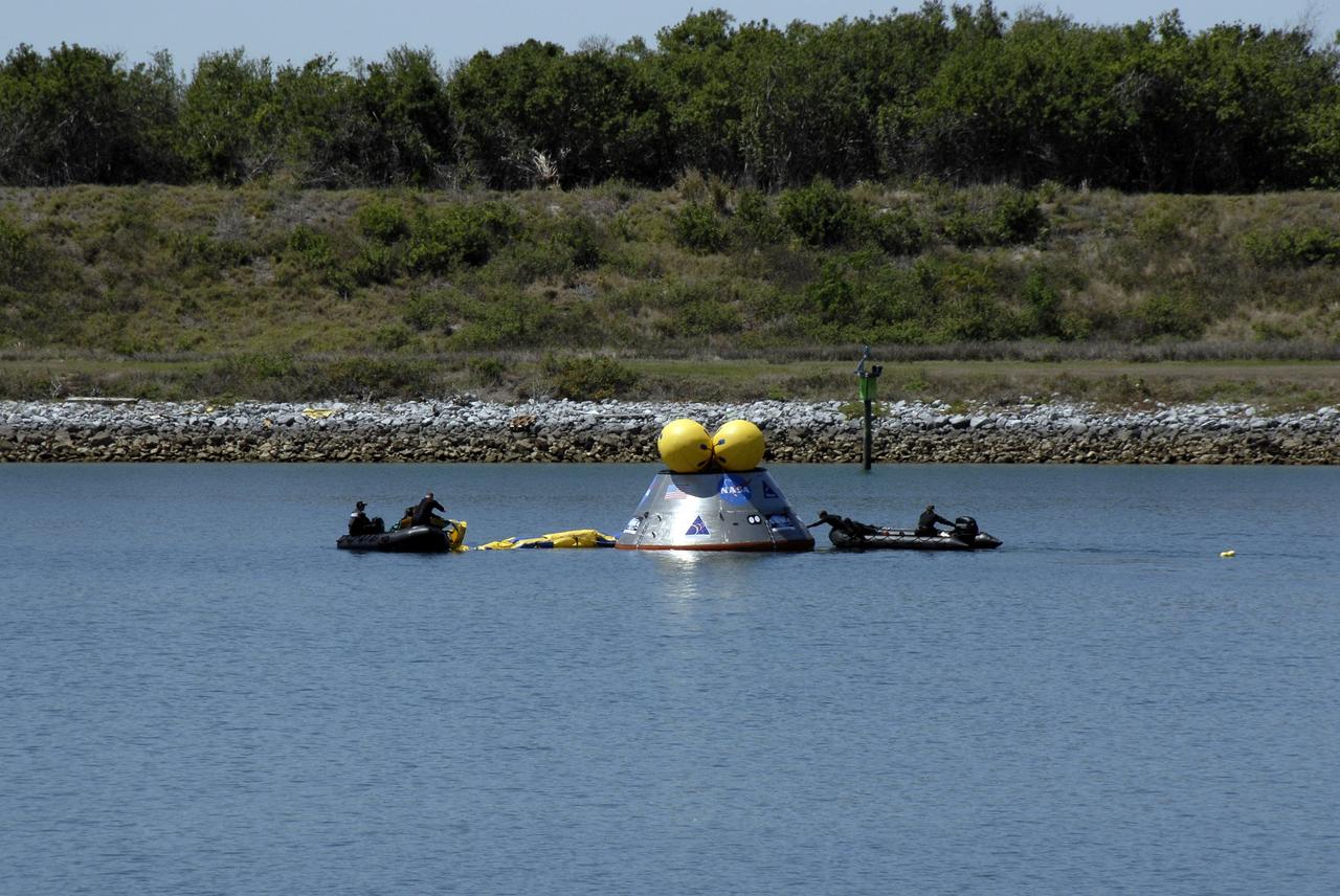
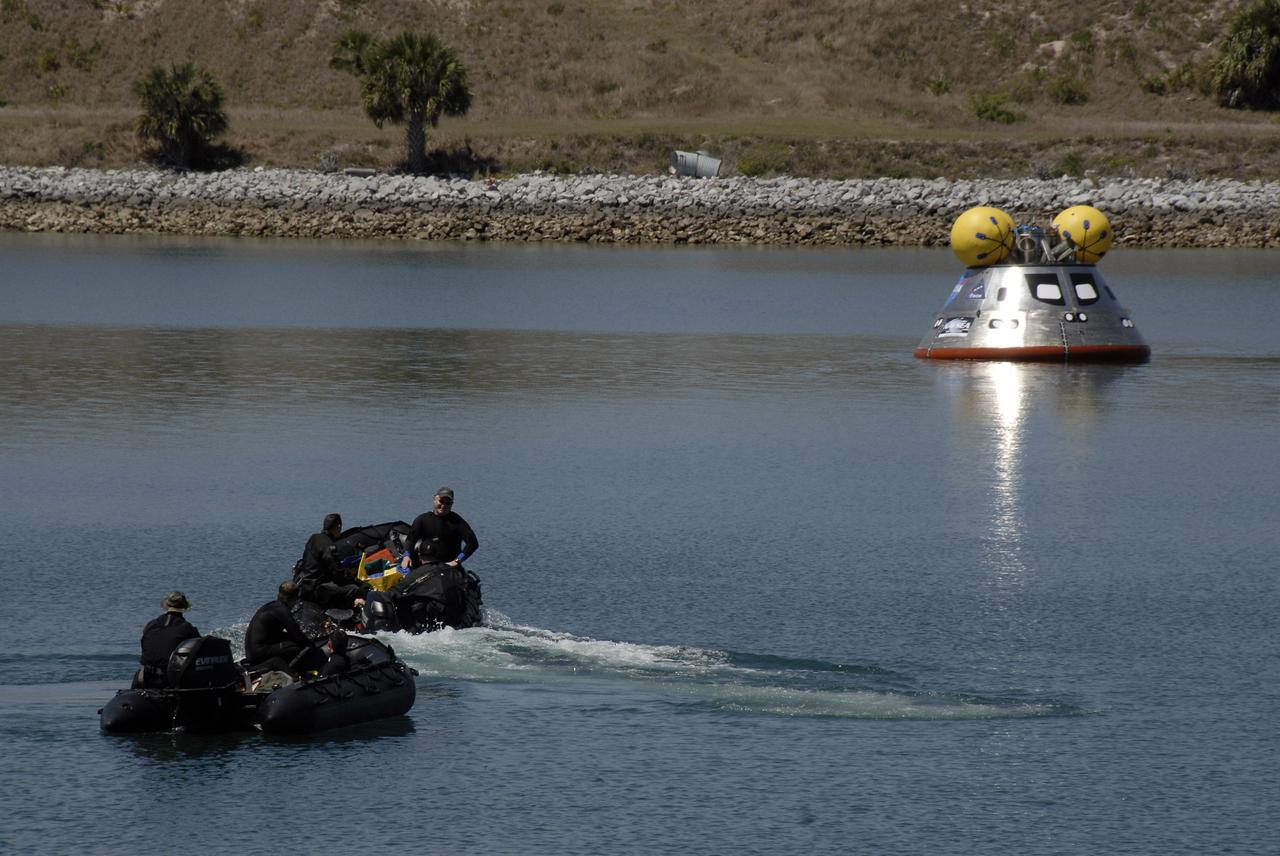
CAPE CANAVERAL, Fla. – The mockup Orion crew exploration vehicle is prepared to be lifted into the water at the Trident Basin at Port Canaveral, Fla., for testing. Orion is targeted to begin carrying humans to the International Space Station in 2015 and to the moon by 2020. The goal of the operation, dubbed the Post-landing Orion Recovery Test, or PORT, is to determine what kind of motion astronauts can expect after landing, as well as outside conditions for recovery teams. Orion, along with the Ares I and V rockets and the Altair lunar lander, are part of the Constellation Program. Photo credit: NASA/Dimitri Gerondidakis
CAPE CANAVERAL, Fla. – The mockup Orion crew exploration vehicle floats in the water at the Trident Basin at Port Canaveral, Fla. Orion is targeted to begin carrying humans to the International Space Station in 2015 and to the moon by 2020. The mockup vehicle will undergo testing in open water. The goal of the operation, dubbed the Post-landing Orion Recovery Test, or PORT, is to determine what kind of motion astronauts can expect after landing, as well as outside conditions for recovery teams. Orion, along with the Ares I and V rockets and the Altair lunar lander, are part of the Constellation Program. Photo credit: NASA/Dimitri Gerondidakis
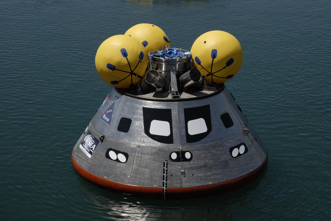
CAPE CANAVERAL, Fla. – The mockup Orion crew exploration vehicle floats in the water at the Trident Basin at Port Canaveral, Fla. On top of Orion are additional flotation devices. Orion is targeted to begin carrying humans to the International Space Station in 2015 and to the moon by 2020. The mockup vehicle is undergoing testing in open water. The goal of the operation, dubbed the Post-landing Orion Recovery Test, or PORT, is to determine what kind of motion astronauts can expect after landing, as well as outside conditions for recovery teams. Orion, along with the Ares I and V rockets and the Altair lunar lander, are part of the Constellation Program. Photo credit: NASA/Kim Shiflett
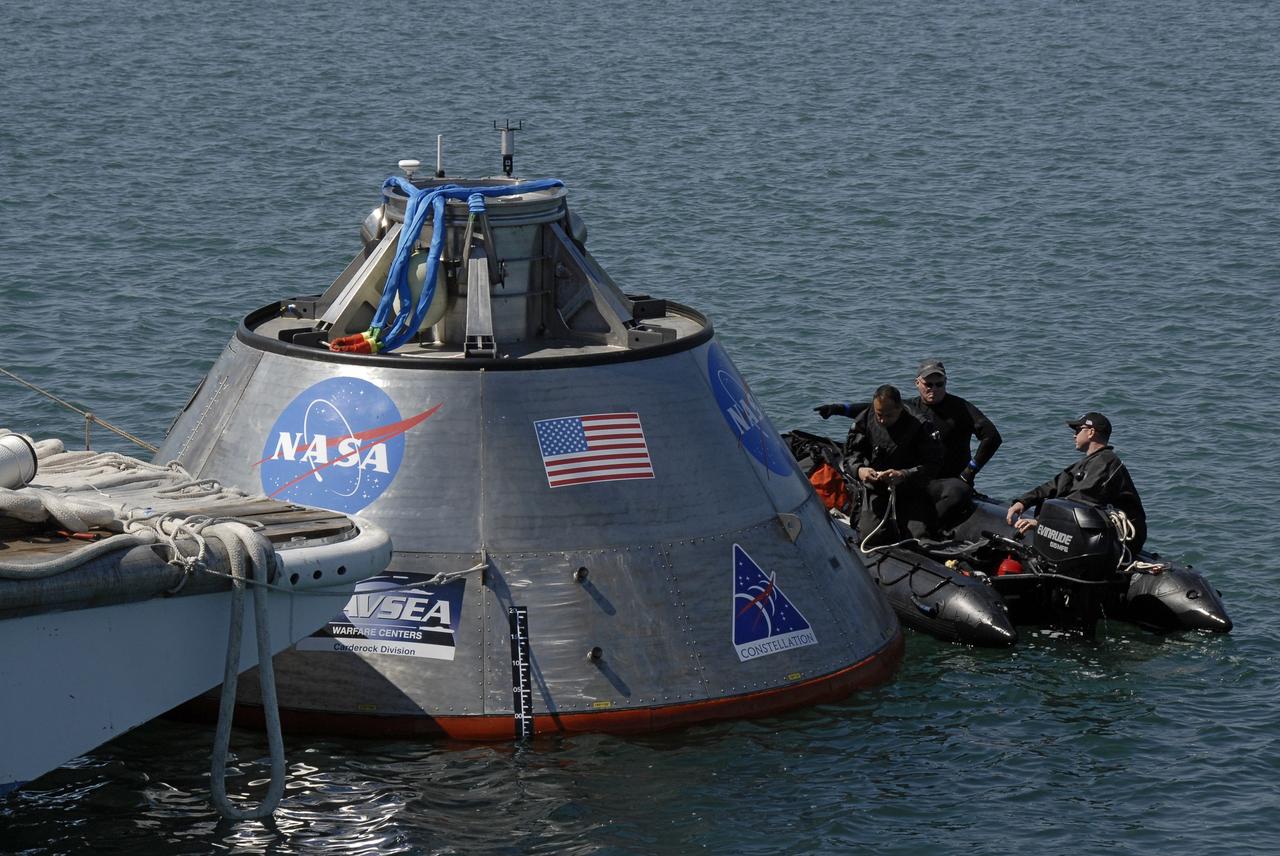
CAPE CANAVERAL, Fla. – Members of the 920th Rescue Wing get ready to release a flotation collar around the mockup Orion crew exploration vehicle at the Trident Basin at Port Canaveral, Fla. On top of Orion are additional flotation devices. The goal of the operation, dubbed the Post-landing Orion Recovery Test, or PORT, is to determine what kind of motion astronauts can expect after landing, as well as outside conditions for recovery teams. Orion is targeted to begin carrying humans to the International Space Station in 2015 and to the moon by 2020. Orion, along with the Ares I and V rockets and the Altair lunar lander, are part of the Constellation Program. Photo credit: NASA/Dimitri Gerondidakis
CAPE CANAVERAL, Fla. – Members of the 920th Rescue Wing secure a flotation collar around the mockup Orion crew exploration vehicle at the Trident Basin at Port Canaveral, Fla. On top of Orion are additional flotation devices. The mockup vehicle will undergo testing in open water. The goal of the operation, dubbed the Post-landing Orion Recovery Test, or PORT, is to determine what kind of motion astronauts can expect after landing, as well as outside conditions for recovery teams. Orion is targeted to begin carrying humans to the International Space Station in 2015 and to the moon by 2020. Orion, along with the Ares I and V rockets and the Altair lunar lander, are part of the Constellation Program. Photo credit: NASA/Kim Shiflett
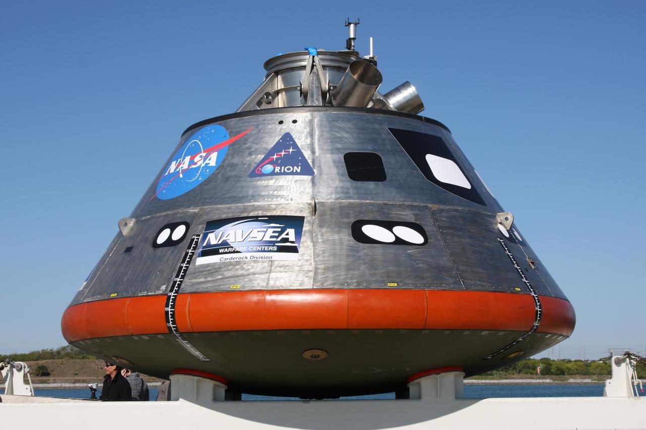
CAPE CANAVERAL, Fla. – The mockup Orion crew exploration vehicle is on the dock at the Trident Basin at Port Canaveral, Fla., waiting to be tested in open waters. Orion is targeted to begin carrying humans to the International Space Station in 2015 and to the moon by 2020. The goal of the operation, dubbed the Post-landing Orion Recovery Test, or PORT, is to determine what kind of motion astronauts can expect after landing, as well as outside conditions for recovery teams. Orion, along with the Ares I and V rockets and the Altair lunar lander, are part of the Constellation Program. Photo credit: NASA/Dimitri Gerondidakis
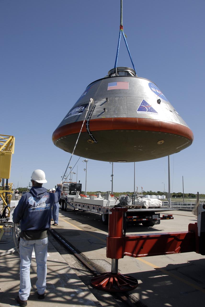
CAPE CANAVERAL, Fla. – The mockup Orion crew exploration vehicle is prepared to be lifted into the water at the Trident Basin at Port Canaveral, Fla., for testing in open water. The goal of the operation, dubbed the Post-landing Orion Recovery Test, or PORT, is to determine what kind of motion astronauts can expect after landing, as well as outside conditions for recovery teams. Orion is targeted to begin carrying humans to the International Space Station in 2015 and to the moon by 2020. Orion, along with the Ares I and V rockets and the Altair lunar lander, are part of the Constellation Program. Photo credit: NASA/Kim Shiflett
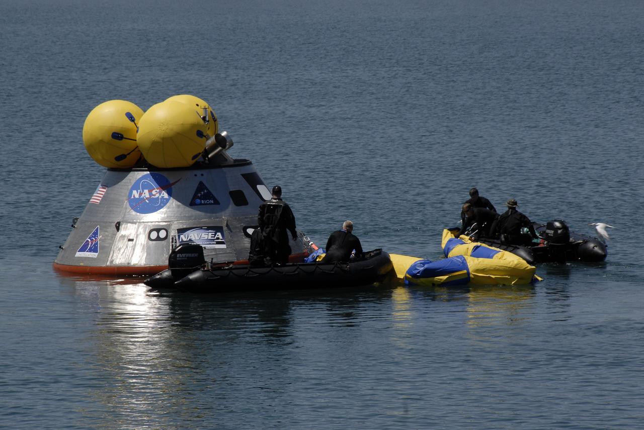
CAPE CANAVERAL, Fla. – Members of the 920th Rescue Wing release a flotation collar around the mockup Orion crew exploration vehicle at the Trident Basin at Port Canaveral, Fla. On top of Orion are additional flotation devices. The mockup vehicle will undergo testing in open water. The goal of the operation, dubbed the Post-landing Orion Recovery Test, or PORT, is to determine what kind of motion astronauts can expect after landing, as well as outside conditions for recovery teams. Orion is targeted to begin carrying humans to the International Space Station in 2015 and to the moon by 2020. Orion, along with the Ares I and V rockets and the Altair lunar lander, are part of the Constellation Program. Photo credit: NASA/Kim Shiflett
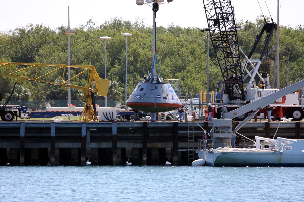
CAPE CANAVERAL, Fla. – The mockup Orion crew exploration vehicle is lowered toward the water at the Trident Basin at Port Canaveral, Fla., for testing. Orion is targeted to begin carrying humans to the International Space Station in 2015 and to the moon by 2020. The goal of the operation, dubbed the Post-landing Orion Recovery Test, or PORT, is to determine what kind of motion astronauts can expect after landing, as well as outside conditions for recovery teams. Orion, along with the Ares I and V rockets and the Altair lunar lander, are part of the Constellation Program. Photo credit: NASA/Dimitri Gerondidakis
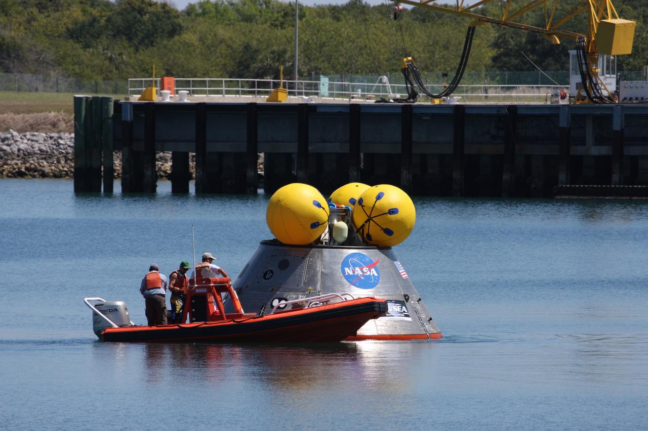
CAPE CANAVERAL, Fla. – Members of the 920th Rescue Wing help prepare the mockup Orion crew exploration vehicle for testing in the open water at the Trident Basin at Port Canaveral, Fla. The mockup vehicle will undergo testing in open water. The goal of the operation, dubbed the Post-landing Orion Recovery Test, or PORT, is to determine what kind of motion astronauts can expect after landing, as well as outside conditions for recovery teams. Orion is targeted to begin carrying humans to the International Space Station in 2015 and to the moon by 2020. Orion, along with the Ares I and V rockets and the Altair lunar lander, are part of the Constellation Program. Photo credit: NASA/Kim Shiflett
CAPE CANAVERAL, Fla. – Flotation devices are attached to the top of the mockup Orion crew exploration vehicle before the testing in the open water at the Trident Basin at Port Canaveral, Fla. The mockup vehicle will undergo testing in open water. The goal of the operation, dubbed the Post-landing Orion Recovery Test, or PORT, is to determine what kind of motion astronauts can expect after landing, as well as outside conditions for recovery teams. Orion is targeted to begin carrying humans to the International Space Station in 2015 and to the moon by 2020. Orion, along with the Ares I and V rockets and the Altair lunar lander, are part of the Constellation Program. Photo credit: NASA/Kim Shiflett
CAPE CANAVERAL, Fla. – The mockup Orion crew exploration vehicle is on the dock at the Trident Basin at Port Canaveral, Fla., waiting to be tested in open water. The goal of the operation, dubbed the Post-landing Orion Recovery Test, or PORT, is to determine what kind of motion astronauts can expect after landing, as well as outside conditions for recovery teams. Orion is targeted to begin carrying humans to the International Space Station in 2015 and to the moon by 2020. Orion, along with the Ares I and V rockets and the Altair lunar lander, are part of the Constellation Program. Photo credit: NASA/Kim Shiflett
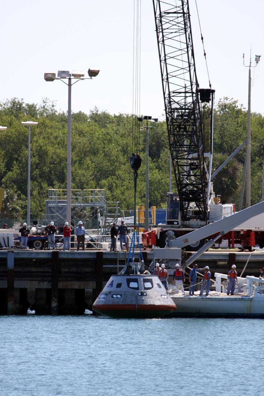
CAPE CANAVERAL, Fla. – The mockup Orion crew exploration vehicle is lowered into the water at the Trident Basin at Port Canaveral, Fla., for testing. Orion is targeted to begin carrying humans to the International Space Station in 2015 and to the moon by 2020. The goal of the operation, dubbed the Post-landing Orion Recovery Test, or PORT, is to determine what kind of motion astronauts can expect after landing, as well as outside conditions for recovery teams. Orion, along with the Ares I and V rockets and the Altair lunar lander, are part of the Constellation Program. Photo credit: NASA/Dimitri Gerondidakis
CAPE CANAVERAL, Fla. – The mockup Orion crew exploration vehicle is lowered into the water at the Trident Basin at Port Canaveral, Fla., for testing in open water. The goal of the operation, dubbed the Post-landing Orion Recovery Test, or PORT, is to determine what kind of motion astronauts can expect after landing, as well as outside conditions for recovery teams. Orion is targeted to begin carrying humans to the International Space Station in 2015 and to the moon by 2020. Orion, along with the Ares I and V rockets and the Altair lunar lander, are part of the Constellation Program. Photo credit: NASA/Kim Shiflett
CAPE CANAVERAL, Fla. – Members of the 920th Rescue Wing release a flotation collar around the mockup Orion crew exploration vehicle at the Trident Basin at Port Canaveral, Fla. On top of Orion are additional flotation devices. The mockup vehicle will undergo testing in open water. The goal of the operation, dubbed the Post-landing Orion Recovery Test, or PORT, is to determine what kind of motion astronauts can expect after landing, as well as outside conditions for recovery teams. Orion is targeted to begin carrying humans to the International Space Station in 2015 and to the moon by 2020. Orion, along with the Ares I and V rockets and the Altair lunar lander, are part of the Constellation Program. Photo credit: NASA/Kim Shiflett
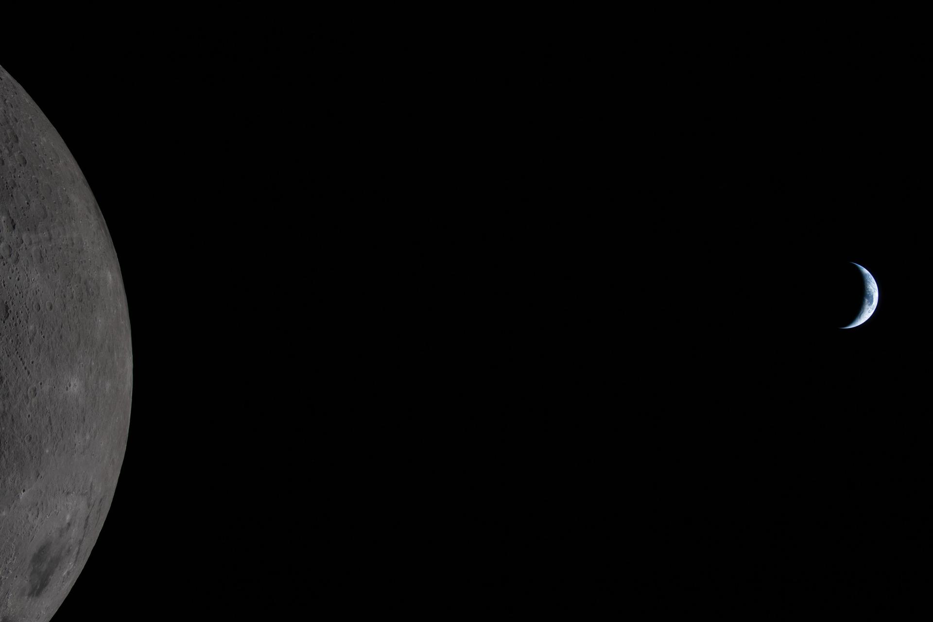
art002e009284 (April 6, 2026) – Earth appears tiny as the Moon looms large in this photo taken by the Artemis II crew during their lunar flyby on April 6, 2026. Taken 36 minutes before Earthset, our home planet is visible in the blackness of space off the limb of the illuminated Moon. Earth is in a crescent phase, with sunlight coming from the right. Orientale mare basin, with its dark floor of cooled lava and outer rings of mountains, covers nearly the lower third of the imaged lunar surface. Different colors in the mare hint at its mineral composition. The lines of small indentations above Orientale are secondary crater chains, formed by material ejected during a violent primary impact. Both of the new craters that the Artemis II crew has suggested names for – Integrity and Carroll – are in full view. The edge of the visible surface of the Moon is called the “lunar limb.” Seen from afar, it almost looks like a circular arc – except when backlit, as in other images captured by the Artemis II crew.
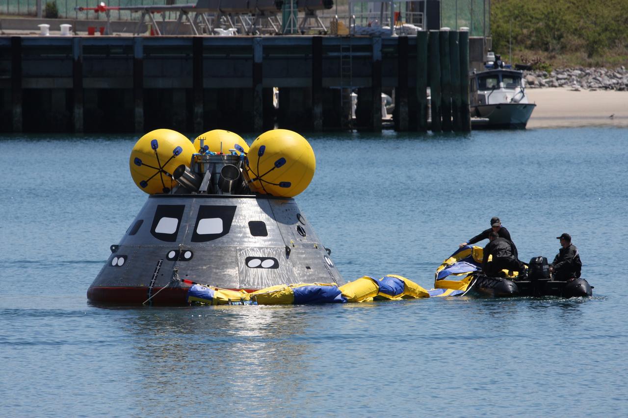
CAPE CANAVERAL, Fla. – Members of the 920th Rescue Wing release a flotation collar around the mockup Orion crew exploration vehicle at the Trident Basin at Port Canaveral, Fla. On top of Orion are additional flotation devices. The goal of the operation, dubbed the Post-landing Orion Recovery Test, or PORT, is to determine what kind of motion astronauts can expect after landing, as well as outside conditions for recovery teams. Orion is targeted to begin carrying humans to the International Space Station in 2015 and to the moon by 2020. Orion is targeted to begin carrying humans to the International Space Station in 2015 and to the moon by 2020. Orion, along with the Ares I and V rockets and the Altair lunar lander, are part of the Constellation Program. Photo credit: NASA/Dimitri Gerondidakis
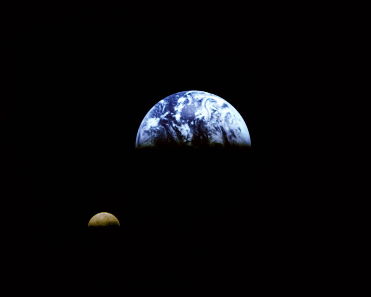
Eight days after its encounter with the Earth, the Galileo spacecraft was able to look back and capture this remarkable view of the Moon in orbit about the Earth, taken from a distance of about 6.2 million kilometers (3.9 million miles). The picture was constructed from images taken through the violet, red, and 1.0-micron infrared filters. The Moon is in the foreground, moving from left to right. The brightly-colored Earth contrasts strongly with the Moon, which reflects only about one-third as much sunlight as the Earth. Contrast and color have been computer-enhanced for both objects to improve visibility. Antarctica is visible through clouds (bottom). The Moon's far side is seen; the shadowy indentation in the dawn terminator is the south-Pole/Aitken Basin, one of the largest and oldest lunar impact features. Alternate Jet Propulsion Laboratory (JPL) number is P-41508. View appears in the Space News Roundup v32 n1 p1, 01-11-93.
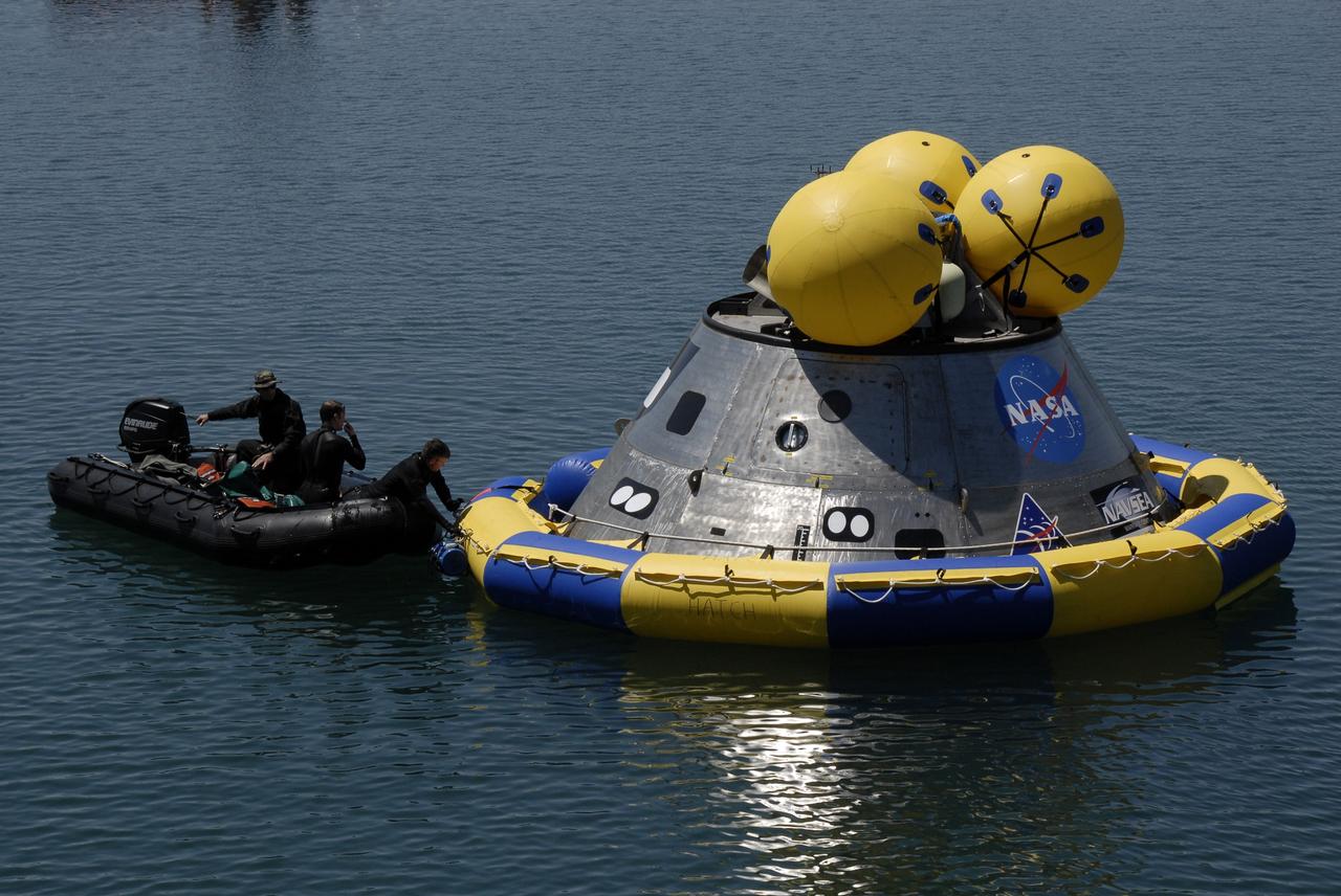
CAPE CANAVERAL, Fla. – Members of the 920th Rescue Wing make their way toward the mockup Orion crew exploration vehicle floating in the open water of the Trident Basin at Port Canaveral, Fla. They will place a flotation collar around the mockup vehicle. The mockup vehicle will undergo testing in open water. The goal of the operation, dubbed the Post-landing Orion Recovery Test, or PORT, is to determine what kind of motion astronauts can expect after landing, as well as outside conditions for recovery teams. Orion is targeted to begin carrying humans to the International Space Station in 2015 and to the moon by 2020. Orion, along with the Ares I and V rockets and the Altair lunar lander, are part of the Constellation Program. Photo credit: NASA/Kim Shiflett

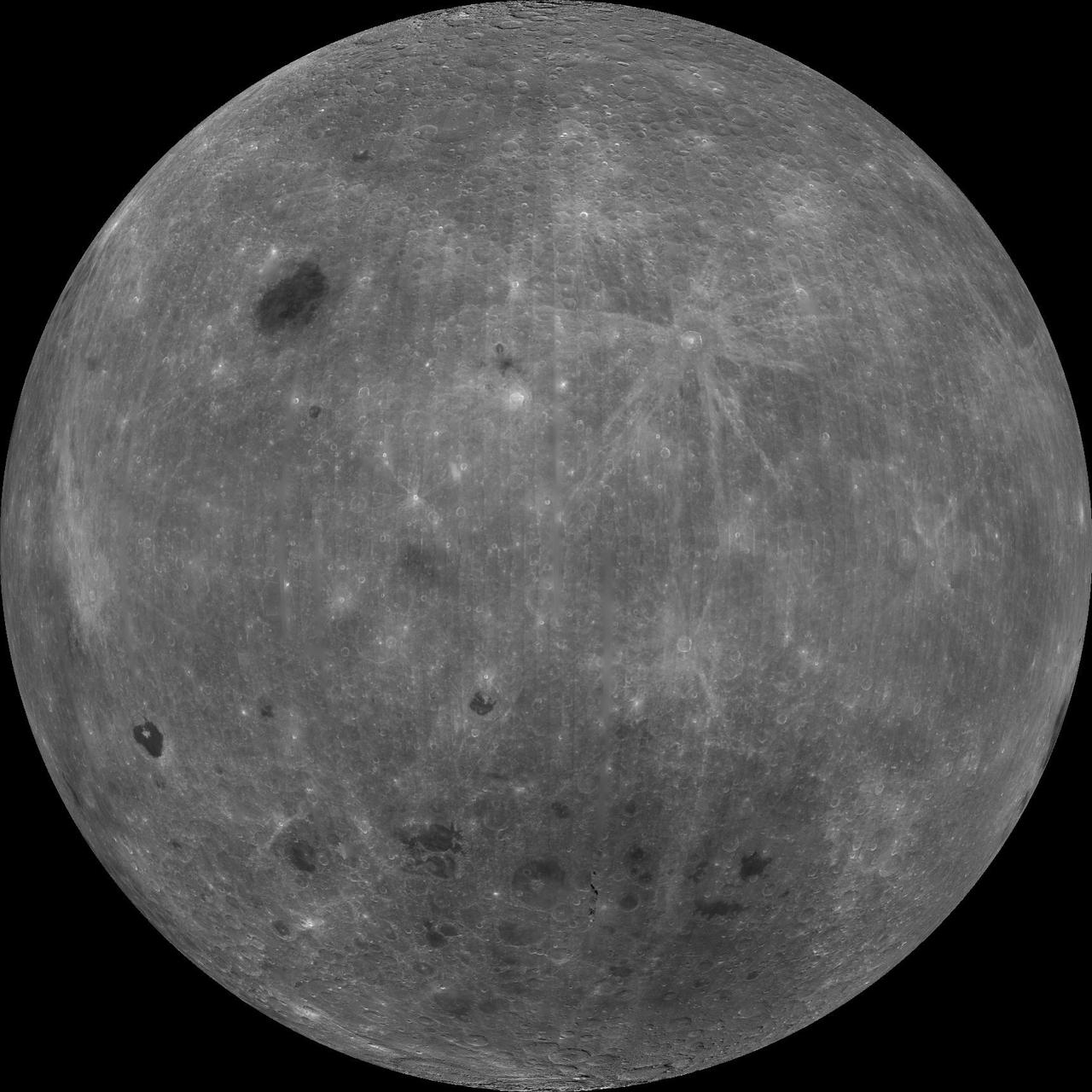
NASA image release March 11, 2011 Caption: The lunar farside as never seen before! LROC WAC orthographic projection centered at 180° longitude, 0° latitude. Credit: NASA/Goddard/Arizona State University. Because the moon is tidally locked (meaning the same side always faces Earth), it was not until 1959 that the farside was first imaged by the Soviet Luna 3 spacecraft (hence the Russian names for prominent farside features, such as Mare Moscoviense). And what a surprise - unlike the widespread maria on the nearside, basaltic volcanism was restricted to a relatively few, smaller regions on the farside, and the battered highlands crust dominated. A different world from what we saw from Earth. Of course, the cause of the farside/nearside asymmetry is an interesting scientific question. Past studies have shown that the crust on the farside is thicker, likely making it more difficult for magmas to erupt on the surface, limiting the amount of farside mare basalts. Why is the farside crust thicker? That is still up for debate, and in fact several presentations at this week's Lunar and Planetary Science Conference attempt to answer this question. The Clementine mission obtained beautiful mosaics with the sun high in the sky (low phase angles), but did not have the opportunity to observe the farside at sun angles favorable for seeing surface topography. This WAC mosaic provides the most complete look at the morphology of the farside to date, and will provide a valuable resource for the scientific community. And it's simply a spectacular sight! The Lunar Reconnaissance Orbiter Camera (LROC) Wide Angle Camera (WAC) is a push-frame camera that captures seven color bands (321, 360, 415, 566, 604, 643, and 689 nm) with a 57-km swath (105-km swath in monochrome mode) from a 50 km orbit. One of the primary objectives of LROC is to provide a global 100 m/pixel monochrome (643 nm) base map with incidence angles between 55°-70° at the equator, lighting that is favorable for morphological interpretations. Each month, the WAC provides nearly complete coverage of the Moon under unique lighting. As an added bonus, the orbit-to-orbit image overlap provides stereo coverage. Reducing all these stereo images into a global topographic map is a big job, and is being led by LROC Team Members from the German Aerospace Center (Deutsches Zentrum für Luft- und Raumfahrt; DLR). Several preliminary WAC topographic products have appeared in LROC featured images over the past year (Orientale basin, Sinus Iridum). For a sneak preview of the WAC global DEM with the WAC global mosaic, view a rotating composite moon (70 MB video from ASU's LROC website). The WAC topographic dataset will be completed and released later this year. The global mosaic released today is comprised of over 15,000 WAC images acquired between November 2009 and February 2011. The non-polar images were map projected onto the GLD100 shape model (WAC derived 100 m/pixel DTM), while polar images were map projected on the LOLA shape model. In addition, the LOLA derived crossover corrected ephemeris, and an improved camera pointing, provide accurate positioning (better than 100 m) of each WAC image. As part of the March 2011 PDS release, the LROC team posted the global map in ten regional tiles. Eight of the tiles are equirectangular projections that encompass 60° latitude by 90° longitude. In addition, two polar stereographic projections are available for each pole from ±60° to the pole. These reduced data records (RDR) products will be available for download on March 15, 2011. As the mission progresses, and our knowledge of the lunar photometric function increases, improved and new mosaics will be released! Work your way around the moon with these six orthographic projections constructed from WAC mosaics. The nearside view linked below is different from that released on 21 February. To read more con't here: <a href="http://www.nasa.gov/mission_pages/LRO/news/lro-farside.html" rel="nofollow">www.nasa.gov/mission_pages/LRO/news/lro-farside.html</a> <b><a href="http://www.nasa.gov/centers/goddard/home/index.html" rel="nofollow">NASA Goddard Space Flight Center</a></b> enables NASA’s mission through four scientific endeavors: Earth Science, Heliophysics, Solar System Exploration, and Astrophysics. Goddard plays a leading role in NASA’s accomplishments by contributing compelling scientific knowledge to advance the Agency’s mission. <b>Follow us on <a href="http://twitter.com/NASA_GoddardPix" rel="nofollow">Twitter</a></b> <b>Join us on <a href="http://www.facebook.com/pages/Greenbelt-MD/NASA-Goddard/395013845897?ref=tsd" rel="nofollow">Facebook</a></b>
This still image features a free-air gravity map of the Moon's southern latitudes developed by S. Goossens et al. from data returned by the Gravity Recovery and Interior Laboratory (GRAIL) mission. If the Moon were a perfectly smooth sphere of uniform density, the gravity map would be a single, featureless color, indicating that the force of gravity at a given elevation was the same everywhere. But like other rocky bodies in the solar system, including Earth, the Moon has both a bumpy surface and a lumpy interior. Spacecraft in orbit around the Moon experience slight variations in gravity caused by both of these irregularities. The free-air gravity map shows deviations from the mean gravity that a cueball Moon would have. The deviations are measured in milliGals, a unit of acceleration. On the map, purple is at the low end of the range, at around -400 mGals, and red is at the high end near +400 mGals. Yellow denotes the mean. The map shown here extends from the south pole of the Moon up to 50°S and reveals the gravity for that region in even finer detail than the global gravity maps published previously. The image illustrates the very good correlation between the gravity map and topographic features such as peaks and craters, as well as the mass concentration lying beneath the large Schrödinger basin in the center of the frame. The terrain in the image is based on Lunar Reconnaissance Orbiter (LRO) altimeter and camera data. Credit: NASA's Scientific Visualization Studio <b><a href="http://www.nasa.gov/audience/formedia/features/MP_Photo_Guidelines.html" rel="nofollow">NASA image use policy.</a></b> <b><a href="http://www.nasa.gov/centers/goddard/home/index.html" rel="nofollow">NASA Goddard Space Flight Center</a></b> enables NASA’s mission through four scientific endeavors: Earth Science, Heliophysics, Solar System Exploration, and Astrophysics. Goddard plays a leading role in NASA’s accomplishments by contributing compelling scientific knowledge to advance the Agency’s mission. <b>Follow us on <a href="http://twitter.com/NASAGoddardPix" rel="nofollow">Twitter</a></b> <b>Like us on <a href="http://www.facebook.com/pages/Greenbelt-MD/NASA-Goddard/395013845897?ref=tsd" rel="nofollow">Facebook</a></b> <b>Find us on <a href="http://instagram.com/nasagoddard?vm=grid" rel="nofollow">Instagram</a></b>