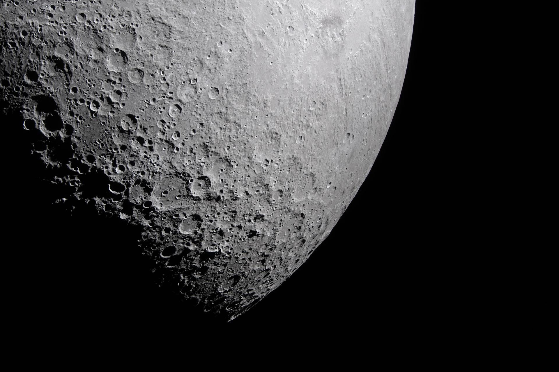
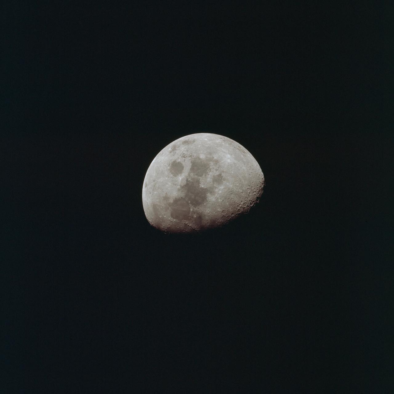
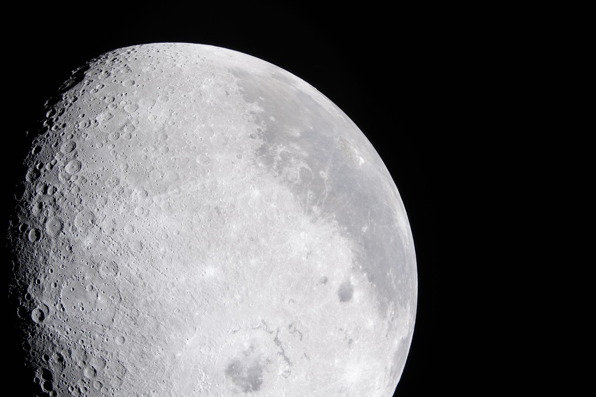
art002e014055 (April 6, 2026) - A close-up view of the Moon along the terminator—the boundary between lunar day and night—captured by the crew during the Artemis II mission. The low-angle sunlight on this specific day casts long shadows across the surface, revealing the shape and depth of craters in striking detail. Since the early days of the telescope, astronomers used observations along the terminator to map the Moon’s terrain, taking advantage of the contrast between light and shadow to distinguish surface features. While modern imaging has advanced significantly, this lighting still provides valuable insight into the Moon’s topography.
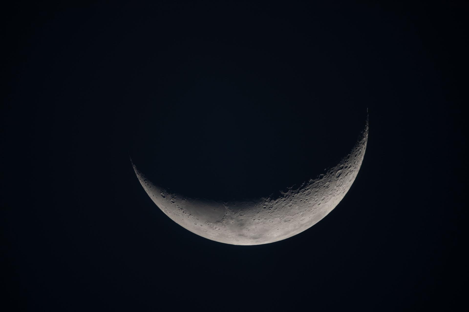
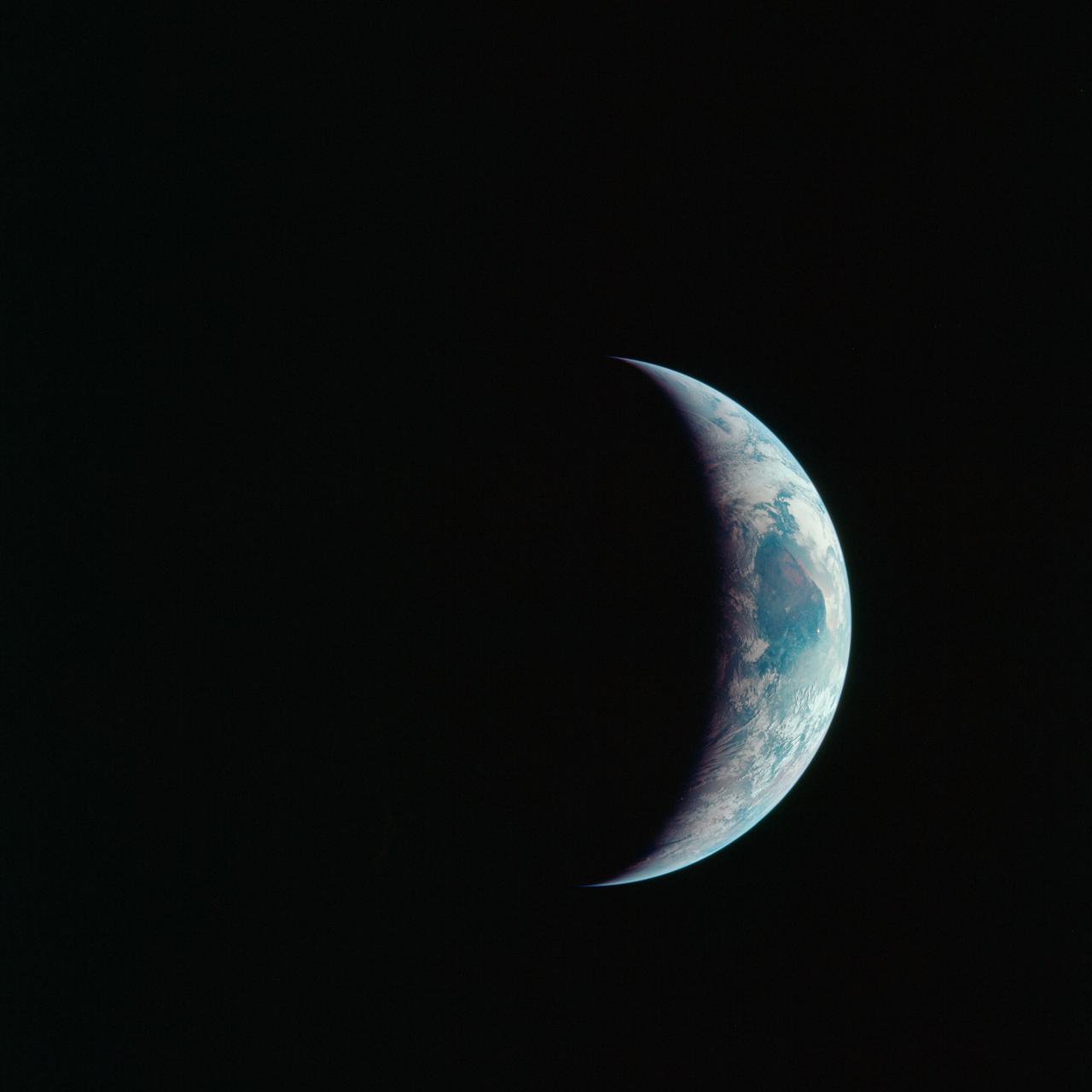
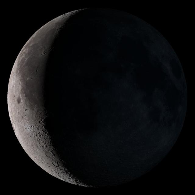
art002e019570 (April 7, 2026) – On flight day seven, following their lunar flyby, the Artemis II crew captured this view of a delicate crescent Moon on their journey back to Earth. Along the terminator—the boundary between lunar day and night—low-angle sunlight casts long shadows that accentuate craters, ridges, and subtle variations in terrain. The softly illuminated surface highlights the Moon’s rugged landscape, while much of it remains in shadow. Credit: NASA
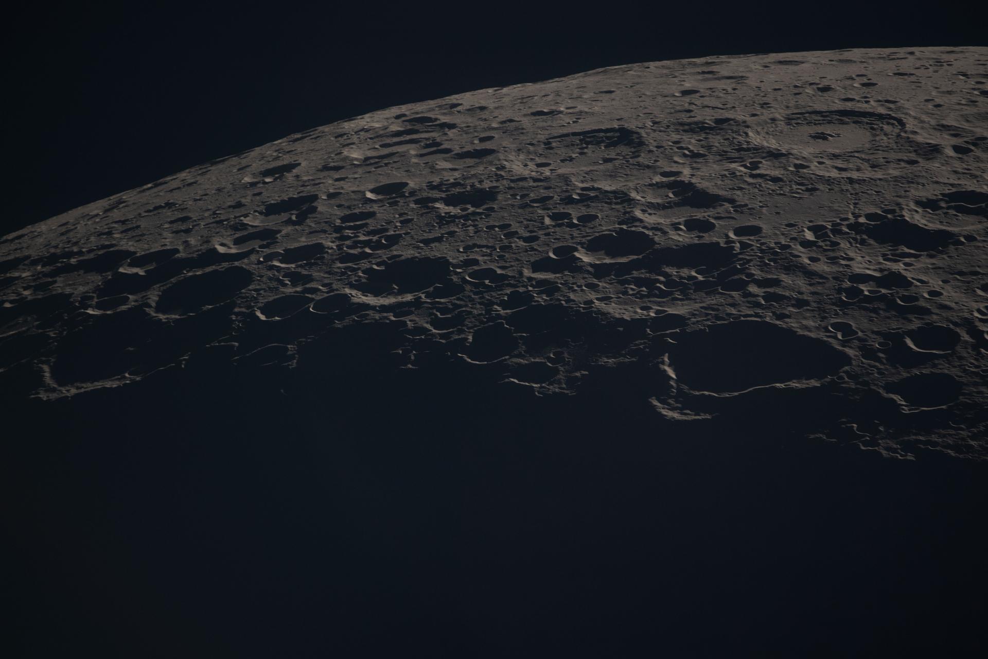
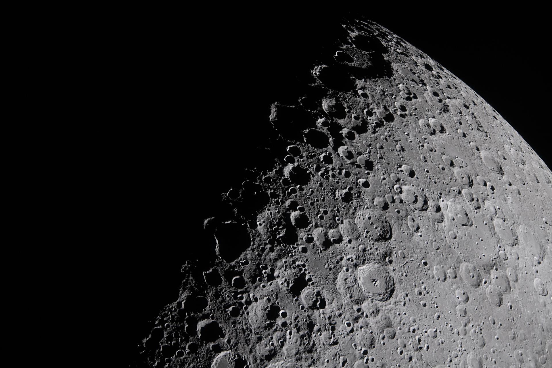
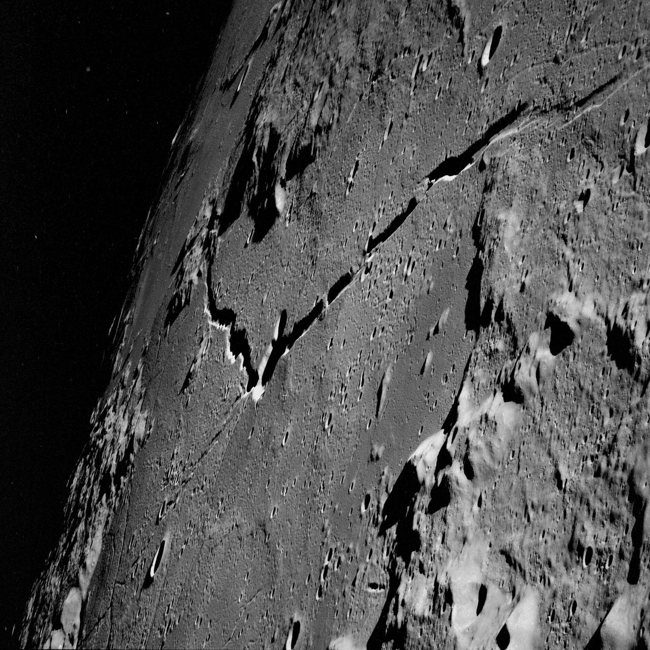
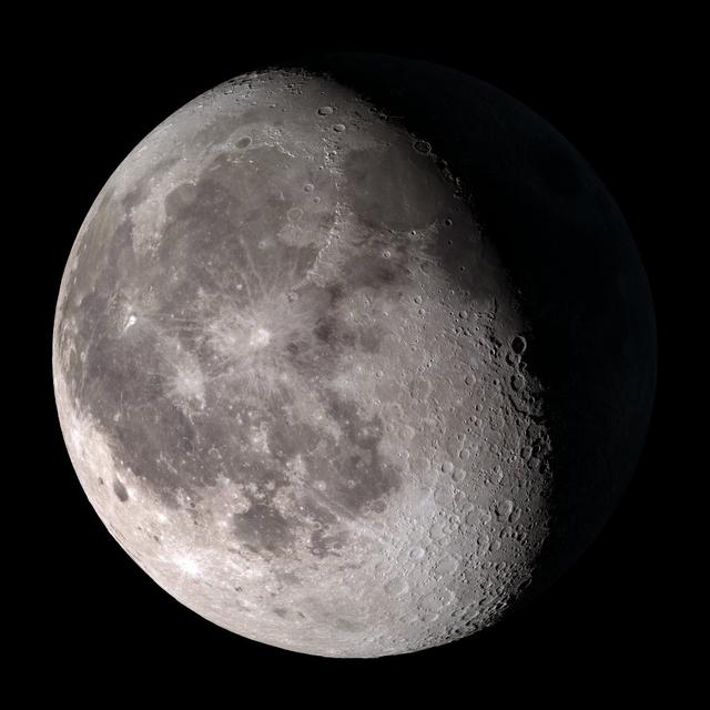
art002e014045 (April 6, 2026) - This view of the Moon captures the terminator—the shifting boundary between day and night—where sunlight grazes the surface at a low angle. Taken by the crew during the Artemis II mission, the lighting accentuates the Moon’s rugged terrain, casting long shadows that reveal the depth and structure of craters, ridges, and surrounding highlands.
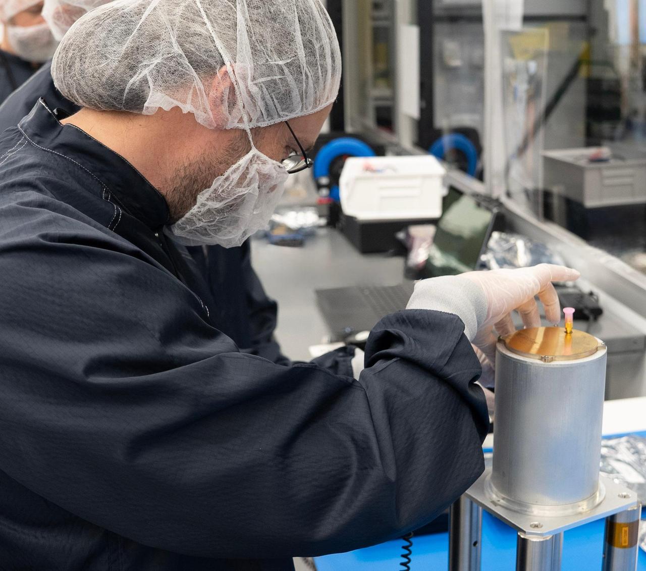
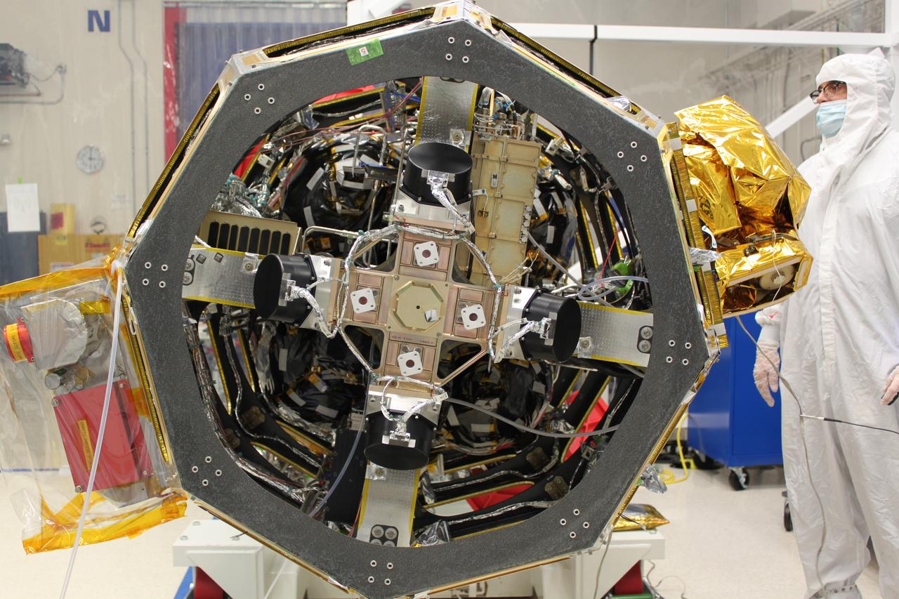
Engineer Emmanuel Decrossas of NASA's Jet Propulsion Laboratory in Southern California makes an adjustment to an antenna's connector, part of a NASA telecommunications payload called User Terminal, at Firefly Aerospace's facility in Cedar Park, Texas, in August 2025. Figure A (https://photojournal.jpl.nasa.gov/figures/PIA26596_figA.jpg) shows members of the team from JPL and NASA (dark blue) and Firefly (white) with the User Terminal antenna, radio, and other components on the bench behind them. Managed by JPL, the User Terminal will test a new, low-cost lunar communications system that future missions to the Moon's far side could use to transfer data to and from Earth via lunar relay satellite. The User Terminal payload will be installed atop Firefly's Blue Ghost Mission 2 lunar lander, which is slated to launch to the Moon's far side in 2026 under NASA's CLPS (Commercial Lunar Payload Services) initiative. NASA's Apollo missions brought large and powerful telecommunications systems to the lunar near-side surface to communicate directly with Earth. But spacecraft on the far side will not have that option because only the near side of the Moon is visible to Earth. Sending messages between the Moon and Earth via a relay orbiter enables communication with the lunar far side and improves it at the Moon's poles. The User Terminal will for the first time test such a setup for NASA by using a compact, lightweight software defined radio, antenna, and related hardware to communicate with a satellite that Blue Ghost Mission 2 is delivering to lunar orbit: ESA's (the European Space Agency's) Lunar Pathfinder. The User Terminal radio and antenna installed on the Blue Ghost lander will be used to commission Lunar Pathfinder, sending test data back and forth. After the lander ceases operations as planned at the end of a single lunar day (about 14 Earth days), a separate User Terminal radio and antenna installed on LuSEE-Night – another payload on the lander – will send LuSEE-Night's data to Lunar Pathfinder, which will relay the information to a commercial network of ground stations on Earth. LuSEE-Night is a radio telescope that expected to operate for at least 1½ years; it is a joint effort by NASA, the U.S. Department of Energy, and University of California, Berkeley's Space Sciences Laboratory. Additionally, User Terminal will be able to communicate with another satellite that's being delivered to lunar orbit by Blue Ghost Mission 2: Firefly's own Elytra Dark orbital vehicle. The hardware on the lander is only part of the User Terminal project, which was also designed to implement a new S-band two-way protocol, or standard, for short-range space communications between entities on the lunar surface (such as rovers and landers) and lunar orbiters, enabling reliable data transfer between them. The standard is a new version of a space communications protocol called Proximity-1 that was initially developed more than two decades ago for use at Mars by an international standard body called the Consultative Committee for Space Data Systems (CCSDS), of which NASA is a member agency. The User Terminal team made recommendations to CCSDS on the development of the new lunar S-band standard, which was specified in 2024. The new standard will enable lunar orbiters and surface spacecraft from various entities – NASA and other civil space agencies as well as industry and academia – to communicate with each other, a concept known as interoperability. At Mars, NASA rovers communicate with various Red Planet orbiters using the Ultra-High Frequency (UHF) radio band version of the Proximity-1 standard. On the Moon's far side, use of UHF is reserved for radio astronomy science; so a new lunar standard was needed using a different frequency range, S-band, as were more efficient modulation and coding schemes to better fit the available frequency spectrum specified by the new standard. User Terminal is funded by NASA's Exploration Science Strategy and Integration Office, part of the agency's Science Mission Directorate, which manages the CLPS initiative. JPL manages the project and supported development of the new S-band radio standard and the payload in coordination with Vulcan Wireless in Carlsbad, California, which built the radio. Caltech in Pasadena manages JPL for NASA. https://photojournal.jpl.nasa.gov/catalog/PIA26596
art002e009281 (April 6, 2026) – The Artemis II crew captures a portion of the Moon coming into view along the terminator – the boundary between lunar day and night – where low-angle sunlight casts long, dramatic shadows across the surface. This grazing light accentuates the Moon’s rugged topography, revealing craters, ridges, and basin structures in striking detail. Features along the terminator such as Jule Crater, Birkhoff Crater, Stebbins Crater, and surrounding highlands stand out. From this perspective, the interplay of light and shadow highlights the complexity of the lunar surface in ways not visible under full illumination. The image was captured about three hours into the crew’s lunar observation period, as they flew around the far side of the Moon on the sixth day of the mission.
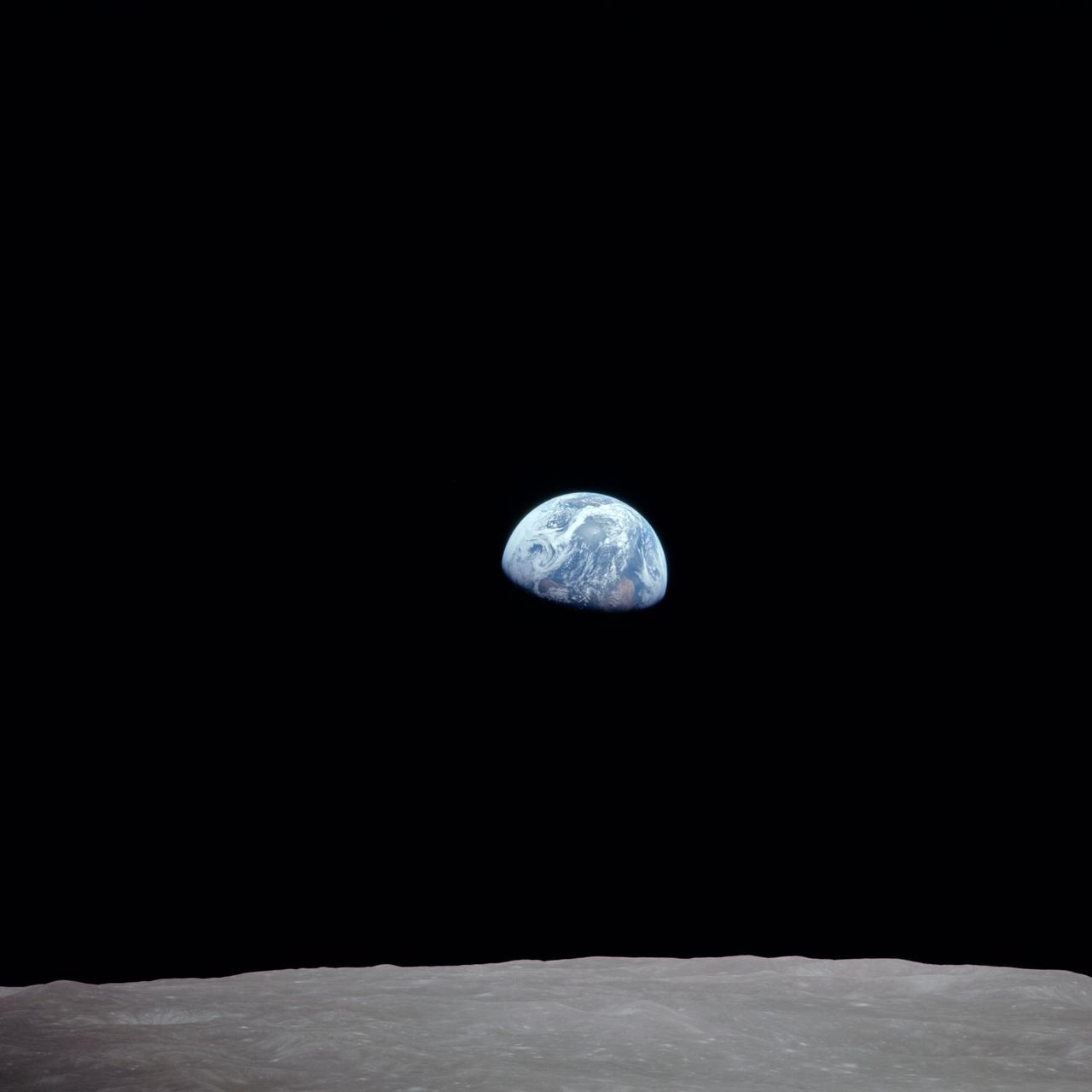
AS11-44-6689 (16-24 July 1969) --- One-third of the Earth's sphere illuminated, Earth's terminator, sunglint, a portion of east Africa, as photographed from the Apollo 11 spacecraft during its first lunar landing mission. While astronauts Neil A. Armstrong, commander, and Edwin E. Aldrin Jr., lunar module pilot, descended in the Lunar Module (LM) "Eagle" to explore the Sea of Tranquility region of the moon, astronaut Michael Collins, command module pilot, remained with the Command and Service Modules (CSM) "Columbia" in lunar orbit.
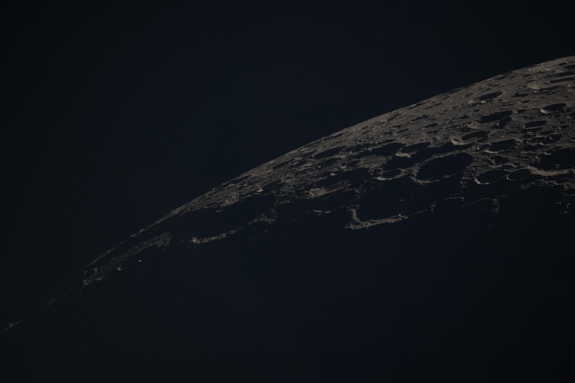
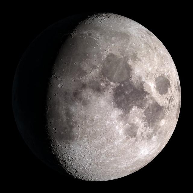
art002e020686 (April 6, 2026) – A portion of the Moon’s farside is seen along the terminator—the boundary between lunar day and night—where low-angle sunlight casts long shadows across the surface. A section of Orientale Basin is visible along the upper right portion of the lunar disk, its structure subtly revealed under grazing illumination. This lighting enhances contrast across the cratered terrain, highlighting variations in surface features and providing insight into the Moon’s geologic history. Credit: NASA
AS08-16-2596 (21-27 Dec. 1968) --- View of Earth as photographed by the Apollo 8 astronauts during their lunar orbit mission. North is about five percent to the right of vertical. The sunset terminator crosses North and South America. Clouds cover most of the United States. Only the desert southwest and Florida are clear.
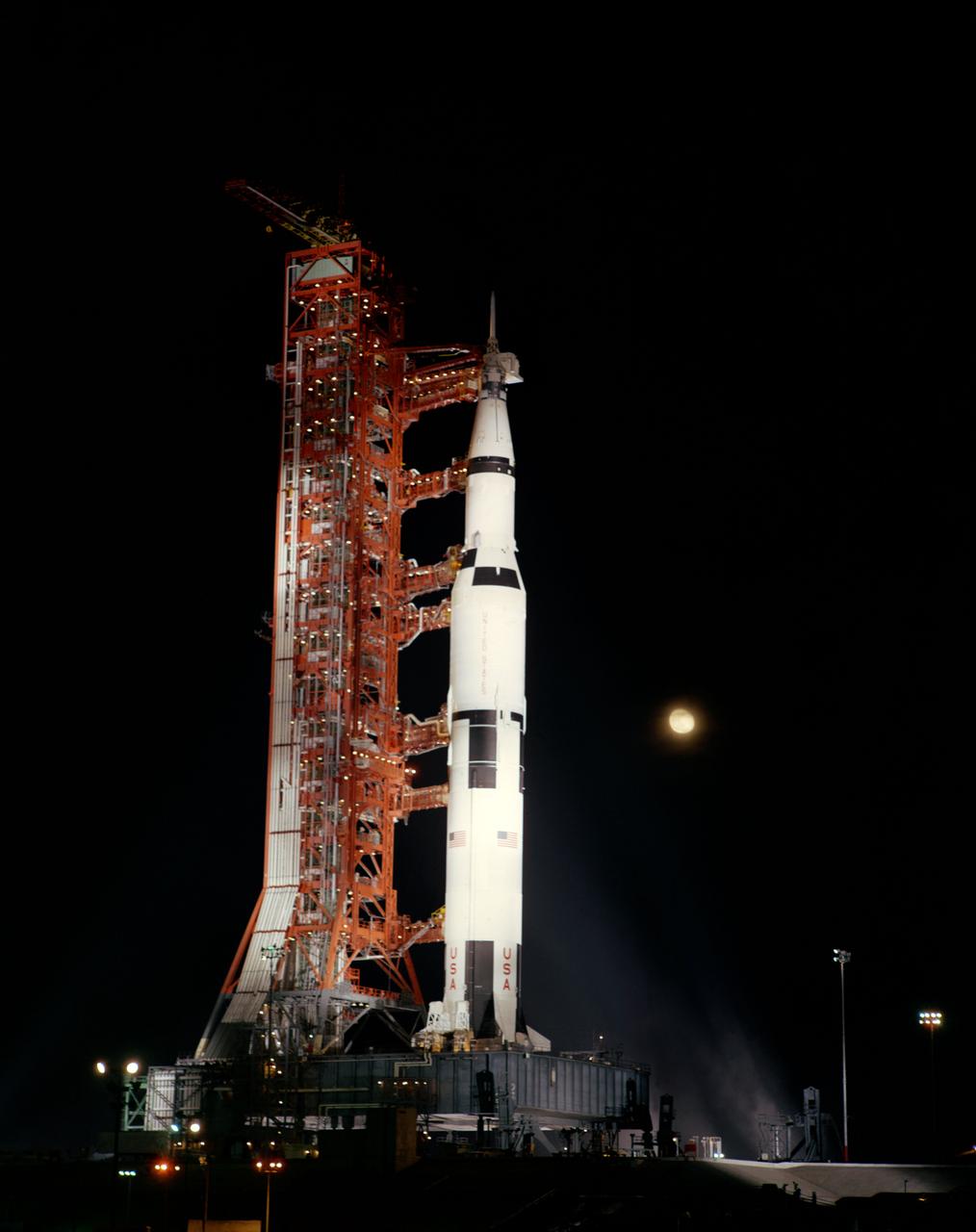
S69-56596 (28 Oct. 1969) --- A nighttime, ground-level view of Pad A, Launch Complex 39, Kennedy Space Center (KSC) showing the Apollo 12 (Spacecraft 108/Lunar Module 6/Saturn 507) space vehicle, during the terminal phase of a Countdown Demonstration Test (CDDT). The crew of the National Aeronautics and Space Administration's (NASA) second lunar landing mission will be astronauts Charles Conrad Jr., commander; Richard F. Gordon Jr., command module pilot; and Alan L. Bean, lunar module pilot. The Apollo 12 launch has been scheduled for 11:22 a.m. (EST) on Nov. 14, 1969.
AS08-14-2505 (21-27 Dec. 1968) --- This photograph of a nearly full moon was taken from the Apollo 8 spacecraft at a point above 70 degrees east longitude. (Hold picture with moon's dark portion at left). Mare Crisium, the circular, dark-colored area near the center, is near the eastern edge of the moon as viewed from Earth. Mare Nectaris is the circular mare near the terminator. The large, irregular maira are Tranquillitatis and Fecunditatis. The terminator at left side of picture crosses Mare Tranquillitatis and highlands to the south. Lunar farside features occupy most of the right half of the picture. The large, dark-colored crater Tsiolkovsky is near the limb at the lower right. Conspicuous bright rays radiate from two large craters, one to the north of Tsiolkovsky, the other near the limb in the upper half of the picture. These rayed craters were not conspicuous in Lunar Orbiter photography due to the low sun elevations when the Lunar Orbiter photography was made. The crater Langrenus is near the center of the picture at the eastern edge of Mare Fecunditatis. The lunar surface probably has less pronounced color that indicated by this print.
AS08-14-2506 (21-27 Dec. 1968) --- This photograph of a nearly full moon was taken from the Apollo 8 spacecraft at a point above 70 degrees east longitude. (Hold picture with moon's dark portion at left). Mare Crisium, the circular, dark-colored area near the center, is near the eastern edge of the moon as viewed from Earth. Mare Nectaris is the circular mare near the terminator. The large, irregular maira are Tranquillitatis and Fecunditatis. The terminator at left side of picture crosses Mare Tranquillitatis and highlands to the south. Lunar farside features occupy most of the right half of the picture. The large, dark-colored crater Tsiolkovsky is near the limb at the lower right. Conspicuous bright rays radiate from two large craters, one to the north of Tsiolkovsky, the other near the limb in the upper half of the picture. These rayed craters were not conspicuous in Lunar Orbiter photography due to the low sun elevations when the Lunar Orbiter photography was made. The crater Langrenus is near the center of the picture at the eastern edge of Mare Fecunditatis. The lunar surface probably has less pronounced color that indicated by this print.
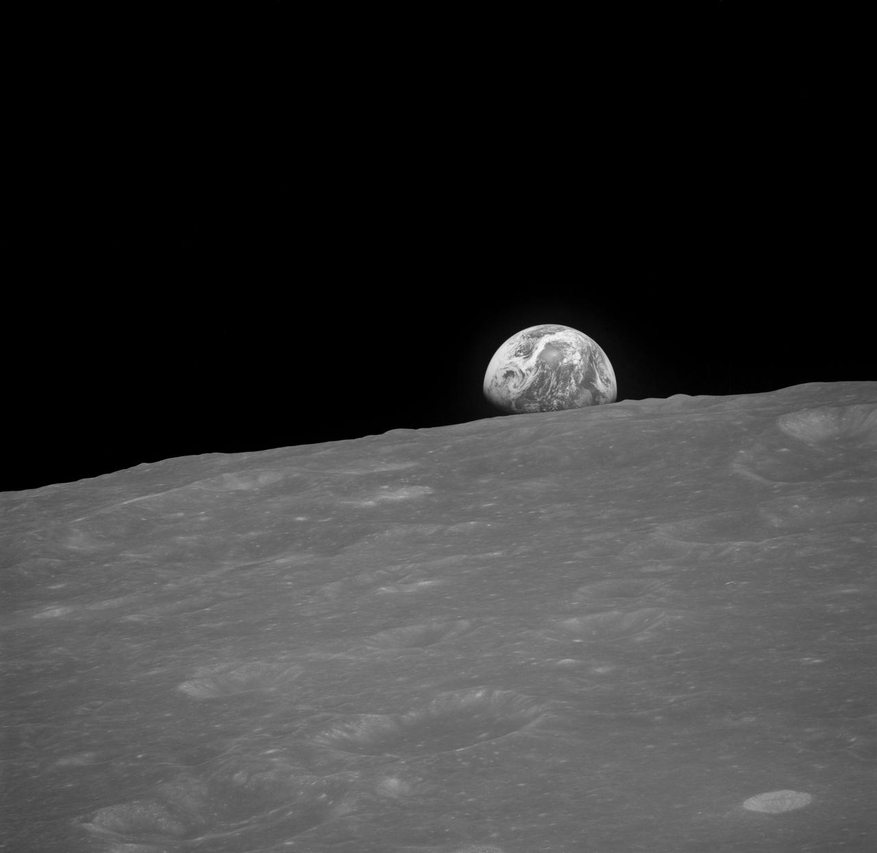
AS08-13-2329 (Dec. 1968) --- The Earth rising is about five degrees above the lunar horizon in this black and white telephoto view photographed from the Apollo 8 spacecraft near 110 degrees east longitude. The horizon, about 570 kilometers (350 statute miles) from the spacecraft, is near the eastern limb of the Moon as viewed from Earth. On Earth, 240,000 statute miles away, the sunset terminator crosses Africa. The South Pole is in the white area near the left end of the terminator. North and South America are under clouds.
AS10-27-3956 (24 May 1969) --- This photograph of the moon was taken after trans-Earth insertion when the Apollo 10 spacecraft was high above the lunar equator near 27 degrees east longitude. North is about 20 degrees left of the top of the photograph. Apollo Landing Site 3 is on the lighted side of the terminator in a dark area just north of the equator. Apollo Landing Site 2 is near the lower left margin of the Sea of Tranquility (Mare Tranquillitatis), which is the large, dark area near the center of the photograph.
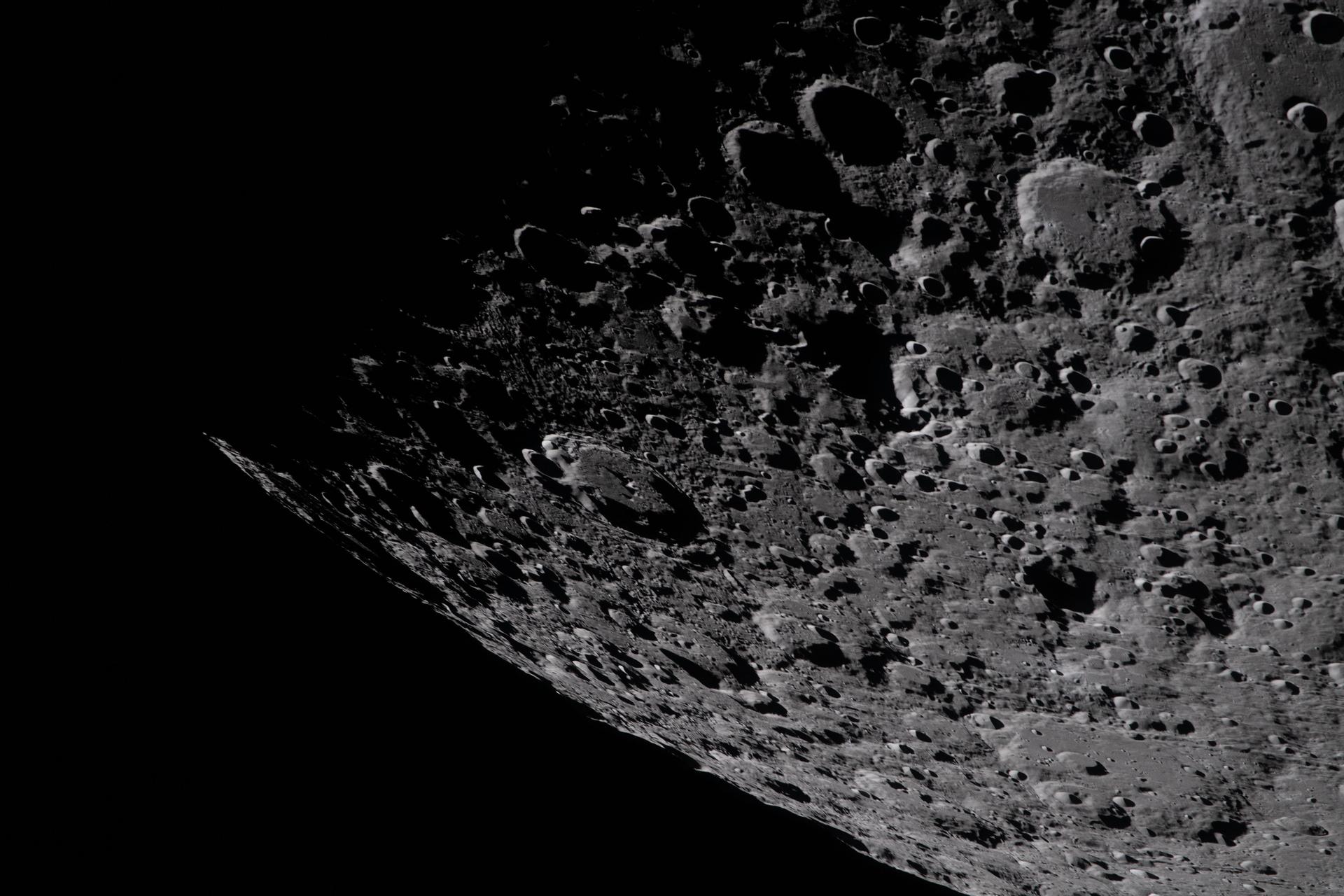
art002e009283 (April 6, 2026) – Captured by the Artemis II crew, the heavily cratered terrain of the eastern edge of the South Pole-Aitken basin is seen with the shadowed terminator – the boundary between lunar day and night – at the top of the image. The South Pole-Aitken basin is the largest and oldest basin on the Moon, providing a glimpse into an ancient geologic history built up over billions of years.
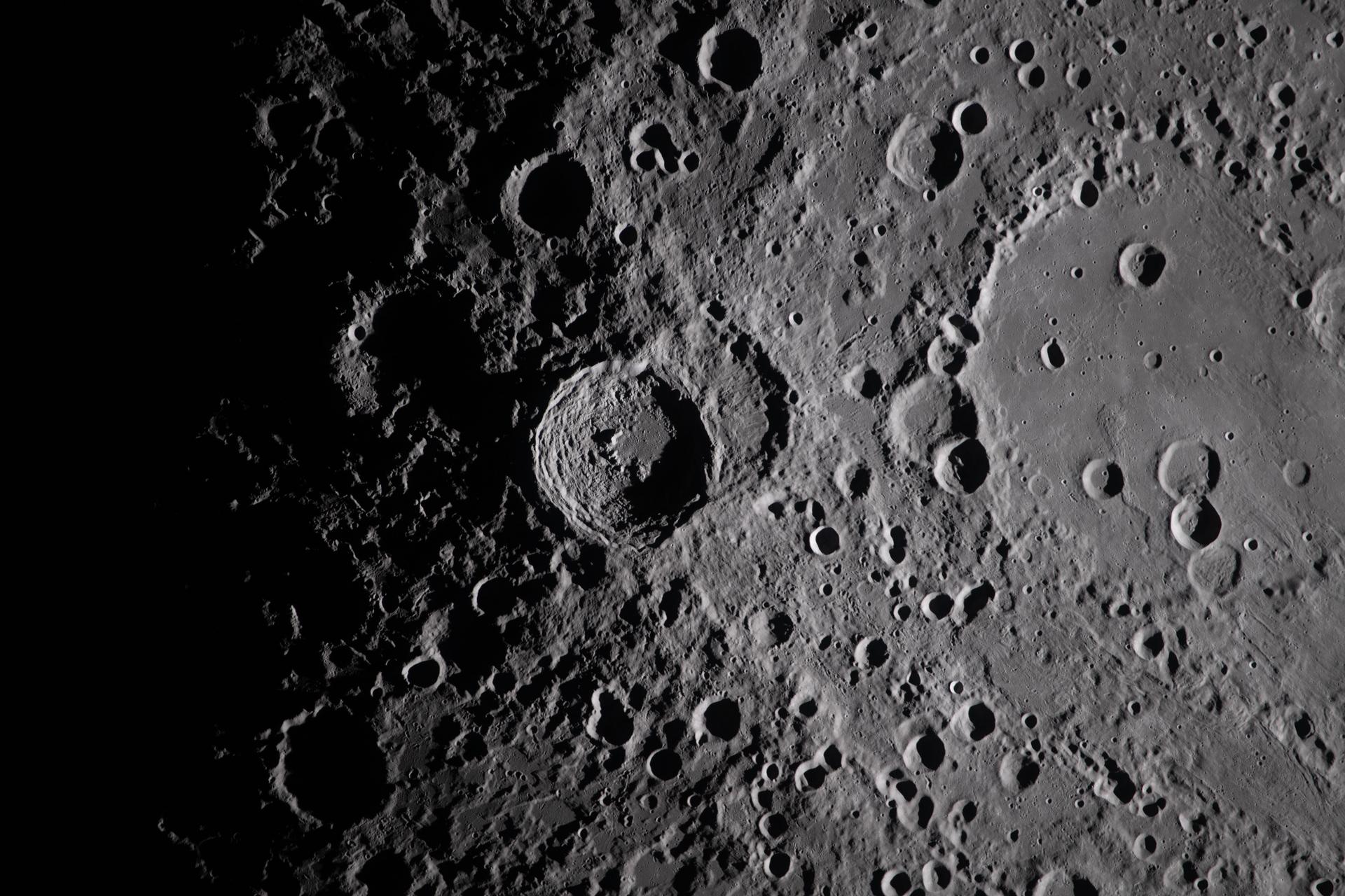
art002e009282 (April 6, 2026) - A close-up view taken by the Artemis II crew of Vavilov Crater on the rim of the older and larger Hertzsprung basin. The right portion of the image shows the transition from smooth material within an inner ring of mountains to more rugged terrain around the rim. Vavilov and other craters and their ejecta are accentuated by long shadows at the terminator, the boundary between lunar day and night. The image was captured with a handheld camera at a focal length of 400 mm, as the crew flew around the far side of the Moon.
AS08-14-2384 (Dec. 1968)--- The rising Earth is about five degrees above the lunar horizon in this photograph--one of a pair taken within a short time of each other --from the Apollo 8 spacecraft . The horizon, about 570 kilometers (350 statute miles) from the spacecraft, is near the eastern limb of the Moon as viewed from Earth. Width of the view at the horizon is about 150 kilometers (95 statute miles). On the Earth 240,000 statute miles away, the sunset terminator crosses Africa. The South Pole is in the white area near the left end of the terminator. North and South America are almost totally under clouds. However, part of North America is visible at the top (western) part of the planet.

AS08-14-2383 (24 Dec. 1968) --- The rising Earth is about five degrees above the lunar horizon in this telephoto view taken from the Apollo 8 spacecraft near 110 degrees east longitude. The horizon, about 570 kilometers (350 statute miles) from the spacecraft, is near the eastern limb of the moon as viewed from Earth. Width of the view at the horizon is about 150 kilometers (95 statute miles). On Earth 240,000 statute miles away the sunset terminator crosses Africa. The crew took the photo around 10:40 a.m. Houston time on the morning of Dec. 24, and that would make it 15:40 GMT on the same day. The South Pole is in the white area near the left end of the terminator. North and South America are under the clouds.
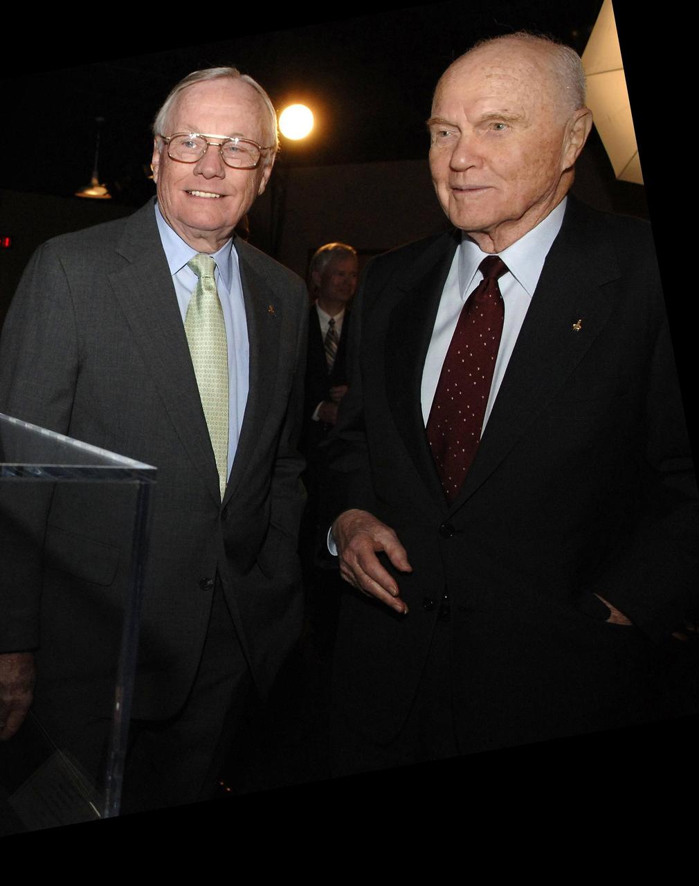
CINCINNATI, OHIO - NASA Administrator Michael Griffin presented the NASA Ambassadors of Exploration award to Neil Armstrong (left). At right is former awardee John Glenn. Armstrong received the award that includes a moon rock to recognize the sacrifices and dedication of the astronauts and others who were part of the Mercury, Gemini and Apollo programs. A former naval aviator, NASA test pilot and Apollo 11 commander, Armstrong was the first human to ever land a spacecraft on the moon and the first to step on the lunar surface. Armstrong's award will be displayed at the Cincinnati Museum Center at Union Terminal. Photo credit: NASA/Bill Ingalls
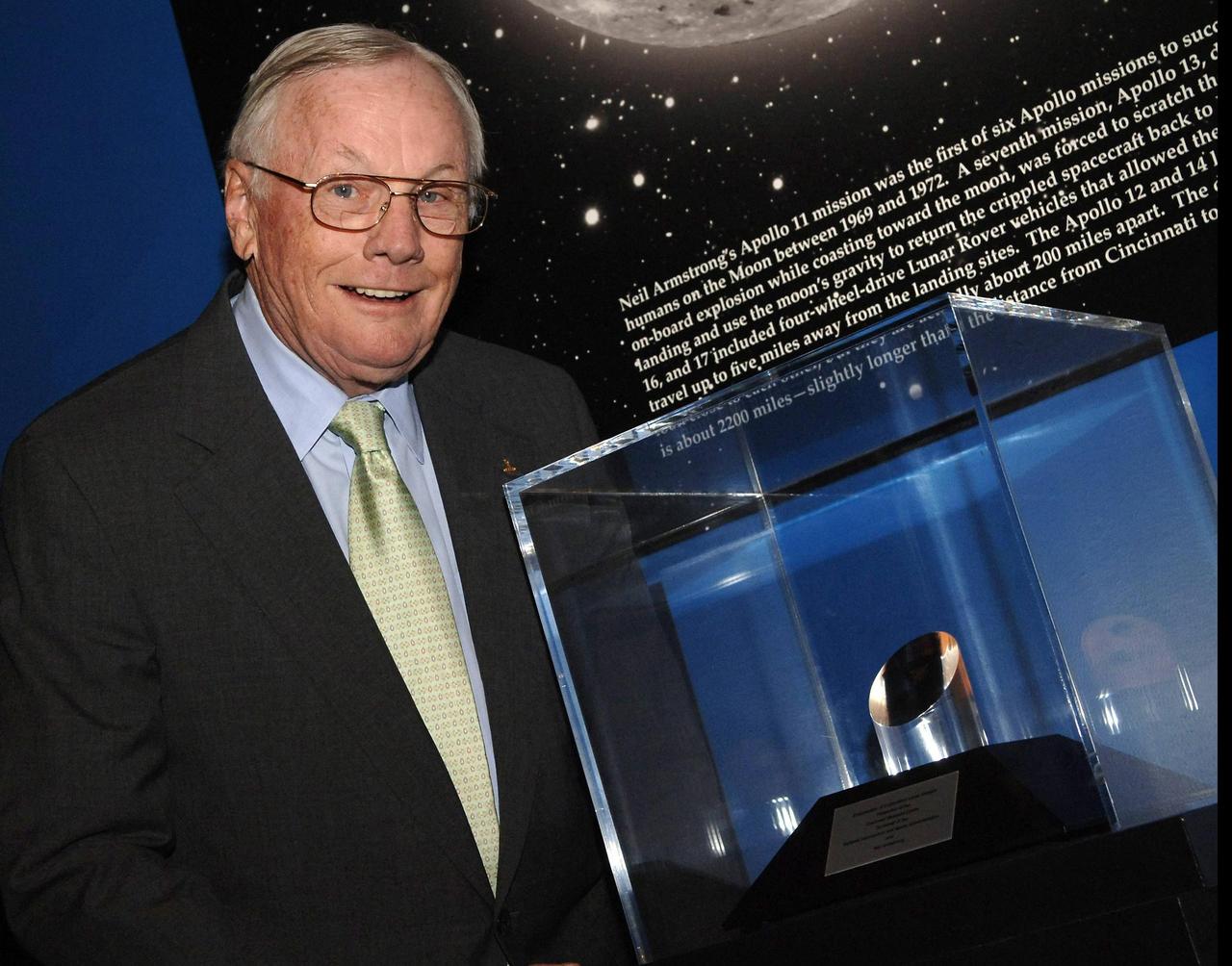
CINCINNATI, OHIO - Former astronaut Neil Armstrong stands next to the NASA Ambassadors of Exploration award presented to him by NASA Administrator Michael Griffin. Armstrong received the award that includes a moon rock to recognize the sacrifices and dedication of the astronauts and others who were part of the Mercury, Gemini and Apollo programs. A former naval aviator, NASA test pilot and Apollo 11 commander, Armstrong was the first human to ever land a spacecraft on the moon and the first to step on the lunar surface. Armstrong's award will be displayed at the Cincinnati Museum Center at Union Terminal. Photo credit: NASA/Bill Ingalls
New Moon. By the modern definition, New Moon occurs when the Moon and Sun are at the same geocentric ecliptic longitude. The part of the Moon facing us is completely in shadow then. Pictured here is the traditional New Moon, the earliest visible waxing crescent, which signals the start of a new month in many lunar and lunisolar calendars. NASA's Lunar Reconnaissance Orbiter (LRO) has been in orbit around the Moon since the summer of 2009. Its laser altimeter (LOLA) and camera (LROC) are recording the rugged, airless lunar terrain in exceptional detail, making it possible to visualize the Moon with unprecedented fidelity. This is especially evident in the long shadows cast near the terminator, or day-night line. The pummeled, craggy landscape thrown into high relief at the terminator would be impossible to recreate in the computer without global terrain maps like those from LRO. To download, learn more about this visualization, or to see what the Moon will look like at any hour in 2015, visit <a href="http://svs.gsfc.nasa.gov/goto?4236" rel="nofollow">svs.gsfc.nasa.gov/goto?4236</a> <b><a href="http://www.nasa.gov/audience/formedia/features/MP_Photo_Guidelines.html" rel="nofollow">NASA image use policy.</a></b> <b><a href="http://www.nasa.gov/centers/goddard/home/index.html" rel="nofollow">NASA Goddard Space Flight Center</a></b> enables NASA’s mission through four scientific endeavors: Earth Science, Heliophysics, Solar System Exploration, and Astrophysics. Goddard plays a leading role in NASA’s accomplishments by contributing compelling scientific knowledge to advance the Agency’s mission. <b>Follow us on <a href="http://twitter.com/NASAGoddardPix" rel="nofollow">Twitter</a></b> <b>Like us on <a href="http://www.facebook.com/pages/Greenbelt-MD/NASA-Goddard/395013845897?ref=tsd" rel="nofollow">Facebook</a></b> <b>Find us on <a href="http://instagram.com/nasagoddard?vm=grid" rel="nofollow">Instagram</a></b>
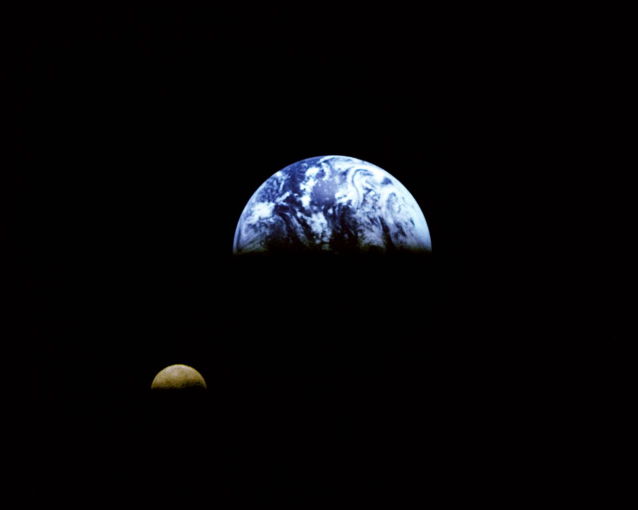
Eight days after its encounter with the Earth, the Galileo spacecraft was able to look back and capture this remarkable view of the Moon in orbit about the Earth, taken from a distance of about 6.2 million kilometers (3.9 million miles). The picture was constructed from images taken through the violet, red, and 1.0-micron infrared filters. The Moon is in the foreground, moving from left to right. The brightly-colored Earth contrasts strongly with the Moon, which reflects only about one-third as much sunlight as the Earth. Contrast and color have been computer-enhanced for both objects to improve visibility. Antarctica is visible through clouds (bottom). The Moon's far side is seen; the shadowy indentation in the dawn terminator is the south-Pole/Aitken Basin, one of the largest and oldest lunar impact features. Alternate Jet Propulsion Laboratory (JPL) number is P-41508. View appears in the Space News Roundup v32 n1 p1, 01-11-93.
AS10-31-4650 (18-26 May 1969) --- This Apollo 10 oblique telephoto view of the lunar nearside is centered on the crater Hyginus located at 6.3 degrees north latitude, near the northeast margin of Central Bay. HOLD PICTURE WITH SKY AT TOP. The crater is about 10 kilometers (6.5 statue miles) in diameter. From the crater the prominent Hyginus Rille extends east-southeast toward the camera and northwest toward the Sea of Vapors. The rille is about 3 kilometers (2 statue miles) wide and more than 200 kilometers (130 statue miles) long. The horizon is not visible in this photograph, taken from the Command and Service Modules. The sunrise terminator is between the spacecraft and the horizon. At the time this picture was taken Apollo 10 was 325 kilometers (200 statute miles) southeast of Hyginus.
A new NASA-developed, laser-based space communication system will enable higher rates of satellite communications similar in capability to high-speed fiber optic networks on Earth. The space terminal for the Lunar Laser Communication Demonstration (LLCD), NASA's first high-data-rate laser communication system, was recently integrated onto the Lunar Atmosphere and Dust Environment Explorer (LADEE) spacecraft. LLCD will demonstrate laser communications from lunar orbit to Earth at six times the rate of the best modern-day advanced radio communication systems. Credit: NASA ----- What is LADEE? The Lunar Atmosphere and Dust Environment Explorer (LADEE) is designed to study the Moon's thin exosphere and the lunar dust environment. An "exosphere" is an atmosphere that is so thin and tenuous that molecules don't collide with each other. Studying the Moon's exosphere will help scientists understand other planetary bodies with exospheres too, like Mercury and some of Jupiter's bigger moons. The orbiter will determine the density, composition and temporal and spatial variability of the Moon's exosphere to help us understand where the species in the exosphere come from and the role of the solar wind, lunar surface and interior, and meteoric infall as sources. The mission will also examine the density and temporal and spatial variability of dust particles that may get lofted into the atmosphere. The mission also will test several new technologies, including a modular spacecraft bus that may reduce the cost of future deep space missions and demonstrate two-way high rate laser communication for the first time from the Moon. LADEE now is ready to launch when the window opens on Sept. 6, 2013. Read more: <a href="http://www.nasa.gov/ladee" rel="nofollow">www.nasa.gov/ladee</a> <b><a href="http://www.nasa.gov/audience/formedia/features/MP_Photo_Guidelines.html" rel="nofollow">NASA image use policy.</a></b> <b><a href="http://www.nasa.gov/centers/goddard/home/index.html" rel="nofollow">NASA Goddard Space Flight Center</a></b> enables NASA’s mission through four scientific endeavors: Earth Science, Heliophysics, Solar System Exploration, and Astrophysics. Goddard plays a leading role in NASA’s accomplishments by contributing compelling scientific knowledge to advance the Agency’s mission. <b>Follow us on <a href="http://twitter.com/NASA_GoddardPix" rel="nofollow">Twitter</a></b> <b>Like us on <a href="http://www.facebook.com/pages/Greenbelt-MD/NASA-Goddard/395013845897?ref=tsd" rel="nofollow">Facebook</a></b> <b>Find us on <a href="http://instagram.com/nasagoddard?vm=grid" rel="nofollow">Instagram</a></b>
First quarter. Visible high in the southern sky in early evening. NASA's Lunar Reconnaissance Orbiter (LRO) has been in orbit around the Moon since the summer of 2009. Its laser altimeter (LOLA) and camera (LROC) are recording the rugged, airless lunar terrain in exceptional detail, making it possible to visualize the Moon with unprecedented fidelity. This is especially evident in the long shadows cast near the terminator, or day-night line. The pummeled, craggy landscape thrown into high relief at the terminator would be impossible to recreate in the computer without global terrain maps like those from LRO. To download, learn more about this visualization, or to see what the Moon will look like at any hour in 2015, visit <a href="http://svs.gsfc.nasa.gov/goto?4236" rel="nofollow">svs.gsfc.nasa.gov/goto?4236</a> <b><a href="http://www.nasa.gov/audience/formedia/features/MP_Photo_Guidelines.html" rel="nofollow">NASA image use policy.</a></b> <b><a href="http://www.nasa.gov/centers/goddard/home/index.html" rel="nofollow">NASA Goddard Space Flight Center</a></b> enables NASA’s mission through four scientific endeavors: Earth Science, Heliophysics, Solar System Exploration, and Astrophysics. Goddard plays a leading role in NASA’s accomplishments by contributing compelling scientific knowledge to advance the Agency’s mission. <b>Follow us on <a href="http://twitter.com/NASAGoddardPix" rel="nofollow">Twitter</a></b> <b>Like us on <a href="http://www.facebook.com/pages/Greenbelt-MD/NASA-Goddard/395013845897?ref=tsd" rel="nofollow">Facebook</a></b> <b>Find us on <a href="http://instagram.com/nasagoddard?vm=grid" rel="nofollow">Instagram</a></b>

This visualization shows the Moon's phase and libration at hourly intervals throughout 2015, as viewed from the northern hemisphere. Each frame represents one hour. Lunar Reconnaissance Orbiter (LRO) has been in orbit around the Moon since the summer of 2009. Its laser altimeter (LOLA) and camera (LROC) are recording the rugged, airless lunar terrain in exceptional detail, making it possible to visualize the Moon with unprecedented fidelity. This is especially evident in the long shadows cast near the terminator, or day-night line. The pummeled, craggy landscape thrown into high relief at the terminator would be impossible to recreate in the computer without global terrain maps like those from LRO. To download, learn more about this visualization, or to see what the Moon will look like at any hour in 2015, visit <a href="http://svs.gsfc.nasa.gov/goto?4236" rel="nofollow">svs.gsfc.nasa.gov/goto?4236</a> <b><a href="http://www.nasa.gov/audience/formedia/features/MP_Photo_Guidelines.html" rel="nofollow">NASA image use policy.</a></b> <b><a href="http://www.nasa.gov/centers/goddard/home/index.html" rel="nofollow">NASA Goddard Space Flight Center</a></b> enables NASA’s mission through four scientific endeavors: Earth Science, Heliophysics, Solar System Exploration, and Astrophysics. Goddard plays a leading role in NASA’s accomplishments by contributing compelling scientific knowledge to advance the Agency’s mission. <b>Follow us on <a href="http://twitter.com/NASAGoddardPix" rel="nofollow">Twitter</a></b> <b>Like us on <a href="http://www.facebook.com/pages/Greenbelt-MD/NASA-Goddard/395013845897?ref=tsd" rel="nofollow">Facebook</a></b> <b>Find us on <a href="http://instagram.com/nasagoddard?vm=grid" rel="nofollow">Instagram</a></b>
Third quarter. Rises around midnight, visible to the south after sunrise. NASA's Lunar Reconnaissance Orbiter (LRO) has been in orbit around the Moon since the summer of 2009. Its laser altimeter (LOLA) and camera (LROC) are recording the rugged, airless lunar terrain in exceptional detail, making it possible to visualize the Moon with unprecedented fidelity. This is especially evident in the long shadows cast near the terminator, or day-night line. The pummeled, craggy landscape thrown into high relief at the terminator would be impossible to recreate in the computer without global terrain maps like those from LRO. To download, learn more about this visualization, or to see what the Moon will look like at any hour in 2015, visit <a href="http://svs.gsfc.nasa.gov/goto?4236" rel="nofollow">svs.gsfc.nasa.gov/goto?4236</a> <b><a href="http://www.nasa.gov/audience/formedia/features/MP_Photo_Guidelines.html" rel="nofollow">NASA image use policy.</a></b> <b><a href="http://www.nasa.gov/centers/goddard/home/index.html" rel="nofollow">NASA Goddard Space Flight Center</a></b> enables NASA’s mission through four scientific endeavors: Earth Science, Heliophysics, Solar System Exploration, and Astrophysics. Goddard plays a leading role in NASA’s accomplishments by contributing compelling scientific knowledge to advance the Agency’s mission. <b>Follow us on <a href="http://twitter.com/NASAGoddardPix" rel="nofollow">Twitter</a></b> <b>Like us on <a href="http://www.facebook.com/pages/Greenbelt-MD/NASA-Goddard/395013845897?ref=tsd" rel="nofollow">Facebook</a></b> <b>Find us on <a href="http://instagram.com/nasagoddard?vm=grid" rel="nofollow">Instagram</a></b>
Waning gibbous. Rises after sunset, high in the sky after midnight, visible to the southwest after sunrise. NASA's Lunar Reconnaissance Orbiter (LRO) has been in orbit around the Moon since the summer of 2009. Its laser altimeter (LOLA) and camera (LROC) are recording the rugged, airless lunar terrain in exceptional detail, making it possible to visualize the Moon with unprecedented fidelity. This is especially evident in the long shadows cast near the terminator, or day-night line. The pummeled, craggy landscape thrown into high relief at the terminator would be impossible to recreate in the computer without global terrain maps like those from LRO. To download, learn more about this visualization, or to see what the Moon will look like at any hour in 2015, visit <a href="http://svs.gsfc.nasa.gov/goto?4236" rel="nofollow">svs.gsfc.nasa.gov/goto?4236</a> <b><a href="http://www.nasa.gov/audience/formedia/features/MP_Photo_Guidelines.html" rel="nofollow">NASA image use policy.</a></b> <b><a href="http://www.nasa.gov/centers/goddard/home/index.html" rel="nofollow">NASA Goddard Space Flight Center</a></b> enables NASA’s mission through four scientific endeavors: Earth Science, Heliophysics, Solar System Exploration, and Astrophysics. Goddard plays a leading role in NASA’s accomplishments by contributing compelling scientific knowledge to advance the Agency’s mission. <b>Follow us on <a href="http://twitter.com/NASAGoddardPix" rel="nofollow">Twitter</a></b> <b>Like us on <a href="http://www.facebook.com/pages/Greenbelt-MD/NASA-Goddard/395013845897?ref=tsd" rel="nofollow">Facebook</a></b> <b>Find us on <a href="http://instagram.com/nasagoddard?vm=grid" rel="nofollow">Instagram</a></b>
Waxing gibbous. Visible to the southeast in early evening, up for most of the night. NASA's Lunar Reconnaissance Orbiter (LRO) has been in orbit around the Moon since the summer of 2009. Its laser altimeter (LOLA) and camera (LROC) are recording the rugged, airless lunar terrain in exceptional detail, making it possible to visualize the Moon with unprecedented fidelity. This is especially evident in the long shadows cast near the terminator, or day-night line. The pummeled, craggy landscape thrown into high relief at the terminator would be impossible to recreate in the computer without global terrain maps like those from LRO. To download, learn more about this visualization, or to see what the Moon will look like at any hour in 2015, visit <a href="http://svs.gsfc.nasa.gov/goto?4236" rel="nofollow">svs.gsfc.nasa.gov/goto?4236</a> <b><a href="http://www.nasa.gov/audience/formedia/features/MP_Photo_Guidelines.html" rel="nofollow">NASA image use policy.</a></b> <b><a href="http://www.nasa.gov/centers/goddard/home/index.html" rel="nofollow">NASA Goddard Space Flight Center</a></b> enables NASA’s mission through four scientific endeavors: Earth Science, Heliophysics, Solar System Exploration, and Astrophysics. Goddard plays a leading role in NASA’s accomplishments by contributing compelling scientific knowledge to advance the Agency’s mission. <b>Follow us on <a href="http://twitter.com/NASAGoddardPix" rel="nofollow">Twitter</a></b> <b>Like us on <a href="http://www.facebook.com/pages/Greenbelt-MD/NASA-Goddard/395013845897?ref=tsd" rel="nofollow">Facebook</a></b> <b>Find us on <a href="http://instagram.com/nasagoddard?vm=grid" rel="nofollow">Instagram</a></b>
Waning crescent. Low to the east before sunrise. NASA's Lunar Reconnaissance Orbiter (LRO) has been in orbit around the Moon since the summer of 2009. Its laser altimeter (LOLA) and camera (LROC) are recording the rugged, airless lunar terrain in exceptional detail, making it possible to visualize the Moon with unprecedented fidelity. This is especially evident in the long shadows cast near the terminator, or day-night line. The pummeled, craggy landscape thrown into high relief at the terminator would be impossible to recreate in the computer without global terrain maps like those from LRO. To download, learn more about this visualization, or to see what the Moon will look like at any hour in 2015, visit <a href="http://svs.gsfc.nasa.gov/goto?4236" rel="nofollow">svs.gsfc.nasa.gov/goto?4236</a> <b><a href="http://www.nasa.gov/audience/formedia/features/MP_Photo_Guidelines.html" rel="nofollow">NASA image use policy.</a></b> <b><a href="http://www.nasa.gov/centers/goddard/home/index.html" rel="nofollow">NASA Goddard Space Flight Center</a></b> enables NASA’s mission through four scientific endeavors: Earth Science, Heliophysics, Solar System Exploration, and Astrophysics. Goddard plays a leading role in NASA’s accomplishments by contributing compelling scientific knowledge to advance the Agency’s mission. <b>Follow us on <a href="http://twitter.com/NASAGoddardPix" rel="nofollow">Twitter</a></b> <b>Like us on <a href="http://www.facebook.com/pages/Greenbelt-MD/NASA-Goddard/395013845897?ref=tsd" rel="nofollow">Facebook</a></b> <b>Find us on <a href="http://instagram.com/nasagoddard?vm=grid" rel="nofollow">Instagram</a></b>
Waxing crescent. Visible toward the southwest in early evening. NASA's Lunar Reconnaissance Orbiter (LRO) has been in orbit around the Moon since the summer of 2009. Its laser altimeter (LOLA) and camera (LROC) are recording the rugged, airless lunar terrain in exceptional detail, making it possible to visualize the Moon with unprecedented fidelity. This is especially evident in the long shadows cast near the terminator, or day-night line. The pummeled, craggy landscape thrown into high relief at the terminator would be impossible to recreate in the computer without global terrain maps like those from LRO. To download, learn more about this visualization, or to see what the Moon will look like at any hour in 2015, visit <a href="http://svs.gsfc.nasa.gov/goto?4236" rel="nofollow">svs.gsfc.nasa.gov/goto?4236</a> <b><a href="http://www.nasa.gov/audience/formedia/features/MP_Photo_Guidelines.html" rel="nofollow">NASA image use policy.</a></b> <b><a href="http://www.nasa.gov/centers/goddard/home/index.html" rel="nofollow">NASA Goddard Space Flight Center</a></b> enables NASA’s mission through four scientific endeavors: Earth Science, Heliophysics, Solar System Exploration, and Astrophysics. Goddard plays a leading role in NASA’s accomplishments by contributing compelling scientific knowledge to advance the Agency’s mission. <b>Follow us on <a href="http://twitter.com/NASAGoddardPix" rel="nofollow">Twitter</a></b> <b>Like us on <a href="http://www.facebook.com/pages/Greenbelt-MD/NASA-Goddard/395013845897?ref=tsd" rel="nofollow">Facebook</a></b> <b>Find us on <a href="http://instagram.com/nasagoddard?vm=grid" rel="nofollow">Instagram</a></b>
Full Moon. Rises at sunset, high in the sky around midnight. Visible all night. NASA's Lunar Reconnaissance Orbiter (LRO) has been in orbit around the Moon since the summer of 2009. Its laser altimeter (LOLA) and camera (LROC) are recording the rugged, airless lunar terrain in exceptional detail, making it possible to visualize the Moon with unprecedented fidelity. This is especially evident in the long shadows cast near the terminator, or day-night line. The pummeled, craggy landscape thrown into high relief at the terminator would be impossible to recreate in the computer without global terrain maps like those from LRO. To download, learn more about this visualization, or to see what the Moon will look like at any hour in 2015, visit <a href="http://svs.gsfc.nasa.gov/goto?4236" rel="nofollow">svs.gsfc.nasa.gov/goto?4236</a> <b><a href="http://www.nasa.gov/audience/formedia/features/MP_Photo_Guidelines.html" rel="nofollow">NASA image use policy.</a></b> <b><a href="http://www.nasa.gov/centers/goddard/home/index.html" rel="nofollow">NASA Goddard Space Flight Center</a></b> enables NASA’s mission through four scientific endeavors: Earth Science, Heliophysics, Solar System Exploration, and Astrophysics. Goddard plays a leading role in NASA’s accomplishments by contributing compelling scientific knowledge to advance the Agency’s mission. <b>Follow us on <a href="http://twitter.com/NASAGoddardPix" rel="nofollow">Twitter</a></b> <b>Like us on <a href="http://www.facebook.com/pages/Greenbelt-MD/NASA-Goddard/395013845897?ref=tsd" rel="nofollow">Facebook</a></b> <b>Find us on <a href="http://instagram.com/nasagoddard?vm=grid" rel="nofollow">Instagram</a></b>
P-29521 BW Range: 557,000 kilometers ( 346, 000 miles) The southern hemisphere of Umbriel displays heavy cratering in this Voyager 2 image. This frame, taken through the clear-filter of Voyager's narrow-angle camera, is the most detailed image of Umbriel, with a resolution of about 10 km (6 mi). Umbriel is the darkest of Uranus' larger moons and the one that appears to have experienced the lowest level of geological activity. It has a diameter of about 1,200 km (750 mi) and reflects only 16 percent of the light striking its surface; in the latter respect, Umbriel is similiar to lunar highland areas. Umbriel is heavily cratered but lacks the numerous bright-ray craters seen on the other large Uranian satellites; this results in a relatively uniform surface albedo (reflectivity). The prominent crater on the terminator (upper right) is about 110 km (70 mi) across and has a bright central peak. The strangest feature in this image (at top) is a curious bright ring, the most reflective area seen on Umbriel. The ring is about 140 km (90 mi) in diameter and lies near the satellite's equator. The nature of the ring is not known, although it might be a frost deposit, perhaps associated with an impact crater. Spots against the black background are due to 'noise' in the data.
![Multiple exposure of Gemini rendezvous docking simulator. Francis B. Smith wrote in his paper "Simulators for Manned Space Research," "The rendezvous and docking operation of the Gemini spacecraft with the Agena and of the Apollo Command Module with the Lunar Excursion Module have been the subject of simulator studies for several years. [This figure] illustrates the Gemini-Agena rendezvous docking simulator at Langley. The Gemini spacecraft was supported in a gimbal system by an overhead crane and gantry arrangement which provided 6 degrees of freedom - roll, pitch, yaw, and translation in any direction - all controllable by the astronaut in the spacecraft. Here again the controls fed into a computer which in turn provided an input to the servos driving the spacecraft so that it responded to control motions in a manner which accurately simulated the Gemini spacecraft." A.W. Vogeley further described the simulator in his paper "Discussion of Existing and Planned Simulators For Space Research," "Docking operations are considered to start when the pilot first can discern vehicle target size and aspect and terminate, of course, when soft contact is made. ... This facility enables simulation of the docking operation from a distance of 200 feet to actual contact with the target. A full-scale mock-up of the target vehicle is suspended near one end of the track. ... On [the Agena target] we have mounted the actual Agena docking mechanism and also various types of visual aids. We have been able to devise visual aids which have made it possible to accomplish nighttime docking with as much success as daytime docking." -- Published in Barton C. Hacker and James M. Grimwood, On the Shoulders of Titans: A History of Project Gemini, NASA SP-4203; Francis B. Smith, "Simulators for Manned Space Research," Paper presented at the 1966 IEEE International convention, March 21-25, 1966; A.W. Vogeley, "Discussion of Existing and Planned Simulators For Space Research," Paper presented at the Conference on the Role of Simulation in Space Technology, August 17-21, 1964.](https://images-assets.nasa.gov/image/LRC-1963-B701_P-08973/LRC-1963-B701_P-08973~medium.jpg)
Multiple exposure of Gemini rendezvous docking simulator. Francis B. Smith wrote in his paper "Simulators for Manned Space Research," "The rendezvous and docking operation of the Gemini spacecraft with the Agena and of the Apollo Command Module with the Lunar Excursion Module have been the subject of simulator studies for several years. [This figure] illustrates the Gemini-Agena rendezvous docking simulator at Langley. The Gemini spacecraft was supported in a gimbal system by an overhead crane and gantry arrangement which provided 6 degrees of freedom - roll, pitch, yaw, and translation in any direction - all controllable by the astronaut in the spacecraft. Here again the controls fed into a computer which in turn provided an input to the servos driving the spacecraft so that it responded to control motions in a manner which accurately simulated the Gemini spacecraft." A.W. Vogeley further described the simulator in his paper "Discussion of Existing and Planned Simulators For Space Research," "Docking operations are considered to start when the pilot first can discern vehicle target size and aspect and terminate, of course, when soft contact is made. ... This facility enables simulation of the docking operation from a distance of 200 feet to actual contact with the target. A full-scale mock-up of the target vehicle is suspended near one end of the track. ... On [the Agena target] we have mounted the actual Agena docking mechanism and also various types of visual aids. We have been able to devise visual aids which have made it possible to accomplish nighttime docking with as much success as daytime docking." -- Published in Barton C. Hacker and James M. Grimwood, On the Shoulders of Titans: A History of Project Gemini, NASA SP-4203; Francis B. Smith, "Simulators for Manned Space Research," Paper presented at the 1966 IEEE International convention, March 21-25, 1966; A.W. Vogeley, "Discussion of Existing and Planned Simulators For Space Research," Paper presented at the Conference on the Role of Simulation in Space Technology, August 17-21, 1964.
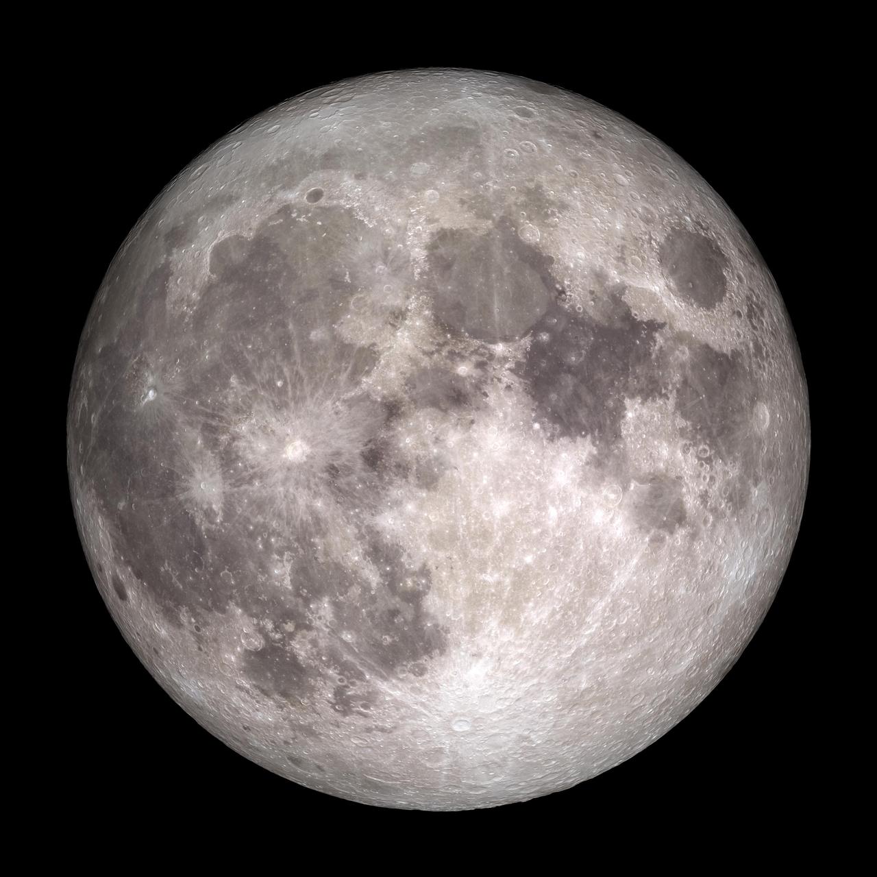
art002e010014 (April 6, 2026) – A bright portion of the Moon is visible in this image. If you look closely, you can see linear, pitted features known as “crater chains” radiating from the Orientale basin, an impact crater with a patch of ancient lava at its center, visible in the bottom center of the image. These crater chains formed about 3.8 billion years ago, when rocks spewed from the collision that formed Orientale landed in lines extending away from the crater. These chains are found near other large craters on the Moon, but we don’t get to see them on Earth because our planet’s crust has been turned over so many times through plate tectonics and largely erased by rain, wind, and ice. In the upper left corner of the Moon disk is a line called the terminator, the boundary between lunar day and night. Here, low-angle sunlight skims the surface, casting dramatic shadows that expose the area’s topography — or the shape of its surface. Glushko crater is the bright spot just to the left of the dark mare, or “sea” of ancient lava flows on the near side of the Moon. It’s identifiable by the bright rays that shoot across the mare, some hundreds of miles away. These rays are made of ejected material after the collision that formed Glushko. Glushko and its rays are brighter than the surrounding area because that younger has experienced less weathering from radiation and impacts. Oceanus Procellarum, the largest lava-filled region on the Moon, spans the horizon. The Aristarchus crater, the bright spot in the sea of lava, creeps toward the right edge of the Moon.
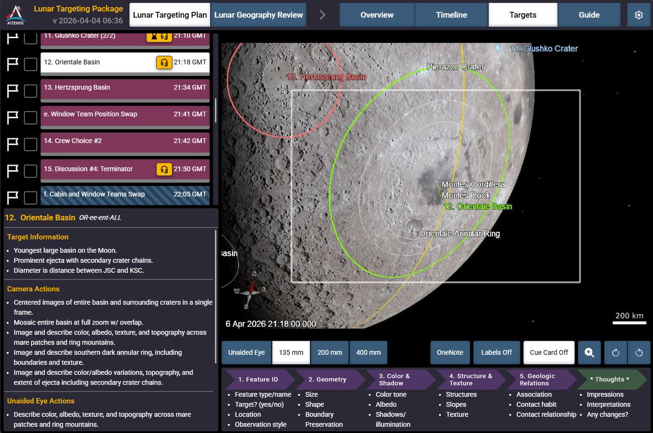
Caption: This is a screen shot of the application the crew sees on their personal computing devices that guides them in the execution of the lunar science observation plan. This custom software was built by the crew lunar observations team, a subset of the Artemis II lunar science team. In this screenshot you can see Orientale basin, target number 12 circled on the bottom right of the Moon, and to its left, target number 13, Hertzsprung basin.