The eastern edge of Alpha Regio is shown in this image from NASA Magellan spacecraft. http://photojournal.jpl.nasa.gov/catalog/PIA00215
This image mosaic from NASA Magellan spacecraft shows the impact crater Golubkina. http://photojournal.jpl.nasa.gov/catalog/PIA00236
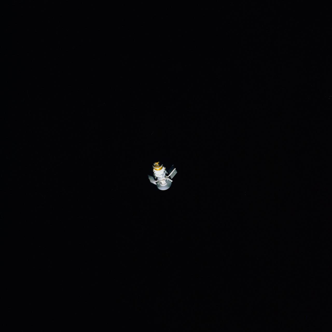
STS030-71-063 (4 May 1989) --- This scene is one of two released by NASA showing the process of solar array panel deployment on the Magellan spacecraft. Panels are not fully extended in this frame. The spacecraft had earlier been released by the STS-30 crewmembers to begin its long journey to the planet Venus for an extensive radar mapping mission. The frame was photographed through Atlantis? aft flight deck windows with a handheld 70mm camera. The complementary photograph is STS030-71-070.
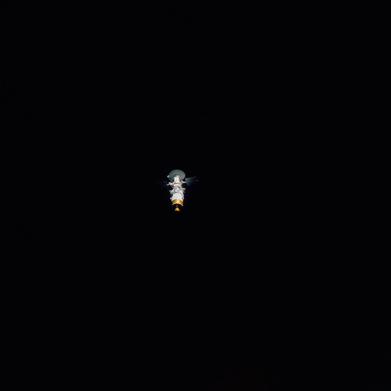
STS030-71-070 (4 May 1989) --- This scene is one of two released by NASA showing the process of solar array panel deployment on the Magellan spacecraft. Though partially blended into the backdrop of the blackness of space, it appears the two panels are fully extended in this frame. The spacecraft had earlier been released by the STS-30 crewmembers to begin its long journey to the planet Venus for an extensive radar mapping mission. The frame was photographed through Atlantis' aft flight deck windows with a handheld 70mm camera. The complementary photograph is STS030-71-063.
This image from NASA Magellan spacecraft is of an area located in the Eistla Region of Venus in the southern hemisphere. http://photojournal.jpl.nasa.gov/catalog/PIA00089

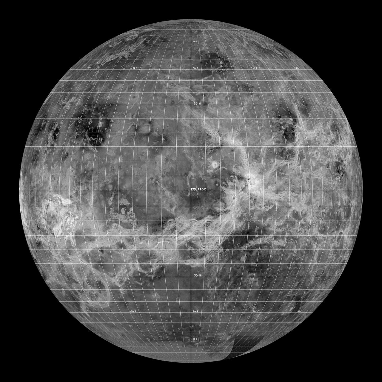
The northern hemisphere is displayed in this global view of the surface of Venus as seen by NASA Magellan spacecraft. http://photojournal.jpl.nasa.gov/catalog/PIA00270
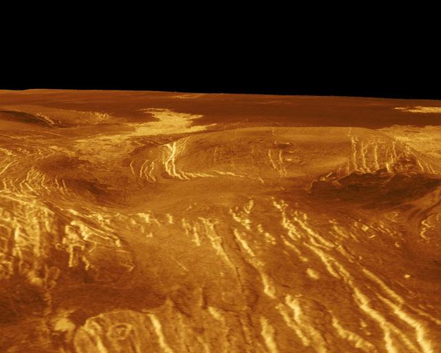
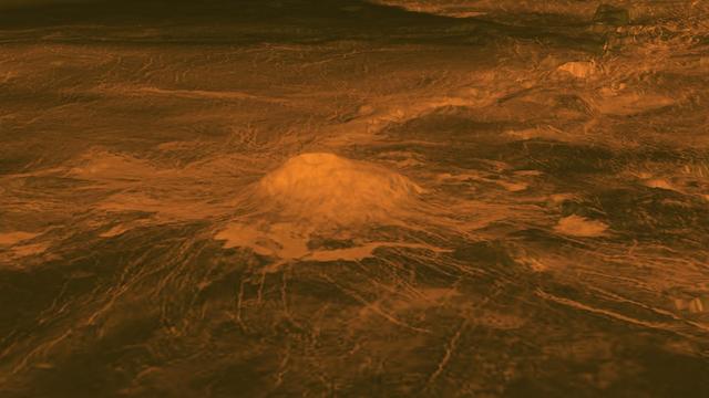
Sif Mons is displayed in this computer-simulated view obtained by NASA's Magellan spacecraft of the surface of Venus. http://photojournal.jpl.nasa.gov/catalog/PIA00108
A corona is displayed in this computer-simulated view from NASA's Magellan spacecraft of the surface of Venus. http://photojournal.jpl.nasa.gov/catalog/PIA00109
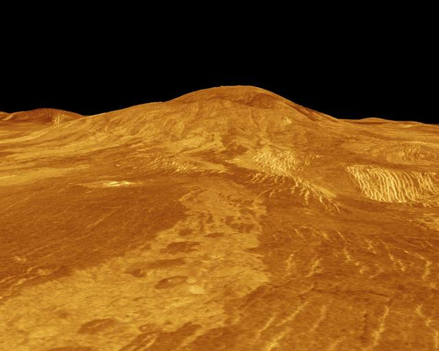
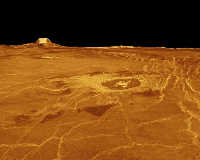
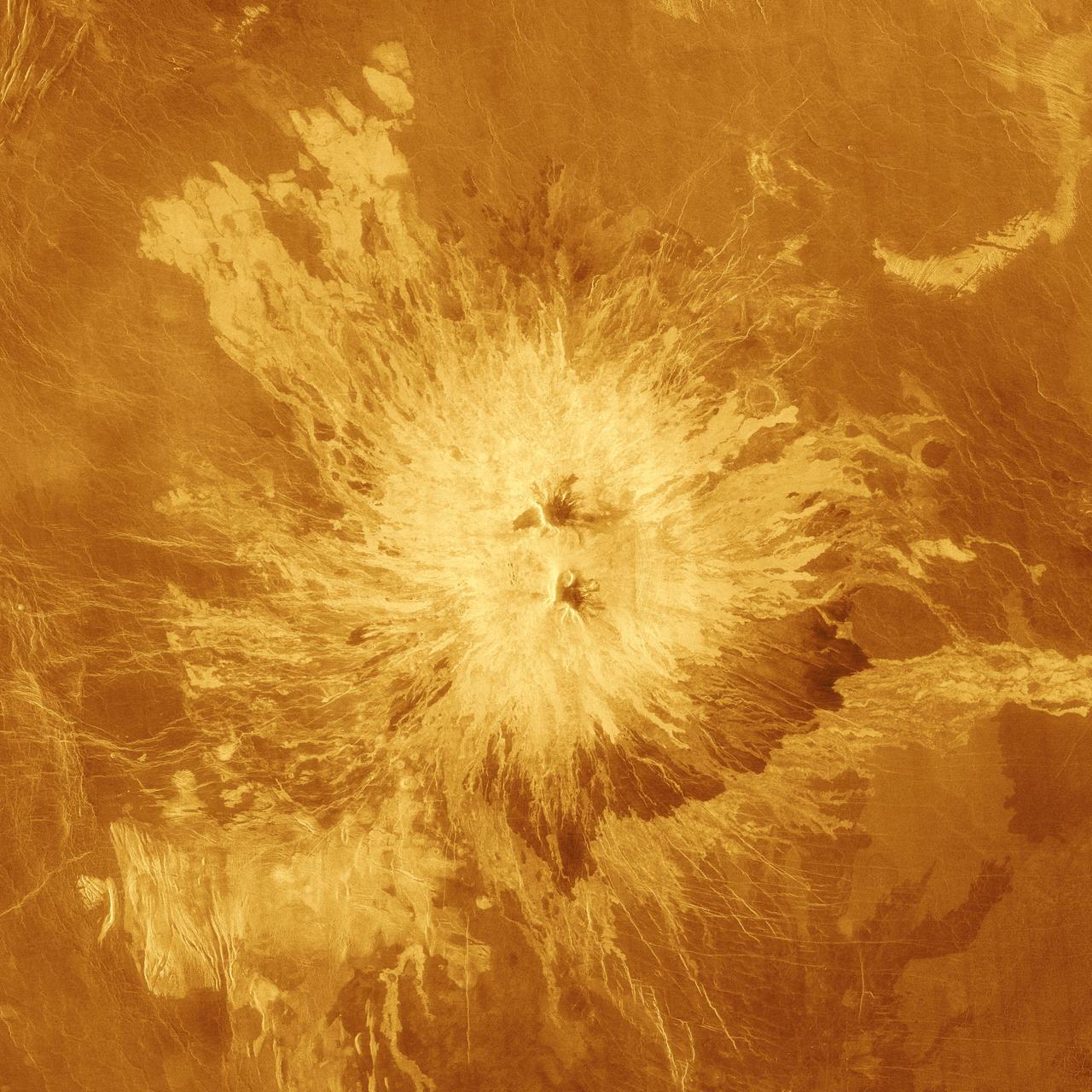
Gula Mons is displayed in this computer-simulated view from NASA Magellan spacecraft of the surface of Venus. http://photojournal.jpl.nasa.gov/catalog/PIA00234
This image mosaic from NASA Magellan spacecraft is of an impact crater located in Guinevere Planitia on Venus. http://photojournal.jpl.nasa.gov/catalog/PIA00238

The northern hemisphere is displayed in this global view of the surface of Venus as seen by NASA Magellan spacecraft. http://photojournal.jpl.nasa.gov/catalog/PIA00271
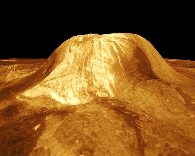
Two unusual volcanic domes are shown in this full-resolution mosaic obtained by NASA Magellan spacecraft. http://photojournal.jpl.nasa.gov/catalog/PIA00244
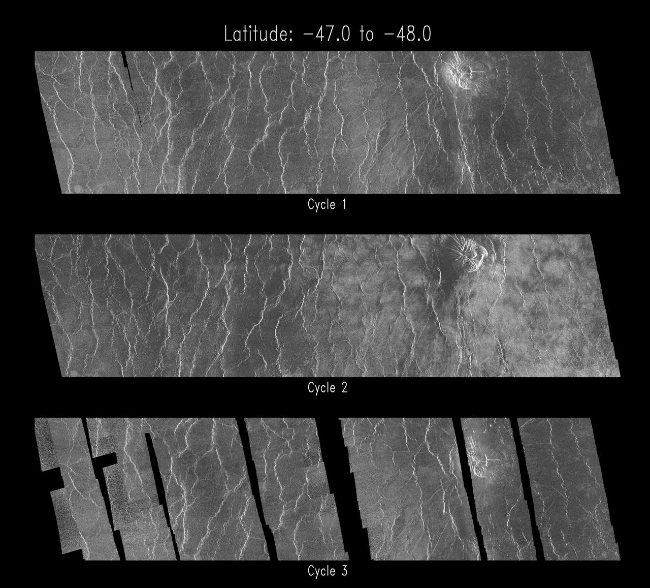
As NASA Magellan mission progressed, areas of Venus became accessible for a second look. During Magellan second 243-day global mapping cycle, the spacecraft was rotated 180 degrees to view the surface from the opposite direction. http://photojournal.jpl.nasa.gov/catalog/PIA00260
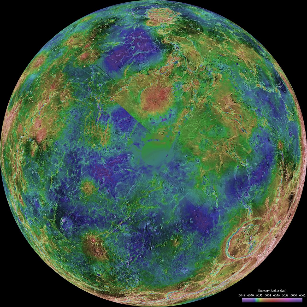
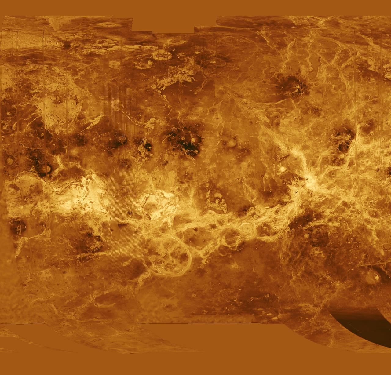
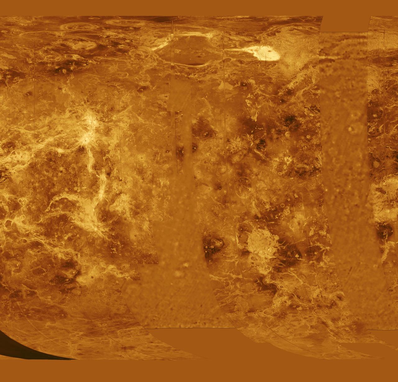
This hemispheric view of Venus, as revealed by more than a decade of radar investigations culminating in the 1990-1994 Magellan mission, is centered on the North Pole. NASA Magellan spacecraft imaged more than 98% of Venus. http://photojournal.jpl.nasa.gov/catalog/PIA00008

This global view from NASA's Magellan spacecraft is of the surface of Venus is centered at 180 degrees east longitude. http://photojournal.jpl.nasa.gov/catalog/PIA00104

This image from NASA Magellan spacecraft shows a relatively flat plains region composed of many lava flows. http://photojournal.jpl.nasa.gov/catalog/PIA00082
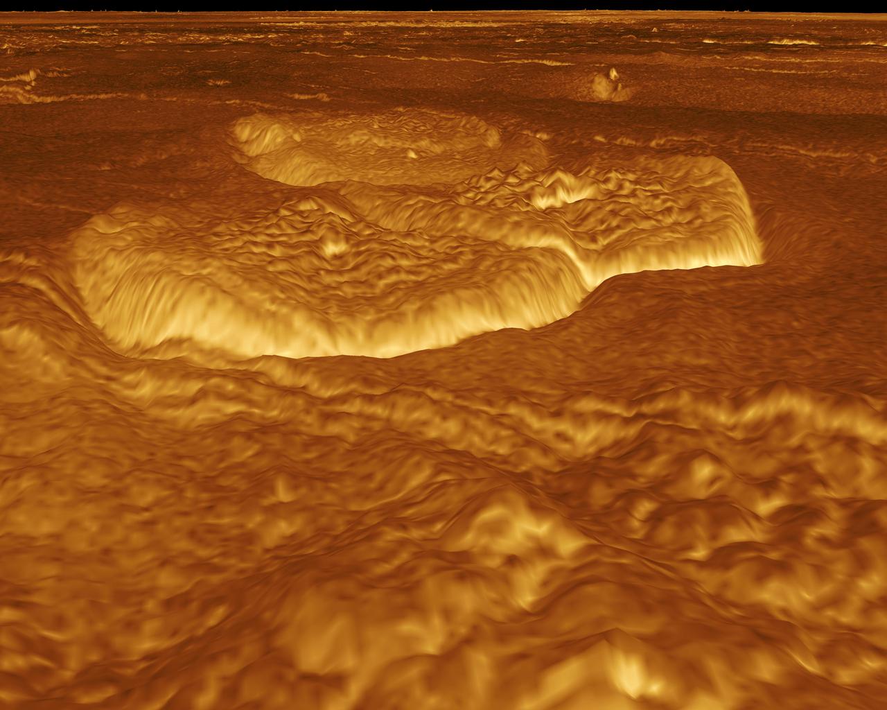
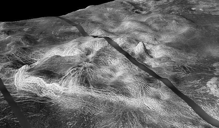
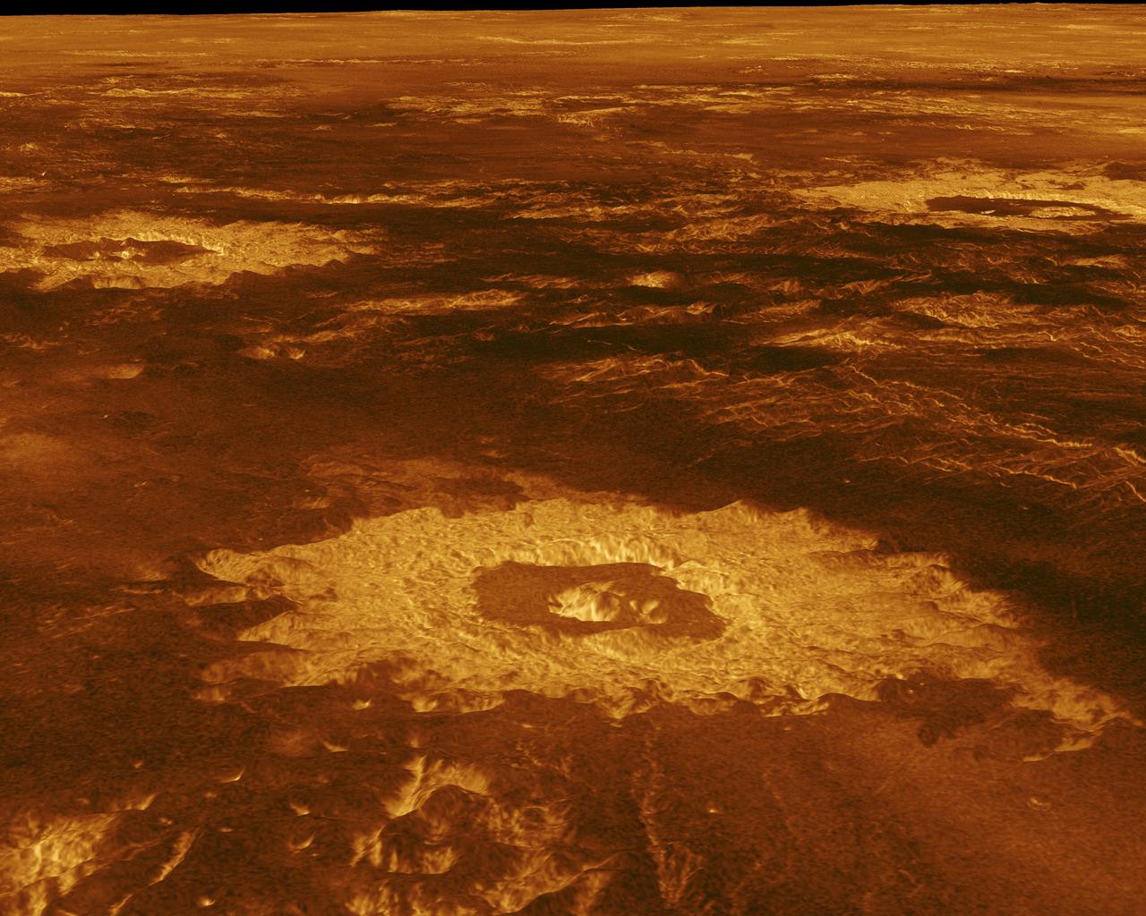
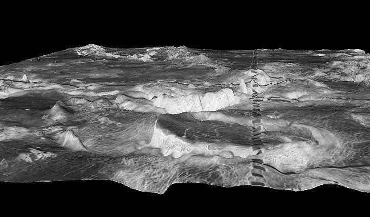
A portion of the eastern edge of Alpha Regio is displayed in this three-dimensional perspective view of the surface of Venus from NASA Magellan spacecraft. http://photojournal.jpl.nasa.gov/catalog/PIA00246
The eastern half of the planet is displayed in this simple cylindrical map of the surface of Venus obtained by NASA Magellan spacecraft. http://photojournal.jpl.nasa.gov/catalog/PIA00256
This false color image from NASA Magellan spacecraft shows a portion of Bereghinya Planitia plains in the northern hemisphere of Venus. http://photojournal.jpl.nasa.gov/catalog/PIA00259

This full-resolution mosaic of Venus, obtained by NASA Magellan spacecraft, shows an area replete with diverse volcanic features. http://photojournal.jpl.nasa.gov/catalog/PIA00265
This full-resolution image from NASA Magellan spacecraft shows the northern part of the Akna Montes mountains of Venus. http://photojournal.jpl.nasa.gov/catalog/PIA00250
The western half of the planet is displayed in this simple cylindrical map of the surface of Venus obtained by NASA Magellan spacecraft. http://photojournal.jpl.nasa.gov/catalog/PIA00255
This image from NASA Magellan spacecraft shows a complex crater with a circular rim, terraced walls, and central peaks. http://photojournal.jpl.nasa.gov/catalog/PIA00239
NASA Magellan spacecraft has observed remnant landslide deposits apparently resulting from the collapse of volcanic structures. http://photojournal.jpl.nasa.gov/catalog/PIA00263
A portion of western Eistla Regio is displayed in this three-dimensional perspective view from NASA's Magellan spacecraft of the surface of Venus. http://photojournal.jpl.nasa.gov/catalog/PIA00102

Sapas Mons is displayed in the center of this computer-generated three-dimensional perspective view from NASA's Magellan spacecraft of the surface of Venus. http://photojournal.jpl.nasa.gov/catalog/PIA00107

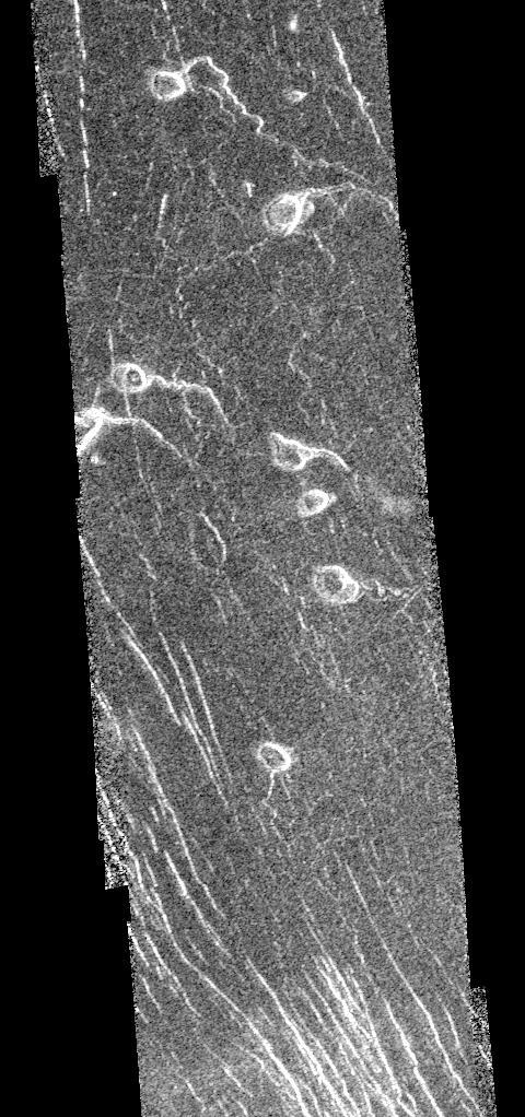
Three large meteorite impact craters are seen in this image obtained by NASA Magellan spacecraft of the Lavinia region of Venus. http://photojournal.jpl.nasa.gov/catalog/PIA00214
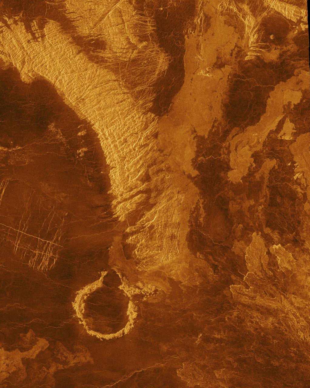
Southwest Lakshmi Planum plains is bounded on the south by the Danu Montes mountains as shown by NASA Magellan spacecraft. http://photojournal.jpl.nasa.gov/catalog/PIA00249
This image from NASA's Magellan spacecraft covers part of the eastern flank of the volcano Sapas Mons on the western edge of Atla Regio. http://photojournal.jpl.nasa.gov/catalog/PIA00099
A portion of western Eistla Regio is displayed in this three-dimensional perspective view of the surface of Venus as seen by NASA Magellan spacecraft. http://photojournal.jpl.nasa.gov/catalog/PIA00233
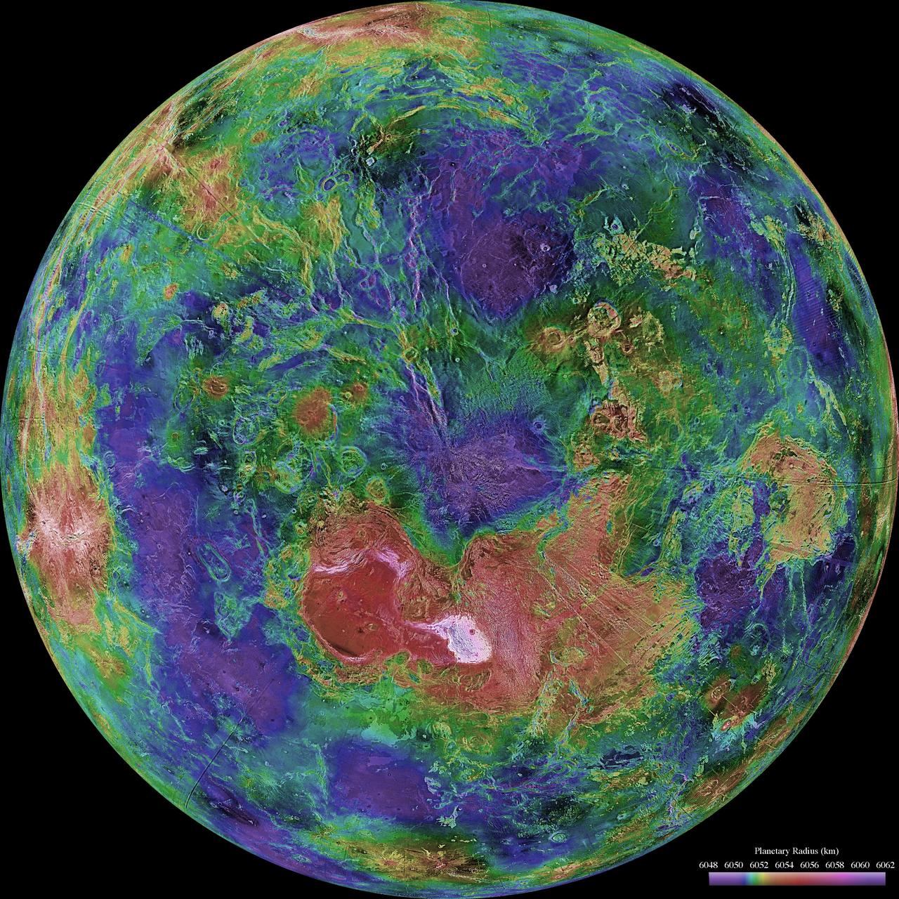
The hemispheric view of Venus, as revealed by more than a decade of radar investigations culminating in the 1990-1994 Magellan mission, is centered on the North Pole. The Magellan spacecraft imaged more than 98% of Venus at a resolution of about 100 meters; the effective resolution of this image is about 3 km. A mosaic of the Magellan images (most with illumination from the west) forms the image base. Gaps in the Magellan coverage were filled with images from the Earth-based Arecibo radar in a region centered roughly on 0 degree latitude and longitude, and with a neutral tone elsewhere (primarily near the south pole). The composite image was processed to improve contrast and to emphasize small features, and was color-coded to represent elevation. Gaps in the elevation data from the Magellan radar altimeter were filled with altimetry from the Venera spacecraft and the U.S. Pioneer Venus missions. An orthographic projection was used, simulating a distant view of one hemisphere of the planet. The Magellan mission was managed for NASA by Jet Propulsion Laboratory (JPL), Pasadena, CA. Data processed by JPL, the Massachusetts Institute of Technology, Cambridge, MA, and the U.S. Geological Survey, Flagstaff, AZ. http://photojournal.jpl.nasa.gov/catalog/PIA00007
This image from NASA Magellan spacecraft reveals Sacajawea Patera, a large, elongate caldera located in Western Ishtar Terra on the smooth plateau of Lakshmi Planum.
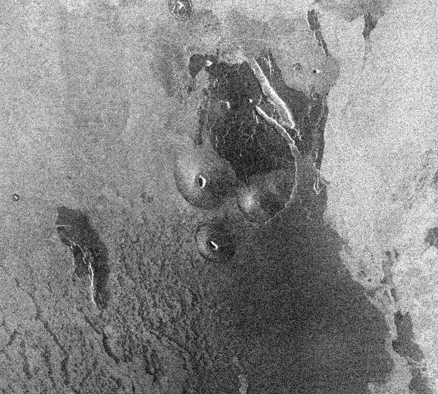
This image from NASA Magellan spacecraft is from the eastern Ovda region of Venus. The image shows some small volcanic domes on the flank of the volcano Maat.
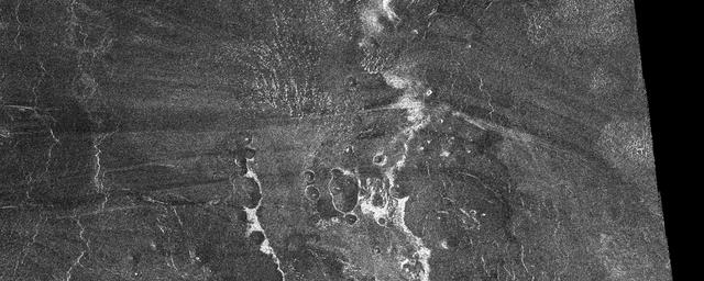
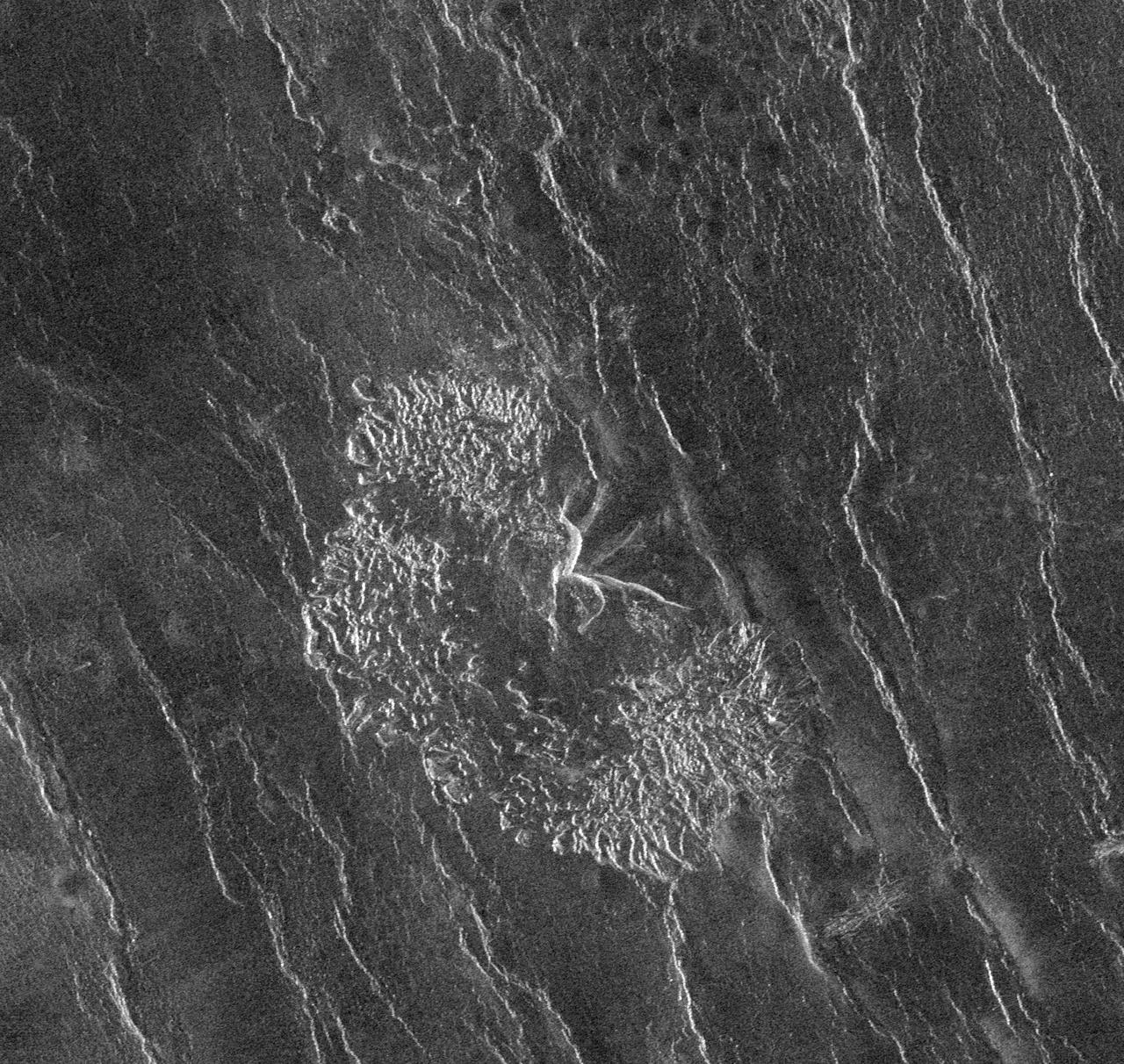
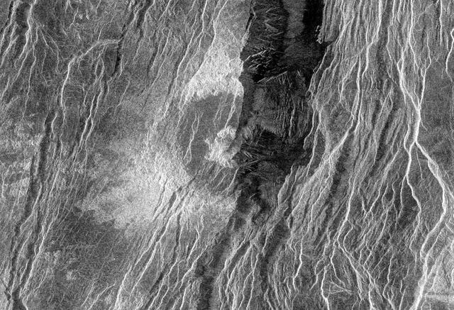
This image from NASA Magellan spacecraft is from the southern portion of Navka. In the center of this image are two bright deposits running north to south.
This image from the Atla region of Venus obtained by NASA Magellan spacecraft shows several types of volcanic features and superimposed surface fractures. http://photojournal.jpl.nasa.gov/catalog/PIA00201
This false-color image obtained by NASA Magellan spacecraft shows the volcano Sapas Mons, which is located in the broad equatorial rise called Atla Regio. http://photojournal.jpl.nasa.gov/catalog/PIA00203

This image obtained by NASA Magellan spacecraft reveals Sacajawea Patera, a large, elongate caldera located in western Ishtar Terra on the smooth plateau of Lakshmi Planum. http://photojournal.jpl.nasa.gov/catalog/PIA00216
This full resolution radar image from NASA Magellan spacecraft is centered along the eastern edge of Lakshmi Planum and the western edge of Maxwell Montes. http://photojournal.jpl.nasa.gov/catalog/PIA00241
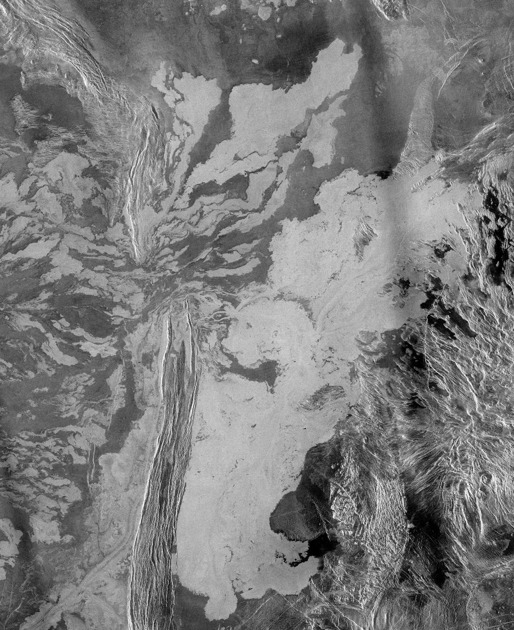
NASA Magellan spacecraft observed remnant landslide deposits apparently resulting from the collapse of volcanic structures. This radar image is centered in the southwestern Navka Region of Venus. http://photojournal.jpl.nasa.gov/catalog/PIA00262
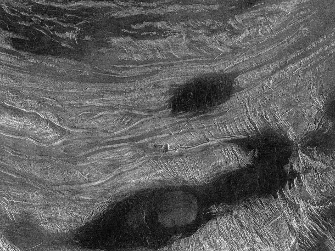
This radar image from NASA Magellan spacecraft shows a region located in a vast plain to the south of Aphrodite Terra. The data for this image was obtained in January 1991. http://photojournal.jpl.nasa.gov/catalog/PIA00202

This is a full resolution radar mosaic of the Lavinia region of Venus as seen by NASA Magellan spacecraft. This area shows a diverse set of geologic features. http://photojournal.jpl.nasa.gov/catalog/PIA00087
After traveling more than 1.5 billion kilometers 948 million miles, NASA Magellan spacecraft was inserted into orbit around Venus on Aug. 10, 1990. http://photojournal.jpl.nasa.gov/catalog/PIA00205
This compressed resolution radar mosaic from NASA Magellan spacecraft shows a 600 kilometers 360 mile segment of the longest channel discovered on Venus in 1990. http://photojournal.jpl.nasa.gov/catalog/PIA00245
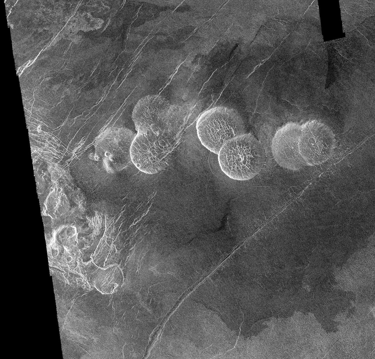
This image from NASA Magellan spacecraft, with radar illumination from west to east, shows three unusual volcanoes located in the Guinevere Planitia lowland. http://photojournal.jpl.nasa.gov/catalog/PIA00261
This image from NASA Magellan spacecraft shows part of the northern boundary of Ovda Regio, one of the large highlands ringing the equator of Venus. http://photojournal.jpl.nasa.gov/catalog/PIA00242

This full resolution radar mosaic from NASA Magellan spacecraft shows a 200 kilometer 124 mile segment of a sinuous channel on Venus. http://photojournal.jpl.nasa.gov/catalog/PIA00253
Ushas Mons, a volcano in the southern hemisphere of Venus is shown in this radar image from NASA Magellan spacecraft. The volcano is marked by numerous bright lava flows and a set of north-south trending fractures. http://photojournal.jpl.nasa.gov/catalog/PIA00272
This false color image from NASA's Magellan spacecraft shows a portion of Leda Planitia plains in the northern hemisphere of Venus, centered at 41 degrees north latitude, 52 degrees east longitude. http://photojournal.jpl.nasa.gov/catalog/PIA00105
These two radar images from NASA Magellan spacecraft are centered about 60.5 degrees south latitude and 348.8 degrees east longitude in the eastern Lavinia Region of Venus. http://photojournal.jpl.nasa.gov/catalog/PIA00247
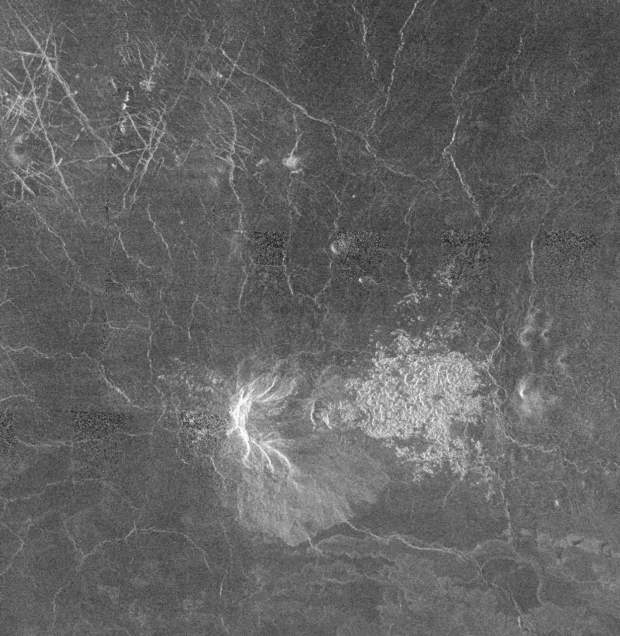
This area of Venus northeast of Ushas Mons measures 40 by 112 kilometers 25 by 70 miles and shows evidence of possible explosive volcanism as seen by NASA Magellan spacecraft. http://photojournal.jpl.nasa.gov/catalog/PIA00213
The view from NASA's Magellan spacecraft shows Yavine Corona, looking northeast. Coronae are roughly circular, volcanic features believed to form over hot upwellings of magma within the Venusian mantle. http://photojournal.jpl.nasa.gov/catalog/PIA00098
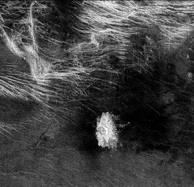
This set of three images from NASA Magellan spacecraft, shows a small volcano, lava plains distorted into wrinkle ridges, and some unusual wispy-appearing surface deposits. http://photojournal.jpl.nasa.gov/catalog/PIA00267
This image from NASA Magellan spacecraft shows an area of dark volcanic lava flows overlying the brighter surrounding plains which are thought to have been formed from older flows.

A portion of Alpha Regio is displayed in this three-dimensional perspective view of the surface of Venus from NASA Magellan spacecraft. In 1963, Alpha Regio was the first feature on Venus to be identified from Earth-based radar.
Crater Isabella is seen in this radar image from NASA Magellan spacecraft. The second largest impact crater on Venus, the crater is named in honor of the 15th Century queen of Spain, Isabella of Castile.
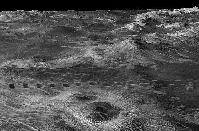
Three impact craters are displayed in this three-dimensional perspective view from NASA's Magellan spacecraft of the surface of Venus. The center of the image is located in the northwestern portion of Lavinia Planitia. http://photojournal.jpl.nasa.gov/catalog/PIA00103
This radar image mosaic of Venus from NASA Magellan spacecraft, is in the Lada region. The mosaic shows a system of east-trending radar-bright and dark lava flows encountering and breaching a north-trending ridge belt left of center.
This is a full resolution mosaic from NASA Magellan spacecraft shows a series of complex lava flows which emerge from the northern flank of Sif Mons, a large volcano just to the south.
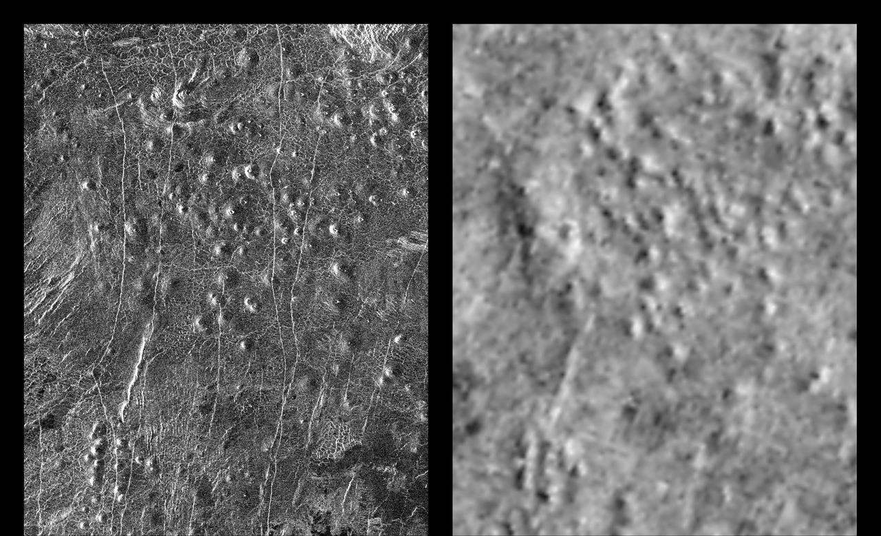
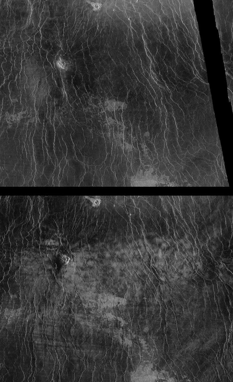
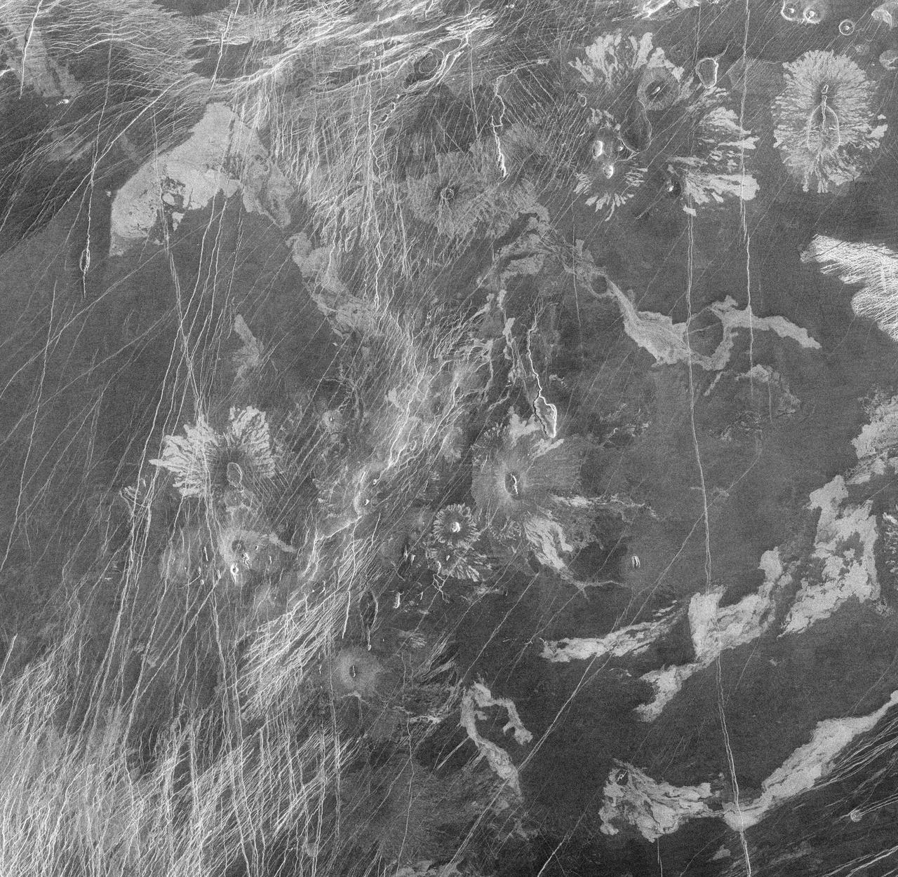
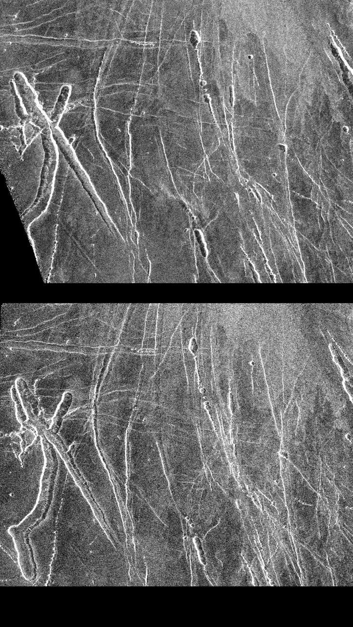
These radar images show an identical area on Venus (centered at 110 degrees longitude and 64 degrees north latitude) as imaged by the U.S. NASA Magellan spacecraft in 1991 (left) and the U.S.S.R. Venera 15/16 spacecraft in the early 1980's (right). Illumination is from the left (or west) in the Magellan image (left) and from the right (or east) in the Venera image (right). Differences in apparent shading in the images are due to differences in the two radar imaging systems. Prior to Magellan, the Venera 15/16 data was the best available for scientists studying Venus. Much greater detail is visible in the Magellan image owing to the greater resolution of the Magellan radar system. In the area seen here, approximately 200 small volcanoes, ranging in diameter from 2 to 12 kilometers (1.2 to 7.4 miles) can be identified. These volcanoes were first identified as small hills in Venera 15/16 images and were predicted to be shield-type volcanoes constructed mainly from eruptions of fluid lava flows similar to those that produce the Hawaiian Islands and sea floor volcanoes - a prediction that was confirmed by Magellan. These small shield-type volcanoes are the most abundant geologic feature on the surface of Venus, believed to number in the hundreds of thousands, perhaps millions, and are important evidence in understanding the geologic evolution of the planet. The only other planet in our Solar System with this large number of volcanoes is Earth. Clearly visible in the Magellan image are details of volcano morphology, such as variation in slope, the occurrence and size range of summit craters, and geologic age relationships between adjacent volcanoes, as well as additional volcanoes that were not identifiable in the Venera image. http://photojournal.jpl.nasa.gov/catalog/PIA00465
This figure shows the volcanic peak Idunn Mons in the Imdr Regio area of Venus. The topographic backbone brown color was derived from data obtained by NASA Magellan spacecraft and the overlay was derived from data from ESA Venus Express Spacecraft.
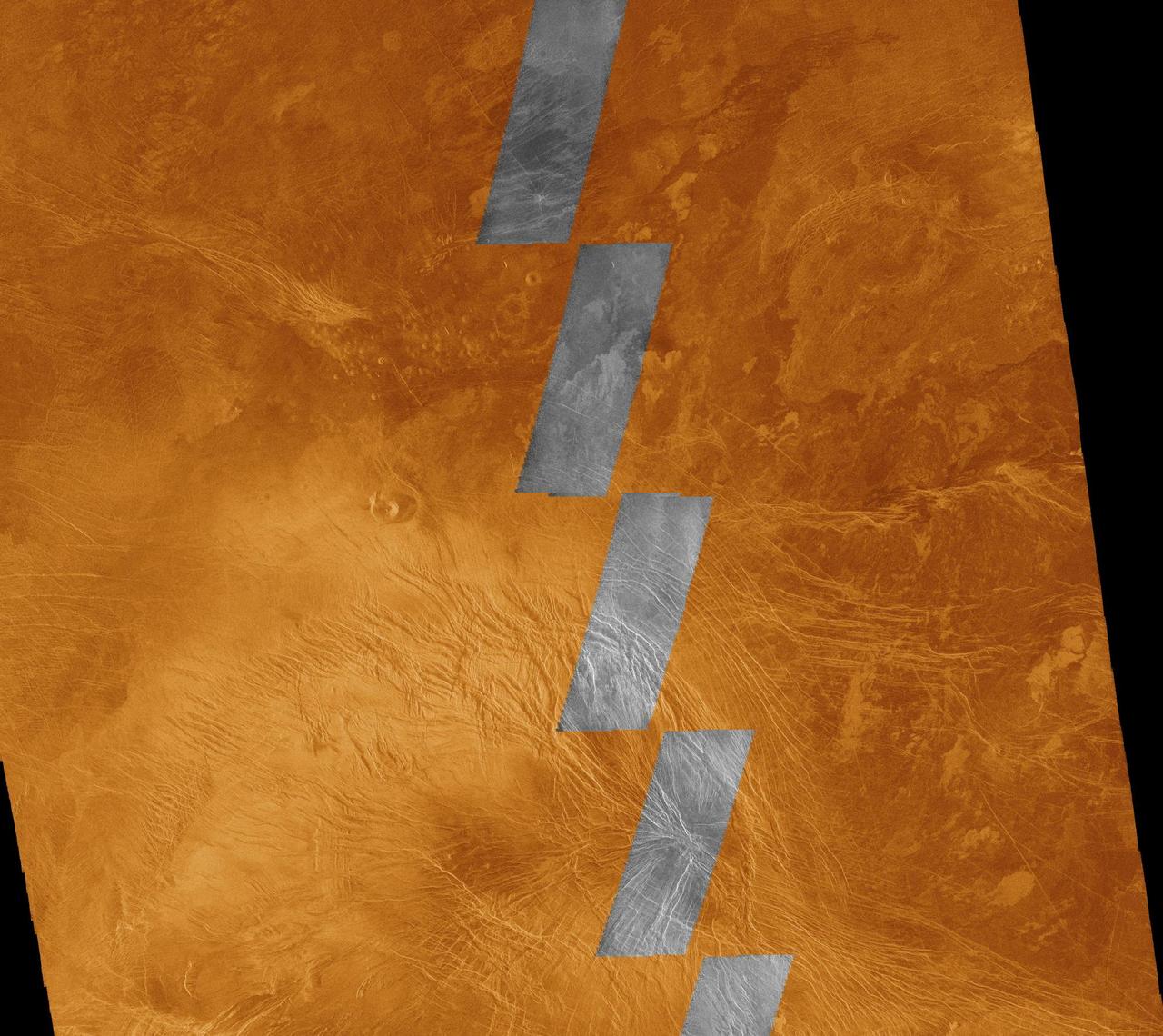
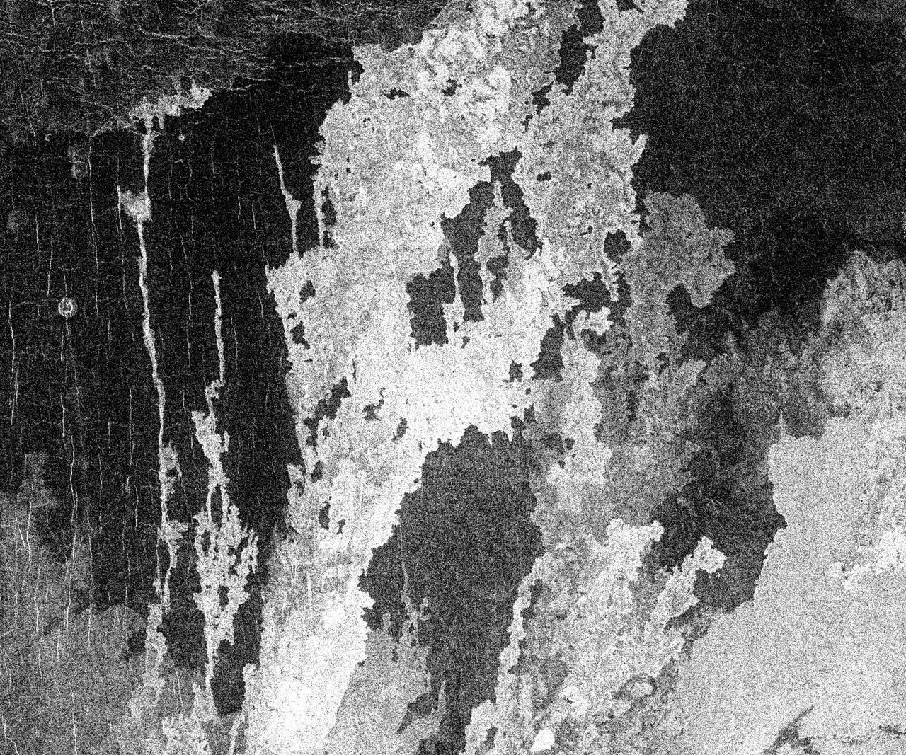
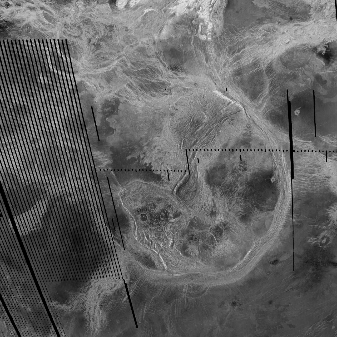
This image compares NASA Magellan data acquired in August 1990 during the initial test of the radar system black and white insets with data acquired by the spacecraft in April 1991 color background. The area is in the southern hemisphere of Venus. http://photojournal.jpl.nasa.gov/catalog/PIA00220
This radar image from NASA's Magellan spacecraft is of a half crater located in the rift between Rhea and Theia Montes in Beta Regio on Venus and has been cut by many fractures or faults since it was formed by the impact of a large asteroid. http://photojournal.jpl.nasa.gov/catalog/PIA00100
This is full-resolution mosaic from NASA Magellan spacecraft. The bright feature, slightly south of center is interpreted to be a volcano with a large apron of blocky debris to its right and some smaller aprons to its left. http://photojournal.jpl.nasa.gov/catalog/PIA00264
This view of the surface of Venus acquired by NASA Magellan spacecraft shows a geographically young region of lowland plains. The location is near the equator between two highland areas known as Asteria Regio and Phoebe Regio. http://photojournal.jpl.nasa.gov/catalog/PIA00237
This image is a full-resolution mosaic of several images from NASA Magellan spacecraft. The radar smooth region in the northern part of the image is Lakshmi Planum, a high plateau region above the mean planetary radius. http://photojournal.jpl.nasa.gov/catalog/PIA00240
This view from NASA's Magellan spacecraft is a close-up of Atete Corona, a 600-km-long and 450-km-wide feature at latitude 16 degrees S., longitude 244 degrees; looking north. http://photojournal.jpl.nasa.gov/catalog/PIA00097
The view from NASA's Magellan spacecraft shows a 100-km-wide nova superposed on Yavine Corona. Coronae are roughly circular, volcanic features believed to form over hot upwellings of magma within the Venusian mantle. http://photojournal.jpl.nasa.gov/catalog/PIA00150
The view from NASA's Magellan spacecraft shows most of Galindo V-40 quadrangle looking east; Atete Corona, in the foreground, is a 600-km-long and about 450-km-wide, circular volcano-tectonic feature. http://photojournal.jpl.nasa.gov/catalog/PIA00096
Many of the impact craters of Venus revealed by NASA Magellan spacecraft have characteristics unlike craters on any other planetary body. This crater, named Adivar, is located just north of the western Aphrodite highland. http://photojournal.jpl.nasa.gov/catalog/PIA00083
The view from NASA's Magellan spacecraft shows part of Galindo V40 quadrangle looking north; Nagavonyi Corona is in the foreground. Coronae are roughly circular, volcanic features believed to form over hot upwellings of magma within the Venusian mantle. http://photojournal.jpl.nasa.gov/catalog/PIA00095
This spectacular image from NASA's Magellan spacecraft is centered on 30 degrees south latitude, 135 degrees east longitude, spans 3500 kilometers 2170 miles from east to west left to right, and shows the near-circular trough of Artemis Chasma. http://photojournal.jpl.nasa.gov/catalog/PIA00101
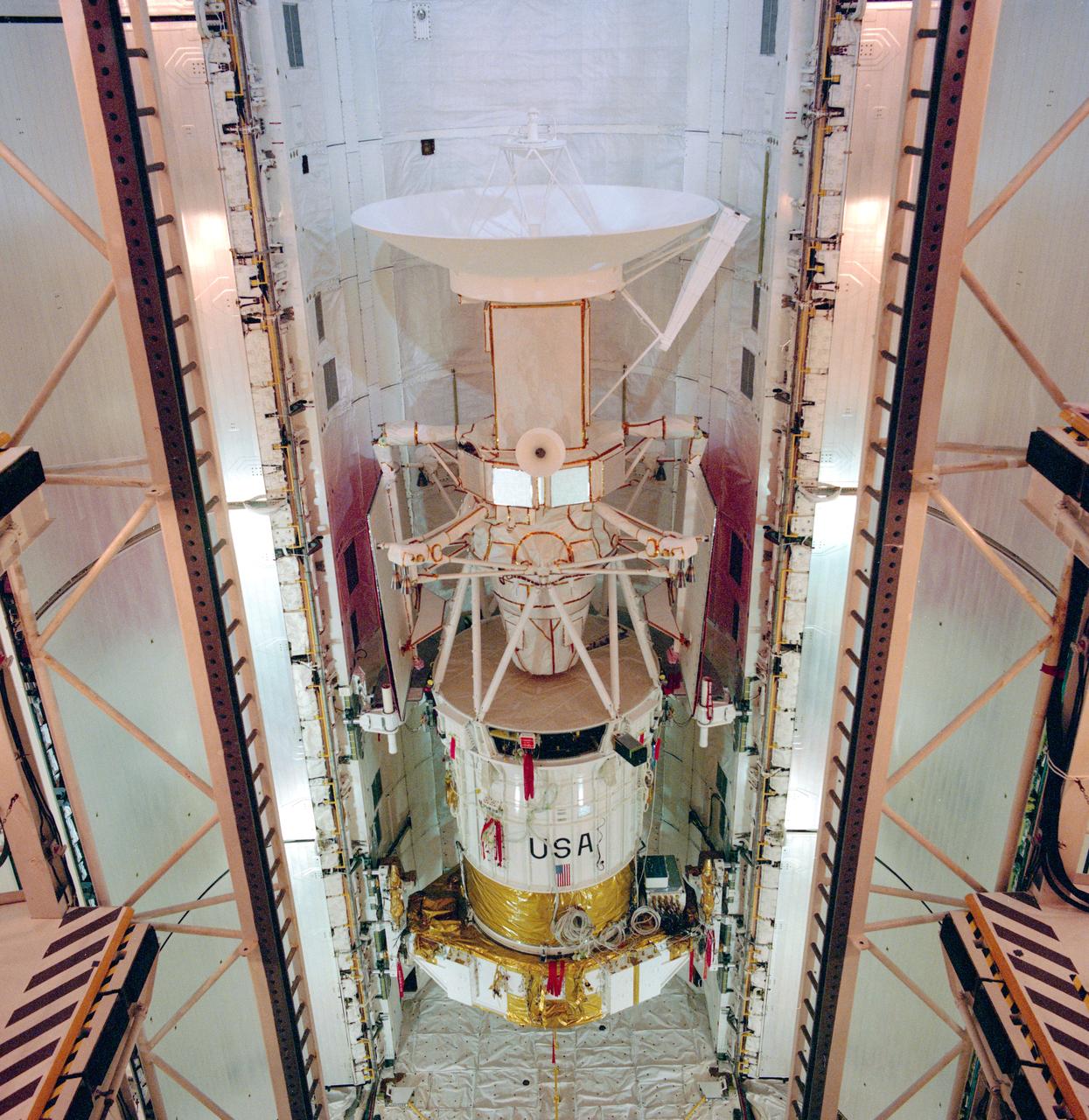
S89-30720 (29 March 1989) --- The spacecraft Magellan is in the payload bay of the orbiter Atlantis at launch pad 39-B. Magellan is scheduled to be released from Atlantis April 28, 1989, on NASA's STS-30 mission. Its mission will be the first U.S. planetary probe in over 10 years and it is the first deployed by the shuttle. The mission calls for the spacecraft to make the approximately 15-month journey to the planet Venus and perform radar mapping operations, transmitting the information back to NASA's Jet Propulsion Laboratory (JPL) in California.
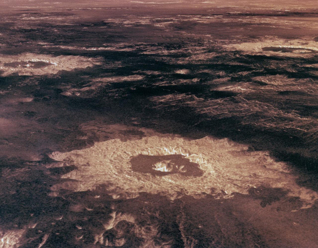
Three impact craters in three-dimensional perspective located approximately 27 degrees south latitude, 339 degrees east longitude in the northwestern portion of Lavinia Planitia. The viewpoint is located southwest of Howe Crater which appears centered in the lower portion of the image. Howe has a diameter of 37.3 kilometers (23.1 miles) located at 28.6 degrees south latitude, 337.1 degrees east longitude. Danilova, a crater with a diameter of 47.6 kilometers (29.5 miles) and located at 26.35 degrees south latitude and 337.5 east longitude, appears above and to the left of Howe in the image. Aglaonice, a crater with a diameter of 62.7 kilometers (38.9 miles) and located at 26.5 degrees south latitude and 340 degrees east longitude is on the right of Danilova. Magellan synthetic aperture radar data is combined with radar altimetry to develop a 3D map of the surface. Rays cast in a computer intersect the surface to create a 3D view. Simulated color and a digital elevation map developed by the United States (U.S.) Geological Survey is used to enhance small-scale structure. The simulated hues are based on color images recorded by the Soviet Venera 13 and 14 spacecraft. The image was processed at the Jet Propulsion Laboratory (JPL) Multimission Image Processing Laboratory and is a single frame from a video released at the JPL news conference 05-29-91. View provided by JPL with alternate number P-39146.
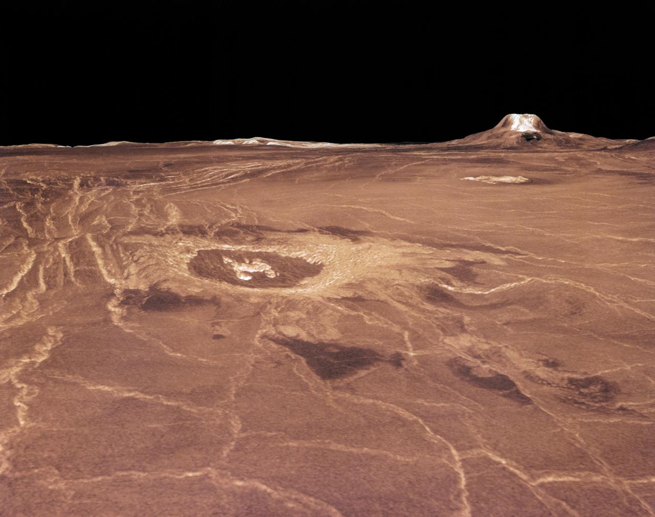
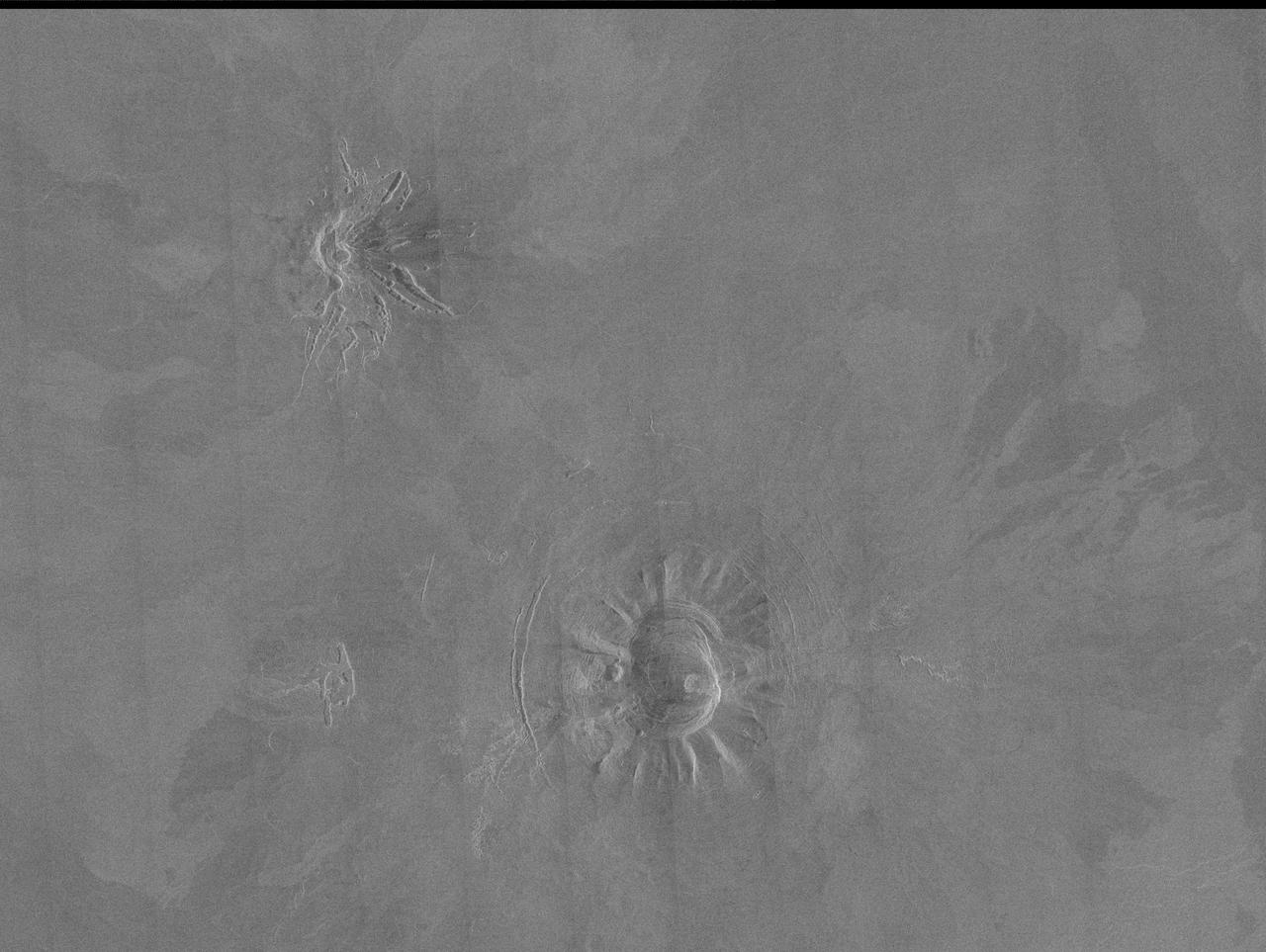
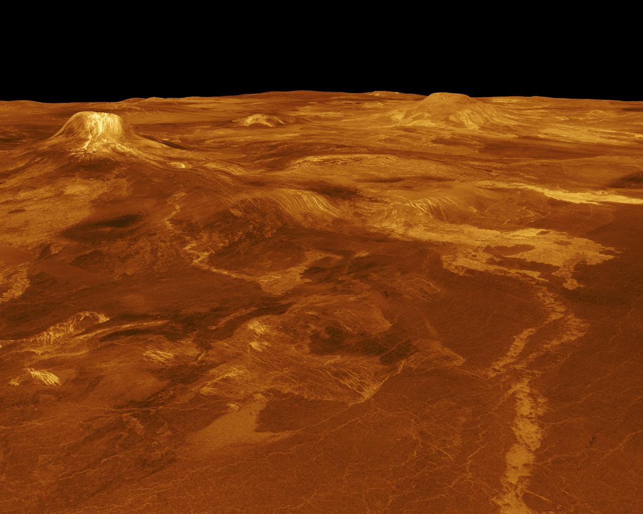
Magellan synthetic aperture radar data was used to create this three- dimensional (3D) perspective view of Venus' western Eistla Regio. This viewpoint is located at 1,310 kilometers (812 miles) southwest of Gula Mons at an elevation of 0.178 kilometers (0.48 miles). The view is of the northeast with Gula Mons appearing on the horizon. Gula Mons, a 3 kilometer (1.86 mile) high volcano, is located at approximately 22 degrees north latitude, 359 degrees east longitude. The impact crater Cunitz, named for the astronomer and mathematician Maria Cunitz, is visible in the center of the image. The crater is 48.5 kilometers (30 miles) in diameter and is 215 kilometers (133 miles) from the viewer's position. Magellan synthetic aperture radar data is combined with radar altimetry to develop a 3D map of the surface. Rays cast in a computer intersect the surface to create a 3D view. Simulated color and a digital elevation map developed by the United States (U.S.) Geological Survey is used to enhance small-scale structure. The simulated hues are based on color images recorded by the Soviet Venera 13 and 14 spacecraft. The image was produced at the Jet Propulsion Laboratory (JPL) Multimission Image Processing Laboratory and is a single frame from a video released at the JPL news conference 03-05-91. View was provided by JPL with alternate number P-38720 MGN76.
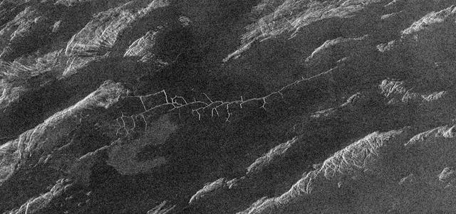
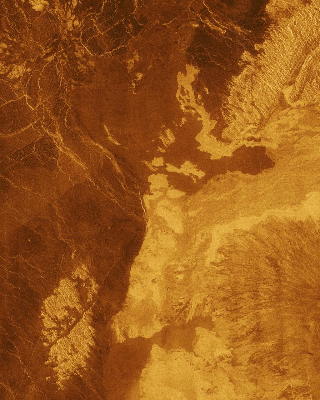
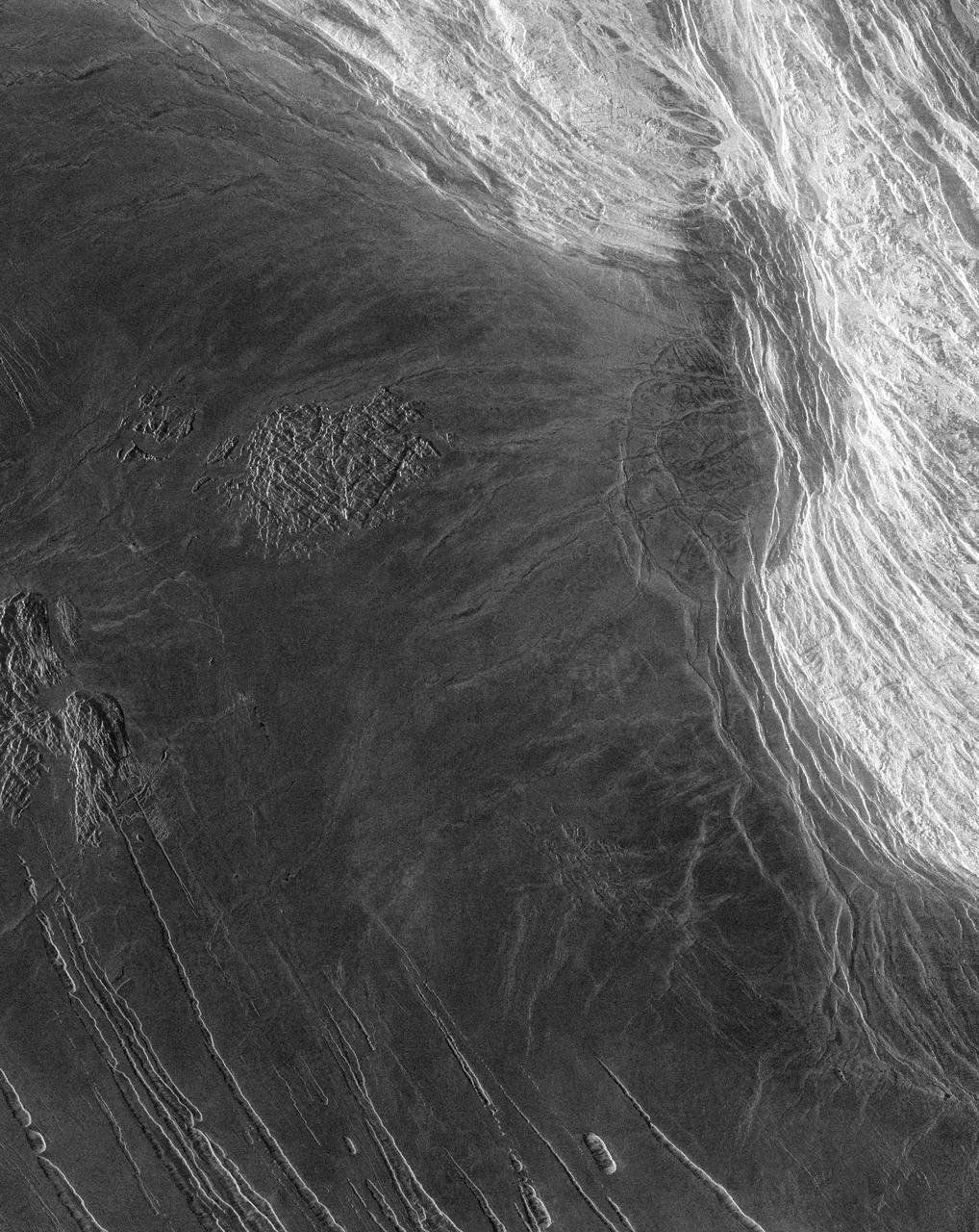
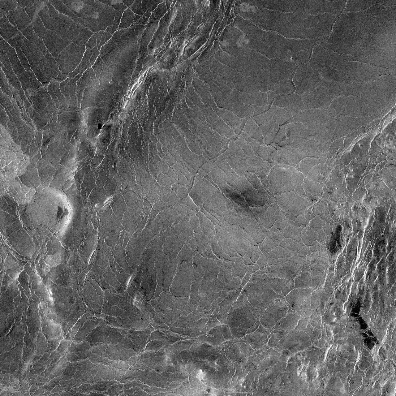
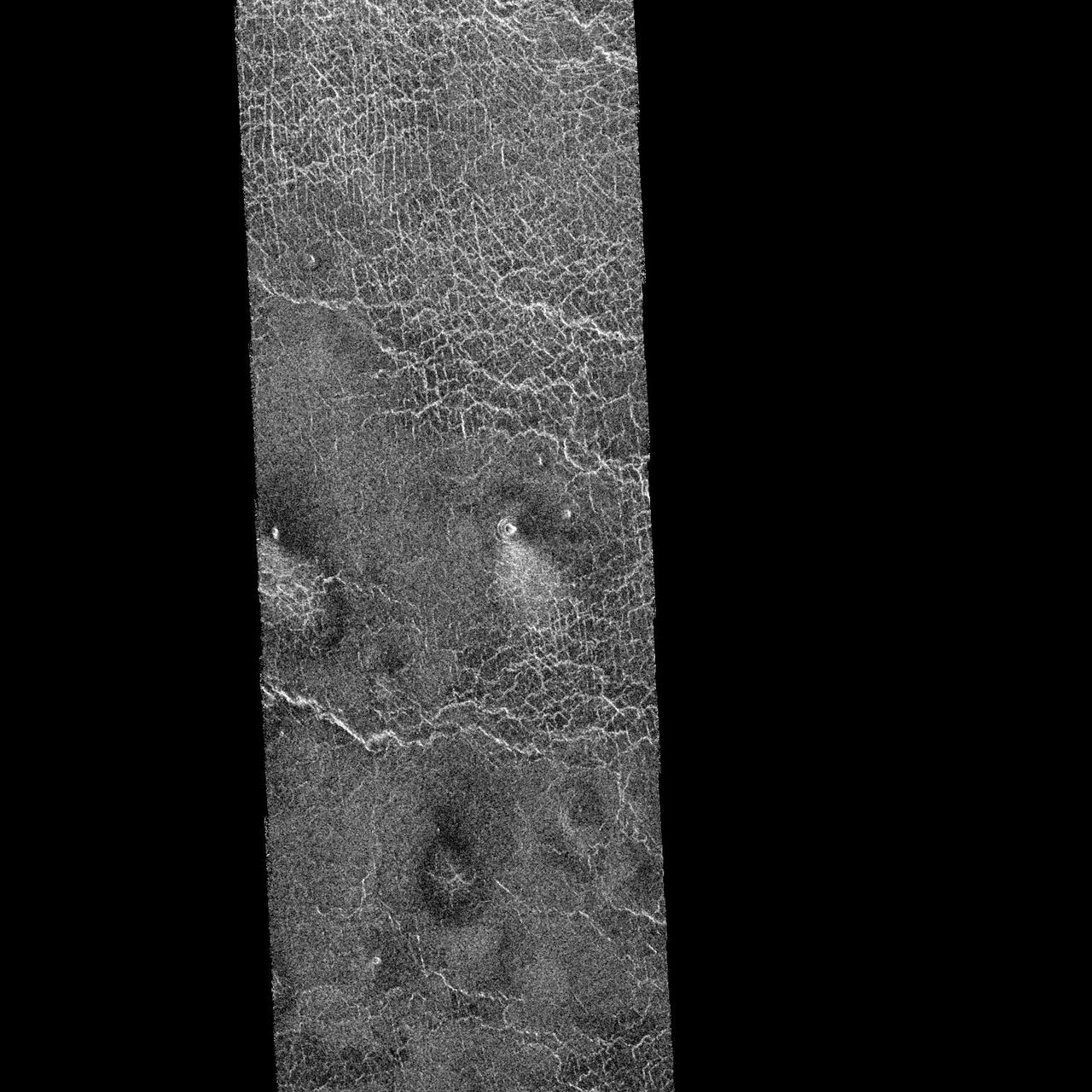
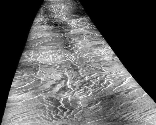
This image from NASA Magellan spacecraft covers region near Hestia Rupes on the northwestern corner of Aphrodite Terra. The complex network of narrow (<1 kilometer) fractures in the center of the image extends for approximately 50 kilometers (31 miles). This network exhibits tributary-like branches similar to those observed in river systems on Earth. However, the angular intersections of tributaries suggest tectonic control. These features appear to be due to drainage of lava along preexisting fractures and subsequent collapse of the surface. The underlying tectonic fabric can be observed in the northeast trending ridges which predate the plains. http://photojournal.jpl.nasa.gov/catalog/PIA00469

iss072e281189 (Nov. 28, 2024) --- This long-duration photograph looks out a window on the SpaceX Dragon crew spacecraft to the Large and Small Magellanic Clouds, two irregular dwarf galaxies, as the International Space Station orbited 260 miles above the Pacific Ocean northeast of Australia. Credit: NASA/Don Pettit

iss072e281085 (Nov. 28, 2024) --- This long-duration photograph looks out a window on the SpaceX Dragon crew spacecraft to the Large and Small Magellanic Clouds, two irregular dwarf galaxies, as the International Space Station orbited 260 miles above the Pacific Ocean off the coast of Mexico. Credit: NASA/Don Pettit
This image from NASA Magellan spacecraft is of Crater Stephania, located at 51.3 degrees latitude, 333.3 degrees longitude in northern Sedna Planitia on Venus. With a diameter of 11 kilometers (6.8 miles) it is one of the smaller craters on Venus. Because many small meteoroids disintegrate during their passage through the dense atmosphere, there is an absence of craters smaller than 3 kilometers (1.9 miles) in diameter, and even craters smaller than 25 kilometers (15.5 miles) are relatively scarce. The apron of ejected material suggests that the impacting body made contact with the surface from an oblique angle. Upon closer observation it is possible to delineate secondary craters, impact scars from blocks ejected from the primary crater. A feature associated with this and many other Venusian craters is a radar-dark halo. Since dark radar return signifies a smooth surface, it has been hypothesized that an intense shock wave removed or pulverized previously rough surface material or that a blanket of fine material was deposited during or after the impact. http://photojournal.jpl.nasa.gov/catalog/PIA00475
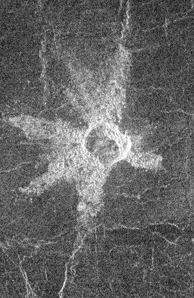
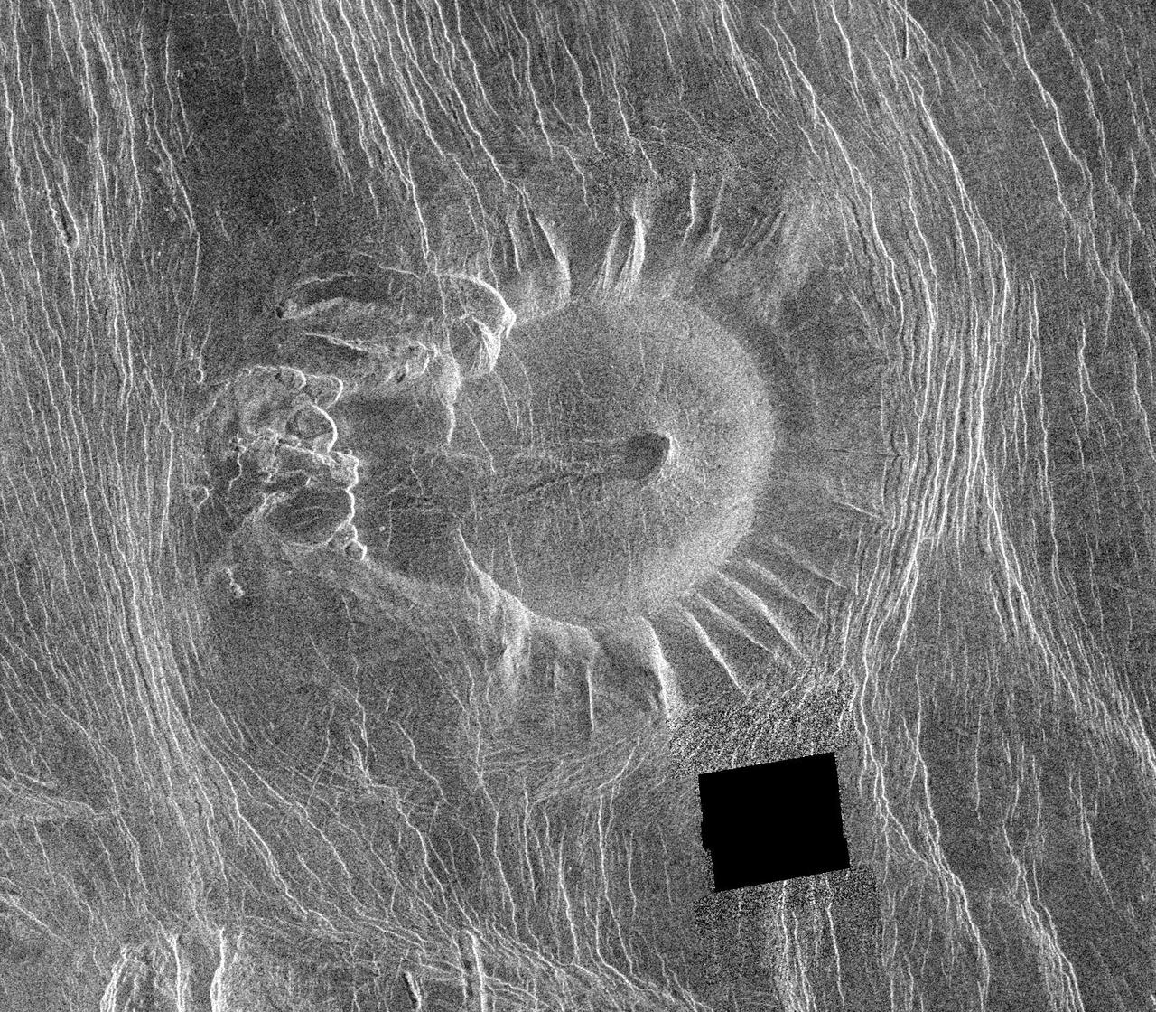
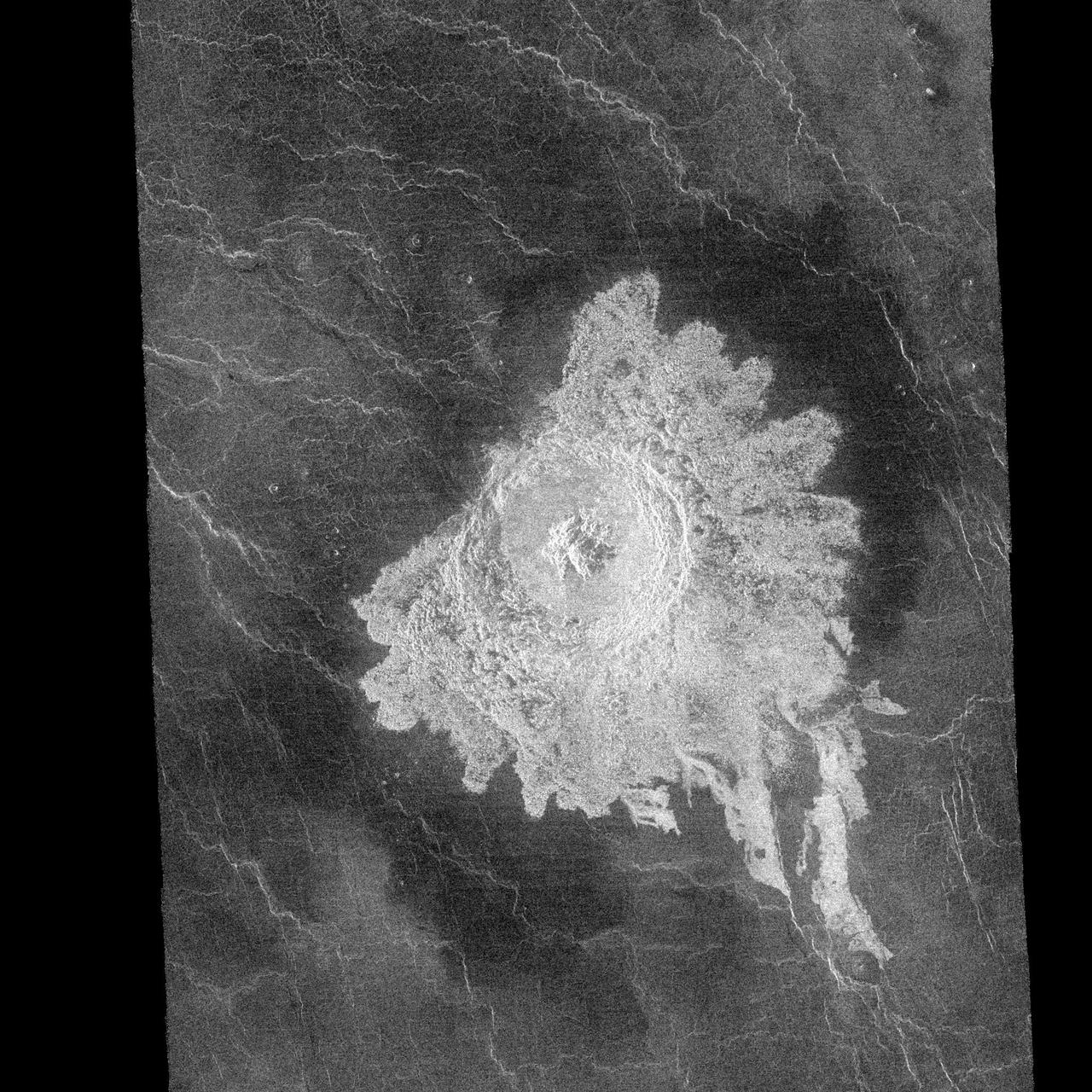
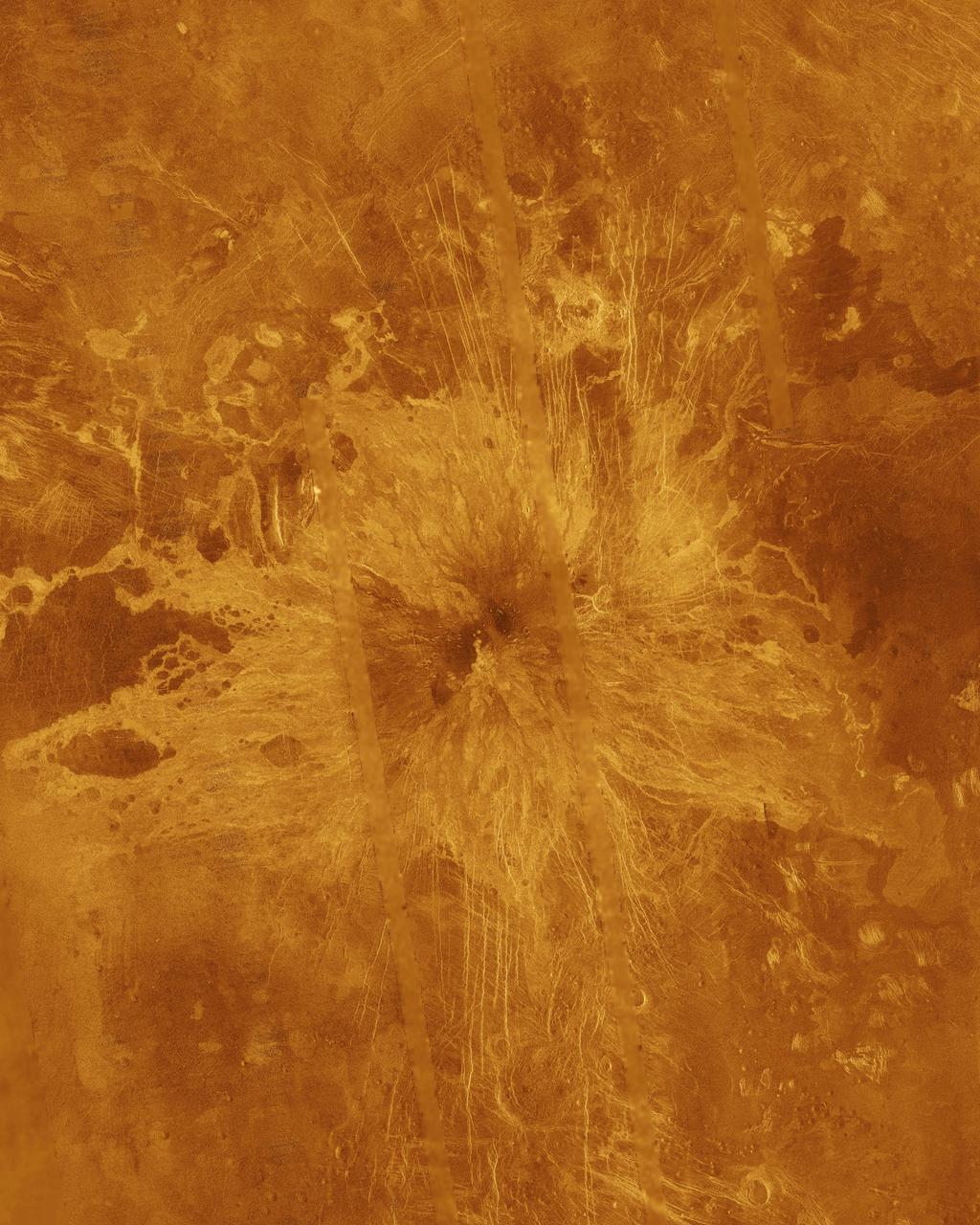
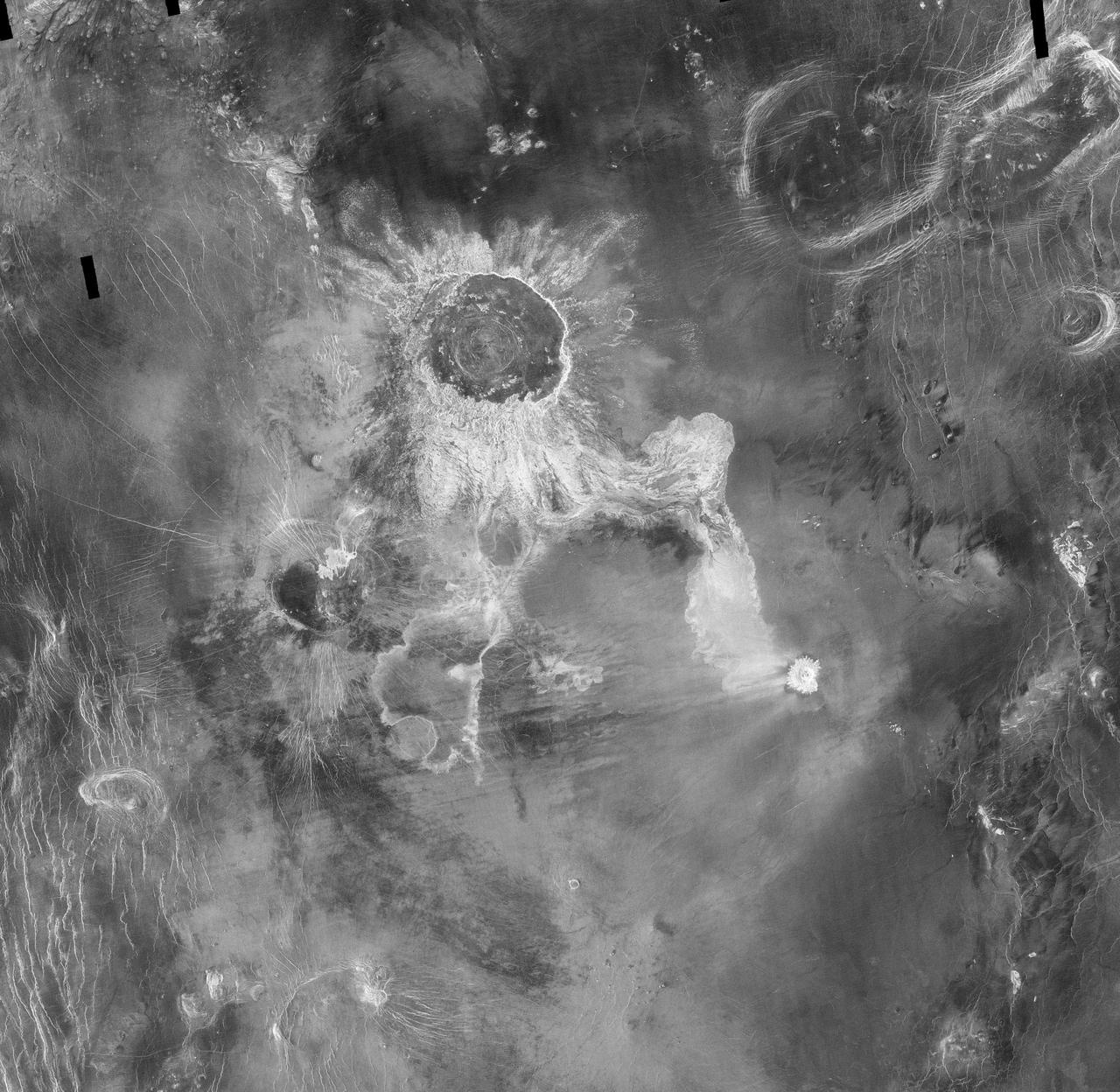
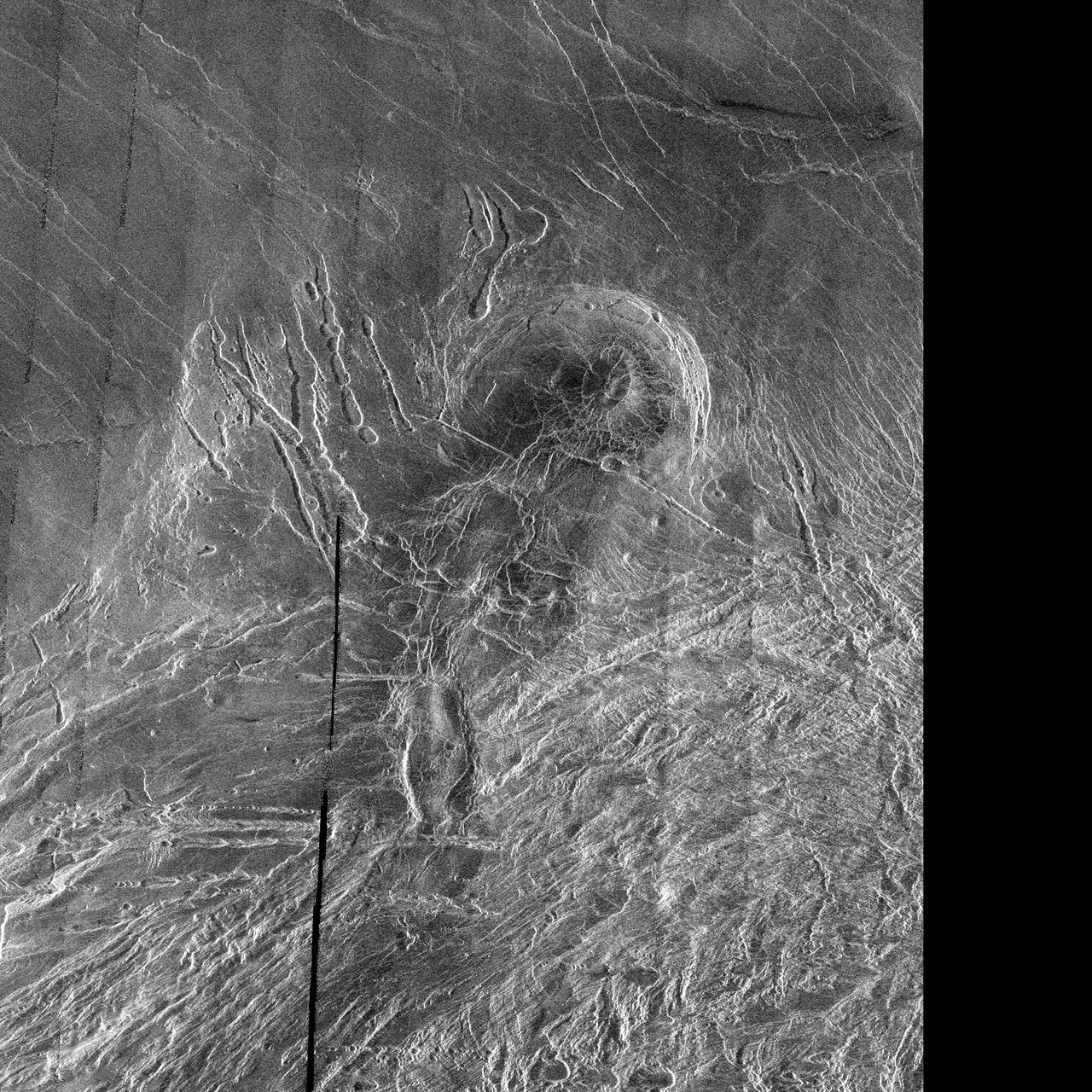
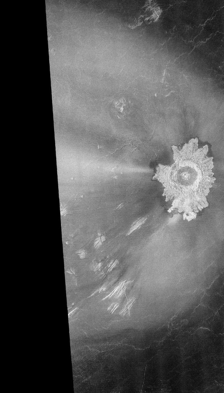
This image from NASA Magellan spacecraft shows the central Eistla Region of the equatorial highlands of Venus. It is centered at 15 degrees north latitude and 5 degrees east longitude. The image is 76.8 kilometers (48 miles) wide. The crater is slightly irregular in platform and approximately 6 kilometers (4 miles) in diameter. The walls appear terraced. Five or six lobes of radar-bright ejecta radiate up to 13.2 kilometers (8 miles) from the crater rim. These lobes are up to 3.5 kilometers (2 miles) in width and form a "starfish" pattern against the underlying radar-dark plains. The asymmetric pattern of the ejecta suggests the angle of impact was oblique. The alignment of two of the ejecta lobes along fractures in the underlying plains is apparently coincidental. http://photojournal.jpl.nasa.gov/catalog/PIA00466
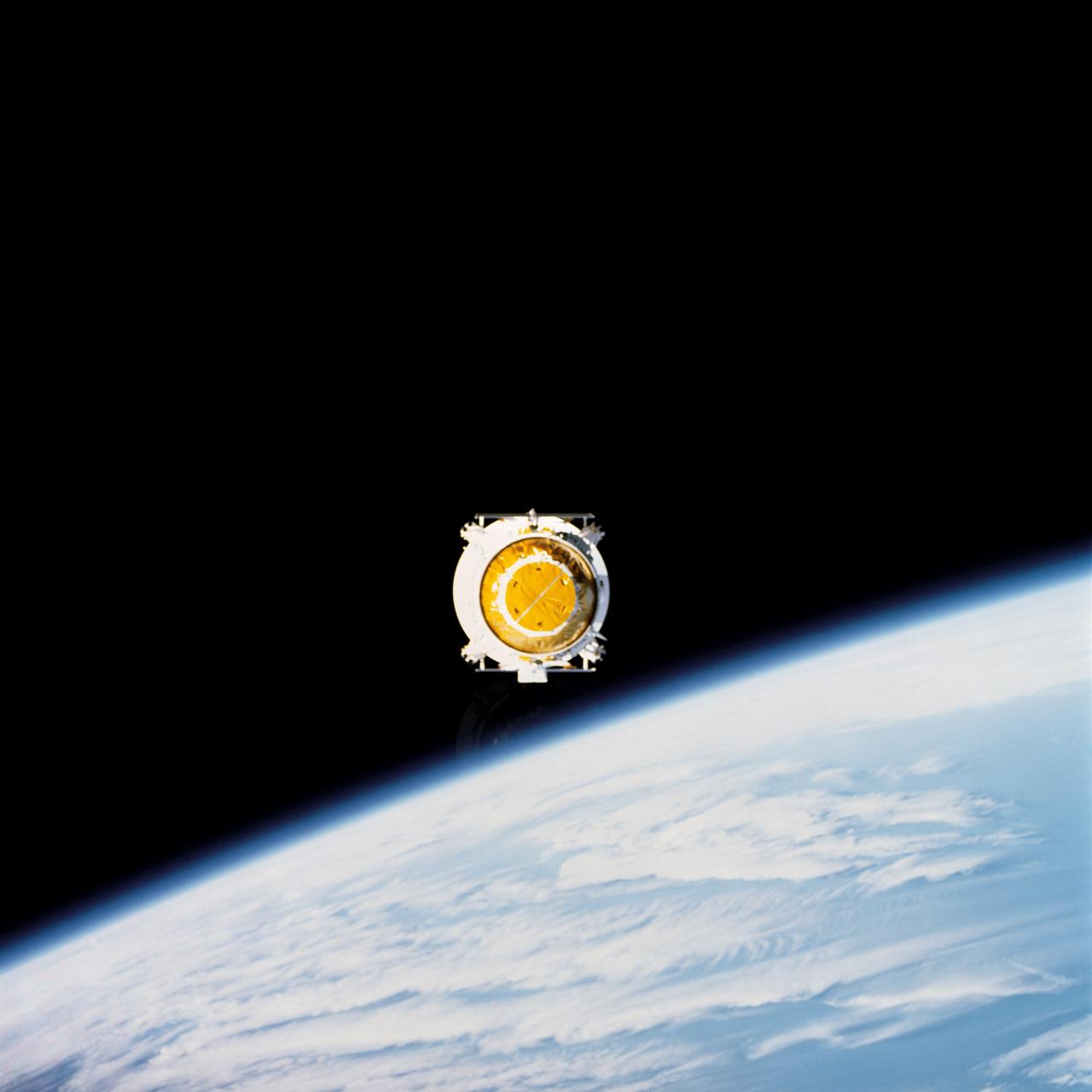
STS030-71-053 (4 May 1989) --- In the early evening hours of Space Shuttle Atlantis’ first day in space for the four-day STS-30 mission, the Magellan spacecraft is released into space to begin its long journey to the planet Venus for an extensive radar mapping mission. The scene was photographed through Atlantis’ aft flight deck windows with a handheld 70mm camera.

STS030-71-052 (4 May 1989) --- In the early evening hours of the Space Shuttle Atlantis' first day in space for the four-day mission, the Magellan spacecraft begins its long journey to the planet Venus for an extensive radar mapping mission. The scene was photographed through Atlantis' aft flight deck windows with a handheld 70mm camera.

This global view of Venus, centered at 270 degrees east longitude, is a compilation of data from several sources. Magellan synthetic aperature radar mosaics from the first cycle of Magellan mapping are mapped onto a computer-simulated globe to create the image. Data gaps are filled with Pioneer-Venus orbiter data, or a constant mid-range value. Simulated color is used to enhance small-scale structure. The simulated hues are based on color images recorded by the Soviet Venera 13 and 14 spacecraft. The image was produced at the Jet Propulsion Laboratory (JPL) Multimission Image Processing Laboratory and is a single frame from a video released at the JPL news conference, 10-29-91. View provided by JPL with alternate number P-39225 MGN81.
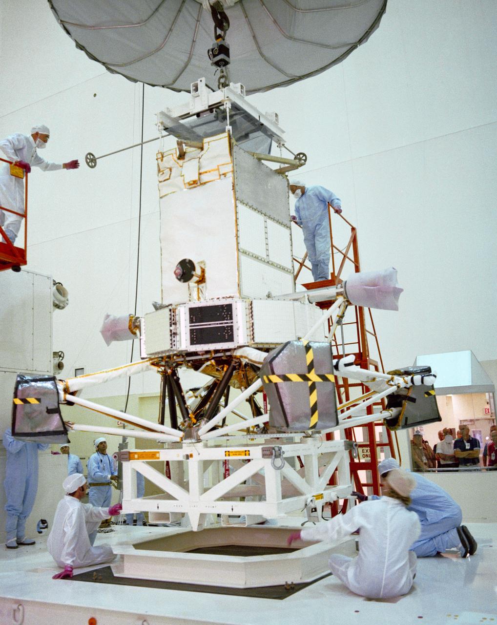
S89-25281 (8 Oct 1988) --- The Magellan spacecraft is hoisted from the transport trailer of the Payload Environmental Transportation System (PETS) to the floor of the cleanroom in the SAEF-2 planetary checkout facility at the Kennedy Space Center (KSC). The spacecraft, destined for unprecedented studies of Venusian topographic features, is to be deployed by the crew of NASA's STS-30 mission in April 1989.

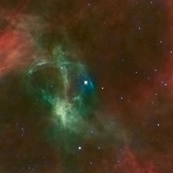
Image release June 22, 2010 A spectacular new NASA/ESA Hubble Space Telescope image — one of the largest ever released of a star-forming region — highlights N11, part of a complex network of gas clouds and star clusters within our neighbouring galaxy, the Large Magellanic Cloud. This region of energetic star formation is one of the most active in the nearby Universe. The Large Magellanic Cloud contains many bright bubbles of glowing gas. One of the largest and most spectacular has the name LHA 120-N 11, from its listing in a catalogue compiled by the American astronomer and astronaut Karl Henize in 1956, and is informally known as N11. Close up, the billowing pink clouds of glowing gas make N11 resemble a puffy swirl of fairground candy floss. From further away, its distinctive overall shape led some observers to nickname it the Bean Nebula. The dramatic and colourful features visible in the nebula are the telltale signs of star formation. N11 is a well-studied region that extends over 1000 light-years. It is the second largest star-forming region within the Large Magellanic Cloud and has produced some of the most massive stars known. It is the process of star formation that gives N11 its distinctive look. Three successive generations of stars, each of which formed further away from the centre of the nebula than the last, have created shells of gas and dust. These shells were blown away from the newborn stars in the turmoil of their energetic birth and early life, creating the ring shapes so prominent in this image. Beans are not the only terrestrial shapes to be found in this spectacular high resolution image from the NASA/ESA Hubble Space Telescope. In the upper left is the red bloom of nebula LHA 120-N 11A. Its rose-like petals of gas and dust are illuminated from within, thanks to the radiation from the massive hot stars at its centre. N11A is relatively compact and dense and is the site of the most recent burst of star development in the region. Other star clusters abound in N11, including NGC 1761 at the bottom of the image, which is a group of massive hot young stars busily pouring intense ultraviolet radiation out into space. Although it is much smaller than our own galaxy, the Large Magellanic Cloud is a very vigorous region of star formation. Studying these stellar nurseries helps astronomers understand a lot more about how stars are born and their ultimate development and lifespan. Both the Large Magellanic Cloud and its small companion, the Small Magellanic Cloud, are easily seen with the unaided eye and have always been familiar to people living in the southern hemisphere. The credit for bringing these galaxies to the attention of Europeans is usually given to Portuguese explorer Fernando de Magellan and his crew, who viewed it on their 1519 sea voyage. However, the Persian astronomer Abd Al-Rahman Al Sufi and the Italian explorer Amerigo Vespucci recorded the Large Magellanic Cloud in 964 and 1503 respectively. Credit: NASA, ESA and Jesús Maíz Apellániz (Instituto de Astrofísica de Andalucía, Spain) To learn more about Hubble go to: <a href="http://www.nasa.gov/mission_pages/hubble/main/index.html" rel="nofollow">www.nasa.gov/mission_pages/hubble/main/index.html</a> <b><a href="http://www.nasa.gov/centers/goddard/home/index.html" rel="nofollow">NASA Goddard Space Flight Center</a></b> is home to the nation's largest organization of combined scientists, engineers and technologists that build spacecraft, instruments and new technology to study the Earth, the sun, our solar system, and the universe.
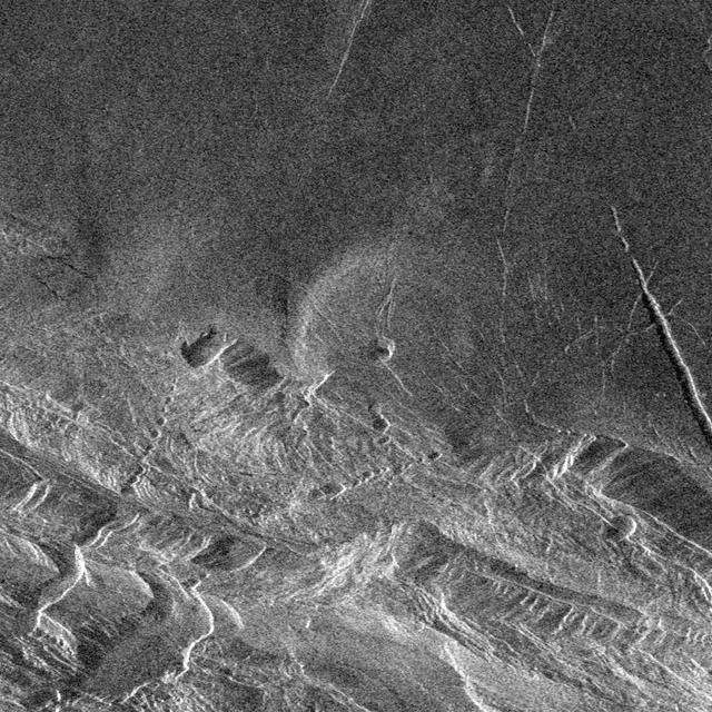
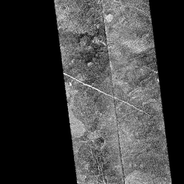
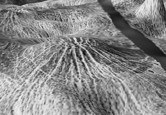
This image from NASA Magellan spacecraft is centered at approximately 29.6 degrees south latitude and 341 degrees east longitude in the Lavinia Region of Venus. Volcanic vent areas in this part of the plains west of Alpha Regio consist of domes and pits up to nearly 3 kilometers across. Extending eastward these features are sinuous channels, most of which are about 10 kilometers or more long. The channels narrow away from the pits and for most of their lengths are about 1 kilometer in diameter. The nearest planetary analogues for these features are sinuous rilles on the moon. These have been explained as lava channels and/or the result of lava erosion. On Earth lava channels form by downhill drainage of a lava flow leaving a channel behind. Lava may continue to flow in the channel once it has formed. However, lava channels on Earth are normally only a few meters or tens of meters wide. On the other hand, they may be the result of lava erosion. This is a process that only normally occurs to a limited extent on Earth because melting is inhibited by the cool upper layers of the planet. Also, lavas rarely flow turbulently enough to cause mechanical erosion. On Venus the surface materials are already at high temperatures, thus assisting thermal erosion and it is possible that lavas which may flow turbulently are more readily available than on Earth. Resolution of the Magellan data is about 120 meters (400 feet). http://photojournal.jpl.nasa.gov/catalog/PIA00467

This image covers part of the 150 kilometer (90 mile) wide, 1 to 1.5 kilometer (0.6 to 0.9 mile) deep valley, Devana Chasma. The image is a composite of the first two orbits recorded by NASA's Magellan spacecraft in August 1990 superimposed on Pioneer Venus topography. This image is located at the intersection of Devana Chasma and the Phoebe Regio upland. It covers a region approximately 525 by 525 kilometers (315 by 315 miles), centered 288 degrees east longitude on the equator. Devana Chasma consists of radar bright lineaments, interpreted to be fault scarps, oriented in a north-northeast direction. This part of the planet is thought to be an area where the crust is being stretched and pulled apart producing a rift valley, similar to the East African rift. http://photojournal.jpl.nasa.gov/catalog/PIA00464

S89-30719 (22 March 1989) --- Space shuttle Atlantis is seen soon in duplicate, thanks to reflection in nearby water, after arriving at Pad 39-B. The spacecraft left the vehicle assembly building (VAB) at 12:01A.M. and arrived to this point at 7 A.M. Atlantis is scheduled for NASA STS-30 mission on which the Magellan will be deployed to orbit planet Venus and map its topographic features. Launch is scheduled for April 28.
This full-resolution image from NASA Magellan spacecraft shows Jeanne crater, a 19.5 kilometer (12 mile) diameter impact crater. Jeanne crater is located at 40.0 degrees north latitude and 331.4 degrees longitude. The distinctive triangular shape of the ejecta indicates that the impacting body probably hit obliquely, traveling from southwest to northeast. The crater is surrounded by dark material of two types. The dark area on the southwest side of the crater is covered by smooth (radar-dark) lava flows which have a strongly digitate contact with surrounding brighter flows. The very dark area on the northeast side of the crater is probably covered by smooth material such as fine-grained sediment. This dark halo is asymmetric, mimicking the asymmetric shape of the ejecta blanket. The dark halo may have been caused by an atmospheric shock or pressure wave produced by the incoming body. Jeanne crater also displays several outflow lobes on the northwest side. These flow-like features may have formed by fine-grained ejecta transported by a hot, turbulent flow created by the arrival of the impacting object. Alternatively, they may have formed by flow of impact melt. http://photojournal.jpl.nasa.gov/catalog/PIA00472

STS030-72-047 (4 May 1989) --- In the early evening hours of Atlantis?s first day in space for the four-day STS-30 mission, the Magellan spacecraft is released into space to begin its long journey to the planet Venus for an extensive radar mapping mission. The scene was photographed through Atlantis?s aft flight deck windows with a handheld 70mm camera.
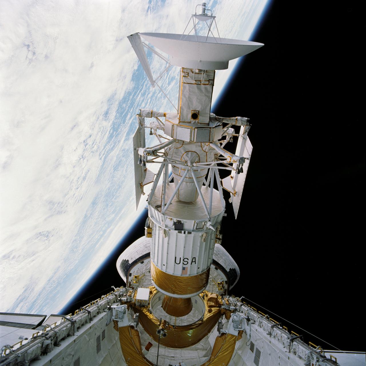
STS030-72-046 (4 May 1989) --- In the early evening hours of the Space Shuttle Atlantis' first day in space for the four-day STS-30 mission, the Magellan spacecraft is released into space to begin its long journey to the planet Venus for an extensive radar mapping mission. The scene was photographed through Atlantis' aft flight deck windows with a handheld 70mm camera.
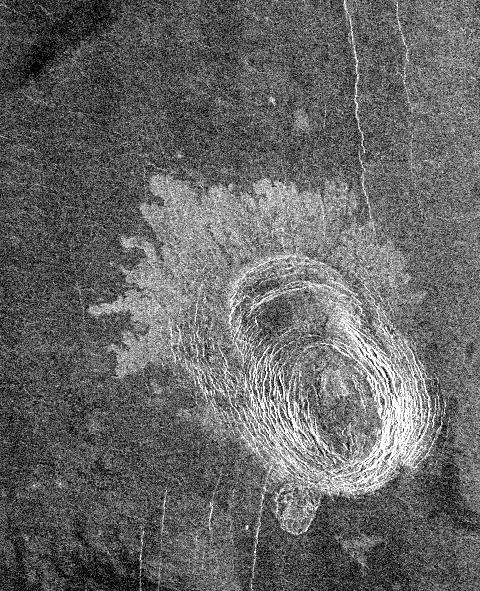
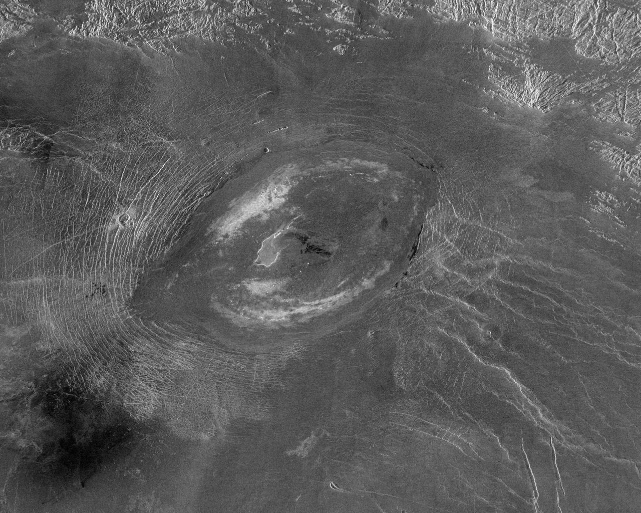
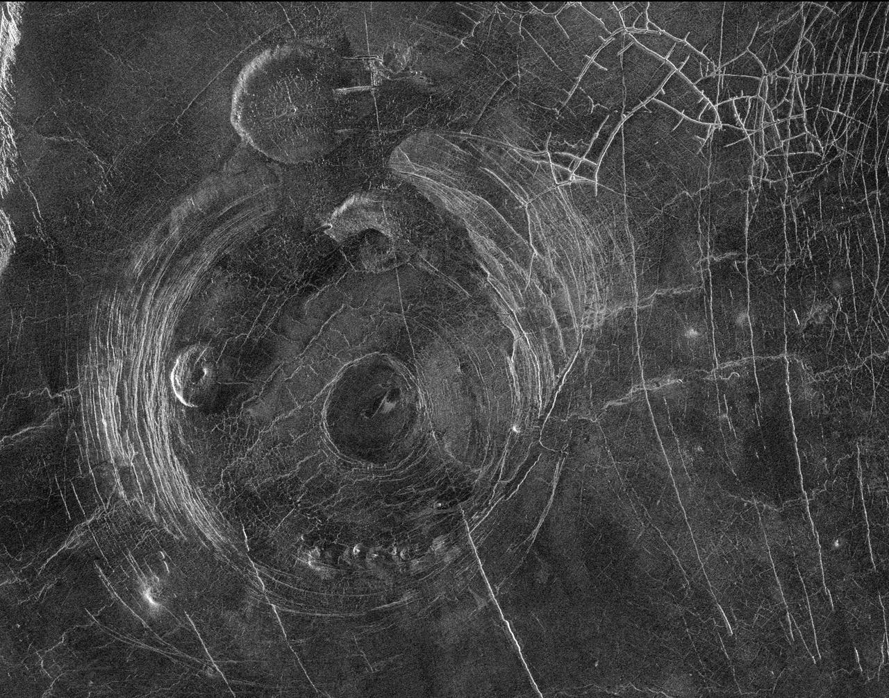
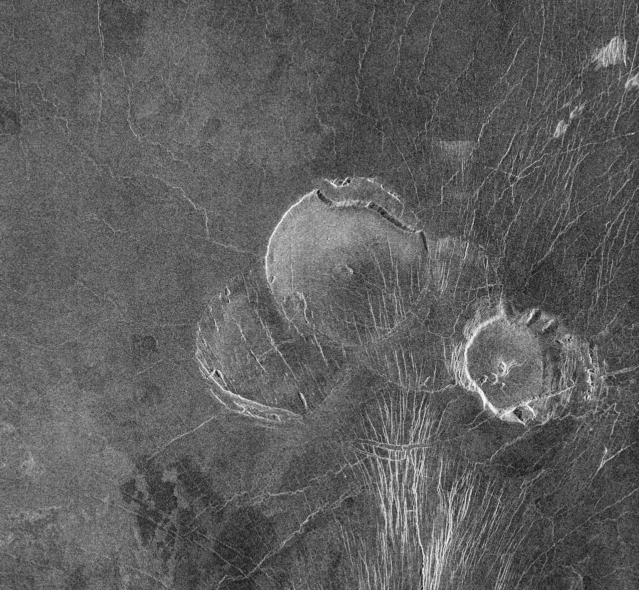
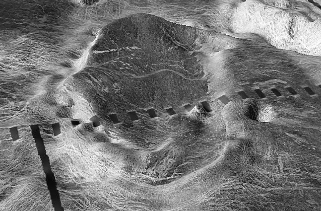
This image from NASA Magellan spacecraft is of Sachs Patera on Venus, centered at 49 degrees north, 334 degrees east. Defined as a sag-caldera, Sachs is an elliptical depression 130 meters (81 feet) in depth, spanning 40 kilometers (25 miles) in width along its longest axis. The morphology implies that a chamber of molten material drained and collapsed, forming a depression surrounded by concentric scarps spaced 2-to-5 kilometers (1.2- to-3 miles) apart. The arc-shaped set of scarps, extending out to the north from the prominent ellipse, is evidence for a separate episode of withdrawal; the small lobe-shaped extension to the southwest may represent an additional event. Solidified lava flows 10-to-25 kilometers (6-to-16 miles) long, give the caldera its flower-like appearance. The flows are a lighter tone of gray in the radar data because the lava is blockier in texture and consequently returns more radar waves. Much of the lava, which was evacuated from the chamber, probably traveled to other locations underground, while some of it may have surfaced further south. This is unlike calderas on Earth, where a rim of lava builds up in the immediate vicinity of the caldera. http://photojournal.jpl.nasa.gov/catalog/PIA00473

The STS-30 patch depicts the joining of NASA's manned and unmanned space programs. The sun and inner planets of our solar system are shown with the curve connecting Earth and Venus symbolizing the shuttle orbit, the spacecraft trajectory toward Venus, and its subsequent orbit around our sister planet. A Spanish caravel similar to the ship on the official Magellan program logo commemorates the 16th century explorer's journey and his legacy of adventure and discovery. Seven stars on the patch honor the crew of Challenger. The five-star cluster in the shape of the constellation Cassiopeia represent the five STS-30 crewmembers - Astronauts David Walker, Ronald Grabe, Norman Thagard, Mary Cleave and Mark Lee - who collectively designed the patch.

S89-20025 (3 March 1989) --- The STS-30 patch depicts the joining of NASA's manned and unmanned space programs. The sun and inner planets of our solar system are shown with the curve connecting Earth and Venus symbolizing the shuttle orbit, the spacecraft trajectory toward Venus and its subsequent orbit around our sister planet. A Spanish caravel similar to the ship on the official Magellan program logo commemorates the 16th century explorer's journey and his legacy of adventure and discovery. Seven stars on the patch honor the crew of Challenger. The five-star cluster in the shape of the constellation Cassiopeia represent the five STS-30 crew members--astronauts David M. Walker, Ronald J. Grabe, Norman E. Thagard, Mary L. Cleave and Mark C. Lee-who collectively designed the patch. The NASA insignia design for space shuttle flights is reserved for use by the astronauts and for other official use as the NASA Administrator may authorize. Public availability has been approved only in the forms of illustrations by the various news media. When and if there is any change in this policy, which is not anticipated, the change will be publicly announced. Photo credit: NASA

In April 2025, just weeks after its launch, NASA's SPHEREx mission revealed a cloud of dust in a patch of sky inside the Large Magellanic Cloud, a dwarf galaxy near the Milky Way, when making observations in a specific infrared wavelength (3.29 microns). The difference between the images illustrates the power of multiwavelength observations for revealing hidden features of the universe – a key feature of SPHEREx. Observing individual wavelengths of light from cosmic sources is called spectroscopy. This technique can be used to reveal the composition of objects, because chemical elements and molecules leave a unique signature in the colors they absorb and emit. Spectroscopy can also help scientists measure how far away galaxies are, making it essential for SPHEREx's goal of mapping the locations of hundreds of millions of galaxies in 3D. SPHEREx detects infrared light, which is invisible to the human eye, but is represented here in visible colors. The observatory will map the entire sky in 102 infrared colors (or wavelengths of light) to learn more about our universe. To do this, the mission images every object in the sky 102 times, each in a different wavelength. The spacecraft will map the entire sky four times over two years. https://photojournal.jpl.nasa.gov/catalog/PIA26352
This global view of the surface of Venus is centered at 180 degrees east longitude. Magellan synthetic aperture radar mosaics from the first cycle of Magellan mapping, and a 5 degree latitude-longitude grid, are mapped onto a computer-simulated globe to create this image. Data gaps are filled with Pioneer-Venus Orbiter data, or a constant mid-range value. The image was produced by the Solar System Visualization project and the Magellan Science team at the JPL Multimission Image Processing Laboratory. http://photojournal.jpl.nasa.gov/catalog/PIA00478
This image covers much of Ovda Regio, which forms the western part of Aphrodite Terra. It covers an area about 2,250 kilometers (1,386 miles) wide by 1,300 kilometers (800 miles) north to south, and ranges in latitude from 8 degrees north to 12 degrees south and in longitude from 62 degrees east to 90 degrees east. Ovda Regio is a highland region that rises over 4 kilometers (2.5 miles) above the surrounding plain. Magellan images show a complex surface, with several generations of structures. A pervasive fabric of irregular broad domes and ridges and associated curvilinear valleys was flooded by lava, then fractured. The circular feature surrounded by dark lava flows in the western part of the image is a caldera, or large volcanic collapse pit. Late-stage extension created long graben, or fault-bounded valleys, is best seen near the center of the image. The northern boundary of Ovda Regio is a steep, curvilinear mountain belt made up of long, narrow, rounded ridges. These ridges are similar in appearance to folded mountain belts on Earth. Several impact craters, such as the circular features on the western margin of the image, are scattered across the area. The bright area in the southeast part of the image indicates the presence of a radar-reflective mineral such as pyrite. Most of the highland areas on Venus display a similar bright signal. Each pixel of this image covers an area on the surface 675 meters (2,215 feet) across, representing a 9- times reduction in resolution compared to full-scale resolution data. http://photojournal.jpl.nasa.gov/catalog/PIA00146
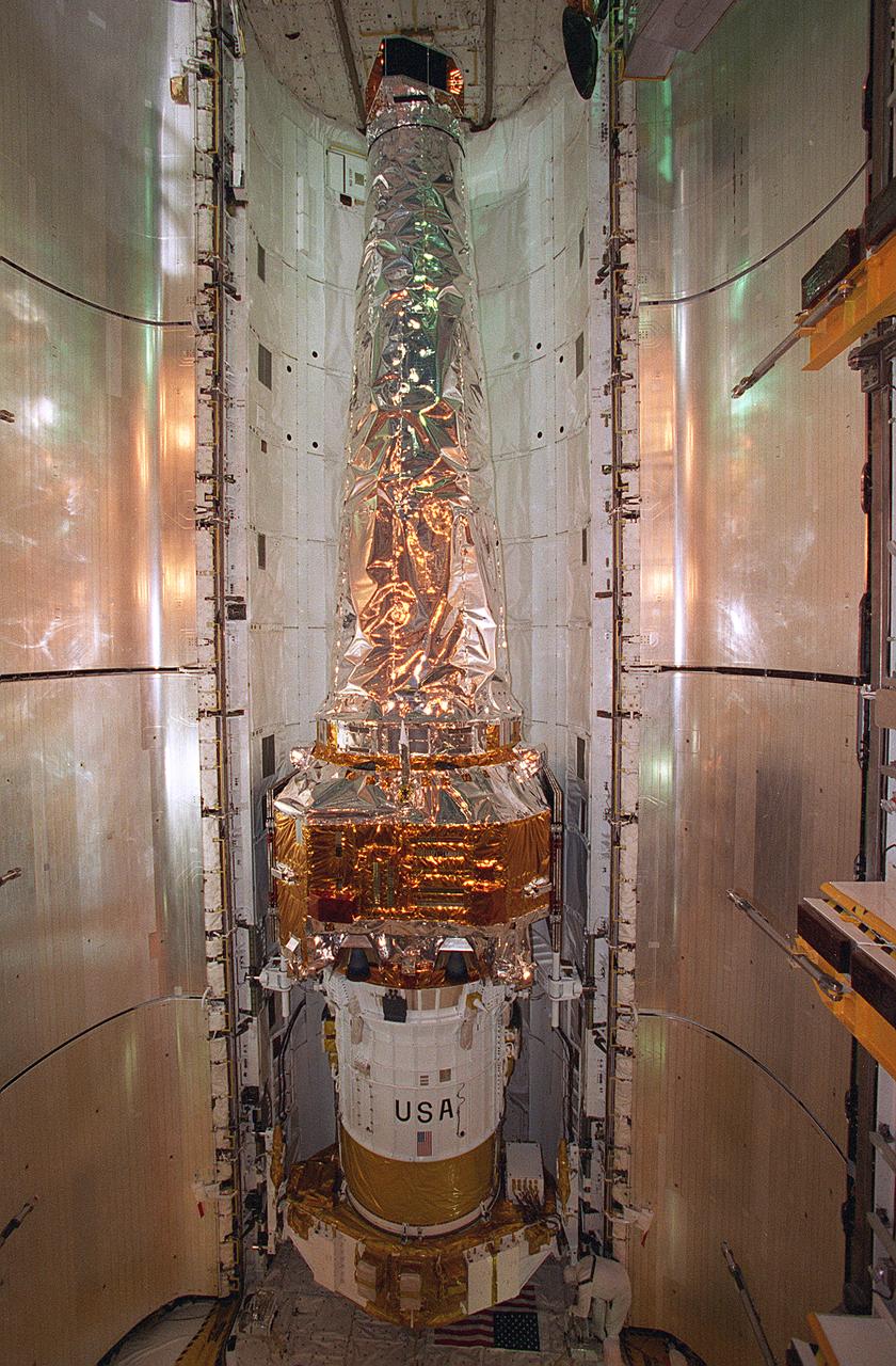
In this photograph, the Chandra X-Ray Observatory (CXO) was installed and mated to the Inertial Upper Stage (IUS) inside the Shuttle Columbia's cargo bay at the Kennedy Space Center. The CXO will help astronomers world-wide better understand the structure and evolution of the universe by studying powerful sources of x-rays such as exploding stars, matter falling into black holes, and other exotic celestial objects. X-ray astronomy can only be done from space because Earth's atmosphere blocks x-rays from reaching the surface. The Observatory provides images that are 50 times more detailed than previous x-ray missions. At more than 45 feet in length and weighing more than 5 tons, the CXO was carried into low-Earth orbit by the Space Shuttle Columbia (STS-93 mission) on July 22, 1999. The Observatory was deployed from the Shuttle's cargo bay at 155 miles above the Earth. Two firings of an attached IUS rocket, and several firings of its own onboard rocket motors, after separating from the IUS, placed the Observatory into its working orbit. The IUS is a solid rocket used to place spacecraft into orbit or boost them away from the Earth on interplanetary missions. Since its first use by NASA in 1983, the IUS has supported a variety of important missions, such as the Tracking and Data Relay Satellite, Galileo spacecraft, Magellan spacecraft, and Ulysses spacecraft. The IUS was built by the Boeing Aerospace Co., at Seattle, Washington and managed by the Marshall Space Flight Center.
NASA image release May 11, 2010 Hubble Catches Heavyweight Runaway Star Speeding from 30 Doradus Image: Hubble/WFPC2 and ESO/2.2-m Composite Image of 30 Dor Runaway Star A blue-hot star, 90 times more massive than our Sun, is hurtling across space fast enough to make a round trip from Earth to the Moon in merely two hours. Though the speed is not a record-breaker, it is unique to find a homeless star that has traveled so far from its nest. The only way the star could have been ejected from the star cluster where it was born is through a tussle with a rogue star that entered the binary system where the star lived, which ejected the star through a dynamical game of stellar pinball. This is strong circumstantial evidence for stars as massive as 150 times our Sun's mass living in the cluster. Only a very massive star would have the gravitational energy to eject something weighing 90 solar masses. The runaway star is on the outskirts of the 30 Doradus nebula, a raucous stellar breeding ground in the nearby Large Magellanic Cloud. The finding bolsters evidence that the most massive stars in the local universe reside in 30 Doradus, making it a unique laboratory for studying heavyweight stars. 30 Doradus, also called the Tarantula Nebula, is roughly 170,000 light-years from Earth. To learn more about this image go to: <a href="http://www.nasa.gov/mission_pages/hubble/science/runaway-star.html" rel="nofollow">www.nasa.gov/mission_pages/hubble/science/runaway-star.html</a> Credit: NASA, ESA, J. Walsh (ST-ECF), and ESO <b><a href="http://www.nasa.gov/centers/goddard/home/index.html" rel="nofollow">NASA Goddard Space Flight Center</a></b> is home to the nation's largest organization of combined scientists, engineers and technologists that build spacecraft, instruments and new technology to study the Earth, the sun, our solar system, and the universe.

NASA image release May 11, 2010 Hubble Catches Heavyweight Runaway Star Speeding from 30 Doradus Image: ESO 2.2-m WFI Image of the Tarantula Nebula A blue-hot star, 90 times more massive than our Sun, is hurtling across space fast enough to make a round trip from Earth to the Moon in merely two hours. Though the speed is not a record-breaker, it is unique to find a homeless star that has traveled so far from its nest. The only way the star could have been ejected from the star cluster where it was born is through a tussle with a rogue star that entered the binary system where the star lived, which ejected the star through a dynamical game of stellar pinball. This is strong circumstantial evidence for stars as massive as 150 times our Sun's mass living in the cluster. Only a very massive star would have the gravitational energy to eject something weighing 90 solar masses. The runaway star is on the outskirts of the 30 Doradus nebula, a raucous stellar breeding ground in the nearby Large Magellanic Cloud. The finding bolsters evidence that the most massive stars in the local universe reside in 30 Doradus, making it a unique laboratory for studying heavyweight stars. 30 Doradus, also called the Tarantula Nebula, is roughly 170,000 light-years from Earth. To learn more about this image go to: <a href="http://www.nasa.gov/mission_pages/hubble/science/runaway-star.html" rel="nofollow">www.nasa.gov/mission_pages/hubble/science/runaway-star.html</a> Credit: NASA/ESO, J. Alves (Calar Alto, Spain), and B. Vandame and Y. Beletski (ESO) <b><a href="http://www.nasa.gov/centers/goddard/home/index.html" rel="nofollow">NASA Goddard Space Flight Center</a></b> is home to the nation's largest organization of combined scientists, engineers and technologists that build spacecraft, instruments and new technology to study the Earth, the sun, our solar system, and the universe.
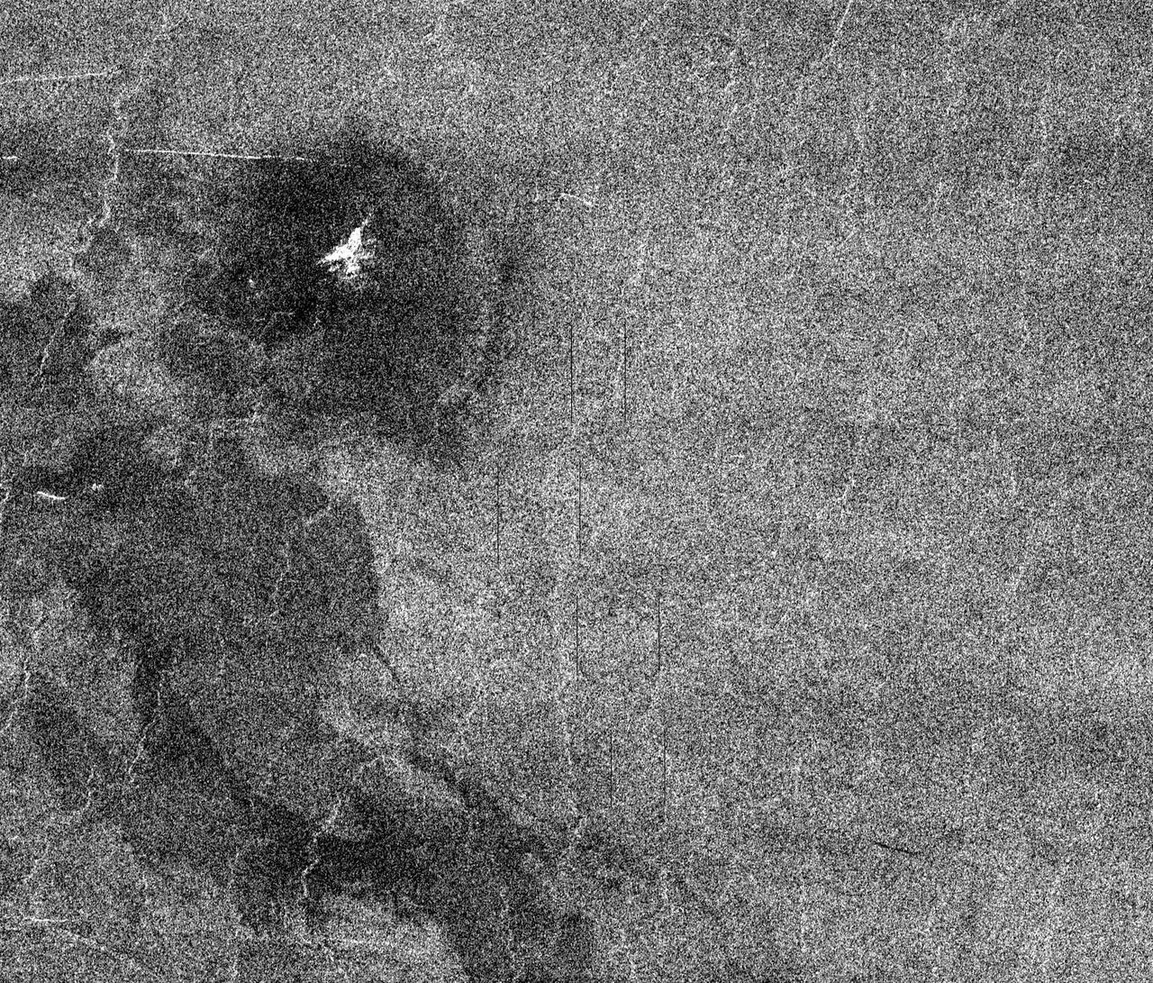
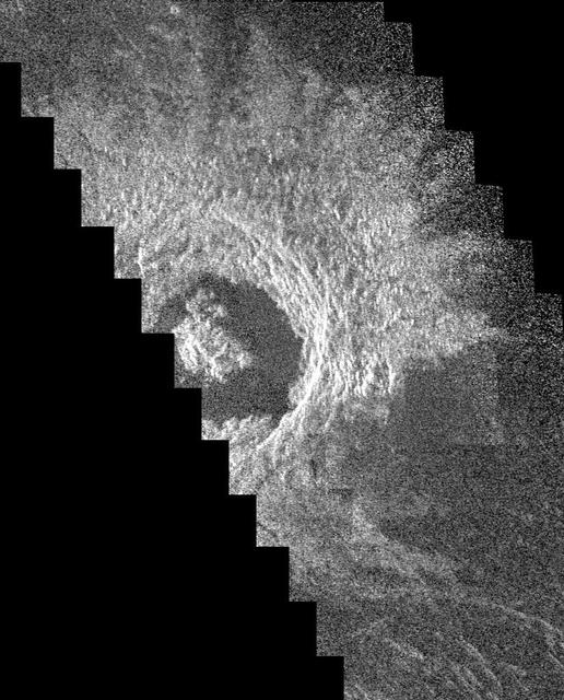
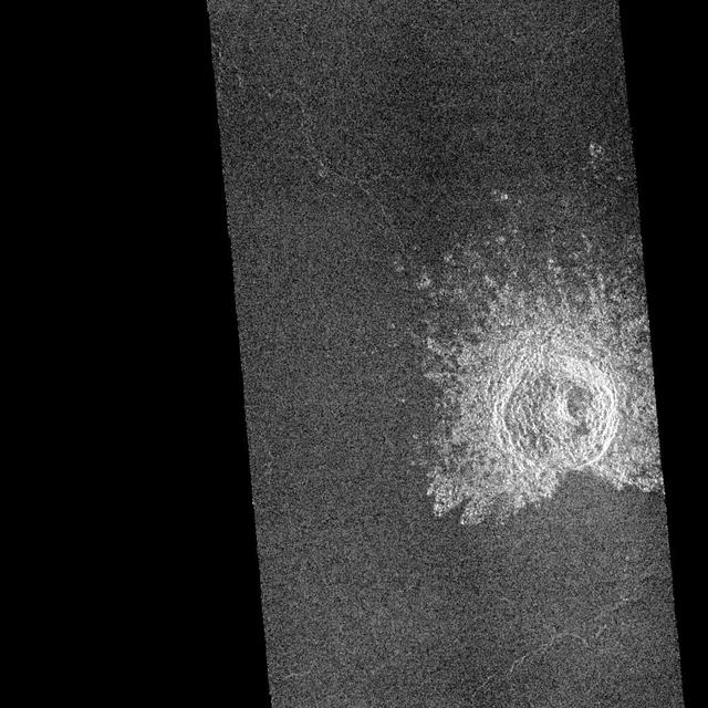
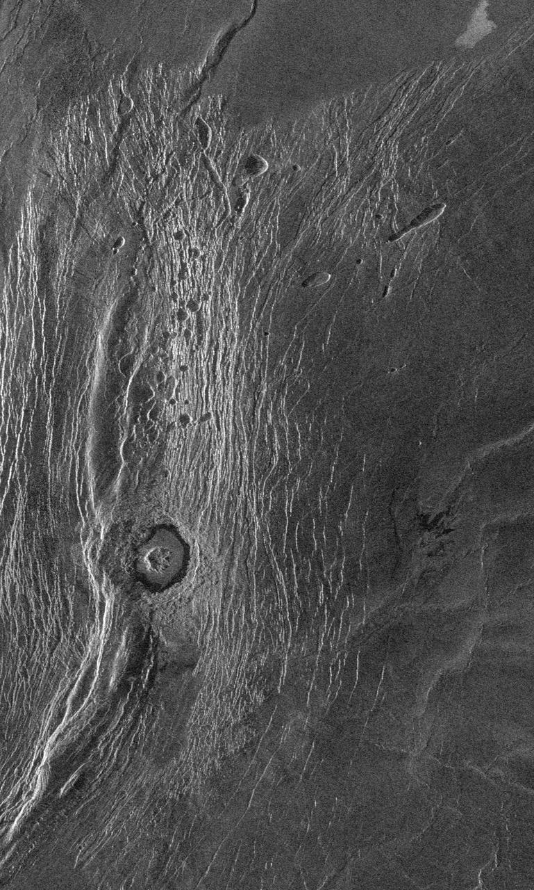
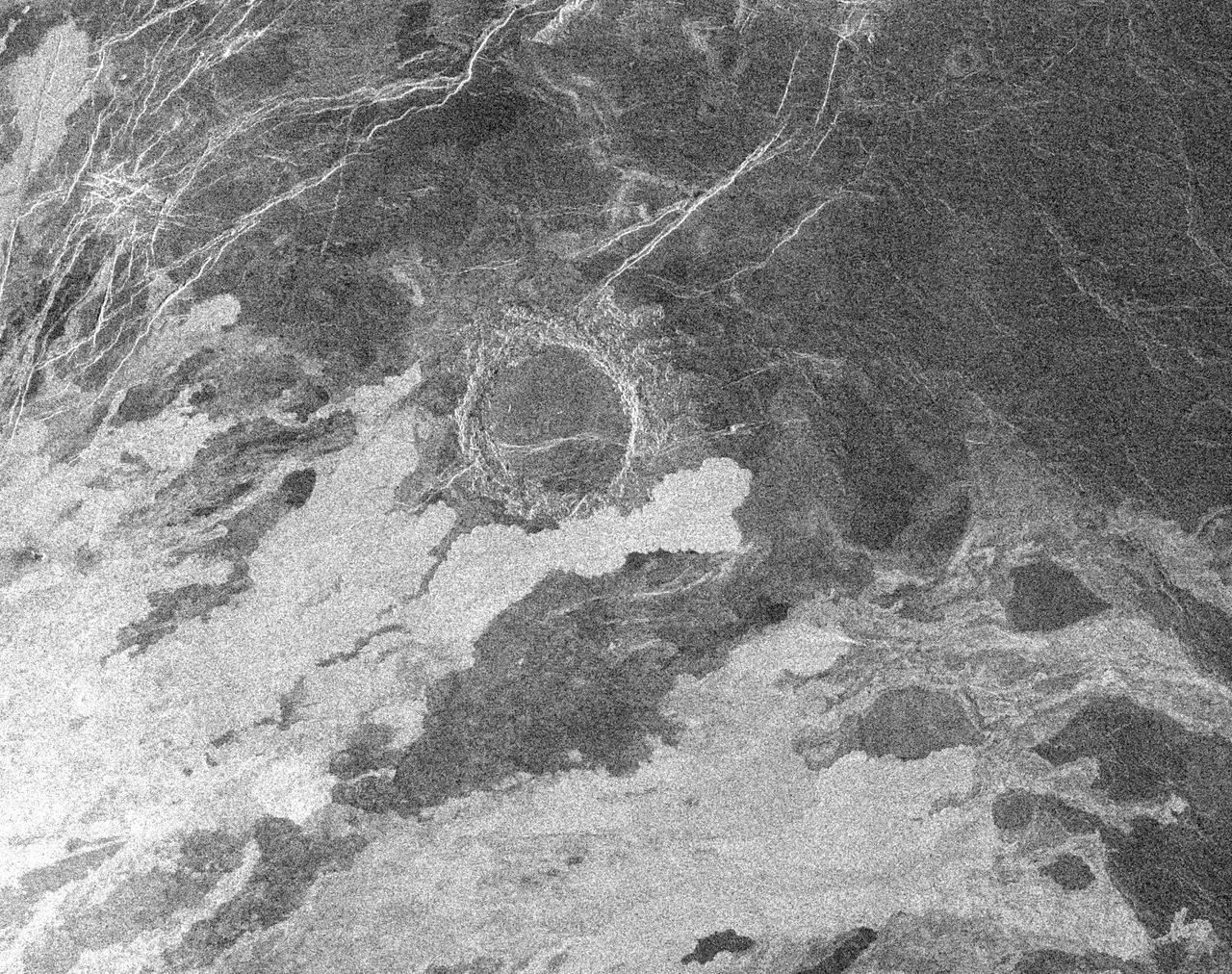
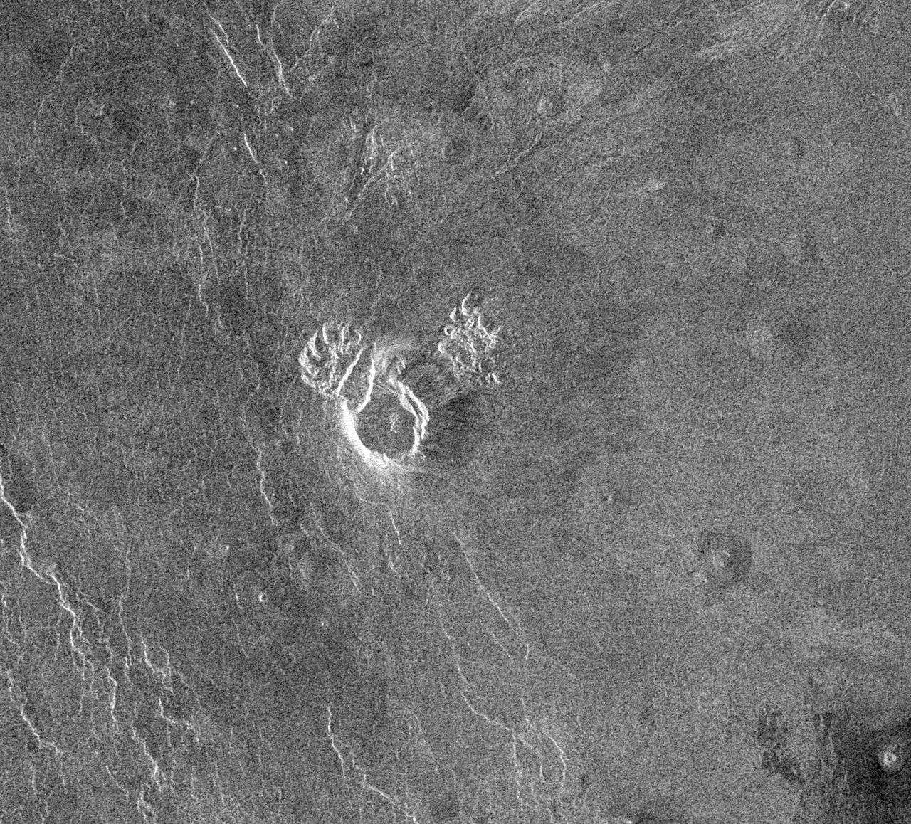
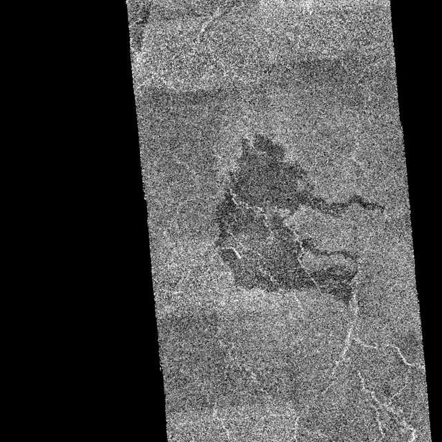
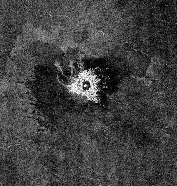
This full resolution mosaiced image covers an area of approximately 100 kilometers by 120 kilometers (62 by 74 miles) and is located in the Lakshmi region of Venus at 47 degrees north latitude and 334 east longitude. Due to the dense Venusian atmosphere, primary impact craters of less than a 3 kilometer (2 mile) diameter are nonexistent. The dark circular region and associated central bright feature in this image are thought to be the remnants of a meteoroid smaller than the size necessary to create an impact crater entering the atmosphere at a low velocity (approximately 350 meters/second.) The central bright feature appears to be a cluster of small secondary impacts, ejecta and debris from the original meteor that broke up in the atmosphere. Even though most of the meteorite did not hit the surface, the atmospheric shock wave could be great enough to modify the surrounding region. One explanation for this radar dark circular formation, called dark margins, could be that the shock wave was energetic enough to pulverize the surface (smooth surfaces generally appear radar dark.) Another explanation is that the surface could be blanketed by a fine material that was formed by the original meteor's breakup through the atmosphere. More than half of the impact craters on Venus have associated dark margins, and most of these are prominently located left of center of the crater. This is another effect which could be caused by the dense atmosphere of Venus. http://photojournal.jpl.nasa.gov/catalog/PIA00477