This view of the Malay Peninsula shows the city state of Singapore, Malaysia (1.5N, 104.0E) with all its urban, industrial and commercial land use areas. Singapore is located at the south tip of the Malay peninsula separated by the Johor Strait. The prosporous island state, once Asia's major trade center, is now highly industrialized despite its small size and its ideal location has made this island a hub of trade, shipping and service industries.
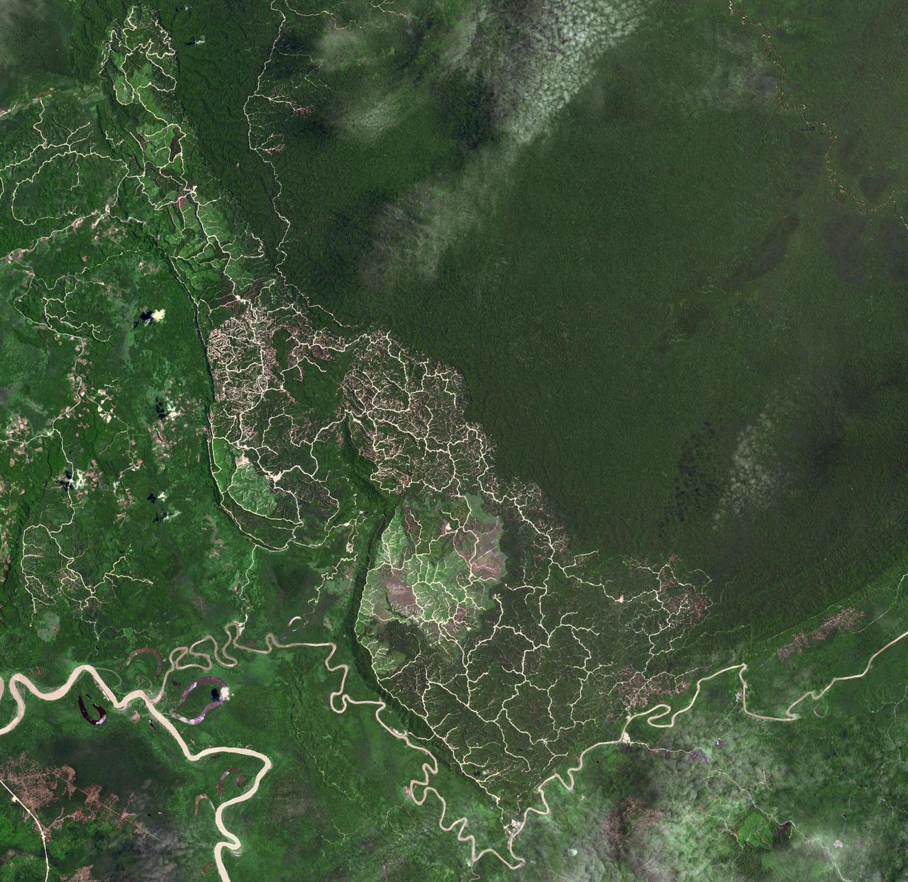
The southwestern border of Brunei with Sarawak, Malaysia is strikingly apparent due to differences in land use practice. On the Malaysian side, a spider web of small roads indicates intensive land use: in this case clearing of the forest for palm oil plantations. On the Brunei side, the virgin forest is preserved, with few if any roads cutting through the forest. The image was acquired September 10, 2012, covers an area of 38 by 38 km, and is located at 4.2 degrees north, 114.4 degrees east. https://photojournal.jpl.nasa.gov/catalog/PIA22034
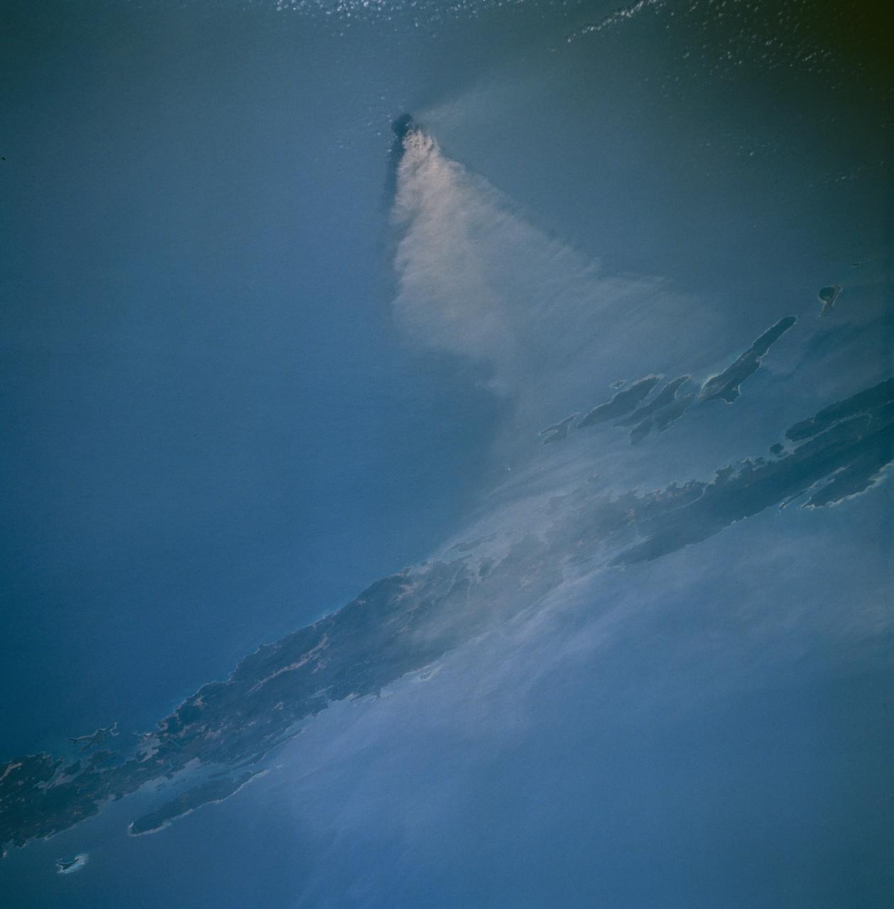
Barren Island, a small volcanic island which is part of the Andaman Island group in the Andaman Sea west of Malaysia, began a new eruptive phase late in 1994. The STS-67 crew noticed the volcanic plume early in their flight, and had several opportunities to document the on-going eruption. This view, taken March 14, 1995, shows a healthy volcanic plume rising several thousand feet into the atmosphere. The main plume drifts westward over Andaman Island, although a smaller plume close to the ground is being dispersed to the south.
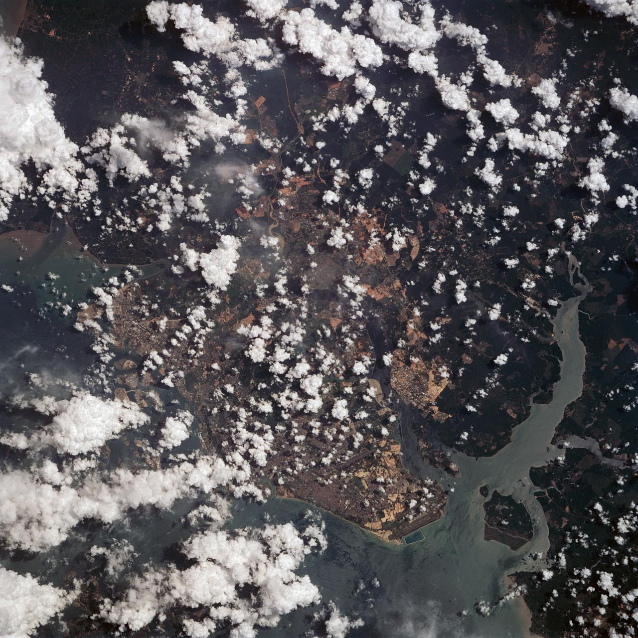
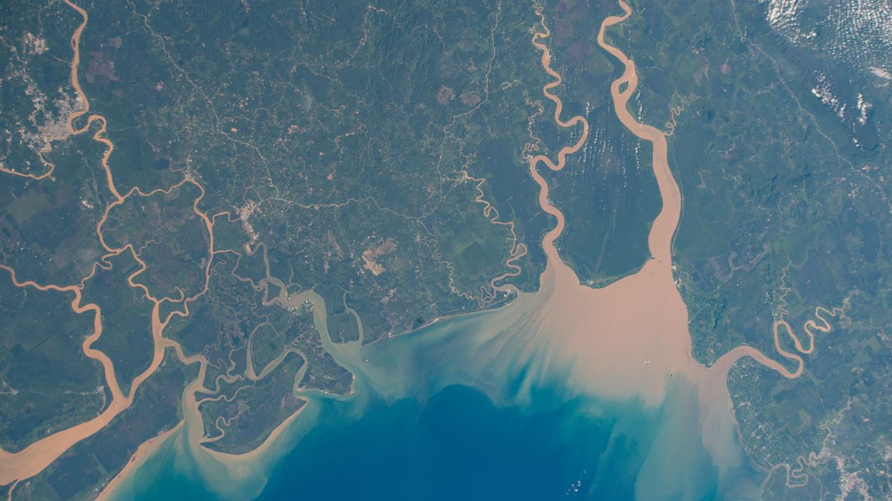
iss073e0818426 (Oct. 2, 2025) --- The Kelantan River flows through one of Malaysia’s most densely populated floodplains before emptying into the South China Sea. On its eastern bank, where the river meets the sea, lies Kota Bharu, a city founded in the late 19th century and home to approximately 570,000 people. This photograph was taken from the International Space Station as it orbited 260 miles above Earth.
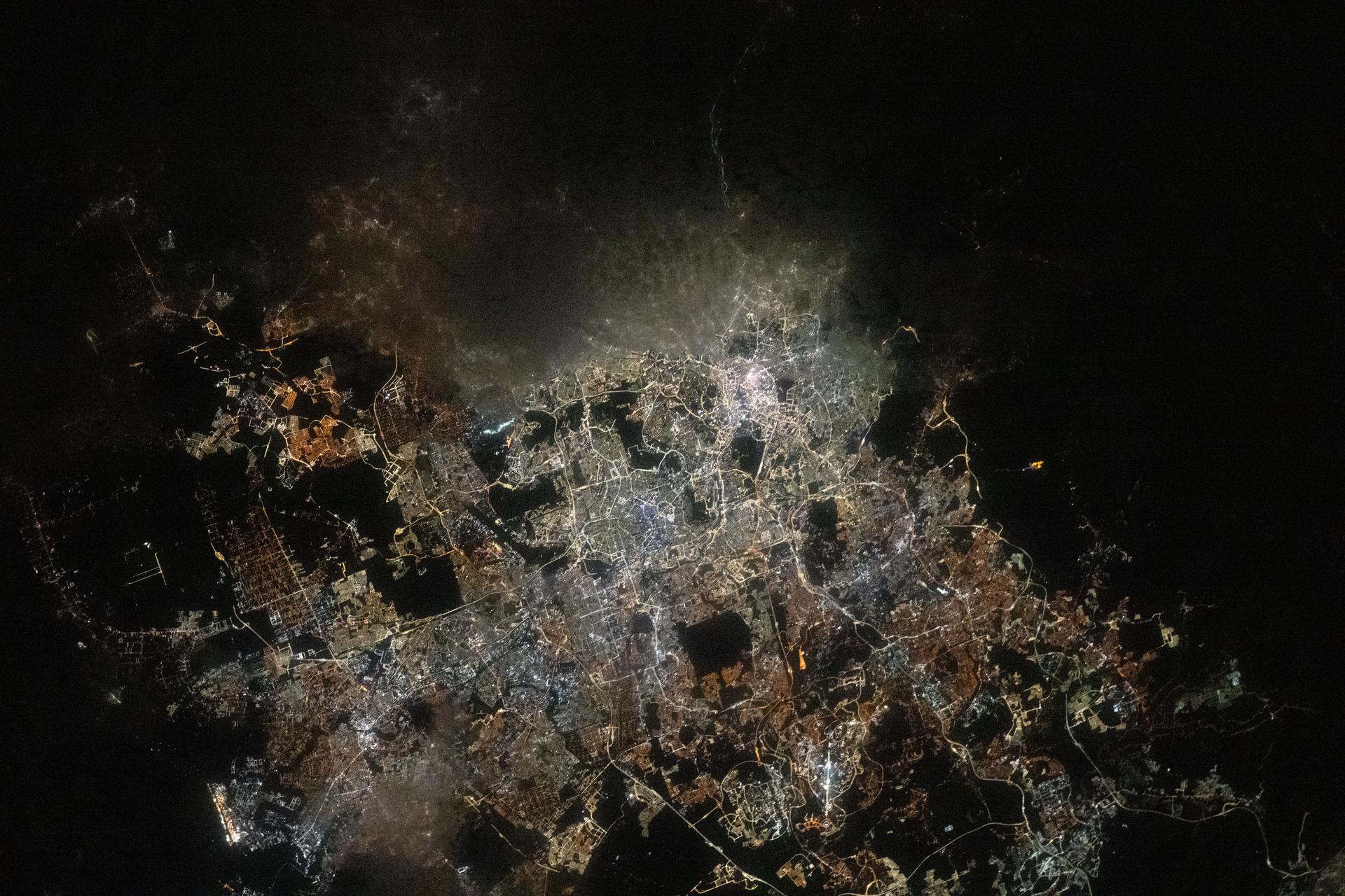
iss073e0763824 (Sept. 21, 2025) --- The Greater Kuala Lumpur area of Malaysia, home to approximately 9.1 million people, is pictured from the International Space Station as it orbited 260 miles above Earth at approximately 3:33 a.m. local time. Dark patches scattered throughout the urban landscape mark nature preserves and parks, many of which feature dams, waterfalls, and hiking trails.
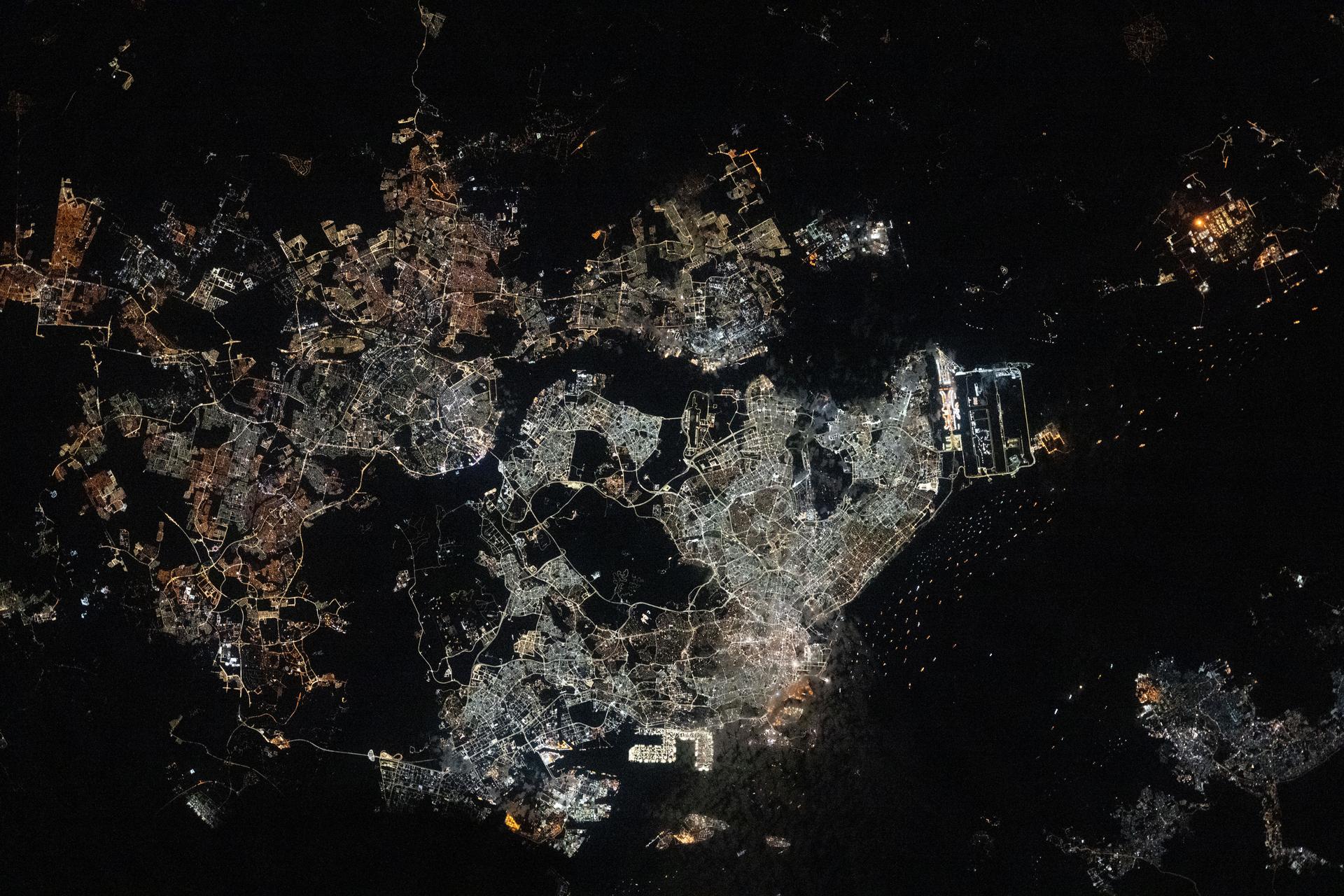
iss073e0763866 (Sept. 21, 2025) --- The Southeast Asian city-state of Singapore (center), separated from Johor Bahru, Malaysia (left), by the Johor Strait, is pictured at approximately 12:34 a.m. from the International Space Station as it orbited 260 miles above. Singapore Changi Airport (right center) sits along the Straits of Singapore and features the world’s tallest indoor waterfall and a forest with over 2,000 trees and 100,000 shrubs. The bright rectangular area at bottom center is Pasir Panjang Terminal, designed to accommodate some of the world’s largest container vessels.
iss061e097961 (Dec. 26, 2019) --- The shadow of the Moon is cast over portions of Malaysia and the Philippines during today's solar eclipse. The International Space Station was orbiting 259 miles above the South China Sea at the time this photograph was taken.
iss062e104685 (March 21, 2020) --- The International Space Station was orbiting 262 miles above the Bay of Bengal when an Expedition 62 captured this photograph of city lights and boat lights in Malaysia and Indonesia
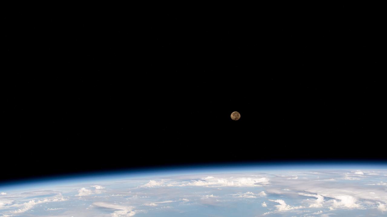
iss069e018196 (June 6, 2023) --- The waning gibbous Moon is pictured above Earth's horizon as the International Space Station was orbiting 257 miles over the Celebes Sea off the coast of Malaysia.
iss061e097976 (Dec. 26, 2019) --- The shadow of the Moon is cast over portions of Malaysia and the Philippines during today's solar eclipse. The International Space Station was orbiting 260 miles above the South China Sea at the time this photograph was taken.
iss067e119830 (June 7, 2022) --- Maludam National Park in East Malaysia is composed of low-lying forests and several rivers that empty into the South China Sea. The International Space Station was orbiting 261 miles above the Maludam Peninsula when this photograph was taken.
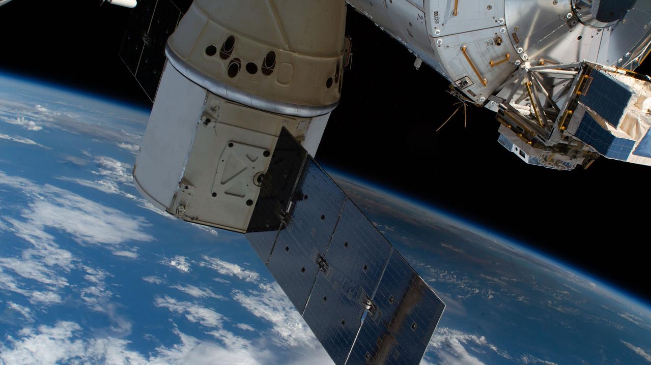
iss061e100234 (Dec. 26, 2019) --- The shadow of the Moon is cast over portions of Malaysia and the Philippines during today's solar eclipse. The International Space Station was orbiting 259 miles above the South China Sea at the time this photograph was taken. In the foreground is the SpaceX Dragon resupply ship and part of the ESA (European Space Agency) Columbus laboratory module.
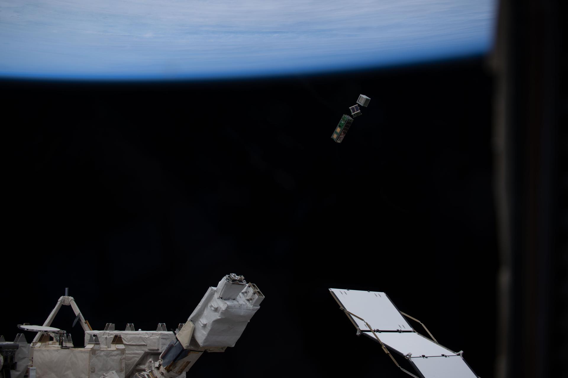
iss074e0301636 (Feb. 3, 2026) --- A trio of CubeSats designed by college students from around the world is deployed into Earth orbit from a small satellite orbital deployer on the outside of the International Space Station's Kibo laboratory module. Students from Mexico, Italy, Thailand, Malaysia, and Japan designed the shoe-boxed sized satellites for a series of Earth observations and technology demonstrations.
iss071e604388 (Aug. 15, 2024) --- The city lights of southern Thailand and Malaysia sit in between the Malacca Strait (top) and the Gulf of Thailand with the southern coast of Vietnam, at bottom right, revealed by Ho Chi Minh City's night lights. Fishing boats, lit by LED green lights that attract plankton luring squid for catching, are pictured in both bodies of water in this orbital nighttime photograph from the International Space Station as it soared 261 miles above into a sunrise.
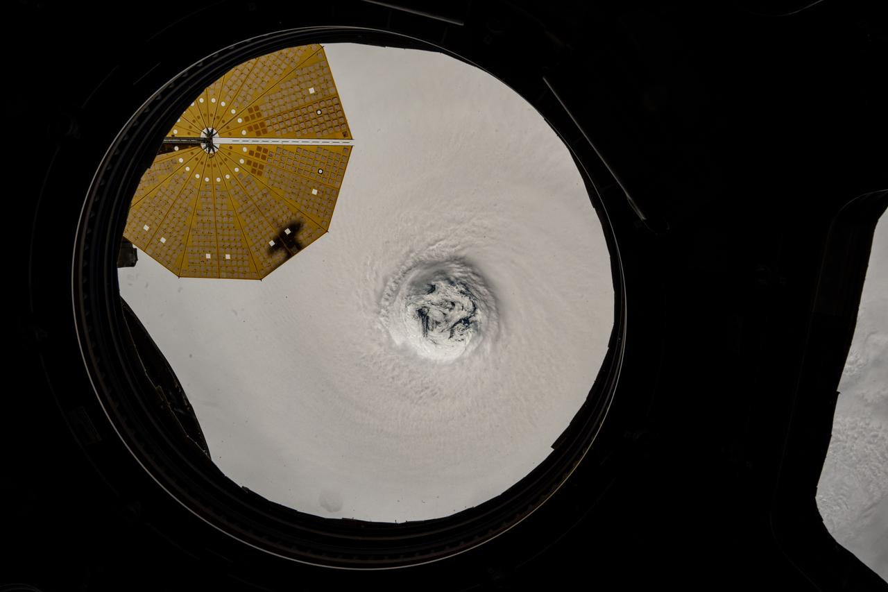
iss073e0764640 (Sept. 22, 2025) --- This near overhead view from the main window on the International Space Station's cupola shows the well-defined eye of Typhoon Ragasa. The orbital outpost was soaring 256 miles above the South China Sea north of Malaysia's island of Luzon at the time of this photograph. At upper left, is one of two cymbal-shaped UltraFlex solar arrays that powers the Northrop Grumman Cygnus XL cargo craft.
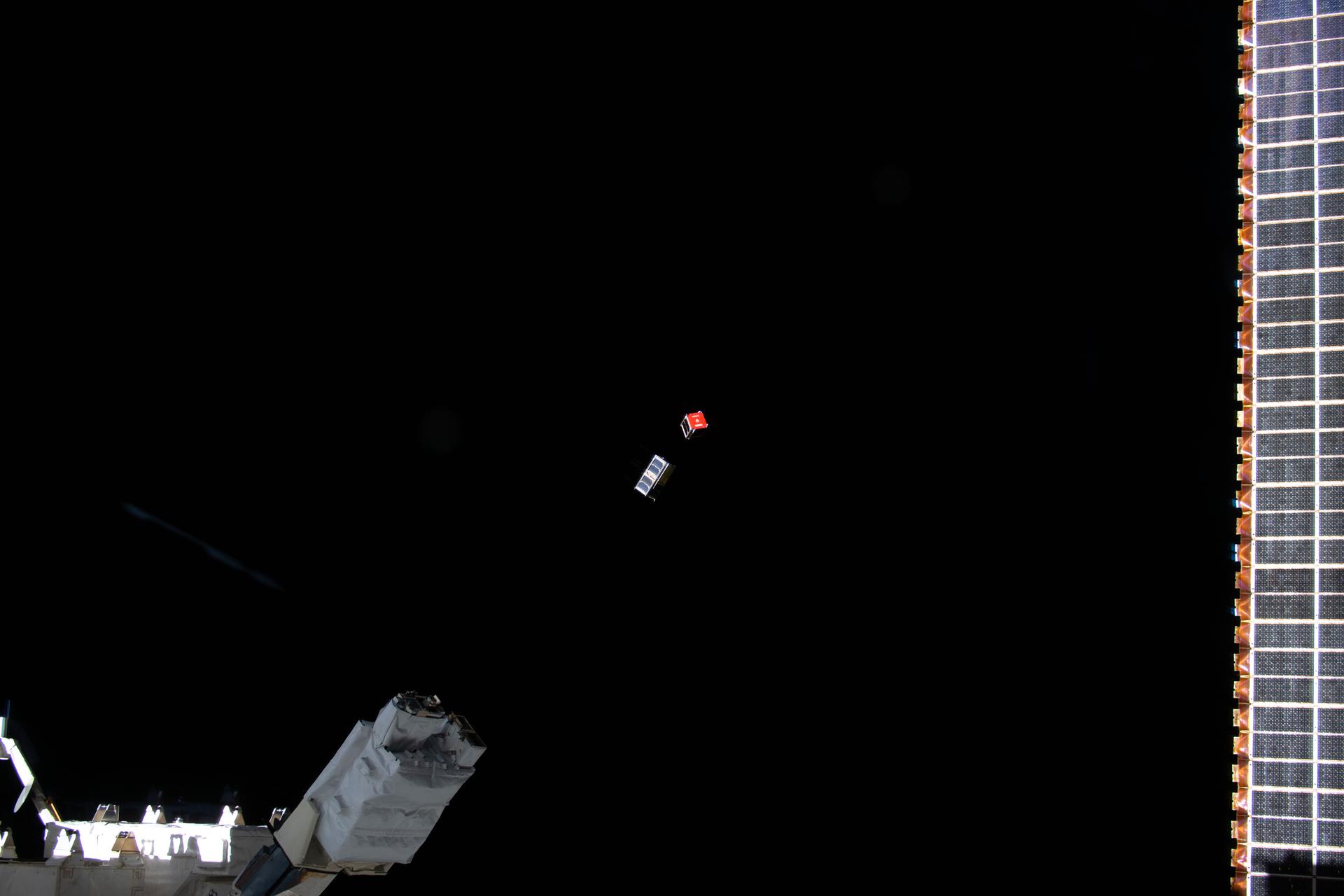
iss074e0301064 (Feb. 3, 2026) --- A pair of CubeSats designed by college students from around the world is deployed into Earth orbit from a small satellite orbital deployer on the outside of the International Space Station's Kibo laboratory module. Students from Mexico, Italy, Thailand, Malaysia, and Japan designed the shoe-boxed sized satellites for a series of Earth observations and technology demonstrations.
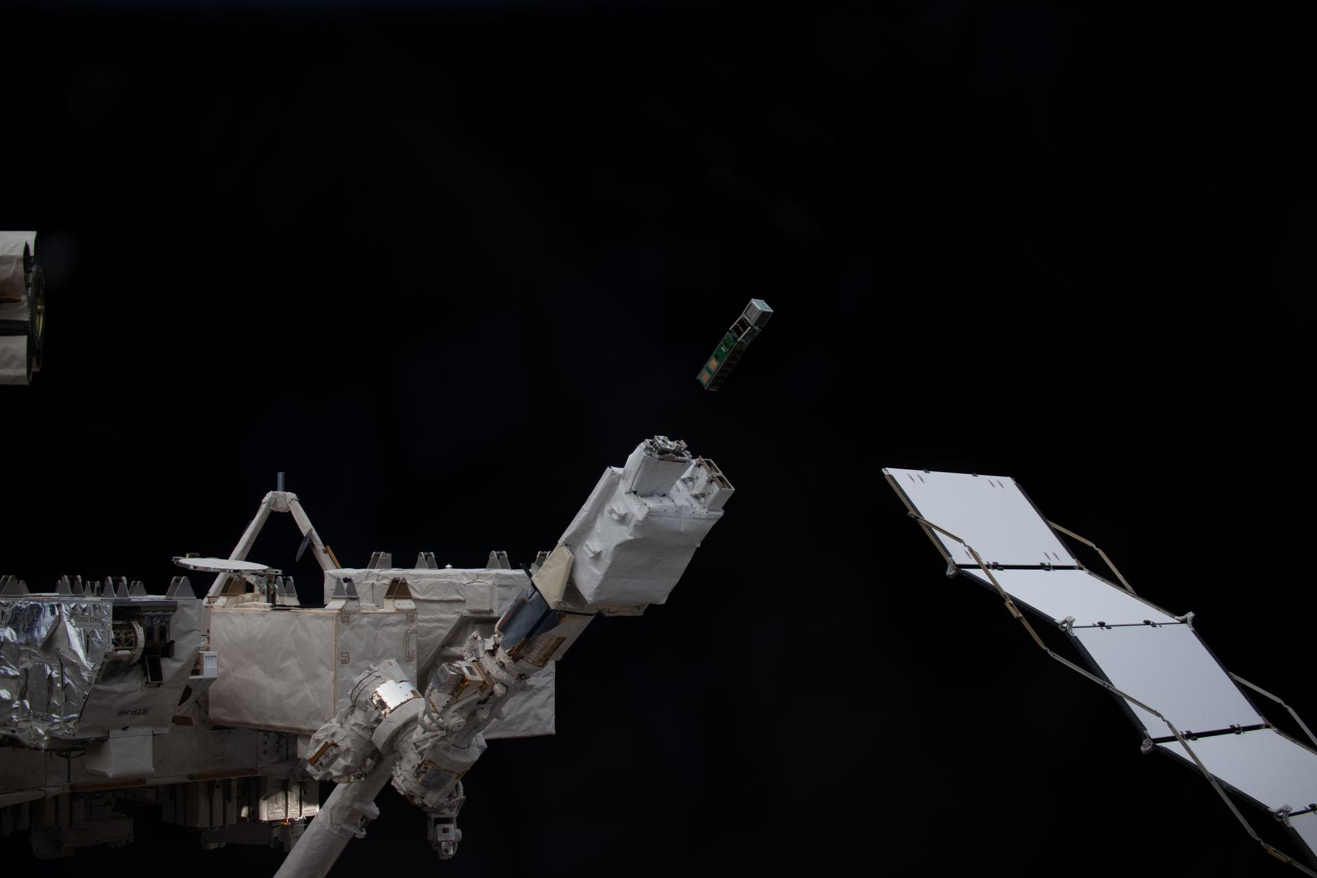
iss074e0301612 (Feb. 3, 2026) --- A trio of CubeSats designed by college students from around the world is deployed into Earth orbit from a small satellite orbital deployer on the outside of the International Space Station's Kibo laboratory module. Students from Mexico, Italy, Thailand, Malaysia, and Japan designed the shoe-boxed sized satellites for a series of Earth observations and technology demonstrations.
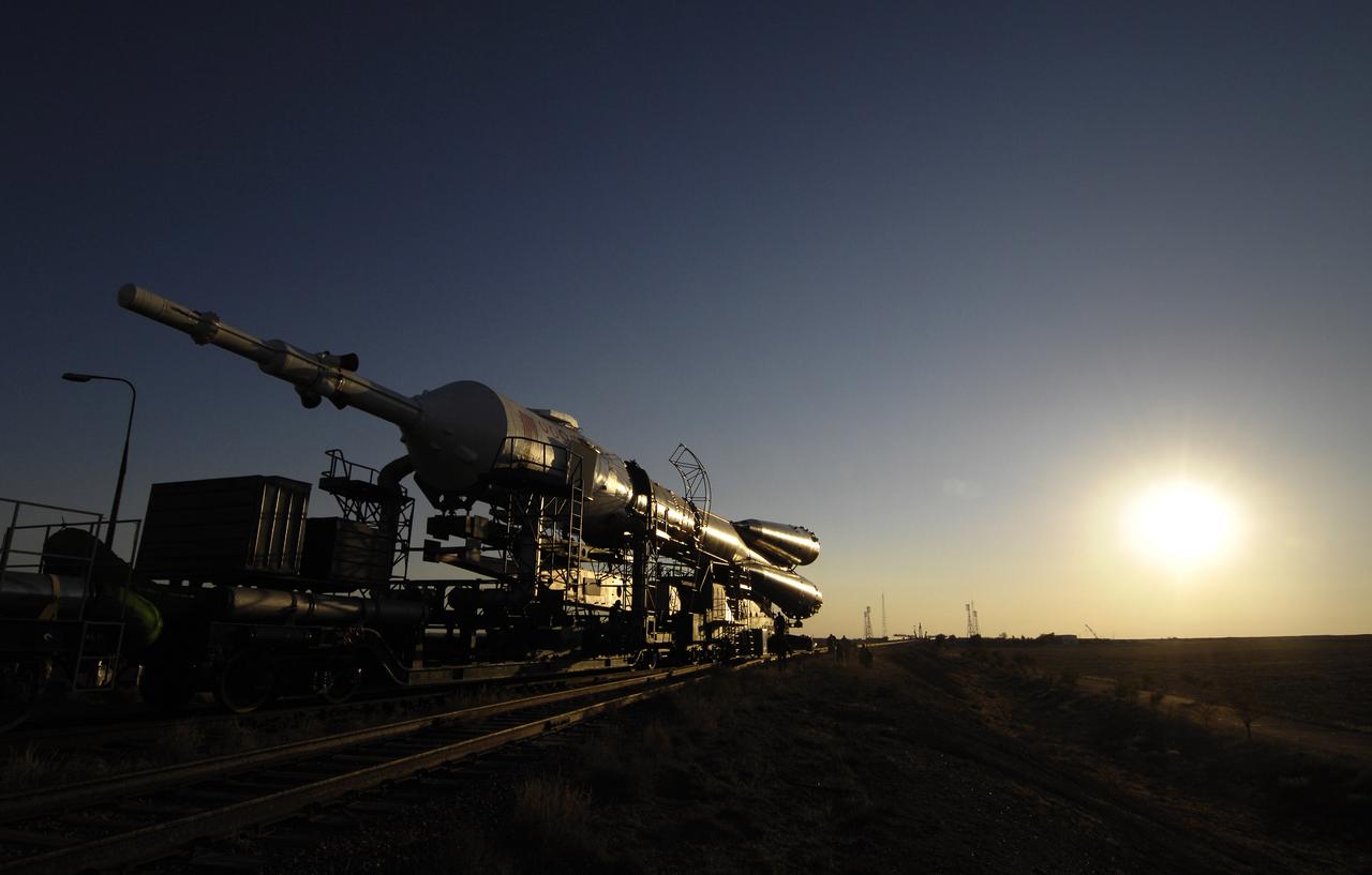
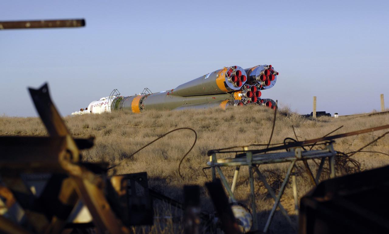
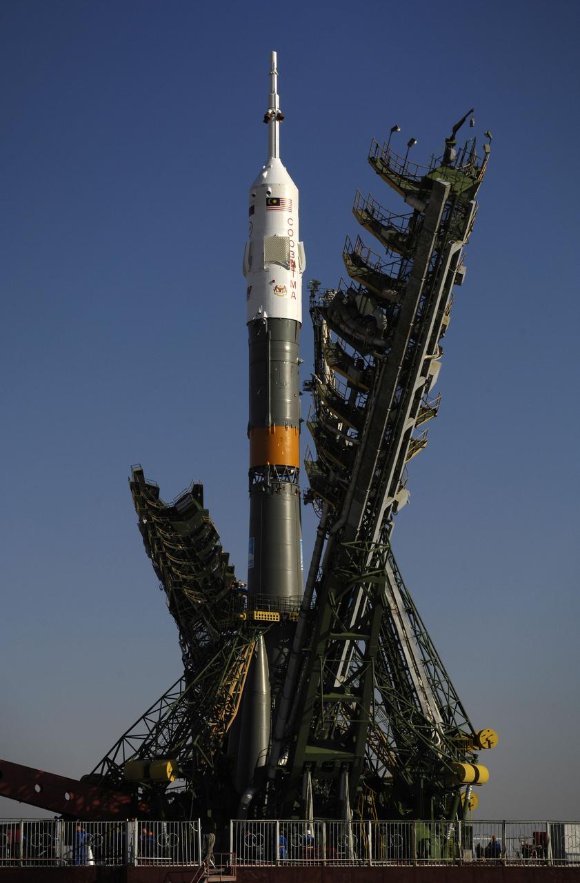
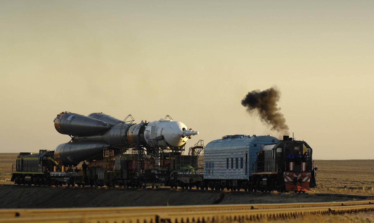
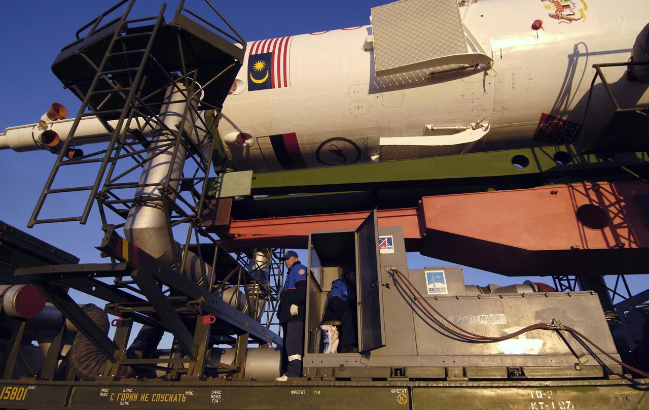
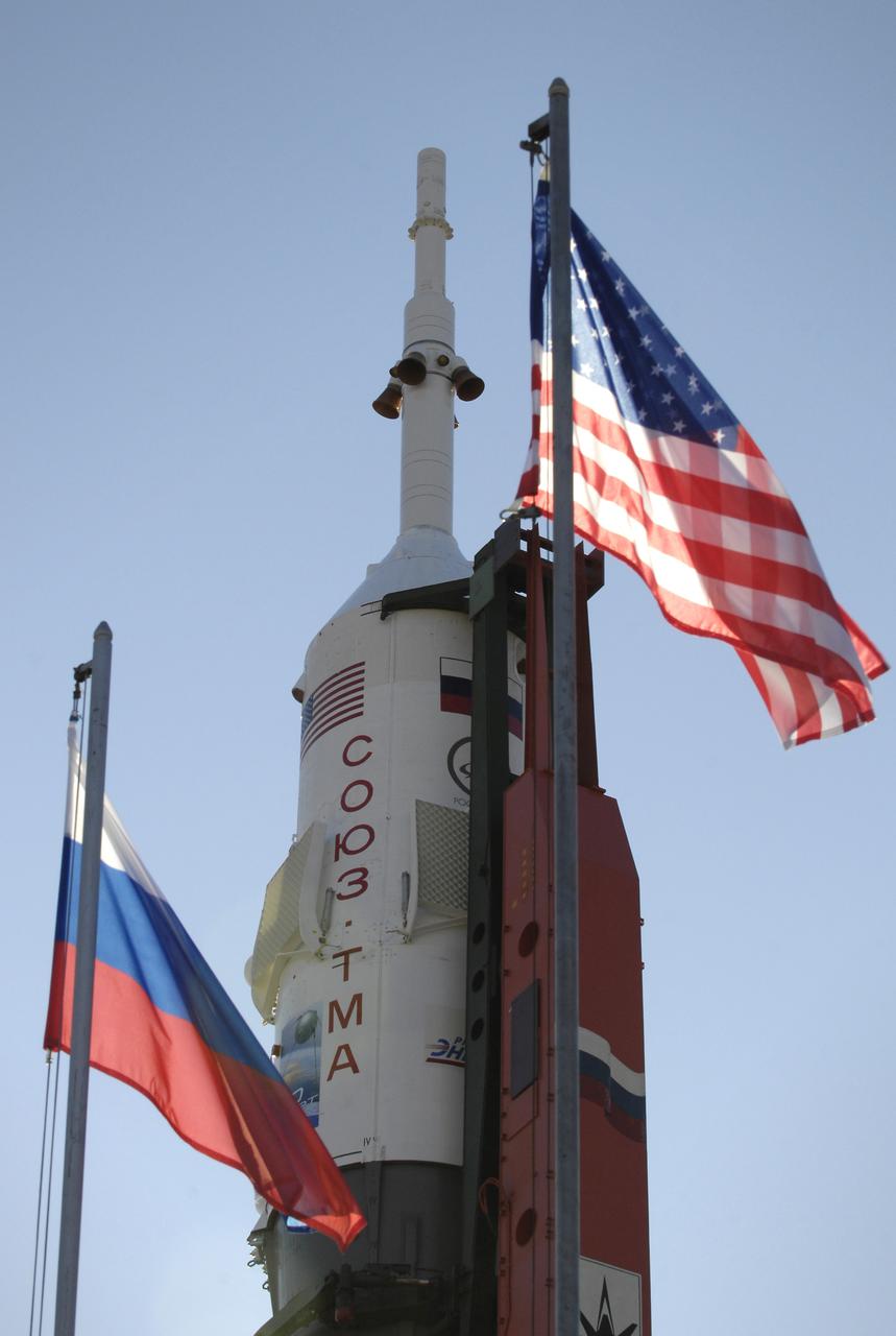
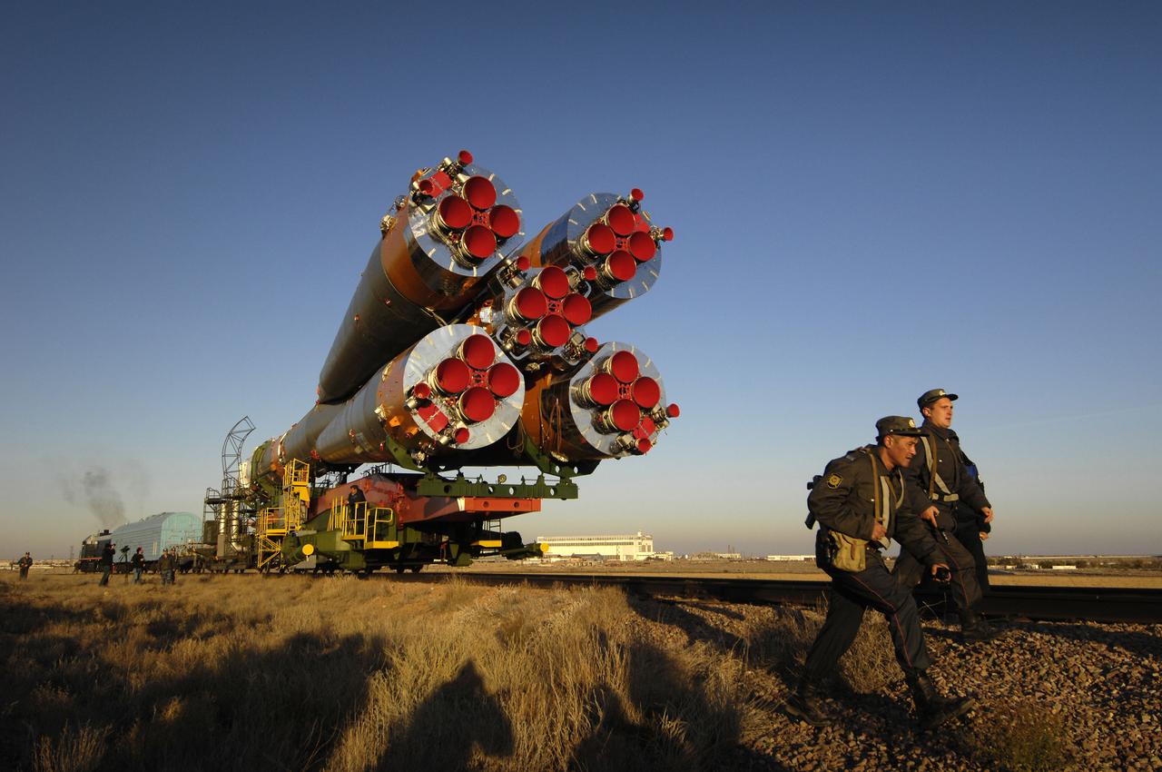
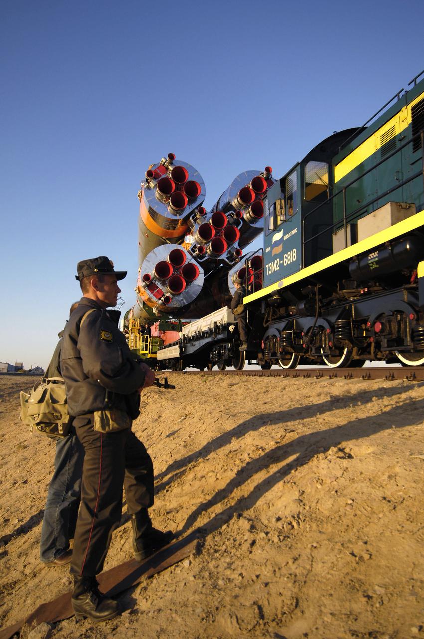
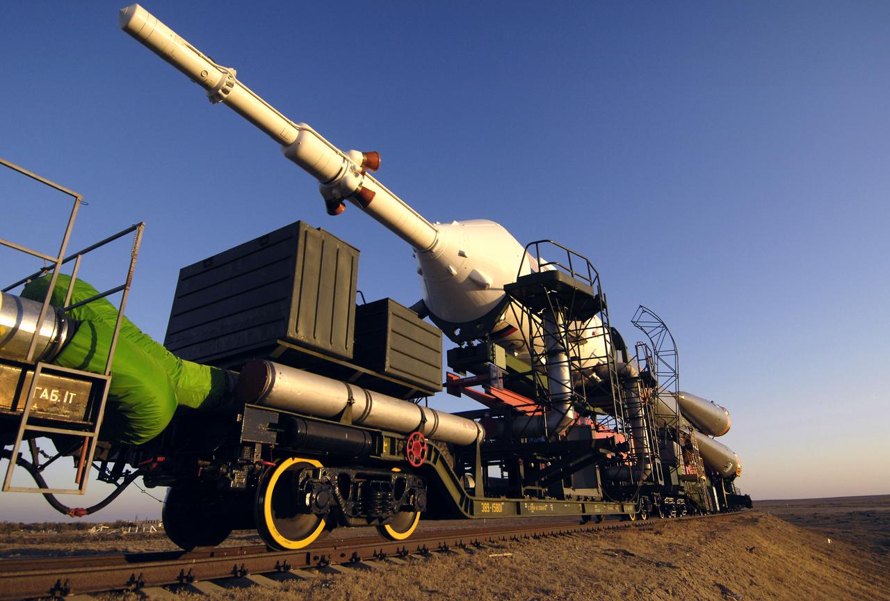
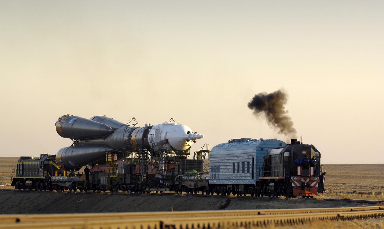
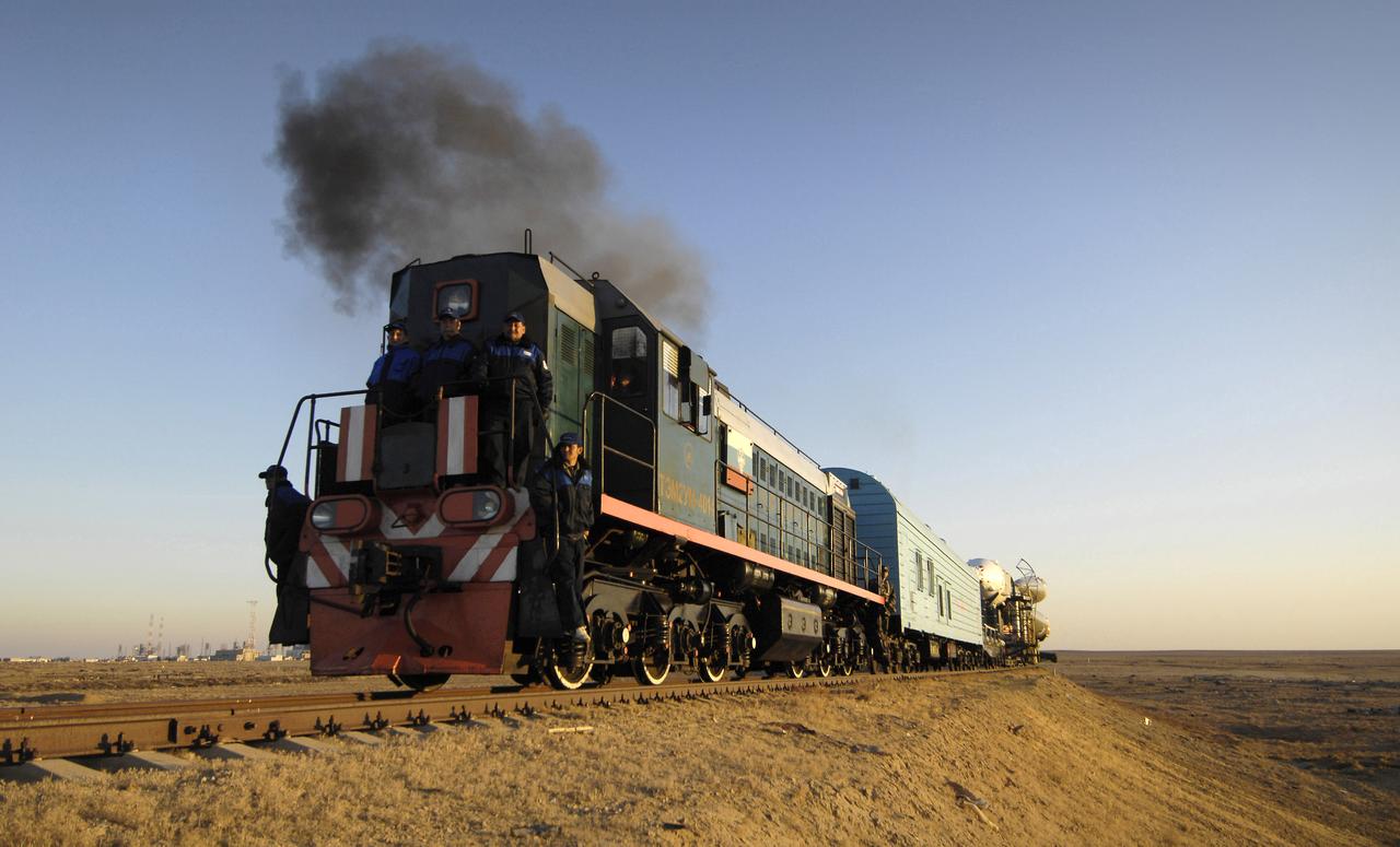
The Soyuz TMA-11 spacecraft is transported by railcar to its launch pad at the Baikonur Cosmodrome, Monday, Oct. 8, 2007, in Kazakhstan for an October 10th launch date. The Soyuz will carry Expedition 16 Commander Peggy Whitson, Flight Engineer and Soyuz Commander Yuri Malenchenko and Malaysian spaceflight participant Sheikh Muszaphar Shukor to the International Space Station. Whitson and Malenchenko will spend six months on the station. Shukor, who is flying under an agreement between Malaysia and the Russian Federal Space Agency, will return to Earth October 21 with two of the Expedition 15 crew members currently on the complex. Photo Credit: (NASA/Bill Ingalls)
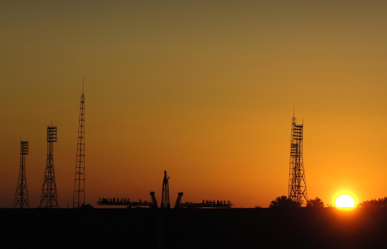
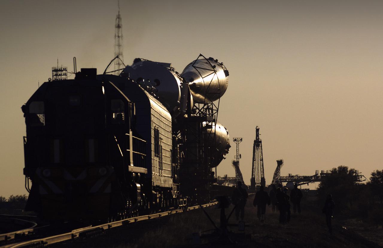
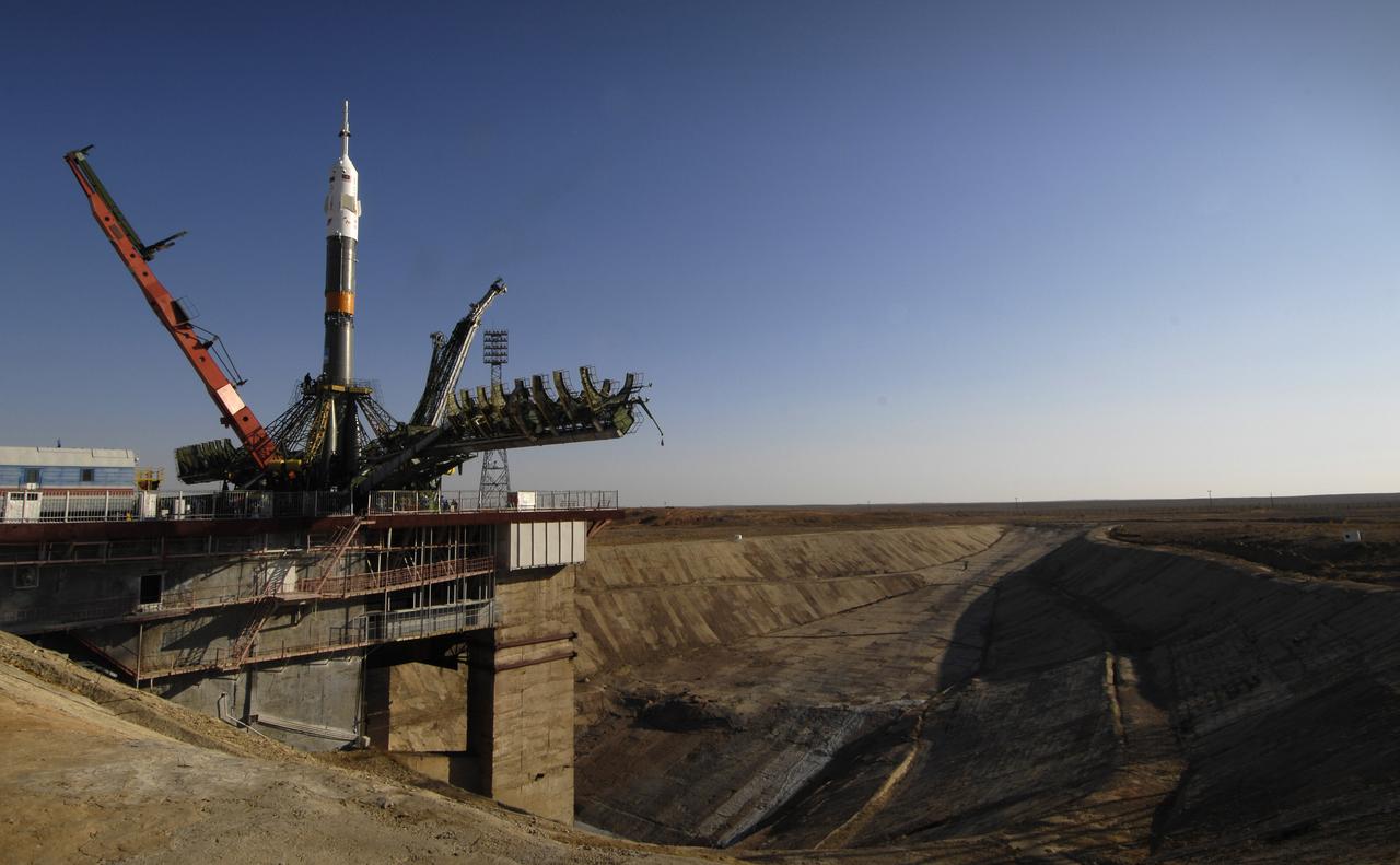
The Soyuz launch pad is seen prior to the arrival of the Soyuz TMA-11 spacecraft, Monday, Oct. 8, 2007, in Baikonur, Kazakhstan. The Soyuz was transported by railcar to its launch pad at the Baikonur Cosmodrome for an October 10th launch date, when it will carry Expedition 16 Commander Peggy Whitson, Flight Engineer and Soyuz Commander Yuri Malenchenko and Malaysian spaceflight participant Sheikh Muszaphar Shukor to the International Space Station. Whitson and Malenchenko will spend six months on the station. Shukor, who is flying under an agreement between Malaysia and the Russian Federal Space Agency, will return to Earth October 21 with two of the Expedition 15 crew members currently on the complex. Photo Credit: (NASA/Bill Ingalls)

The flags of Malaysia, Russia and the United States sit between the phones used by officials to speak with the crew of the International Space Station (ISS) in the Russian Mission Control Center in Korolev, outside Moscow, Friday, Oct. 12, 2007. Expedition 16 Commander Peggy Whitson, Soyuz Commander and Flight Engineer Yuri Malenchenko and Malaysian spaceflight participant Sheikh Muszaphar Shukor docked their Soyuz TMA-11 spacecraft to the ISS at 10:50 a.m. EDT, October 12. The crew launched on Wednesday from the Baikonur Cosmodrome in Kazakhstan. Photo Credit: (NASA/Bill Ingalls)

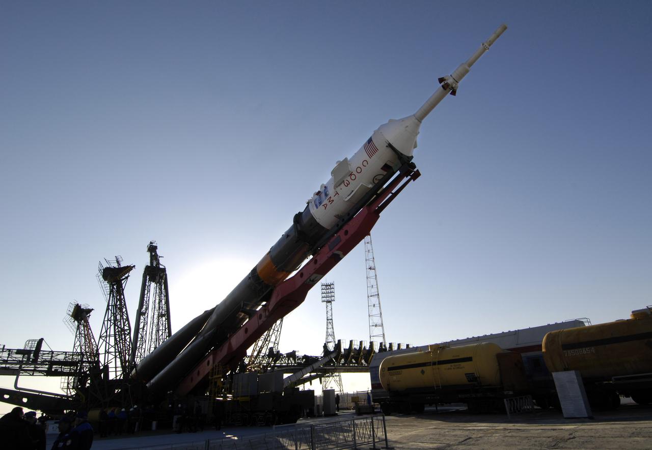
Baikonur, Kazakhstan -- The Soyuz TMA-11 spacecraft was transported by railcar to its launch pad at the Baikonur Cosmodrome in Kazakhstan Oct. 8, 2007, for launch Oct. 10 to carry Expedition 16 Commander Peggy Whitson, Flight Engineer and Soyuz Commander Yuri Malenchenko and Malaysian Spaceflight Participant Sheikh Muszaphar Shukor to the International Space Station. Whitson and Malenchenko will spend six months on the station. Shukor, who is flying under an agreement between Malaysia and the Russian Federal Space Agency, will return to Earth Oct. 21 with two of the Expedition 15 crewmembers currently on the complex. Photo credit: NASA/Bill Ingalls
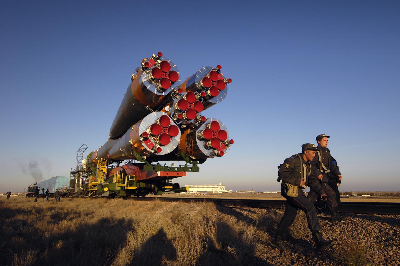
The Soyuz TMA-11 spacecraft is transported by railcar to its launch pad at the Baikonur Cosmodrome, Monday, Oct. 8, 2007, in Kazakhstan for an October 10th launch date. The Soyuz will carry Expedition 16 Commander Peggy Whitson, Flight Engineer and Soyuz Commander Yuri Malenchenko and Malaysian spaceflight participant Sheikh Muszaphar Shukor to the International Space Station. Whitson and Malenchenko will spend six months on the station. Shukor, who is flying under an agreement between Malaysia and the Russian Federal Space Agency, will return to Earth October 21 with two of the Expedition 15 crew members currently on the complex. Photo Credit: (NASA/Bill Ingalls)
The Soyuz TMA-11 spacecraft is transported by railcar to its launch pad at the Baikonur Cosmodrome, Monday, Oct. 8, 2007, in Kazakhstan for an October 10th launch date. The Soyuz will carry Expedition 16 Commander Peggy Whitson, Flight Engineer and Soyuz Commander Yuri Malenchenko and Malaysian spaceflight participant Sheikh Muszaphar Shukor to the International Space Station. Whitson and Malenchenko will spend six months on the station. Shukor, who is flying under an agreement between Malaysia and the Russian Federal Space Agency, will return to Earth October 21 with two of the Expedition 15 crew members currently on the complex. Photo Credit: (NASA/Bill Ingalls)

The Soyuz TMA-11 spacecraft was transported by railcar to its launch pad at the Baikonur Cosmodrome, Monday, Oct. 8, 2007, in Kazakhstan for an October 10th launch date. The Soyuz will carry Expedition 16 Commander Peggy Whitson, Flight Engineer and Soyuz Commander Yuri Malenchenko and Malaysian spaceflight participant Sheikh Muszaphar Shukor to the International Space Station. Whitson and Malenchenko will spend six months on the station. Shukor, who is flying under an agreement between Malaysia and the Russian Federal Space Agency, will return to Earth October 21 with two of the Expedition 15 crew members currently on the complex. Photo Credit: (NASA/Bill Ingalls)
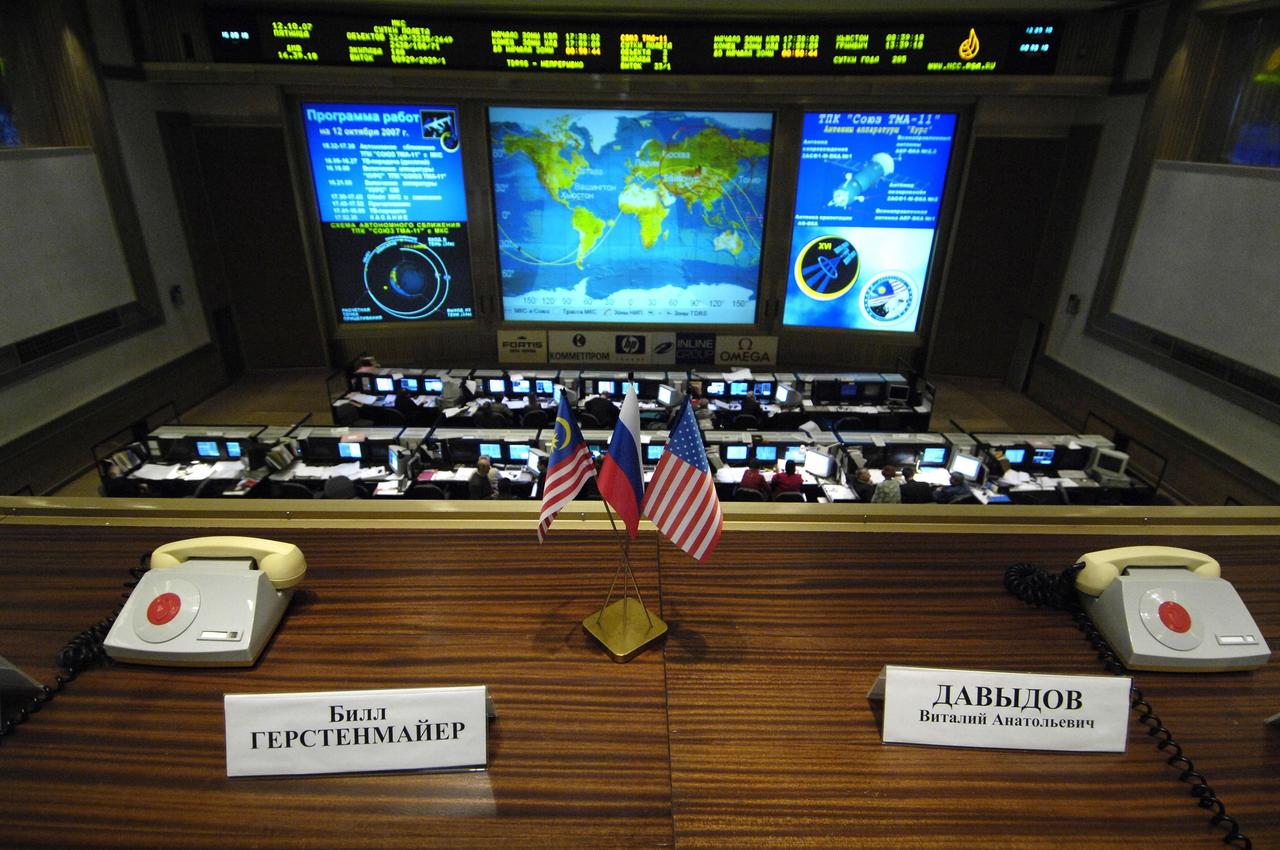
Korolev, Russia -- The flags of Malaysia, Russia and the United States sit between the phones used by officials to talk to the crew of the International Space Station (ISS) in the Russian Mission Control Center, Korolev, outside Moscow. Expedition 16 Commander Peggy Whitson, Flight Engineer and Soyuz Commander Yuri Malenchenko and Malaysian Spaceflight Participant Sheikh Muszaphar Shukor docked their Soyuz TMA-11 spacecraft to the station at 10:50 a.m. EDT Oct. 12, 2007. The crew launched Wednesday from the Baikonur Cosmodrome in Kazakhstan. Photo credit: NASA/Bill Ingalls
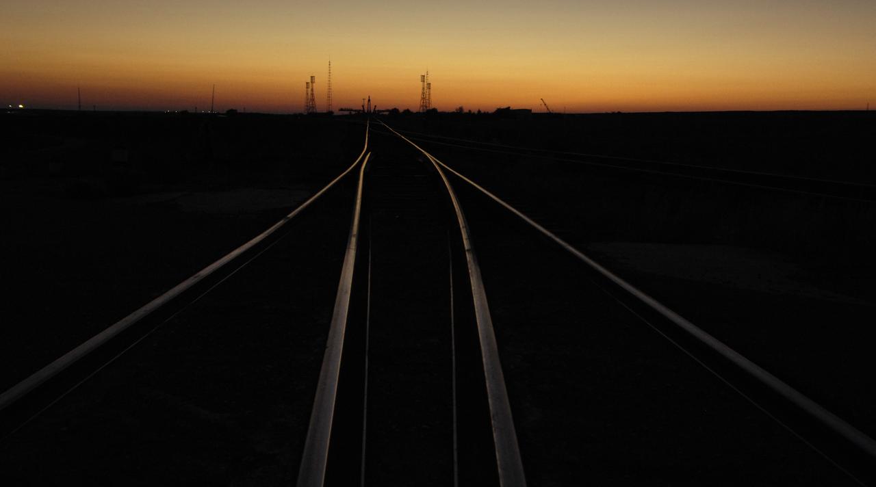
The Soyuz launch pad is seen prior to the arrival of the Soyuz TMA-11 spacecraft, Monday, Oct. 8, 2007, in Baikonur, Kazakhstan. The Soyuz was transported by railcar to its launch pad at the Baikonur Cosmodrome for an October 10th launch date, when it will carry Expedition 16 Commander Peggy Whitson, Flight Engineer and Soyuz Commander Yuri Malenchenko and Malaysian spaceflight participant Sheikh Muszaphar Shukor to the International Space Station. Whitson and Malenchenko will spend six months on the station. Shukor, who is flying under an agreement between Malaysia and the Russian Federal Space Agency, will return to Earth October 21 with two of the Expedition 15 crew members currently on the complex. Photo Credit: (NASA/Bill Ingalls)
The Soyuz TMA-11 spacecraft was transported by railcar to its launch pad at the Baikonur Cosmodrome in Kazakhstan Oct. 8, 2007 for launch Oct. 10 to carry Expedition 16 Commander Peggy Whitson, Flight Engineer and Soyuz Commander Yuri Malenchenko and Malaysian Spaceflight Participant Sheikh Muszaphar Shukor to the International Space Station. Whitson and Malenchenko will spend six months on the station. Shukor, who is flying under an agreement between Malaysia and the Russian Federal Space Agency, will return to Earth Oct. 21 with two of the Expedition 15 crewmembers currently on the complex. Photo Credit: "NASA/Bill Ingalls"
Baikonur, Kazakhstan -- The Soyuz TMA-11 spacecraft was transported by railcar to its launch pad at the Baikonur Cosmodrome in Kazakhstan Oct. 8, 2007, for launch Oct. 10 to carry Expedition 16 Commander Peggy Whitson, Flight Engineer and Soyuz Commander Yuri Malenchenko and Malaysian Spaceflight Participant Sheikh Muszaphar Shukor to the International Space Station. Whitson and Malenchenko will spend six months on the station. Shukor, who is flying under an agreement between Malaysia and the Russian Federal Space Agency, will return to Earth Oct. 21 with two of the Expedition 15 crewmembers currently on the complex. Photo credit: NASA/Bill Ingalls
The Soyuz TMA-11 spacecraft is transported by railcar to its launch pad at the Baikonur Cosmodrome, Monday, Oct. 8, 2007, in Kazakhstan for an October 10th launch date. The Soyuz will carry Expedition 16 Commander Peggy Whitson, Flight Engineer and Soyuz Commander Yuri Malenchenko and Malaysian spaceflight participant Sheikh Muszaphar Shukor to the International Space Station. Whitson and Malenchenko will spend six months on the station. Shukor, who is flying under an agreement between Malaysia and the Russian Federal Space Agency, will return to Earth October 21 with two of the Expedition 15 crew members currently on the complex. Photo Credit: (NASA/Bill Ingalls)

The flags of Malaysia, Russia and the United States sit between the phones used by officials to talk to the crew of the International Space Station (ISS) in the Russian Mission Control Center in Korolev, outside Moscow. Expedition 16 Commander Peggy Whitson, Soyuz Commander and Flight Engineer Yuri Malenchenko and Malaysian Spaceflight Participant Sheikh Muszaphar Shukor docked their Soyuz TMA-11 spacecraft to the station at 10:50 a.m. EDT. Oct. 12, 2007. The crew launched on Wednesday from the Baikonur Cosmodrome in Kazakhstan. Photo Credit: "NASA/Bill Ingalls"

Baikonur, Kazakhstan -- The Soyuz TMA-11 spacecraft was transported by railcar to its launch pad at the Baikonur Cosmodrome in Kazakhstan Oct. 8, 2007, for launch Oct. 10 to carry Expedition 16 Commander Peggy Whitson, Flight Engineer and Soyuz Commander Yuri Malenchenko and Malaysian Spaceflight Participant Sheikh Muszaphar Shukor to the International Space Station. Whitson and Malenchenko will spend six months on the station. Shukor, who is flying under an agreement between Malaysia and the Russian Federal Space Agency, will return to Earth Oct. 21 with two of the Expedition 15 crewmembers currently on the complex. Photo credit: NASA/Bill Ingalls

The Soyuz TMA-11 spacecraft was transported by railcar to its launch pad at the Baikonur Cosmodrome in Kazakhstan Oct. 8, 2007 for launch Oct. 10 to carry Expedition 16 Commander Peggy Whitson, Flight Engineer and Soyuz Commander Yuri Malenchenko and Malaysian Spaceflight Participant Sheikh Muszaphar Shukor to the International Space Station. Whitson and Malenchenko will spend six months on the station. Shukor, who is flying under an agreement between Malaysia and the Russian Federal Space Agency, will return to Earth Oct. 21 with two of the Expedition 15 crewmembers currently on the complex. Photo Credit: "NASA/Bill Ingalls"
The Soyuz TMA-11 spacecraft was transported by railcar to its launch pad at the Baikonur Cosmodrome, Monday, Oct. 8, 2007, in Kazakhstan for an October 10th launch date. The Soyuz will carry Expedition 16 Commander Peggy Whitson, Flight Engineer and Soyuz Commander Yuri Malenchenko and Malaysian spaceflight participant Sheikh Muszaphar Shukor to the International Space Station. Whitson and Malenchenko will spend six months on the station. Shukor, who is flying under an agreement between Malaysia and the Russian Federal Space Agency, will return to Earth October 21 with two of the Expedition 15 crew members currently on the complex. Photo Credit: (NASA/Bill Ingalls)
The Soyuz TMA-11 spacecraft was transported by railcar to its launch pad at the Baikonur Cosmodrome in Kazakhstan Oct. 8, 2007 for launch Oct. 10 to carry Expedition 16 Commander Peggy Whitson, Flight Engineer and Soyuz Commander Yuri Malenchenko and Malaysian Spaceflight Participant Sheikh Muszaphar Shukor to the International Space Station. Whitson and Malenchenko will spend six months on the station. Shukor, who is flying under an agreement between Malaysia and the Russian Federal Space Agency, will return to Earth Oct. 21 with two of the Expedition 15 crewmembers currently on the complex. Photo Credit: "NASA/Bill Ingalls"
The Soyuz TMA-11 spacecraft is transported by railcar to its launch pad at the Baikonur Cosmodrome, Monday, Oct. 8, 2007, in Kazakhstan for an October 10th launch date. The Soyuz will carry Expedition 16 Commander Peggy Whitson, Flight Engineer and Soyuz Commander Yuri Malenchenko and Malaysian spaceflight participant Sheikh Muszaphar Shukor to the International Space Station. Whitson and Malenchenko will spend six months on the station. Shukor, who is flying under an agreement between Malaysia and the Russian Federal Space Agency, will return to Earth October 21 with two of the Expedition 15 crew members currently on the complex. Photo Credit: (NASA/Bill Ingalls)
The Soyuz TMA-11 spacecraft is transported by railcar to its launch pad at the Baikonur Cosmodrome, Monday, Oct. 8, 2007, in Kazakhstan for an October 10th launch date. The Soyuz will carry Expedition 16 Commander Peggy Whitson, Flight Engineer and Soyuz Commander Yuri Malenchenko and Malaysian spaceflight participant Sheikh Muszaphar Shukor to the International Space Station. Whitson and Malenchenko will spend six months on the station. Shukor, who is flying under an agreement between Malaysia and the Russian Federal Space Agency, will return to Earth October 21 with two of the Expedition 15 crew members currently on the complex. Photo Credit: (NASA/Bill Ingalls)
The Soyuz TMA-11 spacecraft is transported by railcar to its launch pad at the Baikonur Cosmodrome, Monday, Oct. 8, 2007, in Kazakhstan for an October 10th launch date. The Soyuz will carry Expedition 16 Commander Peggy Whitson, Flight Engineer and Soyuz Commander Yuri Malenchenko and Malaysian spaceflight participant Sheikh Muszaphar Shukor to the International Space Station. Whitson and Malenchenko will spend six months on the station. Shukor, who is flying under an agreement between Malaysia and the Russian Federal Space Agency, will return to Earth October 21 with two of the Expedition 15 crew members currently on the complex. Photo Credit: (NASA/Bill Ingalls)
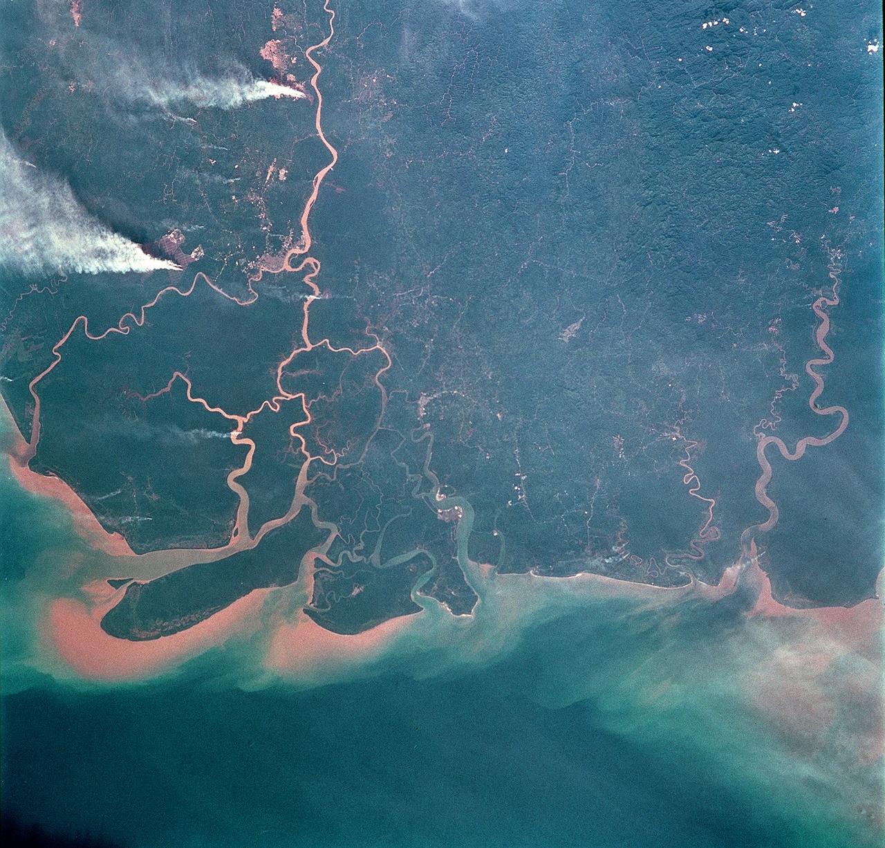
STS093-708-062 (23-27 July 1999) --- The STS-93 astronauts took this picture of the Island of Borneo, which is divided among Indonesia, Malaysia and Brunei. The Rajang River meets the South China Sea in the northwestern portion of the Malaysian state of Sarawak. Smoke from both large and small fires is blowing north by the prevailing summer winds. Notice the contrast of dark colored rainforest with the lighter clearings where the largest fires are burning. According to NASA scientists studying the STS-93 photo collection, the sediment plumes along the coast are mostly shoreline erosional materials caught up in longshore currents. The Saribas River can be seen at the bottom.
The Soyuz TMA-11 spacecraft was transported by railcar to its launch pad at the Baikonur Cosmodrome, Monday, Oct. 8, 2007, in Kazakhstan for an October 10th launch date. The Soyuz will carry Expedition 16 Commander Peggy Whitson, Flight Engineer and Soyuz Commander Yuri Malenchenko and Malaysian spaceflight participant Sheikh Muszaphar Shukor to the International Space Station. Whitson and Malenchenko will spend six months on the station. Shukor, who is flying under an agreement between Malaysia and the Russian Federal Space Agency, will return to Earth October 21 with two of the Expedition 15 crew members currently on the complex. Photo Credit: (NASA/Bill Ingalls)
The Soyuz TMA-11 spacecraft is transported by railcar to its launch pad at the Baikonur Cosmodrome, Monday, Oct. 8, 2007, in Kazakhstan for an October 10th launch date. The Soyuz will carry Expedition 16 Commander Peggy Whitson, Flight Engineer and Soyuz Commander Yuri Malenchenko and Malaysian spaceflight participant Sheikh Muszaphar Shukor to the International Space Station. Whitson and Malenchenko will spend six months on the station. Shukor, who is flying under an agreement between Malaysia and the Russian Federal Space Agency, will return to Earth October 21 with two of the Expedition 15 crew members currently on the complex. Photo Credit: (NASA/Bill Ingalls)
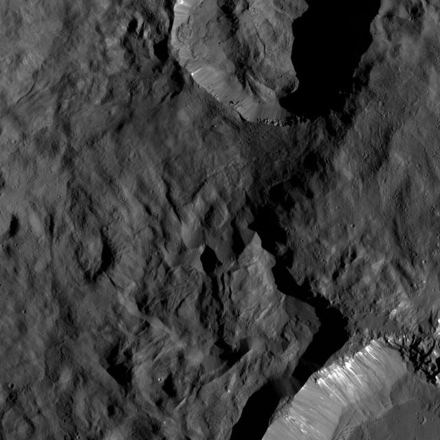
This region on Ceres, located in the vicinity of Toharu Crater, presents two small craters: Juling at top (12 miles, 20 kilometers in diameter) and Kupalo at bottom (16 miles, 26 kilometers in diameter). Both craters are relatively young, as indicated by their sharp rims. These features are located at about the same latitude (about 38 degrees south) as Tawals Crater and show similar crater shapes and rugged terrain. These features may reflect the presence of ice below the surface. Subtle bright features can be distinguished in places. These likely were excavated by small impacts and landslides along the slopes of the crater rims. This suggests that a different type of material, likely rich in salts, is present in the shallow subsurface. Juling is named after the Sakai/Orang Asli spirit of the crops from Malaysia, and Kupalo gets its name from the Russian god of vegetation and of the harvest. NASA's Dawn spacecraft acquired this picture on August 24, 2016. The image was taken during Dawn's extended mission, from its low altitude mapping orbit at about 240 miles (385 kilometers) above the surface. The center coordinates of this image are 38 degrees south latitude, 165 degrees east longitude. https://photojournal.jpl.nasa.gov/catalog/PIA21753
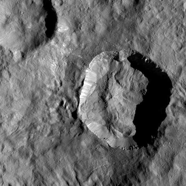
This high-resolution image of Juling Crater on Ceres reveals, in exquisite detail, features on the rims and crater floor. The crater is about 1.6 miles (2.5 kilometers) deep and the small mountain, seen left of the center of the crater, is about 0.6 miles (1 kilometers) high. The many features indicative of the flow of material suggest the subsurface is rich in ice. The geological structure of this region also generally suggests that ice is involved. The origin of the small depression seen at the top of the mountain is not fully understood but might have formed as a consequence of a landslide, visible on the northeastern flank. Dawn took this image during its extended mission on August 25, 2016, from its low-altitude mapping orbit at a distance of about 240 miles (385 kilometers) above the surface. The center coordinates of this image are 36 degrees south latitude, 167 degrees east longitude. Juling is named after the Sakai/Orang Asli spirit of the crops from Malaysia. NASA's Dawn spacecraft acquired this picture on August 24, 2016. The image was taken during Dawn's extended mission, from its low altitude mapping orbit at about 240 miles (385 kilometers) above the surface. The center coordinates of this image are 38 degrees south latitude, 165 degrees east longitude. https://photojournal.jpl.nasa.gov/catalog/PIA21754
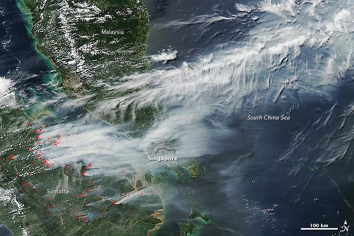
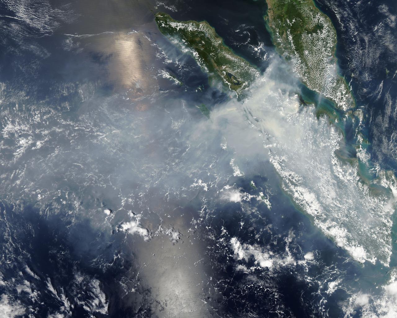
On June 19, 2013, NASA’s Aqua satellite captured a striking image of smoke billowing from illegal wildfires on the Indonesian island of Sumatra. The smoke blew east toward southern Malaysia and Singapore, and news media reported that thick clouds of haze had descended on Singapore, pushing pollution levels to record levels. Singapore’s primary measure of pollution, the Pollutant Standards Index (PSI)—a uniform measure of key pollutants similar to the Air Quality Index (AQI) used by the U.S. Environmental Protection Agency—spiked to 371 on the afternoon of June 20, 2013, the highest level ever recorded. The previous record occurred in 1997, when the index hit 226. Health experts consider any level above 300 to be “hazardous” to human health. Levels above 200 are considered “very unhealthy.” The image above was captured by the Moderate Resolution Imaging Spectroradiometer (MODIS), an instrument that observes the entire surface of Earth’s every 1 to 2 days. The image was captured during the afternoon at 6:30 UTC (2:30 p.m. local time). Though local laws prohibit it, farmers in Sumatra often burn forests during the dry season to prepare soil for new crops. The BBC reported that Singapore’s Prime Minister Lee Hsien Loong warned that the haze could “easily last for several weeks and quite possibly longer until the dry season ends in Sumatra.” NASA image by Jeff Schmaltz, LANCE/EOSDIS Rapid Response. Caption by Adam Voiland. Credit: <b><a href="http://www.earthobservatory.nasa.gov/" rel="nofollow"> NASA Earth Observatory</a></b> Instrument: Aqua - MODIS <b><a href="http://www.nasa.gov/audience/formedia/features/MP_Photo_Guidelines.html" rel="nofollow">NASA image use policy.</a></b> <b><a href="http://www.nasa.gov/centers/goddard/home/index.html" rel="nofollow">NASA Goddard Space Flight Center</a></b> enables NASA’s mission through four scientific endeavors: Earth Science, Heliophysics, Solar System Exploration, and Astrophysics. Goddard plays a leading role in NASA’s accomplishments by contributing compelling scientific knowledge to advance the Agency’s mission. <b>Follow us on <a href="http://twitter.com/NASA_GoddardPix" rel="nofollow">Twitter</a></b> <b>Like us on <a href="http://www.facebook.com/pages/Greenbelt-MD/NASA-Goddard/395013845897?ref=tsd" rel="nofollow">Facebook</a></b> <b>Find us on <a href="http://instagram.com/nasagoddard?vm=grid" rel="nofollow">Instagram</a></b>
On June 19, 2013, NASA’s Aqua satellite captured a striking image of smoke billowing from illegal wildfires on the Indonesian island of Sumatra. The smoke blew east toward southern Malaysia and Singapore, and news media reported that thick clouds of haze had descended on Singapore, pushing pollution levels to record levels. Singapore’s primary measure of pollution, the Pollutant Standards Index (PSI)—a uniform measure of key pollutants similar to the Air Quality Index (AQI) used by the U.S. Environmental Protection Agency—spiked to 371 on the afternoon of June 20, 2013, the highest level ever recorded. The previous record occurred in 1997, when the index hit 226. Health experts consider any level above 300 to be “hazardous” to human health. Levels above 200 are considered “very unhealthy.” The image above was captured by the Moderate Resolution Imaging Spectroradiometer (MODIS), an instrument that observes the entire surface of Earth’s every 1 to 2 days. The image was captured during the afternoon at 6:30 UTC (2:30 p.m. local time). Though local laws prohibit it, farmers in Sumatra often burn forests during the dry season to prepare soil for new crops. The BBC reported that Singapore’s Prime Minister Lee Hsien Loong warned that the haze could “easily last for several weeks and quite possibly longer until the dry season ends in Sumatra.” NASA image by Jeff Schmaltz, LANCE/EOSDIS Rapid Response. Caption by Adam Voiland. Credit: <b><a href="http://www.earthobservatory.nasa.gov/" rel="nofollow"> NASA Earth Observatory</a></b> Instrument: Aqua - MODIS <b><a href="http://www.nasa.gov/audience/formedia/features/MP_Photo_Guidelines.html" rel="nofollow">NASA image use policy.</a></b> <b><a href="http://www.nasa.gov/centers/goddard/home/index.html" rel="nofollow">NASA Goddard Space Flight Center</a></b> enables NASA’s mission through four scientific endeavors: Earth Science, Heliophysics, Solar System Exploration, and Astrophysics. Goddard plays a leading role in NASA’s accomplishments by contributing compelling scientific knowledge to advance the Agency’s mission. <b>Follow us on <a href="http://twitter.com/NASA_GoddardPix" rel="nofollow">Twitter</a></b> <b>Like us on <a href="http://www.facebook.com/pages/Greenbelt-MD/NASA-Goddard/395013845897?ref=tsd" rel="nofollow">Facebook</a></b> <b>Find us on <a href="http://instagram.com/nasagoddard?vm=grid" rel="nofollow">Instagram</a></b>
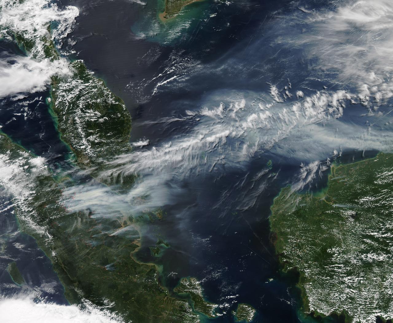
Fires burning in Sumatra continued to pour smoke over the region in mid-March, 2014, bringing air quality to dangerous levels. The Moderate Resolution Imaging Spectroradiometer (MODIS) aboard NASA’s Aqua satellite captured this true-color image of the smoke and haze across the region on March 12. According to the Jakarta Post, on March 12 the Sumatra Environmental Laboratory reported that 10 of 12 spots in Riau had an air quality of index above 300 on the Pollutant Standards Index (PSI), which is considered hazardous. Hazardous air quality had been recorded in some of the locations for 11 consecutive days. The province of Riau is located in the central eastern coast of Sumatra and, in this image, is hidden under thick bands of light gray smoke. Intense fires, reported as deliberately set to clear land, were burning in the Giam Siak Kecil-Bukit Batu biosphere reserve. This reserve contains over 700,000 hectares of sensitive peat forest that sustains a wide range of plant and animal species, including the Sumatra tiger, elephant, tapir and sun bear. With visibility as low as 500 m (1640 ft), 58 flights were cancelled in Pekanbaru, the capital of Riau province, on March 11. Schools were closed across the region, with 43,000 students affected in Payakumbuh, West Sumatra. On March 14, Selangor, Malaysia closed 203 schools, affecting 211,700 pupils, until the air quality improved. On that same day, according to Riau Health Agency, more than 55,000 residents in the province were suffering from haze-related illnesses, including acute respiratory infections, pneumonia and skin and eye irritation. Poor air quality not only affected transportation, human health and the ecosystem, but has had significant economic impacts. On March 17, Reuters reported that the poor air quality had forced Chevron, the country’s biggest oil producer, to close hundreds of its wells. As a result, Indonesia’s crude oil output dropped to 790,000 barrels per day (bpd) – significantly lower than the 870,000 bpd target. Although slash-and-burn techniques, which use fire to clear land, is illegal in Indonesia, the practice is still widespread, with approximately 99% of fires in Sumatra considered to be intentionally set. This year’s early agricultural fires began in February in Riau Province, home to palm-oil and pulpwood plantations. The emergency has prompted strong government response, including a shoot-on-sight order for any suspects involved in land burning activities that resisted arrest. According to the Jakarta Post, police have named as many as 60 suspected-fire starters in Riau. Credit: NASA/GSFC/Jeff Schmaltz/MODIS Land Rapid Response Team <b><a href="http://www.nasa.gov/audience/formedia/features/MP_Photo_Guidelines.html" rel="nofollow">NASA image use policy.</a></b> <b><a href="http://www.nasa.gov/centers/goddard/home/index.html" rel="nofollow">NASA Goddard Space Flight Center</a></b> enables NASA’s mission through four scientific endeavors: Earth Science, Heliophysics, Solar System Exploration, and Astrophysics. Goddard plays a leading role in NASA’s accomplishments by contributing compelling scientific knowledge to advance the Agency’s mission. <b>Follow us on <a href="http://twitter.com/NASAGoddardPix" rel="nofollow">Twitter</a></b> <b>Like us on <a href="http://www.facebook.com/pages/Greenbelt-MD/NASA-Goddard/395013845897?ref=tsd" rel="nofollow">Facebook</a></b> <b>Find us on <a href="http://instagram.com/nasagoddard?vm=grid" rel="nofollow">Instagram</a></b>

This collage shows some of the most interesting geological sites that NASA's Dawn spacecraft has revealed at dwarf planet Ceres. Images were acquired with the spacecraft's framing camera during various phases of the mission: Survey orbit at a distance of about 2,700 miles (4,400 kilometers); high-altitude mapping orbit (HAMO) at a distance of 915 miles (1,470 kilometers) from Ceres; and low-altitude mapping orbit (LAMO) at an altitude of 240 miles (385 kilometers). In the first row, from left to right: Ceres in shown in false color, roughly centered on Occator Crater, home of the brightest area on Ceres. This picture combines color images obtained by Dawn in its survey orbit. Red corresponds to a wavelength range around 980 nanometers (near infrared), green to a wavelength range around 750 nanometers (red, visible light) and blue to a wavelength range of around 430 nanometers (blue, visible light). This picture illustrates the diversity of terrains on Ceres where the bluish material points to recently emplaced material and the brownish background material is associated with older terrains. Juling Crater (12 miles, 20 kilometers in diameter) as seen in LAMO. Central coordinates are 36 degrees south latitude, 168 degrees east longitude. It is named after the Sakai/Orang Asli (Malaysia) spirit of the crops. This crater displays evidence for the presence of ice -- for example, in the form of a large flow feature seen at the top of the image. Oxo Crater (6 miles, 10 kilometers in diameter) as seen in LAMO. Center coordinates are 42 degrees north latitude, 0 degrees east longitude. It is named after the god of agriculture in Afro-Brazilian beliefs of Yoruba derivation. Oxo hosts the first site at which Dawn detected ice on Ceres, exposed by a landslide. Ahuna Mons is not only a volcano, but also the tallest mountain on Ceres. It is about 2.5 miles (4 kilometers) high and 11 miles (17 kilometers) wide. Center coordinates are 10 degrees south latitude, 316 degrees east longitude. This view combines images obtained in LAMO in blue (430 nanometers), green (750 nanometers) and infrared (980 nanometers) color filters. Ahuna is named after the Sumi tribe (Nagaland, northeastern India) traditional post-harvest thanksgiving festival. Second Row Occator Crater (57 miles, 92 kilometers across) is seen in LAMO images. Center coordinates are 20 degrees north latitude, 239 degrees east longitude. Named after the Roman agricultural deity of the harrowing. This image shows a "Type I" flow feature with a thick "toe" typical of rock glaciers and icy landslides on Earth as viewed in LAMO. The flow feature, found in Ghanan Crater (77 degrees north latitude, 31 degrees east longitude), is one of the most voluminous on Ceres. Enhanced color view of Haulani Crater (21 miles, 34 kilometers in diameter) in color observed in HAMO. Central coordinates: 6 degrees north latitude, 11 degrees east longitude. Named after the Hawaiian plant goddess. Kokopelli Crater (21 miles, 34 kilometers in diameter) seen in LAMO. Central coordinates: 18 degrees north latitude, 125 degrees east longitude. Named after the Pueblo (SW USA) fertility deity, who presides over agriculture. This crater displays a nice arrangement of scarps that likely formed when the crater partly collapsed during its formation. Third Row Central region of Occator Crater, called Cerealia Facula, seen in color. The facula -- or "bright spot" -- is about 9 miles (14 kilometers) in diameter. Center coordinates: 20 N, 240 E. Cerealia refers to the major festival in Ancient Rome that celebrates the grain goddess Ceres (8 days in mid- to late April). The view was produced by combining the highest resolution images of Occator obtained in LAMO (at image scales of 35 meters, or 115 feet, per pixel) with color images obtained in HAMO (at image scales of 135 meters, or about 440 feet, per pixel). The three images used to produce the color were taken using filters centered at 430, 750 and 980 nanometers (the last being slightly beyond the range of human vision, in the near-infrared). North part of Nar Sulcus seen in LAMO. The full feature is about 39 miles (63 km) in length and is located around 42 degrees south latitude, 280 degrees east longitude. Nar is a Azerbaijani festival of pomegranate harvest held in October-November in Goychay city, center of pomegranate cultivation in Azerbaijan. A sulcus is a set of parallel furrows or ridges. Ikapati Crater (31 miles, 50 kilometers in diameter) seen in LAMO. Central coordinates: 34 degrees north latitude, 46 degrees east longitude. Ikapati is named after the Philippine goddess of the cultivated lands. The crater has a smooth floor, probably because heat from the impact that formed Ikapati caused ice in the ground to melt, and then refreeze. This view of Ceres, taken in LAMO, shows an area located at approximately 86 degrees south longitude, 177 degrees east longitude. This part of Ceres, near the south pole, has such long shadows because, from the perspective of this location, the sun is near the horizon. At the time this image was taken, the sun was 4 degrees north of the equator. If you were standing this close to Ceres' south pole, the sun would never get high in the sky during the course of a nine-hour Cerean day. https://photojournal.jpl.nasa.gov/catalog/PIA22090