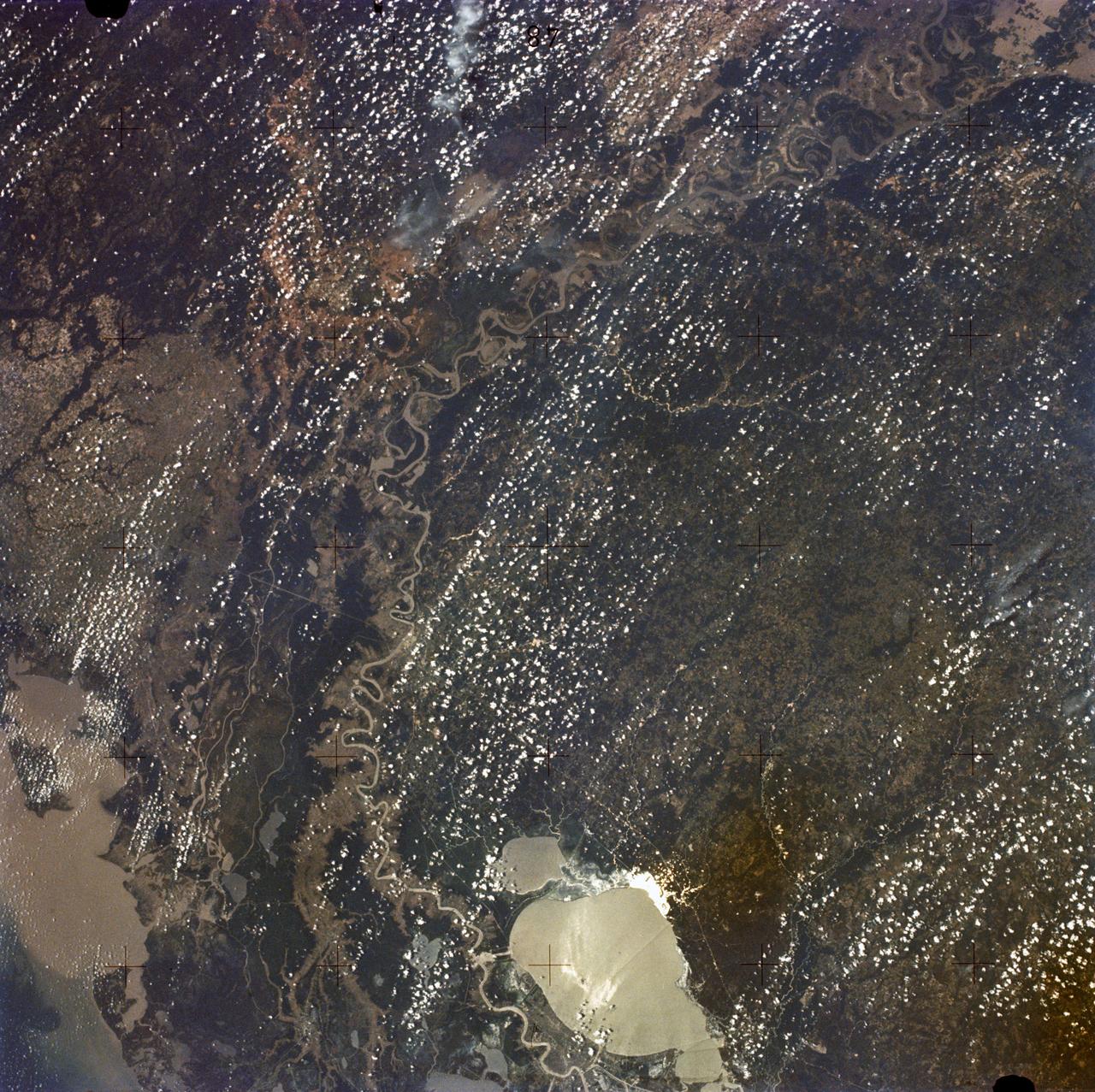
SL2-05-397 (22 June 1973) --- New Orleans, Louisiana, Mississippi River, and Lake Pontchartrain (31.0N, 91.0W) can all be seen in this single detailed view. The marshlands of the Atchafalaya Basin, previously the main drainage way for the Mississippi River, can be seen to be partially silted as a result of sediments. The long narrow field patterns fronting on the river is called the "Long Lot" system of equal land distribution based on the French Napoleonic Civil Code. Photo credit: NASA
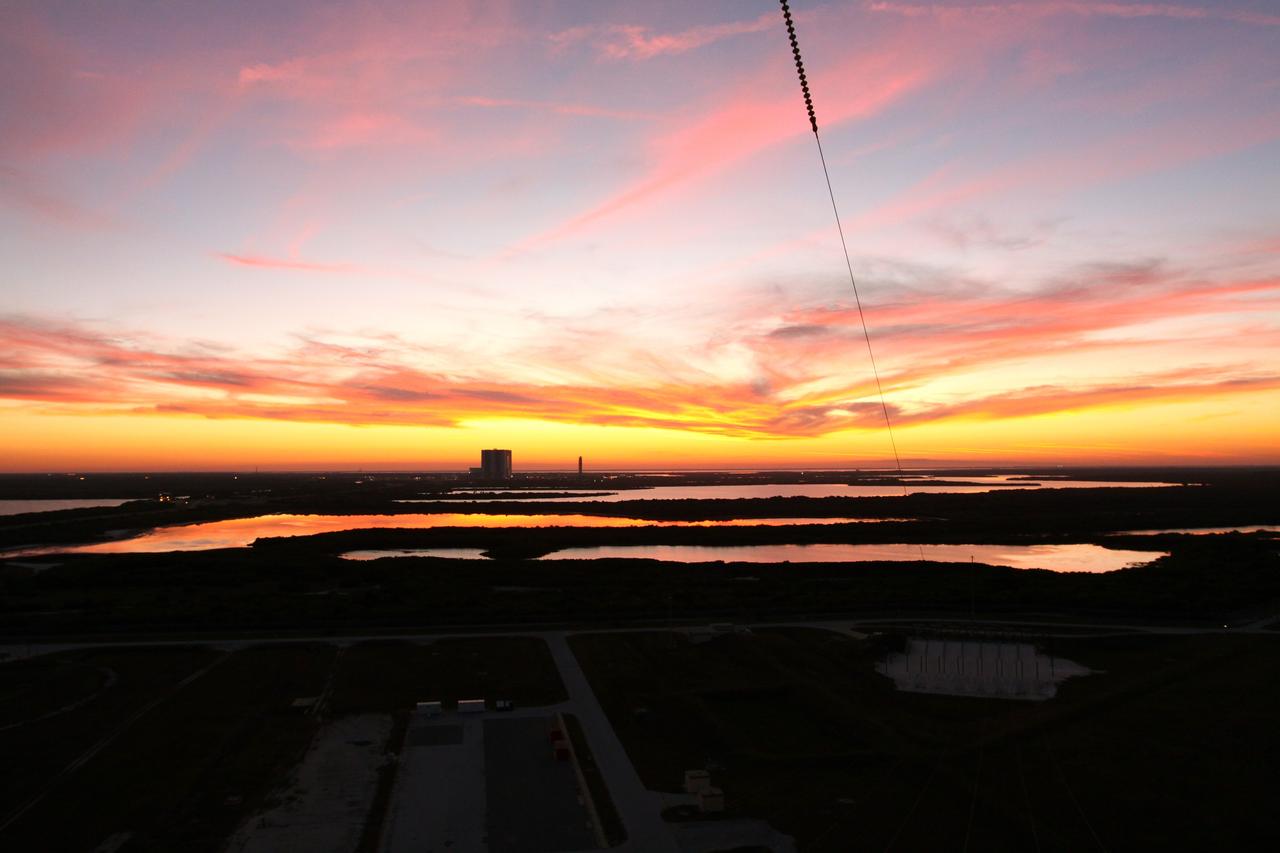
CAPE CANAVERAL, Fla. -- Taken from Launch Pad 39A at NASA's Kennedy Space Center in Florida, the sun sets, casting beautiful hues on the center's many bodies of water and shadowing the vast marshland, Vehicle Assembly Building and NASA's new mobile launcher. Photo credit: NASA/Jack Pfaller
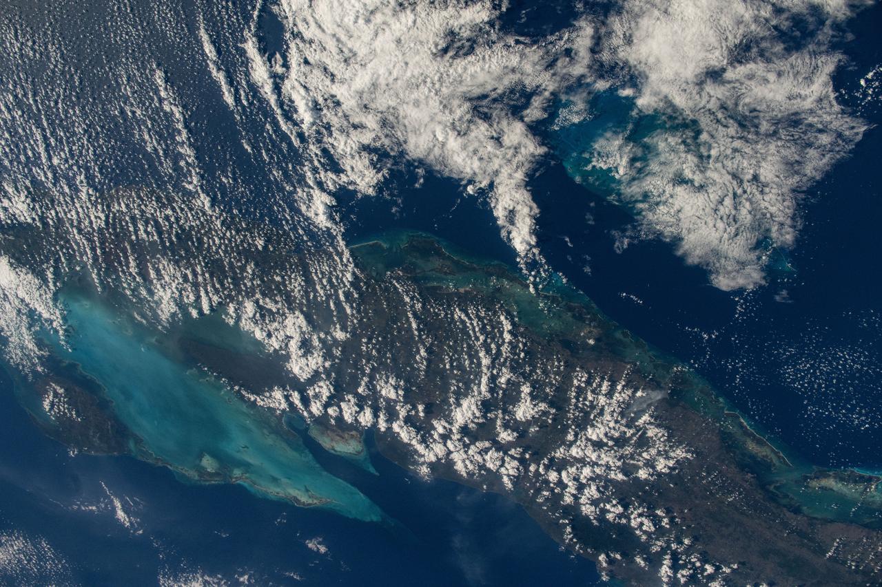
iss072e1000000 (April 11, 2025) --- This is the one-millionth image taken during the Expedition 72 mission aboard the International Space Station. The clouds covering the island nation of Cuba hide its capital and largest city Havana (far left) on the Florida Strait. To the south are the marshlands and forests of Cuba's Zapata Swamp that leads to the Caribbean Sea. NASA astronaut and Expedition 72 Flight Engineer Nichole Ayers took this photograph from the International Space Station as it orbited 261 miles above the Bahamas.
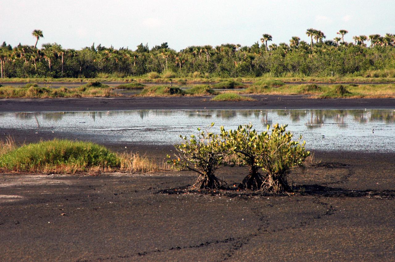
KENNEDY SPACE CENTER, FLA. - Visitors to the Space Coast may experience Florida's marshlands firsthand from Blackpoint Wildlife Drive on the Merritt Island National Wildlife Refuge. The water level subsides at this time of the year in part due to the hot daytime temperatures. The refuge was established in 1963 on Kennedy Space Center land and water not used by NASA for the space program. It encompasses 92,000 acres that are a habitat for more than 331 species of birds, 31 mammals, 117 fishes, and 65 amphibians and reptiles.
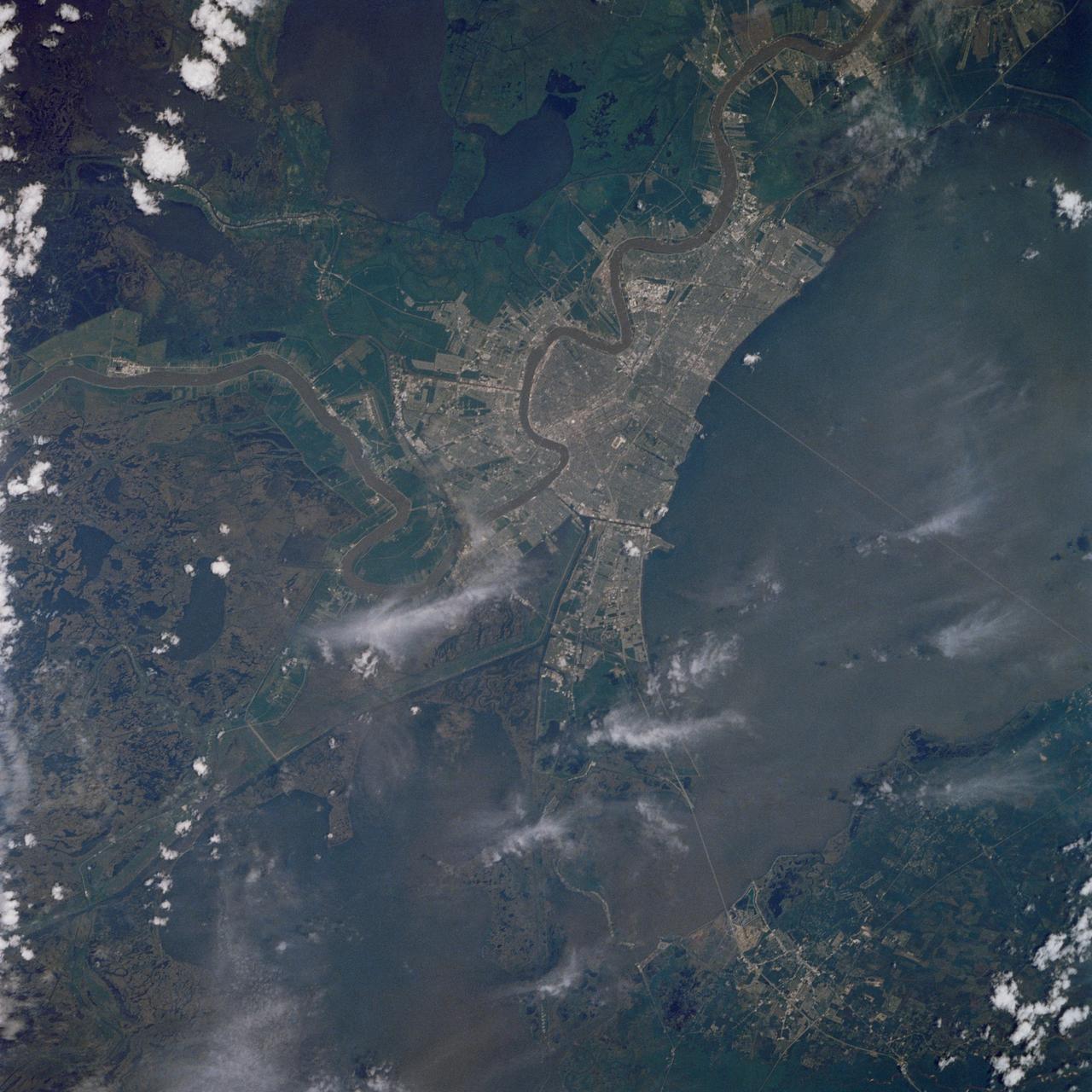
As one of the best ever views of the city of New Orleans, LA (30.0N, 90.0W) from space, this image allows the study of the city and the region in minute detail. Major city street and highway patterns can easily be traced. Even the Superdome near the old French Quarter can be seen as a large round white circle near the middle of the photo. The French Napoleonic Code land distribution system of long narrow fields fronting the river is also evident.
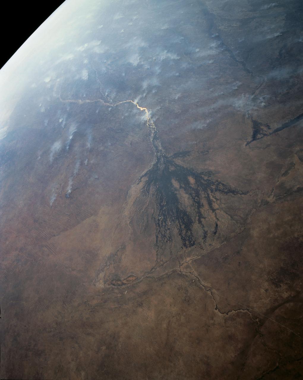
In this panoramic view of the Okavango Swamp, Botswana, (19.0S, 22.0E), the Okavango River, seen in sunglint, flows into a topographic trough to form an inland delta. Water, trapped in the meandering delta distributaries is evaporated or transpired by vegetation. In Angola to the north, the many fires of the seasonal burning of savannah vegetation for land clearing, in preparation for agriculture, has filled the atmosphere with haze and smoke.
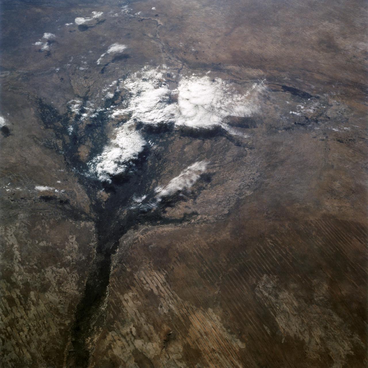
STS066-122-091 (3-14 Nov. 1994) --- This November 1994 view looking south-southeast shows clouds over the Okavango Delta area of northern Botswana. The Okavango is one of the wilder, less spoiled regions of Africa. The area still supports great herds of wild animals such as elephant, zebra and the cape buffalo. Despite conservation efforts from the stable government of Botswana, delta habitats are pressured. The Okavango River (lower left of view) brings water from the high, wet plateaus of Angola into the Kalahari Desert, and enormous inland basin. As a result of a series of small faults (upper center of the view) related to the African Rift System, the river is dammed up in the form of swampy inland delta. Here, water is consumed by evaporation, infiltration, and the swamp forests. Late summer floods take six months to slowly penetrate the 160 kilometer (95 miles) to the other end of the Delta. The visual patterns of the area are strongly linear: straight sand dunes occur in many places and can be seen across the bottom portion of the photograph. Numerous brush-fire scars produce a complex, straight-edged pattern over much of the lower portion of this view. Lake Ngami (upper right of view) was once permanently full as late as the middle 1800's. Changes in the climate of the area over the last 100 years has changed the size and shape of the inland delta.
STS060-90-028 (3-11 Feb 1994) --- This view is centered over Rome and covers approximately 3,600 square miles. Anzio, the site of the January 22, 1944, Allied landing in Central Italy, is on the coast at the lower left. The coastal protuberance near the center is Ostia. This Roman Empire port on the Tiber River silted in and was covered over. It is now an archeological site and a tourist attraction. Southeast of the mouth of the Tiber is the Pontine Marsh. These marshlands were drained in the 1930's and have been converted to farmland. Volcanism formed the land in the region. It is evidenced in the circular caldera lakes visible. Castel Gandolfo, part of the Papal State, is on Lake Albano toward the bottom of the frame. Rome was founded during the Bronze Age on a river crossing. The road from the coast along the river was the main route for the early salt trade. The city became the capital of modern Italy in 1861. It has undergone explosive growth since World War II and now has a population of over three million people. Leonardo da Vinci (Fiumicino) Airport, the main international airport, is visible near the coast north of the Tiber River.

KENNEDY SPACE CENTER, Fla. -- A helicopter provides a unique view of the launch of Space Shuttle Discovery from Launch Pad 39A on mission STS-105. Liftoff occurred at 5:10:14 p.m. EDT. As Discovery soars into the sky it casts a shadow from the setting sun. Below the smoke column rises the 525-foot-high Vehicle Assembly Building, a landmark at Kennedy Space Center. To the left is the Banana Creek and in the foreground are the marshlands of the Merritt Island National Wildlife Refuge, which shares a boundary with Kennedy. Besides the Shuttle crew of four, Discovery carries the Expedition Three crew who will replace Expedition Two on the Space Station. The mission includes the third flight of an Italian-built Multi-Purpose Logistics Module delivering additional scientific racks, equipment and supplies for the Space Station and the Early Ammonia Servicer (EAS) tank. The EAS, which will be attached to the Station during two spacewalks, contains spare ammonia for the Station’s cooling system. The three-member Expedition Two crew will be returning to Earth aboard Discovery after a five-month stay on the Station
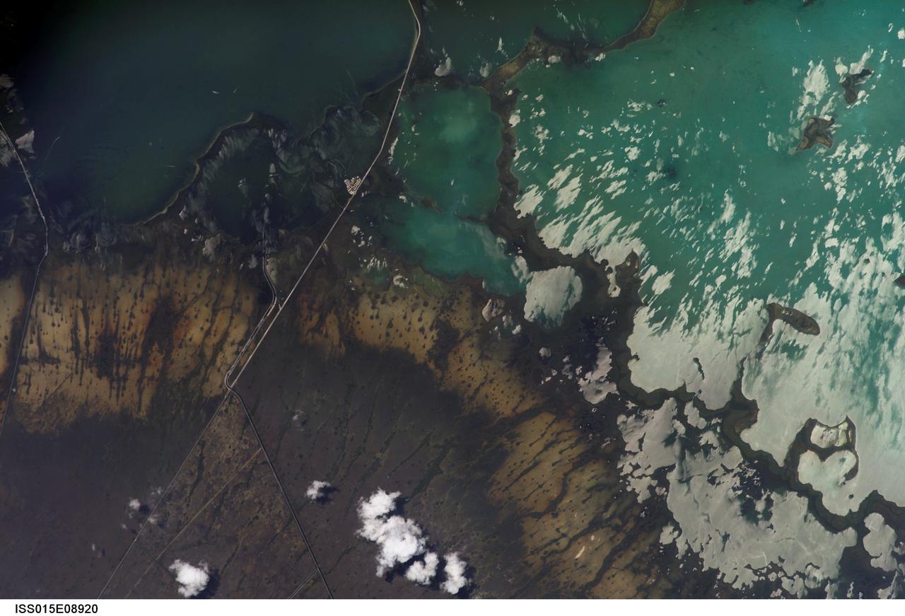
ISS015-E-08920 (19 May 2007) --- Southern Everglades National Park, Florida is featured in this image photographed by an Expedition 15 crewmember on the International Space Station. Everglades National Park in southern Florida is the largest subtropical wilderness in the United States. Known as the "river of grass", the Everglades wetlands and wooded uplands host a variety of endangered species including crocodiles, manatees, and panthers. During the late 19th and 20th centuries, the original 11,000 square miles of wetlands were viewed as useless swampland in need of reclamation. The success of reclamation efforts -- for agriculture and urban expansion in southern Florida -- has led to the loss of approximately 50 per cent of the original wetlands and 90 per cent of wading bird species. Today, an extensive restoration effort is underway to return portions of the Everglades to a more natural state and prevent further ecosystem degradation. This view highlights the southern Everglades estuarine ecosystem where the wetlands meet Florida Bay. Thin fingers of land and small islands (keys) host mangrove, hardwood hammocks, marsh and prairie (mainly dark to light green in the image). The tan and grayish-brown areas are dominantly scrub, marshland and prairie; small green "dots" and narrow lines in this region are isolated mangrove and hardwood stands indicating the general direction of slow water flow toward the bay. The silver-gray regions are water surfaces highlighted by sunglint. The roadway forming the western boundary of the National Park is US Route 1 connecting the Miami metropolitan area to the north (not shown) with the Florida Keys to the south (not shown). A small built feature visible along the roadway is a fishing camp.
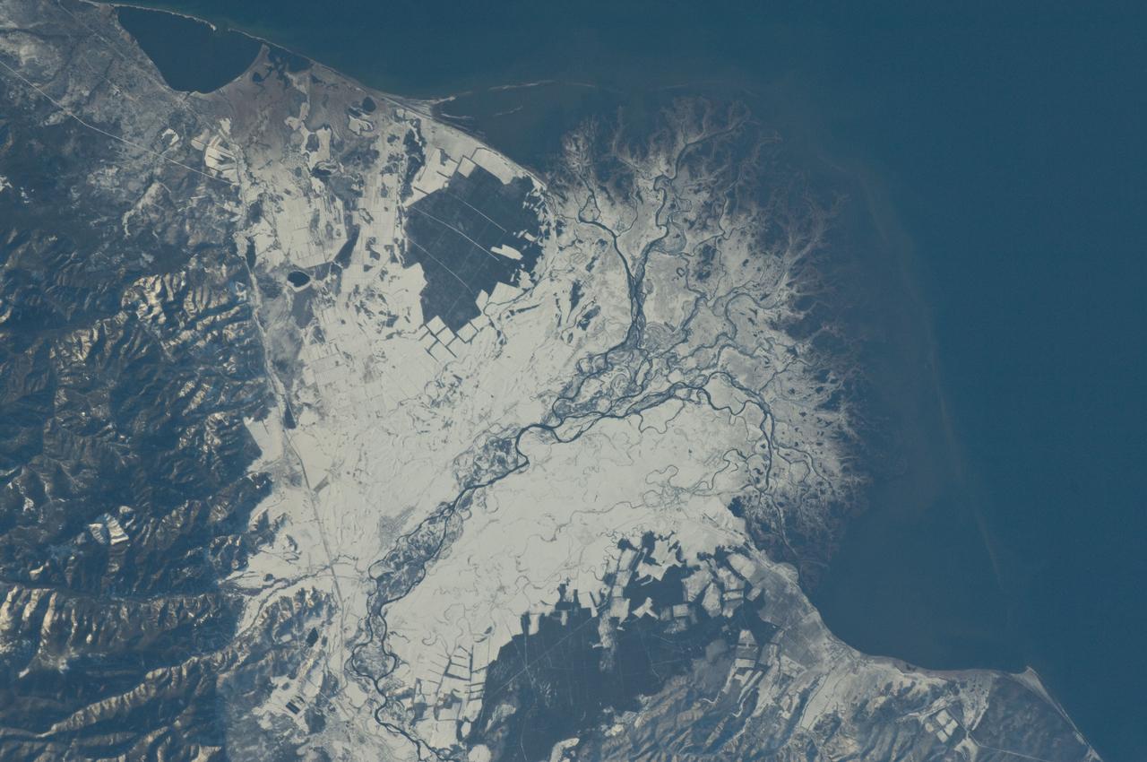
ISS029-E-037915 (3 Nov. 2011) --- Snowfall on the Selenga River Delta, Russian Federation is featured in this image photographed by an Expedition 29 crew member on the International Space Station. This photograph illustrates the Selenga River Delta built out into Lake Baikal in Russia. The Selenga River delta (center) is lobate in form, with an intricate network of distributary channels and levees surrounded by marshlands building out into Lake Baikal. This suggests that development of the delta is governed by the sediment load carried by the river, and any modifications of form due to lake tides or waves are relatively minor. Further out, dark brown depositional bars are visible forming a rough arc marking the edge of the delta. Snow cover on the river floodplain highlights numerous secondary channels, as well as channels previously occupied by the river but now abandoned. The regular outlines of agricultural fields to the southwest and northeast of the river are also highlighted by the snow cover. Lake Baikal is a World Heritage Site. The Selenga River is the major contributor of water to Lake Baikal; it occupies approximately 82 per cent of the watershed area for the lake. The wetlands of the Selenga River delta are designated as a RAMSAR site and provide valuable habitat for more than 170 species of birds, including many that are migrating. Like Baikal, the Selenga Delta is home to unique ecosystems, including more than 70 rare or endangered species of plants and animals. Waters of the Selenga River serve many (and differing) uses in both Mongolia and Russia, including support of agriculture, provision of drinking water, light industry, mining, recreation, and tourism. These uses also contribute to degradation of the river water quality, downstream availability of water, and ecological impacts. For example, a pulp and paper plant in the city of Selenginsk (lower left) has been tied to high levels of pollution in the river. International efforts to integrate management of the Selenga River basin for both ecological and economic sustainability are ongoing.
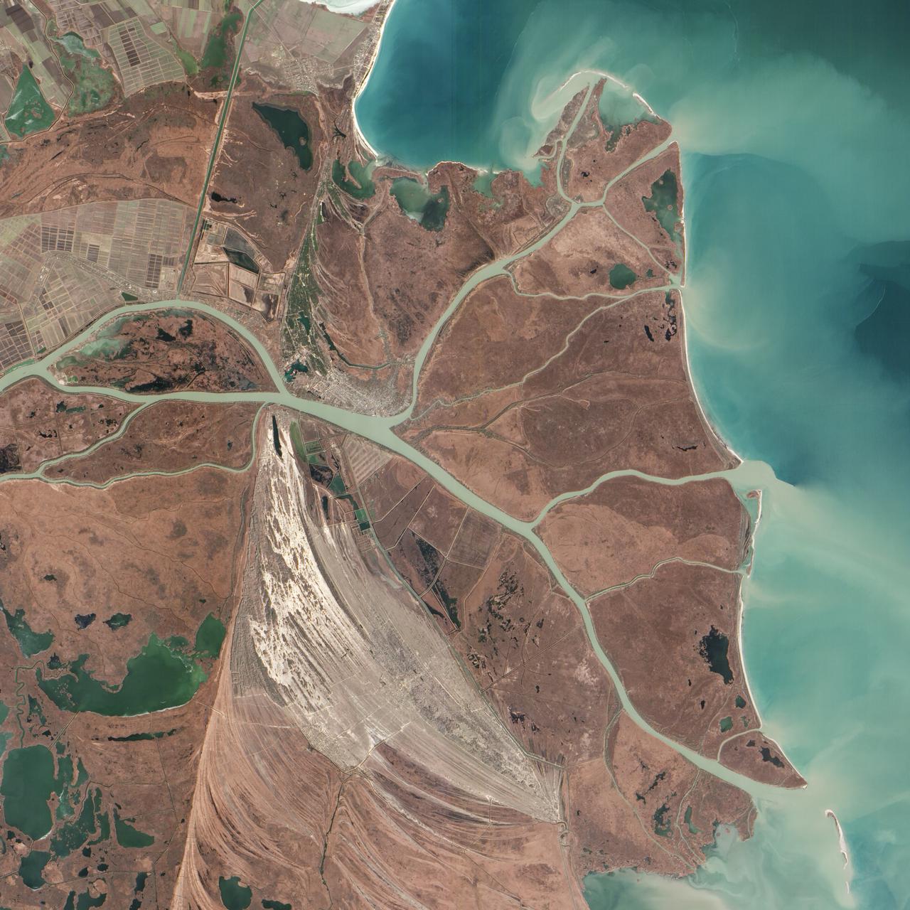
Acquired February 5, 2013 The Danube River is the largest in the European Union, its watershed draining 801,463 square kilometers (309,447 square miles) of land across 19 countries. Where that great river reaches the Black Sea, a remarkable delta has formed—the “Everglades” of Europe. The Danube Delta is home to more than 300 species of bird and 45 species of freshwater fish. The Danube Delta has been home to human settlements since the end of the Stone Age (the Neolithic Period), and the ancient Greeks, Romans, and Byzantines all built trading ports and military outposts along this coast. Today, the border between Romania and Ukraine cuts through the northern part of the delta. The area is a United Nations World Heritage Site, both for its natural and human history, and for the traditional maritime culture that persists in its marshes. All the while, the landscape has been shaped and re-shaped by nature and man. The image above was acquired on February 5, 2013, by the Advanced Land Imager (ALI) on NASA’s Earth Observing-1 (EO-1) satellite. The Danube Delta has a number of lobes formed over the past several thousand years, and this image is focused largely on the northernmost Chilia (or Kilia) lobe. It is the youngest section of the delta—somewhere between 300 to 400 years old—and lies mostly within Ukraine. Much of the land in the image above is officially considered part of the Danube Biosphere Reserve. Near the center of the image, the small city of Vylkove is known as the “Ukranian Venice,” due to its canals. To the lower left, the older Sulina lobe of the delta stretches to the south and further inland into Romania. White and brown curved lines reveal beach ridges and former shorelines, with the whiter ridges composed almost entirely of pure quartz sand in high dunes. To the east of the ridges, most of the landscape is flat marshland that is mostly brown in the barren days of winter. The Bystroye Canal through the center of the Chilia lobe has been the subject of heated debate over the past two decades. Over the centuries, damming and channeling of the Danube throughout Europe has reduced its water flow and sediment load to roughly 30 percent of what it once was, according to coastal geologist Liviu Giosan of the Woods Hole Oceanographic Institution. In recent years, the Ukrainian government has dredged some delta channels (including Bystroye) and proposed extensive dredging of others in order to provide navigational channels for large ships. Proponents argue for the economic needs of water transportation routes. Opponents note that deeper, faster channels mean less mud and sand is deposited in the delta; in some places, more is carried away by swifter currents. Both affect the sensitive ecosystems and the ability of the delta to restore itself and grow. In a 2012 report led by Giosan, scientists noted that the shape, water chemistry, and biology of Danube Delta was being altered long before the modern Industrial Era. Land use practices—particularly farming and forest clearing—added significant amounts of nutrients into the water and reduced salinity in the Black Sea, changing the dominant species of phytoplankton and sending a ripple of effects through the entire food web. NASA Earth Observatory image by Jesse Allen and Robert Simmon, using EO-1 ALI data provided courtesy of the NASA EO-1 team and the U.S. Geological Survey. Caption by Mike Carlowicz. Instrument: EO-1 - ALI More info: <a href="http://earthobservatory.nasa.gov/IOTD/view.php?id=80459" rel="nofollow">earthobservatory.nasa.gov/IOTD/view.php?id=80459</a> Credit: <b><a href="http://www.earthobservatory.nasa.gov/" rel="nofollow"> NASA Earth Observatory</a></b> <b><a href="http://www.nasa.gov/audience/formedia/features/MP_Photo_Guidelines.html" rel="nofollow">NASA image use policy.</a></b> <b><a href="http://www.nasa.gov/centers/goddard/home/index.html" rel="nofollow">NASA Goddard Space Flight Center</a></b> enables NASA’s mission through four scientific endeavors: Earth Science, Heliophysics, Solar System Exploration, and Astrophysics. Goddard plays a leading role in NASA’s accomplishments by contributing compelling scientific knowledge to advance the Agency’s mission. <b>Follow us on <a href="http://twitter.com/NASA_GoddardPix" rel="nofollow">Twitter</a></b> <b>Like us on <a href="http://www.facebook.com/pages/Greenbelt-MD/NASA-Goddard/395013845897?ref=tsd" rel="nofollow">Facebook</a></b> <b>Find us on <a href="http://instagram.com/nasagoddard?vm=grid" rel="nofollow">Instagram</a></b>