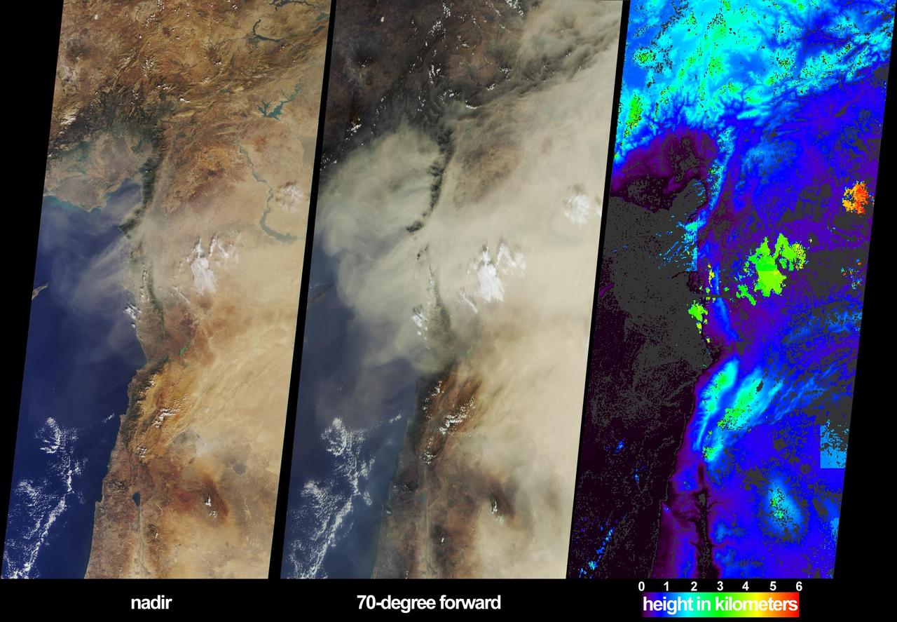
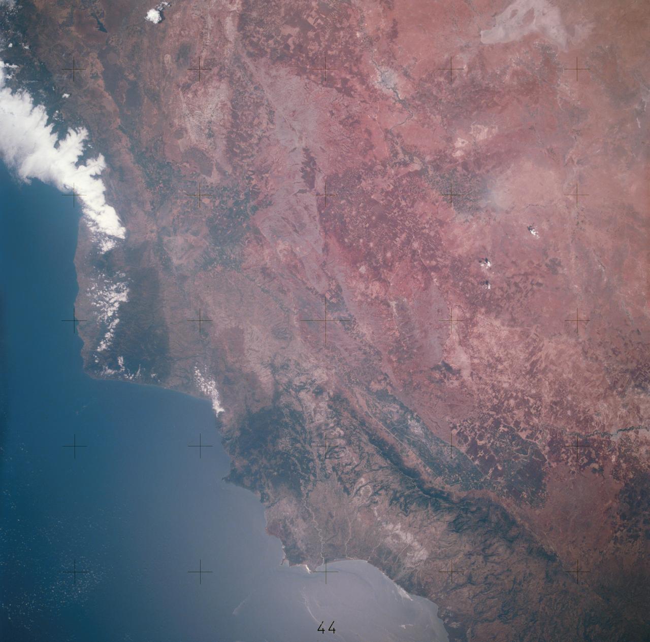
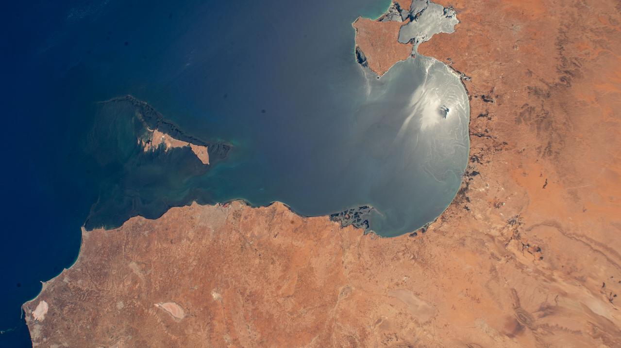
These images from NASA Terra satellite, captured on October 18, 2002, display a large dust plume extended across countries bordering the eastern Mediterranean Sea.
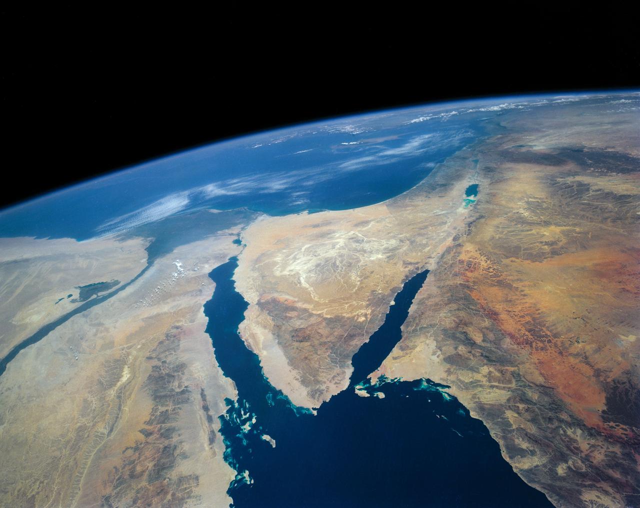
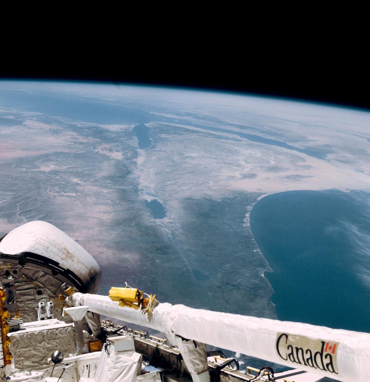
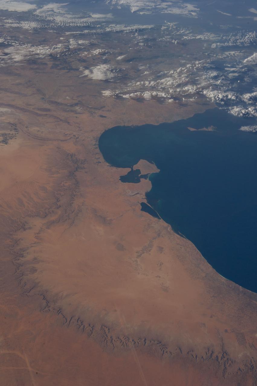
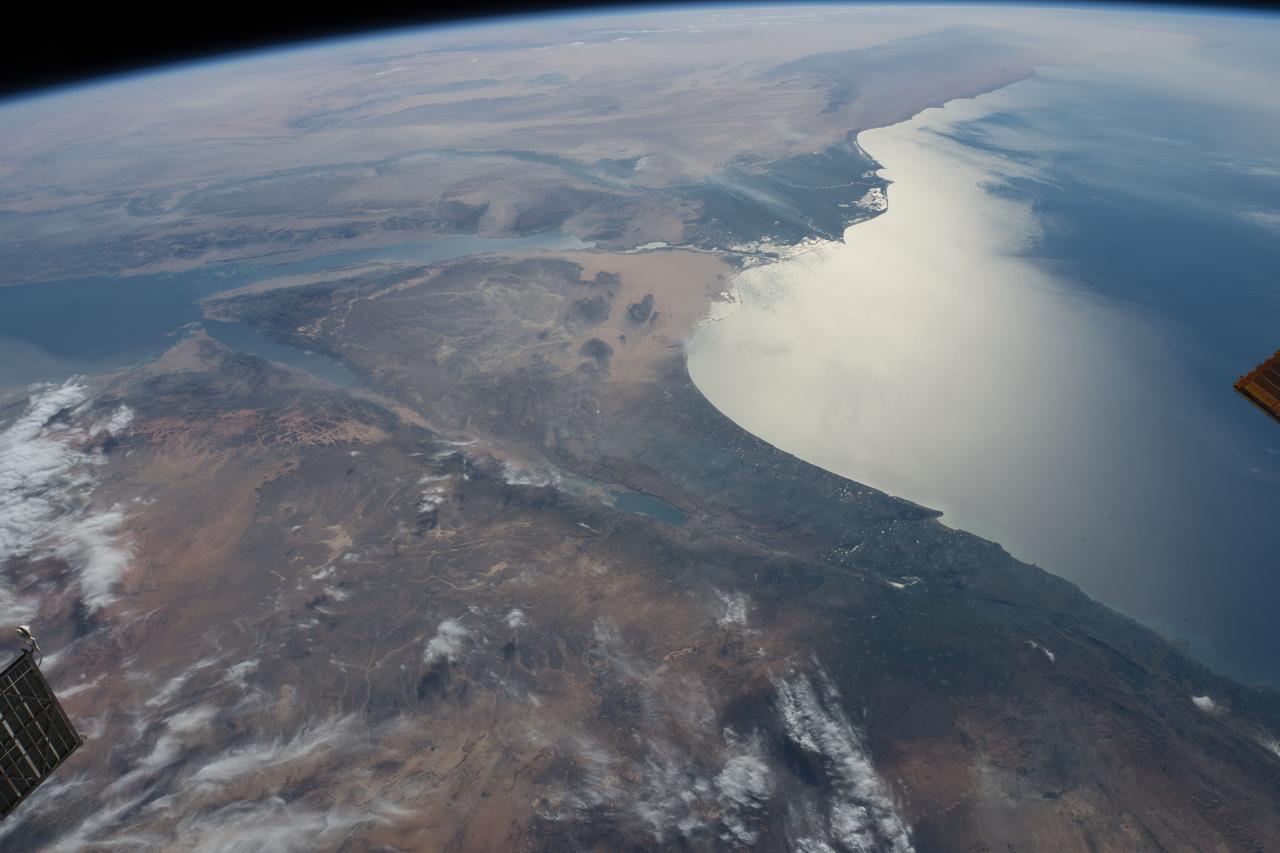
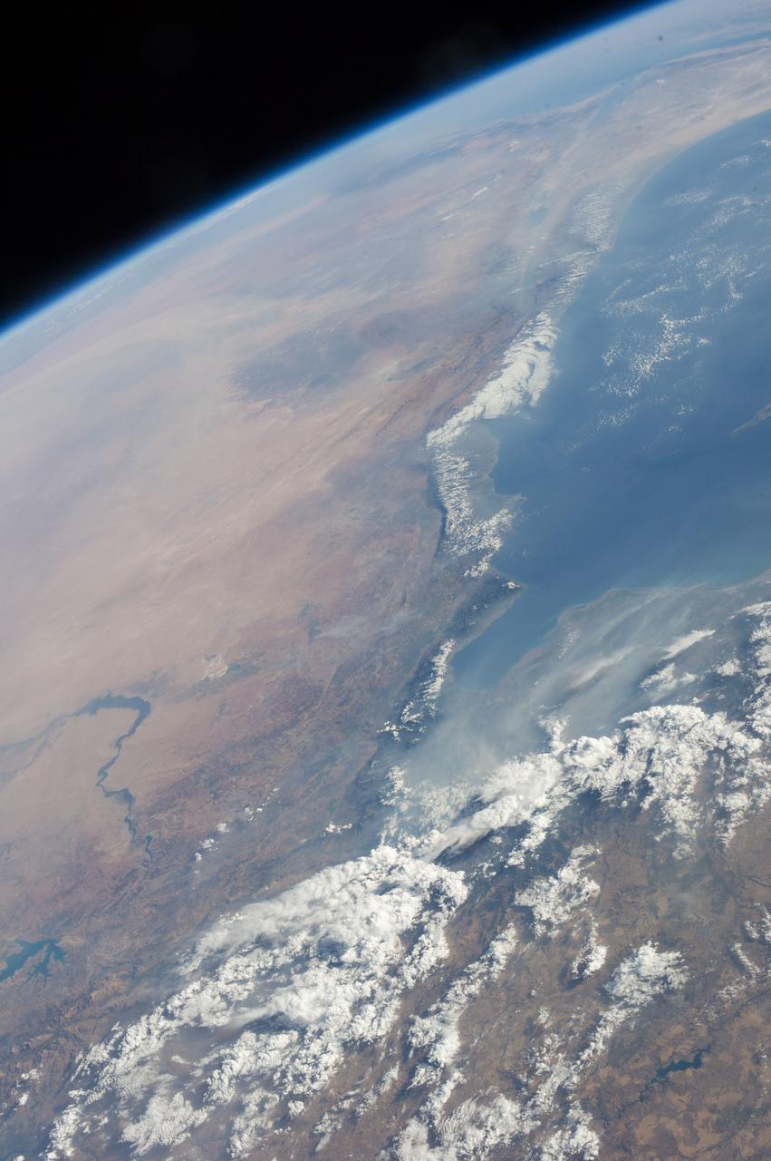
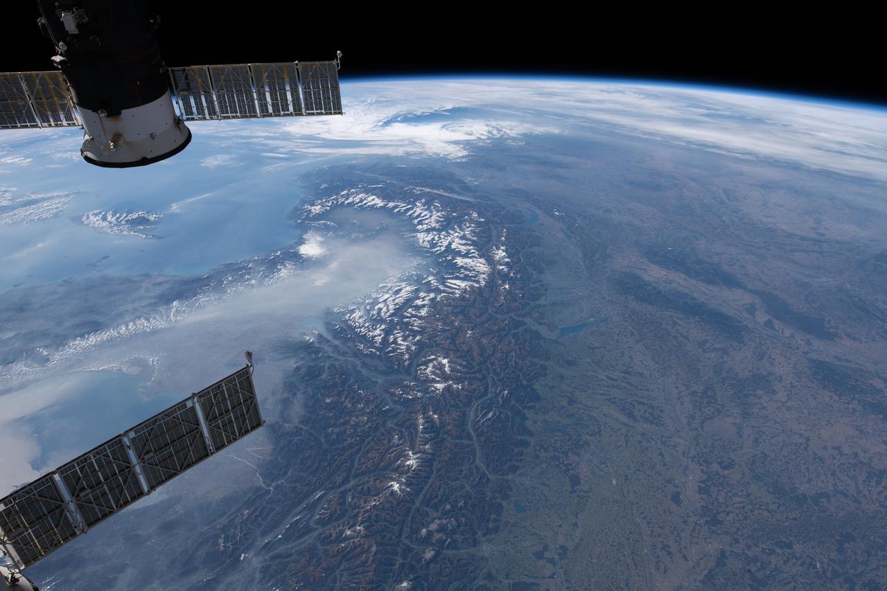
STS040-152-180 (5-24 June 1991) --- The Sinai Peninsula dominates this north-looking, oblique view. According to NASA photo experts studying the STS 40 imagery, the Red Sea in the foreground is clear of river sediment because of the prevailing dry climate of the Middle East. The great rift of the Gulf of Aqaba extends northward to Turkey (top right) through the Dead Sea. The international boundary between Israel and Egypt, reflecting different rural landscapes, stands out clearly. The Nile River runs through the frame. NASA photo experts believe the haze over the Mediterranean to be wind-borne dust. The photo was taken with an Aero-Linhof large format camera.
STS057-73-075 (21 June-1 July 1993) --- Eastern Mediterranean from an unusually high vantage point over the Nile River, this north-looking view shows not only the eastern Mediterranean but also the entire landmass of Asia Minor, with the Black Sea dimly visible at the horizon. Many of the Greek islands can be seen in the Aegean Sea (top left), off the coast of Asia Minor. Cyprus is visible under atmospheric dust in the northeast corner of the Mediterranean. The dust cloud covers the east end of the Mediterranean, its western edge demarcated by a line that cuts the center of the Nile Delta. This dust cloud originated far to the west, in Algeria, and moved northeast over Sicily, southern Italy, and Greece. Part of the cloud then moved on over the Black Sea, but another part swerved southward back towards Egypt. A gyre of clouds in the southeast corner of the Mediterranean indicates a complementary counterclockwise (cyclonic) circulation of air. The Euphrates River appears as a thin green line (upper right) in the yellow Syrian Desert just south of the blue-green mountains of Turkey. The Dead Sea (lower right) lies in a rift valley which extends north into Turkey and south thousands of miles down the Gulf of Aqaba, the Red Sea, and on through East Africa. The straight international boundary between Israel and Egypt (where the coastline angles) is particularly clear in this view, marked by the thicker vegetation on the Israeli side of the border. The green delta of the Nile River appears in the foreground, with the great conurbation of Cairo seen as a gray area at the apex of the triangle. Most of Egypt's 52 million inhabitants live in the delta. On the east side of the delta, the Suez Canal is visible. On the western corner of the delta lies the ancient city of Alexandria, beside the orange and white salt pans. The World War II battlesite El Alamein lies on the coast.
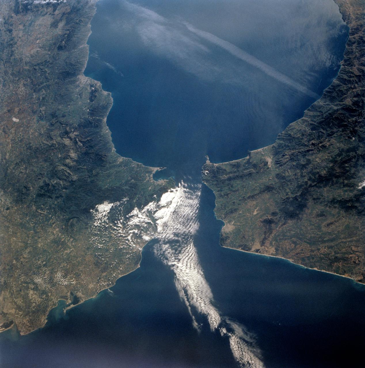
S66-45749 (18 July 1966) --- Straits of Gibraltar, Mediterranean Sea, Spain in background, Algeria and Morocco in foreground as seen from Gemini-10 spacecraft. Photo credit: NASA
AST-16-1268 (20 July 1975) --- A near vertical view of a portion of the Mediterranean coast of Turkey and Syria, as photographed from the Apollo spacecraft in Earth orbit during the joint U.S-USSR Apollo-Soyuz Test Project mission. This view covers the Levant Coast north of Beirut, showing the cities of Aleppo, Hamah, Homs and Latakia. The Levantine rift bends to the northeast. This picture was taken with a 70mm Hasselblad camera using high-definition aerial Ektachrome SO-242 type film. The altitude of the spacecraft was 225 kilometers (140 statute miles) when this photograph was taken.
This image from NASA Kidsat electronic still camera was requested by Buist Academy for the purpose of studying the coast of Israel and the Mediterranean Sea.
During STS-56, the Shuttle Pointed Autonomous Research Tool for Astronomy 201 (SPARTAN-201), a freeflying payload, was photographed by Discovery's, Orbiter Vehicle (OV) 103's, crewmembers as it drifted above the Mediterranean Sea near the island of Crete. On the mission's third day, the remote manipulator system (RMS) arm was used to lift SPARTAN-201 from its support structure in OV-103's payload bay and release it in space. SPARTAN-201 was later recaptured by OV-103's RMS and returned to Earth with the astronaut crew.
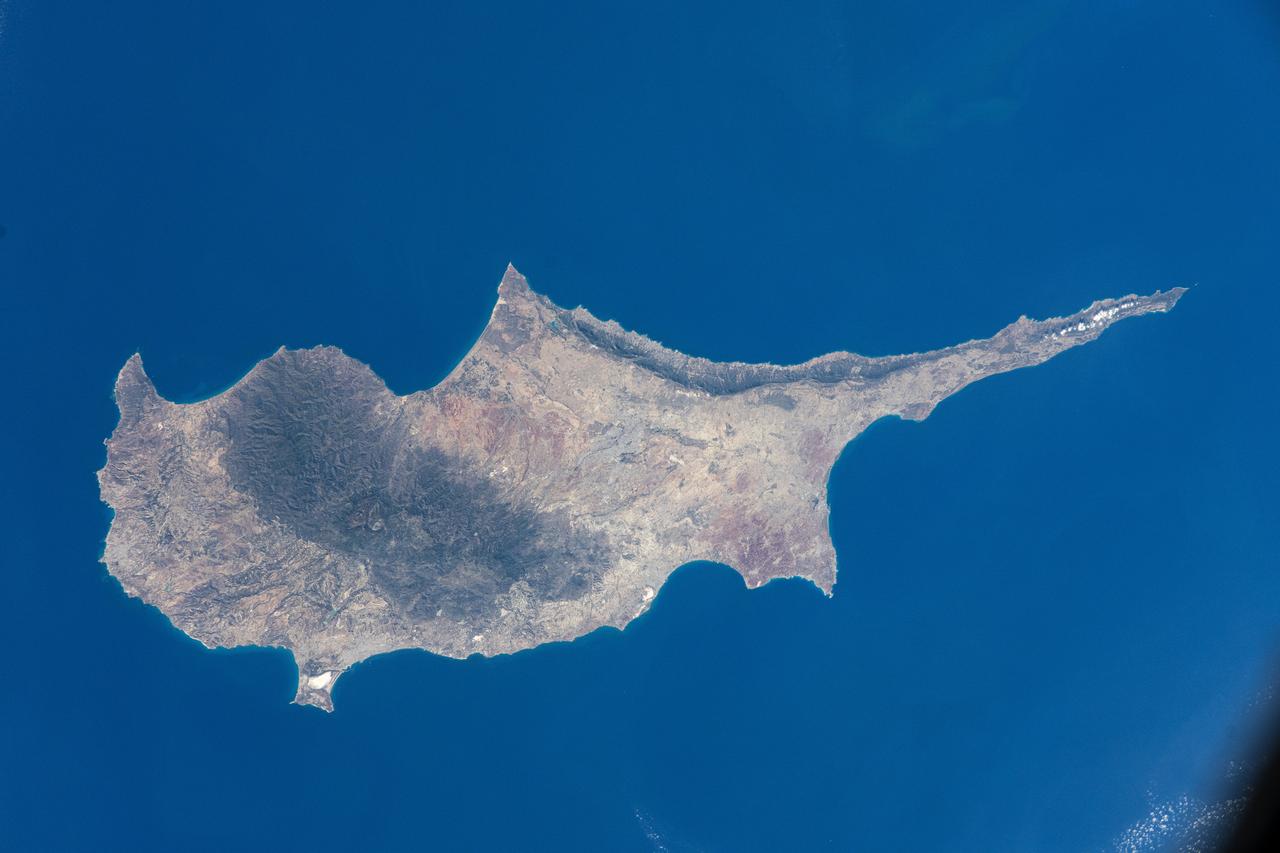
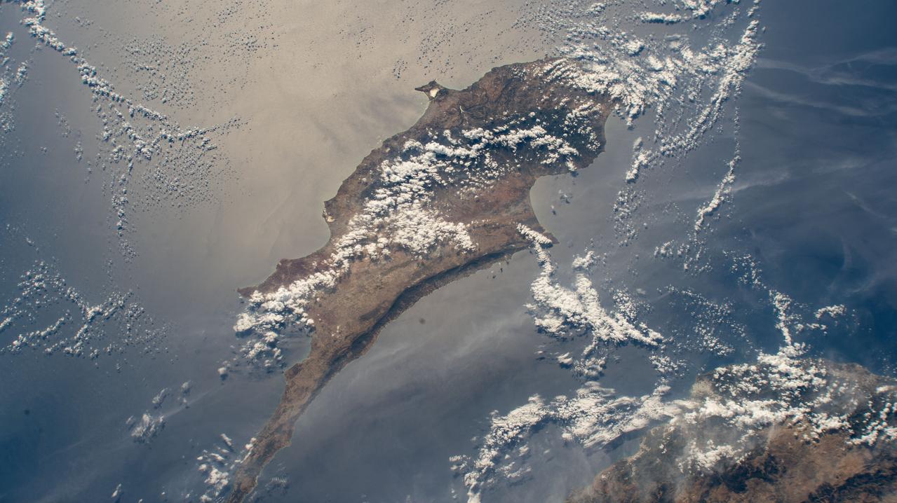
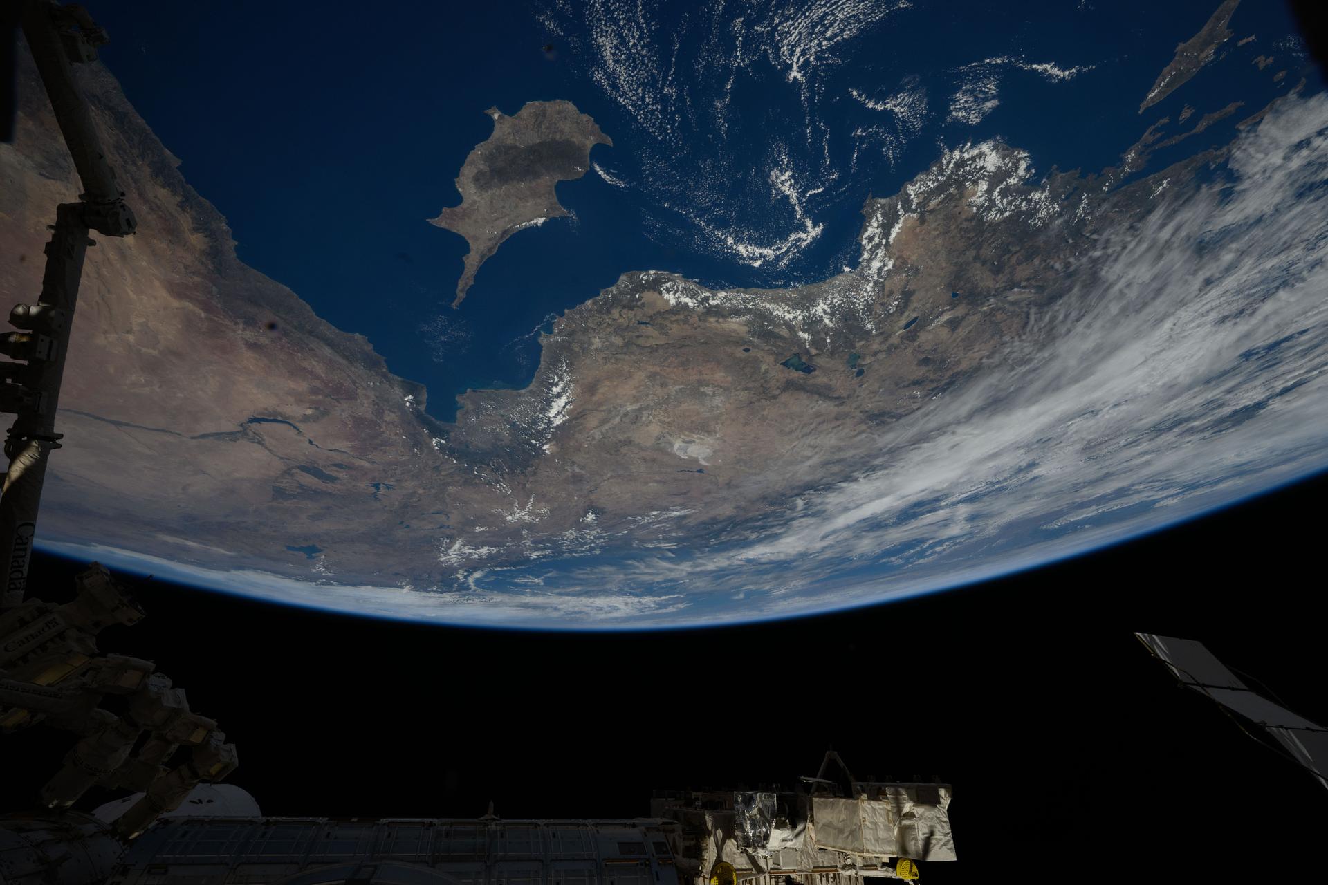
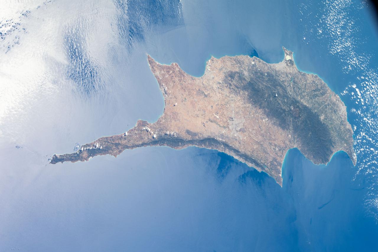
iss072e008767 (Sept. 28, 2024) -- Cyprus Island, the third largest in the Mediterranean Sea, was photographed by NASA astronaut Mike Barratt as the International Space Station orbited 257 miles above.

SL3-40-077 (July-September 1973) --- A vertical view of the Mediterranean coastal area of southeastern France as photographed from Earth orbit by one of the six lenses of the Itek-furnished S190-A Multispectral Photographic Facility Experiment aboard the Skylab space station. This view of the coast extends from the eastern outskirts of Marseilles easterly to Cannes, and includes the city of Toulon. The S190-A experiment is part of the Skylab Earth Resources Experiments Package. Federal agencies participating with NASA on the EREP project are the Departments of Agriculture, Commerce, Interior, the Environmental Protection Agency and the Corps of Engineers. All EREP photography is available to the public through the Department of Interior?s Earth Resources Observations Systems Data Center, Sioux Falls, South Dakota, 57198. Photo credit: NASA
iss072e065376 (Oct. 17, 2024) --- The island Republic of Cyprus in the Mediterranean Sea is pictured from the International Space Station as it orbited 258 miles above the nation of Turkey.
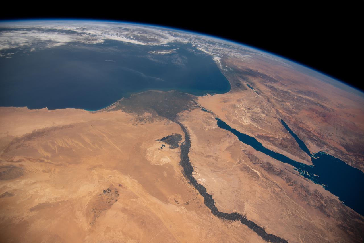
iss071e207494 (June 24, 2024) -- Soaring 263 miles above Egypt, NASA astronaut Butch Wilmore captured this photo from the International Space Station. To the left of the image is the Mediterranean Sea. Snaking from it is the Nile River, and at the very top of the image is the Red Sea.
iss073e0906745 (Sept. 28, 2025) --- The Republic of Cyprus—an island inhabited for over 12,000 years and home to the world’s oldest named wine, produced for more than 4,000 years—is pictured in the Mediterranean Sea from the International Space Station as it orbited 262 miles above, heading northwest toward Türkiye.
These four images of the Mediterranean were obtained concurrently on June 14, 2002 from the three instruments that make up the Atmospheric Infrared Sounder experiment system aboard NASA Aqua spacecraft. http://photojournal.jpl.nasa.gov/catalog/PIA00326
iss071e414023 (Aug. 2, 2024) --- The sun's glint beams off the Gulf of Gabes on the coast of Tunisia with Sharqi Island in the Mediterranean Sea in this photograph taken from the International Space Station as it orbited 262 miles above the African nation.
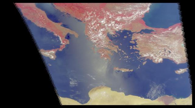
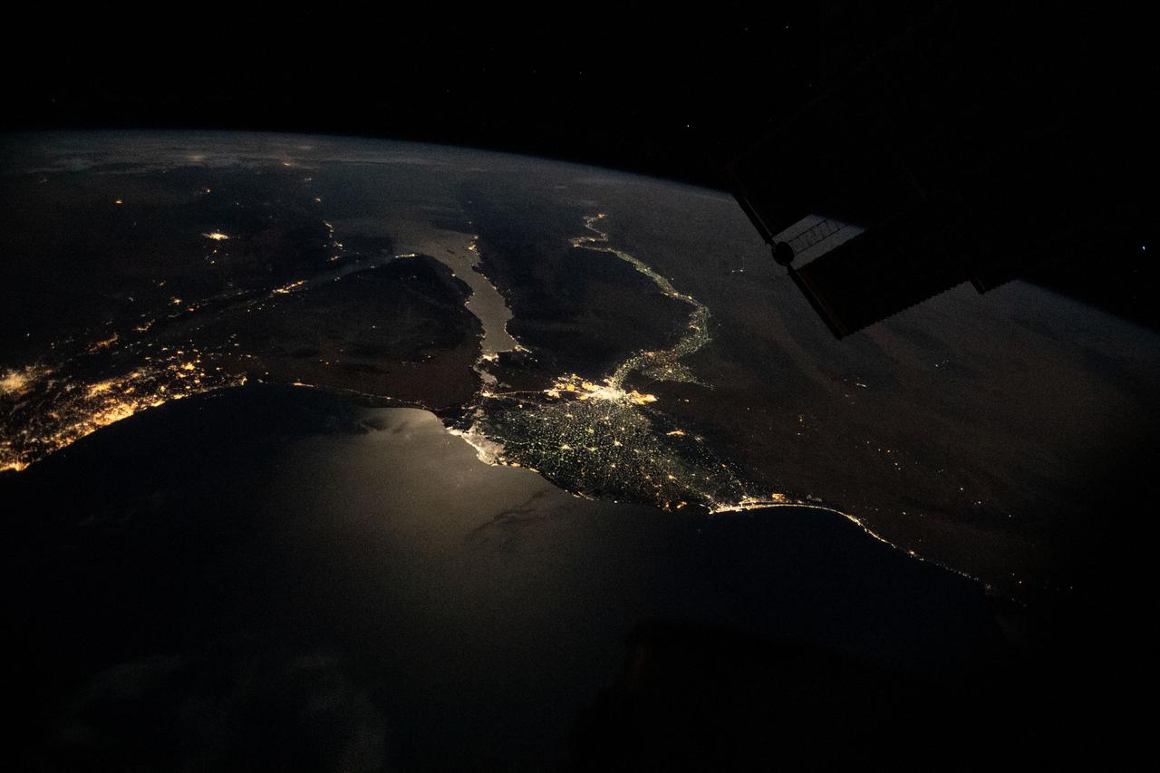
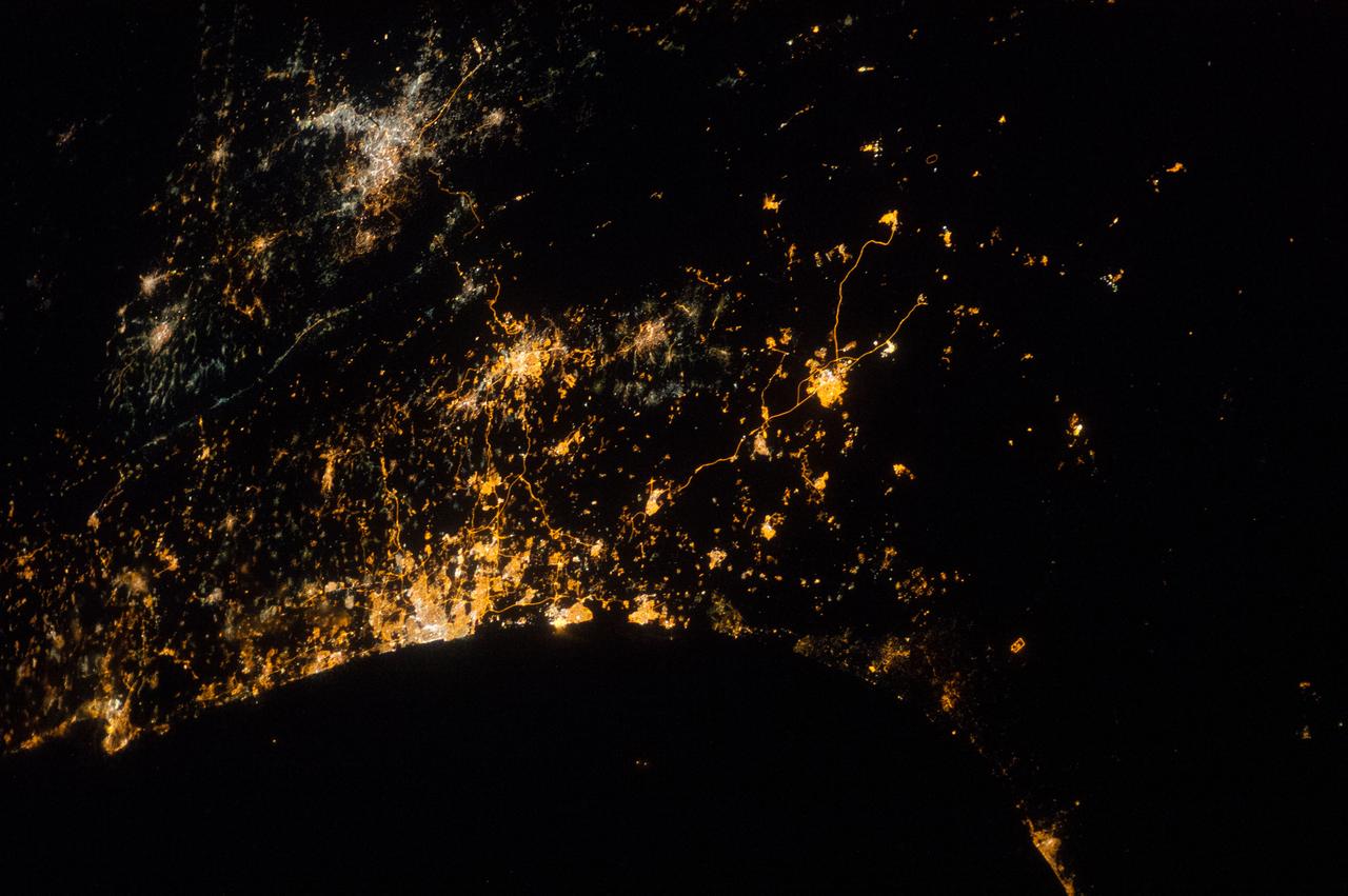
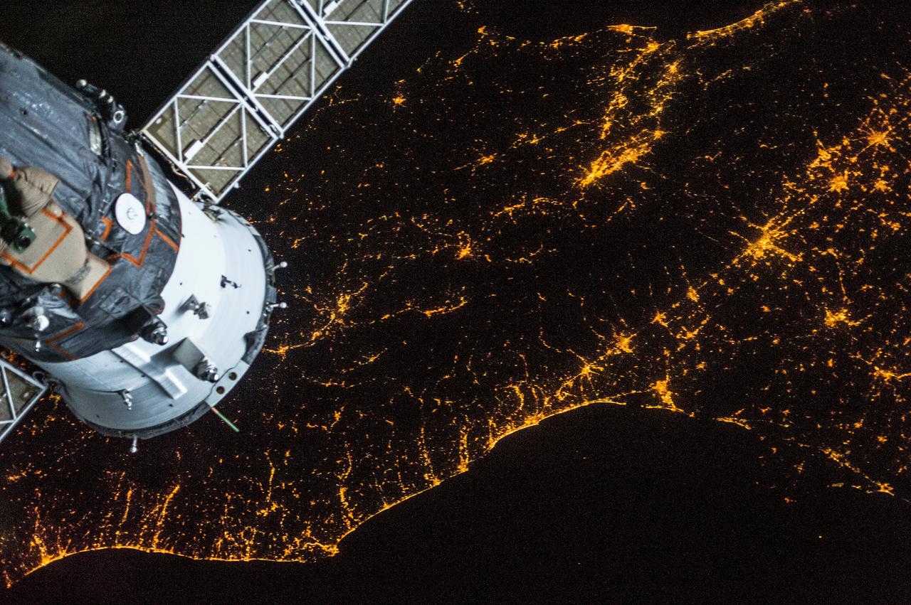
iss073e0312086 (May 22, 2025) --- At top left, the city lights of Benghazi, Libya, arc downward toward the glow of civilization on Egypt's Nile Delta outlining Africa's Mediterranean Sea coast. Israel's metropolitan lights then round north and east into Istanbul, Turkey (far right), and Athens, Greece, and their surrounding suburbs in southern Europe. Resting in the center of the Mediterranean's darkness is the Greek island of Crete.
iss071e405499 (July 26, 2024) -- Flowing into the Mediterranean Sea, the Nile River is pictured from the International Space Station as it orbited 257 miles above Egypt. The Gulfs of Suez and Aqaba, feeding into the Red Sea, can also be seen in this photo, contrasting against the surrounding tan and orange terrain.
This southerly looking view photographed from the orbiting Space Shuttle Columbia shows a small portion of the vehichle's aft section. The 50-ft Canadian built remote manipulator system (RMS) is in a resting posture (lower right corner) stretched out along the 60-ft. long cargo bay. Many of the components of the OSS-1 payload package are in the bottom center. The Mediterranean Sea is at right foreground. Parts of the Sinai peninsula, Israel, Egypt, Saudi Arabia, Jordan, Palestine, Syria, and Lebanon can be located in the photo. The Red Sea, Gulf of Aqaba, Suez Canal are near the photo's horizon.
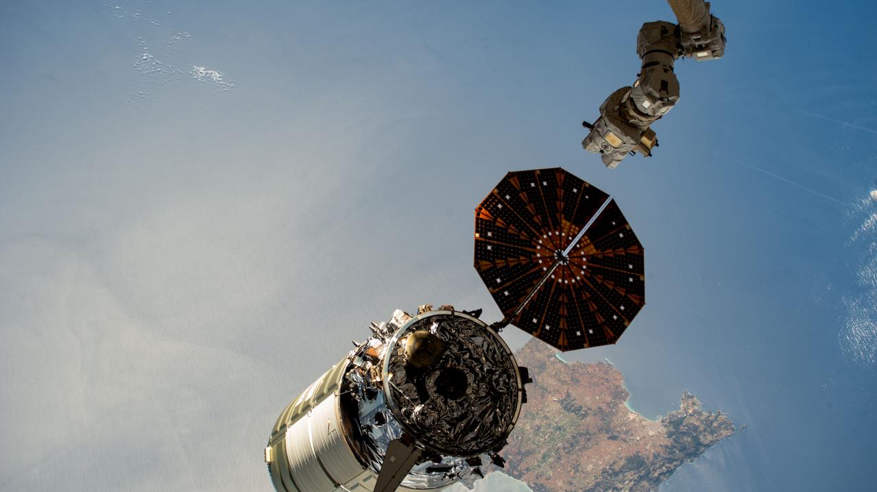
iss071e384199 (July 17, 2024) --- The Canadarm2 robotic arm's latching end effector, or LEE, is used to grapple fixtures on the International Space Station, as well as capture the approaching Cygnus cargo craft from Northrop Grumman and attach it to the Unity module for cargo transfer operations. 256 miles below the outpost is the Mediterranean coast of Libya and Egypt and the Greek island of Crete.
iss072e000922 (Sept. 23, 2024) -- The vibrant night lights of coastal cities on the Mediterranean Sea, from Spain to Italy in Europe and Algeria to Lybia in Africa, are pictured from the International Space Station as it orbited 262 miles above Barcelona. Peeking in at the bottom of the image is Mallorca Island, next to it Minorca. The Italian islands of Corsica, Sardinia, and Sicily are also visible. Above Earth, stars glitter in the night sky.
iss073e1047001 (Nov. 2, 2025) --- Tripoli, Libya—a city founded approximately 2,700 years ago on the Mediterranean Sea coast—is pictured at about 11:10 p.m. local time from the International Space Station as it orbited 259 miles above the African nation. The city’s modern, cool white lights reflect a major transition to LED and solar-powered LED lighting, part of efforts to modernize urban design, enhance safety, and support tourism infrastructure.
iss073e0686732 (Aug. 30, 2025) --- The atmospheric glow blankets southern Europe and the northwestern Mediterranean coast, outlined by city lights. At left, the Po Valley urban corridor in Italy shines with the metropolitan areas of Milan and Turin and their surrounding suburbs. This photograph was taken at approximately 1:39 a.m. local time from the International Space Station as it orbited 261 miles above Earth.
STS-56 Earth observation taken aboard Discovery, Orbiter Vehicle (OV) 103, is of the Strait of Gibraltar. A small bank of clouds marks the passage between Spain and Morocco at the western edge of the Mediterranean Sea. This passage, one of the two Pilars of Hercules of the Ancient Greeks, is now known as the Strait of Gibraltar. The cities of Cadiz on the Atlantic Coast of Spain and Malaga on the Mediterranean coast, as well as Tangier, Morocco (facing the strait), can be seen. According to NASA scientists studying the STS-56 photos, a subtle difference in the water color on the Atlantic side suggests that a pulse of surface water had recently flowed out of the Mediterranean into the Atlantic.
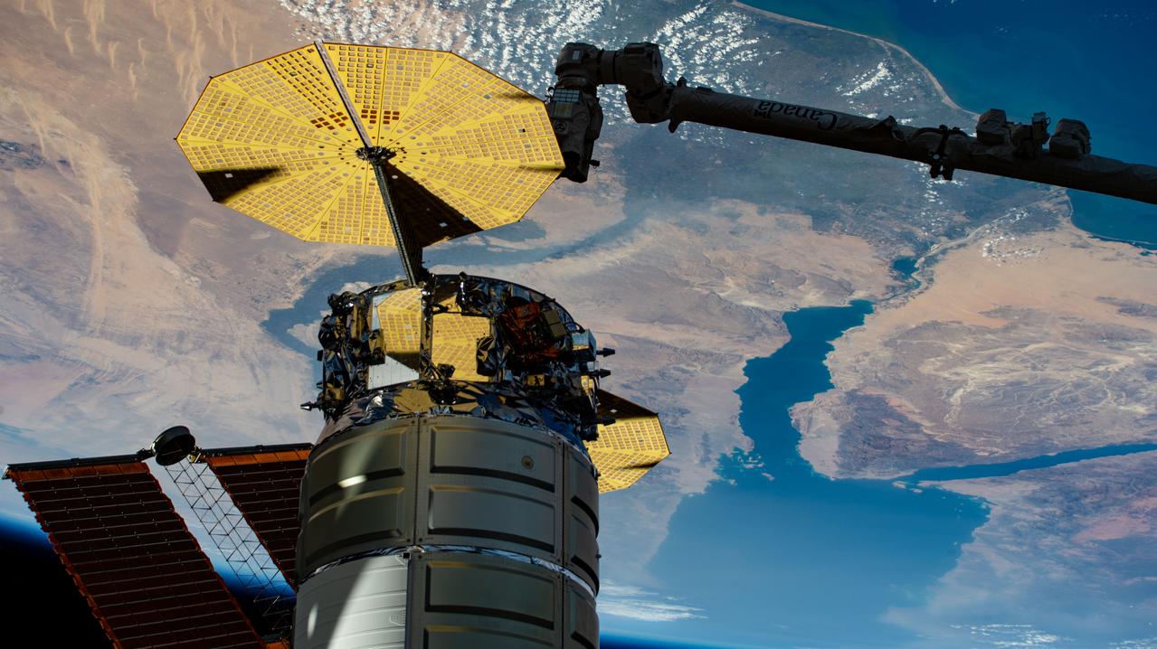
iss073e0767188 (Sept. 23, 2025) --- Northrop Grumman's Cygnus XL cargo craft is pictured installed to the Unity module's Earth-facing port as the International Space Station orbited 259 miles above the Mediterranean Sea. The Red Sea and Egypt's Nile Delta are viewed from the vantage point of an external high definition camera on the orbital outpost. Extending from the upper right, is the Canadarm2 robotic arm that had captured Cygnus after its arrival on Sept. 18, 2025.
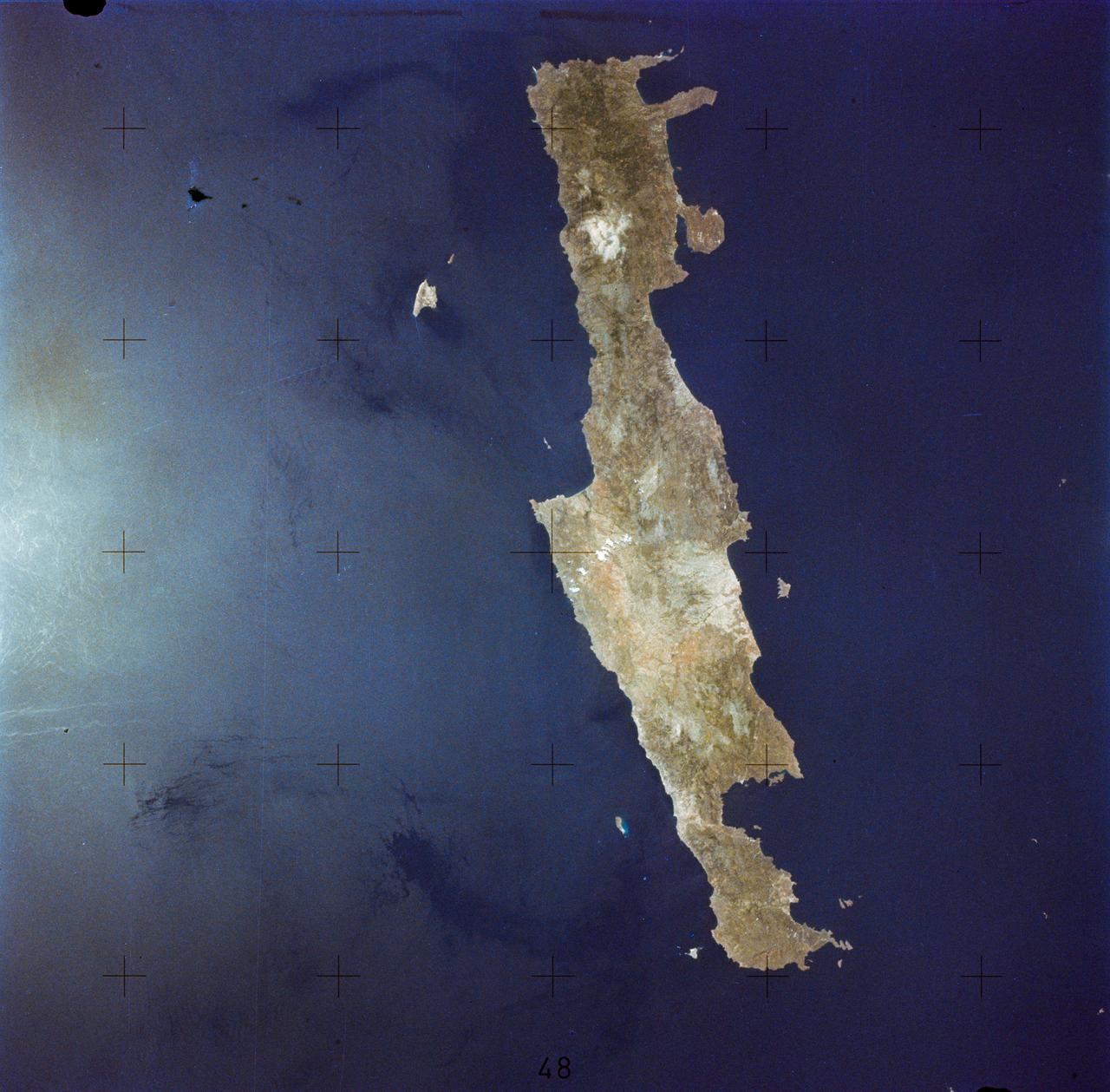
SL2-05-364 (22 June 1973) --- Lying in the eastern Mediterranean Sea, the entire Island of Crete (35.0N, 25.0E) can be seen in great detail in this cloud free view. The volcanic origins of this island can also be observed in the many sharp and angular ridgelines and rugged coastal features. Photo credit: NASA
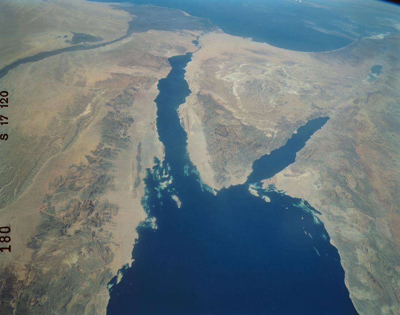
Suez Canal, Gulf of Suez, Sinai Peninsula, United Arab Republic (Egypt), Mediterranean Sea, as seen from the Apollo 7 spacecraft during its 13th revolution of the earth. Photographed from an altitude of 126 nautical miles, at ground elapsed time of 19 hours and 42 minutes.
iss074e0149410 (Jan. 17, 2026) --- Benghazi, Libya’s second-largest city, with a metropolitan population of over 890,000, shines with bright, modern city lights that trace its urban landscape on the country’s Mediterranean coastline. The International Space Station was orbiting 262 miles above at approximately 12:37 a.m. local time when this photograph was taken. Credit: NASA/Chris Williams
AST-17-1378 (20 July 1975) --- A near vertical view of the most southerly portion of the Island of Sicily in the Mediterranean Sea, as photographed from the Apollo spacecraft in Earth orbit during the joint U.S.-USSR Apollo-Soyuz Test Project mission. This view includes the towns of Gala, Pachino, Avela and Pozzalo. The photograph was taken at an altitude of 228 kilometers (141 statute miles) with a 70mm Hasselblad camera using high-definition aerial Ektachrome SO-242 type film.
SL2-05-359 (22 June 1973) --- This rare cloud free view of southern Italy (41.0N, 16.0E) shows almost all of the famous `boot' configuration of the peninsula up to just north of Naples and Mount Vesuvius. The land mass of this historic peninsula contrasts sharply with the sparkling blue waters of the Mediterranean Sea. Photo credit: NASA
41G-120-082 (5-13 Oct. 1984) --- This High oblique view was photographed with a medium format camera aboard the Earth-orbiting space shuttle Challenger. It features the Strait of Gibraltar and the Mediterranean Sea. Unlike vertical photographs from this area taken by crews of previous spaceflights, this oblique view allows extensive viewing into Spain and Morocco. Photo credit: NASA
iss065e074560 (May 20, 2021) --- This nighttime photograph, taken from the International Space Station as it orbited 263 miles above Turkey, highlights the Moon's glint on the Mediterranean Sea and the Gulf of Suez. The city lights along the Nile Delta and the eastern Mediterranean coast also figure prominently in the picture.
iss069e004822 (April 21, 2023) --- The Cygnus space freighter from Northrop Grumman is pictured moments after its release from the Canadarm2 robotic arm as the International Space Station orbited 262 miles above the Mediterranean Sea near the Spanish island of Mallorca.
41G-34-098 (5-13 Oct 1984) --- Strait of Gibraltar and western Mediterranean photographed sunglint. Sun reflection on water delineates surface texture, which corresponds to the ocean's dynamics. The large group of waves connecting Gibraltar with the Moroccan coast is the response of the ocean to a tidal pulse moving into the Mediterranean. The low level wing shear line extending out from the Moroccan coastline into the Mediterranean for approximately 40 miles is the southern extremity of the wind funneling through the strait. This is the first high resolution photograph ever taken of this phenomenon permitting detailed delineation of individual waves which comprise the wave packet.
Earth observation taken during a day pass by the Expedition 37 crew. Per Twitter message: Southwest Libya to the Mediterranean coast.
Even after the mega-freighter Ever Given was freed from its grounding in the Suez Canal on March 29, 5 days later shipping traffic still had not recovered from the crisis. At the southern entrance to the Canal, in the Gulf of Suez, over 100 freighters waited their turn to enter the Canal and proceed to the Mediterranean Sea. The image was acquired April 4, covers an area of 21.3 by 34.5 km, and is located 29.7 degrees north, 32.6 degrees east. https://photojournal.jpl.nasa.gov/catalog/PIA24553
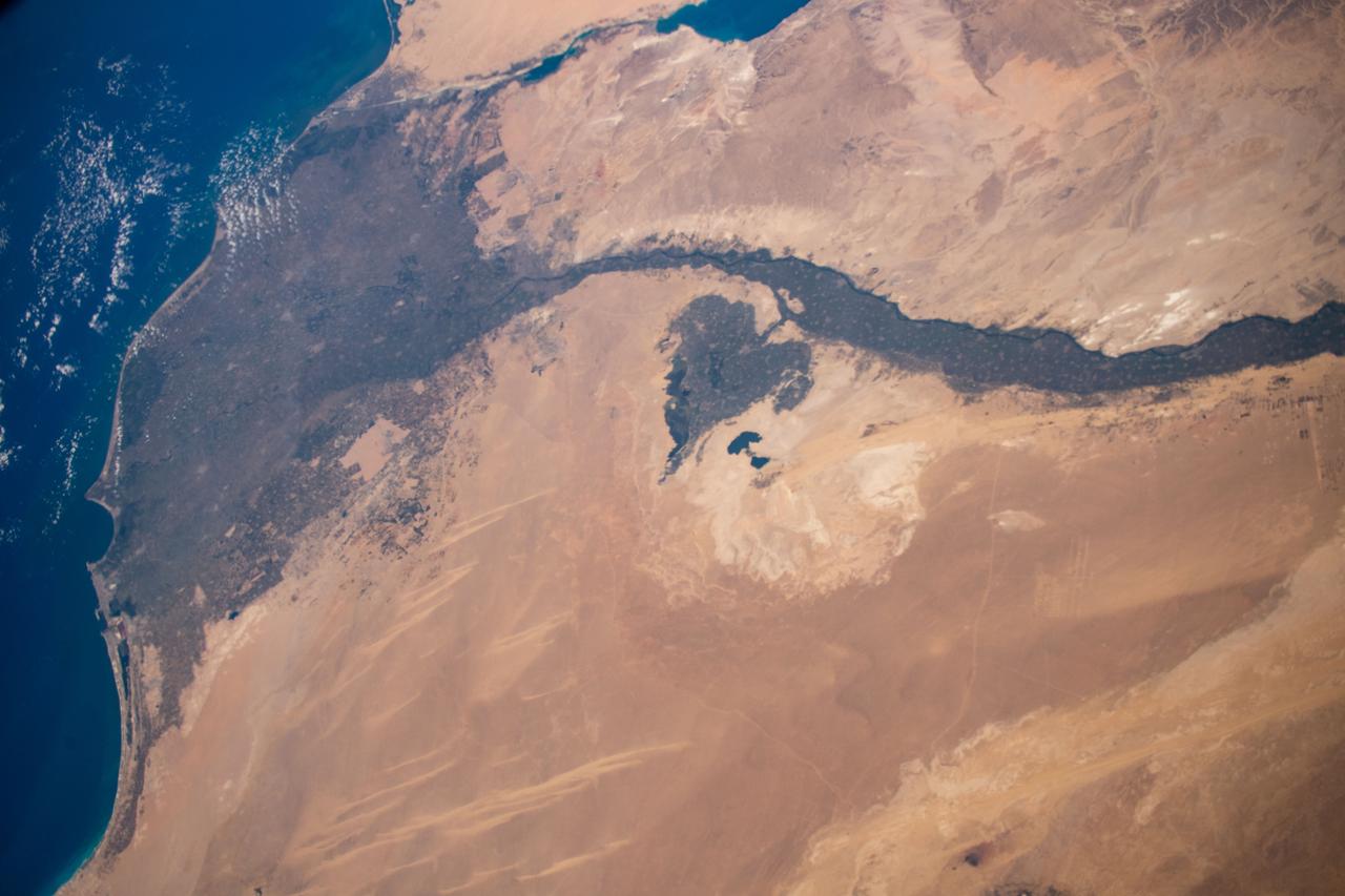
STS-56 Earth observation of the northeastern Nile Delta was photographed from the Earth-orbiting Discovery, Orbiter Vehicle (OV) 103. The branch of the Nile featured in the frame is Daimietta. The Suez Canal marks the boundary of the Nile Delta agriculture and the Sinai Desert to the right. Lake Masada, the dark waterlogged area to the west (left) of Port Said is becoming more saline as the Aswan Dam has reduced sediment downstream. This sediment reduction, according to NASA scientists studying the STS-56 photography, has resulted in increased coastal erosion and the intrusion of a salt-water lens to the ground water, particularly in the northeastern portions of the delta. Center pivot irrigation fields are located along either side of the Ramses Canal, which connects the Daimietta Nile with Great Bitter Lake. This canal has been re-dug three or four times in the past 3,000 years. Historians note that the canal's most famous use was as the departure point of the fleet of Pharaoh Necho. The fleet circumnavigated Africa clockwise from the head of the Red Sea to the Mediterranean coast of the Nile (probably the Rosetta Nile) in a three-year voyage circa 660 BC.
iss065e002119 (April 22, 2021) --- The island of Cyprus in the eastern Mediterranean Sea is pictured from the International Space Station as it orbited 263 above Aleppo, Syria.

iss068e021243 (Nov. 8, 2022) --- The Full Moon is pictured from the International Space Station as it orbited 258 miles above the coast of Tunisia on the Mediterranean Sea.
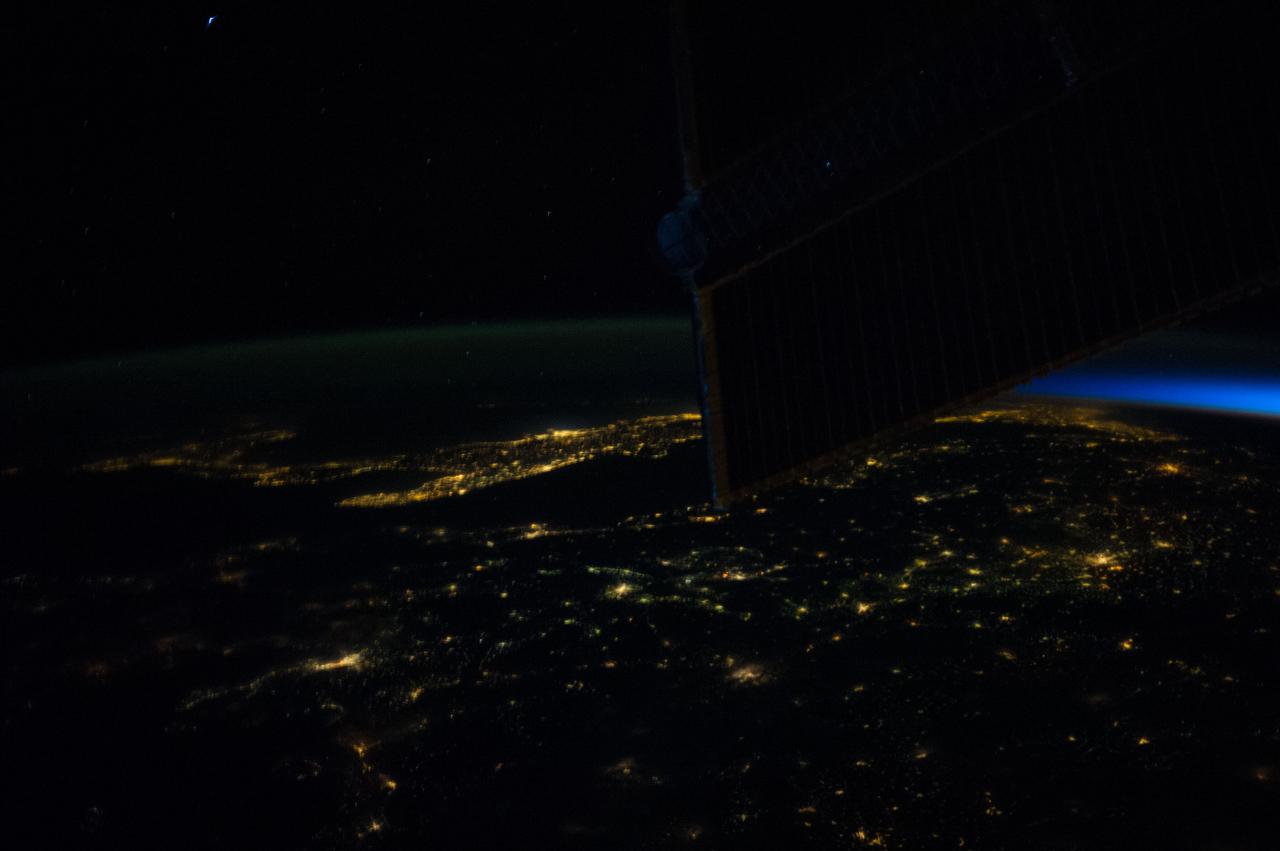
Earth observation (Mediterranean Sea) taken by the Expedition 45 crew. ISS solar array wings (SAWs) are in view. Image was released by astronaut on social media.
iss067e030640 (April 26, 2022) --- Barcelona, Spain, on the Balaeric Sea coast, is pictured from the International Space Station as it orbited 260 miles above the Mediterranean Sea.
iss064e000399 (Oct. 25, 2020) --- Valencia, Spain is pictured from the International Space Station moments before the orbital lab crossed over the Mediterranean Sea.
iss066e137420 (Feb. 7, 2022) --- The northwest coast of the African nation of Libya is pictured from the International Space Station as it orbited 259 miles above the Mediterranean Sea.
iss067e135192 (June 16, 2022) --- The southwestern coast of Turkey on the Mediterranean Sea is pictured from the International Space Station as it orbited 262 miles above.

iss068e053809 (Feb. 14, 2023) --- The southern coast of Turkey on the Mediterranean Sea near Syria is pictured from the International Space Station as it orbited 264 miles above.
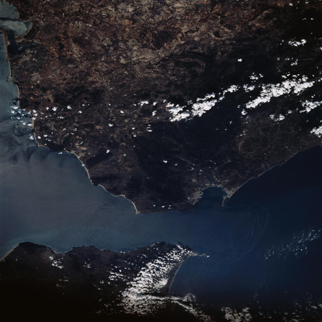
Earth observation taken during a day pass by the Expedition 37 crew. Per Twitter message: Mediterranean coast of Tunisia & northwest Libya.
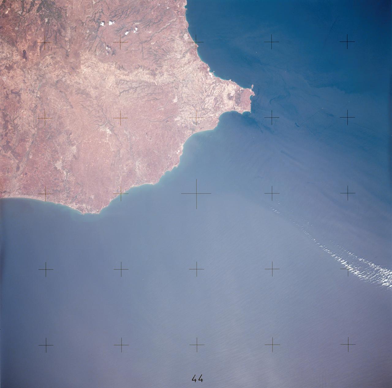
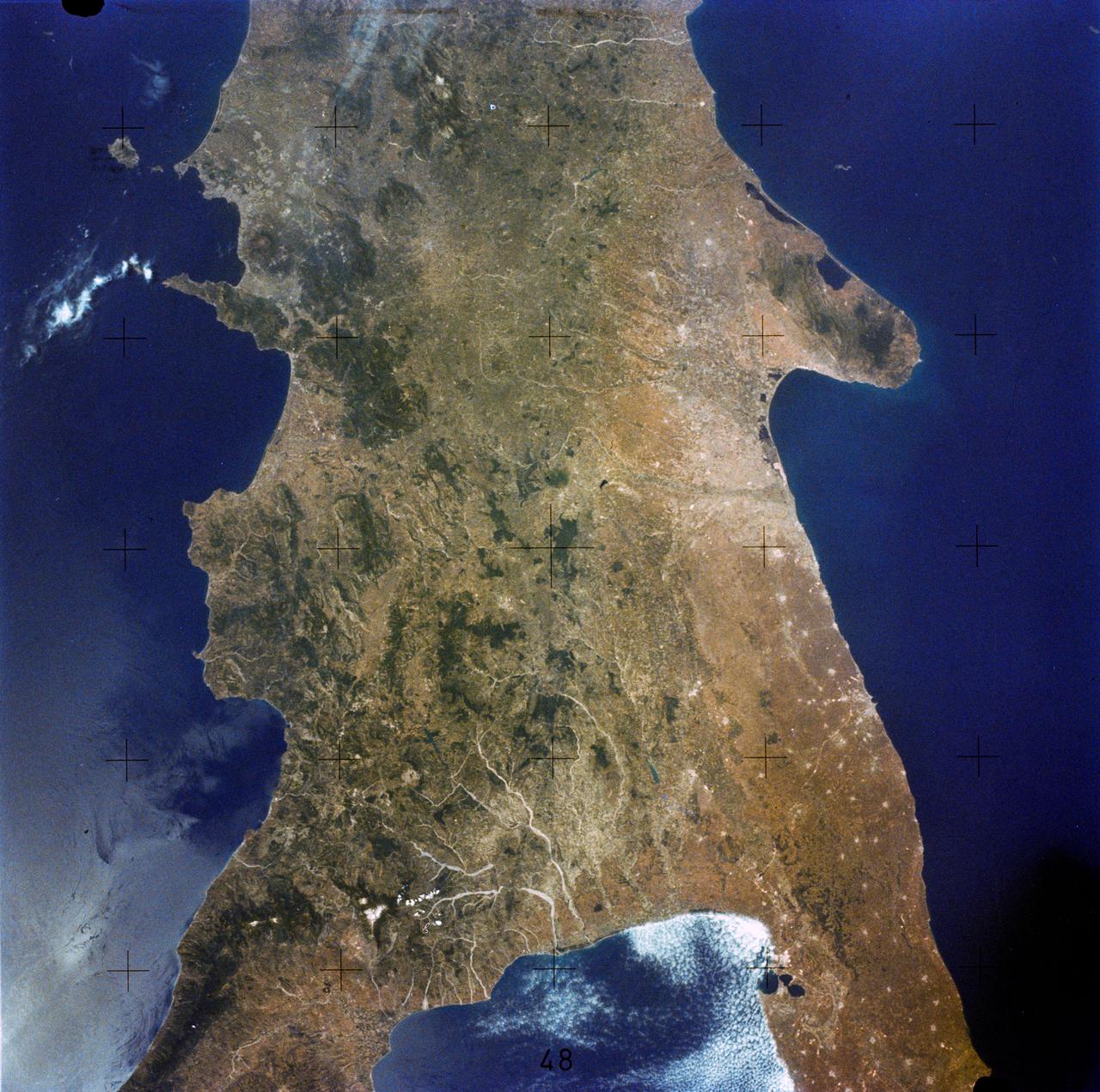
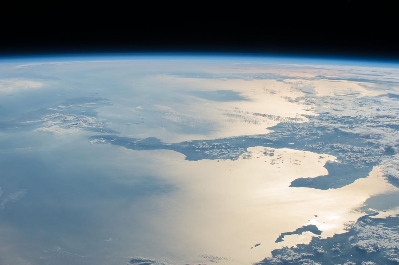
Earth Observation taken during a day pass by the Expedition 40 crew aboard the International Space Station (ISS). Folder lists this as: Europe and Mediterranean.
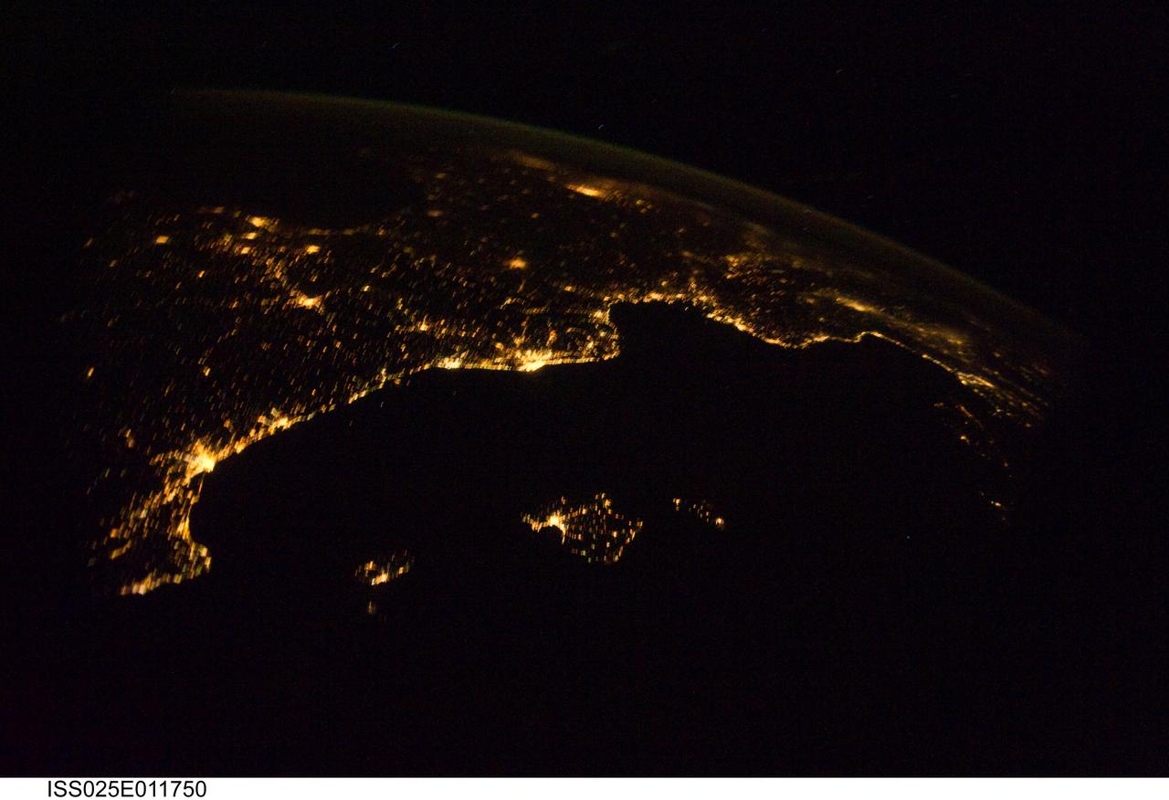
ISS025-E-011750 (4 Nov. 2010) --- From 220 miles above Earth, one of the Expedition 25 crew members aboard the International Space Station aimed a camera through a Cupola window and recorded this night time image of the Mediterranean Riviera and a panorama along the coastline from Valencia, Spain to Livorno, Italy and many points in between including parts of Andorra and Monaco. Islands in the Mediterranean that can easily be delineated in the Nov. 4 picture are the Balearic Islands, as well as Corsica and Sardinia.
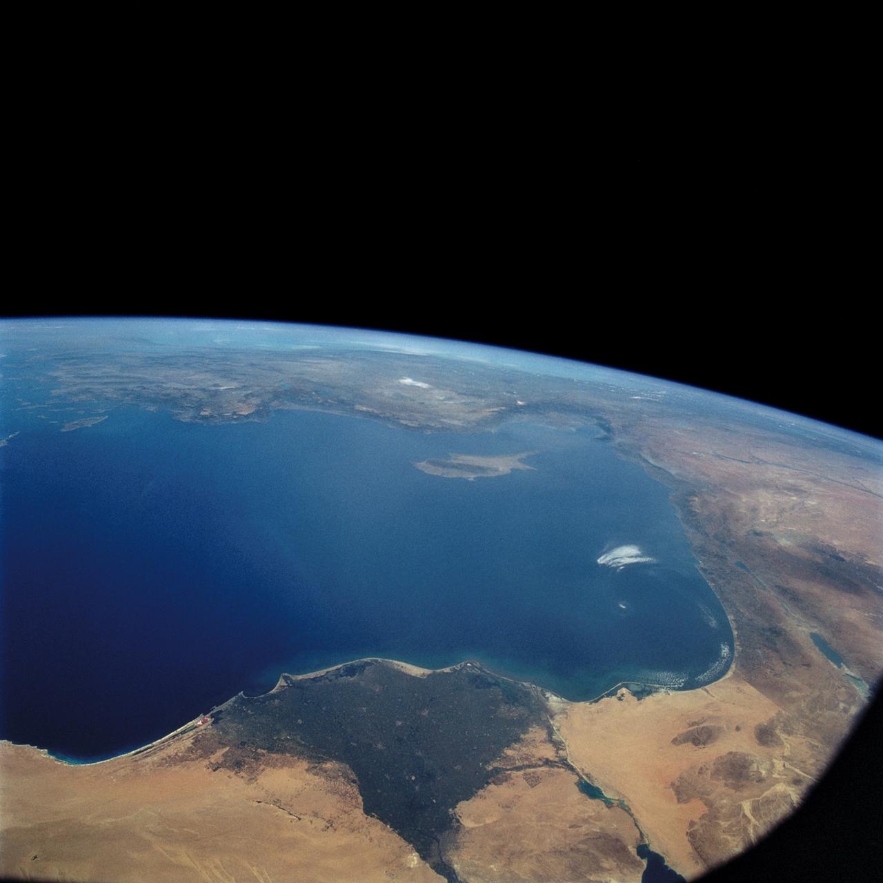
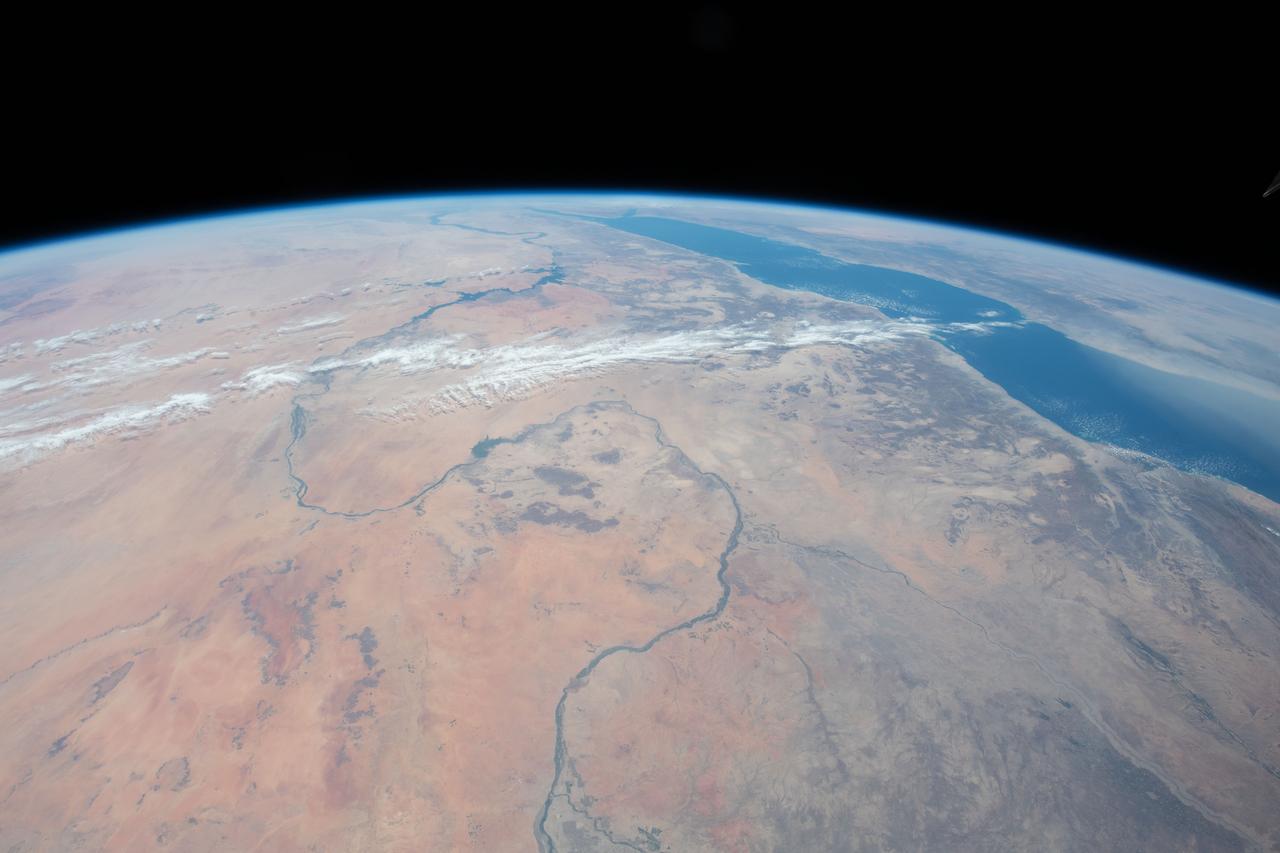
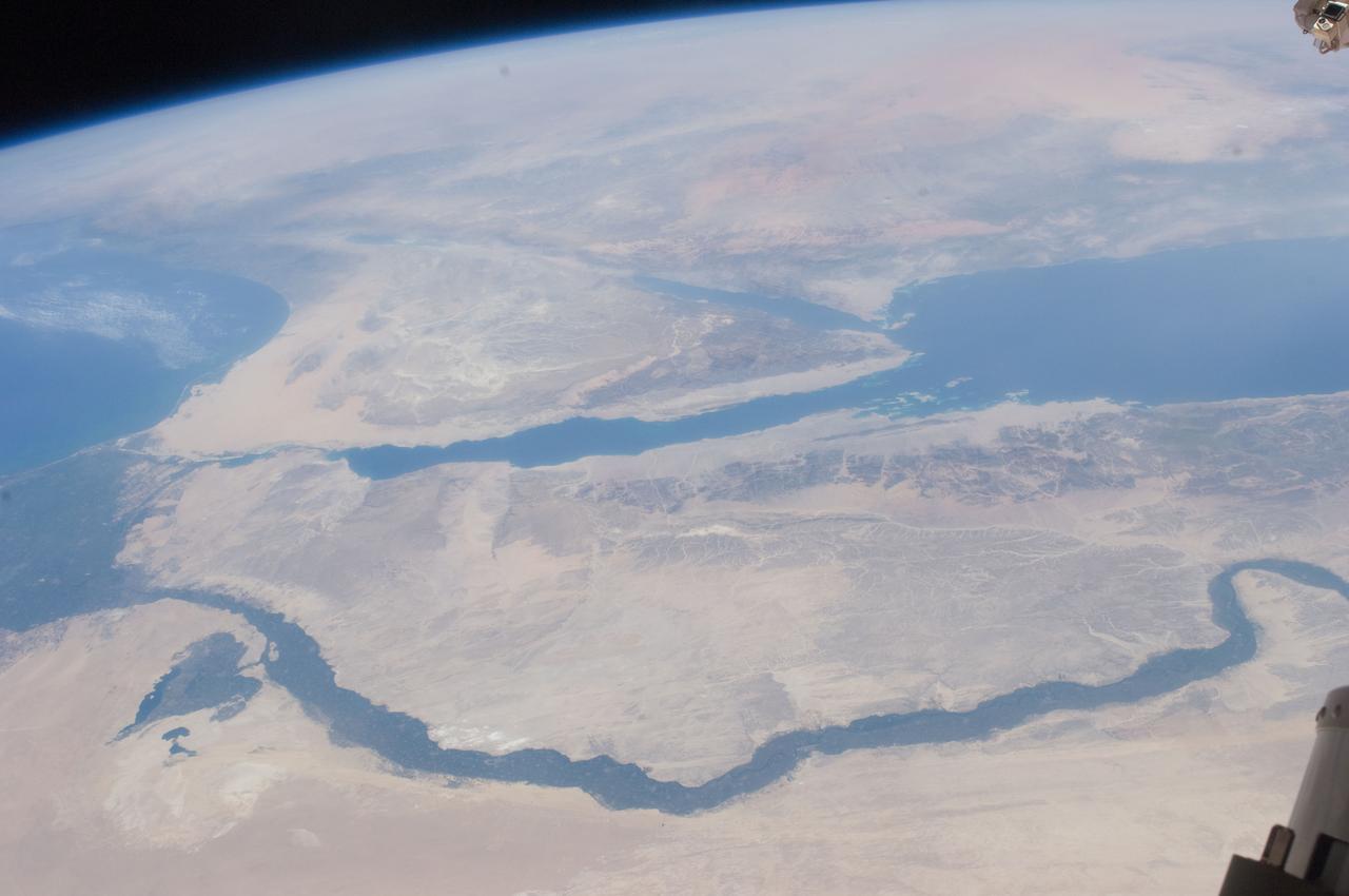
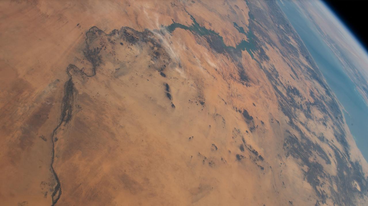
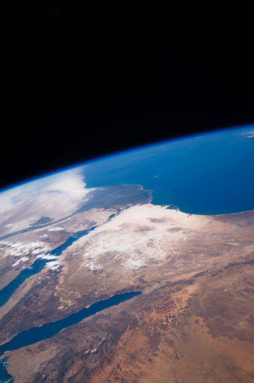
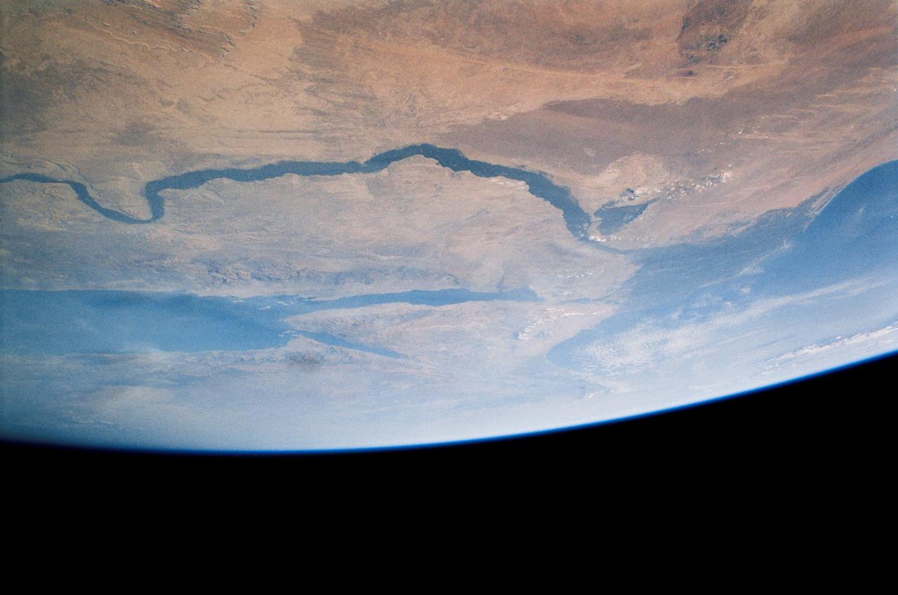
An excellent panoramic view of the entire Sinai Peninsula (29.0N, 34.0E) and the nearby Nile River Delta and eastern Mediterranean coastal region. The Suez Canal, at the top of the scene just to the right of the Delta, connects the Mediterranean Sea with the Gulf of Suez on the west side of the Sinai Peninsula and the Gulf of Aqaba is on the west where they both flow into the Red Sea. At upper right, is the Dead Sea, Jordan River and Lake Tiberius.
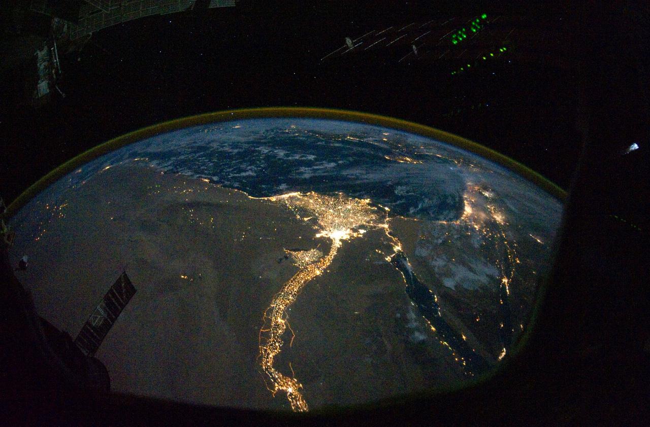
From 220 miles above Earth, one of the Expedition 25 crew members on the International Space Station took this night time photo featuring the bright lights of Cairo and Alexandria, Egypt on the Mediterranean coast. The Nile River and its delta stand out clearly as well. On the horizon, the airglow of the atmosphere is seen across the Mediterranean. The Sinai Peninsula, at right, is outlined with lights highlighting the Gulf of Suez and Gulf of Aqaba. Credit: NASA
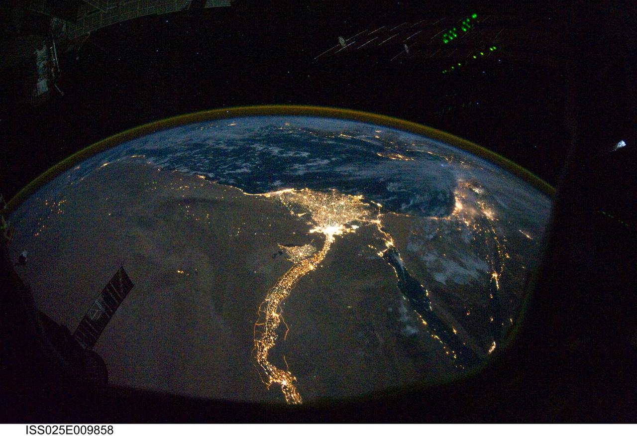
ISS025-E-009858 (28 Oct. 2010) --- From 220 miles above Earth, one of the Expedition 25 crew members on the International Space Station took this night time photo featuring the bright lights of Cairo and Alexandria, Egypt on the Mediterranean coast. The Nile River and its delta stand out clearly as well. On the horizon, the airglow of the atmosphere is seen across the Mediterranean. The Sinai Peninsula, at right, is outlined with lights highlighting the Gulf of Suez and Gulf of Aqaba.
STS039-151-193 (28 April-6 May 1991) --- The Strait of Gibraltar, the only outlet for the Mediterranean Sea, was photographed with a large format handheld camera by the STS-39 crew members. Scientists site evidence in Shuttle photography that the Mediterranean Sea dried up a number of times between 5 million and 20 million years ago. Sea levels, they say, dropped slightly, cutting off the Mediterranean (top right) from the Atlantic Ocean (bottom). In southern Spain, the dark area near the coast is the delta of the Guadalquivir River with the city of Seville. The Sierra Nevada range still has some snow. A small field fire near the Spanish coast has generated a conspicuous smoke plume. The small spike of land on the north side of the Strait is the Rock of Gibraltar, an outpost of the British empire. The larger spike of land on the north coast of Africa marks the border between Morocco (center foreground) and Algeria (right). The sharp line cutting across them Mediterranean (top right) marks the edge of a dust cloud blowing from Africa into Europe. Photo credit: NASA
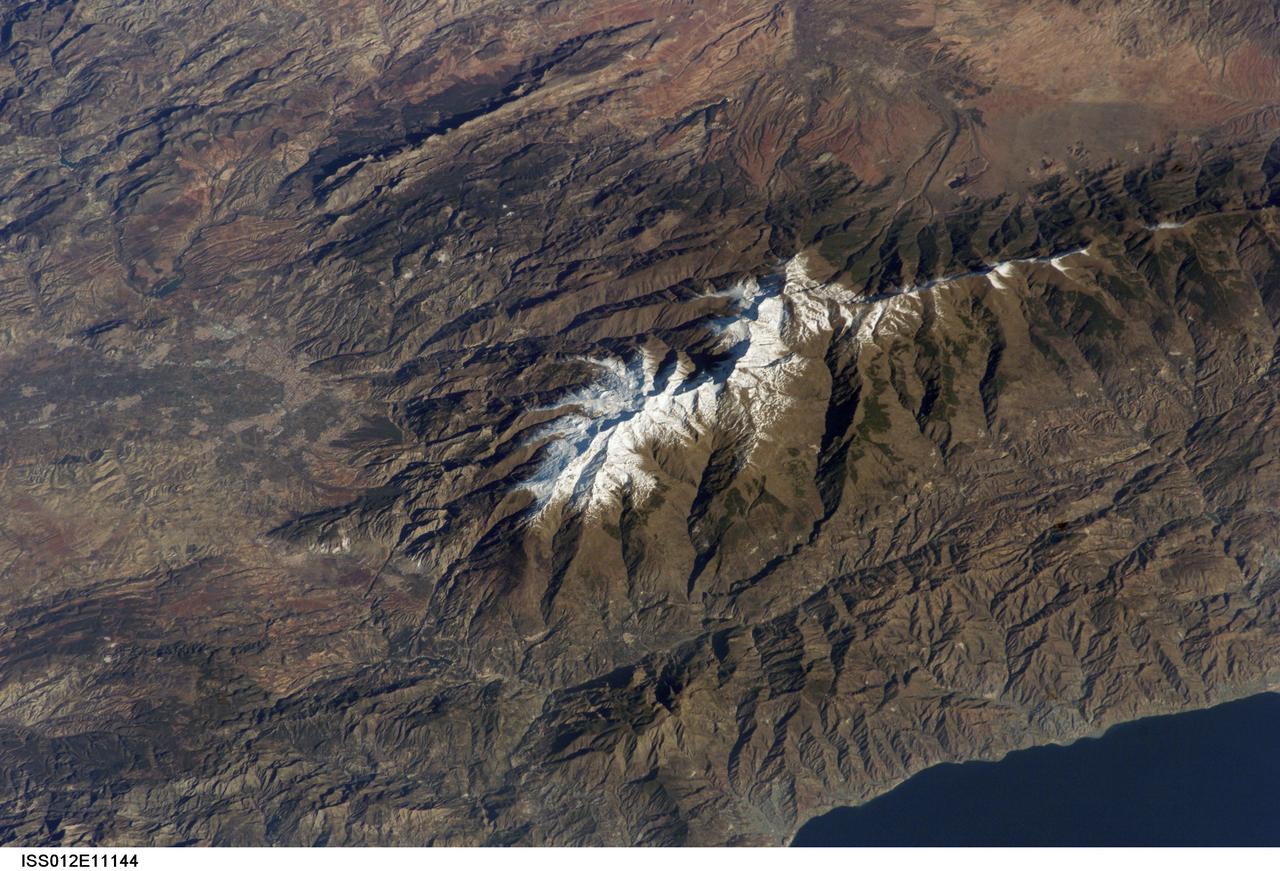
ISS012-E-11144 (11 Dec. 2005) --- Sierra Nevada, Spain is featured in this image photographed by an Expedition 12 crew member on the International Space Station. According to scientists, the Sierra Nevada, part of the Betic Cordillera of southern Spain, was formed during the Alpine Orogeny (or mountain-building event) that also formed the European Alps to the east and the Atlas Mountains of northern Africa across the Mediterranean Sea to the south. The Sierra as observed today formed during the Tertiary Period (65 to 1.8 million years ago) during collision of the African and Eurasian continental plates. The former Tethys Sea also closed during this time period, the scientists say, and the Mediterranean Sea is the largest surviving remnant basin of the ancient Tethys. The Sierra Nevada in the Granada province of Spain is perhaps the southernmost skiing location in all of Europe. Veleta Peak, at an elevation of 3,398 meters above sea level, is a popular destination for skiers and snowboarders. The rapid transition from lofty ski runs to Mediterranean beaches within a few hours’ drive has made the Sierra Nevada region popular for both outdoor and urban tourism. This photograph depicts the Veleta Peak region of the range and illustrates the sharp contrast between the snow capped mountains, adjacent dry lowlands to the west and north, and the Mediterranean Sea to the south.
This perspective view shows the Strait of Gibraltar, which is the entrance to the Mediterranean Sea from the Atlantic Ocean. Europe (Spain) is on the left. Africa (Morocco) is on the right. The Rock of Gibraltar, administered by Great Britain, is the peninsula in the back left. The Strait of Gibraltar is the only natural gap in the topographic barriers that separate the Mediterranean Sea from the world's oceans. The Sea is about 3700 kilometers (2300 miles) long and covers about 2.5 million square kilometers (one million square miles), while the Strait is only about 13 kilometers (8 miles) wide. Sediment samples from the bottom of the Mediterranean Sea that include evaporite minerals, soils, and fossil plants show that about five million years ago the Strait was topographically blocked and the Sea had evaporated into a deep basin far lower in elevation than the oceans. Consequent changes in the world's hydrologic cycle, including effects upon ocean salinity, likely led to more ice formation in polar regions and more reflection of sunlight back to space, resulting in a cooler global climate at that time. Today, topography plays a key role in our regional climate patterns. But through Earth history, topographic change, even perhaps over areas as small as 13 kilometers across, has also affected the global climate. This image was generated from a Landsat satellite image draped over an elevation model produced by the Shuttle Radar Topography Mission (SRTM). The view is eastward with a 3-times vertical exaggeration to enhance topographic expression. Natural colors of the scene (green vegetation, blue water, brown soil, white beaches) are enhanced by image processing, inclusion of some infrared reflectance (as green) to highlight the vegetation pattern, and inclusion of shading of the elevation model to further highlight the topographic features. Landsat has been providing visible and infrared views of the Earth since 1972. SRTM elevation data matches the 30-meter (99-feet) resolution of most Landsat images and will substantially help in analyses of the large Landsat image archive. Elevation data used in this image was acquired by the Shuttle Radar Topography Mission (SRTM) aboard the Space Shuttle Endeavour, launched on February 11, 2000. http://photojournal.jpl.nasa.gov/catalog/PIA03397
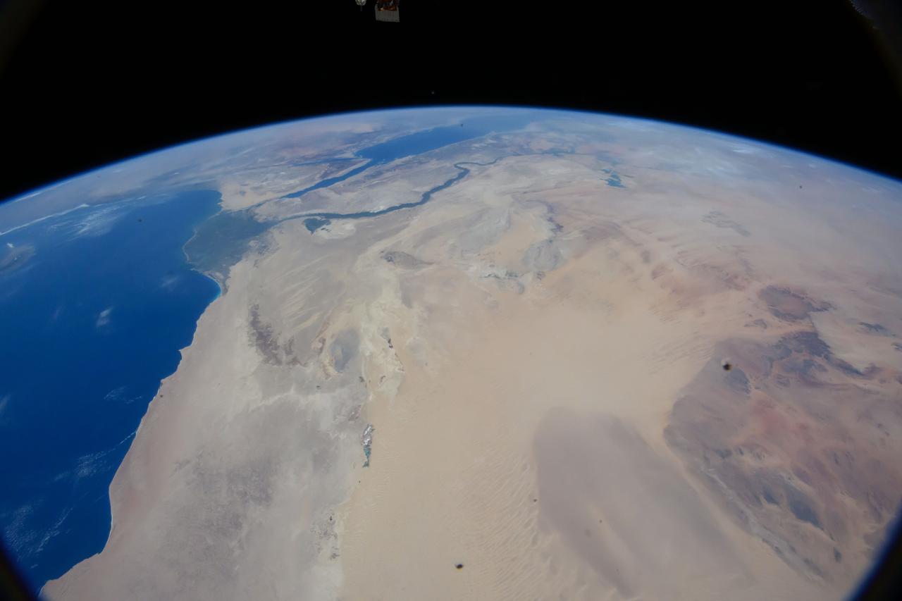
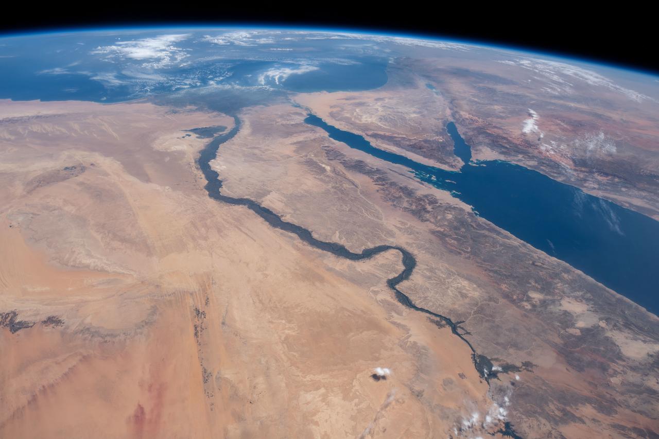
iss064e053173 (April 4, 2021) --- The Nile River, The Red Sea, The Gulf of Oman, The Gulf of Aqaba, and The Mediterranean Sea are pictured in the Middle East from the International Space Station as it orbited 263 miles above Egypt.
iss059e061476 (May 13, 2019) --- This oblique nighttime view of Western Europe and the well-lit coasts (from left) of Spain, France and Italy was taken from the International Space Station as it orbited 256 miles above the Mediterranean Sea.
iss069e061443 (Aug. 17, 2023) --- Wadi al Qattarah, containing an agricultural zone, grazing land, and a dam, is located southeast of Benghazi, Libya, in this photograph from the International Space Station as it orbited 263 miles above the Mediterranean Sea.
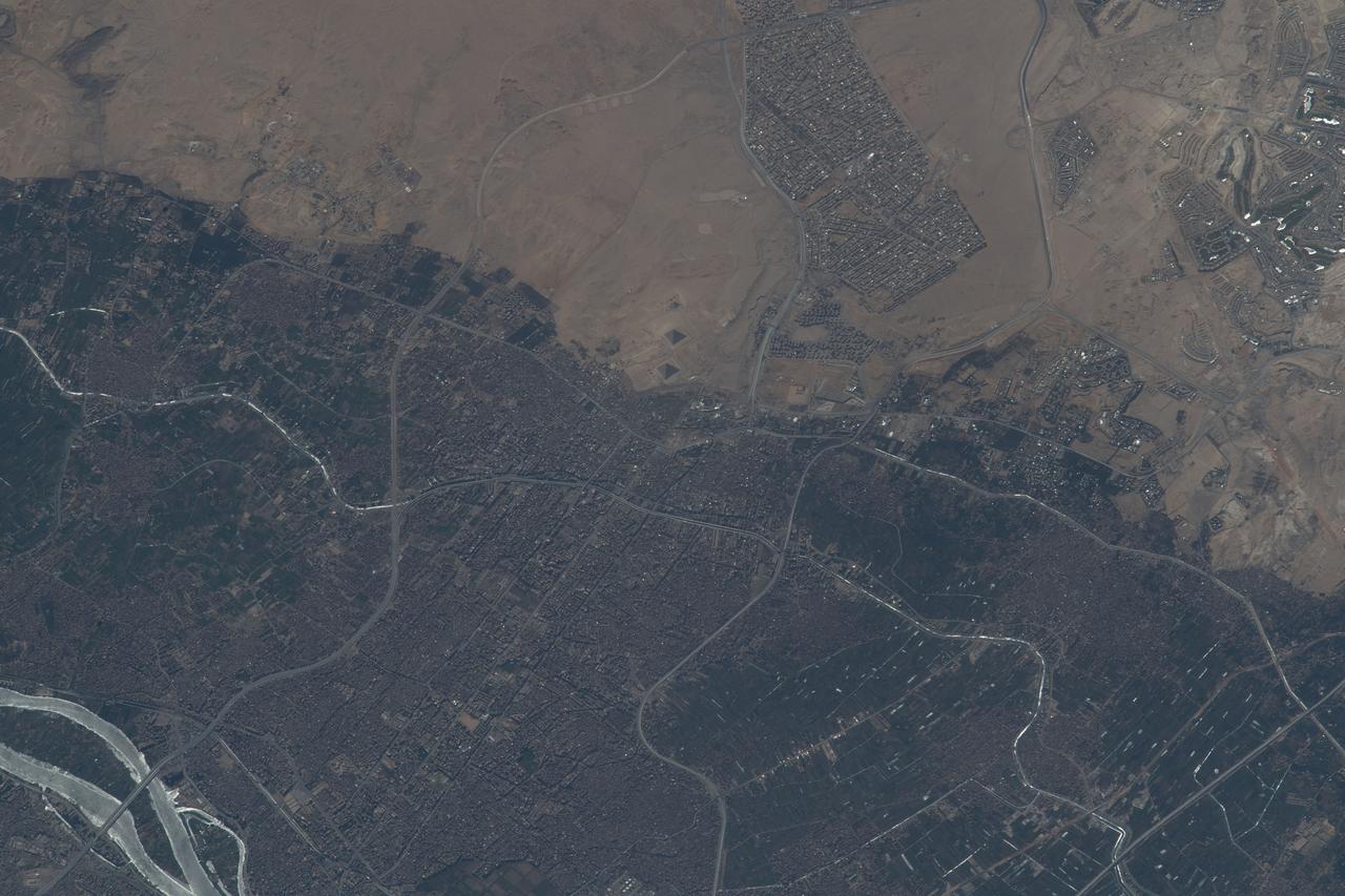
iss068e006657 (Oct. 1, 2022) --- Giza, Egypt, the home of the Great Pyramids (center), and a portion of the Nile River (lower left) are pictured from the International Space Station as it orbited 259 miles above the Mediterranean Sea.
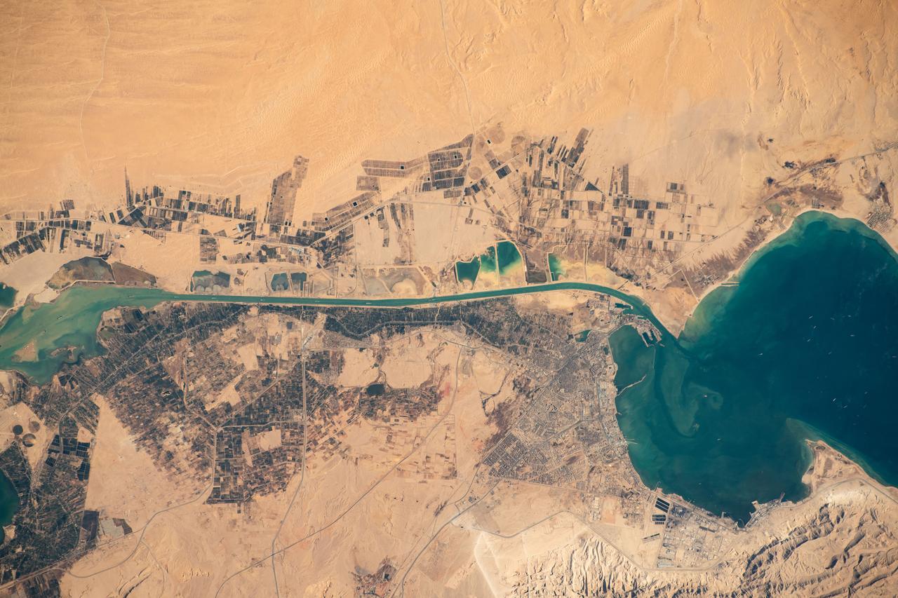
iss070e034694 (Nov. 30, 2023) --- The Suez Gulf (right) and the southern portion of the Suez Canal are pictured from the International Space Station as it orbited 260 miles above Egypt near the Mediterranean coast.
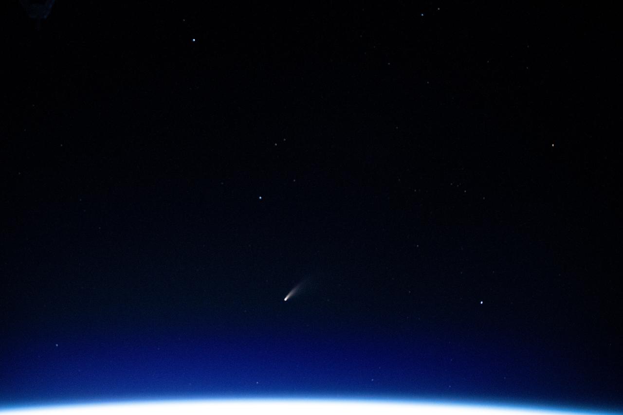
iss063e040067 (July 5, 2020) --- The tiny shooting star in the lower center of this image is Comet Neowise pictured from the International Space Station as it orbited above the Mediterranean Sea in between Tunisia and Italy.
Earth Observation taken during a day pass by the Expedition 37 crew. Identified via Twitter message as storms over the Mediterranean and a nadir docking port left empty after movement of the Soyuz.
iss062e069299 (March 1, 2020) --- This image taken from the International Space Station as it orbited 263 miles above Sudan shows the Nile River winding northward next to the Red Sea toward the Mediterranean Sea.
iss064e052447 (April 4, 2021) --- The Nile Delta, The Sinai Peninsula, and The Mediterranean Sea are pictured in the Middle East from the International Space Station as it orbited 263 miles above Egypt.
iss060e014848 (July 26, 2019) --- The Mediterranean coasts of Tunisia and Libya and the Italian island of Sicily across the sea are pictured as the International Space Station orbited 260 miles above north Africa.
iss056e014254 (June 16, 2018) --- The Mediterranean port city of Béjaïa and its airport in the African country of Algeria are pictured from the International Space Station by an Expedition 56 crew member.
iss055e007948 (April 1, 2018) --- This view looking southwest over the Egyptian delta, the Nile River and the Mediterranean sea was taken from the International Space Station as it was orbiting above the Middle Eastern nation of Jordan.
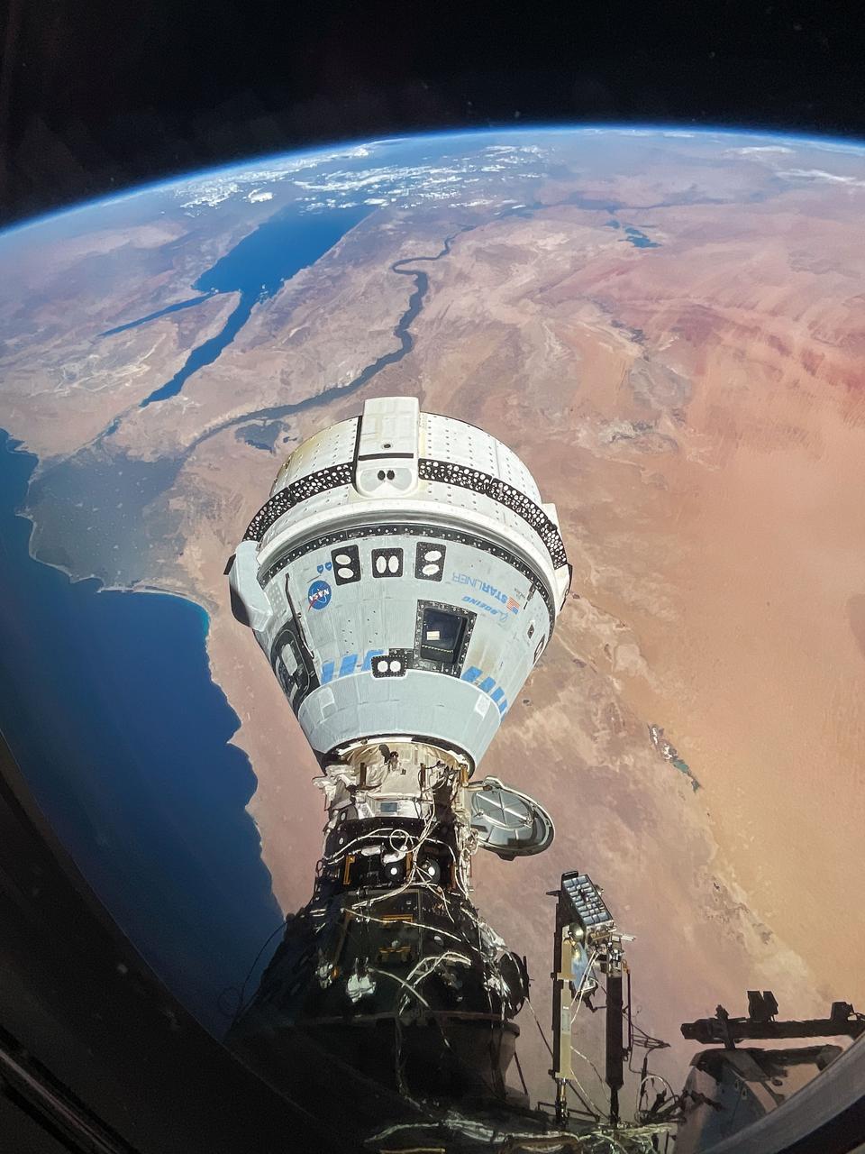
iss071e182991 (June 13, 2024) --- The Starliner spacecraft on NASA's Boeing Crew Flight Test is pictured docked to the Harmony module's forward port as the International Space Station orbited 262 miles above Egypt's Mediterranean coast.
iss061e004613 (Oct. 9, 2019) --- Looking like a leaf on a vine, the Faiyum Oasis extends west of the Nile River and south of Cairo, Egypt. The fertile area at the left of the photograph is the Nile Delta opening up into the Mediterranean Sea.
ISS028-E-014970 (10 July 2011) --- One of the crewmembers aboard the International Space Station recorded this oblique view showing the Nile River Delta and the Sinai Peninsula, with a 28 millimeter lens. The Mediterranean Coast is at far left.
iss055e012690 (April 6, 2018) --- This Earth view taken by an Expedition 55 crew member aboard the International Space Station looks over southeastern Europe, across Italy and into the Mediterranean Sea toward France and Spain.
iss059e099177 (June 10, 2019) --- The Nile River, Red Sea and Mediterranean Sea are contrasted by the desert nations of Egypt, Saudi Arabia, Israel and Jordan as the International Space Station orbits 254 miles above Africa.
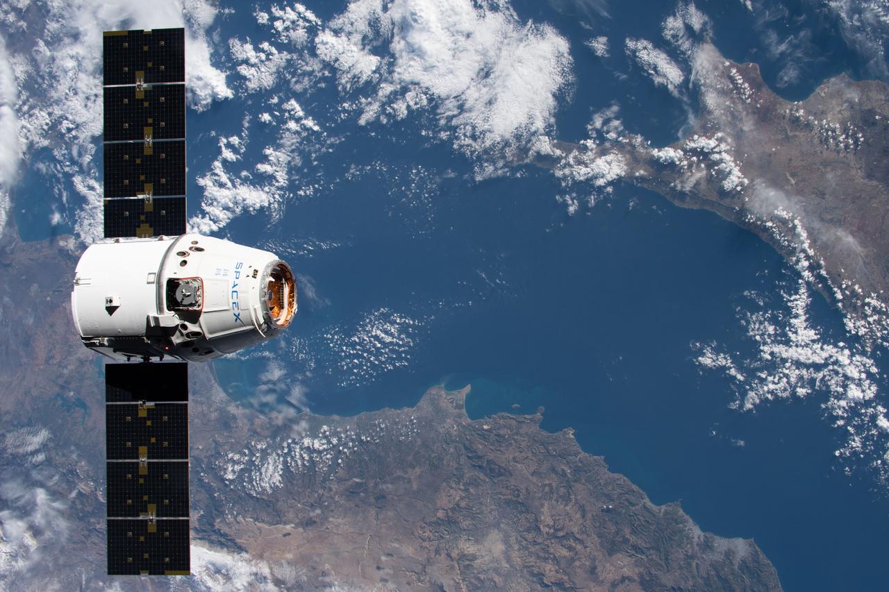
iss061e069087 (Dec. 8, 2019) --- The SpaceX Dragon resupply ship approaches the International Space Station as both spacecraft were orbiting 258 miles above the Mediterranean Sea in between Turkey and Cyprus.
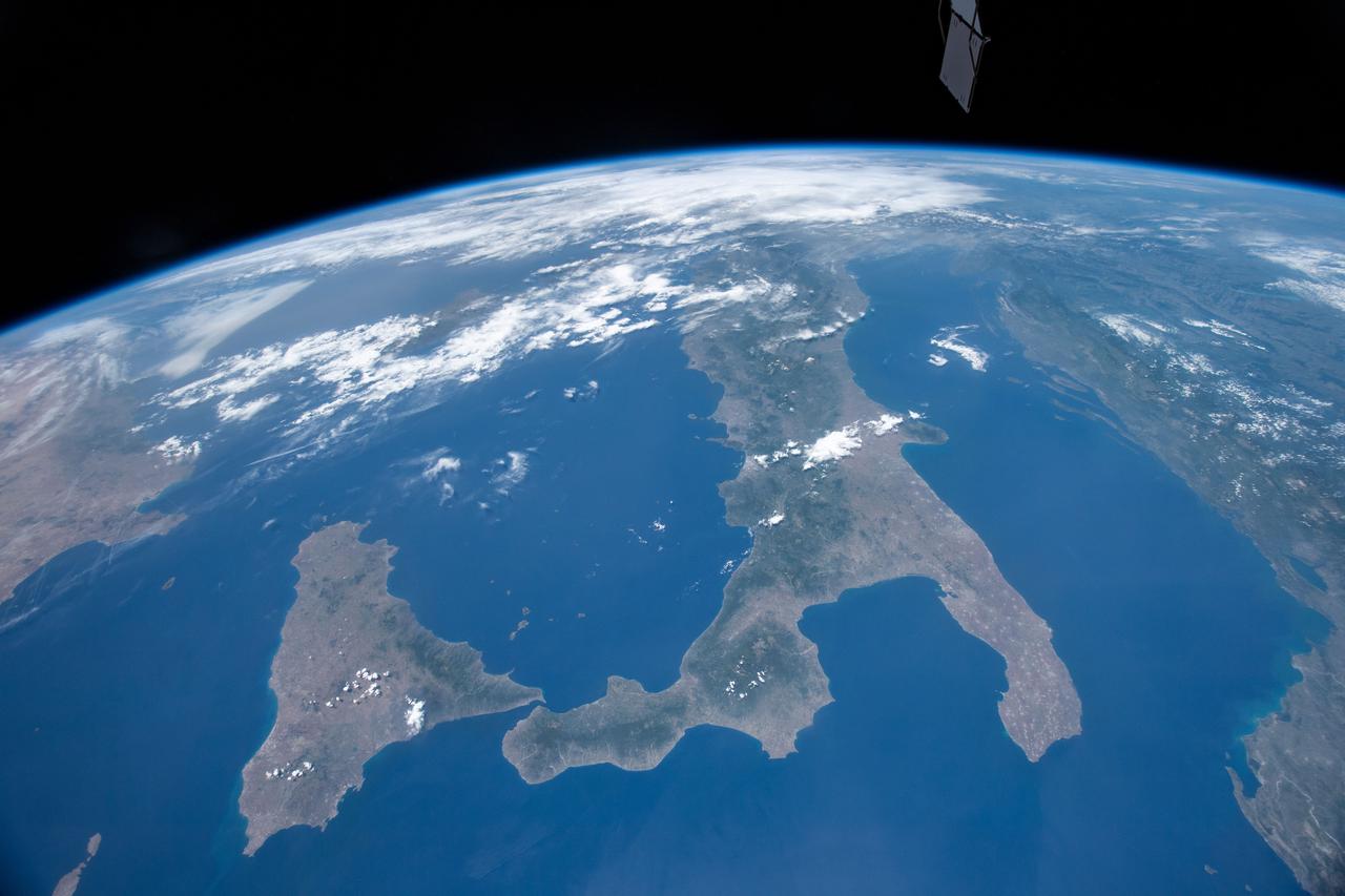
iss059e099173 (June 9, 2010) --- The International Space Station was orbiting 255 miles above the Mediterranean Sea when an Expedition 59 crewmember looking northwest took this photograph of Italy and its island Sicily.
Earth observation taken by an Expedition 36 crew member on board the International Space Station (ISS). Per Twitter message: Eastern Mediterranean Sea coast, Turkey, Syria, Lebanon, Israel.
iss067e178289 (July 8, 2022) --- The Nile River is pictured flowing toward the Mediterranean Sea in this picture from the International Space Station as it orbited 261 miles above the African nation of Sudan. At right, is the Red Sea.
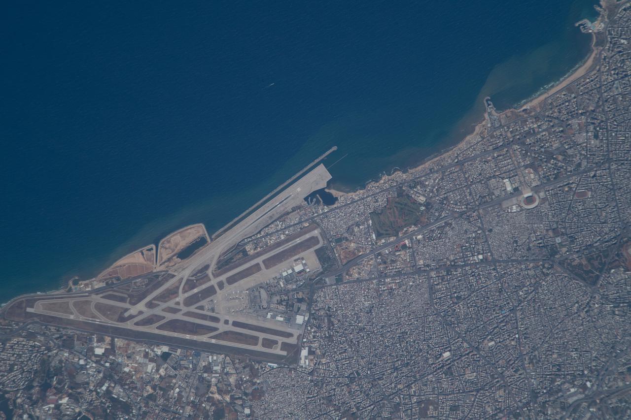
iss065e078580 (May 29, 2021) --- Lebanon's Beirut-Rafic Hariri International Airport on the Mediterranean coast is pictured from the International Space Station as it orbited 261 miles above the Middle Eastern nation.
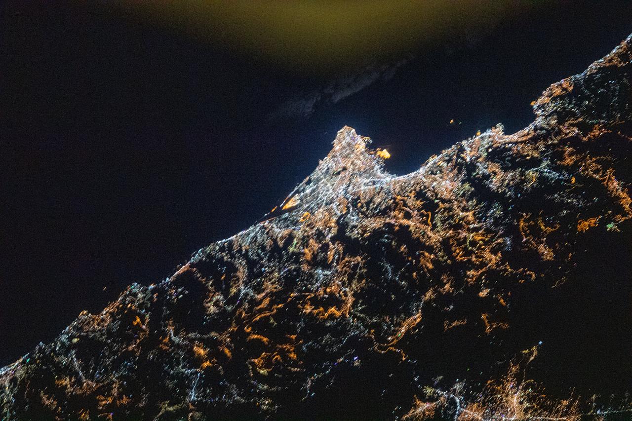
iss061e066550 (Dec. 3, 2019) --- Beirut, the capital city of Lebanon, and its metropolitan area with a population of 2.2 million, is pictured on the coast of the Mediterranean Sea as the International Space Station orbited 252 miles above the Middle East.
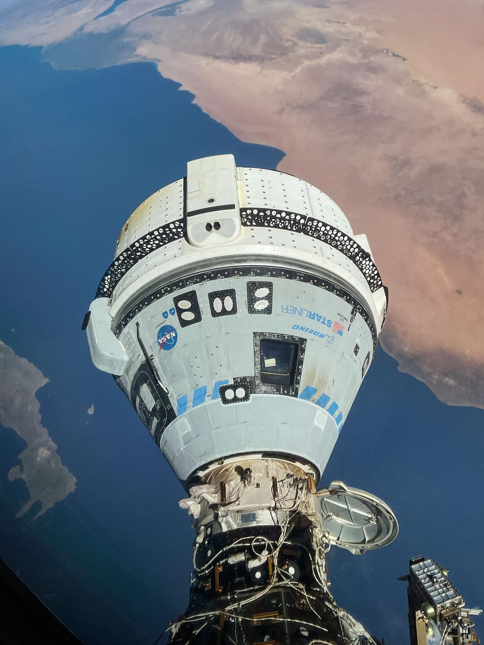
iss071e182982 (June 13, 2024) --- The Starliner spacecraft on NASA's Boeing Crew Flight Test is pictured docked to the Harmony module's forward port as the International Space Station orbited 263 miles above the Mediterranean Sea.

iss060e019901 (July 29, 2019) --- The International Space Station was orbiting 258 miles above the Mediterranean Sea when an Expedition 60 crewmember photographed a well-lit Italy and its island of Sicily near midnight local time.
Earth observation taken during a night pass by the Expedition 37 crew. City lights visible. Per Twitter message this is eastern Mediterranean coast, Tel Aviv to Beirut.
iss056e032465 (June 16, 2018) --- An Expedition 56 crew member photographed the Port de Valencia in the Spanish city of Valencia as the International Space Station orbited across the Mediterranean coast of Spain.
iss069e028451 (July 3, 2023) -- Sicily, the largest Mediterranean island and one of 20 regions of Italy, is photographed from the International Space Station as it orbited 258 miles above.
iss057e051220 (Oct. 13, 2018) --- The International Space Station was orbiting 256 miles above central Europe when this photograph was taken of the Swiss Alps mountain range and the Mediterranean coasts of Italy and France.
iss061e069080 (Dec. 8, 2019) --- The SpaceX Dragon resupply ship approaches the International Space Station as both spacecraft were orbiting 257 miles above Egypt and about to cross over the Mediterranean Sea.
iss064e022729 (Jan. 12, 2021) --- This long duration photograph, taken from the International Space Station orbiting 263 miles above the Mediterranean Sea, shows streaks of a starry field above Earth's exaggerated atmospheric glow.

iss063e040072 (July 5, 2020) --- The tiny shooting star in the lower center of this image is Comet Neowise pictured from the International Space Station as it orbited above the Mediterranean Sea in between Tunisia and Italy.
iss055e013356 (April 7, 2018) --- The eastern-most portion of the Mediterranean Sea and portions of the countries of Turkey, Syria and Lebanon was photographed from the International Space Station by an Expedition 55 crew member.
iss064e038919 (Feb. 28, 2021) --- The city of Algiers on the Mediterranean coast was pictured from the International Space Station as it orbited 262 miles above the African nation of Algeria. Credit: Roscosmos
Earth observation taken during day pass by an Expedition 36 crew member on board the International Space Station (ISS). Per Twitter message: Evening in southern Turkey, on the Mediterranean Sea.
iss069e060397 (Aug. 15, 2023) --- The Aoos River in Albania leads to the Mediterranean Sea in this photograph from the International Space Station as it orbited 264 miles above southern Europe.
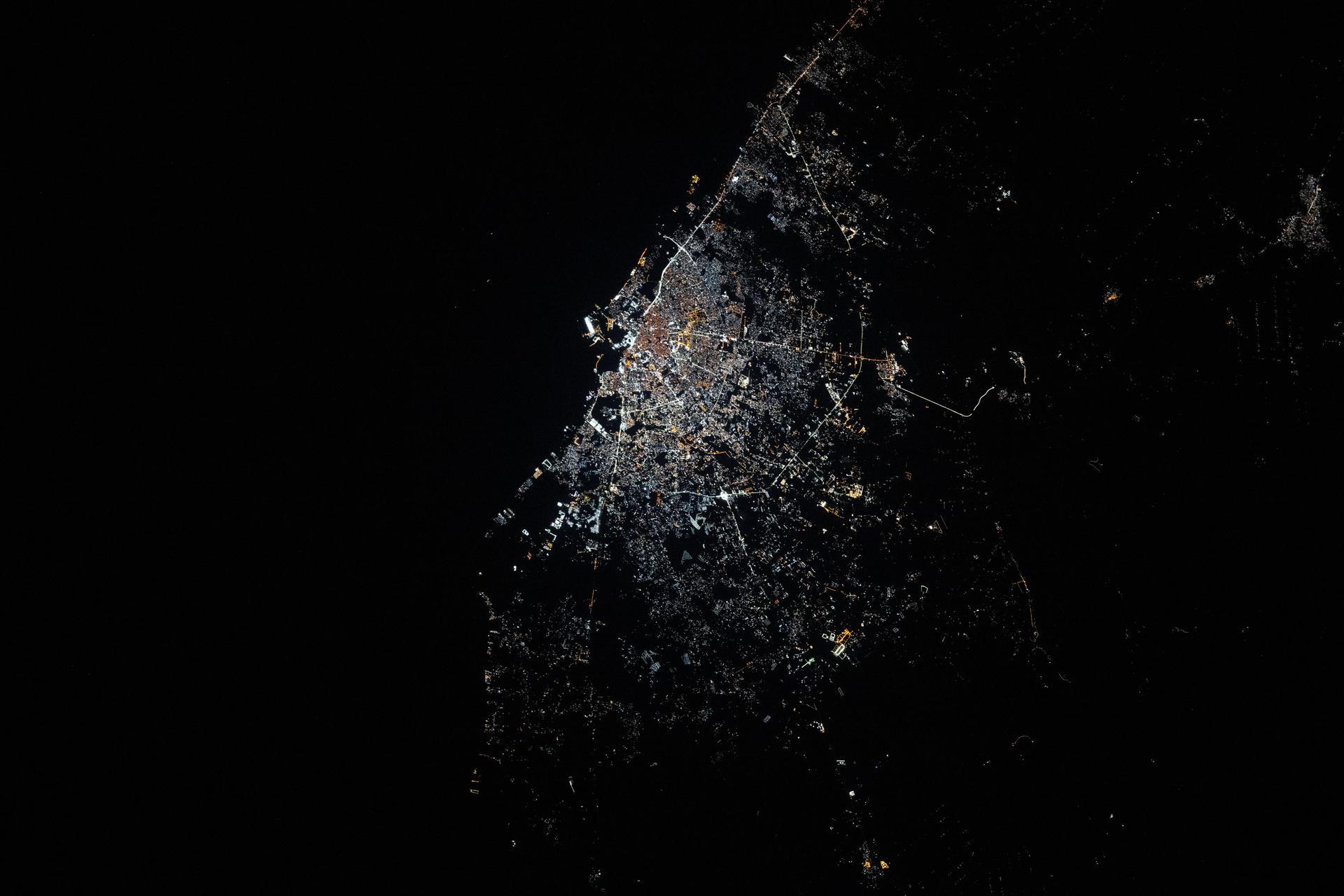
ISS040-E-074047 (22 July 2014) --- Because of city lights, several points in the mid-east along the Eastern Mediterranean Sea coast and a bit inland can be delineated in this early morning view photographed by one of the Expedition 40 crew members aboard the Earth-orbiting International Space Station on July 22, 2014. A portion of the Mediterranean Sea is at the top (northwest) of this image. The orbital outpost was flying at an altitude of approximately 223 nautical miles above a point the coordinates of which are 31.7 degrees north latitude and 34.4 degrees east longitude when the image was exposed, using an 85mm lens.
ISS040-E-074022 (22 July 2014) --- Because of city lights, several points in the mid-east along the Eastern Mediterranean Sea coast and a bit inland can be delineated in this early morning view photographed by one of the Expedition 40 crew members aboard the Earth-orbiting International Space Station on July 22, 2014. A portion of the Mediterranean Sea is at the bottom of this image. The orbital outpost was flying at an altitude of approximately 223 nautical miles above a point the coordinates of which are 29.8 degrees north latitude and 32.3 degrees east longitude (near the Suez Canal) when the image was exposed, using an 85mm lens.
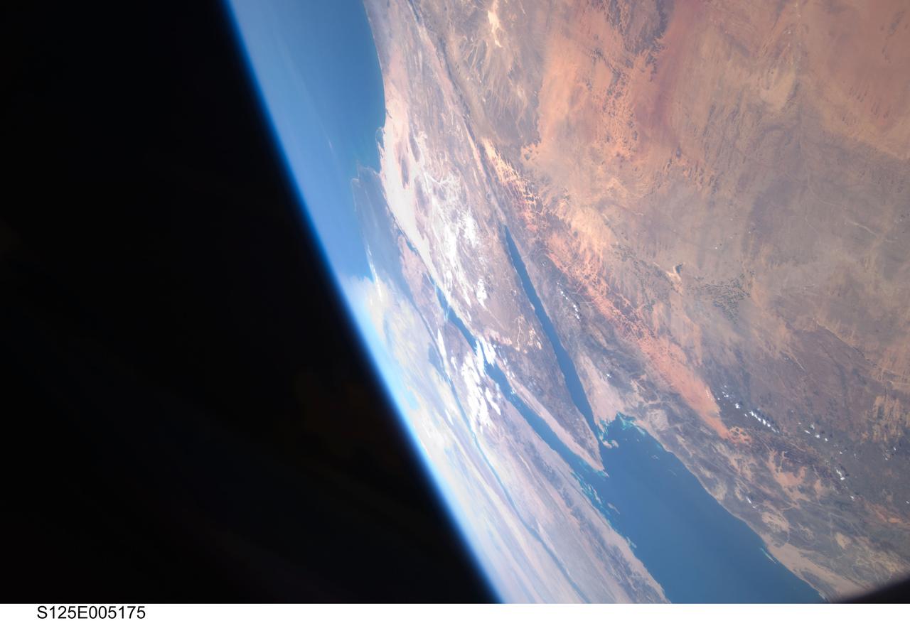
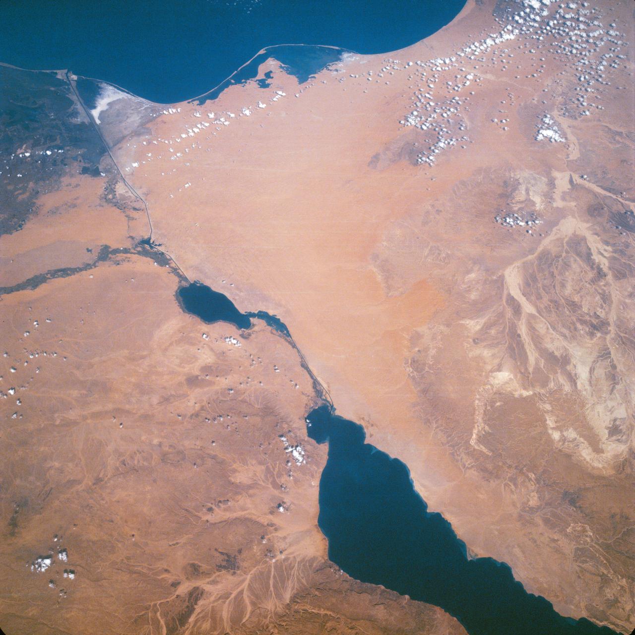
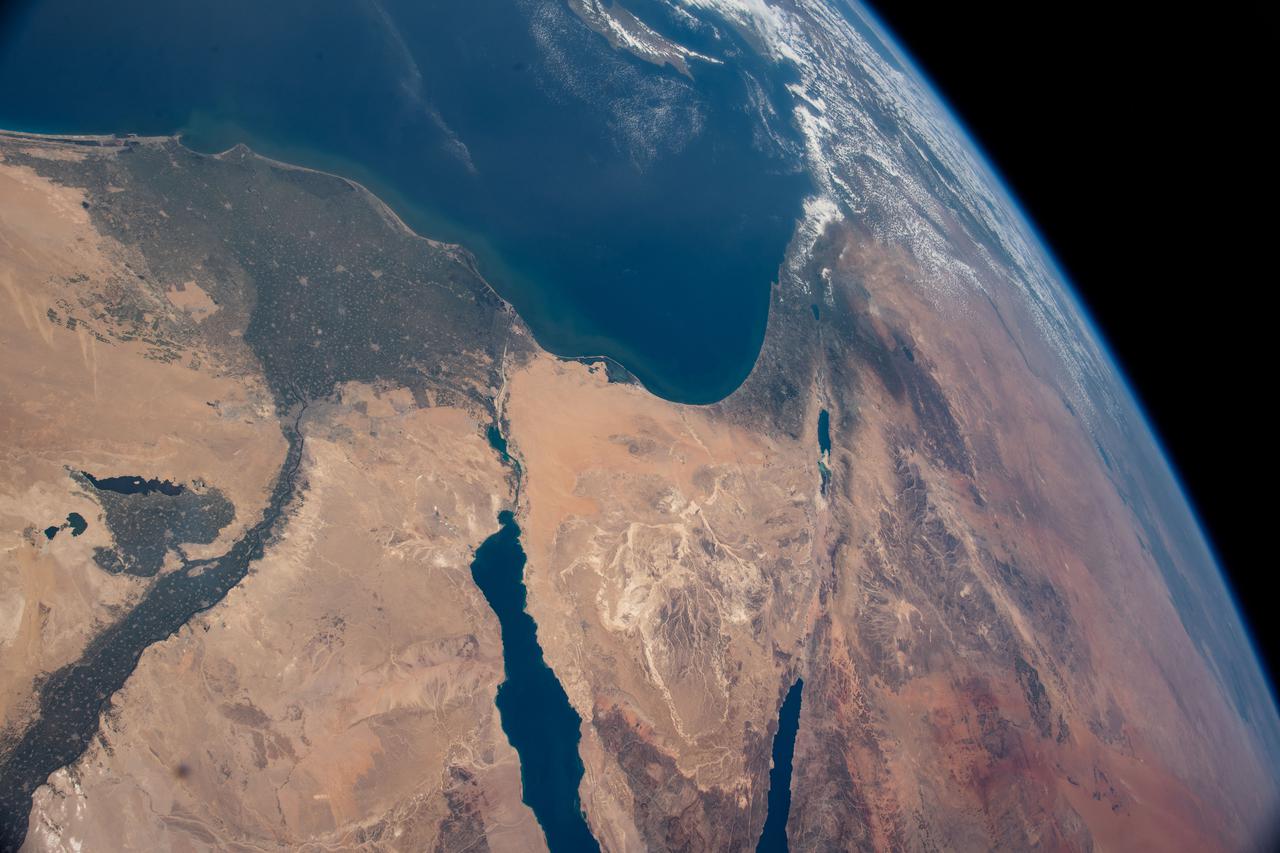
S125-E-005175 (12 May 2009) --- Among the first group of still images downlinked by the STS-125 crewmembers onboard the Space Shuttle Atlantis was this high oblique scene looking toward the Red Sea, Sinai Peninsula and the Mediterranean Sea. Saudi Arabia is in the foreground and Egypt?s Nile River and its delta can be seen (left) toward the horizon. Israel and Jordan can be seen near the top edge of the frame. The Gulf of Suez and the Gulf of Aqaba (near frame center) extend from the Red Sea toward the Mediterranean Sea.
S125-E-005173 (12 May 2009) --- Among the first group of still images downlinked by the STS-125 crewmembers onboard the Space Shuttle Atlantis was this high oblique scene looking toward the Sinai Peninsula and the Mediterranean Sea. The Red Sea is just out of frame at bottom right. Saudi Arabia is in the right foreground and Egypt?s Nile River and its delta can be seen (lower left) toward the horizon. Jordan and a small portion of Israel can be seen near the top of the frame. The Gulf of Suez and the Gulf of Aqaba extend from the Red Sea toward the Mediterranean.
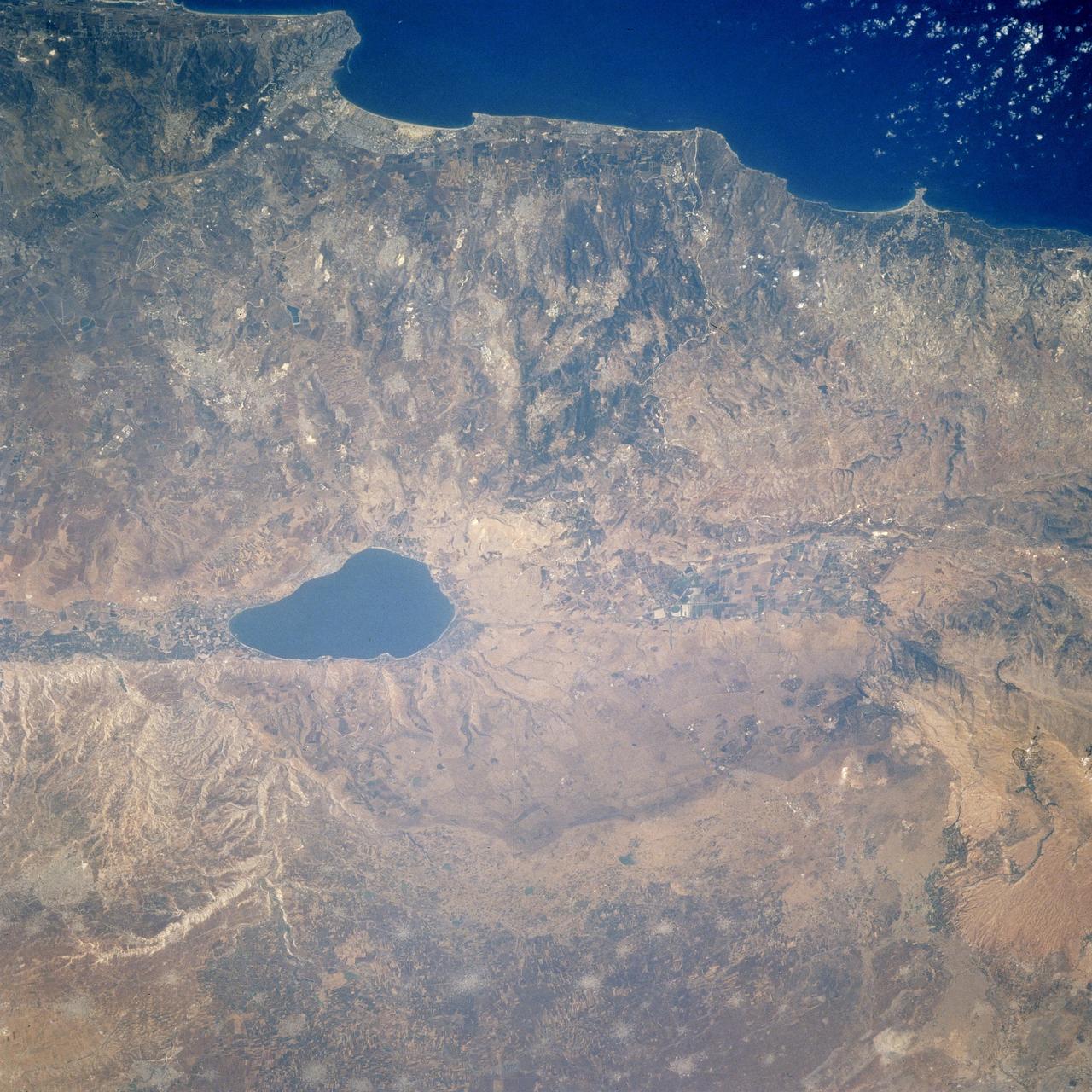
STS106-713-002 (19 September 2000) --- One of the STS-106 crew members on board the Space Shuttle Atlantis, 204 nautical miles above Earth, used a handheld 70mm camera to photograph this image featuring the Sea of Galilee and part of the Mediterranean coast. Also known as Lake Tiberius and other names, the body of water is the only natural fresh-water lake in Israel. It borders on the Golan Heights on its east side. The port of Haifa is visible on the Mediterranean coast. The large agriculture projects on the Israeli side of Galilee are irrigated by the lake and the Jordan River.
ISS036-E-027014 (31 July 2013) --- One of the Expedition 36 crew members aboard the Earth-orbiting International Space Station, as it was passing over Eastern Europe on July 31, 2013, took this night picture looking toward the Mediterranean Sea, which almost blends into the horizon. Also visible are the Aegean Sea, Adriatic Sea and Mediterranean Sea. Parts of the following countries are among those visible as well: Greece, Italy, Sicily, Bulgaria, Serbia, Croatia and Albania. The high oblique 50mm lens shot includes a number of stars in the late July sky. A solar array panel is visible in the darkness on the right side of the frame.

STS060-88-070 (3-11 Feb 1994) --- This view shows sunglint in the Strait of Gibralter. In this photograph a high pressure atmospheric system over the Iberian Peninsula has set the conditions for seeing a plankton bloom along the Moroccan coast in the Alboran Sea (Western Mediterranean) coastal counter current as well as illumining the influence of winds in the sunglint pattern near the Strait of Gibraltar. Where the water is ruffled from a wind gust, such as off Cadiz, Spain, the surface is less reflective and thus appears dark. A combination of the effects of the tide and the surface winds through the Strait of Gibraltar have created a unique sunglint pattern at the entrance of the Mediterranean. The Atlantic Ocean waters are flowing with the tide through the Strait of Gibraltar into the Mediterranean Sea and are probably smoothing out some of the smaller waves at the surface. The incoming tide generates internal waves as can be faintly seen in this photograph. The incoming relatively cooler, less dense Atlantic water flows over the warm, more saline Mediterranean water. As the tide moves into the Strait of Gibraltar it encounters the Camarinal Sill, which is like a cliff under the water, south of Camarinal Point, Spain. Internal waves are generated at this sill and they travel along the density boundary between the Atlantic water and the Mediterranean water masses. There is little evidence of the internal waves at the surface of the ocean. We can see them in spacecraft photography because of the sunglint which reflects off the different water layers in differential patterns. The internal waves also smooth out some of the bands of capillary waves at the surface. That is, the sun reflects more brightly from these smooth areas, showing the pattern of the underwater waves more prominently than do the surface waves. The Bay of Cadiz on the southwest coast of Spain, the Rock of Gibraltar, and the Moroccan coast are also beautifully illustrated in this photography. The focus for scientists, however, remains the high clarity and spatial resolution given by sunglint studies to physical phenomena in the ocean.
STS058-73-009 (18 Oct-1 Nov 1993) --- Atlantic water flowing with the tide through the Strait of Gibraltar into the Mediterranean generates internal waves as depicted in this photo. The incoming cool, less dense Atlantic water flows over the warm, more saline Mediterranean water. As the tide moves into the Strait of Gibraltar it encounters the Camarinal Sill, which is like a cliff under water, south of Camarinal Point, Spain. Internal waves are generated at the Sill and travel along the density boundary between the Atlantic water and the Mediterranean water. Internal waves have very little effect on the sea surface, except for gentle slopes and slight differences in roughness. We can see them in the Space Shuttle photos because of sunglint which reflects off the water. Internal waves smooth out some of the capillary waves at the surface in bands. The sun reflects more brightly from these smooth areas showing us the pattern of the underwater waves. The Bay of Cadiz on the southwest coast of Spain, the Rock of Gibraltar, and the Moroccan coast are also visible in this photo.
ISS47e141893 (06/02/2016) --- This Earth observation image of the southern Mediterranean area was taken by the crew of Expedition 47 aboard the International Space Station. The image looks from the coastline of Greece (bottom left) across the Ionian sea to the bottom "heel" of Italy. The tip of the toe reaches toward Sicily.
STS121-334-026 (4-17 July 2006) --- This photo, featuring an easterly view of the Nile River, the Nile River Delta, Sinai Peninsula, the Suez Canal, Red Sea and part of the Mediterranean Sea, was taken by one of the STS-121 crewmembers aboard the Space Shuttle Discovery. Cairo, Egypt, can be seen at far right.
ISS036-E-028696 (3 Aug. 2013) --- One of the Expedition 36 crew members aboard the International Space Station photographed this nighttime image of northern parts of Italy showing both the Mediterranean Sea (top) and Adriatic Sea coasts on Aug. 3, 2013. A Russian Soyuz vehicle, docked to the orbital outpost, is in upper left.
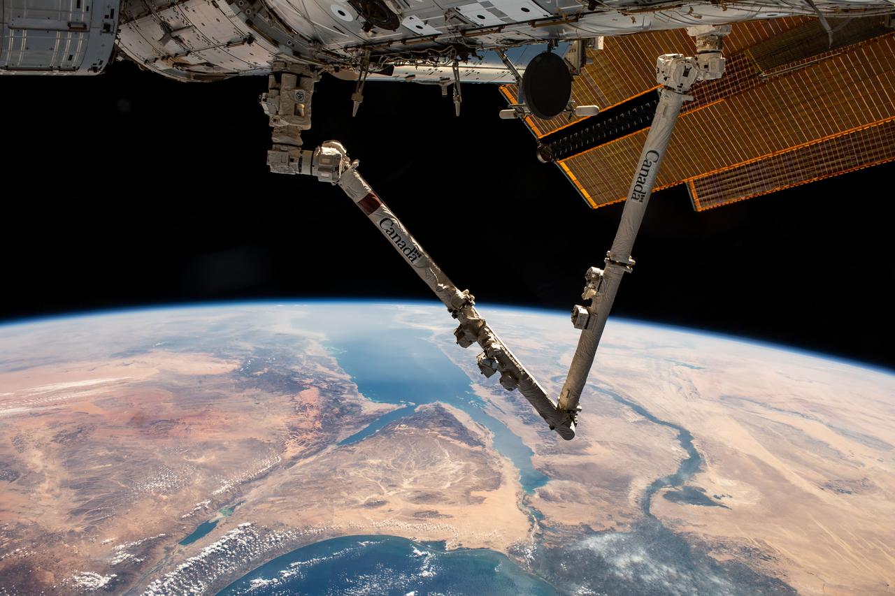
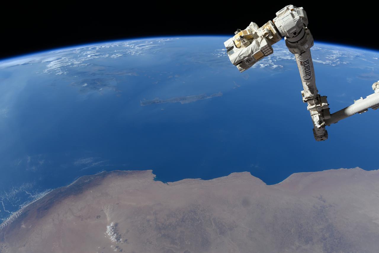
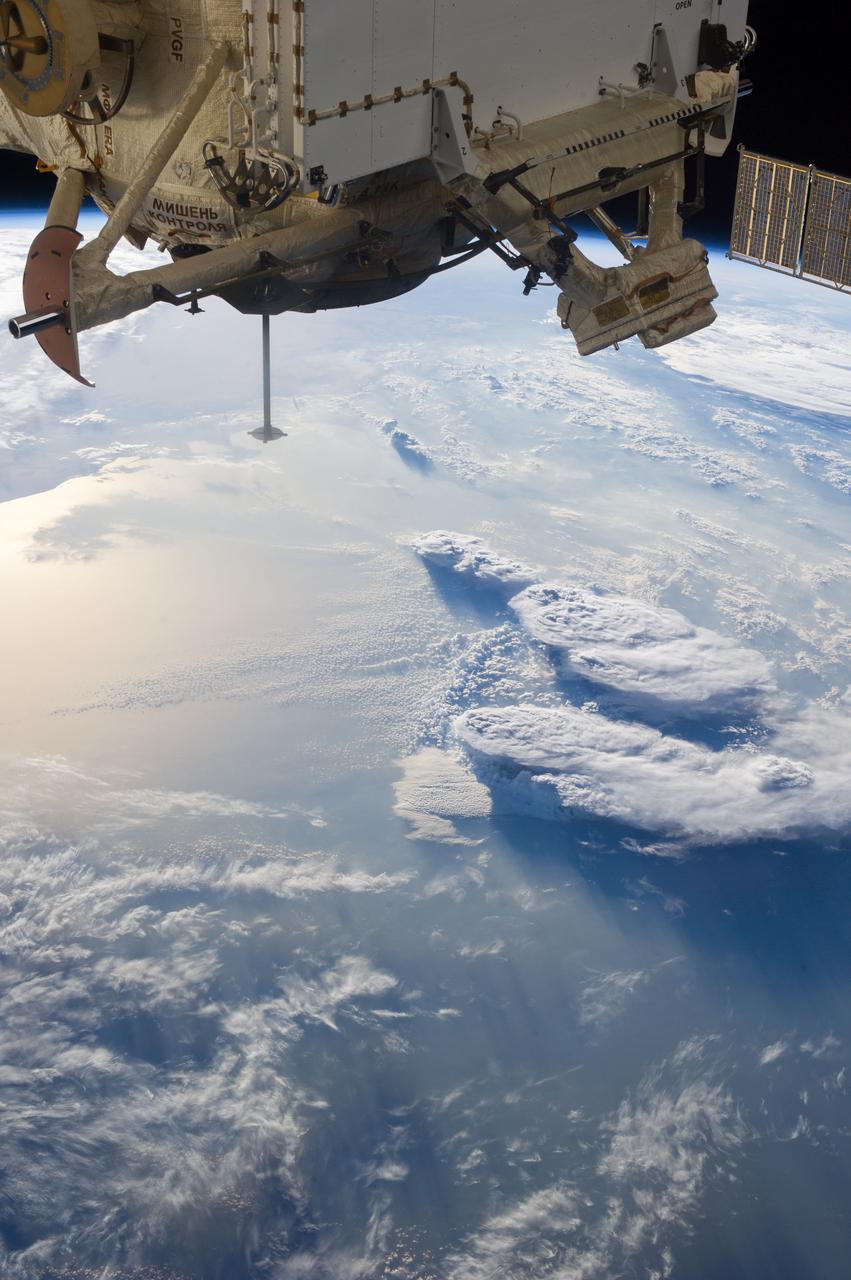
iss070e007599 (Oct. 20, 2023) --- The Canadarm2 robotic arm extends from the International Space Station as it orbited 261 miles above Turkey. Below, the Sinai Peninsula, the Red Sea, and the Nile River Delta are pictured leading toward the Mediterranean Sea at bottom.