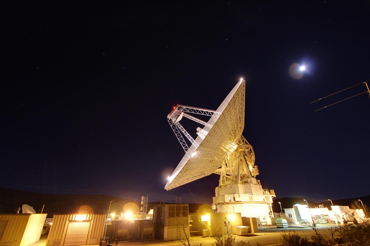
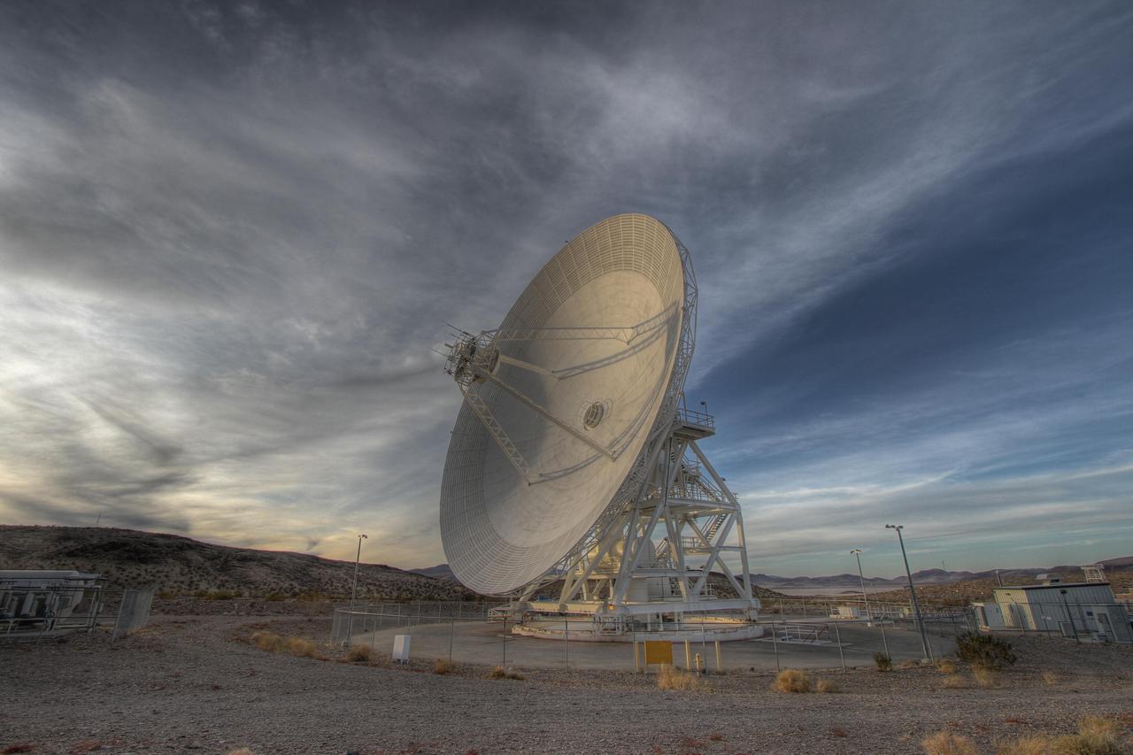
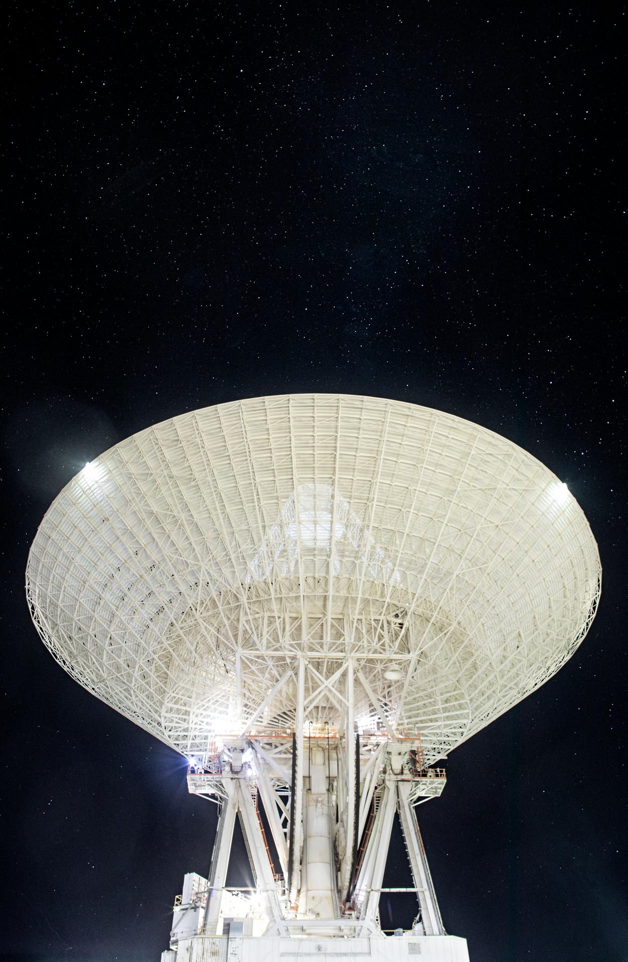
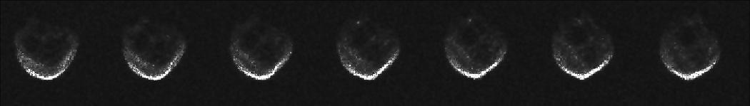
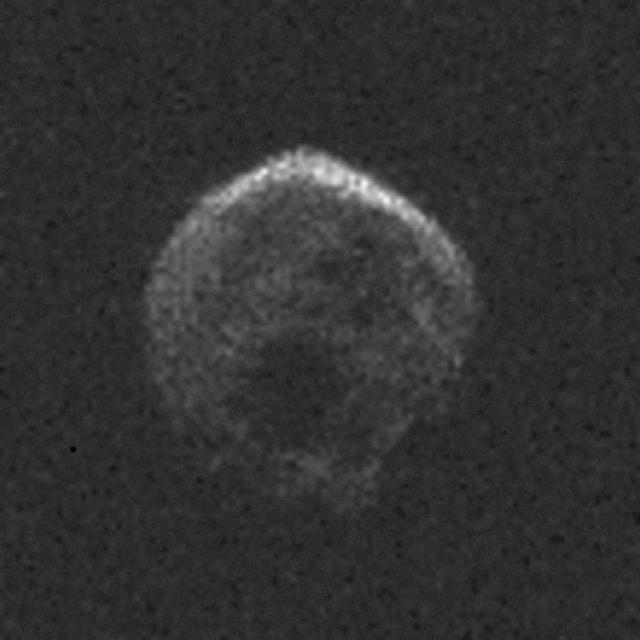
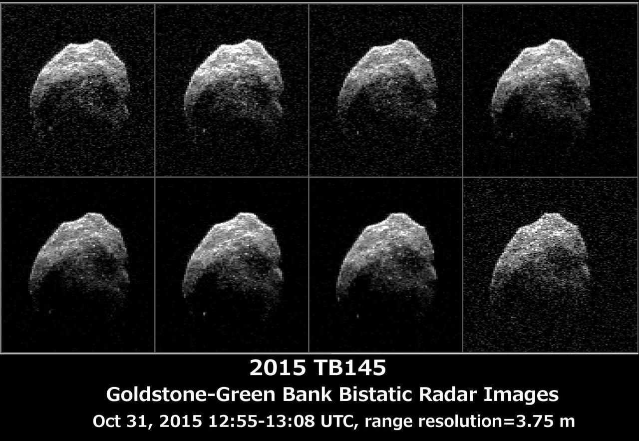
A specimen cab mounted on the Space Biosciences division’s 1.22-meter radius centrifuge with centrifuge in motion in N239A.
1.22-Meter Radius Centrifuge
1.2 meter Multi-Mission Earth Entry Vehicle (MMEEV): Tethered and free flying test in 20 foot Vertical Spin Tunnel
1.2 meter Multi-Mission Earth Entry Vehicle (MMEEV)
1.2 meter Multi-Mission Earth Entry Vehicle (MMEEV): Tethered and free flying test in 20 foot Vertical Spin Tunnel
1.2 meter Multi-Mission Earth Entry Vehicle (MMEEV)
1.2 meter Multi-Mission Earth Entry Vehicle (MMEEV): Tethered and free flying test in 20 foot Vertical Spin Tunnel
1.2 meter Multi-Mission Earth Entry Vehicle (MMEEV)
1.2 meter Multi-Mission Earth Entry Vehicle (MMEEV): Tethered and free flying test in 20 foot Vertical Spin Tunnel
1.2 meter Multi-Mission Earth Entry Vehicle (MMEEV)
1.2 meter Multi-Mission Earth Entry Vehicle (MMEEV): Tethered and free flying test in 20 foot Vertical Spin Tunnel
1.2 meter Multi-Mission Earth Entry Vehicle (MMEEV)
1.2 meter Multi-Mission Earth Entry Vehicle (MMEEV): Tethered and free flying test in 20 foot Vertical Spin Tunnel
1.2 meter Multi-Mission Earth Entry Vehicle (MMEEV)
Forty Meters from Entry to Victoria Crater Vertical
Forty Meters from Entry to Victoria Crater Polar
1.5 Meter Per Pixel View of Boulders in Ganges Chasma
Final Eros Images: Range 1,150 meters 3,773 feet
Final Eros Images: Range 700 meters 2,300 feet
Final Eros Images: Range 250 meters 820 feet
Late night in the desert: Goldstone 230-foot 70-meter antenna tracks spacecraft day and night. This photograph was taken on Jan. 11, 2012. The Goldstone Deep Space Communications Complex is located in the Mojave Desert in California, USA.
Goldstone 70-Meter
This image was taken by the Philae lander of the European Space Agency Rosetta mission when it was about 130 feet 40 meters above the surface of comet 67P/Churyumov-Gerasimenko during descent to the surface on Nov. 12, 2014.
Comet from 40 Meters
The High Resolution Imaging Science Experiment camera on NASA Mars Reconnaissance Orbiter excavates ice in a twelve-meter-wide crater.
Twelve-Meter-Wide Crater Excavates Ice on Mars
Goldstone 111.5-foot 34-meter Beam Waveguide tracks a spacecraft as it comes into view. The Goldstone Deep Space Communications Complex is located in the Mojave Desert in California, USA.
Goldstone 34-meter Beam Waveguide
A 112-foot (34-meter) antenna glows from within a nighttime scene at the Goldstone Deep Space Communications Complex near Barstow, California, in September 2025.   Goldstone is part of NASA’s Deep Space Network (DSN), which operates three complexes around the globe that support communications with dozens of deep space missions.    For more information about the DSN, visit: https://www.nasa.gov/communicating-with-missions/dsn/
A 34-meter Antenna at Goldstone
ISS027-E-019517 (6 April 2011) --- NASA astronaut Cady Coleman, Expedition 27 flight engineer, is pictured near a conductivity meter floating freely in the Tranquility node of the International Space Station.
Coleman with Conductivity Meter
The Apollo Telescope Mount (ATM), designed and developed by the Marshall Space Flight Center, served as the primary scientific instrument unit aboard the Skylab. The ATM contained eight complex astronomical instruments designed to observe the Sun over a wide spectrum from visible light to x-rays. This angle view is of an ATM contamination monitor meter mockup.
Saturn Apollo Program
ISS040-E-086654 (1 Aug. 2014) --- NASA astronaut Steve Swanson, Expedition 40 commander, uses a sound level meter in the Destiny laboratory of the International Space Station.
Sound Level Meter (SLM) Operations
ISS040-E-086653 (1 Aug. 2014) --- NASA astronaut Steve Swanson, Expedition 40 commander, uses a sound level meter in the Destiny laboratory of the International Space Station.
Sound Level Meter (SLM) Operations
The Five-hundred-meter Aperture Spherical Telescope (FAST) is a radio telescope in China's Guizhou Province. When it is completed in September, it will be the world's second largest radio telescope, with a diameter of 500m.The largest telescope is the operating Russian RATAN-600, with a diameter of 576m. The image was acquired April 14, 2013, covers an area of 6.2 by 8.2 km, and is located at 25.7 degrees north, 106.9 degrees east.  http://photojournal.jpl.nasa.gov/catalog/PIA20986
Five-hundred-meter Aperture Spherical Telescope, China
NASA Opportunity had driven 72.3 meters southward 237 feet that sol. Engineers drove the rover backward as a strategy to counteract an increase in the amount of current drawn by the drive motor of the right-front wheel. This is a vertical projection.
Opportunity View After 72-Meter Drive, Sol 1912 Vertical
NASA Opportunity had driven 72.3 meters southward 237 feet that sol. Engineers drove the rover backward as a strategy to counteract an increase in the amount of current drawn by the drive motor of the right-front wheel. This is a polar projection.
Opportunity View After 72-Meter Drive, Sol 1912 Polar
NASA Opportunity had driven 72.3 meters southward 237 feet that sol. Engineers drove the rover backward as a strategy to counteract an increase in the amount of current drawn by the drive motor of the right-front wheel. This is a cylindric projection.
Opportunity View After 72-Meter Drive, Sol 1912
shows the 15-foot 4.5-meter diameter heat shield when it was about 50 feet 16 meters from the spacecraft.
Curiosity Heat Shield in View
Seen from inside the dome, a new five-meter telescope is lowered into place. The tracking telescope is part of the Distant Object Attitude Measurement System (DOAMS) in Cocoa Beach, Fla., that provides optical support for launches from KSC and Cape Canaveral.
New five-meter DOAMS Telescope
Deep Space Station 14 (DSS-14), the 230-foot-wide (70-meter) antenna at the Goldstone Deep Space Communications Complex near Barstow, California, points up toward a starry sky in September 2025.   Goldstone is part of NASA’s Deep Space Network (DSN), which operates three complexes around the globe to support communications with dozens of deep space missions. DSS-14 is also the agency’s Goldstone Solar System Radar, which is used to observe asteroids that come close to Earth.  For more information about the DSN, visit: https://www.nasa.gov/communicating-with-missions/dsn/
Goldstone’s 70-Meter Antenna Under the Stars
NASA Opportunity had driven 72.3 meters southward 237 feet on June 10. Engineers drove the rover backward as a strategy to counteract an increase in the amount of current drawn by the drive motor of the right-front wheel. 3D glasses are necessary.
Opportunity View After 72-Meter Drive, Sol 1912 Stereo
Scientists carefully examine data being received during nighttime line operations testing of the SOFIA airborne observatory's 2.5-meter infrared telescope.
Scientists carefully examine data being received during nighttime line operations testing of the SOFIA airborne observatory's 2.5-meter infrared telescope
The 2.5-meter infrared telescope peers out from its cavity in the SOFIA airborne observatory during nighttime line operations testing at Palmdale, Calif.
The SOFIA airborne observatory's 2.5-meter infrared telescope peers out from its cavity in the SOFIA rear fuselage during nighttime line operations testing.
The SOFIA airborne observatory's 2.5-meter infrared telescope peers out from its cavity in the SOFIA rear fuselage during nighttime line operations testing
KENNEDY SPACE CENTER, FLA. - This bird's-eye view of a high bay in the Orbiter Processing Facility (OPF) shows Space Shuttle Atlantis surrounded by the standard platforms and equipment required to process a Space Shuttle orbiter for flight.  The high bay is 197 feet (60 meters) long, 150 feet (46 meters) wide, 95 feet (29 meters) high, and encompasses a 29,000-square-foot (2,694-meter) area.  Platforms, a main access bridge, and two rolling bridges with trucks provide access to various parts of the orbiter. The next mission scheduled for Atlantis is STS-114, a utilization and logistics flight to the International Space Station.
KENNEDY SPACE CENTER, FLA. - This bird's-eye view of a high bay in the Orbiter Processing Facility (OPF) shows Space Shuttle Atlantis surrounded by the standard platforms and equipment required to process a Space Shuttle orbiter for flight. The high bay is 197 feet (60 meters) long, 150 feet (46 meters) wide, 95 feet (29 meters) high, and encompasses a 29,000-square-foot (2,694-meter) area. Platforms, a main access bridge, and two rolling bridges with trucks provide access to various parts of the orbiter. The next mission scheduled for Atlantis is STS-114, a utilization and logistics flight to the International Space Station.
Barringer Crater, also known as Meteor Crater, is a 1,300-meter 0.8 mile diameter, 174-meter 570-feet deep hole in the flat-lying desert sandstones 30 kilometers 18.6 miles west of Winslow, Arizona.
Barringer Meteor Crater, Arizona
KENNEDY SPACE CENTER, FLA. -  This bird's-eye view of a high bay in the Orbiter Processing Facility (OPF) shows the open payload bay of Space Shuttle Discovery surrounded by the standard platforms and equipment required to process a Space Shuttle orbiter.  The high bay is 197 feet (60 meters) long, 150 feet (46 meters) wide, 95 feet (29 meters) high, and encompasses a 29,000-square-foot (2,694-meter) area.  The 30-ton (27-metric-ton) bridge crane (yellow device, right) has a hook height of approximately 66 feet (20 meters).  Platforms, a main access bridge, and two rolling bridges with trucks provide access to various parts of the orbiter.  In addition to routine servicing and checkout, the inspections and modifications made to enhance Discovery's performance and upgrade its systems were performed in the OPF during its recently completed Orbiter Major Modification (OMM) period.
KENNEDY SPACE CENTER, FLA. - This bird's-eye view of a high bay in the Orbiter Processing Facility (OPF) shows the open payload bay of Space Shuttle Discovery surrounded by the standard platforms and equipment required to process a Space Shuttle orbiter. The high bay is 197 feet (60 meters) long, 150 feet (46 meters) wide, 95 feet (29 meters) high, and encompasses a 29,000-square-foot (2,694-meter) area. The 30-ton (27-metric-ton) bridge crane (yellow device, right) has a hook height of approximately 66 feet (20 meters). Platforms, a main access bridge, and two rolling bridges with trucks provide access to various parts of the orbiter. In addition to routine servicing and checkout, the inspections and modifications made to enhance Discovery's performance and upgrade its systems were performed in the OPF during its recently completed Orbiter Major Modification (OMM) period.
he SOFIA airborne observatory's 2.5-meter infrared telescope peers out from its cavity in the SOFIA rear fuselage during nighttime line operations testing.
he SOFIA airborne observatory's 2.5-meter infrared telescope peers out from its cavity in the SOFIA rear fuselage during nighttime line operations testing
These first radar images of 2015 TB145 from the National Science Foundation 1,000-foot 305-meter Arecibo Observatory in Puerto Rico, indicate the near-Earth object is spherical in shape and approximately 2,000 feet 600 meters in diameter. The radar images were taken on Oct. 30, 2015, and the image resolution is 25 feet (7.5 meters) per pixel.  The celestial object is more than likely a dead comet that has shed its volatiles after numerous passes around the sun.   http://photojournal.jpl.nasa.gov/catalog/PIA20040
First Radar Images of Halloween Asteroid
Prominently displayed in this image, Mt. Pinos, at 2,692 meters 8,831 feet is the highest peak in the Los Padres National Forest.
SRTM Perspective View with Landsat Overlay: Mt. Pinos, California
Engineers test Aquarius 2.5 meter reflector in the clean room at NASA Jet Propulsion Laboratory in Pasadena, Calif.
Aquarius Reflector Test
Each of the six wheels for NASA Mars Science Laboratory rover is about half a meter 20 inches in diameter.
Wheel for Mars Science Laboratory Rover
The NASA logo on Bldg. 703 at Armstrong Flight Research Center in Palmdale, Calif., is reflected in the telescope's 2.5-meter primary mirror.
ED11-0173-076
Aquarius instrument, including 2.5 meter reflector, in the clean room at NASA Jet Propulsion Laboratory in Pasadena, Calif.
Aquarius at JPL
The 5000 meter 16,000 feet high Tibetan Plateau has been formed by the collision of the Indian subcontinent with central Asia.
Western Tibet, Shaded Relief with Color as Height
At the time NASA Terra spacecraft acquired this image, the Mississippi River had reached a level of 53 feet 16.2 meters, 3 feet 1 meter above the major flood stage. Flood water had already inundated parts of Vicksburg, Mississippi.
NASA Spacecraft Eyes Mississippi Flooding
This 360-degree panorama shows evidence of a successful first test drive for NASA Curiosity rover; the rover made its first move, going forward about 15 feet 4.5 meters, rotating 120 degrees and then reversing about 8 feet 2.5 meters.
Curiosity First Track Marks on Mars
Yogi is a meter-size rock about 5 meters northwest of NASA Mars Pathfinder lander and was the second rock visited by the Sojourner Rover alpha proton X-ray spectrometer APXS instrument. 3D glasses are necessary to identify surface detail.
Yogi in Super Resolution from Super Panorama
A drive of about 30 meters about 100 feet on Sept. 25, 2006 brought NASA Mars Exploration Rover Opportunity to within about 20 meters about 66 feet of the rim of Victoria Crater. 3D glasses are necessary to view this image.
Victoria After Sol 950 Drive Stereo
At approximately 1.1 meters/pixel, this image is among the highest-resolution views MESSENGER has ever taken of the surface of Mercury.  The final orbital correction maneuver (OCM) of the mission is planned for today, raising the periapsis from approximately 8 to 19 km (5 to 12 miles) and delaying the spacecraft's inevitable crash for one more week.  Date acquired: April 23, 2015 Image Mission Elapsed Time (MET): 72114468 Image ID: 8382023 Instrument: Narrow Angle Camera (NAC) of the Mercury Dual Imaging System (MDIS) Center Latitude: 49.26° Center Longitude: 253.44° E Resolution: 1.1 meters/pixel Scale: This scene is approximately 560 meters (~1837 feet) across.  http://photojournal.jpl.nasa.gov/catalog/PIA19434
Delaying the Inevitable
NASA's SOFIA 747SP bearing a German-built 2.5-meter infrared telescope in its rear fuselage taxis up to NASA Dryden's ramp after a ferry flight from Waco, Texas. NASA's Stratospheric Observatory for Infrared Astronomy, or SOFIA, arrived at NASA's Dryden Flight Research Center at Edwards Air Force Base, Calif. on May 31, 2007. The heavily modified Boeing 747SP was ferried to Dryden from Waco, Texas, where L-3 Communications Integrated Systems installed a German-built 2.5-meter infrared telescope and made other major modifications over the past several years. SOFIA is scheduled to undergo installation and integration of mission systems and a multi-phase flight test program at Dryden over the next three years that is expected to lead to a full operational capability to conduct astronomy missions in about 2010. During its expected 20-year lifetime, SOFIA will be capable of "Great Observatory" class astronomical science, providing astronomers with access to the visible, infrared and sub-millimeter spectrum with optimized performance in the mid-infrared to sub-millimeter range.
NASA's SOFIA 747SP bearing a German-built 2.5-meter infrared telescope in its rear fuselage taxis up to NASA Dryden's ramp after a ferry flight from Waco, TX
DSS43 is a 70-meter-wide (230-feet-wide) radio antenna at the Deep Space Network's Canberra facility in Australia. It is the only antenna that can send commands to the Voyager 2 spacecraft.  https://photojournal.jpl.nasa.gov/catalog/PIA23682
NASA's Deep Space Antenna Upgrade to Affect Voyager
This partial frame from an animation was generated using radar data collected by the National Science Foundation 1,000-foot 305-meter Arecibo Observatory in Puerto Rico.
Halloween Asteroid Rotation
At more than 4,300 meters 14,000 feet , Mount Shasta is California tallest volcano and part of the Cascade chain of volcanoes extending south from Washington.
Perspective View with Landsat Overlay, Mount Shasta, Calif.
This chart graphs measurements made by the Dynamic Albedo of Neutrons DAN instrument on NASA Mars rover Curiosity against the distance the rover has driven, in meters.
Variations of DAN Measurements Along Curiosity Traverse
Aquarius 2.5 meter composite reflector being fitted with gold foil covering in the clean room at NASA Jet Propulsion Laboratory in Pasadena, Calif.
Gold Foil on Aquarius Reflector
In this image from NASA Mars Odyssey, the late afternoon sun casts a shadow over a rim of Huygens Crater that 700 meters nearly 2,300 feet high.
Crater Rim
The Mini Matterhorn is a 3/4 meter rock immediately east-southeast of NASA Mars Pathfinder lander. 3D glasses are necessary to identify surface detail.
Super Resolution Anaglyph of Mini-Matterhorn
Aquarius 2.5 meter reflector is hoisted before being attached to boom in the clean room at NASA Jet Propulsion Laboratory in Pasadena, Calif.
Aquarius Reflector Attachment
Mini Matterhorn is a 3/4 meter rock immediately east-southeast of NASA Mars Pathfinder lander. 3D glasses are necessary to identify surface detail.
Mini Matterhorn in Super Resolution from Super Panorama
Surveyor 5 sitting in a 10-meter diameter crater. Surveyor 5 landed on Mare Tranquillitatis in September of 1967. This image was taken by NASA Lunar Reconnaissance Orbiter.
Surveyor 5: A Hole-in-One
This is a 3-foot 1-meter aperture main telescope located at the NASA Jet Propulsion Laboratory Optical Communications Telescope Laboratory ground station.
OPALS Main Telescope
NASA's Ingenuity Mars Helicopter took this color image from an altitude of 33 feet (10 meters) during its fifth flight on May 7, 2021. This was the helicopter's first one-way flight, and it settled down at a new landing location 423 feet (129 meters) south of its previous location at Wright Brothers Field. The contrast has been enhanced to show surface details.  https://photojournal.jpl.nasa.gov/catalog/PIA24650
Ingenuity's View from its Fifth Flight
iss074e0458241 (April 13, 2026) --- Northrop Grumman's Cygnus XL cargo spacecraft rests at its capture point, 12 meters from the International Space Station, as the Canadarm2 robotic arm prepares to grapple the resupply ship. Cygnus XL delivered more than 11,000 pounds of new science experiments, lab hardware, and crew supplies for the Expedition 74 crew. Credit: NASA/Jessica Meir
The Cygnus XL cargo spacecraft at its capture point 12 meters from the International Space Station
The 230-foot 70-meter DSS-14 antenna at Goldstone, Ca. obtained these radar images of asteroid 2015 TB145 on Oct. 31, 2015.  Asteroid 2015 TB145 is depicted in eight individual radar images collected on Oct. 31, 2015 between 5:55 a.m. PDT (8:55 a.m. EDT) and 6:08 a.m. PDT (9:08 a.m. EDT). At the time the radar images were taken, the asteroid was between 440,000 miles (710,000 kilometers) and about 430,000 miles (690,000 kilometers) distant. Asteroid 2015 TB145 safely flew past Earth on Oct. 31, at 10:00 a.m. PDT (1 p.m. EDT) at about 1.3 lunar distances (300,000 miles, 480,000 kilometers).  To obtain the radar images, the scientists used the 230-foot (70-meter) DSS-14 antenna at Goldstone, California, to transmit high power microwaves toward the asteroid. The signal bounced of the asteroid, and their radar echoes were received by the National Radio Astronomy Observatory's 100-meter (330-foot) Green Bank Telescope in West Virginia. The images achieve a spatial resolution of about 13 feet (4 meters) per pixel.  http://photojournal.jpl.nasa.gov/catalog/PIA20043
Halloween Asteroid Rotation
This image of Mars was taken from the height of 33 feet (10 meters) by NASA's Ingenuity Mars helicopter during its sixth flight, on May 22, 2021.  https://photojournal.jpl.nasa.gov/catalog/PIA24600
Ingenuity Flight Six Navcam Image
This image, taken by NASA's Dawn spacecraft, shows a portion of the southern hemisphere of dwarf planet Ceres from an altitude of 2,700 miles (4,400 kilometers). The image, with a resolution of 1,400 feet (410 meters) per pixel, was taken on June 25, 2015.  The image was obtained on June 25, 2015 from an altitude of 2,700 miles (4,400 kilometers) above Ceres and has a resolution of 1,400 feet (410 meters) per pixel.   http://photojournal.jpl.nasa.gov/catalog/PIA19616
Dawn Survey Orbit Image 43
Tour buses unload passengers at a new stop on the KSC tour that allows visitors to view Pad LC-39B. The tour road runs parallel to the crawlerway (just out of sight) that is used to transport the Space Shuttle vehicles to the pad. The length of the crawlerway from the Vehicle Assembly Building to Pad B is 6,828 meters (22,440 ft); its width overall is 40 meters (130 ft); each lane is 12 meters (40ft) with a 15-meter (50ft) median. This view looks south
KSC-98pc1055
This aerial view looking northeast shows a new stop (bottom) on the KSC bus tour that allow visitors to view Pad LC-39B (top). The tour stop is next to the crawlerway that is used to transport the Space Shuttle vehicles to the pad. The length of the crawlerway from the Vehicle Assembly Building to Pad B is 6,828 meters (22,440 ft); its width overall is 40 meters (130 ft); each lane is 12 meters (40ft) with a 15-meter (50ft) median.
KSC-98PC-1054
The two prominent mesas in this view of Mars' "Murray Buttes" region from NASA's Curiosity Mars rover are about 260 feet (about 80 meters) apart.  The top of the one on the left is about 26 feet (about 8 meters) above the surrounding plain and about 330 feet (about 100 meters) from Curiosity's position when the rover acquired this view on Aug. 18, 2016, during the 1,434th Martian day, or sol, of its work Mars.  The component images of this mosaic were taken by the right-eye camera of the rover's Mast Camera (Mastcam), which has a telephoto lens.  The mesa on the right is about 33 feet (about 10 meters) high. The top of it is about 270 feet (about 82 meters) from the rover. Upper Mount Sharp is the salmon-hued mound dominating the horizon between the scene's two prominent mesas.  The left edge of this view is east-northeast from the rover; the right edge is southeast. The rover's location when it recorded this scene was the site it reached in its Sol 1433 drive. (See map at http://mars.nasa.gov/msl/multimedia/images/?ImageID=7999.)  The scene is presented with a color adjustment that approximates white balancing, to resemble how the rocks and sand would appear under daytime lighting conditions on Earth.  http://photojournal.jpl.nasa.gov/catalog/PIA20841
Martian Mesas in Murray Buttes Area, Sol 1434
TIFFANY LOCKETT OVERSEES THE HALF SCALE (36 SQUARE METERS) ENGINEERING DEVELOPMENT UNIT (EDU) SOLAR SAIL DEPLOYMENT DEMONSTRATION IN PREPARATION FOR FULL SCALE EDU (86 SQUARE METERS) DEPLOYMENT IN APRIL, 2016
ENGINEERING DEVELOPMENT UNIT SOLAR SAIL
TIFFANY LOCKETT OVERSEES THE HALF SCALE (36 SQUARE METERS) ENGINEERING DEVELOPMENT UNIT (EDU) SOLAR SAIL DEPLOYMENT DEMONSTRATION IN PREPARATION FOR FULL SCALE EDU (86 SQUARE METERS) DEPLOYMENT IN APRIL, 2016
ENGINEERING DEVELOPMENT UNIT SOLAR SAIL
TIFFANY LOCKETT OVERSEES THE HALF SCALE (36 SQUARE METERS) ENGINEERING DEVELOPMENT UNIT (EDU) SOLAR SAIL DEPLOYMENT DEMONSTRATION IN PREPARATION FOR FULL SCALE EDU (86 SQUARE METERS) DEPLOYMENT IN APRIL, 2016
ENGINEERING DEVELOPMENT UNIT SOLAR SAIL
TIFFANY LOCKETT OVERSEES THE HALF SCALE (36 SQUARE METERS) ENGINEERING DEVELOPMENT UNIT (EDU) SOLAR SAIL DEPLOYMENT DEMONSTRATION IN PREPARATION FOR FULL SCALE EDU (86 SQUARE METERS) DEPLOYMENT IN APRIL, 2016
ENGINEERING DEVELOPMENT UNIT SOLAR SAIL
TIFFANY LOCKETT OVERSEES THE HALF SCALE (36 SQUARE METERS) ENGINEERING DEVELOPMENT UNIT (EDU) SOLAR SAIL DEPLOYMENT DEMONSTRATION IN PREPARATION FOR FULL SCALE EDU (86 SQUARE METERS) DEPLOYMENT IN APRIL, 2016
ENGINEERING DEVELOPMENT UNIT SOLAR SAIL
TIFFANY LOCKETT OVERSEES THE HALF SCALE (36 SQUARE METERS) ENGINEERING DEVELOPMENT UNIT (EDU) SOLAR SAIL DEPLOYMENT DEMONSTRATION IN PREPARATION FOR FULL SCALE EDU (86 SQUARE METERS) DEPLOYMENT IN APRIL, 2016
ENGINEERING DEVELOPMENT UNIT SOLAR SAIL
TIFFANY LOCKETT OVERSEES THE HALF SCALE (36 SQUARE METERS) ENGINEERING DEVELOPMENT UNIT (EDU) SOLAR SAIL DEPLOYMENT DEMONSTRATION IN PREPARATION FOR FULL SCALE EDU (86 SQUARE METERS) DEPLOYMENT IN APRIL, 2016
ENGINEERING DEVELOPMENT UNIT SOLAR SAIL
TIFFANY LOCKETT OVERSEES THE HALF SCALE (36 SQUARE METERS) ENGINEERING DEVELOPMENT UNIT (EDU) SOLAR SAIL DEPLOYMENT DEMONSTRATION IN PREPARATION FOR FULL SCALE EDU (86 SQUARE METERS) DEPLOYMENT IN APRIL, 2016
ENGINEERING DEVELOPMENT UNIT SOLAR SAIL
TIFFANY LOCKETT OVERSEES THE HALF SCALE (36 SQUARE METERS) ENGINEERING DEVELOPMENT UNIT (EDU) SOLAR SAIL DEPLOYMENT DEMONSTRATION IN PREPARATION FOR FULL SCALE EDU (86 SQUARE METERS) DEPLOYMENT IN APRIL, 2016
ENGINEERING DEVELOPMENT UNIT SOLAR SAIL
TIFFANY LOCKETT OVERSEES THE HALF SCALE (36 SQUARE METERS) ENGINEERING DEVELOPMENT UNIT (EDU) SOLAR SAIL DEPLOYMENT DEMONSTRATION IN PREPARATION FOR FULL SCALE EDU (86 SQUARE METERS) DEPLOYMENT IN APRIL, 2016
ENGINEERING DEVELOPMENT UNIT SOLAR SAIL
TIFFANY LOCKETT OVERSEES THE HALF SCALE (36 SQUARE METERS) ENGINEERING DEVELOPMENT UNIT (EDU) SOLAR SAIL DEPLOYMENT DEMONSTRATION IN PREPARATION FOR FULL SCALE EDU (86 SQUARE METERS) DEPLOYMENT IN APRIL, 2016
ENGINEERING DEVELOPMENT UNIT SOLAR SAIL
TIFFANY LOCKETT OVERSEES THE HALF SCALE (36 SQUARE METERS) ENGINEERING DEVELOPMENT UNIT (EDU) SOLAR SAIL DEPLOYMENT DEMONSTRATION IN PREPARATION FOR FULL SCALE EDU (86 SQUARE METERS) DEPLOYMENT IN APRIL, 2016
ENGINEERING DEVELOPMENT UNIT SOLAR SAIL
TIFFANY LOCKETT OVERSEES THE HALF SCALE (36 SQUARE METERS) ENGINEERING DEVELOPMENT UNIT (EDU) SOLAR SAIL DEPLOYMENT DEMONSTRATION IN PREPARATION FOR FULL SCALE EDU (86 SQUARE METERS) DEPLOYMENT IN APRIL, 2016
ENGINEERING DEVELOPMENT UNIT SOLAR SAIL
TIFFANY LOCKETT OVERSEES THE HALF SCALE (36 SQUARE METERS) ENGINEERING DEVELOPMENT UNIT (EDU) SOLAR SAIL DEPLOYMENT DEMONSTRATION IN PREPARATION FOR FULL SCALE EDU (86 SQUARE METERS) DEPLOYMENT IN APRIL, 2016
ENGINEERING DEVELOPMENT UNIT SOLAR SAIL
TIFFANY LOCKETT OVERSEES THE HALF SCALE (36 SQUARE METERS) ENGINEERING DEVELOPMENT UNIT (EDU) SOLAR SAIL DEPLOYMENT DEMONSTRATION IN PREPARATION FOR FULL SCALE EDU (86 SQUARE METERS) DEPLOYMENT IN APRIL, 2016
ENGINEERING DEVELOPMENT UNIT SOLAR SAIL
TIFFANY LOCKETT OVERSEES THE HALF SCALE (36 SQUARE METERS) ENGINEERING DEVELOPMENT UNIT (EDU) SOLAR SAIL DEPLOYMENT DEMONSTRATION IN PREPARATION FOR FULL SCALE EDU (86 SQUARE METERS) DEPLOYMENT IN APRIL, 2016
ENGINEERING DEVELOPMENT UNIT SOLAR SAIL
TIFFANY LOCKETT OVERSEES THE HALF SCALE (36 SQUARE METERS) ENGINEERING DEVELOPMENT UNIT (EDU) SOLAR SAIL DEPLOYMENT DEMONSTRATION IN PREPARATION FOR FULL SCALE EDU (86 SQUARE METERS) DEPLOYMENT IN APRIL, 2016
ENGINEERING DEVELOPMENT UNIT SOLAR SAIL
One of InSight's 7-foot (2.2 meter) wide solar panels was imaged by the lander's Instrument Deployment Camera, which is fixed to the elbow of its robotic arm.  https://photojournal.jpl.nasa.gov/catalog/PIA22736
InSight Images a Solar Panel
NASA Dawn spacecraft obtained this image with its framing camera on Aug. 20, 2011. This image was taken through the camera clear filter. The image has a resolution of about 260 meters per pixel.
An Impact Structure Resembling a Snowman
NASA Dawn spacecraft obtained this image of a young and old crater at the night and day boundary on asteroid Vesta. The image has a resolution of about 260 meters per pixel.
Young and Old Crater at the Night and Day Boundary on Vesta
Death Valley, Calif., has the lowest point in North America, Badwater at 85.5 meters 282 feet below sea level. It is also the driest and hottest location in North America. This image is from NASA Terra spacecraft.
Death Valley, California
NASA Opportunity had driven 62.5 meters 205 feet that sol, southward away from an outcrop called Penrhyn, which the rover had been examining for a few sols, and toward a crater called Adventure. This is a cylindrical projection.
Opportunity Surroundings After Backwards Drive, Sol 1850
This view of Intrepid crater, about 20 meters 66 feet in diameter, is a mosaic of images taken by the navigation camera on NASA Mars Exploration Rover Opportunity. The view spans 180 degrees and is centered toward the east.
Intrepid Crater on Opportunity Martian Trek
On Mar. 8, 2005, NASA Mars Exploration Rover Opportunity drove 95 meters 312 feet toward Vostok Crater that sol before taking images. 3D glasses are necessary to view this image.
Beside Vostok Crater 3-D
This image of Ceres is part of a sequence taken by NASA Dawn spacecraft on May 22, 2015, from a distance of 3,200 miles 5,100 kilometers with a resolution of 1,600 feet 480 meters per pixel.  http://photojournal.jpl.nasa.gov/catalog/PIA19567
Dawn OpNav9 Image 5
This observation from NASA Mars Reconnaissance Orbiter is of one many that highlights new discoveries; one of these is that many sand dunes and ripples are moving, some at rates of several meters per year.
Migrating and Static Sand Ripples on Mars
This MOC image shows light-toned, layered, sedimentary rock outcrops in northwest Schiaparelli Basin. The layers are all of about the same thickness a few meters or less and appear to have similar properties
Light-toned Terraces
This image of Ceres is part of a sequence taken by NASA Dawn spacecraft on May 22, 2015, from a distance of 3,200 miles 5,100 kilometers with a resolution of 1,600 feet 480 meters per pixel.  http://photojournal.jpl.nasa.gov/catalog/PIA19564
Dawn OpNav9 Image 2
This image taken by NASA Mars Reconnaissance Orbiter reveals meter-scale yard-scale surface textures of mesas and knobs in the Aureum Chaos region of Mars. Aureum Chaos is a wide region of plateaus, mesas, and knobs.
Mesas in Aureum Chaos
Technicians at Lockheed Martin Space Systems, Denver, prepare the heat shield for NASA Mars Science Laboratory. With a diameter of 4.5 meters nearly 15 feet, this heat shield is the largest ever built for a planetary mission.
Preparing Mars Science Laboratory Heat Shield
This mosaic of images from NASA Mars Exploration Rover Opportunity shows surroundings of the rover location following an 122.2-meter 401-foot drive on Oct. 25, 2010. 3D glasses are necessary.
Opportunity Eastward View After Sol 2401 Drive Stereo