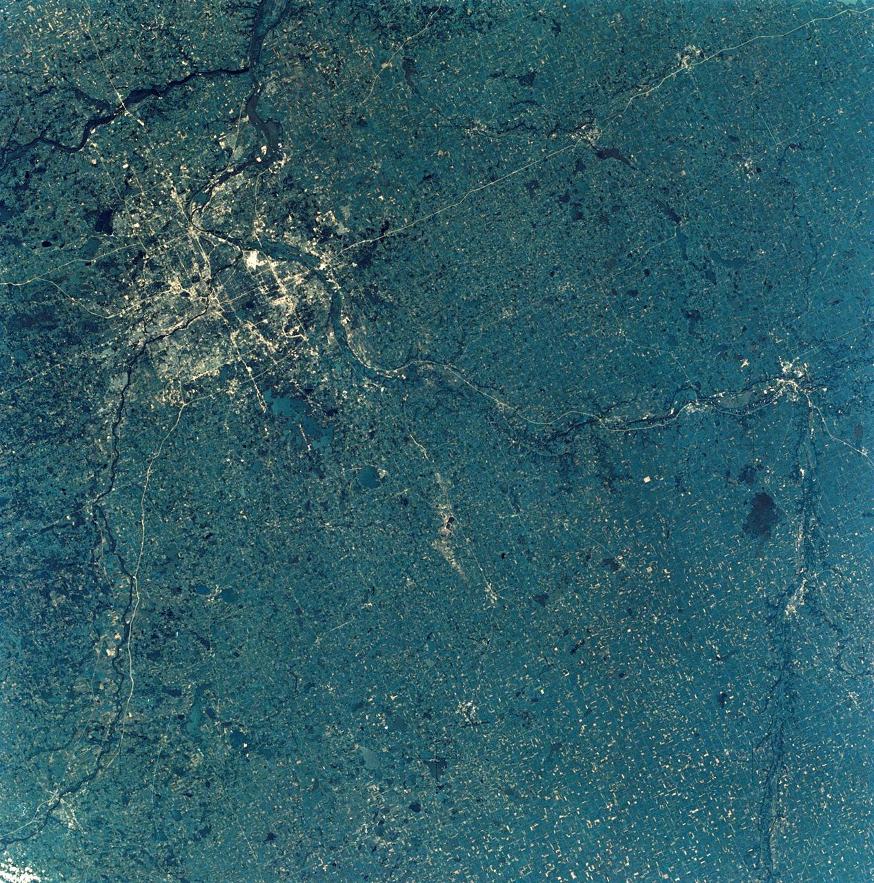
SL3-28-009 (July-September 1973) --- A near vertical view of the Minneapolis-St. Paul, Minnesota area, as photographed from Earth orbit by one of the six lenses of the Itek-furnished S190-A Multispectral Photographic Facility Experiment in the Multiple Docking Adapter of the Skylab space station. A 150mm lens, with SO-356 high definition Ektachrome film, was used to take this picture. The Mississippi River flows southeasterly through this large metropolitan area. Minneapolis is on the west bank of the Mississippi. The Minnesota River makes a large bend at the southern edge of the picture then flows northeasterly to empty into the Mississippi at Minneapolis-St. Paul. The St. Croix River, which serves as a portion of the boundary between Minnesota and Wisconsin, flows into the Mississippi downstream from the twin cities. A long, nearly straight, stretch of Interstate 35 leads southward from Minneapolis-St. Paul. Interstate 94 parallels the Mississippi toward the northwest. The highway and road network in the area is clearly visible. Note the numerous small lakes in the photograph. This view includes the smaller cities of Hastings, Faribault, Owatonna, Mankato, St. Peter, New Ulm and St. Cloud. The S190-A experiment is part of the Skylab Earth Resources Experiments Package. Photo credit: NASA
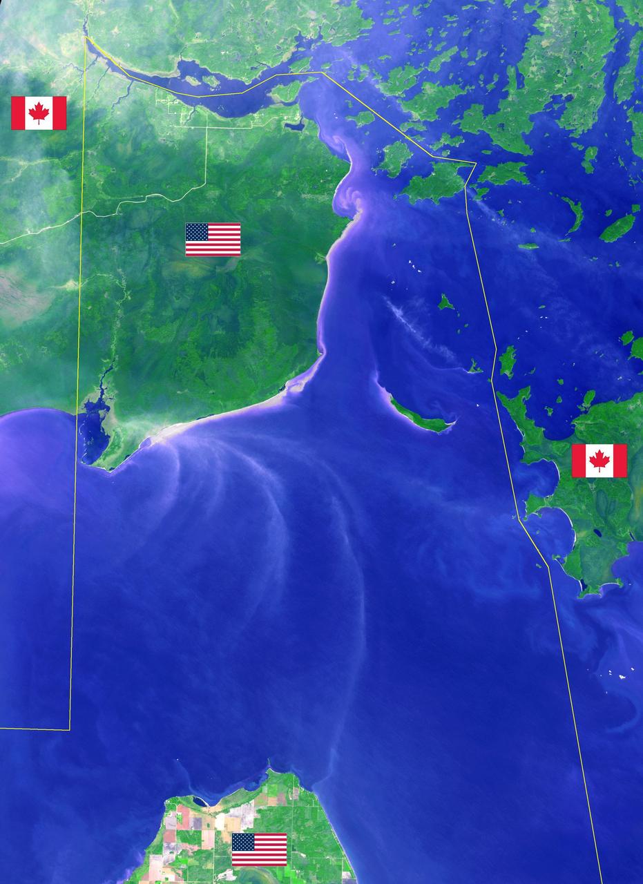
Minnesota's Northwest Angle is the northernmost point of the continental United States. The Angle became part of the US due to a map error during the 1783 Treaty of Paris. Located in the Lake of the Woods, driving there requires crossing the US-Canada border twice. The image was acquired September 22, 2013, covers an area of 40 by 55 km, and is located at 49.2 degrees north, 95.1 degrees west. https://photojournal.jpl.nasa.gov/catalog/PIA21997
SL4-139-3932 (December 1973) --- A 70mm hand-held Hasselblad photograph showing parts of Minnesota, Iowa and Wisconsin. Lake Superior is in the upper part of the photo; Duluth at upper left; Castle Rock Flowage and Petenwell Flowage at far right center. Note circular feature (partially formed by rivers) which the Skylab 4 crewmen commented on when they made this fly-over. Photo credit: NASA
iss058e001857 (Jan. 1, 2019) --- The western tip of Lake Superior and the cities of Duluth, Minnesota and Superior, Wisconsin separated by the frozen St. Louis River, are pictured from the International Space Station on New Year's Day 2019.

Landsat satellites collect data along a wide ground track that spans 185 kilometers (115 miles) but with a spatial resolution that allows them to see the human signature on the landscape. Each Landsat pixel covers a 30 by 30 meter area (98 by 98 feet), about the size of a baseball diamond. This visualization shows the Landsat path over Minneapolis, the site of the 2014 Major League Baseball All-Star game, and then zooms in to reveal the individual pixels. The green of the field and the white of the stadium are visible, before fading to an aerial photograph taken March 2010. See close up of stadium here: <a href="https://www.flickr.com/photos/gsfc/14662019381/in/photostream/">www.flickr.com/photos/gsfc/14662019381/in/photostream/</a> Credit: NASA/Goddard/Landsat <b><a href="http://www.nasa.gov/audience/formedia/features/MP_Photo_Guidelines.html" rel="nofollow">NASA image use policy.</a></b> <b><a href="http://www.nasa.gov/centers/goddard/home/index.html" rel="nofollow">NASA Goddard Space Flight Center</a></b> enables NASA’s mission through four scientific endeavors: Earth Science, Heliophysics, Solar System Exploration, and Astrophysics. Goddard plays a leading role in NASA’s accomplishments by contributing compelling scientific knowledge to advance the Agency’s mission. <b>Follow us on <a href="http://twitter.com/NASAGoddardPix" rel="nofollow">Twitter</a></b> <b>Like us on <a href="http://www.facebook.com/pages/Greenbelt-MD/NASA-Goddard/395013845897?ref=tsd" rel="nofollow">Facebook</a></b> <b>Find us on <a href="http://instagram.com/nasagoddard?vm=grid" rel="nofollow">Instagram</a></b>
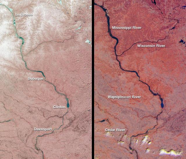
The mighty Mississippi River, from its source at Lake Itasca, Minnesota to the Gulf of Mexico, is approximately 3780 kilometers long and has flooded many times during its history. NASA Terra satellite acquired these images one month apart in 2001.
Why does Fargo flood? The Red River of the North, which forms the border between North Dakota and Minnesota, has a long history of severe floods. Major floods include those of 1826, 1897, 1950, 1997, and now 2009.
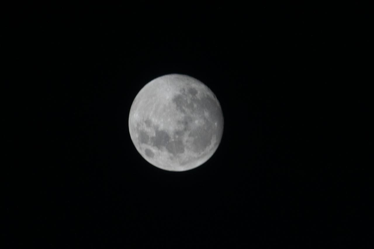
iss066e105101 (Dec. 17, 2021) --- The waxing gibbous Moon is pictured from the International Space Station as it orbited 265 miles above the U.S. state of Minnesota.
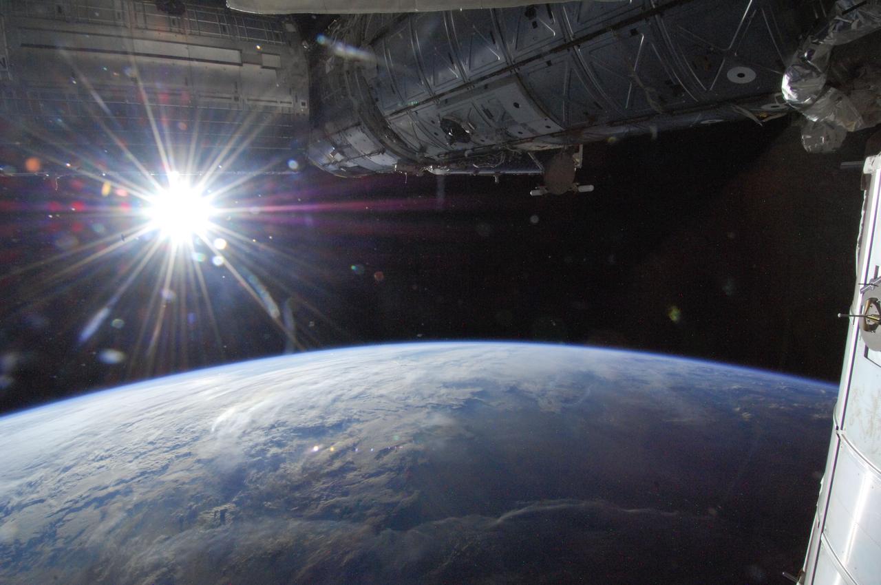
ISS036-E-002224 (21 May 2013) --- The sun is captured in a "starburst" mode over Earth's horizon by one of the Expedition 36 crew members as the orbital outpost was above a point in southwestern Minnesota on May 21, 2013.
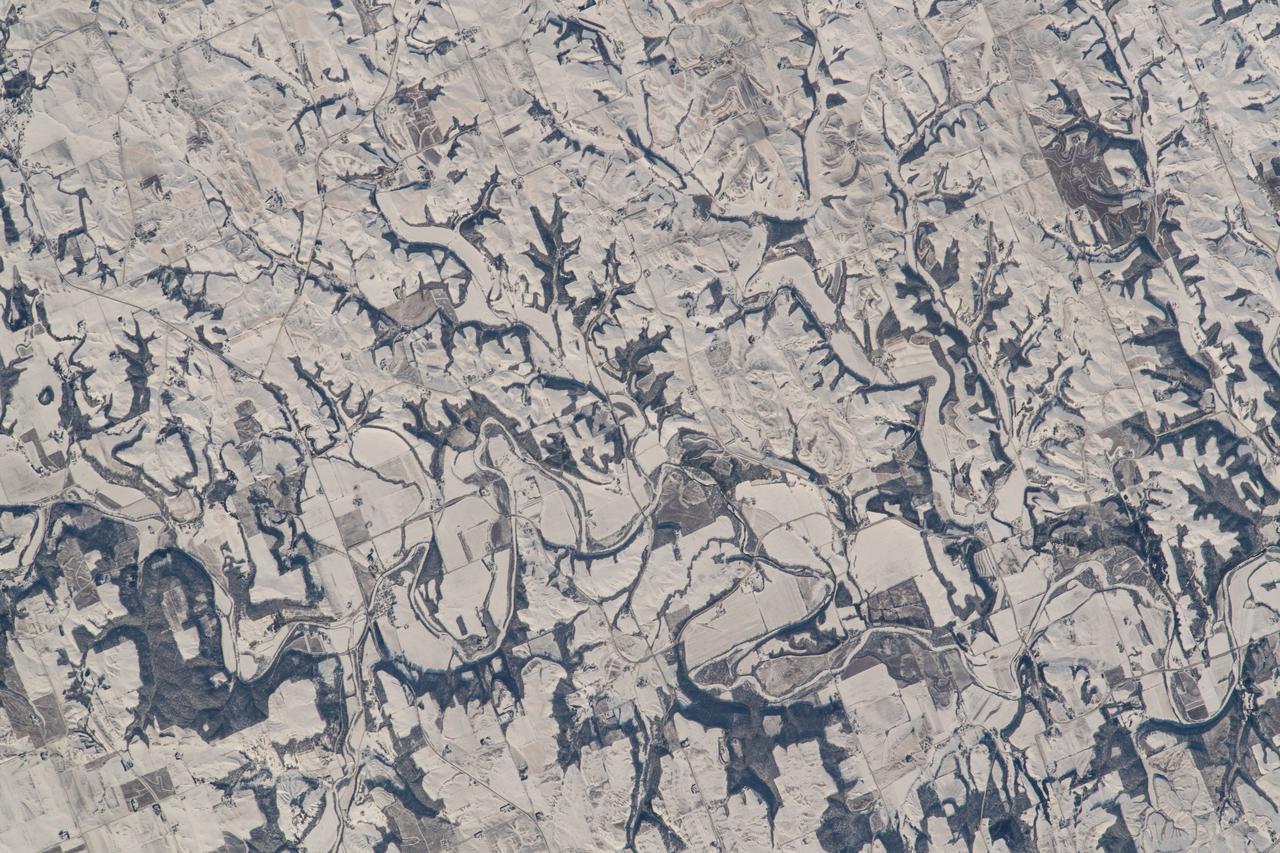
iss066e143485 (Feb. 13, 2022) --- The snow and ice-covered state of Minnesota on its southeast border with Wisconsin is pictured from the International Space Station as it orbited 260 miles above.

iss073e0006003 (April 26, 2025) --- This oblique of view of the sun's glint beaming off Lake Superior was taken at about 8:34 a.m. local time from the International Space Station as it orbited 263 miles above the state of Minnesota, Land of 10,000 Lakes.
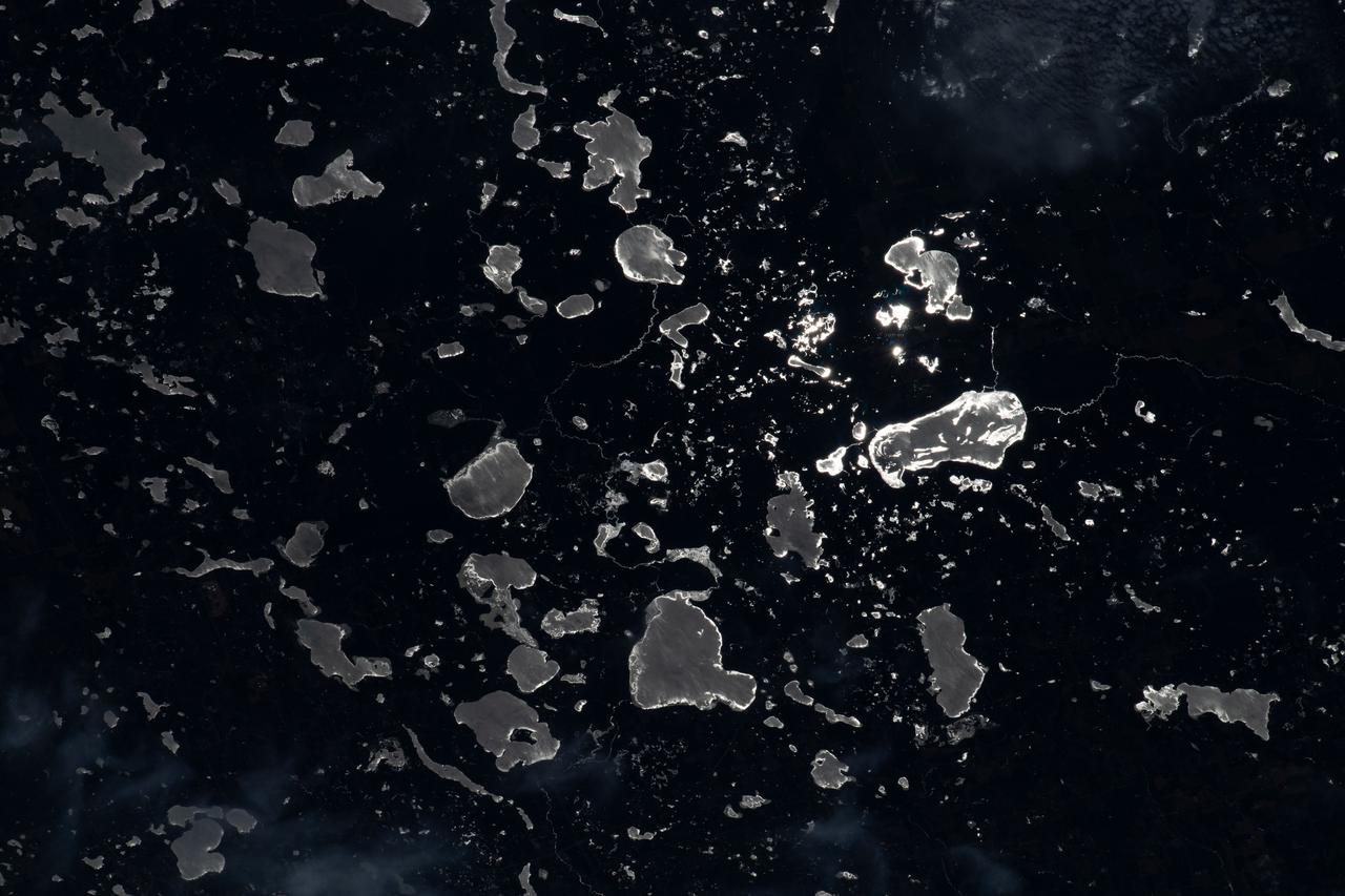
iss067e265450 (Aug. 14, 2022) --- The Moon's glint beams off lakes on the U.S.-Canadian border, between the state of Minnesota and the province of Ontario, in this nighttime photograph from the International Space Station as it orbited 260 miles above North America.
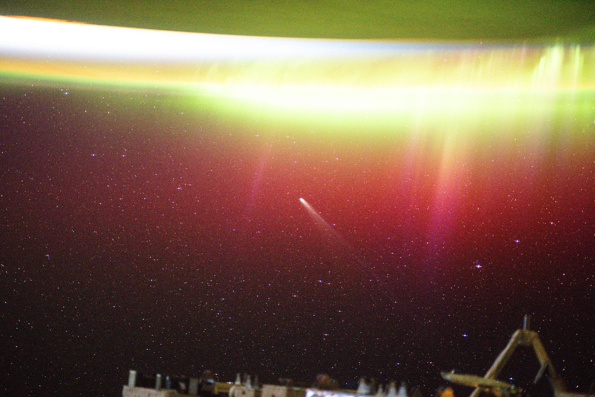
iss073e0981058 (Oct. 24, 2025) --- This long-exposure photograph shows a bright aurora radiating above Earth as Comet Lemmon (C/2025 A6) soared past the planet at a distance of about 57.2 million miles (92.1 million kilometers). The International Space Station was orbiting 263 miles above northern Minnesota at the time of this photograph.
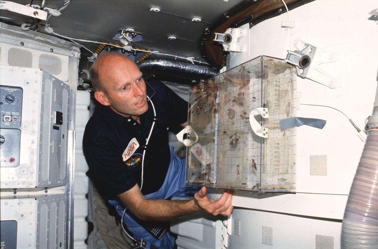
STS003-23-178 (22-30 March 1982) --- Astronaut C. Gordon Fullerton, STS-3 pilot, examines Student Experiment 81-8 (SE-81-8) Insect Flight Motion Study taped to the airlock on aft middeck. Todd Nelson, a high school senior from Minnesota, won a national contest to fly his experiment on this particular flight. Moths, flies, and bees were studied in the near weightless environment. Photo credit: NASA
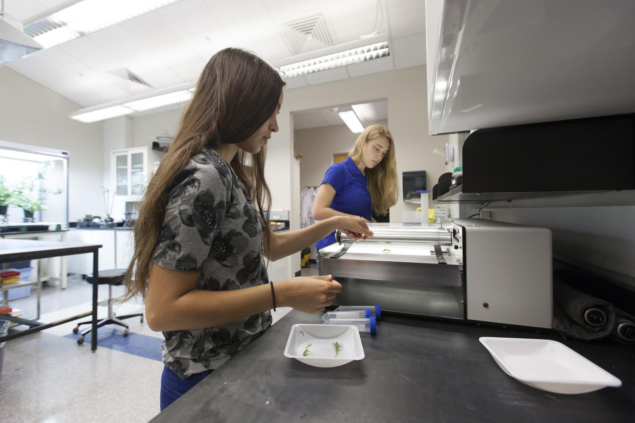
In the Space Life Sciences Laboratory at NASA's Kennedy Space Center in Florida, student interns such as Emma Boehm, left, and Jessica Scotten are joining agency scientists, contributing in the area of plant growth research for food production in space. Boehm is pursuing a degree in ecology and evolution at the University of Minnesota. Scotten is majoring in microbiology at Oregon State University. The agency attracts its future workforce through the NASA Internship, Fellowships and Scholarships, or NIFS, Program.
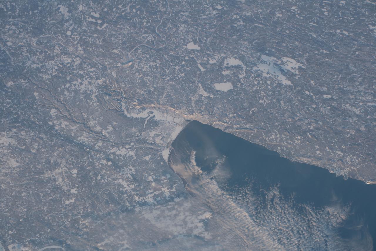
SL2-05-454 (22 June 1973) --- This view shows the west end of Lake Superior and Duluth, MN (47.0N, 91.0W). Portions of Minnesota, Michigan and Ontario, Canada are in the scene. The Duluth metropolitan area is at the west end of the lake. The discoloration plume in the water at Duluth is the result of tailings from the iron ore smelters that process the iron ore from the nearby open pit mines seen near the upper left corner of the photo. Photo credit: NASA

Ecomaster, an affiliate of BioServe Space Technologies, this PentaPure technology has been used to purify water for our nation's Space Shuttle missions since 1981. WTC-Ecomaster of Mirneapolis, Minnesota manufactures water purification systems under the brand name PentaPure (TM). BioServe researcher Dr. George Marchin, of Kansas State University, first demonstrated the superiority of this technology and licensed it to WTC. Marchin continues to perform microgravity research in the development of new technologies for the benefit of life on Earth.
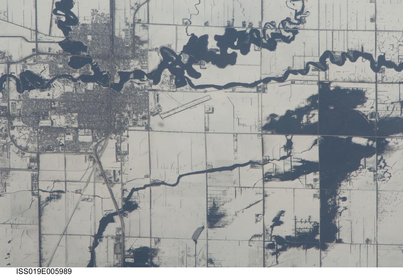
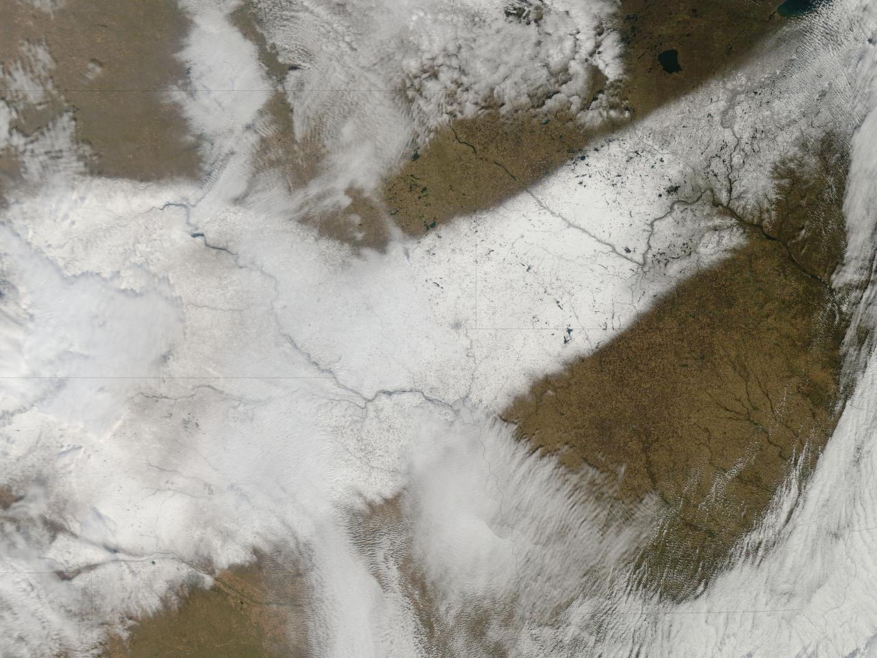
ISS019-E-005989 (9 April 2009) --- Red River floods in North Dakota and Minnesota are featured in this image photographed by an Expedition 19 crewmember on the International Space Station. The Red River, which flows north between North Dakota and Minnesota, flooded for a second time on the day this image was taken (9 April 2009). Two weeks earlier the river had crested at very high levels. The new floodwaters in the Red River, and especially in the less well-drained meandering tributaries east of the river, appear as black shapes against a snowy agricultural landscape defined by rectangular fields. The largest irregular black patches are the flooded low parts of fields along a canalized western tributary of the Red River (right). The city-block patterns of Wahpeton ND and Breckenridge MN, opposite one another on the banks of the Red River, stand out as dark gray patches against the snow at image top left. The main runway of the Henry Stern Airport lies angled northwest directly south of Wahpeton, and its 1.3 kilometers runway length gives scale to the view. Access roads to the agricultural fields tend to follow an orthogonal pattern, while larger roads leading to the cities cut across this pattern (lower left, near Wahpeton). A subtle pattern of drainage ditches and plow lines appear as thin parallel lines throughout fields in the scene.

KENNEDY SPACE CENTER, FLA. - A closeup of some of the new crawler shoes that arrived from Minnesota. The new shoes were manufactured by ME Global in Duluth. The CT transports the Mobile Launcher Platform, with the assembled Space Shuttle aboard, between the refurbishment area, the VAB and Launch Complex Pads 39A and 39B. The crawlers have 456 shoes, 57 per belt (8 belts in all). Each shoe weighs 2,200 pounds. The original shoes were manufactured for the Apollo Program. Cracks appeared in the shoes in recent years spurring a need for replacement. The new manufacturer, in Duluth, Minn., has improved the design for Return to Flight and use through the balance of the Space Shuttle Program.

A Sandhill Crane searches for food with its still-fuzzy fledgling by its side. The two, along with another adult crane, have been seen wandering the grassy areas in the KSC Launch Complex 39 area. Sandhill cranes range from Siberia, Alaska and Arctic islands to Michigan, Minnesota and California; from Florida to Texas. They prefer large freshwater marshes, prairie ponds and marshy tundra. KSC shares a boundary with the Merritt Island National Wildlife Refuge, which encompasses 92,000 acres that are a habitat for more than 331 species of birds, 31 mammals, 117 fishes, and 65 amphibians and reptiles. The marshes and open water of the refuge provide wintering areas for 23 species of migratory waterfowl, as well as a year-round home for great blue herons, great egrets, wood storks, cormorants, brown pelicans and other species of marsh and shore birds, as well as a variety of insects
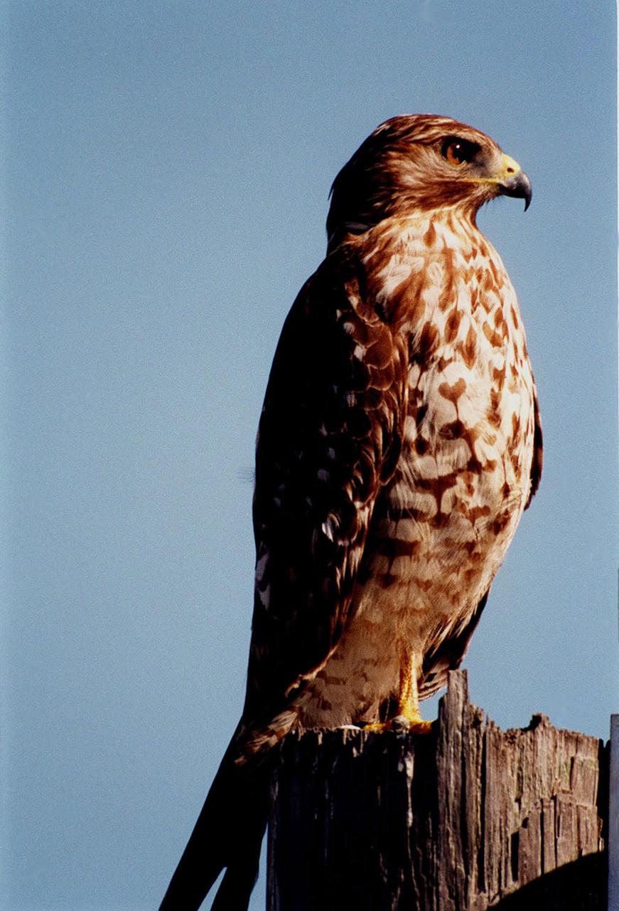
KENNEDY SPACE CENTER, FLA. -- Near a road at Kennedy Space Center, a red-shouldered hawk perches on a weathered tree stump. Red-shouldered hawks are large, long-winged, with rust-barred underparts, reddish shoulders, a narrowly banded tail, and a translucent area ner the tip of the wing. It ranges from Minnesota and New Brunswick south to the Gulf Coast, including Florida. It prefers deciduous woodlands, especially where there is standing water as in swampy woods and bogs. Kennedy Space Center shares a boundary with the Merritt Island National Wildlife Refuge that is a habitat for more than 331 species of birds, 31 mammals, 117 fishes, and 65 amphibians and reptiles. The marshes and open water of the refuge provide wintering areas for 23 species of migratory waterfowl, as well as a year-round home for great blue herons, great egrets, wood storks, cormorants, brown pelicans and other species of marsh and shore birds, as well as a variety of insects.

St. Paul, Minnesota high school student, Roger Johnston, is greeted by (left to right): Astronauts Russell L. Schweickart, and Owen K. Garriott; Marshall Space Flight Center (MSFC) Skylab Program Manager, Leland Belew; and MSFC Director of Administration and Technical Services, David Newby, during a tour of MSFC. Johnston was among 25 winners of a contest in which some 3,500 high school students proposed experiments for the following year’s Skylab mission. The nationwide scientific competition was sponsored by the National Science Teachers Association and the National Aeronautics and Space Administration (NASA). The winning students, along with their parents and sponsor teachers, visited MSFC where they met with scientists and engineers, participated in design reviews for their experiments, and toured MSFC facilities. Of the 25 students, 6 did not see their experiments conducted on Skylab because the experiments were not compatible with Skylab hardware and timelines. Of the 19 remaining, 11 experiments required the manufacture of additional equipment.
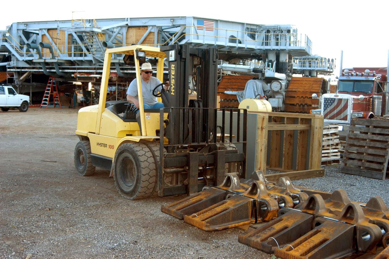
KENNEDY SPACE CENTER, FLA. - In the Crawler Transporter (CT) area, a worker offloads some of the new crawler shoes that arrived from Minnesota. In the background is one of the two CTs. The new shoes were manufactured by ME Global in Duluth, Minn. The CT transports the Mobile Launcher Platform, with the assembled Space Shuttle aboard, between the refurbishment area, the VAB and Launch Complex Pads 39A and 39B. The crawlers have 456 shoes, 57 per belt (8 belts in all). Each shoe weighs 2,200 pounds. The original shoes were manufactured for the Apollo Program. Cracks appeared in the shoes in recent years spurring a need for replacement. The new manufacturer, in Duluth, Minn., has improved the design for Return to Flight and use through the balance of the Space Shuttle Program.

On the first day of NASA's 9th Robotic Mining Competition, set-up day on May 14, team members from the University of Minnesota-Twin Cities work on their robot miner in the RobotPits in the Educator Resource Center at Kennedy Space Center Visitor Complex in Florida. More than 40 student teams from colleges and universities around the U.S. will use their mining robots to dig in a supersized sandbox filled with BP-1, or simulated Lunar soil, gravel and rocks, and participate in other competition requirements. The Robotic Mining Competition is a NASA Human Exploration and Operations Mission Directorate project designed to encourage students in science, technology, engineering and math, or STEM fields. The project provides a competitive environment to foster innovative ideas and solutions that could be used on NASA's deep space missions.
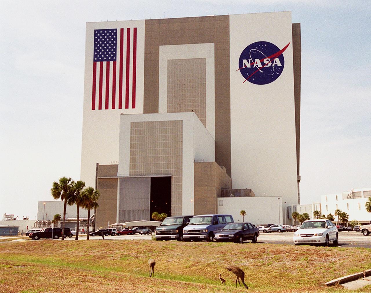
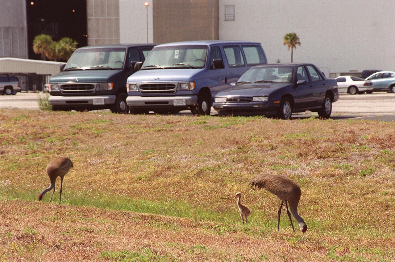
A family of sandhill cranes searches for food on the grounds near the Vehicle Assembly Building. The cranes have been a constant sight in the Launch Complex 39 area during the month of May. Sandhill cranes range from Siberia, Alaska and Arctic islands to Michigan, Minnesota and California; from Florida to Texas. They prefer large freshwater marshes, prairie ponds and marshy tundra. KSC shares a boundary with the Merritt Island National Wildlife Refuge, which encompasses 92,000 acres that are a habitat for more than 331 species of birds, 31 mammals, 117 fishes, and 65 amphibians and reptiles. The marshes and open water of the refuge provide wintering areas for 23 species of migratory waterfowl, as well as a year-round home for great blue herons, great egrets, wood storks, cormorants, brown pelicans and other species of marsh and shore birds, as well as a variety of insects

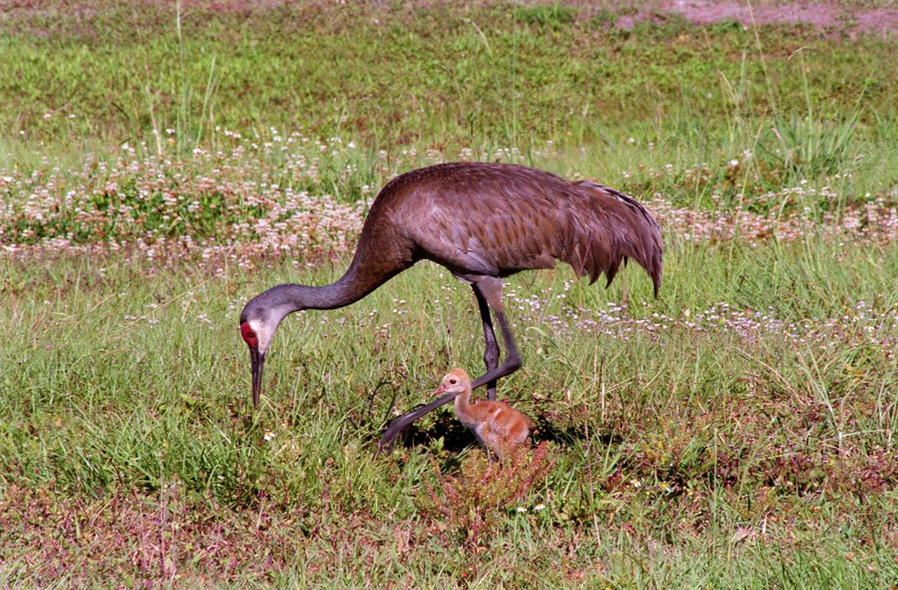
While the sandhill crane parents search for food in front of the Vehicle Assembly Building, their still-featherless baby nearby tests its voice. The cranes have been a constant sight in the Launch Complex 39 area during the month of May. Sandhill cranes range from Siberia, Alaska and Arctic islands to Michigan, Minnesota and California; from Florida to Texas. They prefer large freshwater marshes, prairie ponds and marshy tundra. KSC shares a boundary with the Merritt Island National Wildlife Refuge, which encompasses 92,000 acres that are a habitat for more than 331 species of birds, 31 mammals, 117 fishes, and 65 amphibians and reptiles. The marshes and open water of the refuge provide wintering areas for 23 species of migratory waterfowl, as well as a year-round home for great blue herons, great egrets, wood storks, cormorants, brown pelicans and other species of marsh and shore birds, as well as a variety of insects

A family of sandhill cranes searches for food on the grounds near the Vehicle Assembly Building. The cranes have been a constant sight in the Launch Complex 39 area during the month of May. Sandhill cranes range from Siberia, Alaska and Arctic islands to Michigan, Minnesota and California; from Florida to Texas. They prefer large freshwater marshes, prairie ponds and marshy tundra. KSC shares a boundary with the Merritt Island National Wildlife Refuge, which encompasses 92,000 acres that are a habitat for more than 331 species of birds, 31 mammals, 117 fishes, and 65 amphibians and reptiles. The marshes and open water of the refuge provide wintering areas for 23 species of migratory waterfowl, as well as a year-round home for great blue herons, great egrets, wood storks, cormorants, brown pelicans and other species of marsh and shore birds, as well as a variety of insects
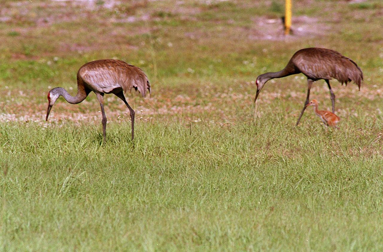
A pair of Sandhill Cranes searches for food with their still-fluffy fledgling close by. The trio have been seen wandering the grassy areas in the KSC Launch Complex 39 area. Sandhill cranes range from Siberia, Alaska and Arctic islands to Michigan, Minnesota and California; from Florida to Texas. They prefer large freshwater marshes, prairie ponds and marshy tundra. KSC shares a boundary with the Merritt Island National Wildlife Refuge, which encompasses 92,000 acres that are a habitat for more than 331 species of birds, 31 mammals, 117 fishes, and 65 amphibians and reptiles. The marshes and open water of the refuge provide wintering areas for 23 species of migratory waterfowl, as well as a year-round home for great blue herons, great egrets, wood storks, cormorants, brown pelicans and other species of marsh and shore birds, as well as a variety of insects
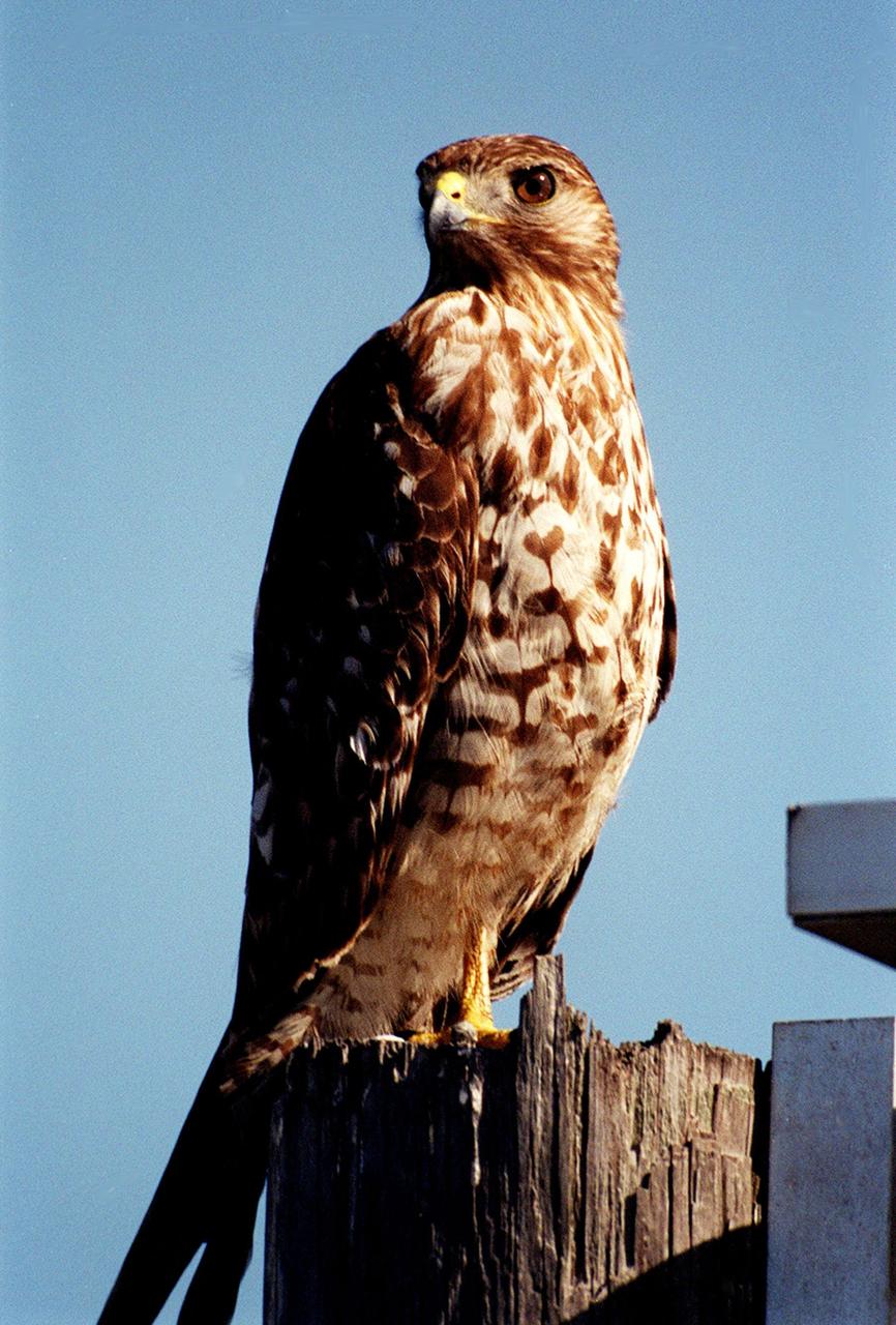
KENNEDY SPACE CENTER, FLA. -- This immature red-shouldered hawk on the roadside at Kennedy Space Center appears to be eyeing the photographer. The red-shouldered hawk's range extends from Minnesota and New Brunswick south to the Gulf Coast and on the Pacific Coast from northern California to Baja California. This hawk is often found in lowlands, especially swampy woods and bogs. It feeds on small snakes, frogs, insects and small mammals. Kennedy shares a boundary with the Merritt Island National Wildlife Refuge, which encompasses 92,000 acres that are a habitat for more than 331 species of birds, 31 mammals, 117 fishes, and 65 amphibians and reptiles. The marshes and open water of the refuge provide wintering areas for 23 species of migratory waterfowl, as well as a year-round home for great blue herons, great egrets, wood storks, cormorants, brown pelicans and other species of marsh and shore birds, as well as a variety of insects.

KENNEDY SPACE CENTER, FLA. -- This immature red-shouldered hawk on the roadside at Kennedy Space Center appears to be eyeing the photographer. The red-shouldered hawk's range extends from Minnesota and New Brunswick south to the Gulf Coast and on the Pacific Coast from northern California to Baja California. This hawk is often found in lowlands, especially swampy woods and bogs. It feeds on small snakes, frogs, insects and small mammals. Kennedy shares a boundary with the Merritt Island National Wildlife Refuge, which encompasses 92,000 acres that are a habitat for more than 331 species of birds, 31 mammals, 117 fishes, and 65 amphibians and reptiles. The marshes and open water of the refuge provide wintering areas for 23 species of migratory waterfowl, as well as a year-round home for great blue herons, great egrets, wood storks, cormorants, brown pelicans and other species of marsh and shore birds, as well as a variety of insects.
A Sandhill Crane searches for food with its still-fuzzy fledgling by its side. The two, along with another adult crane, have been seen wandering the grassy areas in the KSC Launch Complex 39 area. Sandhill cranes range from Siberia, Alaska and Arctic islands to Michigan, Minnesota and California; from Florida to Texas. They prefer large freshwater marshes, prairie ponds and marshy tundra. KSC shares a boundary with the Merritt Island National Wildlife Refuge, which encompasses 92,000 acres that are a habitat for more than 331 species of birds, 31 mammals, 117 fishes, and 65 amphibians and reptiles. The marshes and open water of the refuge provide wintering areas for 23 species of migratory waterfowl, as well as a year-round home for great blue herons, great egrets, wood storks, cormorants, brown pelicans and other species of marsh and shore birds, as well as a variety of insects
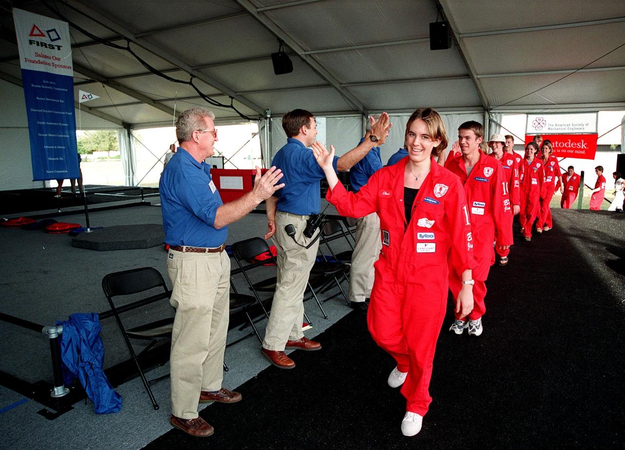
At the start of the award ceremony at the 1999 FIRST Southeastern Regional robotic competition held at KSC, judges, including Deputy Director for Launch and Payload Processing Loren Shriver (left), give "high fives" to a winning team from Minnesota as they enter. FIRST is a nonprofit organization, For Inspiration and Recognition of Science and Technology, that sponsors the event pitting gladiator robots against each other in an athletic-style competition. The FIRST robotics competition is designed to provide students with a hands-on, inside look at engineering and other professional careers, pairing high school students with engineer mentors and corporations. The regional event comprised 27 teams. Along with the championship award, which went to high school teams in Miami and San German, Puerto Rico, 15 other awards were presented

KENNEDY SPACE CENTER, FLA. -- Near a road at Kennedy Space Center, a red-shouldered hawk perches on a weathered tree stump. Red-shouldered hawks are large, long-winged, with rust-barred underparts, reddish shoulders, a narrowly banded tail, and a translucent area ner the tip of the wing. It ranges from Minnesota and New Brunswick south to the Gulf Coast, including Florida. It prefers deciduous woodlands, especially where there is standing water as in swampy woods and bogs. Kennedy Space Center shares a boundary with the Merritt Island National Wildlife Refuge that is a habitat for more than 331 species of birds, 31 mammals, 117 fishes, and 65 amphibians and reptiles. The marshes and open water of the refuge provide wintering areas for 23 species of migratory waterfowl, as well as a year-round home for great blue herons, great egrets, wood storks, cormorants, brown pelicans and other species of marsh and shore birds, as well as a variety of insects.

A pair of Sandhill Cranes searches for food with their still-fluffy fledgling close by. The trio have been seen wandering the grassy areas in the KSC Launch Complex 39 area. Sandhill cranes range from Siberia, Alaska and Arctic islands to Michigan, Minnesota and California; from Florida to Texas. They prefer large freshwater marshes, prairie ponds and marshy tundra. KSC shares a boundary with the Merritt Island National Wildlife Refuge, which encompasses 92,000 acres that are a habitat for more than 331 species of birds, 31 mammals, 117 fishes, and 65 amphibians and reptiles. The marshes and open water of the refuge provide wintering areas for 23 species of migratory waterfowl, as well as a year-round home for great blue herons, great egrets, wood storks, cormorants, brown pelicans and other species of marsh and shore birds, as well as a variety of insects
While the sandhill crane parents search for food in front of the Vehicle Assembly Building, their still-featherless baby nearby tests its voice. The cranes have been a constant sight in the Launch Complex 39 area during the month of May. Sandhill cranes range from Siberia, Alaska and Arctic islands to Michigan, Minnesota and California; from Florida to Texas. They prefer large freshwater marshes, prairie ponds and marshy tundra. KSC shares a boundary with the Merritt Island National Wildlife Refuge, which encompasses 92,000 acres that are a habitat for more than 331 species of birds, 31 mammals, 117 fishes, and 65 amphibians and reptiles. The marshes and open water of the refuge provide wintering areas for 23 species of migratory waterfowl, as well as a year-round home for great blue herons, great egrets, wood storks, cormorants, brown pelicans and other species of marsh and shore birds, as well as a variety of insects
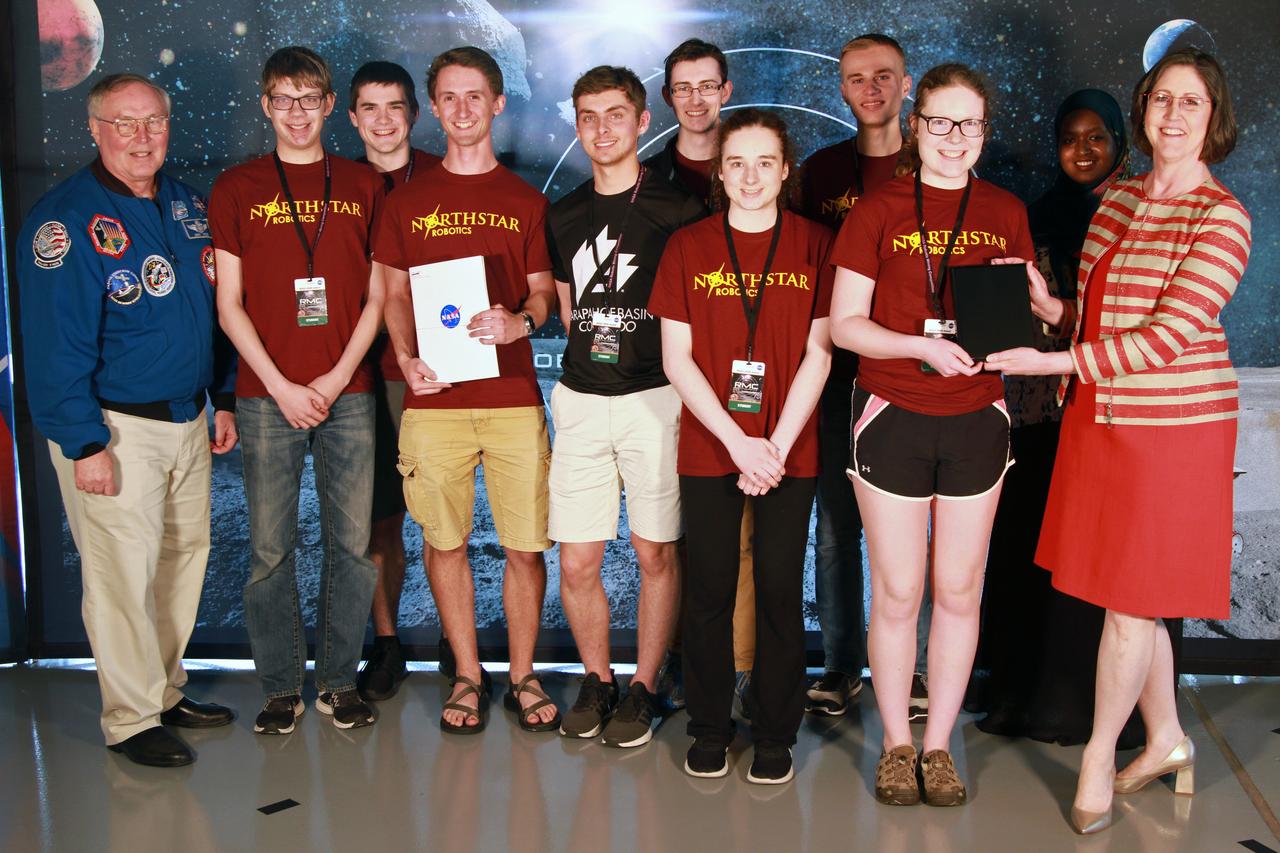
NASA's 9th Annual Robotic Mining Competition concludes with an awards ceremony May 18, 2018, at the Apollo/Saturn V Center at the Kennedy Space Center Visitor Complex in Florida. Team Northstar Robotics from the University of Minnesota - Twin Cities received an honorable mention award for their Systems Engineering Paper. At left is retired NASA astronaut Jerry Ross. At right is Jonette Stecklein, lead systems engineering paper judge. More than 40 student teams from colleges and universities around the U.S. participated in the competition, May 14-18, by using their mining robots to dig in a supersized sandbox filled with BP-1, or simulated lunar soil, gravel and rocks, and participate in other competition requirements. The Robotic Mining Competition is a NASA Human Exploration and Operations Mission Directorate project designed to encourage students in science, technology, engineering and math, or STEM fields. The project provides a competitive environment to foster innovative ideas and solutions that could be used on NASA's deep space missions.
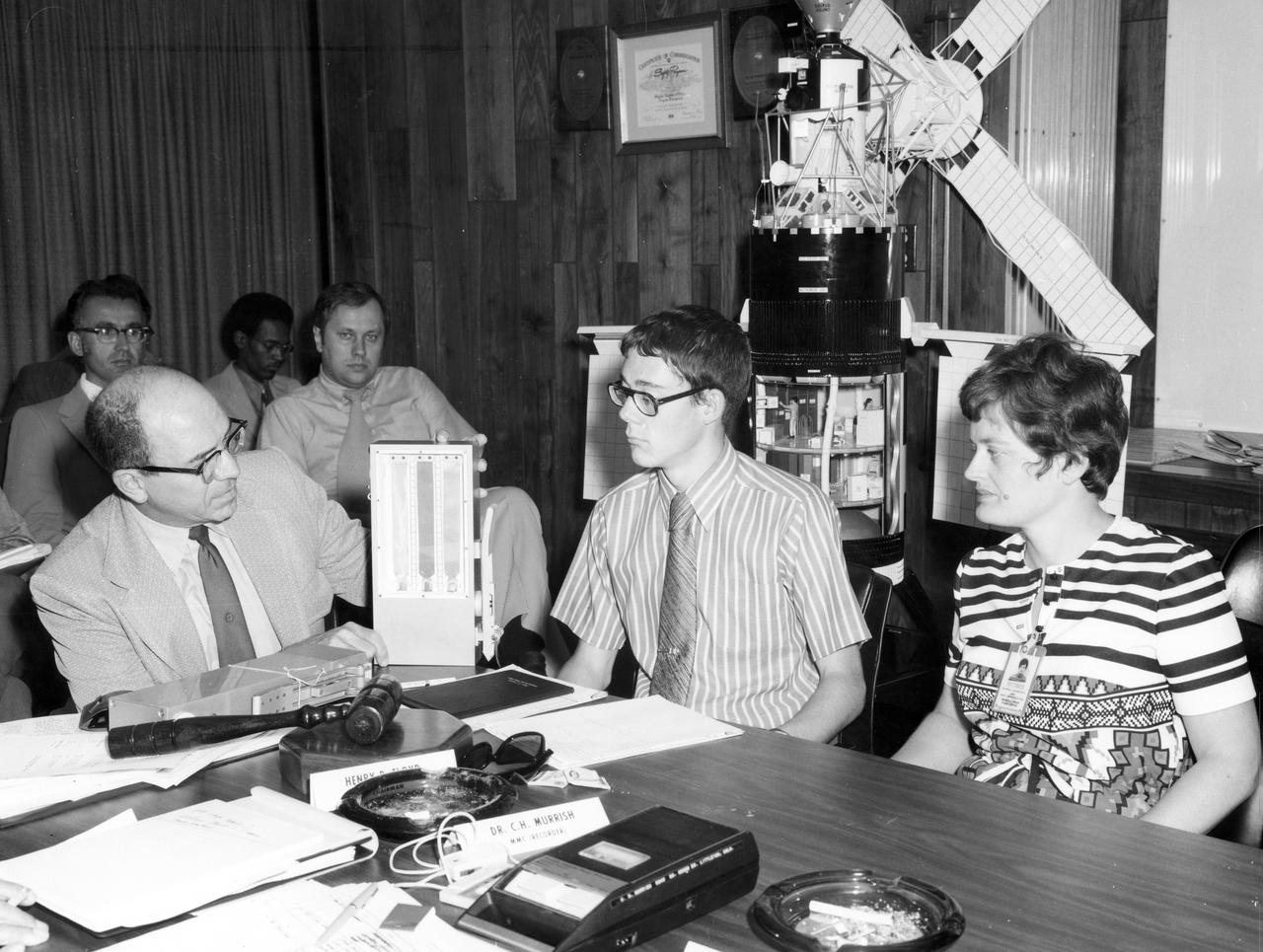
St. Paul Minnesota high school student, Roger Johnston (center), Gene Vacca (left) of NASA Headquarters, and Ann Whitaker of the Marshall Space Flight Center (MSFC) discuss the equipment to be used for the student’s experiment, “Capillary Action Studies in a State of Free Fall”, to be performed aboard the Skylab the following year. Johnston was among 25 winners of a contest in which some 3,500 high school students proposed experiments for the following year’s Skylab mission. The nationwide scientific competition was sponsored by the National Science Teachers Association and the National Aeronautics and Space Administration (NASA). The winning students, along with their parents and sponsor teachers, visited MSFC two months earlier where they met with scientists and engineers, participated in design reviews for their experiments, and toured MSFC facilities. Of the 25 students, 6 did not see their experiments conducted on Skylab because the experiments were not compatible with Skylab hardware and timelines. Of the 19 remaining, 11 experiments required the manufacture of additional equipment. The equipment for the experiments was manufactured at MSFC.
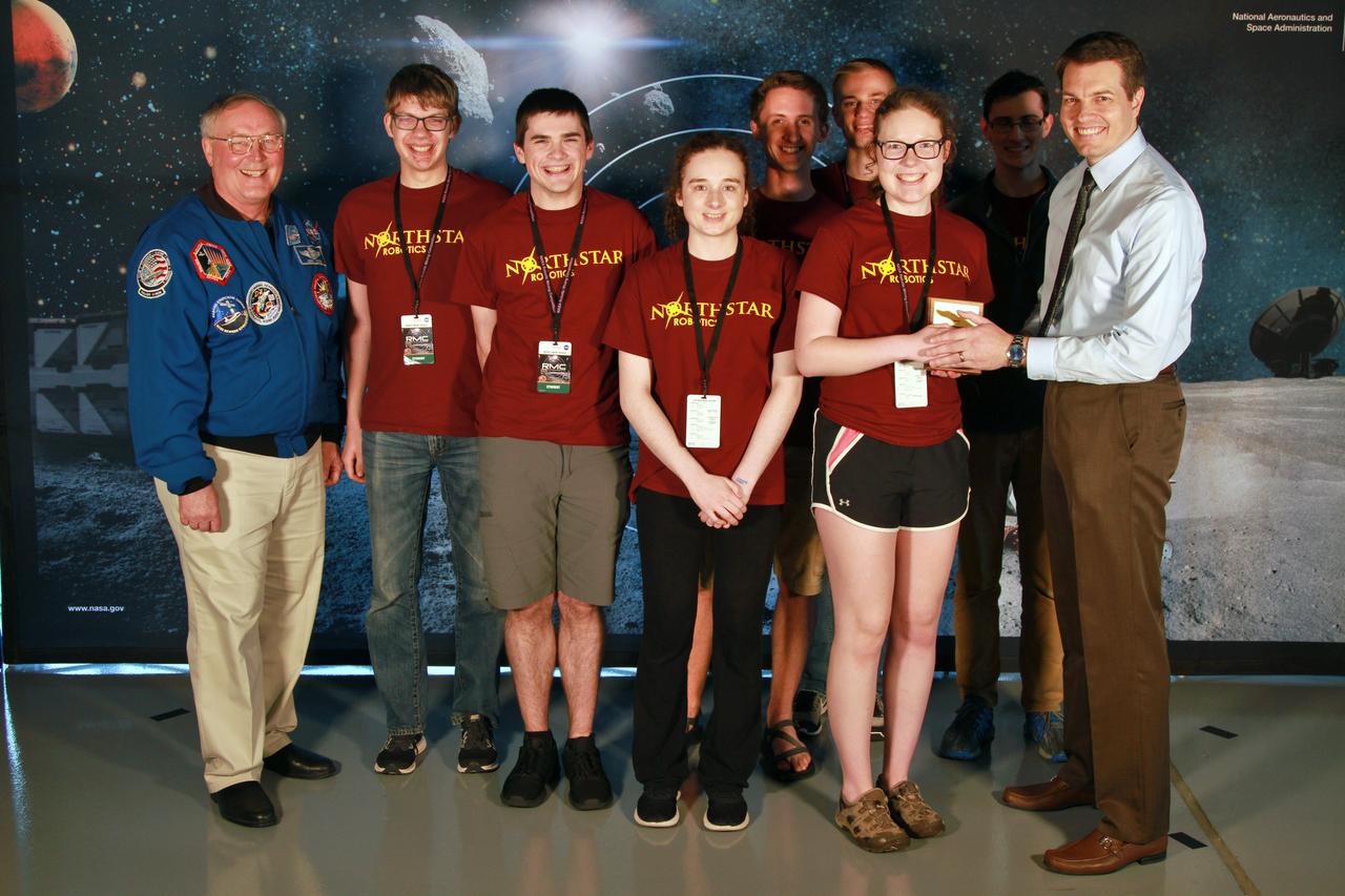
NASA's 9th Annual Robotic Mining Competition concludes with an awards ceremony May 18, 2018, at the Apollo/Saturn V Center at the Kennedy Space Center Visitor Complex in Florida. Team Northstar Robotics from the University of Minnesota - Twin Cities received the Golden E-Stop Award for their robot's safety system. At left is retired NASA astronaut Jerry Ross. At right is Daniel Hull, lead presentation judge. More than 40 student teams from colleges and universities around the U.S. participated in the competition, May 14-18, by using their mining robots to dig in a supersized sandbox filled with BP-1, or simulated lunar soil, gravel and rocks, and participate in other competition requirements. The Robotic Mining Competition is a NASA Human Exploration and Operations Mission Directorate project designed to encourage students in science, technology, engineering and math, or STEM fields. The project provides a competitive environment to foster innovative ideas and solutions that could be used on NASA's deep space missions.

The Polar Vortex is a whirling and persistent large area of low pressure, found typically over both north and south poles. The northern Polar Vortex is pushing southward over western Wisconsin/eastern Minnesota today, Monday, January 6, 2014 and is bringing frigid temperatures to half of the continental United States. It is expected to move northward back over Canada toward the end of the week. This image was captured by NOAA's GOES-East satellite on January 6, 2014 at 1601 UTC/11:01 a.m. EST. A frontal system that brought rain to the coast is draped from north to south along the U.S. East Coast. Behind the front lies the clearer skies bitter cold air associated with the Polar Vortex. The GOES image also revealed snow on the ground in Minnesota, Wisconsin, Illinois, Indiana, Ohio, Michigan, Iowa and Missouri, stretching into the Great Plains. Cloudiness over Texas is associated with a low pressure system centered over western Oklahoma that is part of the cold front connected to the movement of the Polar Vortex. The GOES image was created at NASA's GOES Project, located at NASA's Goddard Space Flight Center in Greenbelt, Md. Both the northern and southern polar vortices are located in the middle and upper troposphere (lowest level of the atmosphere) and the stratosphere (next level up in the atmosphere). The polar vortex is a winter phenomenon. It develops and strengthens in its respective hemisphere's winter as the sun sets over the polar region and temperatures cool. They weaken in the summer. In the northern hemisphere, they circulate in a counter-clockwise direction, so the vortex sitting over western Wisconsin is sweeping in cold Arctic air around it. The Arctic Polar Vortex peaks in the Northern Hemisphere's wintertime and has already moved southward several times this winter. In the past, it has also moved southward over Europe.On January 21, 1985, the National Oceanic and Atmospheric Administration Daily Weather Map series showed a strong polar vortex centered over Maine. The Polar Vortex also affects ozone. For more information on the Polar Vortex and how it affects ozone, visit NASA's Ozone Watch page: <a href="http://ozonewatch.gsfc.nasa.gov/facts/vortex_NH.html" rel="nofollow">ozonewatch.gsfc.nasa.gov/facts/vortex_NH.html</a> Rob Gutro NASA's Goddard Space Flight Center <b><a href="http://goes.gsfc.nasa.gov/" rel="nofollow">Credit: NOAA/NASA GOES Project</a></b> <b><a href="http://www.nasa.gov/audience/formedia/features/MP_Photo_Guidelines.html" rel="nofollow">NASA image use policy.</a></b> <b><a href="http://www.nasa.gov/centers/goddard/home/index.html" rel="nofollow">NASA Goddard Space Flight Center</a></b> enables NASA’s mission through four scientific endeavors: Earth Science, Heliophysics, Solar System Exploration, and Astrophysics. Goddard plays a leading role in NASA’s accomplishments by contributing compelling scientific knowledge to advance the Agency’s mission. <b>Follow us on <a href="http://twitter.com/NASA_GoddardPix" rel="nofollow">Twitter</a></b> <b>Like us on <a href="http://www.facebook.com/pages/Greenbelt-MD/NASA-Goddard/395013845897?ref=tsd" rel="nofollow">Facebook</a></b> <b>Find us on <a href="http://instagram.com/nasagoddard?vm=grid" rel="nofollow">Instagram</a></b>
The smoke from the Canadian wildfires that was in the middle of the U.S. on June 30 has drifted its way to the East Coast obscuring parts of the coast from New Jersey to North Carolina. Images taken on June 30 showed the smoke covering states from Minnesota to Tennessee. The jet stream has pushed the smoke along so that by July 1 it reached the U.S. East Coast. Residents of the area will get a preview of July 4th fireworks with redder than usual sunrises and sunsets due to particulates in the air. This natural-color satellite image was collected by the Moderate Resolution Imaging Spectroradiometer (MODIS) aboard the Aqua satellite on July 1, 2015. Credit: NASA/GSFC/Jeff Schmaltz/MODIS Land Rapid Response Team <b><a href="http://www.nasa.gov/audience/formedia/features/MP_Photo_Guidelines.html" rel="nofollow">NASA image use policy.</a></b> <b><a href="http://www.nasa.gov/centers/goddard/home/index.html" rel="nofollow">NASA Goddard Space Flight Center</a></b> enables NASA’s mission through four scientific endeavors: Earth Science, Heliophysics, Solar System Exploration, and Astrophysics. Goddard plays a leading role in NASA’s accomplishments by contributing compelling scientific knowledge to advance the Agency’s mission. <b>Follow us on <a href="http://twitter.com/NASAGoddardPix" rel="nofollow">Twitter</a></b> <b>Like us on <a href="http://www.facebook.com/pages/Greenbelt-MD/NASA-Goddard/395013845897?ref=tsd" rel="nofollow">Facebook</a></b> <b>Find us on <a href="http://instagrid.me/nasagoddard/?vm=grid" rel="nofollow">Instagram</a></b>

Canada has already had its share of wildfires this season, and the smoke from these wildfires is slowly drifting south over the United States' Midwest. The drifting smoke can be seen in this Terra satellite image over Lake Michigan, as well as parts of Minnesota, Wisconsin, Indiana and Ohio. The smoke released by any type of fire (forest, brush, crop, structure, tires, waste or wood burning) is a mixture of particles and chemicals produced by incomplete burning of carbon-containing materials. All smoke contains carbon monoxide, carbon dioxide and particulate matter (PM or soot). Smoke can contain many different chemicals, including aldehydes, acid gases, sulfur dioxide, nitrogen oxides, polycyclic aromatic hydrocarbons (PAHs), benzene, toluene, styrene, metals and dioxins. The type and amount of particles and chemicals in smoke varies depending on what is burning, how much oxygen is available, and the burn temperature. Exposure to any type of smoke should be avoided if possible, but especially by those with respiratory issues, the elderly, and children. This natural-color satellite image was collected by the Moderate Resolution Imaging Spectroradiometer (MODIS) aboard the Terra satellite on June 09, 2015. Credit: NASA image courtesy Jeff Schmaltz, MODIS Rapid Response Team <b><a href="http://www.nasa.gov/audience/formedia/features/MP_Photo_Guidelines.html" rel="nofollow">NASA image use policy.</a></b> <b><a href="http://www.nasa.gov/centers/goddard/home/index.html" rel="nofollow">NASA Goddard Space Flight Center</a></b> enables NASA’s mission through four scientific endeavors: Earth Science, Heliophysics, Solar System Exploration, and Astrophysics. Goddard plays a leading role in NASA’s accomplishments by contributing compelling scientific knowledge to advance the Agency’s mission. <b>Follow us on <a href="http://twitter.com/NASAGoddardPix" rel="nofollow">Twitter</a></b> <b>Like us on <a href="http://www.facebook.com/pages/Greenbelt-MD/NASA-Goddard/395013845897?ref=tsd" rel="nofollow">Facebook</a></b> <b>Find us on <a href="http://instagrid.me/nasagoddard/?vm=grid" rel="nofollow">Instagram</a></b>
This true color image of the Continental United States was taken on Nov. 25, 2013 by the Suomi NPP satellite and shows the system as it moves through the South and Midwest. The National Weather Service noted that a complex and powerful storm system continues to generate widespread moderate to heavy rainfall and snows in various parts of the eastern United States as travelers make their way to destinations to celebrate Thanksgiving and Hanukkah on Nov. 28. There are two low-pressure areas working together. One was centered near New Jersey while the other was located over the Carolinas. From the Southeast to New England widespread moderate to heavy rainfall is expected. The rains will also affect the Mid-Atlantic and Southeastern United States, although those regions are not expected to get as much of a soaking. The Appalachians and interior New England are expected to receive snowfall. Areas of heavy snow are forecast for northwestern Indiana and northwestern Pennsylvania on Nov. 27. Snows will blanket the north central United States from the Dakotas to Minnesota, Iowa, Wisconsin, Michigan, the Ohio and Tennessee Valleys, upstate New York and parts of northern New England. The National Weather Service noted that cold air is moving in behind the storm and drop temperatures along the eastern U.S. making for a chilly Thanksgiving. Credit: NASA/NOAA <b><a href="http://www.nasa.gov/audience/formedia/features/MP_Photo_Guidelines.html" rel="nofollow">NASA image use policy.</a></b> <b><a href="http://www.nasa.gov/centers/goddard/home/index.html" rel="nofollow">NASA Goddard Space Flight Center</a></b> enables NASA’s mission through four scientific endeavors: Earth Science, Heliophysics, Solar System Exploration, and Astrophysics. Goddard plays a leading role in NASA’s accomplishments by contributing compelling scientific knowledge to advance the Agency’s mission. <b>Follow us on <a href="http://twitter.com/NASA_GoddardPix" rel="nofollow">Twitter</a></b> <b>Like us on <a href="http://www.facebook.com/pages/Greenbelt-MD/NASA-Goddard/395013845897?ref=tsd" rel="nofollow">Facebook</a></b> <b>Find us on <a href="http://instagram.com/nasagoddard?vm=grid" rel="nofollow">Instagram</a></b>
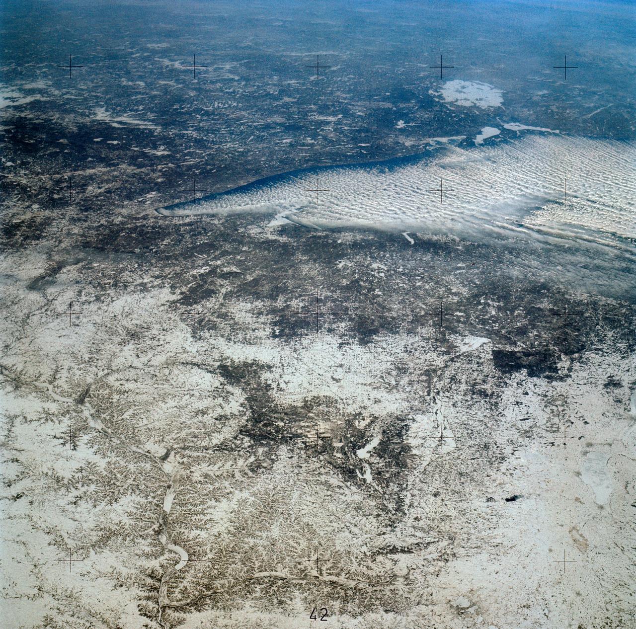
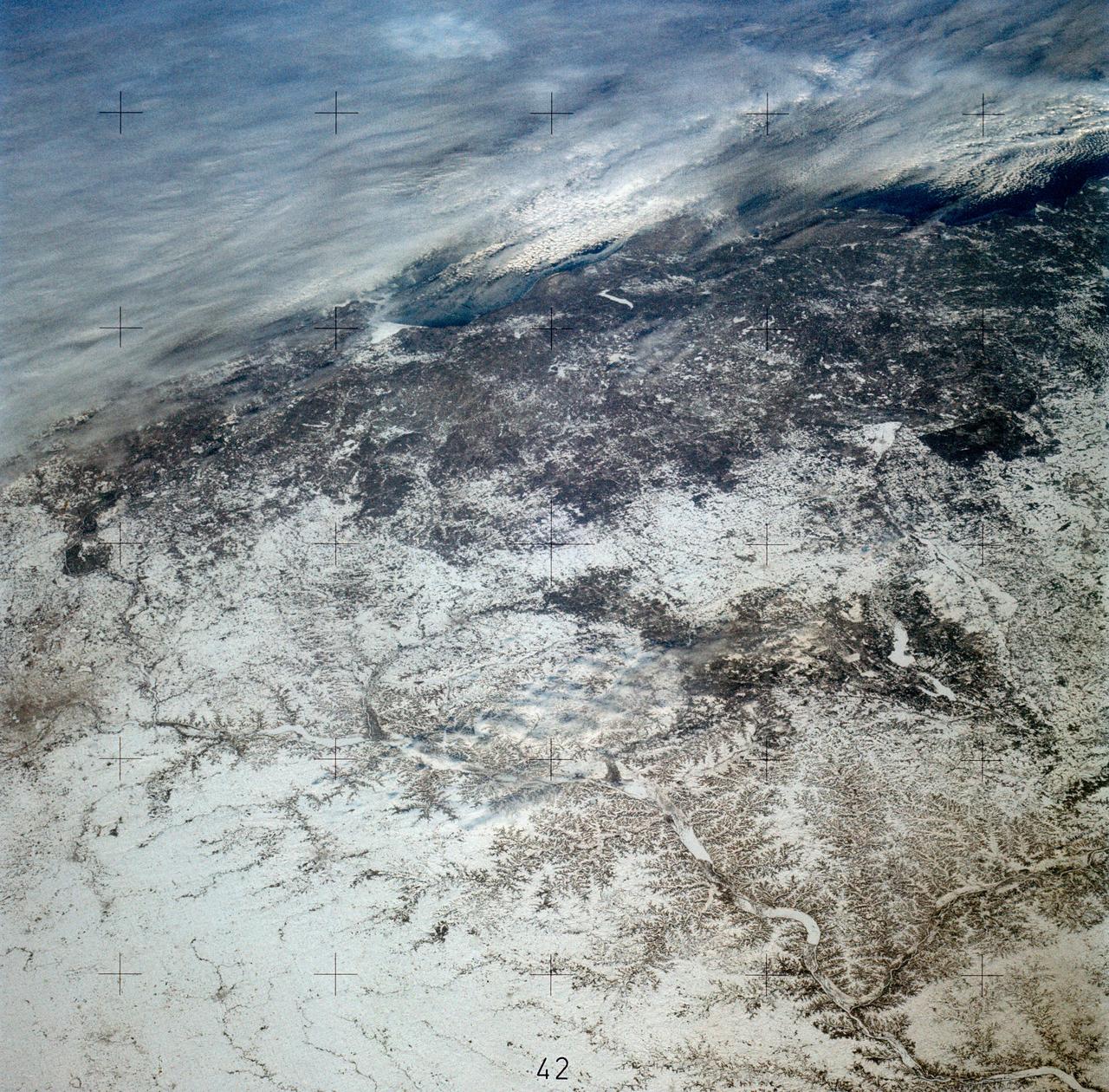
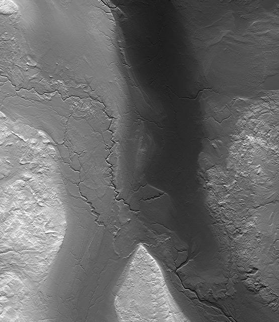
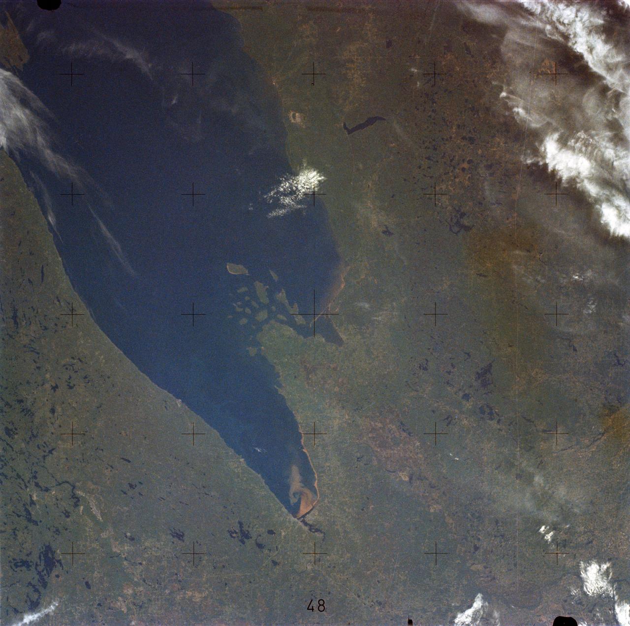
SL4-139-3953 (7 Jan. 1974) --- An oblique view of a portion of the Middle West looking northeastward toward Lake Superior and Ontario, Canada, as seen from the Skylab space station in Earth orbit. This picture was taken by one of the Skylab 4 crewmen with a hand-held 70mm Hasselblad camera using a 100mm lens. Most of the land mass in the foreground is Wisconsin. Iowa is in the lower left corner. Minnesota is at left and upper left. Ontario is in the far right background. Michigan is at right center. Note the circular-shaped feature at center left which was first observed by the Skylab 4 crewmen. The feature is 85 kilometers (55 miles) in diameter, and it is centered near 91.5 degrees west longitude and 44.5 degrees north latitude. The Mississippi River Valley forms the southwest side of the circular feature. The City of La Crosse, Wisconsin, is just south of the near side of the circle, and the Black River completes the southern and eastern part. The City of Eau Claire is at the north edge of the circle. The most likely origin of circular features of this magnitude are (1) volcanic, (2) structural, or (3) meteorite impact. The feature is not volcanic -- the rocks are the wrong type. Possibly it is structural, formed by slight warping of layered rocks into a basin or dome, followed by erosion of all but the most subtle trace of the structure. The feature could be a severely eroded meteorite impact crater. If so, a thorough study of the area may yield evidence of the extreme pressure and temperature the rocks were subjected to by the shock of an impacting meteorite. Photo credit: NASA
An autumn storm brought the first snow of the season to the Upper Mississippi River Valley and the Midwestern United States in early November, 2013. The Moderate Resolution Imaging Spectroradiometer (MODIS) aboard NASA’s Terra satellite captured this true color image on November 6 just as the storm was clearing. A long band of snow stretching from Colorado in the southwest to Wisconsin in the northeast marked the path of the blowing storm. According to WeatherBug, up to 10 inches blanketed Gordon, Nebraska and Pipestone, Minnesota. Most snow totals in the Central and Northern Plains and Upper Mississippi Valley ranged from 2-5 inches, while Minneapolis-St. Paul metro area picked up 1-2 inches of new snow from the event. Credit: NASA/GSFC/Jeff Schmaltz/MODIS Land Rapid Response Team <b><a href="http://www.nasa.gov/audience/formedia/features/MP_Photo_Guidelines.html" rel="nofollow">NASA image use policy.</a></b> <b><a href="http://www.nasa.gov/centers/goddard/home/index.html" rel="nofollow">NASA Goddard Space Flight Center</a></b> enables NASA’s mission through four scientific endeavors: Earth Science, Heliophysics, Solar System Exploration, and Astrophysics. Goddard plays a leading role in NASA’s accomplishments by contributing compelling scientific knowledge to advance the Agency’s mission. <b>Follow us on <a href="http://twitter.com/NASA_GoddardPix" rel="nofollow">Twitter</a></b> <b>Like us on <a href="http://www.facebook.com/pages/Greenbelt-MD/NASA-Goddard/395013845897?ref=tsd" rel="nofollow">Facebook</a></b> <b>Find us on <a href="http://instagram.com/nasagoddard?vm=grid" rel="nofollow">Instagram</a></b>
Yet another potent winter storm battered the northeastern United States on February 14-15, 2015. The nor'easter brought 12 to 20 inches (30 to 50 centimeters) of snow across much of eastern New England, along with tropical storm force winds over 60 miles (100 kilometers) per hour. The latest snowfall pushed Boston to its highest monthly total on record—58 inches and counting—and its third highest yearly snow total. This image was acquired by the GOES-East weather satellite at 3:45 p.m. Eastern Standard Time (20:45 Universal Time) on February 15, 2015, as the storm was mostly out to sea. Note the comma-like shape of the nor'easter, which spawned blizzard conditions at coastal locations. The official meteorological definition of a blizzard is three consecutive hours of falling or blowing snow with winds gusting above 35 miles (56 kilometers) per hour and visibility below one-fourth of a mile (0.4 kilometers). As of February 17, the snow depth near Boston was greater than in all but two reported locations in Alaska. It was significantly higher than the notoriously snowy states of Michigan, Wisconsin, and Minnesota. Only Buffalo, New York, had a higher snow pack. On February 16-17, more snow and ice fell across the eastern United States from northern Mississippi all the way to Maine. Read more: <a href="http://1.usa.gov/19wR4LI" rel="nofollow">1.usa.gov/19wR4LI</a> Via: <b><a href="http://www.earthobservatory.nasa.gov/" rel="nofollow"> NASA Earth Observatory</a></b> GOES image courtesy of the NASA/NOAA GOES Project Science team. Terra MODIS image by Jeff Schmaltz, LANCE/EOSDIS Rapid Response at NASA Goddard Space Flight Center. Caption by Mike Carlowicz. <b><a href="http://www.nasa.gov/audience/formedia/features/MP_Photo_Guidelines.html" rel="nofollow">NASA image use policy.</a></b> <b><a href="http://www.nasa.gov/centers/goddard/home/index.html" rel="nofollow">NASA Goddard Space Flight Center</a></b> enables NASA’s mission through four scientific endeavors: Earth Science, Heliophysics, Solar System Exploration, and Astrophysics. Goddard plays a leading role in NASA’s accomplishments by contributing compelling scientific knowledge to advance the Agency’s mission. <b>Follow us on <a href="http://twitter.com/NASAGoddardPix" rel="nofollow">Twitter</a></b> <b>Like us on <a href="http://www.facebook.com/pages/Greenbelt-MD/NASA-Goddard/395013845897?ref=tsd" rel="nofollow">Facebook</a></b> <b>Find us on <a href="http://instagram.com/nasagoddard?vm=grid" rel="nofollow">Instagram</a></b>
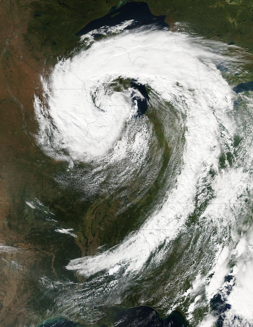
NASA image acquired October 26, 2010 The storm that swept across the center of the United States on October 26 and October 27, 2010, was memorable to those who experienced it because of its strong winds, rain, hail, and widespread tornadoes. Meteorologists get excited about the storm because it set a record for the lowest pressure (not associated with a hurricane) measured over land in the continental United States. At 5:13 p.m. CDT, the weather station in Bigfork, Minnesota recorded 955.2 millibars (28.21 inches of pressure). Pressure is one indicator of a storm’s strength, and this measurement corresponds to the pressure seen in a Category 3 hurricane. This image, taken by the GOES satellite on October 26, shows the storm system circling around the area of extreme low pressure. Such extratropical cyclones form over the United States in the spring and fall, when the temperature difference from north to south is large. Warm, high-pressure air rushes toward the cooler, low-pressure air in the north. Because the Earth is rotating, the air moving in ends up circling the area of low pressure, creating the cyclone shown in the image. The intensity of the storm is determined by the pressure difference between the center and the outer edges. Extreme low pressure in the center of the storm, therefore, is an indicator that the storm was very intense. The animation shows the storm developing starting late on October 25 and running through October 27. The cyclone formed very quickly on October 26, taking a distinctive comma shape as the day went on. The storm developed so quickly, in fact, that it is classified as a bomb, an extremely fast developing storm (dropping at least one millibar of pressure per hour for 24 hours), more common over water than land. The storm was also huge. Though the area of low pressure is centered over the Upper Midwest, the storm reached from the Gulf of Mexico into Canada, and from the Rocky Mountains to the Atlantic Ocean. Extratropical cyclones bring an array of unsettled weather, including strong wind, rain, hail, and tornadoes, and this cyclone brought all of that. On October 26–27, winds gusted up to 78 miles per hour in Michigan, with high winds throughout the Midwest. The National Weather Service reported 61 tornadoes over the two days. Heavy snow also fell in the north. NASA Earth Observatory imagery created by Jesse Allen, using imagery provided courtesy of the NASA GOES Project Science Office. Caption by Holli RIebeek. Instrument: GOES Credit: <b><a href="http://www.earthobservatory.nasa.gov/" rel="nofollow"> NASA Earth Observatory</a></b> <b><a href="http://www.nasa.gov/centers/goddard/home/index.html" rel="nofollow">NASA Goddard Space Flight Center</a></b> enables NASA’s mission through four scientific endeavors: Earth Science, Heliophysics, Solar System Exploration, and Astrophysics. Goddard plays a leading role in NASA’s accomplishments by contributing compelling scientific knowledge to advance the Agency’s mission. <b>Follow us on <a href="http://twitter.com/NASA_GoddardPix" rel="nofollow">Twitter</a></b> <b>Join us on <a href="http://www.facebook.com/pages/Greenbelt-MD/NASA-Goddard/395013845897?ref=tsd" rel="nofollow">Facebook</a></b>
This visible image of the Great Lakes low pressure area was taken from the Moderate Resolution Imaging Spectroradiometer (MODIS) instrument on NASA's Aqua satellite. It was taken at 19:05 UTC (3:05 p.m. EDT) on Monday, Sept. 26, 2011. Credit: NASA Goddard MODIS Rapid Response Team Two Instruments on NASA's Aqua Satellite Catch the Pesky Great Lakes Low A low pressure area has been sitting over the Great Lakes region for about a week now, keeping the region and the U.S. northeast and Mid-Atlantic under cloud cover. NASA's Aqua satellite flew over head yesterday, Sept. 26, and captured two views of it from space. That low pressure area continues to spin counter-clockwise today over the Great Lakes. Its centered over northern Illinois and southeastern Wisconsin and is once again going to keep the region cloudy, cool and wet with showers. When the Aqua satellite passed overhead Monday afternoon at 3:05 p.m. EDT (Sept. 26) a detailed, clear image was captured from the Moderate Resolution Imaging Spectroradiometer (MODIS) instrument . The clouds from the low spread over Illinois, Wisconsin, parts of Iowa, northeastern Missouri, southeastern Minnesota, Michigan, Ohio, Indiana, Pennsylvania, Kentucky, Tennessee, Alabama, Mississippi, Georgia, and the northeastern and Mid-Atlantic states. A second visible image was captured by the Atmospheric Infrared Sounder (AIRS) instrument that also flies aboard NASA's Aqua satellite and showed the huge comma shape of the storm that spans the U.S. from its northern to southern borders. (seen here: <a href="http://www.flickr.com/photos/gsfc/6188946564">www.flickr.com/photos/gsfc/6188946564</a> ) According to the National Weather Service, the low will finally start moving to the east as an upper-atmospheric trough (an elongated area of low pressure) continues to strengthen and move into the upper Midwest. However, a ridge (elongated area) of high pressure will slow its move eastward, so it will be slow clearing this week in the northeastern and Mid-Atlantic U.S. Rob Gutro NASA's Goddard Space Flight Center <b><a href="http://www.nasa.gov/audience/formedia/features/MP_Photo_Guidelines.html" rel="nofollow">NASA image use policy.</a></b> <b><a href="http://www.nasa.gov/centers/goddard/home/index.html" rel="nofollow">NASA Goddard Space Flight Center</a></b> enables NASA’s mission through four scientific endeavors: Earth Science, Heliophysics, Solar System Exploration, and Astrophysics. Goddard plays a leading role in NASA’s accomplishments by contributing compelling scientific knowledge to advance the Agency’s mission. <b>Follow us on <a href="http://twitter.com/NASA_GoddardPix" rel="nofollow">Twitter</a></b> <b>Like us on <a href="http://www.facebook.com/pages/Greenbelt-MD/NASA-Goddard/395013845897?ref=tsd" rel="nofollow">Facebook</a></b> <b>Find us on <a href="http://instagrid.me/nasagoddard/?vm=grid" rel="nofollow">Instagram</a></b>
There are three low pressure systems around the U.S. and they resemble dragons on satellite imagery. NOAA's GOES-13 and GOES-15 satellite image from March 31 shows the low pressure systems in the eastern Pacific Ocean, over the nation's Heartland, and in the eastern Atlantic Ocean. All three lows have the signature comma shape that make them appear to be curled up dragons. According to the National Weather Service, the low pressure area approaching the northwestern U.S. is expected to bring rainfall to the coast and areas of snow that stretch from western Washington state south toward the four corners region. The low in the middle of the country is located over Nebraska and dropping snow to the north and west of it. That same low is bringing rain from southern Minnesota south to eastern Texas. Meanwhile, the third low pressure system is bringing rain and snow to parts of New England. NOAA's GOES-East satellite sits in a fixed orbit in space capturing visible and infrared imagery of all weather over the eastern U.S. and Atlantic Ocean. The data to create this image was taken on March 31 at 17:45 UTC/1:45 p.m. EDT by NOAA's GOES-East or GOES-13 satellite and made into an image by NASA/NOAA's GOES Project at NASA's Goddard Space Flight Center in Greenbelt, Md. To create the image NASA/NOAA's GOES Project takes the cloud data from NOAA's GOES-East satellite and overlays it on a true-color image of land and ocean created by data from the Moderate Resolution Imaging Spectroradiometer, or MODIS, instrument that flies aboard NASA's Aqua and Terra satellites. Together, those data created the entire picture of the storm and show its movement. After the storm system passes, the snow on the ground becomes visible. GOES satellites provide the kind of continuous monitoring necessary for intensive data analysis. Geostationary describes an orbit in which a satellite is always in the same position with respect to the rotating Earth. This allows GOES to hover continuously over one position on Earth's surface, appearing stationary. As a result, GOES provide a constant vigil for the atmospheric "triggers" for severe weather conditions such as tornadoes, flash floods, hail storms and hurricanes. For updated information about the storm system, visit NOAA's NWS website: <a href="http://www.weather.gov" rel="nofollow">www.weather.gov</a> For more information about GOES satellites, visit: <a href="http://www.goes.noaa.gov/" rel="nofollow">www.goes.noaa.gov/</a> or goes.gsfc.nasa.gov/ Rob Gutro NASA's Goddard Space Flight Center, Greenbelt, Md. <b><a href="http://www.nasa.gov/audience/formedia/features/MP_Photo_Guidelines.html" rel="nofollow">NASA image use policy.</a></b> <b><a href="http://www.nasa.gov/centers/goddard/home/index.html" rel="nofollow">NASA Goddard Space Flight Center</a></b> enables NASA’s mission through four scientific endeavors: Earth Science, Heliophysics, Solar System Exploration, and Astrophysics. Goddard plays a leading role in NASA’s accomplishments by contributing compelling scientific knowledge to advance the Agency’s mission. <b>Follow us on <a href="http://twitter.com/NASAGoddardPix" rel="nofollow">Twitter</a></b> <b>Like us on <a href="http://www.facebook.com/pages/Greenbelt-MD/NASA-Goddard/395013845897?ref=tsd" rel="nofollow">Facebook</a></b> <b>Find us on <a href="http://instagram.com/nasagoddard?vm=grid" rel="nofollow">Instagram</a></b>
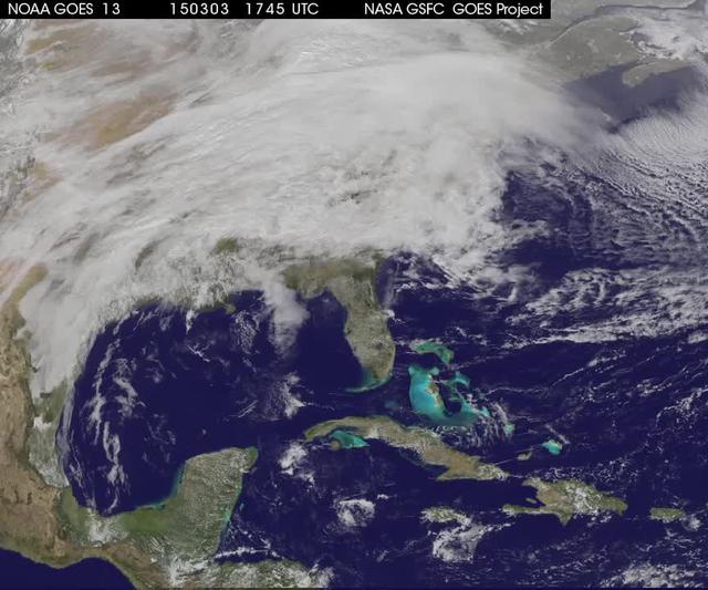
A winter storm was bringing snow, sleet and freezing rain from lower Mississippi Valley to Northeastern U.S. on Thursday, March 5, 2015. A new NASA animation of NOAA's GOES-East satellite imagery showed the progression of the clouds associated with the storm system that triggered winter storm warnings and winter weather advisories from the southern Plains eastward through the Mid-Atlantic and southern New England coast. The system also triggered flood warnings along and to the west of the central Appalachians. An animation of GOES satellite visible and infrared imagery from March 3 through March 5 showed clouds associated with a cold front push over U.S. East coast. Behind the front, Arctic air is expected to drop low temperatures into the single numbers from Washington, D.C. to Minnesota overnight. Temperatures in the Carolinas and Tennessee are expected to drop to the low 20s. NOAA's National Weather Service Weather Prediction Center (NWS NPC) in College Park, Maryland noted "a strong cold front moving across the eastern U.S. will bring heavy snow from parts of the Ohio Valley to the Northeast today (March 5) with rain, freezing rain and sleet possible from parts of the lower Mississippi Valley across the Southeast to the southern Mid-Atlantic. Snowfall totals of 5 to 10 inches are possible for some areas. Winter Storm Warnings remain in effect from Texas to Nantucket." The animation ends at 17:45 UTC (12:45 p.m. EST). Before the end of the animation, the low pressure center along an arctic frontal boundary was nearly stationary over western North Carolina at 9 a.m. EST on March 5, according to the NWS NPC. NWS radar and surface observations indicated an extended swath of precipitation from near the Texas Gulf Coast through the interior eastern U.S. into southern New England. NPC's storm summary noted at that time "rain was changing to sleet/freezing rain and to all snow along a band within this swath as colder air continues to filter in from the north. Some areas in Tennessee, the northern mid-Atlantic and southern New England were reporting moderate to heavy snow." To create the video and imagery, NASA/NOAA's GOES Project takes the cloud data from NOAA's GOES-East satellite and overlays it on a true-color image of land and ocean created by data from the Moderate Resolution Imaging Spectroradiometer, or MODIS, instrument that flies aboard NASA's Aqua and Terra satellites. Together, those data created the entire picture of the storm and show its movement. After the storm system passes, the snow on the ground becomes visible. GOES satellites provide the kind of continuous monitoring necessary for intensive data analysis. Geostationary describes an orbit in which a satellite is always in the same position with respect to the rotating Earth. This allows GOES to hover continuously over one position on Earth's surface, appearing stationary. For updated information about the storm system, visit NOAA's NWS website: <a href="http://www.weather.gov" rel="nofollow">www.weather.gov</a> For more information about GOES satellites, visit: <a href="http://www.goes.noaa.gov/" rel="nofollow">www.goes.noaa.gov/</a> or goes.gsfc.nasa.gov/ Rob Gutro NASA's Goddard Space Flight Center <b><a href="http://www.nasa.gov/audience/formedia/features/MP_Photo_Guidelines.html" rel="nofollow">NASA image use policy.</a></b> <b><a href="http://www.nasa.gov/centers/goddard/home/index.html" rel="nofollow">NASA Goddard Space Flight Center</a></b> enables NASA’s mission through four scientific endeavors: Earth Science, Heliophysics, Solar System Exploration, and Astrophysics. Goddard plays a leading role in NASA’s accomplishments by contributing compelling scientific knowledge to advance the Agency’s mission. <b>Follow us on <a href="http://twitter.com/NASAGoddardPix" rel="nofollow">Twitter</a></b> <b>Like us on <a href="http://www.facebook.com/pages/Greenbelt-MD/NASA-Goddard/395013845897?ref=tsd" rel="nofollow">Facebook</a></b> <b>Find us on <a href="http://instagrid.me/nasagoddard/?vm=grid" rel="nofollow">Instagram</a></b>