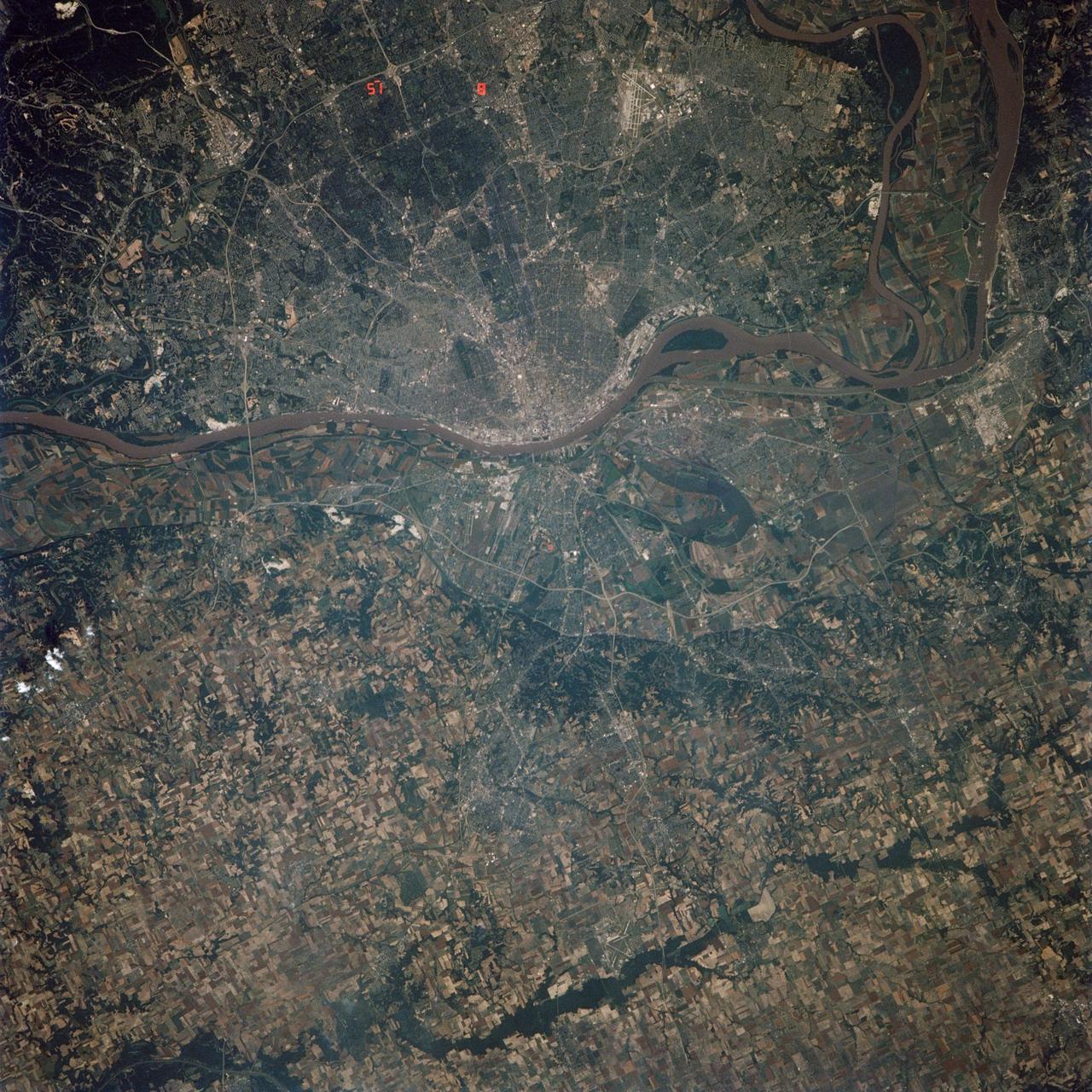
This is a spaceborne radar image of the area surrounding St. Louis, Missouri, where the Mississippi and Missouri Rivers come together. The city of St. Louis is the bright gold area within a bend in the Mississippi River at the lower center of the image.
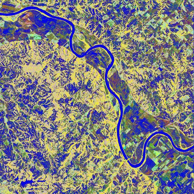
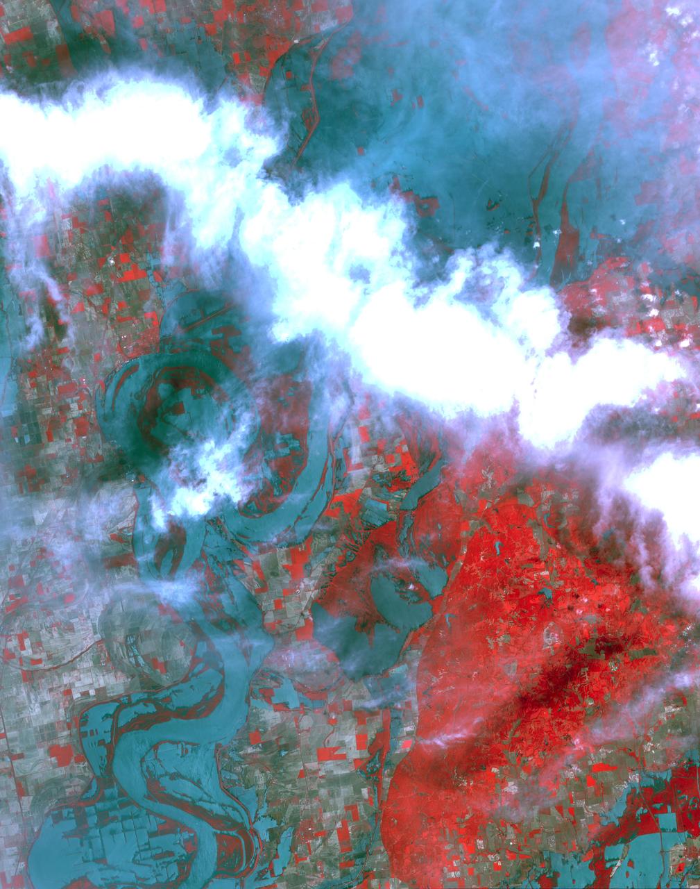
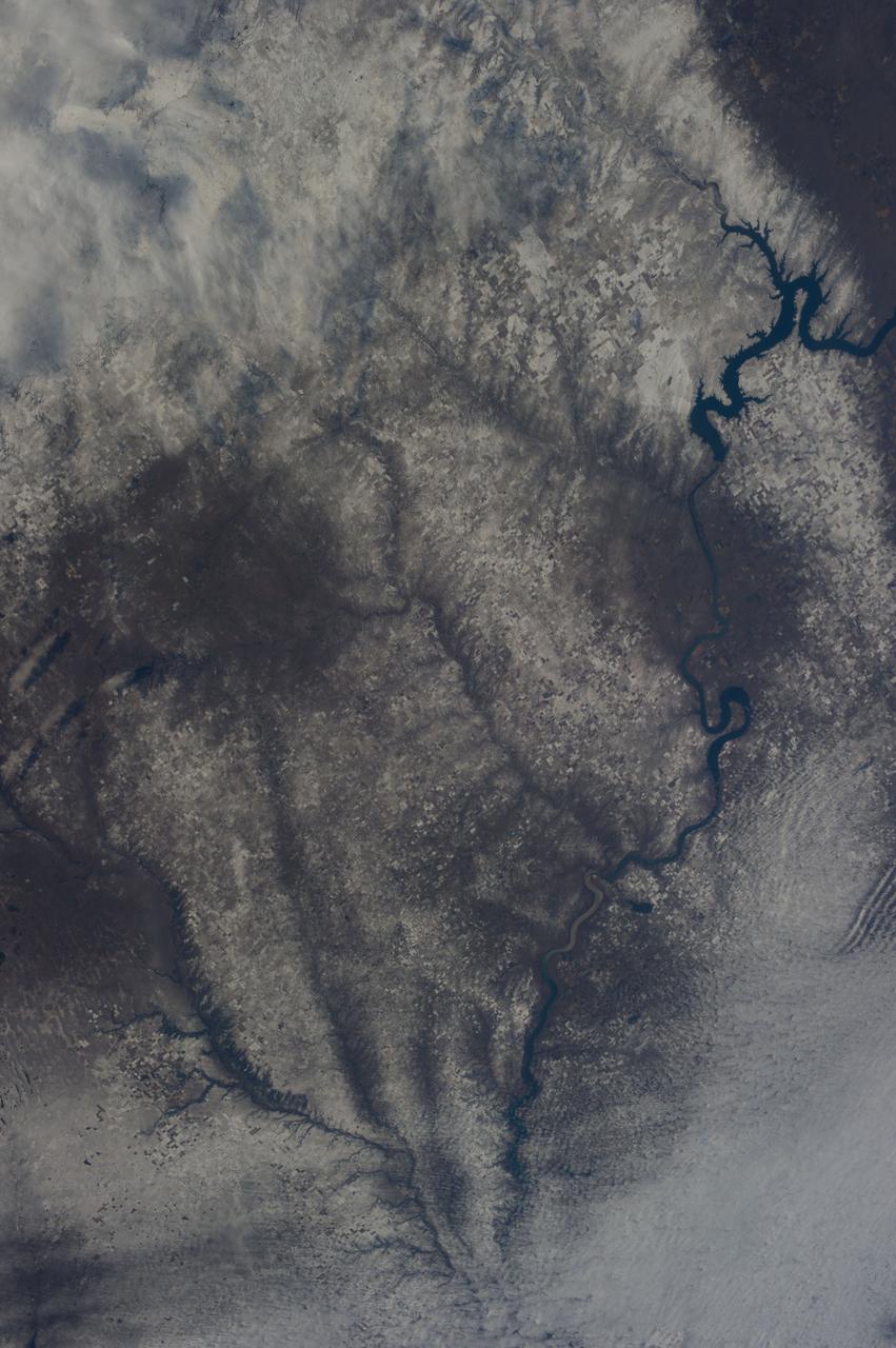
This is a false-color L-band image of an area near Glasgow, Missouri, centered at about 39.2 degrees north latitude and 92.8 degrees west longitude. The image was acquired by the Spaceborne Imaging Radar-C and X-band Synthetic Aperture Radar (SIR-C/X-SAR) aboard the space shuttle Endeavour on its 50th orbit on October 3, 1994. The false-color composite was made by displaying the L-band (horizontally transmitted and received) return in red; the L-band (horizontally transmitted and vertically received) return in green; and the sum of the two channels in blue. The area shown is approximately 37 kilometers by 25 kilometers (23 miles by 16 miles). The radar data, coupled with pre-flood aerial photography and satellite data and post-flood topographic and field data, are being used to evaluate changes associated with levee breaks in landforms, where deposits formed during the widespread flooding in 1993 along the Missouri and Mississippi Rivers. The distinct radar scattering properties of farmland, sand fields and scoured areas will be used to inventory floodplains along the Missouri River and determine the processes by which these areas return to preflood conditions. The image shows one such levee break near Glasgow, Missouri. In the upper center of the radar image is a region covered by several meters of sand, shown as blue regions below the bend in the river. West (left) of this dark area, a blue gap in the levee tree canopy can be seen, showing the area where the levee failed. Radar data such as these can help scientists more accurately assess the potential for future flooding in this region and how that might impact surrounding communities. http://photojournal.jpl.nasa.gov/catalog/PIA01744
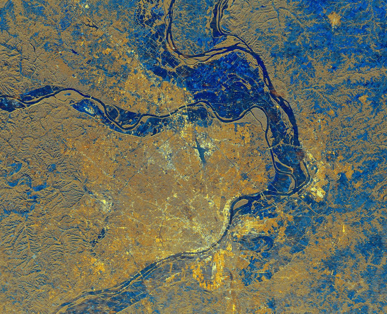
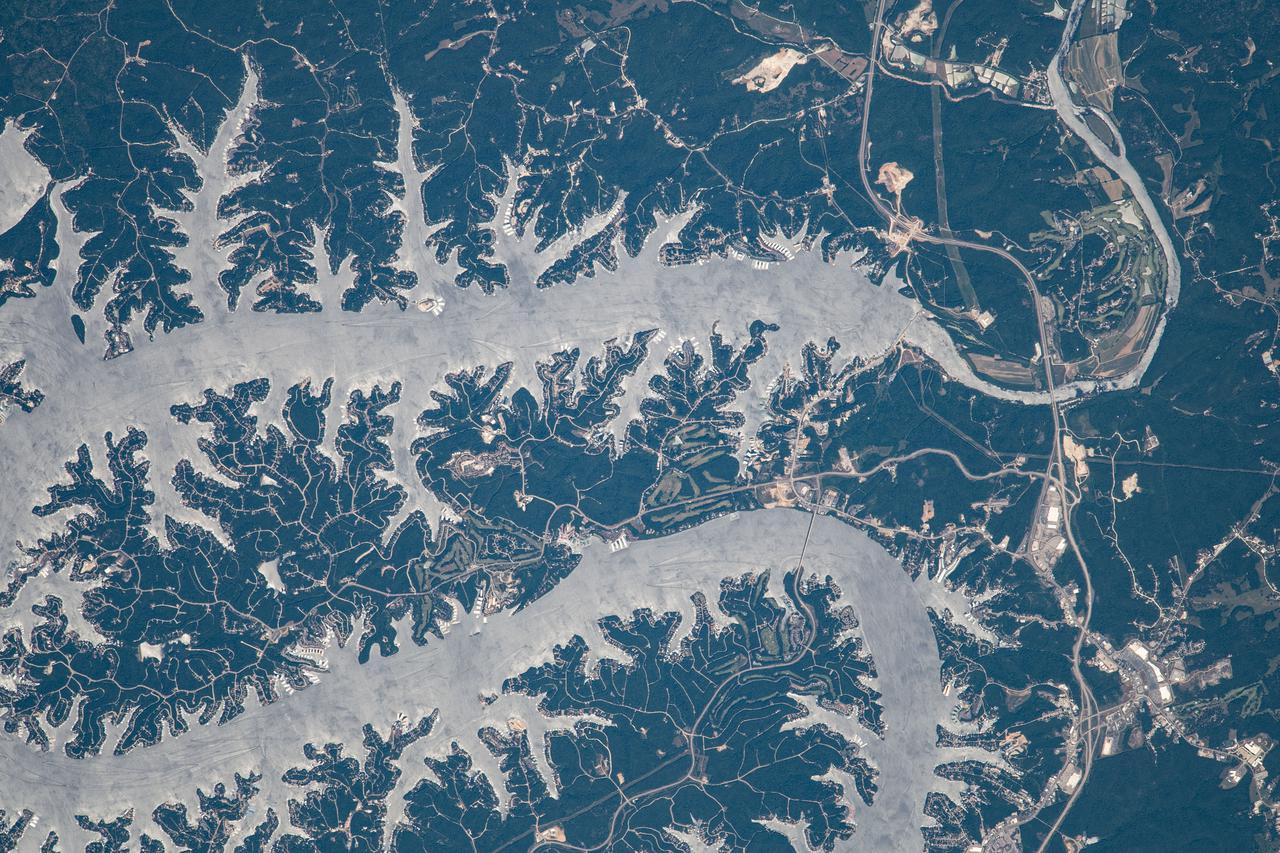
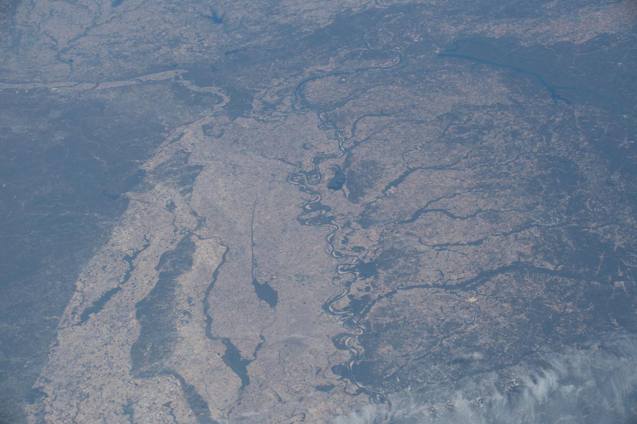
The confluence of the Mississippi, Missouri and Illinois rivers are shown in this view of the St. Louis area from NASA Shuttle Radar Topography Mission.
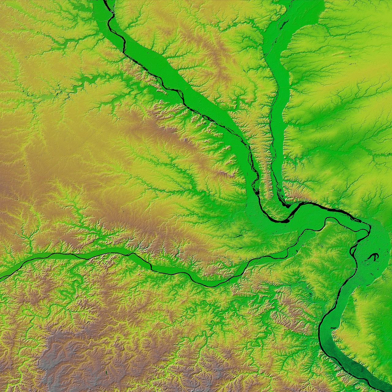
This is a combined radar and topography image of an area along the Missouri River that experienced severe flooding and levee failure in the summer of 1993.
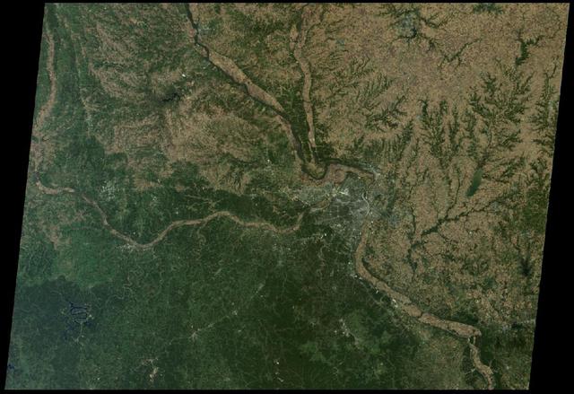
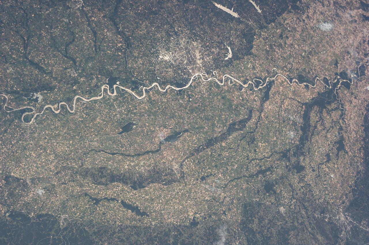
St. Louis, Missouri is tucked in a bend of the Mississippi River, just south of the point at which the Illinois River joins the larger Mississippi as seen by NASA Terra spacecraft on October 15, 2005.
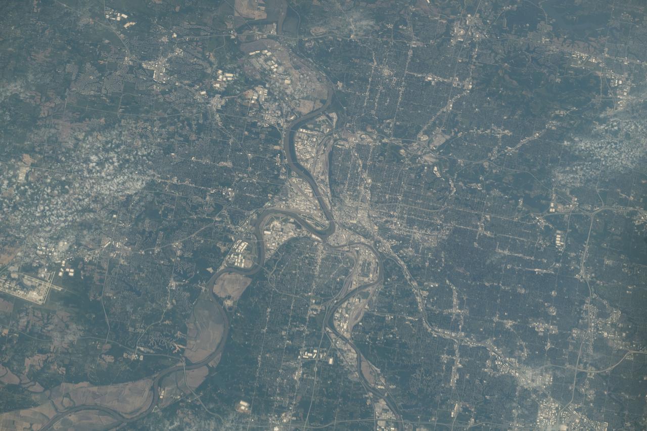
iss073e0134680 (May 31, 2025) --- Kansas City, the largest city in Missouri with a population of about 516,000 and split by the Missouri River, is pictured from the International Space Station as it orbited 262 miles above the midwestern United States.
NASA Terra spacecraft views central South Dakota, where the Missouri River forms a meander bend, creating Lake Sharpe. Eventually, the Missouri River will cut through the skinny peninsula, creating a shorter path.
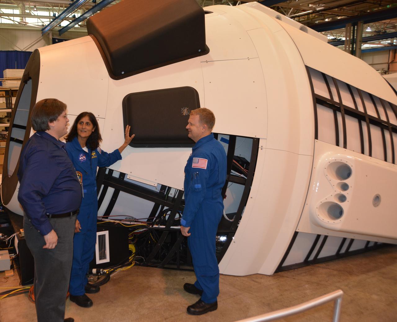
NASA astronauts Suni WIlliams and Eric Boe check the Boeing Mission Simulator at the Boeing facility in St. Louis, Missouri, prior to its completion and shipment to NASA's Johnson Space Center in Houston. The simulator is a full-scale mockup of Boeing's Starliner spacecraft. The simulator will be used to train crews to fly the spacecraft.
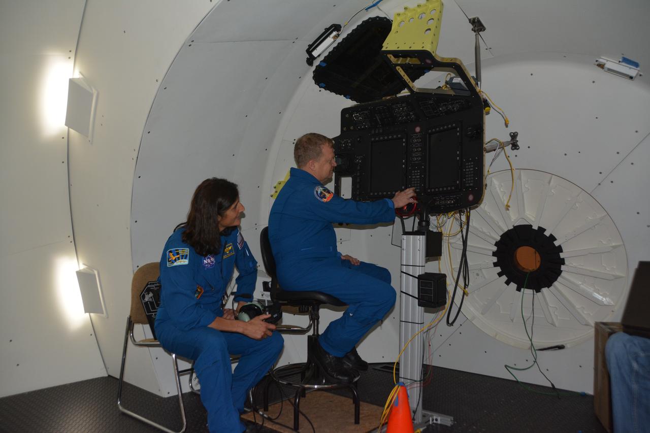
NASA astronauts Suni WIlliams and Eric Boe check the Boeing Mission Simulator at the Boeing facility in St. Louis, Missouri, prior to its completion and shipment to NASA's Johnson Space Center in Houston. The simulator is a full-scale mockup of Boeing's Starliner spacecraft. The simulator will be used to train crews to fly the spacecraft.
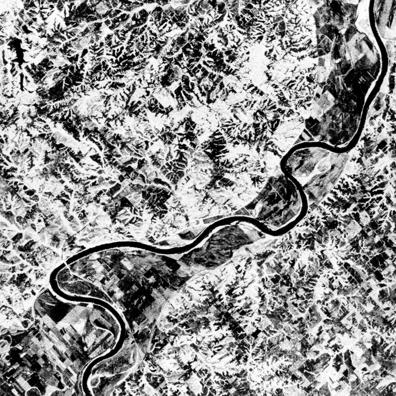
STS068-S-055 (7 October 1994) --- This is a false-color L-Band image of an area near Glasgow, Missouri, centered at about 39.2 degrees north latitude and 92.8 degrees west longitude. The image was acquired using the L-Band radar channel (horizontally transmitted and received and horizontally transmitted and vertically received) polarization's combined. The data were acquired by the Spaceborne Imaging Radar-C/X-Band Synthetic Aperture Radar (SIR-C/X-SAR) aboard the Space Shuttle Endeavour on orbit 50 on October 3, 1994. The area shown is approximately 37 by 25 kilometers (23 by 16 miles). The radar data, coupled with pre-flood aerial photography and satellite data and post-flood topographic and field data, are being used to evaluate changes associated with levee breaks in land forms, where deposits formed during the widespread flooding in 1993 along the Missouri and Mississippi Rivers. The distinct radar scattering properties of farmland, sand fields and scoured areas will be used to inventory flood plains along the Missouri River and determine the processes by which these areas return to preflood conditions. The image shows one such levee break near Glasgow, Missouri. In the upper center of the radar image, below the bend of the river, is a region covered by several meters of sand, shown as dark regions. West (left) of the dark areas, a gap in the levee tree canopy shows the area where the levee failed. Radar data such as these can help scientists more accurately assess the potential for future flooding in this region and how that might impact surrounding communities. Spaceborne Imaging Radar-C/X-Band Synthetic Aperture Radar (SIR-C/X-SAR) is part of NASA's Mission to Planet Earth. The radars illuminate Earth with microwaves, allowing detailed observations at any time, regardless of weather or sunlight conditions. SIR-C/X-SAR uses the three microwave wavelengths: the L-Band (24 centimeters), C-Band (6 centimeters) and X-Band (3 centimeters). The multi-frequency data will be used by the international scientific community to better understand the global environment and how it is changing. The SIR-C/X-SAR data, complemented by aircraft and ground studies, will give scientists clearer insights into those environmental changes which are caused by nature and those changes which are induced by human activity. SIR-C was developed by NASA's Jet Propulsion Laboratory (JPL). X-SAR was developed by the Dornier and Alenia Spazio companies for the German space agency, Deutsche Agentur fuer Raumfahrtangelegenheiten (DARA), and the Italian space agency, Agenzia Spaziale Italiana (ASI), with the Deutsche Forschungsanstalt fuer Luft und Raumfahrt e.v. (DLR), the major partner in science, operations and data processing of X-SAR. (P-44734)
STS040-614-066 (5-14 June 1991) --- St. Louis, Missouri-East St. Louis, Illinois and surrounding area were photographed by the STS 40 crewmembers aboard the Space Shuttle Columbia. The winding Mississippi River serves as a reference point for finding features of the area. Busch Stadium is clearly seen. NASA photo experts studying the STS 40 imagery claim photographs of this type aid in following demographic changes and in planning for development. The ground track of STS-40 and the existence of exceptionally clear skies during much of the nine-day flight permitted photographic acquisition of several cities not generally seen from the space flights flying at 28-degree inclinations to the Equator.
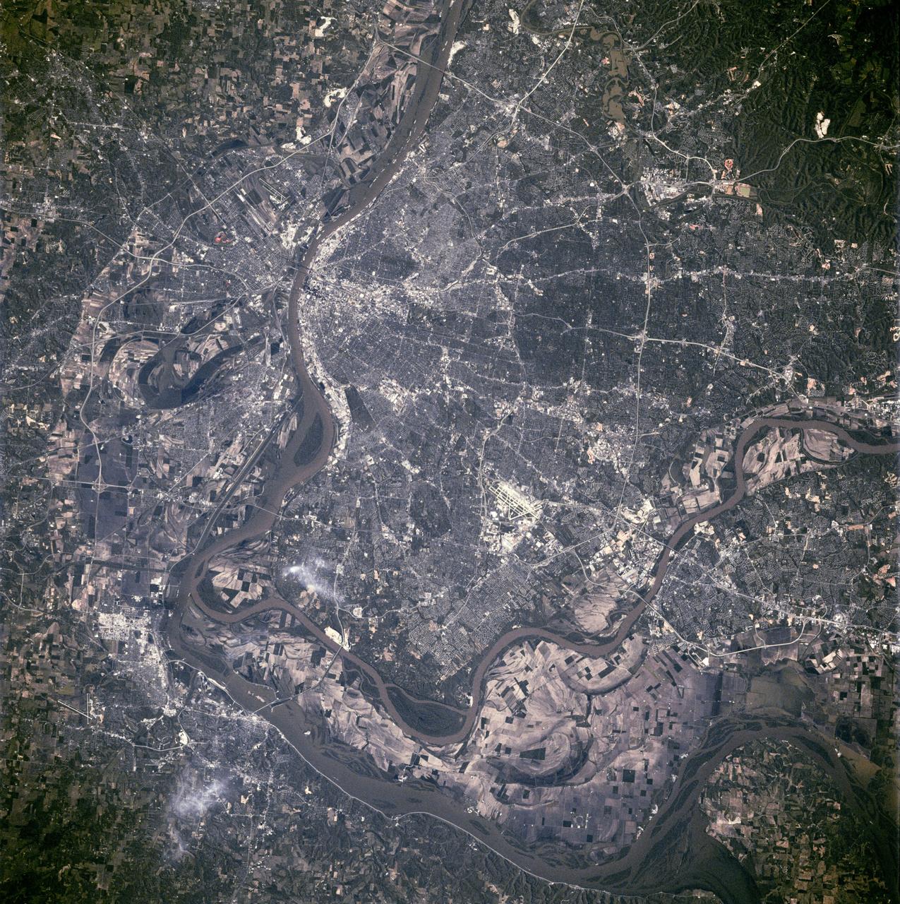
STS090-755-062 (17 April - 3 May 1998) --- The Mississippi River stands out among the geographic features in this view of the St. Louis, Missouri and East St. Louis, Illinois area as photographed with a 70mm handheld camera from the Space Shuttle Columbia. The Shuttle was flying at almost a nadir position to the area when the photo was taken. The picture should be held with the two major rivers at the top of the frame in order for north to be toward the top. The Illinois-Missouri Border is easily delineated by following the Mississippi River from upper left to bottom center. The Missouri River separates St. Charles and St. Louis counties several miles inside the Mississippi at top center.
iss065e144017 (June 23, 2021) --- Lake of the Ozarks in Missouri is pictured from the International Space Station as it orbited 261 miles above the Midwestern United States.
Earth observation taken during a day pass by the Expedition 37 crew. Per Twitter message: The Mississippi River through Missouri, Tennessee, Arkansas, Mississippi.

ISS038-E-024442 (7 Dec. 2013) --- One of the Expedition 38 crew members aboard the Earth-orbiting International Space Station photographed this night image of St. Louis, Missouri and East St. Louis, Illinois and surrounding area on Dec. 7, 2013. North is at the bottom of the picture, with the Mississippi River separating Missouri on the right (west) and Illinois on the east (left). Belleville, Illinois is also visible.
NASA Terra spacecraft shows the resultant flooding of farmland west of the Mississippi 20 miles south of the Mississippi River levee breach. U.S. Army Corps of Engineers detonated explosives at the Birds Point levee near Wyatt, Missouri, on May 2, 2011.
Testing of the subsonic and transonic mach number for clean and full protuberances in support of the Ares/CLV Integrated Vehicle at the Boeing facility in Missouri. This image is extracted from a high definition video file and is the highest resolution available.
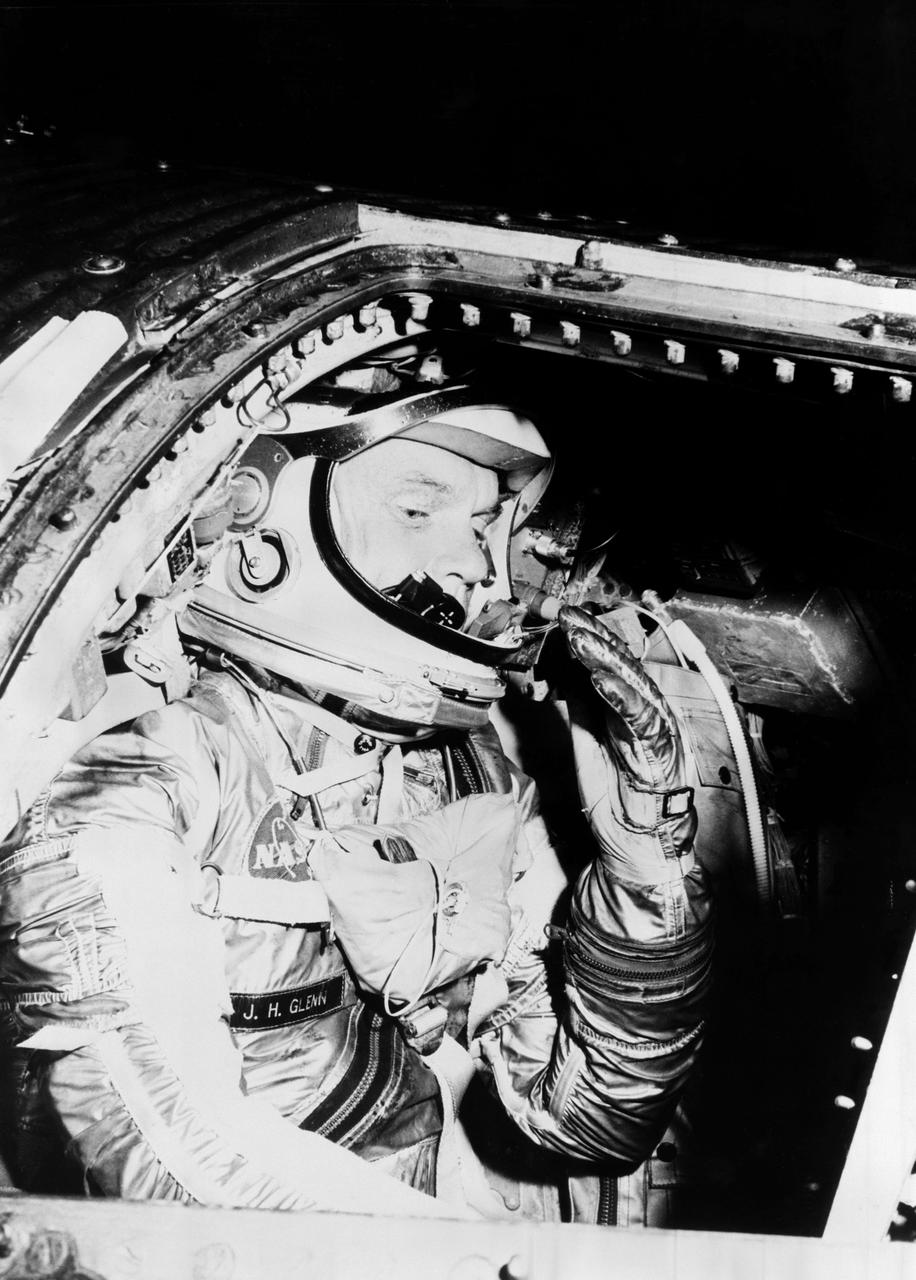
S62-01021 (1962) --- Astronaut John H. Glenn Jr. during training procedures in a trainer at the McDonnell Douglas training facility in St. Louis, Missouri. Photo credit: NASA
iss070e008440 (Oct. 22, 2023) --- The Mississippi River Valley and portions of the states of Arkansas, Missouri, Tennessee, Kentucky, and Illinois are pictured from the International Space Station as it orbited 261 miles above
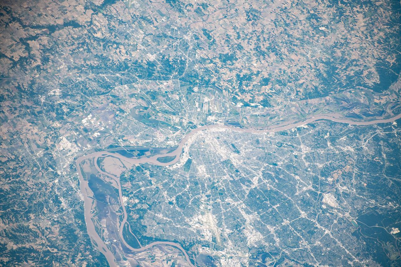
iss060e000556 (June 25, 2019) --- The city of St. Louis, Missouri is pictured along the Mississippi River as the International Space Station orbited 256 miles above the northern United States.
iss069e060833 (Aug. 15, 2023) --- South Dakota's Missouri River and its tributary the White River are pictured from the International Space Station as it orbited 264 miles above North America.
Earth observation taken during day pass by an Expedition 37 crew member on board the International Space Station (ISS). Possibly Identified as snow covered South Dakota,along the Missouri river.

iss069e008226 (May 2, 2023) --- The city lights of St. Louis, Missouri, and its suburbs, fan out west of the Mississippi River in this photograph from the International Space Station as it orbited 262 miles above. The Mississippi separates the Show-Me State from the Prairie State of Illinois.

STS028-06-031 (August 1989) --- Astronaut Richard N. Richards, pilot, is captured with a 35mm camera at the pilot's station on the flight deck of the space shuttle Columbia during the STS-28 flight. Nearby is a tiger. Richards is an alumnus of the University of Missouri, whose mascot is a tiger.
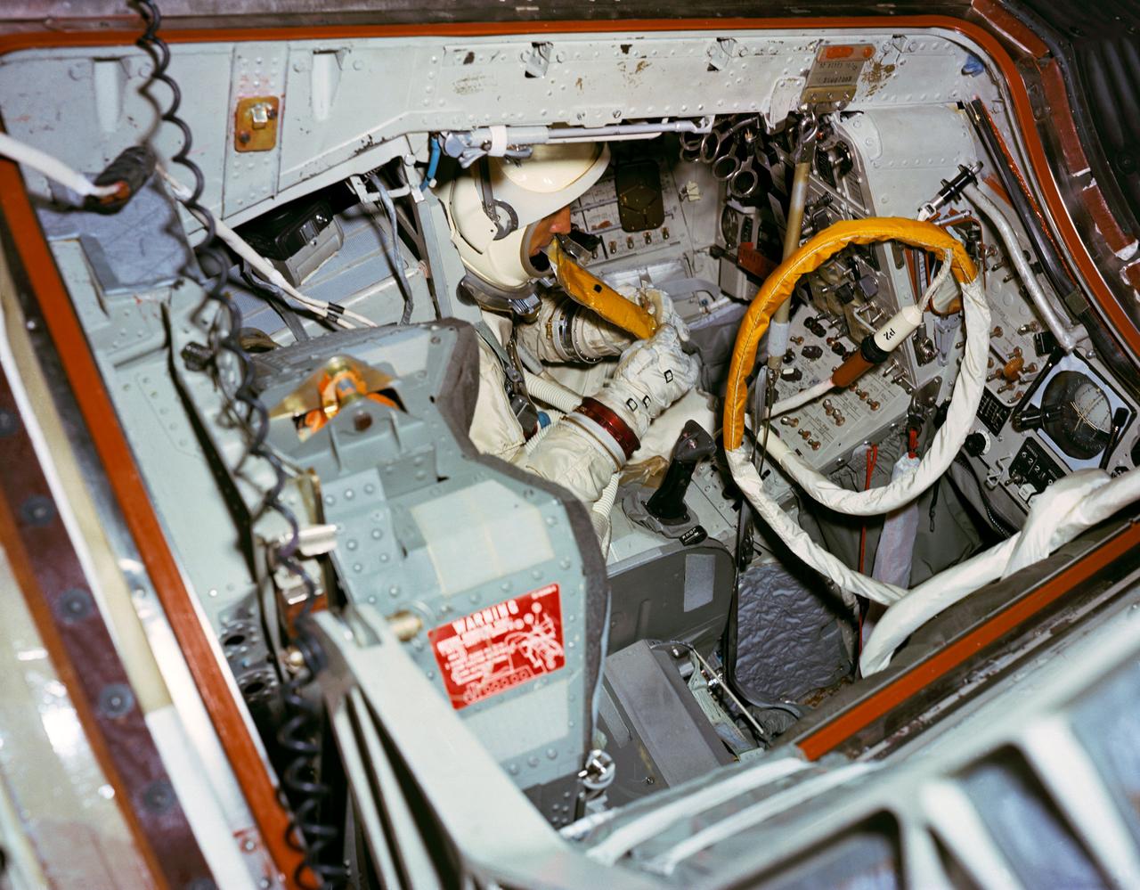
S66-51054 (15 Aug. 1966) --- Astronaut James A. Lovell Jr., prime crew command pilot of the Gemini-12 space mission, simulates using space food packet while seated in the Gemini-12 spacecraft in the 30-feet Altitude Chamber at McDonnell Aircraft Corporation, St. Louis, Missouri. Photo credit: NASA
ISS008-E-06565 (30 November 2003) --- This view featuring the Lake Michigan area was photographed by an Expedition 8 crewmember on the International Space Station (ISS). The photo also shows Chicago area; Illinois River; Mississippi and Missouri Rivers meeting at St. Louis. Aircraft contrails are also visible.

This image acquired on Jan. 17, 2016 by NASA Terra spacecraft shows major flooding along the Mississippi River, affecting Missouri, Illinois, Arkansas and Tennessee. As of January 17, flood warnings were issued for the area around Baton Rouge, Louisiana, as the river crested at 43.3 feet (13.1 meters), 8 feet (2.4 meters) above flood stage. Shipping and industrial activities were significantly affected; low-lying areas were flooded, and agricultural operations were impacted on the west side of the river. This image from the Advanced Spaceborne Thermal Emission and Reflection Radiometer (ASTER) on NASA's Terra spacecraft was acquired Jan. 17, 2016, covers an area of 23.6 by 23.6 miles (38 by 38 kilometers), and is located at 30.6 degrees north, 91.3 degrees west. http://photojournal.jpl.nasa.gov/catalog/PIA20364
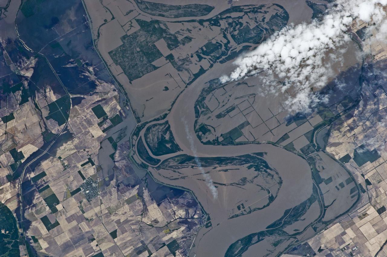
ISS027-E-027023 (12 May 2011) --- An Expediton 27 crew member aboard the International Space Station, 220 miles above Earth and the Mississippi River, captured this May 12 still photo, clearly showing the outlines of some heavily flooded agricultural fields on the Missouri side of the river. The center point for this 400-mm frame is 36.27 degrees north latitude and 89.57 degrees west longitude (north of Caruthersville, Mo. and west of Ridgely, Tenn.). North is towards the lower right corner of the image.
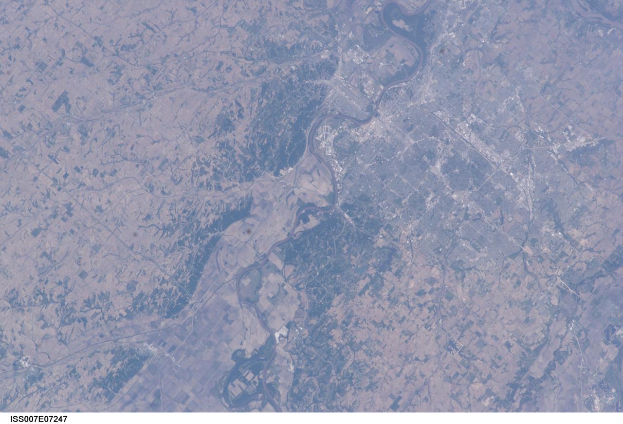
ISS007-E-07247 (13 June 2003) --- This image, photographed by an Expedition 7 crewmember onboard the International Space Station (ISS), features the Missouri River and a near-vertical view of Omaha, Nebraska. With a population estimated at more than three quarters of a million residents, Omaha is situated on high ground to the west of the river while Eppley Airfield and the town of Council Bluffs, Iowa are located on the floodplain.
STS058-102-018 (18 Oct-1 Nov 1993) --- A cloud-free, wide-angle view from above western Tennessee to the northern edge of Lake Michigan. The view extends from Saint Louis, Missouri near the lower left-hand corner, past Evansville, Indiana and Louisville, Kentucky to Cincinnati, Ohio. A range of hills covered by trees in Fall foliage extends from the Ohio River toward Lake Michigan, ending just southwest of Indianapolis, Indiana.

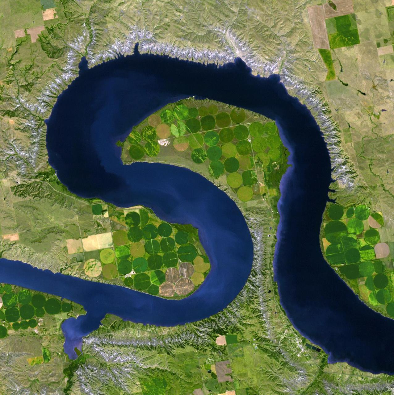
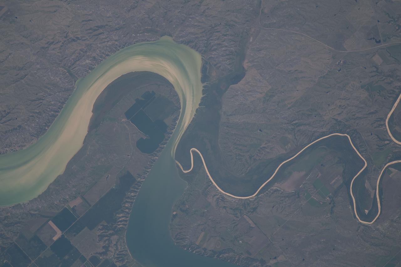
ISS038-E-023651 (26 Dec. 2013) --- Lake Sharpe near Lower Brule, South Dakota is featured in this image photographed by an Expedition 38 crew member on the International Space Station. The Missouri River rises in the Rocky Mountains of western Montana, and flows generally to the southeast for approximately 3,767 kilometers (2,341 miles) to its confluence with the Mississippi River north of St. Louis, Missouri -- making it the longest river in North America. The river does not follow a straight southeasterly course along this distance, but includes may meander bends such as illustrated in this photograph. This particular bend is occupied by Lake Sharpe, an approximately 130-kilometer (80 miles) long reservoir formed behind the Big Bend Dam on the Missouri River. The lake surface is frozen and covered with snow, presenting a uniform white appearance in the image. As meander bends develop, they tend to assume a distinctive U-shape when viewed from above. Over time, the river channel can continue to cut into the ends of the "U", eventually bringing them so close together that the river then cuts across the gap to achieve a shorter flow path, essentially short-circuiting or cutting off the meander bend. When this happens and the meander ceases to be part of the active river channel, it may become an oxbow lake. The distance across the narrow neck of land (lower right) associated with this meander near Lower Brule, South Dakota is approximately one kilometer (0.62 miles); however, as the river flow is controlled by the Big Bend Dam downstream, the natural process of meander cutoff has been significantly slowed. The snow cover also highlights circular agricultural fields on the small peninsula within the meander bend. This type of field indicates center-pivot irrigation, where water is distributed from a central point radially outwards using sprinklers to cover the field area. Crops grown here include corn and soybeans according to data from the US Department of Agriculture's CropScape database.
ISS030-E-059433 (19 Jan. 2012) --- Ice cover on Lake Sakakawea in North Dakota is featured in this image photographed by an Expedition 30 crew member on the International Space Station. This striking photograph illustrates the harsh winter conditions frequently experienced in North Dakota. Ice covers the surface of northwestern Lake Sakakawea, a reservoir on the Missouri River in west-central North Dakota. A local weather station near New Town, ND reported an air temperature of approximately -24 °C (-11 °F), with a wind chill of approximately -32 °C (-25 °F) at 10:36 local time – six minutes before the image was taken. In addition to the grey ice on the lake, a dusting of white snow highlights agricultural fields to the north and northeast, as well as fissures and irregularities in the ice surfaces. For a sense of scale, the arms of the lake to either side of New Town are approximately 10 kilometers (6 miles) apart. Lake Sakakawea is named—in the Hidatsa language—for the Shoshone woman generally known as Sacagawea, or “Bird Woman”. She accompanied the Lewis and Clark Expedition in 1805–1806 as an interpreter and guide. The lake was created following the completion of Garrison Dam (not shown) on the Missouri River in 1954. With a surface area of approximately 148,924 hectares (368,000 acres) and length of 286 kilometers (178 miles), Lake Sakakawea is one of the largest artificial reservoirs in the USA.
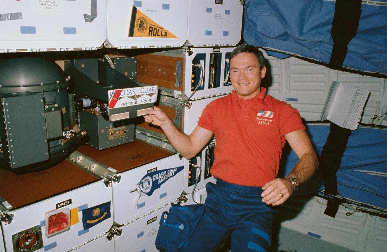
STS041-06-029 (10 Oct 1990) --- STS-41 Mission Specialist (MS) Bruce E. Melnick, who is a graduate of the Coast Guard Academy and the first ever active Coast Guardsman to fly in space, draws attention to his branch of the service, while posing next to a banner from his Alma Mater (on locker MF57K) and a United States (U.S.) Coast Guard decal (on the Solid Surface Combustion Experiment (SSCE)). Behind Melnick are the starboard wall-mounted sleep restraints. Insignias belonging to other crewmembers are displayed on the lockers including University of Missouri Rolla and U.S. Marine Corps.
S84-35757 (May 1984) --- Astronaut Judith A. Resnik, 41-D mission specialist, and Charles Walker, payload specialist for that June 1984 flight, prepare for some scheduled intravehicular activity involving the continuous flow electrophoresis systems (CFES) experiment. CFES will join the six-member crew aboard the Earth-orbiting Discovery for a seven day mission. The two share in preparing a sample to be processed by the CFES. In the background are stowage lockers and a CFES trainer-- part of the Shuttle one-g trainer at NASA's Johnson Space Center (JSC). Walker, an engineer at McDonnell Douglas Astronautics Co. in St. Louis, Missouri, will be the first Shuttle payload specialist to represent a project designed for commercial purposes. As payload specialist, his job will be to run the materials electrophoresis-operations-in-space project. The project is aimed at separating large quantities of biological materials in space for ultimate use in new pharmaceuticals. The photo was taken by a McDonnell Douglas photographer.
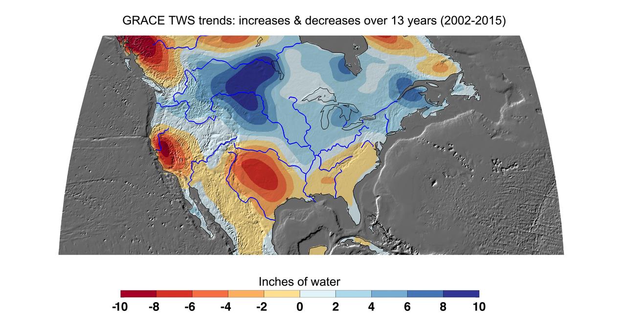
Cumulative total freshwater losses in the United States from 2002 to 2015 (in inches) observed by NASA's Gravity Recovery and Climate Experiment (GRACE) mission. Total water refers to all of the snow, surface water, soil water and groundwater combined. Much of the northern half of the country experienced increasing total water storage during this time period, while total water storage in the southern half decline. Areas where groundwater depletion strongly impacted total water losses include California's Central Valley, and the southern High Plains aquifer beneath the Texas and Oklahoma panhandles. Total water storage in the Upper Missouri River basin increased signficantly and contributed to considerable flooding during the 2002-15 time period. Image updated from Famiglietti and Rodell, 2013. Citation of Record: Famiglietti, J. S., and M. Rodell, Water in the Balance, Science, 340, 1300-1301. http://photojournal.jpl.nasa.gov/catalog/PIA20204
This photograph depicts the flight article of the Airlock Module (AM) Flight Article being mated to the Fixed Airlock Shroud and aligned in a clean room of the McDornell Douglas Plant in St. Louis, Missouri. The AM enabled crew members to conduct extravehicular activities outside Skylab as required for experiment support. Separated from the Workshop and the Multiple Docking Adapter by doors, the AM could be evacuated for egress or ingress of a space-suited astronaut through a side hatch. Oxygen and nitrogen storage tanks needed for Skylab's life support system were mounted on the external truss work of the AM. Major components in the AM included Skylab's electric power control and distribution station, environmental control system, communication system, and data handling and recording systems. The Marshall Space Flight Center was responsible for the design and development of the Skylab hardware and experiment management.
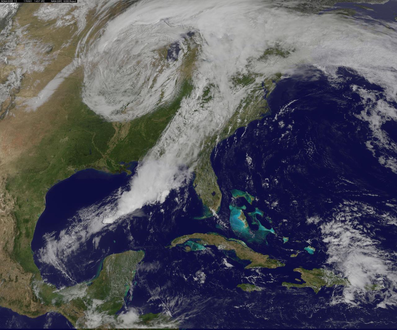
NASA Sees Severe Weather from Central to Eastern US A vigorous weather system has generated severe weather over the mid-section of the U.S. and satellites are providing a look at it as it is moving toward the East Coast. NASA and NOAA satellites have been tracking a storm system that has generated flooding and tornadic thunderstorms in the central U.S. and is expected bring severe weather to the U.S. Mid-Atlantic region. At NASA's Goddard Space Flight Center in Greenbelt, Maryland, data from NOAA's GOES-East satellite were used to create images and an animation of the movement of the powerful storm. On April 30, the Moderate Resolution Imaging Spectroradiometer, or MODIS, instrument aboard NASA's Aqua satellite captured a visible image of the storms moving over eastern Texas and Louisiana. Tornadoes in eastern Texas killed four people. The system generated heavy rainfall and caused additional fatalities and damages in Arkansas, Missouri, Mississippi, Alabama and Tennessee. On Monday, May 1, NOAA's National Weather Service noted, "Major to record flooding continues over portions of the central U.S. Severe thunderstorms are possible from the Mid-Atlantic to the northeastern U.S. "Major to record flooding will continue over portions of eastern Oklahoma, northern Arkansas, Missouri, Illinois and Indiana. Rivers will gradually recede over the next several days. Additional strong to severe thunderstorms will be possible Monday afternoon and evening over portions of the Mid-Atlantic and Northeast U.S. Damaging winds, large hail, and isolated tornadoes will be possible." Image caption: On May 1, 2017, at 10:37 a.m. EDT (1437 UTC) NOAA's GOES-East satellite captured this visible image of the storm system centered over Iowa with an associated cold front that stretches into the Gulf of Mexico. Credits: NASA/NOAA GOES Project <b><a href="http://www.nasa.gov/audience/formedia/features/MP_Photo_Guidelines.html" rel="nofollow">NASA image use policy.</a></b> <b><a href="http://www.nasa.gov/centers/goddard/home/index.html" rel="nofollow">NASA Goddard Space Flight Center</a></b> enables NASA’s mission through four scientific endeavors: Earth Science, Heliophysics, Solar System Exploration, and Astrophysics. Goddard plays a leading role in NASA’s accomplishments by contributing compelling scientific knowledge to advance the Agency’s mission. <b>Follow us on <a href="http://twitter.com/NASAGoddardPix" rel="nofollow">Twitter</a></b> <b>Like us on <a href="http://www.facebook.com/pages/Greenbelt-MD/NASA-Goddard/395013845897?ref=tsd" rel="nofollow">Facebook</a></b> <b>Find us on <a href="http://instagrid.me/nasagoddard/?vm=grid" rel="nofollow">Instagram</a></b>

NASA image acquired July 17, 2011 In mid-July 2011, more than a month after the Missouri River broke through two levees and flooded fields near Hamburg, Iowa, muddy water lingered near the city. Hamburg residents were relieved, however, that a newly built levee had spared the town from flooding. On July 17, 2011, the Advanced Land Imager (ALI) on NASA’s Earth Observing-1 (EO-1) satellite captured this natural-color image. Compared to an image acquired on June 24, flooding has apparently receded slightly in some areas. Sediment-choked water nevertheless lingers on large swaths of land. On July 13, 2011, KETV of Omaha, Nebraska, reported that a newly built, 2-mile levee designed to protect Hamburg already exceeded federal standards. The U.S. Army Corps of Engineers handed control of the levee over to city officials on July 12. In the end, the levee was expected to cost the Army Corps $6 million, and the city of Hamburg about $800,000. On July 18, 2011, the Advanced Hydrological Prediction Service reported moderate flooding along the Missouri River not far from Hamburg, Iowa. In the northwest, the river reached 24.37 feet (7.43 meters) at Nebraska City. In the southeast, the river reached 38.98 feet (11.88 meters) at Brownville, Nebraska. NASA Earth Observatory image created by Jesse Allen and Robert Simmon, using EO-1 ALI data provided courtesy of the NASA EO-1 team. Caption by Michon Scott. Instrument: EO-1 - ALI Credit: <b><a href="http://www.earthobservatory.nasa.gov/" rel="nofollow"> NASA Earth Observatory</a></b> <b><a href="http://www.nasa.gov/centers/goddard/home/index.html" rel="nofollow">NASA Goddard Space Flight Center</a></b> enables NASA’s mission through four scientific endeavors: Earth Science, Heliophysics, Solar System Exploration, and Astrophysics. Goddard plays a leading role in NASA’s accomplishments by contributing compelling scientific knowledge to advance the Agency’s mission. <b>Follow us on <a href="http://twitter.com/NASA_GoddardPix" rel="nofollow">Twitter</a></b> <b>Like us on <a href="http://www.facebook.com/pages/Greenbelt-MD/NASA-Goddard/395013845897?ref=tsd" rel="nofollow">Facebook</a></b> <b>Find us on <a href="http://web.stagram.com/n/nasagoddard/?vm=grid" rel="nofollow">Instagram</a></b>
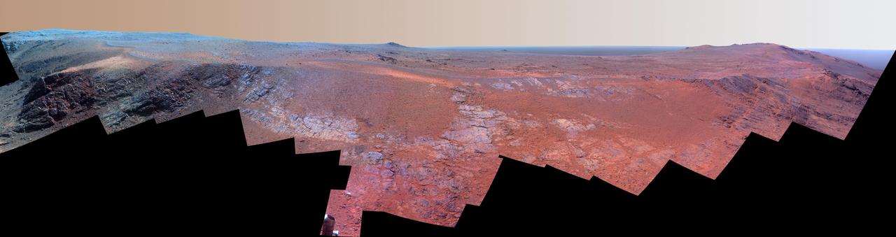
A ridge called "Rocheport" on the western rim of Mars' Endeavour Crater spans this mosaic of images from the panoramic camera (Pancam) on NASA's Mars Exploration Rover Opportunity. In this version of the scene the landscape is presented in enhanced color to make differences in surface materials more easily visible. The view extends from south-southeast on the left to north on the right. Rocheport is near the southern end of an Endeavour rim segment called "Cape Tribulation." The Pancam took the component images for this panorama on Feb. 25, 2017, during the 4,654th Martian day, or sol, of Opportunity's work on Mars. Opportunity began exploring the western rim of Endeavour Crater in 2011 and reached the north end of Cape Tribulation in 2014. This ridge bears some grooves on its side, such as between the two dark shoulders angling down near the left edge of the scene. For scale, those shoulders are about 10 to 16 feet (3 to 5 meters) long. The grooves might have been carved long ago by water or ice or wind. The Rocheport name comes from a riverbank town in Missouri along the route of Lewis and Clark's "Corps of Discovery" Expedition. The view merges exposures taken through three of the Pancam's color filters, centered on wavelengths of 753 nanometers (near-infrared), 535 nanometers (green) and 432 nanometers (violet). https://photojournal.jpl.nasa.gov/catalog/PIA21492
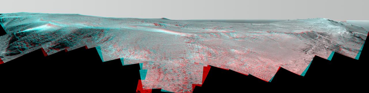
A ridge called "Rocheport" on the western rim of Mars' Endeavour Crater spans this stereo scene from the panoramic camera (Pancam) on NASA's Mars Exploration Rover Opportunity. The mosaic combines views from the left eye and right eye of the Pancam to appear three-dimensional when seen through blue-red glasses with the red lens on the left. The view extends from south-southeast on the left to north on the right. Rocheport is near the southern end of an Endeavour rim segment called "Cape Tribulation." The Pancam took the component images for this panorama on Feb. 25, 2017, during the 4,654th Martian day, or sol, of Opportunity's work on Mars. Opportunity began exploring the western rim of Endeavour Crater in 2011 and reached the north end of Cape Tribulation in 2014. This ridge bears some grooves on its side, such as between the two dark shoulders angling down near the left edge of the scene. For scale, those shoulders are about 10 to 16 feet (3 to 5 meters) long. The grooves might have been carved long ago by water or ice or wind. The Rocheport name comes from a riverbank town in Missouri along the route of Lewis and Clark's "Corps of Discovery" Expedition. https://photojournal.jpl.nasa.gov/catalog/PIA21491

A ridge called "Rocheport" on the western rim of Mars' Endeavour Crater spans this mosaic of images from the panoramic camera (Pancam) on NASA's Mars Exploration Rover Opportunity. The view extends from south-southeast on the left to north on the right. Rocheport is near the southern end of an Endeavour rim segment called "Cape Tribulation." The Pancam took the component images for this panorama on Feb. 25, 2017, during the 4,654th Martian day, or sol, of Opportunity's work on Mars. Opportunity began exploring the western rim of Endeavour Crater in 2011 and reached the north end of Cape Tribulation in 2014. This ridge bears some grooves on its side, such as between the two dark shoulders angling down near the left edge of the scene. For scale, those shoulders are about 10 to 16 feet (3 to 5 meters) long. The grooves might have been carved long ago by water or ice or wind. The view merges exposures taken through three of the Pancam's color filters, centered on wavelengths of 753 nanometers (near-infrared), 535 nanometers (green) and 432 nanometers (violet). It is presented in approximately true color. The Rocheport name comes from a riverbank town in Missouri along the route of Lewis and Clark's "Corps of Discovery" Expedition. https://photojournal.jpl.nasa.gov/catalog/PIA21493

KENNEDY SPACE CENTER, FLA. -- A female anhinga roosts in branches near the water. Anhingas can be found in freshwater ponds and swamps where there is thick vegetation and tall trees. Male anhingas are black and gray; females are distinguished by a buff-colored neck and breast. When anhingas are in their breeding plumage they have a blue ring around their eyes, as seen here. The female lays three to five light blue eggs. The nest is in a tree and it is made of sticks and lined with leaves. The chicks hatch in about a month. Anhingas breed off the Gulf Coast and the Atlantic Coast from North Carolina to Texas and in the Mississippi Valley north to Kentucky and Missouri. They winter along the Gulf Coast north to North Carolina. The anhinga diet is primarily fish. Using their sharp bills, anhingas spear the fish, flip them in the air and swallow them head-first. KSC shares a boundary with the Merritt Island Wildlife Nature Refuge. The refuge is a habitat for more than 310 species of birds, 25 mammals, 117 fishes and 65 amphibians and reptiles. In addition, the Refuge supports 19 endangered or threatened wildlife species on Federal or State lists, more than any other single refuge in the U.S. Photo credit: NASA/Dimitri Gerondidakis
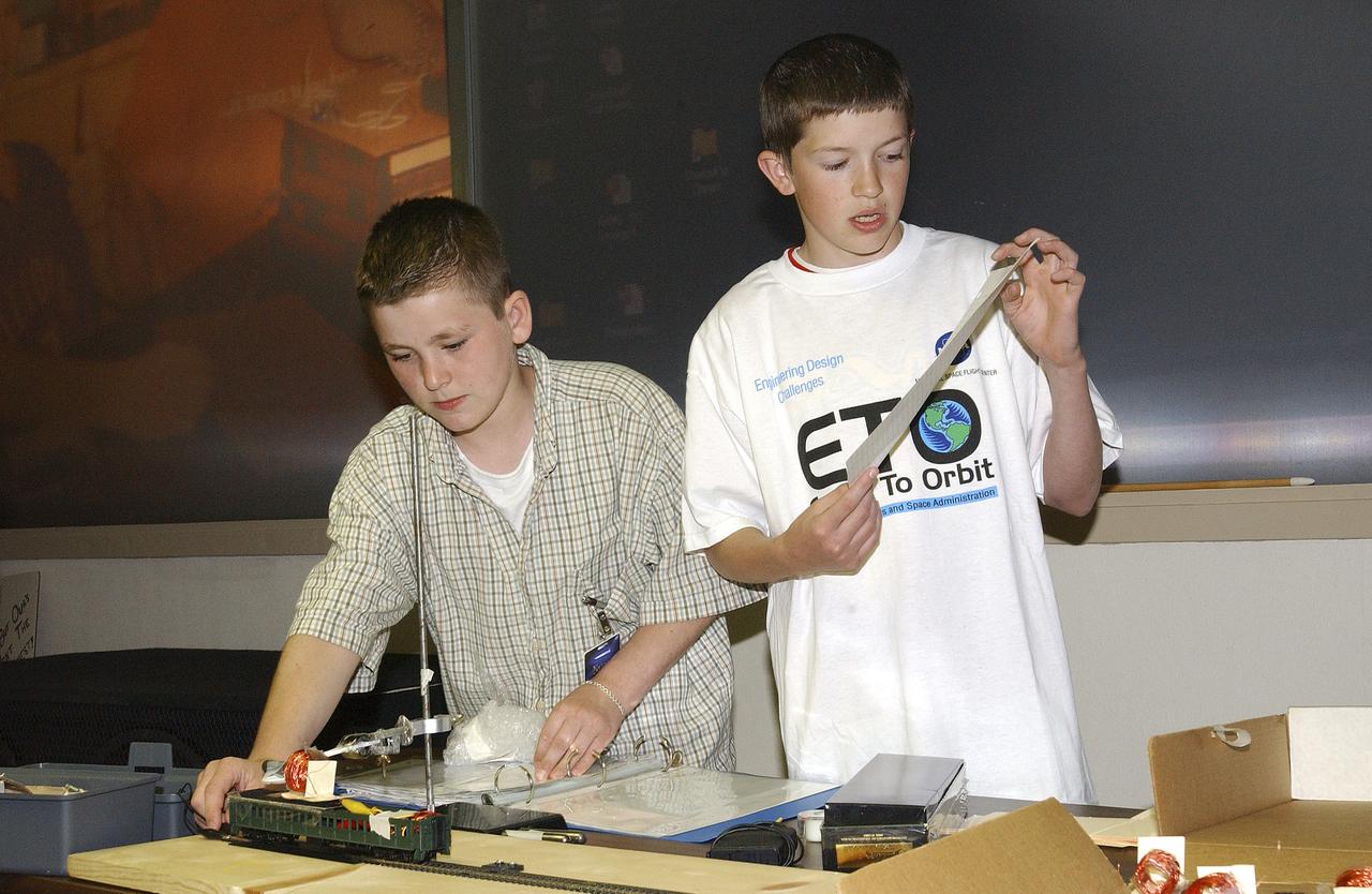
In this photograph, Jeff Alden (left) and Justin O'Cornor, two middle school students at Lane Middle School in Portland, Oregon are demonstrating their Earth-to-Orbit (ETO) Design Challenge project at NASA Marshall Space Flight Center (MSFC) in Huntsville, Alabama. Jeff and Justin, who are just a couple of "typical teens," have been spending their time tackling some of the same challenges NASA engineers face when designing propulsion systems at MSFC. The ETO Design Challenge is a hands-on educational program, targeted to middle school students, in which students are assigned a project engaging in related design challenges in their classrooms under the supervision of their teachers. The project is valuable because it can be used by any student and any teacher, even those without technical backgrounds. Students in 12 states: Alabama, Arkansas, California, Colorado, Illinois, Missouri, Montana, New York, Ohio, Tennessee, Virginia, and Washington, are taking part in the MSFC's Earth-to-Orbit program. NASA uses such programs to support educational excellence while participating in educational outreach programs through centers around the country. The Oregon students' teacher, Joanne Fluvog, commented, "the biggest change I've seen is in the students' motivation and their belief in their ability to think." Both Justin and Jeff said being involved in a real engineering project has made them realize that "science is cool."
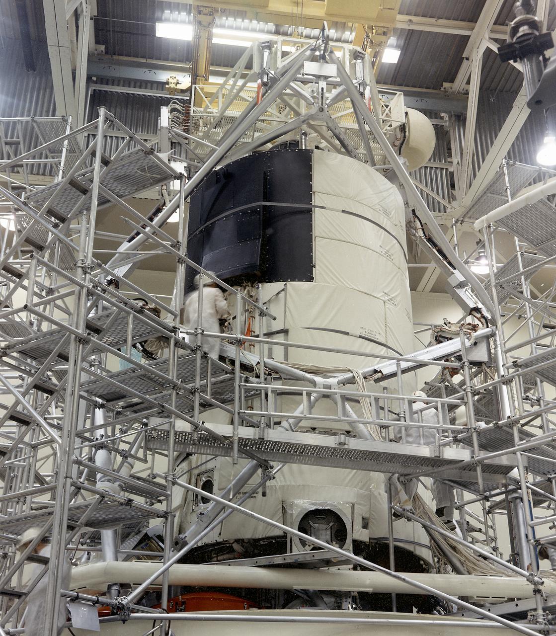
This photograph shows the flight article of the Airlock Module (AM)/Multiple Docking Adapter (MDA) assembly being readied for testing in a clean room at the McDornell Douglas Plant in St. Louis, Missouri. Although the AM and the MDA were separate entities, they were in many respects simply two components of a single module. The AM enabled crew members to conduct extravehicular activities outside Skylab as required for experiment support. Oxygen and nitrogen storage tanks needed for Skylab's life support system were mounted on the external truss work of the AM. Major components in the AM included Skylab's electric power control and distribution station, environmental control system, communication system, and data handling and recording systems. The MDA, forward of the AM, provided docking facilities for the Command and Service Module. It also accommodated several experiment systems, among them the Earth Resource Experiment Package, the materials processing facility, and the control and display console needed for the Apollo Telescope Mount solar astronomy studies. The AM was built by McDonnell Douglas and the MDA was built by Martin Marietta. The Marshall Space Flight Center was responsible for the design and development of the Skylab hardware and experiment management.
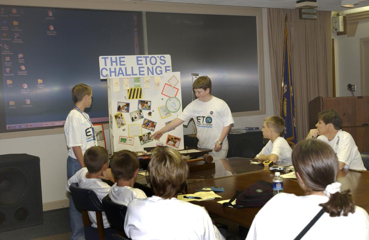
In this photograph, students from all over the country gathered and discussed their Earth-to-Orbit (ETO) Design Challenge project at NASA Marshall Space Flight Center in Huntsville, Alabama. These students who are just "typical teens," have been spending their time tackling some of the same challenges NASA engineers face when designing propulsion systems at MSFC. The ETO Design Challenge is a hands-on educational program, targeted to middle school students, in which students are assigned a project engaging in related design challenges in their classrooms under the supervision of their teachers. The project is valuable because it can be used by any student, and any teacher, even those without technical backgrounds. Student in 12 states: Alabama, Arkansas, California, Colorado, Illinois, Missouri, Montana, New York, Ohio, Ternessee, Virginia, and Washington, are taking part in MSFC's Earth-to-Orbit program. NASA uses such programs to support educational excellence while participating in educational outreach programs through centers around the country. One of the students' teachers, Joanne Fluvog, commented, "the biggest change I've seen is in the students' motivation and their belief in their ability to think." Justin O'Connor and Jeff Alden, students of Lane Middle School in Portland, Oregon, participated in the ETO program and said being involved in a real engineering project has made them realize that "science is cool."

This image from NOAA's GOES satellite shows the swaths of snow across the Midwest after the weekend storms (December 7 and 8) there. This visible image was captured at 1745 UTC/12:45 p.m. EST on December 10, 2013. The riverine topography is highlighted by the snowfall, and the forested Ozarks appear as a dark patch west of St. Louis, Missouri. The image was created by NASA's GOES Project at NASA's Goddard Space Flight Center in Greenbelt, Md. For more information about GOES, visit: <a href="http://www.nasa.gov/goes" rel="nofollow">www.nasa.gov/goes</a>. Credit: NASA Goddard/Dennis Chesters <b><a href="http://www.nasa.gov/audience/formedia/features/MP_Photo_Guidelines.html" rel="nofollow">NASA image use policy.</a></b> <b><a href="http://www.nasa.gov/centers/goddard/home/index.html" rel="nofollow">NASA Goddard Space Flight Center</a></b> enables NASA’s mission through four scientific endeavors: Earth Science, Heliophysics, Solar System Exploration, and Astrophysics. Goddard plays a leading role in NASA’s accomplishments by contributing compelling scientific knowledge to advance the Agency’s mission. <b>Follow us on <a href="http://twitter.com/NASA_GoddardPix" rel="nofollow">Twitter</a></b> <b>Like us on <a href="http://www.facebook.com/pages/Greenbelt-MD/NASA-Goddard/395013845897?ref=tsd" rel="nofollow">Facebook</a></b> <b>Find us on <a href="http://instagram.com/nasagoddard?vm=grid" rel="nofollow">Instagram</a></b>
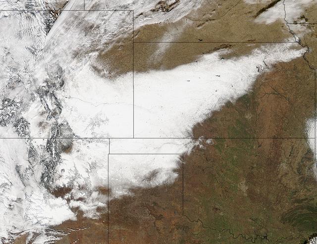
Winter arrived officially on Dec. 22 at 12:35 a.m. EST, but the U.S. Plains states received an early and cool welcome on Dec. 19 from heavy snowfall that was seen by a NASA satellite. NASA's Aqua satellite passed overhead on Dec. 21 at 20:05 UTC (3:05 p.m. EST) and the Moderate Resolution Imaging Spectroradiometer (MODIS) instrument aboard NASA's Aqua satellite captured a visible image of snow blanketing the ground through west and central Kansas, eastern and central Colorado, much of New Mexico, northern Texas and the panhandle of Oklahoma. According to CBS News, blizzard conditions were reported in northern New Mexico, the Texas Panhandle, Oklahoma and northwestern Kansas. The Associated Press reported snow drifts as high as 10 feet in southeast Colorado. Six people lost their lives in traffic accidents from this storm. Heavy snow is expected again today, Dec. 22 in New Mexico and Colorado. Snow is also expected to stretch across the plains into the upper Midwest today, according to the National Weather Service. Portions of many states are expecting some snow today, including the four corners states, north Texas, Kansas, southern Nebraska, western Oklahoma, northern Missouri, Iowa, northern Illinois and southern Wisconsin stretching east into northern New England. The first day of the winter season occurs when the sun is farthest south, either Dec. 21 or 22. The day is also known as the winter solstice. By the second day of winter, NASA's Aqua satellite is going to have a lot more snowfall to observe. Image Credit: NASA Goddard MODIS Rapid Response Team Caption: NASA, Rob Gutro <b><a href="http://www.nasa.gov/audience/formedia/features/MP_Photo_Guidelines.html" rel="nofollow">NASA image use policy.</a></b> <b><a href="http://www.nasa.gov/centers/goddard/home/index.html" rel="nofollow">NASA Goddard Space Flight Center</a></b> enables NASA’s mission through four scientific endeavors: Earth Science, Heliophysics, Solar System Exploration, and Astrophysics. Goddard plays a leading role in NASA’s accomplishments by contributing compelling scientific knowledge to advance the Agency’s mission. <b>Follow us on <a href="http://twitter.com/NASA_GoddardPix" rel="nofollow">Twitter</a></b> <b>Like us on <a href="http://www.facebook.com/pages/Greenbelt-MD/NASA-Goddard/395013845897?ref=tsd" rel="nofollow">Facebook</a></b> <b>Find us on <a href="http://instagrid.me/nasagoddard/?vm=grid" rel="nofollow">Instagram</a></b>
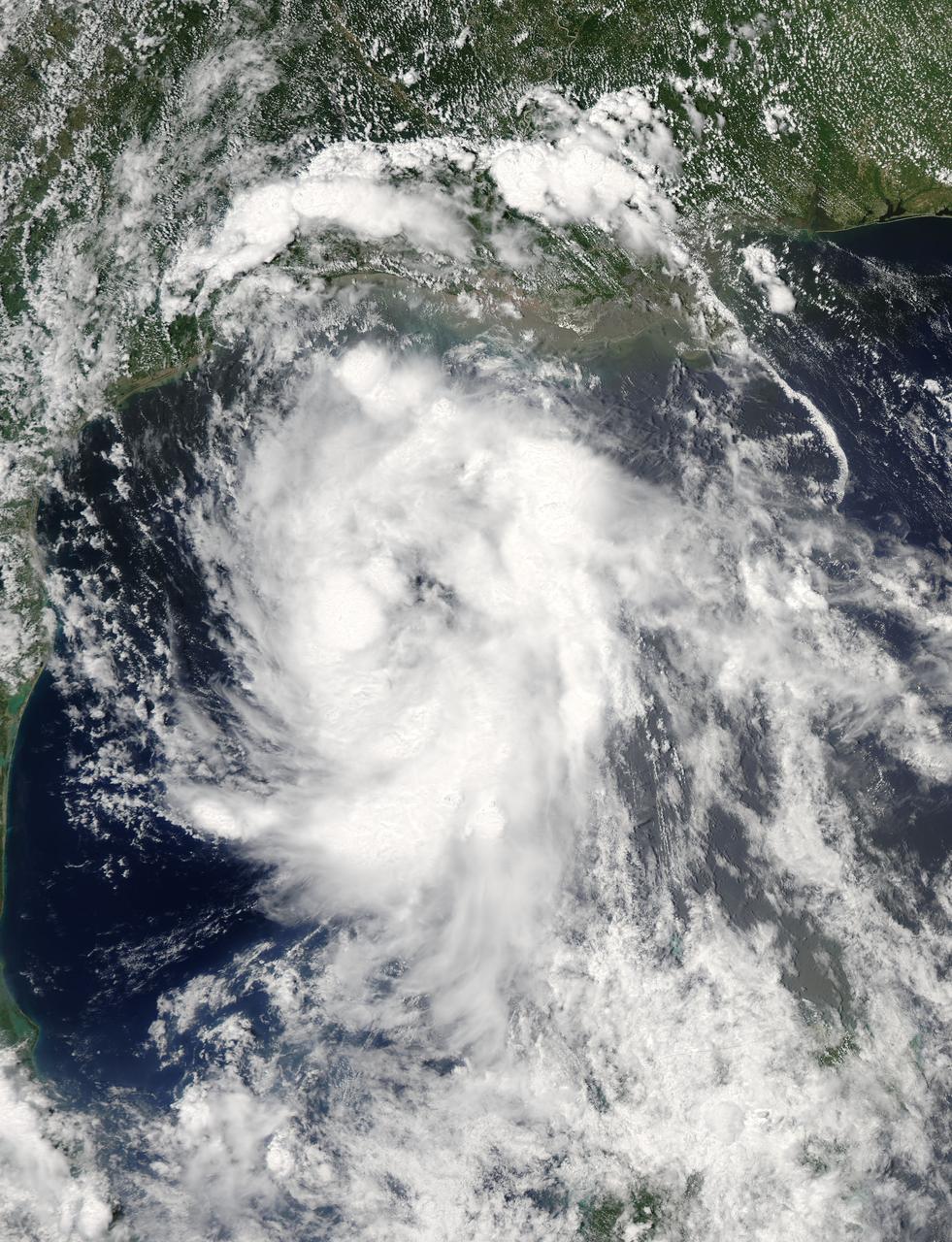
On June 15 at 19:15 UTC (3:15 p.m. EDT) the MODIS instrument aboard NASA's Aqua satellite captured a visible image of Tropical Storm Bill approaching Texas and Louisiana. Powerful thunderstorms circled the center in fragmented bands. At 11 a.m. CDT on June 16, a Tropical Storm Warning was in effect from Baffin Bay to High Island Texas as Bill was making landfall. The National Hurricane Center noted that Bill is expected to produce total rain accumulations of 4 to 8 inches over eastern Texas and eastern Oklahoma and 2 to 4 inches over western Arkansas and southern Missouri, with possible isolated maximum amounts of 12 inches in eastern Texas. In eastern Texas and far western Louisiana today and tonight, isolated tornadoes are also possible, as with any landfalling tropical storm. Tropical storm conditions are expected to continue into the evening in the warning area. Along the coasts, the combination of a storm surge and the tide will cause normally dry areas near the coast to be flooded by rising waters. The water could reach the following heights above ground if the peak surge occurs at the time of high tide. The NHC noted that the Upper Texas coast could experience 2 to 4 feet, and the western Louisiana coast between 1 to 2 feet. At 10 a.m. CDT (1500 UTC), the center of Tropical Storm Bill was located near latitude 28.2 North, longitude 96.4 West. Bill was moving toward the northwest near 10 mph (17 kph) and that general motion is expected to continue today. The latest minimum central pressure reported by an Air Force Reserve Hurricane Hunter aircraft was 997 millibars. Reports from an Air Force Reserve reconnaissance aircraft indicate that maximum sustained winds remain near 60 mph (95 kph) with higher gusts. Unlike Carlos, Bill is not a compact storm. Tropical-storm-force winds extend outward up to 150 miles (240 km) from the center. Between 9 and 10 a.m. CDT, an automated observing station at Port O'Connor also reported a sustained wind of 44 mph (70 kph) and a gust to 53 mph (85 kph). For updated forecasts, watches and warnings, visit the National Hurricane Center webpage at <a href="http://www.nhc.noaa.gov" rel="nofollow">www.nhc.noaa.gov</a>. For local forecasts and advisories, visit: <a href="http://www.weather.gov" rel="nofollow">www.weather.gov</a>. Bill is forecast to continue moving inland and is expected to be a tropical depression by Wednesday, June 17, west of Dallas. The remnants of Bill are forecast to move into the Midwest later in the week. Credit: NASA/GSFC/Jeff Schmaltz/MODIS Land Rapid Response Team <b><a href="http://www.nasa.gov/audience/formedia/features/MP_Photo_Guidelines.html" rel="nofollow">NASA image use policy.</a></b> <b><a href="http://www.nasa.gov/centers/goddard/home/index.html" rel="nofollow">NASA Goddard Space Flight Center</a></b> enables NASA’s mission through four scientific endeavors: Earth Science, Heliophysics, Solar System Exploration, and Astrophysics. Goddard plays a leading role in NASA’s accomplishments by contributing compelling scientific knowledge to advance the Agency’s mission. <b>Follow us on <a href="http://twitter.com/NASAGoddardPix" rel="nofollow">Twitter</a></b> <b>Like us on <a href="http://www.facebook.com/pages/Greenbelt-MD/NASA-Goddard/395013845897?ref=tsd" rel="nofollow">Facebook</a></b> <b>Find us on <a href="http://instagrid.me/nasagoddard/?vm=grid" rel="nofollow">Instagram</a></b>

The Polar Vortex is a whirling and persistent large area of low pressure, found typically over both north and south poles. The northern Polar Vortex is pushing southward over western Wisconsin/eastern Minnesota today, Monday, January 6, 2014 and is bringing frigid temperatures to half of the continental United States. It is expected to move northward back over Canada toward the end of the week. This image was captured by NOAA's GOES-East satellite on January 6, 2014 at 1601 UTC/11:01 a.m. EST. A frontal system that brought rain to the coast is draped from north to south along the U.S. East Coast. Behind the front lies the clearer skies bitter cold air associated with the Polar Vortex. The GOES image also revealed snow on the ground in Minnesota, Wisconsin, Illinois, Indiana, Ohio, Michigan, Iowa and Missouri, stretching into the Great Plains. Cloudiness over Texas is associated with a low pressure system centered over western Oklahoma that is part of the cold front connected to the movement of the Polar Vortex. The GOES image was created at NASA's GOES Project, located at NASA's Goddard Space Flight Center in Greenbelt, Md. Both the northern and southern polar vortices are located in the middle and upper troposphere (lowest level of the atmosphere) and the stratosphere (next level up in the atmosphere). The polar vortex is a winter phenomenon. It develops and strengthens in its respective hemisphere's winter as the sun sets over the polar region and temperatures cool. They weaken in the summer. In the northern hemisphere, they circulate in a counter-clockwise direction, so the vortex sitting over western Wisconsin is sweeping in cold Arctic air around it. The Arctic Polar Vortex peaks in the Northern Hemisphere's wintertime and has already moved southward several times this winter. In the past, it has also moved southward over Europe.On January 21, 1985, the National Oceanic and Atmospheric Administration Daily Weather Map series showed a strong polar vortex centered over Maine. The Polar Vortex also affects ozone. For more information on the Polar Vortex and how it affects ozone, visit NASA's Ozone Watch page: <a href="http://ozonewatch.gsfc.nasa.gov/facts/vortex_NH.html" rel="nofollow">ozonewatch.gsfc.nasa.gov/facts/vortex_NH.html</a> Rob Gutro NASA's Goddard Space Flight Center <b><a href="http://goes.gsfc.nasa.gov/" rel="nofollow">Credit: NOAA/NASA GOES Project</a></b> <b><a href="http://www.nasa.gov/audience/formedia/features/MP_Photo_Guidelines.html" rel="nofollow">NASA image use policy.</a></b> <b><a href="http://www.nasa.gov/centers/goddard/home/index.html" rel="nofollow">NASA Goddard Space Flight Center</a></b> enables NASA’s mission through four scientific endeavors: Earth Science, Heliophysics, Solar System Exploration, and Astrophysics. Goddard plays a leading role in NASA’s accomplishments by contributing compelling scientific knowledge to advance the Agency’s mission. <b>Follow us on <a href="http://twitter.com/NASA_GoddardPix" rel="nofollow">Twitter</a></b> <b>Like us on <a href="http://www.facebook.com/pages/Greenbelt-MD/NASA-Goddard/395013845897?ref=tsd" rel="nofollow">Facebook</a></b> <b>Find us on <a href="http://instagram.com/nasagoddard?vm=grid" rel="nofollow">Instagram</a></b>
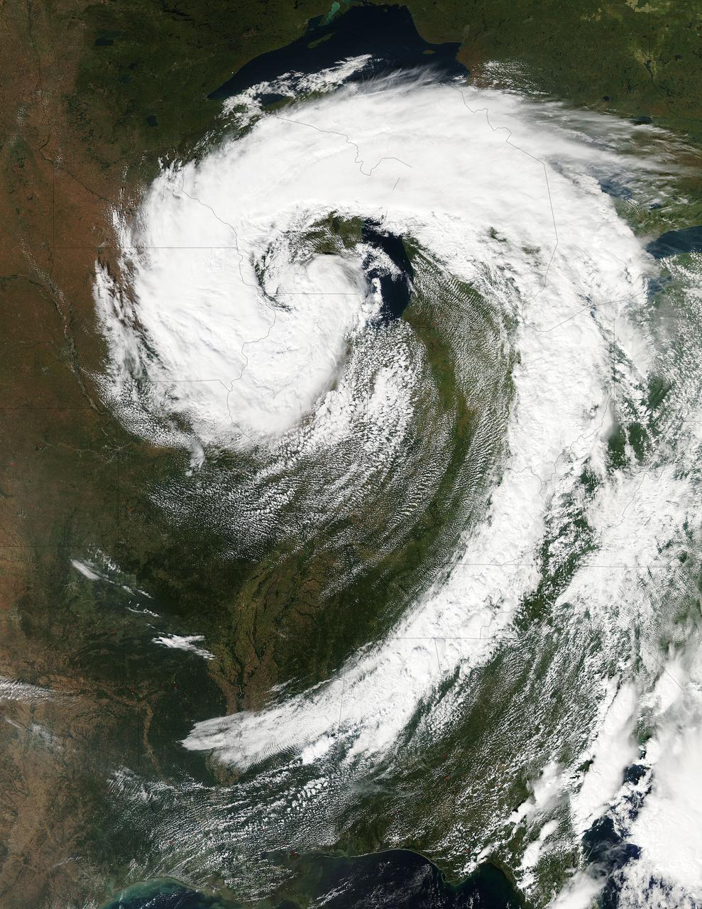
This visible image of the Great Lakes low pressure area was taken from the Moderate Resolution Imaging Spectroradiometer (MODIS) instrument on NASA's Aqua satellite. It was taken at 19:05 UTC (3:05 p.m. EDT) on Monday, Sept. 26, 2011. Credit: NASA Goddard MODIS Rapid Response Team Two Instruments on NASA's Aqua Satellite Catch the Pesky Great Lakes Low A low pressure area has been sitting over the Great Lakes region for about a week now, keeping the region and the U.S. northeast and Mid-Atlantic under cloud cover. NASA's Aqua satellite flew over head yesterday, Sept. 26, and captured two views of it from space. That low pressure area continues to spin counter-clockwise today over the Great Lakes. Its centered over northern Illinois and southeastern Wisconsin and is once again going to keep the region cloudy, cool and wet with showers. When the Aqua satellite passed overhead Monday afternoon at 3:05 p.m. EDT (Sept. 26) a detailed, clear image was captured from the Moderate Resolution Imaging Spectroradiometer (MODIS) instrument . The clouds from the low spread over Illinois, Wisconsin, parts of Iowa, northeastern Missouri, southeastern Minnesota, Michigan, Ohio, Indiana, Pennsylvania, Kentucky, Tennessee, Alabama, Mississippi, Georgia, and the northeastern and Mid-Atlantic states. A second visible image was captured by the Atmospheric Infrared Sounder (AIRS) instrument that also flies aboard NASA's Aqua satellite and showed the huge comma shape of the storm that spans the U.S. from its northern to southern borders. (seen here: <a href="http://www.flickr.com/photos/gsfc/6188946564">www.flickr.com/photos/gsfc/6188946564</a> ) According to the National Weather Service, the low will finally start moving to the east as an upper-atmospheric trough (an elongated area of low pressure) continues to strengthen and move into the upper Midwest. However, a ridge (elongated area) of high pressure will slow its move eastward, so it will be slow clearing this week in the northeastern and Mid-Atlantic U.S. Rob Gutro NASA's Goddard Space Flight Center <b><a href="http://www.nasa.gov/audience/formedia/features/MP_Photo_Guidelines.html" rel="nofollow">NASA image use policy.</a></b> <b><a href="http://www.nasa.gov/centers/goddard/home/index.html" rel="nofollow">NASA Goddard Space Flight Center</a></b> enables NASA’s mission through four scientific endeavors: Earth Science, Heliophysics, Solar System Exploration, and Astrophysics. Goddard plays a leading role in NASA’s accomplishments by contributing compelling scientific knowledge to advance the Agency’s mission. <b>Follow us on <a href="http://twitter.com/NASA_GoddardPix" rel="nofollow">Twitter</a></b> <b>Like us on <a href="http://www.facebook.com/pages/Greenbelt-MD/NASA-Goddard/395013845897?ref=tsd" rel="nofollow">Facebook</a></b> <b>Find us on <a href="http://instagrid.me/nasagoddard/?vm=grid" rel="nofollow">Instagram</a></b>

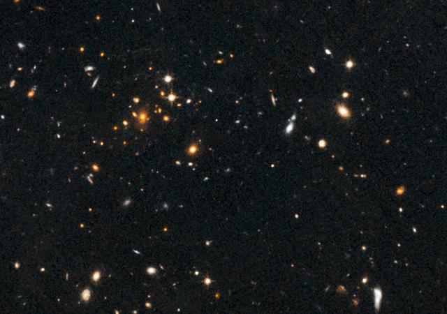
The collection of red dots seen here show one of several very distant galaxy clusters discovered by combining ground-based optical data from the NOAO Kitt Peak National Observatory with infrared data from NASA Spitzer Space Telescope.
Astronomers using NASA Hubble Space Telescope have found a puzzling arc of light behind an extremely massive cluster of galaxies residing 10 billion light-years away.
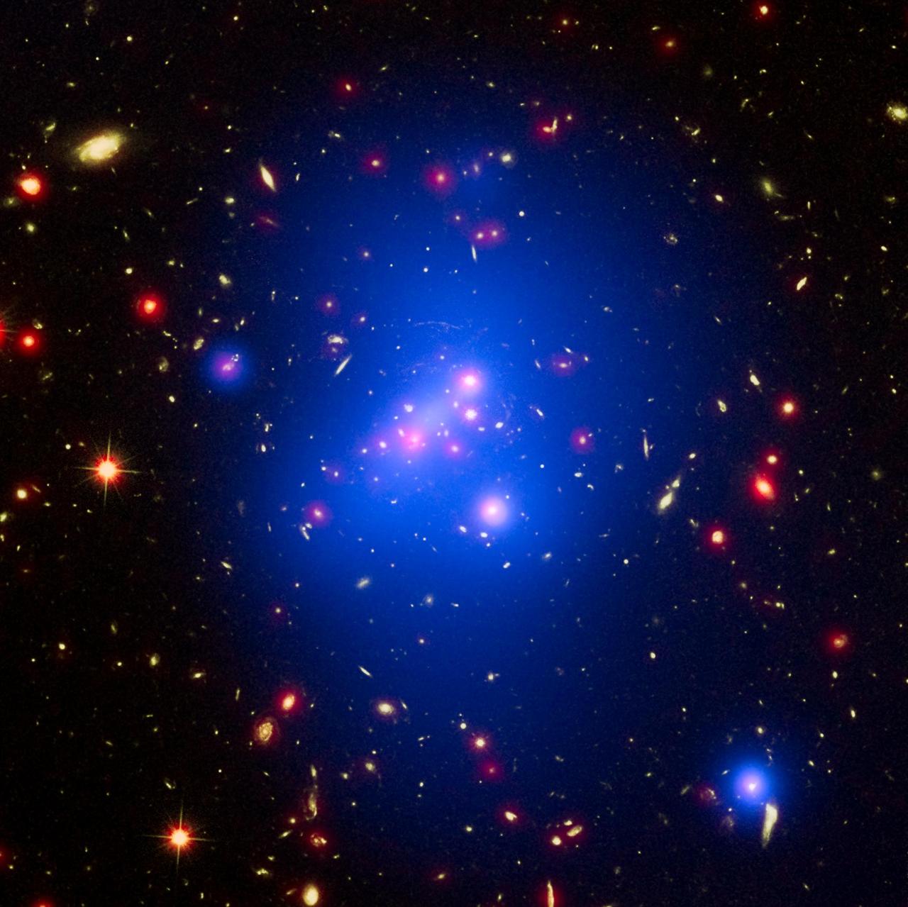
Astronomers have made the most detailed study yet of an extremely massive young galaxy cluster using three of NASA's Great Observatories. This multi-wavelength image shows this galaxy cluster, called IDCS J1426.5+3508 (IDCS 1426 for short), in X-rays recorded by the Chandra X-ray Observatory in blue, visible light observed by the Hubble Space Telescope in green, and infrared light detected by the Spitzer Space Telescope in red. This rare galaxy cluster, which is located 10 billion light-years from Earth, is almost as massive as 500 trillion suns. This object has important implications for understanding how such megastructures formed and evolved early in the universe. The light astronomers observed from IDCS 1426 began its journey to Earth when the universe was less than a third of its current age. It is the most massive galaxy cluster detected at such an early time. First discovered by the Spitzer Space Telescope in 2012, IDCS 1426 was then observed using the Hubble Space Telescope and the Keck Observatory to determine its distance. Observations from the Combined Array for Millimeter-wave Astronomy indicated it was extremely massive. New data from the Chandra X-ray Observatory confirm the galaxy cluster's mass and show that about 90 percent of this mass is in the form of dark matter -- the mysterious substance that has so far been detected only through its gravitational pull on normal matter composed of atoms. http://photojournal.jpl.nasa.gov/catalog/PIA20063