This spaceborne radar image shows how the Atlas Mountains in northwestern Africa dominate the geography of Morocco.
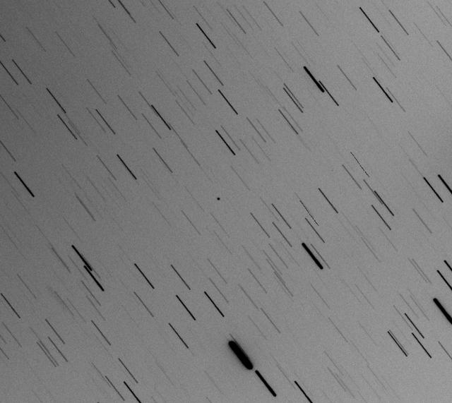
This optical composite image shows asteroid 2017 YE5, taken on June 30, 2018, by the Cadi Ayyad University Morocco Oukaimeden Sky Survey, one of the first surveys to identify 2017 YE5 in December 2017. https://photojournal.jpl.nasa.gov/catalog/PIA22558
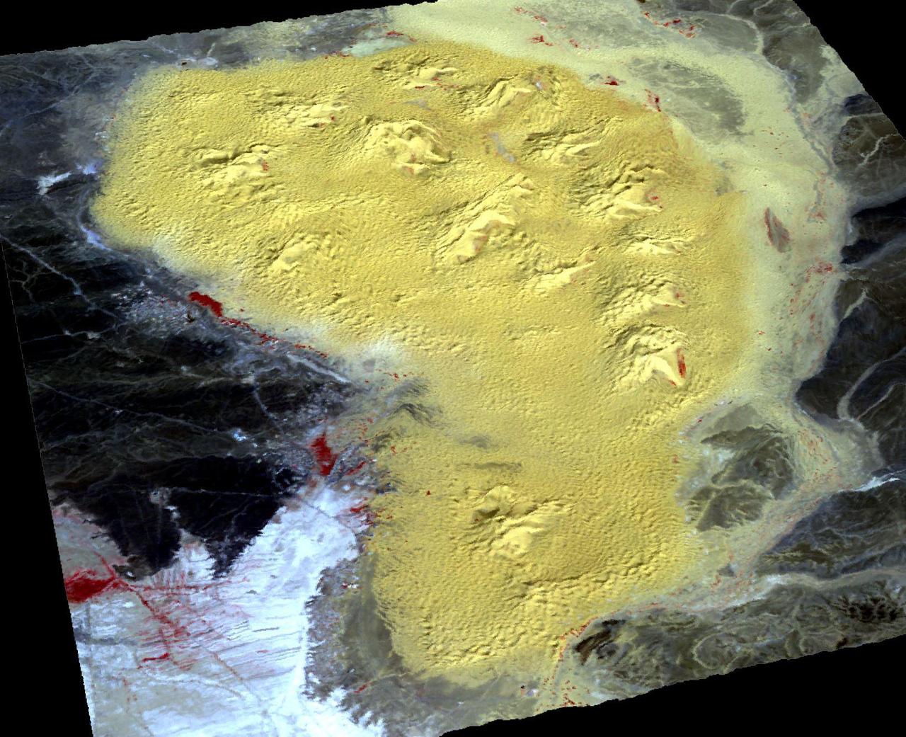
For the first time scientists have calculated the age of star dunes (or pyramid dunes). Some of the tallest – over 100 m high – are located in the Erg Chebbi sand sea in southeast Morocco. Using luminescence dating techniques, the dunes were found to have formed over 13,000 years ago. The perspective view has 5X vertical exaggeration. The image was acquired October 2, 2020, covers an area of 13.5 by 20.4 km, and is located at 31.2 degrees north, 4 degrees west. https://photojournal.jpl.nasa.gov/catalog/PIA26287
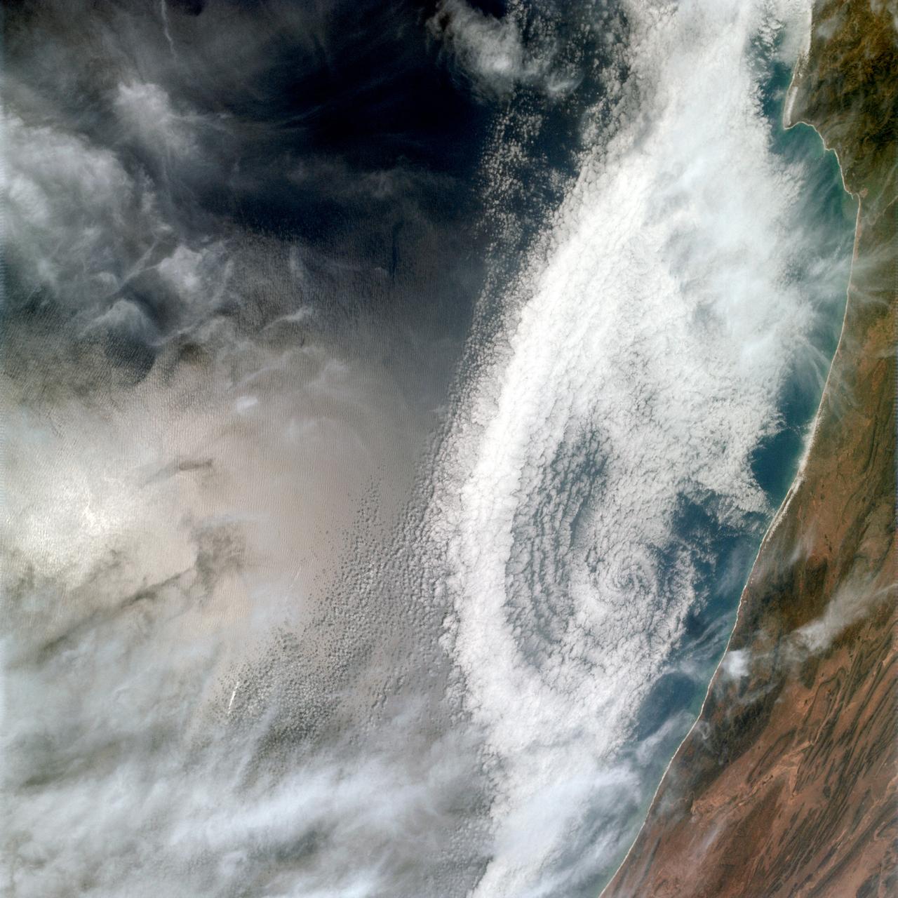
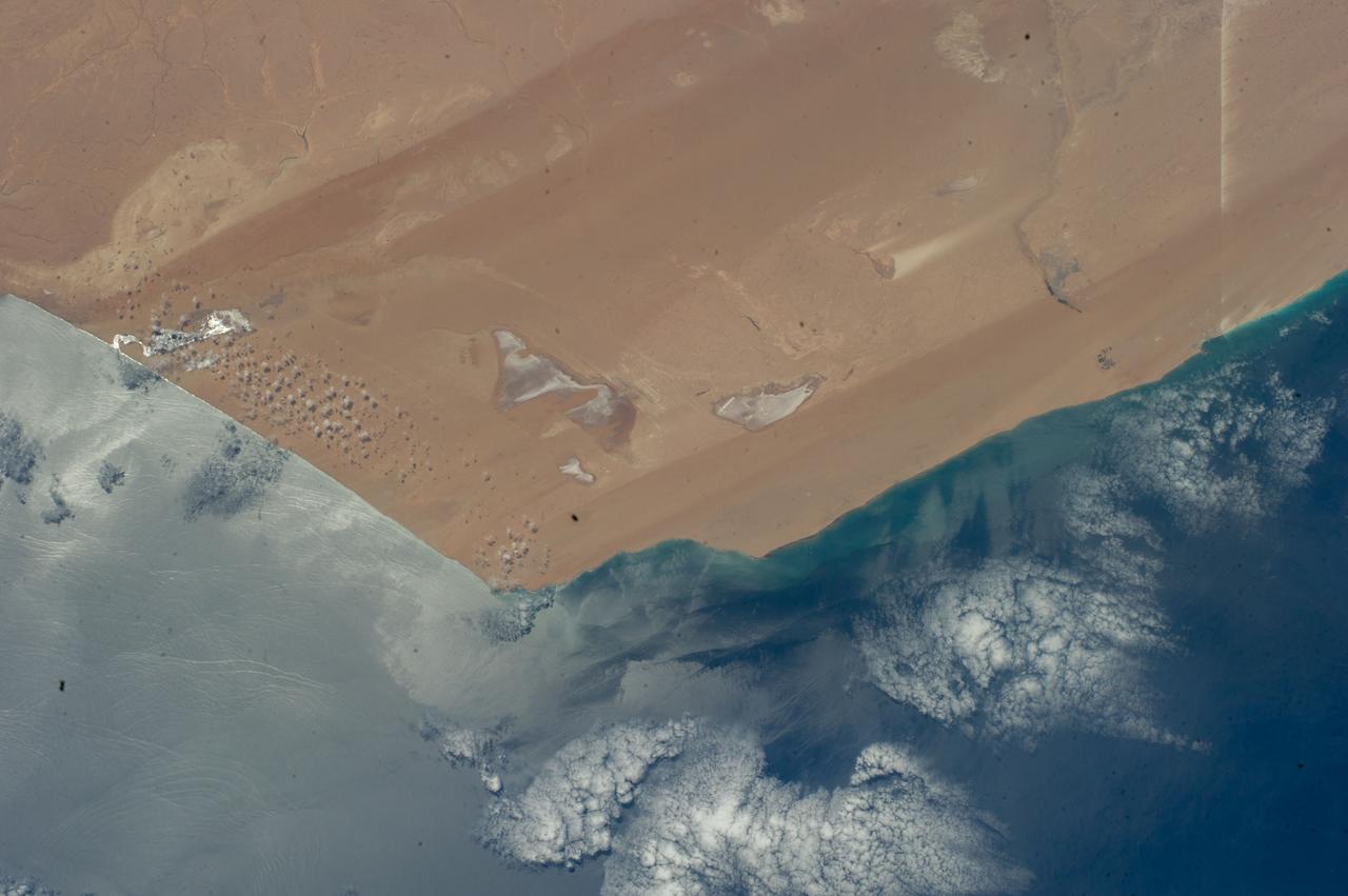
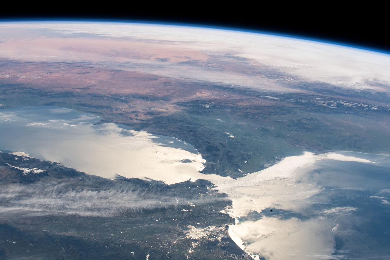
iss071e414090 (July 30, 2024) -- Clouds swirl into the coast of Morocco, hanging low over the Atlantic Ocean, as the International Space Station orbited 258 miles above.
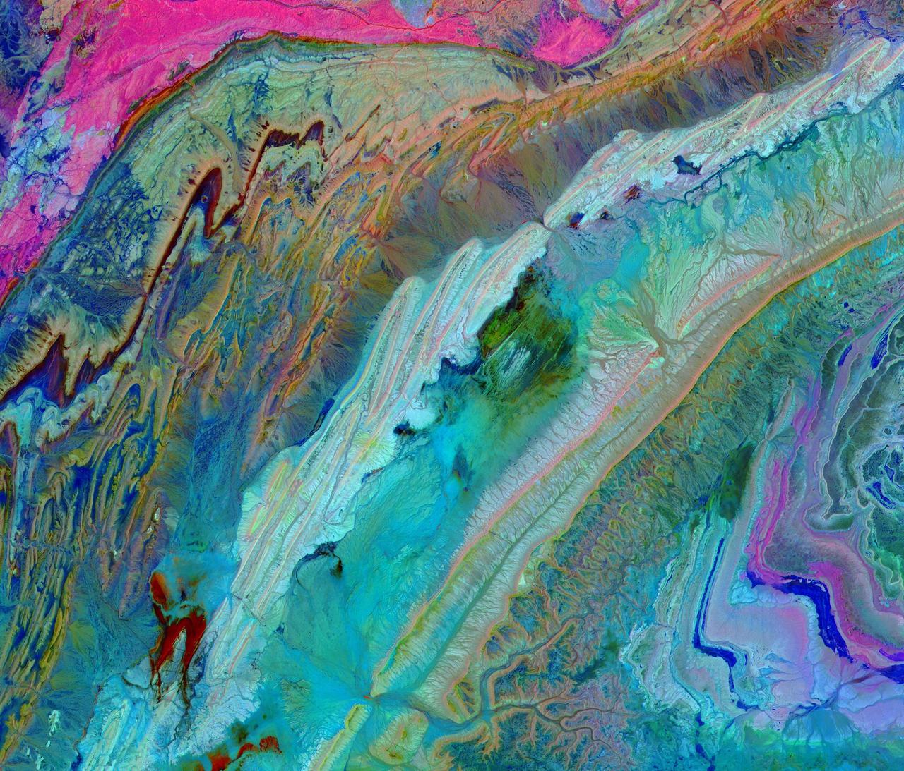
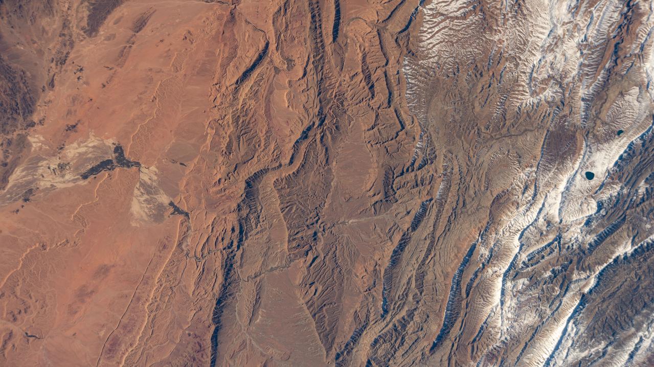
The Anti-Atlas Mountains of Morocco formed as a result of the collision of the African and Eurasian tectonic plates about 80 million years ago. This collision destroyed the Tethys Ocean; the limestone, sandstone, claystone, and gypsum layers that formed the ocean bed were folded and crumpled to create the Anti-Atlas Mountains. In this ASTER image of southwest Morocco, visible, near infrared, and short wavelength infrared bands are combined to dramatically highlight the different rock types, and illustrate the complex folding. The ability to map geology using ASTER data is enhanced by bands that are sensitive to differences in rock mineralogy. The image was acquired on November 5, 2007, covers an area of 51.9 by 60.8 km, and is located at 28.1 degrees north and 10.7 degrees west. With its 14 spectral bands from the visible to the thermal infrared wavelength region and its high spatial resolution of about 50 to 300 feet (15 to 90 meters), ASTER images Earth to map and monitor the changing surface of our planet. ASTER is one of five Earth-observing instruments launched Dec. 18, 1999, on Terra. The instrument was built by Japan's Ministry of Economy, Trade and Industry. A joint U.S./Japan science team is responsible for validation and calibration of the instrument and data products. The broad spectral coverage and high spectral resolution of ASTER provides scientists in numerous disciplines with critical information for surface mapping and monitoring of dynamic conditions and temporal change. Example applications are monitoring glacial advances and retreats; monitoring potentially active volcanoes; identifying crop stress; determining cloud morphology and physical properties; wetlands evaluation; thermal pollution monitoring; coral reef degradation; surface temperature mapping of soils and geology; and measuring surface heat balance. https://photojournal.jpl.nasa.gov/catalog/PIA23533
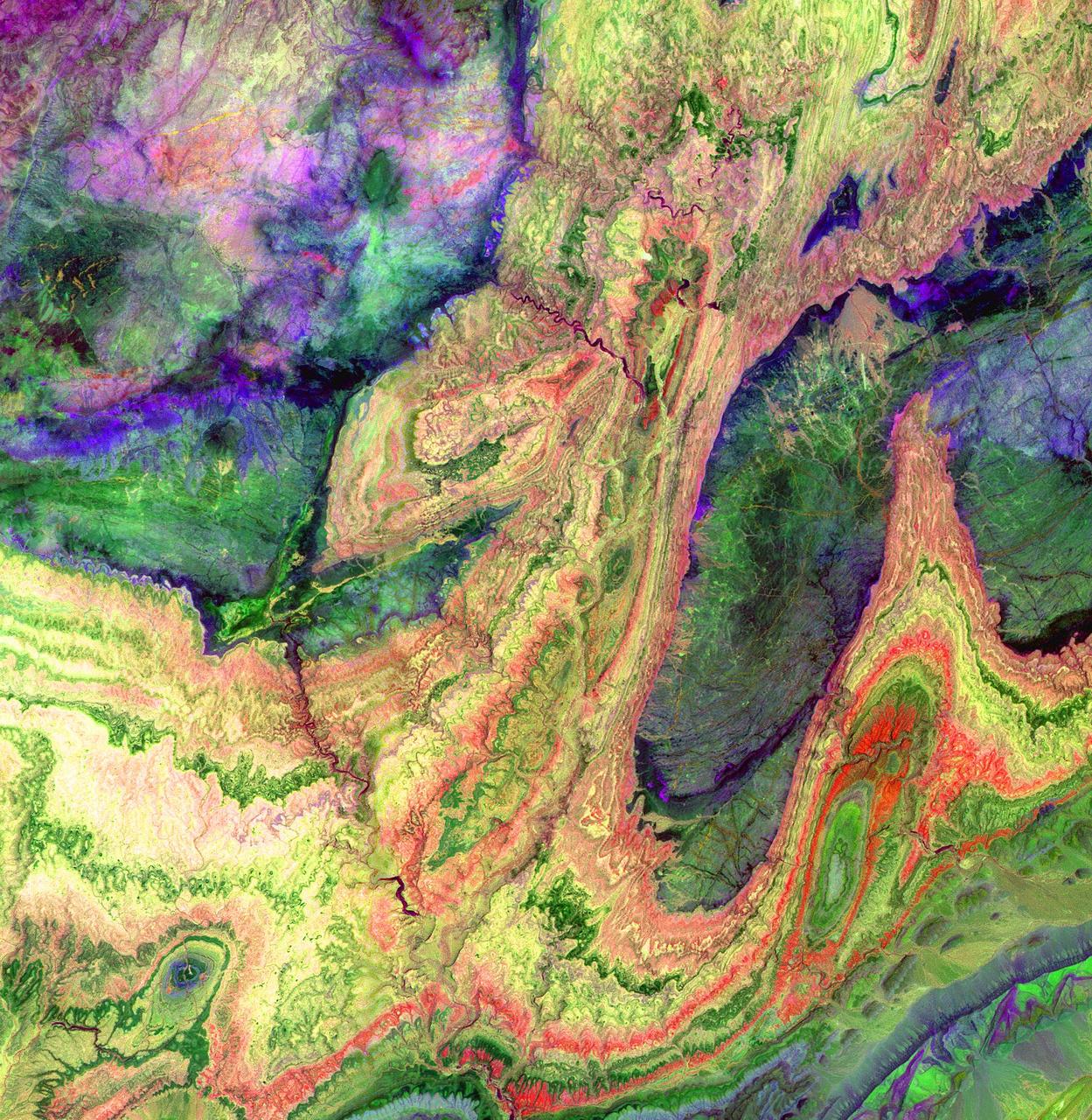
The Anti-Atlas Mountains of Morocco formed as a result of the collision of the African and Eurasian tectonic plates about 80 million years ago. This collision destroyed the Tethys Ocean; the limestone, sandstone, claystone, and gypsum layers that formed the ocean bed were folded and crumpled to create the Atlas and Anti-Atlas Mountains. In this ASTER image, short wavelength infrared bands are combined to dramatically highlight the different rock types, and illustrate the complex folding. The yellowish, orange and green areas are limestones, sandstones and gypsum; the dark blue and green areas are underlying granitic rocks. The ability to map geology using ASTER data is enhanced by the multiple short wavelength infrared bands, that are sensitive to differences in rock mineralogy. This image was acquired on June 13, 2001 by the Advanced Spaceborne Thermal Emission and Reflection Radiometer (ASTER) on NASA's Terra satellite. With its 14 spectral bands from the visible to the thermal infrared wavelength region, and its high spatial resolution of 15 to 90 meters (about 50 to 300 feet), ASTER images Earth to map and monitor the changing surface of our planet. http://photojournal.jpl.nasa.gov/catalog/PIA03893
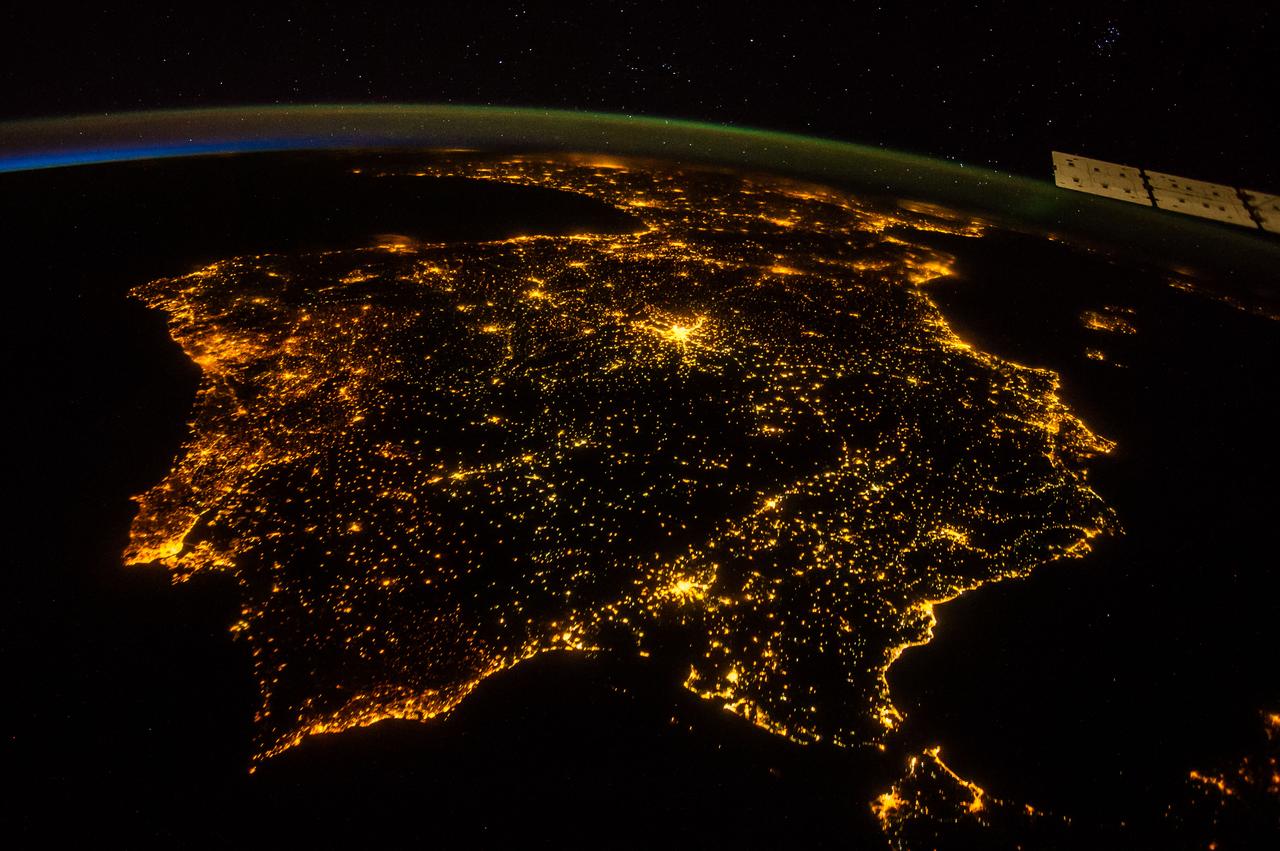
iss073e0686324 (Aug. 30, 2025) --- The nighttime coastal lights of Morocco and Spain, where the Atlantic Ocean meets the Mediterranean Sea at the Strait of Gibraltar, are pictured at approximately 1:36 a.m. local time as the International Space Station orbited 260 miles above the Moroccan coast.
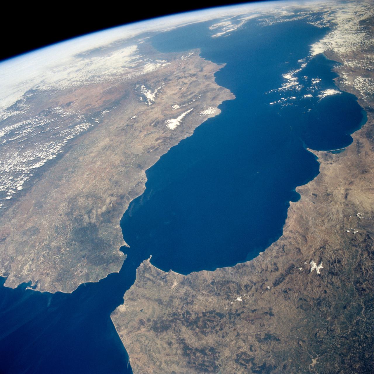
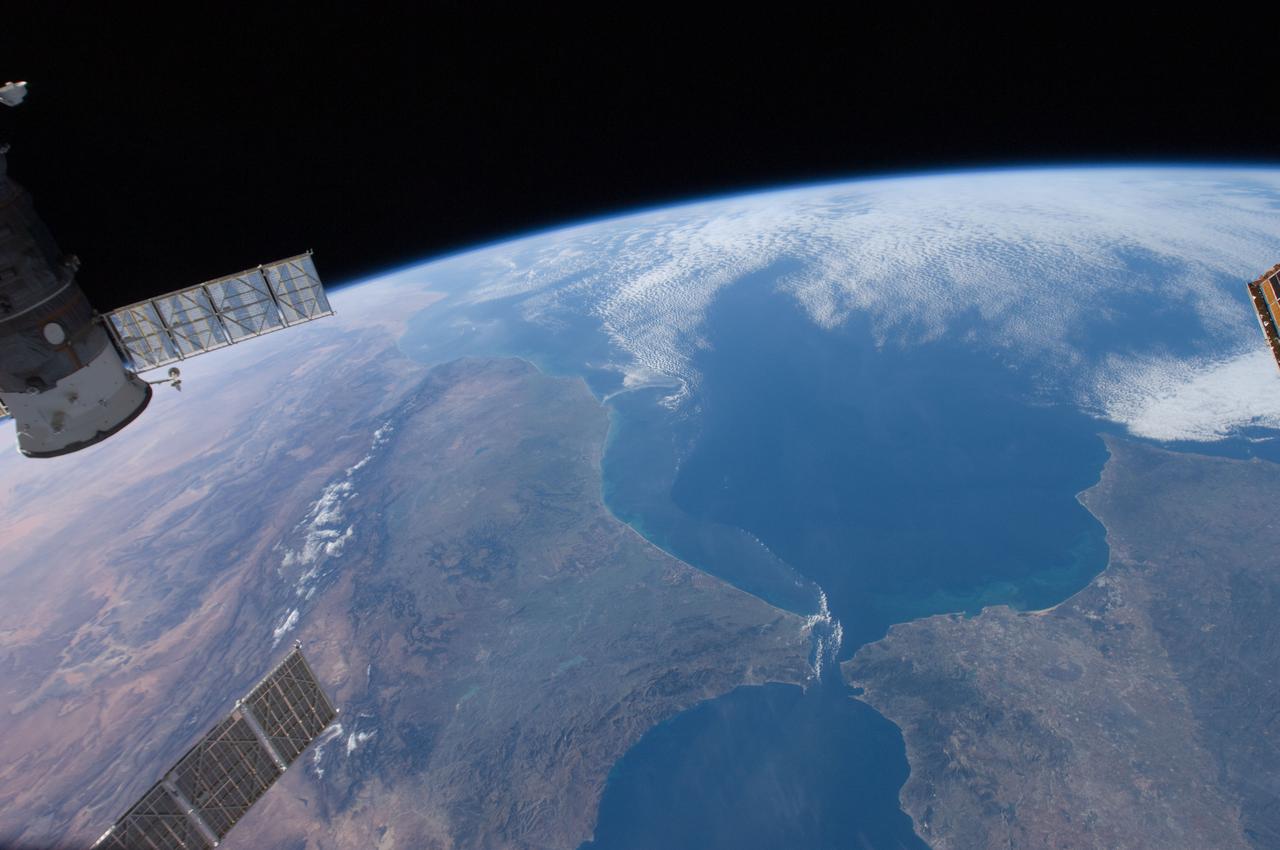
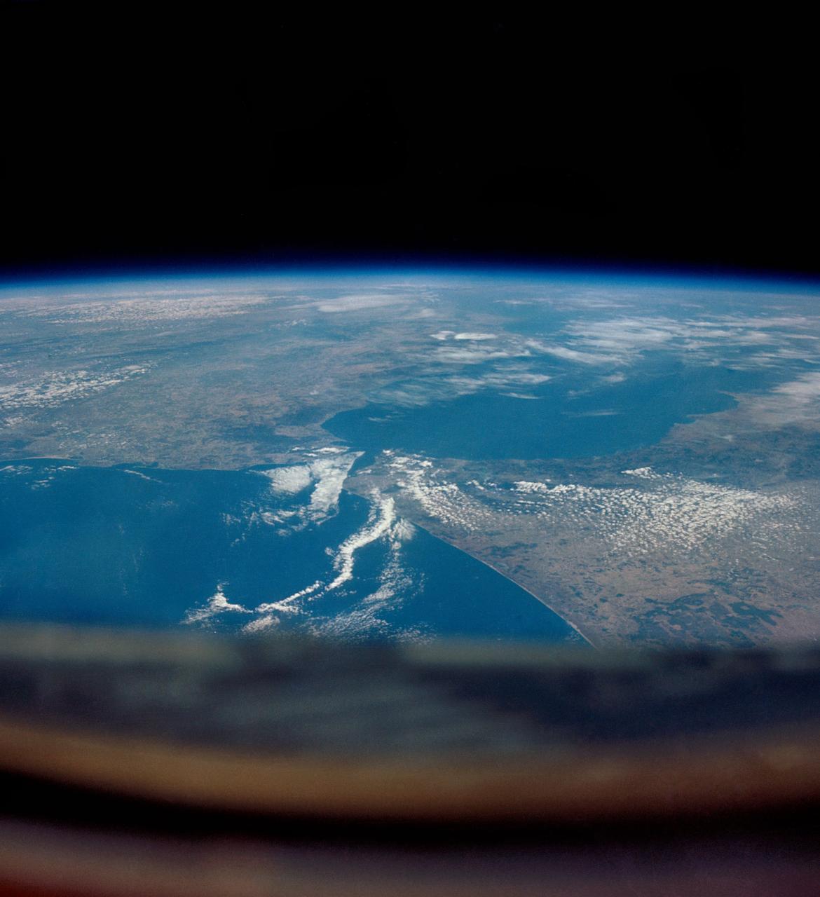
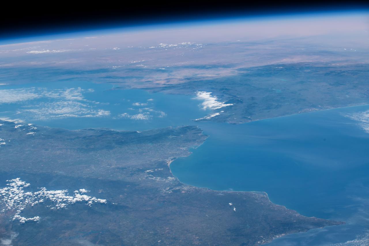
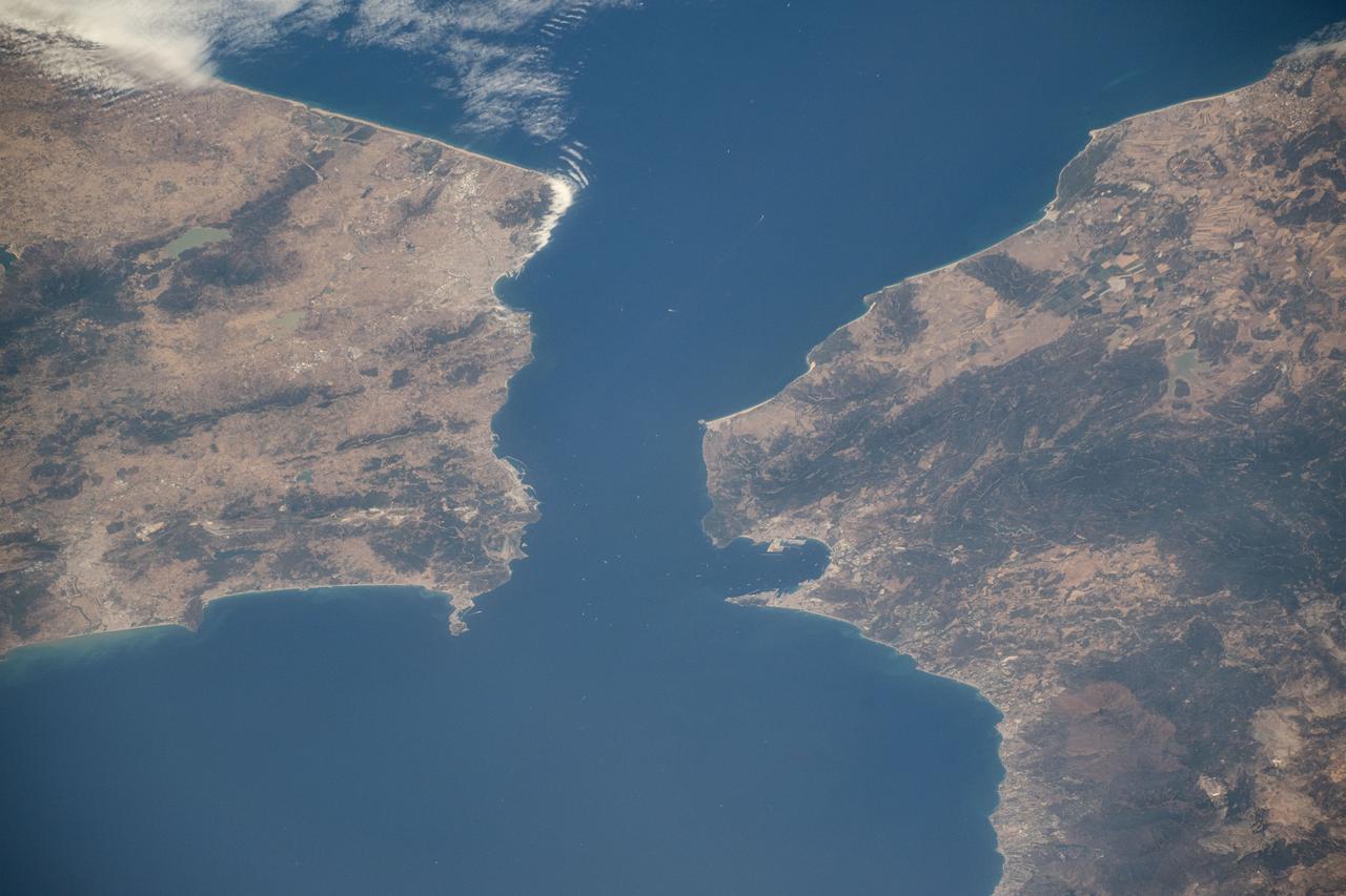
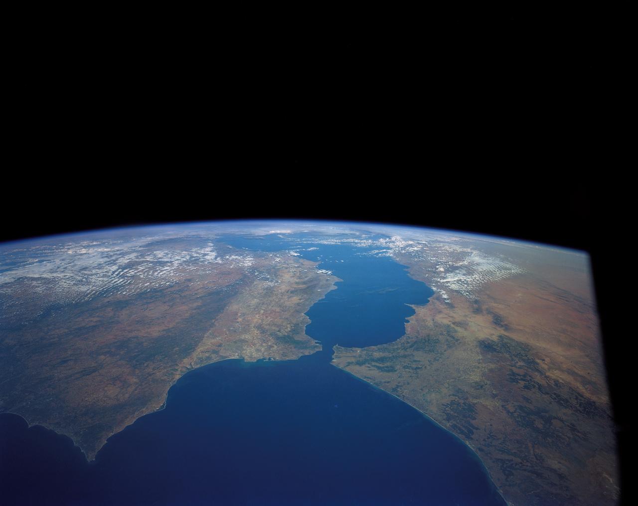
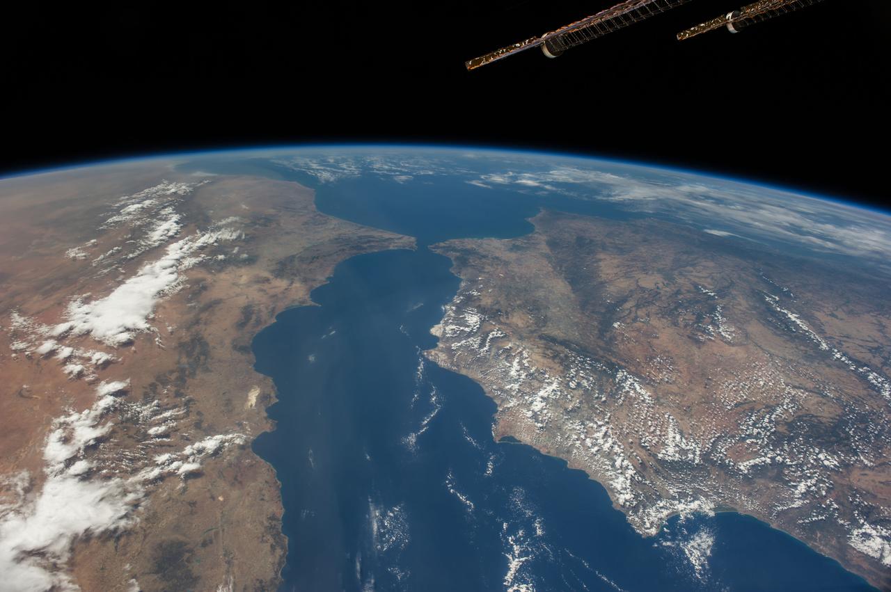
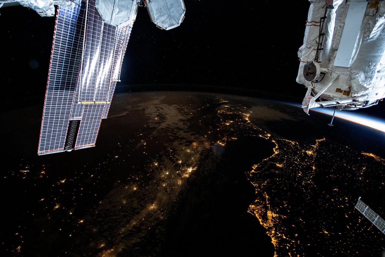
iss071e217183 (June 25, 2024) -- As the International Space Station orbited 263 miles above Earth, NASA astronaut Butch Wilmore captured this image of Spain and Morocco. The Strait of Gibraltar separates the two countries and connects the Atlantic Ocean to the Mediterranean Sea.
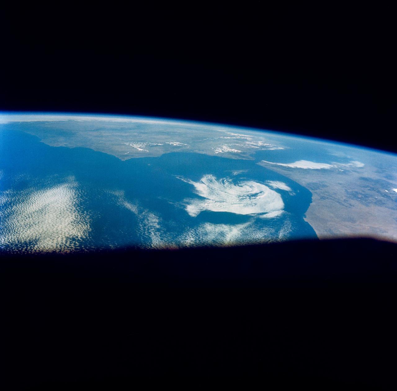
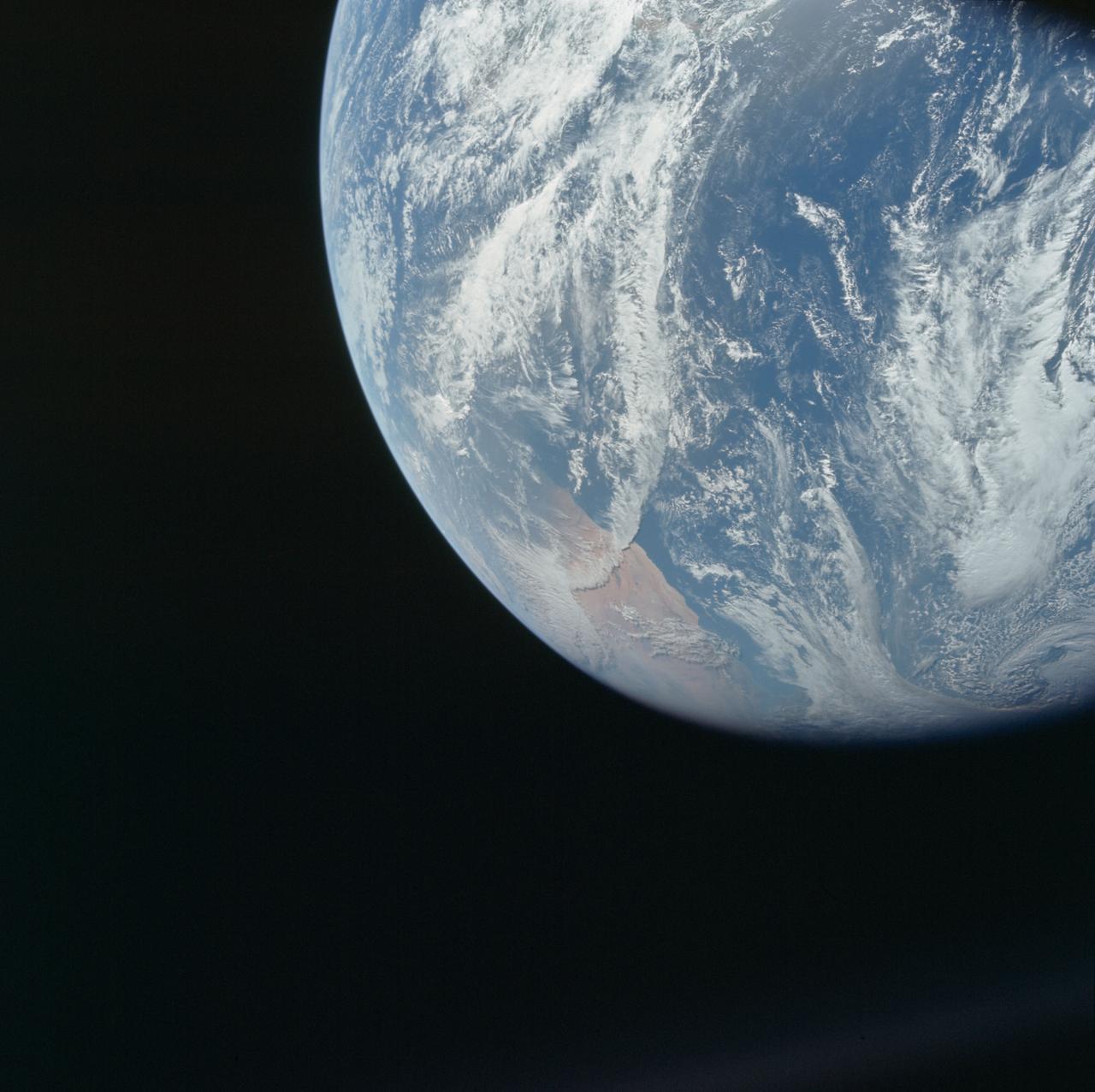
AS09-23-3617 (12 March 1969) --- Morocco, Ifni, cloud eddy over Ras Rhir, as photographed from the Apollo 9 spacecraft during its 134th revolution of Earth.
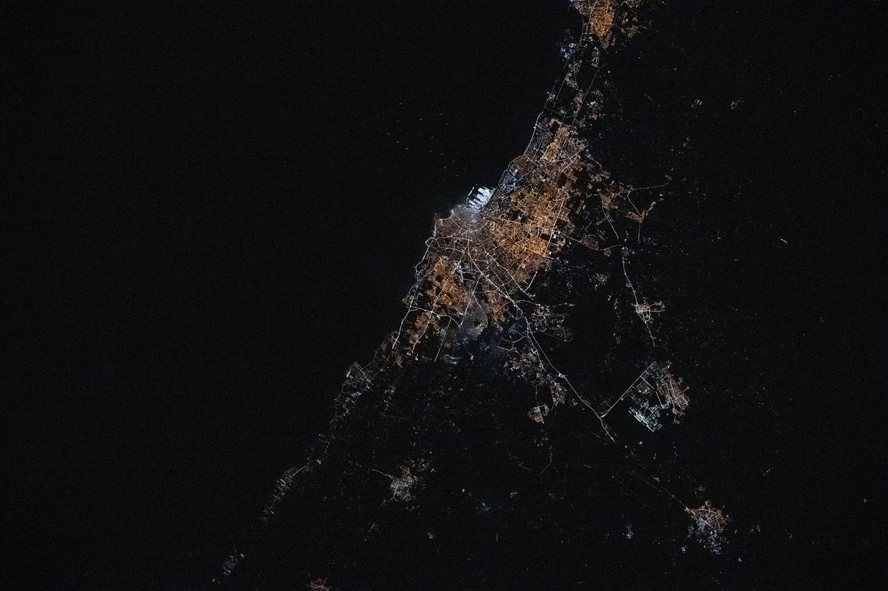
iss072e645691 (Feb. 17, 2025) --- The city lights of Casablanca, Morocco's largest city with a population of over 3.2 million on the Atlantic coast, are pictured at approximately 5:47 a.m. local time from the International Space Station as it orbited 260 miles above the African nation.
S66-45749 (18 July 1966) --- Straits of Gibraltar, Mediterranean Sea, Spain in background, Algeria and Morocco in foreground as seen from Gemini-10 spacecraft. Photo credit: NASA
S66-46044 (18-21 July 1966) --- Straits of Gibraltar and Spain ? Portugal (left), Morocco (right), Atlantic Ocean (foreground), and unique vortex, as seen from the Gemini-10 spacecraft. Taken with J.A. Maurer 70mm camera, using Eastman Kodak, Ektachrome, MS (S.O. 217) color film. Photo credit: NASA
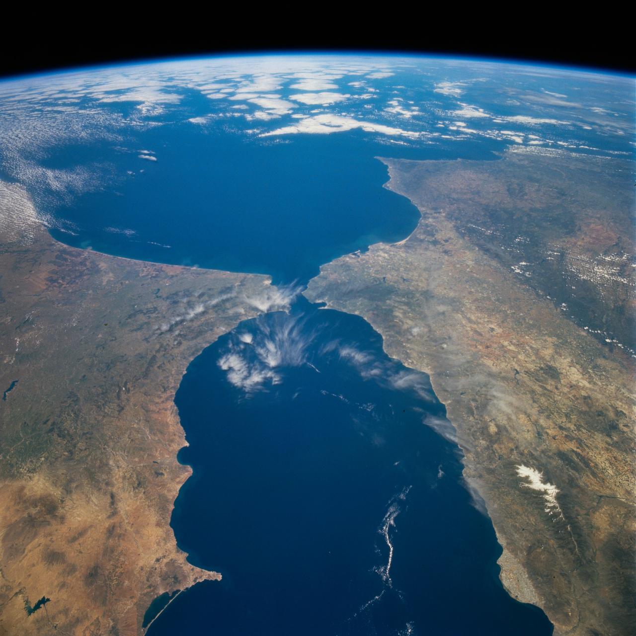
STS059-238-074 (9-20 April 1994) --- The Atlantic Ocean, Straits of Gibraltar, and Alboran Sea (the westernmost portion of the Mediterranean Sea) separate Spain on the left from Morocco on the right. Algeciras Harbor is the prominent notch cut out of the eastern end of the north shore of the Strait; the Rock of Gibraltar is the tiny arrowhead that separates the notch from the Alboran Sea. The Sierra Nevada, farther away down the Spanish coast, lives up to its name in this April scene. The difference in elevation between the Sierra Morena and the Guadalquivir River valley is highlighted nicely by cumulus clouds. Tangier, Morocco can be seen as a light-toned spot on the southern shore of the Strait, near the entrance to the Atlantic Ocean. Hasselblad photograph.
STS-56 Earth observation taken aboard Discovery, Orbiter Vehicle (OV) 103, is of the Strait of Gibraltar. A small bank of clouds marks the passage between Spain and Morocco at the western edge of the Mediterranean Sea. This passage, one of the two Pilars of Hercules of the Ancient Greeks, is now known as the Strait of Gibraltar. The cities of Cadiz on the Atlantic Coast of Spain and Malaga on the Mediterranean coast, as well as Tangier, Morocco (facing the strait), can be seen. According to NASA scientists studying the STS-56 photos, a subtle difference in the water color on the Atlantic side suggests that a pulse of surface water had recently flowed out of the Mediterranean into the Atlantic.
S66-46062 (18-21 July 1966) --- Area of the Spanish Sahara--Mauritania--Algeria--Morocco, looking north into Hamada Du Dra, as seen from the Gemini-10 spacecraft. Taken with a J.A. Maurer 70mm camera, using Eastman Kodak, Ektachrome, MS (S.O. 217) color film. Photo credit: NASA
Data from a portion of the imagery acquired by NASA Terra spacecraft during 2000-2002 were combined to create this cloud-free natural-color mosaic of southwestern Europe and northwestern Morocco and Algeria.
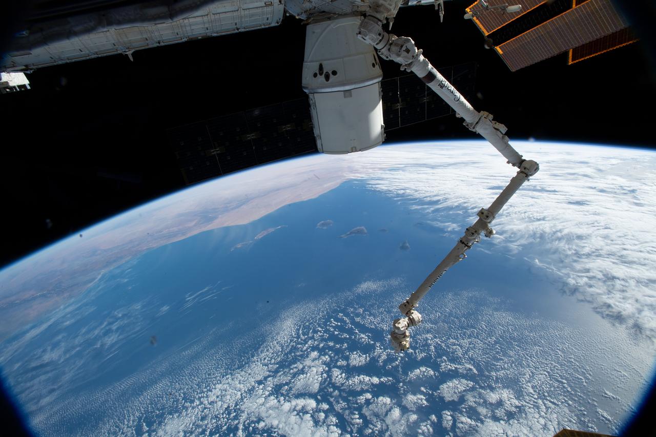
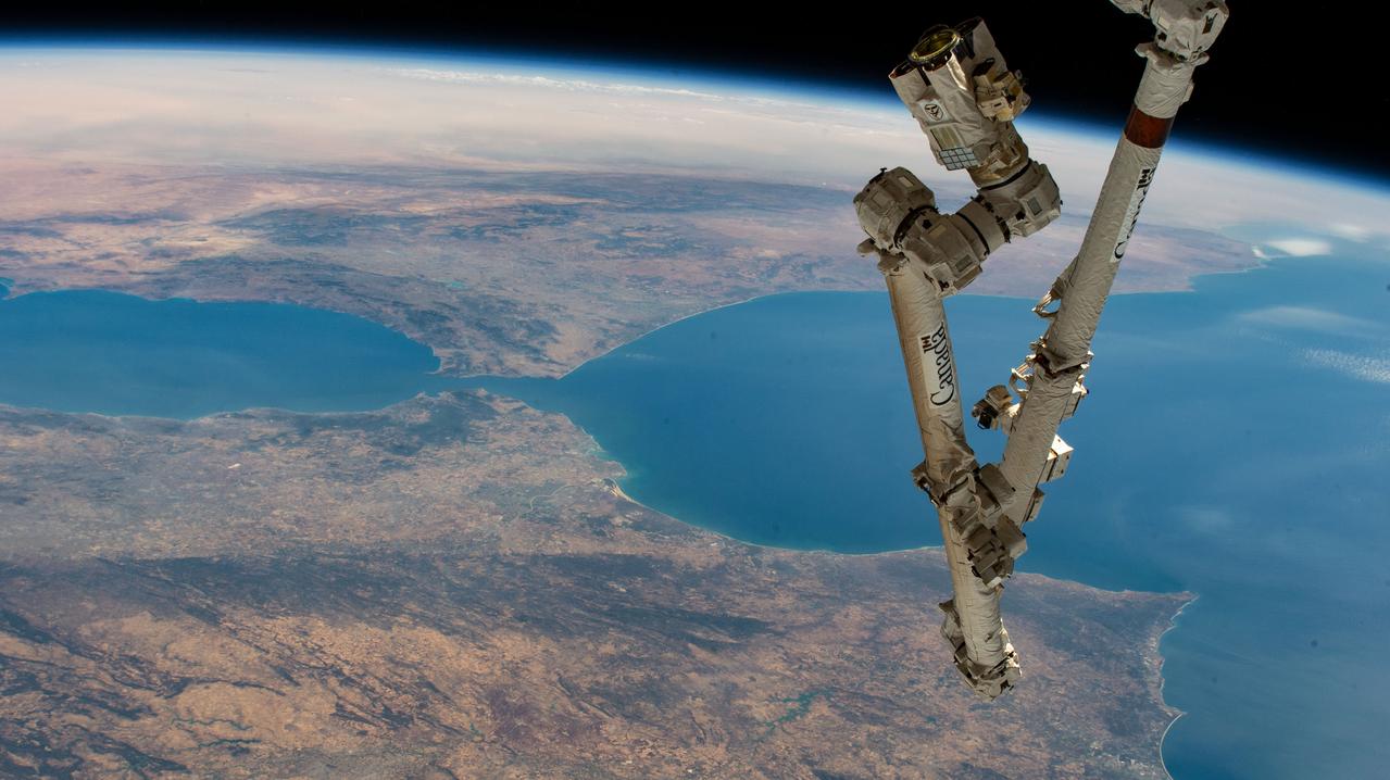
iss058e000081 (Dec. 22, 2018) --- The SpaceX Dragon cargo craft and the Canadarm2 robotic arm are pictured attached to the International Space Station as the orbital complex was 251 miles above the Atlantic Ocean about to fly over Morocco.
STS076-E-05264 (22-31 March 1996) --- STS-76 KidSat Earth View (Morocco)
Earth observation taken during a day pass by the Expedition 37 crew. Per Twitter message: Southern Morocco.
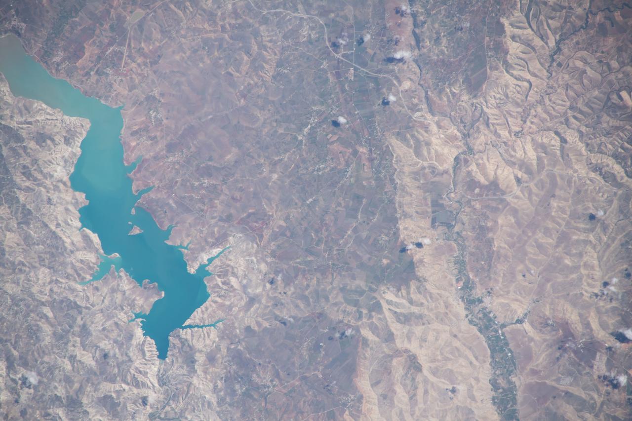
iss063e002302 (April 22, 2020) --- The Idriss I Dam in Morocco is pictured from the International Space Station as it orbited off the Atlantic coast of the North African nation.
iss064e011238 (Dec. 8, 2020) --- The Errachidia Province in east central Morocco is pictured from the International Space Station as it orbited 261 miles above.
iss063e002398 (April 22, 2020) --- The Errachidia Province of Morocco is pictured from the International Space Station as it orbited above the North African nation.
iss063e002389 (April 22, 2020) --- The northern central portion of Morocco, pictured from the International Space Station, is a mountainous region that borders the Sahara Desert in northwest Africa.
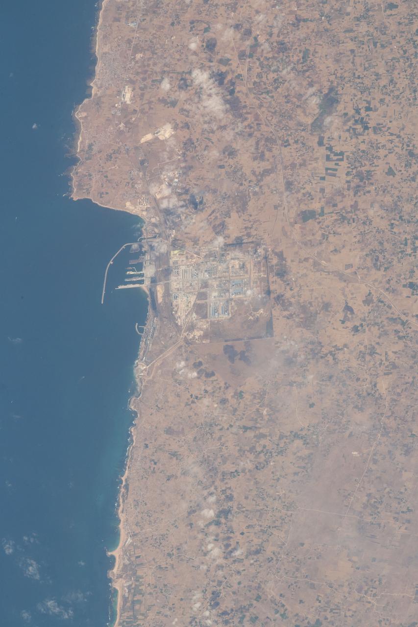
iss056e032818 (June 23, 2018) --- The commercial Port of Jorf Lasfar and surrounding industrial facilities are pictured on the Atlantic coast of Morocco about 67 miles southwest of Casablanca.
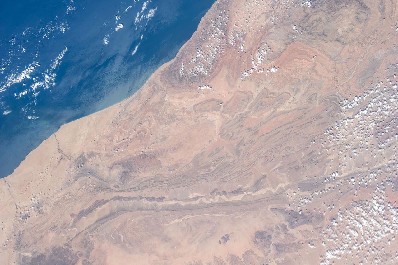
ISS040-E-000788 (20 May 2014) --- Expedition 40 Commander Steve Swanson of NASA photographed this image from an Earth-facing window on the Earth-orbiting International Space Station featuring the Atlantic coast of the African nation of Morocco and the disputed territory of Western Sahara on May 20, 2014. The town of Tarfaya, Morocco, located at 22.45 degrees north latitude, and 13.13 degrees, east longitude, is visible. Obvious streaks in the sand were created by northerly winds.
ISS030-E-030428 (31 Dec. 2011) --- This high oblique panorama shows Morocco and Spain as photographed by the Expedition 30 crew members aboard the International Space Station. The Atlantic Ocean, Straits of Gibraltar and Alboran Sea (the westernmost portion of the Mediterranean Sea) separate Spain on the right from Morocco on the left. Algeciras Harbor is the prominent notch cut out of the eastern end of the north shore of the Strait. A Russian spacecraft, docked to the orbital outpost, is in the upper left corner.
iss067e014093 (April 15, 2022) --- The western portion of Algeria, near the border with Morocco, is pictured from the International Space Station as it orbited 258 miles above the African nation.
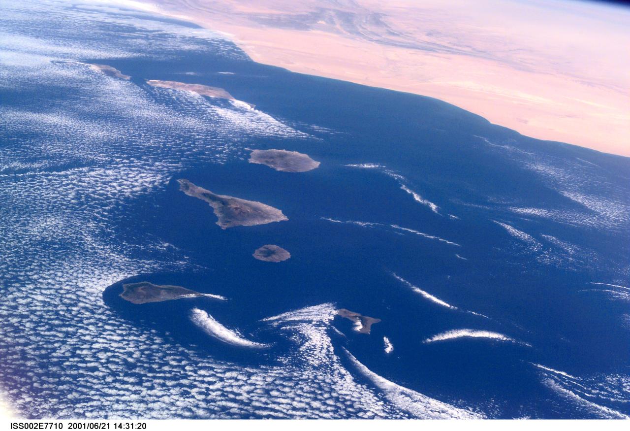
ISS002-E-7710 (21 June 2001) --- Commonly visible cloud vortices hover in the area of the Canary Islands off the coast of Morocco in this Expedition Two digital still camera's view from the International Space Station (ISS).
S65-45737 (22 Aug. 1965) --- Looking northeast, the Strait of Gibraltar, Morocco (foreground) and Spain (background) are photographed from the Gemini-5 spacecraft during its 14th revolution of Earth.
ISS040-E-011996 (14 June 2014) --- One of the Expedition 40 crew members aboard the Earth-orbiting International Space Station recorded this image of the Strait of Gibraltar, showing parts of Morocco and Spain, on June 14, 2014.
ISS040-E-010889 (12 June 2014) --- One of the Expedition 40 crew members aboard the Earth-orbiting International Space Station recorded this image of the Strait of Gibraltar, showing parts of Morocco and Spain, on June 12, 2014.
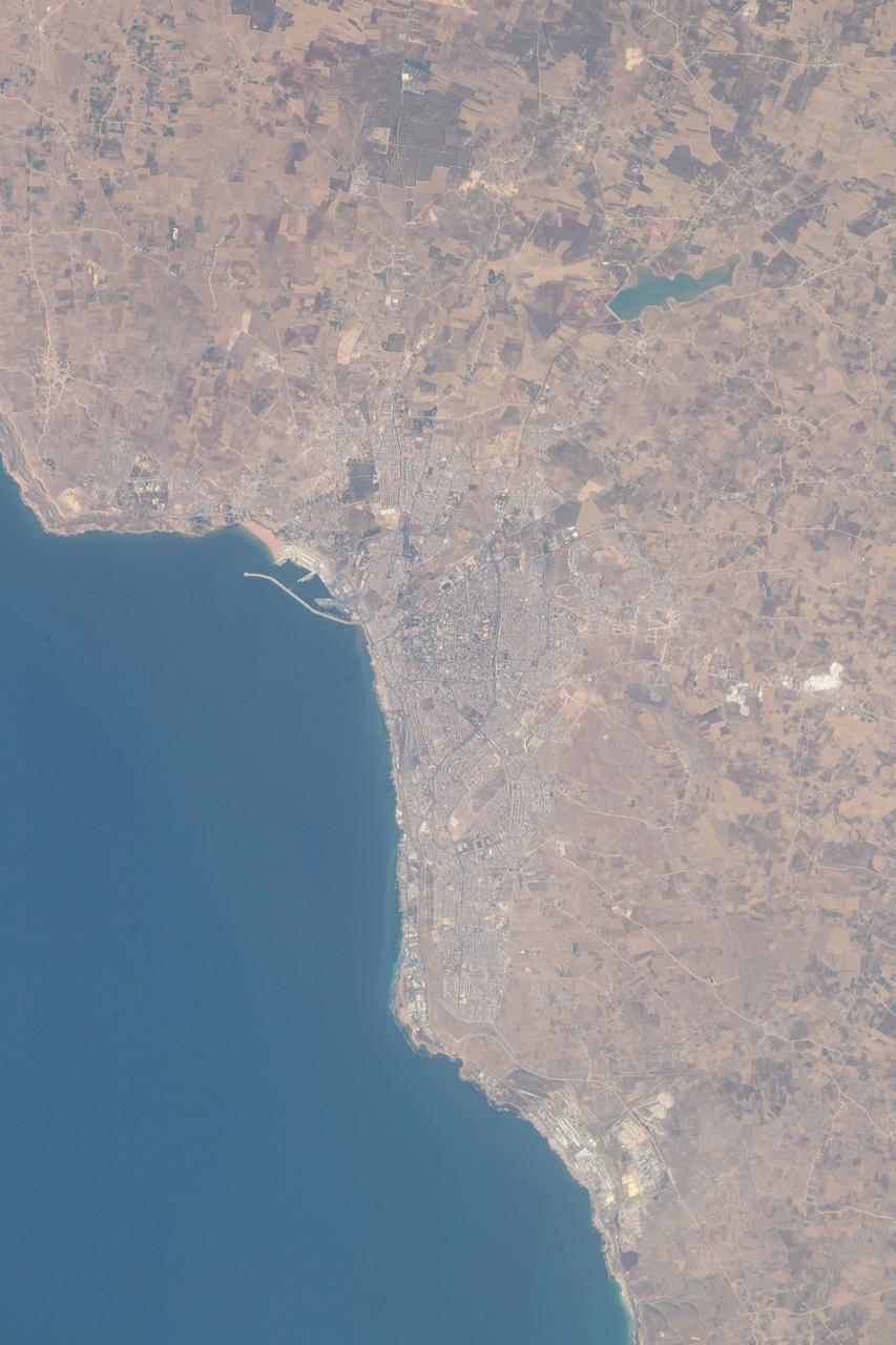
iss056e032816 (June 23, 2018) --- The north Atlantic coast of Morocco and its port city of Safi with a population of over 300,000 feature prominently in this photograph taken by an Expedition 56 crew member aboard the International Space Station.
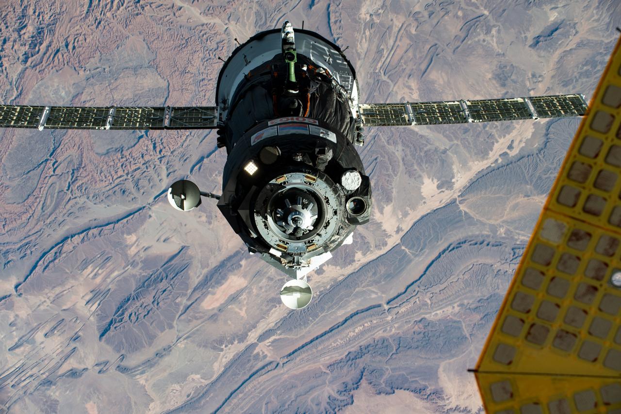
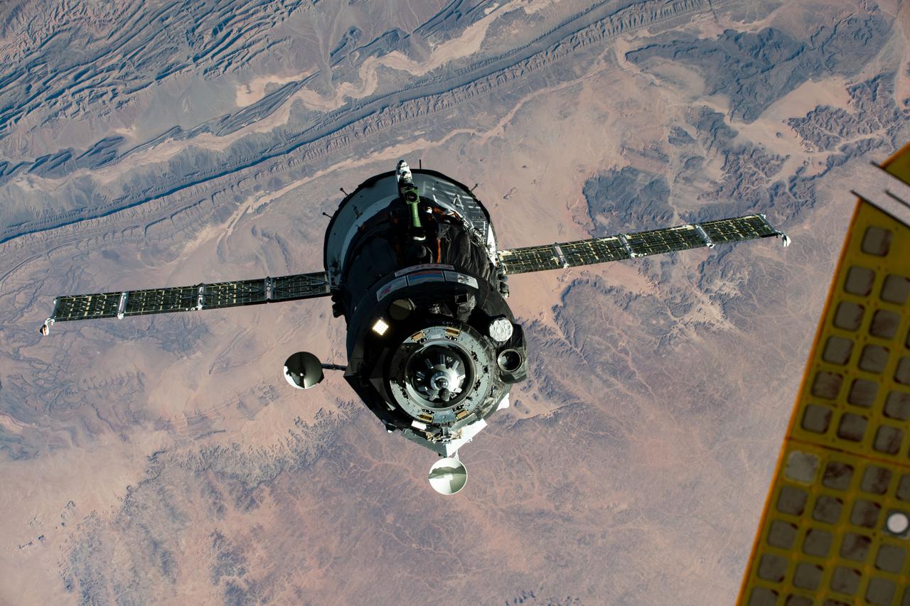
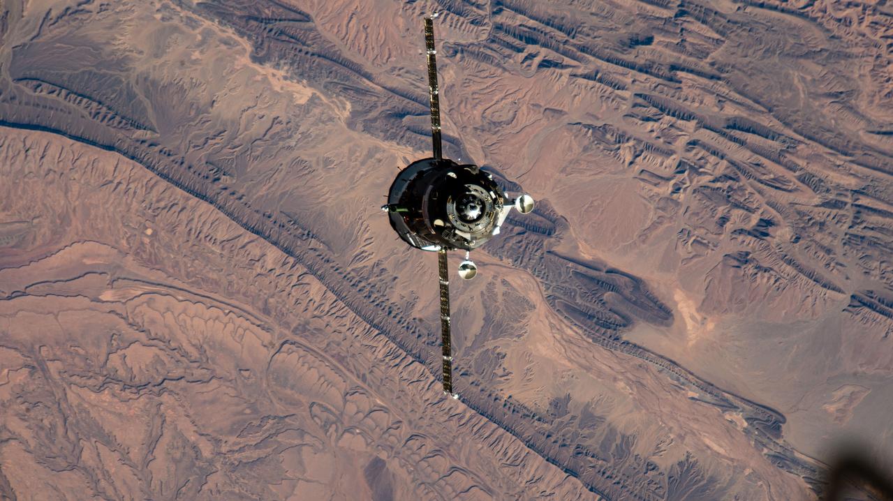
iss063e107241 (Oct. 14, 2020) --- The Soyuz MS-17 spacecraft, with Expedition 64 crew members Kate Rubins of NASA and Roscosmos cosmonauts Sergey Ryzhikov and Sergey Kud-Sverchkov, approaches the International Space Station for a docking to the Rassvet module. This photograph was taken as both spacecraft were orbiting above Morocco.
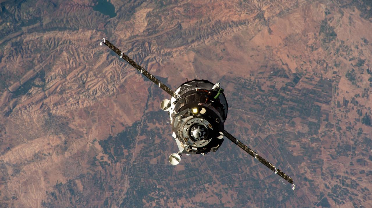
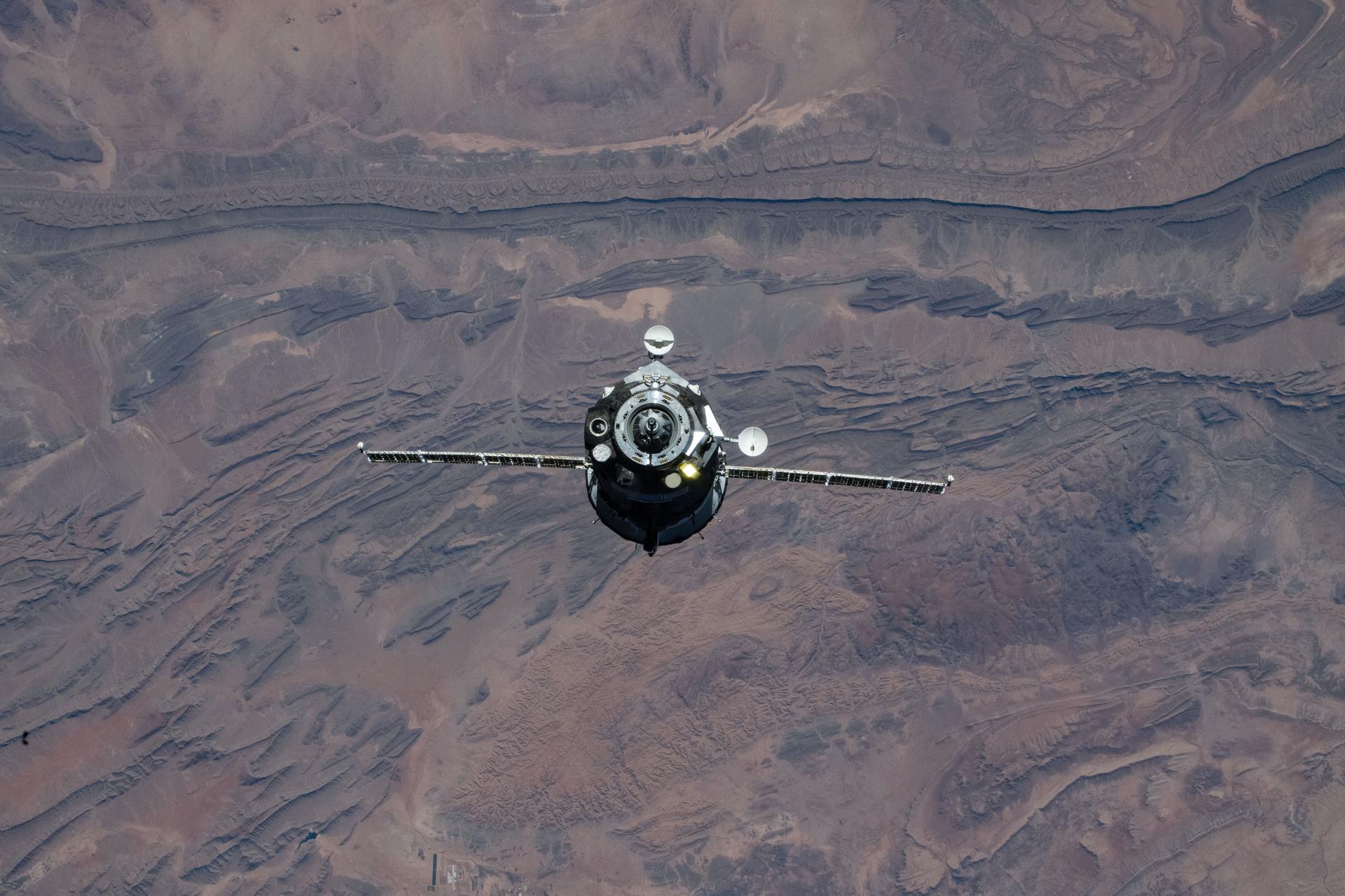
iss072e941647 (April 8, 2025) --- The Soyuz MS-27 spacecraft approaches the International Space Station 259 miles above Morocco on the African continent. The Soyuz spacecraft would dock shortly afterward to the Prichal module bringing NASA astronaut Jonny Kim and Roscosmos cosmonauts Sergey Ryzhikov and Alexey Zubritsky to the orbital outpost.
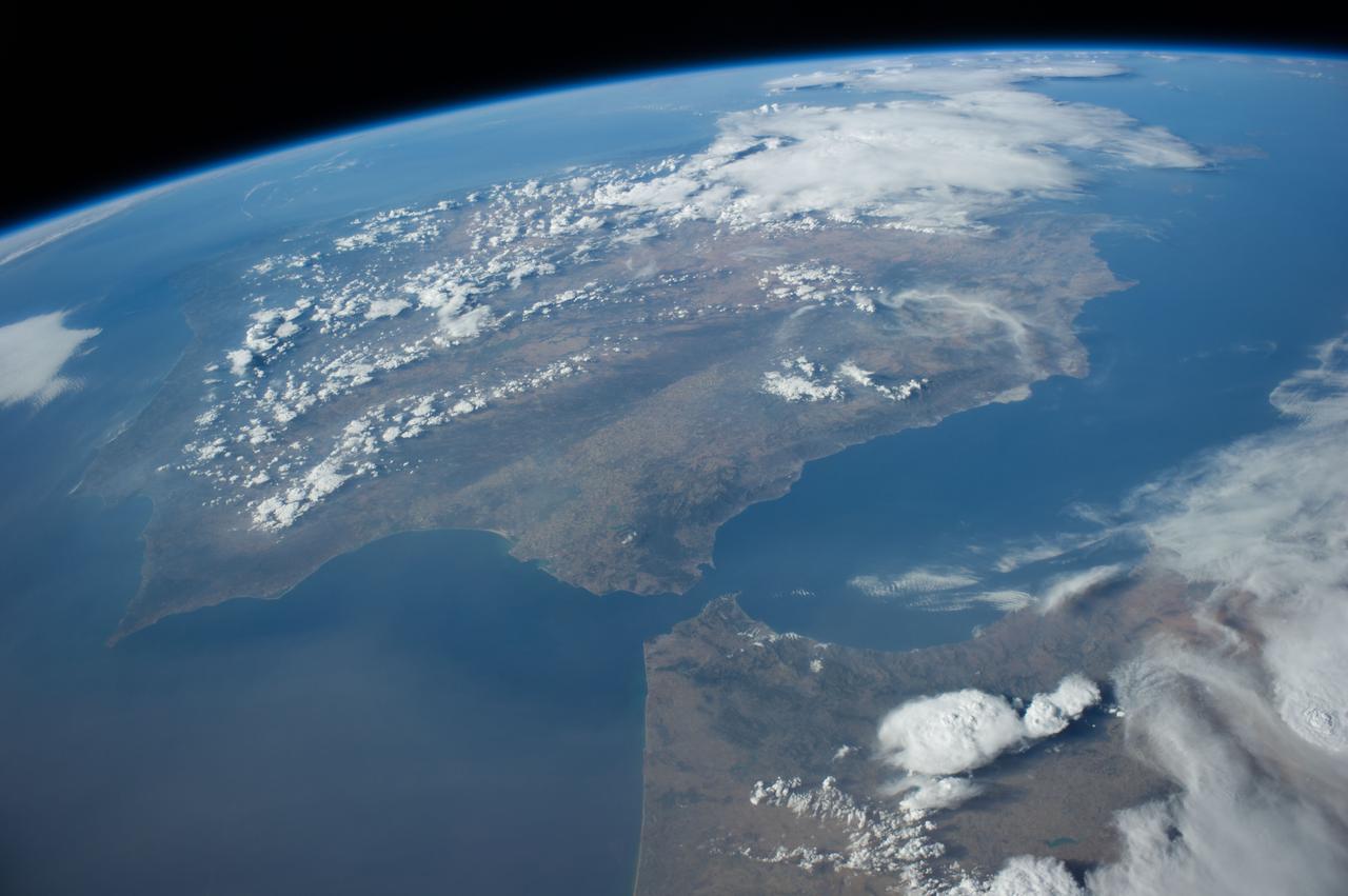
iss071e082775 (May 16, 2024) --- The Atlas Mountain range rises on the Atlantic coast of Morocco and extends east to the North African nations of Algeria and Tunisia. The International Space Station was orbiting 258 miles above the Moroccan coast at the time of this photograph.
iss059e043281 (May 6, 2019) --- The SpaceX Dragon cargo craft approaches the International Space Station 256 miles above Morocco. Astronaut David Saint-Jacques would command the Canadarm2 robotic arm to capture Dragon as astronaut Nick Hague backed him up and monitored systems.
iss067e270597 (Aug. 18, 2022) --- The Canadarm2 robotic arm extends from the International Space Station, orbiting 259 miles above the northern coast of Spain, in this photograph of the Strait of Gibraltar which separates the Atlantic Ocean (right) from the Mediterranean Sea and the European nation of Spain (bottom) from the African country of Morocco.
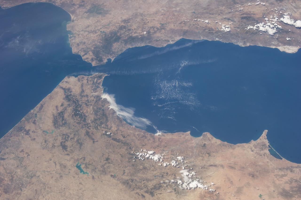
iss062e005579 (Feb. 11, 2020) --- The Strait of Gibraltar connects the Atlantic Ocean with the Mediterranean Sea and separates Spain on the European continent from Morocco on the African continent. The International Space Station was orbiting 265 miles above the Atlantic off the coast of Lisbon, Portugal, when this photograph was taken.
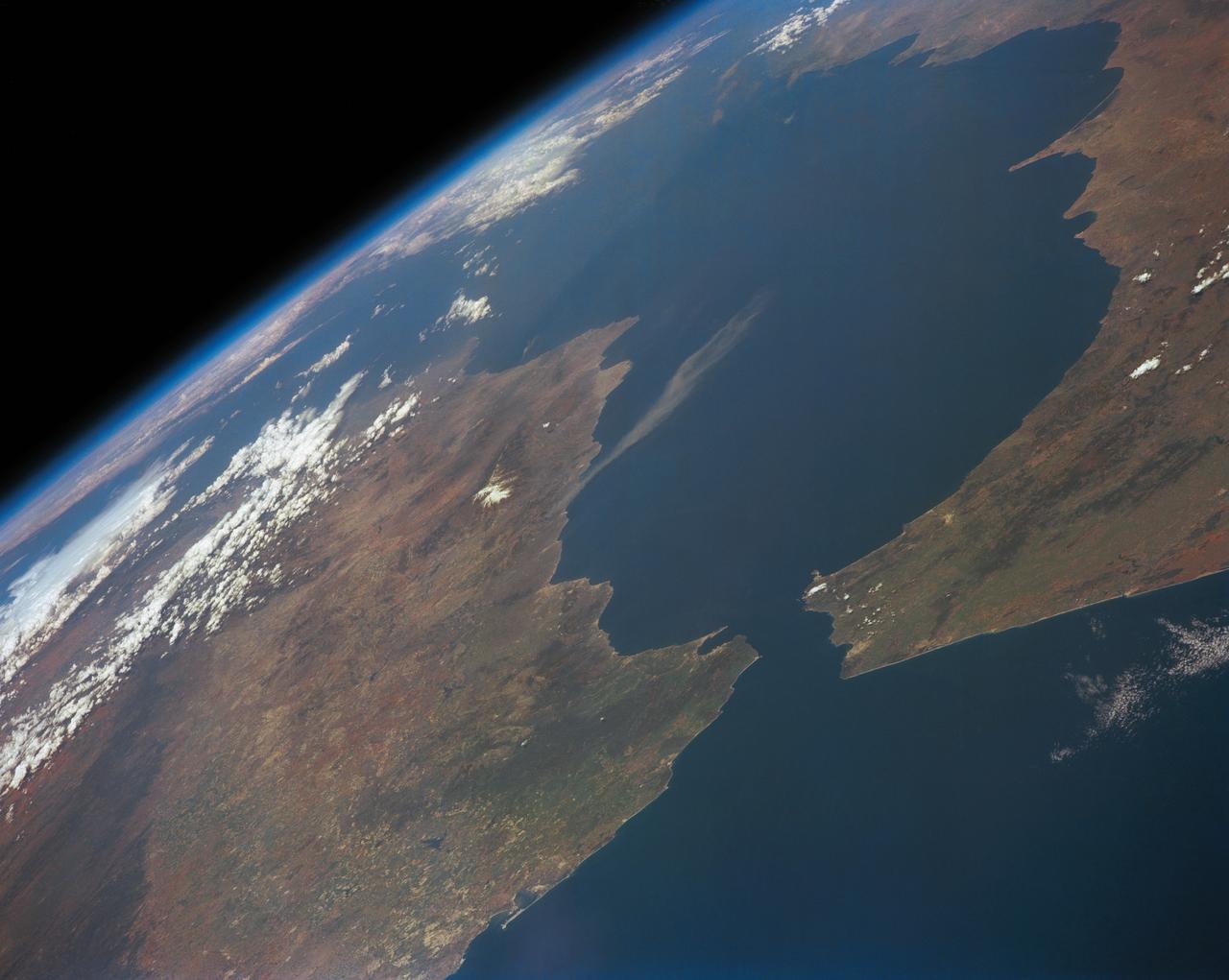
iss059e038134 (April 30, 2019) --- Looking from northwest to southeast (bottom to top), this oblique view shows portions of Western Europe, the Atlantic Ocean, the Mediterranean Sea and North Africa. More specific regions such as Portugal, Spain, the Strait of Gibraltar, Morocco and Algeria are seen as the International Space Station orbited 257 miles above the Atlantic.
ISS040-E-016324 (20 June 2014) --- One of the Expedition 40 crew members aboard the Earth-orbiting International Space Station recorded this oblique panorama of the Strait of Gibraltar, showing parts of Morocco and Spain, on June 20, 2014.
iss063e107170 (Oct. 14, 2020) --- The Soyuz MS-17 spacecraft, with Expedition 64 crew members Kate Rubins of NASA and Roscosmos cosmonauts Sergey Ryzhikov and Sergey Kud-Sverchkov, approaches the International Space Station for a docking to the Rassvet module. This photograph was taken as both spacecraft were orbiting above Morocco.
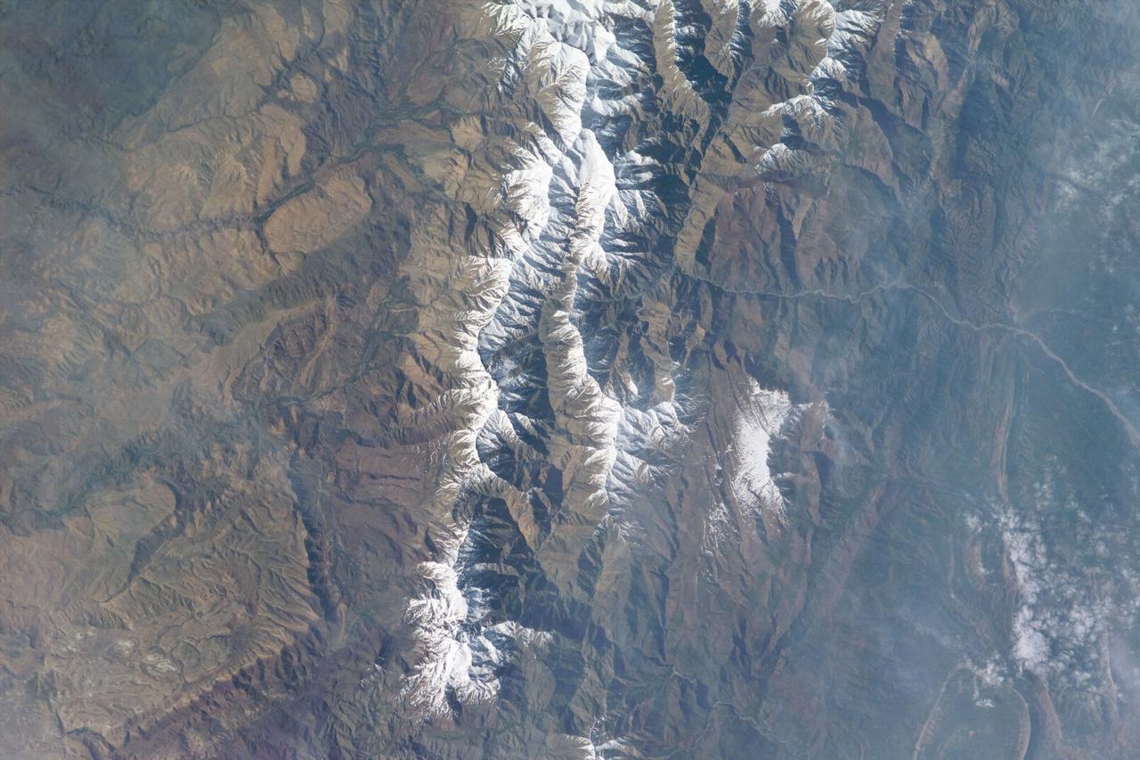
iss073e1196761 (Nov. 27, 2025) --- The Soyuz MS-28 crew spacecraft carrying NASA astronaut Chris Williams and Roscosmos cosmonauts Sergey Kud-Sverchkov and Sergei Mikaev approaches the International Space Station. Both spacecraft were orbiting 263 miles above the mountainous region in southern Morocco at the time of this photograph.
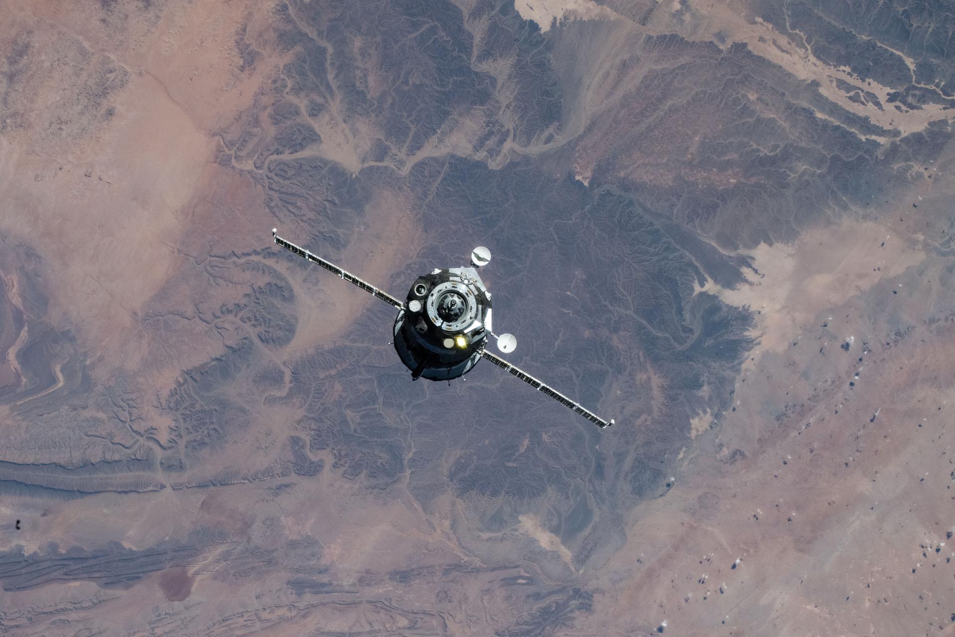
iss073e1196741 (Nov. 27, 2025) --- The Soyuz MS-28 crew spacecraft carrying NASA astronaut Chris WIlliams and Roscosmos cosmonauts Sergey Kud-Sverchkov and Sergei Mikaev approaches the International Space Station. Both spacecraft were orbiting 263 miles above the mountainous region in southern Morocco at the time of this photograph.

iss073e1196772 (Nov. 27, 2025) --- The Soyuz MS-28 crew spacecraft carrying NASA astronaut Chris Williams and Roscosmos cosmonauts Sergey Kud-Sverchkov and Sergei Mikaev approaches the International Space Station. Both spacecraft were orbiting 263 miles above the mountainous region in southern Morocco at the time of this photograph.

iss073e1197951 (Dec. 2, 2025) --- The Soyuz MS-28 crew spacecraft carrying NASA astronaut Chris Williams and Roscosmos cosmonauts Sergey Kud-Sverchkov and Sergei Mikaev approaches the International Space Station 263 miles above the Mediterranean Sea in between Spain and Morocco.

iss073e1197970 (Dec. 2, 2025) --- The Soyuz MS-28 crew spacecraft carrying NASA astronaut Chris Williams and Roscosmos cosmonauts Sergey Kud-Sverchkov and Sergei Mikaev approaches the International Space Station 263 miles above Morocco.
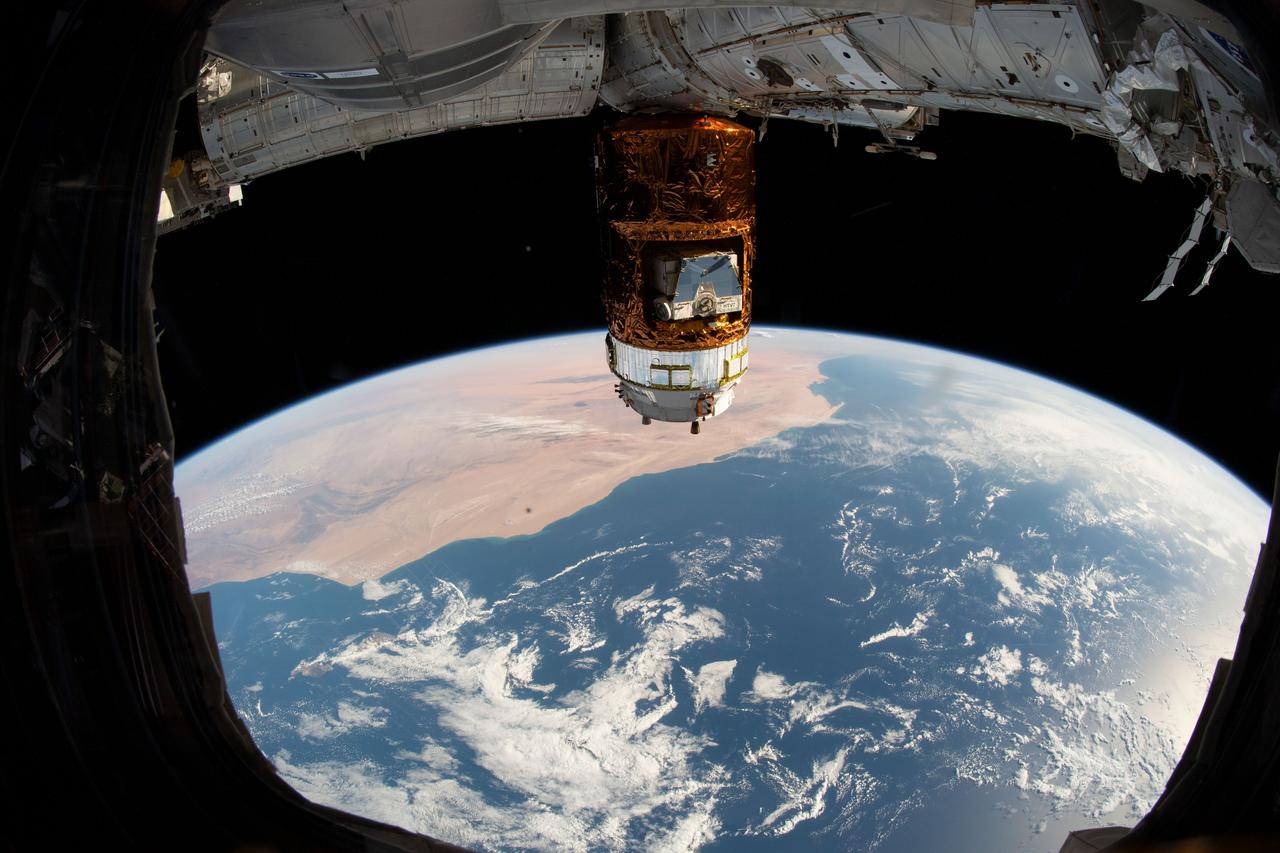
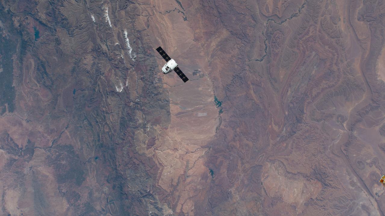
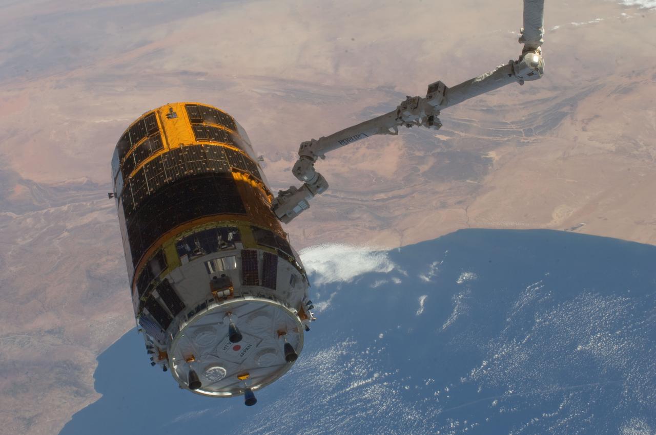
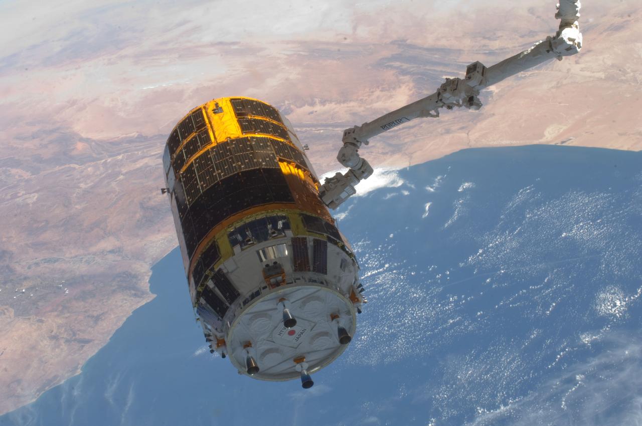
iss061e012184 (Oct. 20, 2019) --- Japan's H-II Transfer Vehicle-8 (HTV-8) highlights this image as the International Space Station orbited 253 miles above the Atlantic Ocean. This view from the orbiting complex looks across Morocco and Western Sahara.
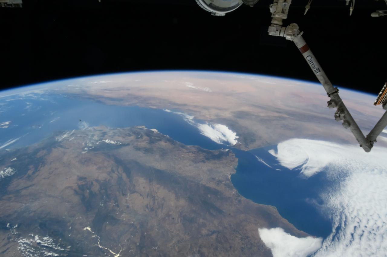
iss071e082829 (May 16, 2024) --- The Strait of Gibraltar separates the European nation of Spain from the African nation of Morocco and connects the Atlantic Ocean with the Medirrranean Sea. The International Space Station was orbiting 259 miles above North Africa at the time of this photograph.
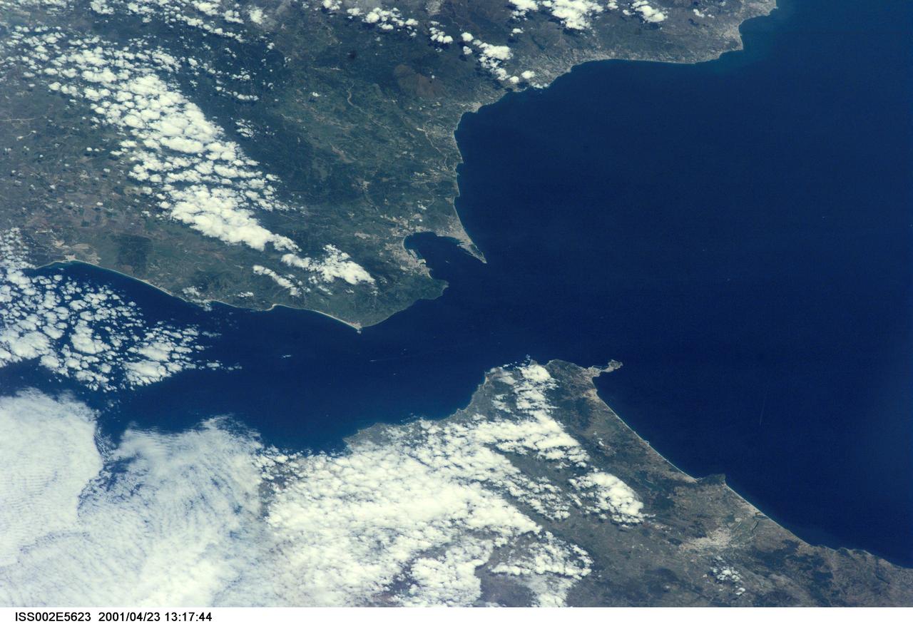
ISS002-E-5623 (23 April 2001) --- The Strait of Gibraltar, with part of Spain and all of Gibraltar at upper left and upper center, respectively, and portions of Morocco at bottom, was photographed with a digital still camera by the Expedition Two crew onboard the International Space Station (ISS).
iss072e941654 (April 8, 2025) --- The Soyuz MS-27 spacecraft approaches the International Space Station 259 miles above Morocco on the African continent. The Soyuz spacecraft would dock shortly afterward to the Prichal module bringing NASA astronaut Jonny Kim and Roscosmos cosmonauts Sergey Ryzhikov and Alexey Zubritsky to the orbital outpost.

The Strait of Gibraltar separates Spain from Morocco. This image, acquired on July 5, 2000, covers an area 34 kilometers (21 miles) wide and 59 kilometers (37 miles) long in three bands of the reflected visible and infrared wavelength region. The promontory on the eastern side of the conspicuous Spanish port is the Rock of Gibraltar. Once one of the two classical Pillars of Hercules, the Rock was crowned with silver columns by Phoenician mariners to mark the limits of safe navigation for the ancient Mediterranean peoples. The rocky promontory still commands the western entrance to the Mediterranean Sea. The rocky limestone and shale ridge rises abruptly from the sea, to a maximum elevation of 426 meters (1,398 feet). A British colony, Gibraltar occupies a narrow strip of land at the southernmost tip of the Iberian Peninsula. It is separated from the Spanish mainland by a neutral zone contained on a narrow, sandy isthmus. Because of its strategic location and formidable topography, Gibraltar serves mainly as a British fortress. Most of its sparse land is taken up by air and naval installations, and the civilian population is small. http://photojournal.jpl.nasa.gov/catalog/PIA02657
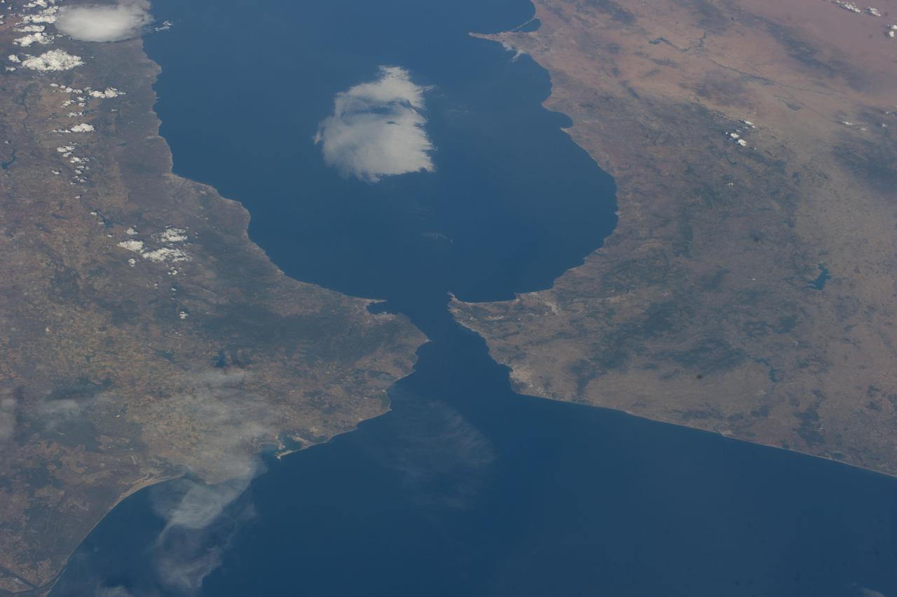
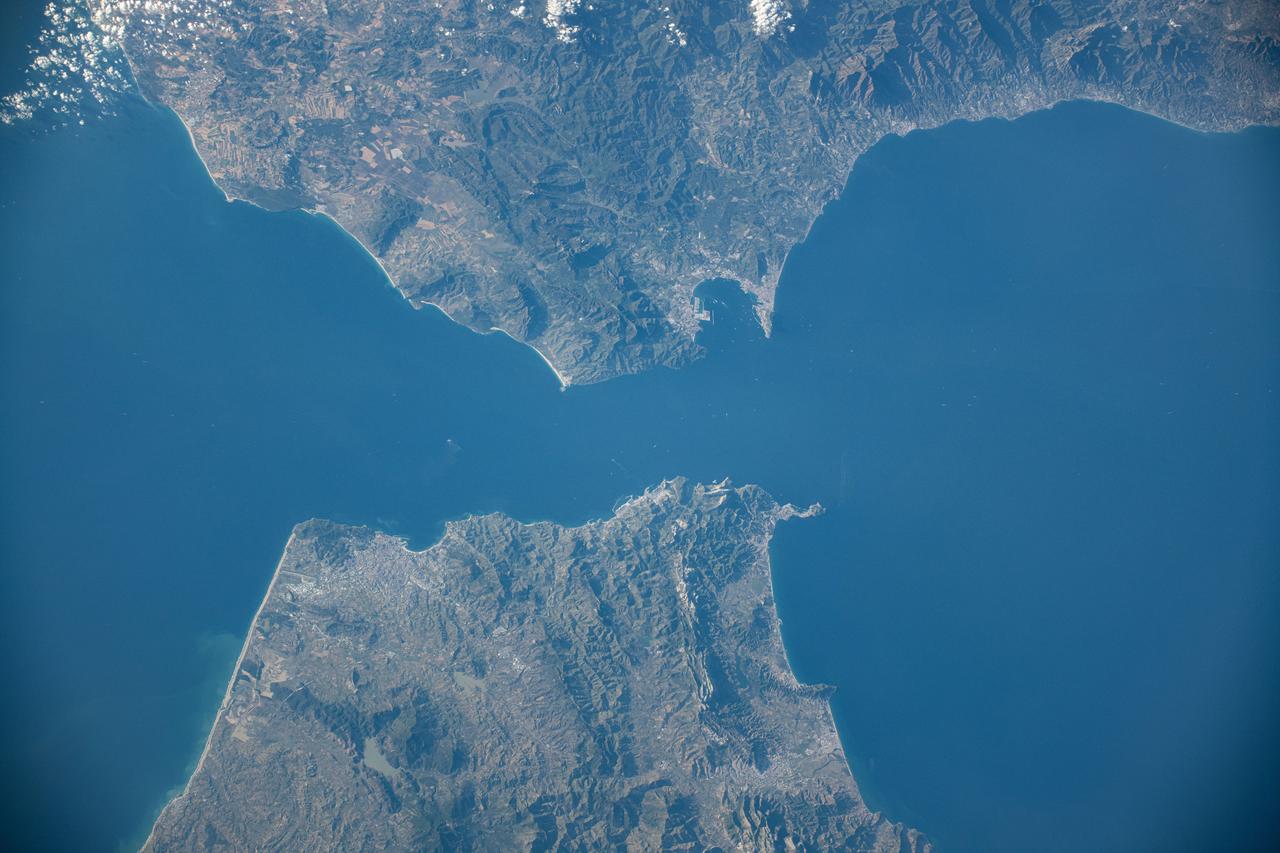
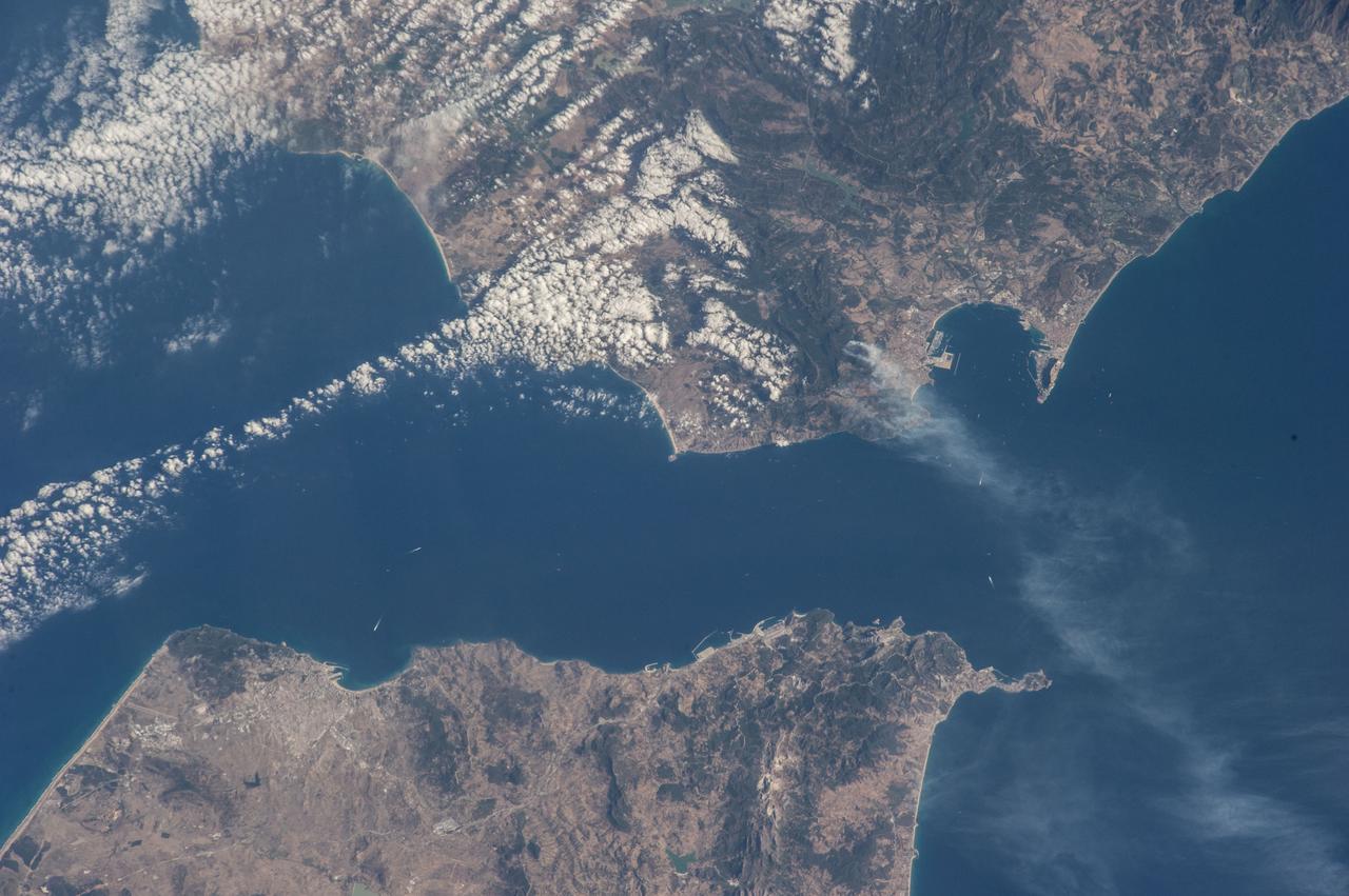
iss071e414110 (July 30, 2024) -- The Strait of Gibraltar separates Morocco (left) and Spain (right) while connecting the Atlantic Ocean to the Mediterranean Sea. The narrow strait spans only ~8 miles (~13 kilometers) between the two countries. As the International Space Station soared 258 miles above, NASA astronaut Matthew Dominick captured this photo.
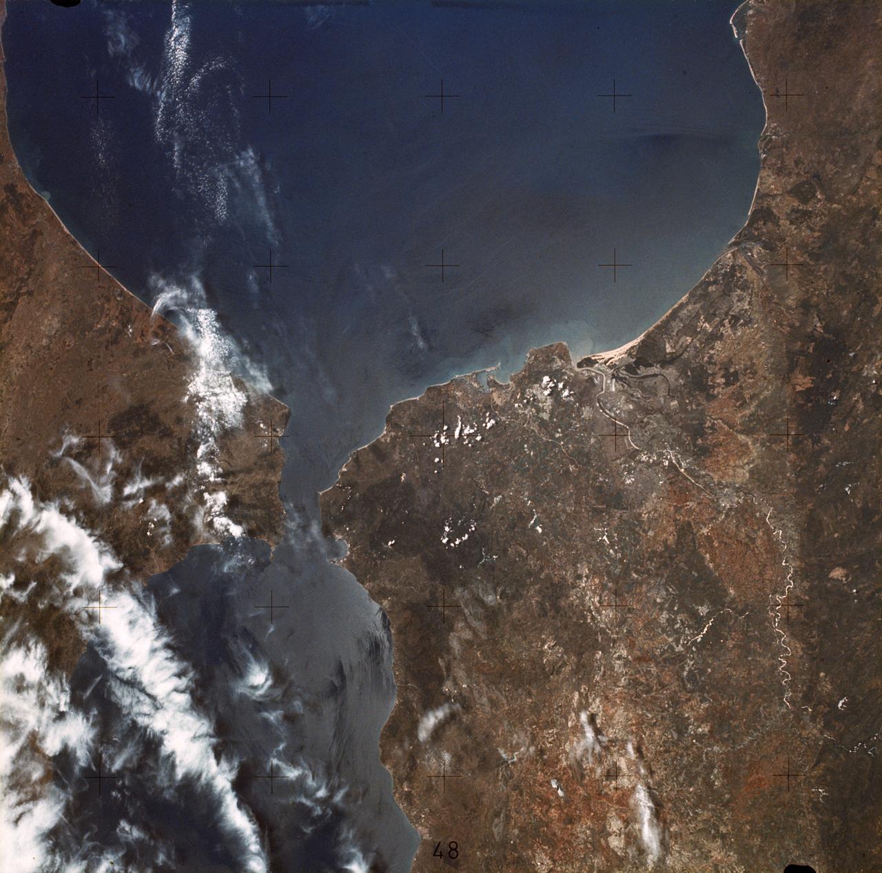
ISS040-E-081001 (25 July 2014) --- One of the Expedition 40 crew members aboard the Earth-orbiting International Space Station was aiming his camera almost straight down when he recorded this view of parts of Spain (top), Morocco (bottom) and the Strait of Gibraltar (center) at 08:04:35 GMT on July 25, 2014. Gibraltar and the Alboran Sea are on the right side of the frame. Cadiz, Spain is almost under clouds on the Bay of Cadiz above and to the left of frame center.

Twitter user Karim Jazouani from Casablanca, Morocco, who goes by the twitter name @karimjazouani, uses his laptop during a two-day NASA Tweetup event held at NASA's Kennedy Space Center in Cape Canaveral, Fla, Sunday, Nov. 15, 2009. NASA Twitter followers in attendance will have the opportunity to take a tour of NASA's Kennedy Space Center, view the space shuttle launch and speak with shuttle technicians, engineers, astronauts and managers. Photo Credit: (NASA/Carla Cioffi)
SL2-05-370 (22 June 1973) --- Gateway to the Atlantic, since ancient times the Strait of Gibraltar (36.5N, 4.5W) is also the border between Africa and Europe. In Spain to the north, the dark area near the coast is the delta of the Guadalquivir River and the city of Seville. The small spike of land on the north side of the strait is the actual Rock of Gibraltar. On the African side, a cloud front cutting across from the coast is blowing into Europe from Morocco and Algeria. Photo credit: NASA
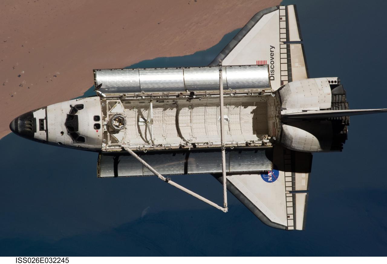
ISS026-E-032245 (7 March 2011) --- The space shuttle Discovery is seen from the International Space Station as the two orbital spacecraft accomplish their relative separation on March 7 after an aggregate of 12 astronauts and cosmonauts worked together for over a week. The area below is the southwestern coast of Morocco in the northern Atlantic. During a post undocking fly-around, the crew members aboard the two spacecraft collected a series of photos of each other’s vehicle.
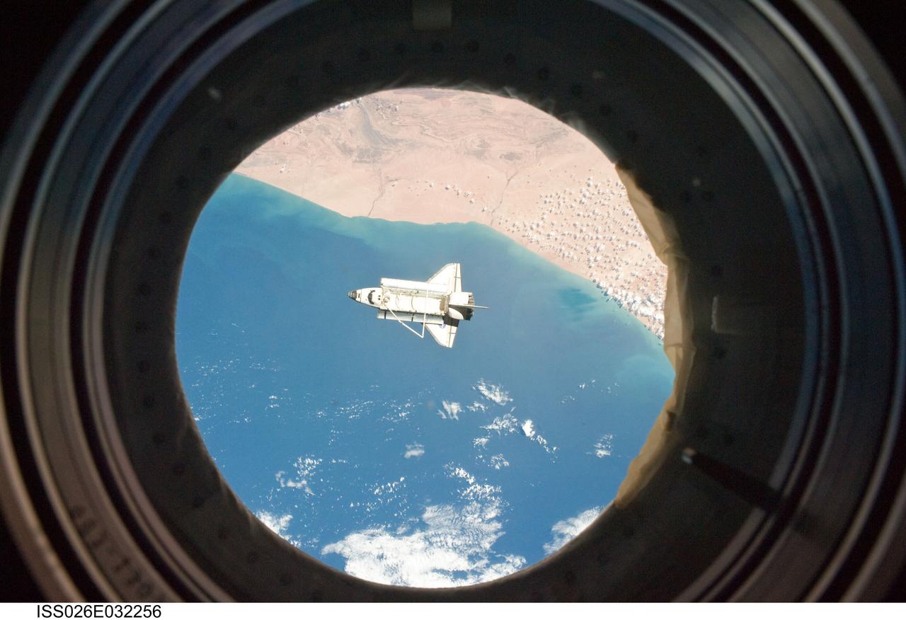
ISS026-E-032256 (7 March 2011) --- The space shuttle Discovery is seen from the International Space Station as the two orbital spacecraft accomplish their relative separation on March 7 after an aggregate of 12 astronauts and cosmonauts worked together for over a week. The area below is the southwestern coast of Morocco in the northern Atlantic. During a post undocking fly-around, the crew members aboard the two spacecraft collected a series of photos of each other’s vehicle.

ISS026-E-032253 (7 March 2011) --- The space shuttle Discovery is seen from the International Space Station as the two orbital spacecraft accomplish their relative separation on March 7 after an aggregate of 12 astronauts and cosmonauts worked together for over a week. The area below is the southwestern coast of Morocco in the northern Atlantic. During a post undocking fly-around, the crew members aboard the two spacecraft collected a series of photos of each other’s vehicle.
41G-120-082 (5-13 Oct. 1984) --- This High oblique view was photographed with a medium format camera aboard the Earth-orbiting space shuttle Challenger. It features the Strait of Gibraltar and the Mediterranean Sea. Unlike vertical photographs from this area taken by crews of previous spaceflights, this oblique view allows extensive viewing into Spain and Morocco. Photo credit: NASA
ISS040-E-017303 (23 June 2014) --- One of the Expedition 40 crew members aboard the Earth-orbiting International Space Station, flying approximately 223 nautical miles above the Atlantic Ocean photographed this image featuring the Atlantic coasts of the northwest African nation of Morocco and the disputed territory of Western Sahara. Two islands in the Canary Islands chain are pictured. Gran Canaria is just out of the frame at left.
iss067e006359 (April 9, 2022) --- The SpaceX Dragon Endeavour crew ship carrying four Axiom Mission 1 astronauts approaches the International Space Station less than a day after launching from NASA's Kennedy Space Center in Florida. Both spacecraft were orbiting 259 miles above the Atlantic Ocean off the coast of Casablanca, Morocco, in northwest Africa.
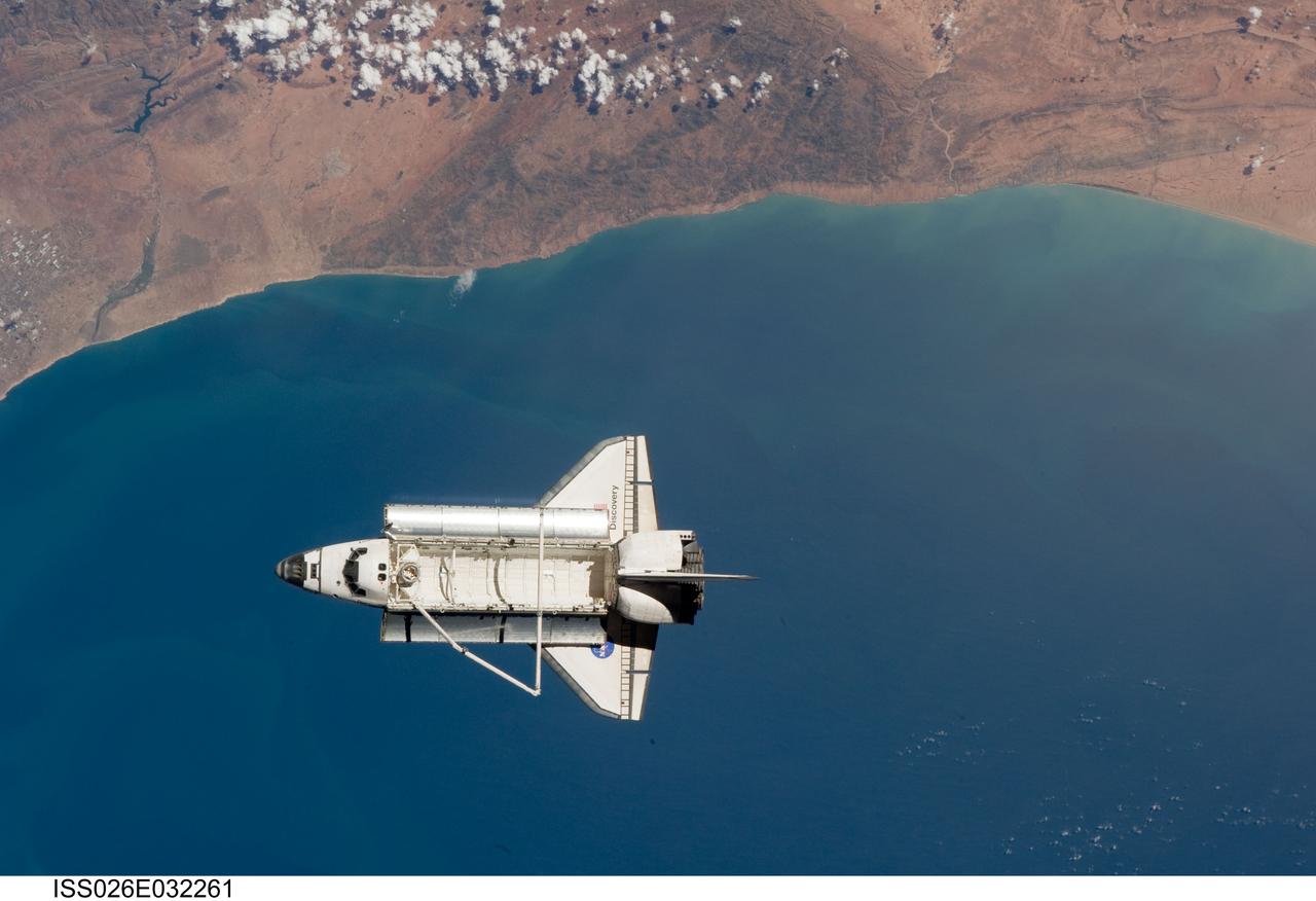
ISS026-E-032261 (7 March 2011) --- The space shuttle Discovery is seen from the International Space Station as the two orbital spacecraft accomplish their relative separation on March 7 after an aggregate of 12 astronauts and cosmonauts worked together for over a week. The area below is the southwestern coast of Morocco in the northern Atlantic. During a post undocking fly-around, the crew members aboard the two spacecraft collected a series of photos of each other’s vehicle.
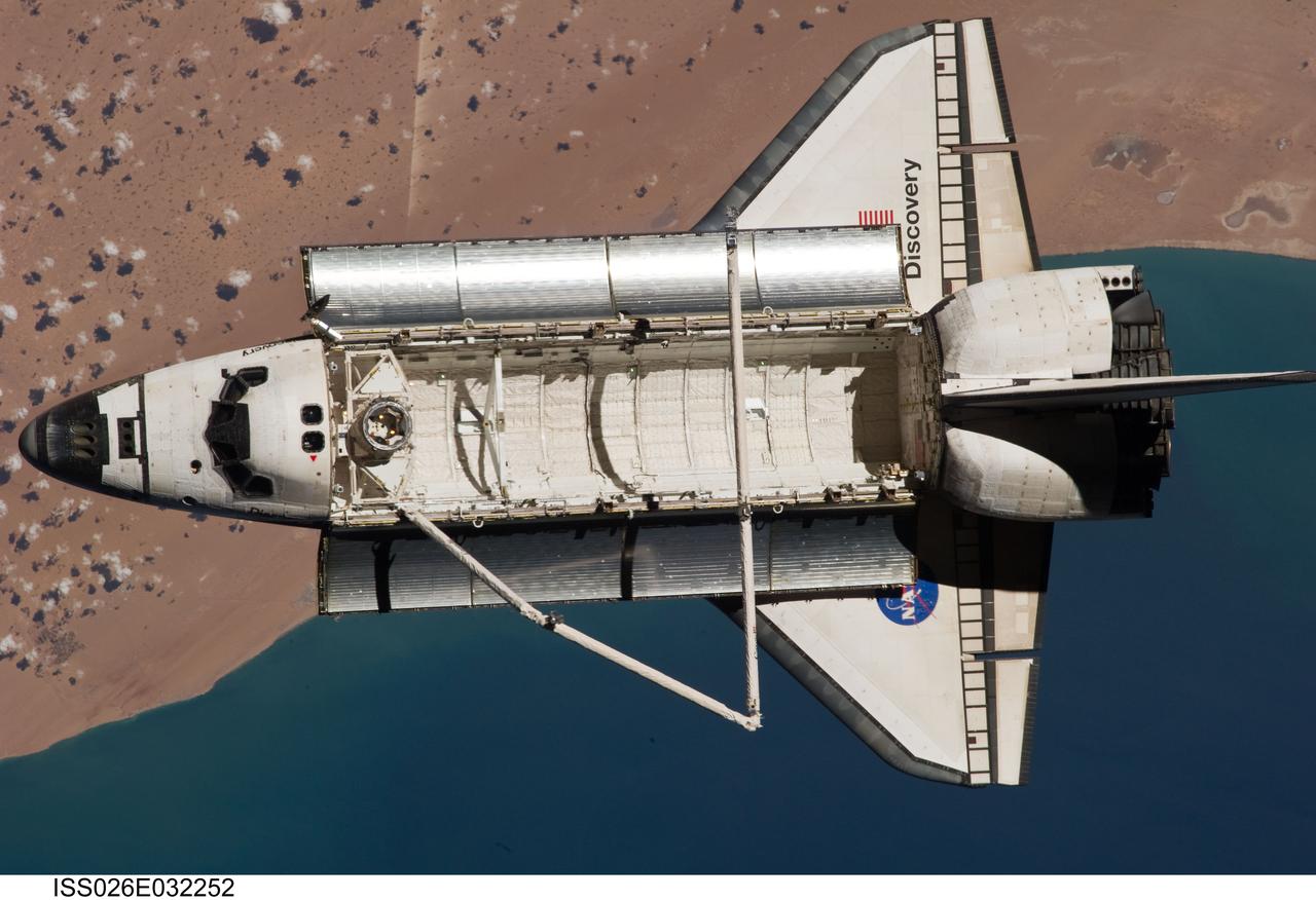
ISS026-E-032252 (7 March 2011) --- The space shuttle Discovery is seen from the International Space Station as the two orbital spacecraft accomplish their relative separation on March 7 after an aggregate of 12 astronauts and cosmonauts worked together for over a week. The area below is the southwestern coast of Morocco in the northern Atlantic. During a post undocking fly-around, the crew members aboard the two spacecraft collected a series of photos of each other’s vehicle.

iss056e127068 (Aug. 6, 2018) --- The International Space Station was orbiting off the coast of Portugal when an Expedition 56 crew member photographed wildfires near its southern coast and the Strait of Gibraltar which separates Spain on the European continent from Morocco on the African continent. The North Atlantic Ocean connects to the Strait of Gibraltar which leads into the Mediterranean Sea.
ISS040-E-105800 (23 Aug. 2014) --- One of the Expedition 40 crew members aboard the International Space Station, flying at an altitude of 220 nautical miles, recorded this oblique panorama showing almost the entire Iberian Peninsula (Spain and Portugal) at right, Morocco and other parts of Africa (left) and the Strait of Gibraltar (top center) on Aug. 23, 2014. A 28mm focal length was used.
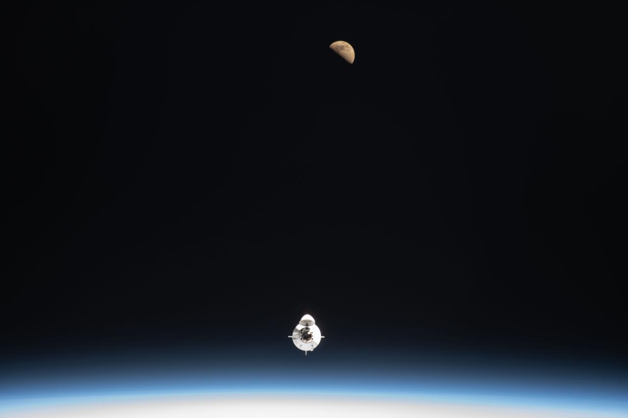
iss067e006147 (April 9, 2022) --- The SpaceX Dragon Endeavour crew ship carrying four Axiom Mission 1 astronauts approaches the International Space Station less than a day after launching from NASA's Kennedy Space Center in Florida. Pictured above Endeavour is the first quarter Moon as both spaceraft were orbiting 259 miles above the Atlantic Ocean off the coast of Morocco.
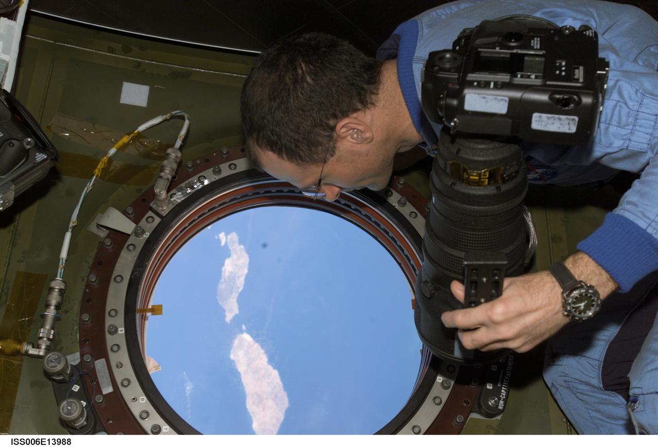
ISS006-E-13988 (2 January 2003) --- Astronaut Donald R. Pettit, Expedition Six NASA ISS science officer, holds a still camera as he looks through the nadir window in the Destiny laboratory on the International Space Station (ISS). The islands of Lanzarote and Fuerteventura of the Canary Island chain in the Atlantic Ocean off the coast of Morocco are visible.
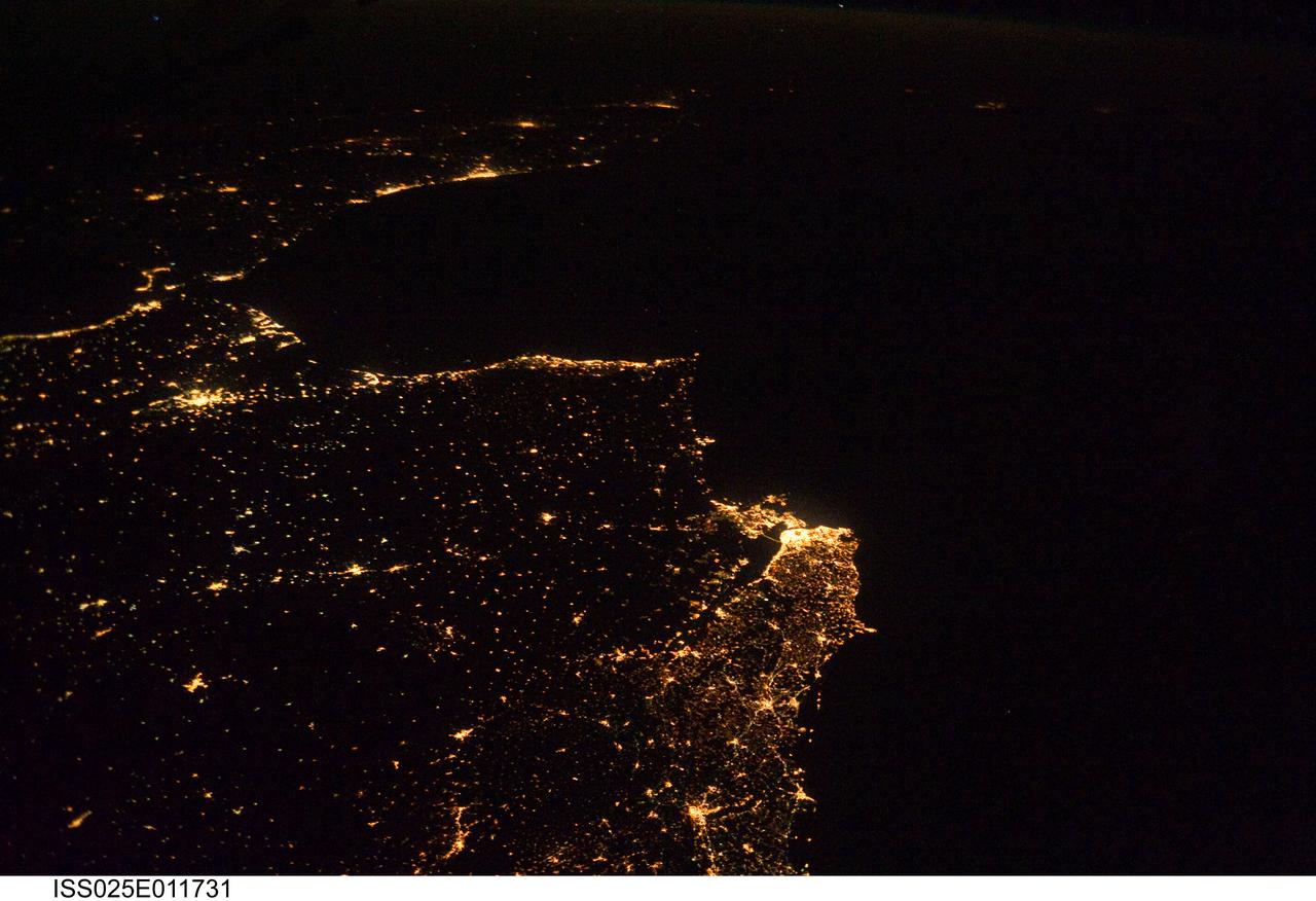
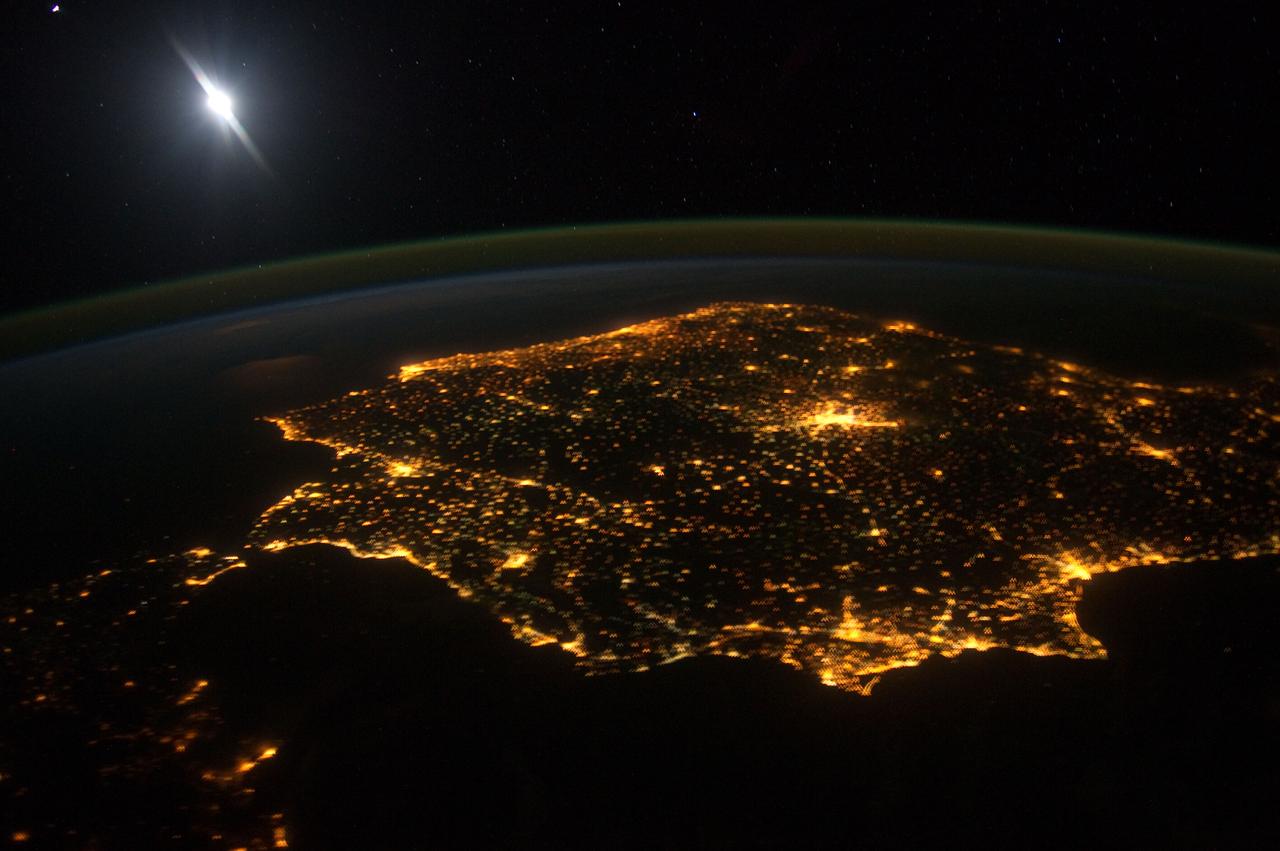
ISS025-E-011731 (5 Nov. 2010) --- One of the Expedition 25 crew members aboard the International Space Station, 220 miles above Earth, took this night time photo, looking south along the Atlantic coast of Europe and into Africa, from Lisbon, Portugal south across the Strait of Gibraltar. The lights can be followed down the coast of Morocco to Casablanca, and beyond.
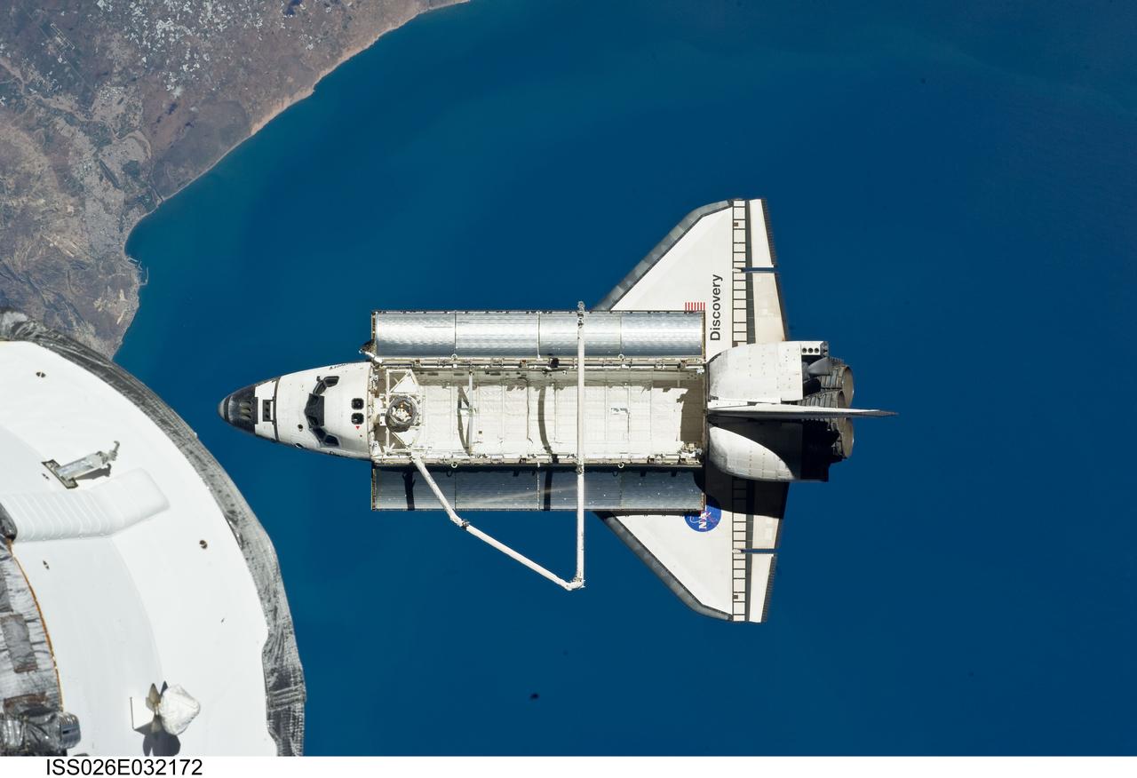
ISS026-E-032172 (7 March 2011) --- The space shuttle Discovery is seen from the International Space Station as the two orbital spacecraft accomplish their relative separation on March 7 after an aggregate of 12 astronauts and cosmonauts worked together for over a week. The area below is the coast of Morocco in the northern Atlantic. During a post undocking fly-around, the crew members aboard the two spacecraft collected a series of photos of each other’s vehicle.
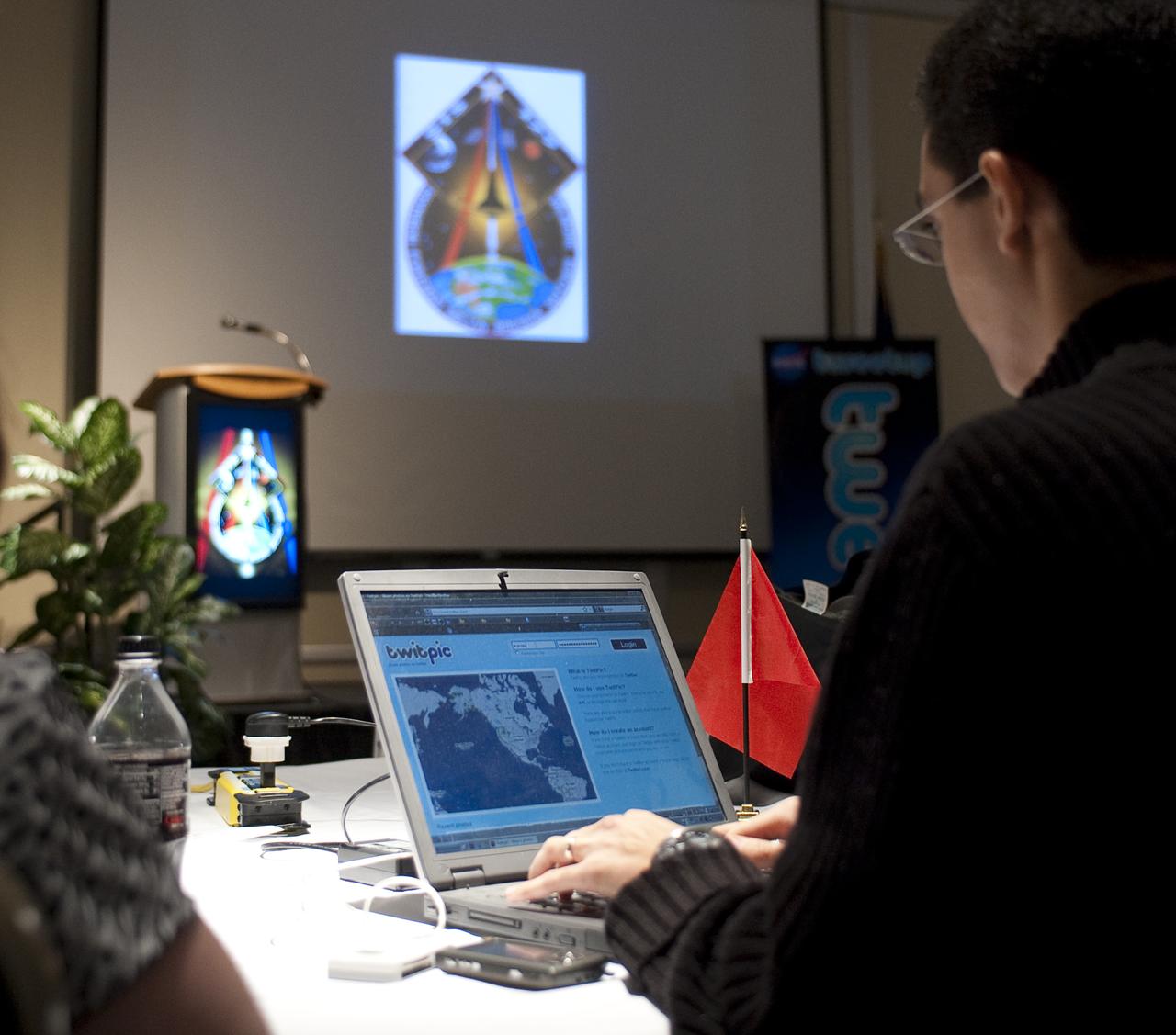
Twitter user Karim Jazouani from Casablanca, Morocco, who goes by the twitter name @karimjazouani, uses his laptop during a two-day NASA Tweetup event held at NASA's Kennedy Space Center in Cape Canaveral, Fla, Sunday, Nov. 15, 2009. NASA Twitter followers in attendance will have the opportunity to take a tour of NASA's Kennedy Space Center, view the space shuttle launch and speak with shuttle technicians, engineers, astronauts and managers. Photo Credit: (NASA/Carla Cioffi)
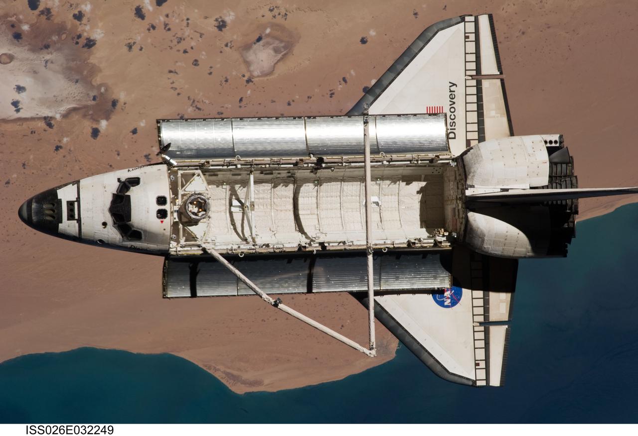
ISS026-E-032249 (7 March 2011) --- The space shuttle Discovery is seen from the International Space Station as the two orbital spacecraft accomplish their relative separation on March 7 after an aggregate of 12 astronauts and cosmonauts worked together for over a week. The area below is the southwestern coast of Morocco in the northern Atlantic. During a post undocking fly-around, the crew members aboard the two spacecraft collected a series of photos of each other’s vehicle.
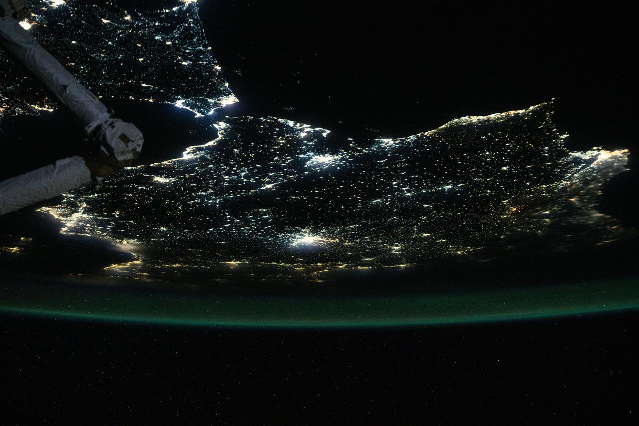
iss069e037776 (Aug. 8, 2023) --- This nighttime photograph shows the Mediterranean Sea ringed by the coastal city lights of Morocco and Algeria on the African side and Spain on the European side. The city lights extending to the Strait of Gibraltar and the Atlantic Ocean are also prominent. The International Space Station was orbiting 261 miles above the Balearic Sea off the coast of Mallorca at the time of this photograph.
ISS040-E-081320 (26 July 2014) --- One of the Expedition 40 crew members aboard the International Space Station recorded this early evening photo of the entire Iberian Peninsula (Spain and Portugal) on July 26, 2014. Part of France can be seen at the top of the image and the Strait of Gibraltar is visible at bottom, with a very small portion of Morocco visible near the lower right corner.
Swift currents flow through the Strait of Gibraltar, producing complicated patterns in the surface waters. Some of those patterns are highlighted in the sunglint in this photograph. The Mediterranian Sea is on the upper right, the Atlantic Ocean in in the lower left. Few features can be seen on the Mediterranian side, but current shears (straight lines coming off Spain), several sets of internal waves (impinging on the Spanish continental shelf) and ship wakes can be seen on the Atlantic side, west of Cadiz. Both Tangier and Cadiz show up in the sunglint as well.
This 34 by 59 km sub-scene, acquired on July 5, 2000, covers the eastern part of the Strait of Gibraltar, separating Spain from Morocco. The promontory on the eastern side of the conspicuous Spanish port is the Rock of Gibraltar. The Rock of Gibraltar was once one of the two classical Pillars of Hercules, crowned with silver columns by Phoenician mariners to mark the limits of safe navigation for the ancient Mediterranean peoples. The rocky promontory still commands the western entrance to the Mediterranean Sea, separated from North Africa only by the narrow Strait of Gibraltar. A British colony, Gibraltar occupies a narrow strip of land at the southernmost tip of the Iberian Peninsula. It is separated from the Spanish mainland by a neutral zone contained on a narrow, sandy isthmus. The rocky limestone and shale ridge known as the Rock rises abruptly from the sea, to a maximum elevation of 426 meters (1,398 feet). Because of its strategic location and formidable topography, Gibraltar serves mainly as a British fortress. The Rock has traditionally been a symbol of British naval strength. Most of its sparse land is taken up by air and naval installations, and the civilian population is small. The image is centered at 36 degrees north latitude, 5.5 degrees west longitude. http://photojournal.jpl.nasa.gov/catalog/PIA11167
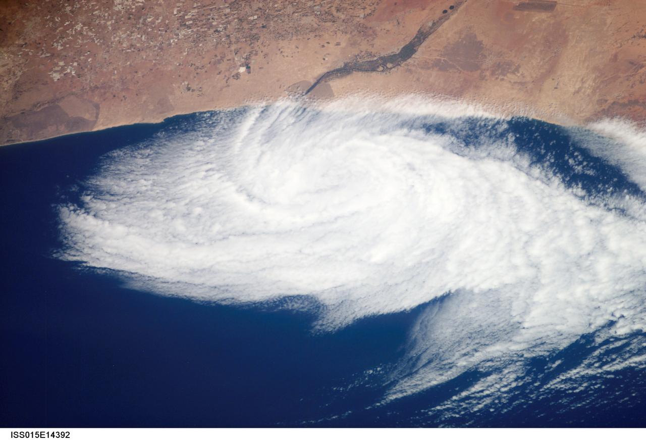
ISS015-E-14392 (26 June 2007) --- This nadir view from the International Space Station, photographed at 11:43 GMT on June 26, 2007, shows a weak low pressure area off the coast of Morocco, just south of Agadir (out of frame), near the Oued Massa River at about 30 degrees north latitude and 9.5 degrees west longitude. A low pressure area like this can be caused either by the winds forming an eddy due to some land feature or a heat low has drifted off the coast.
ISS030-E-060478 (30 Jan. 2012) --- The city lights of Madrid (just right of center) stand out in this photograph from the International Space Station. Recorded by one of the Expedition 30 crew members, the view shows almost the entire Iberian Peninsula (both Spain and Portugal) with the Strait of Gibraltar and Morocco appearing at lower left. What is thought to be a blur of the moon appears in upper left corner. The faint gold or brownish line of airglow?caused by ultraviolet radiation exciting the gas molecules in the upper atmosphere?parallels the horizon or Earth limb.
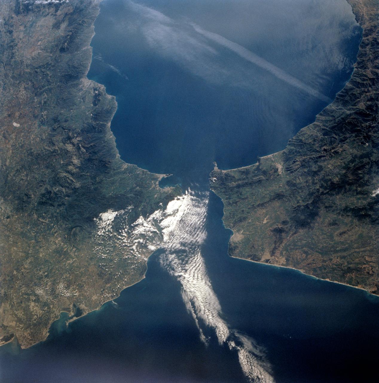
STS077-718-088 (19-29 May 1996) --- A popular photographic target of Space Shuttle astronauts has always been the Strait of Gibraltar seen at center in this wide photograph, shot from the Space Shuttle Endeavour. Spain is to the north (right) and Morocco to the south. The strait is 36 miles (58 kilometers) long and narrows to 8 miles (13 kilometers) at it’s most narrow point. The winds in the strait are either easterly or westerly. The British colony of Gibraltar is the semi-circular feature north of the strait. Gibraltar is considered to be one of the Pillars of Hercules. The white colored area to the southeast of Gibraltar on the Moroccan coast is the city of Tanger (Tangier). The snow covered mountains in Spain are the Sistemas Penibeticos.
ISS036-E-036611 (23 Aug. 2013) --- One of the Expedition 36 crew members aboard the International Space Station on Aug. 23 exposed this image of the Strait of Gibraltar, where Europe and Africa meet and where the Atlantic Ocean waters flow through the strait into the Mediterranean Sea. A popular photographic target of astronauts has always been the Strait of Gibraltar, easily spotted at left center in this wide photograph, shot from the International Space Station. Spain is to the north (top) and Morocco to the south. The strait is 36 miles (58 kilometers) long and slims down to 8 miles (13 kilometers) at it?s most narrow point. The British colony of Gibraltar is north of the strait.
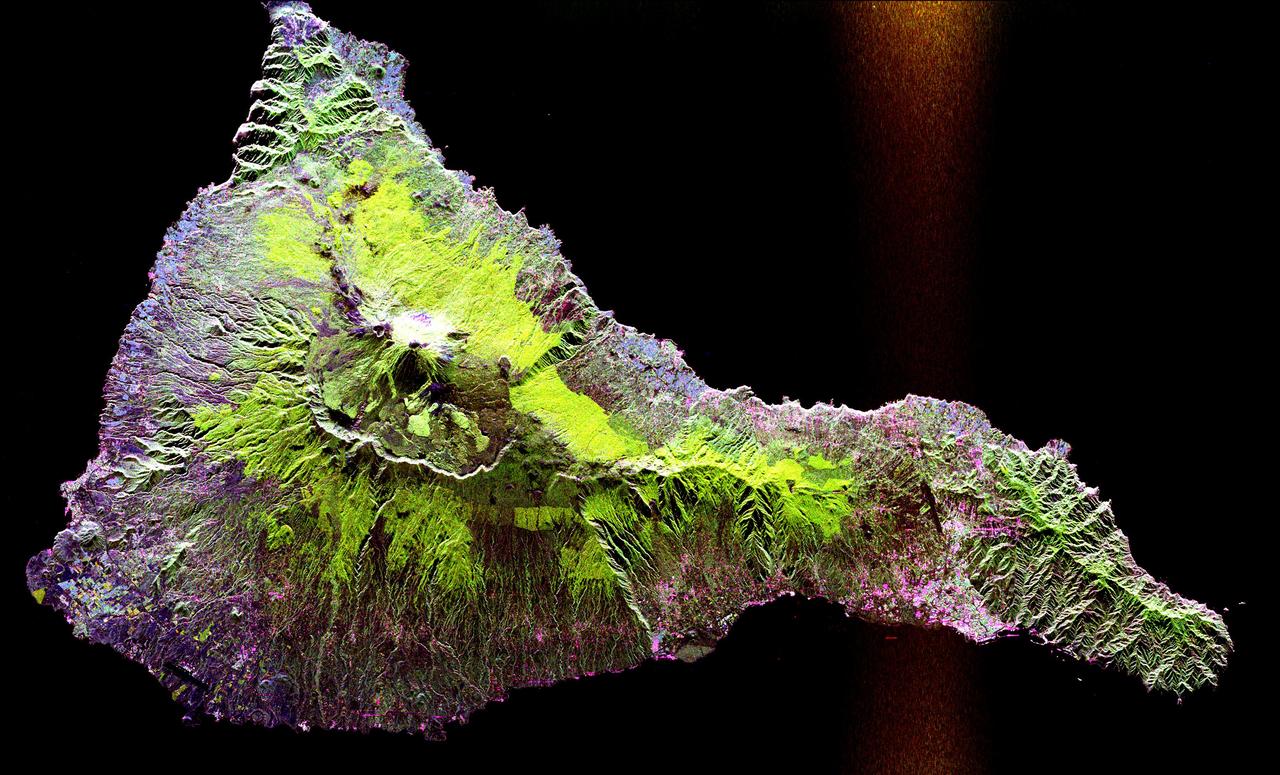
This radar image shows the Teide volcano on the island of Tenerife in the Canary Islands. The Canary Islands, part of Spain, are located in the eastern Atlantic Ocean off the coast of Morocco. Teide has erupted only once in the 20th Century, in 1909, but is considered a potentially threatening volcano due to its proximity to the city of Santa Cruz de Tenerife, shown in this image as the purple and white area on the lower right edge of the island. The summit crater of Teide, clearly visible in the left center of the image, contains lava flows of various ages and roughnesses that appear in shades of green and brown. Different vegetation zones, both natural and agricultural, are detected by the radar as areas of purple, green and yellow on the volcano's flanks. Scientists are using images such as this to understand the evolution of the structure of Teide, especially the formation of the summit caldera and the potential for collapse of the flanks. The volcano is one of 15 identified by scientists as potentially hazardous to local populations, as part of the international The image was acquired by the Spaceborne Imaging Radar-C/X-Band Synthetic Aperture Radar (SIR-C/X-SAR) onboard the space shuttle Endeavour on October 11, 1994. SIR-C/X-SAR, a joint mission of the German, Italian and the United States space agencies, is part of NASA's Mission to Planet Earth. The image is centered at 28.3 degrees North latitude and 16.6 degrees West longitude. North is toward the upper right. The area shown measures 90 kilometers by 54.5 kilometers (55.8 miles by 33.8 miles). The colors in the image are assigned to different frequencies and polarizations of the radar as follows: red is L-band horizontally transmitted, horizontally received; green is L-band horizontally transmitted, vertically received; blue is C-band horizontally transmitted, vertically received. http://photojournal.jpl.nasa.gov/catalog/PIA01779
STS058-73-009 (18 Oct-1 Nov 1993) --- Atlantic water flowing with the tide through the Strait of Gibraltar into the Mediterranean generates internal waves as depicted in this photo. The incoming cool, less dense Atlantic water flows over the warm, more saline Mediterranean water. As the tide moves into the Strait of Gibraltar it encounters the Camarinal Sill, which is like a cliff under water, south of Camarinal Point, Spain. Internal waves are generated at the Sill and travel along the density boundary between the Atlantic water and the Mediterranean water. Internal waves have very little effect on the sea surface, except for gentle slopes and slight differences in roughness. We can see them in the Space Shuttle photos because of sunglint which reflects off the water. Internal waves smooth out some of the capillary waves at the surface in bands. The sun reflects more brightly from these smooth areas showing us the pattern of the underwater waves. The Bay of Cadiz on the southwest coast of Spain, the Rock of Gibraltar, and the Moroccan coast are also visible in this photo.
ISS032-E-026884 (12 Sept. 2012) --- With an oblique view of the southwest coast of Morocco serving as a backdrop, the International Space Station's Canadarm2 grasps the unpiloted Japan Aerospace Exploration Agency (JAXA) H-II Transfer Vehicle (HTV-3), filled with trash and unneeded items, in preparation for its release from the station. JAXA astronaut Aki Hoshide and NASA astronaut Joe Acaba, both Expedition 32 flight engineers, used the station's robot arm to grapple the HTV-3 and undock it from the Earth-facing port of the Harmony node. The cargo craft was released at 11:50 a.m. (EDT) on Sept. 12, 2012. Cape Rhir is at lower left and part of the Anti-Atlas mountain range can be seen just inland.
ISS035-E-027420 (23 April 2013) --- One of the Expedition 35 crew members aboard the International Space Station photographed this high oblique image of the Iberian Peninsula on April 23, 2013. This is one of the very few pictures in the history of the decades old NASA-managed human-tended space program that shows the entire peninsula, with Portugal, Spain and Gibraltar. The Strait of Gibraltar (right center) is a narrow strait that connects the Atlantic Ocean to the Mediterranean Sea and separates Gibraltar and Spain in Europe from Morocco (far right center)in Africa. Europe and Africa are separated by 7.7 nautical miles (14.3 kilometers or 8.9 statute miles) of ocean at the strait's narrowest point. A small part of France is barely visible at the horizon (top center).
AS08-16-2588 (21-27 Dec. 1968) --- Both sides of the Atlantic Ocean are visible in this view from Apollo 8 spacecraft. (Hold picture with Earth at bottom left). The large, most prominent land mass is the bulge of West Africa. The portion of Africa near the equator is dark and cloudy, but the more northerly portions are clear, showing the prominent cape at Dakar and the Senegal River in Senegal; Cap Blanc; the Adrar Plateau in Mauretania; the wide expanse of desert in Algeria and Spanish Sahara; and the far edge, the Atlas and Anti-Atlas Mountains in Morocco. Clouds cover the eastern coast of South America, southward from Surinam and Guyana to near the city of Salvador, Brazil. The view was photographed following trans-lunar insertion.
ISS032-E-026883 (12 Sept. 2012) --- With an oblique view of the southwest coast of Morocco serving as a backdrop, the International Space Station's Canadarm2 grasps the unpiloted Japan Aerospace Exploration Agency (JAXA) H-II Transfer Vehicle (HTV-3), filled with trash and unneeded items, in preparation for its release from the station. JAXA astronaut Aki Hoshide and NASA astronaut Joe Acaba, both Expedition 32 flight engineers, used the station's robot arm to grapple the HTV-3 and undock it from the Earth-facing port of the Harmony node. The cargo craft was released at 11:50 a.m. (EDT) on Sept. 12, 2012. Cape Rhir and port city of Agadir are at lower left and part of the Anti-Atlas mountain range can be seen just inland.
This perspective view shows the Strait of Gibraltar, which is the entrance to the Mediterranean Sea from the Atlantic Ocean. Europe (Spain) is on the left. Africa (Morocco) is on the right. The Rock of Gibraltar, administered by Great Britain, is the peninsula in the back left. The Strait of Gibraltar is the only natural gap in the topographic barriers that separate the Mediterranean Sea from the world's oceans. The Sea is about 3700 kilometers (2300 miles) long and covers about 2.5 million square kilometers (one million square miles), while the Strait is only about 13 kilometers (8 miles) wide. Sediment samples from the bottom of the Mediterranean Sea that include evaporite minerals, soils, and fossil plants show that about five million years ago the Strait was topographically blocked and the Sea had evaporated into a deep basin far lower in elevation than the oceans. Consequent changes in the world's hydrologic cycle, including effects upon ocean salinity, likely led to more ice formation in polar regions and more reflection of sunlight back to space, resulting in a cooler global climate at that time. Today, topography plays a key role in our regional climate patterns. But through Earth history, topographic change, even perhaps over areas as small as 13 kilometers across, has also affected the global climate. This image was generated from a Landsat satellite image draped over an elevation model produced by the Shuttle Radar Topography Mission (SRTM). The view is eastward with a 3-times vertical exaggeration to enhance topographic expression. Natural colors of the scene (green vegetation, blue water, brown soil, white beaches) are enhanced by image processing, inclusion of some infrared reflectance (as green) to highlight the vegetation pattern, and inclusion of shading of the elevation model to further highlight the topographic features. Landsat has been providing visible and infrared views of the Earth since 1972. SRTM elevation data matches the 30-meter (99-feet) resolution of most Landsat images and will substantially help in analyses of the large Landsat image archive. Elevation data used in this image was acquired by the Shuttle Radar Topography Mission (SRTM) aboard the Space Shuttle Endeavour, launched on February 11, 2000. http://photojournal.jpl.nasa.gov/catalog/PIA03397
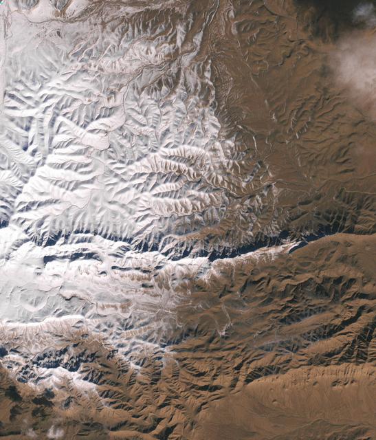
In December 2016, snow fell in the Sahara for the first time since 1979. In 1984, the charitable supergroup Band Aid sang: “There won’t be snow in Africa this Christmas time.” In fact, it does snow in Africa at high elevations. Kilimanjaro has long had a cap of snow and ice, though it has been shrinking. Skiiers travel for natural and manufactured snow in the Atlas Mountains of Morocco and Algeria, as well as a few spots in South Africa and Lesotho. Nonetheless, snow on the edge of the Sahara Desert is rare. On December 19, 2016, snow fell on the Algerian town of Ain Sefra, which is sometimes referred to as the “gateway to the desert.” The town of roughly 35,000 people sits between the Atlas Mountains and the northern edge of the Sahara. The last recorded snowfall in Ain Sefra occurred in February 1979. The Enhanced Thematic Mapper Plus (ETM+) on the Landsat 7 satellite acquired this natural-color image of snow in North Africa on December 19, 2016. This scene shows an area near the border of Morocco and Algeria, south of the city of Bouarfa and southwest of Ain Sefra. Though the news has been dominated by snow in the Saharan city, a review of several years of satellite data suggests that snow is also pretty rare in this section of the Atlas range. Read more: <a href="http://go.nasa.gov/2hIH4Xe" rel="nofollow">go.nasa.gov/2hIH4Xe</a> NASA Earth Observatory image by Joshua Stevens, using Landsat data from the U.S. Geological Survey. Caption by Mike Carlowicz. b><a href="http://www.nasa.gov/audience/formedia/features/MP_Photo_Guidelines.html" rel="nofollow">NASA image use policy.</a> <b><a href="http://www.nasa.gov/centers/goddard/home/index.html" rel="nofollow">NASA Goddard Space Flight Center</a></b> enables NASA’s mission through four scientific endeavors: Earth Science, Heliophysics, Solar System Exploration, and Astrophysics. Goddard plays a leading role in NASA’s accomplishments by contributing compelling scientific knowledge to advance the Agency’s mission. <b>Follow us on <a href="http://twitter.com/NASAGoddardPix" rel="nofollow">Twitter</a></b> <b>Like us on <a href="http://www.facebook.com/pages/Greenbelt-MD/NASA-Goddard/395013845897?ref=tsd" rel="nofollow">Facebook</a></b> <b>Find us on <a href="http://instagrid.me/nasagoddard/?vm=grid" rel="nofollow">Instagram</a></b>
STS039-151-193 (28 April-6 May 1991) --- The Strait of Gibraltar, the only outlet for the Mediterranean Sea, was photographed with a large format handheld camera by the STS-39 crew members. Scientists site evidence in Shuttle photography that the Mediterranean Sea dried up a number of times between 5 million and 20 million years ago. Sea levels, they say, dropped slightly, cutting off the Mediterranean (top right) from the Atlantic Ocean (bottom). In southern Spain, the dark area near the coast is the delta of the Guadalquivir River with the city of Seville. The Sierra Nevada range still has some snow. A small field fire near the Spanish coast has generated a conspicuous smoke plume. The small spike of land on the north side of the Strait is the Rock of Gibraltar, an outpost of the British empire. The larger spike of land on the north coast of Africa marks the border between Morocco (center foreground) and Algeria (right). The sharp line cutting across them Mediterranean (top right) marks the edge of a dust cloud blowing from Africa into Europe. Photo credit: NASA
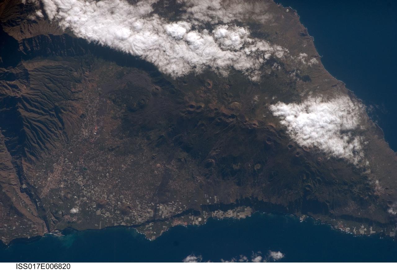
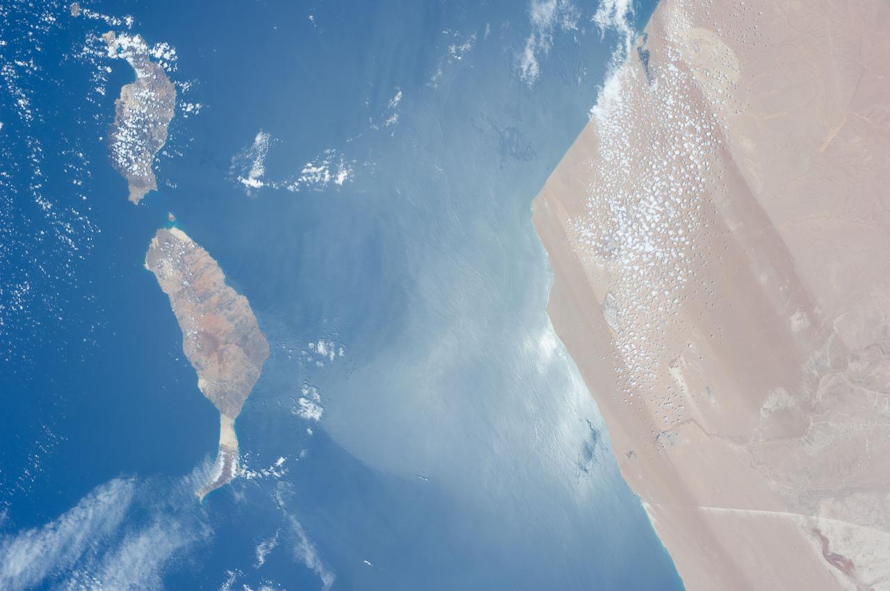
ISS017-E-006820 (13 May 2008) --- Isla de la Palma in the Canary Islands is featured in this image photographed by an Expedition 17 crewmember on the International Space Station. The Canary Islands, a group of volcanic islands, lie just off the west coast of Morocco in the Atlantic Ocean; at the northwest end of the chain of islands is Isla de la Palma. According to scientists, the island started forming as a submarine volcano approximately 3-4 million years ago. Subaerial (above the water surface) volcanic activity and island formation began around 2 million years ago. Most geologists believe the Canary Islands formed over the remnants of an old "hotspot" in the mantle, or mantle plume. The residual hotspot melting produced the magma that resulted in the Canary Island volcanoes. While there is little evidence to support the current existence of a mantle plume, volcanic activity is still taking place -- the most recent lava flows on Isla de Palma were erupted in 1971. In addition to volcanic hazards, the Canary Islands are also subject to occasional dust storms originating in the Sahara Desert. This view highlights volcanic landforms on the southern portion of Isla de Palma. The elongated, 1949-meter high Cumbre Vieja volcanic center is characterized by numerous cinder cones, craters, and gray lava flows that punctuate the green vegetated hillslopes. To the north, the cities of El Paso and Los Llanos de Aridanes nestle against collapsed fragments of the Caldera Taburiente (left), formed by massive slope failure of an older volcanic center to the north. Tourism is a major component of the local economy, but the high mountains and clear air of Isla de la Palma are also attractive to astronomers -- several large observatories (not shown) are located along the northern edge of the Caldera Taburiente.
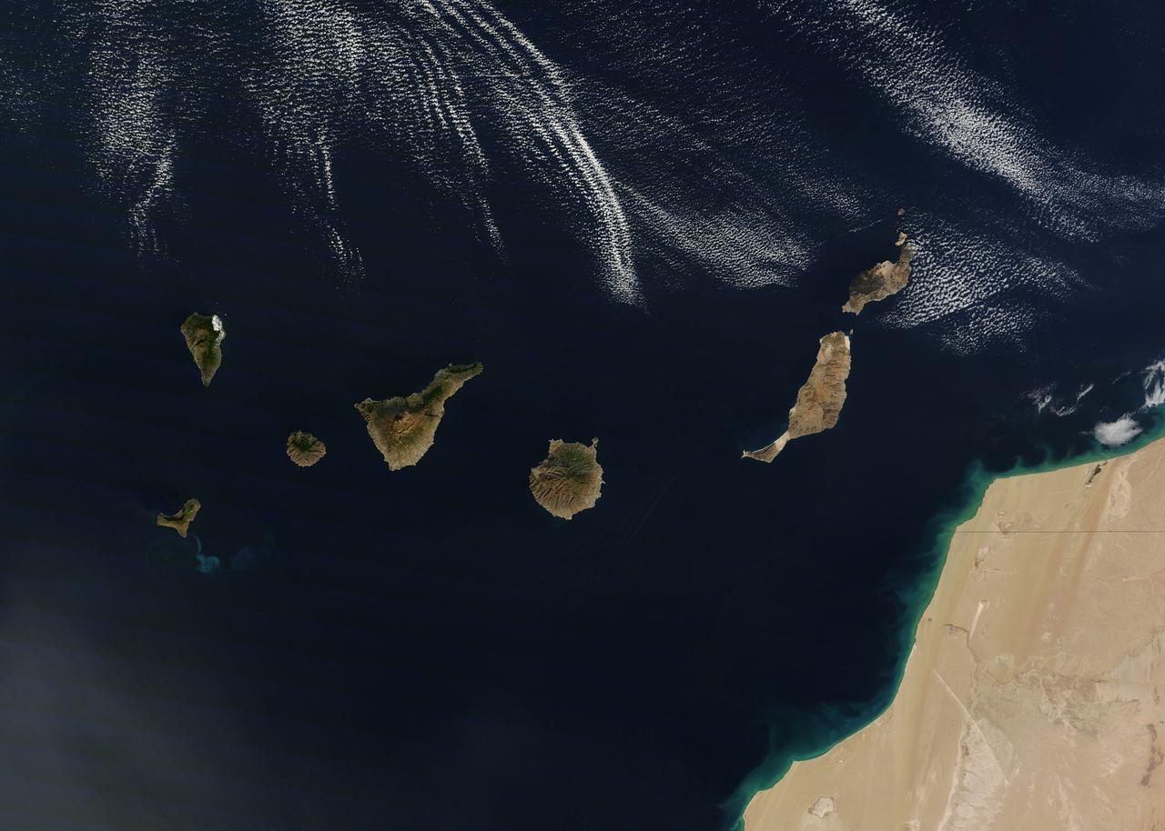
NASA image acquired December 21, 2011 The rugged landscape of the Canary Islands stood out in sharp contrast to the smooth blue waters of the Atlantic Ocean and the flat tan land of northwestern Africa on December 21, 2011, when the Moderate Resolution Imaging Spectroradiometer (MODIS) aboard the Terra satellite captured this true-color image. The Canary Islands are a group of seven large islands and several smaller islets, all volcanic in origin. The eastern edge of the chain lies only 100 kilometers from the coasts of Morocco and Western Sahara, and the chain stretches for about 500 kilometers across the Atlantic. All the islands are mountainous, and Tenerife, the central island in this image is home to Pico de Teinde, the highest peak, which rises 12,198 feet (3,718 meters) above sea level. From east to west, the islands are named Lanzarote, Fuerteventura, Gran Canaria, Tenerife, La Gomera, La Palmera and El Hierro. A bright swirl of peacock blue marks the ocean south of El Hierro, a stain on the sea from an ongoing eruption of a volcano under the waters. Credit: NASA/GSFC/Jeff Schmaltz/MODIS Land Rapid Response Team <b><a href="http://www.nasa.gov/audience/formedia/features/MP_Photo_Guidelines.html" rel="nofollow">NASA image use policy.</a></b> <b><a href="http://www.nasa.gov/centers/goddard/home/index.html" rel="nofollow">NASA Goddard Space Flight Center</a></b> enables NASA’s mission through four scientific endeavors: Earth Science, Heliophysics, Solar System Exploration, and Astrophysics. Goddard plays a leading role in NASA’s accomplishments by contributing compelling scientific knowledge to advance the Agency’s mission. <b>Follow us on <a href="http://twitter.com/NASA_GoddardPix" rel="nofollow">Twitter</a></b> <b>Like us on <a href="http://www.facebook.com/pages/Greenbelt-MD/NASA-Goddard/395013845897?ref=tsd" rel="nofollow">Facebook</a></b> <b>Find us on <a href="http://instagrid.me/nasagoddard/?vm=grid" rel="nofollow">Instagram</a></b>

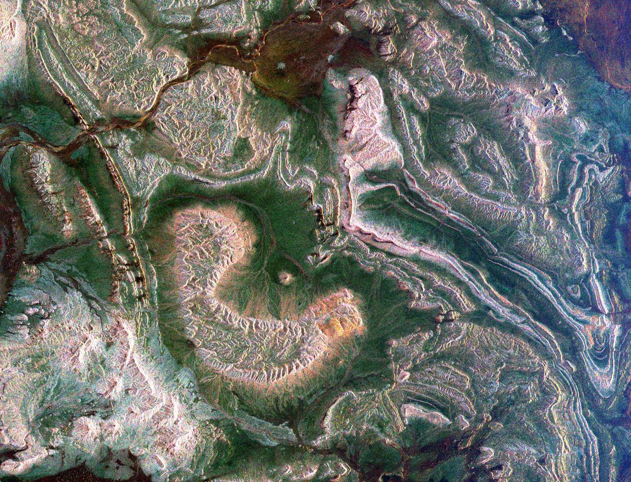
ISS030-E-254011 (21 April 2012) --- The Ouarkziz Impact Crater is featured in this image photographed by an Expedition 30 crew member on the International Space Station. The Ouarkziz Impact Crater is located in northwestern Algeria close to the border with Morocco. According to scientists, the crater was formed by a meteor impact less than 70 million years ago during the late Cretaceous Period of the Mesozoic Era or “Age of Dinosaurs”. Originally called Tindouf, the 3.5-kilometer in diameter impact crater (center) has been heavily eroded since its formation; however its circular morphology is highlighted by exposures of older sedimentary rock layers that form roughly northwest-to-southeast-trending ridgelines to the north and south. From the vantage point of a crew member onboard the space station, the impact crater is clearly visible with a magnifying camera lens. A geologist interpreting this image to build a working geological history of the region would conclude that the Ouarkziz impact crater is younger than the sedimentary rocks, as the rock layers had to be already present for the meteor to hit them. Likewise, a stream channel is visible cutting across the center of the impact structure (center), indicating that the channel formed after the impact had occurred. This Principal of Cross-Cutting Relationships, usually attributed to the famous 19th century geologist Charles Lyell, is a basic logic tool used by geologists to build relative sequence and history of events when investigating a region.
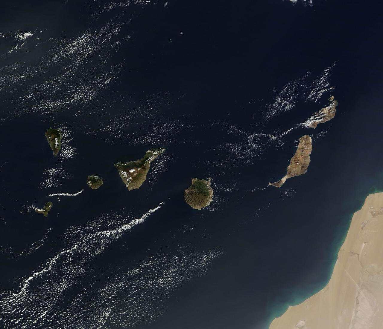
On December 10, 2013 the Moderate Resolution Imaging Spectroradiometer (MODIS) aboard NASA’s Terra satellite flew across the central Atlantic Ocean and captured a true-color image of the Canary Islands. Lying off of the coast of Western Sahara and Morocco, the islands were created by successive submarine volcanic eruptions which raised the ocean floor vertically until some of land rose above sea level. The oldest islands lie in the east and the youngest in the west. From east to west, the major islands seen in this image are: Lanzarote, Fuerteventura, Gran Canaria, Tenerife, La Gomera, La Palmera and El Hierro. While the creation of the islands began in the Late Cretaceous Period (70 – 80 million years ago), active volcanic activity continues. In 2011, a spectacular submarine eruption occurred just off the shore of El Hierro. The volcano became quiet again, but very recently increasing earthquakes and changing height of El Hierro suggested the volcano may again be entering an active eruptive phase. On December 27 the island’s volcano monitoring agency had raised the volcanic eruption risk for El Hierro to “yellow” – a code that means increasing activity but no eruption imminent. That afternoon a magnitude 5.1 earthquake struck offshore at El Hierro. The epicenter was 9 miles (15 km) deep, and it was one of the largest quakes ever recorded at the island. Credit: NASA/GSFC/Jeff Schmaltz/MODIS Land Rapid Response Team <b><a href="http://www.nasa.gov/audience/formedia/features/MP_Photo_Guidelines.html" rel="nofollow">NASA image use policy.</a></b> <b><a href="http://www.nasa.gov/centers/goddard/home/index.html" rel="nofollow">NASA Goddard Space Flight Center</a></b> enables NASA’s mission through four scientific endeavors: Earth Science, Heliophysics, Solar System Exploration, and Astrophysics. Goddard plays a leading role in NASA’s accomplishments by contributing compelling scientific knowledge to advance the Agency’s mission. <b>Follow us on <a href="http://twitter.com/NASA_GoddardPix" rel="nofollow">Twitter</a></b> <b>Like us on <a href="http://www.facebook.com/pages/Greenbelt-MD/NASA-Goddard/395013845897?ref=tsd" rel="nofollow">Facebook</a></b> <b>Find us on <a href="http://instagram.com/nasagoddard?vm=grid" rel="nofollow">Instagram</a></b>