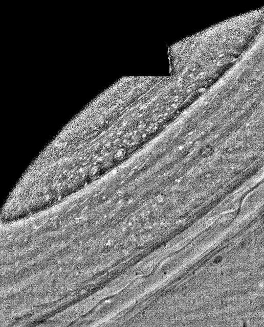
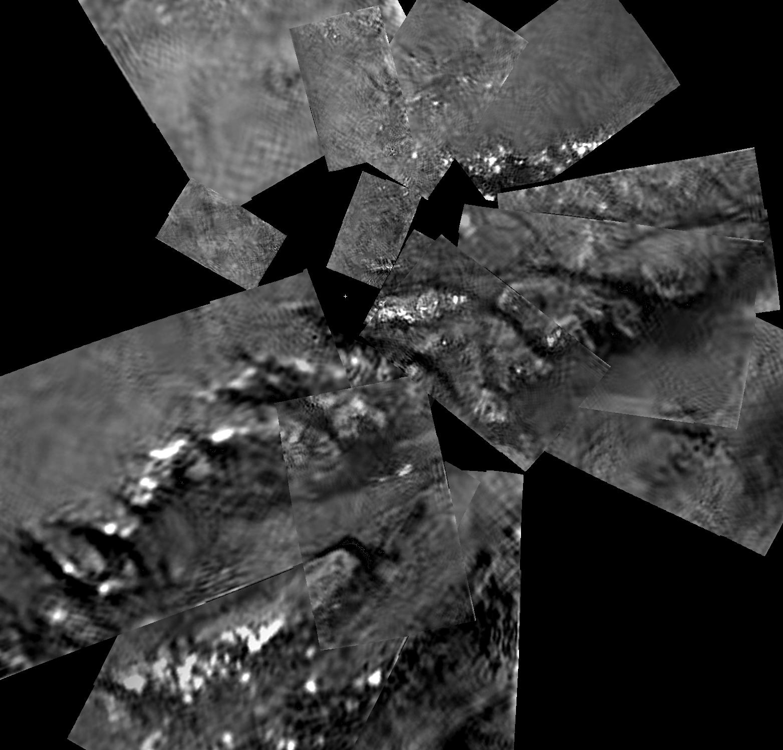
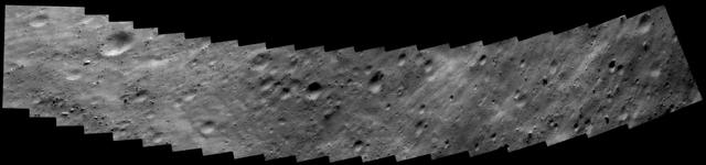
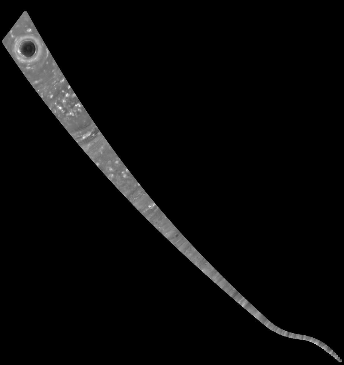
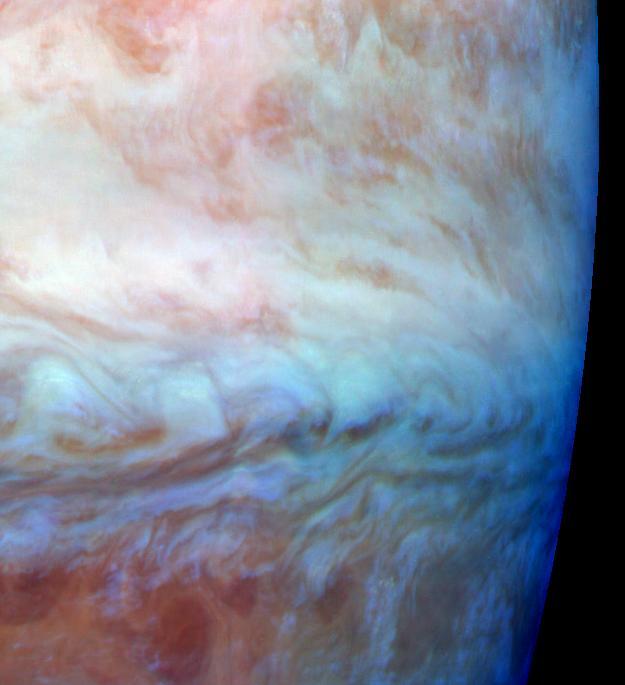
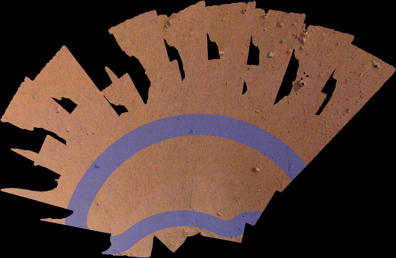
Antarctica is the coldest, driest and windiest place on Earth – and, during the austral summer, it is also the sunniest. Due to the tilt of the Earth’s axis in relation of the sun, the frozen land south of the Antarctic Circle receives six months of daylight in summertime, and six months of darkness in winter. The long hours of sunshine allow for excellent imagery of the region from space.  This true-color mosaic of Antarctica was created from images acquired by multiple passes of the Moderate Resolution Imaging Spectroradiometer (MODIS) aboard the Terra satellite on December 16, 2013. Because Terra is in a polar orbit, it passes over each pole approximately 14 times a day, and acquires an image on each pass. To create a mosaic, the data that are closest to the center of each swath – where edge distortion is minimized – are used to create a complete view of the region.  The MODIS Rapid Response system generates complete mosaic images of Antarctica every day in austral late spring, summer and early fall. Because the light is poor in austral late fall, winter and early spring, MODIS images are not created during that period. A mosaic of Antarctica can be found for any given day at NASA’s Project Antarctica at <a href="http://rapidfire.sci.gsfc.nasa.gov/subsets/?project=antarctica" rel="nofollow">rapidfire.sci.gsfc.nasa.gov/subsets/?project=antarctica</a>  Credit: NASA/GSFC/Jeff Schmaltz/MODIS Land Rapid Response Team    <b><a href="http://www.nasa.gov/audience/formedia/features/MP_Photo_Guidelines.html" rel="nofollow">NASA image use policy.</a></b>  <b><a href="http://www.nasa.gov/centers/goddard/home/index.html" rel="nofollow">NASA Goddard Space Flight Center</a></b> enables NASA’s mission through four scientific endeavors: Earth Science, Heliophysics, Solar System Exploration, and Astrophysics. Goddard plays a leading role in NASA’s accomplishments by contributing compelling scientific knowledge to advance the Agency’s mission.  <b>Follow us on <a href="http://twitter.com/NASA_GoddardPix" rel="nofollow">Twitter</a></b>  <b>Like us on <a href="http://www.facebook.com/pages/Greenbelt-MD/NASA-Goddard/395013845897?ref=tsd" rel="nofollow">Facebook</a></b>  <b>Find us on <a href="http://instagram.com/nasagoddard?vm=grid" rel="nofollow">Instagram</a></b>
Mosaic of Antarctica
Mosaic of Mathilde
Mosaic of Mathilde
Enceladus Mosaic
Enceladus Mosaic
Mosaic of Io
Mosaic of Io
Europa - Mosaic  http://photojournal.jpl.nasa.gov/catalog/PIA00366
Europa - Mosaic
Hellas Mosaic  http://photojournal.jpl.nasa.gov/catalog/PIA00406
Hellas Mosaic
Making a Mosaic  http://photojournal.jpl.nasa.gov/catalog/PIA10604
Making a Mosaic
The New Three-Color Mosaic
Titan Mosaic - Feb 2005
Mosaic of Commemorative Microscope Substrate
Full Global Mercury Mosaic
North Pole Mosaics
North Pole Mosaics
Arsia Mons Mosaic
Arsia Mons Mosaic
Zooming In On Enceladus Mosaic
Callisto Scarp Mosaic
The Southern Saddle Mosaic
Photographic Mosaic of Saturn
Io 2x2 Mosaic
Io 2x2 Mosaic
Huygens Titan Mosaic #1
Jovian Ring System Mosaic
Southwest of the Big Crater Mosaic
Tyrrhena Patera Mosaic
Highest Resolution Mosaic of Io
Mosaic of Eros Northern Hemisphere
Color Global Mosaic of Io
Titan Mosaic: October 2004
Titan Mosaic: December 2004
Huygens Titan Mosaic #2
Phoebe Hi-Resolution Mosaic
Hebes Chasma Mosaic
Hebes Chasma Mosaic
Valles Marineris Mosaic
Callisto Crater Chain Mosaic
Eros Closest Approach Mosaic
Kasei Vallis Mosaic
Kasei Vallis Mosaic
Full Jupiter Mosaic
Full Jupiter Mosaic
Mosaic of Eros Northern Hemisphere
Asgard Scarp Mosaic
Asgard Scarp Mosaic
Mosaic of Saturn Rings
Making a Mosaic - Part II  http://photojournal.jpl.nasa.gov/catalog/PIA10605
Making a Mosaic - Part II
Mars Digital Image Mosaic Globe
Two-image Mosaic of Saturn Rings
Orbital Mosaic of Mercury North Pole
Tracing Surface Features on Titan--Mosaic
Rover Camera Mosaic of Lander & Wedge
Early MOC Global Color Mosaics
Eros Image Mosaic, Looking North
Mosaic of Triton constructed from 16 individual images. After globally minimizing the camera pointing errors, the frames we reprocessed by map projections, photometric function removal and placement in the mosaic.
Triton Mosaic
Moon - North Polar Mosaic, Color  http://photojournal.jpl.nasa.gov/catalog/PIA00404
Moon - North Polar Mosaic, Color
Many impact craters -- the record of the collision of cosmic debris -- are shown in this mosaic from NASA Voyager 1 of Saturn moon Dione.
Dione Mosaic
The hemisphere of Ganymede that faces away from the Sun displays a great variety of terrain in this mosaic from NASA Voyager 2.  http://photojournal.jpl.nasa.gov/catalog/PIA00081
Ganymede Mosaic
High-Resolution South Polar Cap Mosaics
Uruk Sulcus Mosaic - Galileo over Voyager Data
Regional Mosaic of Chaos and Gray Band on Europa
False Color Mosaic of Jupiter Belt-Zone Boundary
High-Resolution South Polar Cap Mosaics
Approach Mosaic from Mercury Flyby 3
Mosaic of River Channel and Ridge Area on Titan
Departure Mosaics from the Second Mercury Flyby
Color Mosaic and Active Volcanic Plumes on Io
NEAR First Whole-Eros Mosaic from Orbit
Galileo Regio Mosaic - Galileo over Voyager Data
Mercury QuickMap Mosaics Available in High Resolution
High-Resolution Mosaic - Mars Rocky Horizon
This picture of Triton is a mosaic of the highest resolution images taken by NASA Voyager 2 on Aug. 25, 1989 from a distance of about 40,000 kilometers 24,800 miles.
Triton Mosaic
Mosaic of Mermaid
Mosaic of Mermaid
Color mosaic of Olympus Mons volcano on Mars from the Viking 1 Orbiter. The mosaic was created using images from orbit 735 taken 22 June 1978. Olympus Mons is about 600 km in diameter and the summit caldera is 24 km above the surrounding plains.
Color Mosaic of Olympus Mons
Aug 30, 2011  USGS has released a new mosaic of the Chesapeake Bay. Using six Landsat 5 images collected in July 2009 and 2011 a beautiful, seamless mosaic of the Chesapeake Bay region was created by the USGS Landsat team. The Washington D.C.-Baltimore-Philadelphia-New York City corridor can be clearly seen (look for silvery purple) as can the Chesapeake and Delaware Bays and the coastal Atlantic barrier islands from Fishermans Island, Virginia to Sandy Hook, New Jersey.  To download the full high res go to: <a href="http://landsat.gsfc.nasa.gov/news/news-archive/news_0387.html" rel="nofollow">landsat.gsfc.nasa.gov/news/news-archive/news_0387.html</a>  Credit: NASA/USGS/Landsat 5  <b><a href="http://www.nasa.gov/centers/goddard/home/index.html" rel="nofollow">NASA Goddard Space Flight Center</a></b> enables NASA’s mission through four scientific endeavors: Earth Science, Heliophysics, Solar System Exploration, and Astrophysics. Goddard plays a leading role in NASA’s accomplishments by contributing compelling scientific knowledge to advance the Agency’s mission.  <b>Follow us on <a href="http://twitter.com/NASA_GoddardPix" rel="nofollow">Twitter</a></b>  <b>Like us on <a href="http://www.facebook.com/pages/Greenbelt-MD/NASA-Goddard/395013845897?ref=tsd" rel="nofollow">Facebook</a></b>  <b>Find us on <a href="http://instagrid.me/nasagoddard/?vm=grid" rel="nofollow">Instagram</a></b>
Beautiful New Landsat Mosaic of Chesapeake Bay
The ASTER instrument has been acquiring images since 2000. Currently the archive contains over 3.7 million images, including day and night thermal infrared data, and stereo pairs of the entire land surface of the Earth. This mosaic was created from thumbnail browse images, using bands 3, 2 and 1 displayed in red, green, and blue, respectively. The mosaic was also warped onto a spinning globe.  https://photojournal.jpl.nasa.gov/catalog/PIA22979
ASTER Global Mosaic
Pseudo-true color mosaic of a belt-zone boundary near Jupiter equator. The images that make up the four quadrants of this mosaic were taken within a few minutes of each other by NASA Galileo orbiter.
True Color Mosaic of Jupiter Belt-Zone Boundary
This mosaic of images combines views captured by NASA's Cassini spacecraft as it made the first dive of the mission's Grand Finale on April 26, 2017. It shows a vast swath of Saturn's atmosphere, from the north polar vortex to the boundary of the hexagon-shaped jet stream, to details in bands and swirls at middle latitudes and beyond.  The mosaic is a composite of 137 images captured as Cassini made its first dive toward the gap between Saturn and its rings. It is an update to a previously released image product. In the earlier version, the images were presented as individual movie frames, whereas here, they have been combined into a single, continuous mosaic. The mosaic is presented as a still image as well as a video that pans across its length. Imaging scientists referred to this long, narrow mosaic as a "noodle" in planning the image sequence.  The first frame of the mosaic is centered on Saturn's north pole, and the last frame is centered on a region at 18 degrees north latitude. During the dive, the spacecraft's altitude above the clouds changed from 45,000 to 3,200 miles (72,400 to 8374 kilometers), while the image scale changed from 5.4 miles (8.7 kilometers) per pixel to 0.6 mile (1 kilometer) per pixel.  The bottom of the mosaic (near the end of the movie) has a curved shape. This is where the spacecraft rotated to point its high-gain antenna in the direction of motion as a protective measure before crossing Saturn's ring plane.  The images in this sequence were captured in visible light using the Cassini spacecraft wide-angle camera. The original versions of these images, as sent by the spacecraft, have a size of 512 by 512 pixels. The small image size was chosen in order to allow the camera to take images quickly as Cassini sped over Saturn.  These images of the planet's curved surface were projected onto a flat plane before being combined into a mosaic. Each image was mapped in stereographic projection centered at 55 degree north latitude.   A movie is available at https://photojournal.jpl.nasa.gov/catalog/PIA21617
Cassini "Noodle" Mosaic of Saturn
This image is a mosaic of Vesta equatorial region, composed of observations taken through the panchromatic filter on the framing camera onboard NASA Dawn spacecraft on July 24, 2011.
Mosaic Image of Vesta Surface
Titan T28 Mosaic
Titan T28 Mosaic
This mosaic from NASA Magellan data is in the Lavinia region of Venus. Three large impact craters can be seen located in a region of fractured plains.  http://photojournal.jpl.nasa.gov/catalog/PIA00086
Mosaic of Large Impact Craters
Morning on Chryse Planitia - Viking Lander 1 Camera 2 Mosaic
Ganymede Galileo Regio High Resolution Mosaic Shown in Context
Afternoon on Chryse Planitia - Viking Lander 1 Camera 1 Mosaic
Five of Five: The Last Scene in a High-resolution Color Mosaic
Enceladus Rev 91 Flyby - Skeet Shoot 1-4 Mosaic
Ganymede Uruk Sulcus High Resolution Mosaic Shown in Context
Morning on Chryse Planitia - Viking Lander 1 Camera 1 Mosaic
Afternoon on Chryse Planitia - Viking Lander 1 Camera 2 Mosaic
This mosaic from NASA Dawn spacecraft shows asteroid Vesta southern hemisphere lower part of the image and equatorial regions upper part of the image.
Mosaic of Visible and Infrared Spectrometer Data
This false color mosaic shows a belt-zone boundary near Jupiter equator. The images that make up the four quadrants of this mosaic were taken within a few minutes of each other. These images were taken on Nov. 5, 1996 by NASA Galileo orbiter.
False Color Mosaic of Jupiter Belt-Zone Boundary
This false-color mosaic of part of the Moon was constructed from 54 images taken by the imaging system aboard NASA's Galileo as the spacecraft flew past the Moon on December 7, 1992.  http://photojournal.jpl.nasa.gov/catalog/PIA00129
Moon - False Color Mosaic
This view of the Moon north pole is a mosaic assembled from 18 images taken by NASA's Galileo imaging system through a green filter as the spacecraft flew by on December 7, 1992.  http://photojournal.jpl.nasa.gov/catalog/PIA00130
Moon - North Pole Mosaic
NASA Galileo spacecraft acquired this global mosaic right during Galileo third orbit on Nov. 4, 1996. The lighter bluish area in the upper latitudes is the Asgard multi-ring structure with crater Burr to the north and Tornasuk to the east.
NIMS Callisto Global Mosaic
This color mosaic of Dantu Crater was obtained by NASA's Dawn spacecraft on May 23, 2018 from an altitude of about 305 miles (490 kilometers).  The center of Dantu Crater is located at about 24 degrees north in latitude and 138 degrees east in longitude.   https://photojournal.jpl.nasa.gov/catalog/PIA22471
Color Mosaic of Dantu Crater
Spirit Arm Movements for Mosaic of Keystone
Global mosaics of Pluto and Charon projected at 300 meters (985 feet) per pixel that have been assembled from most of the highest resolution images obtained by the Long-Range Reconnaissance Imager (LORRI) and the Multispectral Visible Imaging Camera (MVIC) onboard New Horizons. Transparent, colorized stereo topography data generated for the encounter hemispheres of Pluto and Charon have been overlain on the mosaics. Terrain south of about 30°S on Pluto and Charon was in darkness leading up to and during the flyby, so is shown in black. "S" and "T" respectively indicate Sputnik Planitia and Tartarus Dorsa on Pluto, and "C" indicates Caleuche Chasma on Charon. All feature names on Pluto and Charon are informal.   https://photojournal.jpl.nasa.gov/catalog/PIA21862
Global Mosaics of Pluto and Charon
S74-23654 (22 June 1973) --- This mosaic of Baja and the Sea of Cortez in Mexico (28.0N, 112.0W) is a composite of six 70mm photos carefully pieced together to appear as one. Mosaics such as this one are useful to portray a large area in a single format instead of many photos covering only partial images. In this mosaic, almost the entire area of the Sea of Cortez, the adjacent Baja Peninsula and part of the Sonoran Desert of northwest Mexico can be seen. Photo credit: NASA
SKYLAB (SL)-2 - ONBOARD (MOSAIC)
This color picture of the limb of the Earth, looking north past Antarctica, is a mosaic of 11 images taken during a ten-minute period near 5:45 p.m. PST Dec. 8, 1990, by NASA’s Galileo imaging system.  http://photojournal.jpl.nasa.gov/catalog/PIA00116
Earth - Antarctica Mosaic
This mosaic picture of the Moon was compiled from 18 images taken with a green filter NASA's Galileo imaging system during the spacecraft flyby on December 7, 1992, some 11 hours before its Earth flyby.  http://photojournal.jpl.nasa.gov/catalog/PIA00128
Moon - 18 Image Mosaic
This picture of asteroid 951 Gaspra is a mosaic of two images taken by NASA's Galileo spacecraft from a range of 5,300 kilometers 3,300 miles, some 10 minutes before closest approach on October 29, 1991.  http://photojournal.jpl.nasa.gov/catalog/PIA00118
Gaspra - Highest Resolution Mosaic
This false-color mosaic was constructed from a series of 53 images taken through three spectral filters by NASA's Galileo imaging system as the spacecraft flew over the northern regions of the Moon on December 7, 1992.  http://photojournal.jpl.nasa.gov/catalog/PIA00131
Moon - False Color Mosaic
This picture of asteroid 951 Gaspra is a mosaic of two images taken by NASA's Galileo spacecraft from a range of 5,300 kilometers 3,300 miles, some 10 minutes before closest approach on October 29, 1991.  http://photojournal.jpl.nasa.gov/catalog/PIA00119
Highest Resolution Gaspra Mosaic
This mosaic of Miranda was obtained by NASA Voyager 2 during its close flyby of the Uranian moon. Miranda exhibits varied geologic provinces where ridges and valleys of one province are cut off against the boundary of the next province.  http://photojournal.jpl.nasa.gov/catalog/PIA00043
Miranda - High Resolution Mosaic
The Aristarchus region is one of the most diverse and interesting areas on the Moon. About 500 images from NASA's Clementine spacecraft were processed and combined into a multispectral mosaic of this region.  http://photojournal.jpl.nasa.gov/catalog/PIA00090
Multispectral Mosaic of the Aristarchus Crater and Plateau
This mosaic, made of 52 individual images from NASA's InSight lander, shows the workspace where the spacecraft will eventually set its science instruments. The workspace is roughly 14 by 7 feet (4 by 2 meters). The lavender annotation shows where InSight's seismometer (called the Seismic Experiment for Interior Structure, or SEIS) and heat flow probe (called the Heat Flow and Physical Properties Package, or HP3) can be placed.  https://photojournal.jpl.nasa.gov/catalog/PIA22874
Mosaic of InSight's Workspace
Cosmonauts and astronauts alike are welcomed by this tiled mosaic monument outside the city gates of Baikonur, Kazakhstan as seen Saturday, Oct. 9, 2005. Photo Credit: (NASA/Bill Ingalls)
Expedition 11 Arrival
This mosaic shows various scenes captured from a location called "Housedon Hill" by the ChemCam instrument aboard NASA's Curiosity Mars rover between September 9 and October 23, 2020 (Sols 2878 and 2921). ChemCam uses a laser to zap rock and soil, then studies the resulting vapor to determine the composition of different material from a distance. The instrument's Remote Microscopic Imager camera takes black-and-white images so that scientists can look closely at the material before and after laser zaps.  Early in the mission, the team discovered that the camera can be used like a telescope, looking at distant horizons rather than nearby rock textures. While parked at a location nicknamed "Mary Anning," they used the camera to repeatedly take pictures of the landscape, assembling them all into this long mosaic. This image includes the mosaic as well as several detail shots.  https://photojournal.jpl.nasa.gov/catalog/PIA24262
Housedon Hill Mosaic Taken by Curiosity's ChemCam