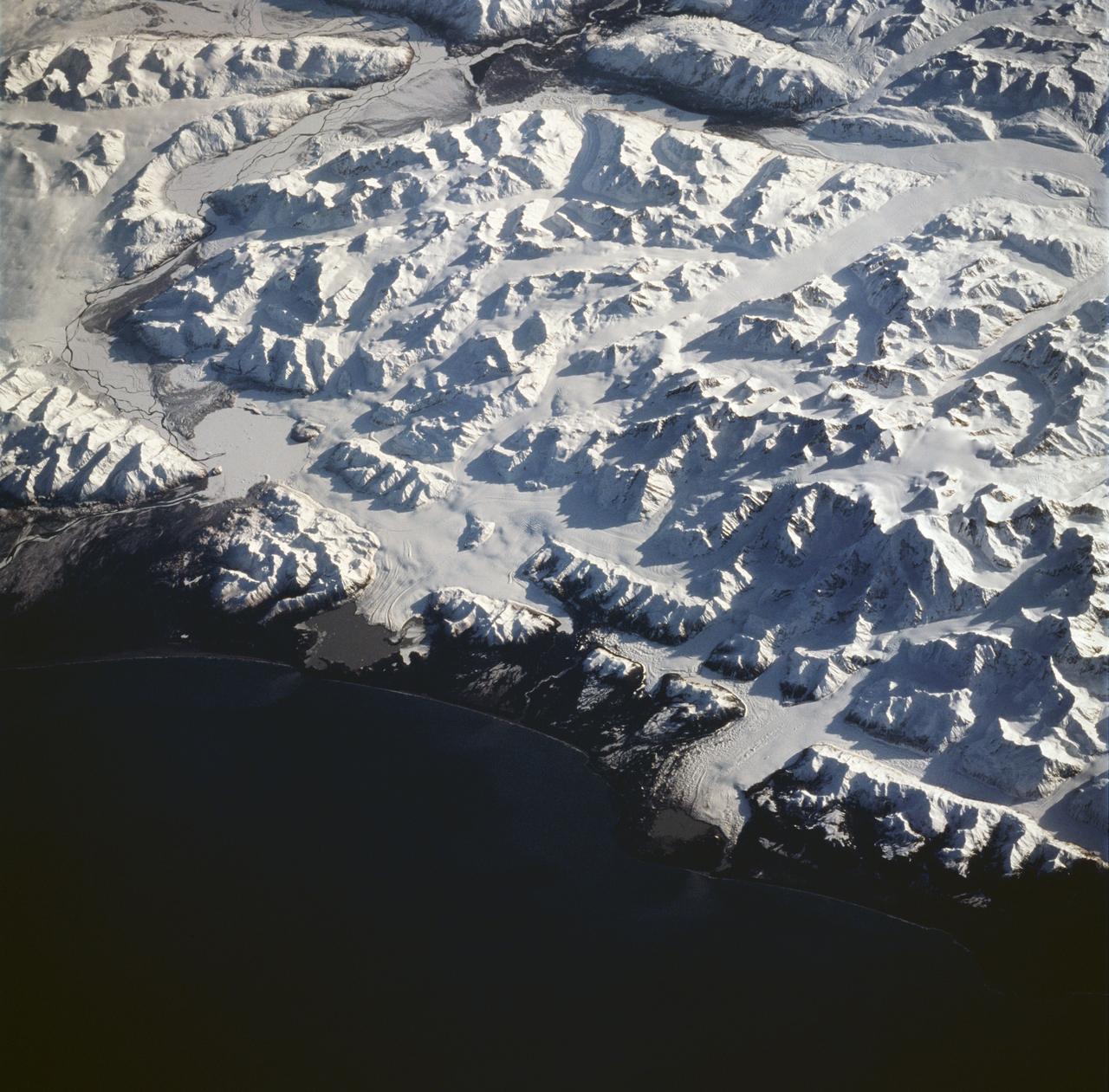
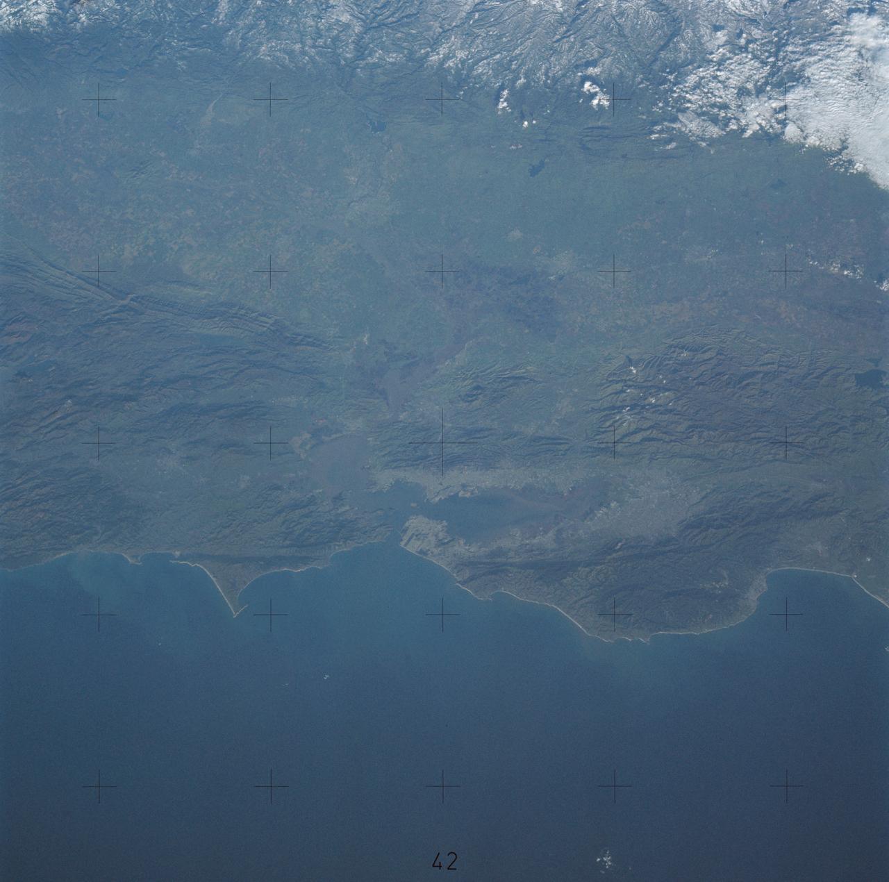
STS059-228-094 (9-20 April 1994) --- The spring thaw along the coast of the Gulf of Alaska has not touched the St. Elias Mountains, southeast of Yakutat Bay and Malaspina Glacier. A prominent glacier flows from Mt. Fairweather (15,300 feet) at right center, to form Cape Fairweather. Another glacier to the northwest almost reaches the sea; the valley of the Alsek River forms a broad, braided plan at upper left. The low sun elevation and oblique angle of this photograph provide a striking 3-dimensional appearance to the black-and-white landscape. SRL investigators will study microwave response to varying depths and conditions of ice and snow along this coast, in Spring and Summer. Hasselblad photograph.
STS059-L09-162 (9-20 April 1994) --- Orient with the snow-covered mountains (Sierra Nevada of California) in the upper right corner. Then Owens Valley runs along the top of the photograph to Owens Lake playa at top center. The upper end of Death Valley extends from right to left in the foreground, with the drainage running down to a playa at Stovepipe Wells in the left foreground. Geologists are studying microwave signatures of the different playa surfaces, and the coatings on alluvial fans that extend from mountain masses, to try to sort out the history of different climates in this formerly wet but now hyperarid region.
AS09-23-3566 (3-13 March 1969) --- Near vertical view of the Birmingham, Alabama area extending to Gadeden, as photographed from the Apollo 9 spacecraft during its Earth-orbital mission. The city spreads out between ridges of the folded southern Appalachian Mountains. The major stream in the picture is the Coosa River.

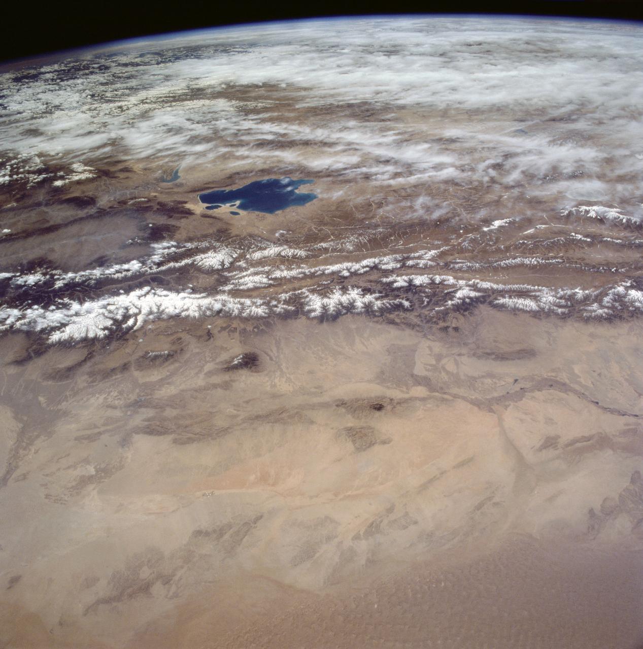
STS058-95-028 (18 Oct-1Nov 1993) --- Lake Urmia (Orumiyeh) in the high desert plateau of northwest Iran dominates the center of this northeast-looking view. The left edge of the view cuts Lake Van in eastern Turkey. The Caucasus Mountains in war-torn Georgia appear just beyond. Mount Ararat, of biblical fame, is a major peak north of Lake Van. The Caspian Sea, an international body of water, stretches across the top right of the view. Countries bordering the Caspian are Iran in the south, Kazakhstan in the west, and Russia and Azerbaijan in the west.
STS058-72-004 (18 Oct-1 Nov 1993) --- The Sierra Nevada Mountain Range can be seen in this north-looking high oblique view taken in October, 1993, by the STS-58 crew. Visible in the view to the west of the Sierra Nevada are the San Joaquin and Sacramento Valleys of central California. The San Francisco/Oakland Bay Area can be seen to the west of the valley at the extreme left of the photograph. To the east or right of the Sierra Nevada, the basin and Range Region of central and northern Nevada is visible. Mono Lake, Lake Tahoe and Pyramid Lake are also visible in this scene. The long northwest/southeast trending Walker Lane Shear Zone, which lies just to the east (right) of the Sierra Nevada is also visible. Near the top of the view (near the horizon), the snow covered volcanic peak Mount Shasta can be seen. Over 645 kilometers (400 miles) long and from 65 to 130 kilometers (40 to 80 miles) wide, the Sierra Nevada have many peaks in excess of 3,300 meters (11,000 feet) above sea level. A titled fault block in structure (the largest in the United States) and shaped by glaciers during the last ice age over 12,000 years ago, the Sierra Nevada eastern front rises sharply from the Great Basin of Nevada, while its western slope descends gradually to the hills bordering the Central Valley of California. Snow-fed streams supply much of the irrigation water to the Central Valley and to western Nevada and also generate hydroelectricity. Recent above normal precipitation (snowfall) of the last two years has helped in alleviating the drought conditions that had prevailed throughout most of California in the mid and late 1980's and early 1990's.

AST-02-130 (20 July 1975) --- An oblique view of a portion of Libya and the Arab Republic of Egypt, as photographed from the Apollo spacecraft in Earth orbit during the joint U.S.-USSR Apollo-Soyuz Test Project mission. The geological features are the Jebel Uweinat and Jebel Arkenu basaltic mountains in the Libyan sand sea. This picture was taken with a 70mm Hasselblad camera using medium-speed Ektachrome QX-807 type film. The spacecraft was at an altitude of 219 kilometers (136 statute miles).
AS07-07-1832 (15 Oct. 1968) --- Toba, Kakar, Fort Sandeman, Sulaiman Range area in (West) Pakistan, as seen from the Apollo 7 spacecraft during its 84th revolution of Earth. Note geological features such as folded mountain structures, anticlines and synclines. Photographed from an altitude of 108 nautical miles, at ground elapsed time of 132 hours and 30 minutes.
AST-30-2601 (20 July 1975) --- An area of the Cascade Mountains southeast of Seattle in the State of Washington, as photographed from the Apollo spacecraft in Earth orbit during the joint U.S.-USSR Apollo-Soyuz Test Project mission. The view includes Snoqualmie Pass, Cle Elum Lake, Kachess Lake and Keechelus Lake. The picture was taken at an altitude of 228 kilometers (141 statute miles) with a 70mm Hasselblad camera using medium-speed Ektachrome QX-807 type film.
STS061-106-091 (December 1993) --- The entire southern tip of Africa is shown in this high altitude 50mm photograph. The center of the photograph is at approximately 28.0 degrees south and 24.0 degrees east Cape Columbine is at the upper right with Durban at the lower center. The Orange River is at the upper center of the frame. Cape Agulas is the southernmost part of the African continent and is visible toward the upper right corner with the great bays of South Africa trending toward the bottom right. Continuing clockwise along the coast, Durban projects out into the Indian Ocean. The oceanic clouds on the right side of the photograph probably depict a current boundary. The Drakensberg Range on the east, the great Karoo Range to the south and the Karas Mountains on the west surround the drier central plateau. The southern Kalahari Desert is at the upper left of the photograph.
STS058-085-091 (18 Oct-1 Nov 1993) --- Yellowstone Lake and the surrounding Plateau are centered in this scene of northwestern Wyoming, and adjacent Idaho and Montana. The view extends across the Absaroka Range to Billings, on the Yellowstone River at the upper right edge of the photograph. Jackson Lake, Jackson Hole (valley) and the Grand Tetons extend from the Yellowstone Plateau toward the camera.
STS058-89-013 (18 Oct-1 Nov 1993) --- An oblique westward view, across the wheat fields and cattle pastures, of eastern Colorado to the Front Range of the Rocky Mountains. Denver is bisected at the center of the right edge of the frame. Pikes Peak and Colorado Springs are left of center, and the Arkansas River Valley with Canyon City and the Royal Gorge are along the left edge of the frame. This view shows the startling contrast between the nearly-flat High Plains and the ancient geological uplift of the Rockies.
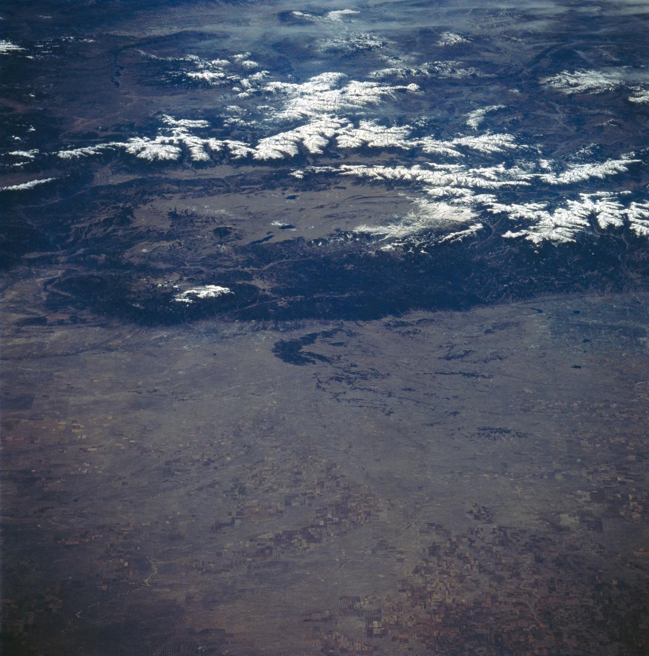
STS059-220-041 (9-20 April 1994) --- View to the south by southwest across the southern Gobi Desert (China) across the Chi-Lien-Shan or Quilienshan or Nanshan (Mountains) in Gansu Province to Lake Quinghai or Ch'ing-Hai (orthography varies with political conditions and scholarship) in Quinghai Province. The lake has a surface elevation of 10,450 feet, partially filling one of the easternmost closed drainage basins of Central Asia. Hasselblad photograph.

This view of southern California as seen from the Apollo 7 spacecraft during its 18th revolution of the earth. Photographed from an altitude of 124 nautical miles. The coast of California can be seen from Point Mugu southward to Oceanside. Santa Catalina can be seen below the off shore clouds. Details of the Los Angeles area are obscured by pollution which extends from Banning westard for 100 miles to beyond Malibu. In the upper portion of the photograph can be seen (left to right) the San Joaquin Valley beyond Bakersfield, the Techachapi Mountains, the Sierra Nevada, Owens Valley, Death Valley and the Mojave Desert.

STS058-77-083 (18 Oct-1 Nov 1993) --- In this scene of the south coast of Africa, Cape Agulhas, the southernmost point on the continent, appears as the leftmost cape. Viewed with the Earth's limb top left, clouds at bottom, the view direction is west and north top right. The Cape of Good Hope, with Cape Town nearby, is the thin spike beyond. The great bay in the foreground is Algoa Bay with the city of Port Elizabeth. This was the first time European voyagers are known to have rounded the Cape of Good Hope in their quest to reach India by sea. The entire fold mountain belt of southern Africa is visible: these mountains appear as green (forested) wavy structures stretching west form the foreground, to the Cape of Good Hope, and then northwards some distance. One theory about their origin is that the Falkland Plateau, now an undersea extension of South America, was jostled up against Africa more than 150 million years ago, in times before the Atlantic Ocean existed, before Africa and South America drifted apart from one another. The jostling caused the evolution of the fold mountain belt.
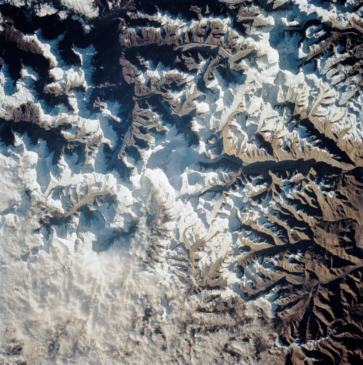
STS058-101-014 (18 Oct-1 Nov 1993) --- The best, most-nearly cloud-free, shuttle view yet of Mount Everest, the highest mountain in the world at 29,028 feet. The peak, on the border between Nepal and China, is almost exactly in the center of the photograph. The challenging North Face is in shadow; valley glaciers radiate in all directions from the central massif.
STS059-154-160 (9-20 April 1994) --- Orient with Mono Lake, California at the lower right; then the view is westward across the Sierra Nevada into the San Joaquin River drainage. A tiny network of ski trails can be seen on the Mono Lake side of the Sierras, on a line between Mono Lake and the snow-free San Joaquin headwaters. The ski trails mark Mammoth Mountain, where SRL investigators are studying microwave measurements of the water content of snowpacks. Linhof camera.
AS7-07-1748 (15 Oct. 1968) --- The world's dozen peaks which reach a height of greater than five miles above sea level are seen in this photograph from the Apollo 7 spacecraft at an altitude of approximately 130 nautical miles. The 29,028 ft. high Mount Everest is at lower center. On the central horizon can be seen the 28,250 ft. high Mount Godwin-Austen (K-2) some 800 miles northwest of Mount Everest. In the lower right, Mount Kanchenjunga rises 28,208 ft. to separate Nepal from Sikkim. The snow line on the peaks was at 17,500 ft. In the upper right the lake-studded highlands of Tibet are visible.
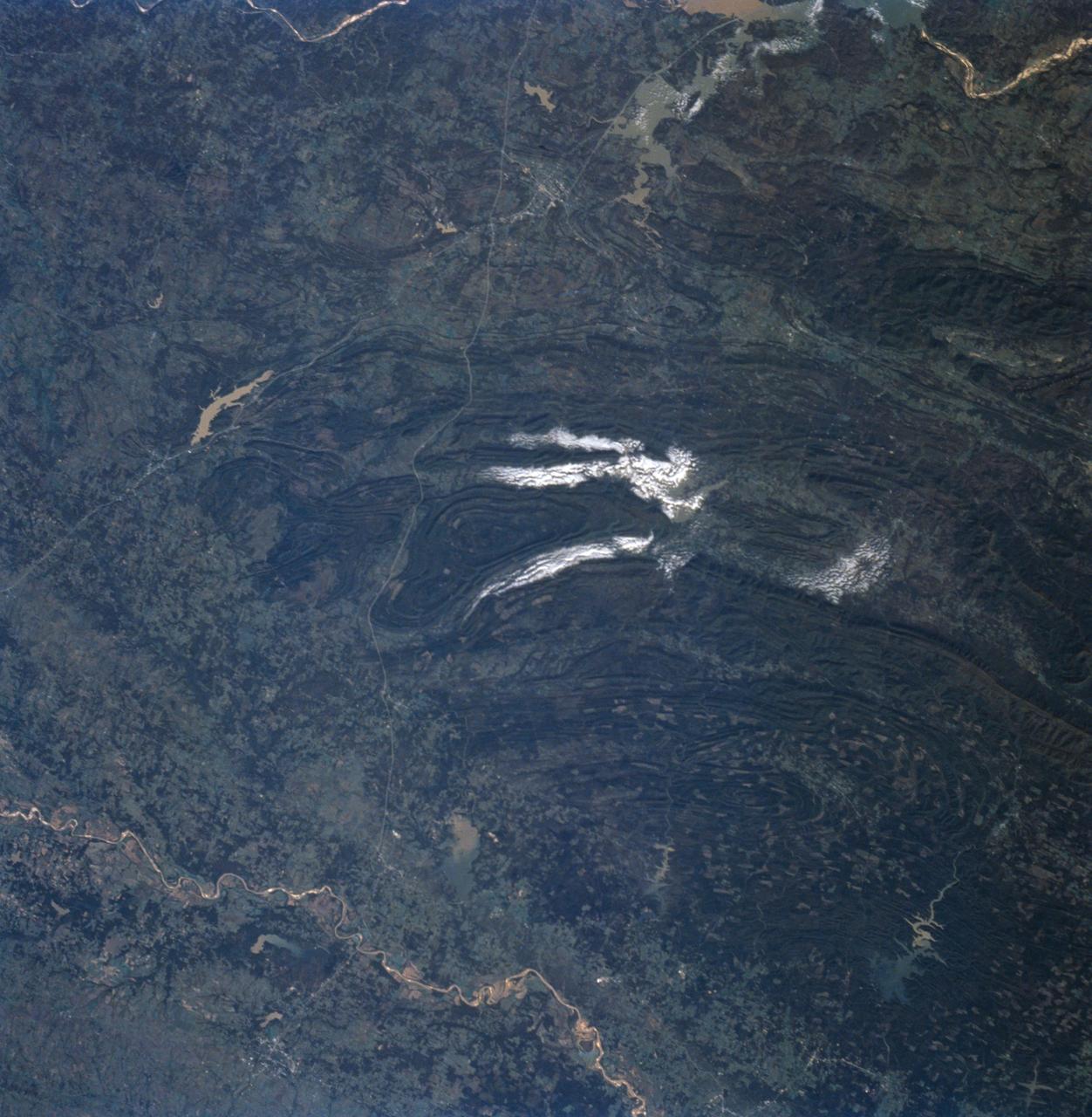
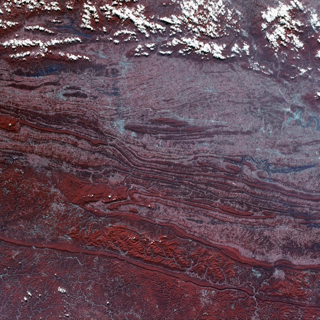
STS058-91-058 (18 Oct-1 Nov 1993) --- In this unusually clear view, the Ouachita Mountains of southeastern Oklahoma are framed on the north by Lake Eufaula on the South Canadian River, and on the south by the Red River. Sandstone, shale and chert (similar to flint) deposited in a sea several thousand feet deep were squeezed up to form the mountains about 250 million years ago. During the ensuing time, erosion of the western end of the Ouachita Mountains has emphasized linear ridges of resistant rock in the plunging anticlines and synclines, causing relief of 800 meters (2,600 feet) or more. Clouds formed by upslope winds border both the north and south sides of one of the most dramatic plunging synclines (in a syncline the rock layers dip toward the center of the structure). Toward the west, densely forested mountains give way to gently rolling, less rocky terrain and a drier climate which is better suited to farming. The mountains centered on Broken Bow, in the lower right corner of the scene, display abundant timber clearcuts that are being regenerated.
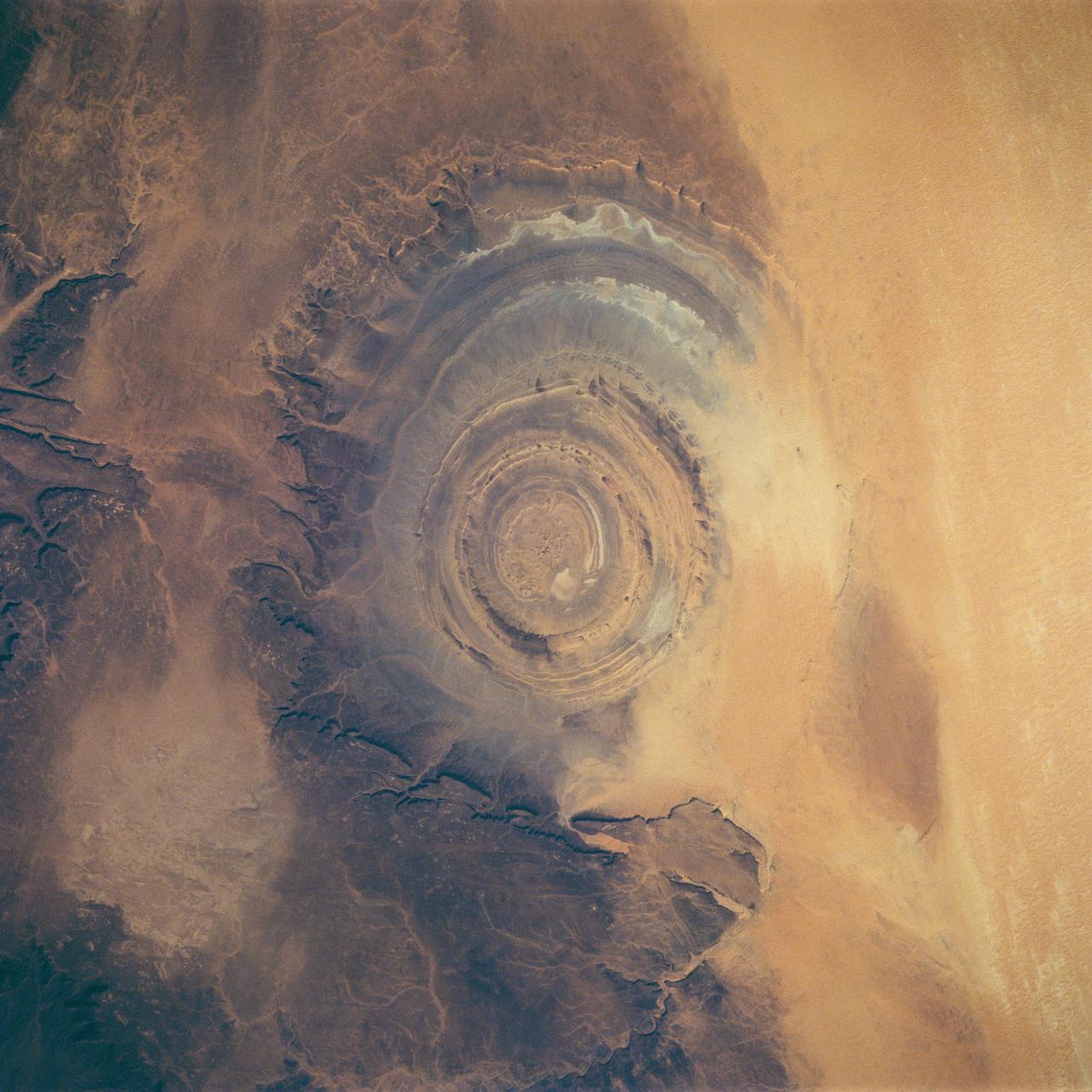
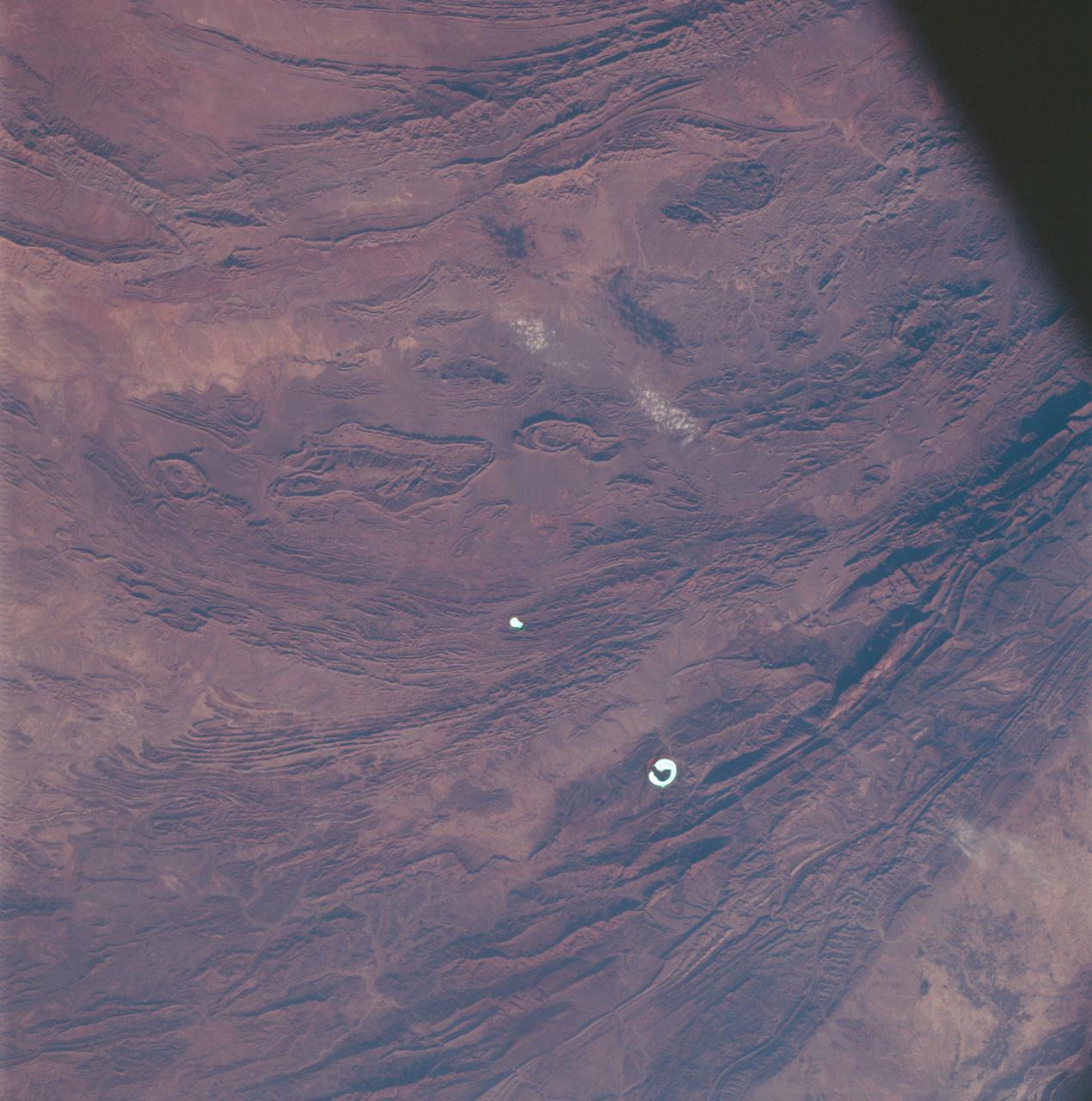
STS058-88-017 (18 Oct-1 Nov 1993) --- The eye-catching "bullseye" of the Richat Structure adds interest to the barren Gres de Chinguetti Plateau in central Mauretania, northwest Africa. It represents domally uplifted, layered (sedimentary) rocks that have been eroded by water and wind into the present shape. Desert sands have invaded the feature from the south. The origin of the structure is unknown. It is not an impact structure, because field work showed that strata are undisturbed and flat-lying in the middle of the feature, and no shock-altered rock could be found. There is no evidence for a salt dome or shale diapir, nor is there any geophysical evidence for an underlying dome of dense igneous rock having about the same density as the sedimentary layers.
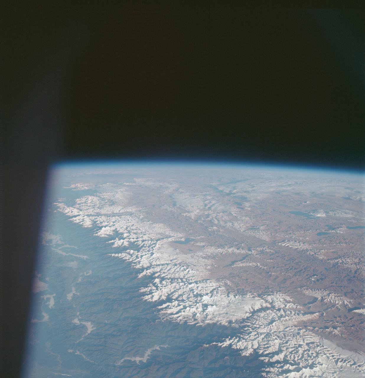
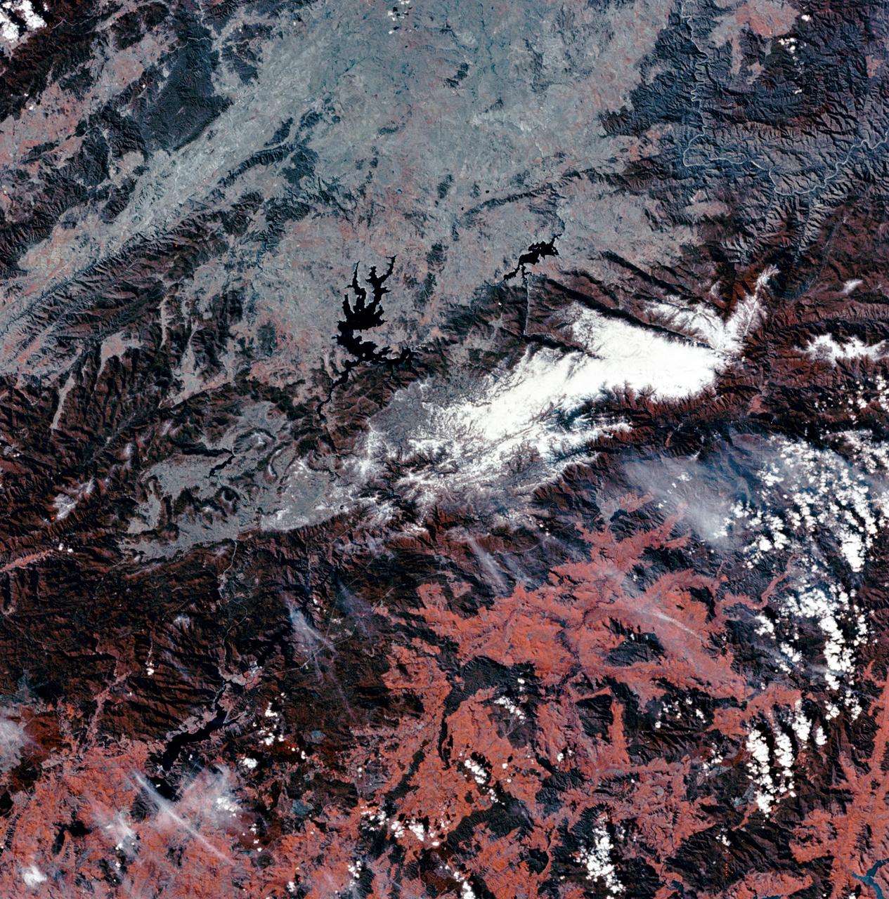
STS058-78-021 (18 Oct-1 Nov 1993) --- A clear three-dimensional view of the Karakorum Range. This northwestern extension of the Himalaya contains glaciated peaks having elevations of 7,000 to 8,000 meters.
SL4-138-3843 (1 Jan. 1974) --- A part of northern California centered near San Francisco Bay photographed at 3 p.m. Jan. 2, 1974, from the Skylab space station in Earth orbit. This near vertical view encompasses the coastline from Monterey Bay (right) to about 50 miles north of Point Reyes (left) and includes, from bottom to top, San Francisco Bay (center), Sacramento Valley (left center), San Joaquin Valley (right center), and the snow-covered Sierra Nevada. Afternoon shadows sharply delineate a valley which parallels San Francisco Bay, crosses Point Reyes, and lies between the Bay and the Pacific coastline. This valley marks the location of the San Andreas Fault, a major break in the Earth's crust. Forces acting on the crust are causing the land west (bottom) of the fault line to move north relative to land on the east side. The Skylab 4 astronauts photographed major fault zones in South America, New Zealand, Japan and Africa for use in the study of worldwide tectonic system. Agricultural areas in the Sacramento and San Joaquin Valleys are indicated by the tan areas which are easily discerned in contrast to the green-gray background. Photo credit: NASA
AST-19-1570 (24 July 1975) --- An oblique view of the Rocky Mountains area of British Columbia and Alberta in Canada, as photographed from the Apollo spacecraft in Earth orbit during the joint U.S.-USSR Apollo-Soyuz Test Project mission. This picture was taken at an altitude of 222 kilometers (138 statute miles) with a 70mm Hasselblad camera using medium-speed Ektachrome QX-807 type film.
AST-16-1132 (20 July 1975) --- A vertical view of the eastern portion of the state of South Australia in Australia, as photographed from the Apollo spacecraft in Earth orbit during the joint U.S.-USSR Apollo-Soyuz Test Project mission. The highlands area is the Flinders Range. The light-colored body of water is Lake Blanche. The lake to the south is Callabonna. This picture was taken at an altitude of 224 kilometers (139 statute miles) with a 70mm Hasselblad camera using high-definition aerial Ektachrome SO-242 type film.
AS09-20-3137 (3-13 March 1969) --- The Grand Canyon is sharply etched on the snow-covered Colorado Plateau in Arizona in this photograph from the Apollo 9 spacecraft during its Earth-orbital mission. Lake Powell behind Glen Canyon Dam is in the upper right corner. Humphreys Peak and the many volcanic craters around the San Francisco Mountains near Flagstaff, Arizona, are right of center. Prescott is under clouds at lower center.
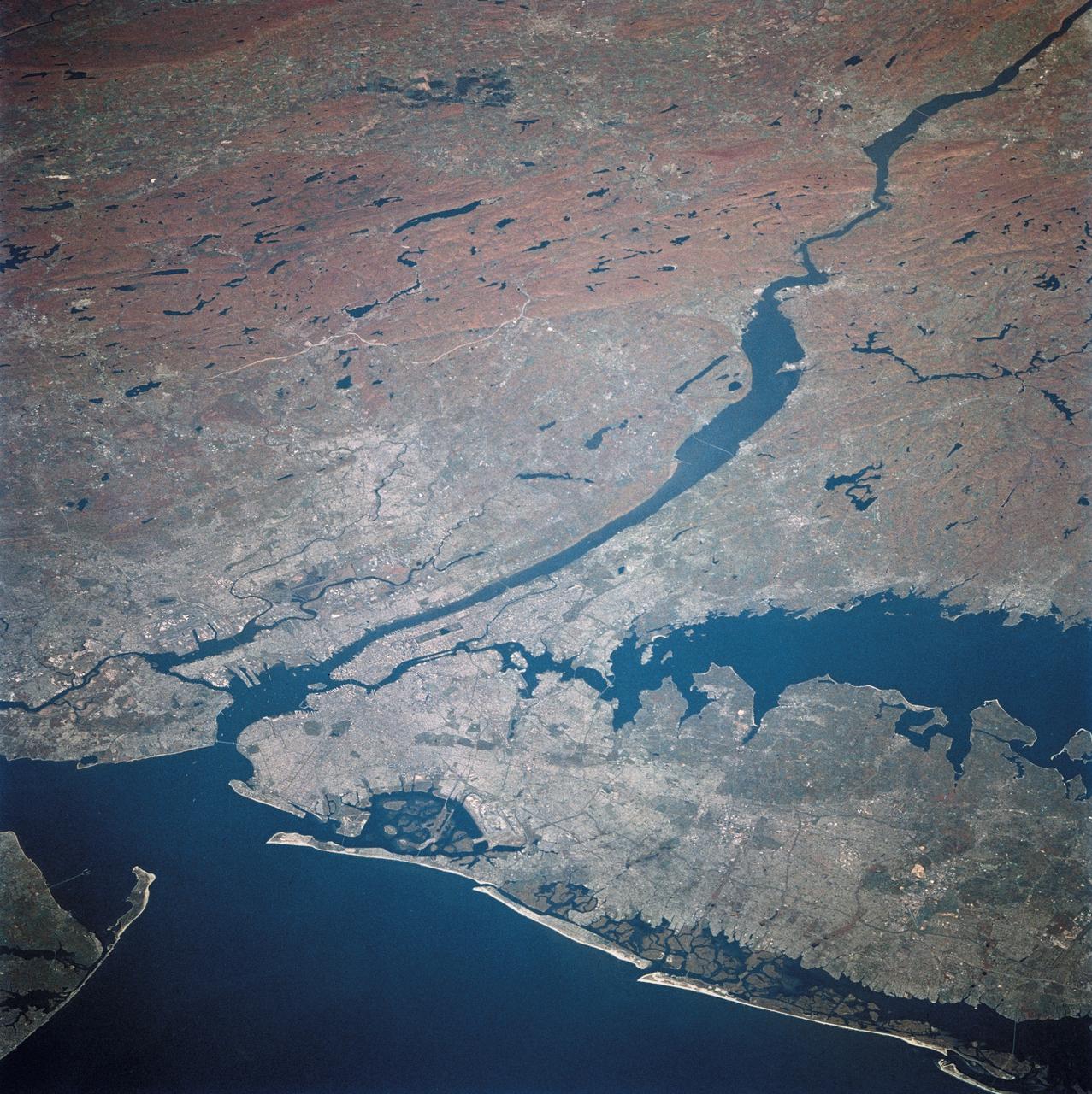
STS058-081-038 (18 Oct-1 Nov 1993) --- Fall colors in the northeast were captured by the STS-58 crew members. Long Island and the lower Hudson River dominate this scene, taken on a clear October day at the peak of the colorful fall foliage season. The maples and oaks of the Hudson Highlands are particularly striking, and contrast with the many lakes and reservoirs north of the city. The New York metropolitan area in New York and New Jersey (including Jersey City and Newark) is easily seen in the foreground. Manhattan Island sits near the middle of the scene, but Central Park foliage is still fairly green. West Point can be seen near the upper right, on the west-pointing bend of the Hudson, and the Catskills are in the far upper left.

SL3-22-0214 (July-September 1973) --- A vertical view of southeastern Washington State as photographed from Earth orbit by one of the six lenses of the Itek-furnished S190-A Multispectral Photographic Facility Experiment aboard the Skylab space station. The Snake River flows into the Columbia River in the most southerly corner of the picture. The Wallula Lake is below the junction of the two rivers. The Yakima Valley is at the southwestern edge of the photograph. The Columbia Basin is in the center of the picture. The Cascade Range extends across the northwest corner of the photograph. This picture was taken with type SO-356 regular color film. The S190-A experiment is part of the Earth Resources Experiments Package. Federal agencies participating with NASA on the EREP project are the Departments of Agriculture, Commerce, Interior, the Environmental Protection Agency and the Corps of Engineers. All EREP photography is available to the public through the Department of Interior?s Earth Resources Observations Systems Data Center, Sioux Falls, South Dakota, 57198. Photo credit: NASA
SL4-138-3875 (February 1974) --- A color oblique photograph looking east over the Rocky Mountains and Great Plains. This view covers a portion of the States of Colorado, Wyoming, and Nebraska. A Skylab 4 crewmen took this picture with a hand-held 70mm Hasselblad camera. This entire region, covered with a blanket of snow, depicts much of the structural and topographic features of the Rocky Mountain chain. Man's only apparent change to the snow pattern seen here is the (right center) metropolitan areas of Denver and Colorado Springs, Colorado, which can be observed along the eastern edge of the mountain front. Grand Junction, Colorado on the western slope of the Rocky Mountains is just off the photograph at left center bottom. The major inter-montane valleys of South Park (right center), Middle Park (center), and North Park (left center) are clearly visible and separate the Colorado Rockies Front Range from the high rugged mountains can be discovered such as Pikes Peak near right border (center), Mt. Cunnison region, circular feature accentuated by the Cunnison River (dark) in the right center (bottom) of the photograph. The snow covered peaks of Mts. Harvard, Princeton and Yale form the high region of the Collegiate Range which is the pronounced mountain area in the right center. Snow cover not only enhances mountain features but also the drainage patterns. East of Denver (right corner) the sinuous trace of the South Platte River (center) and its junction with the North Platte River near North Platte, Nebraska. Lake McConaughy in Nebraska is the body of water (black) near the river intersection. The trace of the Republic River in southern Nebraska is visible near the right corner of the photography. Geologic and hydro logic studies using this photograph will be conducted by Dr. Roger Morrison, U.S. Geological Survey. Photo credit: NASA
SL3-88-004 (July-September 1973) --- A vertical view of the Salinas River Valley area south of Monterey Bay, California area is seen in this Skylab 3 Earth Resources Experiments Package S190-B (five-inch Earth terrain camera) photograph taken from the Skylab space station in Earth orbit. The valley is an irrigated agricultural area, and is indicated by the dark-green and light-gray rectangular patterns in the centre of the picture. The city of Salinas is barely visible under the cloud cover at the top (north) end of the valley. The dark mass on the left (west) side of the valley is the Santa Lucia mountain range. The Big Sur area is on the left and partly covered by clouds. The Diablo Range forms the dark mass in the lower right (southeast) corner of the photograph. The town of Hollister is the gray area in the dark-green rectangular farm tracts which occupy the floor of the San Benito Valley in the upper right (northeast) corner of the photograph. The Salinas River flows northwestward toward Monterey Bay. The towns of Soledad, Greenfield and King City appear as gray areas along U.S. 101 in the Salinas Valley. The geology of the area is complex, and has been racked by several earthquakes resulting from movement along the San Andreas and subsidiary faults. Here, the surface expression of the San Andreas Fault can be traced from a point just west of Hollister at the contrast of dark brown and tan to a point about one inch left of the lower right (southeast) corner of the picture. Subsidiary faults are indicated by the curving trend of the rocks along the right side. The photograph will provide detailed information on land use patterns (Dr. R. Colwell, University of California, Berkeley) and fault tectonics (Dr. P. Merifield, Earth Science Res., Inc. and Dr. M. Abdel-Gawad, Rockwell International). Federal agencies participating with NASA on the EREP project are the Departments of Agriculture, Commerce, Interior, the Environmental Protection Agency and the Corps of Engineers. All EREP photography is available to the public through the Department of Interior’s Earth Resources Observations Systems Data Center, Sioux Falls, South Dakota, 57198. Photo credit: NASA

SL3-33-156 (July-September 1973) --- A near vertical view of the Florence, Italy area as photographed from Earth orbit by one of the Itek-furnished S190-A Multispectral Photographic Facility Experiment aboard the Skylab space station. The view extends from the Ligurian Sea, an extension of the Mediterranean Sea, across the Apennine Mountains to the Po River Valley. Florence (Firenze) is near the center of the land mass. The mouth of the Arno River is at the center of the coastline. The city of Leghorn (Livorno) is on the coast just south of the Arno River. This picture was taken with type 2443 infrared color film. The S190-A experiment is part of the Skylab Earth Resources Experiments Package. Federal agencies participating with NASA on the EREP project are the Department of Agriculture, Commerce, Interior, the Environmental Protection Agency and the Corps of Engineers. All EREP photography is available to the public through the Department of Interior?s Earth Resources Observations Systems Data Center, Sioux Falls, South Dakota, 57198. Photo credit: NASA
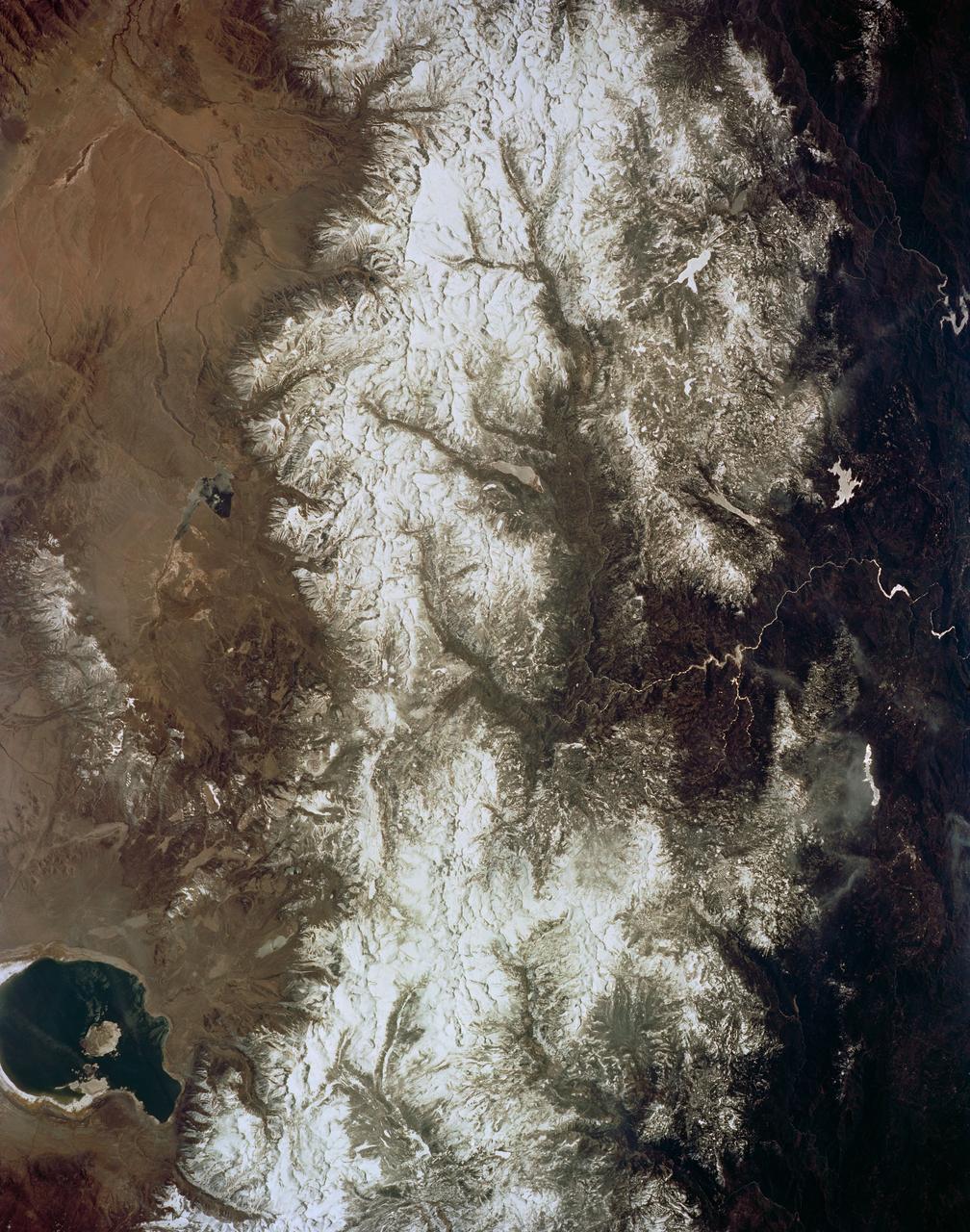
SL3-22-0322 (July-September 1973) --- An oblique view of the Salt Lake City, Utah area as photographed from Earth orbit by one of the six lenses of the Itek-furnished S190-A Multispectral Photographic Facility Experiment aboard the Skylab space station. Approximately two-thirds of the Great Salt Lake is in view. The smaller body of water south of Salt Lake City is Utah Lake. The Wasatch Range is on the east side of the Great Salt Lake. Federal agencies participating with NASA on the EREP project are the Departments of Agriculture, Commerce, Interior, the Environmental Protection Agency and the Corps of Engineers. All EREP photography is available to the public through the Department of Interior?s Earth Resources Observations Systems Data Center, Sioux Falls, South Dakota, 57198. Photo credit: NASA
SL3-27-180 (July-September 1973) --- A vertical view of the Snowy Mountains area of Australian Alps in the States of Victoria and New South Wales, Australia, as photographed from Earth orbit by one of the six lenses of the Itek-furnished S190-A Multispectral Photographic Facility Experiment aboard the Skylab space station. This picture was taken with type 2443 infrared color film. The lake near the center of the picture is the Eucumbene Reservoir. This area is located immediately south-southwest of the capital city of Canberra. Federal agencies participating with NASA on the EREP project are the Departments of Agriculture, Commerce, Interior, the Environmental Protection Agency and the Corps of Engineers. All EREP photography is available to the public through the Department of Interior?s Earth Resources Observations Systems Data Center, Sioux Falls, South Dakota, 57198. Photo credit: NASA
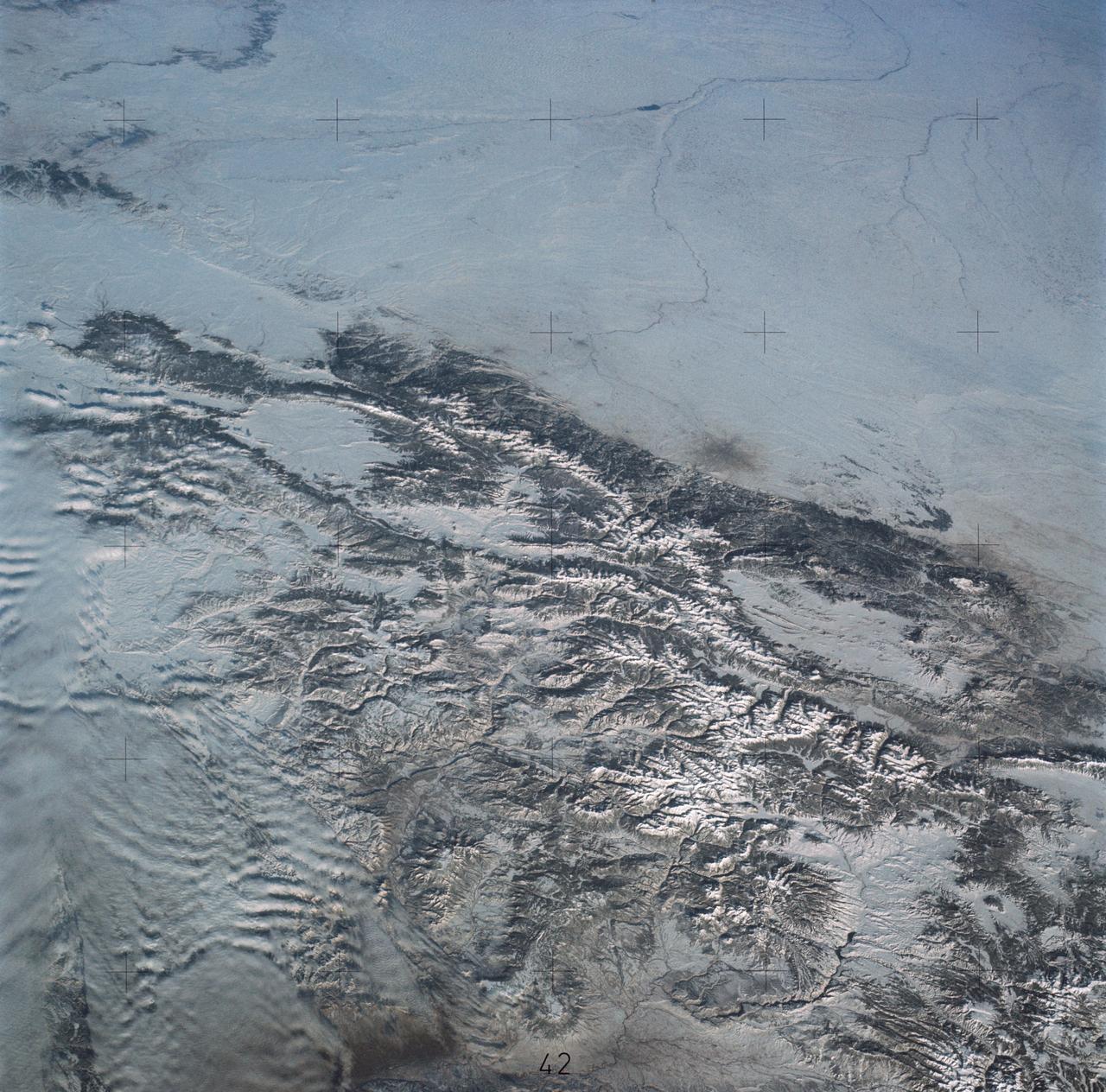
S66-54839 (14 Sept. 1966) --- China, India, and Nepal, looking east, as seen from the Gemini-11 spacecraft during its 37th revolution of Earth. The Great Himalaya Mountain Range is clearly visible. Photo credit: NASA

SL4-93-153 (February 1974) --- A vertical view of the Birmingham and central Alabama area is seen in this Skylab 4 Earth Resources Experiments Package S190-B (five-inch earth terrain camera) infrared photographed taken from the Skylab space station in Earth orbit. Illustrated here is the utility of color infrared film in depicting distribution of living vegetation in the 3,600 square mile Birmingham region. The Birmingham industrial complex, with a population of nearly 850,000, is the light gray area nestled in the valley between the northeast-trending ridges that are prominent topographic features in the southern Appalachian Mountains. The narrow ridges and adjacent valleys reflect folded and faulted sedimentary rocks, indicating the complex geological history of the region. Two major rivers and several reservoirs are easily distinguished in this photograph. Bankhand Lake, formed by a dam on the Black Warrior River, appears as bright blue west of Birmingham. Two lakes are formed by dams on the Goosa River east of Birmingham. Federal and state highways appear as thin white lines and are easily identified. Interstate 65 to Montgomery is the prominent white line extending southward from Birmingham. Power line clearings are visible in the center of the picture along the Goosa River, and can be traced northwestward to northern parts of Birmingham. The predominant deep red color of the picture is due to the reflections from living vegetation. In contrast are the light tan areas that commonly occur as rectangular patterns in the east part of the photograph and represent mature agricultural crops or grazing lands. Analysis of the photographic data from the earth terrain camera will be conducted by Dr. H. Jayroe of the Marshall Space Flight Center in developing analytical techniques. All EREP photography is available to the public through the Department of Interior's Earth Resources Observations Systems Data Center, Sioux Falls, South Dakota, 57198. Photo credit: NASA
SL3-45-020 (July-September 1973) --- A vertical view of the Virginia-Tennessee-Kentucky border area as photographed from Earth orbit by one of the six lenses of the Itek-furnished S190-A Multispectral Photographic Facility Experiment aboard the Skylab space station. This picture was taken with type 2443 infrared color film. The S190-A experiment is part of the Skylab Earth Resources Experiments Package. The long, narrow ridge is Pine Mountain; and it is crossed by U.S. 25E at Pineville near its southernmost end. Some 25 miles south of Pineville U.S. 25E passes through the famed Cumberland Gap which at 1,600 feet elevation crosses Cumberland Mountain. Kingsport, Tennessee is located east of Cumberland Gap near the center of the picture. Bristol, Tennessee-Virginia is further east. Greenville and Elizabethton, Tennessee can also be seen in this photograph. The clouds across the southeast edge of the picture are over the Blue Ridge Mountains. Federal agencies participating with NASA on the EREP project are the Departments of Agriculture, Commerce, Interior, the Environmental Protection Agency and the Corps of Engineers. All EREP photography is available to the public through the Department of Interior?s Earth Resources Observations Systems Data Center, Sioux Falls, 57198. Photo credit: NASA
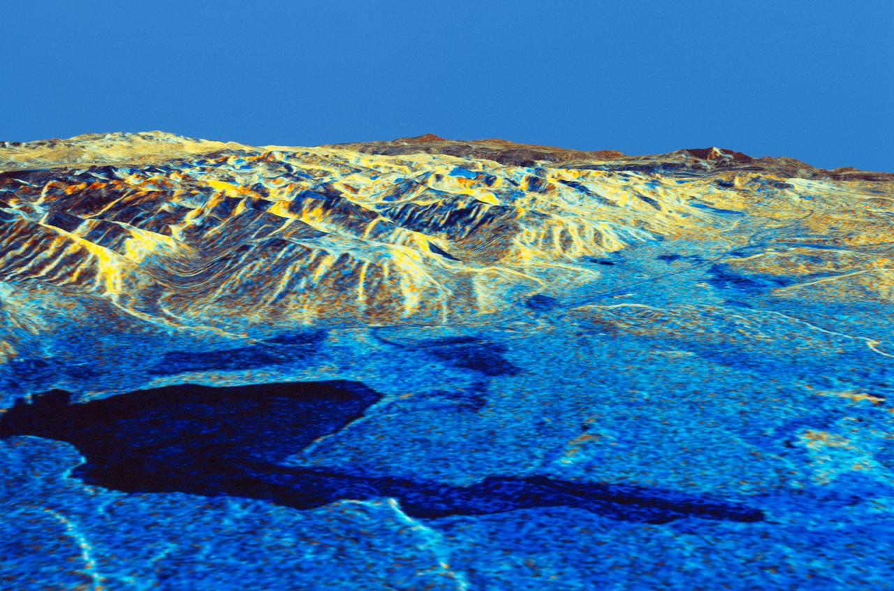
STS059-S-084 (17 April 1994) --- This is a three-dimensional perspective of Mammoth Mountain, California. This view was constructed by overlaying a SIR-C radar image on a U.S. Geological Survey digital elevation map. Vertical exaggeration is 2x. The image is centered at 37.6 degrees north, 119.0 degrees west. It was acquired from the Spaceborne Imaging Radar-C and X-Band Synthetic Aperture Radar (SIR-C/X-SAR) onboard the Space Shuttle Endeavour on its 67th orbit, April 13, 1994. In this color representation, red is C-Band HV-polarization, green is C-Band VV-polarization and blue is the ratio of C-Band VV to C-Band HV. Blue areas are smooth and yellow areas are rock outcrops with varying amounts of snow and vegetation. Crowley Lake is in the foreground and Highway 395 crosses in the middle of the image. Mammoth Mountain is shown in the upper right. SIR-C/X-SAR is part of NASA's Mission to Planet Earth (MTPE). SIR-C/X-SAR radars illuminate Earth with microwaves allowing detailed observations at any time, regardless of weather or sunlight conditions. SIR-C/X-SAR uses three microwave wavelengths: L-Band (24 cm), C-Band (6 cm), and X-Band (3 cm). The multi-frequency data will be used by the international scientific community to better understand the global environment and how it is changing. The SIR-C/X-SAR data, complemented by aircraft and ground studies, will give scientists clearer insights into those environmental changes which are caused by nature and those changes which are induced by human activity. SIR-C was developed by NASA's Jet Propulsion Laboratory (JPL). X-SAR was developed by the Dornire and Alenia Spazio Companies for the German Space Agency, Deutsche Agentur fuer Raumfahrtangelegenheiten (DARA), and the Italian Space Agency, Agenzia Spaziale Italiana (ASI). JPL Photo ID: P-43933