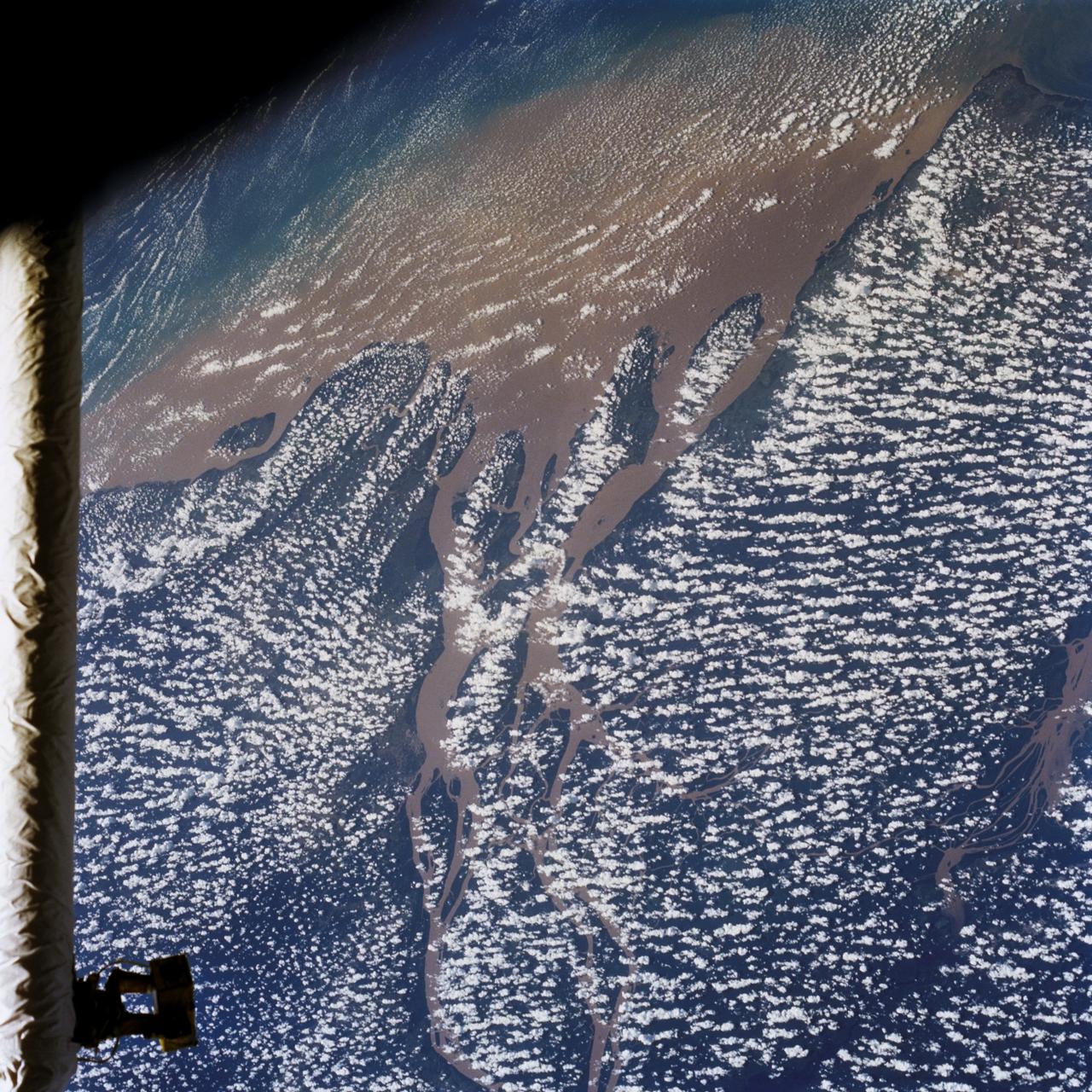
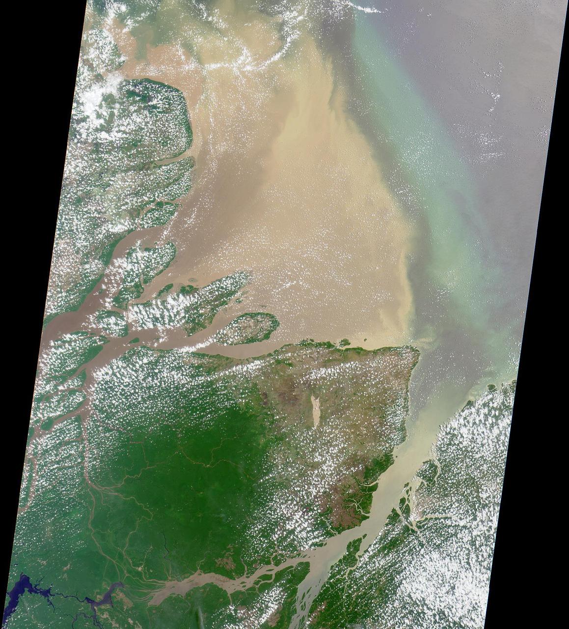
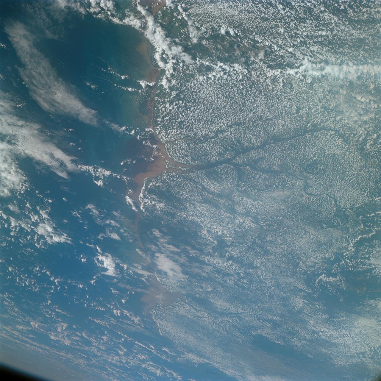
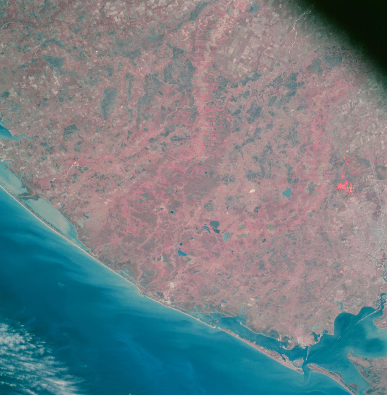
STS046-80-009 (31 July-8 Aug. 1992) --- A view of the mouth of the Amazon River and the Amazon Delta shows a large sediment plume expanding outward into the Atlantic Ocean. The sediment plume can be seen hugging the coast north of the Delta. This is caused by the west-northwest flowing Guyana Current. The large island of Marajo is partially visible through the clouds.

At first glance, this NASA/ESA Hubble Space Telescope image seems to show an array of different cosmic objects, but the speckling of stars shown here actually forms a single body — a nearby dwarf galaxy known as Leo A. Its few million stars are so sparsely distributed that some distant background galaxies are visible through it. Leo A itself is at a distance of about 2.5 million light-years from Earth and a member of the Local Group of galaxies; a group that includes the Milky Way and the well-known Andromeda galaxy. Astronomers study dwarf galaxies because they are very numerous and are simpler in structure than their giant cousins. However, their small size makes them difficult to study at great distances. As a result, the dwarf galaxies of the Local Group are of particular interest, as they are close enough to study in detail. As it turns out, Leo A is a rather unusual galaxy. It is one of the most isolated galaxies in the Local Group, has no obvious structural features beyond being a roughly spherical mass of stars, and shows no evidence for recent interactions with any of its few neighbors. However, the galaxy’s contents are overwhelmingly dominated by relatively young stars, something that would normally be the result of a recent interaction with another galaxy. Around 90% of the stars in Leo A are less than eight billion years old — young in cosmic terms! This raises a number of intriguing questions about why star formation in Leo A did not take place on the “usual” timescale, but instead waited until it was good and ready. Image credit: ESA/Hubble & NASA; Acknowledgment: Judy Schmidt
Oil from the Deepwater Horizon spill laps around the mouth of the Mississippi River Delta in this May 24, 2010, image from NASA Terra spacecraft. The oil appears silver, while vegetation is red.
S66-38191 (4 June 1966) --- The mouth of the Amazon River on the northern coast of Brazil, looking southwest, as seen from the Gemini-9A spacecraft during its 18th revolution of Earth. The image was taken with a 70mm Hasselblad camera, using Eastman Kodak, Ektachrome MS (S.O. 217) color film. Photo credit: NASA
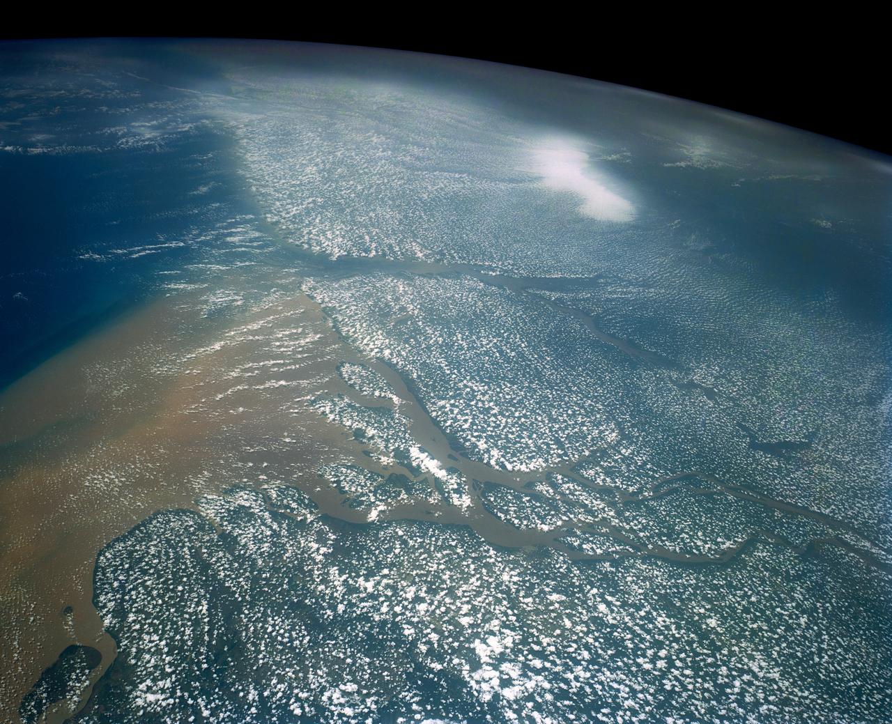
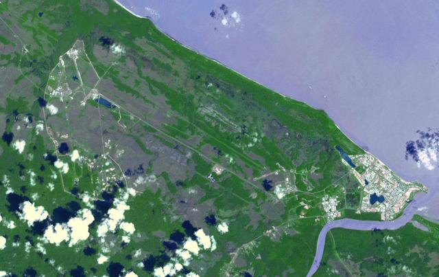
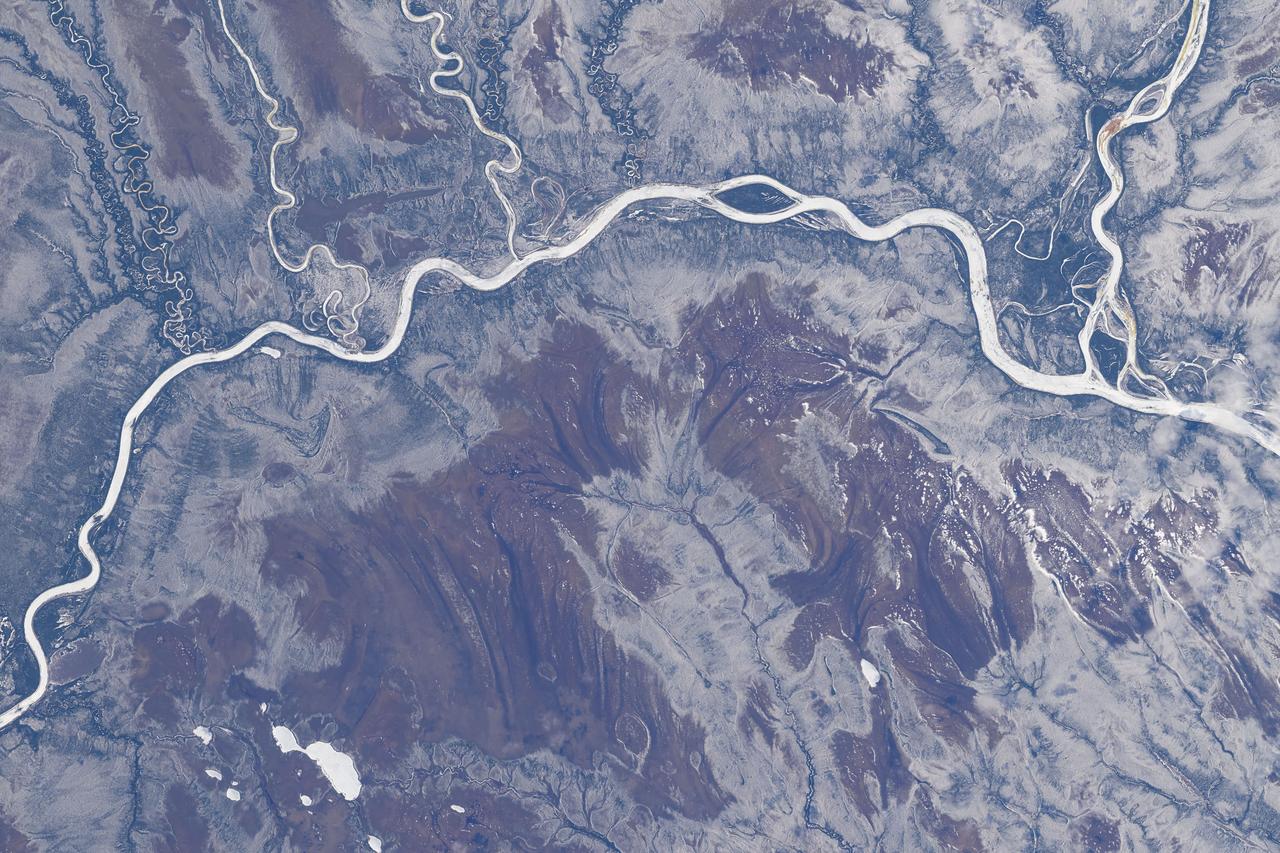
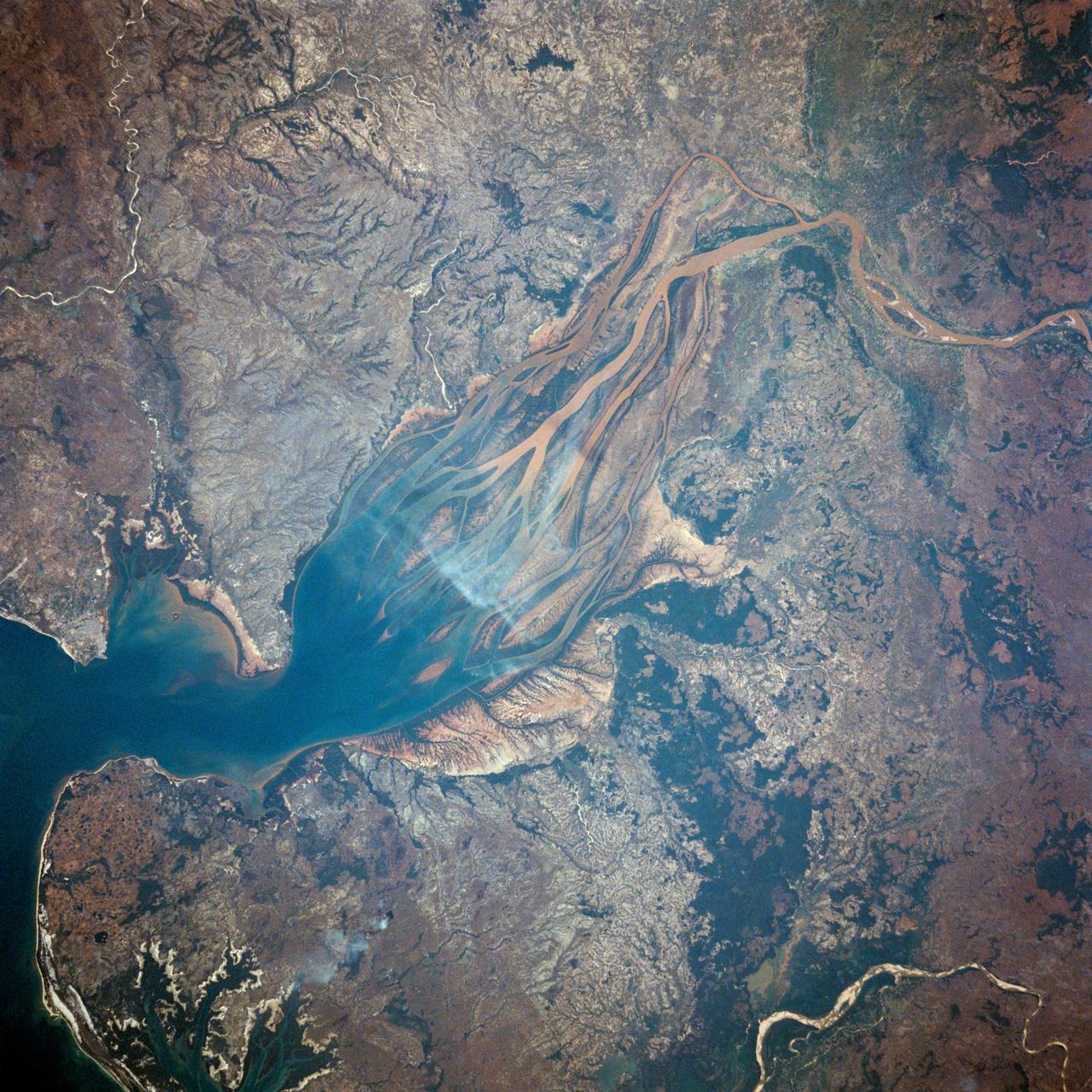
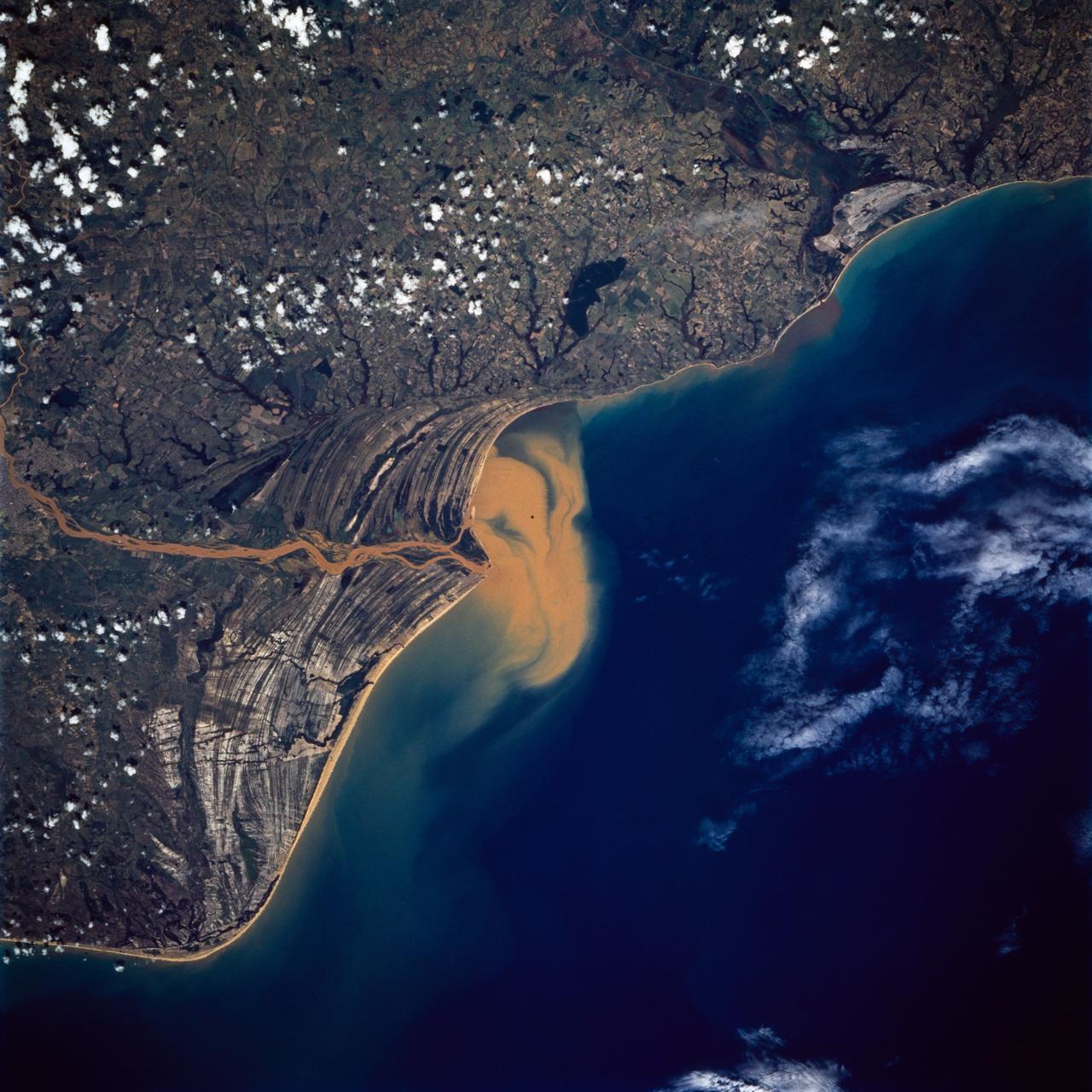
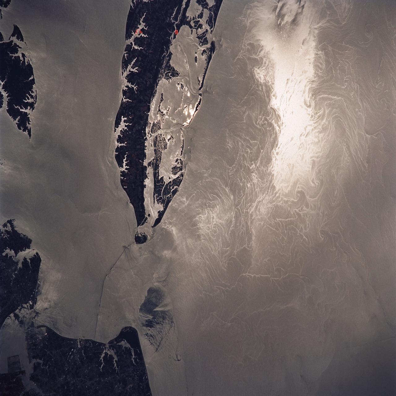
Huge sediment loads from the interior of the country flow through the Mouths of the Amazon River, Brazil (0.5S, 50.0W). The river current carries hundreds of tons of sediment through the multiple outlets of the great river over 100 miles from shore before it is carried northward by oceanic currents. The characteristic "fair weather cumulus" pattern of low clouds over the land but not over water may be observed in this scene.
This image from NASA Terra spacecraft shows the town of Kourou, which sits at the mouth of the Kourou River, French Guiana.
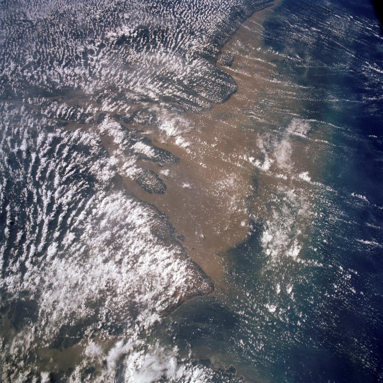
STS058-107-083 (18 Oct.-1 Nov. 1993) --- A near-nadir view of the mouth of the Amazon River, that shows all signs of being a relatively healthy system, breathing and exhaling. The well-developed cumulus field over the forested areas on both the north and south sides of the river (the view is slightly to the west) shows that good evapotranspiration is underway. The change in the cloud field from the moisture influx from the Atlantic (the cloud fields over the ocean are parallel to the wind direction) to perpendicular cloud fields over the land surface are normal. This change in direction is caused by the increased surface roughness over the land area. The plume of the river, although turbid, is no more or less turbid than it has been reported since the Portuguese first rounded Brasil's coast at the end of the 15th Century.
S66-54559 (14 Sept. 1966) --- Gulf Coast from Corpus Christi, Texas, to mouth of Mississippi River, as seen from the Gemini-11 spacecraft during its 29th revolution of Earth. This photo was taken near sunrise. Photo credit: NASA
Do you see what I see? A giant fish with open mouth looks to the left in the center of this image from NASA Mars Odyssey spacecraft.
Flowing over 6450 kilometers eastward across Brazil, the Amazon River originates in the Peruvian Andes as tiny mountain streams that eventually combine to form one of the world mightiest rivers as shown in this image from NASA Terra satellite.
Nuuk or Gadthab is the capital and largest city of Greenland. It is located at the mouth of the Nuup Kangerlua inlet on the west coast of Greenland. This image was acquired August 2, 2004 by NASA Terra spacecraft.
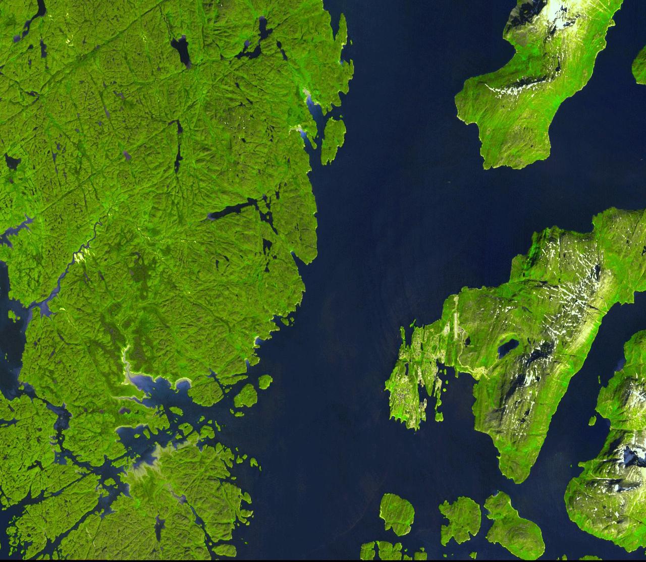
This image, acquired by NASA Terra spacecraft, is of the Aaland archipelago at the mouth of the Gulf of Bothnia which belongs to Finland, though it enjoys autonomy from Helsinki and locals speak Swedish.
S66-46054 (18 July 1966) --- Venezuela, British Guyana, Surinam and Trinidad, as seen from the Gemini-10 spacecraft. On the left is the mouth of the Orinoco River in Venezuela. Mouth of Essequibo River in British Guyana is in right center. Photo credit: NASA
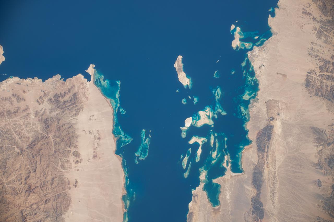
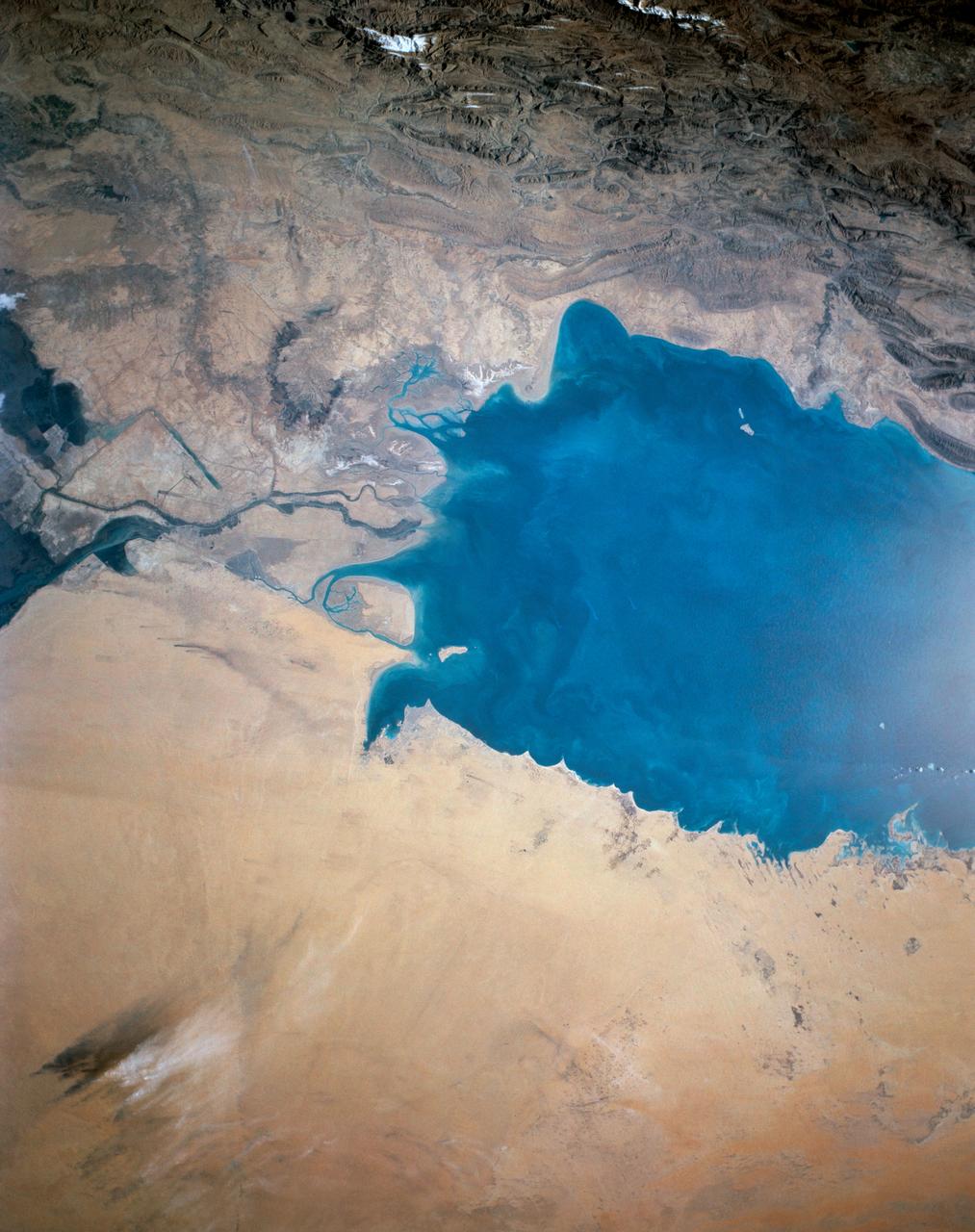
iss071e183808 (June 14, 2024) -- The mouth of the Gulf of Suez feeds into the Red Sea as the International Space Station orbited 262 miles above Egypt.
AS09-23-3568 (3-13 March 1969) --- Atlantic coast of South Carolina as photographed from the Apollo 9 spacecraft during its Earth-orbital mission. The visible coastline extends from the mouth of the Savannah River northeastward to the mouth of the Santee River. The city of Charleston is on the coast in the center of picture. Lake Moultrie is at left center edge of picture.
iss064e037443 (Feb. 23, 2021) --- The mouth of the Mississippi River, emptying into the Gulf of Mexico south of New Orleans, Louisiana, is pictured from the International Space Station as it orbited 262 miles above. Credit: Roscosmos
S65-63713 (19 Dec. 1965) --- Astronaut Frank Borman, Gemini-7 command pilot, is using the visual acuity device and a portable mouth thermometer during his experiment in space. Photo credit: NASA
iss071e007986 (April 13, 2024) --- The Kenogami River, at the mouth of the Albany River (far right), is pictured in the Canadian province of Ontario from the International Space Station as it orbited 261 miles above North America.
ISS010-E-19333 (8 March 2005) --- The spectacular mouth of the Betsiboka River in Madagascar is featured in this image photographed by an Expedition 10 crew member on the International Space Station.
The Mississippi Watershed is the largest drainage basin in North America at 3.2 million square kilometers in area. The USGS has created a database of this area which indicates the direction of waterflow at each point. By assembling these directions into streamflows, it is possible to trace the path of water from every point of the area to the mouth of the Mississippi in the Gulf of Mexico. This animation starts with the points furthest from the Gulf and reveals the streams and rivers as a steady progression towards the mouth of the Mississippi until all the major rivers are revealed. The speed of the reveal of the rivers is not dependent on the actual speed of the water flow. The reveal proceeds at a constant velocity along each river path, timed so that all reveals reach the mouth of the Mississippi at the same time. This animation does not show actual flow rates of the rivers. All rivers are shown with identical rates. The river colors and widths correspond to the relative lengths of river segments. Credit: NASA's Scientific Visualization Studio/Horace Mitchell Go here to download this video: <a href="http://svs.gsfc.nasa.gov/4493" rel="nofollow">svs.gsfc.nasa.gov/4493</a>
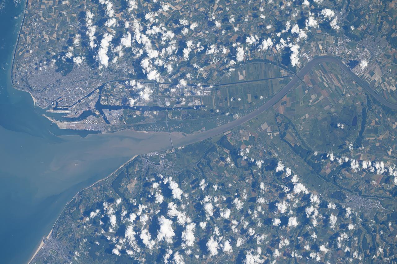
iss071e207619 (June 23, 2024) --- The French port city of Le Havre on the river Seine at the mouth of the English Channel is pictured from the International Space Station as it orbited 264 miles above. The cable-stayed bridge Pont de Normandie crosses the Seine and links Le Havre to the city of Honfleur in France's Normandy region.
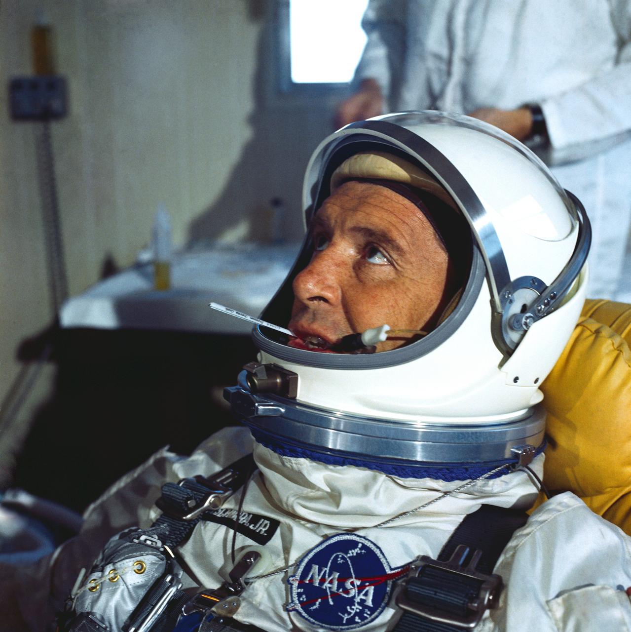
S65-22666 (8 March 1965) --- Astronaut Walter M. Schirra Jr., the command pilot of the GT-3 backup crew, is shown suited up for prelaunch tests. He is shown with his helmet visor up and a thermometer in his mouth.
41G-120-040 (5-13 Oct. 1984) --- Pakistan, featuring the city of Karachi, the Makran mountain range, the mouth of the Indus River and the North Arabian Sea were photographed with a medium format camera aboard the space shuttle Challenger during the 41-G mission. Photo credit: NASA
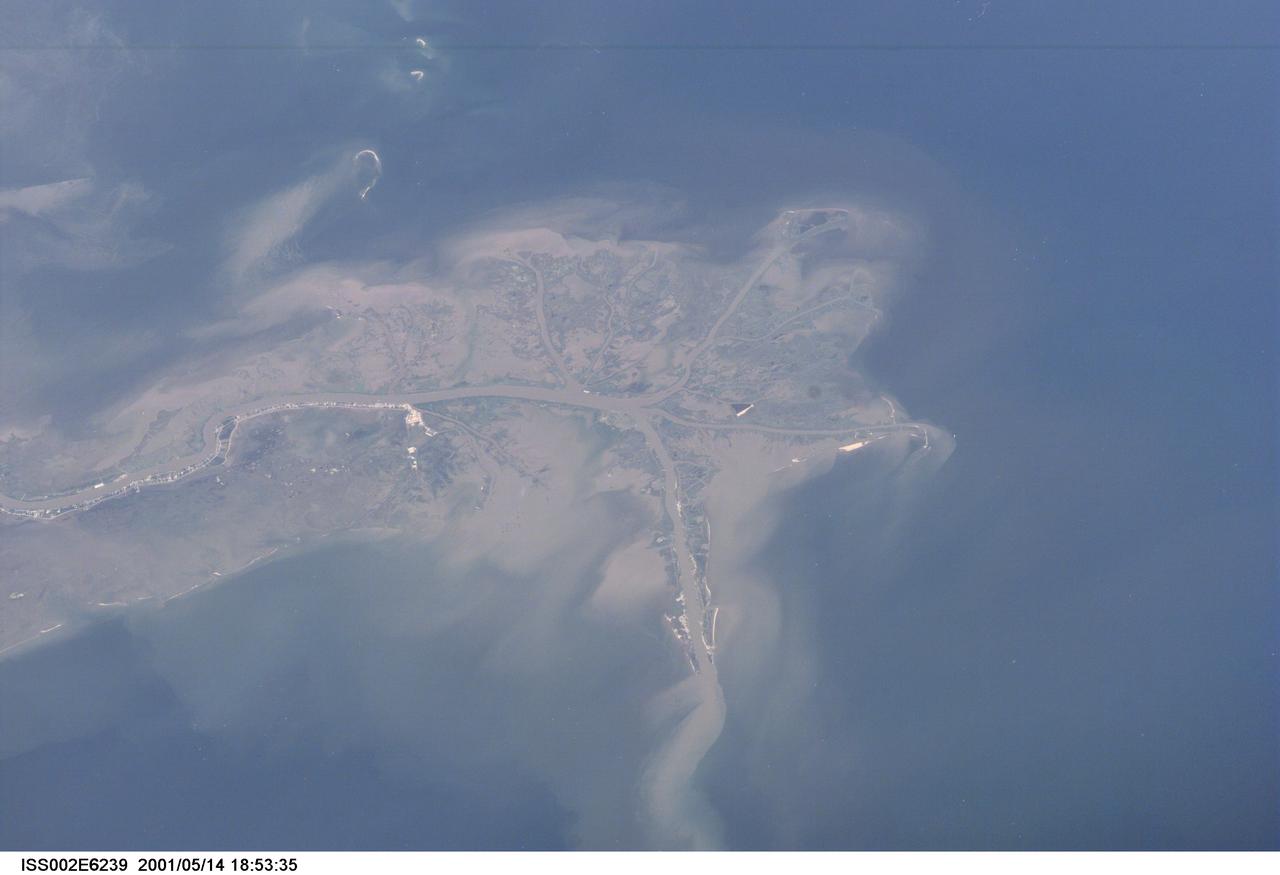
ISS002-E-6239 (14 May 2001) --- This digital still camera's image, recorded by one of the Expedition Two crew members aboard the International Space Station, features the mouth of the Mississippi River. The distribution of riverborne sediments is clearly evident in the Gulf of Mexico. This delta area is often referred to as the "crow's foot."
iss063e077259 (Aug. 21, 2020) --- The International Space Station was orbiting above Brazil when an external high-definition camera pictured the Marine Extractive Reserve of Tracuateua near the mouth of the Amazon River located on the northeast coast of the South American nation.
STS007-03-058 (18-24 June 1983) --- The Island of Madagascar in the Indian Ocean off the coast of Africa. The colorful area is the mouth of the Betsiboka River near the city of Majunga. The photograph was taken with a 70mm handheld camera aimed through the aft flight deck?s overhead windows on the Earth-orbiting Space Shuttle Challenger.

ISS020-E-011074 (16 June 2009) --- Japan Aerospace Exploration Agency (JAXA) astronaut Koichi Wakata, Expedition 20 flight engineer, attempts to catch a water bubble with his mouth in the Harmony node of the International Space Station.
51F-37-059 (29 July-6 Aug 1985) --- The mouth of the Betsiboka River in northwest Madagascar is seen. The estuary at Mahajanga is being quickly filled with river borne sediments due to poor land management, mainly deforest-action in the river basin. Changes in the estuary can be seen from one Shuttle flight to the next.
S88-E-5028 (12-05-98) --- Partial cloud cover above the mouth of the Amazon was captured with an electronic still camera by the astronauts aboard the Space Shuttle Endeavour. The image was recorded at 16:41:42 GMT, Dec. 5.
On May 26, 2015, Wolf Volcano on Isabela Island in the Galapagos Islands erupted for the first time in 33 years. This image was acquired by NASA Terra spacecraft on June 11, 2015, after the eruption had quieted.
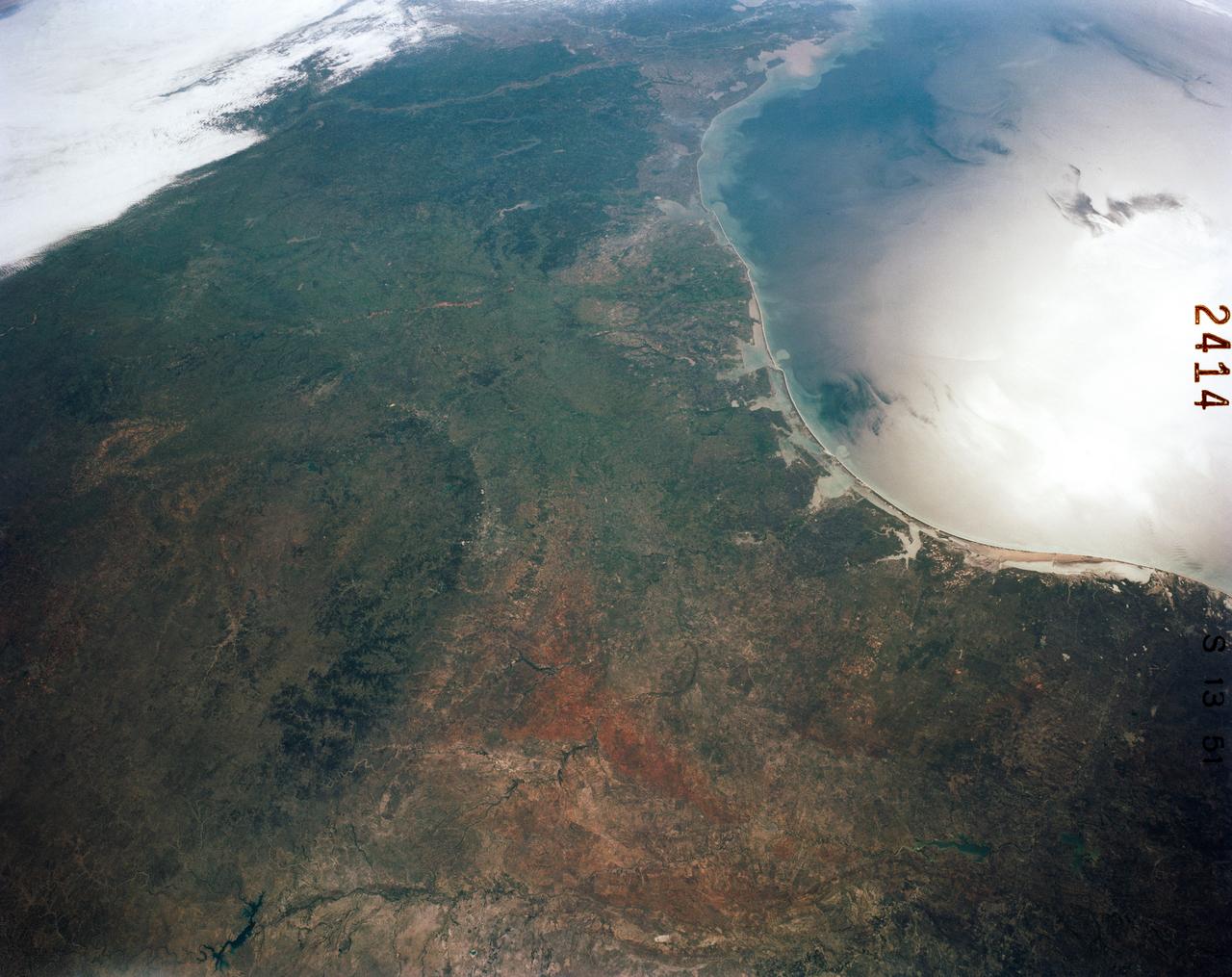
41C-51-2414 (6-13 April 1984) --- The entire Texas portion of the Gulf Coast and part of Louisiana's shoreline are visible in this frame, photographed on 4"x5" roll film using a large format camera aboard the Earth-orbiting space shuttle Challenger. Coastal bays and other geographic features from the Boca Chica (mouth of Rio Grande), to the mouth of the Mississippi are included in the frame, photographed from approximately 285 nautical miles above Earth. Inland cities that can be easily delineated are San Antonio, Austin, College Station, Del Rio and Lufkin. Easily pinpointed coastal cities include Houston, Galveston and Corpus Christi. The 41-C crew members used this frame as one of the visuals for their post-flight press conference on April 24, 1984.
STS068-237-055 (30 September - 11 October 1994) --- This coastal area, considered home by astronaut Peter J. K. (Jeff) Wisoff, was photographed from the Space Shuttle Endeavour during the Space Radar Laboratory (SRL-2) mission. Wisoff, a native of Norfolk, talked about this area during a post-flight crew awards and presentation event at the Johnson Space Center (JSC). He pointed out that the waterways are heavily used for commercial, recreational and military purposes. Piers near the mouth of the Elizabeth River are associated with the U. S. Naval Base and those down river support the activities of the city of Norfolk. Seashore State Park and the Ft. Story Military Reservation are visible at the mouth of the Chesapeake.

AS09-26A-3781A (11 March 1969) --- Colored infrared photograph of the mouth of the Colorado River in northern Baja California and Sonora, Mexico, as seen from Apollo 9 spacecraft during its 121st revolution of Earth. Photographed from an altitude of 130 nautical miles, at 16:14 GMT, on March 11, 1969. Color infrared film is designed to render healthy green foliage as tones of red, such as the red checker-board patterns in the irrigated farm lands along the Colorado River. Red hues of vegetation can be seen in the valleys and on the slopes of the San Pedro Martia and Juarez Mountains, at left. White ribbon-like salt lakes near the river mouth and the wide expanse of sand dunes in the Great Desert, at right, are evidence of the arid climate. Light colors of silt bands in the waters of the Gulf of California reflect currents and water depths. The town of San Felipe is on the Gulf coast at lower left.
On Aug. 24, the National Hurricane Center noted that Hurricane Harvey was quickly strengthening and is forecast to be a category 3 Hurricane when it approaches the middle Texas coast. In addition, life-threatening storm surge and freshwater flooding expected. On Aug. 24, many warnings and watches were in effect: A Storm Surge Warning is in effect from Port Mansfield to San Luis Pass Texas. A Storm Surge Watch is in effect from south of Port Mansfield Texas to the mouth of the Rio Grande River and from north of San Luis Pass to High Island, Texas. A Hurricane Warning is in effect from Port Mansfield to Matagorda, Texas. A Tropical Storm Warning is in effect from north of Matagorda to High Island, Texas and south of Port Mansfield, Texas to the Mouth of the Rio Grande. A Hurricane Watch is in effect from south of Port Mansfield, Texas to the Mouth of the Rio Grande. A Tropical Storm Watch is in effect from south of the mouth of the Rio Grande to Boca de Catan, Mexico. GOES-16 captured this geocolor image of Tropical Storm Harvey in the Gulf of Mexico this morning, August 24, 2017. Geocolor imagery enhancement shown here displays geostationary satellite data in different ways depending on whether it is day or night. This image, captured as daylight moves into the area, offers a blend of both, with nighttime features on the left side of the image and daytime on the right. Credit: NOAA/NASA GOES Project
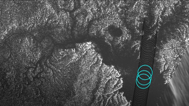
Radar data from NASA's Cassini spacecraft reveal the depth of liquid methane/ethane seas on Saturn's moon Titan. Cassini's Titan flyby on August 21, 2014, included a segment designed to collect altimetry (or height) data, using the spacecraft's radar instrument, along a 120-mile (200-kilometer) shore-to-shore track on Kraken Mare, Titan's largest hydrocarbon sea. For a 25-mile (40-kilometer) stretch of this data, along the sea's eastern shoreline, Cassini's radar beam bounced off the sea bottom and back to the spacecraft, revealing the sea's depth in that area. Observations in this region, near the mouth of a large, flooded river valley, showed depths ranging from 66 to 115 feet (20 to 35 meters). Plots of three radar echoes are shown at left, indicating depths of 89 feet (27 meters), 108 feet (33 meters) and 98 feet (30 meters), respectively. The altimetry echoes show the characteristic double-peaked returns of a bottom-reflection. The tallest peak represents the sea surface; the shorter of the pair represents the sea bottom. The distance between the two peaks is a measure of the liquid's depth. The Synthetic Aperture Radar (SAR) image at right shows successive altimetry observations as black circles. The three blue circles indicate the locations of the three altimetry echoes shown in the plots at left. http://photojournal.jpl.nasa.gov/catalog/PIA19046

AS08-16-2593 (21-27 Dec. 1968) --- A striking view from the Apollo 8 spacecraft showing nearly the entire Western Hemisphere, from the mouth of the St. Lawrence River, including nearby Newfoundland, extending to Tierra del Fuego at the southern tip of South America. Central America is clearly outlined. Nearly all of South America is covered by clouds, except the high Andes Mountain chain along the west coast. A small portion of the bulge of West Africa shows along the sunset terminator.
STS027-152-004 (2-6 Dec. 1988) --- Crew members for the STS-27 mission aboard the Earth-orbiting space shuttle Atlantis took this photo of the south Persian Gulf. with a hand-held, large format camera. The mouths of both the Tigris and Euphrates Rivers can be seen, as can nearly all the country of Kuwait. Photo credit: NASA
S65-63136 (16 Dec. 1965) --- Shark Bay area on the western coast of Western Australia as seen from the Gemini-6 spacecraft during its 16th revolution of Earth. City of Carnarven, where NASA has a tracking station, is located near the bottom of picture in lower left corner, near mouth of stream. Indian Ocean is body of water at upper right. South is toward top of picture. Photo credit: NASA or National Aeronautics and Space Administration
Tropical storm Bonnie, Gulf of Mexico, captured on August 11 at 1:30am CDT. Located in the Gulf of Mexico, the center of the storm is positioned about 280 miles south-southwest of the mouth of the Mississippi River. Bonnie is a small tropical storm with wind speeds sustained at 45 mph and extending 30 miles from the storm center. It is moving northward at 5 mph. http://photojournal.jpl.nasa.gov/catalog/PIA00441
STS085-502-104 (7 - 19 August 1997) --- The abundant plankton, microscopic organisms, are taking the shape of the currents in the Baltic Sea offshore from Gdansk, Poland. Plankton blooms occur when there is enough nutrient in the water to support rapid growth and reproduction of the microorganisms. Gdansk is situated at the mouth of the Vistula River on the north coast of Poland. It is a major industrial center for shipyards, metallurgical and chemical plants, timber mills, food-processing facilities and more recently (since 1975) for coal exports and petroleum imports.
AS09-26A-3727A (8 March 1969) --- Color infrared photograph of the Texas Gulf Coast, Galveston Bay to Matagorda Bay, as seen from the Apollo 9 spacecraft during it 78th revolution of Earth. Houston is located at right center edge of photograph. Also visible are Galveston, Texas City, Manned Spacecraft Center, and Freeport. The mouth of the Colorado River is located near left center edge of picture. This picture was taken as a part of the SO65 Multispectral Terrain Photography Experiment.
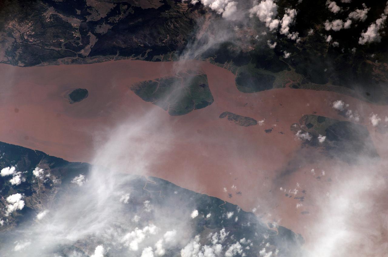
iss073e0818427 (Oct. 2, 2025) --- The Bassac River surrounds Cù Lao Dung, a river islet district in southern Vietnam, before emptying into the South China Sea. The river’s brown waters at its mouth result from massive amounts of silt, clay, and organic matter carried from upstream regions of the Mekong River Basin, combined with tidal forces from the sea that stir up sediment. This photograph was taken from the International Space Station as it orbited 260 miles above Earth.

At the KSC Shuttle Landing Facility, the GOES-M satellite is offloaded from the yawning mouth of the C-5 aircraft. It will be transferred to Astrotech in Titusville, Fla., for final testing. The GOES-M (Geostationary Operational Environmental Satellite, I-M Series) provides weather imagery and quantitative sounding data used to support weather forecasting, severe storm tracking, and meteorological research. The satellite is scheduled to be launched on an Atlas-IIA booster, with a Centaur upper stage, July 12 from Launch Pad 36-A, Cape Canaveral Air Force Station
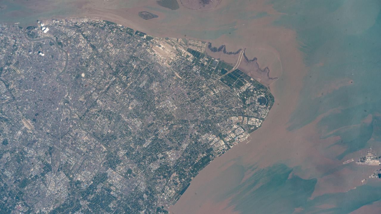
iss073e0513927 (Aug. 22, 2025) --- Shanghai, China's most populous city with over 24 million citizens and sitting on the East China Sea at the mouth of the Yangtze River, is pictured from the International Space Station as it orbited 260 miles above. Highlights include Shanghai Pudong International Airport (at top), the second busiest airport in the world by cargo traffic, and the circular Dishui Lake (center right), the largest artificial freshwater lake in China, hosting business and recreational activities.
STS035-81-040 (2-10 Dec 1990) --- Numerous algae reefs are seen in Shark Bay, Western Australia, Australia (26.0S, 113.5E) especially in the southern portions of the bay. The south end is more saline because tidal flow in and out of the bay is restricted by sediment deposited at the north and central end of the bay opposite the mouth of the Wooramel River. This extremely arid region produces little sediment runoff so that the waters are very clear, saline and rich in algae.
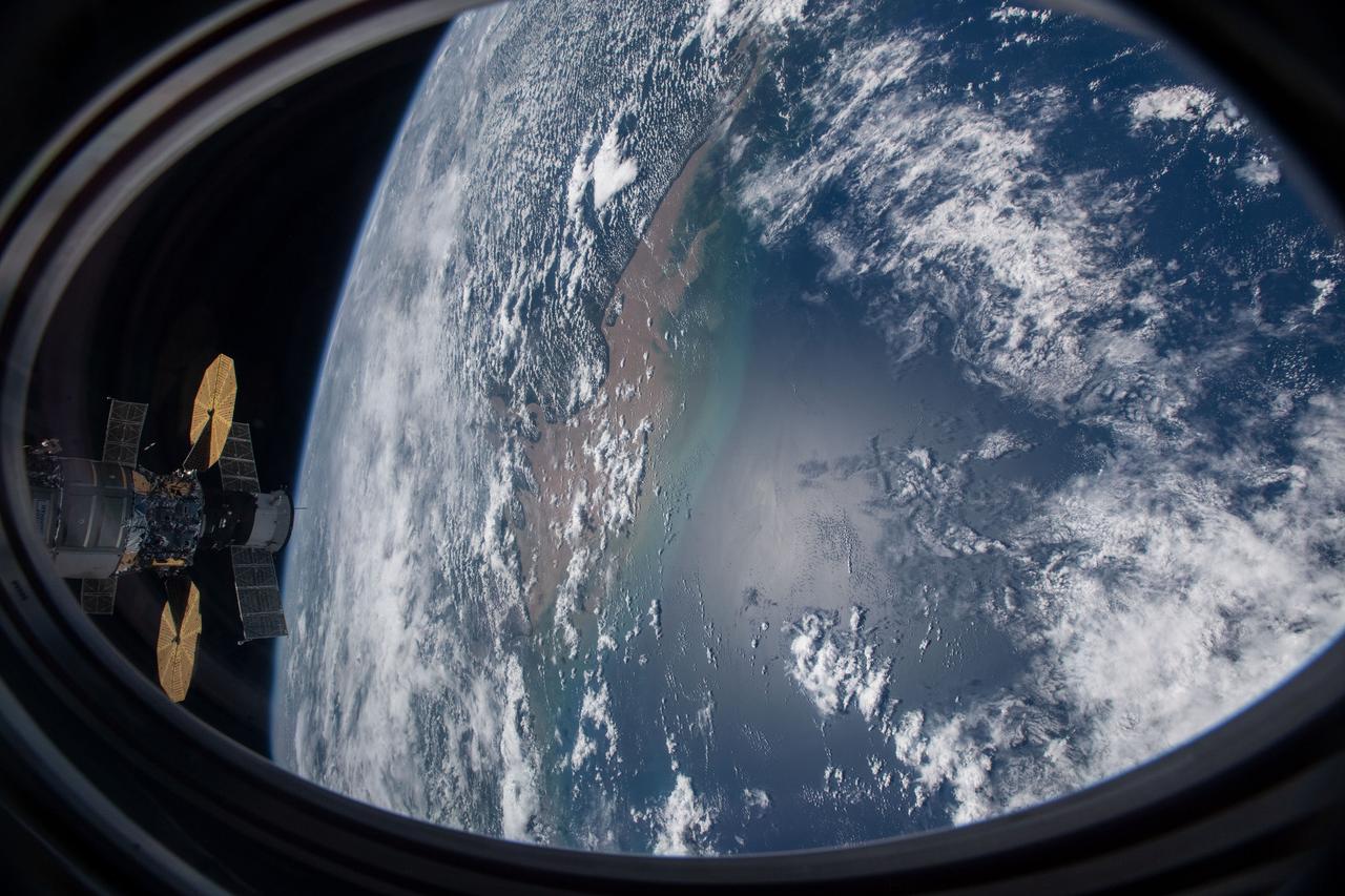
iss064e006446 (Nov. 27, 2020) --- This picture was taken from a window on the SpaceX Crew Dragon vehicle as the International Space Station orbited above the Atlantic Ocean just off the coast of Brazil near the mouth of the Amazon River. Two other spacecraft, including the Cygnus cargo craft with its two prominent cymbal-shaped solar arrays, and behind it, Russia's Soyuz MS-17 crew ship with its rectangular solar arrays, are also pictured docked to the orbiting lab.
S66-54563 (14 Sept. 1966) --- View of the Gulf Coast area from Atchafalaya Bay to Apalachicola, including the mouth of the Mississippi River, Mobile Bay, New Orleans, Louisiana, and Pensacola, Florida, as seen from the Gemini-11 spacecraft during its 29th revolution of Earth. This photo was taken near sunrise. Photo credit: NASA
iss067e034832 (May 5, 2022) --- The Rio de la Plata separates the nations of Argentina (bottom) and Uruguay (top) in this photograph from the International Space Station as it orbited 270 miles above. Barely visible (at lower center), is the populous city of Buenos Aires, Argentina, at the mouth of the Paraná Delta which empties in to the Rio de la Plata.
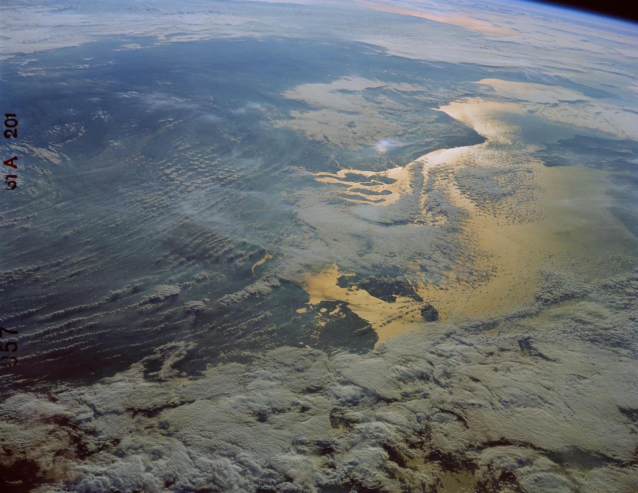
61A-201-057 (30 Oct-6 Nov 1985) --- The North Sea, looking southwest toward Brittany, visible in the upper right portion of the frame. The islands of the mouths of the Rhine River are in the foreground, and above them sunlight reflects off the long causeways and dikes of the Ijsselmeer in the Netherlands. To the right is the Strait of Dover (Pas de Calais) with the southeast corner of England just above the right center edge.
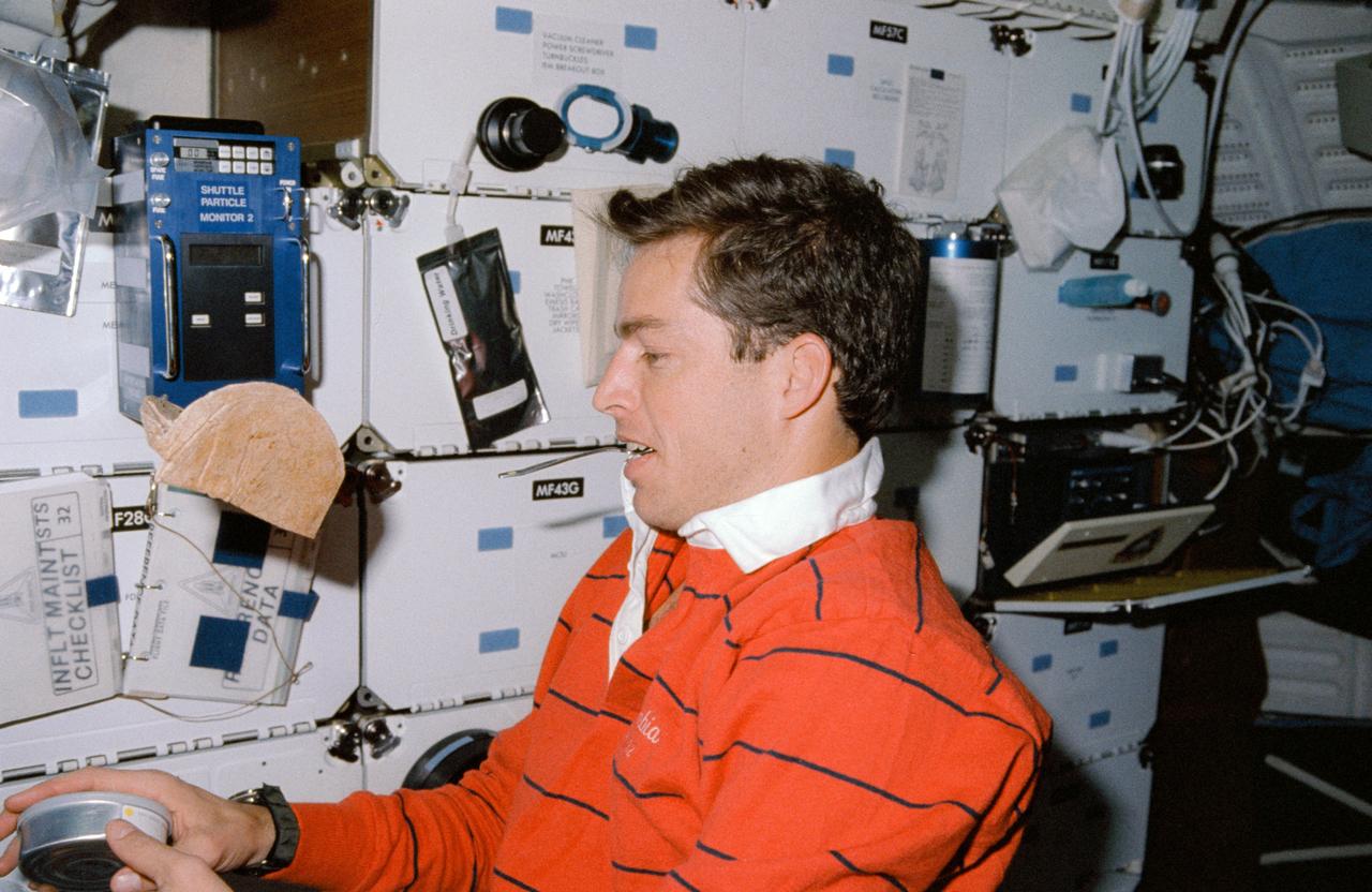
STS032-03-026 (9 - 20 Jan 1990) --- Astronaut James D. Wetherbee, pilot, having run out of shelf space, uses his mouth to temporarily "park" a spoon during meal time preparations on the mid-deck of the Earth-orbiting Space Shuttle Columbia. He prepares to open a can while a packet of tortillas floats in the foreground. This picture was used by the astronauts at their January 30, 1990 Post Flight Press Conference (PFPC) at Johnson Space Center (JSC).
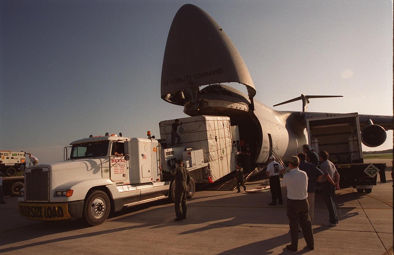
At the KSC Shuttle Landing Facility, the GOES-M satellite is offloaded from the yawning mouth of the C-5 aircraft. It will be transferred to Astrotech in Titusville, Fla., for final testing. The GOES-M (Geostationary Operational Environmental Satellite, I-M Series) provides weather imagery and quantitative sounding data used to support weather forecasting, severe storm tracking, and meteorological research. The satellite is scheduled to be launched on an Atlas-IIA booster, with a Centaur upper stage, July 12 from Launch Pad 36-A, Cape Canaveral Air Force Station
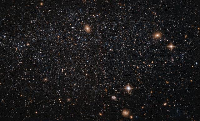
At first glance this NASA/ESA Hubble Space Telescope image seems to show an array of different cosmic objects, but the speckling of stars shown here actually forms a single body — a nearby dwarf galaxy known as Leo A. Its few million stars are so sparsely distributed that some distant background galaxies are visible through it. Leo A itself is at a distance of about 2.5 million light-years from Earth and a member of the Local Group of galaxies; a group that includes the Milky Way and the well-known Andromeda galaxy. Astronomers study dwarf galaxies because they are very numerous and are simpler in structure than their giant cousins. However, their small size makes them difficult to study at great distances. As a result, the dwarf galaxies of the Local Group are of particular interest, as they are close enough to study in detail. As it turns out, Leo A is a rather unusual galaxy. It is one of the most isolated galaxies in the Local Group, has no obvious structural features beyond being a roughly spherical mass of stars, and shows no evidence for recent interactions with any of its few neighbours. However, the galaxy’s contents are overwhelmingly dominated by relatively young stars, something that would normally be the result of a recent interaction with another galaxy. Around 90% of the stars in Leo A are less than eight billion years old — young in cosmic terms! This raises a number of intriguing questions about why star formation in Leo A did not take place on the “usual” timescale, but instead waited until it was good and ready.

ISS038-E-057979 (22 Feb. 2014) --- This image, photographed by one of the Expedition 38 crew members aboard the International Space Station, shows the city of Green Bay, Wisconsin at the southern end of icebound Green Bay. This arm of Lake Michigan is six miles wide as seen in this view. The heavy snowfalls of the winter of 2014 cover the landscape. Combined with low sun illumination of a winter day, all surfaces appear as shades of gray. Fields appear brighter (top right, lower right), the cityscape (lower half of the image) appears as a checkerboard of grays, and forests (top left) appear dark. The center of the city lies on the Fox River, one of the few larger rivers in the United States that flow north. Open water appears as dark patches at the mouth of the river where a power station emits warm water. Thinner (grayer) ice can be detected where slightly warmer water extends from the river mouth towards Long Tail Point, an ancient shoreline of the bay. Crews aboard the space station do not usually take such detailed photographs because of the difficulty of getting sharp images with long lenses (in this case a 1000mm lens). Streets and bridges crossing the Fox River appear quite clearly.

Four hundred bridges cross the labyrinth of canals that form the 120 islands of Venice, situated in a saltwater lagoon between the mouths of the Po and Piave rivers in northeast Italy. All traffic in the city moves by boat. Venice is connected to the mainland, 4 kilometers (2.5 miles) away, by ferries as well as a causeway for road and rail traffic. The Grand Canal winds through the city for about 3 kilometers (about 2 miles), dividing it into two nearly equal sections. According to tradition, Venice was founded in 452, when the inhabitants of Aquileia, Padua, and several other northern Italian cities took refuge on the islands of the lagoon from the Teutonic tribes invading Italy at that time. This image was acquired on December 9, 2001 by the Advanced Spaceborne Thermal Emission and Reflection Radiometer (ASTER) on NASA's Terra satellite. With its 14 spectral bands from the visible to the thermal infrared wavelength region, and its high spatial resolution of 15 to 90 meters (about 50 to 300 feet), ASTER will image Earth for the next 6 years to map and monitor the changing surface of our planet. http://photojournal.jpl.nasa.gov/catalog/PIA03860
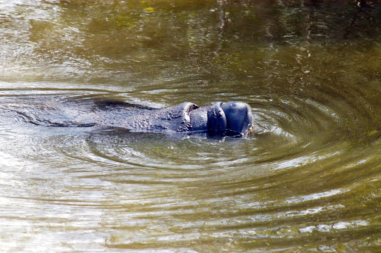
KENNEDY SPACE CENTER, FLA. - At the mouth of Banana Creek on Kennedy Space Center, a manatee rests in the shallows. Manatees live in Florida's warm-water rivers and inland springs. The Florida manatee feeds on more than 60 varieties of grasses and plants. Manatee cows give birth about once every three years. Gestation lasts about 12 months. KSC shares a boundary with the Merritt Island National Wildlife Refuge, which encompasses 92,000 acres that are a habitat for more than 331 species of birds, 31 mammals, 117 fishes, and 65 amphibians and reptiles.

ISS007-E-15177 (21 September 2003) --- This view, photographed by an Expedition 7 crewmember onboard the International Space Station (ISS), features a small part of the coastal dune field which is now protected as the Lencois Maranhenses National Park, on Brazil’s north coast, about 700 kilometers east of the Amazon River mouth. Persistent winds blow off the equatorial Atlantic Ocean onto Brazil from the east, driving white sand inland from 100 kilometers stretch of coast, to form a large field of dunes. The dark areas between the white dunes are fresh water ponds that draw fishermen to this newly established park.
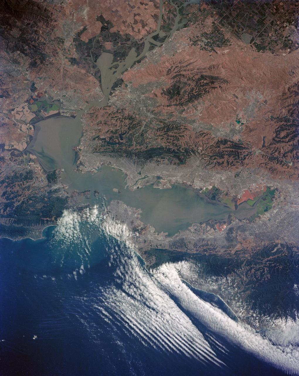
STS040-152-100 (5-14 June 1991) --- Although clouds obscure part of the city of San Francisco and the mouth of San Francisco Bay, development and physiographic features in the immediate vicinity of the bay are well displayed. The photograph clearly shows the eastern part of the city, including the Embarcadero, the Bay Bridge, which was damaged in the 1989 earthquake, and Candlestick Park, San Mateo, and Dumbarton Bridges, cross the southern portion of the bay. Vari-colored salt ponds also rim the southern Bay near Moffett Field. Highway 280 runs along the San Andreas fault south of the city. On the eastern margin of the bay are Berkeley the Sacramento River and the Haywood and Calaveras faults.

At the KSC Shuttle Landing Facility, a truck begins offloading the container with the GOES-M satellite from the yawning mouth of the C-5 aircraft. It will be transferred to Astrotech in Titusville, Fla., for final testing. The GOES-M (Geostationary Operational Environmental Satellite, I-M Series) provides weather imagery and quantitative sounding data used to support weather forecasting, severe storm tracking, and meteorological research. The satellite is scheduled to be launched on an Atlas-IIA booster, with a Centaur upper stage, July 12 from Launch Pad 36-A, Cape Canaveral Air Force Station
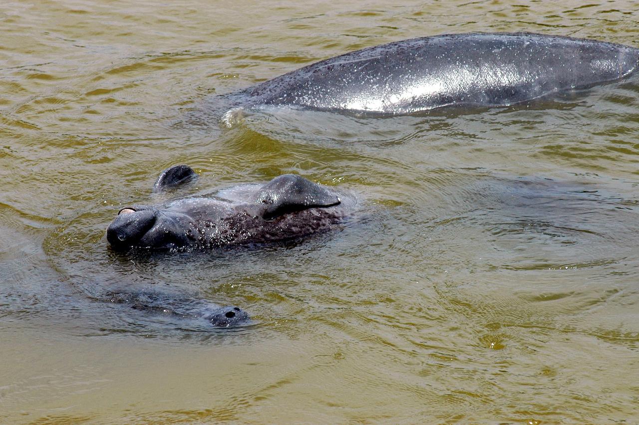
KENNEDY SPACE CENTER, FLA. - At the mouth of Banana Creek on Kennedy Space Center, a baby manatee seems to be smiling as it floats on its back nestled between two adults. Manatees live in Florida's warm-water rivers and inland springs. The Florida manatee feeds on more than 60 varieties of grasses and plants. Manatee cows give birth about once every three years. Gestation lasts about 12 months. KSC shares a boundary with the Merritt Island National Wildlife Refuge, which encompasses 92,000 acres that are a habitat for more than 331 species of birds, 31 mammals, 117 fishes, and 65 amphibians and reptiles.
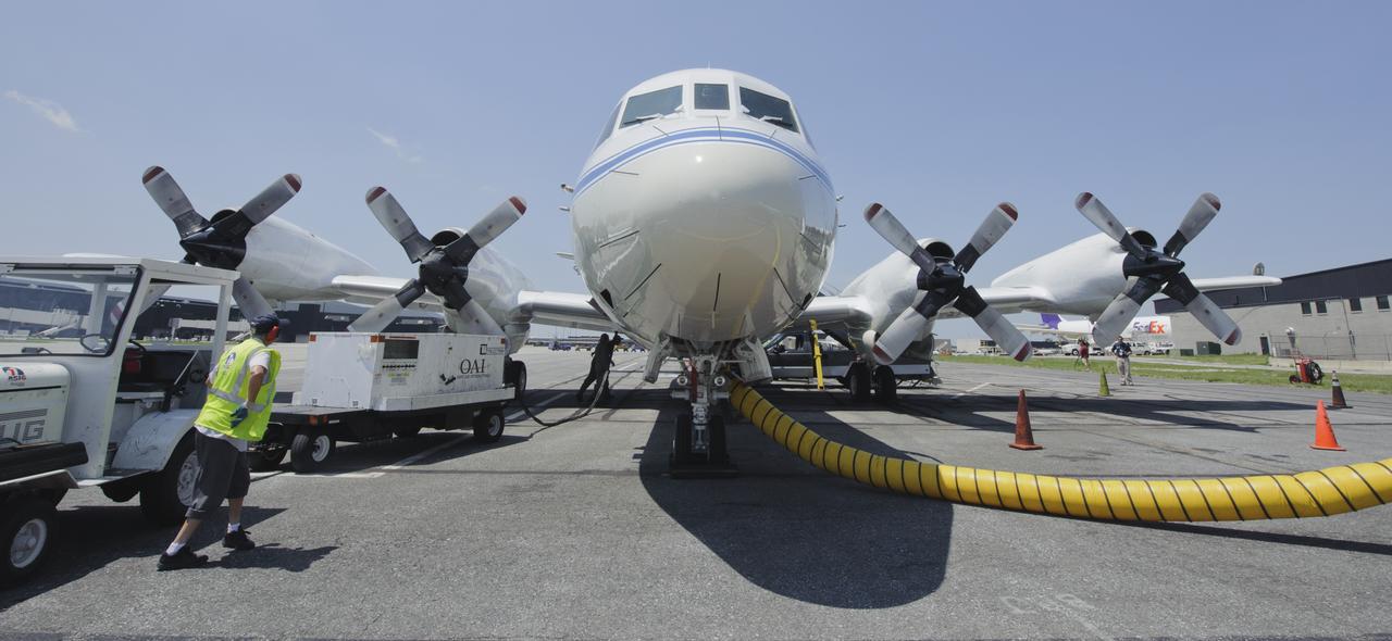
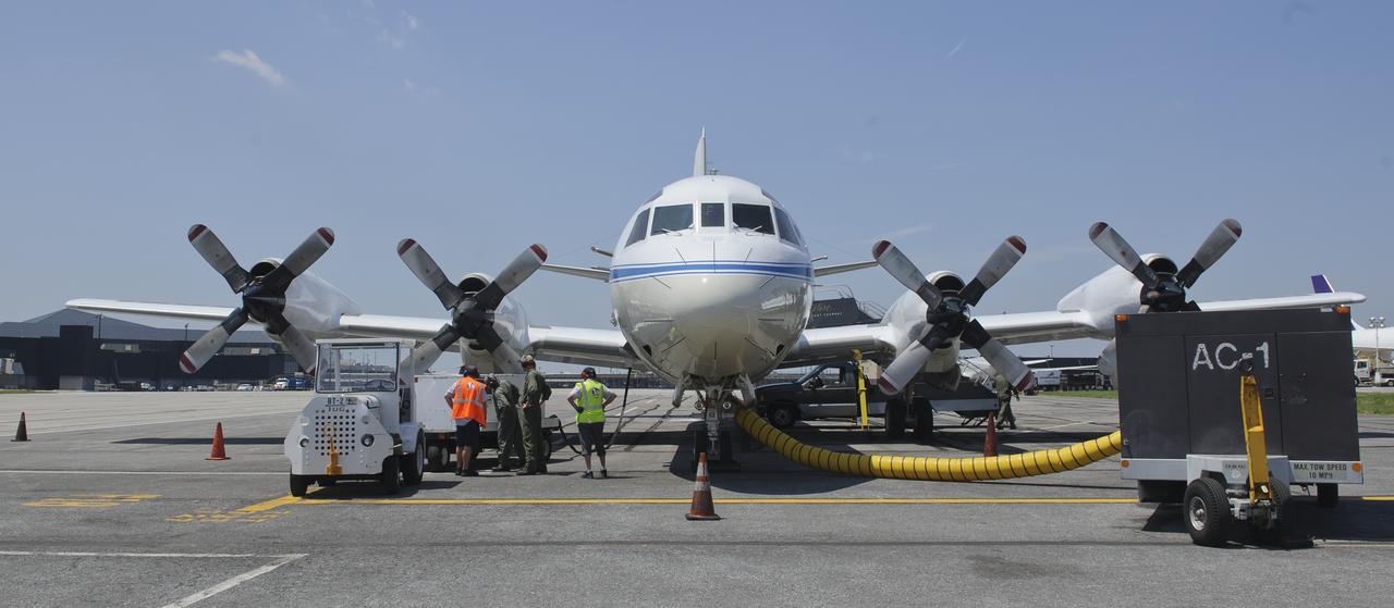
A 117-foot P-3B NASA research aircraft is seen on the tarmac at Baltimore/Washington International Thurgood Marshall Airport, Tuesday, June 28, 2011, in Baltimore, Md. The aircraft is part of a month-long field campaign designed to improve satellite measurements of air pollution. The name of the experiment -- Deriving Information on Surface conditions from Column and Vertically Resolved Observations Relevant to Air Quality (DISCOVER -- AQ) -- is a mouthful, but its purpose is simple. Come July, the aircraft will be flying spirals over six ground stations in Maryland. Photo Credit: (NASA/Paul E. Alers)
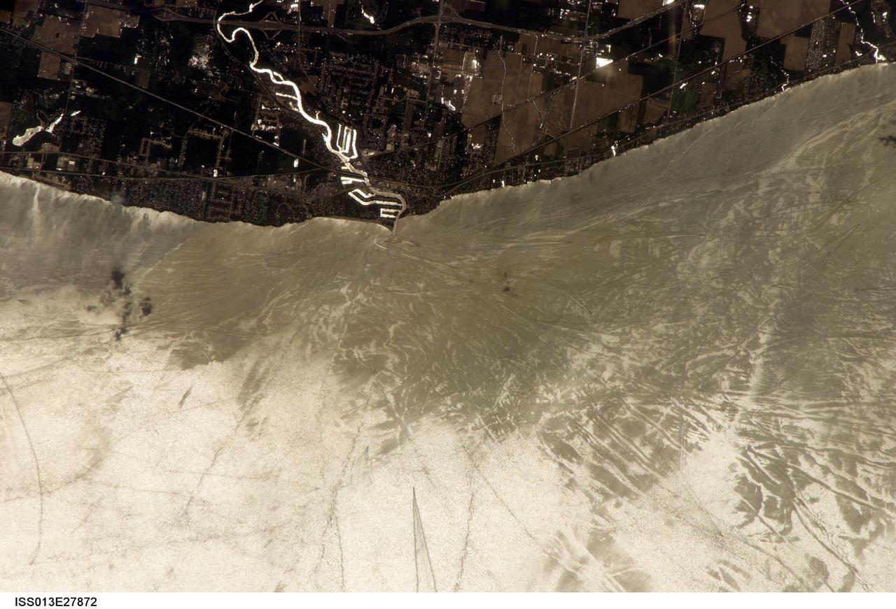
ISS013-E-27872 (28 May 2006) --- Considerable sunglint emphasizes features on Lake Erie in this image photographed by an Expedition 13 crewmember on the International Space Station. This detailed, south-looking image shows features on the surface of Lake Erie, about 30 miles west of Cleveland, Ohio. This view shows the Vermilion River in strong sunglint. The angular water bodies along the river are likely marinas. The main part of the image show numerous ship wakes in the zone of partial glint around the disk of the Sun's reflection point. The wakes radiate from the mouth of the Vermilion River, with many of them heading northwest in the direction of Detroit, Michigan.
STS072-738-019 (11-20 Jan. 1996) --- The Delta of the Paraiba do Sul River, northeast of Rio de Janeiro, Brazil, stands out in this 70mm frame exposed from the Earth-orbiting Space Shuttle Endeavour. The brown color of the river water and offshore sediment plume show that the river is in flood stage. This delta attracts much attention from orbit because of its prominent beach ridges either side of the river mouth. River sediment from inland supplies the material which is redistributed by coastal currents to form the parallel beach ridges. The lower 20 miles of the river appear in this scene. The river flows into the Atlantic in an easterly direction.
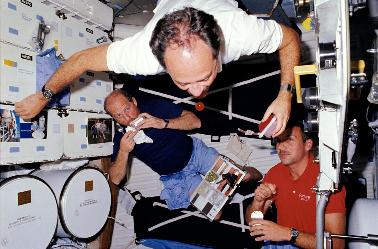
STS026-06-018 (29 Sept. - 3 Oct. 1988) --- Astronaut John M. Lounge, STS-26 mission specialist (MS), using a beverage container, experiments with microgravity as Commander Frederick H. Hauck (left) and MS David C. Hilmers (right) look on. Lounge freefloats as he closes in on a sphere of the red liquid drifting in front of his mouth. Hauck holds a spoon while sipping from a beverage container as he balances a meal tray assembly on his thighs. Hilmers, partially blocked by the open airlock hatch and holding a spoon and a can of food, pauses to watch the experiment. Automated Directional Solidification Furnace (ADSF) and forward middeck lockers appear on Lounge's right.
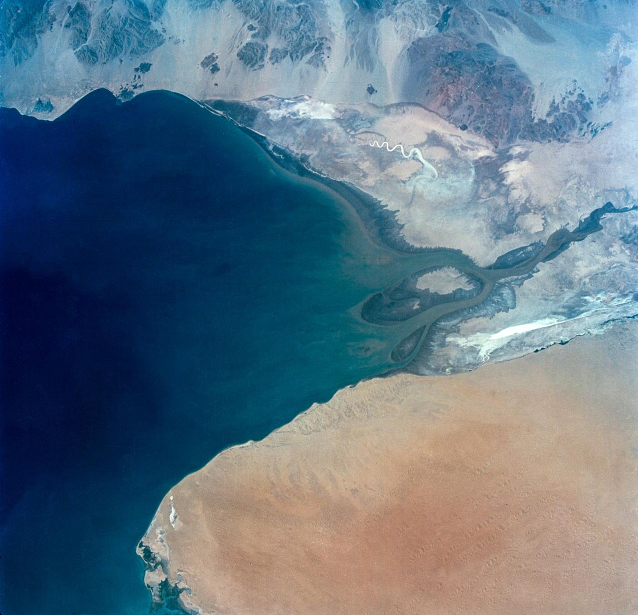
S65-34673 (3-7 June 1965) --- This photograph shows the north end of the Gulf of California at the mouth of the Colorado River as it was seen from the Gemini-4 spacecraft during orbital flight June 3-7, 1965. This picture was part of the Synoptic Terrain Photography experiments conducted during the flight to obtain high quality photographs of large land areas already mapped by aerial photography. In charge of these experiments was Dr. Paul D. Lowman Jr., NASA geologist from Goddard Space Flight Center, Greenbelt, Md. This picture was taken with a modified 70mm Hasselblad camera using Eastman color film, ASA 64 at a lens setting of 250th of a second at f/11.

STS054-86-001 (13-19 Jan. 1993) --- This 70mm view shows a spectacular multiple spit on the coast of Brazil, about halfway between Rio de Janeiro and the mouth of the Amazon River. Over a few thousand years, according to NASA scientists, shifting regimes of wave and current patterns piled up sand onto a series of beach ridges and tidal lagoons. The present swirls of sediment along the coast evidently were derived from beach erosion, because streams flowing into the Atlantic contain dark, clear water. Offshore, reefs and sandbanks parallel the coast. The largest is the Recife da Pedra Grande (Big Rocks Reef).
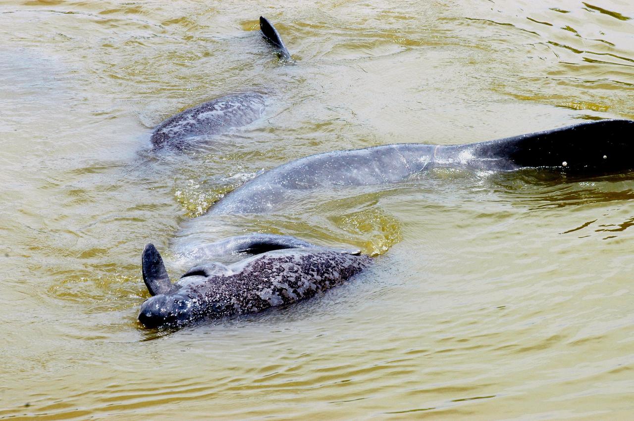
KENNEDY SPACE CENTER, FLA. - At the mouth of Banana Creek on Kennedy Space Center, a baby manatee (foreground) is nuzzled by one of its parents while another swims nearby. Manatees live in Florida's warm-water rivers and inland springs. The Florida manatee feeds on more than 60 varieties of grasses and plants. Manatee cows give birth about once every three years. Gestation lasts about 12 months. KSC shares a boundary with the Merritt Island National Wildlife Refuge, which encompasses 92,000 acres that are a habitat for more than 331 species of birds, 31 mammals, 117 fishes, and 65 amphibians and reptiles.
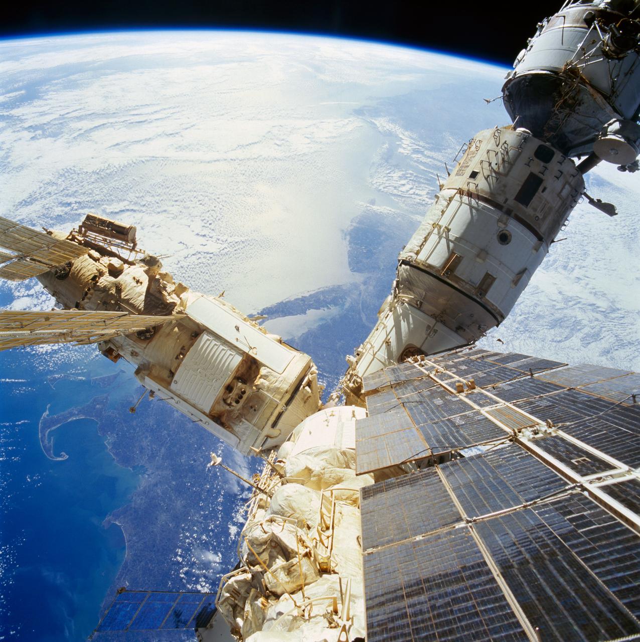
STS074-718-056 (12-20 Nov 1995) --- As photographed from the overhead Windows on the aft flight deck of the docked Space Shuttle Atlantis, a number of components of the cluster comprising the Russia?s Mir Space Station are backdropped over the northeastern United States. The crew enjoyed a southward looking view of the United States east coast from New Hampshire to South Carolina. Cape Cod and Boston, Massachusetts are seen on the north or the side away from Earth?s limb. New York City and Long Island are in the center of the photo. The mouths of both the Delaware and Chesapeake Bays are visible southward.

A 117-foot P-3B NASA research aircraft is seen on the tarmac at Baltimore/Washington International Thurgood Marshall Airport, Tuesday, June 28, 2011, in Baltimore, Md. The aircraft is part of a month-long field campaign designed to improve satellite measurements of air pollution. The name of the experiment -- Deriving Information on Surface conditions from Column and Vertically Resolved Observations Relevant to Air Quality (DISCOVER -- AQ) -- is a mouthful, but its purpose is simple. Come July, the aircraft will be flying spirals over six ground stations in Maryland. Photo Credit: (NASA/Paul E. Alers)
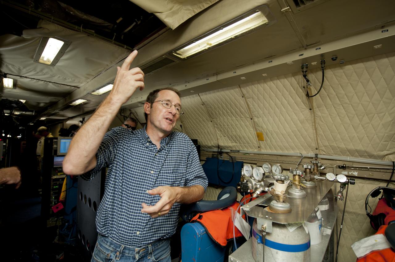
James Crawford, principal investigator and scientist based at NASA’s Langley Research Center in Hampton, Va., talks about the DISCOVER-AQ project on board the P-3B NASA research aircraft at Baltimore/Washington International Thurgood Marshall Airport, Tuesday, June 28, 2011, in Baltimore, Md. The aircraft is part of a month-long field campaign designed to improve satellite measurements of air pollution. The name of the experiment -- Deriving Information on Surface conditions from Column and Vertically Resolved Observations Relevant to Air Quality (DISCOVER -- AQ) -- is a mouthful, but its purpose is simple. Come July, the aircraft will be flying spirals over six ground stations in Maryland. Photo Credit: (NASA/Paul E. Alers)
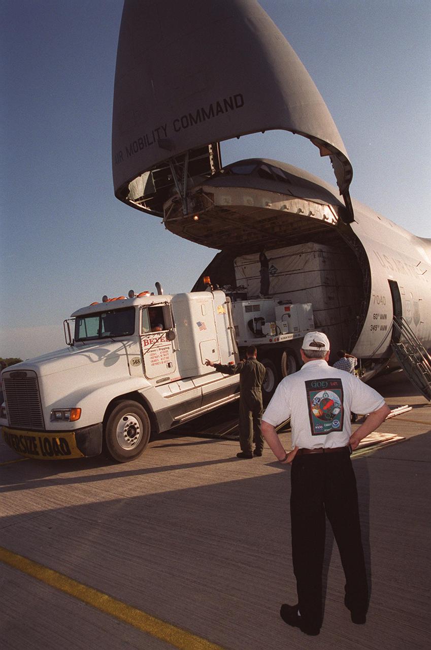
At the KSC Shuttle Landing Facility, a truck begins offloading the container with the GOES-M satellite from the yawning mouth of the C-5 aircraft. It will be transferred to Astrotech in Titusville, Fla., for final testing. The GOES-M (Geostationary Operational Environmental Satellite, I-M Series) provides weather imagery and quantitative sounding data used to support weather forecasting, severe storm tracking, and meteorological research. The satellite is scheduled to be launched on an Atlas-IIA booster, with a Centaur upper stage, July 12 from Launch Pad 36-A, Cape Canaveral Air Force Station
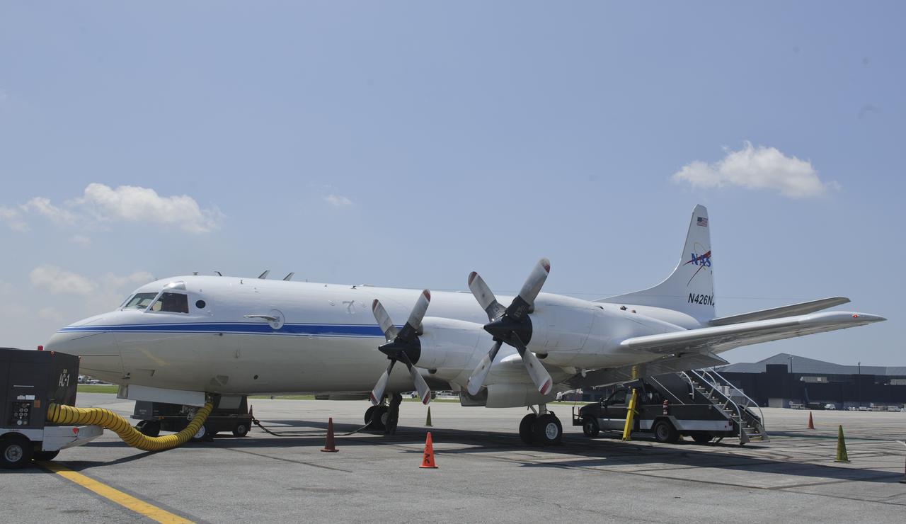
A 117-foot P-3B NASA research aircraft is seen on the tarmac at Baltimore/Washington International Thurgood Marshall Airport, Tuesday, June 28, 2011, in Baltimore, Md. The aircraft is part of a month-long field campaign designed to improve satellite measurements of air pollution. The name of the experiment -- Deriving Information on Surface conditions from Column and Vertically Resolved Observations Relevant to Air Quality (DISCOVER -- AQ) -- is a mouthful, but its purpose is simple. Come July, the aircraft will be flying spirals over six ground stations in Maryland. Photo Credit: (NASA/Paul E. Alers)
A 117-foot P-3B NASA research aircraft is seen on the tarmac at Baltimore/Washington International Thurgood Marshall Airport, Tuesday, June 28, 2011, in Baltimore, Md. The aircraft is part of a month-long field campaign designed to improve satellite measurements of air pollution. The name of the experiment -- Deriving Information on Surface conditions from Column and Vertically Resolved Observations Relevant to Air Quality (DISCOVER -- AQ) -- is a mouthful, but its purpose is simple. Come July, the aircraft will be flying spirals over six ground stations in Maryland. Photo Credit: (NASA/Paul E. Alers)
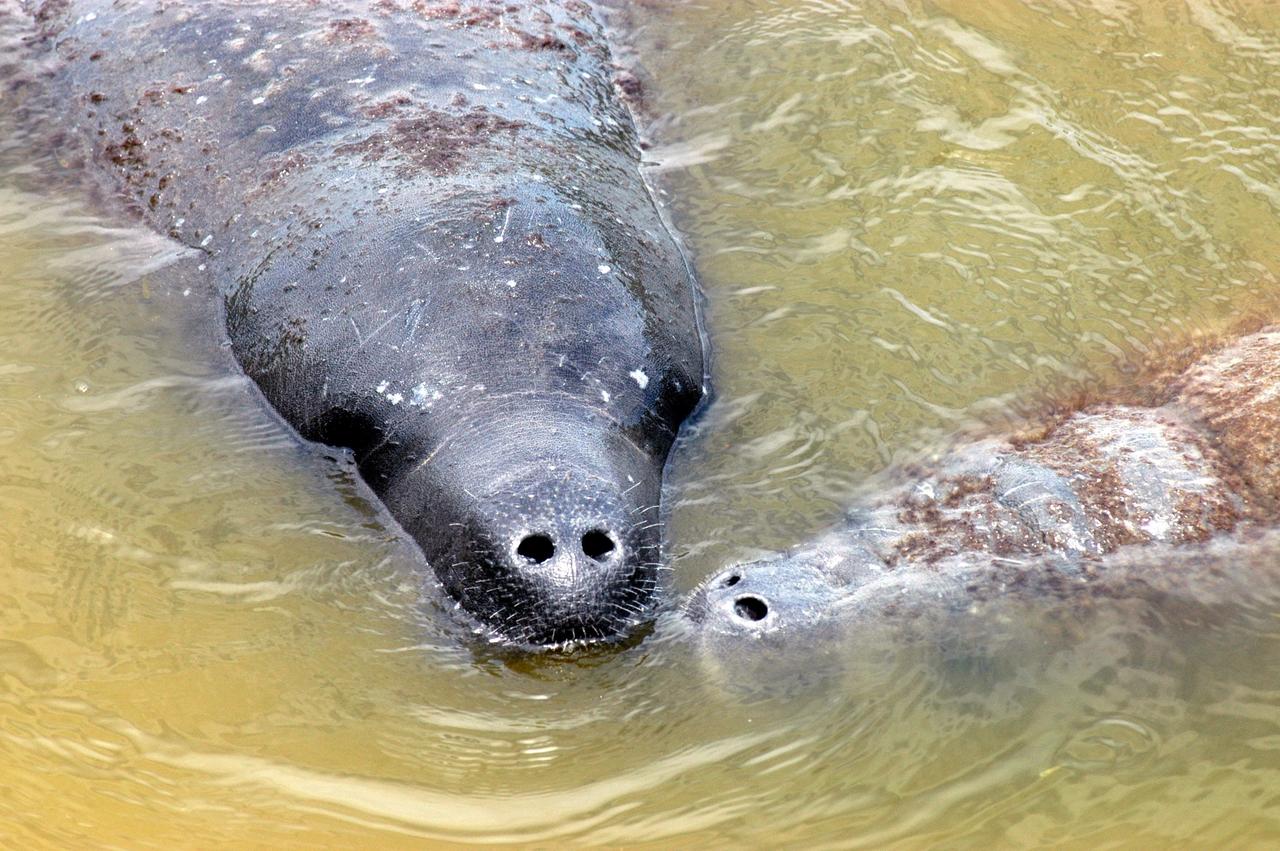
KENNEDY SPACE CENTER, FLA. - Looking more like an alien than a mammal, an adult manatee (left) nuzzles its baby (right) in the water at the mouth of Banana Creek on Kennedy Space Center. Manatees live in Florida's warm-water rivers and inland springs. The Florida manatee feeds on more than 60 varieties of grasses and plants. Manatee cows give birth about once every three years. Gestation lasts about 12 months. KSC shares a boundary with the Merritt Island National Wildlife Refuge, which encompasses 92,000 acres that are a habitat for more than 331 species of birds, 31 mammals, 117 fishes, and 65 amphibians and reptiles.
An unidentified researcher works aboard the P-3B NASA research aircraft at Baltimore/Washington International Thurgood Marshall Airport, Tuesday, June 28, 2011, in Baltimore, Md. The aircraft is part of a month-long field campaign designed to improve satellite measurements of air pollution. The name of the experiment -- Deriving Information on Surface conditions from Column and Vertically Resolved Observations Relevant to Air Quality (DISCOVER -- AQ) -- is a mouthful, but its purpose is simple. Come July, the aircraft will be flying spirals over six ground stations in Maryland. Photo Credit: (NASA/Paul E. Alers)
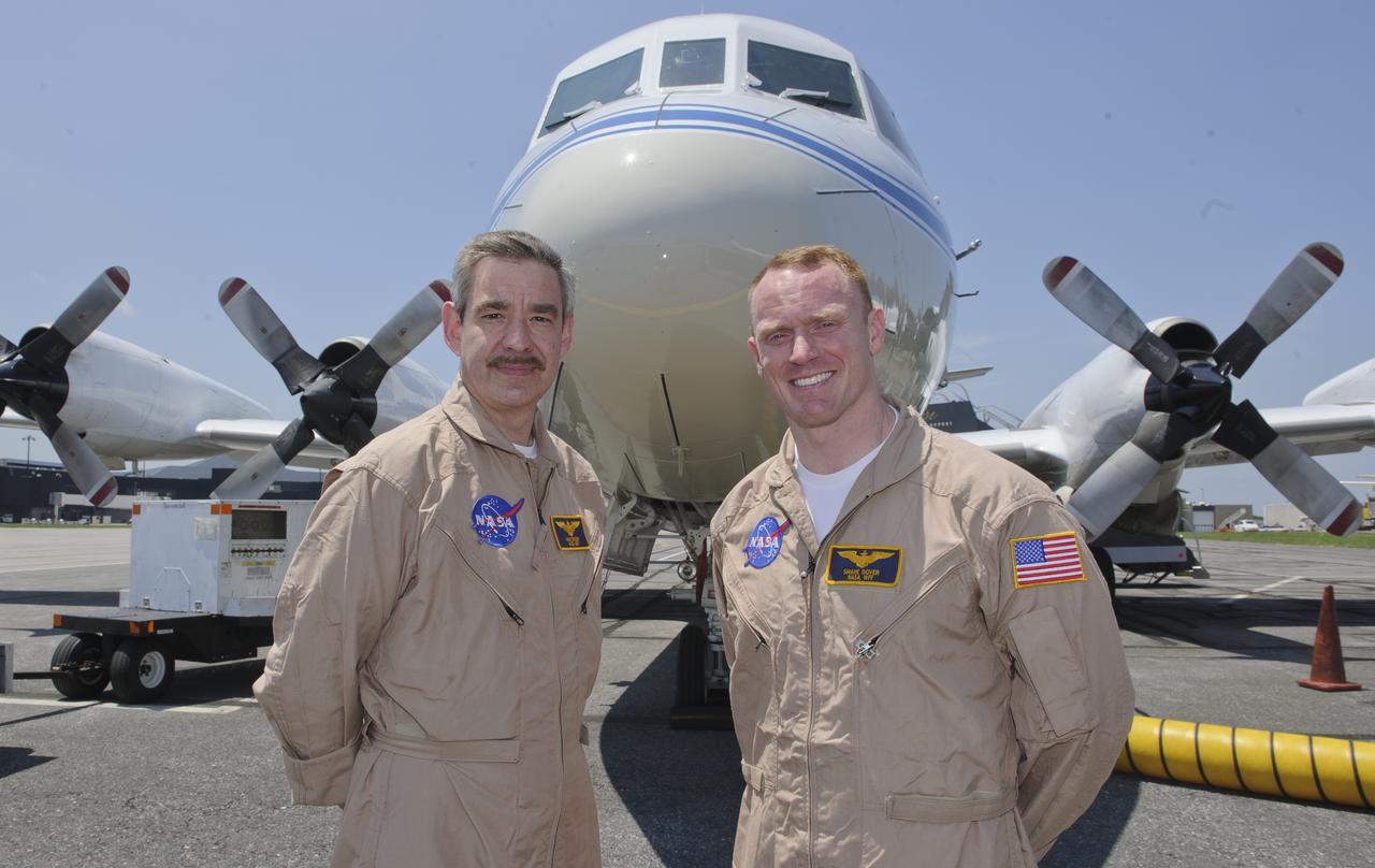
WFF Pilots Mike Singer, left, and Shane Dover stand in front of the 117-foot P-3B NASA research aircraft on the tarmac at Baltimore/Washington International Thurgood Marshall Airport, Tuesday, June 28, 2011, in Baltimore, Md. The aircraft is part of a month-long field campaign designed to improve satellite measurements of air pollution. The name of the experiment -- Deriving Information on Surface conditions from Column and Vertically Resolved Observations Relevant to Air Quality (DISCOVER -- AQ) -- is a mouthful, but its purpose is simple. Come July, the aircraft will be flying spirals over six ground stations in Maryland. Photo Credit: (NASA/Paul E. Alers)

Pilots Shane Dover, left, and Mike Singer are seen on the flight deck of the P-3B NASA research aircraft at Baltimore/Washington International Thurgood Marshall Airport, Tuesday, June 28, 2011, in Baltimore, Md. The aircraft is part of a month-long field campaign designed to improve satellite measurements of air pollution. The name of the experiment -- Deriving Information on Surface conditions from Column and Vertically Resolved Observations Relevant to Air Quality (DISCOVER -- AQ) -- is a mouthful, but its purpose is simple. Come July, the aircraft will be flying spirals over six ground stations in Maryland. Photo Credit: (NASA/Paul E. Alers)
It drains a watershed that spans eight countries and nearly 1.6 million square kilometers 600,000 square miles. The Zambezi also Zambeze is the fourth largest river in Africa, and the largest east-flowing waterway. The Operational Land Imager on the Landsat 8 satellite acquired this natural-color image of the Zambezi Delta on August 29, 2013. Sandbars and barrier spits stretch across the mouths of the delta, and suspended sediment extends tens of kilometers out into the sea. The sandy outflow turns the coastal waters to a milky blue-green compared to the deep blue of open water in the Indian Ocean. The Zambezi Delta includes 230 kilometers of coastline fronting 18,000 square kilometers (7,00 square miles) of swamps, floodplains, and even savannahs (inland). The area has long been prized by subsistence fishermen and farmers, who find fertile ground for crops like sugar and fertile waters for prawns and fish. Two species of endangered cranes and one of the largest concentration of buffalo in Africa -- among many other species of wildlife -- have found a haven in this internationally recognized wetland. However, the past six decades have brought great changes to the Zambezi Delta, which used to pour more water and sediment off of the continent. Hydropower dams upstream-most prominently, the Kariba and the Cahora Bassa-greatly reduce river flows during the wet season; they also trap sediments that would otherwise flow downstream. The result has been less water reaching the delta and the floodplains, which rely on pulses of nutrients and sediments from annual (and mostly benign) natural flooding. The change in the flow of the river affects freshwater availability and quality in the delta. Strong flows push fresh water further out into the sea and naturally keep most of a delta full of fresh (or mostly fresh) water. When that fresh flow eases, the wetlands become drier and more prone to fire. Salt water from the Indian Ocean also can penetrate further into the marsh, upsetting the ecological balance for aquatic plant and animal species. Researchers have found that the freshwater table in the delta has dropped as much as five meters in the 50 years since dams were placed on the river. Less river flow also affects the shape and extent of the delta. Today there is less sediment replenishing the marshes and beaches as they are scoured by ocean waves and tides. "What strikes me in this image is the suspended sediment offshore," said Liviu Giosan, a delta geologist at the Woods Hole Oceanographic Institution. "Sediment appears to be transferred from the delta offshore in plumes that not only originate in active river mouths but also from deactivated former mouths, now tidal channels. This shows the power of tidal scouring contributing to the slow but relentless erosion of the delta." http://photojournal.jpl.nasa.gov/catalog/PIA18155
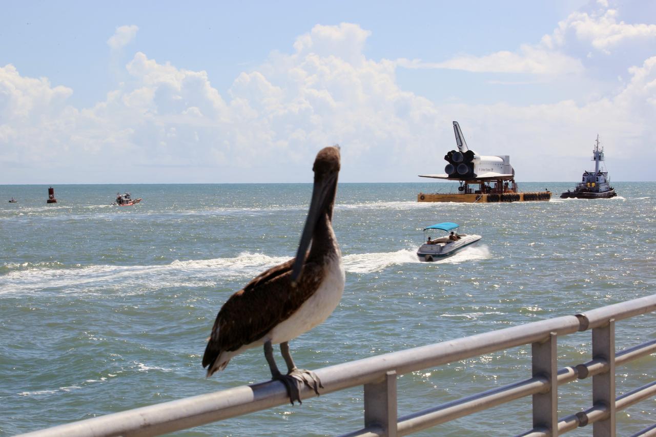
CAPE CANAVERAL, Fla. – The high-fidelity space shuttle model glides past the fishing pier – and this long-beaked fisherman -- near the mouth of Port Canaveral as it heads into the Atlantic Ocean, in the distance. The model is en route by barge from NASA’s Kennedy Space Center in Florida to Space Center Houston, NASA Johnson Space Center’s official visitor center. Its journey to Texas will take it south along the Florida coastline, around Key West and into the Gulf of Mexico. The model was built in Apopka, Fla., by Guard-Lee and installed at the Kennedy Space Center Visitor Complex in 1993. The model is expected to arrive June 1 in Houston and to be transported June 3 to Space Center Houston, its final destination, where it will become part of a unique display telling the story of the space shuttle’s achievements and the nationwide team that made them possible. For more information about Space Center Houston, visit http://www.spacecenter.org. Photo credit: NASA/Dimitri Gerondidakis
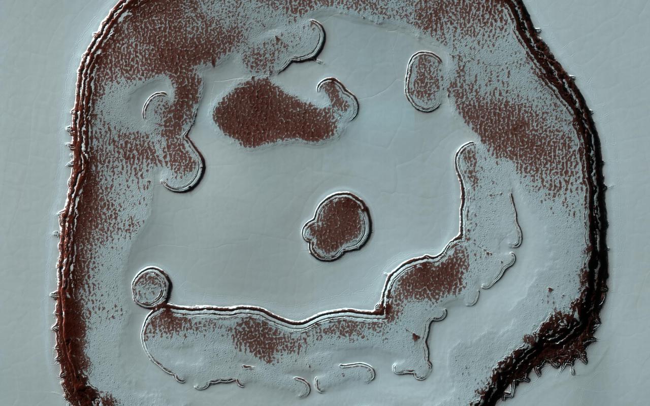
We've monitored the so-called Happy Face Crater in the south polar region of Mars for almost a decade. Two images that we took, one in 2011 and the other in 2020, at roughly the same season, show color variations that are due to different amounts of bright frost over darker red ground. The "blobby" features in the polar cap are due to the sun sublimating away the carbon dioxide into these round patterns. You can see how nine years of this thermal erosion have made the "mouth" of the face larger. The "nose" consisted of a two circular depressions in 2011, and in 2020, those two depressions have grown larger and merged. Measuring these changes throughout the Martian year help scientists understand the annual deposition and removal of polar frost, and monitoring these sites over long periods helps us understand longer term climate trends on the Red Planet. https://photojournal.jpl.nasa.gov/catalog/PIA24389
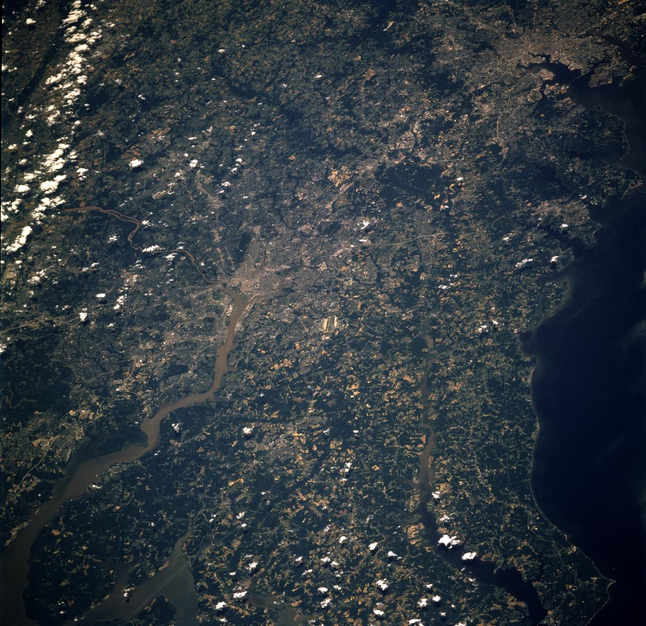
STS078-726-014 (20 June - 7 July 1996) --- Washington D.C., located in the center of the photo, was photographed in both regular color (here) and infrared (STS078-760-010) by the Life and Microgravity Spacelab (LMS-1) crew members. The city of Washington is coextensive with the District of Columbia, whose site was agreed upon by Congress in 1790 as the permanent seat of government for the new nation. It is located at the head of the navigable portion of the Potomac River, which separates it from Virginia to the southwest. It covers an area of 68-square-mile (177-square-kilometers). Andrews Air Force Base is seen east southeast of Washington D.C. Baltimore, Maryland, surrounding the Patapsco River mouth into Chesapeake Bay is located northeast of Washington D. C. or in upper right.
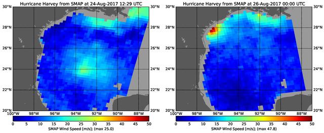
The rapid intensification of Hurricane Harvey is seen in this pair of images of ocean surface wind speeds as observed by the radiometer instrument aboard NASA's Soil Moisture Active Passive (SMAP) satellite at 7:29 a.m. CDT Aug. 24th, 2017 (left) and at 7 p.m. CDT Aug. 26th (right). Color indicates wind speed, with red being highest and blue lowest. The images show Harvey's maximum wind speeds increased from approximately 56 miles per hour (25 meters per second) to about 107 miles per hour (47.8 meters per second) in the 36 hours just before landfall. The higher wind speeds estimated near the mouth of the Mississippi River are erroneous and are due to errors in the ancillary sea-surface-salinity data product used by SMAP to estimate extreme wind speeds. https://photojournal.jpl.nasa.gov/catalog/PIA21884
S66-37910 (3 June 1966) --- The Mississippi River delta, and Gulf coasts of Louisiana, Mississippi, Alabama and Florida as seen from the Gemini-9 spacecraft during its first revolution of Earth. The Florida peninsula is seen at upper right corner of the picture. Lake Pontchartrain is a lower left. New Orleans is located between the lake and the U-shaped bend in the river. Large bay at top left center is Mobile Bay. The next bay to the east is Pensacola Bay. Cape San Blas near Apalachicola, Florida, is the point of land at top center of the picture. Note alluvial deposit at the mouths of the Mississippi. The image was taken with a modified 70mm Hasselblad camera, using Eastman Kodak, Ektachrome MS (S.O. 217) color film. Photo credit: NASA
AS06-02-1436 (4 April 1968) --- View of the mouth of the Colorado River and the Gulf of California in northwestern Mexico as photographed from the unmanned Apollo 6 (Spacecraft 020/Saturn 502) space mission. Altitude of the spacecraft at the time picture was taken was 120 nautical miles. NORTH IS TOWARD LEFT SIDE OF PICTURE. At bottom edge of photograph is Baja California. In the upper left corner is the Mexican state of Sonora showing the Sonoran Desert and the Pinacate Mountains. This photograph was made three hours and seven minutes after liftoff using Eastman Kodak SO-121 high resolution aerial Ektachrome film (exposure setting was f/5.6 at 1/500 second) in a J.A. Maurer model 2200 camera.
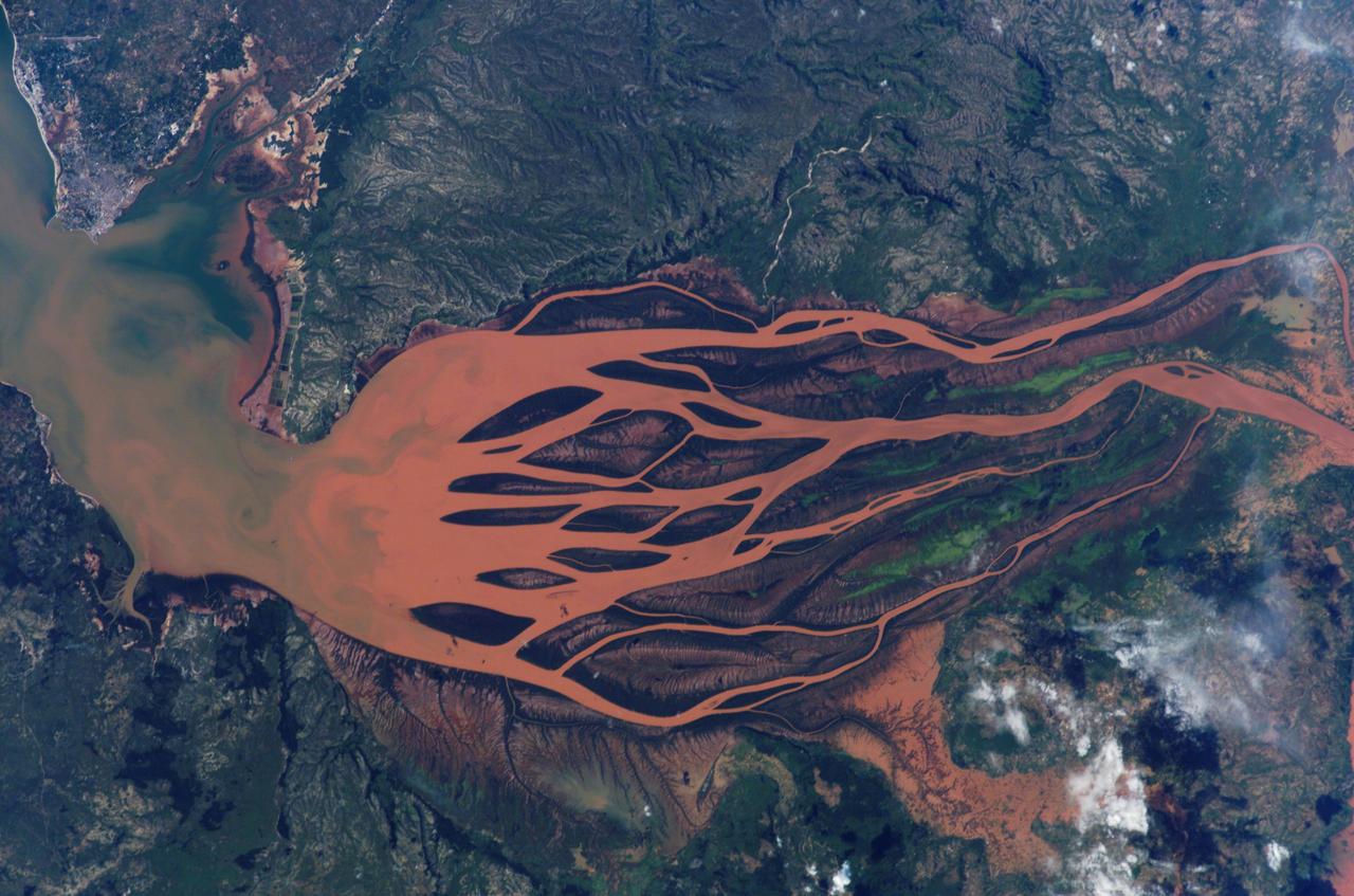
ISS008-E-19236 (25 March 2004) --- This image featuring the Betsiboka estuary on the northwest coast of Madagascar was taken by an Expedition 8 crewmember on the International Space Station (ISS). The Betsiboka estuary is the mouth of Madagascar’s largest river and one of the world’s fast-changing coastlines. Nearly a century of extensive logging of Madagascar’s rainforests and coastal mangroves has resulted in nearly complete clearing of the land and fantastic rates of erosion. After every heavy rain, the bright red soils are washed from the hillsides into the streams and rivers to the coast. Astronauts describe their view of Madagascar as “bleeding into the ocean”. One impact of the extensive 20th century erosion is the filling and clogging of coastal waterways with sediment – a process that is well illustrated in the Betsiboka estuary. In fact, ocean-going ships were once able to travel up the Betsiboka estuary, but must now berth at the coast.
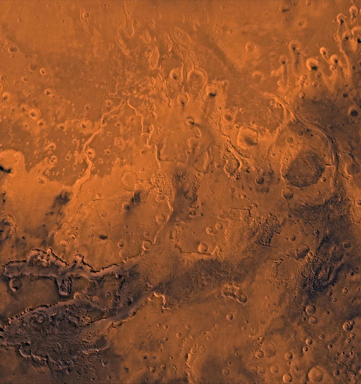
A color image of the south Chryse basin Valles Marineris outflow channels on Mars; north toward top. The scene shows on the southwest corner the chaotic terrain of the east part of Valles Marineris and two of its related canyons: Eos and Capri Chasmata (south to north). Ganges Chasma lies directly north. The chaos in the southern part of the image gives rise to several outflow channels, Shalbatana, Simud, Tiu, and Ares Valles (left to right), that drained north into the Chryse basin. The mouth of Ares Valles is the site of the Mars Pathfinder lander. This image is a composite of NASA's Viking medium-resolution images in black and white and low-resolution images in color. The image extends from latitude 20 degrees S. to 20 degrees N. and from longitude 15 degrees to 53 degrees; Mercator projection. http://photojournal.jpl.nasa.gov/catalog/PIA00418
ISS028-E-016225 (12 July 2011) --- Components of the International Space Station, though moving along at 17,500 miles per hour, appear to hover above the Pacific Ocean just off the California coast. Ten cosmonauts and astronauts were working together when this photo was taken -- four of them as STS-135 visitors from the docked space shuttle Atlantis and six as members of the Expedition 28 crew. The Cupola, near center of frame, is attached to Node 3 or Tranquility. A Russian Soyuz and a Russian Progress spacecraft are parked at the station, left side of frame. While much of the coast is obscured by clouds, just inland from left to right, one can see the agriculture of the San Joaquin Valley, the southern Sierra Nevada, the Los Angeles Basin (center), the Mojave Desert, coastal mountains of southern California, the Salton Sea, the Imperial Valley, and the mouth of the Colorado River on the extreme right edge.
ISS008-E-19233 (25 March 2004) --- This image featuring the Betsiboka estuary on the northwest coast of Madagascar was taken by an Expedition 8 crewmember on the International Space Station (ISS). The Betsiboka estuary is the mouth of Madagascar’s largest river and one of the world’s fast-changing coastlines. Nearly a century of extensive logging of Madagascar’s rainforests and coastal mangroves has resulted in nearly complete clearing of the land and fantastic rates of erosion. After every heavy rain, the bright red soils are washed from the hillsides into the streams and rivers to the coast. Astronauts describe their view of Madagascar as “bleeding into the ocean”. One impact of the extensive 20th century erosion is the filling and clogging of coastal waterways with sediment – a process that is well illustrated in the Betsiboka estuary. In fact, ocean-going ships were once able to travel up the Betsiboka estuary, but must now berth at the coast.
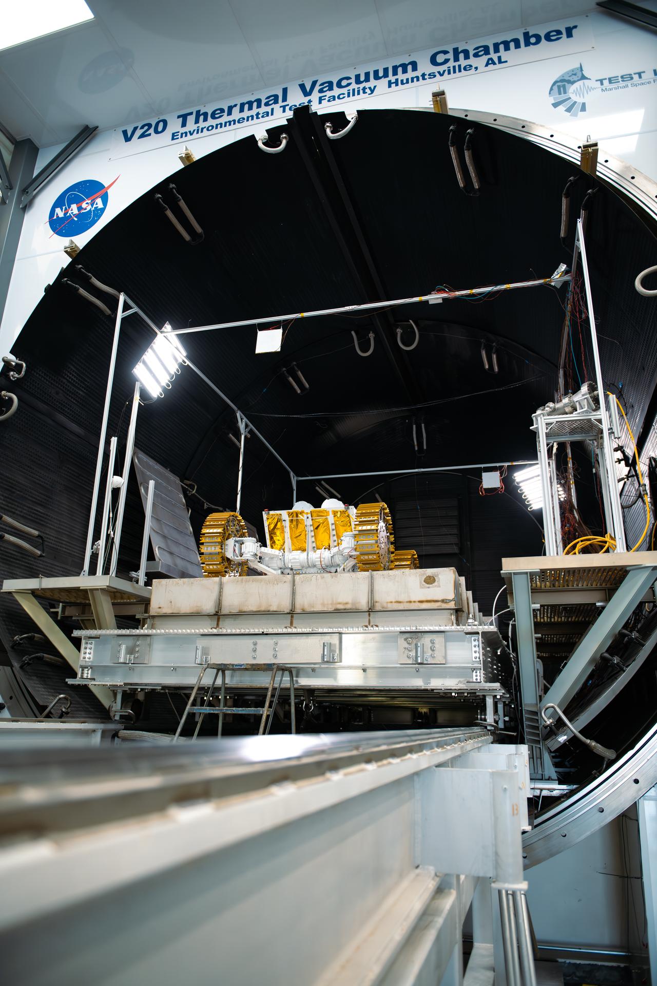
Starpath’s rover sits atop a concrete slab at the mouth of the thermal vacuum chamber, ready to be closed in and commence testing at NASA’s Marshall Space Flight Center in Huntsville, Alabama, on July 30, 2025. The technology startup headquartered in Hawthorne, California, won second place overall at the Break the Ice Lunar Challenge’s live demonstration and finale in June 2024. This competition, one of NASA’s Centennial Challenges, tasked competitors to design, build, and demonstrate robotic technologies that could excavate and transport the icy, rocky dirt – otherwise known as regolith – found on the Moon. Starpath’s visit to NASA Marshall was part of their prize opportunity to test their upgraded lunar regolith excavation and transportation rover in the center’s 20-foot thermal vacuum chamber. For more information, contact NASA Marshall’s Office of Communications at 256-544-0034.

KENNEDY SPACE CENTER, FLA. -- Partly covered with moss (foreleg and mouth), a large alligator suns on the bank of a pond within NASA's Kennedy Space Center. A protected species, alligators can be spotted in the drainage canals and other waters surrounding KSC. American alligators feed and rest in the water, and lay their eggs in dens they dig into the banks. The young alligators spend their first several weeks in these dens. KSC shares a boundary with the Merritt Island National Wildlife Refuge. The refuge is a habitat for more than 310 species of birds, 25 mammals, 117 fishes and 65 amphibians and reptiles. In addition, the refuge supports 19 endangered or threatened wildlife species on Federal or State lists, more than any other single refuge in the U.S. Photo credit: NASA/Ken Thornsley
CAPE CANAVERAL, Fla. – The high-fidelity space shuttle model nears the mouth of Port Canaveral as it heads toward the Atlantic Ocean, in the distance. The model is en route by barge from NASA’s Kennedy Space Center in Florida to Space Center Houston, NASA Johnson Space Center’s official visitor center. Its journey to Texas will take it south along the Florida coastline, around Key West and into the Gulf of Mexico. The model was built in Apopka, Fla., by Guard-Lee and installed at the Kennedy Space Center Visitor Complex in 1993. The model is expected to arrive June 1 in Houston and to be transported June 3 to Space Center Houston, its final destination, where it will become part of a unique display telling the story of the space shuttle’s achievements and the nationwide team that made them possible. For more information about Space Center Houston, visit http://www.spacecenter.org. Photo credit: NASA/Dimitri Gerondidakis
STS040-614-047 (5-14 June 1991) --- This image is of the Norfolk, Virginia -- Southern Delmarva Peninsula Southern Chesapeake Bay Area as seen in sunlight. The exposure is adjusted to emphasize the water patterns present. The outgoing tide generates considerable turbulence as it passes through the mouth of the bay. This is displayed by differences in reflective properties of the water surface due to differences in slope and turbidity. Ship wakes and the wakes of subsurface structures are seen clearly. The bridge tunnel system linking Norfolk with the peninsula and its effect on the system is quite apparent. Sunglint images over land areas were also acquired which emphasize land-water boundaries as demonstrated here in the small Delmarva inlets as a tool for wetland mapping, and river, lake and even pond description. During the first few days of the STS-40 mission the Eastern Seaboard of the United States was free of clouds and haze providing excellent photography of many of the major cities and the countryside of that area as well as the Gulf Stream.
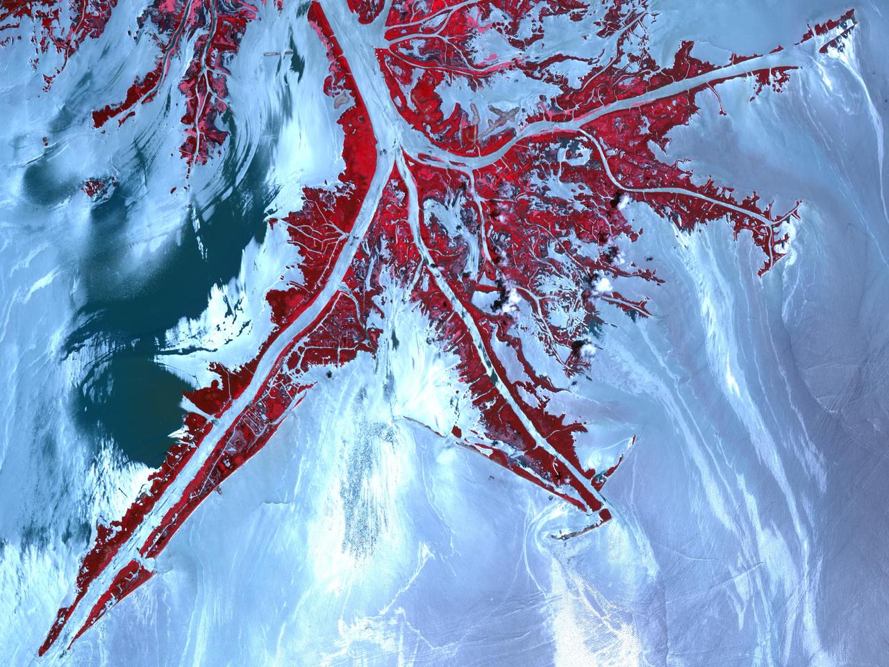
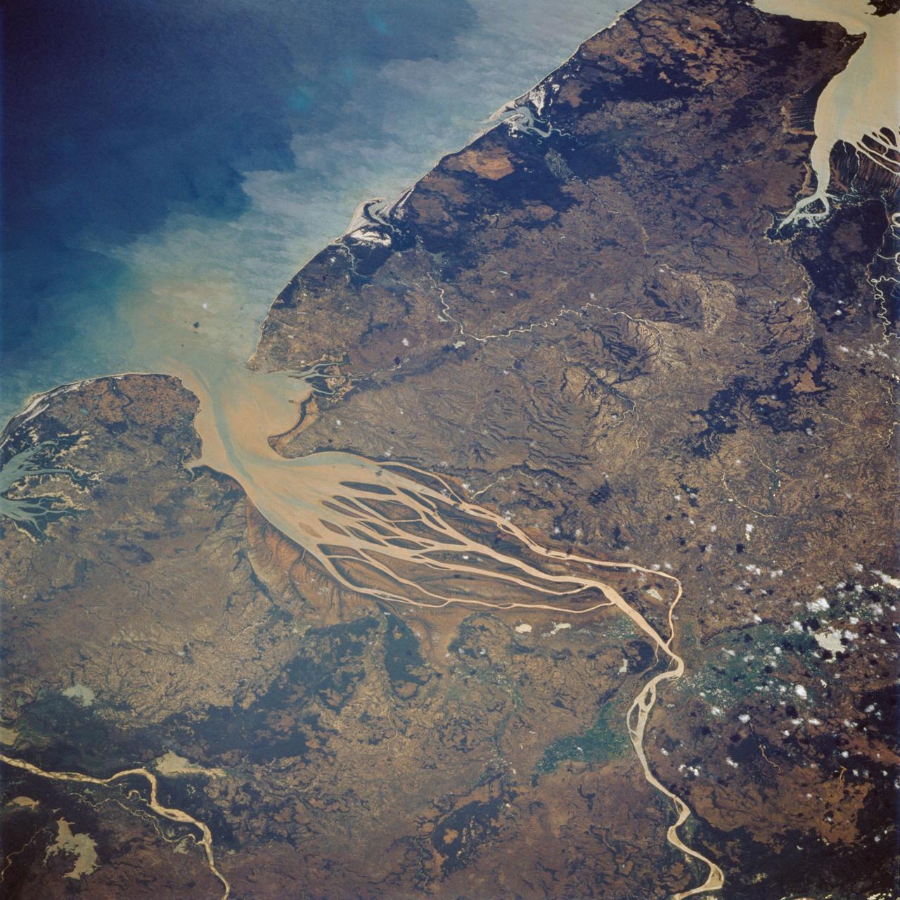
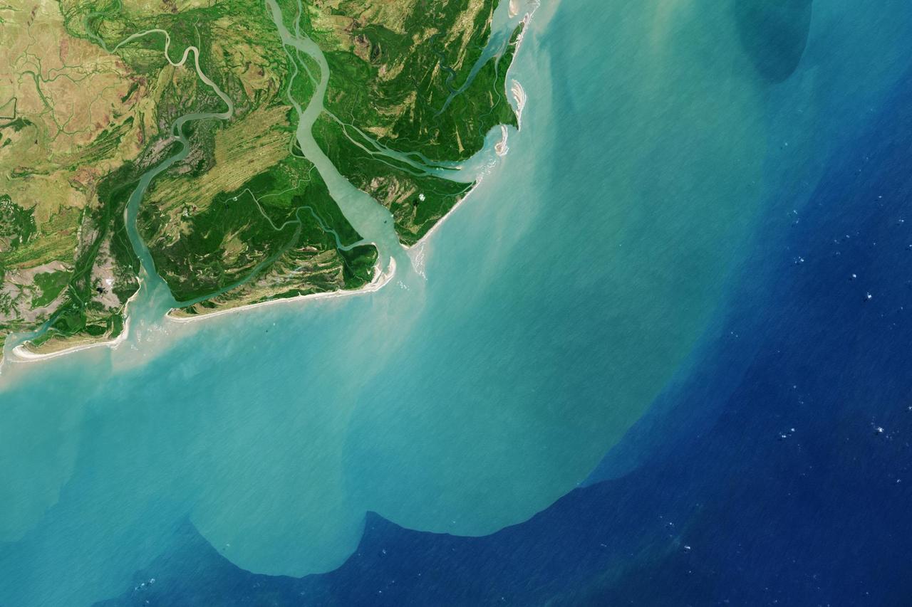
ISS010-E-13029 (13 January 2005) --- The Perigoso Channel and Amazon River mouth are featured in this image photographed by an Expedition 10 crewmember on the International Space Station (ISS). According to NASA scientists studying the Expedition 10 imagery, between 2000 and 2005 the channel on the west side of the island has shifted to the northwest – by eroding ~200 meters of the mainland shoreline and accreting sediment on the west side of the island, broadly maintaining the width of the channel. The North Channel (right) has been significantly widened. This has resulted in the erosional removal of almost 1 kilometer of the north end of the island, as well narrowing of a smaller island downstream (lower right). A more important but subtler visual effect has been the accumulation of sediment on the upstream (left) two-thirds of the island, accompanied by the establishment of permanent vegetation (dark green).

This crater is approximately 2.3 kilometers across and is located in northern Arabia Terra near where the cratered highlands meets the northern lowlands (called a "dichotomy boundary"). Small craters with an exit channel, such as this one, are nicknamed "pollywog" craters, as they resemble tadpoles. The channel is consistent with flow *out of* the crater, rather than flow *into* the crater, because 1) the valleys do not cut down to the level of the interior crater floor, and 2) there are no deposits of material on the floor associated with the mouth of the valley. This small crater was probably once filled with an ice-covered lake that overflowed, forming the exit channel. Young craters with exit channels are intriguing because they record a relatively recent (during the Amazonian epoch) wet environment on Mars. https://photojournal.jpl.nasa.gov/catalog/PIA23738
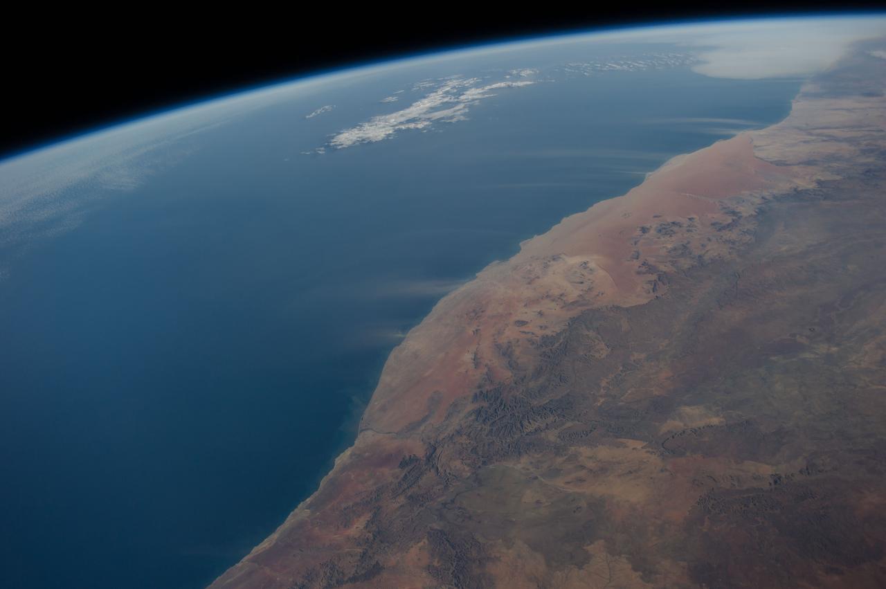
ISS040-E-016513 (21 June 2014) --- Dust plumes and the Namib Desert coast are featured in this image photographed by an Expedition 40 crew member on the International Space Station. Strong, hot winds known as “berg” (mountain) winds are lofting plumes of dust directly out into the Atlantic Ocean in this panoramic image. The southern African equivalent of Santa Ana winds in California, berg winds blow on a few occasions in fall and winter, off all coasts of southern Africa. Other images from the space station have captured these dust plumes. Namibia’s great Sand Sea appears here as a reddish zone along part of the coast (center). The Sand Sea is more than 350 kilometers long, giving a sense of the length of the visible dust plumes. A light-toned sediment plume enters the sea at the mouth of the Orange River (lower left), southern Africa’s largest river.
ISS040-E-016514 (21 June 2014) --- Dust plumes and the Namib Desert coast are featured in this image photographed by an Expedition 40 crew member on the International Space Station. Strong, hot winds known as “berg” (mountain) winds are lofting plumes of dust directly out into the Atlantic Ocean in this panoramic image. The southern African equivalent of Santa Ana winds in California, berg winds blow on a few occasions in fall and winter, off all coasts of southern Africa. Other images from the space station have captured these dust plumes. Namibia’s great Sand Sea appears here as a reddish zone along part of the coast (center). The Sand Sea is more than 350 kilometers long, giving a sense of the length of the visible dust plumes. A light-toned sediment plume enters the sea at the mouth of the Orange River (lower left), southern Africa’s largest river.
CAPE CANAVERAL, Fla. – The United Launch Alliance barge Delta Mariner approaches the mouth of Port Canaveral in Florida. The barge is carrying two of the booster stages for the Delta IV Heavy rocket slated for Orion's Exploration Flight Test-1, or EFT-1. Orion is the exploration spacecraft designed to carry astronauts to destinations not yet explored by humans. It will have emergency abort capability, sustain the crew during space travel and provide safe re-entry from deep-space return velocities. The first unpiloted test flight of Orion is scheduled to launch in September 2014 atop a Delta IV Heavy rocket and in 2017 on NASA’s Space Launch System rocket. For more information, visit www.nasa.gov/orion. Photo credit: NASA/Frankie Martin
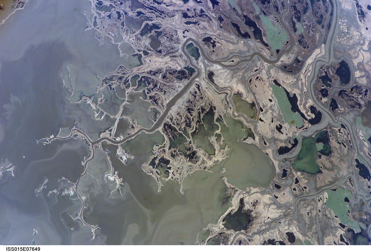
ISS015-E-07649 (11 May 2007) --- Saskatchewan River Delta, Manitoba, Canada is featured in this image photographed by an Expedition 15 crewmember on the International Space Station. This image highlights a portion of the Saskatchewan River delta extending into Cedar Lake in the Province of Manitoba. The Saskatchewan River watershed extends from the Rocky Mountains of Alberta through the plains of Saskatchewan and Manitoba. The construction of the Grand Rapids Dam to the southeast (not shown) in the 1960s flooded the Cedar Lake basin. This has resulted in the formation of numerous shallow, muddy lakes and bogs (dark green to dark grey irregular areas and at upper right) in and around the Saskatchewan River delta. The level of saturation in these bogs is such that peat (semiconsolidated plant and organic matter) deposits have formed; over long periods of time and under the right geological conditions, such deposits can become coal. The velocity of Saskatchewan River water slows significantly as it enters Cedar Lake; as the flow velocity drops, entrained sediment comprised of silt, clay, sand, and gravel is deposited at the river mouth. These deposits, called alluvium by geologists, account for much of the light tan to grey materials bordering the active channels visible in the image (Saskatchewan River, Summerberry River). According to scientists, fossil-bearing amber -- originating from Late Cretaceous (approximately 65-99 million years ago) coal deposits over a thousand kilometers to the west of Cedar Lake -- is also found in the deltaic sediments. As the deposits accumulate, old channels are abandoned and new channels are formed, as the river seeks more favorable flow paths into the lake, this process (known as avulsion) builds out the river delta over time. A typical "birds foot" delta form is currently being constructed at the mouth of the Saskatchewan River (lower left). The birds foot structure is approximately 13 kilometers wide. The Mississippi River's active delta, while having the same general form, is much larger by comparison -- it is approximately 50 kilometers wide.
![“Starting to host live broadcasts [brought up] so many emotions: terrified, excited, proud. And people have told me, ‘Oh my goodness, I feel like I would freeze up when the camera’s on,’ but that was the most natural position for me because I felt, just a little bit, like I was back on stage, cheerleading. You’re standing on the stage, the lights are off, you're in your head. And then the lights turn on, the music drops, and you’re on a world stage in front of thousands of people doing an incredibly difficult three-minute routine and who knows, you might even be injured right now, but you don't have an option. When those lights and that music comes on, it's almost like something bigger than yourself takes over and you just have to go. And that is the exact same feeling when they're counting you down for a live broadcast: “3, 2, 1. Hello, welcome to NASA. My name is Tahira Allen!” Before something like that happens, I am terrified. I am sitting here thinking, what is about to come out of my mouth? But just like with cheer, whatever you do, you keep moving. I don't know what's going to come out my mouth. But I need to keep talking and just embrace fear. Embrace being uncomfortable.” …You cannot grow without approaching the fear, embracing the fear, and then pushing past it.Science Mission Directorate Digital Lead Tahira Allen poses for a portrait Wednesday, Feb. 8, 2023, at the Mary W. Jackson NASA Headquarters building in Washington. Photo Credit: (NASA/Keegan Barber)](https://images-assets.nasa.gov/image/NHQ202302080001/NHQ202302080001~medium.jpg)
“Starting to host live broadcasts [brought up] so many emotions: terrified, excited, proud. And people have told me, ‘Oh my goodness, I feel like I would freeze up when the camera’s on,’ but that was the most natural position for me because I felt, just a little bit, like I was back on stage, cheerleading. You’re standing on the stage, the lights are off, you're in your head. And then the lights turn on, the music drops, and you’re on a world stage in front of thousands of people doing an incredibly difficult three-minute routine and who knows, you might even be injured right now, but you don't have an option. When those lights and that music comes on, it's almost like something bigger than yourself takes over and you just have to go. And that is the exact same feeling when they're counting you down for a live broadcast: “3, 2, 1. Hello, welcome to NASA. My name is Tahira Allen!” Before something like that happens, I am terrified. I am sitting here thinking, what is about to come out of my mouth? But just like with cheer, whatever you do, you keep moving. I don't know what's going to come out my mouth. But I need to keep talking and just embrace fear. Embrace being uncomfortable.” …You cannot grow without approaching the fear, embracing the fear, and then pushing past it.Science Mission Directorate Digital Lead Tahira Allen poses for a portrait Wednesday, Feb. 8, 2023, at the Mary W. Jackson NASA Headquarters building in Washington. Photo Credit: (NASA/Keegan Barber)
ISS009-E-09985 (3 June 2004) --- The Ebro River Delta, located along the eastern coast of Spain, is featured in this image photographed by an Expedition 9 crewmember on the International Space Station (ISS). Taken in partial sun glint, this view defines the Ebro’s fresh water lens— the water density boundary between the upper layer of fresh water issuing from the Ebro River mouth and the saltier, denser Mediterranean Sea water. According to NASA geologists studying the ISS imagery, diversion and impoundment of the Ebro River upstream has led to a decrease in water and sediment delivery to the delta. This decrease has led to increased erosion in some areas to the northeast of El Fangar Bay and along the southwestern shoreline of the delta. The Ebro River Delta is one of the largest wetland areas in the western Mediterranean region. The Ebro delta has grown rapidly—the historical rate of growth of the delta is demonstrated by the city of Amposta. This city was a seaport in the 4th Century, and is now located well inland from the current Ebro river mouth. The rounded form of the delta attests to the balance between sediment deposition by the Ebro River and removal of this material by wave erosion. The modern delta is in intensive agricultural use for rice, fruit, and vegetables. White polygonal areas to the north and south of the Ebro River are paddy fields. The Ebro delta also hosts numerous beaches, marshes, and saltpans that provide habitat for over 300 species of birds. A large part of the delta was designated as Parc Natural del Delta de l'Ebre (Ebre Delta National Park) in 1983. A network of canals and irrigation ditches constructed by both agricultural and conservation groups are helping to maintain the ecologic and economic resources of the Ebro Delta.
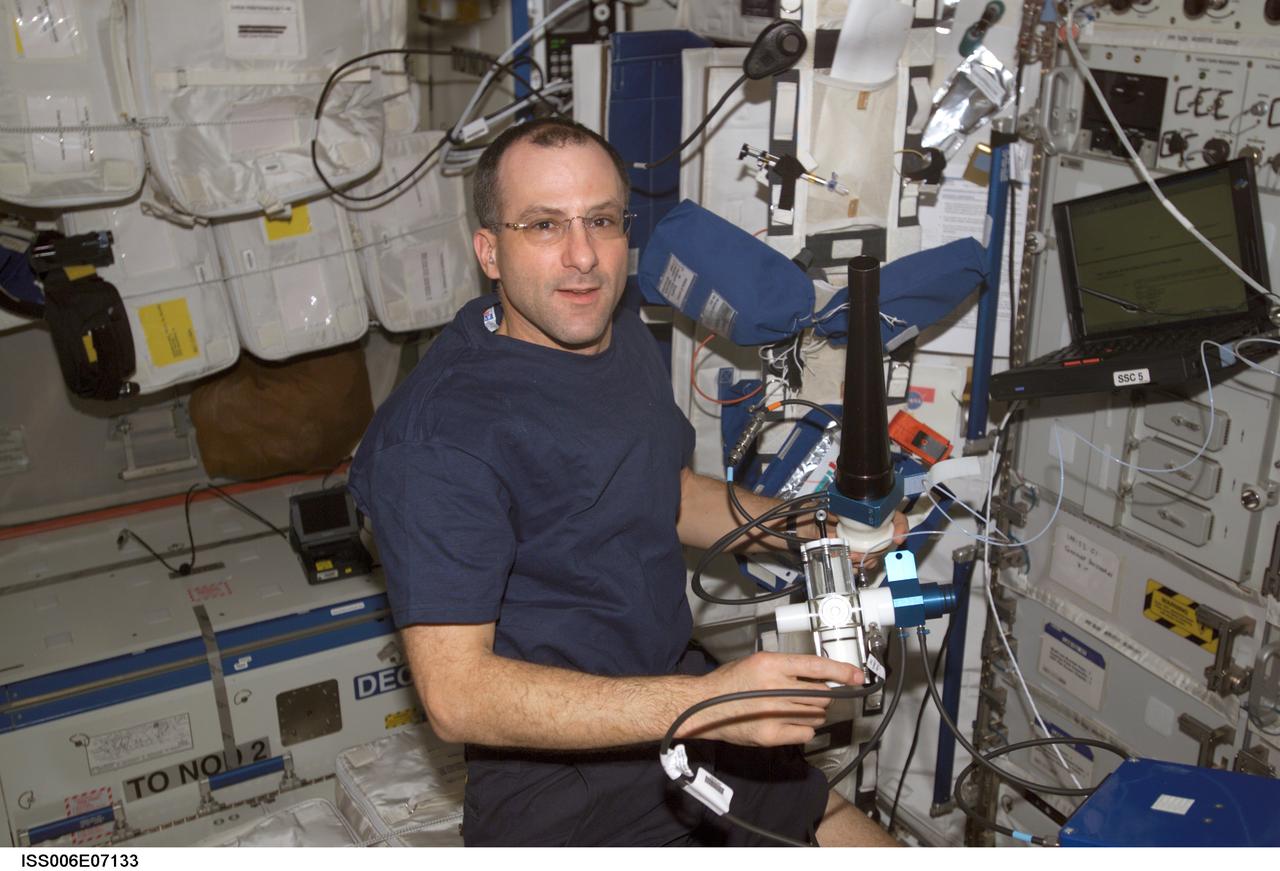
In this International Space Station (ISS) onboard photo, Expedition Six Science Officer Donald R. Pettit works to set up the Pulmonary Function in Flight (PuFF) experiment hardware in the Destiny Laboratory. Expedition Six is the fourth and final crew to perform the PuFF experiment. The PuFF experiment was developed to better understand what effects long term exposure to microgravity may have on the lungs. The focus is on measuring changes in the everness of gas exchange in the lungs, and on detecting changes in respiratory muscle strength. It allows astronauts to measure blood flow through the lungs, the ability of the lung to take up oxygen, and lung volumes. Each PuFF session includes five lung function tests, which involve breathing only cabin air. For each planned extravehicular (EVA) activity, a crew member performs a PuFF test within one week prior to the EVA. Following the EVA, those crew members perform another test to document the effect of exposure of the lungs to the low-pressure environment of the space suits. This experiment utilizes the Gas Analyzer System for Metabolic Analysis Physiology, or GASMAP, located in the Human Research Facility (HRF), along with a variety of other Puff equipment including a manual breathing valve, flow meter, pressure-flow module, pressure and volume calibration syringes, and disposable mouth pieces.