
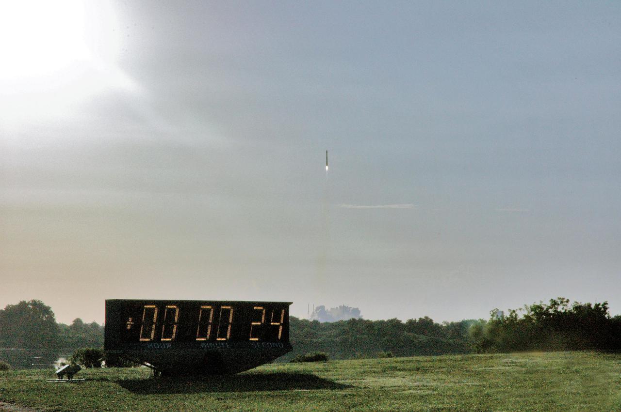
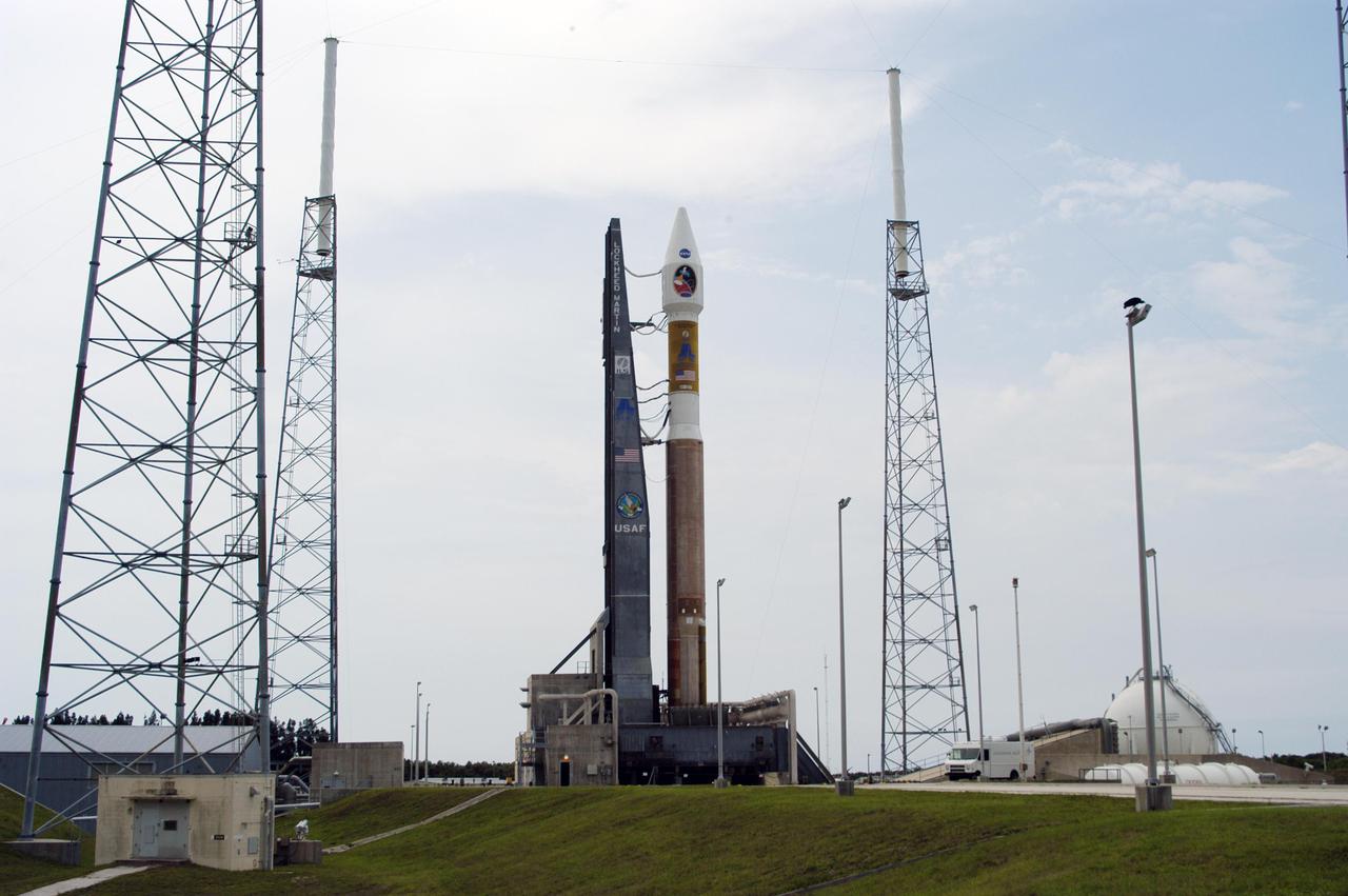
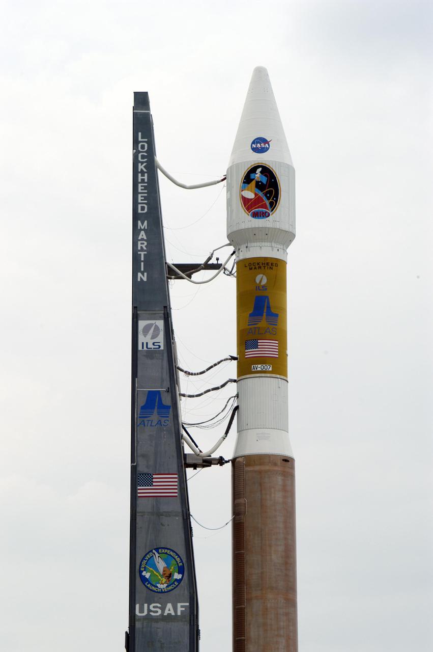
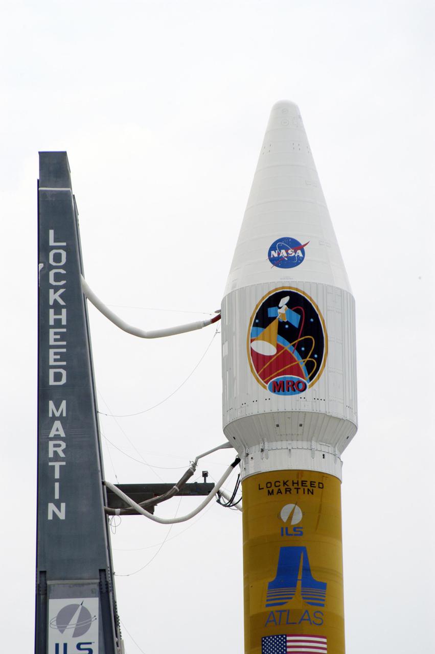
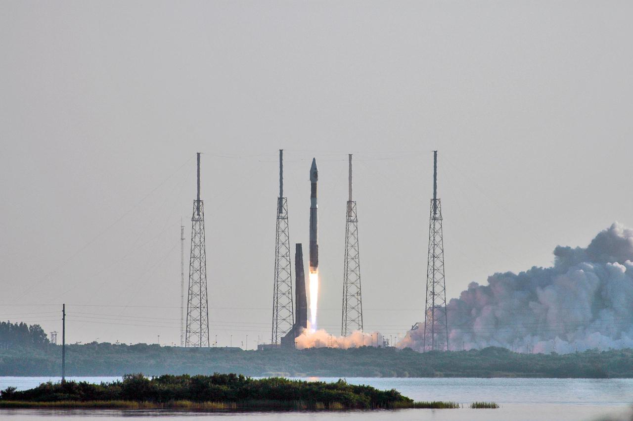
NASA Mars Reconnaissance Orbiter MRO launched at 7:43 a.m. EDT atop a Lockheed Martin Atlas V rocket from Launch Complex 41 at Cape Canaveral Air Force Station in Florida on Aug. 12, 2005.

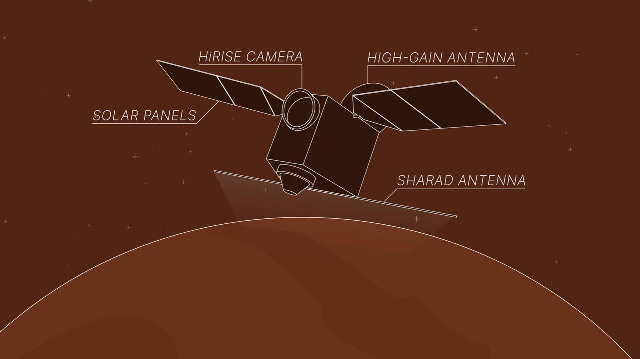
This image taken by NASA's Mars Reconnaissance Orbiter (MRO) shows ice sheets at Mars' south pole. The spacecraft detected clays near this ice; scientists have proposed such clays are the source of radar reflections that have been previously interpreted as liquid water using data from the ESA (European Space Agency) Mars Express orbiter. Flying 186 miles (300 kilometers) above the Martian surface, MRO used its High-Resolution Imaging Science Experiment (HiRISE) camera to study the ice sheets while using its Compact Reconnaissance Imaging Spectrometer (CRISM) to map out clay minerals near the ice. https://photojournal.jpl.nasa.gov/catalog/PIA24763
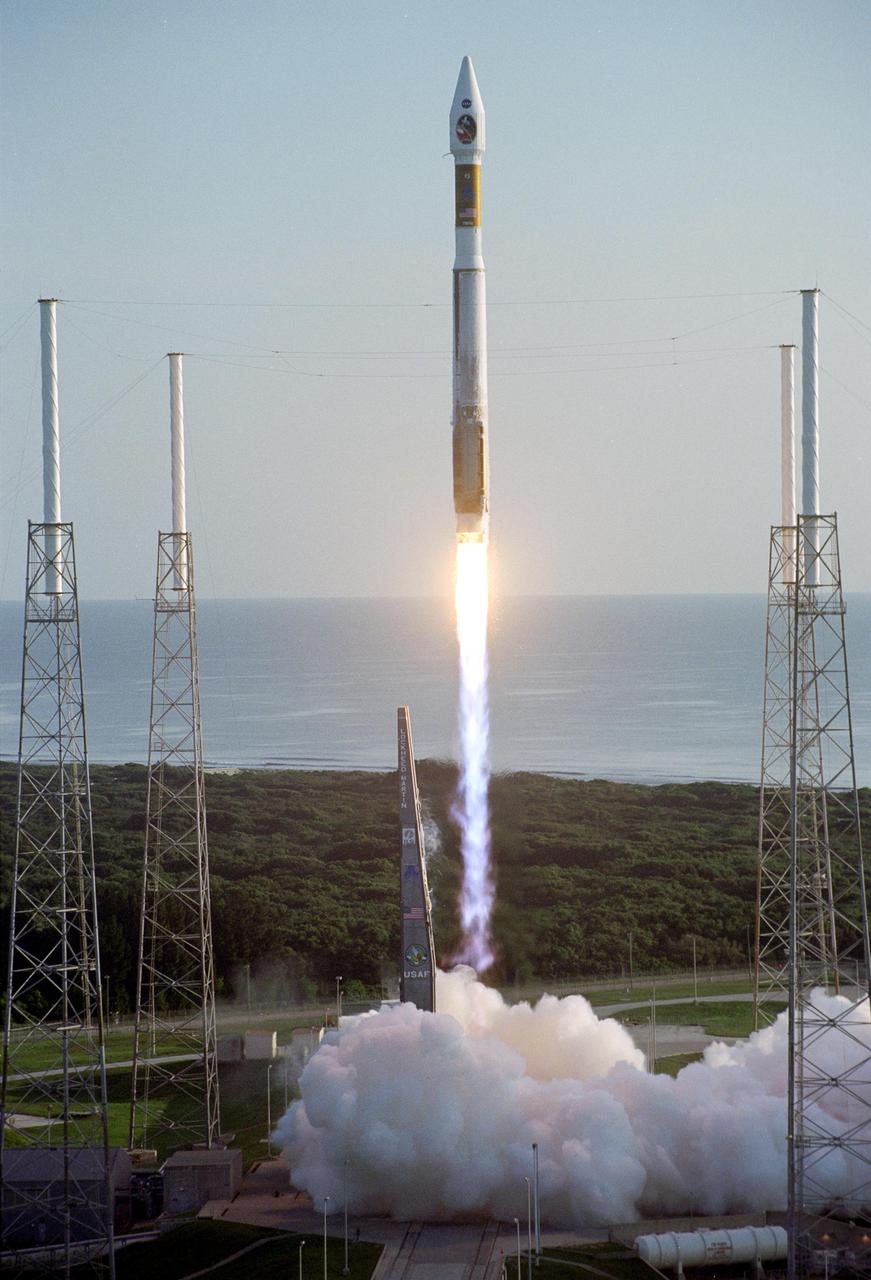
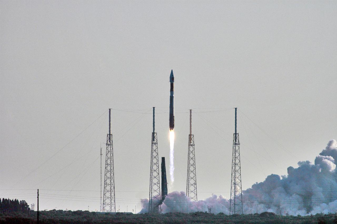
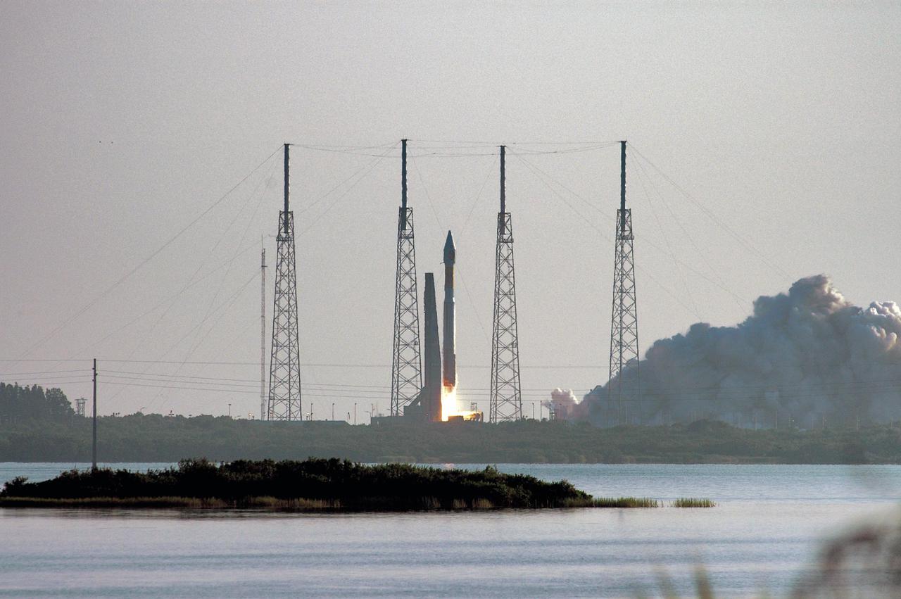
With the Atlantic Ocean as a backdrop, an Atlas V launch vehicle, 19 stories tall, with a two-ton NASA Mars Reconnaissance Orbiter MRO on top, roars away from Launch Complex 41 at Cape Canaveral Air Force Station.
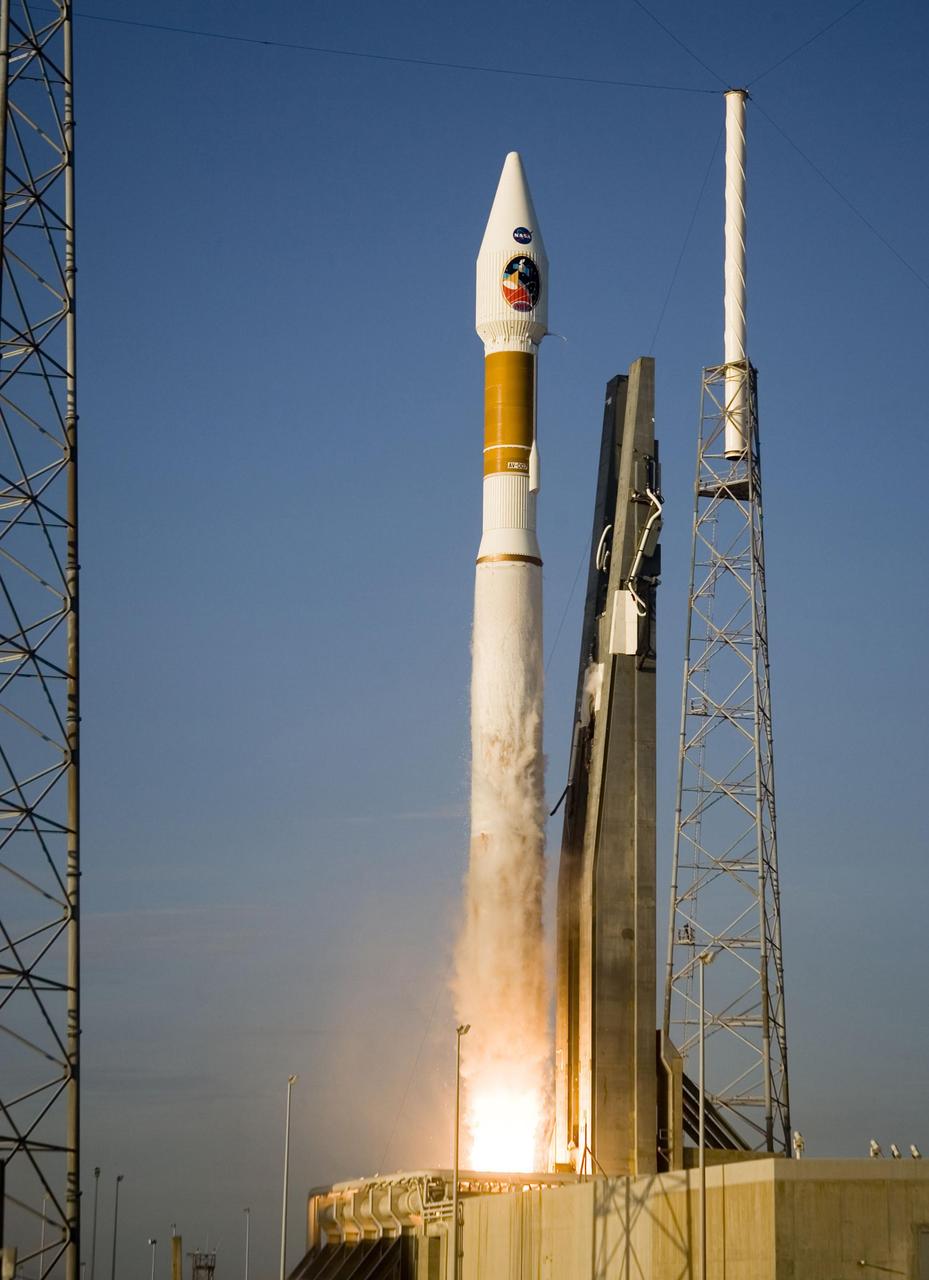
Atlas V launch vehicle, 19 stories tall, with a two-ton NASA Mars Reconnaissance Orbiter MRO on top, lifts off the pad on Launch Complex 41 at Cape Canaveral Air Force Station in Florida on Aug. 12, 2005.
NASA Mars Reconnaissance Orbiter MRO launched at 7:43 a.m. EDT atop a Lockheed Martin Atlas V rocket from Launch Complex 41 at Cape Canaveral Air Force Station in Florida on Aug. 12, 2005.
This animation depicts NASA's Mars Reconnaissance Orbiter (MRO) performing what's called a "very large roll": a 120-degree roll that can increase the capabilities of the spacecraft's subsurface radar instrument, called Shallow Radar, or SHARAD. Very large rolls boost SHARAD's signal by 10 times or more, giving scientists a clearer and deeper look below the Martian surface than MRO has ever had before. The orbiter was designed to roll up to 30 degrees in any direction so that it can point its instruments at surface targets. These standard rolls give cameras like the High-Resolution Imaging Science Experiment (HiRISE) prime viewing at the front of MRO at the expense of SHARAD, which has an antenna mounted at the back of the orbiter. While this setup helps the cameras, it also means that radio signals SHARAD pings onto the surface below encounter parts of the spacecraft, interfering with the signals and resulting in images that are less clear. In 2023, the team decided to try developing 120-degree rolls – the very large rolls – that rotate SHARAD's antenna toward the planet and provide the radio waves an unobstructed path to the surface. That lets the radar's signals reach deeper and get a clearer picture of rocks, sand, and geologic layers underground. It also helps SHARAD look for water ice in the near-subsurface that could be accessed by astronauts to produce rocket propellant for the trip home and is important for learning more about the climate, geology, and potential for life at Mars. Animation available at https://photojournal.jpl.nasa.gov/catalog/PIA26478
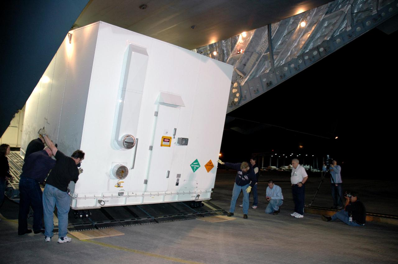
KENNEDY SPACE CENTER, FLA. - At the Vertical Integration Facility on Launch Pad 41 at Cape Canaveral Air Force Station in Florida, the Lockheed Martin Centaur second stage is lifted into the launch tower where it will be mated with the Atlas V already there. The Atlas V_Centaur is the launch vehicle for the Mars Reconnaissance Orbiter (MRO). The MRO is designed for a series of global mapping, regional survey and targeted observations from a near-polar, low-altitude Mars orbit. These observations will be unprecedented in terms of the spatial resolution and coverage achieved by the orbiter’s instruments as they observe the atmosphere and surface of Mars while probing its shallow subsurface as part of a “follow the water” strategy. The launch window for the MRO begins Aug. 10.
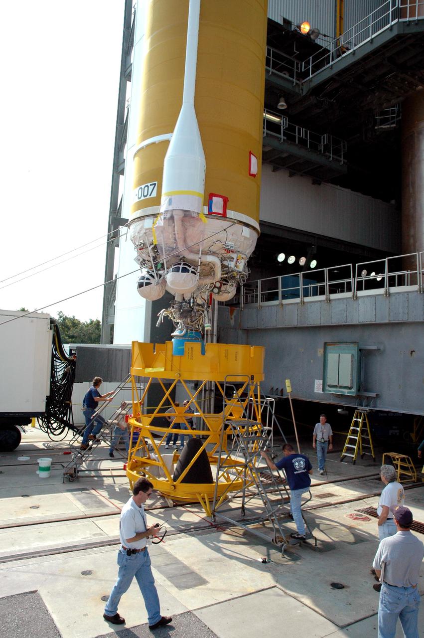
KENNEDY SPACE CENTER, FLA. - At the Vertical Integration Facility on Launch Pad 41 at Cape Canaveral Air Force Station in Florida, the Lockheed Martin Centaur second stage is ready for lifting into the launch tower where it will be mated with the Atlas V already there. The Atlas V_Centaur is the launch vehicle for the Mars Reconnaissance Orbiter (MRO). The MRO is designed for a series of global mapping, regional survey and targeted observations from a near-polar, low-altitude Mars orbit. These observations will be unprecedented in terms of the spatial resolution and coverage achieved by the orbiter’s instruments as they observe the atmosphere and surface of Mars while probing its shallow subsurface as part of a “follow the water” strategy. The launch window for the MRO begins Aug. 10.
KENNEDY SPACE CENTER, FLA. - The Lockheed Martin Atlas V_Centaur second stage arrives at the Vertical Integration Facility on Launch Pad 41 at Cape Canaveral Air Force Station in Florida. It will be mated with the Atlas V already placed in the tower. The Atlas V_Centaur is the launch vehicle for the Mars Reconnaissance Orbiter (MRO). The MRO is designed for a series of global mapping, regional survey and targeted observations from a near-polar, low-altitude Mars orbit. These observations will be unprecedented in terms of the spatial resolution and coverage achieved by the orbiter’s instruments as they observe the atmosphere and surface of Mars while probing its shallow subsurface as part of a “follow the water” strategy. The launch window for the MRO begins Aug. 10.
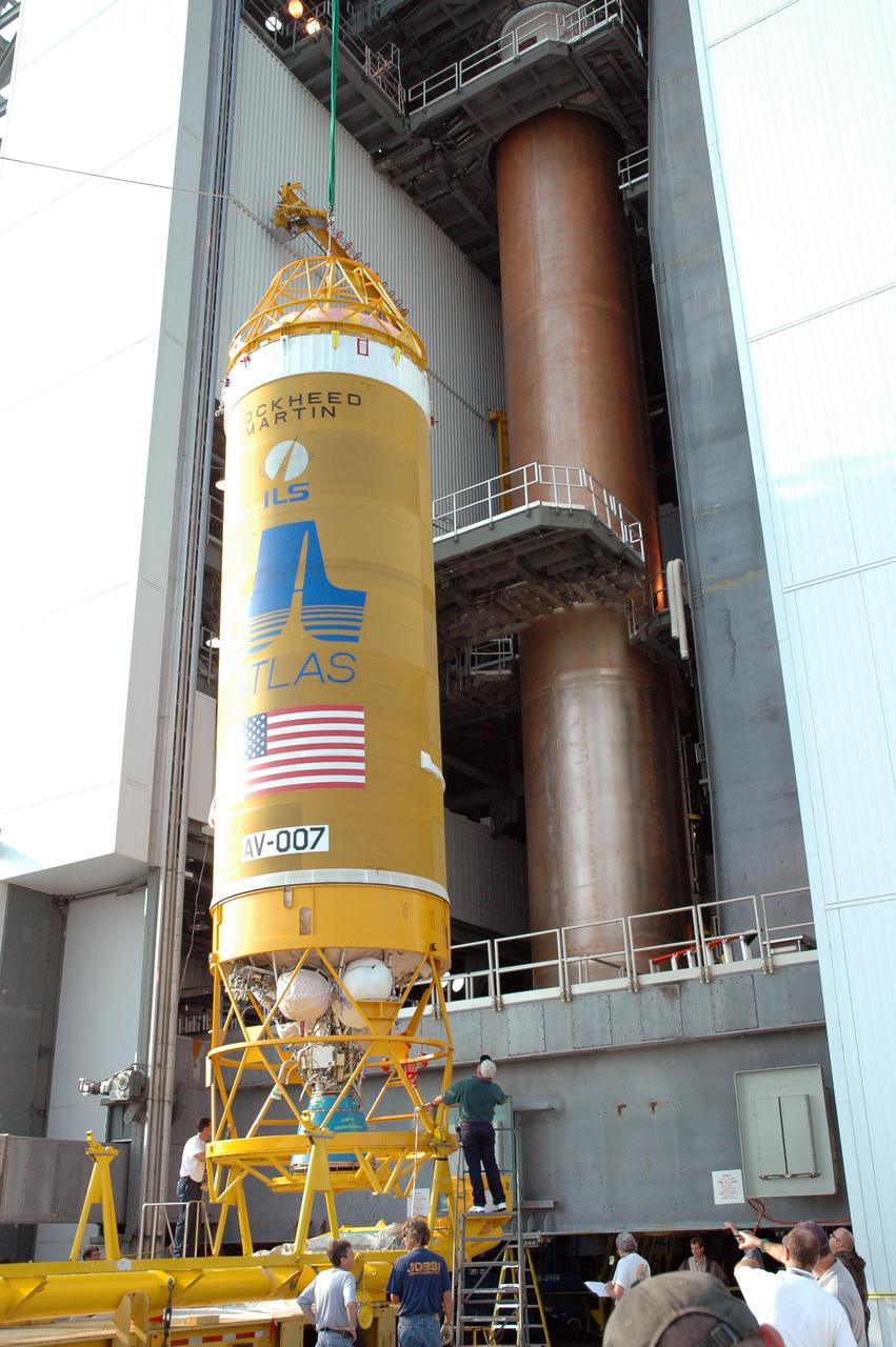
KENNEDY SPACE CENTER, FLA. - At the Vertical Integration Facility on Launch Pad 41 at Cape Canaveral Air Force Station in Florida, the Lockheed Martin Centaur second stage is positioned vertically to be lifted into the launch tower where it will be mated with the Atlas V already there. The Atlas V_Centaur is the launch vehicle for the Mars Reconnaissance Orbiter (MRO). The MRO is designed for a series of global mapping, regional survey and targeted observations from a near-polar, low-altitude Mars orbit. These observations will be unprecedented in terms of the spatial resolution and coverage achieved by the orbiter’s instruments as they observe the atmosphere and surface of Mars while probing its shallow subsurface as part of a “follow the water” strategy. The launch window for the MRO begins Aug. 10.
KENNEDY SPACE CENTER, FLA. - At the Vertical Integration Facility on Launch Pad 41 at Cape Canaveral Air Force Station in Florida, the Lockheed Martin Centaur second stage is lifted up the launch tower where it will be mated with the Atlas V already there. The Atlas V_Centaur is the launch vehicle for the Mars Reconnaissance Orbiter (MRO). The MRO is designed for a series of global mapping, regional survey and targeted observations from a near-polar, low-altitude Mars orbit. These observations will be unprecedented in terms of the spatial resolution and coverage achieved by the orbiter’s instruments as they observe the atmosphere and surface of Mars while probing its shallow subsurface as part of a “follow the water” strategy. The launch window for the MRO begins Aug. 10.
This image from NASA's Mars Reconnaissance Orbiter (MRO) shows a field of boulders. More information is available at https://photojournal.jpl.nasa.gov/catalog/PIA22433

In early 2017, after more than a decade of observing Mars, the Context Camera (CTX) on NASA's Mars Reconnaissance Orbiter (MRO) surpassed 99 percent coverage of the entire planet. This mosaic shows that global coverage. No other camera has ever imaged so much of Mars in such high resolution. The mosaic offers a resolution that enables zooming in for more detail of any region of Mars. It is still far from the full resolution of individual CTX observations, which can reveal the shapes of features smaller than the size of a tennis court. As of March 2017, the Context Camera has taken about 90,000 images since the spacecraft began examining Mars from orbit in late 2006. In addition to covering 99.1 percent of the surface of Mars at least once, this camera has observed more than 60 percent of Mars more than once, checking for changes over time and providing stereo pairs for 3-D modeling of the surface. http://photojournal.jpl.nasa.gov/catalog/PIA21488

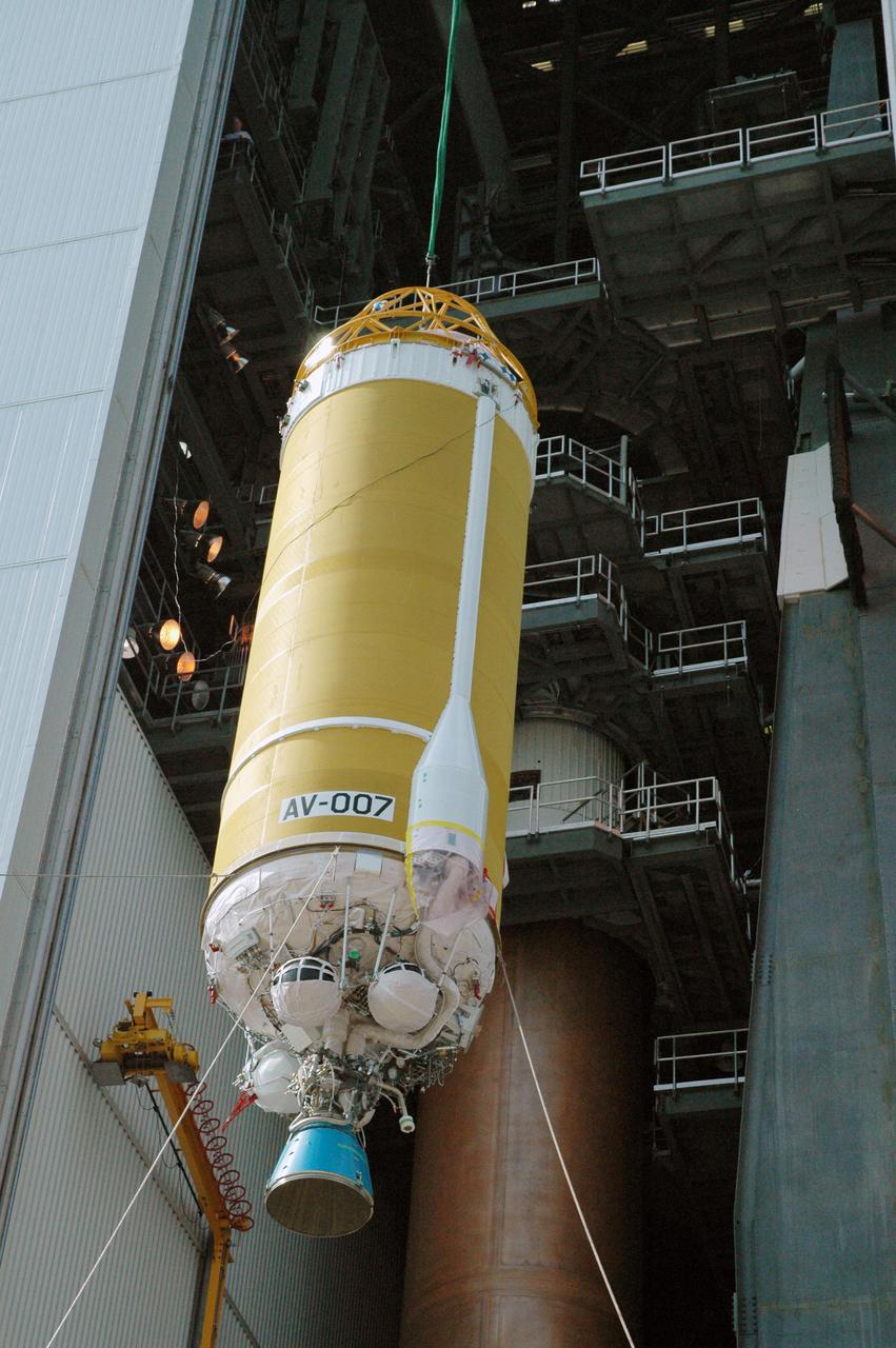
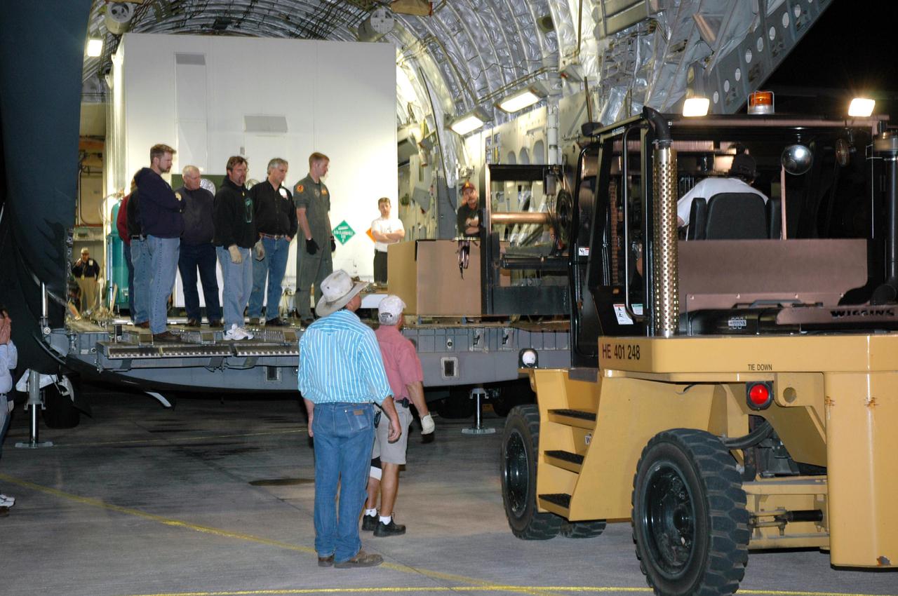
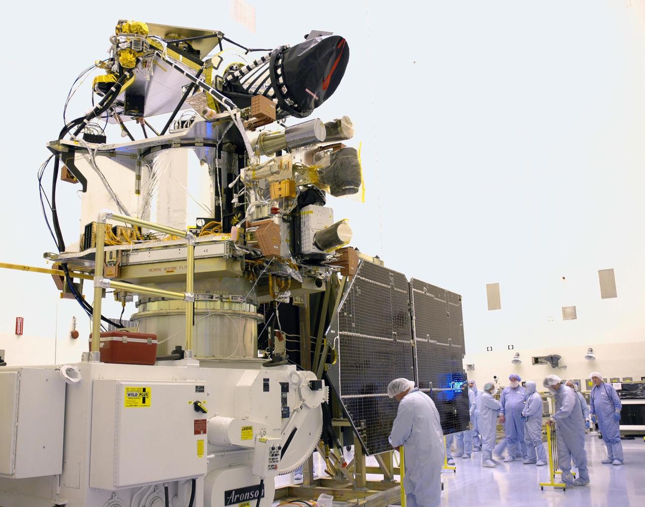
KENNEDY SPACE CENTER, FLA. - In the Payload Hazardous Servicing Facility, workers from Lockheed Martin prepare the Mars Reconnaissance Orbiter (MRO) to be lifted from the rotation stand. It is being transferred to a Mars Orbit Insertion Thruster assembly stand for testing. In late July, the MRO will be transported to the Vertical Installation Facility. It will join the Atlas V for the final phase of launch preparations. The spacecraft is then scheduled to undergo a functional test, and a final week of integrated testing and closeouts. The MRO was built by Lockheed Martin for the Jet Propulsion Laboratory in California. It is the next major step in Mars exploration and scheduled for launch from Cape Canaveral Air Force Station in a window opening Aug. 10. The MRO is an important next step in fulfilling NASA’s vision of space exploration and ultimately sending human explorers to Mars and beyond.
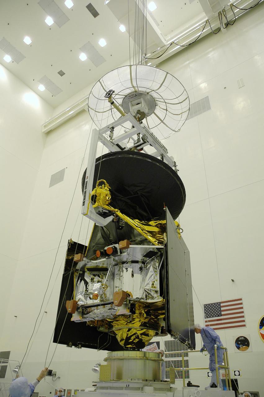
KENNEDY SPACE CENTER, FLA. - In the Payload Hazardous Servicing Facility, the Mars Reconnaissance Orbiter (MRO) has been lifted off the rotation stand and is being transferred to a Mars Orbit Insertion Thruster assembly stand for testing. In late July, the MRO will be transported to the Vertical Installation Facility. It will join the Atlas V for the final phase of launch preparations. The spacecraft is then scheduled to undergo a functional test, and a final week of integrated testing and closeouts. The MRO was built by Lockheed Martin for the Jet Propulsion Laboratory in California. It is the next major step in Mars exploration and scheduled for launch from Cape Canaveral Air Force Station in a window opening Aug. 10. The MRO is an important next step in fulfilling NASA’s vision of space exploration and ultimately sending human explorers to Mars and beyond.
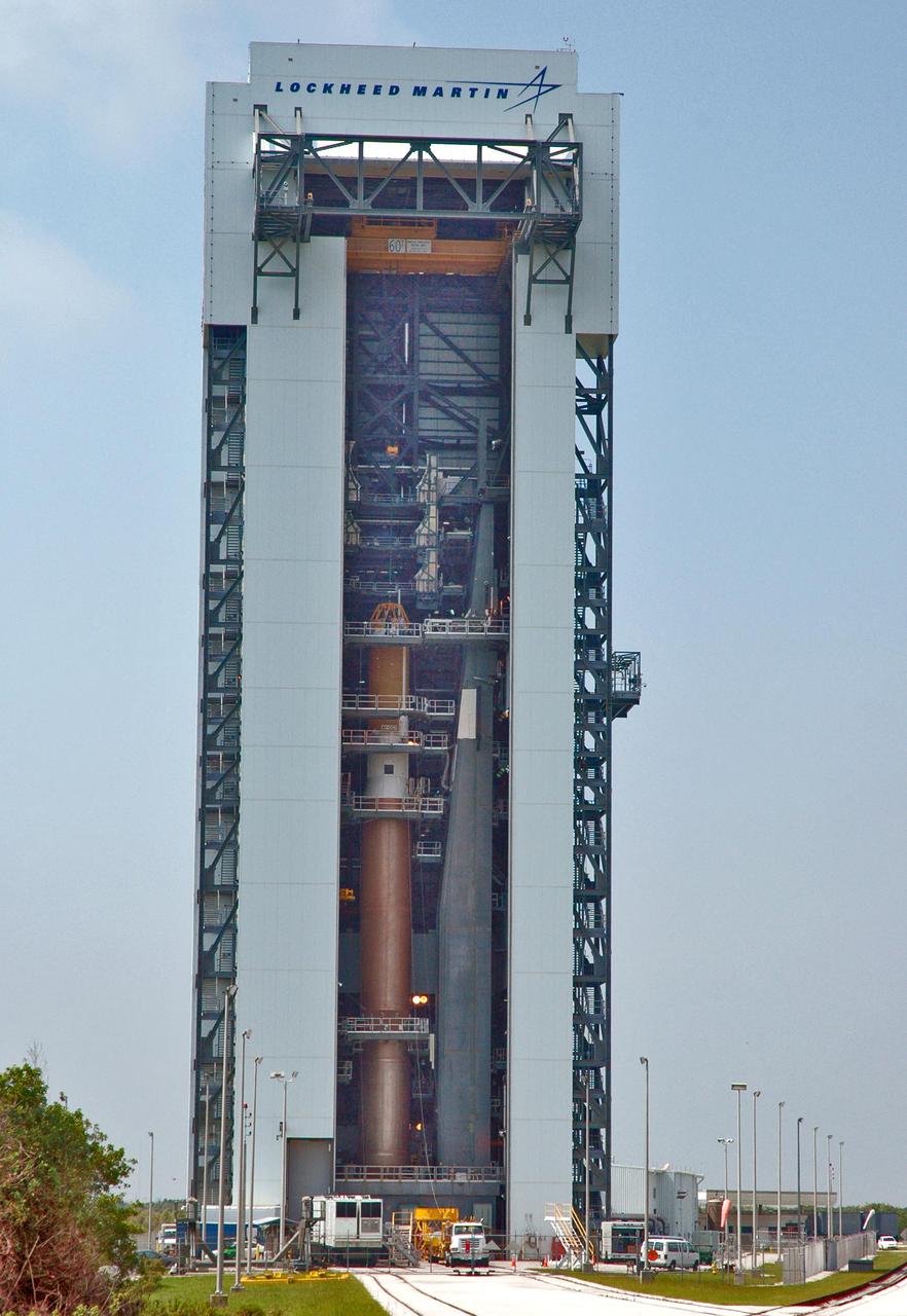
KENNEDY SPACE CENTER, FLA. - Inside the launch tower on Launch Pad 41 at Cape Canaveral Air Force Station in Florida, the upper end of the Lockheed Martin Centaur second stage is being lowered through an opening toward the Atlas V below. The Centaur will be mated with the Atlas V. The Atlas V_Centaur is the launch vehicle for the Mars Reconnaissance Orbiter (MRO). The MRO is designed for a series of global mapping, regional survey and targeted observations from a near-polar, low-altitude Mars orbit. These observations will be unprecedented in terms of the spatial resolution and coverage achieved by the orbiter’s instruments as they observe the atmosphere and surface of Mars while probing its shallow subsurface as part of a “follow the water” strategy. The launch window for the MRO begins Aug. 10.
KENNEDY SPACE CENTER, FLA. - Inside the launch tower on Launch Pad 41 at Cape Canaveral Air Force Station in Florida, the lower end of the Lockheed Martin Centaur second stage is being lowered through an opening toward the Atlas V below. The Centaur will be mated with the Atlas V. The Atlas V_Centaur is the launch vehicle for the Mars Reconnaissance Orbiter (MRO). The MRO is designed for a series of global mapping, regional survey and targeted observations from a near-polar, low-altitude Mars orbit. These observations will be unprecedented in terms of the spatial resolution and coverage achieved by the orbiter’s instruments as they observe the atmosphere and surface of Mars while probing its shallow subsurface as part of a “follow the water” strategy. The launch window for the MRO begins Aug. 10.
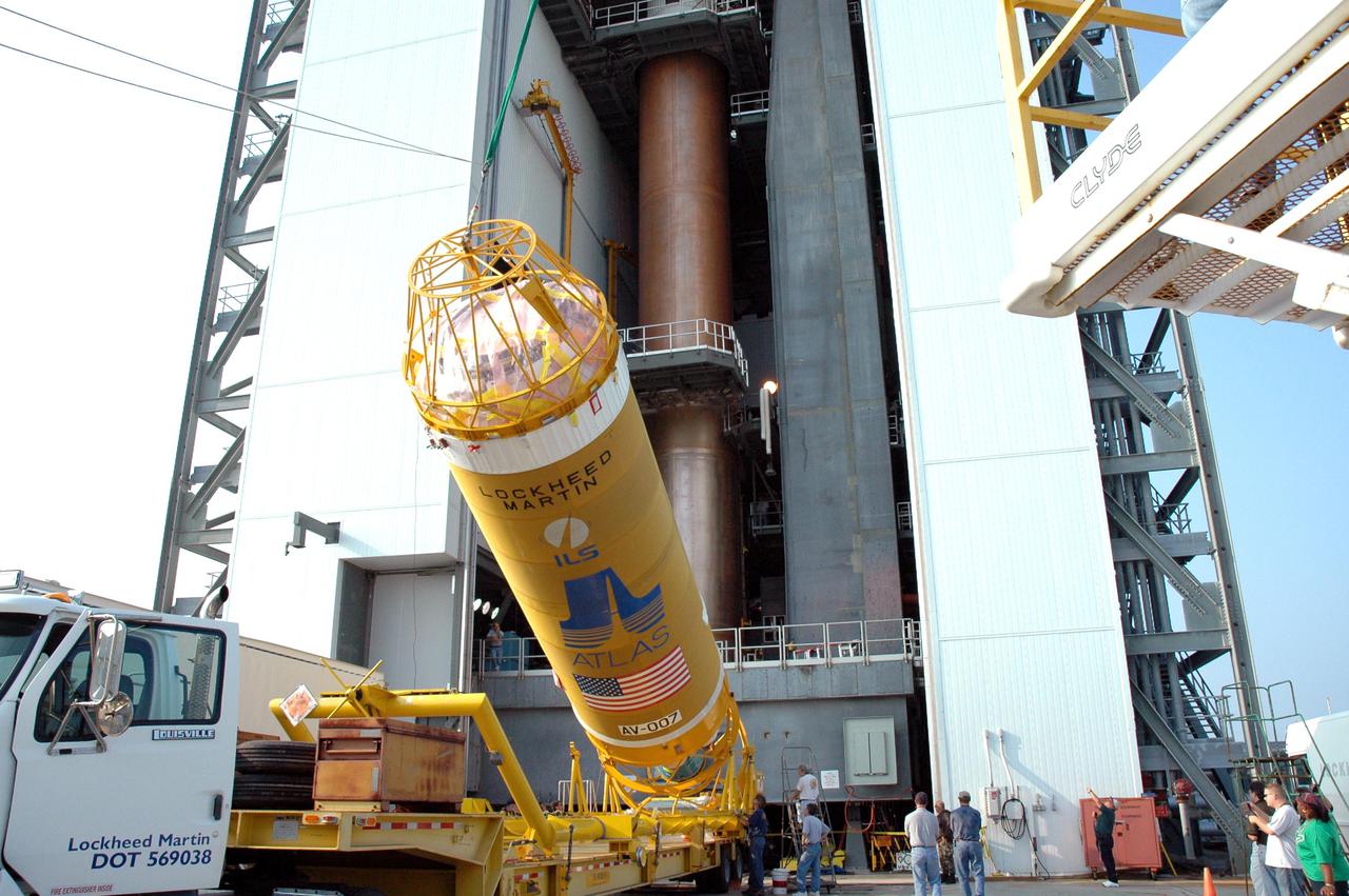
KENNEDY SPACE CENTER, FLA. - At the Vertical Integration Facility on Launch Pad 41 at Cape Canaveral Air Force Station in Florida, the Lockheed Martin Centaur second stage is being raised to a vertical position for lifting into the launch tower and mating with the Atlas V already there. The MRO is designed for a series of global mapping, regional survey and targeted observations from a near-polar, low-altitude Mars orbit. These observations will be unprecedented in terms of the spatial resolution and coverage achieved by the orbiter’s instruments as they observe the atmosphere and surface of Mars while probing its shallow subsurface as part of a “follow the water” strategy. The launch window for the MRO begins Aug. 10.

KENNEDY SPACE CENTER, FLA. - In the Payload Hazardous Servicing Facility, the Mars Reconnaissance Orbiter (MRO) has been lifted off the rotation stand and is being moved toward a Mars Orbit Insertion Thruster assembly stand for testing. In late July, the MRO will be transported to the Vertical Installation Facility. It will join the Atlas V for the final phase of launch preparations. The spacecraft is then scheduled to undergo a functional test, and a final week of integrated testing and closeouts. The MRO was built by Lockheed Martin for the Jet Propulsion Laboratory in California. It is the next major step in Mars exploration and scheduled for launch from Cape Canaveral Air Force Station in a window opening Aug. 10. The MRO is an important next step in fulfilling NASA’s vision of space exploration and ultimately sending human explorers to Mars and beyond.

KENNEDY SPACE CENTER, FLA. -In the Payload Hazardous Servicing Facility, workers from Lockheed Martin help guide the Mars Reconnaissance Orbiter (MRO) onto a Mars Orbit Insertion Thruster assembly stand for testing. In late July, the MRO will be transported to the Vertical Installation Facility. It will join the Atlas V for the final phase of launch preparations. The spacecraft is then scheduled to undergo a functional test, and a final week of integrated testing and closeouts. The MRO was built by Lockheed Martin for the Jet Propulsion Laboratory in California. It is the next major step in Mars exploration and scheduled for launch from Cape Canaveral Air Force Station in a window opening Aug. 10. The MRO is an important next step in fulfilling NASA’s vision of space exploration and ultimately sending human explorers to Mars and beyond.
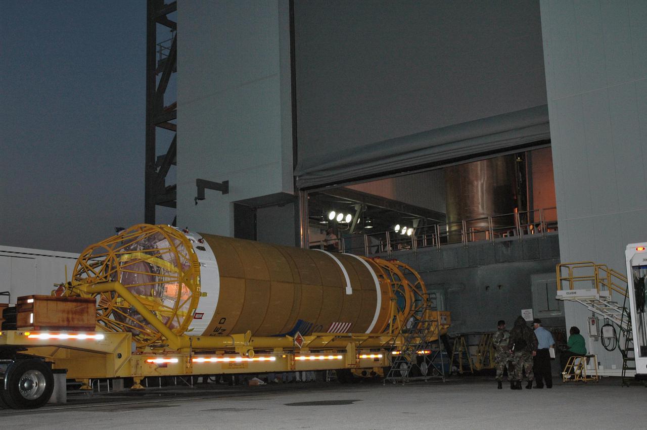
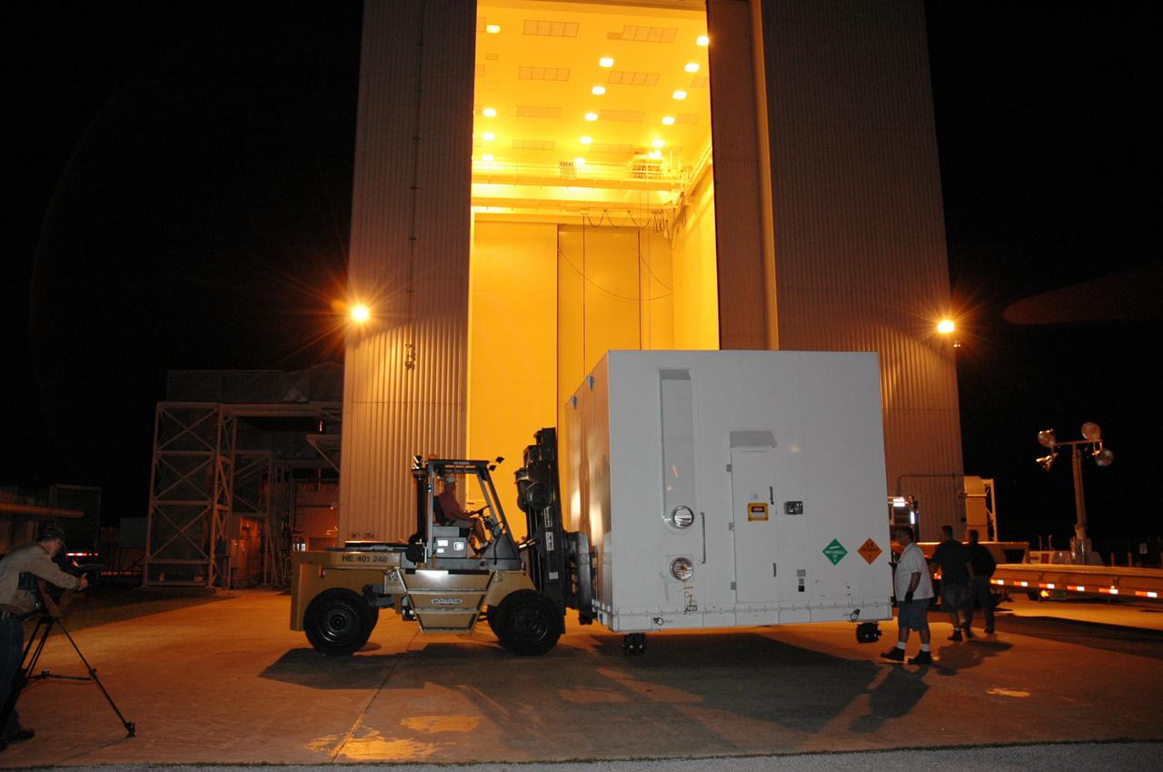
KENNEDY SPACE CENTER, FLA. - At Kennedy Space Center's Shuttle Landing Facility, the second of two containers with the Mars Reconnaissance Orbiter (MRO) equipment is lifted onto a flatbed truck for transport to the Payload Hazardous Servicing Facility. The MRO was built by Lockheed Martin for NASA's Jet Propulsion Laboratory in California. It is the next major step in Mars exploration and scheduled for launch from Cape Canaveral Air Force Station in a window opening Aug. 10. The MRO carries six primary instruments: the High Resolution Imaging Science Experiment, Context Camera, Mars Color Imager, Compact Reconnaissance Imaging Spectrometer for Mars, Mars Climate Sounder and Shallow Radar. By 2007, the MRO will begin a series of global mapping, regional survey and targeted observations from a near-polar, low-altitude Mars orbit. It will observe the atmosphere and surface of Mars while probing its shallow subsurface as part of a “follow the water” strategy.

KENNEDY SPACE CENTER, FLA. - In the Payload Hazardous Servicing Facility, the Mars Reconnaissance Orbiter (MRO) is lowered toward a Mars Orbit Insertion Thruster assembly stand for testing. In late July, the MRO will be transported to the Vertical Installation Facility. It will join the Atlas V for the final phase of launch preparations. The spacecraft is then scheduled to undergo a functional test, and a final week of integrated testing and closeouts. The MRO was built by Lockheed Martin for the Jet Propulsion Laboratory in California. It is the next major step in Mars exploration and scheduled for launch from Cape Canaveral Air Force Station in a window opening Aug. 10. The MRO is an important next step in fulfilling NASA’s vision of space exploration and ultimately sending human explorers to Mars and beyond.

KENNEDY SPACE CENTER, FLA. - In the Payload Hazardous Servicing Facility, workers from Lockheed Martin install the Mars Reconnaissance Orbiter (MRO) onto a Mars Orbit Insertion Thruster assembly stand for testing. In late July, the MRO will be transported to the Vertical Installation Facility. It will join the Atlas V for the final phase of launch preparations. The spacecraft is then scheduled to undergo a functional test, and a final week of integrated testing and closeouts. The MRO was built by Lockheed Martin for the Jet Propulsion Laboratory in California. It is the next major step in Mars exploration and scheduled for launch from Cape Canaveral Air Force Station in a window opening Aug. 10. The MRO is an important next step in fulfilling NASA’s vision of space exploration and ultimately sending human explorers to Mars and beyond.
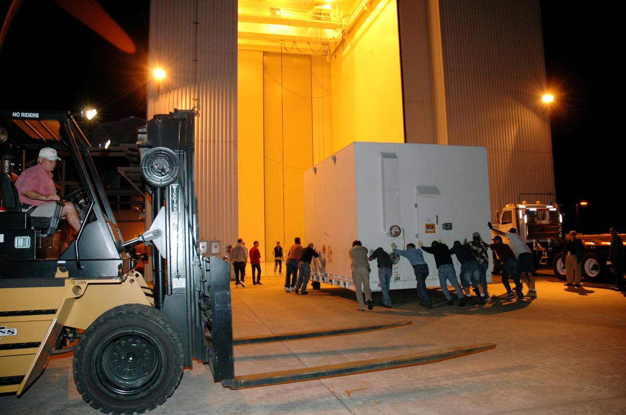
KENNEDY SPACE CENTER, FLA. - Workers roll one of two containers with the Mars Reconnaissance Orbiter (MRO) equipment into the Payload Hazardous Servicing Facility. The MRO was built by Lockheed Martin for NASA's Jet Propulsion Laboratory in California. It is the next major step in Mars exploration and scheduled for launch from Cape Canaveral Air Force Station in a window opening Aug. 10. The MRO carries six primary instruments: the High Resolution Imaging Science Experiment, Context Camera, Mars Color Imager, Compact Reconnaissance Imaging Spectrometer for Mars, Mars Climate Sounder and Shallow Radar. By 2007, the MRO will begin a series of global mapping, regional survey and targeted observations from a near-polar, low-altitude Mars orbit. It will observe the atmosphere and surface of Mars while probing its shallow subsurface as part of a “follow the water” strategy.
KENNEDY SPACE CENTER, FLA. - One of two containers with the Mars Reconnaissance Orbiter (MRO) equipment arrives at the Payload Hazardous Servicing Facility. The MRO was built by Lockheed Martin for NASA's Jet Propulsion Laboratory in California. It is the next major step in Mars exploration and scheduled for launch from Cape Canaveral Air Force Station in a window opening Aug. 10. The MRO carries six primary instruments: the High Resolution Imaging Science Experiment, Context Camera, Mars Color Imager, Compact Reconnaissance Imaging Spectrometer for Mars, Mars Climate Sounder and Shallow Radar. By 2007, the MRO will begin a series of global mapping, regional survey and targeted observations from a near-polar, low-altitude Mars orbit. It will observe the atmosphere and surface of Mars while probing its shallow subsurface as part of a “follow the water” strategy.
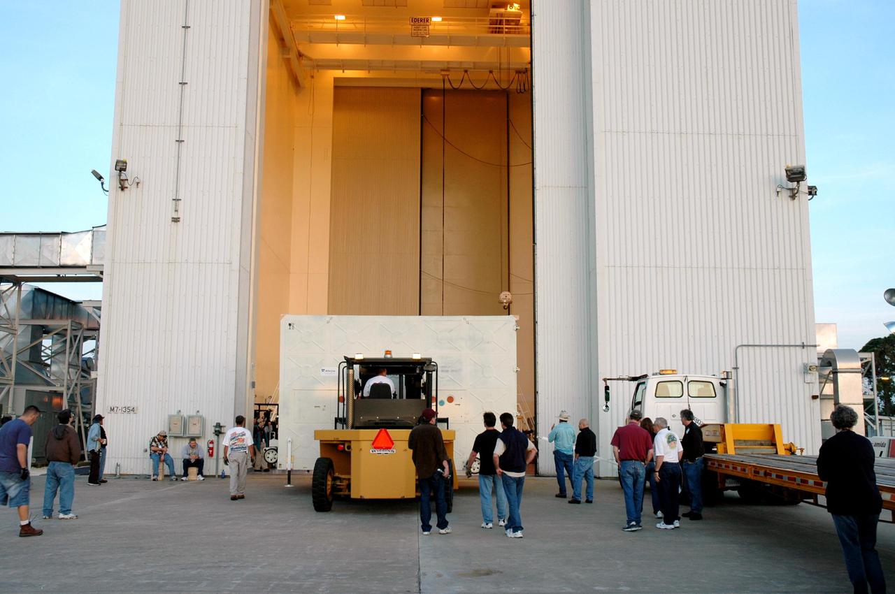
KENNEDY SPACE CENTER, FLA. - A forklift lowers one of two containers with the Mars Reconnaissance Orbiter (MRO) equipment onto the ground in front of the Payload Hazardous Servicing Facility. The MRO was built by Lockheed Martin for NASA's Jet Propulsion Laboratory in California. It is the next major step in Mars exploration and scheduled for launch from Cape Canaveral Air Force Station in a window opening Aug. 10. The MRO carries six primary instruments: the High Resolution Imaging Science Experiment, Context Camera, Mars Color Imager, Compact Reconnaissance Imaging Spectrometer for Mars, Mars Climate Sounder and Shallow Radar. By 2007, the MRO will begin a series of global mapping, regional survey and targeted observations from a near-polar, low-altitude Mars orbit. It will observe the atmosphere and surface of Mars while probing its shallow subsurface as part of a “follow the water” strategy.

Imaged by MRO NASA Mars Reconnaissance Orbiter Context Camera, this observation shows one of two odd, rounded mesas with a knobby, pitted texture.
This image from NASA Mars Reconnaissance Orbiter MRO is part of simulated flyover showing rhythmic layers of sedimentary rock inside Becquerel crater on Mars.
This image from NASA's Mars Reconnaissance Orbiter (MRO) shows chaos terrain on Mars' equator. More information is available at https://photojournal.jpl.nasa.gov/catalog/PIA22435
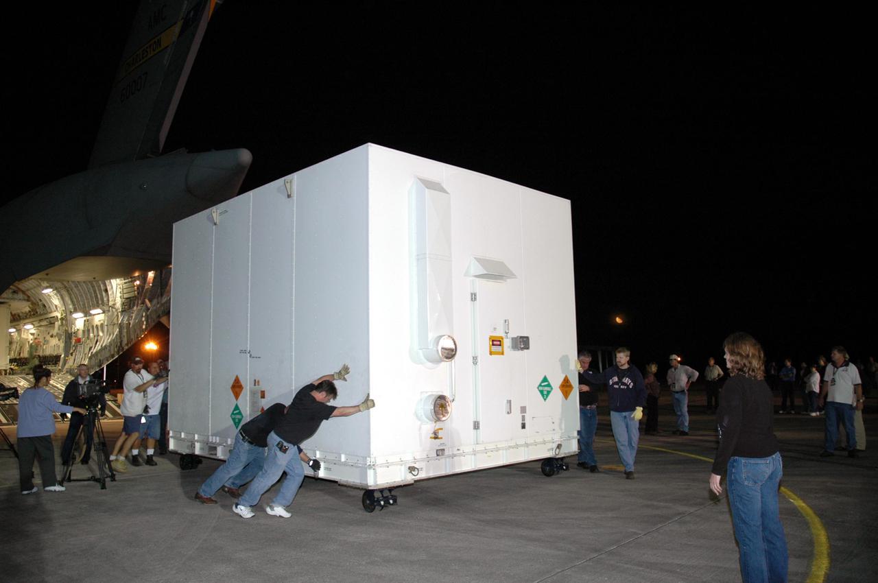
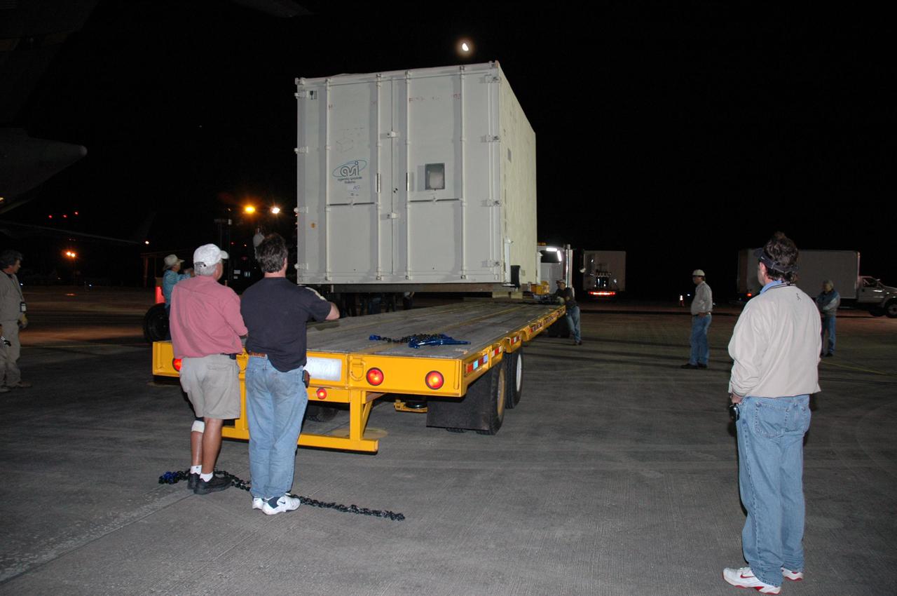
KENNEDY SPACE CENTER, FLA. - Workers at Kennedy Space Center's Shuttle Landing Facility roll one of two containers with the Mars Reconnaissance Orbiter (MRO) equipment away from the Air Force C-17 cargo plane that delivered it. The MRO is being moved to the Payload Hazardous Servicing Facility. The MRO was built by Lockheed Martin for NASA’s Jet Propulsion Laboratory in California. It is the next major step in Mars exploration and scheduled for launch from Cape Canaveral Air Force Station in a window opening Aug. 10. The MRO carries six primary instruments: the High Resolution Imaging Science Experiment, Context Camera, Mars Color Imager, Compact Reconnaissance Imaging Spectrometer for Mars, Mars Climate Sounder and Shallow Radar. By 2007, the MRO will begin a series of global mapping, regional survey and targeted observations from a near-polar, low-altitude Mars orbit. It will observe the atmosphere and surface of Mars while probing its shallow subsurface as part of a “follow the water” strategy.

KENNEDY SPACE CENTER, FLA. - At Kennedy Space Center's Shuttle Landing Facility, one of two containers with the Mars Reconnaissance Orbiter (MRO) equipment is rolled toward the ramp of the Air Force C-17 cargo plane. The MRO is being moved to the Payload Hazardous Servicing Facility. The MRO was built by Lockheed Martin for NASA's Jet Propulsion Laboratory in California. It is the next major step in Mars exploration and scheduled for launch from Cape Canaveral Air Force Station in a window opening Aug. 10. The MRO carries six primary instruments: the High Resolution Imaging Science Experiment, Context Camera, Mars Color Imager, Compact Reconnaissance Imaging Spectrometer for Mars, Mars Climate Sounder and Shallow Radar. By 2007, the MRO will begin a series of global mapping, regional survey and targeted observations from a near-polar, low-altitude Mars orbit. It will observe the atmosphere and surface of Mars while probing its shallow subsurface as part of a “follow the water” strategy.
KENNEDY SPACE CENTER, FLA. - A forklift moves into place behind the Air Force C-17 cargo plane delivering the Mars Reconnaissance Orbiter (MRO) equipment to Kennedy Space Center's Shuttle Landing Facility. The MRO is being moved to the Payload Hazardous Servicing Facility. The MRO was built by Lockheed Martin for NASA's Jet Propulsion Laboratory in California. It is the next major step in Mars exploration and scheduled for launch from Cape Canaveral Air Force Station in a window opening Aug. 10. The MRO carries six primary instruments: the High Resolution Imaging Science Experiment, Context Camera, Mars Color Imager, Compact Reconnaissance Imaging Spectrometer for Mars, Mars Climate Sounder and Shallow Radar. By 2007, the MRO will begin a series of global mapping, regional survey and targeted observations from a near-polar, low-altitude Mars orbit. It will observe the atmosphere and surface of Mars while probing its shallow subsurface as part of a “follow the water” strategy.

KENNEDY SPACE CENTER, FLA. - Workers at Kennedy Space Center's Shuttle Landing Facility roll the second of two containers with the Mars Reconnaissance Orbiter (MRO) equipment away from the Air Force C-17 cargo plane that delivered it. The MRO is being moved to the Payload Hazardous Servicing Facility. The MRO was built by Lockheed Martin for NASA's Jet Propulsion Laboratory in California. It is the next major step in Mars exploration and scheduled for launch from Cape Canaveral Air Force Station in a window opening Aug. 10. The MRO carries six primary instruments: the High Resolution Imaging Science Experiment, Context Camera, Mars Color Imager, Compact Reconnaissance Imaging Spectrometer for Mars, Mars Climate Sounder and Shallow Radar. By 2007, the MRO will begin a series of global mapping, regional survey and targeted observations from a near-polar, low-altitude Mars orbit. It will observe the atmosphere and surface of Mars while probing its shallow subsurface as part of a “follow the water” strategy.
KENNEDY SPACE CENTER, FLA. - Workers at Kennedy Space Center's Shuttle Landing Facility roll one of two containers with the Mars Reconnaissance Orbiter (MRO) equipment away from the Air Force C-17 cargo plane that delivered it. The MRO is being moved to the Payload Hazardous Servicing Facility. The MRO was built by Lockheed Martin for NASA's Jet Propulsion Laboratory in California. It is the next major step in Mars exploration and scheduled for launch from Cape Canaveral Air Force Station in a window opening Aug. 10. The MRO carries six primary instruments: the High Resolution Imaging Science Experiment, Context Camera, Mars Color Imager, Compact Reconnaissance Imaging Spectrometer for Mars, Mars Climate Sounder and Shallow Radar. By 2007, the MRO will begin a series of global mapping, regional survey and targeted observations from a near-polar, low-altitude Mars orbit. It will observe the atmosphere and surface of Mars while probing its shallow subsurface as part of a “follow the water” strategy.
This image from NASA's Mars Reconnaissance Orbiter (MRO) shows bedrock units with diverse colors indicating different mineral concentrations. More information is available at https://photojournal.jpl.nasa.gov/catalog/PIA22434
This color image from NASA's Mars Reconnaissance Orbiter (MRO) shows bedrock layers of diverse colors and composition. For more information see https://photojournal.jpl.nasa.gov/catalog/PIA22437
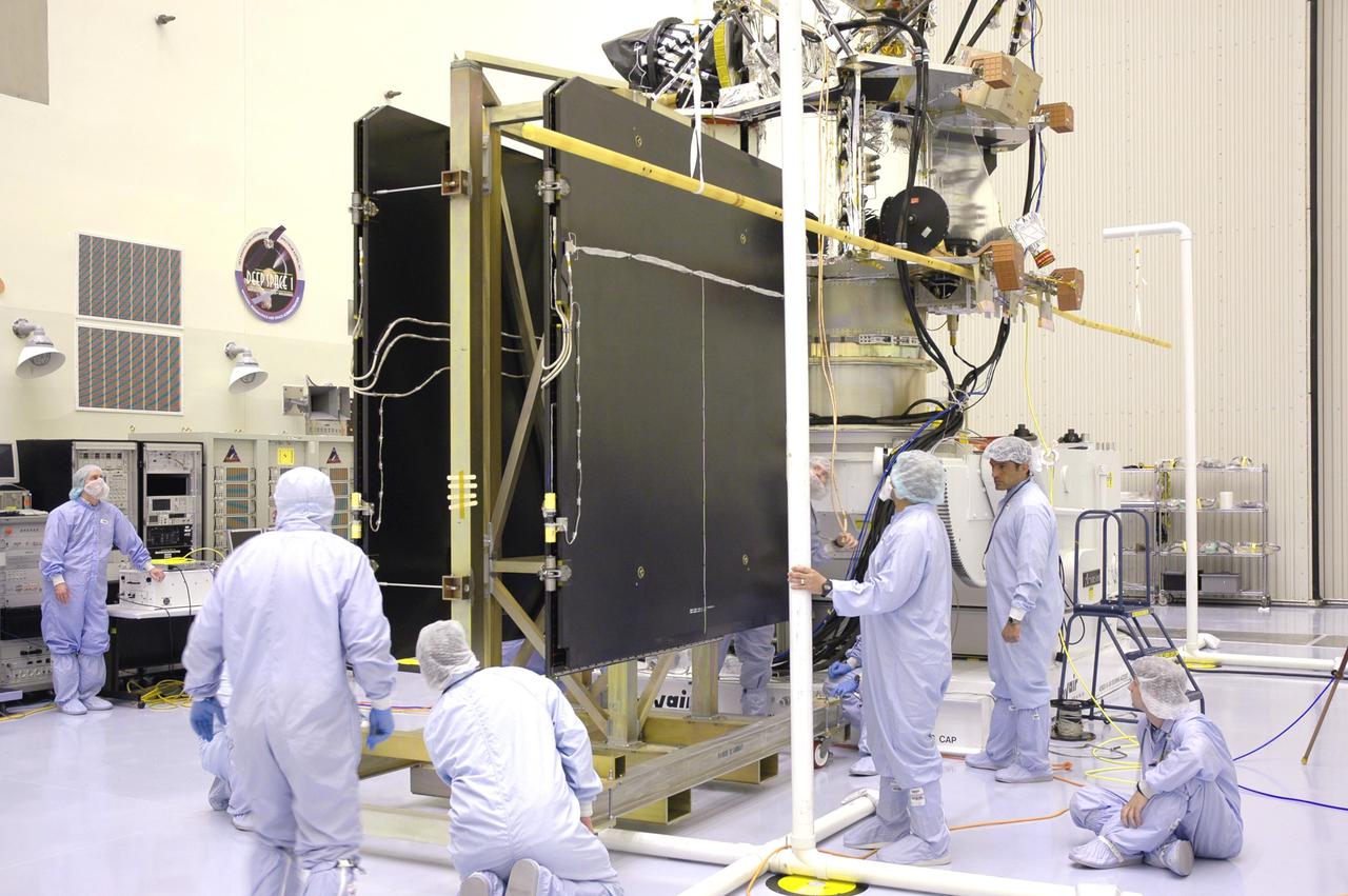
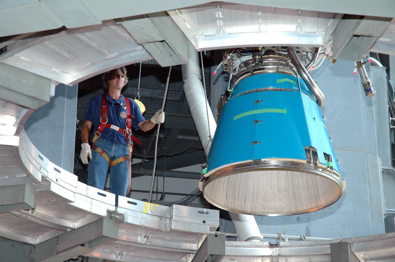
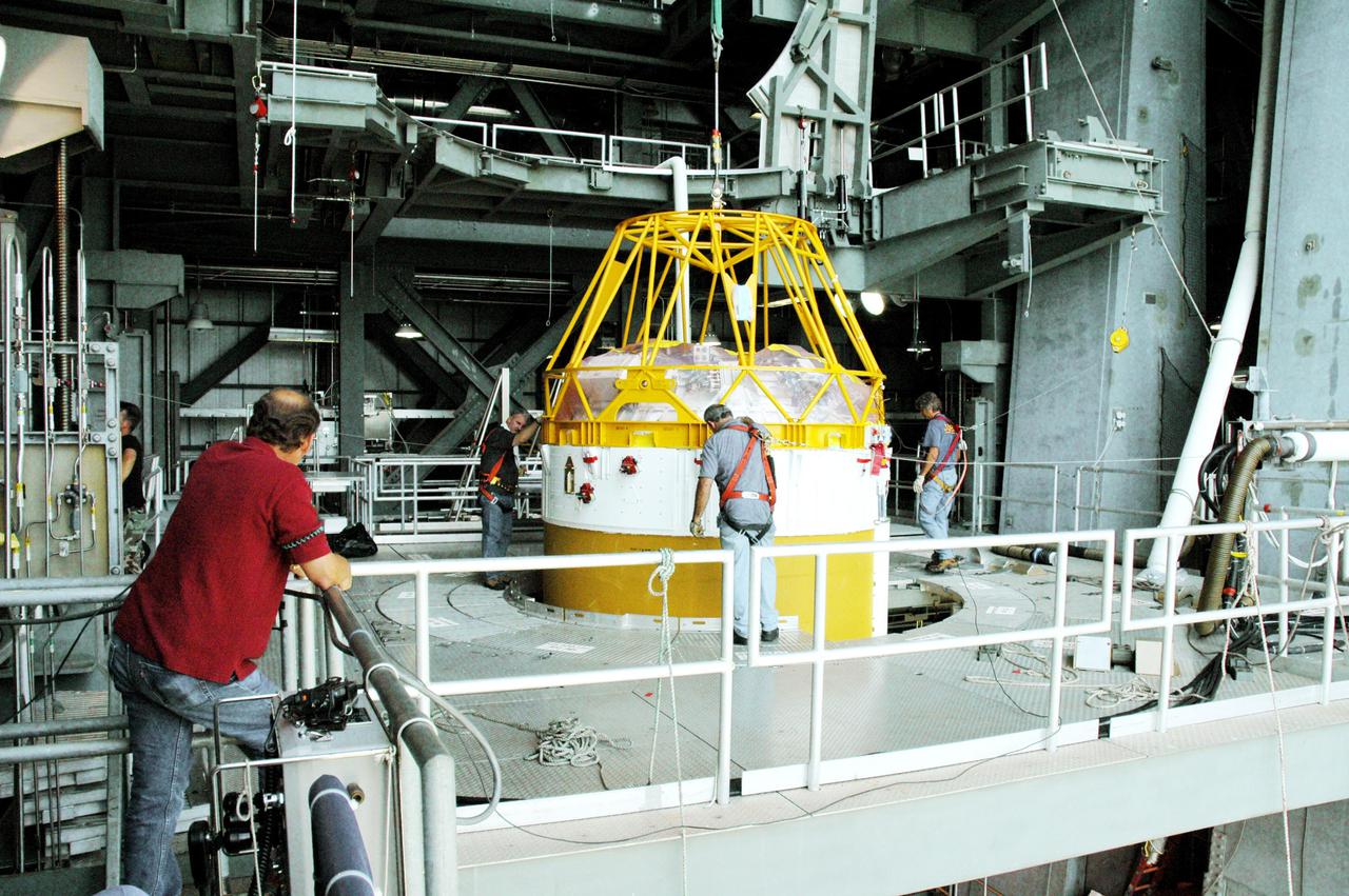
KENNEDY SPACE CENTER, FLA. - In the Payload Hazardous Servicing Facility, technicians prepare the solar arrays for the Mars Reconnaissance Orbiter (MRO) and an antenna simulator (yellow horizontal rod) for an electromagnetic interference verification test. If no interference is found during the test, the Shallow Radar Antenna (SHARAD) will be installed on the spacecraft. The spacecraft is undergoing multiple mechanical assembly operations and electrical tests to verify its readiness for launch. The MRO was built by Lockheed Martin for NASA’s Jet Propulsion Laboratory in California. It is the next major step in Mars exploration and scheduled for launch from Launch Complex 41 at Cape Canaveral Air Force Station in a window opening Aug. 10. The MRO is an important next step in fulfilling NASA’s vision of space exploration and ultimately sending human explorers to Mars and beyond.
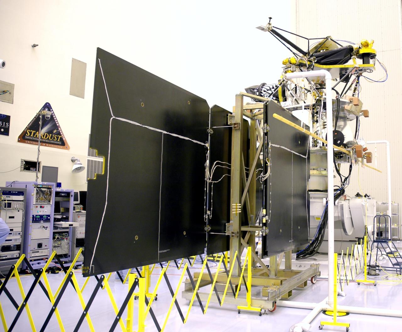
KENNEDY SPACE CENTER, FLA. - In the Payload Hazardous Servicing Facility, an electromagnetic interference verification test is being conducted on the solar arrays for the Mars Reconnaissance Orbiter (MRO) and an antenna simulator (yellow horizontal rod). If no interference is found during the test, the Shallow Radar Antenna (SHARAD) will be installed on the spacecraft. The spacecraft is undergoing multiple mechanical assembly operations and electrical tests to verify its readiness for launch. The MRO was built by Lockheed Martin for NASA’s Jet Propulsion Laboratory in California. It is the next major step in Mars exploration and scheduled for launch from Launch Complex 41 at Cape Canaveral Air Force Station in a window opening Aug. 10. The MRO is an important next step in fulfilling NASA’s vision of space exploration and ultimately sending human explorers to Mars and beyond.
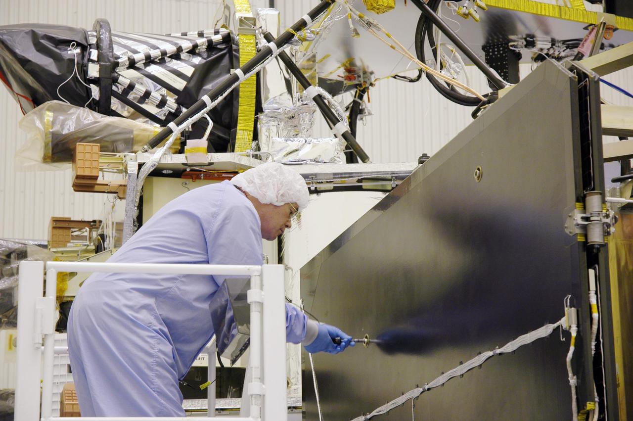
KENNEDY SPACE CENTER, FLA. - In the Payload Hazardous Servicing Facility, a technician prepares the solar arrays for the Mars Reconnaissance Orbiter (MRO) for an electromagnetic interference verification test. If no interference is found during the test, the Shallow Radar Antenna (SHARAD) will be installed on the spacecraft. The spacecraft is undergoing multiple mechanical assembly operations and electrical tests to verify its readiness for launch. The MRO was built by Lockheed Martin for NASA’s Jet Propulsion Laboratory in California. It is the next major step in Mars exploration and scheduled for launch from Launch Complex 41 at Cape Canaveral Air Force Station in a window opening Aug. 10. The MRO is an important next step in fulfilling NASA’s vision of space exploration and ultimately sending human explorers to Mars and beyond.
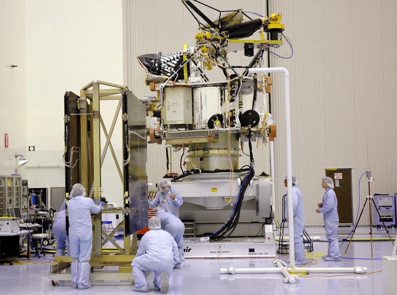
KENNEDY SPACE CENTER, FLA. - In the Payload Hazardous Servicing Facility, technicians position the solar arrays for the Mars Reconnaissance Orbiter (MRO) in preparation for an electromagnetic interference verification test. If no interference is found during the test, the Shallow Radar Antenna (SHARAD) will be installed on the spacecraft. The spacecraft is undergoing multiple mechanical assembly operations and electrical tests to verify its readiness for launch. The MRO was built by Lockheed Martin for NASA’s Jet Propulsion Laboratory in California. It is the next major step in Mars exploration and scheduled for launch from Launch Complex 41 at Cape Canaveral Air Force Station in a window opening Aug. 10. The MRO is an important next step in fulfilling NASA’s vision of space exploration and ultimately sending human explorers to Mars and beyond.
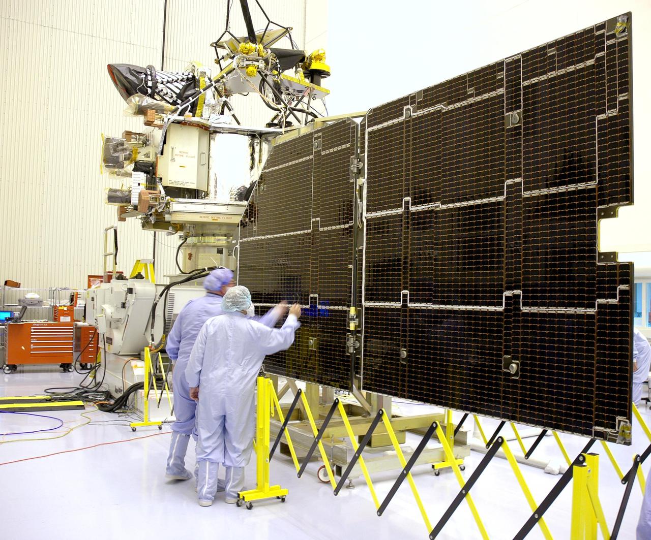
KENNEDY SPACE CENTER, FLA. - In the Payload Hazardous Servicing Facility, technicians inspect the solar panels for the Mars Reconnaissance Orbiter (MRO) during an electromagnetic interference verification test. If no interference is found during the test, the Shallow Radar Antenna (SHARAD) will be installed on the spacecraft. The spacecraft is undergoing multiple mechanical assembly operations and electrical tests to verify its readiness for launch. The MRO was built by Lockheed Martin for NASA’s Jet Propulsion Laboratory in California. It is the next major step in Mars exploration and scheduled for launch from Launch Complex 41 at Cape Canaveral Air Force Station in a window opening Aug. 10. The MRO is an important next step in fulfilling NASA’s vision of space exploration and ultimately sending human explorers to Mars and beyond.
KENNEDY SPACE CENTER, FLA. - In the Payload Hazardous Servicing Facility, technicians prepare to conduct an electromagnetic interference verification test using the solar arrays for the Mars Reconnaissance Orbiter (MRO) and an antenna simulator. If no interference is found during the test, the Shallow Radar Antenna (SHARAD) will be installed on the spacecraft. The spacecraft is undergoing multiple mechanical assembly operations and electrical tests to verify its readiness for launch. The MRO was built by Lockheed Martin for NASA’s Jet Propulsion Laboratory in California. It is the next major step in Mars exploration and scheduled for launch from Launch Complex 41 at Cape Canaveral Air Force Station in a window opening Aug. 10. The MRO is an important next step in fulfilling NASA’s vision of space exploration and ultimately sending human explorers to Mars and beyond.

Richardson Crater is home to this sea of sand dunes. It was fall in the Southern hemisphere when NASA MRO acquired this image of the dunes frosted with the first bit of carbon dioxide ice condensed from the atmosphere.
The Mars Color Imager (MARCI) camera aboard NASA's Mars Reconnaissance Orbiter (MRO) captured this before-and-after comparison of a region of Mars called Amazonis Planitia, which was struck by a meteoroid on Dec. 24, 2021. The impact was so large that MARCI can view it from space. As MRO passes over the planet, MARCI takes linear images – essentially strips – of the planet's circumference each day. The images are then stitched together to create a daily global map of the planet, data that's typically used to monitor atmospheric changes and Martian weather. https://photojournal.jpl.nasa.gov/catalog/PIA25585

The white material seen within this gully is believed to be dusty water ice in a Martian region called Dao Vallis, captured by NASA's Mars Reconnaissance Orbiter (MRO). Scientists believe dust particles within this ice act similarly to dust that falls on to glaciers on Earth, warming up in sunlight and causing subsurface pockets of meltwater to form. On Earth, the dust that forms these pockets are called cryoconite, and the pockets are called cryoconite holes. These Earth-based pockets of water are often teeming with simple life, including algae, fungi and cyanobacteria. Scientists believe similar shallow pools of water could exist on Mars, and may also be excellent places to search for life on the Red Planet today. This black-and-white image was captured by MRO using its HiRISE (High-Resolution Imaging Science Experiment) camera on May 10, 2009. https://photojournal.jpl.nasa.gov/catalog/PIA26408
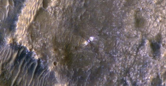
NASA's Perseverance Mars rover and Ingenuity helicopter were spotted on the surface of the Red Planet in this black-and-white image captured Feb. 26, 2022, by the HiRISE camera aboard NASA's Mars Reconnaissance Orbiter. The rover is viewed here sitting on fractured bedrock of the "Máaz" formation before its long drive to the Jezero Crater's delta. About 656 feet (200 meters) to the left is the Ingenuity helicopter, which is so small that it appears as a mere dot on the landscape. A key objective for Perseverance's mission on Mars is astrobiology, including the search for signs of ancient microbial life. The rover will characterize the planet's geology and past climate, pave the way for human exploration of the Red Planet, and be the first mission to collect and cache Martian rock and regolith (broken rock and dust). Subsequent NASA missions, in cooperation with ESA (European Space Agency), would send spacecraft to Mars to collect these sealed samples from the surface and return them to Earth for in-depth analysis. The Mars 2020 Perseverance mission is part of NASA's Moon to Mars exploration approach, which includes Artemis missions to the Moon that will help prepare for human exploration of the Red Planet. https://photojournal.jpl.nasa.gov/catalog/PIA25174
This meteoroid impact crater on Mars was captured using the black-and-white Context Camera aboard NASA's Mars Reconnaissance Orbiter (MRO). The Context Camera took this image showing the impact, which occurred Sept. 18, 2021, in a region called Tempe Terra. The meteoroid struck the side of a graben – a depression created by faults. The impact crater left behind is roughly 427 feet (130 meters) across. https://photojournal.jpl.nasa.gov/catalog/PIA25587

KENNEDY SPACE CENTER, FLA. - NASA's Mars Reconnaissance Orbiter (MRO), atop a Lockheed Martin Atlas V rocket, awaits launch at Launch Complex 41 at Cape Canaveral Air Force Station in Florida. The launch was delayed 24 hours to investigate an anomalous reading in the hydrogen propellant loading system on the Atlas V. At the conclusion of the inquiry, the Atlas V was cleared to launch on Aug. 12 between 7:43 and 9:43 a.m. EDT. The spacecraft will arrive at Mars in March 2006. Once in orbit around Mars, various instruments on the MRO will convey detailed observations of the Martian surface, subsurface and atmosphere. Researchers will use the data to study the history and distribution of Martian water. Learning more about what has happened to the water will focus searches for possible past or present Martian life. Observations by the orbiter will also support future Mars missions by examining potential landing sites and providing a communications relay between the Martian surface and Earth.

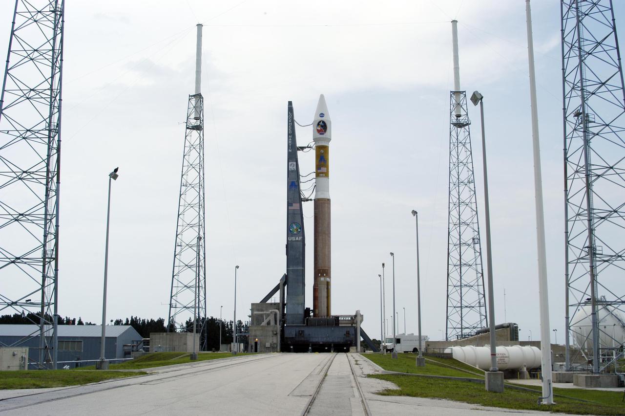
KENNEDY SPACE CENTER, FLA. - The Mars Reconnaissance Orbiter (MRO) atop its Atlas V launch vehicle (right) and launch gantry roll out on the mobile launch platform to the launch pad from the Vertical Integration Facility at Cape Canaveral Air Force Station in Florida. The launch window is from 7:50 a.m. to 9:35 a.m. EDT. The spacecraft will arrive at Mars in March 2006 . Once in orbit around Mars, various instruments on the MRO will convey detailed observations of the Martian surface, subsurface and atmosphere. Researchers will use the data to study the history and distribution of Martian water. Learning more about what has happened to the water will focus searches for possible past or present Martian life. Observations by the orbiter will also support future Mars missions by examining potential landing sites and providing a communications relay between the Martian surface and Earth.

This frame from a movie sequence of images from NASA Mars Reconnaissance Orbiter MRO shows comet C/2013 A1 Siding Spring before and after its close pass by Mars in October 2014. False color enhances subtle variations in brightness in the comet coma.
This image from an animation is from NASA Mars Reconnaissance Orbiter MRO showing the landing effects of the descent stage, the rover lander, the back shell and parachute, and the heat shield, all found on the left side of the image.
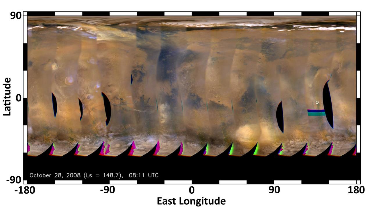
This global map of Mars was acquired on Oct. 28, 2008, by the Mars Color Imager instrument on NASA MRO. One global map is generated each day to forecast weather conditions for the entry, descent and landing of NASA Curiosity rover.
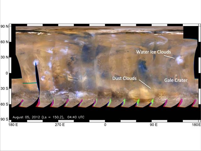
This global map of Mars was acquired on Aug. 5, 2012, by the Mars Color Imager instrument on NASA MRO. One global map is generated each day to forecast weather conditions for the entry, descent and landing of NASA Curiosity rover.
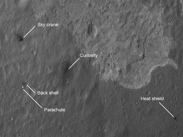
The four main pieces of hardware that arrived on Mars with NASA Curiosity rover were spotted by NASA Mars Reconnaissance Orbiter MRO which captured this image about 24 hours after landing.
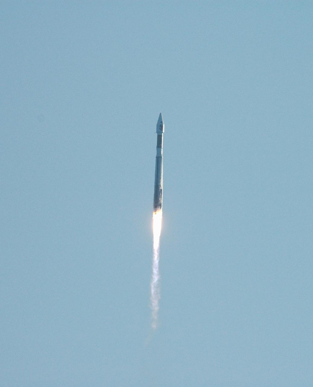
KENNEDY SPACE CENTER, FLA. - Viewed from the NASA News Center, the Mars Reconnaissance Orbiter (MRO) atop a Lockheed Martin Atlas V rocket streaks through the morning sky. The MRO launched at 7:43 a.m. EDT from Launch Complex 41 at Cape Canaveral Air Force Station in Florida. All systems performed nominally for NASA's first Atlas V launch. The spacecraft will arrive at Mars in March 2006. Once in orbit around Mars, various instruments on the MRO will convey detailed observations of the Martian surface, subsurface and atmosphere. Researchers will use the data to study the history and distribution of Martian water. Learning more about what has happened to the water will focus searches for possible past or present Martian life. Observations by the orbiter will also support future Mars missions by examining potential landing sites and providing a communications relay between the Martian surface and Earth.
This enhanced color image from NASA's Mars Reconnaissance Orbiter (MRO) shows the heavily channeled and ancient southern highlands of Mars. The elongated and jagged features are windblown dunes, perhaps hardened and eroded. For more information see https://photojournal.jpl.nasa.gov/catalog/PIA22436
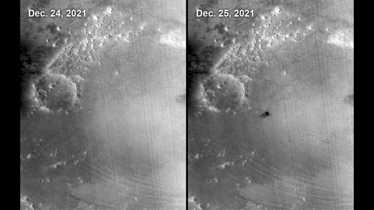
This meteoroid impact crater on Mars was discovered using the black-and-white Context Camera aboard NASA's Mars Reconnaissance Orbiter (MRO). The Context Camera took this image showing the impact, which occurred Dec. 24, 2021, in a region called Amazonis Planitia. Relying on data from the Mars Color Imager camera, also aboard MRO, along with seismic data from NASA's InSight lander, scientists were able to determine when this particular crater formed. Looking closely at the crater's rim, white specks could be detected that suggested the presence of water ice (which was later confirmed by MRO's High-Resolution Imaging Science Experiment, or HiRISE, camera). Debris thrown during the impact can be seen reaching as far as 23 miles (37 kilometers) away. The disturbance seen in the surface suggests the meteoroid was traveling towards the northeast when it hit the ground, throwing the longest streaks of debris in that direction. https://photojournal.jpl.nasa.gov/catalog/PIA25584
This annotated overhead image from the HiRISE camera aboard NASA's Mars Reconnaissance Orbiter (MRO) depicts three options for the agency's Mars Ingenuity Helicopter to take on flights out of the "Séítah" region, as well as the location of the entry, descent, and landing (EDL) hardware. The size and location of the landing ellipses have been analyzed to be safe for landing – free of hazards such as rocks, dunes, and large slopes. See an interactive map with Perseverance and Ingenuity location updates here: https://mars.nasa.gov/mars2020/mission/where-is-the-rover/ https://photojournal.jpl.nasa.gov/catalog/PIA25029
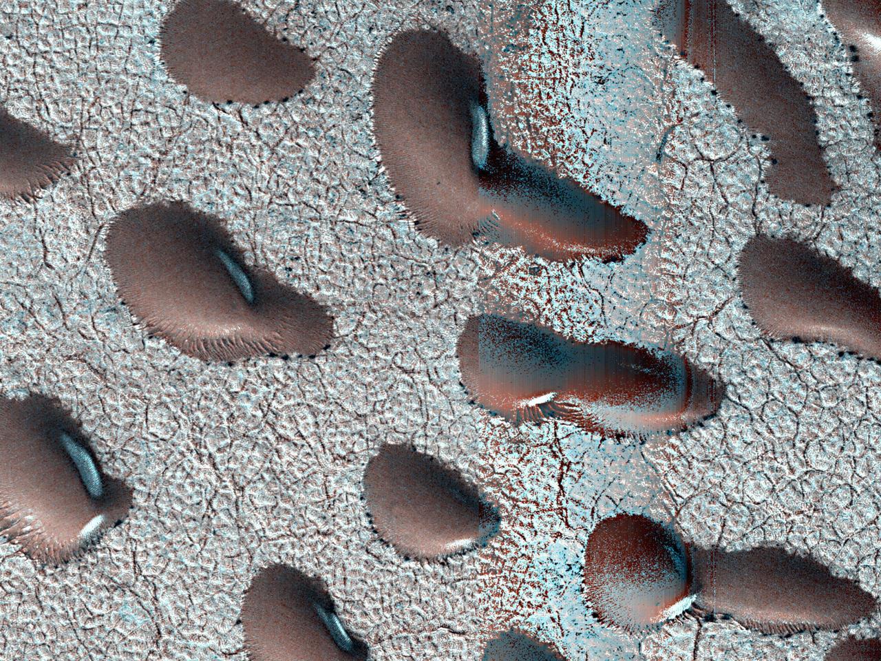
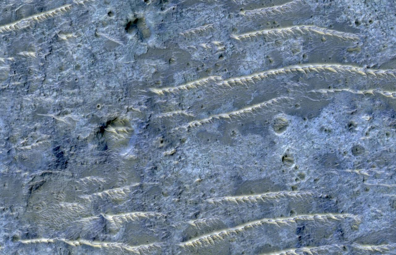
These Martian dunes in Mars' northern hemisphere were captured from above by NASA's Mars Reconnaissance Orbiter using its High-Resolution Imaging Science Experiment (HiRISE) camera on Sept. 8, 2022. Scientists use such images to track the amount of frost that settles on the landforms and then disappears as the weather warms in spring. Martian dunes migrate just like dunes on Earth, with wind blowing away sand on one side of the dune and building up on another. Recent research has shown that winter frost stops the movement of sand grains, locking the dunes in place until the spring thaw. https://photojournal.jpl.nasa.gov/catalog/PIA26517

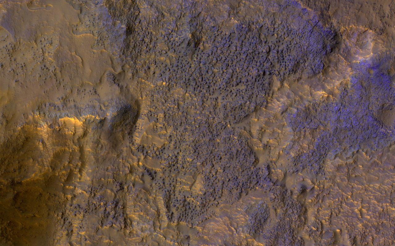
This image shows six views of the Nili Fossae region of Mars captured by the Compact Reconnaissance Imaging Spectrometer for Mars, or CRISM, one of the instruments aboard NASA's Mars Reconnaissance Orbiter. The varying colors represent minerals on the Martian surface seen in different wavelengths of light. Each of these views was produced as part of a near-global map made up of about 1,764 individual segments. The 72-color map is the last major dataset CRISM will ever produce; the instrument will be decommissioned by the end of 2022. Data for the 6.3-gigapixel map was collected over 11 years of CRISM operations. The instrument arrived at Mars with three cryocoolers that allowed it to see in a range of wavelengths, including infrared; in 2017, the last of those cryocoolers stopped working, severely limiting the number of wavelengths CRISM could "see." https://photojournal.jpl.nasa.gov/catalog/PIA25364
NASA's Mars Reconnaissance Orbiter used its Context Camera to capture this image of Bosporos Planum, a location on Mars. The white specks are salt deposits found within a dry channel. The largest impact crater in the scene is nearly 1 mile (1.5 kilometers) across. https://photojournal.jpl.nasa.gov/catalog/PIA25047

In early Martian summer, at the time NASA's Mars Reconnaissance Orbiter (MRO) acquired this image, the dunes are almost free of their seasonal ice cover. Only pockets of ice protected in the shade most of the day remain. The North Pole of Mars is surrounded by a vast sea of sand dunes. In this dune field, the dunes are covered by a seasonal cap of dry ice in the winter. https://photojournal.jpl.nasa.gov/catalog/PIA22463
This image from NASA's Mars Reconnaissance Orbiter (MRO) shows the location with the most impressive known gully activity in Mars' northern hemisphere. Gullies are active in the winter due to carbon dioxide frost, but northern winters are shorter and warmer than southern winters, so there is less frost and less gully activity.. https://photojournal.jpl.nasa.gov/catalog/PIA21593
An enhanced-color image from NASA's Mars Reconnaissance Orbiter (MRO) reveals bedrock that is several kilometers below the top of the giant Valles Marineris canyons. The upper layers have relatively little diversity of colors and textures, but deeper levels show more complex processes. The upper layers could be mostly volcanic while the lower layers were influenced by the period of heavy bombardment and greater interactions with water. https://photojournal.jpl.nasa.gov/catalog/PIA22238
KENNEDY SPACE CENTER, FLA. - NASA's Mars Reconnaissance Orbiter (MRO), atop a Lockheed Martin Atlas V rocket, awaits launch at Launch Complex 41 at Cape Canaveral Air Force Station in Florida. The launch was delayed 24 hours to investigate an anomalous reading in the hydrogen propellant loading system on the Atlas V. At the conclusion of the inquiry, the Atlas V was cleared to launch on Aug. 12 between 7:43 and 9:43 a.m. EDT. The spacecraft will arrive at Mars in March 2006. Once in orbit around Mars, various instruments on the MRO will convey detailed observations of the Martian surface, subsurface and atmosphere. Researchers will use the data to study the history and distribution of Martian water. Learning more about what has happened to the water will focus searches for possible past or present Martian life. Observations by the orbiter will also support future Mars missions by examining potential landing sites and providing a communications relay between the Martian surface and Earth.
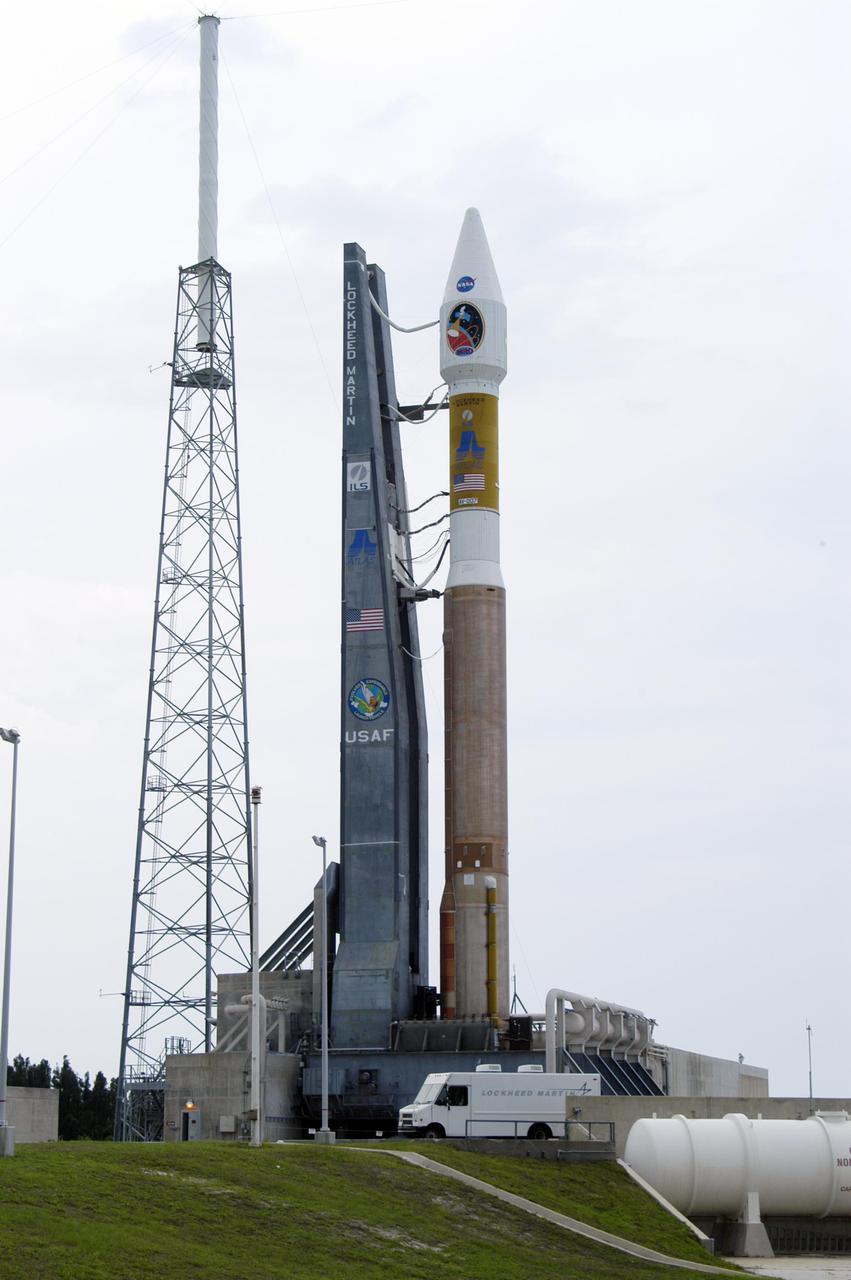
KENNEDY SPACE CENTER, FLA. - NASA's Mars Reconnaissance Orbiter (MRO), atop a Lockheed Martin Atlas V rocket, awaits launch at Launch Complex 41 at Cape Canaveral Air Force Station in Florida. The launch was delayed 24 hours to investigate an anomalous reading in the hydrogen propellant loading system on the Atlas V. At the conclusion of the inquiry, the Atlas V was cleared to launch on Aug. 12 between 7:43 and 9:43 a.m. EDT. The spacecraft will arrive at Mars in March 2006. Once in orbit around Mars, various instruments on the MRO will convey detailed observations of the Martian surface, subsurface and atmosphere. Researchers will use the data to study the history and distribution of Martian water. Learning more about what has happened to the water will focus searches for possible past or present Martian life. Observations by the orbiter will also support future Mars missions by examining potential landing sites and providing a communications relay between the Martian surface and Earth.
KENNEDY SPACE CENTER, FLA. - NASA's Mars Reconnaissance Orbiter (MRO), atop a Lockheed Martin Atlas V rocket, awaits launch at Launch Complex 41 at Cape Canaveral Air Force Station in Florida. The launch was delayed 24 hours to investigate an anomalous reading in the hydrogen propellant loading system on the Atlas V. At the conclusion of the inquiry, the Atlas V was cleared to launch on Aug. 12 between 7:43 and 9:43 a.m. EDT. The spacecraft will arrive at Mars in March 2006. Once in orbit around Mars, various instruments on the MRO will convey detailed observations of the Martian surface, subsurface and atmosphere. Researchers will use the data to study the history and distribution of Martian water. Learning more about what has happened to the water will focus searches for possible past or present Martian life. Observations by the orbiter will also support future Mars missions by examining potential landing sites and providing a communications relay between the Martian surface and Earth.
KENNEDY SPACE CENTER, FLA. - NASA's Mars Reconnaissance Orbiter (MRO), atop a Lockheed Martin Atlas V rocket, awaits launch at Launch Complex 41 at Cape Canaveral Air Force Station in Florida. The launch was delayed 24 hours to investigate an anomalous reading in the hydrogen propellant loading system on the Atlas V. At the conclusion of the inquiry, the Atlas V was cleared to launch on Aug. 12 between 7:43 and 9:43 a.m. EDT. The spacecraft will arrive at Mars in March 2006. Once in orbit around Mars, various instruments on the MRO will convey detailed observations of the Martian surface, subsurface and atmosphere. Researchers will use the data to study the history and distribution of Martian water. Learning more about what has happened to the water will focus searches for possible past or present Martian life. Observations by the orbiter will also support future Mars missions by examining potential landing sites and providing a communications relay between the Martian surface and Earth.
KENNEDY SPACE CENTER, FLA. - NASA's Mars Reconnaissance Orbiter (MRO), atop a Lockheed Martin Atlas V rocket, awaits launch at Launch Complex 41 at Cape Canaveral Air Force Station in Florida. The launch was delayed 24 hours to investigate an anomalous reading in the hydrogen propellant loading system on the Atlas V. At the conclusion of the inquiry, the Atlas V was cleared to launch on Aug. 12 between 7:43 and 9:43 a.m. EDT. The spacecraft will arrive at Mars in March 2006. Once in orbit around Mars, various instruments on the MRO will convey detailed observations of the Martian surface, subsurface and atmosphere. Researchers will use the data to study the history and distribution of Martian water. Learning more about what has happened to the water will focus searches for possible past or present Martian life. Observations by the orbiter will also support future Mars missions by examining potential landing sites and providing a communications relay between the Martian surface and Earth.
Multiple images from the Mars Color Imager (MARCI) aboard NASA's Mars Reconnaissance Orbiter (MRO) were used to generate this view of a regional dust storm obscuring Syrtis Major and Jezero Crater (white circle). The images were acquired on Jan. 9, 2022. MRO creates global maps of Mars but roll maneuvers for targeted observations produce gaps in the coverage, which appear as black gores in the maps. On some days there are data drops where partial or full orbits of coverage are missing. Green and purple observed in the south polar region indicate saturated pixels. https://photojournal.jpl.nasa.gov/catalog/PIA25068
The High-Resolution Science Experiment (HiRISE) camera aboard NASA's Mars Reconnaissance Orbiter (MRO) took this image of the Perseverance rover on Feb. 24, 2021. The false-color image shows a ring of blast marks where thrusters from the rover's descent stage blew away dust during landing on Feb. 18, 2021. By rolling MRO to the side (18 degrees for this image) as it passes over Perseverance every few days, the mission team enables HiRISE to see the rover. Perseverance is about 10 feet by 9 feet (3 by 2.7 meters) in size and is about 180 miles (290 kilometers) away from HiRISE in this image. https://photojournal.jpl.nasa.gov/catalog/PIA24427
This set of images from NASA's Mars Reconnaissance Orbiter (MRO) shows a fierce, giant dust storm is kicking up on Mars, with rovers on the surface indicated as icons. The spread of the storm can be seen in the salmon-colored overlay. These images from MRO's Mars Color Imager start from May 31, when the dust event was first detected, and go through June 11, 2018. MRO creates global maps of Mars but roll maneuvers for targeted observations produce gaps in the coverage, which appear as black gores in the maps. On some days there are data drops where partial or full orbits of coverage are missing. Green and purple observed in the south polar region indicate saturated pixels. Latitude is indicated along the vertical axis. Longitude is indicated along the horizontal axis. https://photojournal.jpl.nasa.gov/catalog/PIA22519

NASA's Curiosity Mars rover appears as a dark speck in this image captured from directly overhead by the agency's Mars Reconnaissance Orbiter, or MRO. The orbiter is equipped with a camera capable of viewing objects the size of a dinner table on the Red Planet's surface. The camera, called the High-Resolution Imaging Science Experiment (HiRISE), has viewed spacecraft on the surface many times before. Here, it captured Curiosity driving up a steep slope on Dec. 29, 2023, the 4,051st Martian day, or sol, of the rover's mission. Curiosity is seen in an area striped with alternating dark and light bands. Scientists are interested in learning what differentiated the materials on the surface to form these different bands. https://photojournal.jpl.nasa.gov/catalog/PIA26245
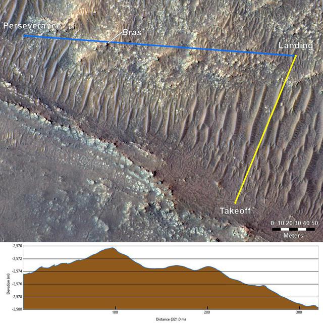
This annotated image from NASA's Mars Reconnaissance Orbiter (MRO), and the topographic map below it, provide a look at the altitude of surface features standing between the agency's Perseverance Mars rover and Ingenuity helicopter at the conclusion of the rotorcraft's 17th flight at Mars on Dec. 5, 2021. In the image of the surface – taken by MRO's High Resolution Science Experiment (HiRISE) camera – Ingenuity's flight path is depicted in yellow. Perseverance's location is indicated in the upper left, with the blue line delineating its line of sight to the helicopter's landing spot. The location of the tallest point on Mars' surface between rover and helicopter during its final descent is the hill near the center of image that the Perseverance science team has nicknamed "Bras," after a city in France. The topographic map below the orbital image provides the elevation of surface features along the blue line, or Perseverance's line of sight to helicopter. The height measurements to the left of the map are derived by comparing local elevations to the areoid (a model for an equipotential surface of Mars, analogous to "sea level" on Earth). The Ingenuity team believes the 13-foot (4-meter) height difference between the Perseverance rover and the top of Bras contributed to the loss of communications when the helicopter descended toward the surface at the end of its flight. The image's background terrain was generated using data collected by the HiRISE camera aboard NASA's Mars Reconnaissance Orbiter. https://photojournal.jpl.nasa.gov/catalog/PIA24980
This image from NASA's Mars Reconnaissance Orbiter (MRO) shows white material believed to be dusty water ice lining the edges of Martian gullies in a region named Terra Sirenum. Scientists believe dust particles within this ice act similarly to dust that falls onto glaciers on Earth, warming up in sunlight and causing subsurface pockets of meltwater to form. On Earth, the dust that builds up on glaciers is called cryoconite, and the pockets it forms are called cryoconite holes. These pockets of water on our planet are often teeming with simple life, including algae, fungi, and cyanobacteria. Scientists believe similar shallow pools of water could exist on Mars, and may also be excellent places to search for life on the Red Planet today. This enhanced-color image was captured by MRO's HiRISE (High-Resolution Imaging Science Experiment) camera on Dec. 25, 2016. The blue color at the bottom of the gullies is likely coarse sand (not ice); the hue would not actually be perceptible to the human eye. HiRISE is able to detect this color by looking at the scene in far-infrared wavelengths. https://photojournal.jpl.nasa.gov/catalog/PIA26407

This radargram shows data collected by the Shallow Radar, or SHARAD, on NASA's Mars Reconnaissance Orbiter (MRO) on May 2, 2023, as it performed a 120-degree roll maneuver called a "very large roll" over a formation named Medusae Fossae. Scientists used SHARAD to look for ice beneath the surface of this region. Designed to peer from about a half-mile to a little over a mile (1 to 2 kilometers) below ground, SHARAD emits radio waves that are reflected off materials in the subsurface, measuring how long it takes for those waves to bounce back to the instrument. The longer it takes, the deeper the subsurface layer is. Because different materials reflect radio waves differently, SHARAD allows scientists to distinguish between rock, sand, and ice. While MRO often performs a standard 28-degree roll to give SHARAD's antenna a more direct view of Martian terrain, the 120-degree very large roll rotates the antenna even farther, providing its radio waves an unobstructed path to the surface. This boosts the radar's signals by 10 times or more, giving SHARAD a clearer, deeper view of the Martian underground than ever before. Scientists hope the very large rolls will help them look for frozen and liquid water, among other things. https://photojournal.jpl.nasa.gov/catalog/PIA26555
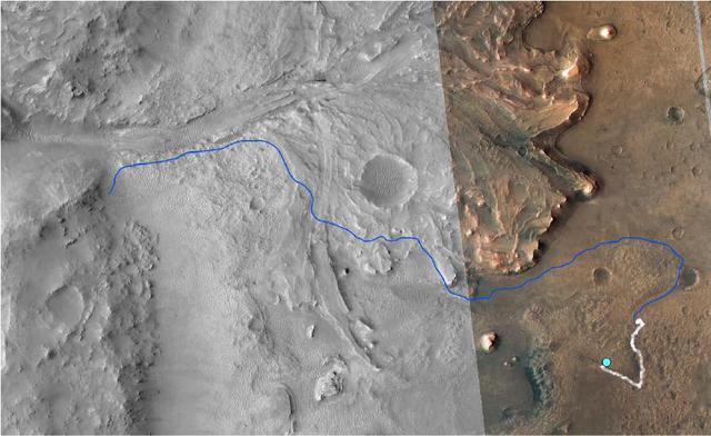
This annotated image from NASA's Mars Reconnaissance Orbiter (MRO) shows the journey NASA's Perseverance rover has taken and will take in the future as it heads toward Jezero Crater's delta on Mars. The white line depicts the route the rover has taken since it touched down at the "Octavia E. Butler Landing" site on Feb. 18, 2021, to its current location in the "South Séítah" geologic unit (light-blue dot). The rover will return to the landing site along the same route and then continue to the delta along the line in blue. This map is composed of images from the MRO's High Resolution Imaging Experiment (HiRISE). A key objective for Perseverance's mission on Mars is astrobiology, including the search for signs of ancient microbial life. The rover will characterize the planet's geology and past climate, pave the way for human exploration of the Red Planet, and be the first mission to collect and cache Martian rock and regolith (broken rock and dust). Subsequent NASA missions, in cooperation with ESA (European Space Agency), would send spacecraft to Mars to collect these sealed samples from the surface and return them to Earth for in-depth analysis. The Mars 2020 Perseverance mission is part of NASA's Moon to Mars exploration approach, which includes Artemis missions to the Moon that will help prepare for human exploration of the Red Planet. https://photojournal.jpl.nasa.gov/catalog/PIA25027

This enhanced color image from NASA's Mars Reconnaissance Orbiter (MRO) shows eroded bedrock on the floor of a large ancient crater. For more information see https://photojournal.jpl.nasa.gov/catalog/PIA22439
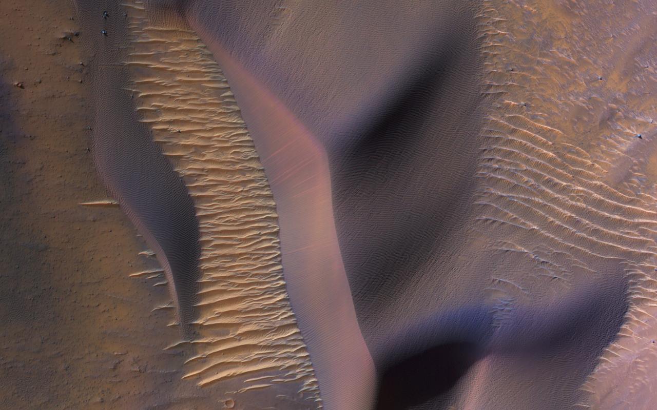
This image from NASA's Mars Reconnaissance Orbiter (MRO) shows some of these on the slopes of Nectaris Montes within Coprates Chasma. Sand dunes in Valles Marineris can be impressive in size, with steep slopes that seem to climb and descend. The brighter bedforms are inactive while the bigger dunes move over the landscape, burying and exhuming the surface. https://photojournal.jpl.nasa.gov/catalog/PIA22455

This image from NASA's Mars Reconnaissance Orbiter (MRO) shows the permanent polar cap of Mars, encircled by sand dunes and looking like pulled threads, these dunes march across a fabric of patterned ground. At this time of the Martian year the dunes are free of the seasonal dry ice that forms a temporary cover every winter. https://photojournal.jpl.nasa.gov/catalog/PIA22464

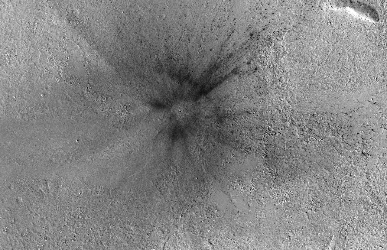
This image from NASA's Mars Reconnaissance Orbiter (MRO) shows two new craters, both with the same distinctive pattern of relatively blue (less red) ejecta surrounded by a dark blast zone (where dust has been removed or disturbed), and with arcing patterns extending northwest and northeast. This pattern indicates an oblique impact angle with the bolide coming from the north. MRO has discovered over 700 new impact sites on Mars. Often, a bolide breaks apart in the atmosphere and makes a tight cluster of new craters. https://photojournal.jpl.nasa.gov/catalog/PIA22453

These mountains are in a region called Sisyphi Montes. The base image from NASA 2001 Mars Odyssey shows a portion of the region about 130 miles. Red outlines indicate possible subglacial volcanic structures. MRO CRISM data are at upper right.
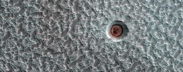
MRO has been observing Mars for 6 Mars Years (MY), each of which lasts for 687 Earth days. Shown here is an impact crater on the north polar ice cap, which contains an icy deposit on the crater floor. https://photojournal.jpl.nasa.gov/catalog/PIA23671
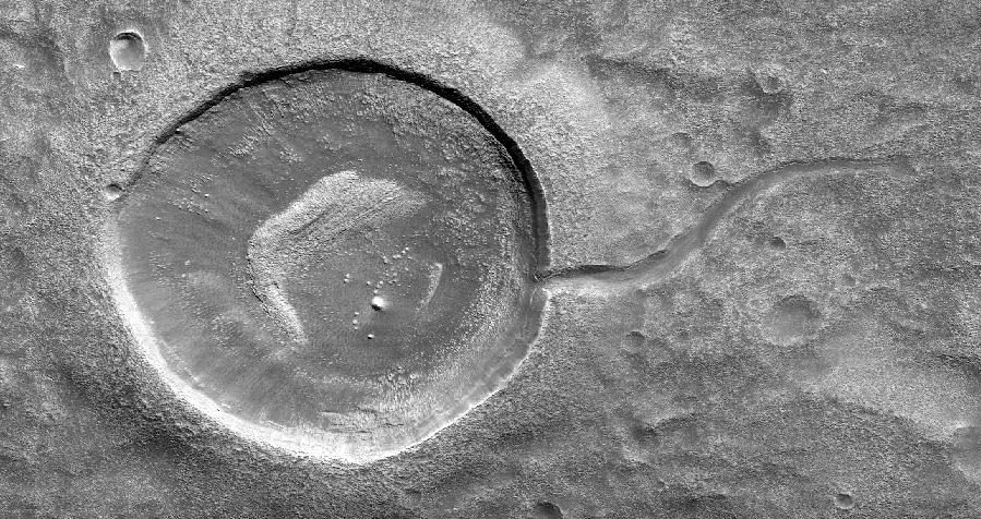
This image from NASA's Mars Reconnaissance Orbiter (MRO) shows an impact crater looking amusingly like a tadpole because of the valley that was carved by water that used to fill it. It is often difficult to differentiate between inlet and outlet channels, but water always flows downhill. In this particular case, we can infer that water is flowing outward because we have the necessary terrain-height information. When studying these images in detail, scientists can gain a better understanding of the strength of the flooding water that carved the channels, and better understand the history of water activity in this region of Mars. https://photojournal.jpl.nasa.gov/catalog/PIA22241
KENNEDY SPACE CENTER, FLA. - NASA's Mars Reconnaissance Orbiter (MRO) launches at 7:43 a.m. EDT atop a Lockheed Martin Atlas V rocket from Launch Complex 41 at Cape Canaveral Air Force Station in Florida on Aug. 12. All systems performed nominally for NASA's first Atlas V launch. The spacecraft will arrive at Mars in March 2006. Once in orbit around Mars, various instruments on the MRO will convey detailed observations of the Martian surface, subsurface and atmosphere. Researchers will use the data to study the history and distribution of Martian water. Learning more about what has happened to the water will focus searches for possible past or present Martian life. Observations by the orbiter will also support future Mars missions by examining potential landing sites and providing a communications relay between the Martian surface and Earth.
KENNEDY SPACE CENTER, FLA. - NASA's Mars Reconnaissance Orbiter (MRO) launches at 7:43 a.m. EDT atop a Lockheed Martin Atlas V rocket from Launch Complex 41 at Cape Canaveral Air Force Station in Florida on Aug. 12. All systems performed nominally for NASA's first Atlas V launch. The spacecraft will arrive at Mars in March 2006. Once in orbit around Mars, various instruments on the MRO will convey detailed observations of the Martian surface, subsurface and atmosphere. Researchers will use the data to study the history and distribution of Martian water. Learning more about what has happened to the water will focus searches for possible past or present Martian life. Observations by the orbiter will also support future Mars missions by examining potential landing sites and providing a communications relay between the Martian surface and Earth.

KENNEDY SPACE CENTER, FLA. - Seen on the horizon just past the NASA News Center’s countdown clock, NASA's Mars Reconnaissance Orbiter (MRO) launches at 7:43 a.m. EDT atop a Lockheed Martin Atlas V rocket from Launch Complex 41 at Cape Canaveral Air Force Station in Florida. All systems performed nominally for NASA's first Atlas V launch. The spacecraft will arrive at Mars in March 2006. Once in orbit around Mars, various instruments on the MRO will convey detailed observations of the Martian surface, subsurface and atmosphere. Researchers will use the data to study the history and distribution of Martian water. Learning more about what has happened to the water will focus searches for possible past or present Martian life. Observations by the orbiter will also support future Mars missions by examining potential landing sites and providing a communications relay between the Martian surface and Earth.
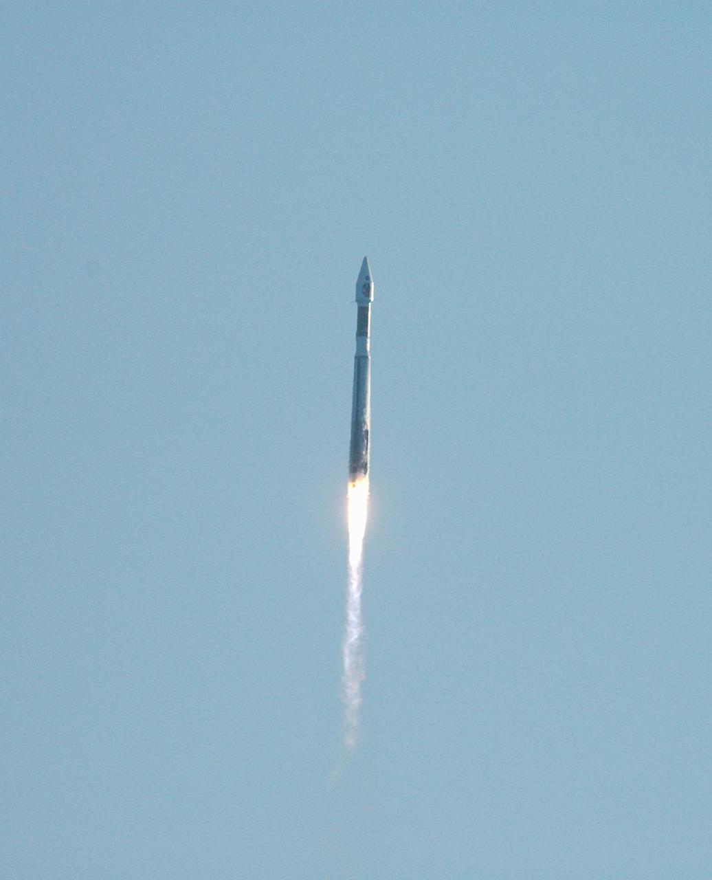
KENNEDY SPACE CENTER, FLA. - NASA's Mars Reconnaissance Orbiter (MRO) launches at 7:43 a.m. EDT atop a Lockheed Martin Atlas V rocket from Launch Complex 41 at Cape Canaveral Air Force Station in Florida on Aug. 12. All systems performed nominally for NASA's first Atlas V launch. The spacecraft will arrive at Mars in March 2006. Once in orbit around Mars, various instruments on the MRO will convey detailed observations of the Martian surface, subsurface and atmosphere. Researchers will use the data to study the history and distribution of Martian water. Learning more about what has happened to the water will focus searches for possible past or present Martian life. Observations by the orbiter will also support future Mars missions by examining potential landing sites and providing a communications relay between the Martian surface and Earth.
KENNEDY SPACE CENTER, FLA. - NASA's Mars Reconnaissance Orbiter (MRO) launches at 7:43 a.m. EDT atop a Lockheed Martin Atlas V rocket from Launch Complex 41 at Cape Canaveral Air Force Station in Florida on Aug. 12. All systems performed nominally for NASA's first Atlas V launch. The spacecraft will arrive at Mars in March 2006. Once in orbit around Mars, various instruments on the MRO will convey detailed observations of the Martian surface, subsurface and atmosphere. Researchers will use the data to study the history and distribution of Martian water. Learning more about what has happened to the water will focus searches for possible past or present Martian life. Observations by the orbiter will also support future Mars missions by examining potential landing sites and providing a communications relay between the Martian surface and Earth.
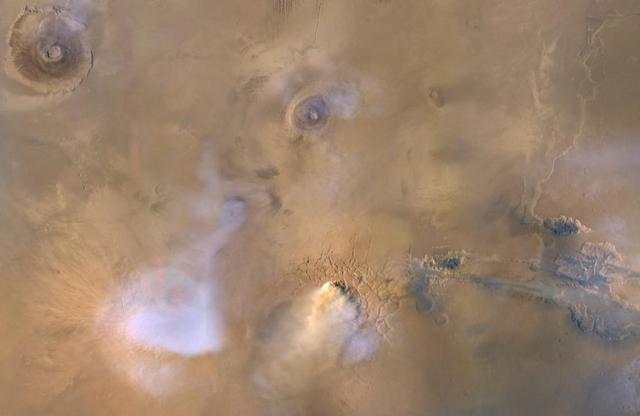
The yellow-white cloud in the bottom-center of this image is a Mars "dust tower" — a concentrated cloud of dust that can be lofted dozens of miles above the surface. The blue-white plumes are water vapor clouds. Olympus Mons, the tallest volcano in the solar system, is visible in the upper left corner, while Valles Marineris can be seen in the lower right. Heat-sensitive instruments like the Mars Climate Sounder, carried aboard NASA's Mars Reconnaissance Orbiter (MRO), can map the formation of these dust towers, which form almost continuously during global dust storms. Taken on Nov. 30, 2010, the image was produced by MRO's Mars Color Imager (MARCI), which was built and is operated by Malin Space Science Systems in San Diego. https://photojournal.jpl.nasa.gov/catalog/PIA23513
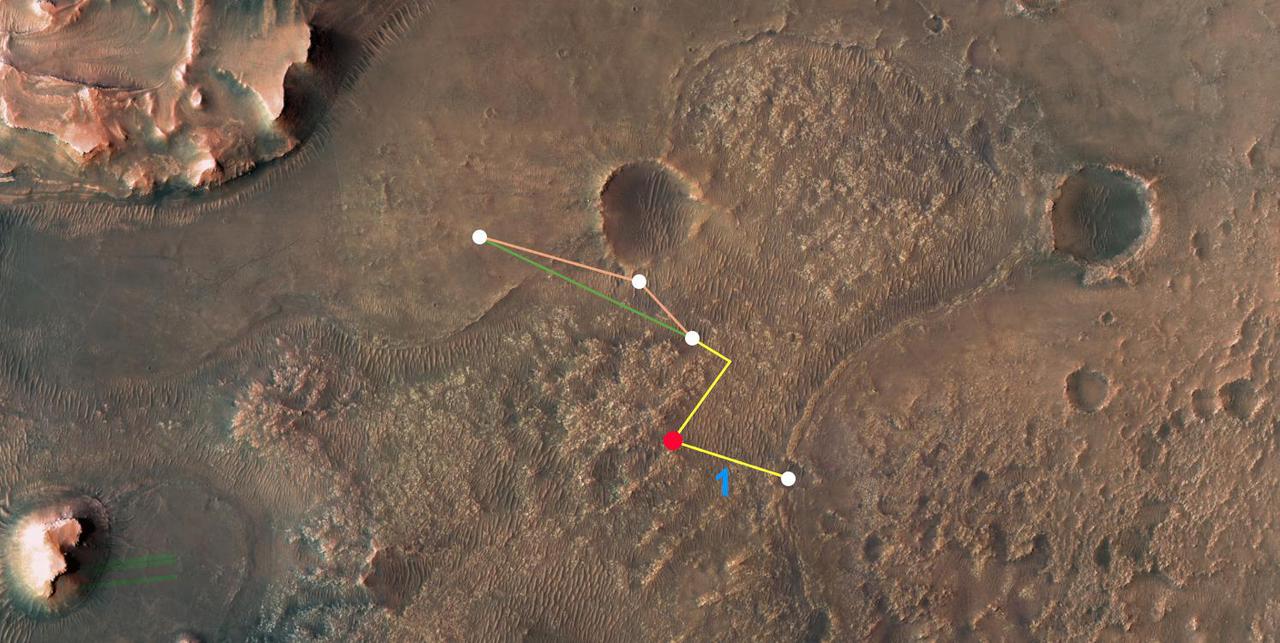
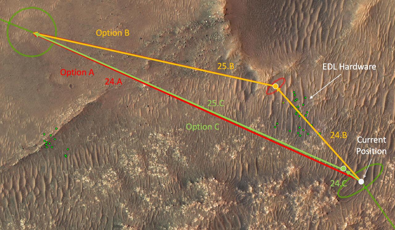
This annotated overhead image from NASA's Mars Reconnaissance Orbiter (MRO) depicts the multiple flights – and two different routes – the agency's Ingenuity Mars Helicopter could take on its way to Jezero Crater's delta. The location of Ingenuity as of March 14, 2022, is indicated by the red dot. This map is made using images from MRO's High Resolution Imaging Experiment (HiRISE) camera. The first flight in this series (indicated by the number 1 in blue) occurred on March 10, 2022. After the next flight – which includes a sharp bend in the course to avoid a large hill – the helicopter team will consider which of two routes to take. The first option requires two flights to reach the base of the delta. The second option is more direct, necessitating only one final flight to reach the same location. https://photojournal.jpl.nasa.gov/catalog/PIA25080
It's not that common to see craters on steep hills, partly because rocks falling downhill can quickly erase such craters. Here, however, NASA's Mars Reconnaissance Orbiter (MRO) observes a small impact has occurred on the sloping wall of a larger crater and is well-preserved. Dark, blocky ejecta from the smaller crater has flowed downhill (to the west) toward the floor of the larger crater. Understanding the emplacement of such ejecta on steep hills is an area of ongoing research. https://photojournal.jpl.nasa.gov/catalog/PIA21758
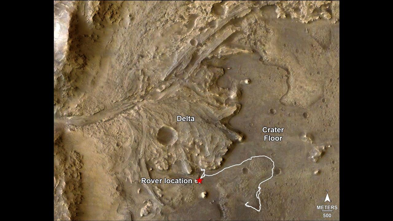
The route of NASA's Perseverance Mars rover – from its landing site on the floor of Jezero Crater to the ancient river delta, which it is currently exploring – is shown in this annotated image composed of overhead views from the agency's Mars Reconnaissance Orbiter (MRO). The red star indicates the location of the rover in September 2022. Perseverance touched down at "Octavia E. Butler Landing" on Feb. 18, 2021, and explored formations (abbreviated "fm" in the annotation) known as "Séítah" and "Máaz" on the floor of Jezero Crater before driving toward the delta region. The delta, which Perseverance reached in April 2022, is a fan-shaped area where, billions of years ago, a river once flowed into a lake and deposited rocks and sediment. Scientists consider it one of the best places on Mars to search for potential signs of ancient microbial life. For this image, the Perseverance team and the U.S. Geological Survey collaborated on the base map, combining multiple images from the High Resolution Imaging Experiment (HiRISE) camera with color from the Compact Reconnaissance Imaging Spectrometer for Mars (CRISM), both instruments aboard MRO. The HiRISE images used span a period from 2007 to 2017. A key objective for Perseverance's mission on Mars is astrobiology, including the search for signs of ancient microbial life. The rover will characterize the planet's geology and past climate, pave the way for human exploration of the Red Planet, and be the first mission to collect and cache Martian rock and regolith (broken rock and dust). Subsequent NASA missions, in cooperation with ESA (European Space Agency), would send spacecraft to Mars to collect these sealed samples from the surface and return them to Earth for in-depth analysis. The Mars 2020 Perseverance mission is part of NASA's Moon to Mars exploration approach, which includes Artemis missions to the Moon that will help prepare for human exploration of the Red Planet. https://photojournal.jpl.nasa.gov/catalog/PIA24922
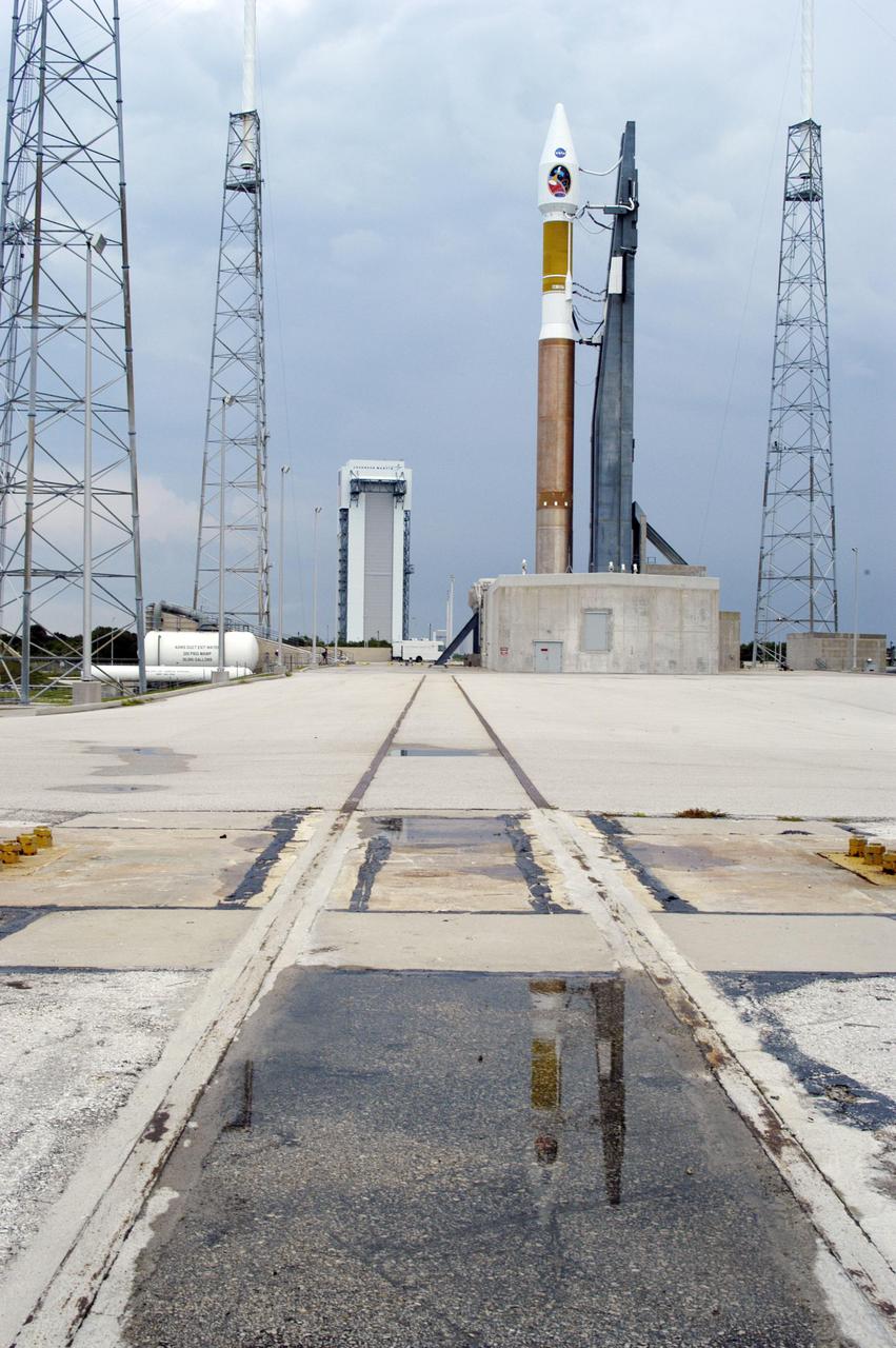
KENNEDY SPACE CENTER, FLA. - NASA's Mars Reconnaissance Orbiter (MRO), atop a Lockheed Martin Atlas V rocket, is reflected in a puddle following an afternoon shower at Launch Complex 41 at Cape Canaveral Air Force Station in Florida. The launch was delayed 24 hours to investigate an anomalous reading in the hydrogen propellant loading system on the Atlas V. At the conclusion of the inquiry, the Atlas V was cleared to launch on Aug. 12 between 7:43 and 9:43 a.m. EDT. The spacecraft will arrive at Mars in March 2006. Once in orbit around Mars, various instruments on the MRO will convey detailed observations of the Martian surface, subsurface and atmosphere. Researchers will use the data to study the history and distribution of Martian water. Learning more about what has happened to the water will focus searches for possible past or present Martian life. Observations by the orbiter will also support future Mars missions by examining potential landing sites and providing a communications relay between the Martian surface and Earth.
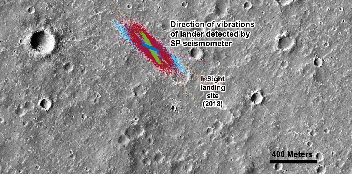
An annotated image of the surface of Mars, taken by the HiRISE camera on NASA's Mars Reconnaissance Orbiter (MRO) on May 30, 2014. The contrast has been enhanced in this image to better show the region where InSight landed on Nov. 26, 2018. The labels show the approximate position of NASA's InSight lander in Elysium Planitia. Overlaid on top are the direction of the vibrations detected by InSight's science instruments. The diagonal lines, faintly seen moving from upper left corner to the lower right corner of the image, show the paths of dust devils on the Martian surface. The vibrations recorded by InSight line up with the direction of the dust devil motion. https://photojournal.jpl.nasa.gov/catalog/PIA22927
This image from NASA's Mars Reconnaissance Orbiter (MRO) shows Hale Crater, a large impact crater (more than 100 kilometers) with a suite of interesting features such as active gullies, active recurring slope lineae, and extensive icy ejecta flows. There are also exposed diverse (colorful) bedrock units. https://photojournal.jpl.nasa.gov/catalog/PIA22465

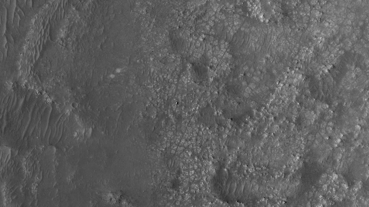
This image from NASA's Mars Reconnaissance Orbiter (MRO) shows remarkably young lava flows in Elysium Planitia. There are almost no impact craters over this flow, indicating that it is probably only a few million years old -- practically an infant in geologic time. For more information see https://photojournal.jpl.nasa.gov/catalog/PIA22432
![Layers, probably sedimentary in origin, have undergone extensive erosion in this image from NASA's Mars Reconnaissance Orbiter (MRO) of Shalbatana Valles, a prominent channel that cuts through Xanthe Terra. This erosion has produced several small mesas and exposed light-toned material that may differ in composition from the surrounding material. The map is projected here at a scale of 25 centimeters (9.8 inches) per pixel. [The original image scale is 27.5 centimeters (10.8 inches) per pixel (with 1 x 1 binning); objects on the order of 82 centimeters (32.3 inches) across are resolved.] North is up. https://photojournal.jpl.nasa.gov/catalog/PIA22182](https://images-assets.nasa.gov/image/PIA22182/PIA22182~medium.jpg)
Layers, probably sedimentary in origin, have undergone extensive erosion in this image from NASA's Mars Reconnaissance Orbiter (MRO) of Shalbatana Valles, a prominent channel that cuts through Xanthe Terra. This erosion has produced several small mesas and exposed light-toned material that may differ in composition from the surrounding material. The map is projected here at a scale of 25 centimeters (9.8 inches) per pixel. [The original image scale is 27.5 centimeters (10.8 inches) per pixel (with 1 x 1 binning); objects on the order of 82 centimeters (32.3 inches) across are resolved.] North is up. https://photojournal.jpl.nasa.gov/catalog/PIA22182

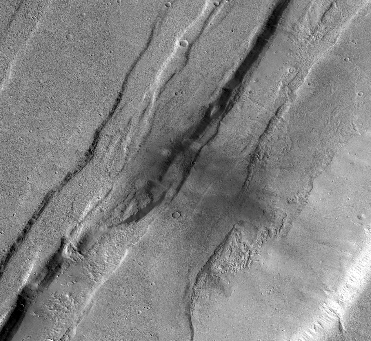
This image from NASA's Mars Reconnaissance Orbiter (MRO) shows streaks forming on slopes when dust cascades downhill. The dark streak is an area of less dust compared to the brighter and reddish surroundings. What triggers these avalanches is not known, but might be related to sudden warming of the surface. These streaks are often diverted by the terrain they flow down. This one has split into many smaller streaks where it encountered minor obstacles. These streaks fade away over decades as more dust slowly settles out of the Martian sky. https://photojournal.jpl.nasa.gov/catalog/PIA22240
This image from NASA's Mars Reconnaissance Orbiter (MRO) shows the western wall of a small pit that is located along the floor of a larger trough in Coprates Catena. Dark layers are exposed along the bottom of the pit wall while light-toned layers are near the top of the pit and the adjacent trough floor. Based upon where the layers are exposed, we can tell that the dark layers formed first followed by the light layers. The light layers could have been deposited when water filled part of the trough while the dark layers could be older lava flows. https://photojournal.jpl.nasa.gov/catalog/PIA22331