
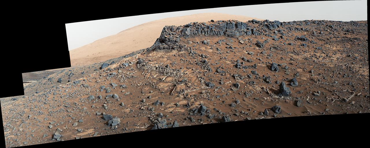
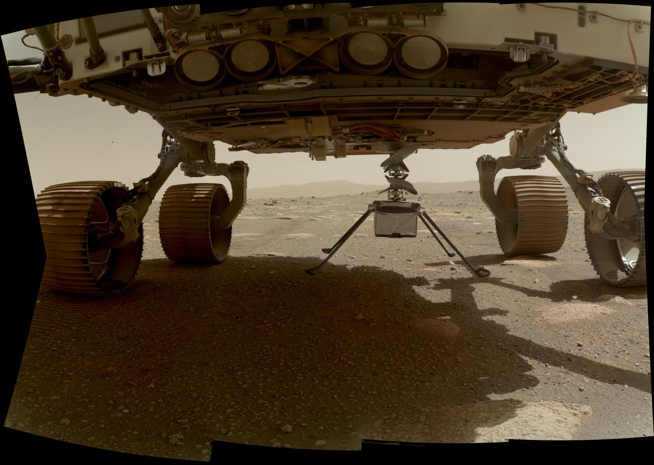
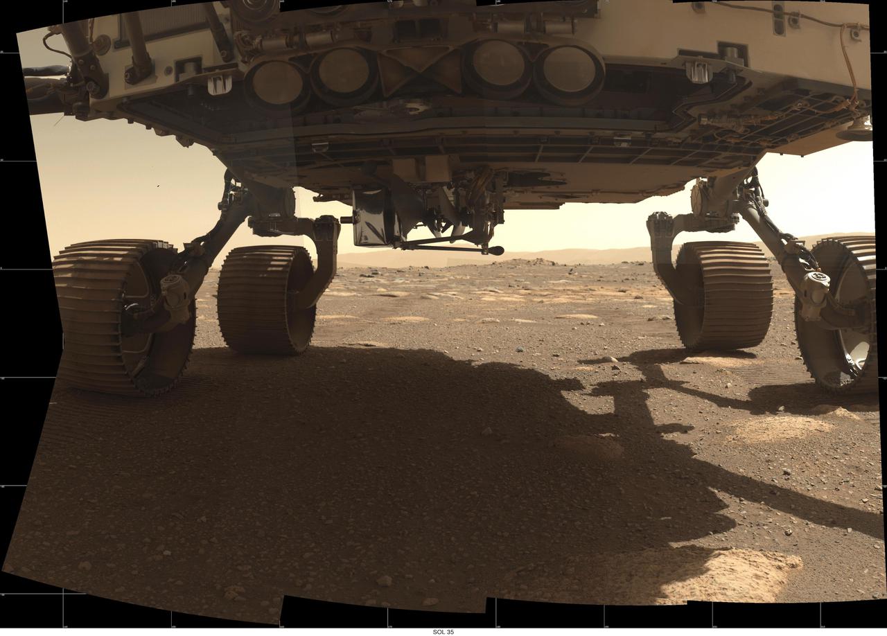
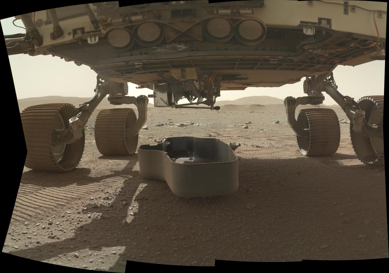
This self-portrait of NASA's Curiosity Mars rover shows the vehicle at the "Big Sky" site, where its drill collected the mission's fifth taste of Mount Sharp. The scene combines dozens of images taken during the 1,126th Martian day, or sol, of Curiosity's work during Mars (Oct. 6, 2015, PDT), by the Mars Hand Lens Imager (MAHLI) camera at the end of the rover's robotic arm. The rock drilled at this site is sandstone in the Stimson geological unit inside Gale Crater. The location is on cross-bedded sandstone in which the cross bedding is more evident in views from when the rover was approaching the area, such as PIA19818. The view is centered toward the west-northwest. It does not include the rover's robotic arm, though the shadow of the arm is visible on the ground. Wrist motions and turret rotations on the arm allowed MAHLI to acquire the mosaic's component images. The arm was positioned out of the shot in the images, or portions of images, that were used in this mosaic. This process was used previously in acquiring and assembling Curiosity self-portraits taken at sample-collection sites "Rocknest" (PIA16468), "John Klein" (PIA16937) and "Windjana" (PIA18390). This portrait of the rover was designed to show the Chemistry and Camera (ChemCam) instrument atop the rover appearing level. This causes the horizon to appear to tilt toward the left, but in reality it is fairly flat. For scale, the rover's wheels are 20 inches (50 centimeters) in diameter and about 16 inches (40 centimeters) wide. The drilled hole in the rock, appearing grey near the lower left corner of the image, is 0.63 inch (1.6 centimeters) in diameter. MAHLI was built by Malin Space Science Systems, San Diego. NASA's Jet Propulsion Laboratory, a division of the California Institute of Technology in Pasadena, manages the Mars Science Laboratory Project for the NASA Science Mission Directorate, Washington. JPL designed and built the project's Curiosity rover. http://photojournal.jpl.nasa.gov/catalog/PIA19920
This view from the Mast Camera (Mastcam) on NASA's Curiosity Mars rover shows a site with a network of prominent mineral veins below a cap rock ridge on lower Mount Sharp. Researchers used the rover in March 2015 to examine the structure and composition of the crisscrossing veins at the "Garden City" site in the center of this scene. For geologists, the vein complex offers a three-dimensional exposure of mineralized fractures in a geological setting called the Pahrump section of the Lower Murray Formation. Curiosity spent several months examining sites in the Pahrump section below this site, before arriving at Garden City. Mineral veins such as these form where fluids move through fractured rocks, depositing minerals in the fractures and affecting chemistry of the surrounding rock. In this case, the veins have been more resistant to erosion than the surrounding host rock. The component images of this mosaic view were taken by the left-eye camera of Mastcam on March 27, 2015, during the 938th Martian day, or sol, of Curiosity's work on Mars. The scene is presented with a color adjustment that approximates white balancing, to resemble how the rocks would appear under daytime lighting conditions on Earth. For scale, the cap rock scarp is about 3 feet (1 meter) tall. Figure 1 includes scale bars of 1 meter (3.3 feet) vertically and 2 meters (6.7 feet) horizontally. Malin Space Science Systems, San Diego, built and operates Curiosity's Mastcam. NASA's Jet Propulsion Laboratory, a division of the California Institute of Technology, Pasadena, built the rover and manages the project for NASA's Science Mission Directorate, Washington. http://photojournal.jpl.nasa.gov/catalog/PIA19921
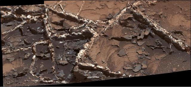
Prominent mineral veins at the "Garden City" site examined by NASA's Curiosity Mars rover vary in thickness and brightness, as seen in this image from Curiosity's Mast Camera (Mastcam). The image covers and area roughly 2 feet (60 centimeters) across. Types of vein material evident in the area include: 1) thin, dark-toned fracture filling material; 2) thick, dark-toned vein material in large fractures; 3) light-toned vein material, which was deposited last. Figure 1 includes annotations identifying each of those three major kinds and a scale bar indicating 10 centimeters (3.9 inches). Researchers used the Mastcam and other instruments on Curiosity in March and April 2015 to study the structure and composition of mineral veins at Garden City, for information about fluids that deposited minerals in fractured rock there. Malin Space Science Systems, San Diego, built and operates Curiosity's Mastcam. NASA's Jet Propulsion Laboratory, a division of the California Institute of Technology, Pasadena, built the rover and manages the project for NASA's Science Mission Directorate, Washington. http://photojournal.jpl.nasa.gov/catalog/PIA19922
NASA's Perseverance Mars rover took this close-up of a rock target nicknamed "Foux" using its WATSON (Wide Angle Topographic Sensor for Operations and eNgineering) camera, part of the SHERLOC instrument on the end of the rover's robotic arm. The image was taken July 11, 2021, the 139th Martian day, or sol, of the mission. The area within the camera is roughly 1.4 by 1 inches (3.5 centimeters by 2.6 centimeters). NASA's Jet Propulsion Laboratory built and manages operations of Perseverance and Ingenuity for the agency. Caltech in Pasadena, California, manages JPL for NASA. WATSON was built by Malin Space Science Systems (MSSS) in San Diego and is operated jointly by MSSS and JPL. A key objective for Perseverance's mission on Mars is astrobiology, including the search for signs of ancient microbial life. The rover will characterize the planet's geology and past climate, pave the way for human exploration of the Red Planet, and be the first mission to collect and cache Martian rock and regolith (broken rock and dust). Subsequent NASA missions, in cooperation with ESA (European Space Agency), would send spacecraft to Mars to collect these sealed samples from the surface and return them to Earth for in-depth analysis. The Mars 2020 Perseverance mission is part of NASA's Moon to Mars exploration approach, which includes Artemis missions to the Moon that will help prepare for human exploration of the Red Planet. https://photojournal.jpl.nasa.gov/catalog/PIA24728
NASA's Perseverance Mars rover used the WATSON camera on the end of its robotic arm to conduct a focus test on May 9, 2021, the 78th Martian day, or sol, of the mission. WATSON (Wide Angle Topographic Sensor for Operations and eNgineering) is located on the SHERLOC (Scanning Habitable Environments with Raman and Luminescence for Organics and Chemicals) instrument, located at the end of Perseverance's long robotic arm. NASA's Jet Propulsion Laboratory built and manages operations of Perseverance and Ingenuity for the agency. Caltech in Pasadena, California, manages JPL for NASA. WATSON was built by Malin Space Science Systems (MSSS) in San Diego and is operated jointly by MSSS and JPL. A key objective for Perseverance's mission on Mars is astrobiology, including the search for signs of ancient microbial life. The rover will characterize the planet's geology and past climate, pave the way for human exploration of the Red Planet, and be the first mission to collect and cache Martian rock and regolith (broken rock and dust). Subsequent NASA missions, in cooperation with ESA (European Space Agency), would send spacecraft to Mars to collect these sealed samples from the surface and return them to Earth for in-depth analysis. The Mars 2020 Perseverance mission is part of NASA's Moon to Mars exploration approach, which includes Artemis missions to the Moon that will help prepare for human exploration of the Red Planet. Movie available at https://photojournal.jpl.nasa.gov/catalog/PIA24641
NASA's Ingenuity helicopter can be seen here with all four of its legs deployed before dropping from the belly of the Perseverance rover on March 30, 2021, the 39th Martian day, or sol, of the mission. This image was taken by the WATSON (Wide Angle Topographic Sensor for Operations and eNgineering) camera on the SHERLOC (Scanning Habitable Environments with Raman and Luminescence for Organics and Chemicals) instrument, located at the end of the rover's long robotic arm. NASA's Jet Propulsion Laboratory built and manages operations of Perseverance and Ingenuity for the agency. Caltech in Pasadena, California, manages JPL for NASA. WATSON was built by Malin Space Science Systems (MSSS) in San Diego and is operated jointly by MSSS and JPL. The Mars helicopter technology demonstration activity is supported by NASA's Science Mission Directorate, the NASA Aeronautics Research Mission Directorate, and the NASA Space Technology Mission Directorate. A key objective for Perseverance's mission on Mars is astrobiology, including the search for signs of ancient microbial life. The rover will characterize the planet's geology and past climate, pave the way for human exploration of the Red Planet, and be the first mission to collect and cache Martian rock and regolith (broken rock and dust). Subsequent NASA missions, in cooperation with ESA (European Space Agency), would send spacecraft to Mars to collect these sealed samples from the surface and return them to Earth for in-depth analysis. https://photojournal.jpl.nasa.gov/catalog/PIA24449
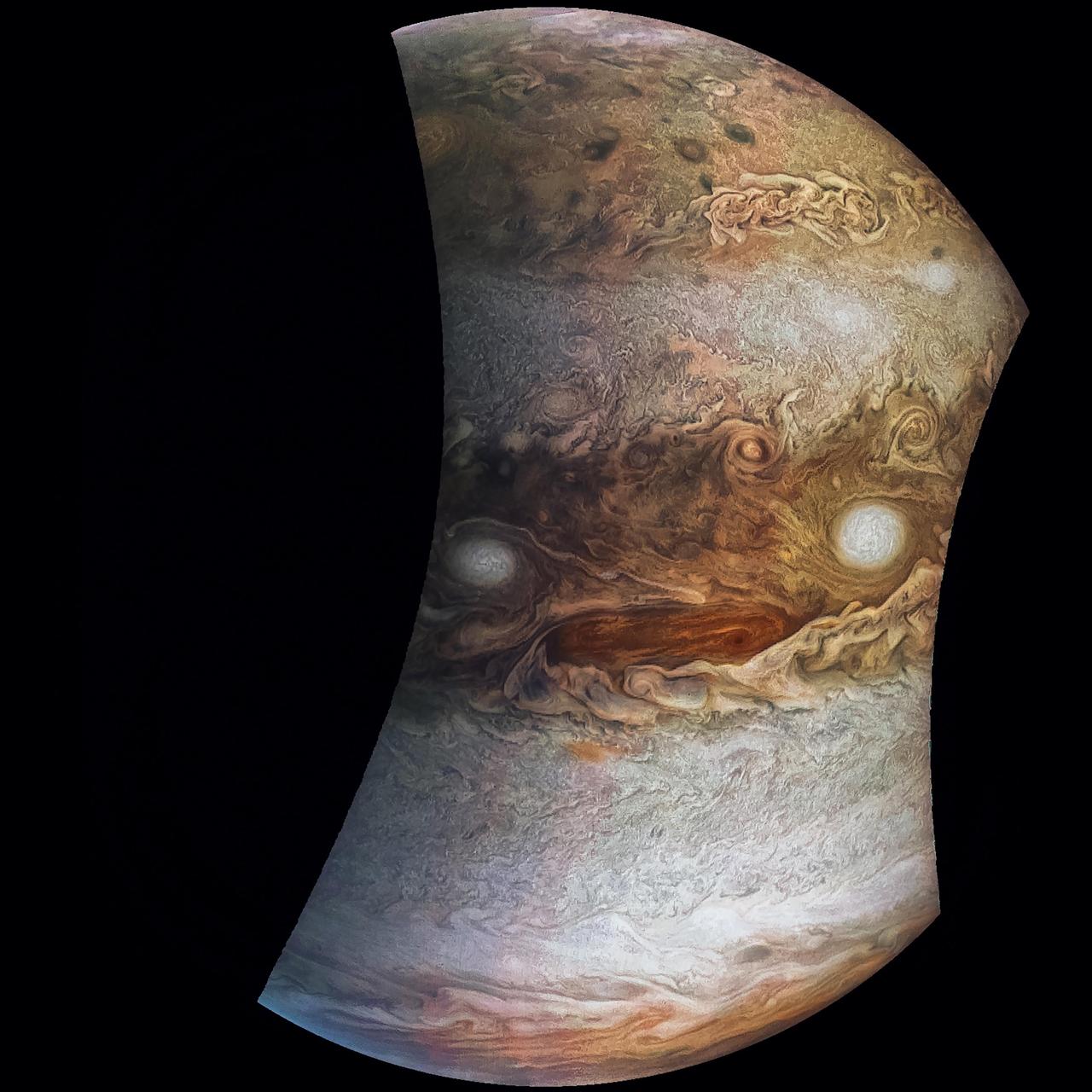
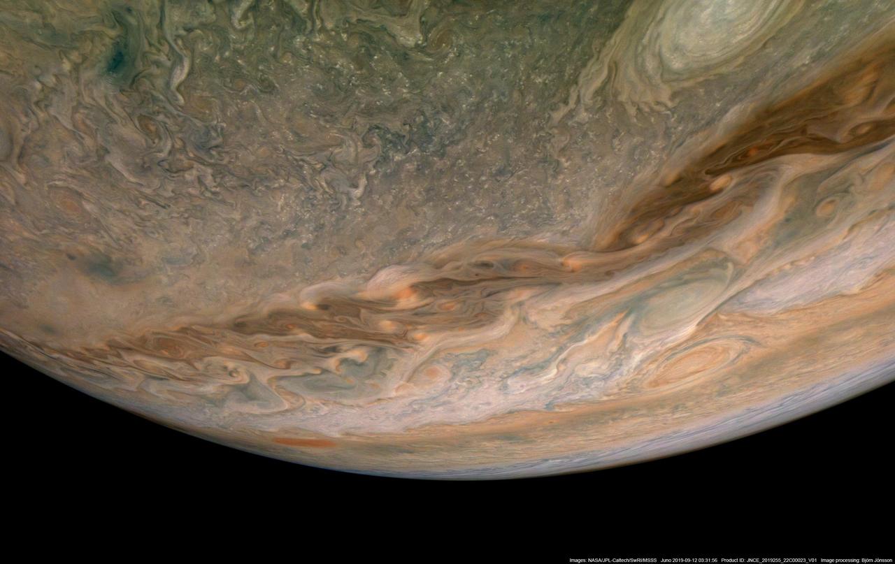
This mosaic combines color-enhanced images taken over Jupiter's north pole when the lighting was excellent for detecting high bands of haze. The images were taken in the final hours of Juno's perijove 12 approach on April 1, 2018. Citizen scientists Gerald Eichstädt and John Rogers created this image using data from the spacecraft's JunoCam imager. https://photojournal.jpl.nasa.gov/catalog/PIA22934. - Enhanced image by Gerald Eichstädt and John Rogers based on images provided courtesy of NASA/JPL-Caltech/SwRI/MSSS
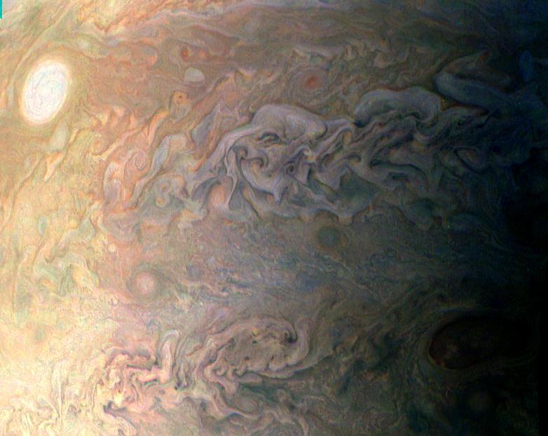
This image of the sunlit part of Jupiter and its swirling atmosphere was created by a citizen scientist (Alex Mai) using data from Juno's JunoCam instrument. JunoCam's raw images are available at www.missionjuno.swri.edu/junocam for the public to peruse and process into image products. http://photojournal.jpl.nasa.gov/catalog/PIA21108 . - Enhanced image by Alex Mai (CC-BY) based on images provided courtesy of NASA/JPL-Caltech/SwRI/MSSS
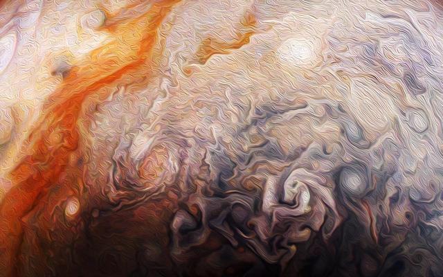
Citizen scientist Rick Lundh created this abstract Jovian artwork using data from the JunoCam imager onboard NASA's Juno spacecraft. The original image captures a close-up view of numerous storms in the northern hemisphere of Jupiter. To produce this artwork, Lundh selected a more contrasting part of one of Jupiter's storms, then cropped the image and applied an oil-painting filter. https://photojournal.jpl.nasa.gov/catalog/PIA21983 . - Enhanced image by Rick Lundh based on images provided courtesy of NASA/JPL-Caltech/SwRI/MSSS

This image shows Jupiter's south pole, as seen by NASA's Juno spacecraft from an altitude of 32,000 miles (52,000 kilometers). The oval features are cyclones, up to 600 miles (1,000 kilometers) in diameter. Multiple images taken with the JunoCam instrument on three separate orbits were combined to show all areas in daylight, enhanced color, and stereographic projection. https://photojournal.jpl.nasa.gov/catalog/PIA21641 . - Enhanced image by Betsy Asher Hall/Gervasio Robles based on images provided courtesy of NASA/JPL-Caltech/SwRI/MSSS

This movie was generated using imagery collected on Oct. 29, 2018, during Juno's 16th perijove (the point at which an orbit comes closest to Jupiter's center). Citizen scientists Gerald Eichstädt created this movie using data from the spacecraft's JunoCam imager. Movie available at https://photojournal.jpl.nasa.gov/catalog/PIA22906. - Enhanced image by Gerald Eichstädt (CC-BY) based on images provided courtesy of NASA/JPL-Caltech/SwRI/MSSS/SPICE
NASA's Juno spacecraft captured this stunning Jovian cloudscape at 5:38 a.m. PST (8:38 a.m. EST) on Feb. 7, 2018, as the spacecraft performed its 11th close flyby of Jupiter. Citizen scientist Kevin M. Gill created this color-enhanced image using data from the spacecraft's JunoCam imager. https://photojournal.jpl.nasa.gov/catalog/PIA22931. - Enhanced image by Kevin M. Gill (CC-BY) based on images provided courtesy of NASA/JPL-Caltech/SwRI/MSSS
Jupiter's northern circumpolar cyclones are captured in this color-enhanced image from NASA's Juno spacecraft. The image was taken at 5:42 p.m. PDT (8:42 p.m. EDT) on Sept. 6, 2018, as the spacecraft performed its 15th close flyby of Jupiter. Citizen scientist Gerald Eichstädt created this image using data from the spacecraft's JunoCam imager. https://photojournal.jpl.nasa.gov/catalog/PIA22932. - Enhanced image by Gerald Eichstädt based on images provided courtesy of NASA/JPL-Caltech/SwRI/MSSS
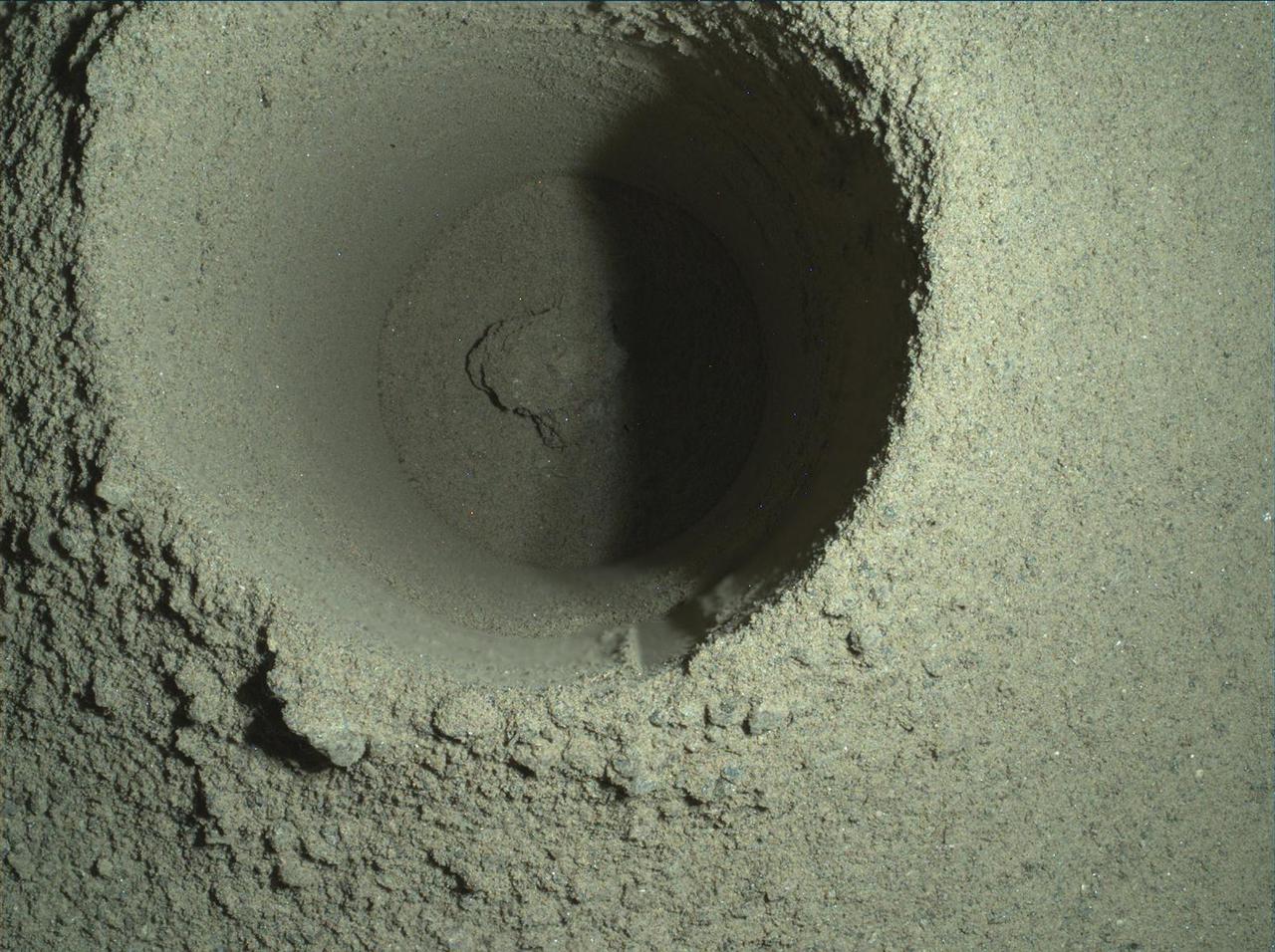
This composite image of the first borehole drilled by NASA's Perseverance rover on Mars was generated using multiple images taken by the rover's WATSON (Wide Angle Topographic Sensor for Operations and eNgineering) imager. The borehole is 1.06 inches (2.7 centimeters) in diameter. A subsystem of the SHERLOC (Scanning Habitable Environments with Raman & Luminescence for Organics & Chemicals) instrument, WATSON can document the structure and texture within a drilled target, and its data can be used to derive depth measurements. The image was taken on the mission's 165th Martian day, or sol, at night in order to reduce self-shadowing within the borehole that can occur during daylight imaging. Some of WATSON's white LEDs illuminated the borehole. NASA's Jet Propulsion Laboratory built and manages operations of Perseverance and Ingenuity for the agency. Caltech in Pasadena, California, manages JPL for NASA. WATSON was built by Malin Space Science Systems (MSSS) in San Diego and is operated jointly by MSSS and JPL. A key objective for Perseverance's mission on Mars is astrobiology, including the search for signs of ancient microbial life. The rover will characterize the planet's geology and past climate, pave the way for human exploration of the Red Planet, and be the first mission to collect and cache Martian rock and regolith (broken rock and dust). Subsequent NASA missions, in cooperation with ESA (European Space Agency), would send spacecraft to Mars to collect these sealed samples from the surface and return them to Earth for in-depth analysis. The Mars 2020 Perseverance mission is part of NASA's Moon to Mars exploration approach, which includes Artemis missions to the Moon that will help prepare for human exploration of the Red Planet. https://photojournal.jpl.nasa.gov/catalog/PIA24796
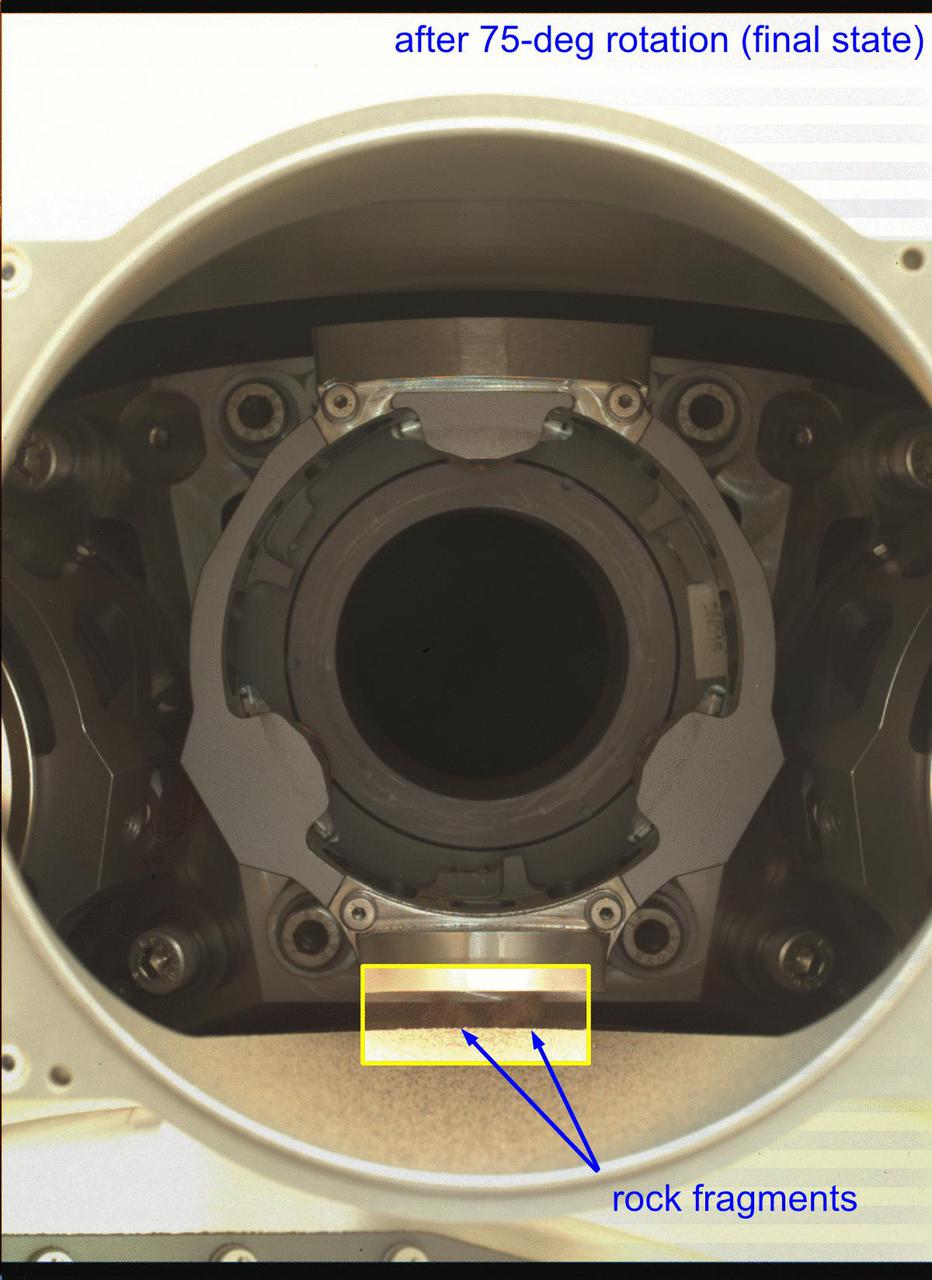
In this annotated animated GIF, the bit carousel on NASA's Perseverance Mars rover can be seen rotating during a test of the component on Jan. 17, 2022, the 325th Martian day, or sol, of the mission. The carousel was rotated about 75 degrees during the test, then was returned back to its original position. The five images that compose this animated GIF were captured to determine the status – after the test – of four fragments of the cored rock that fell out of the sample tube during Perseverance sampling activity on Dec. 29, 2021. After completion of the test, the upper two rock fragments (seen in the first image) have disappeared, having been ejected during the rotation. However, the lower two rock fragments, located below the bit carousel housing, remain. The five images that make up the GIF were obtained by the WATSON (Wide Angle Topographic Sensor for Operations and eNgineering) camera. Located in the turret at the end of the rover's robotic arm, WATSON can document the structure and texture within a drilled or abraded target, and its data can be used to derive depth measurements. The camera is a subsystem of the SHERLOC (Scanning Habitable Environments with Raman & Luminescence for Organics & Chemicals) instrument. NASA's Jet Propulsion Laboratory built and manages operations of Perseverance and Ingenuity for the agency. Caltech in Pasadena, California, manages JPL for NASA. WATSON was built by Malin Space Science Systems (MSSS) in San Diego and is operated jointly by MSSS and JPL. A key objective for Perseverance's mission on Mars is astrobiology, including the search for signs of ancient microbial life. The rover will characterize the planet's geology and past climate, pave the way for human exploration of the Red Planet, and be the first mission to collect and cache Martian rock and regolith (broken rock and dust). Subsequent NASA missions, in cooperation with ESA (European Space Agency), would send spacecraft to Mars to collect these sealed samples from the surface and return them to Earth for in-depth analysis. The Mars 2020 Perseverance mission is part of NASA's Moon to Mars exploration approach, which includes Artemis missions to the Moon that will help prepare for human exploration of the Red Planet. Animation available at https://photojournal.jpl.nasa.gov/catalog/PIA25071
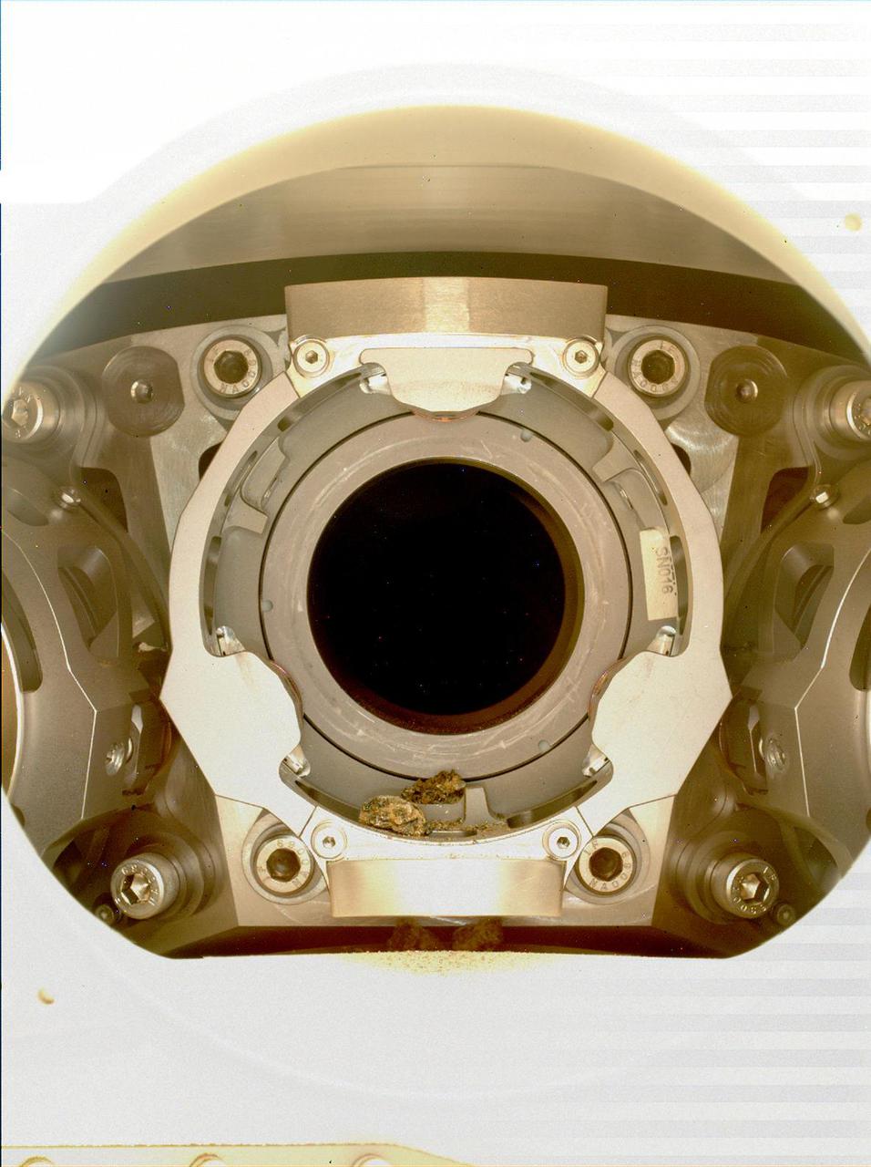
This image of pebble-sized debris in the bit carousel on NASA's Perseverance Mars rover was acquired on Jan. 7, 2022, by the WATSON camera. The image was taken to assist the Perseverance team in diagnosing an anomaly that occurred during a rock sampling on Dec. 29, 2021. A subsystem of the SHERLOC (Scanning Habitable Environments with Raman & Luminescence for Organics & Chemicals) instrument, WATSON can document the structure and texture within a drilled or abraded target, and its data can be used to derive depth measurements. NASA's Jet Propulsion Laboratory built and manages operations of Perseverance and Ingenuity for the agency. Caltech in Pasadena, California, manages JPL for NASA. WATSON was built by Malin Space Science Systems (MSSS) in San Diego and is operated jointly by MSSS and JPL. A key objective for Perseverance's mission on Mars is astrobiology, including the search for signs of ancient microbial life. The rover will characterize the planet's geology and past climate, pave the way for human exploration of the Red Planet, and be the first mission to collect and cache Martian rock and regolith (broken rock and dust). Subsequent NASA missions, in cooperation with ESA (European Space Agency), would send spacecraft to Mars to collect these sealed samples from the surface and return them to Earth for in-depth analysis. The Mars 2020 Perseverance mission is part of NASA's Moon to Mars exploration approach, which includes Artemis missions to the Moon that will help prepare for human exploration of the Red Planet. https://photojournal.jpl.nasa.gov/catalog/PIA25066
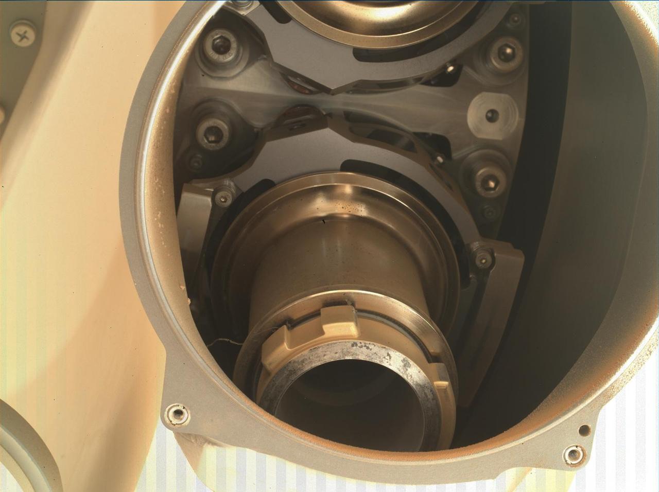
This image shows the back of Coring Bit 2 in the bit carousel of NASA's Perseverance Mars rover. A wavy, stringlike piece of foreign object debris (FOD) can be seen on the left side of the bit (the lower center of image). Coring Bit 2 was recently used to sample the sedimentary rock at "Wildcat Ridge." The image was obtained by the WATSON (Wide Angle Topographic Sensor for Operations and eNgineering) camera on Aug. 17, 2022, the 531st Martian day, or sol, of the mission. Located in the turret at the end of the rover's robotic arm, WATSON can document the structure and texture within a natural (intact), drilled, or abraded target, and its data can be used to derive depth measurements. The camera is a subsystem of the SHERLOC (Scanning Habitable Environments with Raman & Luminescence for Organics & Chemicals) instrument. NASA's Jet Propulsion Laboratory built and manages operations of Perseverance and Ingenuity for the agency. Caltech in Pasadena, California, manages JPL for NASA. WATSON was built by Malin Space Science Systems (MSSS) in San Diego and is operated jointly by MSSS and JPL. A key objective for Perseverance's mission on Mars is astrobiology, including the search for signs of ancient microbial life. The rover will characterize the planet's geology and past climate, pave the way for human exploration of the Red Planet, and be the first mission to collect and cache Martian rock and regolith (broken rock and dust). Subsequent NASA missions, in cooperation with ESA (European Space Agency), would send spacecraft to Mars to collect these sealed samples from the surface and return them to Earth for in-depth analysis. The Mars 2020 Perseverance mission is part of NASA's Moon to Mars exploration approach, which includes Artemis missions to the Moon that will help prepare for human exploration of the Red Planet. https://photojournal.jpl.nasa.gov/catalog/PIA25327
JunoCam images aren't just for art and science -- sometimes they are processed to bring a chuckle. This image, processed by citizen scientist Jason Major, is titled "Jovey McJupiterface." By rotating the image 180 degrees and orienting it from south up, two white oval storms turn into eyeballs, and the "face" of Jupiter is revealed. The original image was acquired by JunoCam on NASA's Juno spacecraft on May 19, 2017 at 11:20 a.m. PT (2: 20 p.m. ET) from an altitude of 12,075 miles (19,433 kilometers). https://photojournal.jpl.nasa.gov/catalog/PIA21394 . - Enhanced image by Jason Major based on images provided courtesy of NASA/JPL-Caltech/SwRI/MSSS
A "brown barge" in Jupiter's South Equatorial Belt is captured in this color-enhanced image from NASA's Juno spacecraft. This color-enhanced image was taken at 10:28 p.m. PDT on July 15, 2018 (1:28 a.m. EDT on July 16), as the spacecraft performed its 14th close flyby of Jupiter. Citizen scientist Joaquin Camarena created this image using data from the spacecraft's JunoCam imager. https://photojournal.jpl.nasa.gov/catalog/PIA22940. Enhanced image by Joaquin Camarena based on images provided courtesy of NASA/JPL-Caltech/SwRI/MSSS
Detailed structure in the clouds of Jupiter's South Equatorial Belt brown barge is visible in this color-enhanced image taken at 10:28 p.m. PDT on July 15, 2018 (1:28 a.m. EDT on July 16), as the spacecraft performed its 14th close flyby of the gas giant planet. Citizen scientist Kevin M. Gill created this image using data from the spacecraft's JunoCam imager. https://photojournal.jpl.nasa.gov/catalog/PIA22941. Enhanced image by Kevin M. Gill (CC-BY) based on images provided courtesy of NASA/JPL-Caltech/SwRI/MSSS

This image of Jupiter's southern hemisphere was captured by NASA's Juno spacecraft as it performed a close flyby of the gas giant planet on Dec. 16, 2017. Juno captured this color-enhanced image at 10:24 a.m. PST (1:24 p.m. EST) when the spacecraft was about 19,244 miles (30,970 kilometers) from the tops of Jupiter's clouds at a latitude of 49.9 degrees south -- roughly halfway between the planet's equator and its south pole. Citizen scientist Gerald Eichstädt processed this image using data from the JunoCam imager. https://photojournal.jpl.nasa.gov/catalog/PIA21977. - Enhanced image by Gerald Eichstädt based on images provided courtesy of NASA/JPL-Caltech/SwRI/MSSS
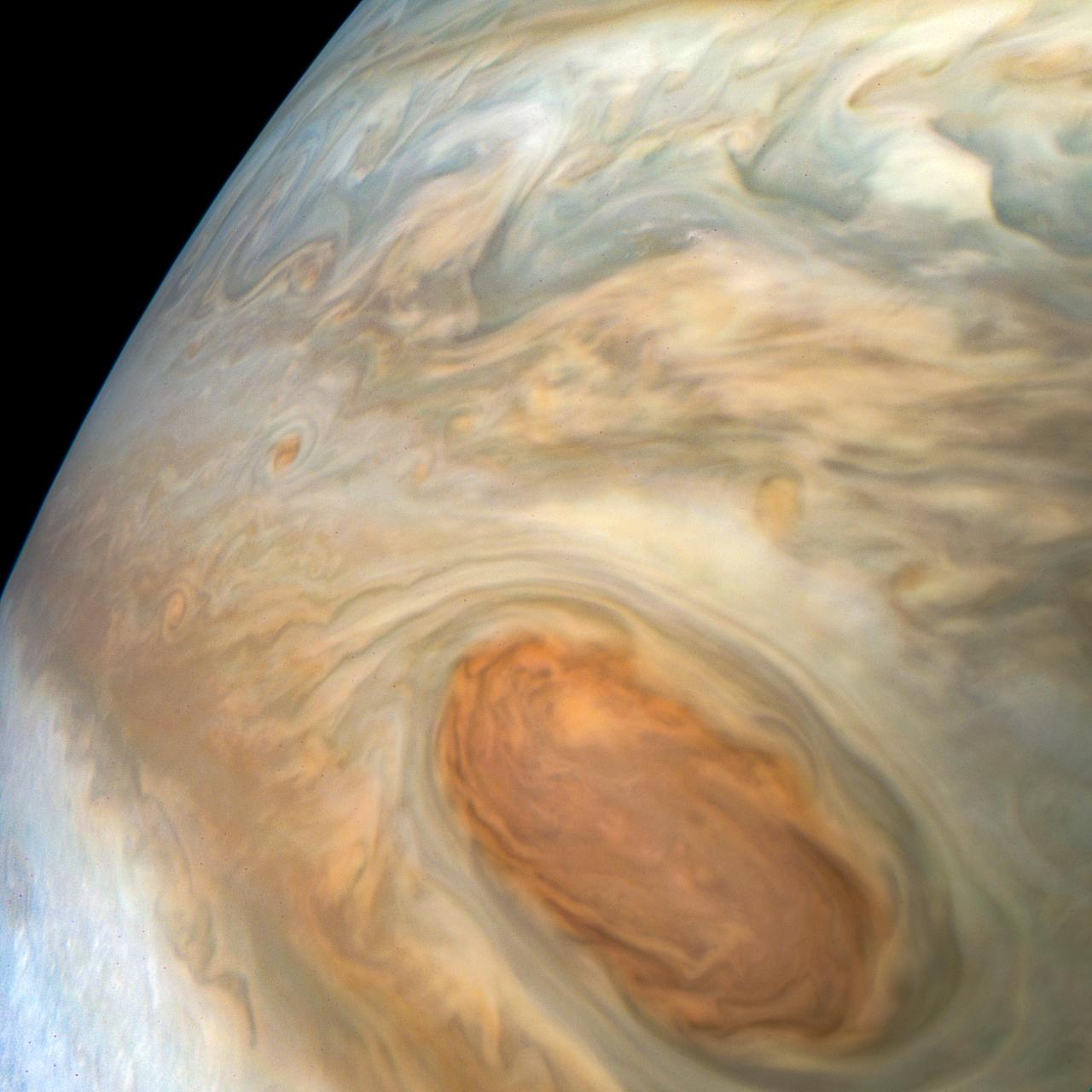
This enhanced-color image of Jupiter's Great Red Spot was created by citizen scientist Kevin Gill using data from the JunoCam imager on NASA's Juno spacecraft. The image was taken on July 10, 2017 at 07:07 p.m. PDT (10:07 p.m. EDT), as the Juno spacecraft performed its 7th close flyby of Jupiter. At the time the image was taken, the spacecraft was about 6,130 miles (9,866 kilometers) from the tops of the clouds of the planet. https://photojournal.jpl.nasa.gov/catalog/PIA21395 . - Enhanced image by Kevin M. Gill (CC-BY) based on images provided courtesy of NASA/JPL-Caltech/SwRI/MSSS
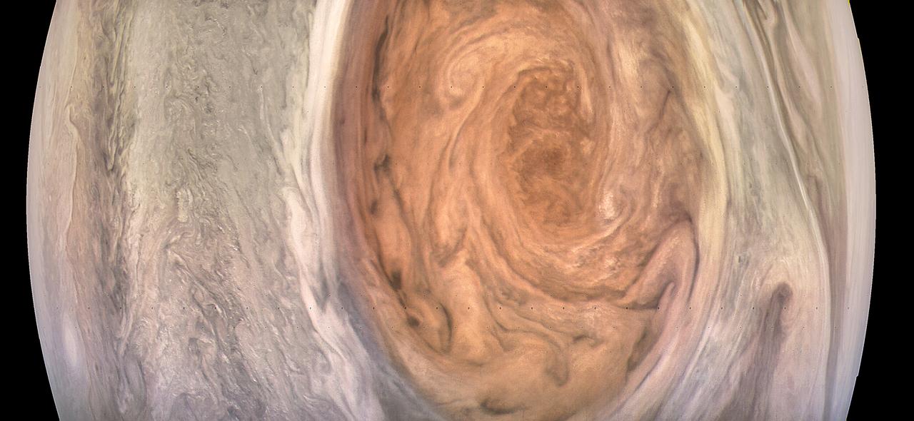
This enhanced-color image of Jupiter's Great Red Spot was created by citizen scientist Gerald Eichstädt using data from the JunoCam imager on NASA's Juno spacecraft. The image was taken on July 10, 2017 at 07:10 p.m. PDT (10:10 p.m. EDT), as the Juno spacecraft performed its 7th close flyby of Jupiter. At the time the image was taken, the spacecraft was about 8,648 miles (13,917 kilometers) from the tops of the clouds of the planet. https://photojournal.jpl.nasa.gov/catalog/PIA21772. - Enhanced image by Gerald Eichstädt based on images provided courtesy of NASA/JPL-Caltech/SwRI/MSSS
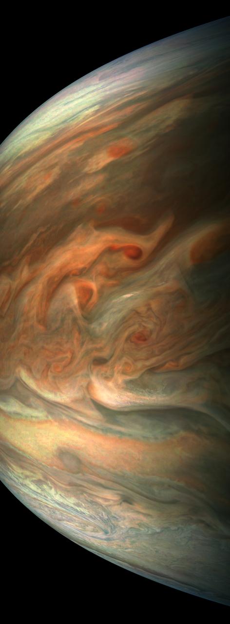
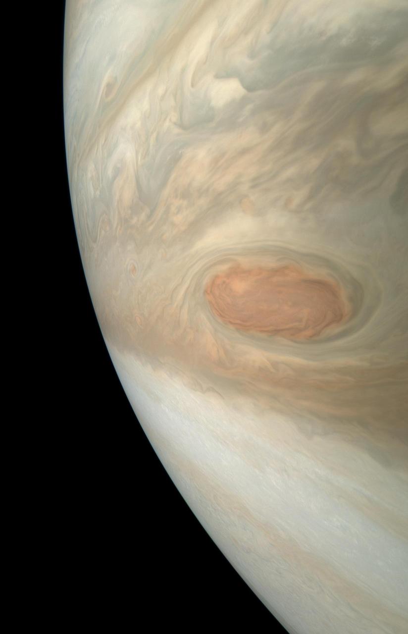
This striking image of Jupiter was captured by NASA's Juno spacecraft as it performed its eighth flyby of the gas giant planet. The image was taken on Sept. 1, 2017 at 2:58 p.m. PDT (5:58 p.m. EDT). At the time the image was taken, the spacecraft was 4,707 miles (7,576 kilometers) from the tops of the clouds of the planet at a latitude of about -17.4 degrees. Citizen scientist Gerald Eichstädt processed this image using data from the JunoCam imager. Points of interest are "Whale's Tail" and "Dan's Spot." https://photojournal.jpl.nasa.gov/catalog/PIA21966. - Enhanced image by Gerald Eichstädt based on images provided courtesy of NASA/JPL-Caltech/SwRI/MSSS

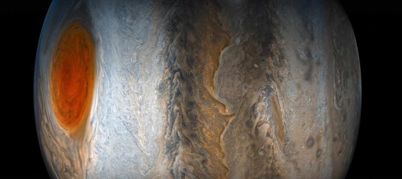
A south tropical disturbance that has just passed Jupiter's iconic Great Red Spot is captured in this color-enhanced image from NASA's Juno spacecraft. Threads of orange haze are pulled from the Great Red Spot by the turbulence of the south tropical disturbance. The image was taken at 3:04 a.m. PDT (6:04 p.m. EDT) on April 1, 2018, as the spacecraft performed its 12th close flyby of Jupiter. Citizen scientist Kevin M. Gill created this image using data from the spacecraft's JunoCam imager. https://photojournal.jpl.nasa.gov/catalog/PIA22938. - Enhanced image by Kevin M. Gill (CC-BY) based on images provided courtesy of NASA/JPL-Caltech/SwRI/MSSS
NASA Juno spacecraft skimmed the upper wisps of Jupiter atmosphere when JunoCam snapped this image on Feb. 2, 2017. from an altitude of about 9,000 miles 14,500 kilometers above the giant planet swirling cloudtops. Streams of clouds spin off a rotating oval-shaped cloud system in the Jovian southern hemisphere. Citizen scientist Roman Tkachenko reconstructed the color and cropped the image to draw viewers' eyes to the storm and the turbulence around it. http://photojournal.jpl.nasa.gov/catalog/PIA21383 . - Enhanced image by Roman Tkachenko (CC-BY) based on images provided courtesy of NASA/JPL-Caltech/SwRI/MSSS
See intricate cloud patterns in the northern hemisphere of Jupiter in this new view taken by NASA's Juno spacecraft. The color-enhanced image was taken on April 1, 2018 at 2:32 a.m. PST (5:32 a.m. EST), as Juno performed its twelfth close flyby of Jupiter. At the time the image was taken, the spacecraft was about 7,659 miles (12,326 kilometers) from the tops of the clouds of the planet at a northern latitude of 50.2 degrees. Citizen scientist Kevin M. Gill processed this image using data from the JunoCam imager. https://photojournal.jpl.nasa.gov/catalog/PIA21984 . - Enhanced image by Kevin M. Gill (CC-BY) based on images provided courtesy of NASA/JPL-Caltech/SwRI/MSSS
This image was taken at 7:21 p.m. PDT (10:21 p.m. EDT) on Sept. 6, 2018, as the spacecraft performed its 15th close flyby of Jupiter. The version of the image on the left side shows Jupiter in approximate true color, while the same image on the right has been processed to bring out detail close to the terminator and reveals four of the five southern circumpolar cyclones plus the cyclone in the center. Citizen scientist Björn Jónsson created this image using data from the spacecraft's JunoCam imager. https://photojournal.jpl.nasa.gov/catalog/PIA22933. - Enhanced image by Björn Jónsson (CC-NC-SA) based on images provided courtesy of NASA/JPL-Caltech/SwRI/MSSS
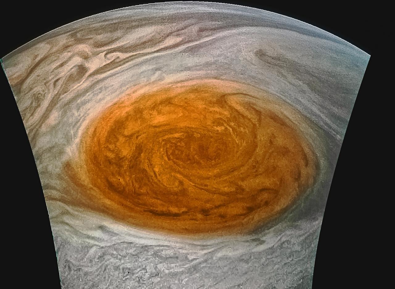
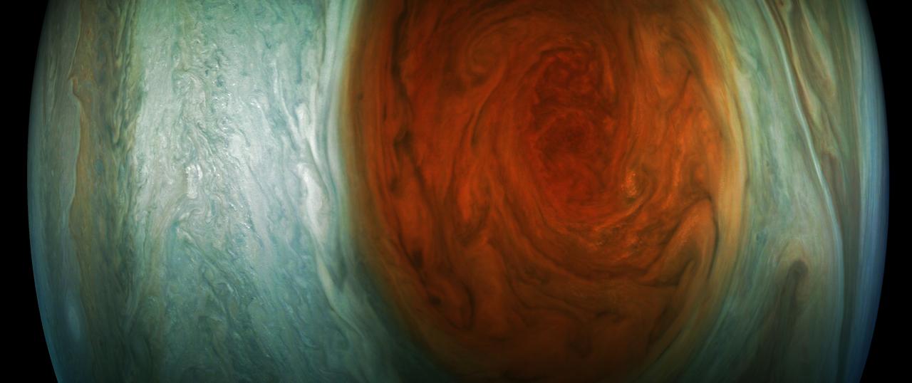
This enhanced-color image of Jupiter's Great Red Spot was created by citizen scientist Jason Major using data from the JunoCam imager on NASA's Juno spacecraft. The image was taken on July 10, 2017 at 07:10 p.m. PDT (10:10 p.m. EDT), as the Juno spacecraft performed its 7th close flyby of Jupiter. At the time the image was taken, the spacecraft was about 8,648 miles (13,917 kilometers) from the tops of the clouds of the planet. https://photojournal.jpl.nasa.gov/catalog/PIA21772 . - Enhanced image by Jason Major based on images provided courtesy of NASA/JPL-Caltech/SwRI/MSSS
A multitude of bright white "pop-up" storms in this Jupiter cloudscape appear in this image from NASA's Juno spacecraft. This color-enhanced image was taken at 1:55 p.m. PDT (4:55 p.m. EDT) on Oct. 29, 2018, as the spacecraft performed its 16th close flyby of Jupiter. Citizen scientists Gerald Eichstädt and Seán Doran created this image using data from the spacecraft's JunoCam imager. https://photojournal.jpl.nasa.gov/catalog/PIA22935 **Image Credit: Enhanced Image by Gerald Eichstädt and Seán Doran (CC BY-NC-SA) based on images provided courtesy of NASA/JPL-Caltech/SwRI/MSSS
A long, brown oval known as a "brown barge" in Jupiter's North North Equatorial Belt is captured in this color-enhanced image from NASA's Juno spacecraft. This image was taken at 6:01 p.m. PDT (9:01 p.m. EDT) on Sept. 6, 2018, as the spacecraft performed its 15th close flyby of Jupiter. Citizen scientist Kevin M. Gill created this image using data from the spacecraft's JunoCam imager. https://photojournal.jpl.nasa.gov/catalog/PIA22939. - Enhanced image by Kevin M. Gill (CC-BY) based on images provided courtesy of NASA/JPL-Caltech/SwRI/MSSS
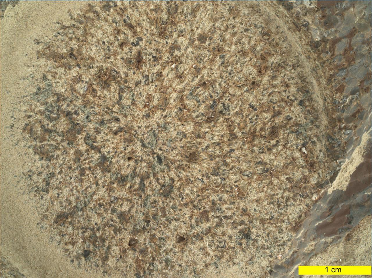
NASA's Perseverance Mars rover used its WATSON (Wide Angle Topographic Sensor for Operations and eNgineering) camera to take eight images – combined here into the single composite image – of a rock abraded by a tool on the rover's robotic arm. The images were taken on Aug. 27, 2021 (the 185th Martian day, or sol, of the mission). Nicknamed "Bellegarde," the abraded target is 0.4 inches (5 centimeters) in diameter. A subsystem of SHERLOC, WATSON can document the structure and texture within a drilled or abraded target, and its data can be used to derive depth measurements. The area within the blue box is roughly 6.5 millimeters squared. NASA's Jet Propulsion Laboratory built and manages operations of Perseverance and Ingenuity for the agency. Caltech in Pasadena, California, manages JPL for NASA. WATSON was built by Malin Space Science Systems (MSSS) in San Diego and is operated jointly by MSSS and JPL. A key objective for Perseverance's mission on Mars is astrobiology, including the search for signs of ancient microbial life. The rover will characterize the planet's geology and past climate, pave the way for human exploration of the Red Planet, and be the first mission to collect and cache Martian rock and regolith (broken rock and dust). Subsequent NASA missions, in cooperation with ESA (European Space Agency), would send spacecraft to Mars to collect these sealed samples from the surface and return them to Earth for in-depth analysis. The Mars 2020 Perseverance mission is part of NASA's Moon to Mars exploration approach, which includes Artemis missions to the Moon that will help prepare for human exploration of the Red Planet. https://photojournal.jpl.nasa.gov/catalog/PIA24770
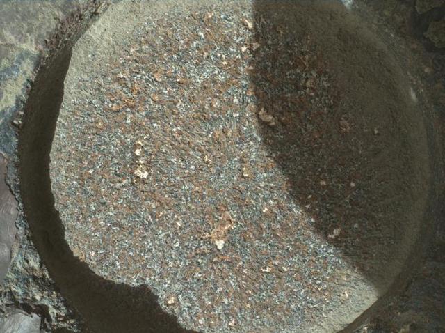
This close-up view of a rock target named "Dourbes" was provided by the WATSON (Wide Angle Topographic Sensor for Operations and eNgineering) camera on the end of the robotic arm aboard NASA's Perseverance Mars rover. WATSON took a series of eight fully-shadowed images on Nov. 5, 2021, the 253rd Martian day, or sol, of the mission, and the images were subsequently merged to create this view. Before drilling rocks, the rover abrades the rock surface using a tool on its robotic arm to clear away dust and weathering rinds, allowing other instruments to study the rocks in detail. The abraded patch is 2 inches (5 centimeters) in diameter. Perseverance subsequently acquired two rock core samples from this outcrop, called "Brac," which forms part of the "South Séítah" geologic unit of Jezero Crater. The WATSON image shows that the abrasion patch is dominated by discrete areas of light-toned material, with subordinate brown, dark-toned interstitial areas. The chemistry and mineralogy of the abrasion patch was analysed by a series of co-registered observations using the SuperCam, Mastcam-Z, PIXL (Planetary Instrument for X-ray Lithochemistry), and SHERLOC (Scanning Habitable Environments with Raman & Luminescence for Organics & Chemicals) instruments. A subsystem of an instrument called SHERLOC (Scanning Habitable Environments with Raman & Luminescence for Organics & Chemicals), WATSON can document the structure and texture within a drilled or abraded target, and its data can be used to derive depth measurements. WATSON was built by Malin Space Science Systems (MSSS) in San Diego and is operated jointly by MSSS and JPL. A key objective for Perseverance's mission on Mars is astrobiology, including the search for signs of ancient microbial life. The rover will characterize the planet's geology and past climate, pave the way for human exploration of the Red Planet, and be the first mission to collect and cache Martian rock and regolith (broken rock and dust). Subsequent NASA missions, in cooperation with ESA (European Space Agency), would send spacecraft to Mars to collect these sealed samples from the surface and return them to Earth for in-depth analysis. The Mars 2020 Perseverance mission is part of NASA's Moon to Mars exploration approach, which includes Artemis missions to the Moon that will help prepare for human exploration of the Red Planet. https://photojournal.jpl.nasa.gov/catalog/PIA24940

This image captures a close-up view of a storm with bright cloud tops in the northern hemisphere of Jupiter. NASA's Juno spacecraft took this color-enhanced image on Feb. 7 at 5:38 a.m. PST (8:38 a.m. EST) during its 11th close flyby of the gas giant planet. At the time, the spacecraft was 7,578 miles (12,195 kilometers) from the tops of Jupiter's clouds at 49.2 degrees north latitude. Citizen scientist Matt Brealey processed the image using data from the JunoCam imager. Citizen scientist Gustavo B C then adjusted colors and embossed Matt Brealey's processing of this storm. https://photojournal.jpl.nasa.gov/catalog/PIA21981 . - Enhanced image by Matt Brealey / Gustavo B C based on images provided courtesy of NASA/JPL-Caltech/SwRI/MSSS
In this view of Jupiter, NASA's Juno spacecraft captures swirling clouds in the region of the giant planet's northern hemisphere known as "Jet N4." Jupiter spins once every 10 hours, and this fast rotation creates strong jet streams, separating its clouds into dark belts and bright zones that stretch across the face of the planet. More than a dozen prevailing winds sweep over Jupiter, some reaching more than 300 miles per hour (480 kilometers per hour) at the equator. The raw image was taken on Sept. 11, 2019 at 8:31 p.m. PDT (11:31 p.m. EDT), as Juno performed its 22nd close flyby of Jupiter. At the time the image was taken, the spacecraft was about 7,540 miles (12,140 kilometers) from the cloud tops at a latitude of 45 degrees. Enhanced image by Björn Jónsson (CC-NC-SA) based on images provided courtesy of NASA/JPL-Caltech/SwRI/MSSS.

This close-up view of Jupiter captures the turbulent region just west of the Great Red Spot in the South Equatorial Belt, with resolution better than any previous pictures from Earth or other spacecraft. NASA's Juno spacecraft captured this image with its JunoCam citizen science instrument when the spacecraft was a mere 5,400 miles (8,700 kilometers) above Jupiter's cloudtops on Dec. 11, 2016 at 9:14 a.m. PT (12:14 p.m. ET). Citizen scientist Sergey Dushkin produced the sublime color processing and cropped the image to draw viewers' eyes to the dynamic clouds. http://photojournal.jpl.nasa.gov/catalog/PIA21384 . - Enhanced image by Sergey Dushkin based on images provided courtesy of NASA/JPL-Caltech/SwRI/MSSS
NASA's Juno spacecraft saw this striking vista during its most recent close flyby of Jupiter. This view highlights the contrast between the colorful South Equatorial Belt and the mostly white Southern Tropical Zone, a latitude that also features Jupiter's most famous phenomenon, the persistent, anticyclonic storm known as the Great Red Spot. Citizen scientist Kevin M. Gill created this image using data from the spacecraft's JunoCam imager. The raw image was taken on July 20, 2019, at 9:37 p.m. PDT (July 21, 2019, at 12:37 a.m. EDT) as the Juno spacecraft performed its 21st close flyby of Jupiter. At the time the image was taken, the spacecraft was 26,697 miles (42,965 kilometers) from the tops of the clouds, above a latitude of 46 degrees south. Enhanced image by Kevin M. Gill (CC-BY) based on images provided courtesy of NASA/JPL-Caltech/SwRI/MSSS.
This image of Jupiter's iconic Great Red Spot (GRS) was created by citizen scientist Björn Jónsson using data from the JunoCam imager on NASA's Juno spacecraft. This true-color image offers a natural color rendition of what the Great Red Spot and surrounding areas would look like to human eyes from Juno's position. The tumultuous atmospheric zones in and around the Great Red Spot are clearly visible. The image was taken on July 10, 2017 at 07:10 p.m. PDT (10:10 p.m. EDT), as the Juno spacecraft performed its seventh close flyby of Jupiter. At the time the image was taken, the spacecraft was about 8,648 miles (13,917 kilometers) from the tops of the clouds of the planet at a latitude of -32.6 degrees. https://photojournal.jpl.nasa.gov/catalog/PIA21775. - Enhanced image by Björn Jónsson (CC-NC-SA) based on images provided courtesy of NASA/JPL-Caltech/SwRI/MSSS
A south tropical disturbance has just passed Jupiter's iconic Great Red Spot and is captured stealing threads of orange haze from the Great Red Spot in this series of color-enhanced images from NASA's Juno spacecraft. From left to right, this sequence of images was taken between 2:57 a.m. and 3:36 a.m. PDT (5:57 a.m. and 6:36 a.m. EDT) on April 1, 2018, as the spacecraft performed its 12th close flyby of Jupiter. Citizen scientists Gerald Eichstädt and Seán Doran created this image using data from the spacecraft's JunoCam imager. https://photojournal.jpl.nasa.gov/catalog/PIA22937 ** Image Credit: Enhanced Image by Gerald Eichstädt and Seán Doran (CC BY-NC-SA) based on images provided courtesy of NASA/JPL-Caltech/SwRI/MSSS

When team members from NASA's Juno mission invited the public to process JunoCam images, they did not anticipate that they would receive back such beautiful, creative expressions of art. The oranges and grayed-out regions of blue-green in this tiled and color-enhanced image resemble a color scheme much like Romantic era paintings, but more abstract. The lack of discreet objects to focus on allows the mind to seek familiar Earthly shapes, and the brightest spots seem to draw the eye. Citizen scientist Eric Jorgensen created this Jovian artwork with a JunoCam image taken when the spacecraft was at an altitude of 11,100 miles (17,800 kilometers) above Jupiter's cloudtops on Dec. 11, 2016 at 9:22 a.m. PT (12:22 p.m. ET). http://photojournal.jpl.nasa.gov/catalog/PIA21385 . - Enhanced image by Eric Jorgensen based on images provided courtesy of NASA/JPL-Caltech/SwRI/MSSS
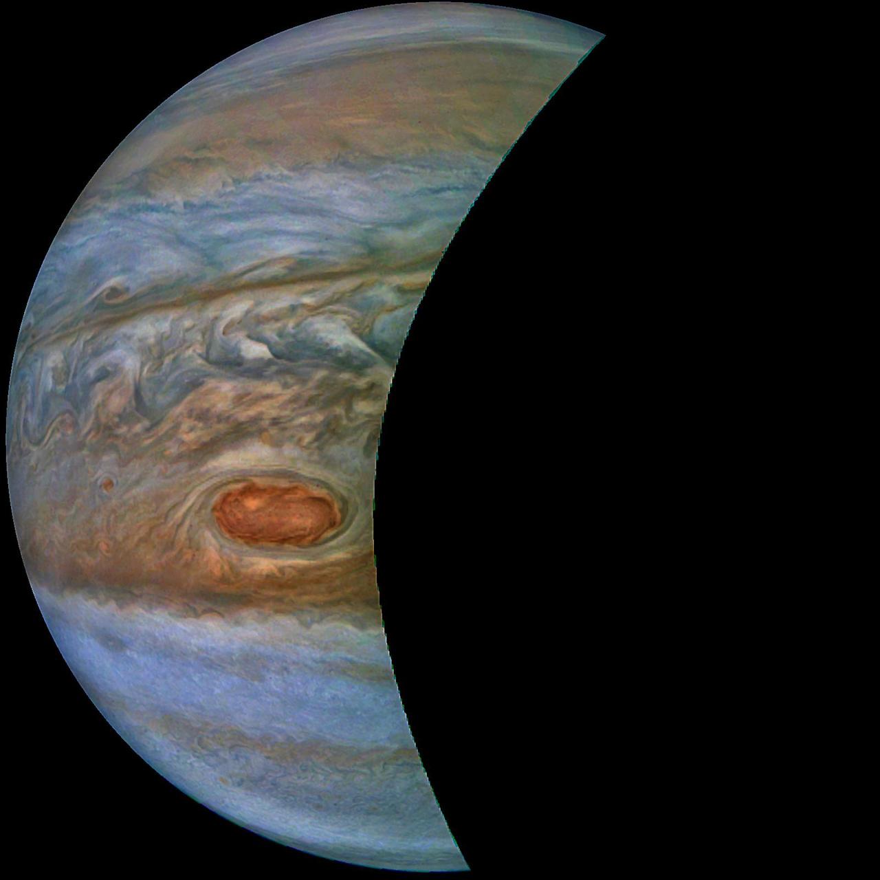
This image of a crescent Jupiter and the iconic Great Red Spot was created by a citizen scientist (Roman Tkachenko) using data from Juno's JunoCam instrument. You can also see a series of storms shaped like white ovals, known informally as the "string of pearls." Below the Great Red Spot a reddish long-lived storm known as Oval BA is visible. The image was taken on Dec. 11, 2016 at 2:30 p.m. PST (5:30 p.m. EST), as the Juno spacecraft performed its third close flyby of Jupiter. At the time the image was taken, the spacecraft was about 285,100 miles (458,800 kilometers) from the planet. http://photojournal.jpl.nasa.gov/catalog/PIA21376 . - Enhanced image by Roman Tkachenko (CC-BY) based on images provided courtesy of NASA/JPL-Caltech/SwRI/MSSS

Citizen scientist David Englund created this avant-garde Jovian artwork using data from the JunoCam imager on NASA's Juno spacecraft. The unique interpretation of Jupiter's Great Red Spot was done in a style that pays tribute to French Impressionist painter Claude Monet. The original image was taken on July 10, 2017 at 7:12 p.m. PDT (10:12 p.m. EDT), as the Juno spacecraft performed its 7th close flyby of Jupiter. At the time the image was taken, the spacecraft was 10,274 miles (16,535 kilometers) from the tops of the clouds of the planet, at a latitude of -36.9 degrees. https://photojournal.jpl.nasa.gov/catalog/PIA21779 . - Enhanced image by David Englund based on images provided courtesy of NASA/JPL-Caltech/SwRI/MSSS
The southern edge of Jupiter's north polar region is captured in this view from NASA's Juno spacecraft. The scene prominently displays a long, brown oval known as a "brown barge" located within a polar jet stream, called "Jet N4." This image was taken at 9:25 a.m. PST on Feb. 12, 2019 (12:25 p.m. EST), as the spacecraft performed its 18th close flyby of Jupiter. At the time, Juno was about 5,000 miles (8,000 kilometers) from the planet's cloud tops, above a latitude of approximately 44 degrees north. https://photojournal.jpl.nasa.gov/catalog/PIA22945. Enhanced image by Gerald Eichstädt and Justin Cowart based on images provided courtesy of NASA/JPL-Caltech/SwRI/MSSS

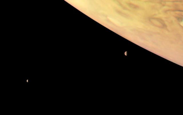
Jupiter's moon Io rises just off the horizon of the gas giant planet in this image from NASA's Juno spacecraft. Slightly larger than Earth's moon, Io is the most volcanically active world in the solar system. This color-enhanced image was taken at 2:26 p.m. PDT (5:56 p.m. EDT) on Oct. 29, 2018 as the spacecraft performed its 16th close flyby of Jupiter. At the time, Juno was about 11,400 miles (18,400 kilometers) from the planet's cloud tops, at approximately 32 degrees south latitude. https://photojournal.jpl.nasa.gov/catalog/PIA22693 . - Enhanced image by Gerald Eichstädt and Justin Cowart based on images provided courtesy of NASA/JPL-Caltech/SwRI/MSSS
Dramatic atmospheric features in Jupiter's northern hemisphere are captured in this view from NASA's Juno spacecraft. The new perspective shows swirling clouds that surround a circular feature within a jet stream region called "Jet N6." This color-enhanced image was taken at 9:20 a.m. PST (12:20 p.m. EST) on Feb. 12, 2019, as the spacecraft performed its 18th close flyby of the gas giant planet. At the time, Juno was about 8,000 miles (13,000 kilometers) from the planet's cloud tops, above a latitude of approximately 55 degrees north. https://photojournal.jpl.nasa.gov/catalog/PIA22944. Enhanced image by Kevin M. Gill (CC-BY) based on images provided courtesy of NASA/JPL-Caltech/SwRI/MSSS
See swirling cloud formations in the northern area of Jupiter's north temperate belt in this new view taken by NASA's Juno spacecraft. The color-enhanced image was taken on Feb. 7 at 5:42 a.m. PST (8:42 a.m. EST), as Juno performed its eleventh close flyby of Jupiter. At the time the image was taken, the spacecraft was about 5,086 miles (8,186 kilometers) from the tops of the clouds of the planet at a latitude of 39.9 degrees. Citizen scientist Kevin M. Gill processed this image using data from the JunoCam imager. https://photojournal.jpl.nasa.gov/catalog/PIA21978 . - Enhanced image by Kevin M. Gill (CC-BY) based on images provided courtesy of NASA/JPL-Caltech/SwRI/MSSS

This enhanced color view of Jupiter's south pole was created by citizen scientist Gabriel Fiset using data from the JunoCam instrument on NASA's Juno spacecraft. Oval storms dot the cloudscape. Approaching the pole, the organized turbulence of Jupiter's belts and zones transitions into clusters of unorganized filamentary structures, streams of air that resemble giant tangled strings. The image was taken on Dec. 11, 2016 at 9:44 a.m. PST (12:44 p.m. EST), from an altitude of about 32,400 miles (52,200 kilometers) above the planet's beautiful cloud tops. https://photojournal.jpl.nasa.gov/catalog/PIA21390 . - Enhanced image by Gabriel Fiset (CC-BY) based on images provided courtesy of NASA/JPL-Caltech/SwRI/MSSS
This image of Jupiter's southern hemisphere was captured by NASA's Juno spacecraft on the outbound leg of a close flyby of the gas-giant planet. The color-enhanced image was taken at 11:31 p.m. PDT on May 23, 2018 (2:31 a.m. EDT on May 24), as the spacecraft performed its 13th close flyby of Jupiter. At the time, Juno was about 44,300 miles (71,400 kilometers) from the planet's cloud tops, above a southern latitude of 71 degrees. JunoCam takes advantage of Juno's unique polar orbit, studying the atmospheric dynamics and clouds right up to Jupiter's poles, which no spacecraft has ever done before. Citizen scientist Kevin M. Gill created this image using data from the spacecraft's JunoCam imager. https://photojournal.jpl.nasa.gov/catalog/PIA22425 . - Enhanced image by Kevin M. Gill (CC-BY) based on images provided courtesy of NASA/JPL-Caltech/SwRI/MSSS

This striking view of Jupiter's Great Red Spot and turbulent southern hemisphere was captured by NASA's Juno spacecraft as it performed a close pass of the gas giant planet. Juno took the three images used to produce this color-enhanced view on Feb. 12, 2019, between 9:59 a.m. PST (12:59 p.m. EST) and 10:39 p.m. PST (1:39 p.m. EST), as the spacecraft performed its 17th science pass of Jupiter. At the time the images were taken, the spacecraft was between 16,700 miles (26,900 kilometers) and 59,300 miles (95,400 kilometers) above Jupiter's cloud tops, above a southern latitude spanning from about 40 to 74 degrees. https://photojournal.jpl.nasa.gov/catalog/PIA22946 Enhanced image by Kevin M. Gill (CC-BY) based on images provided courtesy of NASA/JPL-Caltech/SwRI/MSSS
This image captures the dynamic nature of Jupiter's northern temperate belt. The view reveals a white, oval-shaped anticyclonic storm called WS-4. NASA's Juno spacecraft took this color-enhanced image on April 1 at 2:38 a.m. PST (5:38 a.m. EST) during its 12th close flyby of the gas giant planet. At the time, the spacecraft was 4,087 miles (6,577 kilometers) from the tops of Jupiter's clouds at 35.6 degrees north latitude. This image was created by citizen scientist Emma Walimaki using data from the JunoCam imager on NASA's Juno spacecraft. https://photojournal.jpl.nasa.gov/catalog/PIA22420 . - Enhanced image by Emma Walimaki based on images provided courtesy of NASA/JPL-Caltech/SwRI/MSSS
This image, taken by the JunoCam imager on NASA's Juno spacecraft, highlights a swirling storm just south of one of the white oval storms on Jupiter. The image was taken on March 27, 2017, at 2:12 a.m. PDT (5:12 a.m. EDT), as the Juno spacecraft performed a close flyby of Jupiter. At the time the image was taken, the spacecraft was about 12,400 miles (20,000 kilometers) from the planet. Citizen scientist Jason Major enhanced the color and contrast in this image, turning the picture into a Jovian work of art. He then cropped it to focus our attention on this beautiful example of Jupiter's spinning storms. https://photojournal.jpl.nasa.gov/catalog/PIA21387 . - Enhanced image by Jason Major (CC-BY) based on images provided courtesy of NASA/JPL-Caltech/SwRI/MSSS

In the final minutes of a recent close flyby of Jupiter, NASA's Juno spacecraft captured a departing view of the planet's swirling southern hemisphere. This color-enhanced image was taken at 7:13 p.m. PDT on Sept. 6, 2018 (10:13 p.m. EDT) as the spacecraft performed its 15th close flyby of Jupiter. At the time, Juno was about 55,600 miles (89,500 kilometers) from the planet's cloud tops, above a southern latitude of approximately 75 degrees. Citizen scientist Gerald Eichstädt created this image using data from the spacecraft's JunoCam imager. https://photojournal.jpl.nasa.gov/catalog/PIA22690. - Enhanced image by Gerald Eichstädt based on images provided courtesy of NASA/JPL-Caltech/SwRI/MSSS

This frame from an animation takes the viewer on a simulated flight into, and then out of, Jupiter's upper atmosphere at the location of the Great Red Spot. The perspective begins about 2,000 miles (3,000 kilometers) above the cloud tops of the planet's southern hemisphere. The bar at far left indicates altitude during the quick descent; a second gauge next to that depicts the dramatic increase in temperature that occurs as the perspective dives deeper down. The clouds turn crimson as the perspective passes through the Great Red Spot. Finally, the view ascends out of the spot. This video was created by combining an image from the JunoCam imager on NASA's Juno spacecraft with a computer-generated animation. The animation is available at https://photojournal.jpl.nasa.gov/catalog/PIA22176. - Enhanced image by Gerald Eichstädt / Justin Cowart based on images provided courtesy of NASA/JPL-Caltech/SwRI/MSSS
This enhanced-color image of a mysterious dark spot on Jupiter seems to reveal a Jovian "galaxy" of swirling storms. Juno acquired this JunoCam image on Feb. 2, 2017, at 5:13 a.m. PDT (8:13 a.m. EDT), at an altitude of 9,000 miles (14,500 kilometers) above the giant planet's cloud tops. This publicly selected target was simply titled "Dark Spot." In ground-based images it was difficult to tell that it is a dark storm. Citizen scientist Roman Tkachenko enhanced the color to bring out the rich detail in the storm and surrounding clouds. Just south of the dark storm is a bright, oval-shaped storm with high, bright, white clouds, reminiscent of a swirling galaxy. As a final touch, he rotated the image 90 degrees, turning the picture into a work of art. http://photojournal.jpl.nasa.gov/catalog/PIA21386 . - Enhanced image by Roman Tkachenko (CC-BY) based on images provided courtesy of NASA/JPL-Caltech/SwRI/MSSS
This amateur-processed image was taken on Dec. 11, 2016, at 9:27 a.m. PST (12:27 p.m. EST), as NASA's Juno spacecraft performed its third close flyby of Jupiter. At the time the image was taken, the spacecraft was about 15,200 miles (24,400 kilometers) from the gas giant planet. The citizen scientist (Eric Jorgensen) cropped the JunoCam image and enhanced the color to draw attention to Jupiter's swirling clouds southeast of the "pearl." The "pearl" is one of eight massive rotating storms at 40 degrees south latitude on Jupiter, known colloquially as the "string of pearls." The processing of this image highlights the turbulence of the clouds in the south temperate belt of the planet. http://photojournal.jpl.nasa.gov/catalog/PIA21377 . - Enhanced image by Eric Jorgensen based on images provided courtesy of NASA/JPL-Caltech/SwRI/MSSS
This striking Jovian vista was created by citizen scientists Gerald Eichstädt and Seán Doran using data from the JunoCam imager on NASA's Juno spacecraft. The tumultuous Great Red Spot is fading from Juno's view while the dynamic bands of the southern region of Jupiter come into focus. North is to the left of the image, and south is on the right. The image was taken on July 10, 2017 at 7:12 p.m. PDT (10:12 p.m. EDT), as the Juno spacecraft performed its seventh close flyby of Jupiter. At the time the image was taken, the spacecraft was 10,274 miles (16,535 kilometers) from the tops of the clouds of the planet at a latitude of -36.9 degrees. https://photojournal.jpl.nasa.gov/catalog/PIA21778 **Image Credit: Enhanced Image by Gerald Eichstädt and Seán Doran (CC BY-NC-SA) based on images provided courtesy of NASA/JPL-Caltech/SwRI/MSSS https://creativecommons.org/licenses/by-nc-sa/3.0/
This animation shows each step of the Ingenuity helicopter deploying from the belly of NASA's Perseverance Mars rover from March 26 to April 3, 2021. The final image shows the helicopter on the ground after the rover drove about 13 feet (4 meters) away. These images were taken by the WATSON (Wide Angle Topographic Sensor for Operations and eNgineering) camera on the SHERLOC (Scanning Habitable Environments with Raman and Luminescence for Organics and Chemicals) instrument, located at the end of the rover's long robotic arm. NASA's Jet Propulsion Laboratory built and manages operations of Perseverance and Ingenuity for the agency. Caltech in Pasadena, California, manages JPL for NASA. WATSON was built by Malin Space Science Systems (MSSS) in San Diego and is operated jointly by MSSS and JPL. The Mars helicopter technology demonstration activity is supported by NASA's Science Mission Directorate, the NASA Aeronautics Research Mission Directorate, and the NASA Space Technology Mission Directorate. A key objective for Perseverance's mission on Mars is astrobiology, including the search for signs of ancient microbial life. The rover will characterize the planet's geology and past climate, pave the way for human exploration of the Red Planet, and be the first mission to collect and cache Martian rock and regolith (broken rock and dust). Subsequent NASA missions, in cooperation with ESA (European Space Agency), would send spacecraft to Mars to collect these sealed samples from the surface and return them to Earth for in-depth analysis. The Mars 2020 Perseverance mission is part of NASA's Moon to Mars exploration approach, which includes Artemis missions to the Moon that will help prepare for human exploration of the Red Planet. Animation available at https://photojournal.jpl.nasa.gov/catalog/PIA24548
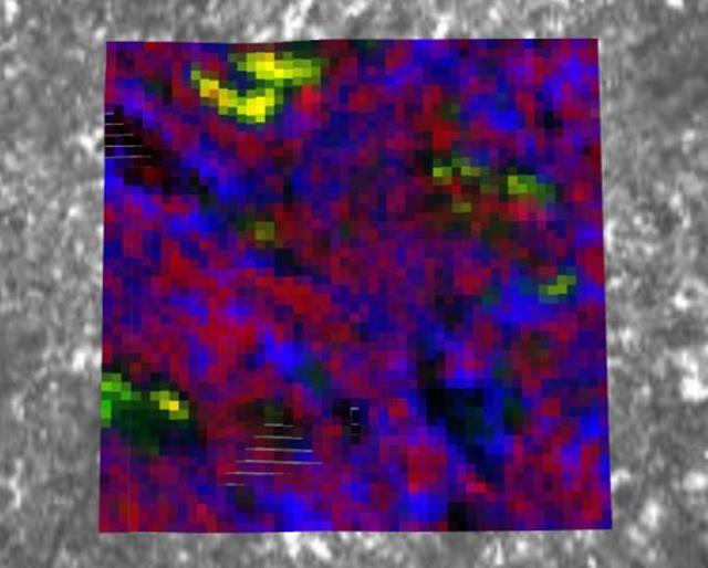
NASA's Perseverance Mars rover used its PIXL (Planetary Instrument for X-ray Lithochemistry) instrument to analyze the "Bellegarde" abrasion target – created when the rover scraped away surface area of the rock named "Rochette" – revealing salt minerals (the yellow color in the image). Salt crystals could have trapped bubbles of ancient water that, after the samples are returned to Earth, scientists could use to learn more about the environment these salts formed in. NASA's Jet Propulsion Laboratory built and manages operations of Perseverance and Ingenuity for the agency. Caltech in Pasadena, California, manages JPL for NASA. WATSON was built by Malin Space Science Systems (MSSS) in San Diego and is operated jointly by MSSS and JPL. A key objective for Perseverance's mission on Mars is astrobiology, including the search for signs of ancient microbial life. The rover will characterize the planet's geology and past climate, pave the way for human exploration of the Red Planet, and be the first mission to collect and cache Martian rock and regolith (broken rock and dust). Subsequent NASA missions, in cooperation with ESA (European Space Agency), would send spacecraft to Mars to collect these sealed samples from the surface and return them to Earth for in-depth analysis. The Mars 2020 Perseverance mission is part of NASA's Moon to Mars exploration approach, which includes Artemis missions to the Moon that will help prepare for human exploration of the Red Planet. https://photojournal.jpl.nasa.gov/catalog/PIA24835
The debris shield, a protective covering on the bottom of NASA's Perseverance rover, was released on March 21, 2021, the 30th Martian day, or sol, of the mission. The debris shield protects the agency's Ingenuity helicopter during landing; releasing it allows the helicopter to rotate down out of the rover's belly. This image was taken by the WATSON (Wide Angle Topographic Sensor for Operations and eNgineering) camera on the SHERLOC (Scanning Habitable Environments with Raman and Luminescence for Organics and Chemicals) instrument, located at the end of the rover's long robotic arm. NASA's Jet Propulsion Laboratory built and manages operations of Perseverance and Ingenuity for the agency. Caltech in Pasadena, California, manages JPL for NASA. WATSON was built by Malin Space Science Systems in San Diego, and is operated jointly by MSSS and JPL. The Mars helicopter technology demonstration activity is supported by NASA's Science Mission Directorate, the NASA Aeronautics Research Mission Directorate, and the NASA Space Technology Mission Directorate. A key objective for Perseverance's mission on Mars is astrobiology, including the search for signs of ancient microbial life. The rover will characterize the planet's geology and past climate, pave the way for human exploration of the Red Planet, and be the first mission to collect and cache Martian rock and regolith (broken rock and dust). Subsequent NASA missions, in cooperation with ESA (European Space Agency), would send spacecraft to Mars to collect these sealed samples from the surface and return them to Earth for in-depth analysis. The Mars 2020 Perseverance mission is part of NASA's Moon to Mars exploration approach, which includes Artemis missions to the Moon that will help prepare for human exploration of the Red Planet. Animation available at https://photojournal.jpl.nasa.gov/catalog/PIA24448

This image captures the swirling cloud formations around the south pole of Jupiter, looking up toward the equatorial region. NASA's Juno spacecraft took the color-enhanced image during its eleventh close flyby of the gas giant planet on Feb. 7 at 7:11 a.m. PST (10:11 a.m. EST). At the time, the spacecraft was 74,896 miles (120,533 kilometers) from the tops of Jupiter's clouds at 84.9 degrees south latitude. Citizen scientist Gerald Gerald Eichstädt processed this image using data from the JunoCam imager. This image was created by reprocessing raw JunoCam data using trajectory and pointing data from the spacecraft. This image is one in a series of images taken in an experiment to capture the best results for illuminated parts of Jupiter's polar region. To make features more visible in Jupiter's terminator -- the region where day meets night -- the Juno team adjusted JunoCam so that it would perform like a portrait photographer taking multiple photos at different exposures, hoping to capture one image with the intended light balance. For JunoCam to collect enough light to reveal features in Jupiter's dark twilight zone, the much brighter illuminated day-side of Jupiter becomes overexposed with the higher exposure. https://photojournal.jpl.nasa.gov/catalog/PIA21980. - Enhanced image by Gerald Eichstädt based on images provided courtesy of NASA/JPL-Caltech/SwRI/MSSS

See Jupiter's northern polar belt region in this view taken by NASA's Juno spacecraft. This color-enhanced image was taken on Dec. 16, 2017 at 9:47 a.m. PST (12:47 p.m. EST), as Juno performed its tenth close flyby of Jupiter. At the time the image was taken, the spacecraft was about 5,600 miles (8,787 kilometers) from the tops of the clouds of the planet at a latitude of 38.4 degrees north. Citizen scientist Björn Jónsson processed this image using data from the JunoCam imager. This image has been processed from the raw JunoCam framelets by removing the effects of global illumination. Jónsson then increased the contrast and color and sharpened smallscale features. The image has also been cropped. While at first glance the view may appear to be in Jupiter's south, the raw source images were obtained when Juno was above the planet's northern hemisphere looking south, potentially causing a sense of disorientation to the viewer. The geometry of the scene can be explored using the time of the image and the Juno mission module of NASA's Eyes on the Solar System. https://photojournal.jpl.nasa.gov/catalog/PIA21976. - Enhanced image by Björn Jónsson (CC-NC-SA) based on images provided courtesy of NASA/JPL-Caltech/SwRI/MSSS

See Jupiter's Great Red Spot as you've never seen it before in this new Jovian work of art. Artist Mik Petter created this unique, digital artwork using data from the JunoCam imager on NASA's Juno spacecraft. The art form, known as fractals, uses mathematical formulas to create art with an infinite variety of form, detail, color and light. The tumultuous atmospheric zones in and around the Great Red Spot are highlighted by the author's use of colorful fractals. Vibrant colors of various tints and hues, combined with the almost organic-seeming shapes, make this image seem to be a colorized and crowded petri dish of microorganisms, or a close-up view of microscopic and wildly-painted seashells. The original JunoCam image was taken on July 10, 2017 at 7:10 p.m. PDT (10:10 p.m. EDT), as the Juno spacecraft performed its seventh close flyby of Jupiter. The spacecraft captured the image from about 8,648 miles (13,917 kilometers) above the tops of the clouds of the planet at a latitude of -32.6 degrees. https://photojournal.jpl.nasa.gov/catalog/PIA21777 . - Enhanced image by Mik Petter (CC-NC-SA) based on images provided courtesy of NASA/JPL-Caltech/SwRI/MSSS
A swirling, oval white cloud in Jupiter's South South Temperate Belt is captured in this image from NASA's Juno spacecraft. Known as White Oval A5, the feature is an anticyclonic storm. An anticyclone is a weather phenomenon where winds around the storm flow in the direction opposite to those of the flow around a region of low pressure. Juno took the two images used to produce this color-enhanced view on Sept. 6, 2018, at 6:45 p.m. PDT (9:45 p.m. EDT) and 6:58 p.m. PDT (9:58 p.m. EDT) as the Juno spacecraft performed its 15th close flyby of Jupiter. At the time the images were taken, the spacecraft was about 25,000 miles (40,500 kilometers) to 39,000 miles (63,000 kilometers) from Jupiter's cloud tops, above a southern latitude spanning from about 54 to 66 degrees. https://photojournal.jpl.nasa.gov/catalog/PIA22691 . - Enhanced image by Kevin M. Gill (CC-BY) based on images provided courtesy of NASA/JPL-Caltech/SwRI/MSSS
This false color view of Jupiter's polar haze was created by citizen scientist Gerald Eichstädt using data from the JunoCam instrument on NASA's Juno spacecraft. The image was taken on Dec. 11, 2016 at 2:30 p.m. PST (5:30 p.m. EST), when the spacecraft was 285,000 miles (459,000 kilometers) from Jupiter on the outbound leg of its third close flyby. This image is composited from four images taken through different filters: red, green, blue and methane. When the near-infrared methane image is processed with the others, the result is a false color product that highlights high clouds and high altitude hazes. The Great Red Spot and Oval BA (just below the Great Red Spot) are high in Jupiter's atmosphere, thus bright in this picture. The high-altitude haze layer over the south pole partially obscures our view of the storms below. By combining the methane data with the visible light images, we can learn about the vertical structure of Jupiter's atmosphere. http://photojournal.jpl.nasa.gov/catalog/PIA21379. - Enhanced image by Gerald Eichstädt based on images provided courtesy of NASA/JPL-Caltech/SwRI/MSSS
This image captures a high-altitude cloud formation surrounded by swirling patterns in the atmosphere of Jupiter's North North Temperate Belt region. The North North Temperate Belt is one of Jupiter's many colorful, swirling cloud bands. Scientists have wondered for decades how deep these bands extend. Gravity measurements collected by Juno during its close flybys of the planet have now provided an answer. Juno discovered that these bands of flowing atmosphere actually penetrate deep into the planet, to a depth of about 1,900 miles (3,000 kilometers). NASA's Juno spacecraft took this color-enhanced image at 10:11 p.m. PDT on July 15, 2018 (1:11 a.m. EDT on July 16), as the spacecraft performed its 14th close flyby of Jupiter. At the time, Juno was about 3,900 miles (6,200 kilometers) from the planet's cloud tops, above a latitude of 36 degrees. Citizen scientist Jason Major created this image using data from the spacecraft's JunoCam imager. https://photojournal.jpl.nasa.gov/catalog/PIA22426 . - Enhanced image by Jason Major based on images provided courtesy of NASA/JPL-Caltech/SwRI/MSSS
A swirling storm somersaults through Jupiter's South Equatorial Belt in this view taken by NASA's Juno spacecraft. This feature -- not to be confused with the planet's iconic Great Red Spot -- is escorted by several smaller, reddish vortices above and to the left. This natural color view offers an approximation of what Jupiter would look like to human eyes from Juno's vantage point near the time of closest approach in its orbit. Jupiter's stunning appearance is due to its atmosphere of colorful cloud bands and spots. The vivid red and orange hues are created by chemicals of uncertain composition called "chromophores." The image was taken at 10:28 p.m. PDT on July 15, 2018 (1:28 a.m. EDT on July 16), as the spacecraft performed its 14th close flyby of Jupiter. At the time, Juno was about 4,900 miles (8,000 kilometers) from the planet's cloud tops, above a southern latitude of 36 degrees. Citizen scientist Björn Jónsson created this image using data from the spacecraft's JunoCam imager. https://photojournal.jpl.nasa.gov/catalog/PIA22427. - Enhanced image by Björn Jónsson (CC-NC-SA) based on images provided courtesy of NASA/JPL-Caltech/SwRI/MSSS

This enhanced color Jupiter image, taken by the JunoCam imager on NASA's Juno spacecraft, showcases several interesting features on the apparent edge (limb) of the planet. Prior to Juno's fifth flyby over Jupiter's mysterious cloud tops, members of the public voted on which targets JunoCam should image. This picture captures not only a fascinating variety of textures in Jupiter's atmosphere, it also features three specific points of interest: "String of Pearls," "Between the Pearls," and "An Interesting Band Point." Also visible is what's known as the STB Spectre, a feature in Jupiter's South Temperate Belt where multiple atmospheric conditions appear to collide. JunoCam images of Jupiter sometimes appear to have an odd shape. This is because the Juno spacecraft is so close to Jupiter that it cannot capture the entire illuminated area in one image -- the sides get cut off. Juno acquired this image on March 27, 2017, at 2:12 a.m. PDT (5:12 a.m. EDT), as the spacecraft performed a close flyby of Jupiter. When the image was taken, the spacecraft was about 12,400 miles (20,000 kilometers) from the planet. https://photojournal.jpl.nasa.gov/catalog/PIA21389. - Enhanced image by Björn Jónsson (CC-NC-SA) based on images provided courtesy of NASA/JPL-Caltech/SwRI/MSSS
Colorful swirling clouds in Jupiter's North Equatorial Belt practically fill this image from NASA's Juno spacecraft. This is the closest image captured of the Jovian clouds during this recent flyby of the gas giant planet. The color-enhanced image was taken at 2:08 p.m. PDT (5:08 p.m. EDT) on Oct. 29, 2018 as the spacecraft performed its 16th close flyby of Jupiter. At the time, Juno was about 2,100 miles (3,400 kilometers) from the planet's cloud tops, at approximately 14 degrees north latitude. In other words, the spacecraft was about as close to Jupiter as San Francisco is to Chicago, which is quite close when racing over a planet that's 11 times wider than Earth. Citizen scientist Björn Jónsson created this image using data from the spacecraft's JunoCam imager. https://photojournal.jpl.nasa.gov/catalog/PIA22695. - Enhanced image by Björn Jónsson (CC-NC-SA) based on images provided courtesy of NASA/JPL-Caltech/SwRI/MSSS
This image, taken by the JunoCam imager on NASA's Juno spacecraft, highlights a feature on Jupiter where multiple atmospheric conditions appear to collide. This publicly selected target is called "STB Spectre." The ghostly bluish streak across the right half of the image is a long-lived storm, one of the few structures perceptible in these whitened latitudes where the south temperate belt of Jupiter would normally be. The egg-shaped spot on the lower left is where incoming small dark spots make a hairpin turn. The image was taken on March 27, 2017, at 2:06 a.m. PDT (5:06 a.m. EDT), as the Juno spacecraft performed a close flyby of Jupiter. When the image was taken, the spacecraft was 7,900 miles (12,700 kilometers) from the planet. The image was processed by Roman Tkachenko, and the description is from John Rogers, the citizen scientist who identified the point of interest. https://photojournal.jpl.nasa.gov/catalog/PIA21388 . - Enhanced image by Roman Tkachenko (CC-BY) based on images provided courtesy of NASA/JPL-Caltech/SwRI/MSSS
This view from NASA's Juno spacecraft captures colorful, intricate patterns in a jet stream region of Jupiter's northern hemisphere known as "Jet N3." Jupiter's cloud tops do not form a simple, flat surface. Data from Juno helped scientists discover that the swirling bands in the atmosphere extend deep into the planet, to a depth of about 1,900 miles (3,000 kilometers). At center right, a patch of bright, high-altitude "pop-up" clouds rises above the surrounding atmosphere. Citizen scientist Gerald Eichstädt created this enhanced-color image using data from the spacecraft's JunoCam imager. The original image was taken on May 29, 2019, at 1:01 a.m. PDT (4:01 a.m. EDT) as the Juno spacecraft performed its 20th close flyby of Jupiter. At the time the image was taken, the spacecraft was about 6,000 miles (9,700 kilometers) from the tops of the clouds, at a latitude of 39 degrees north. PIA23439 - Enhanced image by Gerald Eichstädt based on images provided courtesy of NASA/JPL-Caltech/SwRI/MSSS
The JunoCam imager on NASA's Juno spacecraft snapped this shot of Jupiter's northern latitudes on Dec. 11, 2016 at 8:47 a.m. PST (11:47 a.m. EST), as the spacecraft performed a close flyby of the gas giant planet. The spacecraft was at an altitude of 10,300 miles (16,600 kilometers) above Jupiter's cloud tops. This stunning view of the high north temperate latitudes fortuitously shows NN-LRS-1, a giant storm known as the Little Red Spot (lower left). This storm is the third largest anticyclonic reddish oval on the planet, which Earth-based observers have tracked for the last 23 years. An anticyclone is a weather phenomenon with large-scale circulation of winds around a central region of high atmospheric pressure. They rotate clockwise in the northern hemisphere, and counterclockwise in the southern hemisphere. The Little Red Spot shows very little color, just a pale brown smudge in the center. The color is very similar to the surroundings, making it difficult to see as it blends in with the clouds nearby. Citizen scientists Gerald Eichstaedt and John Rogers processed the image and drafted the caption. http://photojournal.jpl.nasa.gov/catalog/PIA21378. - Enhanced image by Gerald Eichstädt / John Rogers based on images provided courtesy of NASA/JPL-Caltech/SwRI/MSSS

This series of images captures cloud patterns near Jupiter's south pole, looking up towards the planet's equator. NASA's Juno spacecraft took the color-enhanced time-lapse sequence of images during its eleventh close flyby of the gas giant planet on Feb. 7 between 7:21 a.m. and 8:01 a.m. PST (10:21 a.m. and 11:01 a.m. EST). At the time, the spacecraft was between 85,292 to 124,856 miles (137,264 to 200,937 kilometers) from the tops of the clouds of the planet with the images centered on latitudes from 84.1 to 75.5 degrees south. At first glance, the series might appear to be the same image repeated. But closer inspection reveals slight changes, which are most easily noticed by comparing the far left image with the far right image. Directly, the images show Jupiter. But, through slight variations in the images, they indirectly capture the motion of the Juno spacecraft itself, once again swinging around a giant planet hundreds of millions of miles from Earth. https://photojournal.jpl.nasa.gov/catalog/PIA21979. - Enhanced image by Gerald Eichstädt based on images provided courtesy of NASA/JPL-Caltech/SwRI/MSSS

Colorful swirling cloud belts dominate Jupiter's southern hemisphere in this image captured by NASA's Juno spacecraft. Jupiter appears in this color-enhanced image as a tapestry of vibrant cloud bands and storms. The dark region in the far left is called the South Temperate Belt. Intersecting the belt is a ghost-like feature of slithering white clouds. This is the largest feature in Jupiter's low latitudes that's a cyclone (rotating with clockwise motion). This image was taken on Dec. 16, 2017 at 10:12 PST (1:12 p.m. EST), as Juno performed its tenth close flyby of Jupiter. At the time the image was taken, the spacecraft was about 8,453 miles (13,604 kilometers) from the tops of the clouds of the planet at a latitude of 27.9 degrees south. The spatial scale in this image is 5.6 miles/pixel (9.1 kilometers/pixel). Citizen scientist Kevin M. Gill processed this image using data from the JunoCam imager. https://photojournal.jpl.nasa.gov/catalog/PIA21974 . - Enhanced image by Kevin M. Gill (CC-BY) based on images provided courtesy of NASA/JPL-Caltech/SwRI/MSSS
This images is one of two true-color images taken 12 minutes apart neatly captures storm movement in the southern hemisphere of Jupiter. NASA's Juno spacecraft took these images during its tenth close flyby of the gas giant planet on Dec. 16, 2017 at 10:12 a.m. PST (1:12 p.m. EST) and 10:24 a.m. PST (1:24 p.m. EST). At the time, the spacecraft was about 8,453 miles (13,604 kilometers) and 19,244 miles (30,970 kilometers) from the tops of the clouds above the planet, with the images centered on south latitudes of 27.96 degrees and 49.91 degrees. The animation reveals the cyclonic motion of the STB Ghost, a large elongated feature in Jupiter's South Temperate Belt. This feature is elongated in the east-west direction and is located near the center in these images. Citizen scientist Björn Jónsson processed the image using data from the JunoCam imager. An animation is available at https://photojournal.jpl.nasa.gov/catalog/PIA21982. - Enhanced image by Björn Jónsson (CC-NC-SA) based on images provided courtesy of NASA/JPL-Caltech/SwRI/MSSS
This color-enhanced image of Jupiter and two of its largest moons -- Io and Europa -- was captured by NASA's Juno spacecraft as it performed its eighth flyby of the gas giant planet. The image was taken on Sept. 1, 2017 at 3:14 p.m. PDT (6:14 p.m. EDT). At the time the image was taken, the spacecraft was about 17,098 miles (27,516 kilometers) from the tops of the clouds of the planet at a latitude of minus 49.372 degrees. Closer to the planet, the Galilean moon of Io can be seen at an altitude of 298,880 miles (481,000 kilometers) and at a spatial scale of 201 miles (324 kilometers) per pixel. In the distance (to the left), another one of Jupiter's Galilean moons, Europa, is visible at an altitude of 453,601 miles (730,000 kilometers) and at a spatial scale of 305 miles (492 kilometers) per pixel. Citizen scientist Roman Tkachenko processed this image using data from the JunoCam imager. https://photojournal.jpl.nasa.gov/catalog/PIA21968 . - Enhanced image by Roman Tkachenko (CC-BY) based on images provided courtesy of NASA/JPL-Caltech/SwRI/MSSS
This stunning compilation image of Jupiter's stormy northern hemisphere was captured by NASA's Juno spacecraft as it performed a close pass of the gas giant planet. Some bright-white clouds can be seen popping up to high altitudes on the right side of Jupiter's disk. (The Juno team frequently refers to clouds like these as "pop-up" clouds in image captions.) Juno took the four images used to produce this color-enhanced view on May 29, 2019, between 12:52 a.m. PDT (3:52 a.m. EDT) and 1:03 a.m. PDT (4:03 a.m. EDT), as the spacecraft performed its 20th science pass of Jupiter. At the time the images were taken, the spacecraft was between 11,600 miles (18,600 kilometers) and 5,400 miles (8,600 kilometers) above Jupiter's cloud tops, above a northern latitude spanning from about 59 to 34 degrees. Enhanced image by Kevin M. Gill (CC-BY) based on images provided courtesy of NASA/JPL-Caltech/SwRI/MSSS https://photojournal.jpl.nasa.gov/catalog/PIA22949
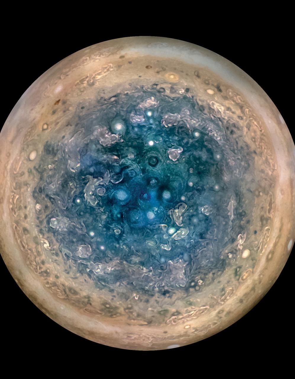
Early science results from NASA’s Juno mission to Jupiter portray the largest planet in our solar system as a complex, gigantic, turbulent world, with Earth-sized polar cyclones, plunging storm systems that travel deep into the heart of the gas giant, and a mammoth, lumpy magnetic field that may indicate it was generated closer to the planet’s surface than previously thought. This image shows Jupiter’s south pole, as seen by NASA’s Juno spacecraft from an altitude of 32,000 miles (52,000 kilometers). The oval features are cyclones, up to 600 miles (1,000 kilometers) in diameter. Multiple images taken with the JunoCam instrument on three separate orbits were combined to show all areas in daylight, enhanced color, and stereographic projection. Read more: <a href="https://go.nasa.gov/2rEgNhT" rel="nofollow">go.nasa.gov/2rEgNhT</a> Credits: NASA/JPL-Caltech/SwRI/MSSS/Betsy Asher Hall/Gervasio Robles <b><a href="http://www.nasa.gov/audience/formedia/features/MP_Photo_Guidelines.html" rel="nofollow">NASA image use policy.</a></b> <b><a href="http://www.nasa.gov/centers/goddard/home/index.html" rel="nofollow">NASA Goddard Space Flight Center</a></b> enables NASA’s mission through four scientific endeavors: Earth Science, Heliophysics, Solar System Exploration, and Astrophysics. Goddard plays a leading role in NASA’s accomplishments by contributing compelling scientific knowledge to advance the Agency’s mission. <b>Follow us on <a href="http://twitter.com/NASAGoddardPix" rel="nofollow">Twitter</a></b> <b>Like us on <a href="http://www.facebook.com/pages/Greenbelt-MD/NASA-Goddard/395013845897?ref=tsd" rel="nofollow">Facebook</a></b> <b>Find us on <a href="http://instagrid.me/nasagoddard/?vm=grid" rel="nofollow">Instagram</a></b>
This image captures the intensity of the jets and vortices in Jupiter's North North Temperate Belt. NASA's Juno spacecraft took this color-enhanced image at 10:31 p.m. PDT on May 23, 2018 (1:31 a.m. EDT on May 24), as Juno performed its 13th close flyby of Jupiter. At the time, the spacecraft was about 4,900 miles (7,900 kilometers) from the tops of the clouds of the gas giant planet at a northern latitude of about 41 degrees. The view is oriented with south on Jupiter toward upper left and north toward lower right. The North North Temperate Belt is the prominent reddish-orange band left of center. It rotates in the same direction as the planet and is predominantly cyclonic, which in the northern hemisphere means its features spin in a counter-clockwise direction. Within the belt are two gray-colored anticyclones. To the left of the belt is a brighter band (the North North Temperate Zone) with high clouds whose vertical relief is accentuated by the low angle of sunlight near the terminator. These clouds are likely made of ammonia-ice crystals, or possibly a combination of ammonia ice and water. Although the region as a whole appears chaotic, there is an alternating pattern of rotating, lighter-colored features on the zone's north and south sides. Scientists think the large-scale dark regions are places where the clouds are deeper, based on infrared observations made at the same time by Juno's JIRAM experiment and Earth-based supporting observations. Those observations show warmer, and thus deeper, thermal emission from these regions. To the right of the bright zone, and farther north on the planet, Jupiter's striking banded structure becomes less evident and a region of individual cyclones can be seen, interspersed with smaller, darker anticyclones. https://photojournal.jpl.nasa.gov/catalog/PIA22423 . - Enhanced image by Kevin M. Gill (CC-BY) based on images provided courtesy of NASA/JPL-Caltech/SwRI/MSSS
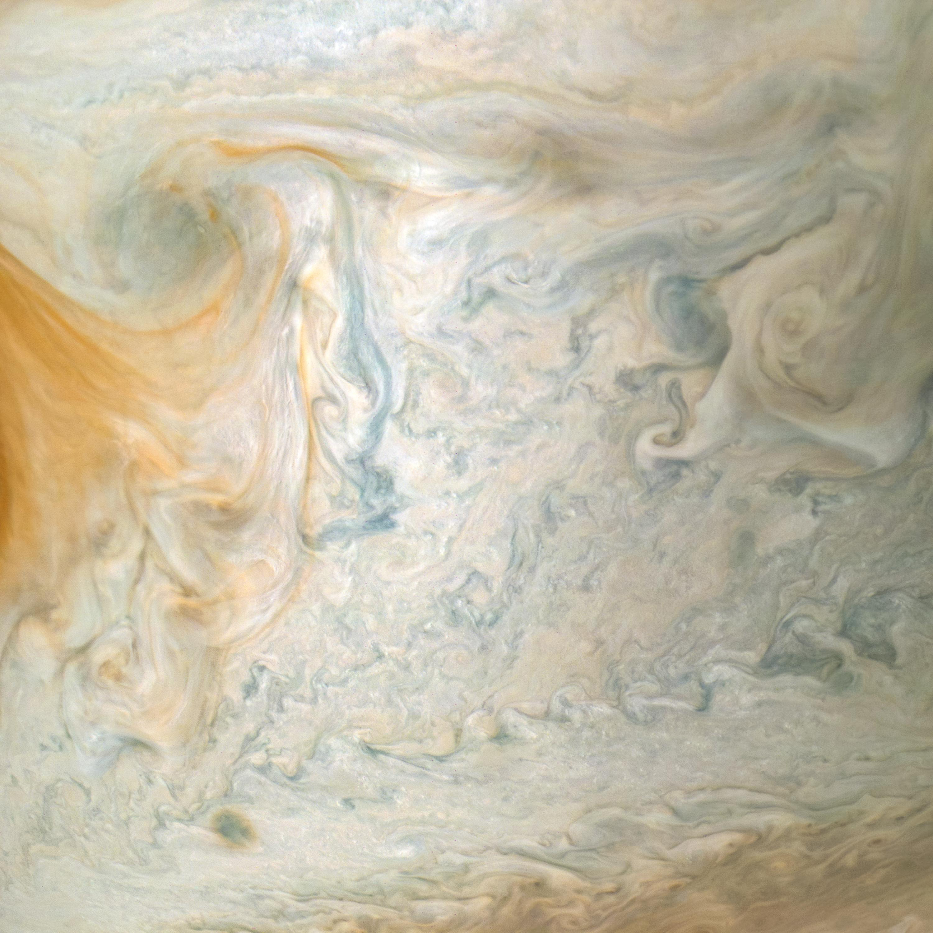
The easternmost edge of Jupiter's Great Red Spot and surrounding south tropical disturbance are captured in this image from NASA's Juno spacecraft. At left, wispy tendrils from the Red Spot give the atmosphere a layered appearance as they partially obscure cloud features below. Jupiter's appearance is a tapestry of vivid colors and swirling atmospheric vortices. Many aspects of the planet's atmosphere are still a mystery. For example, the origin of individual storms or churning cloud features is unknown. By studying Jupiter's weather up close for the first time, Juno is helping researchers better understand how atmospheres work in general -- including our own. What we learn about Jupiter's atmosphere will also help scientists understand how gas-giant planets work in general, including those now being discovered beyond our solar system. This color-enhanced image was taken at 3:01 a.m. PDT on April 1, 2018 (6:01 a.m. EDT), as the spacecraft performed its 12th close flyby of Jupiter. At the time, Juno was about 7,900 miles (12,750 kilometers) from the planet's cloud tops, above a southern latitude of approximately 26 degrees. Citizen scientist Kevin M. Gill created this image using data from the spacecraft's JunoCam imager. https://photojournal.jpl.nasa.gov/catalog/PIA22429 . - Enhanced image by Kevin M. Gill (CC-BY) based on images provided courtesy of NASA/JPL-Caltech/SwRI/MSSS

This sequence of color-enhanced images shows how quickly the viewing geometry changes for NASA's Juno spacecraft as it swoops by Jupiter. The images were obtained by JunoCam. Once every 53 days, Juno swings close to Jupiter, speeding over its clouds. In just two hours, the spacecraft travels from a perch over Jupiter's north pole through its closest approach (perijove), then passes over the south pole on its way back out. This sequence shows 11 color-enhanced images from Perijove 8 (Sept. 1, 2017) with the south pole on the left (11th image in the sequence) and the north pole on the right (first image in the sequence). The first image on the right shows a half-lit globe of Jupiter, with the north pole approximately at the upper center of the image close to the terminator -- the dividing line between night and day. As the spacecraft gets closer to Jupiter, the horizon moves in and the range of visible latitudes shrinks. The second and third images in this sequence show the north polar region rotating away from the spacecraft's field of view while the first of Jupiter's lighter-colored bands comes into view. The fourth through the eighth images display a blue-colored vortex in the mid-southern latitudes near Points of Interest "Collision of Colours," "Sharp Edge," "Caltech, by Halka," and "Structure01." The Points of Interest are locations in Jupiter's atmosphere that were identified and named by members of the general public. Additionally, a darker, dynamic band can be seen just south of the vortex. In the ninth and tenth images, the south polar region rotates into view. The final image on the left displays Jupiter's south pole in the center. From the start of this sequence of images to the end, roughly 1 hour and 35 minutes elapsed. https://photojournal.jpl.nasa.gov/catalog/PIA21967 . - Enhanced image by Kevin M. Gill (CC-BY) based on images provided courtesy of NASA/JPL-Caltech/SwRI/MSSS

Jupiter's iconic Great Red Spot is a 10,000-mile-wide (16,000-kilometer-wide) storm that has been raging since at least the 1800s — and possibly for more than 350 years. Observations with NASA's Juno spacecraft previously indicated that the vertical extent of the Great Red Spot is over 120 miles (200 kilometers), consistent with a storm feature that develops deep in Jupiter's atmosphere. Since NASA's Voyager spacecraft visited Jupiter in 1979, the Great Red Spot has shrunk from about the size of 1.8 Earths to the size of about 1.3 Earths today. NASA's Juno spacecraft has imaged the Great Red Spot numerous times, providing unique information on the details of how the Great Red Spot dynamically changes while it is shrinking. This montage includes five map-projected mosaics of the giant storm, processed from images obtained by the JunoCam imager during several orbits between July 2017 and July 2019. The mosaics show how the Great Red Spot and nearby areas have changed over the course of the Juno mission. Will the Great Red Spot continue to shrink? Only time will tell, but as we study Jupiter's atmosphere, we learn more about how weather systems work, both on giant planets such as Jupiter and Saturn and also on our own home, Earth. Citizen scientist Björn Jónsson created this montage using JunoCam data. The images cover latitudes from about 5 degrees to 38 degrees south. Enhanced image by Björn Jónsson (CC-NC-SA) based on images provided courtesy of NASA/JPL-Caltech/SwRI/MSSS
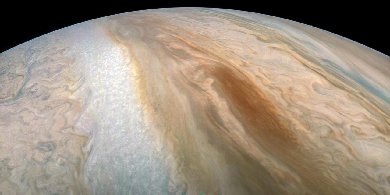
A long, brown oval known as a "brown barge" in Jupiter's South Equatorial Belt is captured in this color-enhanced image from NASA's Juno spacecraft. Brown barges are cyclonic regions that usually lie within Jupiter's dark North Equatorial Belt, although they are sometimes found in the similarly dark South Equatorial Belt as well. They can often be difficult to detect visually because their color blends in with the dark surroundings. At other times, as with this image, the dark belt material recedes, creating a lighter-colored background against which the brown barge is more conspicuous. Brown barges usually dissipate after the entire cloud belt undergoes an upheaval and reorganizes itself. Juno is giving us the first glimpses of the detailed structure within such a barge. This image was taken at 6:26 p.m. PDT on Sept. 6, 2018 (9:26 p.m. EDT) as the spacecraft performed its 15th close flyby of Jupiter. At the time, Juno was 7,425 miles (11,950 kilometers) from the planet's cloud tops, above a southern latitude of approximately 22 degrees. Citizen scientist Kevin M. Gill created this image using data from the spacecraft's JunoCam imager. The image has been rotated 90 degrees to the right from the original image. https://photojournal.jpl.nasa.gov/catalog/PIA22688 . - Enhanced image by Kevin M. Gill (CC-BY) based on images provided courtesy of NASA/JPL-Caltech/SwRI/MSSS
The Mastcam-Z cameras are on a workbench during their assembly at Malin Space Science Systems in San Diego. A square lightshade is mounted at the left end of the camera to reduce the scattered light that reaches the optics. Both cameras are almost identical, except for slight differences in the adjustable color filters that will provide more information about the mineralogy of the rocks on Mars. https://photojournal.jpl.nasa.gov/catalog/PIA24198
The twin Mastcam-Z cameras, shown with a pocket knife for scale, are assembled and ready for testing in this photo taken at Malin Space Science Systems, in San Diego, California. One of two sets of "eyes" on the "head," or mast, of the rover, these cameras can take high-definition video, panoramic color, and 3D images of the Martian surface. These are the first cameras sent to Mars with built-in zoom capability, able to switch from a wide angle to a close-up view. https://photojournal.jpl.nasa.gov/catalog/PIA24200
These three versions of the same image taken by the Mast Camera Mastcam on NASA Mars rover Curiosity illustrate different choices that scientists can make in presenting the colors recorded by the camera.
This series of images shows the Martian moon Deimos as it crossed in front of the Sun, as seen by NASA's Curiosity Mars rover on Sunday, March 17, 2019 (the 2,350th Martian day, or sol, of the mission). The images were captured by Curiosity's telephoto-lens camera, called its Mast Camera pair (right Mastcam). The images have been sped up by a factor of 10. Deimos is small enough that scientists consider it a transit rather than an eclipse. The Deimos transit lasted several minutes. Movie available at https://photojournal.jpl.nasa.gov/catalog/PIA23134

NASA's Curiosity Mars rover used its Mastcam to capture this mosaic of Gediz Vallis on Nov. 7, 2022, the 3,646th Martian day, or sol, of the mission. In the center of the valley in this image is a pile of boulders and debris that may have been swept there by flowing water billions of years ago. Wind is thought to have carved the larger valley, which starts much higher up on Mount Sharp, the 3-mile-tall (5-kilometer-tall) Martian mountain whose foothills Curiosity has been ascending since 2014. The mountain is made up of layers, with the oldest at the bottom and the youngest at the top. Approaching this debris in the valley's interior channel is thought to be the only way that Curiosity will be able to study younger material that originated higher on the mountain than the rover will ever go. The mosaic is made up of 18 individual images that were stitched together after being sent to Earth. The color has been adjusted to match lighting conditions as the human eye would see them on Earth. https://photojournal.jpl.nasa.gov/catalog/PIA25733
Layers of the South Polar Layered Deposits
This image from NASA Mars Curiosity rover shows the Amargosa Valley, on the slopes leading up to Mount Sharp on Mars. The rover is headed toward the Pahrump Hills outcrop.

Lozenge-shaped crystals are evident in this magnified view of a Martian rock target called Mojave, taken on Nov. 15, 2014, by NASA Curiosity Mars rover. These features record concentration of dissolved salts, possibly in a drying lake.

NASA's Curiosity Mars rover viewed these yellow crystals of elemental sulfur using its Mast Camera, or Mastcam, on June 7, 2024, the 4,208th Martian day, or sol, of the mission. The discovery marks the first time this mineral has ever been found in a pure form on Mars. Nicknamed "Convict Lake" after a location in California's Sierra Nevada, this collection of fragments is about 5 inches (13 centimeters) across from left to right. The color has been adjusted to match lighting conditions as the human eye would see them on Earth. These crystals were found after Curiosity happened to drive over and crush the rock several days before, on May 30. The rover later used an instrument on the end of its robotic arm, called the Alpha Particle X-ray Spectrometer, to determine the composition of the rock. Scientists have seen many kinds of sulfur on Mars; the region Curiosity found this rock is, in fact, known for being rich in sulfates – a kind of sulfur-based salt that was left behind as water dried up on this part of the Red Planet billions of years ago. It isn't clear what relationship, if any, the elemental sulfur has to other sulfur-based minerals in the area. Elemental sulfur consists only of pure sulfur atoms, unlike the sulfur bound to oxygen in sulfate. It's an odorless mineral that on Earth is created by a variety of different geological processes, including volcanic and hydrothermal activity. Curiosity's team doesn't yet know which processes would have formed the elemental sulfur found by the rover, but they're searching for clues in the rocks and surrounding area. https://photojournal.jpl.nasa.gov/catalog/PIA26309
Winter Frosts of the Retreating South Polar Cap
NASA's Curiosity Mars rover captured this view using its Mast Camera, or Mastcam, while heading west away from Gediz Vallis channel on Nov. 2, 2024, the 4,352nd Martian day, or sol, of the mission. This panorama is made up of two mosaics: one consisting of 171 individual images taken at 12:16 p.m. local Mars time; and another consisting of 169 at 12:46 p.m. local Mars time. The color has been adjusted to match lighting conditions as the human eye would see them on Earth. Rover tracks can be seen trailing behind Curiosity at right. The difficult, rocky terrain made for slow going. The butte on the left side of the scene is nicknamed "Texoli"; the butte dominating the right side of the scene is nicknamed "Kukenán." https://photojournal.jpl.nasa.gov/catalog/PIA26471
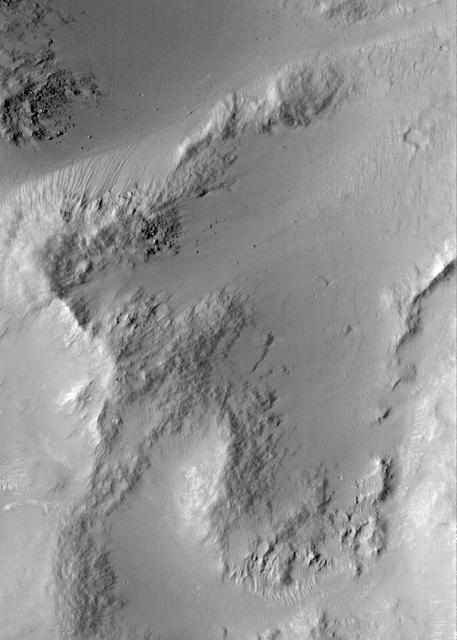
A Typical Martian Scene: Boulders and Slopes in a Crater in Aeolis
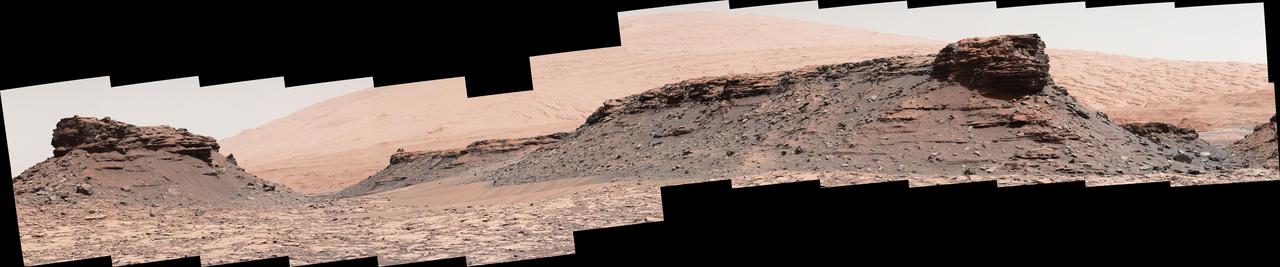
The two prominent mesas in this view of Mars' "Murray Buttes" region from NASA's Curiosity Mars rover are about 260 feet (about 80 meters) apart. The top of the one on the left is about 26 feet (about 8 meters) above the surrounding plain and about 330 feet (about 100 meters) from Curiosity's position when the rover acquired this view on Aug. 18, 2016, during the 1,434th Martian day, or sol, of its work Mars. The component images of this mosaic were taken by the right-eye camera of the rover's Mast Camera (Mastcam), which has a telephoto lens. The mesa on the right is about 33 feet (about 10 meters) high. The top of it is about 270 feet (about 82 meters) from the rover. Upper Mount Sharp is the salmon-hued mound dominating the horizon between the scene's two prominent mesas. The left edge of this view is east-northeast from the rover; the right edge is southeast. The rover's location when it recorded this scene was the site it reached in its Sol 1433 drive. (See map at http://mars.nasa.gov/msl/multimedia/images/?ImageID=7999.) The scene is presented with a color adjustment that approximates white balancing, to resemble how the rocks and sand would appear under daytime lighting conditions on Earth. http://photojournal.jpl.nasa.gov/catalog/PIA20841
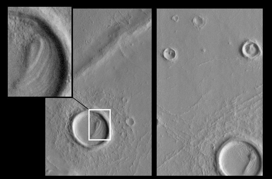
Eroded Layered Material in Southwest Utopia Planitia
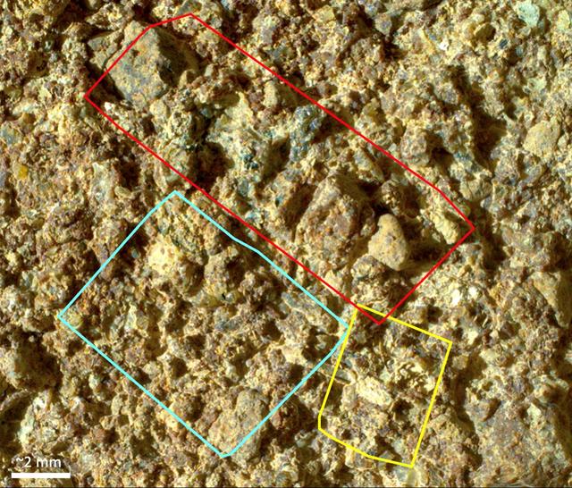
Before collecting a rock sample at a spot nicknamed "Otis Peak," NASA's Perseverance Mars rover employed an abrasion tool to wear down the rock surface and then used the Planetary Instrument for X-ray Lithochemistry, or PIXL, to study the rock's internal chemistry. This image of the abrasion patch, dubbed "Ouzel Falls," was taken in May 2023 by WATSON (Wide Angle Topographic Sensor for Operations and eNgineering), a camera that is part of an instrument called Scanning Habitable Environments with Raman & Luminescence for Organics & Chemicals, or SHERLOC, on the end of the rover's robotic arm. Data from PIXL is laid over the image. Colored squares show different areas where PIXL's X-ray beam scanned the rock's surface. The instrument's data found the rock was rich in phosphate, a material found in the DNA and cell membranes of all known life, and which also serves as a way to store and transfer energy within living things. The Ouzel Falls scan areas contain a rich diversity of other mineral grains, including igneous minerals transported as sand and pebbles, such as olivine and spinel, and minerals crystallized from water, such as carbonates, clays, and sulfates. Each of these record unique aspects of the magmatic, climatic, and paleoenvironmental history of the ancient lake within Jezero Crater and the surrounding region. This diversity will make the Otis Peak sample a treasure trove for scientists on Earth who may study it in the future. A key objective for Perseverance's mission on Mars is astrobiology, including the search for signs of ancient microbial life. The rover will characterize the planet's geology and past climate, pave the way for human exploration of the Red Planet, and be the first mission to collect and cache Martian rock and regolith (broken rock and dust). Subsequent NASA missions, in cooperation with ESA (European Space Agency), would send spacecraft to Mars to collect these sealed samples from the surface and return them to Earth for in-depth analysis. The Mars 2020 Perseverance mission is part of NASA's Moon to Mars exploration approach, which includes Artemis missions to the Moon that will help prepare for human exploration of the Red Planet. https://photojournal.jpl.nasa.gov/catalog/PIA26206
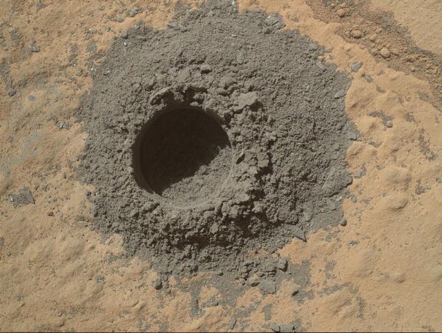
NASA Curiosity Mars rover completed a shallow mini drill test April 29, 2014, in preparation for full-depth drilling at a rock target called Windjana. The hole results from the test is 0.63 inch across and about 0.8 inch deep.
This view of a sandstone target called "Big Arm" covers an area about 1.3 inches (33 millimeters) wide in detail that shows differing shapes and colors of sand grains in the stone. Three separate images taken by the Mars Hand Lens Imager (MAHLI) camera on NASA's Curiosity Mars rover, at different focus settings, were combined into this focus-merge view. The Big Arm target on lower Mount Sharp is at a location near "Marias Pass" where a mudstone bedrock is in contact with overlying sandstone bedrock. MAHLI recorded the component images on May 29, 2015, during the 999th Martian day, or sol, of Curiosity's work on Mars. The rounded shape of some grains visible here suggests they traveled long distances before becoming part of the sediment that later hardened into sandstone. Other grains are more angular and may have originated closer to the rock's current location. Lighter and darker grains may have different compositions. MAHLI was built by Malin Space Science Systems, San Diego. NASA's Jet Propulsion Laboratory, a division of the California Institute of Technology in Pasadena, manages the Mars Science Laboratory Project for the NASA Science Mission Directorate, Washington. http://photojournal.jpl.nasa.gov/catalog/PIA19677

NASA's Perseverance Mars rover captured this image of a rock target nicknamed "Quartier" with the WATSON (Wide Angle Topographic Sensor for Operations and eNgineering) camera belonging to an instrument called SHERLOC (Scanning Habitable Environments with Raman & Luminescence for Organics & Chemicals). The rover uses a tool to abrade the surface of a rock (as with the circular portion in this image), removing dust, debris and other material that has settled on the rock's outer surface. After that's complete, instruments like SHERLOC can study the rock's composition. The white squares show areas where SHERLOC performed multiple scans with its ultraviolet laser. SHERLOC detected signals within Quartier consistent with organic, carbon-based molecules. If they are organic molecules – something that could be verified only by bringing the samples to Earth for closer study – they would have likely been formed by geological processes as opposed to ancient biological sources, but they represent the kinds of molecules Perseverance's science team are looking for. A key objective for Perseverance's mission on Mars is astrobiology, including the search for signs of ancient microbial life. The rover will characterize the planet's geology and past climate, pave the way for human exploration of the Red Planet, and be the first mission to collect and cache Martian rock and regolith (broken rock and dust). Subsequent NASA missions, in cooperation with ESA (European Space Agency), would send spacecraft to Mars to collect these sealed samples from the surface and return them to Earth for in-depth analysis. The Mars 2020 Perseverance mission is part of NASA's Moon to Mars exploration approach, which includes Artemis missions to the Moon that will help prepare for human exploration of the Red Planet. https://photojournal.jpl.nasa.gov/catalog/PIA25919