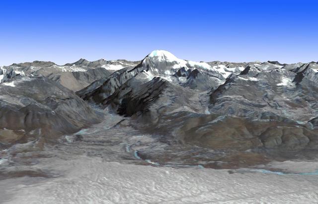
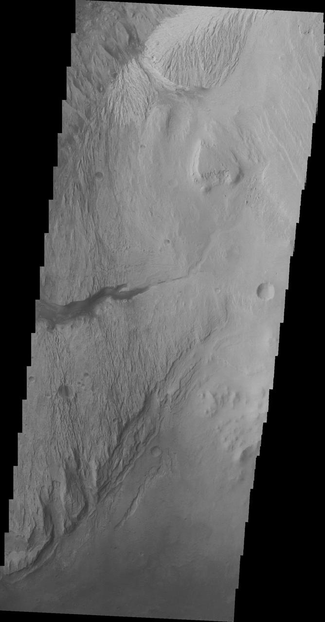
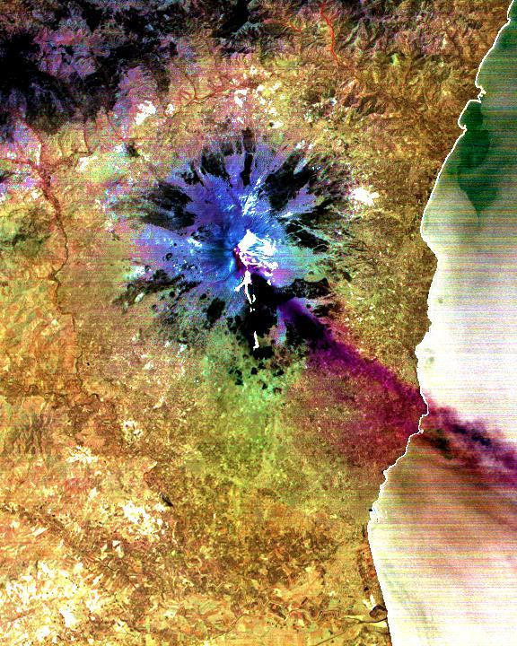
It Not Mt. Fuji ...
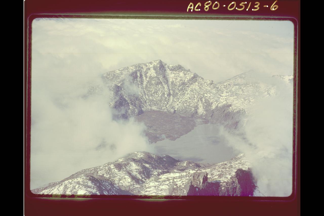
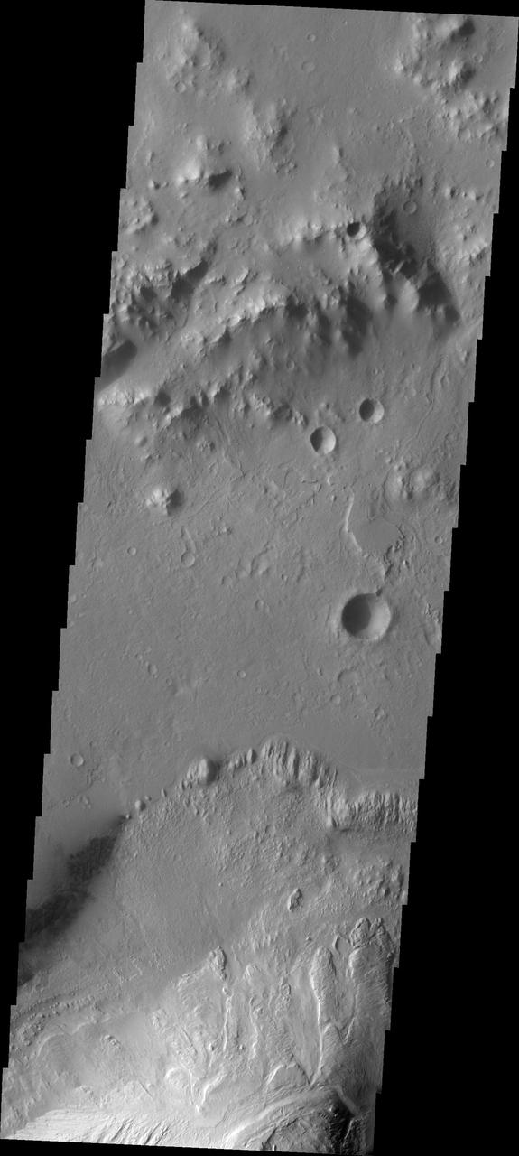
Mt. St. Helens Volcano - post eruption
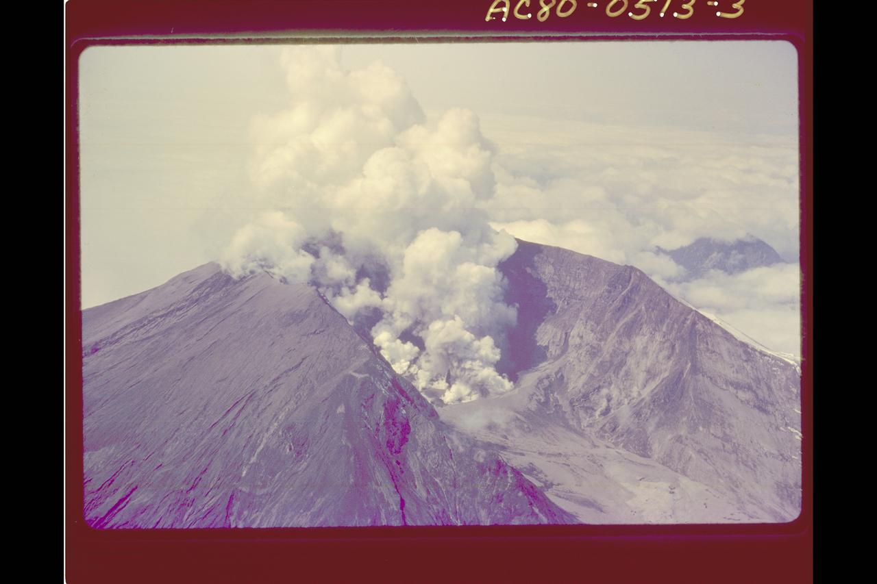
Mt. St. Helens Volcano - post eruption
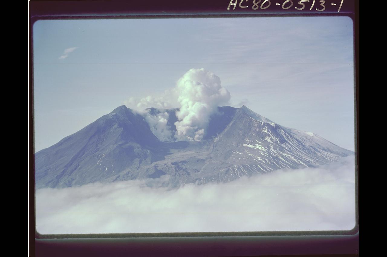
Mt. St. Helens Volcano - post eruption
Mt. St. Helens Volcano - post eruption, forest damage
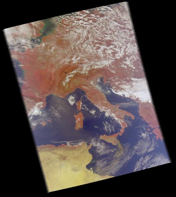
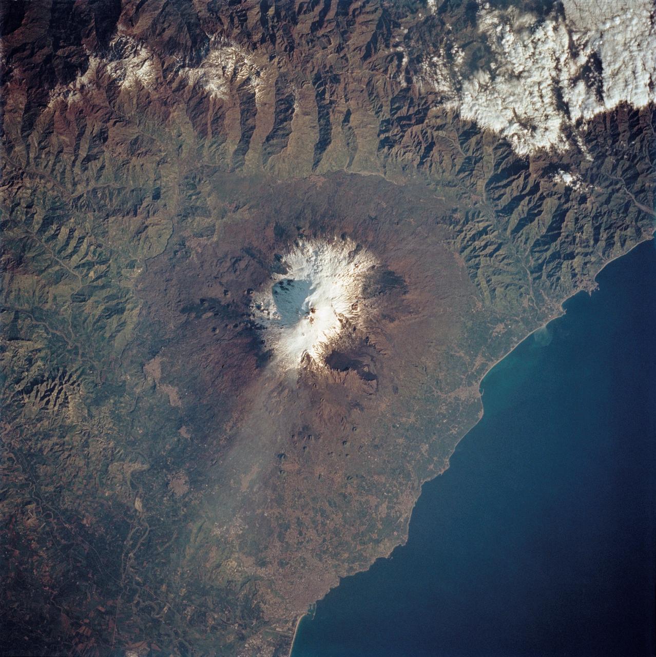
Mt. Etna, a volcano on the island of Sicily, erupted on October 26, 2002, as seen by the Atmospheric Infrared Sounding System AIRS on NASA Aqua. http://photojournal.jpl.nasa.gov/catalog/PIA00355
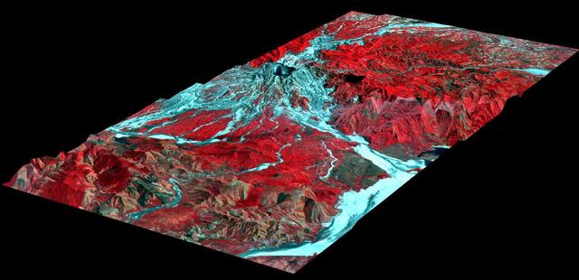
This perspective view, acquired by NASA Airborne Synthetic Aperture Radar AIRSAR, shows the effects of the June 15, 1991, eruption of Mt. Pinatubo.
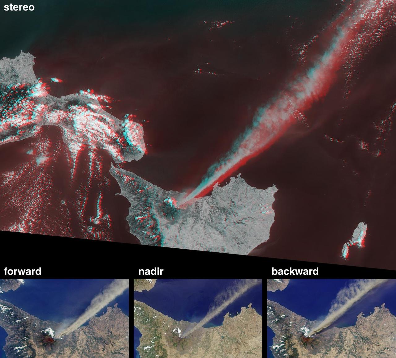
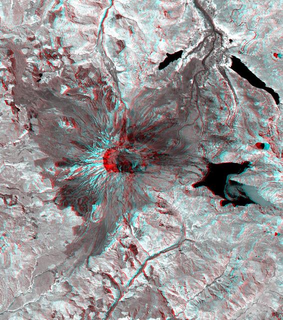
This anaglyph from the MISR instrument aboard NASA Terra spacecraft shows the eruption of Mt. Etna volcano located near the eastern coast of Sicily on July 22, 2001. 3D glasses are necessary to view this image.
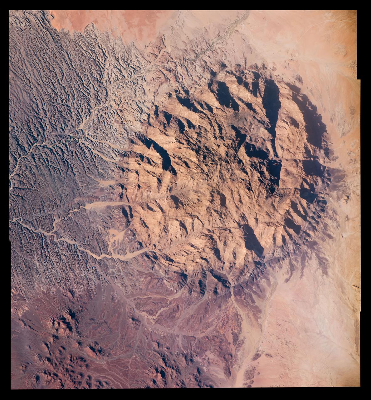
This image from NASA Terra spacecraft shows Mt. Kailash, a peak in the Kailas Range in Tibet. It lies near the source of some of the longest Asian rivers: the Brahmaputra, the Sutlej and the Karnali.

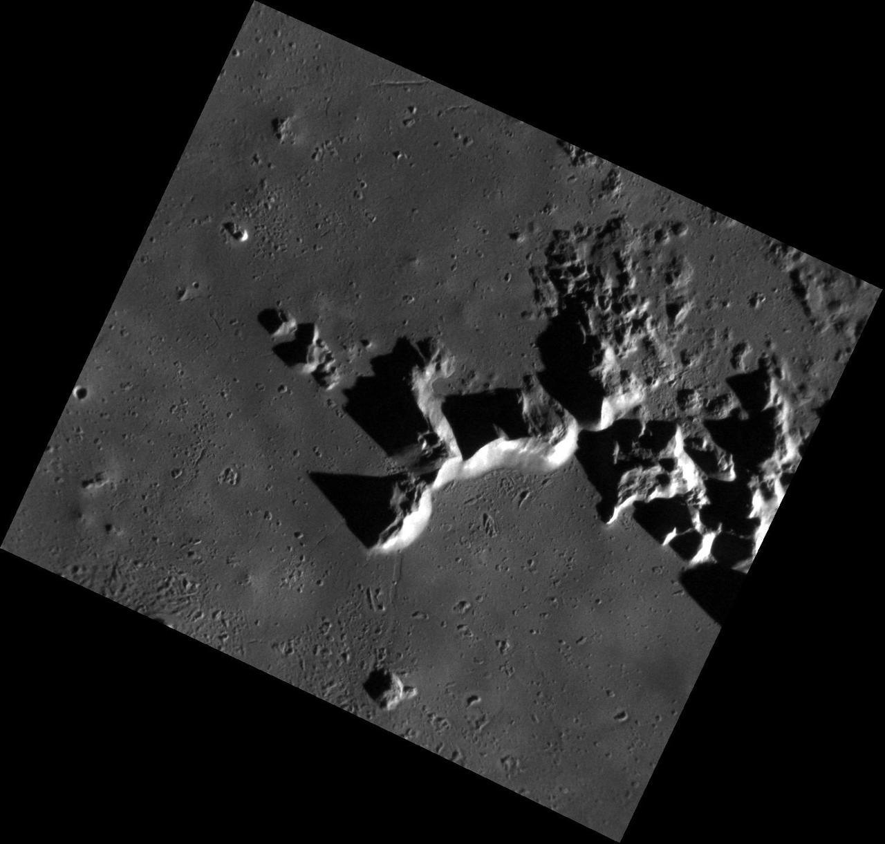
Apollo mission planners selected an adventurous landing site for Apollo 15 located on a relatively small patch of lava plains, called "mare" on the moon. This site is nestled between the towering Apennine mountains to the east, attaining heights of 3-5 km (about 10,000-16,000 feet), and the 200-meter-deep (about 650 feet) valley (~650 ft) of Hadley Rille to the west. The experience gained from the successful landings of the preceding Apollo missions afforded mission controllers confidence that a landing descending through a mountain range was possible. The Hadley Rille landing site also presented an opportunity to test the capabilities of the new lunar roving vehicle. NASA's Lunar Reconnaissance Orbiter captured this oblique view, looking east-to-west over the Apennine Mountains towards Hadley Rille (upper left). Mt. Hadley, at center right, casts a long shadow. Nestled between the Apennines and Hadley Rille lies Hadley Base, the landing site of Apollo 15. For scale, the vee-shaped trough of Hadley Rille is roughly 1 km wide (about 0.6 miles). Credit: NASA/Goddard/Arizona State University <b><a href="http://www.nasa.gov/audience/formedia/features/MP_Photo_Guidelines.html" rel="nofollow">NASA image use policy.</a></b> <b><a href="http://www.nasa.gov/centers/goddard/home/index.html" rel="nofollow">NASA Goddard Space Flight Center</a></b> enables NASA’s mission through four scientific endeavors: Earth Science, Heliophysics, Solar System Exploration, and Astrophysics. Goddard plays a leading role in NASA’s accomplishments by contributing compelling scientific knowledge to advance the Agency’s mission. <b>Follow us on <a href="http://twitter.com/NASAGoddardPix" rel="nofollow">Twitter</a></b> <b>Like us on <a href="http://www.facebook.com/pages/Greenbelt-MD/NASA-Goddard/395013845897?ref=tsd" rel="nofollow">Facebook</a></b> <b>Find us on <a href="http://instagram.com/nasagoddard?vm=grid" rel="nofollow">Instagram</a></b>
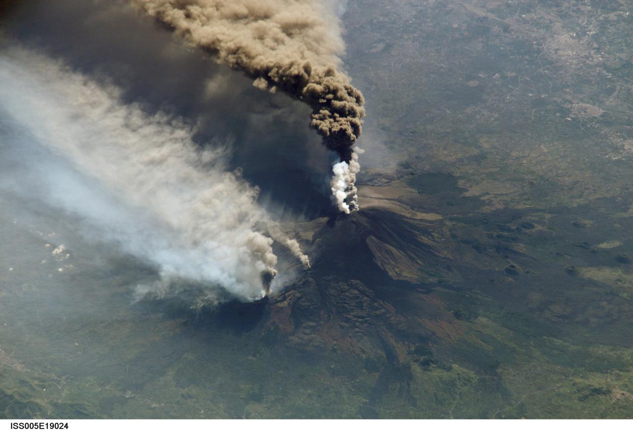
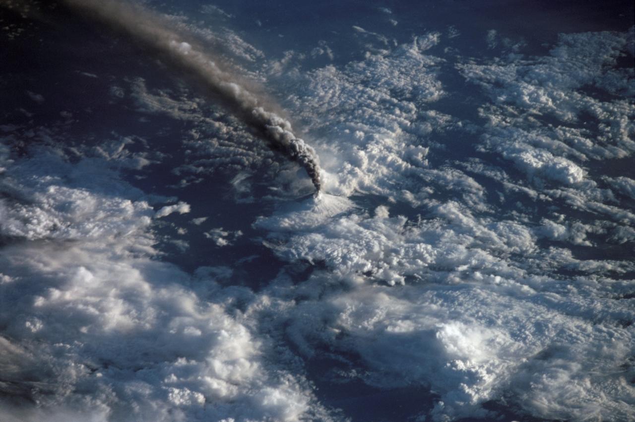
An Expedition Two crewmember aboard the International Space Station (ISS) captured this overhead look at the smoke and ash regurgitated from the erupting volcano Mt. Etna on the island of Sicily, Italy. At an elevation of 10,990 feet (3,350 m), the summit of the Mt. Etna volcano, one of the most active and most studied volcanoes in the world, has been active for a half-million years and has erupted hundreds of times in recorded history.
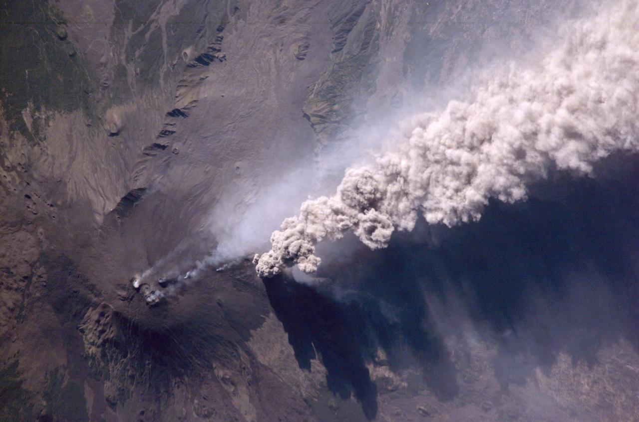
Expedition Five crew members aboard the International Space Station (ISS) captured this overhead look at the smoke and ash regurgitated from the erupting volcano Mt. Etna on the island of Sicily, Italy in October 2002. Triggered by a series of earthquakes on October 27, 2002, this eruption was one of Etna's most vigorous in years. This image shows the ash plume curving out toward the horizon. The lighter-colored plumes down slope and north of the summit seen in this frame are produced by forest fires set by flowing lava. At an elevation of 10,990 feet (3,350 m), the summit of the Mt. Etna volcano, one of the most active and most studied volcanoes in the world, has been active for a half-million years and has erupted hundreds of times in recorded history.
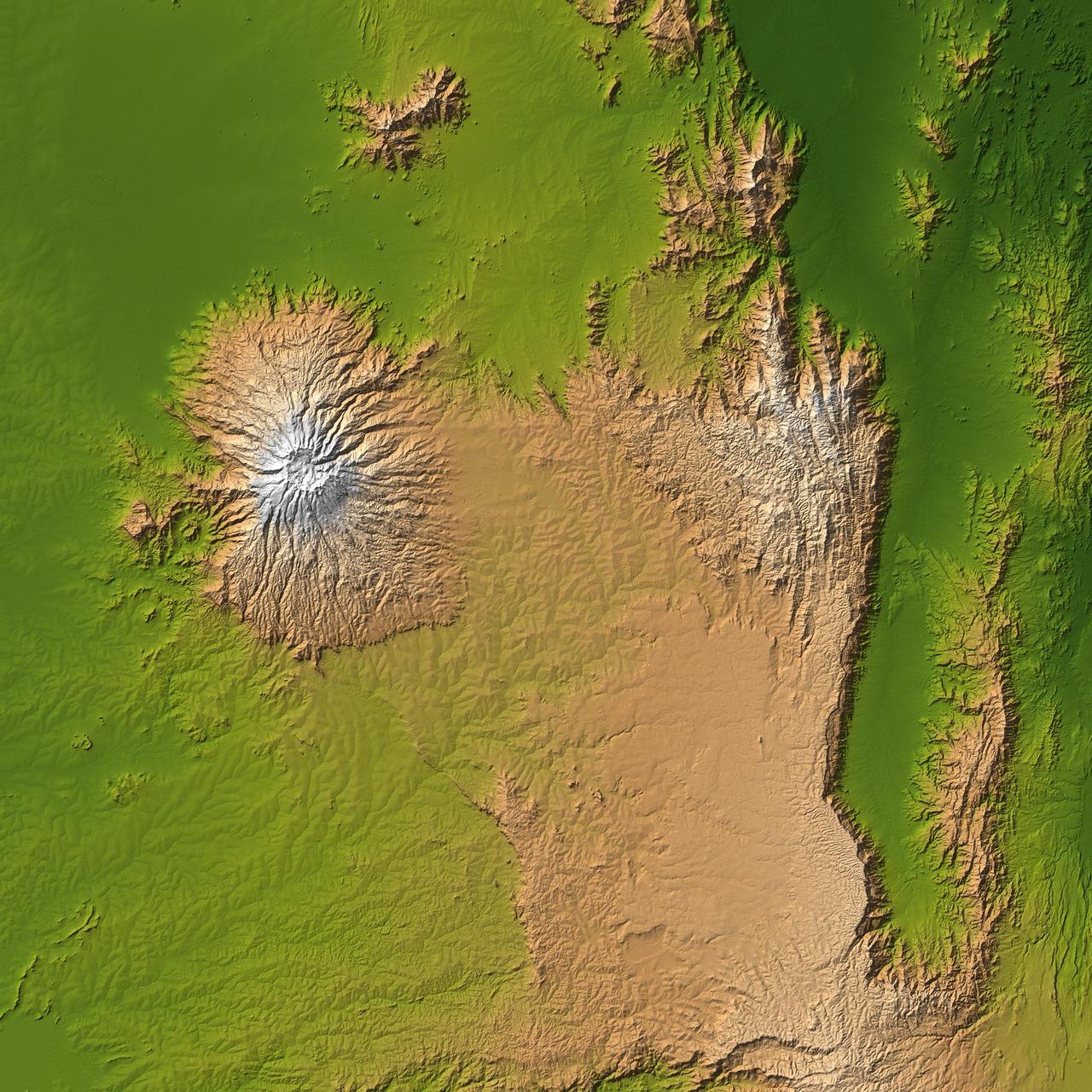
The striking contrast of geologic structures in Africa is shown in this shaded relief image of Mt. Elgon on the left and a section of the Great Rift Valley on the right.
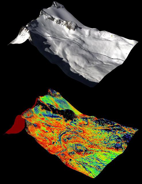
A natural color image of Mt. Lyell, the highest point in the Tuolumne River Basin top image is compared with a three-dimensional color composite image of Mt. Lyell from NASA Airborne Snow Observatory depicting snow depth bottom image.
Prominently displayed in this image, Mt. Pinos, at 2,692 meters 8,831 feet is the highest peak in the Los Padres National Forest.
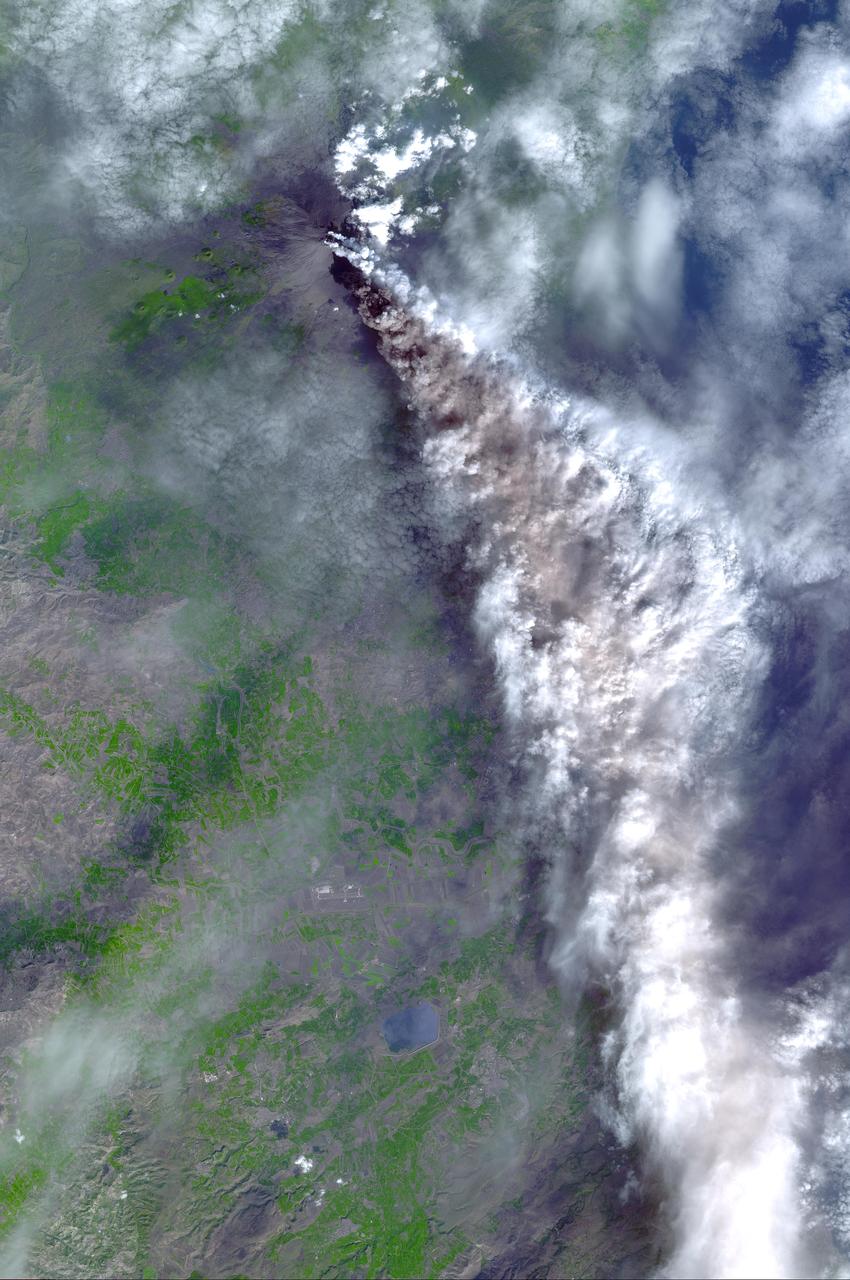
On Sunday, November 3, 2002, Mt. Etna's ash-laden plume was imaged by the Advanced Spaceborne Thermal Emission and Reflection Radiometer (ASTER) on NASA's Terra satellite. The plume is seen blowing toward the south-southeast, over the city and airport of Catania, Sicily. The previous day, the plume was blowing toward the northwest, and posed no hazard to Catania. The current eruption of Mt. Etna, Europe's most active volcano, began on October 27. These sorts of observations from space may help civil defense authorities mitigate hazards from active eruptions. Space data may also help scientists evaluate the behavior and effects volcanic eruptions have on our global climate system. http://photojournal.jpl.nasa.gov/catalog/PIA03881
STS068-259-009 (30 September-11 October 1994) --- This south-looking, summer-time view of Mt. Everest (center) - with strong sense of three dimension because of reduced amount of snow - and neighboring peaks of the Himalayas. Clouds cover lower slopes in India.
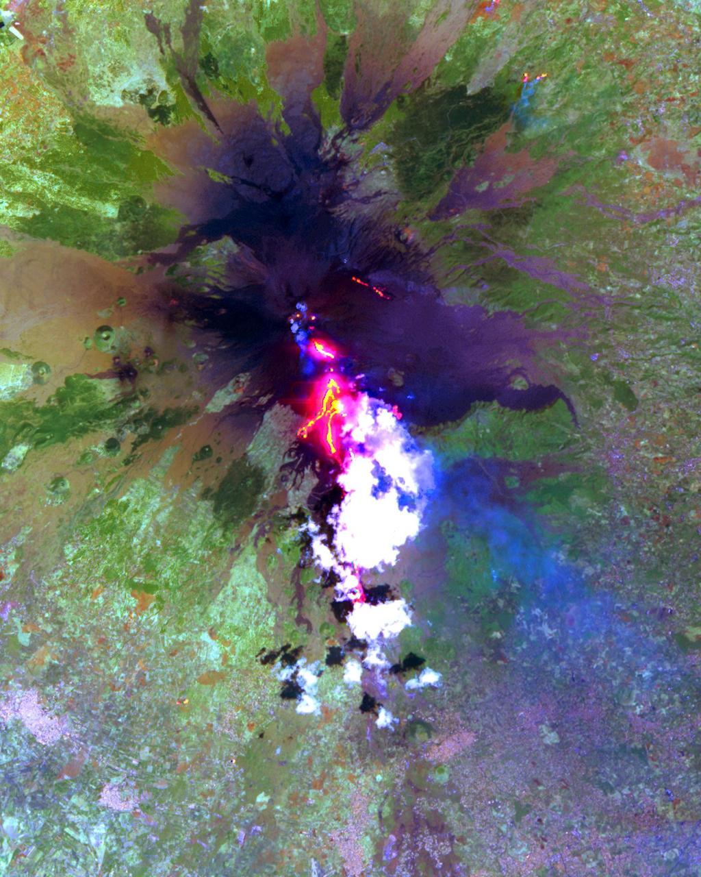
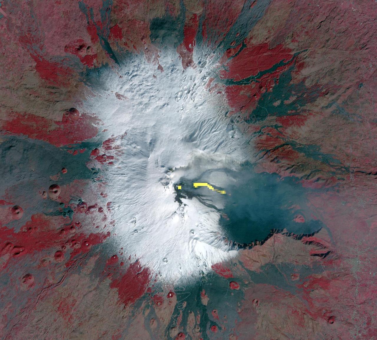
Starting December 13, 2020, a strong eruptive episode began at Mt. Etna's New SE summit crater. Lava fountains produced a new lava flow, traveling to the SW. The fresh lava is hot enough to be incandescent, and appears as a red "snake" issuing from the crater's flank. The lava fountain appears as a separate red area at the crater's summit. A faint gray plume streams southeastward from the crater. Analysis of the thermal infrared data reveals that the plume's composition is dominated by SO2. The image was acquired December 15, 2020, covers an area of 12 by 13.5 km, and is located at 37.7 degrees north, 15 degrees east. https://photojournal.jpl.nasa.gov/catalog/PIA24283
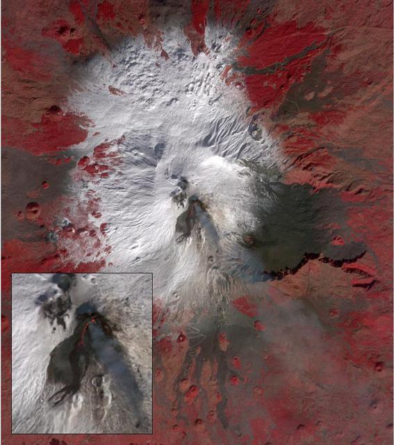
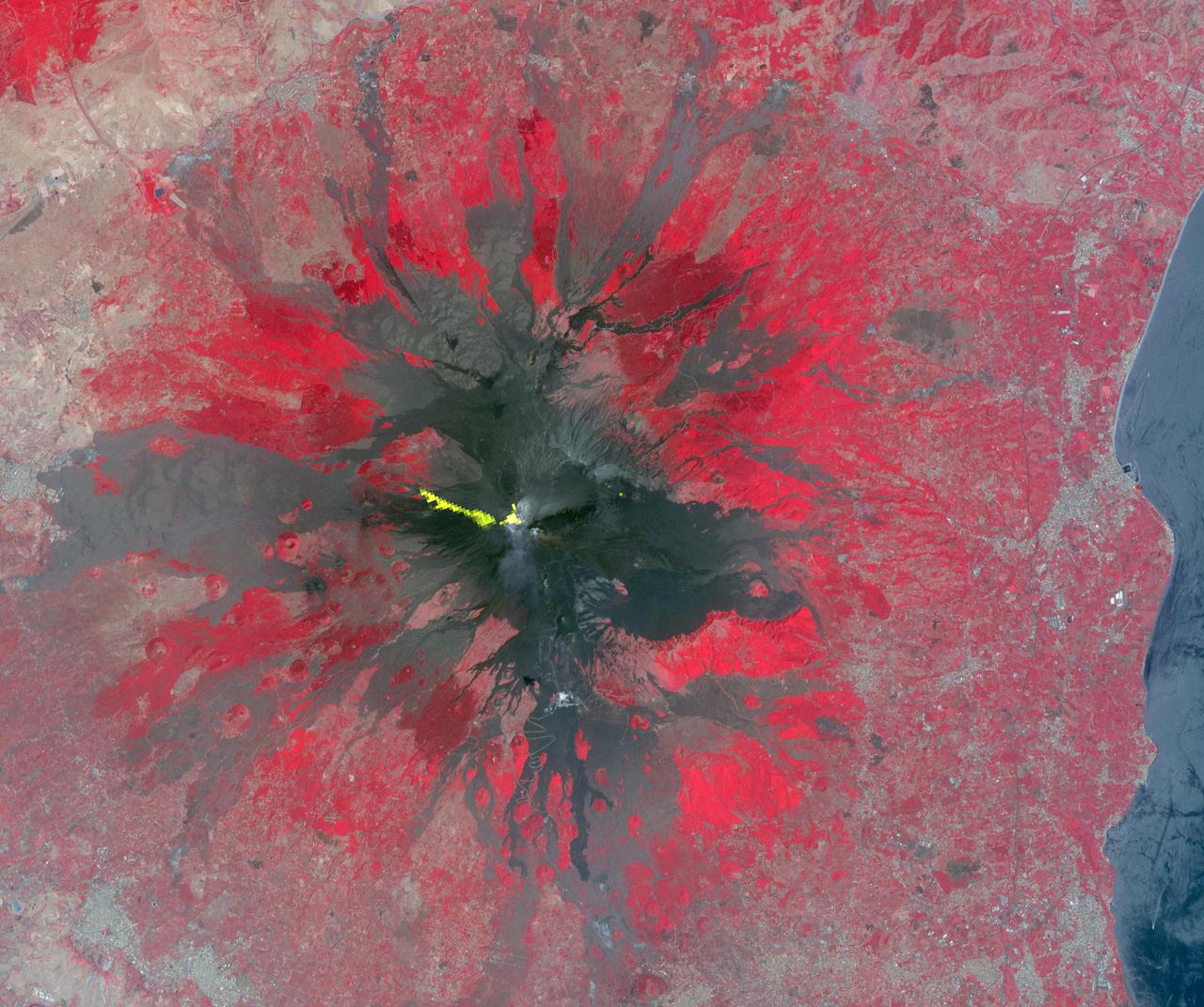
This 3-D anaglyph image of Mt. St. Helens volcano combines the nadir-looking and back-looking band 3 images of ASTER. To view the image in stereo, you will need blue-red glasses. Make sure to look through the red lens with your left eye. This ASTER image of Mt. St. Helens volcano in Washington was acquired on August 8, 2000 and covers an area of 37 by 51 km. Mount Saint Helens, a volcano in the Cascade Range of southwestern Washington that had been dormant since 1857, began to show signs of renewed activity in early 1980. On 18 May 1980, it erupted with such violence that the top of the mountain was blown off, spewing a cloud of ash and gases that rose to an altitude of 19 kilometers. The blast killed about 60 people and destroyed all life in an area of some 180 square kilometers (some 70 square miles), while a much larger area was covered with ash and debris. It continues to spit forth ash and steam intermittently. As a result of the eruption, the mountain's elevation decreased from 2,950 meters to 2,549 meters. The image is centered at 46.2 degrees north latitude, 122.2 degrees west longitude. http://photojournal.jpl.nasa.gov/catalog/PIA11160
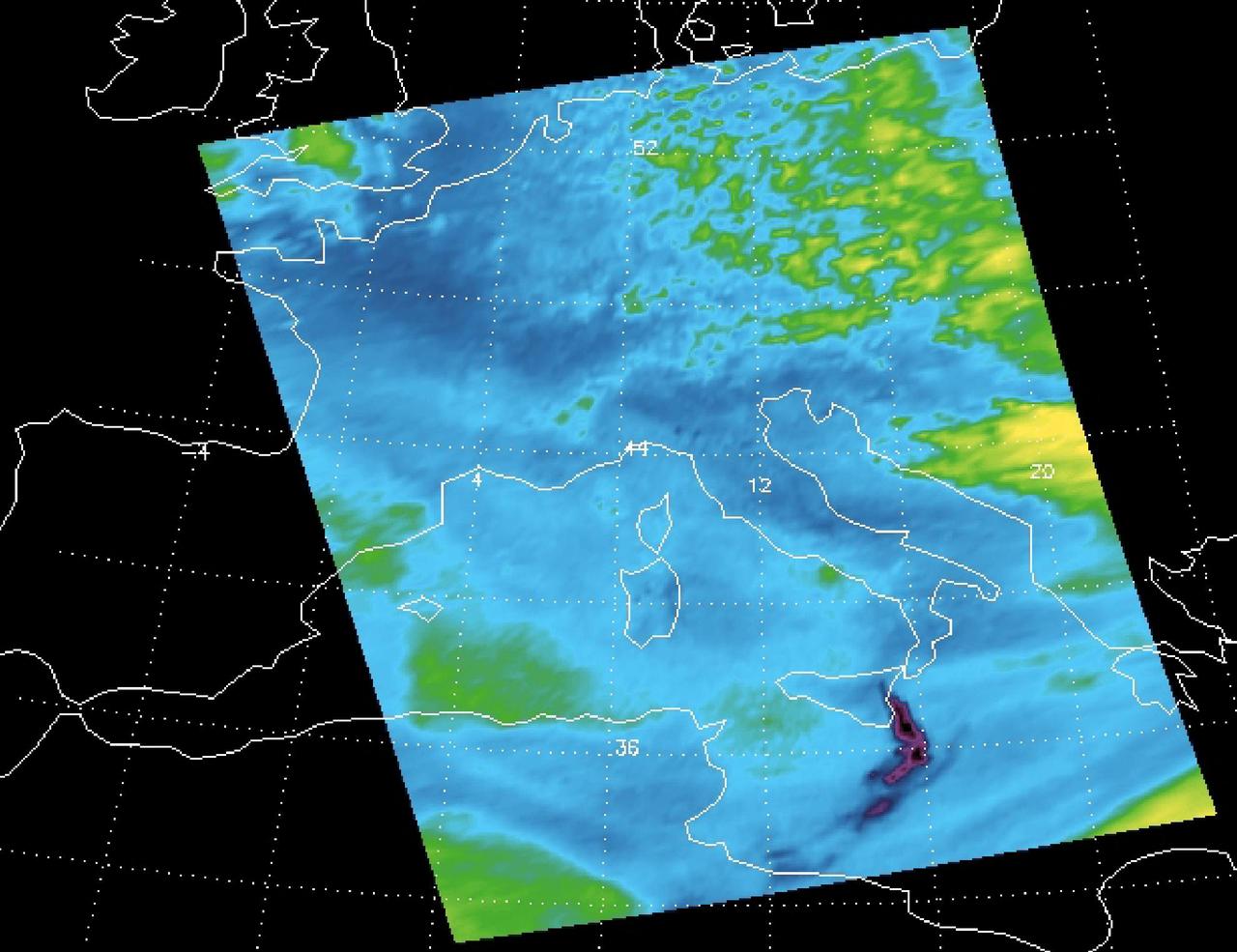
Sulfur dioxide plume from the Mt. Etna Eruption 2002 as seen by the Atmospheric Infrared Sounder AIRS on NASA Aqua satellite.
This image from NASA Mars Odyssey spacecraft shows the northern part of Mt. Sharp and the crater floor between Mt. Sharp and the northern rim of Gale Crater. The layering of Mt. Sharp is visible at the bottom of the image.
Mt. Etna, Italy erupted Tuesday, February 16, 2021, sending rivers of lava down the southeast flank of the volcano, and spewing ashes and volcanic stones over nearby villages. Sicily's Catania Airport was temporarily closed due to an ash plume that rose to 3700 m altitude. The ASTER nighttime thermal infrared data shows the extent of the active lava flows, draped over an older Google Earth image. The image was acquired February 17, 2021, covers an area of 38 by 39 km, and is located at 37.8 degrees north, 15 degrees east. https://photojournal.jpl.nasa.gov/catalog/PIA24417
The current eruption of Mt. Etna started on July 17, and has continued to the present. This ASTER image was acquired on Sunday, July 29 and shows advancing lava flows on the southern flank of Mt. Etna above the town of Nicolosi, which is potentially threatened if the eruption increases in magnitude. Also visible are glowing summit craters above the main lava flows, and a small fissure eruption. The bright puffy clouds were formed from water vapor released during the eruption. The image covers an area of 24 x 30 km. The image is centered at 37.7 degrees north latitude, 15 degrees east longitude. http://photojournal.jpl.nasa.gov/catalog/PIA02677
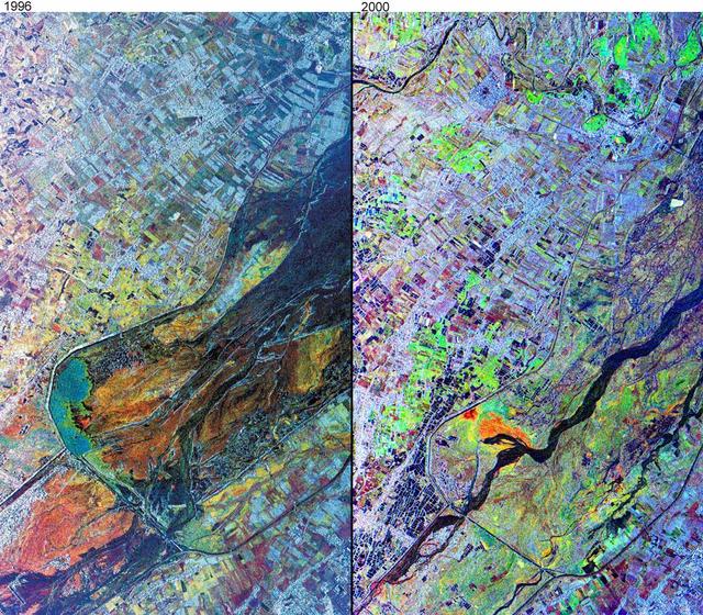
This comparison image, acquired by NASA Airborne Synthetic Aperture Radar AIRSAR November, 1996 and September, 2000, shows the effects of the June 15, 1991, eruption of Mt. Pinatubo.
On April 3, the Advanced Spaceborne Thermal Emission and Reflection Radiometer (ASTER) on NASA's Terra Satellite captured this image of the erupting Mt. Usu volcano in Hokkaido, Japan. With its 14 spectral bands from the visible to the thermal infrared wavelength region, and its high spatial resolution of 15 to 90 meters (about 50 to 300 feet), ASTER will image the Earth for the next 6 years to map and monitor the changing surface of our planet. This false color infrared image of Mt Usu volcano is dominated by Lake Toya, an ancient volcanic caldera. On the south shore is the active Usu volcano. On Friday, March 31, more than 11,000 people were evacuated by helicopter, truck and boat from the foot of Usu, that began erupting from the northwest flank, shooting debris and plumes of smoke streaked with blue lightning thousands of feet in the air. Although no lava gushed from the mountain, rocks and ash continued to fall after the eruption. The region was shaken by thousands of tremors before the eruption. People said they could taste grit from the ash that was spewed as high as 2,700 meters (8,850 ft) into the sky and fell to coat surrounding towns with ash. "Mount Usu has had seven significant eruptions that we know of, and at no time has it ended quickly with only a small scale eruption," said Yoshio Katsui, a professor at Hokkaido University. This was the seventh major eruption of Mount Usu in the past 300 years. Fifty people died when the volcano erupted in 1822, its worst known eruption. In the image, most of the land is covered by snow. Vegetation, appearing red in the false color composite, can be seen in the agricultural fields, and forests in the mountains. Mt. Usu is crossed by three dark streaks. These are the paths of ash deposits that rained out from eruption plumes two days earlier. The prevailing wind was from the northwest, carrying the ash away from the main city of Date. Ash deposited can be traced on the image as far away as 10 kilometers (16 miles) from the volcano. http://photojournal.jpl.nasa.gov/catalog/PIA02608
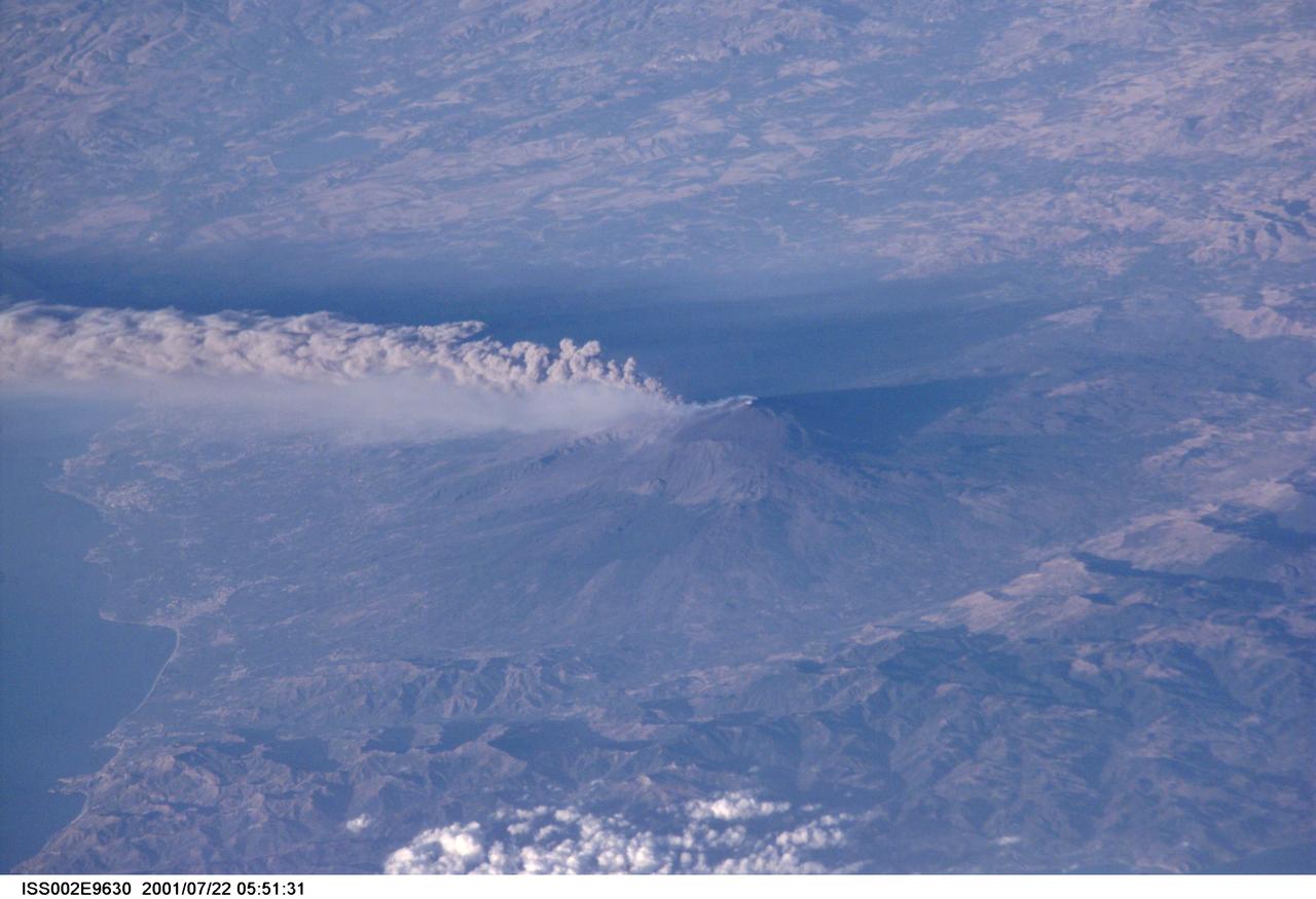
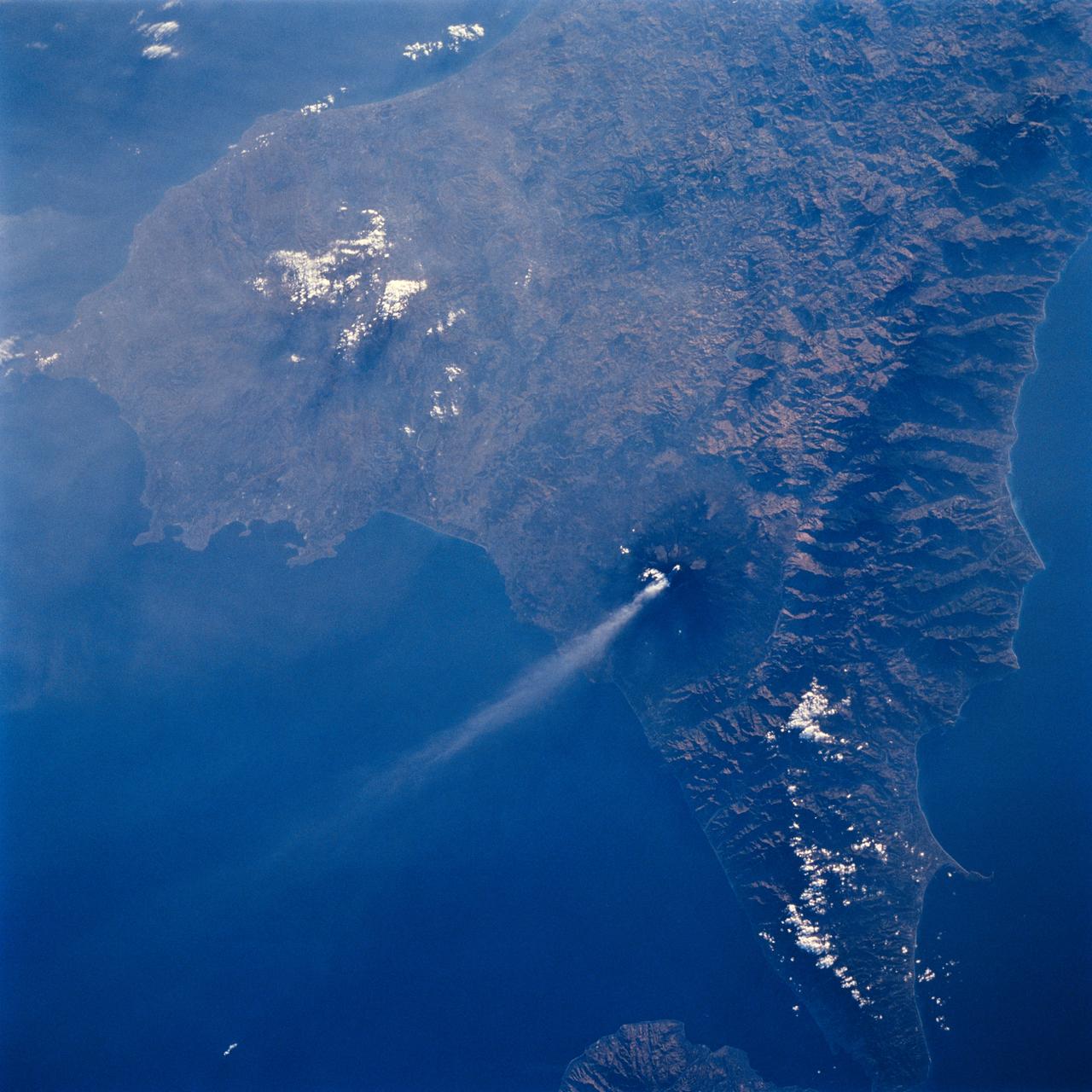
ISS002-E-9630 (22 July 2001) --- The active volcano Mt. Etna on the island of Sicily was recorded by an Expedition Two crew member with a digital still camera.
This distant view of Mt. Fuji, on the main home island of Honshu, Japan (34.0N, 139.0E) was taken from about 450 miles to the south. Evan at that great distance, the majestic and inspiring Mt. Fuji is still plainly visible and easily recognized as a world renowned symbol of Japan. The snow capped extinct volcano lies just a few miles south of Tokyo.
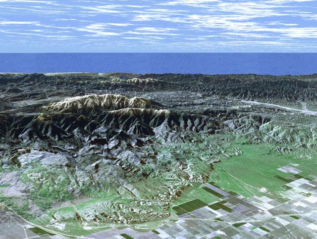
This image is of Mt. Pinos and San Joaquin Valley, California. NASA Shuttle Radar Topography Mission SRTM acquired this data on February 16, 2000.
Astronaut Daniel W. Bursch, Expedition Four flight engineer, was delighted in capturing this image of Mt. Everest in the Himalayan Range from aboard the International Space Station (ISS). The mountain is near frame center. Because the photo was taken close to orbital sunrise, the low sun angle gave tremendous relief to the mountains. Named for Sir George Everest, the British surveyor-general of India, Mount Everest is the tallest point on earth. Standing 29,028 feet tall, it is 5 1/2 miles above sea level. Mount Everest is located half in Nepal and half in Tibet.
Mt. Etna, Italy erupted February 17, 2021, sending rivers of lave down the southeast flank of the volcano, and spewing ashes and volcanic stones over nearby villages. Sicily's Catania Airport was temporarily closed due to an ash plume that rose to 3700 m altitude. By the following week, the eruption had waned. The ASTER visible image shows the extent of the active lava flows (derived from the thermal infrared data). The image was acquired February 26, 2021, covers an area of 25.5 by 27.0 km, and is located at 37.8 degrees north, 15 degrees east. https://photojournal.jpl.nasa.gov/catalog/PIA24418
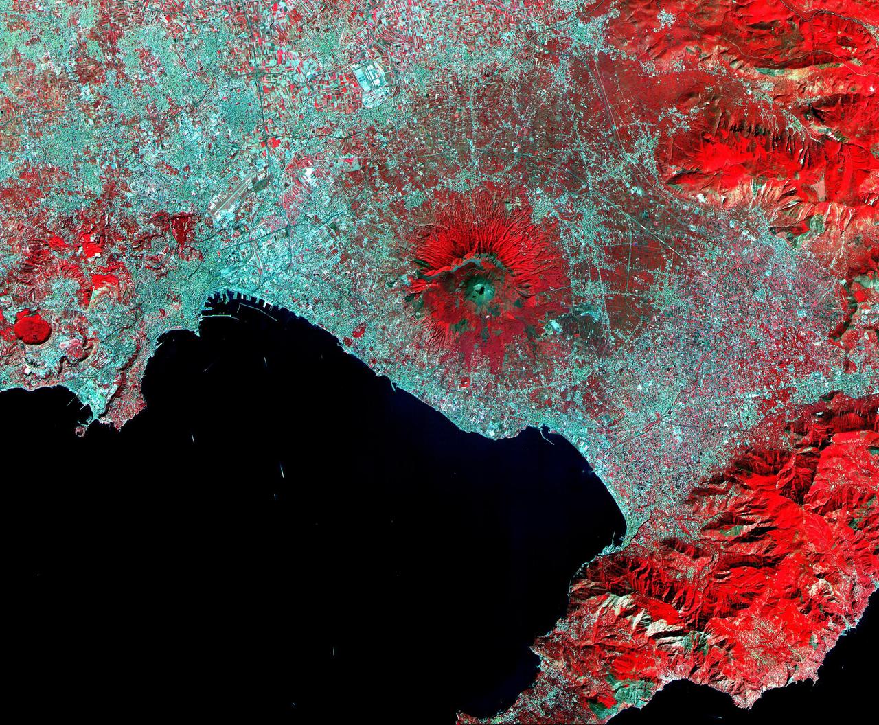
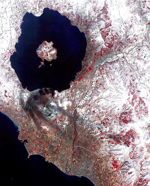
This ASTER image of Mt. Vesuvius Italy was acquired September 26, 2000, and covers an area of 36 by 45 km. Vesuvius overlooks the city of Naples and the Bay of Naples in central Italy. In 79 AD, Vesuvius erupted cataclysmically, burying all of the surrounding cites with up to 30 m of ash. The towns of Pompeii and Herculanaeum were rediscovered in the 18th century, and excavated in the 20th century. They provide a snapshot of Roman life from 2000 years ago: perfectly preserved are wooden objects, food items, and the casts of hundreds of victims. Vesuvius is intensively monitored for potential signs of unrest that could signal the beginning of another eruption. The image is centered at 40.8 degrees north latitude, 14.4 degrees east longitude. http://photojournal.jpl.nasa.gov/catalog/PIA11091
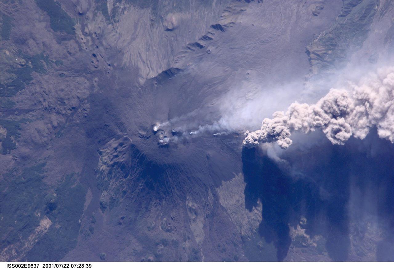
ISS002-E-9637 (22 July 2001) --- An overhead look at the smoke and ash being expelled from the erupting volcano Mt. Etna on the island of Sicily. This image was recorded by an Expedition Two crew member with a digital still camera.
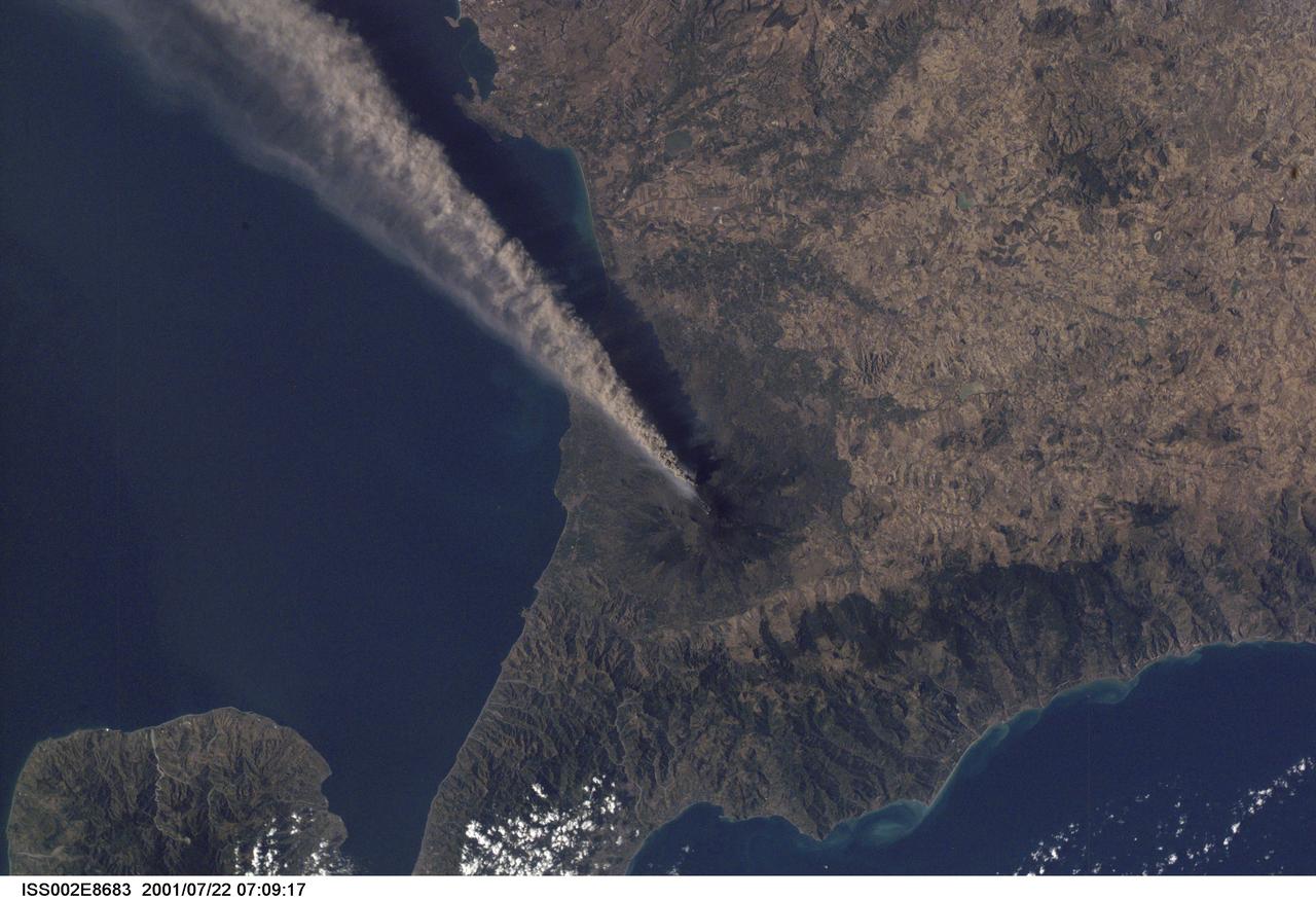
ISS002-E-8683 (22 July 2001) --- Smoke and ash combine to create a plume extending from the erupting volcano on Mt. Etna in Sicily. The digital still image was recorded by one of the Expedition Two crew members.
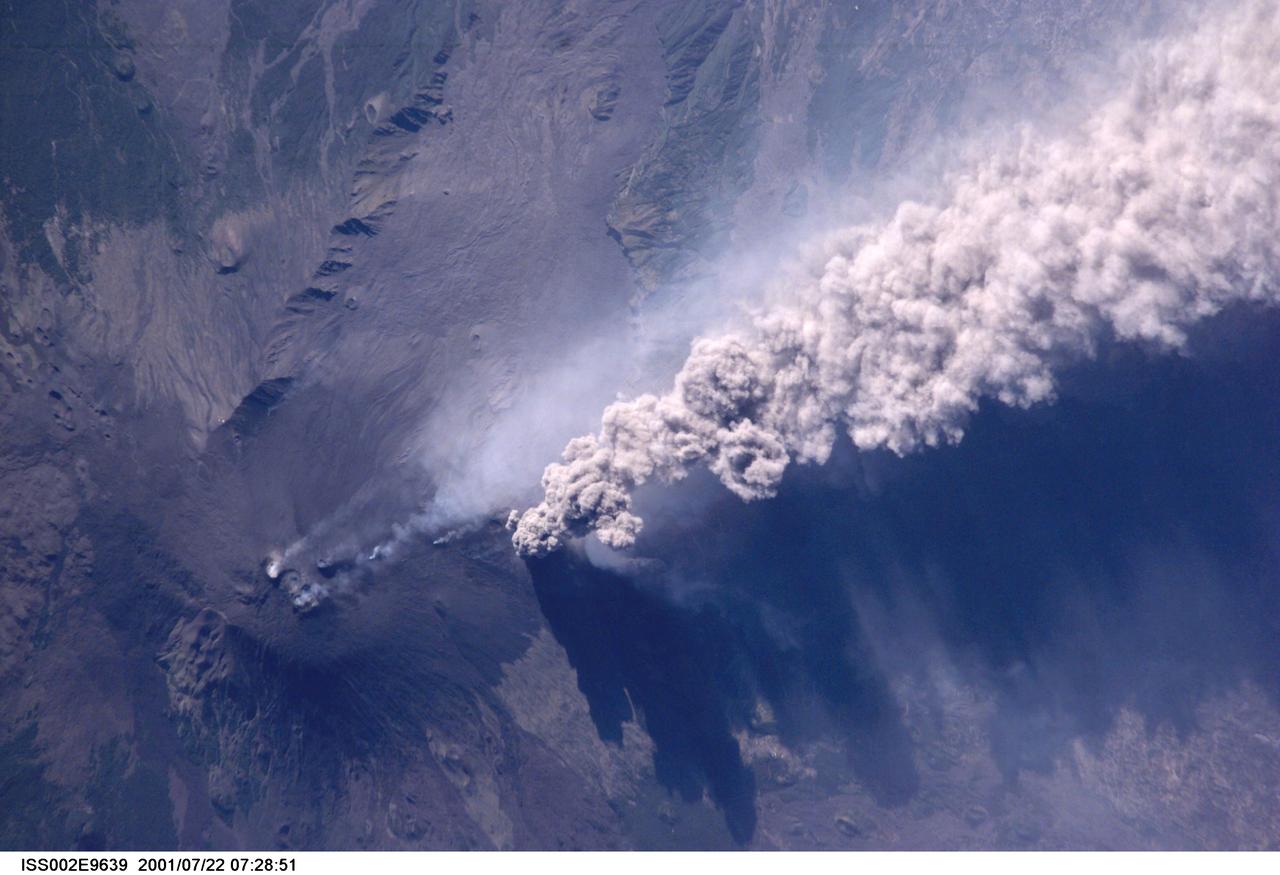
ISS002-E-9639 (22 July 2001) --- An overhead look at the smoke and ash being expelled from the erupting volcano Mt. Etna on the island of Sicily. This image was recorded by an Expedition Two crew member with a digital still camera.

The most recent eruption of Mt. Etna, Italy, began May 30, 2019. New fissure vents opened on the New Southeast Crater, feeding two lava flows that moved down into the Valle del Bove, accompanied by loud explosions. By June 4, when this nighttime ASTER thermal image was acquired, eruption activity had ended. https://photojournal.jpl.nasa.gov/catalog/PIA23235
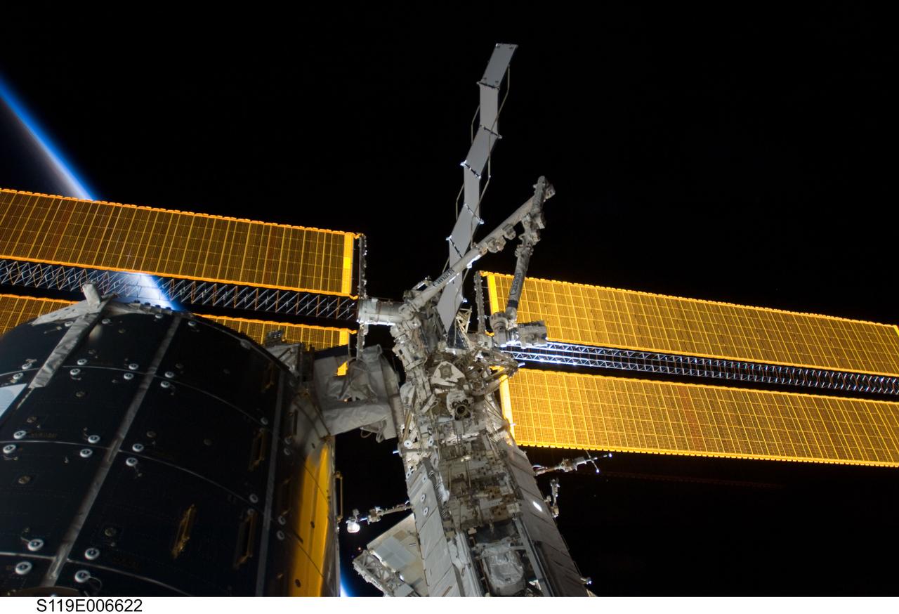
View of the Space Station Remote Manipulator System (SSRMS) on the Mobile Transporter (MT) for S6 Relocation OPS during STS-119 / Expedition 18 joint docked OPS. The MT is on the S1 Truss segment.
We now begin a traverse across Mt. Sharp moving from east to west. The layering of the material that comprises Mt. Sharp is visible in the bottom third of this image from NASA Mars Odyssey spacecraft; showing the weathering that has affected Mt. Sharp.
At 14,505 feet high, Mt. Whitney, the highest point in the contiguous U.S., is located in California Sierra Nevada Mountains, on the west side of Owens Valley. The Alabama Hills appear in the foreground of this image from NASA Terra spacecraft.
Japan Mt. Fuji presents a beautiful backdrop for the city of Tokyo as seen in this image generated from NASA Shuttle Radar Topography Mission SRTM data on February 21, 2000.
Tokyo, located on the island of Honshu, with Mt. Fuji in the background as seen in this image generated from NASA Shuttle Radar Topography Mission SRTM data on February 21, 2000.
STS062-85-195 (4-18 March 1994) --- A thin plume of steam blows southward from the summit of Mt. Etna, the active volcano on the island of Sicily. The summit is capped with snow but the dark lava flow along the eastern flank (the 1991-93 flow) is clearly visible. The coastal city south of Etna is Catania.
STS064-71-037 (9-20 Sept. 1994) --- Mt. Etna on Sicily displays a steam plume from its summit. Geologists attribute the volcano's existence to the collision of tectonic plates. Unlike the sudden, explosive eruption at Rabaul, Mt. Etna's activity is ongoing and is generally not explosive - Etna's slopes have been settled with villages and cultivated land for centuries. Other Mediterranean volcanoes (like Santorini) have experienced large catastrophic eruptions. Etna recently finished a two-year eruption (ending in 1993), marked by relatively gentle lava flows down the eastern flank. It has been continually degassing since then, according to the geologists, producing an omnipresent steam plume, as seen here. The 1993 flow is difficult to identify in this image because it lies within shadows on the eastern flank, but small cinder cones on the western flank mark earlier episodes of volcanic activity. Photo credit: NASA or National Aeronautics and Space Administration
The highest elevations of Mt. Sharp are just outside this image to the east. In the center of this image from NASA Mars Odyssey spacecraft is a channel, indicating that fluids played a part in eroding Mt. Sharp.
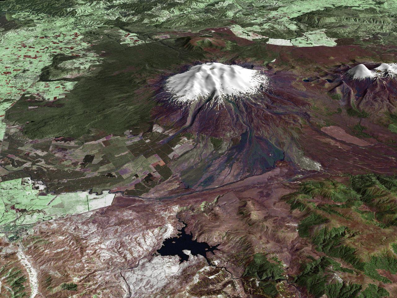
All around the world, people live in places where the threat of natural disaster is high. On the North Island of New Zealand, the Mount Ruapehu volcano is just such a threat. A towering, active stratovolcano (the classic cone-shaped volcano), snow-capped Ruapehu Volcano is pictured in this enhanced-color image. The image is made from topography data collected by the Shuttle Radar Topography Mission aboard the Space Shuttle Endeavour, launched on February 11, 2000, and imagery collected by the Landsat satellite on October 23, 2002. Ruapehu is one of New Zealand’s most active volcanoes, with ten eruptions since 1861. The eruptions aren’t the only threat from the volcano, however. Among the most serious threats is a volcanic mudflow called a lahar. In between eruptions, a lake forms in the volcano’s caldera from melting snow. If a previous eruption has deposited a dam of ash, rocks and mud in the lake’s natural overflow point, then the lake becomes dangerously full, held back only by the temporary dam. In this scene, the lake is nestled among the ridges at the top of the volcano. Eventually, the dam gives way and a massive flow of mud and debris churns down the mountain toward farmland and towns below. Scientists estimate that Ruapehu has experienced 60 lahars in the last 150 years. A devastating lahar in 1953 killed more than 150 people, who died when a passenger train plunged into a ravine when a railroad bridge was taken out by the lahar. The flank of the volcano below the lake is deeply carved by the path of previous lahars; the gouge can be seen just left of image center. Currently scientists in the region are predicting that the lake will overflow in a lahar sometime in the next year. There is great controversy about how to deal with the threat. News reports from the region indicate that the government is planning to invest in a high-tech warning system that will alert those who might be affected well in advance of any catastrophic release. Others feel that the government should combat the threat through engineering at the top of the mountain, for example, by undertaking a controlled release of the lake. Credit Landsat data provided courtesy of the University of Maryland Global Land Cover Facility Landsat processing by Laura Rocchio, Landsat Project Science Office SRTM 3-arcsecond elevation data courtesy of SRTM Team NASA/JPL/NIMA Visualization created by Earth Observatory staff. <b><a href="http://www.nasa.gov/centers/goddard/home/index.html" rel="nofollow">NASA Goddard Space Flight Center</a></b> enables NASA’s mission through four scientific endeavors: Earth Science, Heliophysics, Solar System Exploration, and Astrophysics. Goddard plays a leading role in NASA’s accomplishments by contributing compelling scientific knowledge to advance the Agency’s mission. <b>Follow us on <a href="http://twitter.com/NASA_GoddardPix" rel="nofollow">Twitter</a></b> <b>Join us on <a href="http://www.facebook.com/pages/Greenbelt-MD/NASA-Goddard/395013845897?ref=tsd" rel="nofollow">Facebook</a></b>

The STS-111 mission, the 14th Shuttle mission to visit the International Space Station (ISS), was launched on June 5, 2002 aboard the Space Shuttle Orbiter Endeavour. On board were the STS-111 and Expedition Five crew members. Astronauts Kerneth D. Cockrell, commander; Paul S. Lockhart, pilot; and mission specialists Franklin R. Chang-Diaz and Philippe Perrin were the STS-111 crew members. Expedition Five crew members included Cosmonaut Valeri G. Korzun, commander; Astronaut Peggy A. Whitson and Cosmonaut Sergei Y. Treschev, flight engineers. Three space walks enabled the STS-111 crew to accomplish the delivery and installation of the Mobile Remote Servicer Base System (MBS), an important part of the Station's Mobile Servicing System that allows the robotic arm to travel the length of the Station, which is necessary for future construction tasks. In this photograph, Astronaut Philippe Perrin, representing CNES, the French Space Agency, participates in the second scheduled EVA. During the space walk, Perrin and Chang-Diaz attached power, data, and video cables from the ISS to the MBS, and used a power wrench to complete the attachment of the MBS onto the Mobile Transporter (MT).
Mt. Pinatubo on the island of Luzon (15.0N, 120.0E) erupted catastrophically in June 1991 after over 600 years of inactivity. In this vertical view, the full extent of the eruption is obvious. Thick layers of ash completely surrounds the crater and the effect of mudflows in this previously heavily forested and agricultural region can be traced as ribbons flowing downhill. Clark AFB, once the crossroads of the SW Pacific can only partially be seen.
ISS004-E-8852 (20 March 2002) --- Astronaut Daniel W. Bursch, flight engineer for Expedition Four aboard the International Space Station, used a digital still camera to capture this image of Mt. Everest in the Himalayan Range. The mountain is near frame center. Here are the notes Bursch added in one of his reports to ground controllers: "One morning I happened to be up early. I glanced at our world map and saw that we’d be passing near Mt Everest soon. I checked the computer, realized that we were in an attitude that would allow me to open the window shutter and there was Mt Everest! It almost seemed to jump out at me. The low sun angle (it was close to orbital sunrise) gave tremendous relief to the mountains. It was just one of those sights that will be forever burned into my brain!"
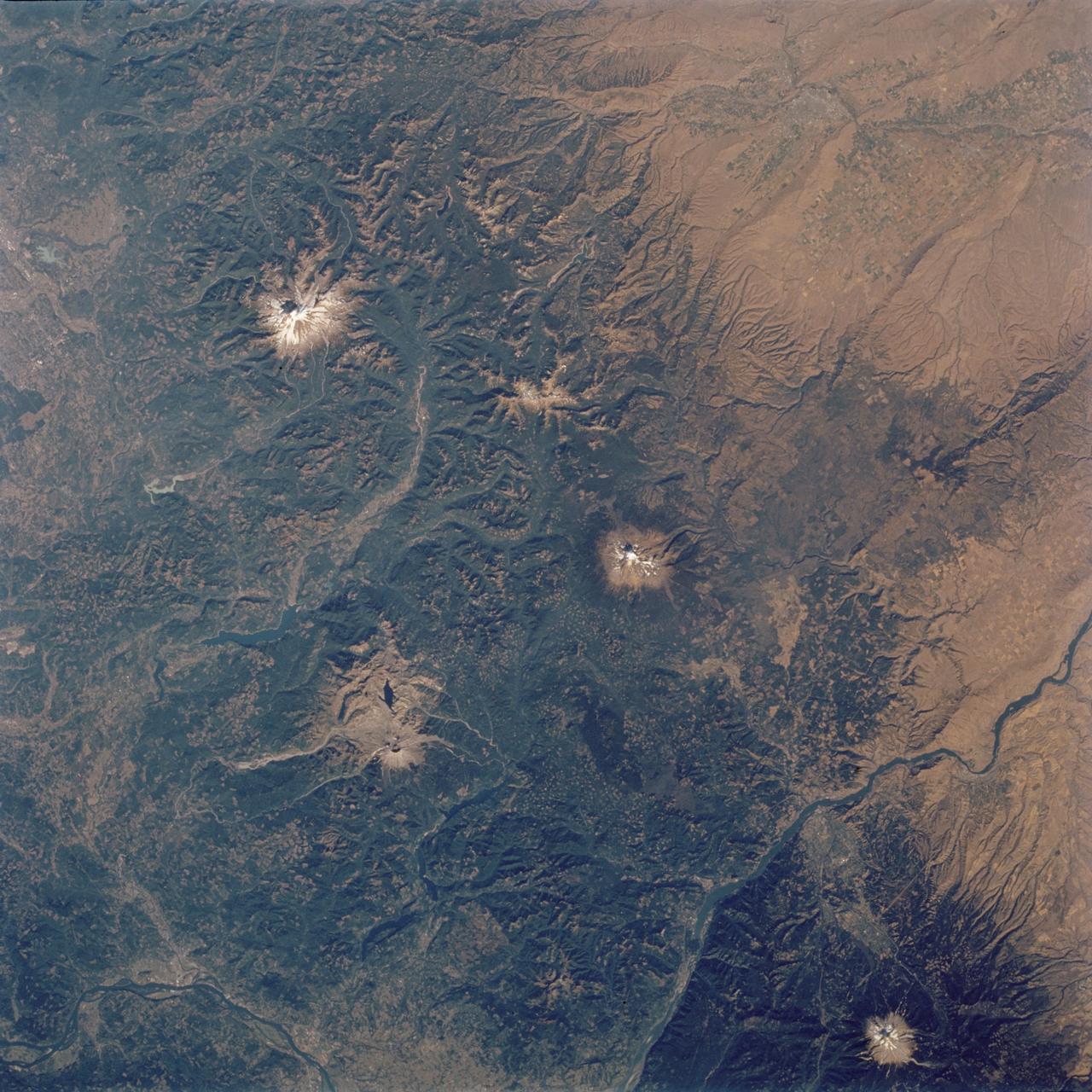
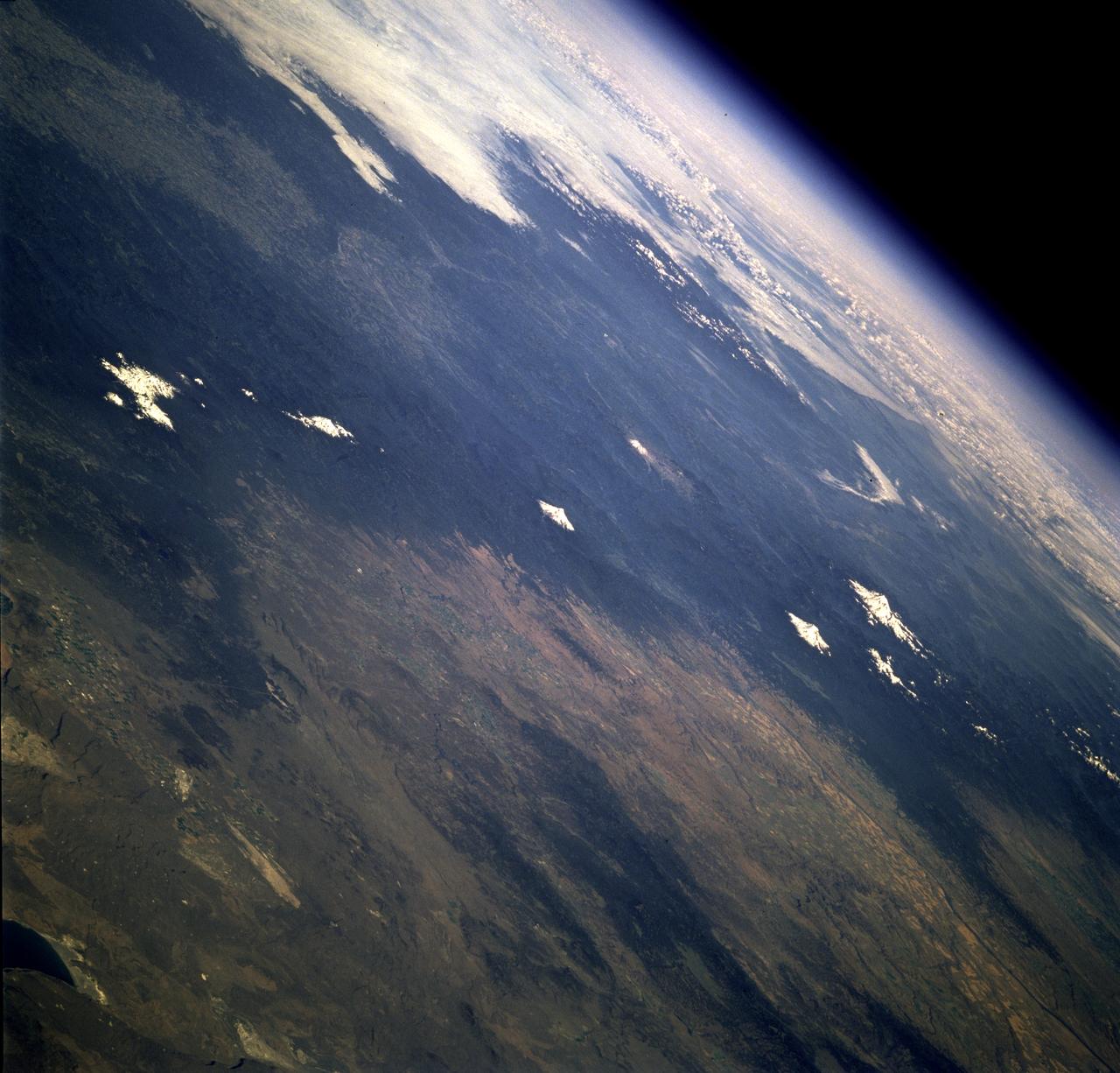
STS112-704-142 (7-18 October 2002) --- (For orientation purposes, north is toward the top left corner). Green colors of the forests of the Cascade Mountains dominate this view, photographed from the Earth-orbiting Space Shuttle Atlantis. Browner colors (top right) are the semiarid plains of the Columbia Basin, in the rain shadow of the Cascades. The highest peaks in this part of the Cascades are four volcanoes. The amount of snow is a good indication of their altitude. The highest is Mt. Rainier (14,410 feet) with the greatest amount of white snow (top left). Seattle lies immediately downslope (top left margin). Mt. Adams (12,276) lies due south in the middle of the view. Mt. Hood (11,235 feet) in the lower right corner, lies south of the great gorge of the Columbia River (which crosses the lower right and then the lower left corners of the view). The river flows broadly west (left) to the Pacific Ocean (out of the picture left). Mt. St Helens (8,364 feet), the snow-free brown patch lower left, was too low to retain snow after the recent fall. According to geologists studying the STS-112 photography, even from the altitude of the Space Shuttle, the intact south half of the cone can be discerned. The geologists point out that the famous blast of 1980 not only destroyed the north side of the cone but blew down the green forest for many square miles on the north side (brown signature).

The STS-111 mission, the 14th Shuttle mission to visit the International Space Station (ISS), was launched on June 5, 2002 aboard the Space Shuttle Orbiter Endeavour. On board were the STS-111 and Expedition Five crew members. Astronauts Kerneth D. Cockrell, commander; Paul S. Lockhart, pilot; and mission specialists Franklin R. Chang-Diaz and Philippe Perrin were the STS-111 crew members. Expedition Five crew members included Cosmonaut Valery G. Korzun, commander; and Astronaut Peggy A. Whitson and Cosmonaut Sergei Y. Treschev, flight engineers. Three space walks enabled the STS-111 crew to accomplish the delivery and installation of the Mobile Remote Servicer Base System (MBS), an important part of the Station's Mobile Servicing System that allows the robotic arm to travel the length of the Station, which is necessary for future construction tasks. In this photograph, Astronaut Franklin R. Chang-Diaz participates in the first scheduled session of extra vehicular activity (EVA) for the STS-111 mission. During the space walk, Chang-Diaz and Perrin attached a Power and Data Grapple Fixture onto the ISS's P6 Truss, setting the stage for the future relocation of the P6. The next major task was to remove Service Module Debris Panels from Space Shuttle Endeavour's payload bay and attach them to their temporary location on Pressurized Mating Adapter 1 (PMA-1). The space walkers also removed thermal blankets to prepare the MBS for installation onto the station's Mobile Transporter (MT).
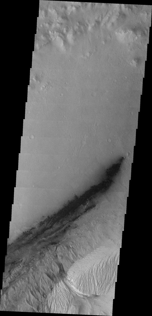
This Gale image from NASA Mars Odyssey spacecraft shows the region just slightly south of yesterday image. The dark region on the crater floor is sand. The dunes that encircle Mt. Sharp are most likely comprised of sand eroded from Mt. Sharp itself.
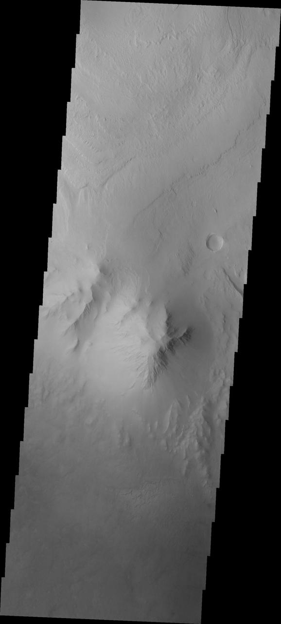
Continuing westward, this image from NASA Mars Odyssey spacecraft shows Mt. Sharp just east of the highest peak of the deposit. The dark material near the top of the image is likely sand. This image shows the dark material on the floor and on Mt. Sharp.
Moving eastward from the previous image, we continue to see the northern floor and rim of Gale Crater and the northern part of Mt. Sharp. This image from NASA Mars Odyssey spacecraft shows a weathered region of the lower elevations of Mt. Sharp.
Mt. Etna, Sicily, Italy, is Europe most active volcano. In mid-May 2016, Mt. Etna put on a display of lava fountaining, ash clouds and lava flows. Three of the four summit craters were active. NASA Terra spacecraft acquired this image on May 26, 2016.
Moving further east, this image from NASA Mars Odyssey spacecraft shows the southern extent of Mt. Sharp as well as the crater floor and rim. In this image there are small dunes near Mt. Sharp as well as dunes near the crater rim.
This image captured by NASA 2001 Mars Odyssey spacecraft shows more of the weathering of the eastern side of Mt. Sharp.
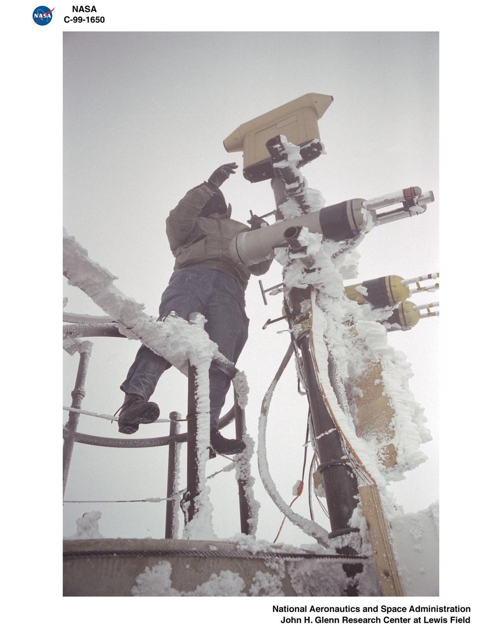
MWISP - MT WASHINGTON ICING SENSORS PROJECT - MWO - MT WASHINGTON OBSERVATORY - TOWER INSTRUMENTATION ADJUSTMENT
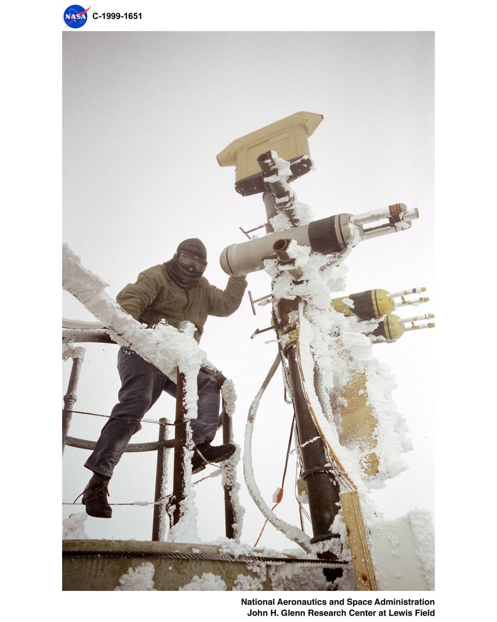
MWISP - MT WASHINGTON ICING SENSORS PROJECT - MWO - MT WASHINGTON OBSERVATORY - TOWER INSTRUMENTATION ADJUSTMENT
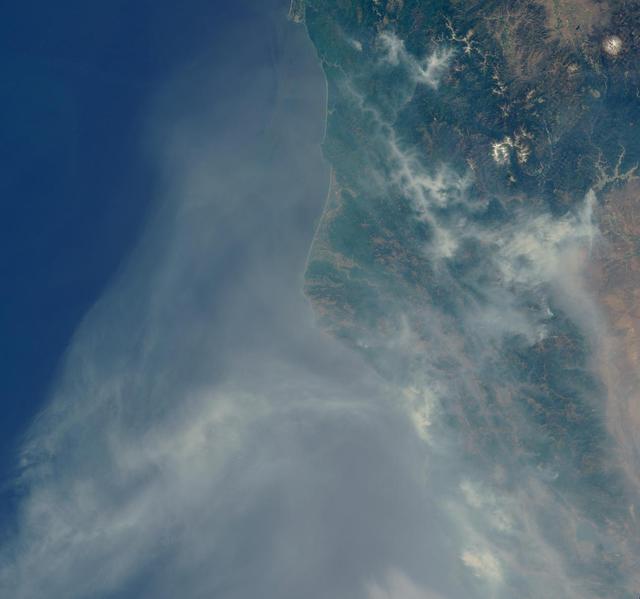
Lightning strikes have sparked more than a thousand fires in northern California. Cape Mendocino is at the center of the image and Mt. Shasta is near the upper right.
Continuing eastward, this image of Gale captured by NASA 2001 Mars Odyssey spacecraft shows the reappearance of dunes on the crater floor near the margin of Mt. Sharp.
The current eruption of Mt. Etna started on July 17, and has continued to the present. This ASTER image was acquired on Sunday, July 29 and shows the sulfur dioxide plume (in purple) originating form the summit, drifting over the city of Catania, and continuing over the Ionian Sea. ASTER's unique combination of multiple thermal infrared channels and high spatial resolution allows the determination of the thickness and position of the SO2 plume. The image covers an area of 24 x 30 km. The image is centered at 37.7 degrees north latitude, 15 degrees east longitude. http://photojournal.jpl.nasa.gov/catalog/PIA02678
STS078-742-004 (20 June - 7 July 1996) --- This is a north-looking perspective of the major volcanoes of the Cascade Mountains of southern Washington and northern Oregon. With the Earth limb in the upper left corner of the photo, the large mountain at the top right, or northern part of the photo, is Mt. Rainier. The next snow covered area to the south east of Mt. Rainier is Gilbert Point. Mt. Adams is the larger peak, south-southeast of Mt. Rainier, Mt. St. Helens is the gray patch in the center of the photo, west of Mt. Adams. Mt. St. Helens erupted on May 18, 1980, removing 1,300 feet of the 9,677-ft. volcano. The eruption toppled trees with a searing, stone-filled 275-mile-per-hour wind over an area of more than 150 square miles. This area, now referred to as the "blast zone", can be easily spotted in this view. NASA scientists say that natural regrowth of vegetation within the blast zone is progressing at a rapid rate, especially on the outer fringes and in the protected valleys. Many fir trees have grown to heights exceeding 20 feet in a little over 12 years. A large lava dome within the crater of the volcano has grown to a height of over 1,000 feet since the 1980 eruption. The next three snow covered peaks are Mt. Hood, Mt. Jefferson and the Three Sisters all located in Oregon.
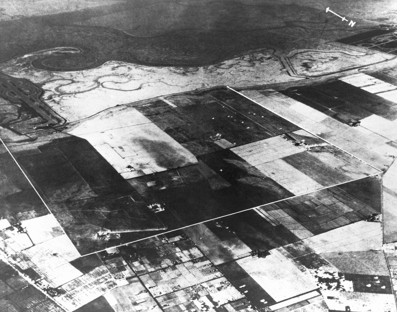
Navy NAS Sunnyvale, Mt View, California prior to construction 1930 Mt View, California farm lands. Property outline in white.
Earth observation taken by the Expedition 42 crew aboard the ISS. Mt. St. Helens (center) and Mt. Rainier, Washington. Image was released by astronaut on Instagram.
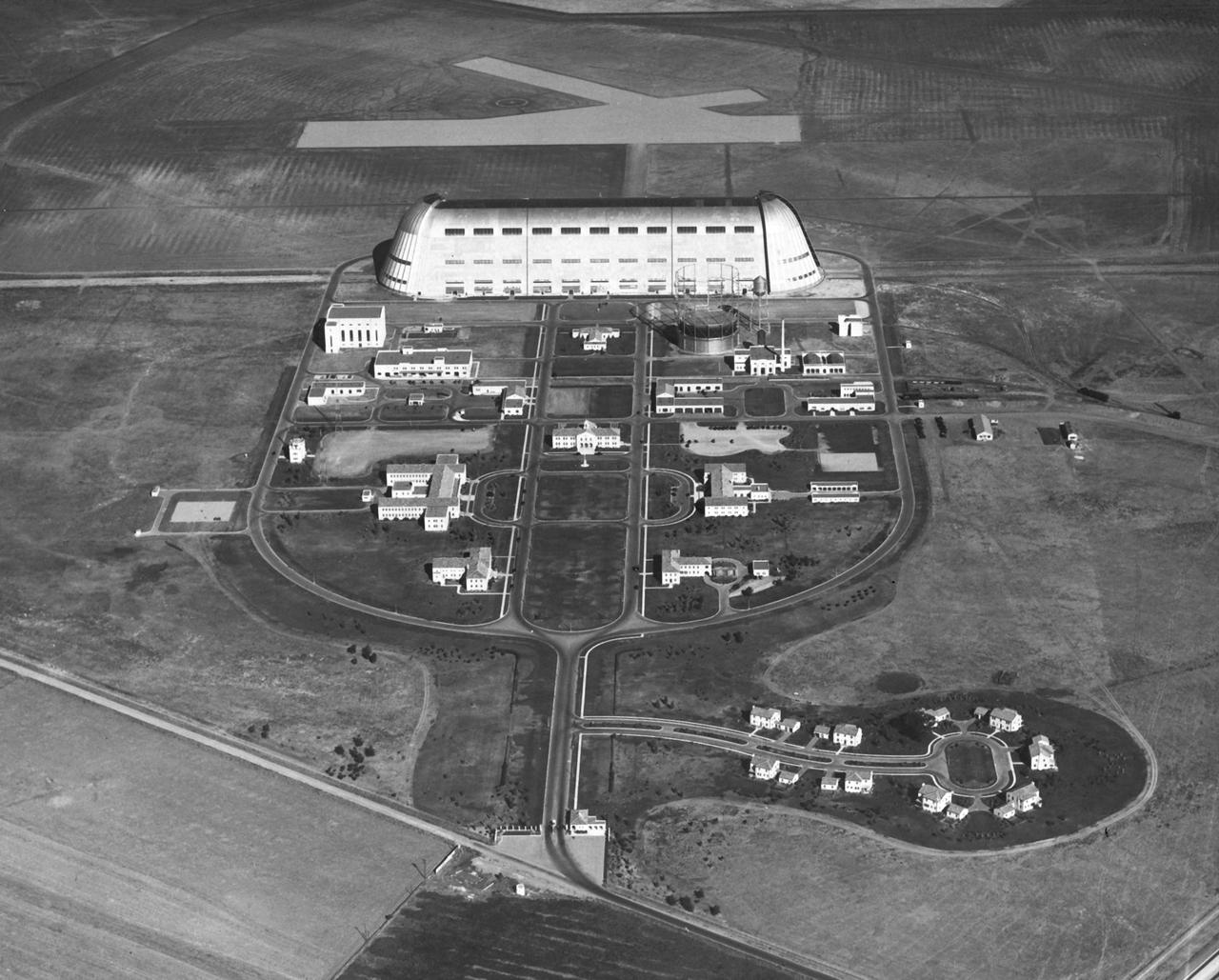
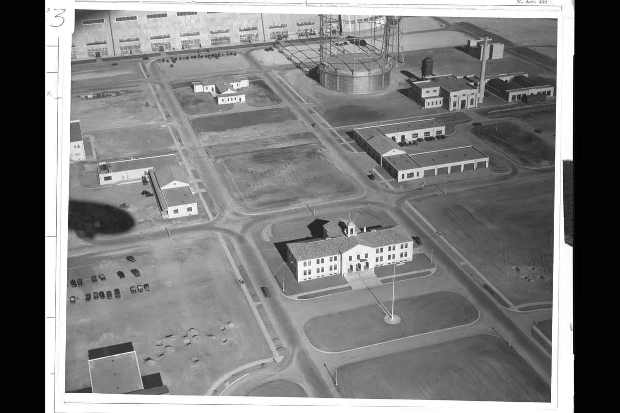
NAS Sunnyvale, Mt View (aerial)
This image from NASA Mars Odyssey spacecraft shows the highest elevation of layered deposit occurs at the top, but just south of the center of the image is a peak that does not appear to be layered and is eroding differently than the rest of Mt. Sharp.
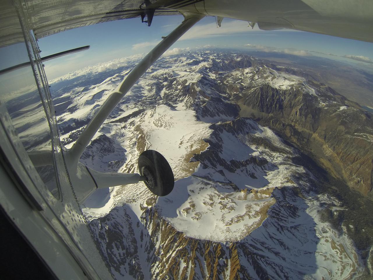
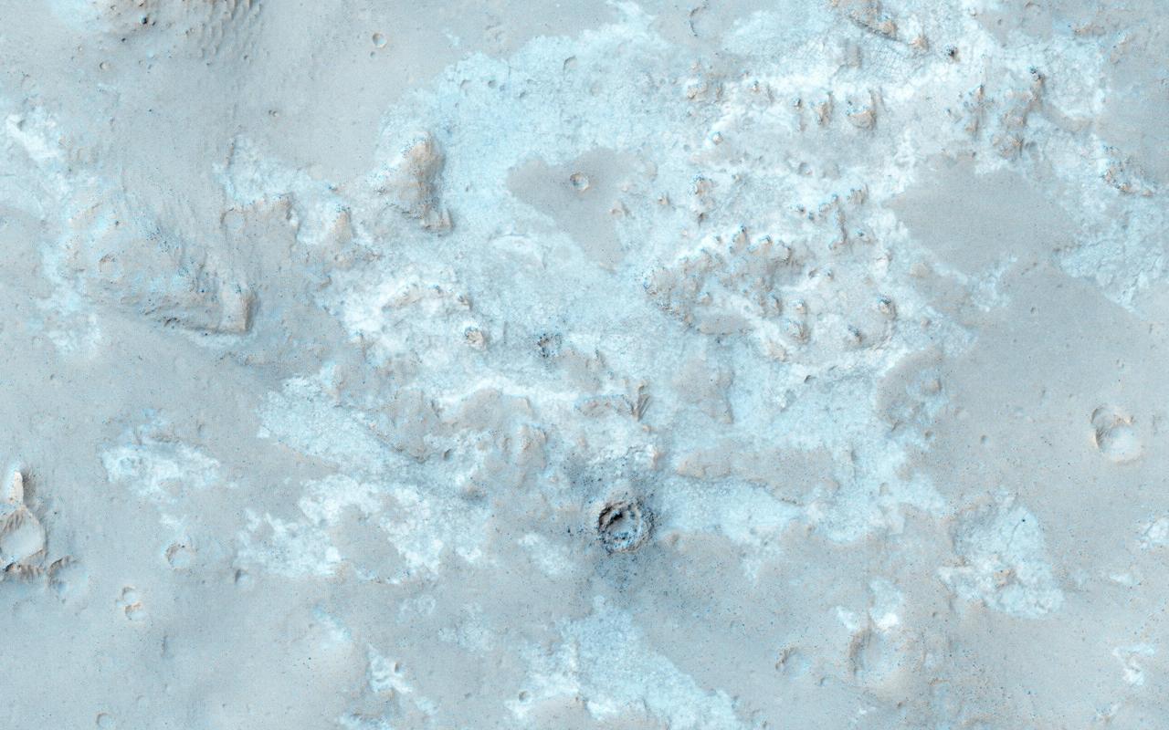
Mt. Dana and Dana Plateau in the Tuolumne River Basin within Yosemite National Park, Calif., as seen out the window of a Twin Otter aircraft carrying NASA Airborne Snow Observatory on April 3, 2013.
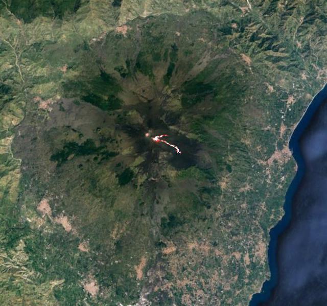
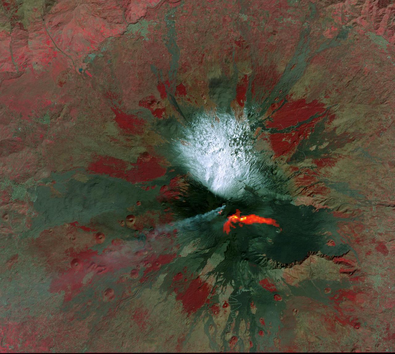
This image acquired by NASA Terra spacecraft is of Mt. Etna, Europe most active volcano, as it continued its latest eruptive activity with a new lava flow from the recently formed southeast crater.
Olympus Mons, imaged here by NASA Mars Odyssey spacecraft, stands 26 km above the surrounding plains, which is three times taller than Mt. Everest, and is the tallest volcano in the solar system.
This image from NASA Mars Odyssey spacecraft shows the major channel that started near the top of Mt. Sharp. Near the top of this image is a wide valley that reaches to the crater floor and the nearby dunes.

This anaglyph shows the central complex in asteroid Vesta Rheasilvia impact basin. The central complex about two and a half times taller than Mt. Everest. You need 3-D glasses to view this image.
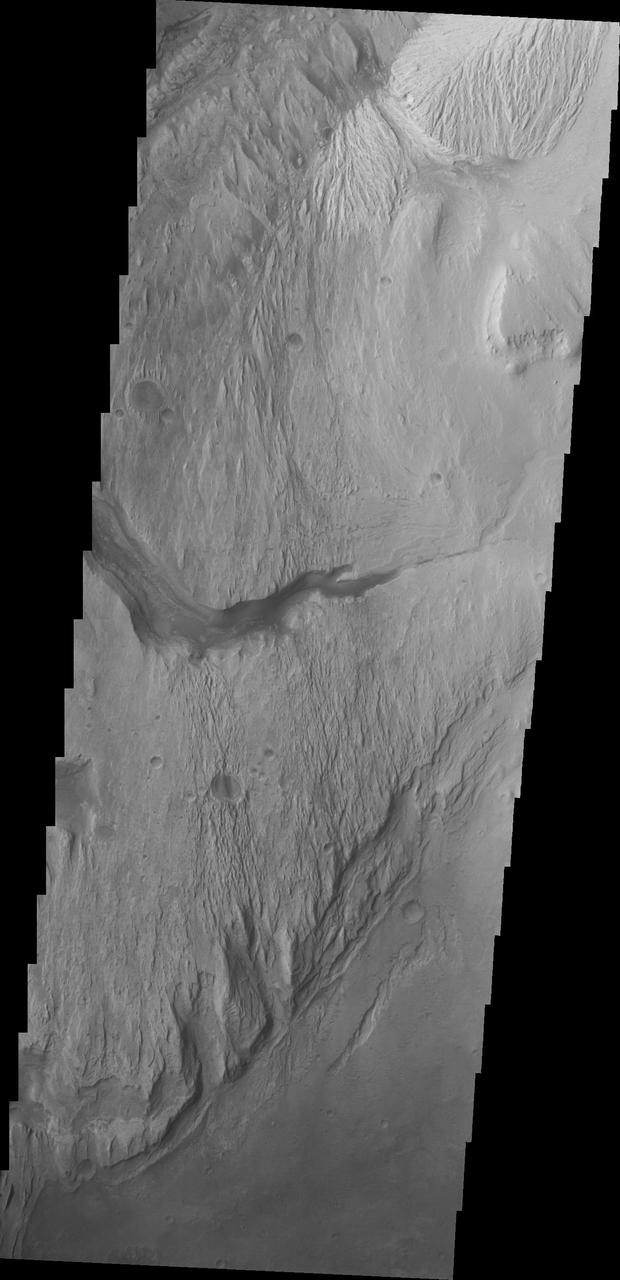
This image captured by NASA 2001 Mars Odyssey spacecraft shows Gale Crater, which contains the landing site of the Mars rover, Curiosity; the rover will have to navigate sand dunes to get to Mt. Sharp.
West of NASA Curiosity landing site, this image from NASA Mars Reconnaissance Orbiter spacecraft along the northwestern floor of Gale Crater is between Aeolis Mons informally called Mt. Sharp and the crater rim.
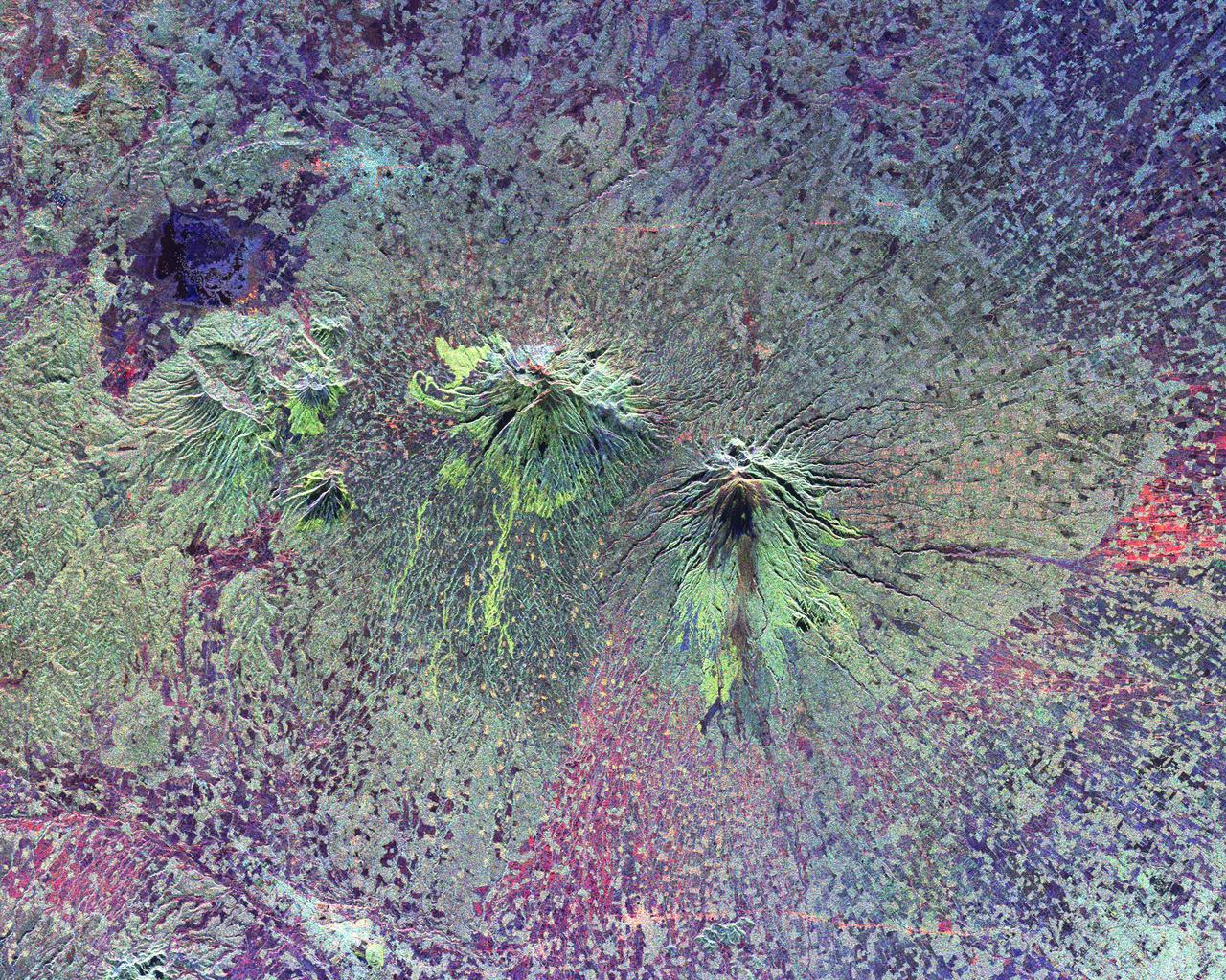
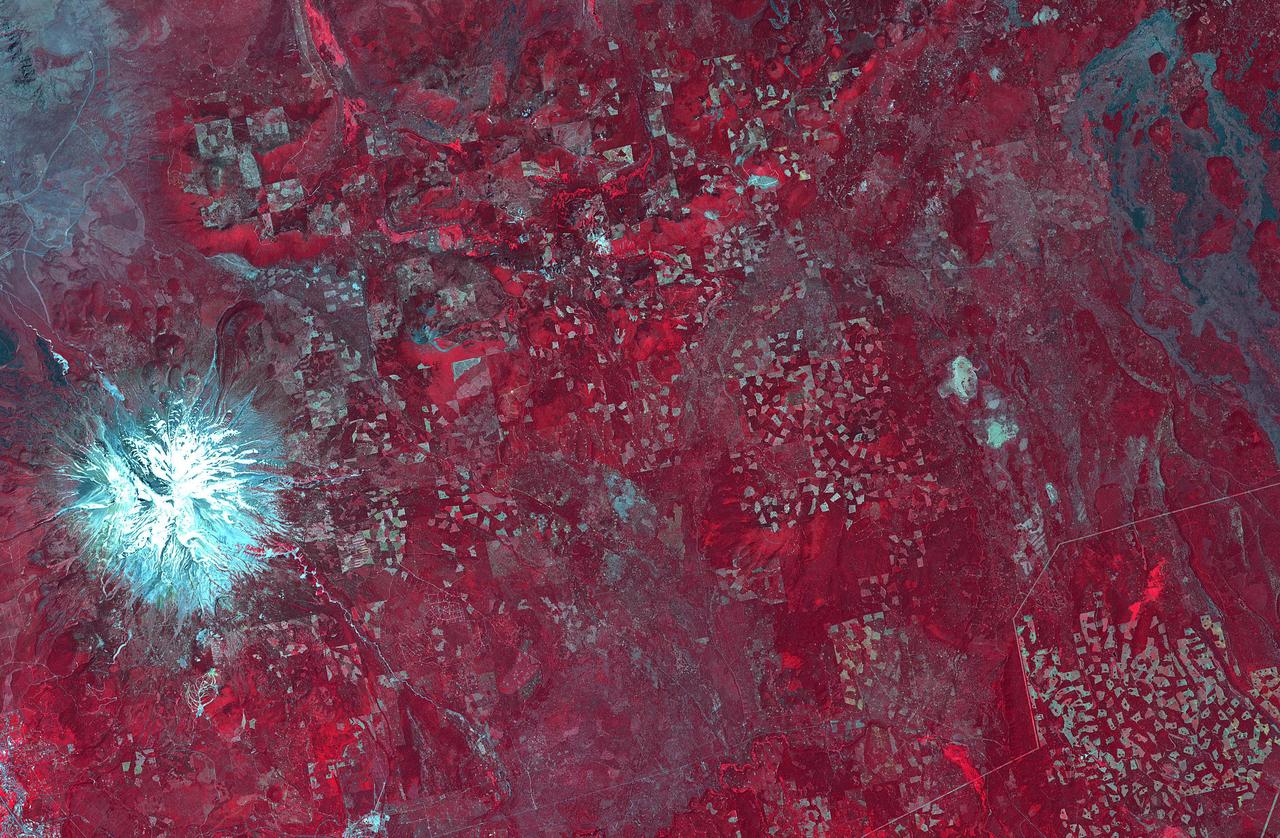
The recently active volcano Mt. Manaro is the dominant feature in this shaded relief image of Ambae Island, part of the Vanuatu archipelago located 1400 miles northeast of Sydney, Australia.
This image from NASA Mars Odyssey spacecraft shows Gale crater, which is east of the landing site. It shows the northern extent of the dunes, and the layers in Mt. Sharp are visible at the bottom of the image.
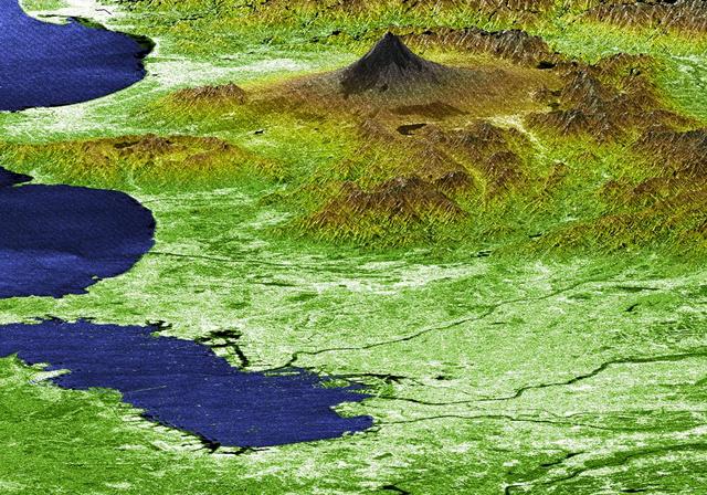
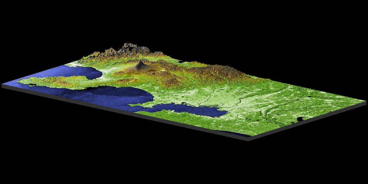
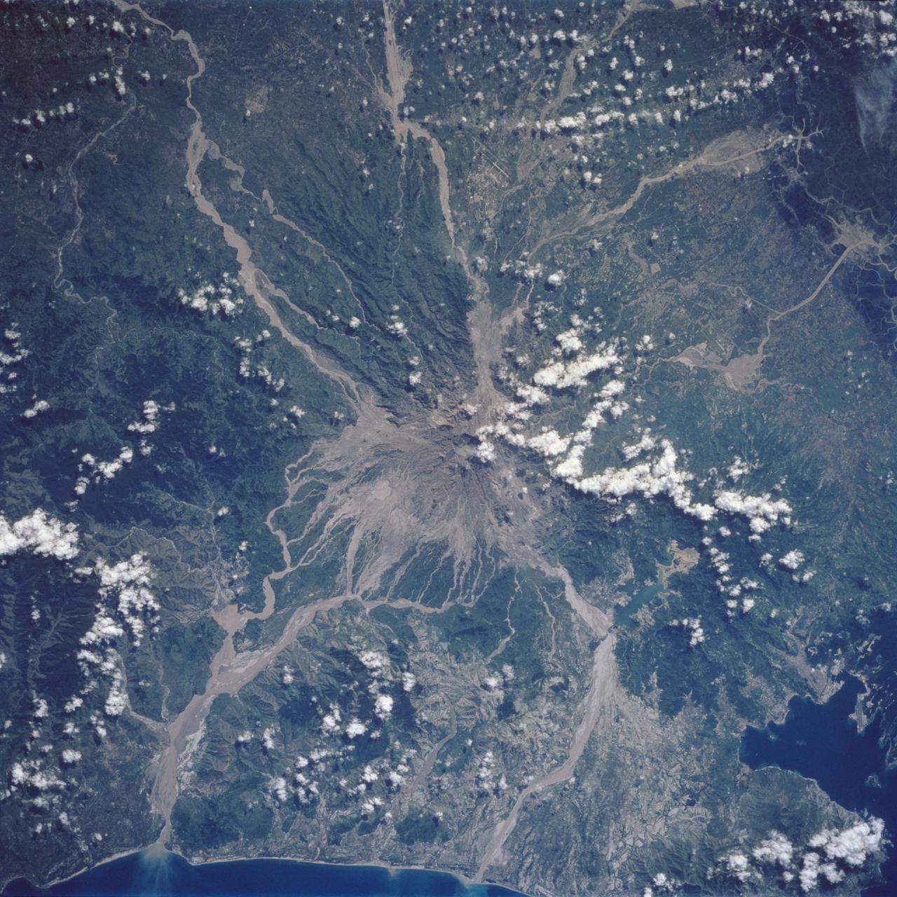
The summits of two large volcanoes in Central Java, Indonesia are shown in the center of this radar image. Lava flows of different ages and surface roughness appear in shades of green and yellow surrounding the summit of Mt. Merbabu (mid-center) and Mt. Merapi (lower center). Mt. Merapi erupted on November 28, 1994 about six weeks after this image was taken. The eruption killed more than 60 people and forced the evacuation of more than 6,000 others. Thousands of other residents were put on alert due to the possibility of volcanic debris mudflows, called lahars, that threatened nearby towns. Mt. Merapi is located approximately 40 kilometers (25 miles) north of Yogyakarta, the capital of Central Java. The older volcano at the top of the image is unnamed. Lake Rawapening is the dark blue feature in the upper right. The light blue area southeast of the lake is the city of Salatiga. Directly south of Salatiga and southeast of Mt. Merapi is the city of Boyolali. Scientists are studying Mt. Merapi as part of the international "Decade Volcanoes" project, because of its recent activity and potential threat to local populations. The radar data are being used to identify and distinguish a variety of volcanic features. http://photojournal.jpl.nasa.gov/catalog/PIA01782
STS113-332-030 (14 December 2002) --- The STS-113 crewmembers used a 35mm still camera to record this image of Mt. Etna Volcano erupting on the island of Sicily. The south-looking oblique sunset view shows snowy, winter-time Mt. Etna with a brown smutty ash plume.
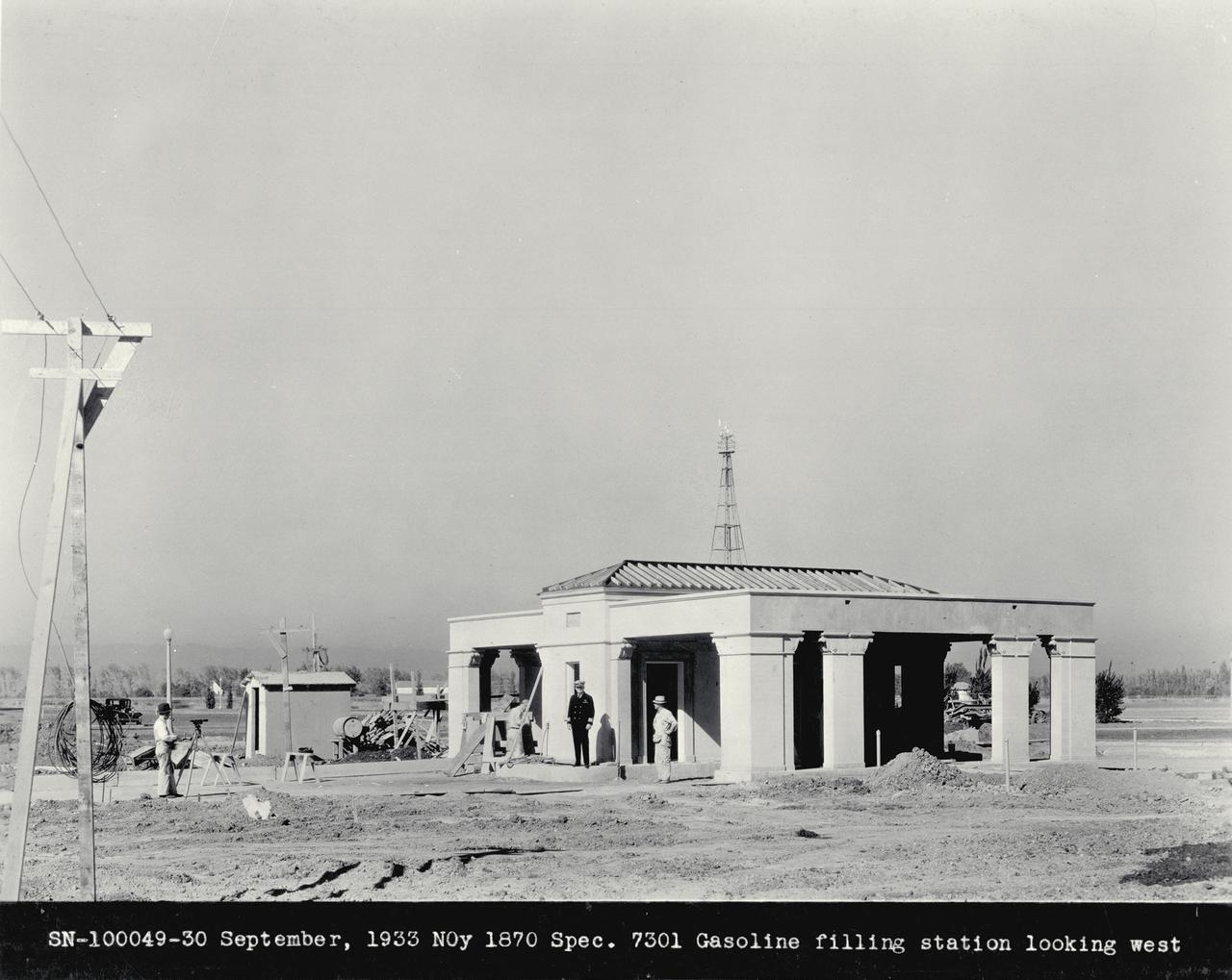
NAS Sunnyvale, Mt View Ca Gasoline Filling Station looking west
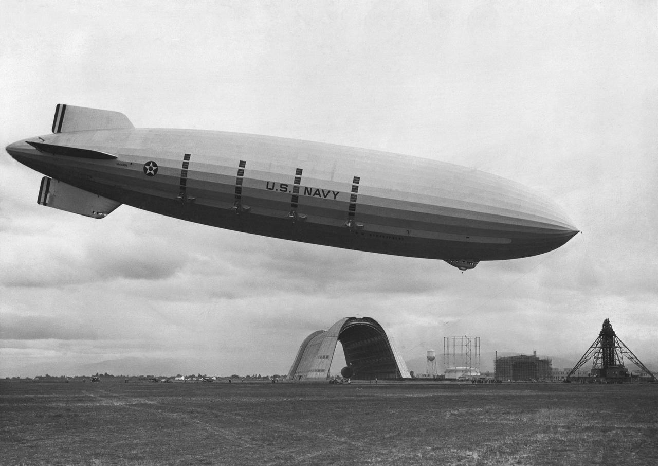
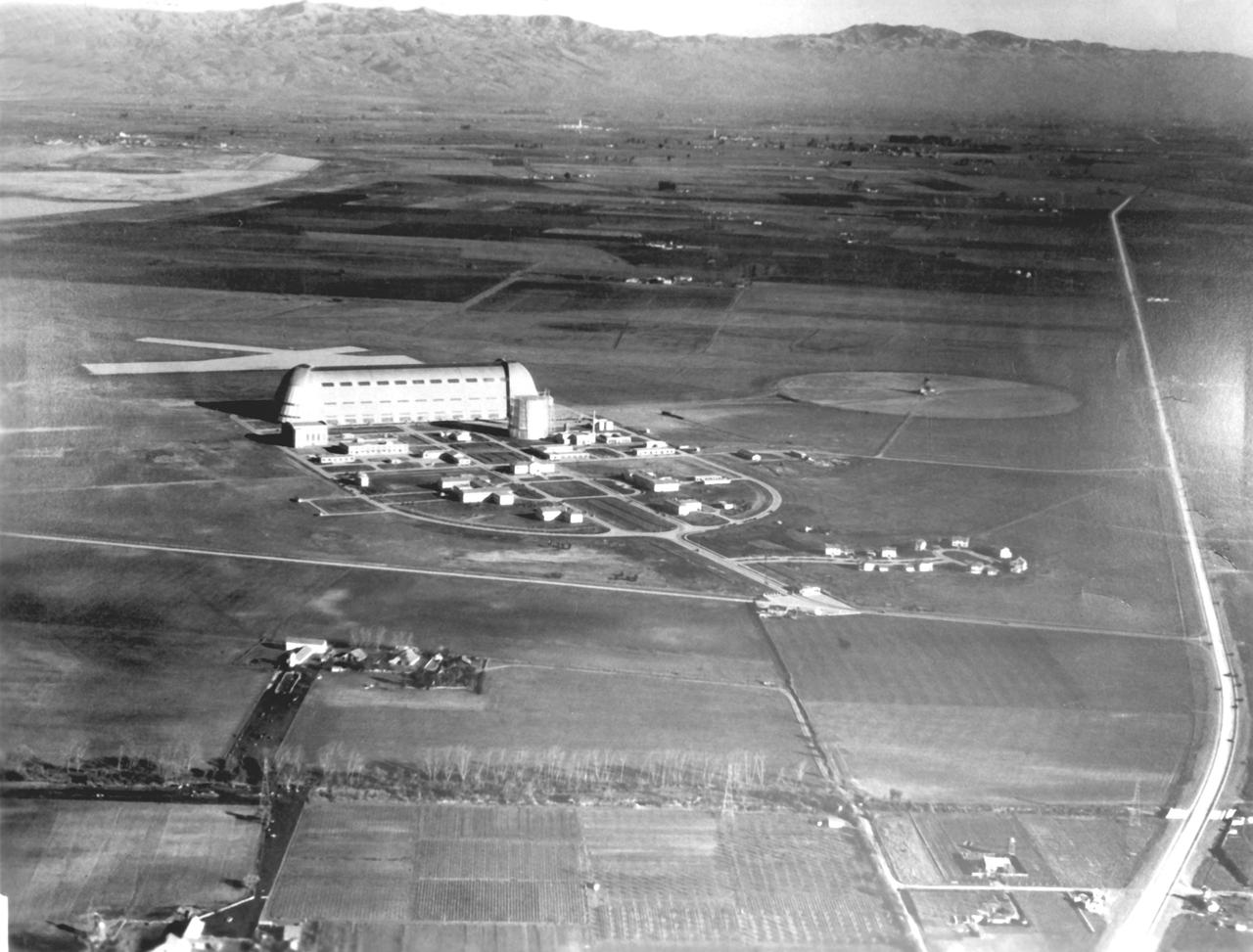
USS MACON AT NORTH CIRCLE NASA SUNNYVALE, MT VIEW, CA
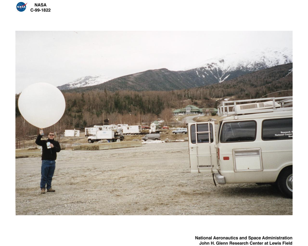
MWISP - MT WASHINGTON ICING SENSORS PROJECT - RADIOSONDE LAUNCH
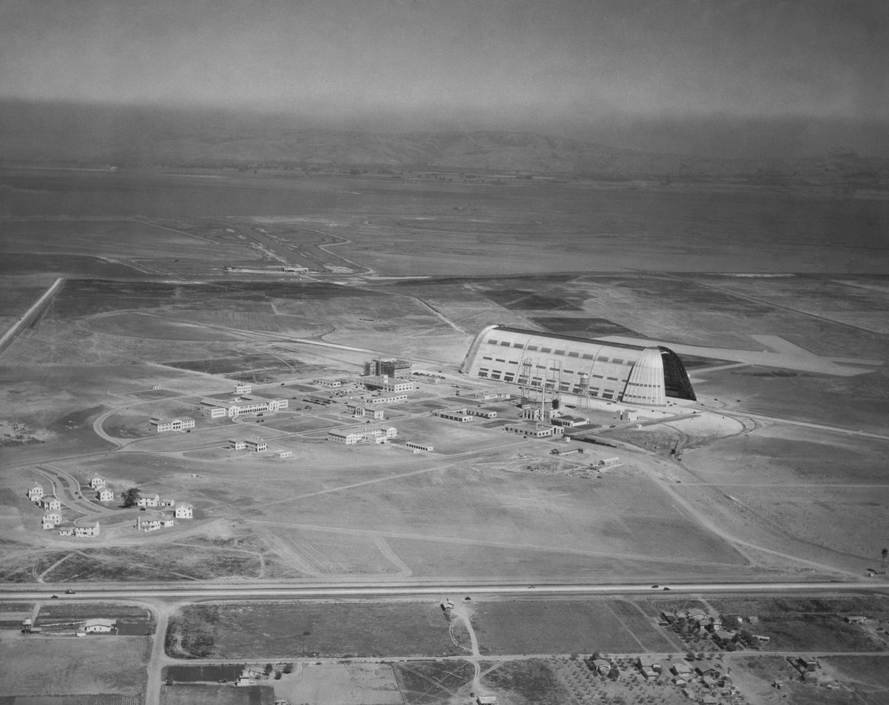
Naval Air Station Synnyvale, Mt View, Ca (aerial)
NAS Sunnyvale, Mt. View CA Looking North East (Alt 1000ft)
Navy NAS Sunnyvale, Mt. View CA Administration Bldg Looking East ALt 800'

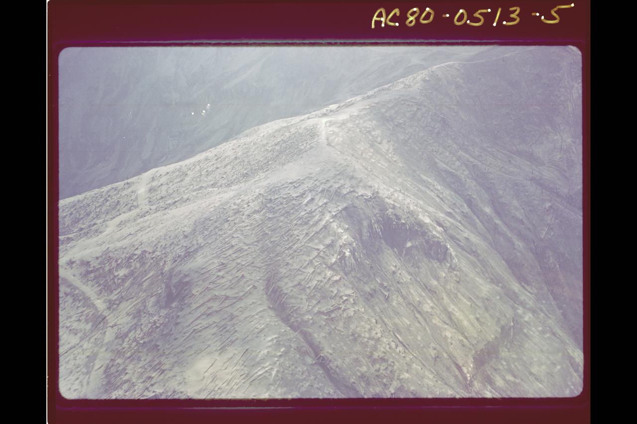
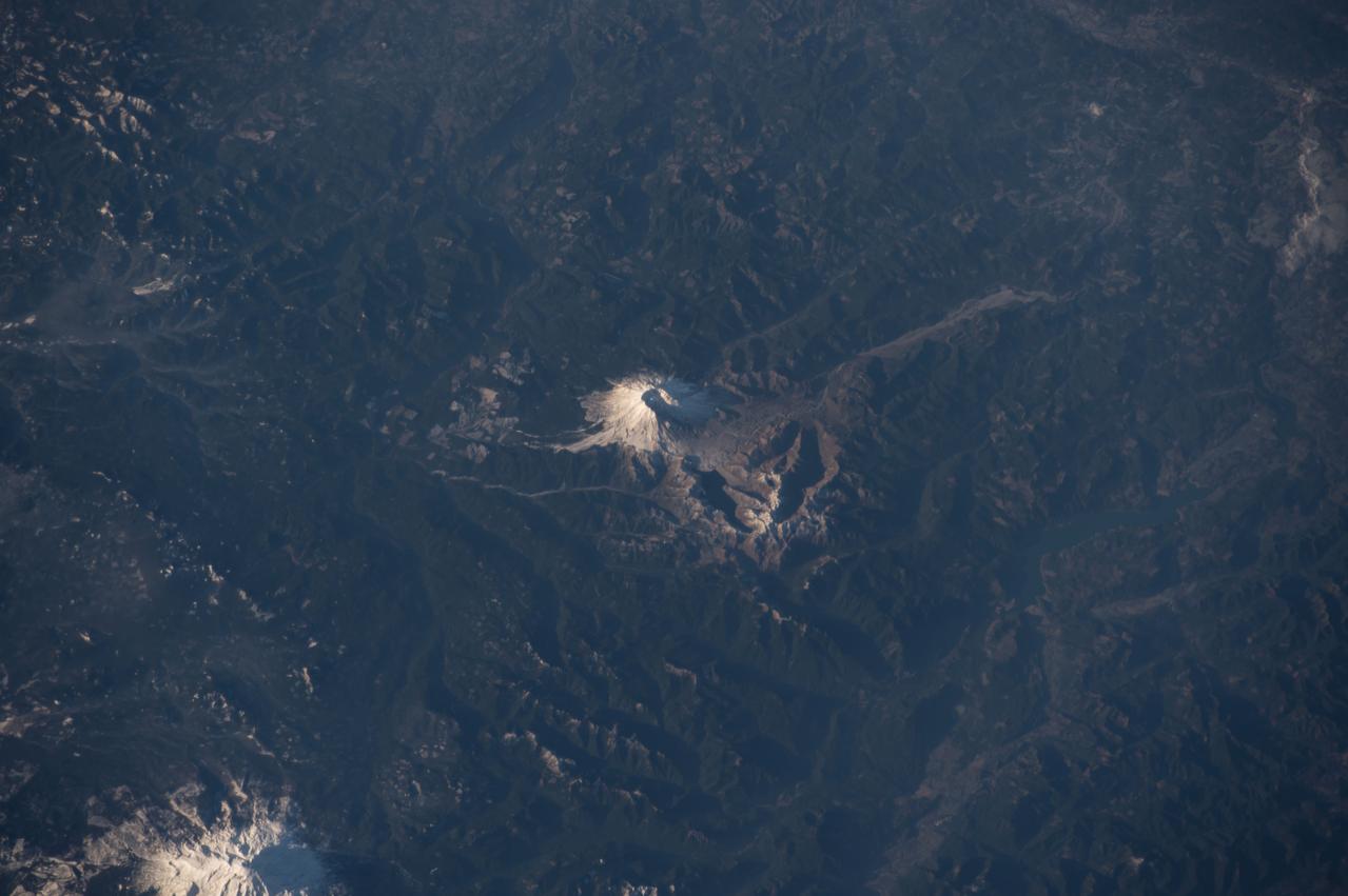
Date: Feb 21, 1991 Photograph: C-130 Imagery Mt St Helens Lava Dome
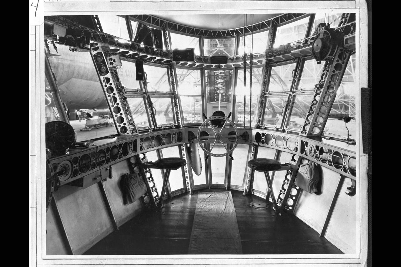
Navy Forward Compartment of control car, USS Macon at NAS Sunnyvale, Mt. View CA
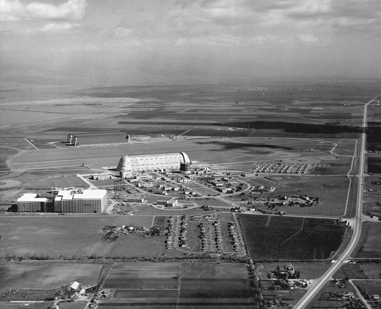
NAS Moffett Field Naval Air Station, Mt. View, Ca Altitude 1300ft E.S. East
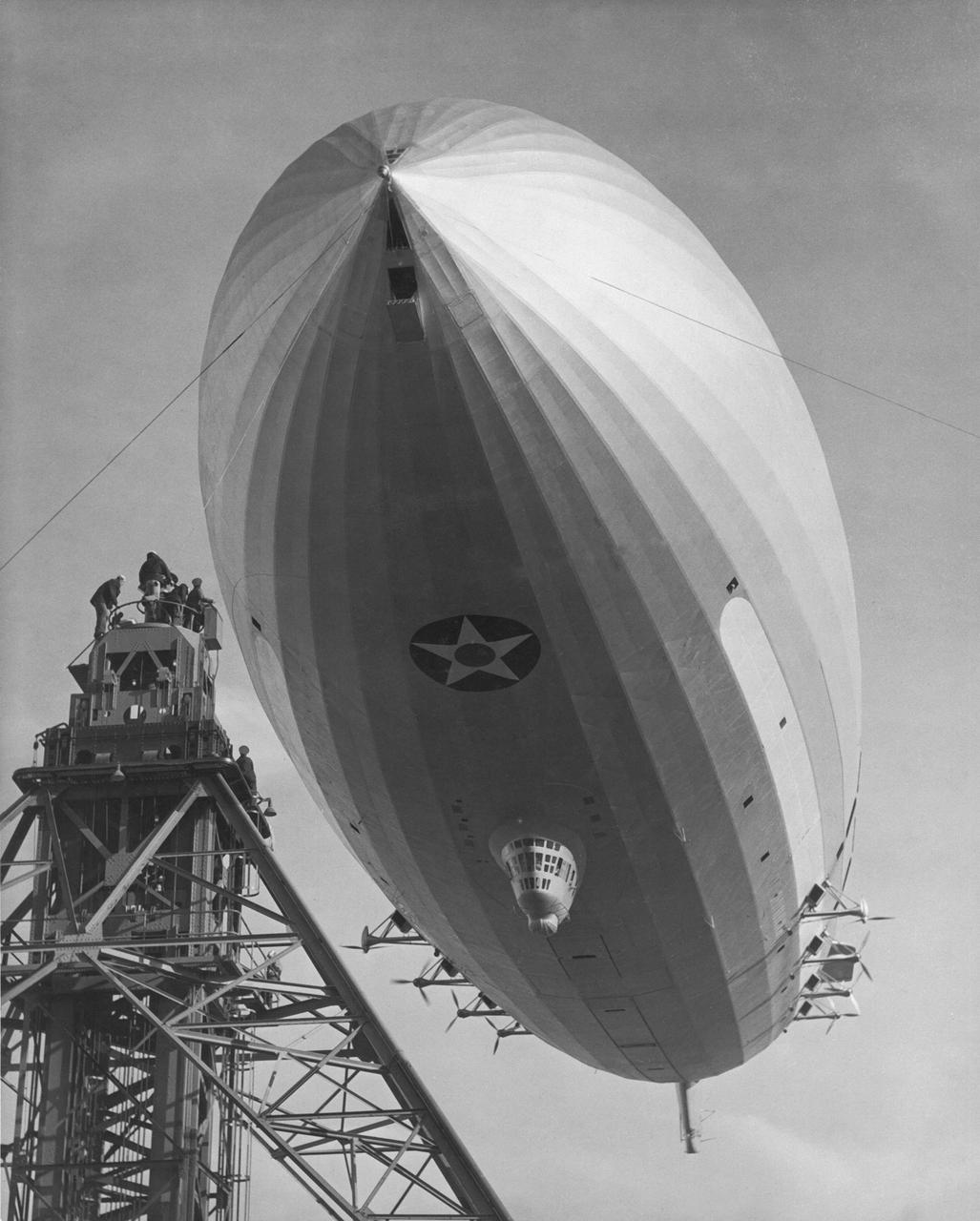
Navy USS Macon Mooring at south circle U.S. Naval Airstation Sunnyvale, Mt. View CA
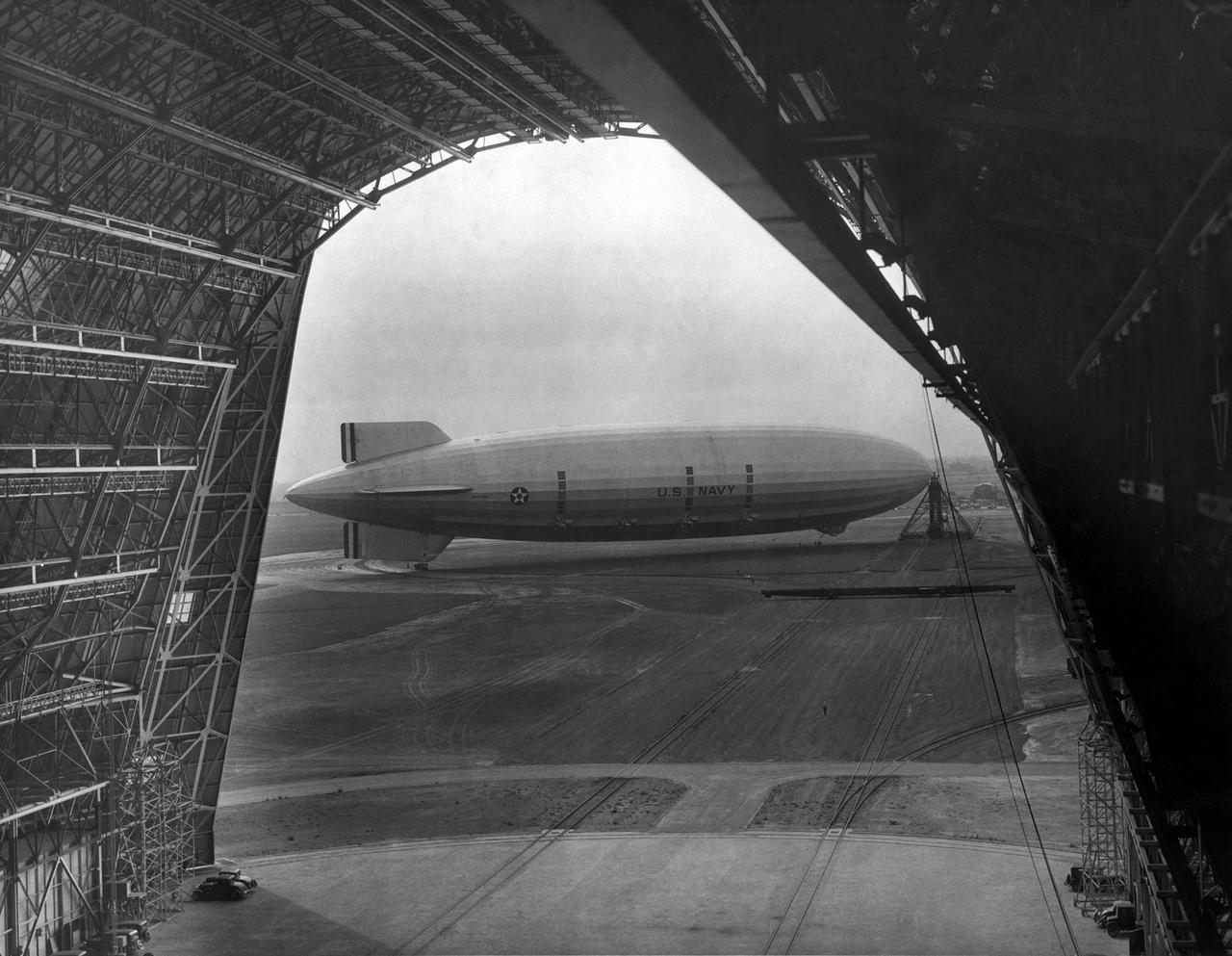
Navy USS Macon Moored at south circle, Mt. View from inside Hangar 1

MWISP - MT WASHINGTON ICING SENSORS PROJECT - DR RYERSON AT CRREL - COLD REGIONS RESEARCH AND ENGINEERING LABORATORY - WORKSTATION

ARCTAS Mission - NASA P-3 aircraft N426NA on tarmac at NASA's Moffett Federal Airfield (MFA) Mt. View, California

ARCTAS Mission - NASA P-3 aircraft N426NA on tarmac at NASA's Moffett Federal Airfield (MFA) Mt. View, California
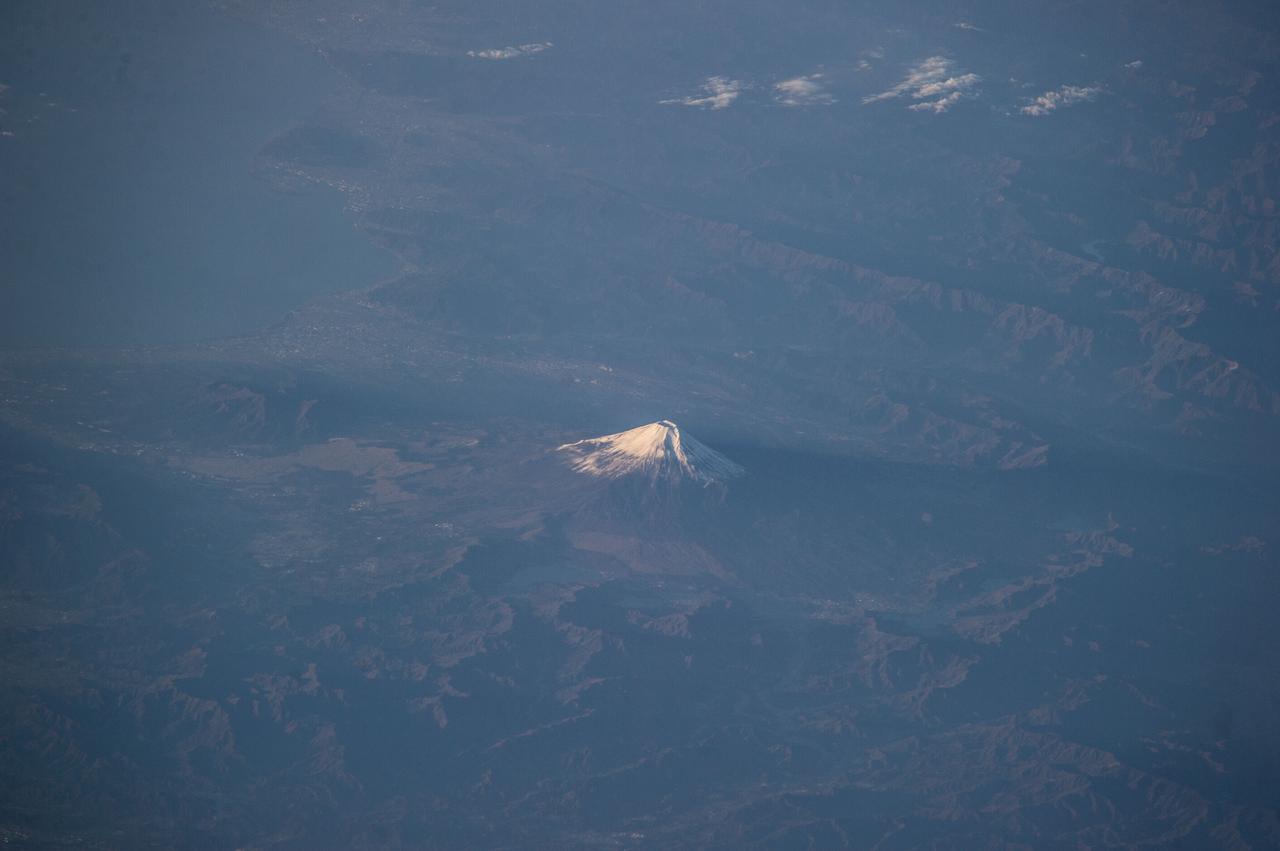
Earth observations taken by Expedition 38 crewmember. Crewmember indicates Mt Fuji,Japan,at sunrise. Image was released by astronaut on Twitter.
In northern California, east of Mt. Shasta, the footprints of clear-cut logging activities are evident in this ASTER image. Newer logged-out parcels are brighter blue-green. Where secondary growth has started, the logged tracts appear "fuzzy." Note that some of the logged-out tracts are located within the Shasta National Forest. The image was acquired July 2, 2018, covers an area of 37 by 56.5 kilometers, and is located at 42.5 degrees north, 122 degrees west. https://photojournal.jpl.nasa.gov/catalog/PIA22613

MWISP - MT WASHINGTON ICING SENSORS PROJECT - CRREL - COLD REGIONS RESEARCH AND ENGINEERING LABORATORY - AND SPEC - STATTON PARK ENGINEERING CORPORATION PROBES

Earth Observation taken during a day pass by the Expedition 40 crew aboard the International Space Station (ISS). Folder lists this as: Italy, Mt. Etna.
Expedition 47 Earth observation composite created with iss047e028742 - iss047e028744 135A2099 – 135A2101 Unique structure in Namibia Mt Brandberg Nature Reserve
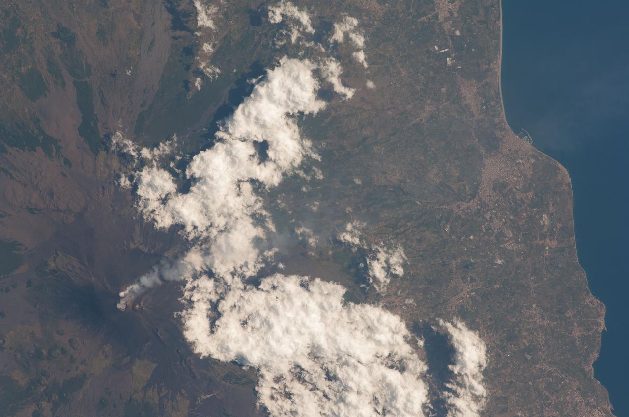
Earth Observation taken during a day pass by the Expedition 40 crew aboard the International Space Station (ISS). Folder lists this as: Italy, Mt. Etna.
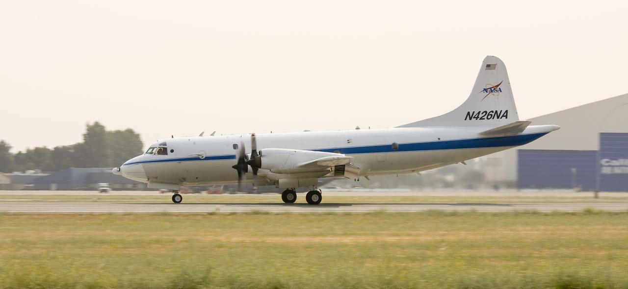
ARCTAS Mission - NASA P-3 aircraft N426NA takes off from NASA's Moffett Federal Airfield (MFA) Mt. View, California

STS113-332-035 (14 December 2002) --- The STS-113 crewmembers used a 35mm still camera to record this image of Mt. Etna Volcano erupting on the island of Sicily. The oblique, south-looking view shows Mt. Etna's dark ash plume rising above the general altitude of storm clouds over the Mediterranean Sea at sunset on Dec. 14, 2002.
STS111-371-003 (5-19 June 2002) --- This photo, showing Mt. St. Helens in the state of Washington, was taken by the STS-111 crewmembers aboard the Space Shuttle Endeavour. The scars from the May 18, 1980 eruption are still visible near Mt. St. Helens. Before the 1980 eruption the volcano had been dormant since 1857. The Gateway to Astronaut Photography of Earth (link to http://eol.jsc.nasa.gov/sseop/) provides searchable access to other photographs of Earth taken by astronauts.
Backtracking a bit, this image from NASA Mars Odyssey spacecraft shows the large channel in the upper left of the frame. Just below the brighter material of Mt. Sharp is the start of the arced edge of material we saw in yesterday image top right.