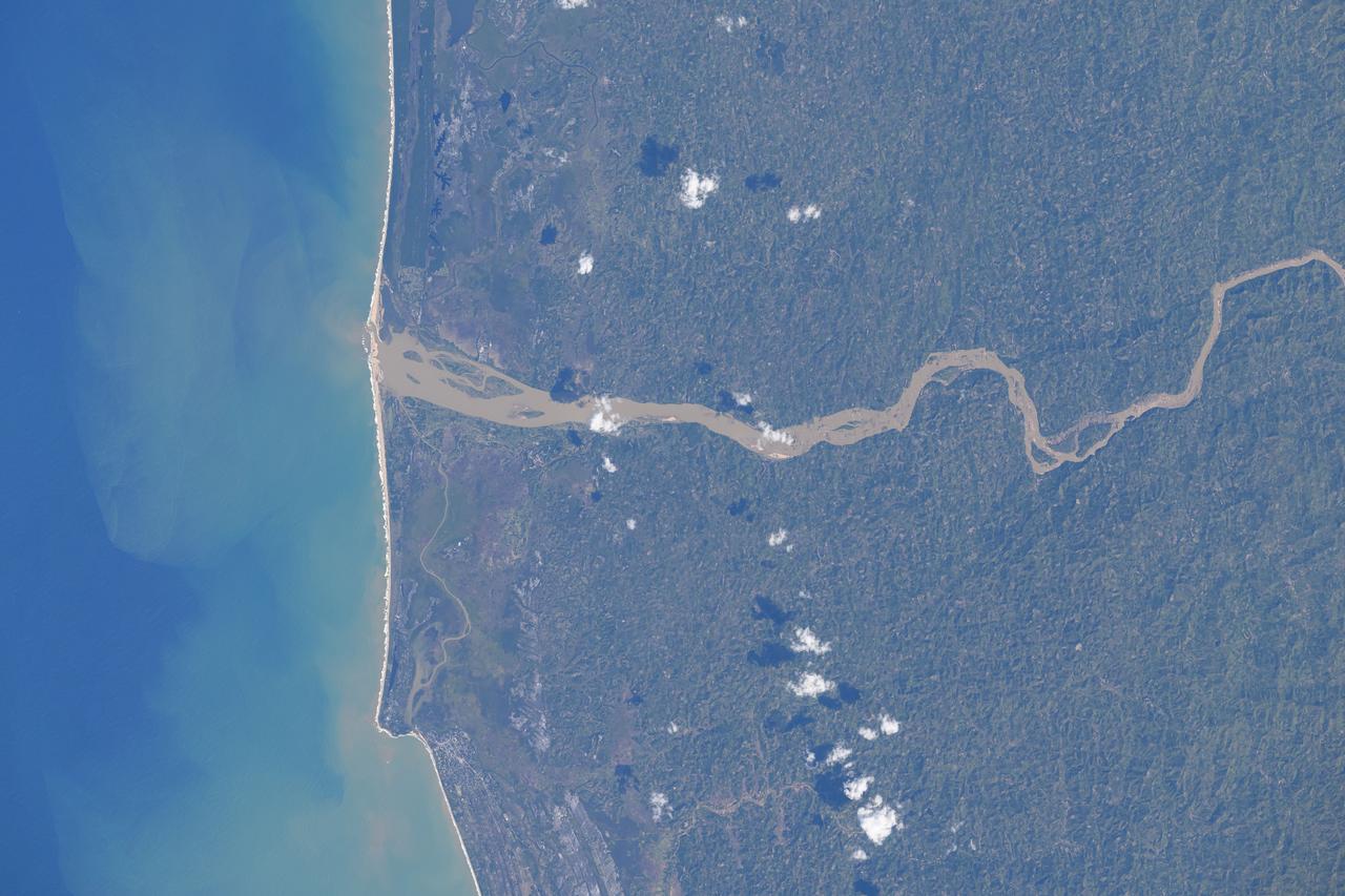
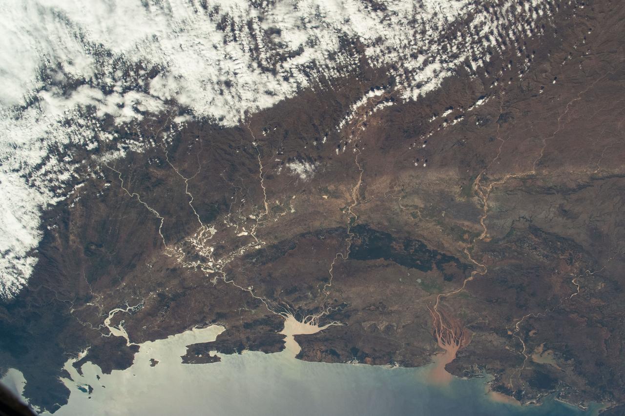
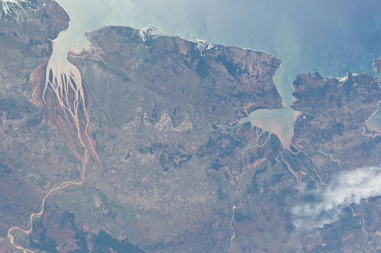
Mangoro River on Madagascar's east coast leads to the Indian Ocean in this photograph from the Indian Ocean as it orbited 263 miles above
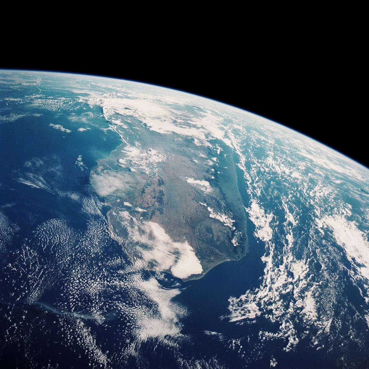
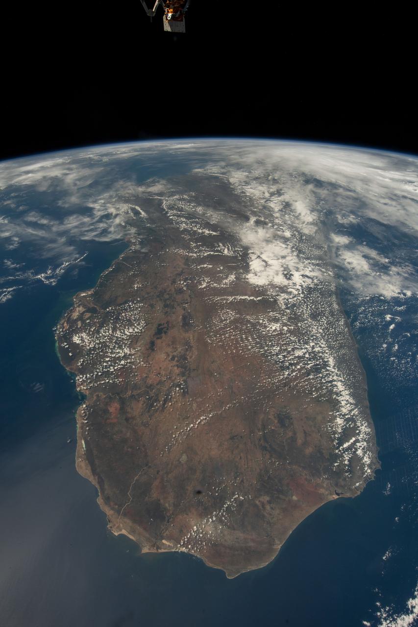
STS033-82-103 (22-27 Nov. 1989) --- This oblique view of the southern half of Madagascar was taken by the crew members of the Space Shuttle Discovery as they orbited Earth at an altitude of 289 nautical miles.
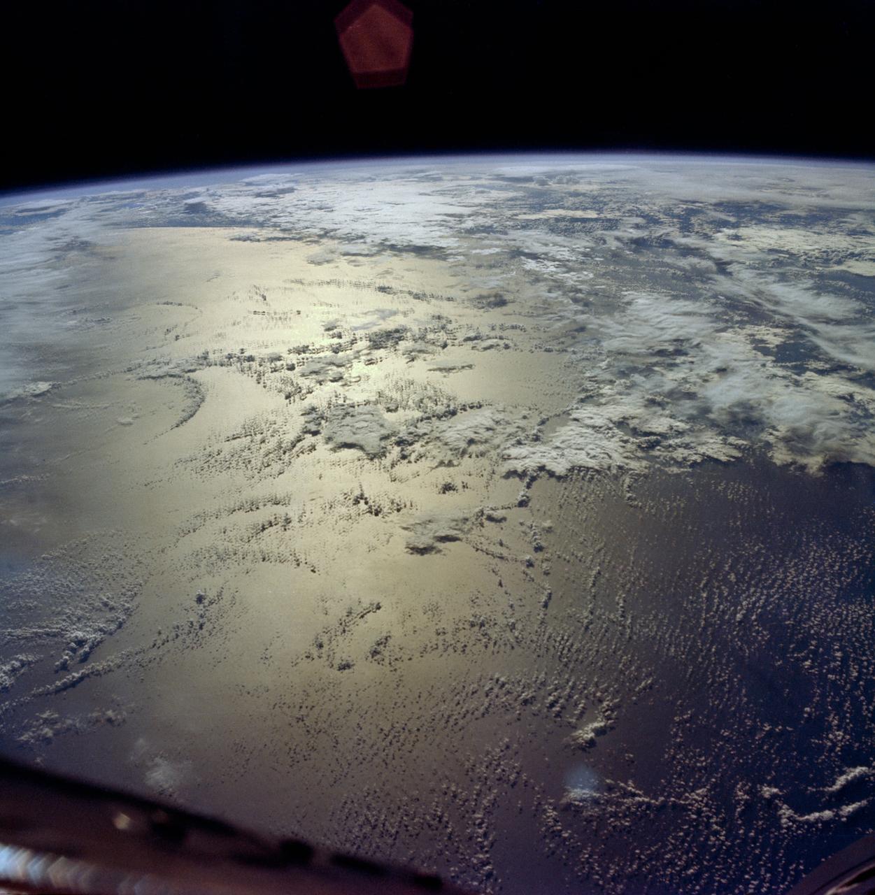
This high oblique view shows the majority of the island of Madagascar (19.0S, 47.5E). This Texas sized island is now largely deforested and is suffering from severe soil erosion as well as a declining biological species diversity and productivity. At the turn of the century, the island was almost totally forested but now, forests cover only about 10 percent of the surface. Evidence of soil erosion can be seen in the offshore sediment plumes.
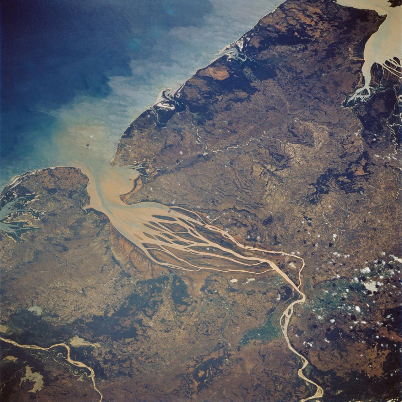
STS007-03-058 (18-24 June 1983) --- The Island of Madagascar in the Indian Ocean off the coast of Africa. The colorful area is the mouth of the Betsiboka River near the city of Majunga. The photograph was taken with a 70mm handheld camera aimed through the aft flight deck?s overhead windows on the Earth-orbiting Space Shuttle Challenger.
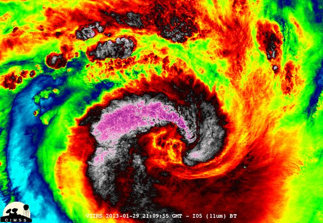
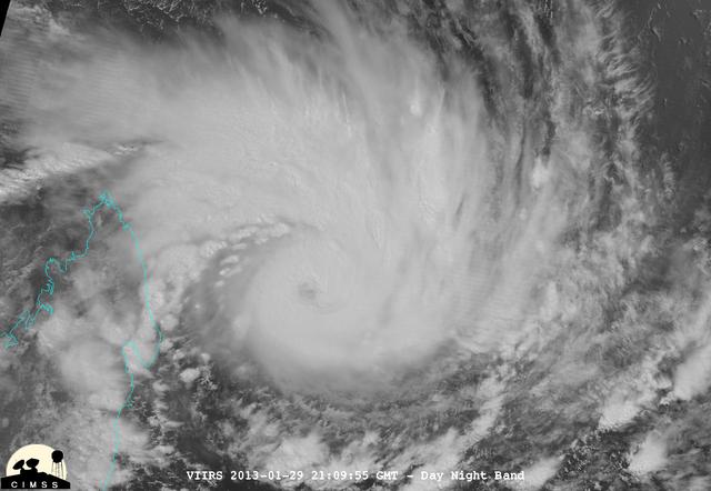
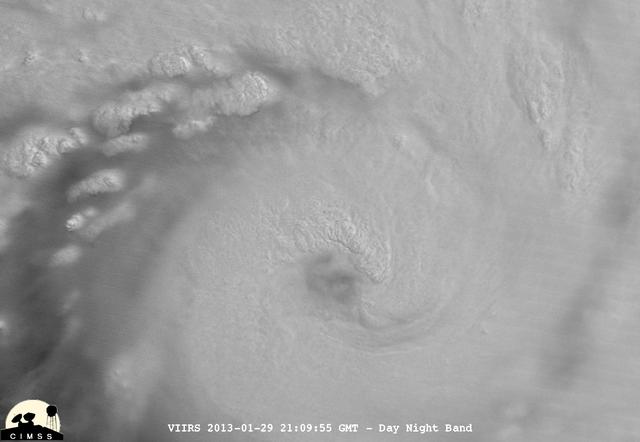
This night-time image revealed Cyclone Haruna's massive eye before it made landfall in southwestern Madagascar. This image was taken from the VIIRS instrument that flies aboard the NASA-NOAA Suomi NPP satellite. The image was taken on Feb. 20 at 2242 UTC (5:42 p.m. EST/U.S.) and shows a clear eye, surrounded by very powerful thunderstorms. The bright lights of the Capital city of Antananarivo are seen in this image. The capital city lies about 300 nautical miles northwest of the storm's center. Haruna's center made landfall near Manombo, Madagascar around 0600 UTC (1 a.m. EST/U.S.) and its eye became cloud-filled quickly. For the entire storm history, visit NASA's Hurricane Page: <a href="http://www.nasa.gov/mission_pages/hurricanes/archives/2013/h2013_Haruna.html" rel="nofollow">www.nasa.gov/mission_pages/hurricanes/archives/2013/h2013...</a> Text: Credit: Univ.of Wisconsin/NASA/NOAA <b><a href="http://www.nasa.gov/audience/formedia/features/MP_Photo_Guidelines.html" rel="nofollow">NASA image use policy.</a></b> <b><a href="http://www.nasa.gov/centers/goddard/home/index.html" rel="nofollow">NASA Goddard Space Flight Center</a></b> enables NASA’s mission through four scientific endeavors: Earth Science, Heliophysics, Solar System Exploration, and Astrophysics. Goddard plays a leading role in NASA’s accomplishments by contributing compelling scientific knowledge to advance the Agency’s mission. <b>Follow us on <a href="http://twitter.com/NASA_GoddardPix" rel="nofollow">Twitter</a></b> <b>Like us on <a href="http://www.facebook.com/pages/Greenbelt-MD/NASA-Goddard/395013845897?ref=tsd" rel="nofollow">Facebook</a></b> <b>Find us on <a href="http://instagram.com/nasagoddard?vm=grid" rel="nofollow">Instagram</a></b>
iss071e345427 (July 15, 2024) --- The Mayotte archipelago, a French overseas department and region, in the Mozambique Channel and in between Madagascar and Mozambique is pictured from the International Space Station as it orbited 263 miles above.
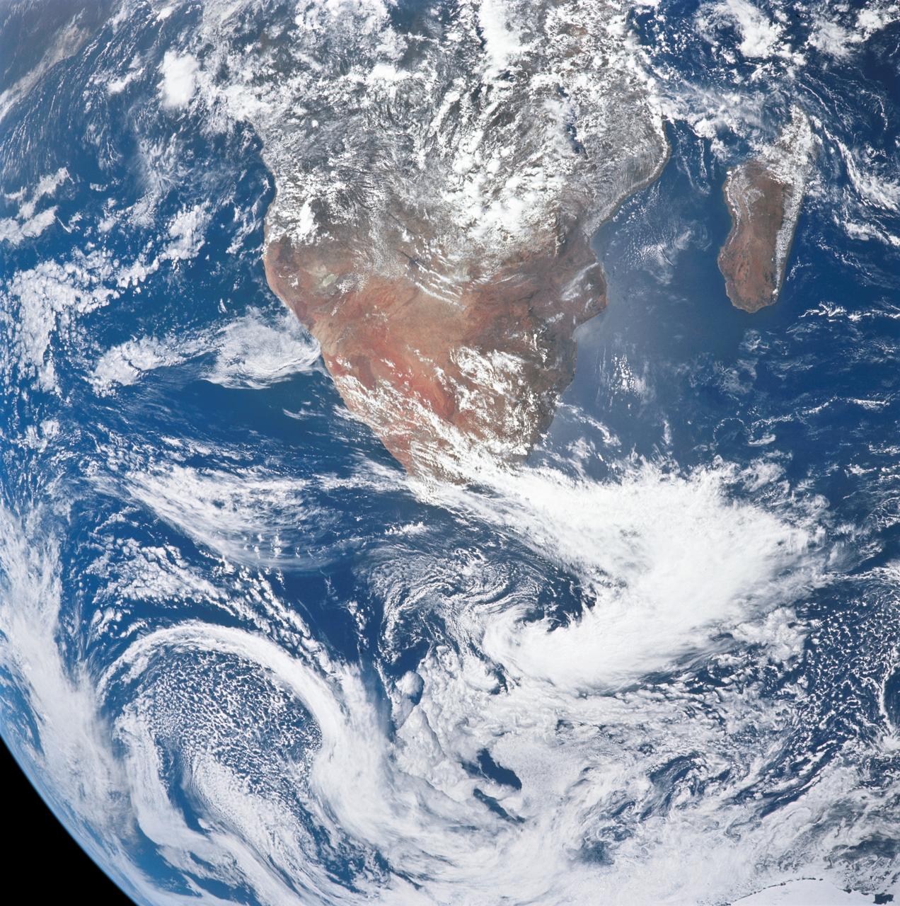
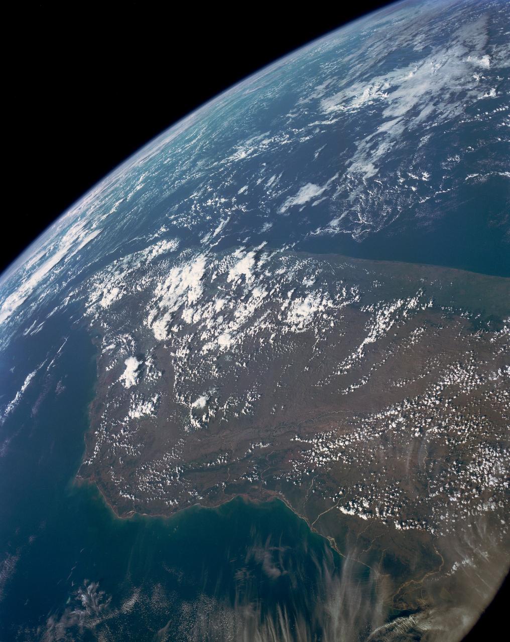
AS17-148-22717 (7 Dec. 1972) --- This view of a portion of Earth was taken from the Apollo 17 spacecraft following trans-lunar insertion during the final lunar landing mission in NASA's Apollo Program. The visible land mass is the southern two-thirds of the African continent, with Madagascar at right. A portion of Antarctica is visible at bottom frame. Onboard the Apollo 17 spacecraft were astronauts Eugene A. Cernan, commander; Ronald E. Evans, command module pilot; and Harrison H. Schmitt, lunar module pilot. While astronauts Cernan and Schmitt descended in the Lunar Module (LM) "Challenger" to explore the Hadley-Apennine region of the moon, astronaut Evans remained with the Command and Service Modules (CSM) "America" in lunar orbit.
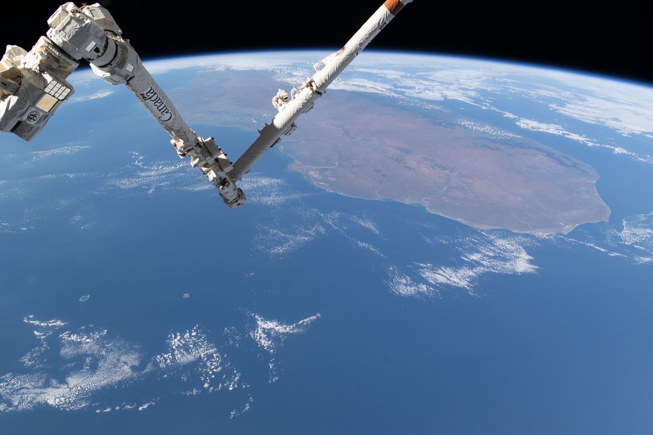
iss071e361950 (July 15, 2024) --- The International Space Station's 57.7-foot-long Canadarm2 robotic arm crosses the foreground as the orbital outpost soared 265 miles above the Mozambique Channel south of the African island nation of Madagascar.
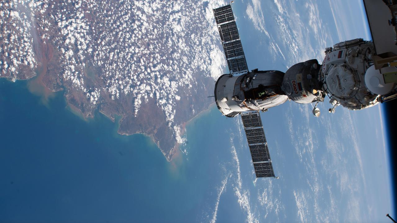
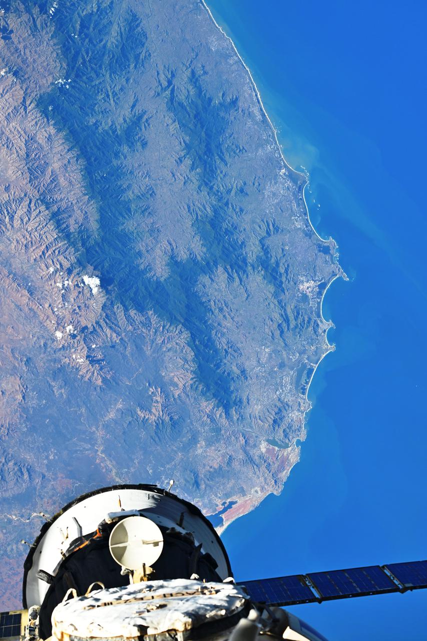
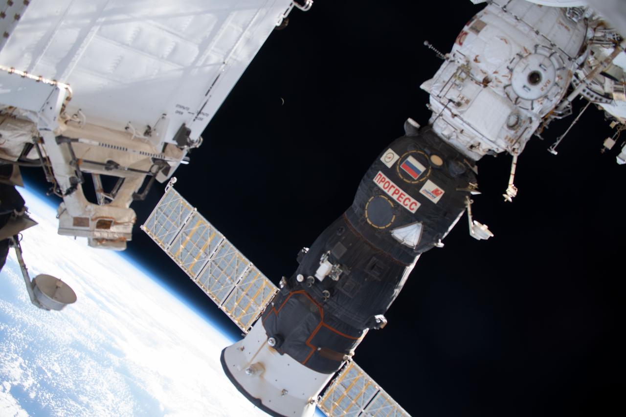
iss073e0659744 (Sept. 14, 2025) --- The Soyuz MS-27 spacecraft is pictured docked to the International Space Station's Prichal module as the orbital outpost soared 259 miles above the northern coast of Madagascar.
ISS018-E-025705 (30 Jan. 2009) --- Betsiboka River floods in Madagascar are featured in this image photographed by an Expedition 18 crewmember on the International Space Station. Between Jan. 18-20, 2009, Tropical Storm Eric swept along the east coast of the island nation of Madagascar. Rain from this storm fell in the catchment of the Betsiboka River, one of the main rivers in northern Madagascar. In an unlikely coincidence, a larger storm, Cyclone Fanele crossed central Madagascar the next day on Jan. 21, with its outer bands dropping more rain in the Betsiboka basin. By the time this image was taken on the Jan. 30, the river was flooding all along its length.
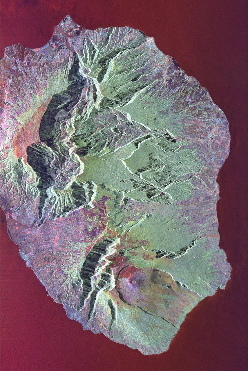
This radar image shows the volcanic island of Reunion, about 700 km 434 miles east of Madagascar in the southwest Indian Ocean. The southern half of the island is dominated by the active volcano, Piton de la Fournaise.
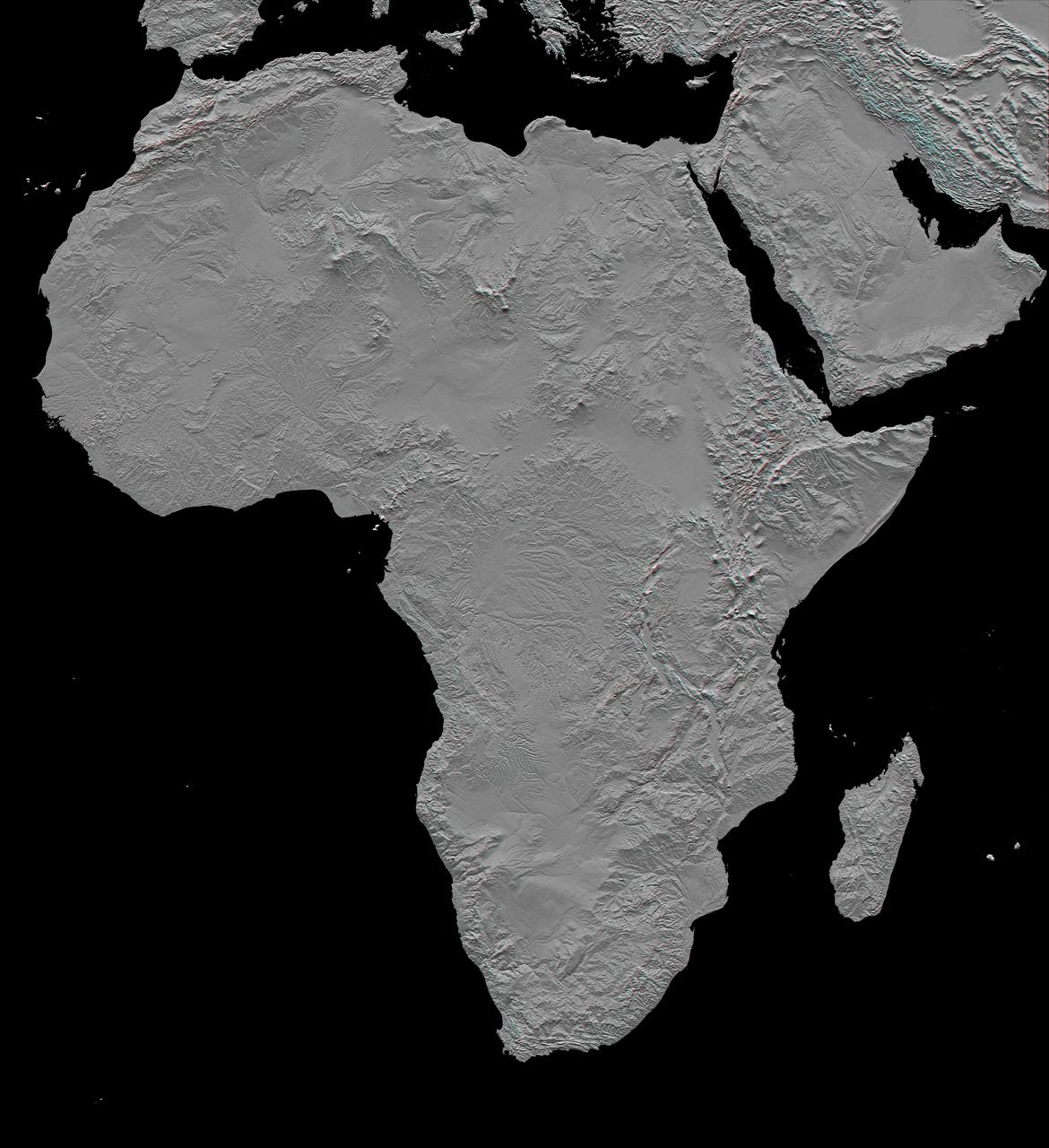
This stereoscopic shaded relief image from NASA Shuttle Radar Topography Mission shows Africa topography. Also shown are Madagascar, the Arabian Peninsula, and other adjacent regions. 3D glasses are necessary to view this image.
S65-63282 (16 Dec. 1965) --- Area of Indian Ocean, just east of the island of Madagascar, as seen from the Gemini-6 spacecraft during its 15th revolution of Earth. Land mass at top of picture is the Malagasy Republic (Madagascar). Photo credit: NASA or National Aeronautics and Space Administration

iss056e084625 (July 7, 2018) --- The island nation of Madagascar was photographed by an Expedition 56 crew member as the International Space Station orbited about 255 miles above the Mozambique Channel which separates Madagascar from the African nation of Mozambique.
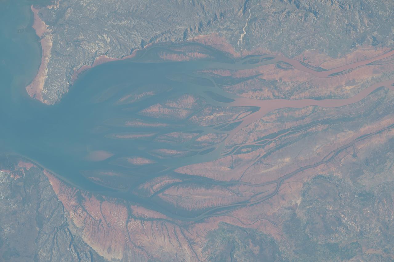
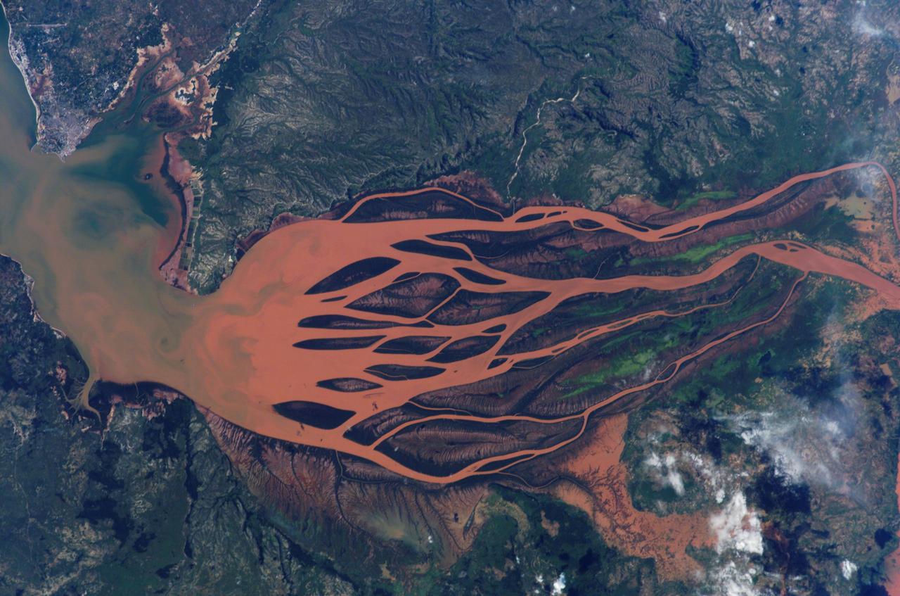
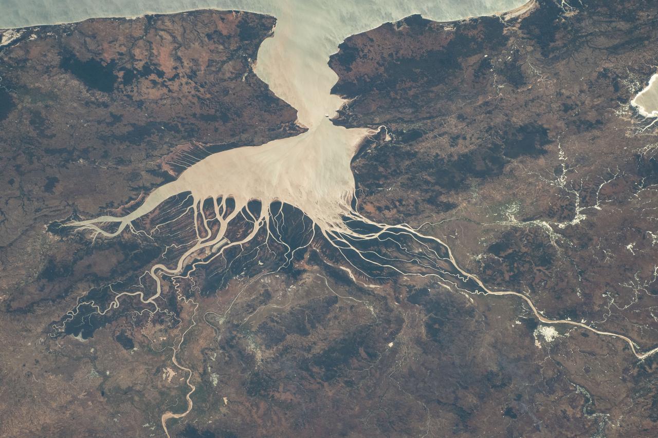
ISS008-E-19233 (25 March 2004) --- This image featuring the Betsiboka estuary on the northwest coast of Madagascar was taken by an Expedition 8 crewmember on the International Space Station (ISS). The Betsiboka estuary is the mouth of Madagascar’s largest river and one of the world’s fast-changing coastlines. Nearly a century of extensive logging of Madagascar’s rainforests and coastal mangroves has resulted in nearly complete clearing of the land and fantastic rates of erosion. After every heavy rain, the bright red soils are washed from the hillsides into the streams and rivers to the coast. Astronauts describe their view of Madagascar as “bleeding into the ocean”. One impact of the extensive 20th century erosion is the filling and clogging of coastal waterways with sediment – a process that is well illustrated in the Betsiboka estuary. In fact, ocean-going ships were once able to travel up the Betsiboka estuary, but must now berth at the coast.
ISS008-E-19236 (25 March 2004) --- This image featuring the Betsiboka estuary on the northwest coast of Madagascar was taken by an Expedition 8 crewmember on the International Space Station (ISS). The Betsiboka estuary is the mouth of Madagascar’s largest river and one of the world’s fast-changing coastlines. Nearly a century of extensive logging of Madagascar’s rainforests and coastal mangroves has resulted in nearly complete clearing of the land and fantastic rates of erosion. After every heavy rain, the bright red soils are washed from the hillsides into the streams and rivers to the coast. Astronauts describe their view of Madagascar as “bleeding into the ocean”. One impact of the extensive 20th century erosion is the filling and clogging of coastal waterways with sediment – a process that is well illustrated in the Betsiboka estuary. In fact, ocean-going ships were once able to travel up the Betsiboka estuary, but must now berth at the coast.
Mayotte is a volcanic island in the Comoros archipelago between the eastern coast of Africa and the northern tip of Madagascar. It is a French Overseas Territory in the Indian Ocean. On December 14, the island was hit by devastating category-4 hurricane Chido, causing widespread damage and loss of life. The image was acquired June 7, 2016, covers an area of 42 by 58.5 km, and is located at 12.8 degrees south, 45.1 degrees east. https://photojournal.jpl.nasa.gov/catalog/PIA26503
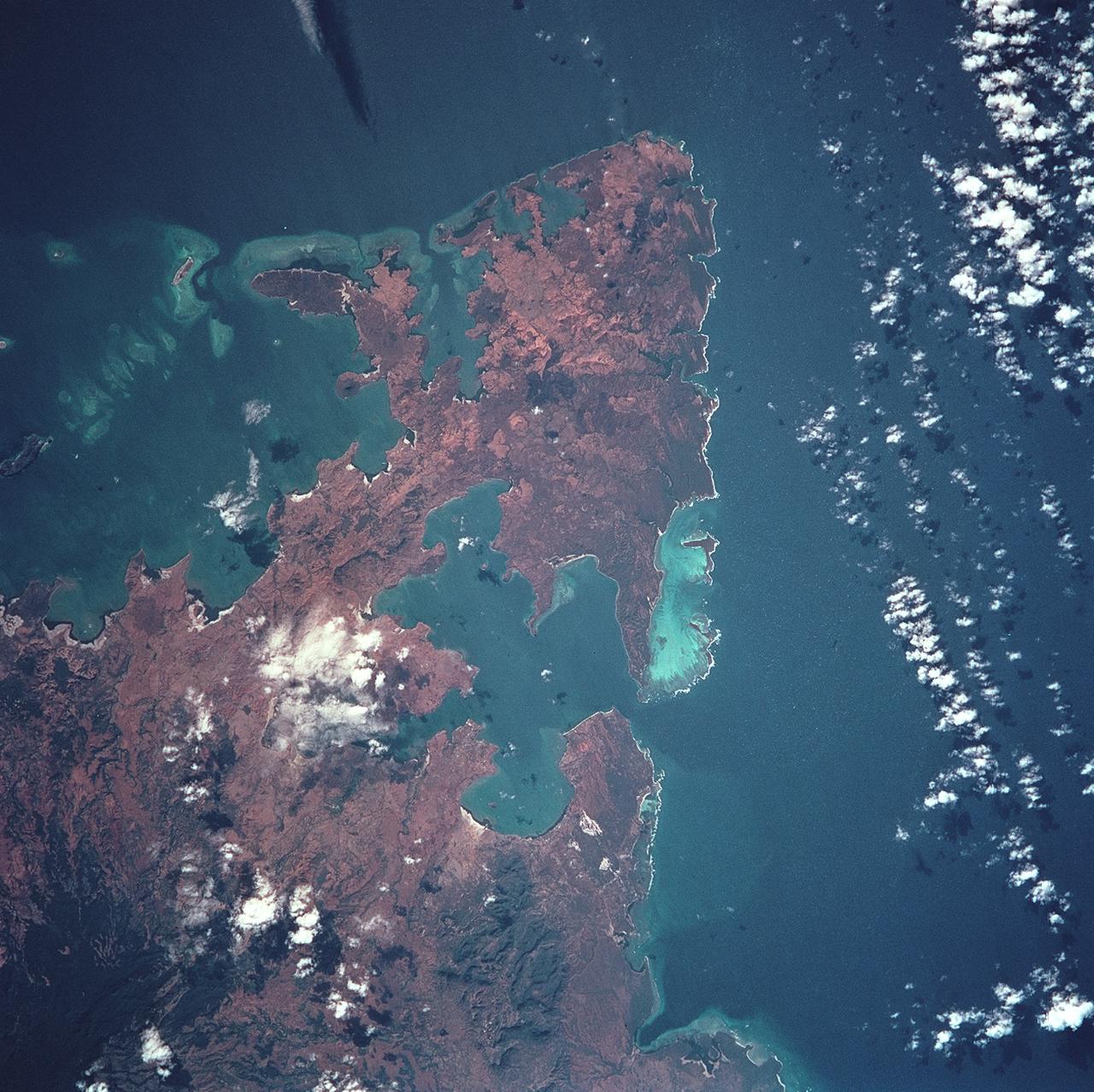
STS093-722-051 (23-27 July 1999) --- The STS-93 astronauts aboard the Space Shuttle Columbia took this picture over the Indian Ocean. The distinctive arrowhead shape of the northern tip of the island of Madagascar is easily recognizable. The land appears red with patches of dark green on the upper slopes. According to NASA scientists studying the STS-93 photo collection, the dark areas are the remnants of forests and the red areas are cleared land. When the photo was taken, the shuttle was flying over a point located at 14.7 degrees south latitude and 44.0 degrees east longitude. Data back information on the 70mm film listed the date and time of the photo as 11:38:20 GMT, July 24, 1999 (Orbit 21).
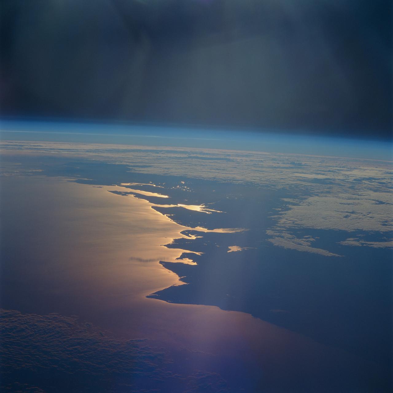
STS093-716-065 (23-27 July 1999) --- The STS-93 astronauts aboard the Space Shuttle Columbia took this picture of a sunrise on the Mozambique Channel along the coast of Madagascar. The nearest point of land is Cape Saint Andre, which forms the northwest corner of the island. Sunglint highlights the land-water boundary along a series of dynamic estuaries. The fifth inlet from the bottom just above the small lake is the Betsiboka Estuary. When the photo was taken, the shuttle was flying over a point located at 18.7 degrees south latitude and 36.1 degrees east longitude. Data back information on the 70mm film listed the time and date as 03:40:43 GMT, July 26, 1999 (orbit 48).
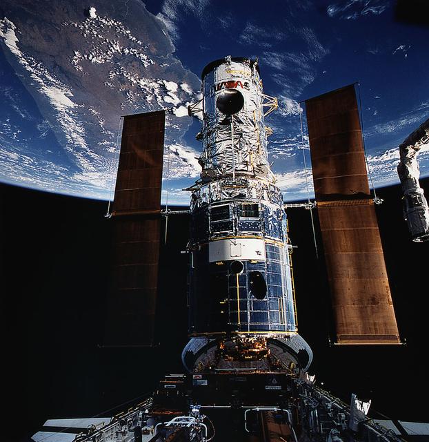
The Hubble Space Telescope (HST), backdropped over Madagascar, is berthed in Endeavour's cargo bay following its capture for repair by the STS-61 astronauts.
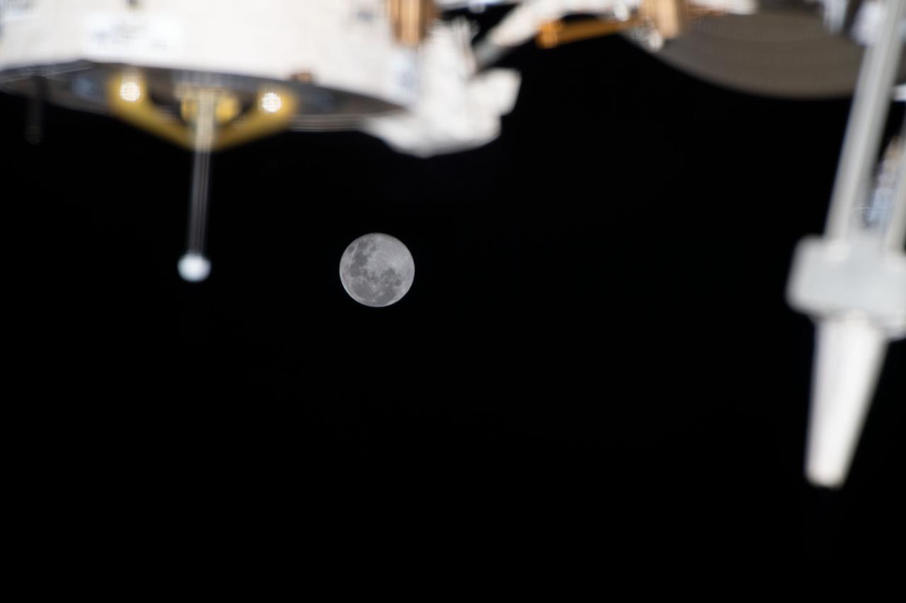
iss068e039237 (Jan. 12, 2023) --- The Full Moon is pictured from the International Space Station as it orbited 262 miles above the Indian Ocean off the coast of Madagascar.
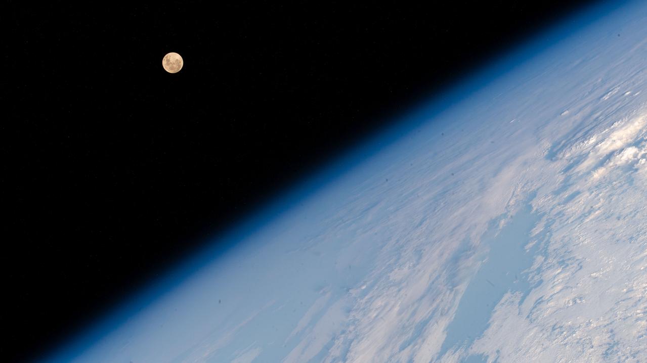
iss071e515452 (Aug. 19, 2024) --- The Full Moon pictured above Earth's horizon as the International Space Station soared 262 miles above the Indian Ocean south of the African island nation of Madagascar.
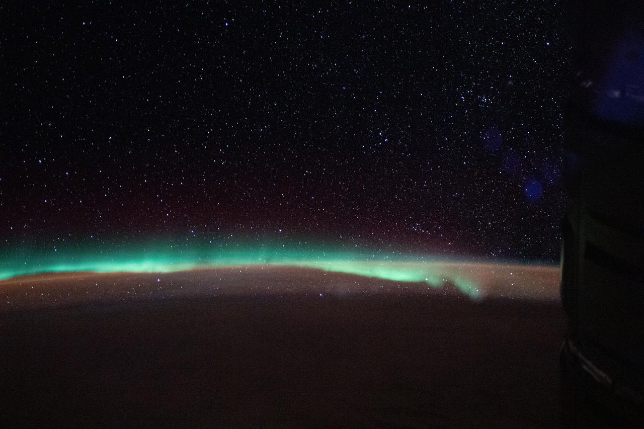
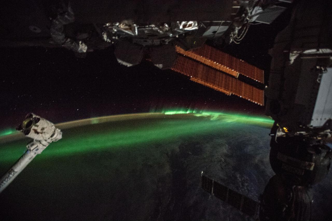
iss059e092459 (June 5, 2019) --- The aurora australis, or "southern lights," highlights a starry nighttime orbital pass as the International Space Station orbited 267 miles above the Indian Ocean southeast of Madagascar.
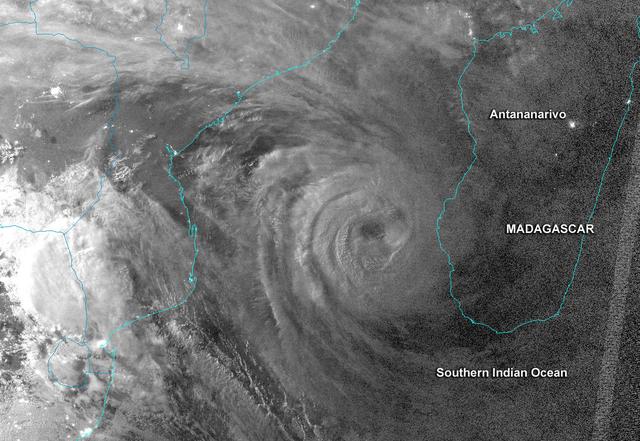
ISS042E136404 (01/11/2015) --- This image of Cyclone Chedza, headed for the Island nation of Madagascar, off the African coast was taken by a member of Expedition 42 on the International Space Station Jan. 11, 2015.
iss069e032071 (July 15, 2023) --- The Bombetoka Bay leads into the Mozambique Channel from the island nation of Madagascar in this photograph from the International Space Station as it orbited 262 miles above.
iss071e218076 (June 26, 2024) --- The northwest coast of Madagascar on the Mozambique Channel is pictured from the International Space Station as it orbited 267 miles above the East African island nation.
iss067e189040 (July 16, 2022) --- The sun's glint beams off the Mozambique Channel in this photograph of Madagascar's coast as the International Space Station orbited 262 miles above the Indian Ocean.
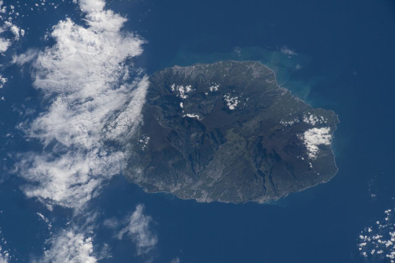
iss055e020372 (April 10, 2018) --- Reunion Island, a French region off the coast of Madagascar, was pictured by an Expedition 55 crew member as the International Space Station orbited over the Indian Ocean.
iss071e619284 (Aug. 20, 2024) --- Clouds stream above the southern Indian Ocean in between Madagascar and the French and Southern Antarctic Lands in this nighttime photograph from the International Space Station as it orbited 265 miles above.
iss072e094988 (Oct. 21, 2024) --- The French atoll of Bassas da India in the Mozambique Channel, halfway beween the African nations of Mozambiue and Madagascar, is pictured from the International Space Station as it orbited 264 miles above.
iss068e040605 (Jan. 18, 2023) --- The island nation of Madagascar, looking north toward Earth's horizon, is pictured from the International Space Station as it orbited 262 miles above the Indian Ocean.
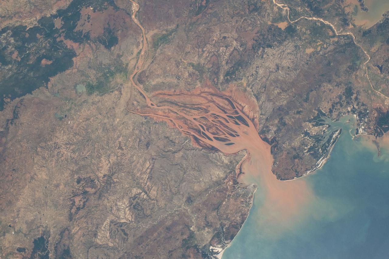
ISS010-E-19333 (8 March 2005) --- The spectacular mouth of the Betsiboka River in Madagascar is featured in this image photographed by an Expedition 10 crew member on the International Space Station.
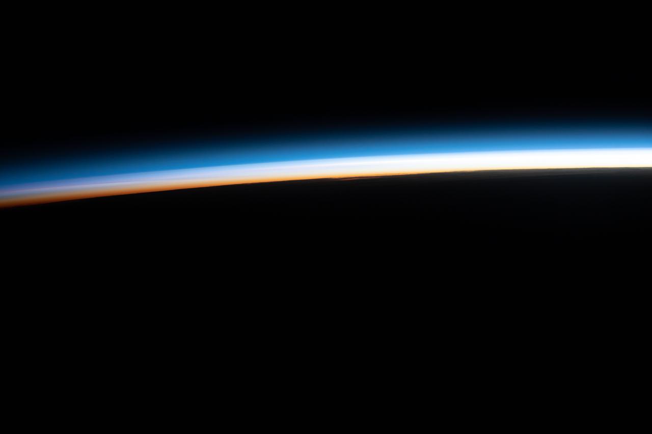
iss067e035797 (May 7, 2022) --- The last rays of an orbital sunset illuminate Earth's horizon in this photograph from the International Space Station as it orbited 267 miles above the Indian Ocean off the coast of Madagascar.
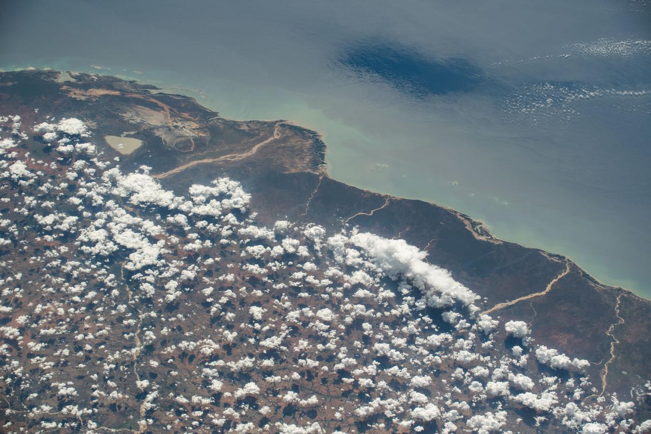
iss070e025919 (Nov. 16, 2023) --- The partly cloudy coast of southwestern Madagascar on the Mozambique Channel is pictured from the International Space Station as it orbited 264 miles above the island nation.
iss071e218073 (June 27, 2024) --- Helodrano Mahajambe, a bay in northwestern Madagascar, opens into the Atlantic Ocean in this photograph from the International Space Station as it orbited 267 miles above the East African island nation.
iss073e0284372 (July 13, 2025) --- The southern coast of Madagascar is pictured 261 miles below the International Space Station with a portion of the Soyuz MS-27 spacecraft docked to the Poisk module in the lower foreground. Credit: Roscosmos
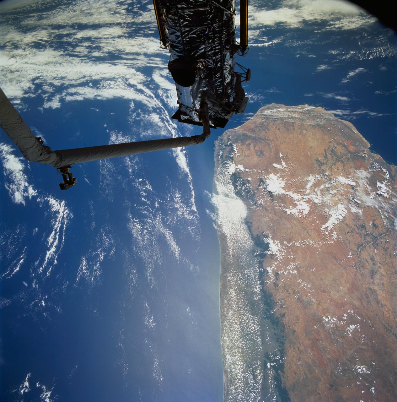
STS061-77-102 (7 Dec 1993) --- Astronauts Jeffrey A. Hoffman (left) and F. Story Musgrave are partially silhouetted against the Indian Ocean as they work to install the Magnetic Sensing System (MSS) on the Hubble Space Telescope (HST). Musgrave is anchored to the end of the Space Shuttle Endeavour's Remote Manipulator System (RMS) arm. The HST is positioned along the southern end of Madagascar, 325 nautical miles away. Visible on the western coast are the sediment laden Onilahy and Fiherenana Rivers which empty into Saint Augustin Bay. North of Fiherenana River is the Mangoky River. The circular feature on the southern end of Madagascar and to the right of HST is the L'ivakoany Mountains. The eastern coast is relatively straight compared to the western coast.
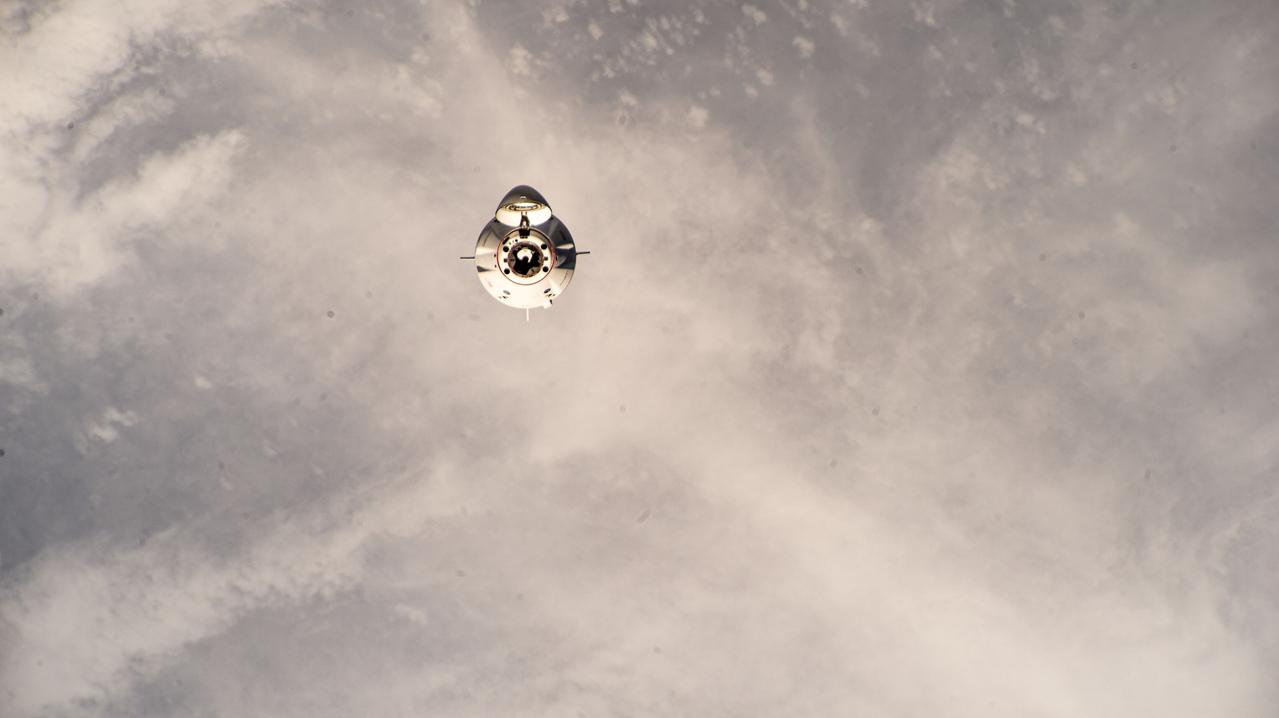
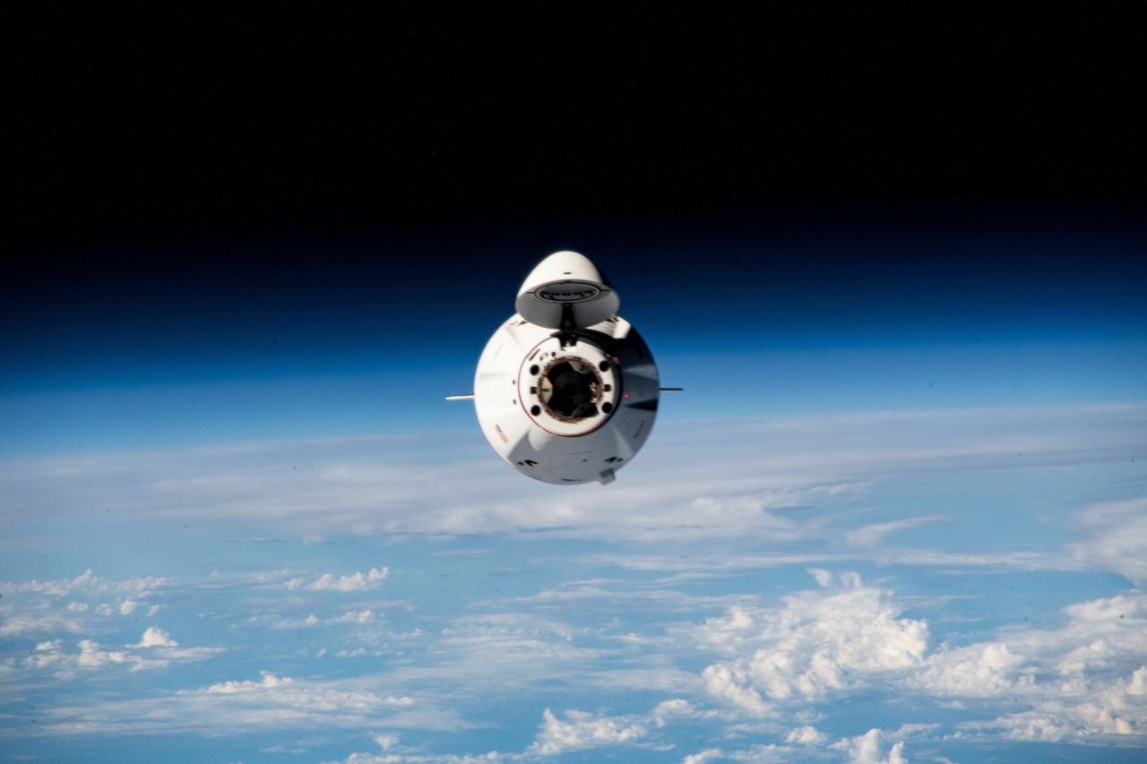
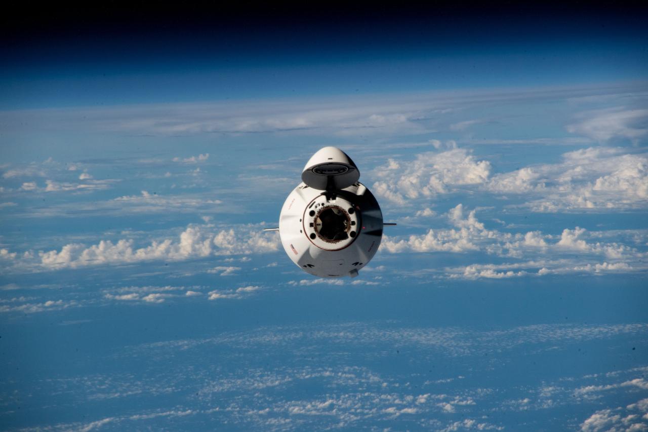
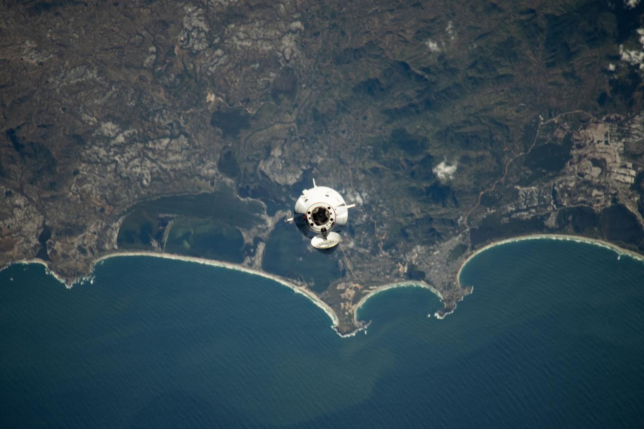
iss070e075551 (Jan. 20, 2024) --- The SpaceX Dragon Freedom spacecraft carrying the four-member Axiom Mission 3 (Ax-3) crew is pictured approaching the International Space Station 264 miles above a cloudy Indian Ocean east of the coast of Madagascar.
S82-E-5434 (15 Feb. 1997) --- Typhoon Josie - south of Madagascar, 25 degrees South by 40 degrees East, with sustained winds of 90 knots and gusts up to 110 knots. This view was taken with an Electronic Still Camera (ESC).
STS080-731-009 (19 Nov.-7 Dec. 1996) --- The space shuttle Columbia astronauts photographed this Southern Hemisphere cyclone named Daniella, as it gathered force off the east coast of Madagascar in the Indian Ocean. Being in the Southern Hemisphere it spins clockwise, just the opposite of the Northern Hemisphere hurricanes and typhoons.
iss060e001774 (June 29, 2019) --- A waning crescent moon is barely visible in the center background as the International Spacer Station orbited 262 miles above the Indian Ocean east of Madagascar. Dominating the foreground is Russia's Progress 72 resupply ship docked to the Pirs module.
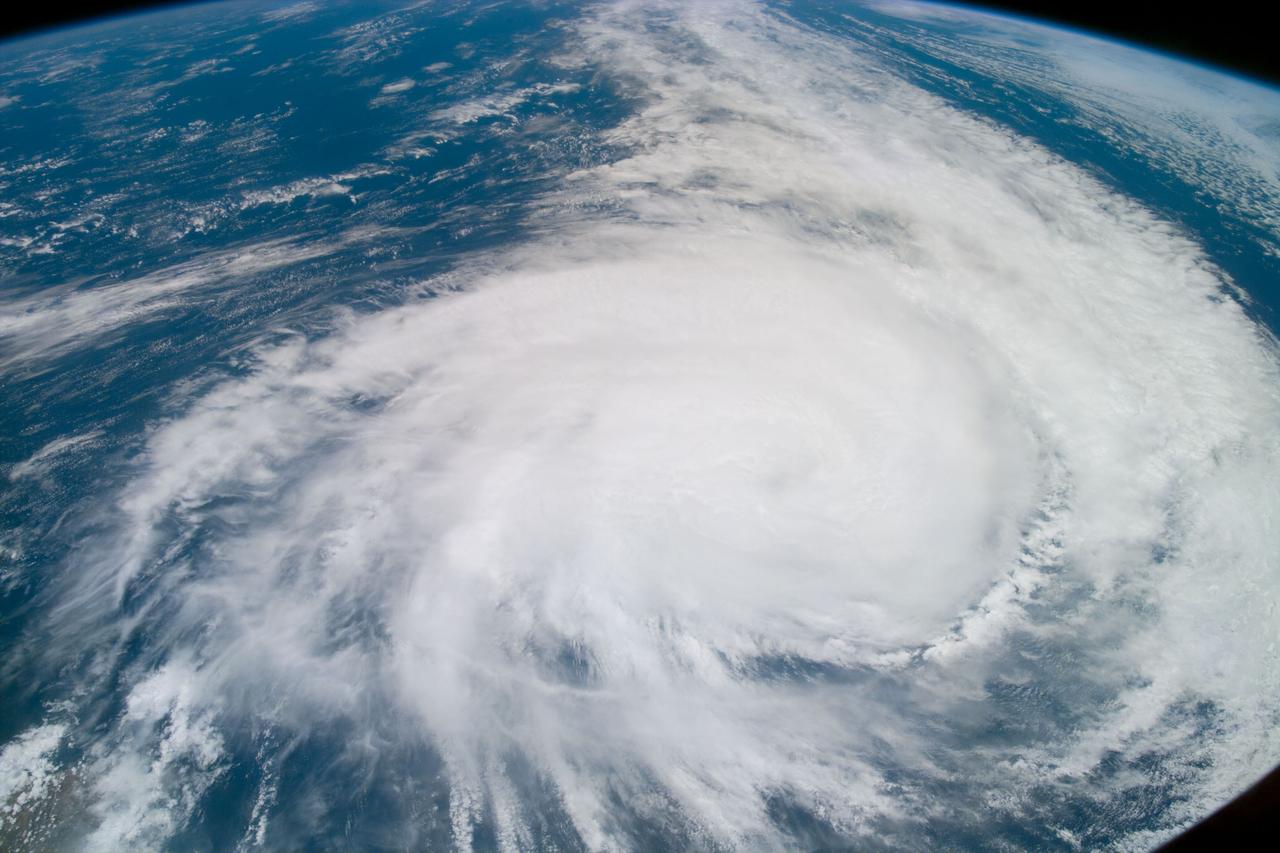
iss059e000515 (March 16, 2019) --- Tropical Cyclone Idai is pictured from the International Space Station as the orbital complex flew 261 miles above the southeast coast of Africa. Idai's track took it over the Mozambique Channel and portions of the nations of Madagascar, Mozambique, Malawi and Zimbabwe creating devastation and casualties in the southeast portion of the African continent.
iss059e021289 (April 15, 2019) --- The International Space Station orbits 265 miles above the southern Indian Ocean about halfway between Madagascar and Antarctica with the aurora australis, also known as the southern lights, photographed by an Expedition 59 crewmember.
iss068e075344 (March 16, 2023) --- The SpaceX Dragon resupply ship approaches the International Space Station carrying more than 6,200 pounds of science experiments, crew supplies, and other cargo, to replenish the Expedition 68 crew. Both spacecraft were flying 269 miles above the Indian Ocean near Madagascar at the time of this photograph.
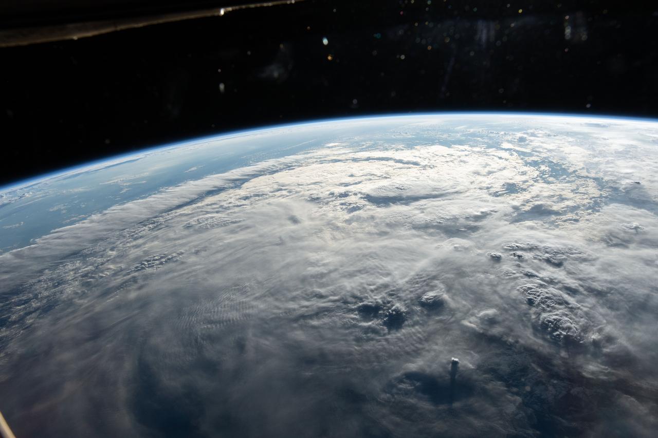
iss070e062791 (Jan. 8, 2024) --- A cloud-covered Indian Ocean, illuminated about an hour before sunset, is pictured from the International Space Station as it orbited 260 miles above just off the northeast coast of the island nation of Madagascar.

iss065e051411 (May 23, 2021) --- A starry sky, an atmospheric glow and the night lights of the island nation of Mauritius (center left) and Réunion Island (bottom right), a French department, stand out as the International Space Station orbited 265 miles above of Madagascar on its northeast Indian Ocean coast.

STS79-E-5390 (24 September 1996) --- Madagascar, off the east coast of Africa, is almost too large to fit into a single frame, but it has long provided NASA astronauts with interesting panoramas as it spans across the horizon, during Flight Day 9.
iss068e075343 (March 16, 2023) --- The SpaceX Dragon resupply ship approaches the International Space Station carrying more than 6,200 pounds of science experiments, crew supplies, and other cargo, to replenish the Expedition 68 crew. Both spacecraft were flying 269 miles above the Indian Ocean near Madagascar at the time of this photograph.

iss059e000502 (March 16, 2019) --- Tropical Cyclone Idai is pictured from the International Space Station as the orbital complex flew 261 miles above the southeast coast of Africa. Idai's track took it over the Mozambique Channel and portions of the nations of Madagascar, Mozambique, Malawi and Zimbabwe creating devastation and casualties in the southeast portion of the African continent.
iss071e673801 (Sept. 15, 2024) --- Ankarana Special Reserve, formed about 150 million years ago during the Jurassic period, on the northwest coast of Madagascar near the Mozambique Channel is pictured from the International Space Station as it orbited 260 miles above.

iss073e0027778 (May 11, 2025) --- NASA astronaut and Expedition 73 Flight Engineer Jonny Kim poses for a portrait inside the cupola, the International Space Station's "window to the world." The orbital outpost was soaring 265 miles above the Indian Ocean off the coast of Madagascar at the time of this photograph.
51F-37-059 (29 July-6 Aug 1985) --- The mouth of the Betsiboka River in northwest Madagascar is seen. The estuary at Mahajanga is being quickly filled with river borne sediments due to poor land management, mainly deforest-action in the river basin. Changes in the estuary can be seen from one Shuttle flight to the next.
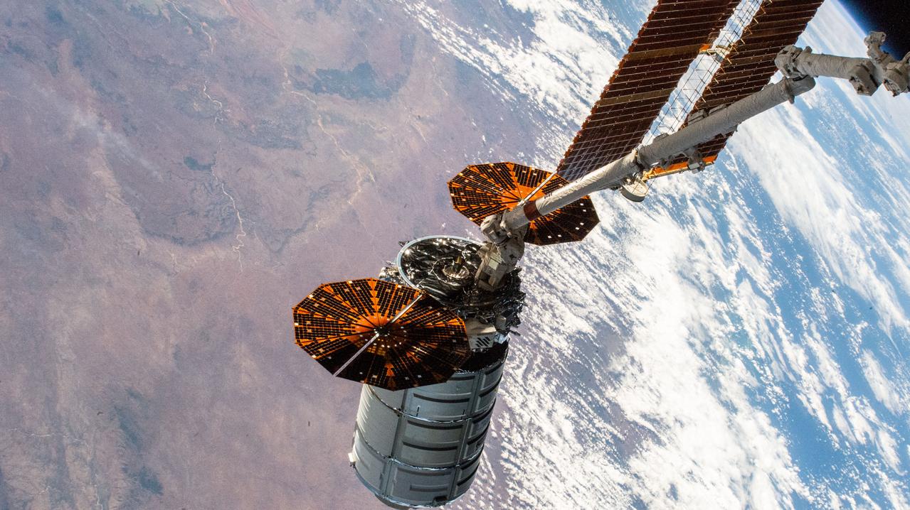
iss067e156217 (June 28, 2022) --- Northrop Grumman's Cygnus space freighter is positioned away from the International Space Station in the grips of the Canadarm2 robotic arm prior to its release ending a four-month stay attached to the orbiting lab's Unity module. The orbiting complex was flying 263 miles above Madagascar at the time of this photograph.
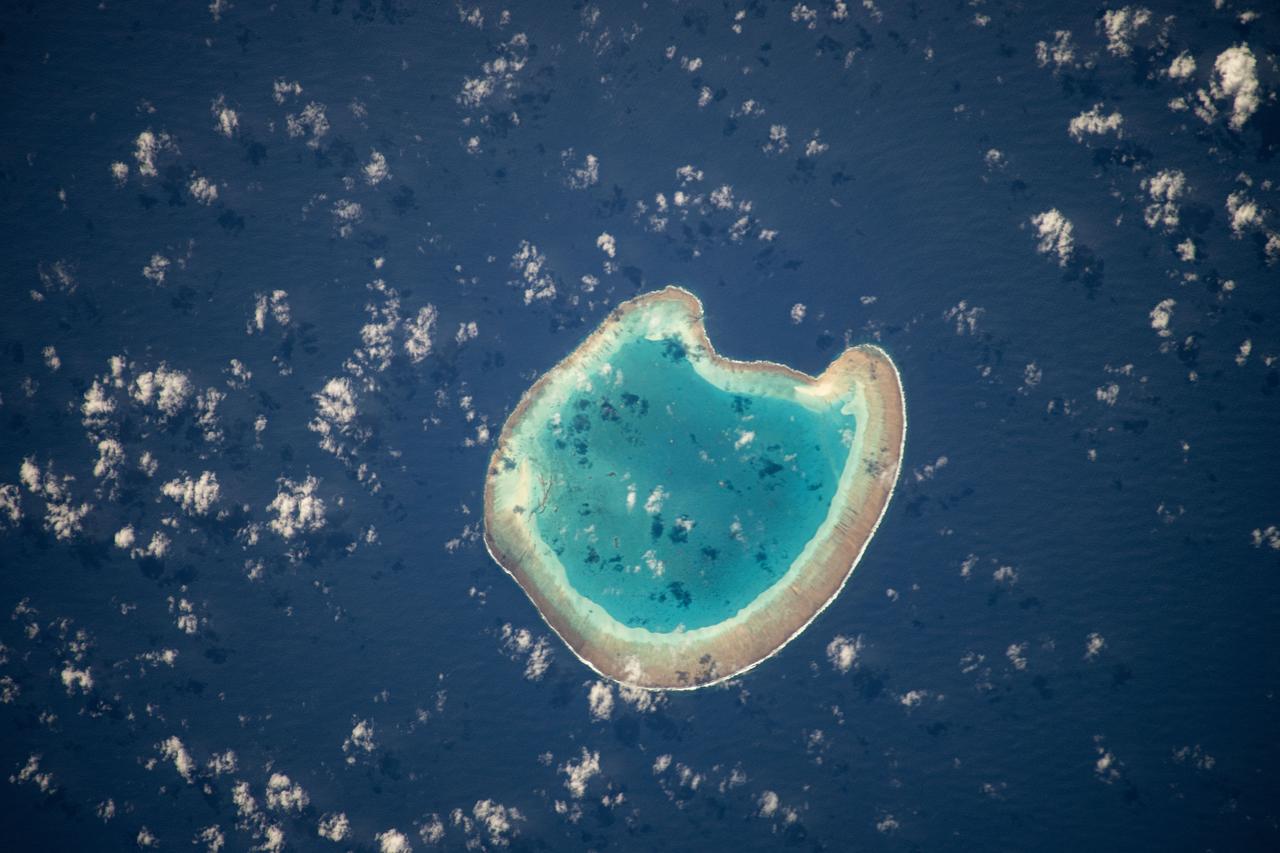
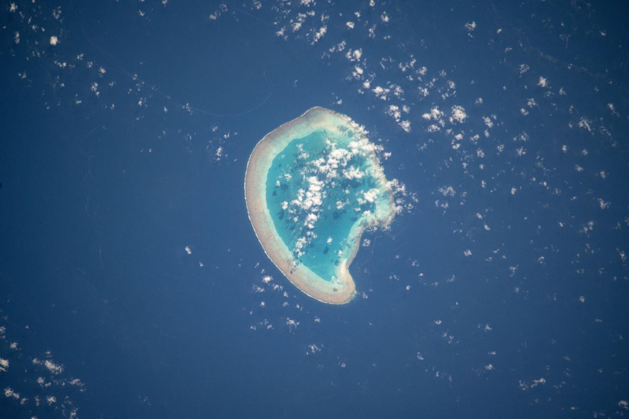
iss071e111610 (May 23, 2024) -- Nearly halfway between Madagascar and Mozambique lies the Bassas da India atoll in the Mozambique Channel. The uninhabited ring-shaped island spans roughly 330 feet (~100 meters) around a shallow lagoon. The International Space Station was soaring 260 miles above as this photo was taken.
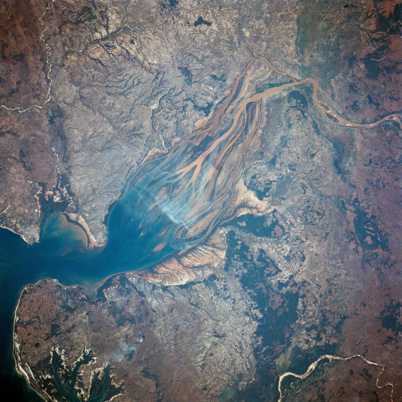
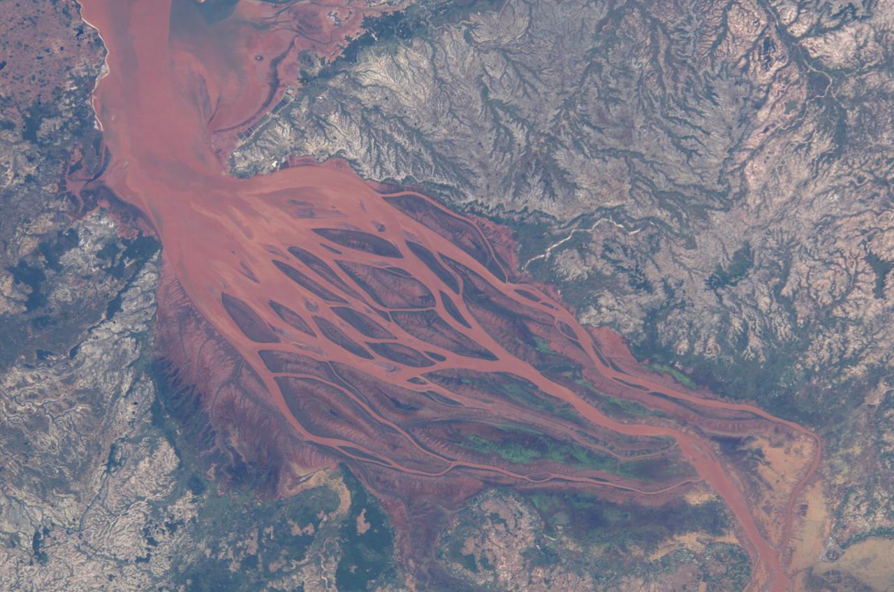
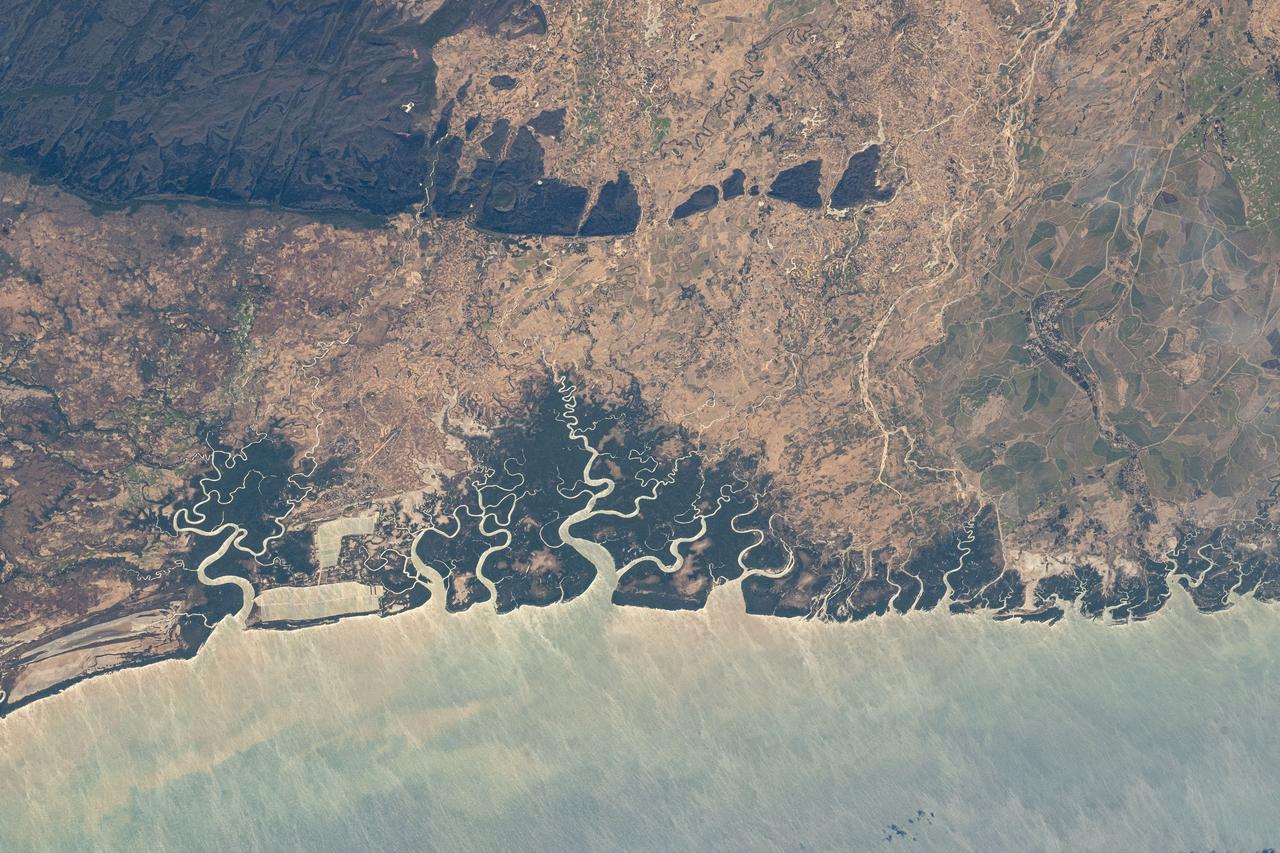
ISS028-E-006687 (2 June 2011) --- Estuaries on the northwestern coast of Madagascar are featured in this image photographed by an Expedition 28 crew member on the International Space Station. Regions where fresh water flowing in rivers and salt water from the seas and oceans mix are called estuaries, and they are among the most biologically productive ecosystems on Earth. This photograph highlights two estuaries located along the northwestern coastline of the island of Madagascar. The Mozambique Channel (top) separates Madagascar from the southeastern coast of Africa. Bombetoka Bay (upper left) is fed by the Betsiboka River and is a frequent subject of astronaut photography due to its striking red floodplain sediments. Mahajamba Bay (right) is fed by several rivers including the Mahajamba and Sofia Rivers; like the Betsiboka, the floodplains of these rivers also contain reddish sediments eroded from their basins upstream. The brackish (mix of fresh and salty water) conditions found in most estuaries host unique plant and animal species adapted to live in such environments. Mangroves in particular are a common plant species found in and around Madagascar estuaries, and Bombetoka Bay contains some of the largest remaining stands. Estuaries also host abundant fish and shellfish species ? many of which need access to freshwater for a portion of their life cycles ? and these in turn support local and migratory bird species that prey on them. However, human activities such as urban development, overfishing, and increased sediment loading from erosion of upriver highlands threaten the ecosystem health of the estuaries. In particular, the silt deposits in Bombetoka Bay at the mouth of the Betsiboka River have been filling in the bay.
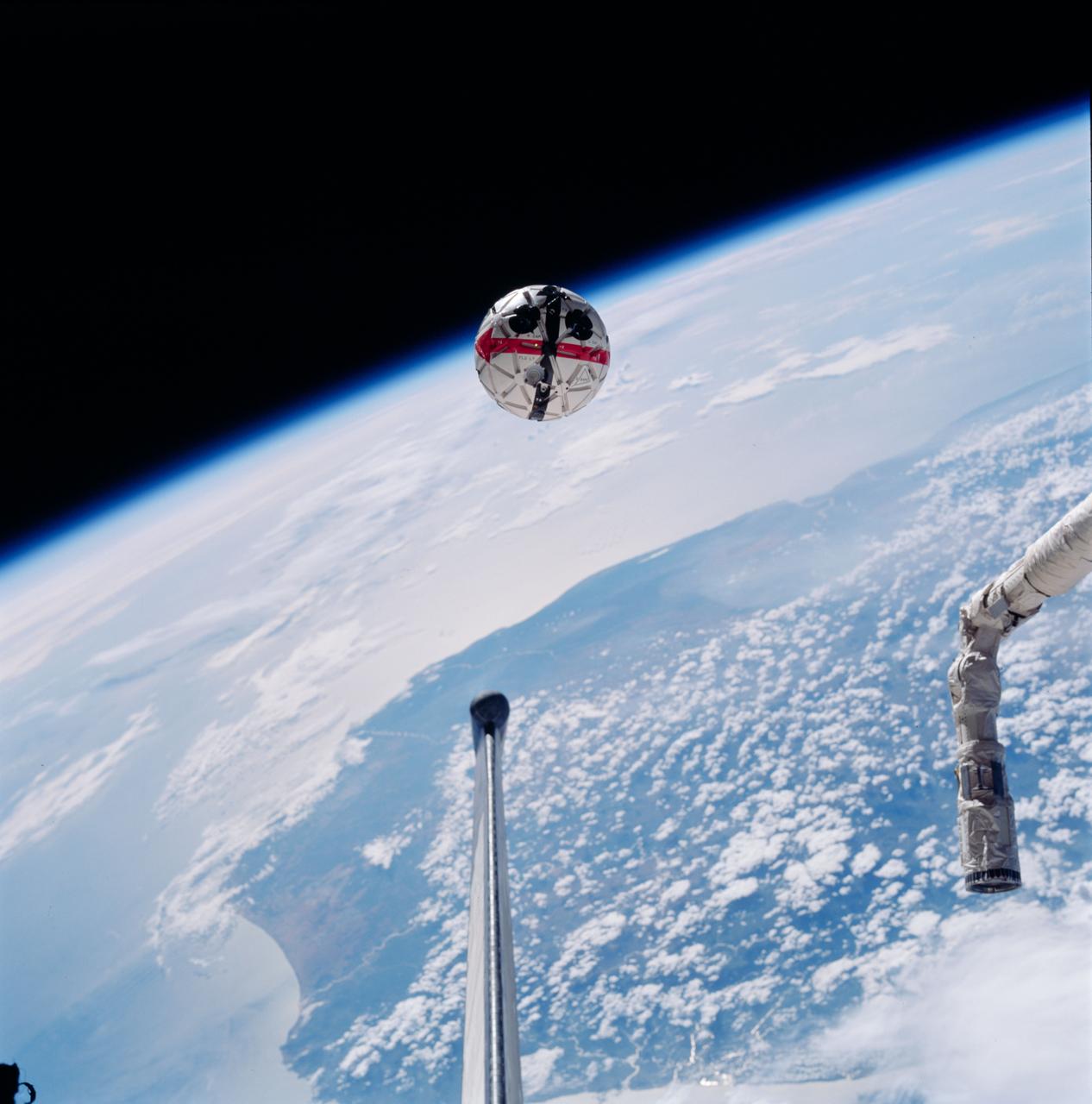
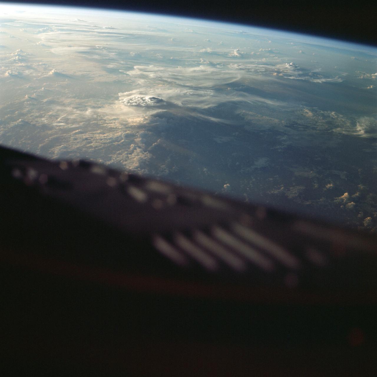
STS087-752-035 (19 November – 5 December 1997) --- This out-the-window view shows the Autonomous Extravehicular Activity Robotic Camera Sprint (AERCam Sprint) free-flying in the vicinity of the cargo bay of the Earth-orbiting Space Shuttle Columbia. The AERCam Sprint is a prototype free-flying television camera that could be used for remote inspections of the exterior of the International Space Station (ISS). This view, backdropped over southern Madagascar, was taken during this flight's second Extravehicular Activity (EVA), on December 3, 1997.
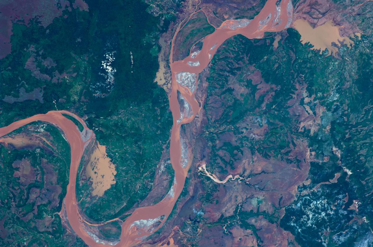
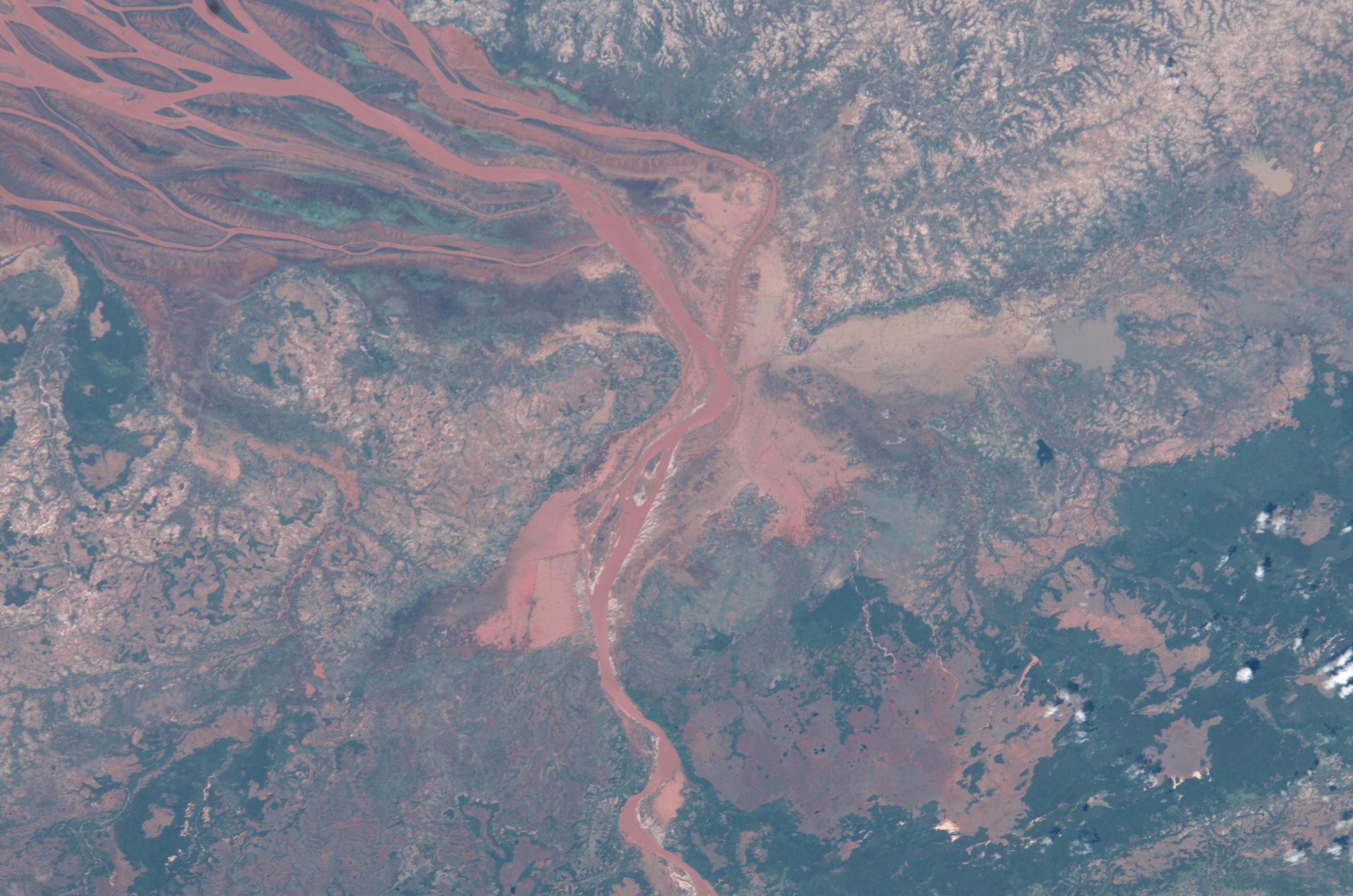
iss071e218069 (June 26, 2024) -- On Madagascar's northwestern coast, the Mozambique Channel flows inland to the Betsiboka River, forming Bombetoka Bay. The reddish-brown color is the result of iron-rich sediment transporting through, creating a striking visual marker for astronauts aboard the International Space Station. This photograph was taken as the orbiting laboratory soared 266 miles above Earth.

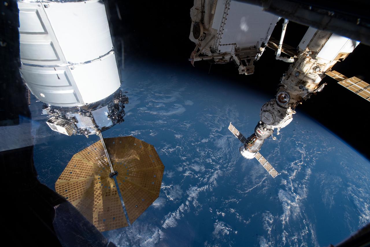
iss070e043722 (Dec. 20, 2023) --- Northrop Grumman's Cygnus space freighter is pictured attached to the International Space Station while orbiting 264 miles above the Indian Ocean south of the island nation of Madagascar. At lower center, is the Canadarm2 robotic arm preparing to grapple Cygnus ahead of its removal from the Unity module and departure from the orbital outpost.

iss065e376020 (Sept. 12, 2021) --- The International Space Station's Russian segment, including the Nauka multipurpose laboratory module, figures prominently in this photograph taken during a spacewalk by ESA (European Space Agency) astronaut Thomas Pesquet. The International Space Station was orbiting 265 miles above the southern Indian Ocean off the coast of Madagascar when this image was captured.
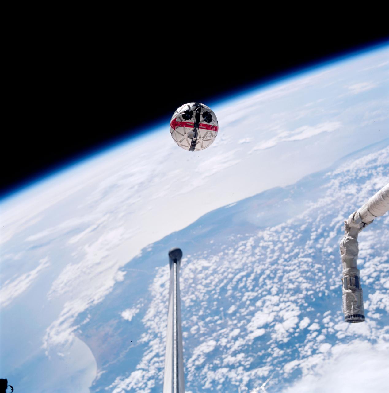
STS087-752-034 (19 November - 5 December 1997) --- This out-the-window view shows the Autonomous Extravehicular Activity Robotic Camera Sprint (AERCam Sprint) free-flying in the vicinity of the cargo bay of the Earth-orbiting Space Shuttle Columbia. The AERCam Sprint is a prototype free-flying television camera that could be used for remote inspections of the exterior of the International Space Station (ISS). This view, backdropped over southern Madagascar, was taken during this flight's second extravehicular activity (EVA), on December 3, 1997.
iss070e043731 (Dec. 20, 2023) --- Northrop Grumman's Cygnus space freighter and the Roscosmos Soyuz MS-24 crew ship (at right) are pictured attached to the International Space Station while orbiting 266 miles above the Indian Ocean south of the island nation of Madagascar. At lower left, is the Canadarm2 robotic arm preparing to grapple Cygnus ahead of its removal from the Unity module and departure from the orbital outpost.
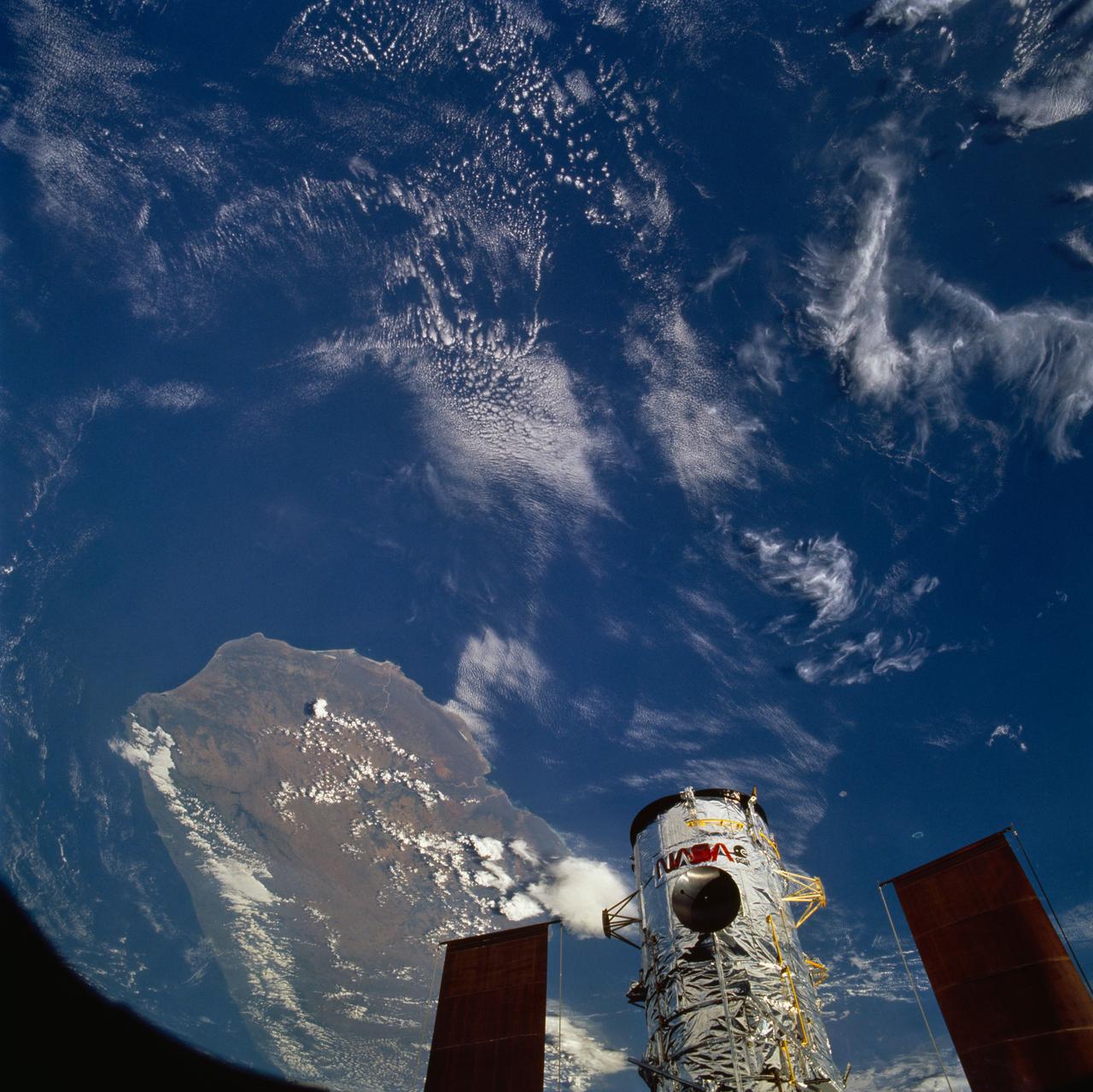
STS061-79-086 (4 Dec 1993) --- The Hubble Space Telescope (HST), backdropped over Madagascar, is berthed in the Space Shuttle Endeavour's cargo bay following its capture by the STS-61 astronauts. The crew used TV cameras to survey the spacecraft before sending out four astronauts on five separate sessions of extravehicular activity (EVA) to perform a variety of servicing tasks.
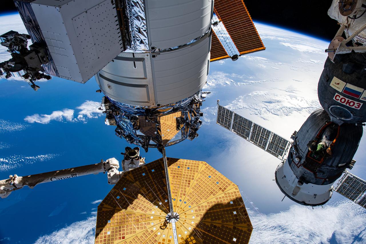
iss067e055885 (May 16, 2022) --- U.S. and Russian spaceships are pictured attached to the International Space Station as it orbited 267 miles above the Indian Ocean south of the island nation of Madagascar. At left, is the U.S. Northrop Grumman Cygnus resupply ship with its prominent cymbal-shaped UltraFlex solar arrays. At right, is the Soyuz MS-21 crew ship docked to the Prichal docking module, which is also attached to the Nauka multipurpose laboratory module. At top center, is the Rassvet module that also hosts Russian visiting vehicles.
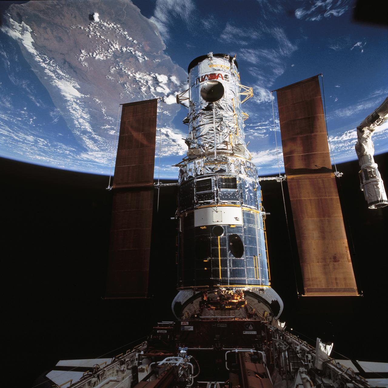
STS061-79-087 (4 Dec. 1993) --- The Hubble Space Telescope (HST), backdropped over Madagascar, is berthed in the space shuttle Endeavour's cargo bay following its capture by the STS-61 astronauts. The crew used TV cameras to survey the spacecraft before sending out four astronauts on five separate sessions of extravehicular activity (EVA) to perform a variety of servicing tasks. Photo credit: NASA
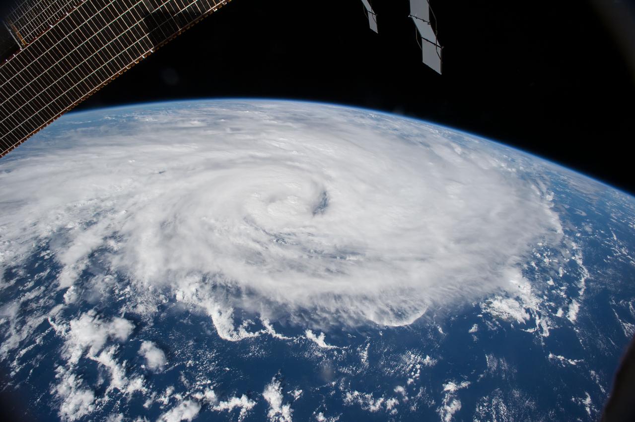
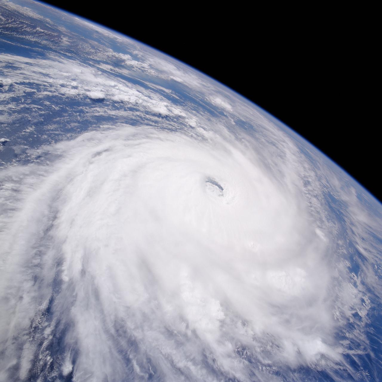
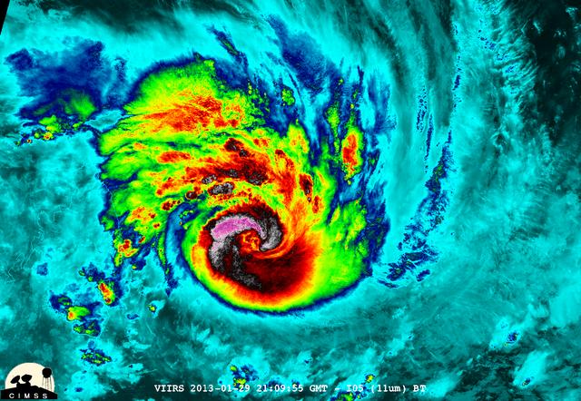
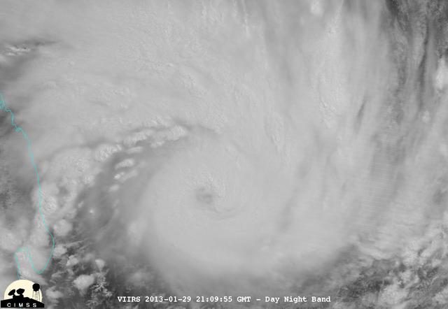
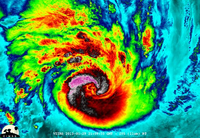
ISS034-E-035983 (28 Jan. 2013) --- This view, photographed by one of the Expedition 34 crew members aboard the International Space Station flying approximately 240 miles above Earth, shows Tropical Cyclone Felleng in the Indian Ocean near Madagascar just prior to being elevated to a Category 4. At the time the photo was taken, the storm was located at 8.5 degrees south latitude and 49.5 degrees east longitude.
iss073e0249606 (June 26, 2025) --- The SpaceX Dragon spacecraft carrying the Axiom Mission 4 (Ax-4) crew from Axiom Space approaches the International Space Station as both spacecraft were orbiting 263 miles above the coast of southern Madagascar. Commanding Ax-4 inside Dragon was veteran astronaut Peggy Whitson leading Pilot Shubhanshu Shukla, and Mission Specialists Sławosz Uznański-Wiśniewski and Tibor Kapu. Dragon would dock later to the orbital outpost's space-facing port on the Harmony module.

iss073e0982679 (Oct. 25, 2025) --- The Milky Way spans the night sky above a bright orange-yellow airglow that blankets the city lights along the east coast of Africa, from Kenya to Somalia. The International Space Station was orbiting 259 miles above the Indian Ocean, north of Madagascar, at approximately 10:29 p.m. local time when this photograph was taken.

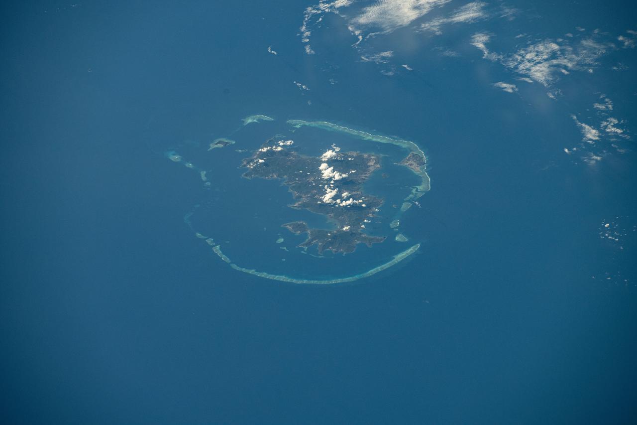
ISS047e141619 (06/06/2016) --- This Earth observation image captured by Expedition 47 members aboard the International Space Station is of Juan de Nova Island, also known as Saint-Christophe. The small French tropical island is in the narrowest part of the Mozambique Channel, about one-third of the way between Madagascar and Mozambique. The Island is 3.7 miles long and 1 mile at its widest. It is a nature reserve surrounded by reefs. Forests cover about half the island and sea turtles nest on the beaches. It is largely uninhabited but the French maintain a weather station on the Island.
41G-120-079 (5-13 Oct 1984) --- This oblique view, photographed from the Space Shuttle Challenger, shows the south tip of the island of Madagascar. Sunglint reflects on the surface of the Mozambique Channel. The crew consisted of astronauts Robert L. Crippen, commander; Jon A. McBride, pilot; mission specialist's Kathryn D. Sullivan, Sally K. Ride, and David D. Leestma; Canadian astronaut Marc Garneau; and Paul D. Scully-Power, payload specialist. EDITOR'S NOTE: The STS-41G mission had the first American female EVA (Sullivan); first seven-person crew; first orbital fuel transfer; and the first Canadian (Garneau).
S65-18752 (23 March 1965) --- View of a cloudy part of Earth as seen from the Gemini-3 spacecraft while in orbit.
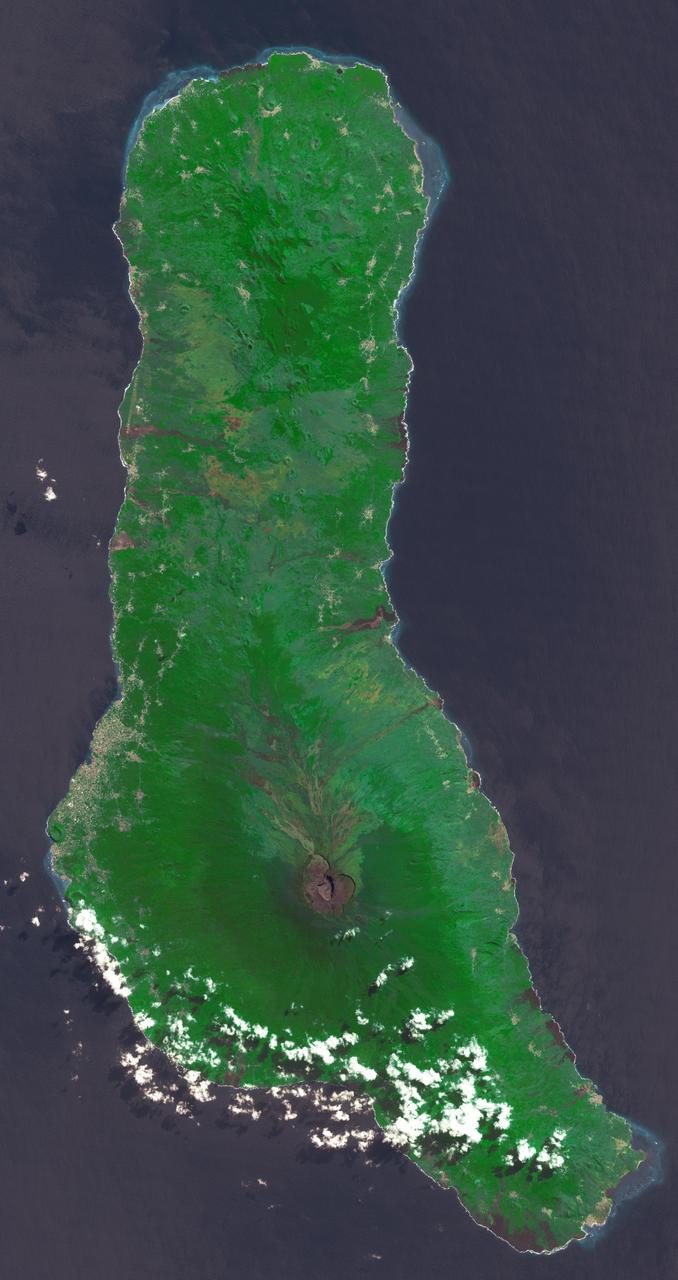
Grande Comore is the largest island of the Union of the Comoros, an island nation located in the Mozambique Channel northwest of Madagascar. The nation was granted independence from France in 1975, and became the Federated Islamic Republic of the Comoro Islands. In 2001, the government reformed as the Union of the Comoros. The three islands making up the country are all of volcanic origin, and Grande Comore is still volcanically active. The image was acquired June 22, 2022, covers an area of 25.7 by 67.4 km, and is located at 11.7 degrees south, 43.3 degrees east. With its 14 spectral bands from the visible to the thermal infrared wavelength region and its high spatial resolution of about 50 to 300 feet (15 to 90 meters), ASTER images Earth to map and monitor the changing surface of our planet. ASTER is one of five Earth-observing instruments launched Dec. 18, 1999, on Terra. The instrument was built by Japan's Ministry of Economy, Trade and Industry. A joint U.S./Japan science team is responsible for validation and calibration of the instrument and data products. The broad spectral coverage and high spectral resolution of ASTER provides scientists in numerous disciplines with critical information for surface mapping and monitoring of dynamic conditions and temporal change. Example applications are monitoring glacial advances and retreats; monitoring potentially active volcanoes; identifying crop stress; determining cloud morphology and physical properties; wetlands evaluation; thermal pollution monitoring; coral reef degradation; surface temperature mapping of soils and geology; and measuring surface heat balance. https://photojournal.jpl.nasa.gov/catalog/PIA25444
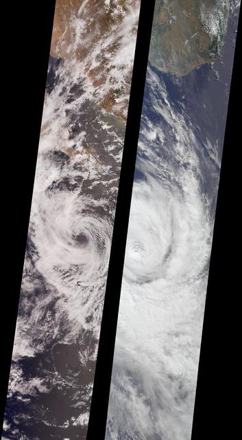
Like dancers pirouetting in opposite directions, the rotational patterns of two different tropical storms are contrasted in this pair of MISR nadir-camera images. The left-hand image is of Tropical Storm Bud, acquired on June 17, 2000 (Terra orbit 2656) as the storm was dissipating. Bud was situated in the eastern Pacific Ocean between Socorro Island and the southern tip of Baja California. South of the storm's center is a vortex pattern caused by obstruction of the prevailing flow by tiny Socorro Island. Sonora, Mexico and Baja California are visible at the top of the image. The right-hand image is of Tropical Cyclone Dera, acquired on March 12, 2001 (Terra orbit 6552). Dera was located in the Indian Ocean, south of Madagascar. The southern end of this large island is visible in the top portion of this image. Northern hemisphere tropical storms, like Bud, rotate in a counterclockwise direction, whereas those in the southern hemisphere, such as Dera, rotate clockwise. The opposite spins are a consequence of Earth's rotation. Each image covers a swath approximately 380 kilometers wide. http://photojournal.jpl.nasa.gov/catalog/PIA03400
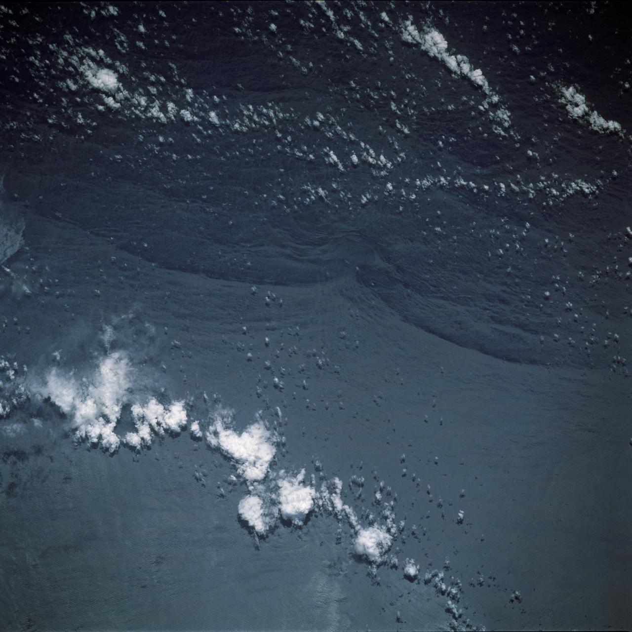
STS044-79-077 (24 Nov.-1 Dec. 1991) --- This photograph, captured from the Earth-orbiting Space Shuttle Atlantis, shows sunglint pattern in the western tropical Indian Ocean. Several large internal waves reflect around a shallow area on the sea floor. NASA scientists studying the STS-44 photography believe the shallow area to be a sediment (a submerged mountain) on top of the Mascarene Plateau, located northeast of Madagascar at approximately 5.6 degrees south latitude and 55.7 degrees east longitude. Internal waves are similar to surface ocean waves, except that they travel inside the water column along the boundary between water layers of different density. At the surface, their passage is marked on the sea surface by bands of smooth and rough water. These bands appear in the sunglint pattern as areas of brighter or darker water. NASA scientists point out that, when the waves encounter an obstacle, such as a near-surface seamount, they bend or refract around the obstacle in the same manner as surface waves bend around an island or headland.
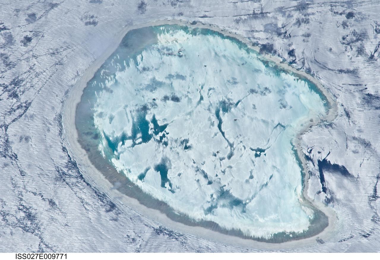
ISS027-E-009771 (2 April 2011) --- Bassas da India is featured in this image photographed by an Expedition 27 crew member on the International Space Station. The vantage point of crew members onboard the space station provides many dramatic views of Earth?s surface. This detailed photograph of the Bassas da India, an uninhabited atoll in the Indian Ocean (between the Mozambique coast of Africa and the island of Madagascar) has an almost surreal quality due to varying degrees of sunglint. Sunglint is an optical phenomena caused by light reflecting off of a water surface directly back towards the observer. Variations in the roughness of the water surface?presence or absence of waves due to wind and water currents?will cause differences in the intensity of the sunglint. The presence of other materials, such as oils or surfactants, can also change the properties of the water surface. Here the presence of currents is highlighted as darker patches or streaks (left and upper right). In contrast, shallow water in the lagoon (center) presents a more uniform, mirror-like appearance in sunglint suggesting that there are no subsurface currents present. Wave crests visible around the atoll are likely the result of both surface winds and subsurface currents. The Bassas da India atoll is part of the French Southern and Antarctic Lands. It is uninhabited due to its complete submergence during high tide ? there is no vegetation established on the atoll for the same reason. The atoll is approximately 10 kilometers in diameter, and covers an area (including the lagoon) of approximately 80 square kilometers.
NASA-NOAA's Suomi NPP satellite captured this false-colored night-time image of Cyclone Felleng during the night on Jan. 28, 2013. Felleng is located in the Southern Indian Ocean, and is northwest of Madagascar. The image revealed some pretty cold overshooting tops, topping at ~170K. The image shows some interesting gravity waves propagating out from the storm in both the thermal and visible imagery. For full storm history on NASA's Hurricane Web Page, visit: <a href="http://www.nasa.gov/mission_pages/hurricanes/archives/2013/h2013_Felleng.html" rel="nofollow">www.nasa.gov/mission_pages/hurricanes/archives/2013/h2013...</a> Credit: William Straka, UWM/NASA/NOAA <b><a href="http://www.nasa.gov/audience/formedia/features/MP_Photo_Guidelines.html" rel="nofollow">NASA image use policy.</a></b> <b><a href="http://www.nasa.gov/centers/goddard/home/index.html" rel="nofollow">NASA Goddard Space Flight Center</a></b> enables NASA’s mission through four scientific endeavors: Earth Science, Heliophysics, Solar System Exploration, and Astrophysics. Goddard plays a leading role in NASA’s accomplishments by contributing compelling scientific knowledge to advance the Agency’s mission. <b>Follow us on <a href="http://twitter.com/NASA_GoddardPix" rel="nofollow">Twitter</a></b> <b>Like us on <a href="http://www.facebook.com/pages/Greenbelt-MD/NASA-Goddard/395013845897?ref=tsd" rel="nofollow">Facebook</a></b> <b>Find us on <a href="http://instagram.com/nasagoddard?vm=grid" rel="nofollow">Instagram</a></b>
NASA-NOAA's Suomi NPP satellite captured this false-colored night-time image of Cyclone Felleng during the night on Jan. 28, 2013. Felleng is located in the Southern Indian Ocean, and is northwest of Madagascar. The image revealed some pretty cold overshooting tops, topping at ~170K. The image shows some interesting gravity waves propagating out from the storm in both the thermal and visible imagery. For full storm history on NASA's Hurricane Web Page, visit: <a href="http://www.nasa.gov/mission_pages/hurricanes/archives/2013/h2013_Felleng.html" rel="nofollow">www.nasa.gov/mission_pages/hurricanes/archives/2013/h2013...</a> Credit: William Straka, UWM/NASA/NOAA <b><a href="http://www.nasa.gov/audience/formedia/features/MP_Photo_Guidelines.html" rel="nofollow">NASA image use policy.</a></b> <b><a href="http://www.nasa.gov/centers/goddard/home/index.html" rel="nofollow">NASA Goddard Space Flight Center</a></b> enables NASA’s mission through four scientific endeavors: Earth Science, Heliophysics, Solar System Exploration, and Astrophysics. Goddard plays a leading role in NASA’s accomplishments by contributing compelling scientific knowledge to advance the Agency’s mission. <b>Follow us on <a href="http://twitter.com/NASA_GoddardPix" rel="nofollow">Twitter</a></b> <b>Like us on <a href="http://www.facebook.com/pages/Greenbelt-MD/NASA-Goddard/395013845897?ref=tsd" rel="nofollow">Facebook</a></b> <b>Find us on <a href="http://instagram.com/nasagoddard?vm=grid" rel="nofollow">Instagram</a></b>
NASA-NOAA's Suomi NPP satellite captured this false-colored night-time image of Cyclone Felleng during the night on Jan. 28, 2013. Felleng is located in the Southern Indian Ocean, and is northwest of Madagascar. The image revealed some pretty cold overshooting tops, topping at ~170K. The image shows some interesting gravity waves propagating out from the storm in both the thermal and visible imagery. For full storm history on NASA's Hurricane Web Page, visit: <a href="http://www.nasa.gov/mission_pages/hurricanes/archives/2013/h2013_Felleng.html" rel="nofollow">www.nasa.gov/mission_pages/hurricanes/archives/2013/h2013...</a> Credit: William Straka, UWM/NASA/NOAA <b><a href="http://www.nasa.gov/audience/formedia/features/MP_Photo_Guidelines.html" rel="nofollow">NASA image use policy.</a></b> <b><a href="http://www.nasa.gov/centers/goddard/home/index.html" rel="nofollow">NASA Goddard Space Flight Center</a></b> enables NASA’s mission through four scientific endeavors: Earth Science, Heliophysics, Solar System Exploration, and Astrophysics. Goddard plays a leading role in NASA’s accomplishments by contributing compelling scientific knowledge to advance the Agency’s mission. <b>Follow us on <a href="http://twitter.com/NASA_GoddardPix" rel="nofollow">Twitter</a></b> <b>Like us on <a href="http://www.facebook.com/pages/Greenbelt-MD/NASA-Goddard/395013845897?ref=tsd" rel="nofollow">Facebook</a></b> <b>Find us on <a href="http://instagram.com/nasagoddard?vm=grid" rel="nofollow">Instagram</a></b>
NASA-NOAA's Suomi NPP satellite captured this false-colored night-time image of Cyclone Felleng during the night on Jan. 28, 2013. Felleng is located in the Southern Indian Ocean, and is northwest of Madagascar. The image revealed some pretty cold overshooting tops, topping at ~170K. The image shows some interesting gravity waves propagating out from the storm in both the thermal and visible imagery. For full storm history on NASA's Hurricane Web Page, visit: <a href="http://www.nasa.gov/mission_pages/hurricanes/archives/2013/h2013_Felleng.html" rel="nofollow">www.nasa.gov/mission_pages/hurricanes/archives/2013/h2013...</a> Credit: William Straka, UWM/NASA/NOAA <b><a href="http://www.nasa.gov/audience/formedia/features/MP_Photo_Guidelines.html" rel="nofollow">NASA image use policy.</a></b> <b><a href="http://www.nasa.gov/centers/goddard/home/index.html" rel="nofollow">NASA Goddard Space Flight Center</a></b> enables NASA’s mission through four scientific endeavors: Earth Science, Heliophysics, Solar System Exploration, and Astrophysics. Goddard plays a leading role in NASA’s accomplishments by contributing compelling scientific knowledge to advance the Agency’s mission. <b>Follow us on <a href="http://twitter.com/NASA_GoddardPix" rel="nofollow">Twitter</a></b> <b>Like us on <a href="http://www.facebook.com/pages/Greenbelt-MD/NASA-Goddard/395013845897?ref=tsd" rel="nofollow">Facebook</a></b> <b>Find us on <a href="http://instagram.com/nasagoddard?vm=grid" rel="nofollow">Instagram</a></b>
NASA-NOAA's Suomi NPP satellite captured this false-colored night-time image of Cyclone Felleng during the night on Jan. 28, 2013. Felleng is located in the Southern Indian Ocean, and is northwest of Madagascar. The image revealed some pretty cold overshooting tops, topping at ~170K. The image shows some interesting gravity waves propagating out from the storm in both the thermal and visible imagery. For full storm history on NASA's Hurricane Web Page, visit: <a href="http://www.nasa.gov/mission_pages/hurricanes/archives/2013/h2013_Felleng.html" rel="nofollow">www.nasa.gov/mission_pages/hurricanes/archives/2013/h2013...</a> Credit: William Straka, UWM/NASA/NOAA <b><a href="http://www.nasa.gov/audience/formedia/features/MP_Photo_Guidelines.html" rel="nofollow">NASA image use policy.</a></b> <b><a href="http://www.nasa.gov/centers/goddard/home/index.html" rel="nofollow">NASA Goddard Space Flight Center</a></b> enables NASA’s mission through four scientific endeavors: Earth Science, Heliophysics, Solar System Exploration, and Astrophysics. Goddard plays a leading role in NASA’s accomplishments by contributing compelling scientific knowledge to advance the Agency’s mission. <b>Follow us on <a href="http://twitter.com/NASA_GoddardPix" rel="nofollow">Twitter</a></b> <b>Like us on <a href="http://www.facebook.com/pages/Greenbelt-MD/NASA-Goddard/395013845897?ref=tsd" rel="nofollow">Facebook</a></b> <b>Find us on <a href="http://instagram.com/nasagoddard?vm=grid" rel="nofollow">Instagram</a></b>
NASA-NOAA's Suomi NPP satellite captured this false-colored night-time image of Cyclone Felleng during the night on Jan. 28, 2013. Felleng is located in the Southern Indian Ocean, and is northwest of Madagascar. The image revealed some pretty cold overshooting tops, topping at ~170K. The image shows some interesting gravity waves propagating out from the storm in both the thermal and visible imagery. For full storm history on NASA's Hurricane Web Page, visit: <a href="http://www.nasa.gov/mission_pages/hurricanes/archives/2013/h2013_Felleng.html" rel="nofollow">www.nasa.gov/mission_pages/hurricanes/archives/2013/h2013...</a> Credit: William Straka, UWM/NASA/NOAA <b><a href="http://www.nasa.gov/audience/formedia/features/MP_Photo_Guidelines.html" rel="nofollow">NASA image use policy.</a></b> <b><a href="http://www.nasa.gov/centers/goddard/home/index.html" rel="nofollow">NASA Goddard Space Flight Center</a></b> enables NASA’s mission through four scientific endeavors: Earth Science, Heliophysics, Solar System Exploration, and Astrophysics. Goddard plays a leading role in NASA’s accomplishments by contributing compelling scientific knowledge to advance the Agency’s mission. <b>Follow us on <a href="http://twitter.com/NASA_GoddardPix" rel="nofollow">Twitter</a></b> <b>Like us on <a href="http://www.facebook.com/pages/Greenbelt-MD/NASA-Goddard/395013845897?ref=tsd" rel="nofollow">Facebook</a></b> <b>Find us on <a href="http://instagram.com/nasagoddard?vm=grid" rel="nofollow">Instagram</a></b>