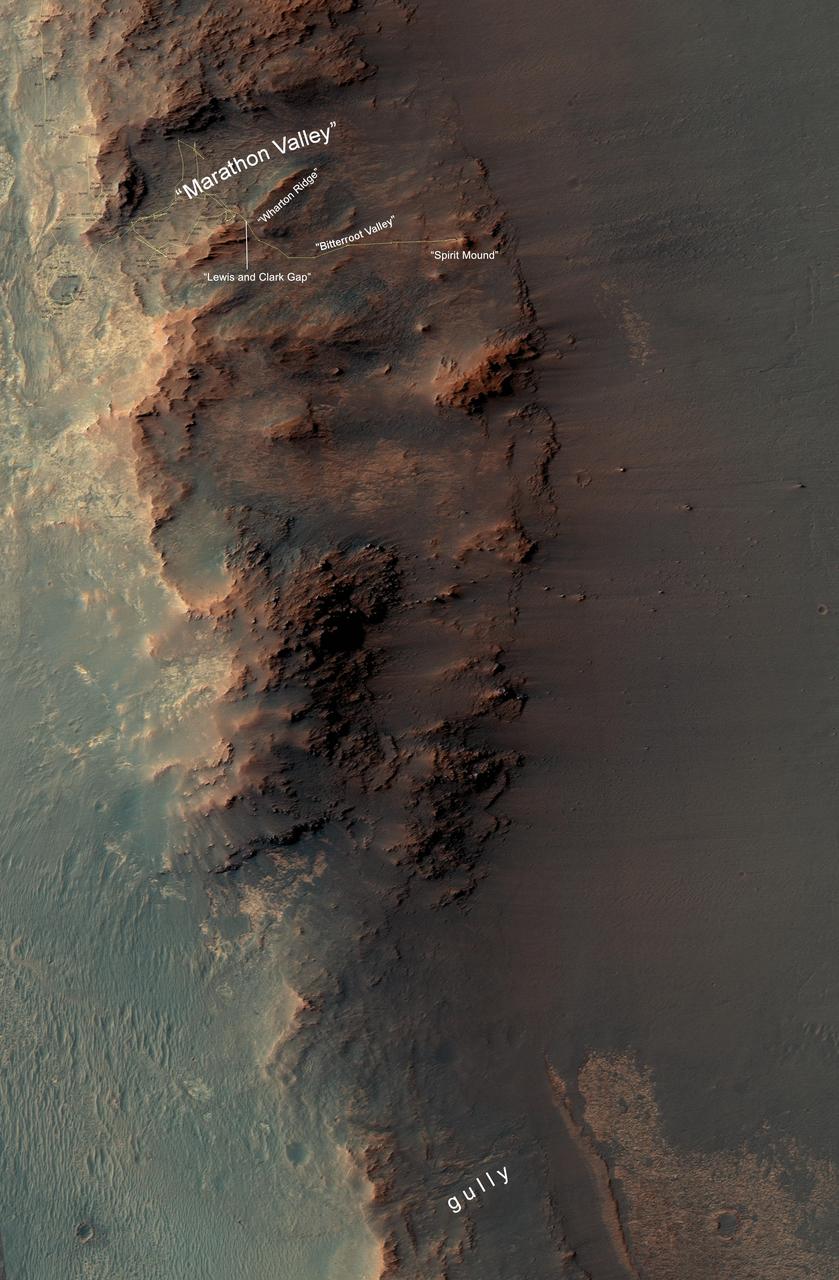
This map show a portion of Endeavour Crater's western rim that includes the "Marathon Valley" area investigated intensively by NASA's Mars Exploration Rover Opportunity in 2015 and 2016, and a fluid-carved gully that is a destination to the south for the mission. The width of the area covered in the map is about half a mile (about 800 meters). North is up. Opportunity entered the northern end of the mapped area in January 2015 and entered Marathon Valley in July 2015. A gold line on the map, which may not be visible without zooming into the image, shows the rover's route. Curiosity departed Marathon Valley in September 2016 by driving southward through "Lewis and Clark Gap" into "Bitterroot Valley." The gully near the south end of the map was incised into Endeavour's rim long ago by a fluid, possibly a water-lubricated debris flow or a flow with mostly water. Driving into this gully to learn more about that flow is one of the goals for a two-year mission extension taking Opportunity through September 2018. A map showing wider context of Opportunity's route from its January 2004 landing in Eagle Crater to Endeavour Crater and Marathon Valley is at PIA19154. The rover's traverse shown here has been mapped by Tim Parker of NASA's Jet Propulsion Laboratory, Pasadena, California, onto an image from the High Resolution Imaging Science Experiment (HiRISE) camera on NASA's Mars Reconnaissance Orbiter. http://photojournal.jpl.nasa.gov/catalog/PIA20854
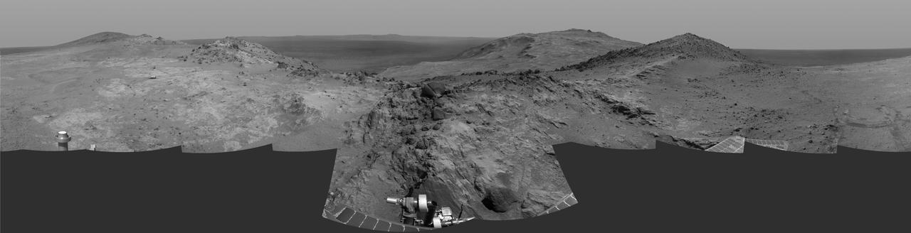
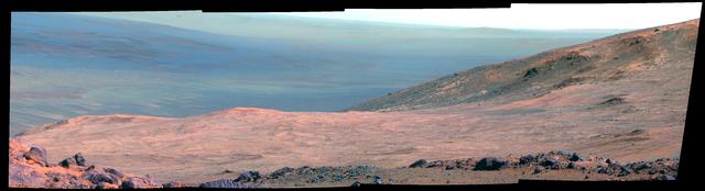
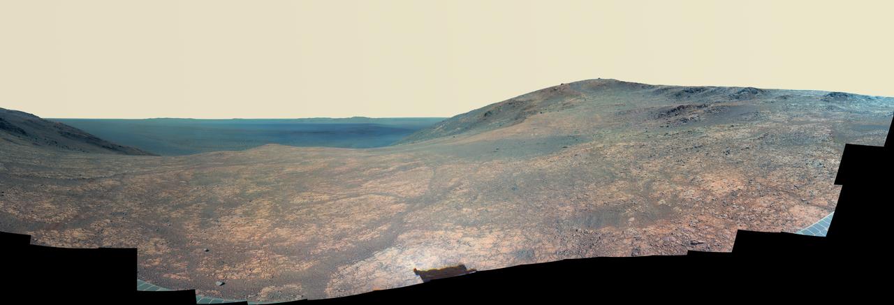
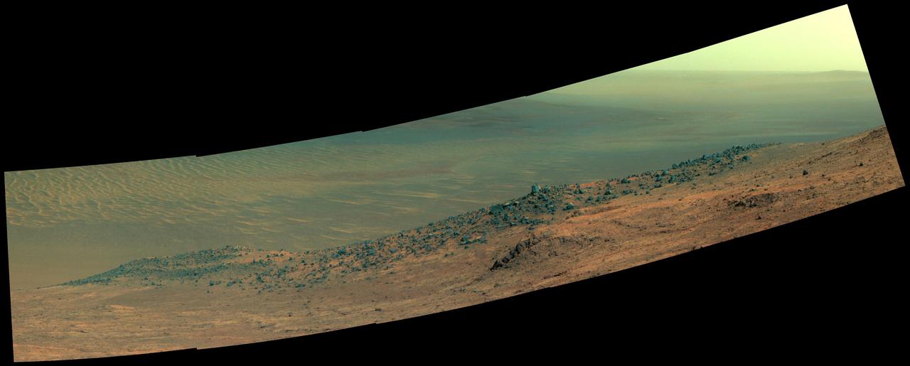
Cumulative driving by NASA's Mars Exploration Rover Opportunity surpassed marathon distance on March 24, 2015, as the rover neared a destination called "Marathon Valley," which is middle ground of this dramatic view from early March. Olympic marathon distance is 26.219 miles (42.195 kilometers). Opportunity's navigation camera collected the component images of this scene during the 3,948th and 3,949th Martian days, or sols, of the rover's work on Mars (March 3 and 4, 2015). The view is centered toward the east-southeast, from a location on Endeavour Crater's western rim overlooking Marathon Valley, with the floor of Endeavour beyond, and the eastern rim in the distance. In the foreground at center, Opportunity's robotic arm is positioned for examination of a blocky rock called "Sergeant Charles Floyd." http://photojournal.jpl.nasa.gov/catalog/PIA19155
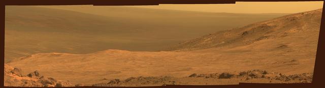
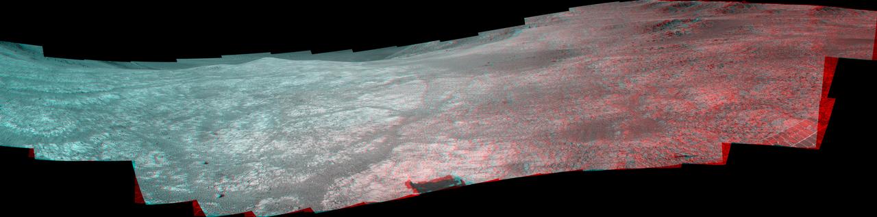
This view from NASA's Mars Exploration Rover Opportunity shows part of "Marathon Valley," a destination on the western rim of Endeavour Crater, as seen from an overlook north of the valley. The scene spans from east, at left, to southeast. It combines four pointings of the rover's panoramic camera (Pancam) on March 13, 2015, during the 3,958th Martian day, or sol, of Opportunity's work on Mars. The rover team selected Marathon Valley as a science destination because observations of this location using the Compact Reconnaissance Imaging Spectrometer for Mars (CRISM) instrument on NASA's Mars Reconnaissance Orbiter yielded evidence of clay minerals, a clue to ancient wet environments. By the time Opportunity explores Marathon Valley, the rover will have exceeded a total driving distance equivalent to an Olympic marathon. Opportunity has been exploring the Meridiani Planum region of Mars since January 2004. This version of the image is presented in approximate true color by combining exposures taken through three of the Pancam's color filters at each of the four camera pointings, using filters centered on wavelengths of 753 nanometers (near-infrared), 535 nanometers (green) and 432 nanometers (violet). http://photojournal.jpl.nasa.gov/catalog/PIA19151
This scene from NASA Mars Exploration Rover Opportunity looks upward at Knudsen Ridge on the southern edge of Marathon Valley from inside the valley.
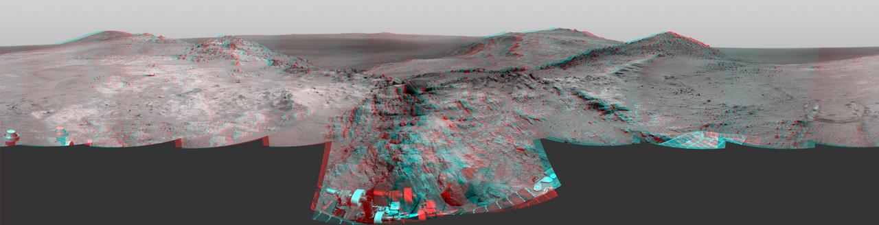
Cumulative driving by NASA's Mars Exploration Rover Opportunity surpassed marathon distance on March 24, 2015, as the rover neared a destination called "Marathon Valley," which is middle ground of this stereo view from early March. The scene appears three-dimensional when viewed through blue-red glasses with the red lens on the left. Olympic marathon distance is 26.219 miles (42.195 kilometers). The left-eye and right-eye cameras of Opportunity's navigation camera collected the component images of this scene during the 3,948th and 3,949th Martian days, or sols, of the rover's work on Mars (March 3 and 4, 2015). The view is centered toward the east-southeast, from a location on Endeavour Crater's western rim overlooking Marathon Valley, with the floor of Endeavour beyond, and the eastern rim in the distance. In the foreground at center, Opportunity's robotic arm is positioned for examination of a blocky rock called "Sergeant Charles Floyd." http://photojournal.jpl.nasa.gov/catalog/PIA19156
This stereo scene from NASA's Mars Exploration Rover Opportunity shows part of "Marathon Valley," a destination on the western rim of Endeavour Crater, as seen from an overlook north of the valley. The image combines views from the left eye and right eye of Opportunity's panoramic camera (Pancam) to appear three-dimensional when seen through blue-red glasses with the red lens on the left. The component Pancam images were taken on March 13, 2015, during the 3,958th Martian day, or sol, of Opportunity's work on Mars. The scene spans from east, at left, to southeast. The rover team selected Marathon Valley as a science destination because observations of this location using the Compact Reconnaissance Imaging Spectrometer for Mars (CRISM) instrument on NASA's Mars Reconnaissance Orbiter yielded evidence of clay minerals, a clue to ancient wet environments. By the time Opportunity explores Marathon Valley, the rover will have exceeded a total driving distance equivalent to an Olympic marathon. Opportunity has been exploring the Meridiani Planum region of Mars since January 2004. http://photojournal.jpl.nasa.gov/catalog/PIA19153
This scene in enhanced color from NASA Mars Exploration Rover Opportunity looks upward at Knudsen Ridge on the southern edge of Marathon Valley from inside the valley.
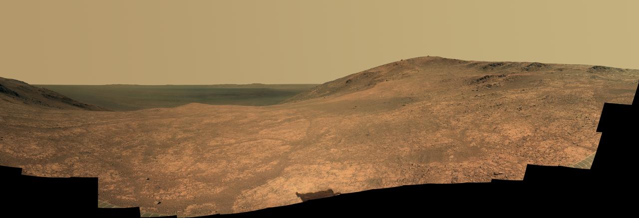
"Marathon Valley" on Mars opens northeastward to a view across the floor of Endeavour Crater in this scene from the panoramic camera (Pancam) of NASA's Mars Exploration Rover Opportunity. The scene merges multiple Pancam exposures taken during the period April 16 through May 15, 2016, corresponding to sols (Martian days) 4,347 through 4,375 of Opportunity's work on Mars. It spans from north, at the left, to west-southwest, at the right. The high point in the right half of the scene is "Knudsen Ridge," which forms part of the southern edge of Marathon Valley. Portions of the northeastern and eastern rim of Endeavour crater appear on the distant horizon. Endeavour Crater is 14 miles (22 kilometers) in diameter. The fractured texture of Marathon Valley's floor is visible in the foreground. The view merges exposures taken through three of the Pancam's color filters, centered on wavelengths of 753 nanometers (near-infrared), 535 nanometers (green) and 432 nanometers (violet). It is presented in approximately true color. The rover team calls this image the mission's "Sacagawea Panorama," for the Lemhi Shoshone woman, also commemorated on U.S. dollar coins, whose assistance to the Lewis and Clark expedition helped enable its successes in 1804-1806. Many rocks and other features in Marathon Valley were informally named for members of Lewis and Clark's "Corps of Discovery" expedition. Opportunity entered Marathon Valley in July 2015. The valley's informal name was chosen because Opportunity's arrival at this point along the western rim of Endeavour Crater coincided closely with the rover surpassing marathon-footrace distance in its total driving odometry since landing on Mars in January 2004. The team's planned investigations in the valley were nearing completion when the component images for this scene were taken. http://photojournal.jpl.nasa.gov/catalog/PIA20749
This view from NASA's Mars Exploration Rover Opportunity shows part of "Marathon Valley," a destination on the western rim of Endeavour Crater, as seen from an overlook north of the valley. In this version of the image, the landscape is presented in false color to make differences in surface materials more easily visible. The scene spans from east, at left, to southeast. It combines four pointings of the rover's panoramic camera (Pancam) on March 13, 2015, during the 3,958th Martian day, or sol, of Opportunity's work on Mars. The rover team selected Marathon Valley as a science destination because observations of this location using the Compact Reconnaissance Imaging Spectrometer for Mars (CRISM) instrument on NASA's Mars Reconnaissance Orbiter yielded evidence of clay minerals, a clue to ancient wet environments. By the time Opportunity explores Marathon Valley, the rover will have exceeded a total driving distance equivalent to an Olympic marathon. Opportunity has been exploring the Meridiani Planum region of Mars since January 2004. The image combines exposures taken through three of the Pancam's color filters at each of the four camera pointings, using filters centered on wavelengths of 753 nanometers (near-infrared), 535 nanometers (green) and 432 nanometers (violet). http://photojournal.jpl.nasa.gov/catalog/PIA19152
"Marathon Valley" on Mars opens northeastward in this stereo scene from the panoramic camera (Pancam) of NASA's Mars Exploration Rover Opportunity. The image combines views from the left eye and right eye of the Pancam to appear three-dimensional when seen through blue-red glasses with the red lens on the left. The component images were taken during the period April 16 through May 15, 2016, corresponding to sols (Martian days) 4,347 through 4,375 of Opportunity's work on Mars. The vista spans from north, at the left, to west-southwest, at the right. The high point in the right half of the scene is "Knudsen Ridge," which forms part of the southern edge of Marathon Valley. The fractured texture of Marathon Valley's floor is visible in the foreground. The rover team calls this image the mission's "Sacagawea Panorama," for the Lemhi Shoshone woman, also commemorated on U.S. dollar coins, whose assistance to the Lewis and Clark expedition helped enable its successes in 1804-1806. Many rocks and other features in Marathon Valley were informally named for members of Lewis and Clark's "Corps of Discovery" expedition. Opportunity entered Marathon Valley in July 2015. The valley's informal name was chosen because Opportunity's arrival at this point along the western rim of Endeavour Crater coincided closely with the rover surpassing marathon-footrace distance in its total driving odometry since landing on Mars in January 2004. The team's planned investigations in the valley were nearing completion when the component images for this scene were taken. http://photojournal.jpl.nasa.gov/catalog/PIA20751
This 3-D stereo view from NASA Mars rover Opportunity shows contrasting textures and colors of Hinners Point, at the northern edge of Marathon Valley, and swirling reddish zones on the valley floor to the left.
This stereo view from NASA Mars Exploration Rover Opportunity looks upward at Knudsen Ridge on the southern edge of Marathon Valley from inside the valley. You need 3-D glasses to view this image.
"Marathon Valley" on Mars opens northeastward to a view across the floor of Endeavour Crater in this scene from the panoramic camera (Pancam) of NASA's Mars Exploration Rover Opportunity. In this version of the scene the landscape is presented in enhanced color to make differences in surface materials more easily visible. The panorama merges multiple Pancam exposures taken during the period April 16 through May 15, 2016, corresponding to sols (Martian days) 4,347 through 4,375 of Opportunity's work on Mars. It spans from north, at the left, to west-southwest, at the right. The high point in the right half of the scene is "Knudsen Ridge," which forms part of the southern edge of Marathon Valley. Portions of the northeastern and eastern rim of Endeavour crater appear on the distant horizon. Endeavour Crater is 14 miles (22 kilometers) in diameter. The fractured texture of Marathon Valley's floor is visible in the foreground. The rover team calls this image the mission's "Sacagawea Panorama," for the Lemhi Shoshone woman, also commemorated on U.S. dollar coins, whose assistance to the Lewis and Clark expedition helped enable its successes in 1804-1806. Many rocks and other features in Marathon Valley were informally named for members of Lewis and Clark's "Corps of Discovery" expedition. Opportunity entered Marathon Valley in July 2015. The valley's informal name was chosen because Opportunity's arrival at this point along the western rim of Endeavour Crater coincided closely with the rover surpassing marathon-footrace distance in its total driving odometry since landing on Mars in January 2004. The team's planned investigations in the valley were nearing completion when the component images for this scene were taken. http://photojournal.jpl.nasa.gov/catalog/PIA20750
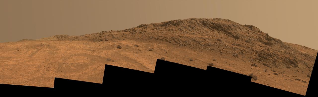
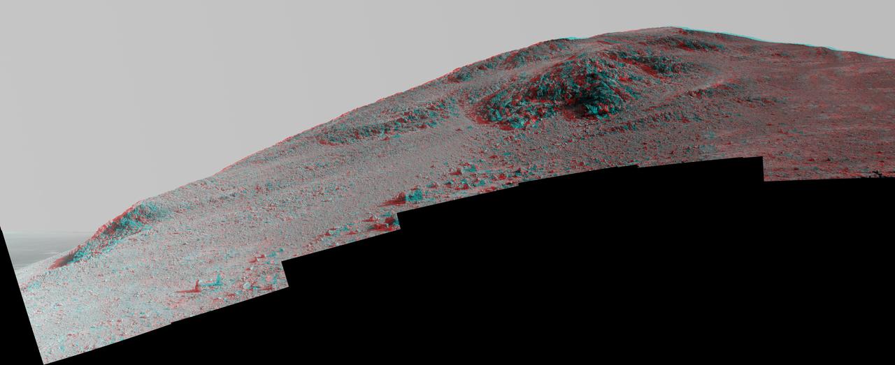
This Martian scene shows contrasting textures and colors of "Hinners Point," at the northern edge of "Marathon Valley," and swirling reddish zones on the valley floor to the left. The view combines six frames taken by the panoramic camera (Pancam) on NASA's Mars Exploration Rover Opportunity on Aug. 14, 2015, during the 4,108th Martian day, or sol, of the rover's work on Mars. The summit takes its informal name as a tribute to Noel Hinners (1935-2014). For NASA's Apollo program, Hinners played important roles in selection of landing sites on the moon and scientific training of astronauts. He then served as NASA associate administrator for space science, director of the Smithsonian National Air and Space Museum, director of NASA's Goddard Space Flight Center, NASA chief scientist and associate deputy administrator of NASA. Subsequent to responsibility for the Viking Mars missions while at NASA, he spent the latter part of his career as vice president for flight systems at Lockheed Martin, where he had responsibility for the company's roles in development and operation of NASA's Mars Global Surveyor, Mars Reconnaissance Orbiter, Mars Odyssey, Phoenix Mars Lander, Stardust and Genesis missions. Marathon Valley cuts generally east-west through the western rim of Endeavour Crater. The valley's name refers to the distance Opportunity drove from its 2004 landing site to arrival at this location in 2014. The valley was a high-priority destination for the rover mission because observations from orbit detected clay minerals there. Dark rocks on Hinners Point show a pattern dipping downward toward the interior of Endeavour, to the right from this viewing angle. The strong dip may have resulted from the violence of the impact event that excavated the crater. Brighter rocks make up the valley floor. The reddish zones there may be areas where water has altered composition. Inspections by Opportunity have found compositions there are higher in silica and lower in iron than the typical composition of rocks on Endeavour's rim. The scene spans from west-southwest at left to northwest at right. The larger of two stones close to each other in the foreground left of center is about 5 inches (12 centimeters) wide. On bright bedrock to the right of those stones, Opportunity inspected a target informally named "Pvt. George Gibson." Another inspected target, "Pvt. Silas Goodrich," is on the valley floor near the left edge of this scene. The informal names for these targets refer to members of the Lewis and Clark expedition's Corps of Discovery. This version of the image is presented in approximate true color by combing exposures taken through three of the Pancam's color filters, centered on wavelengths of 753 nanometers (near-infrared), 535 nanometers (green) and 432 nanometers (violet). http://photojournal.jpl.nasa.gov/catalog/PIA19819
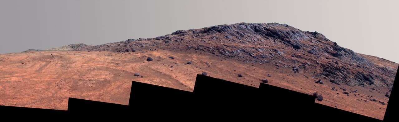
This Martian scene shows contrasting textures and colors of "Hinners Point," at the northern edge of "Marathon Valley," and swirling reddish zones on the valley floor to the left. In this version of the image, the landscape is presented in enhanced color to make differences in surface materials more easily visible. The summit takes its informal name as a tribute to Noel Hinners (1935-2014). For NASA's Apollo program, Hinners played important roles in selection of landing sites on the moon and scientific training of astronauts. He then served as NASA associate administrator for space science, director of the Smithsonian National Air and Space Museum, director of NASA's Goddard Space Flight Center, NASA chief scientist and associate deputy administrator of NASA. Subsequent to responsibility for the Viking Mars missions while at NASA, he spent the latter part of his career as vice president for flight systems at Lockheed Martin, where he had responsibility for the company's roles in development and operation of NASA's Mars Global Surveyor, Mars Reconnaissance Orbiter, Mars Odyssey, Phoenix Mars Lander, Stardust and Genesis missions. Marathon Valley cuts generally east-west through the western rim of Endeavour Crater. The valley's name refers to the distance Opportunity drove from its 2004 landing site to arrival at this location in 2014. The valley was a high-priority destination for the rover mission because observations from orbit detected clay minerals there. Dark rocks on Hinners Point show a pattern dipping downward toward the interior of Endeavour, to the right from this viewing angle. The strong dip may have resulted from the violence of the impact event that excavated the crater. Brighter rocks make up the valley floor. The reddish zones there may be areas where water has altered composition. Inspections by Opportunity have found compositions there are higher in silica and lower in iron than the typical composition of rocks on Endeavour's rim. The scene spans from west-southwest at left to northwest at right. The larger of two stones close to each other in the foreground left of center is about 5 inches (12 centimeters) wide. On bright bedrock to the right of those stones, Opportunity inspected a target informally named "Pvt. George Gibson." Another inspected target, "Pvt. Silas Goodrich," is on the valley floor near the left edge of this scene. The informal names for these targets refer to members of the Lewis and Clark expedition's Corps of Discovery. The image combines exposures taken through three of the Pancam's color filters, centered on wavelengths of 753 nanometers (near-infrared), 535 nanometers (green) and 432 nanometers (violet). http://photojournal.jpl.nasa.gov/catalog/PIA19820
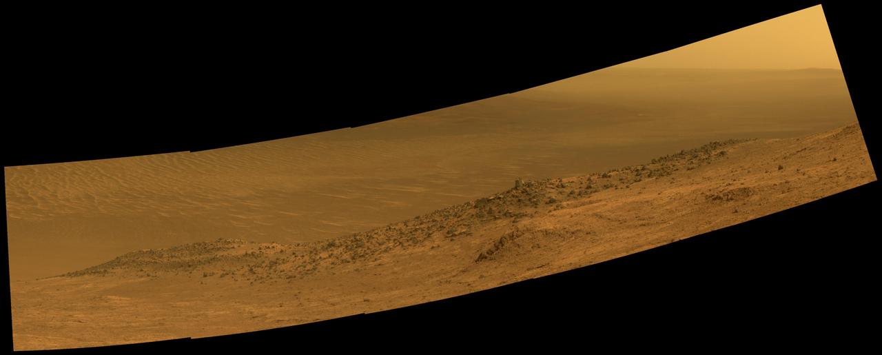
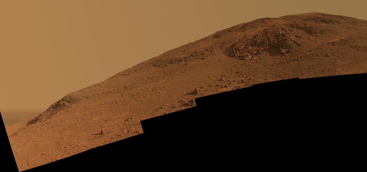
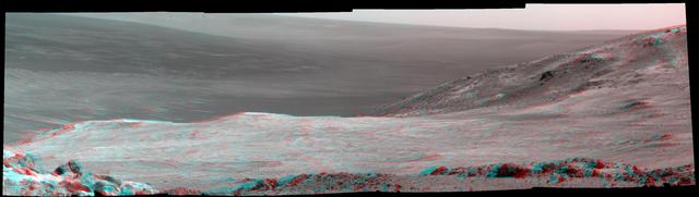
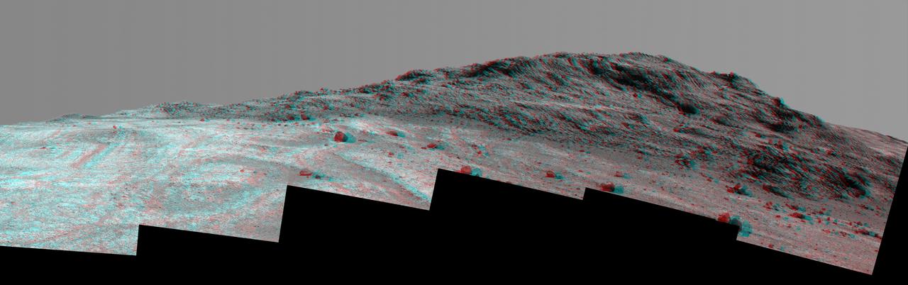
This scene from NASA's Mars Exploration Rover Opportunity shows "Wharton Ridge," which forms part of the southern wall of "Marathon Valley" on the western rim of Endeavour Crater. The full extent of Wharton Ridge is visible, with the floor of Endeavour Crater beyond it and the far wall of the crater in the distant background. Near the right edge of the scene is "Lewis and Clark Gap," through which Opportunity crossed from Marathon Valley to "Bitterroot Valley" in September 2016. Before the rover departed Marathon Valley, its panoramic camera (Pancam) acquired the component images for this scene on Aug. 30, 2016, during the 4,480th Martian day, or sol, of Opportunity's work on Mars. Opportunity's science team chose the ridge's name to honor the memory of Robert A. Wharton (1951-2012), an astrobiologist who was a pioneer in the use of terrestrial analog environments, particularly in Antarctica, to study scientific problems connected to the habitability of Mars. Over the course of his career, he was a visiting senior scientist at NASA Headquarters, vice president for research at the Desert Research Institute, provost at Idaho State University, and president of the South Dakota School of Mines and Technology. The view spans from east-northeast at left to southeast at right. It merges exposures taken through three of the Pancam's color filters, centered on wavelengths of 753 nanometers (near-infrared), 535 nanometers (green) and 432 nanometers (violet). It is presented in approximately true color. http://photojournal.jpl.nasa.gov/catalog/PIA20849
This scene from NASA's Mars Exploration Rover Opportunity shows "Wharton Ridge," which forms part of the southern wall of "Marathon Valley" on the western rim of Endeavour Crater. In this version of the scene the landscape is presented in enhanced color to make differences in surface materials more easily visible The full extent of Wharton Ridge is visible, with the floor of Endeavour Crater beyond it and the far wall of the crater in the distant background. Near the right edge of the scene is "Lewis and Clark Gap," through which Opportunity crossed from Marathon Valley to "Bitterroot Valley" in September 2016. Before the rover departed Marathon Valley, its panoramic camera (Pancam) acquired the component images for this scene on Aug. 30, 2016, during the 4,480th Martian day, or sol, of Opportunity's work on Mars. Opportunity's science team chose the ridge's name to honor the memory of Robert A. Wharton (1951-2012), an astrobiologist who was a pioneer in the use of terrestrial analog environments, particularly in Antarctica, to study scientific problems connected to the habitability of Mars. Over the course of his career, he was a visiting senior scientist at NASA Headquarters, vice president for research at the Desert Research Institute, provost at Idaho State University, and president of the South Dakota School of Mines and Technology. The view spans from east-northeast at left to southeast at right. Color in the scene comes from component images taken through three of the Pancam's color filters, centered on wavelengths of 753 nanometers (near-infrared), 535 nanometers (green) and 432 nanometers (violet). http://photojournal.jpl.nasa.gov/catalog/PIA20850
Eleven years and two months after its landing on Mars, the total driving distance of NASA's Mars Exploration Rover Opportunity surpassed the length of a marathon race: 26.219 miles (42.195 kilometers). This map shows the southward path driven by Opportunity from late December 2014 until it passed marathon distance on March 24, 2015, during the 3,968th Martian day, or sol, of the rover's work on Mars. Recent drives bring the vehicle close to a science destination called "Marathon Valley" on the west rim of Endeavour Crater. The rover team is using instruments on Opportunity to study "Spirit of St. Louis Crater" before entry into Marathon Valley. Opportunity reached the Sol 3881 location near the top of the map on Dec. 24, 2015. A map showing wider context of Opportunity's route from its January 2004 landing in Eagle Crater to Endeavour Crater is at PIA18404. A view from the Sol 3893 location at the summit of "Cape Tribulation," taken the following sol, is at PIA19109. The rover's traverse shown here has been mapped onto an image from the High Resolution Imaging Science Experiment (HiRISE) camera on NASA's Mars Reconnaissance Orbiter. http://photojournal.jpl.nasa.gov/catalog/PIA19158
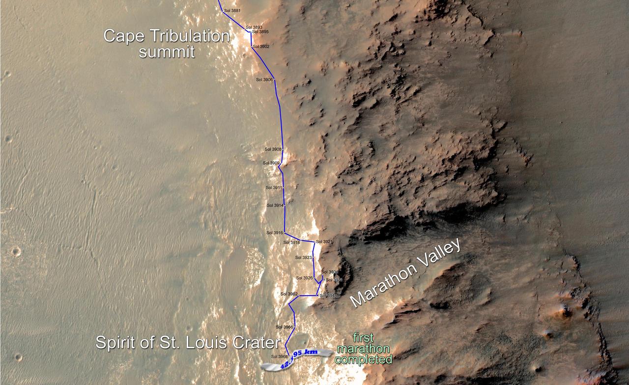
Eleven years and two months after its landing on Mars, the total driving distance of NASA's Mars Exploration Rover Opportunity surpassed the length of a marathon race: 26.219 miles (42.195 kilometers). This map shows the southward path driven by Opportunity from late December 2014 until it passed marathon distance on March 24, 2015, during the 3,968th Martian day, or sol, of the rover's work on Mars. Recent drives bring the vehicle close to a science destination called "Marathon Valley" on the west rim of Endeavour Crater. The rover team is using instruments on Opportunity to study "Spirit of St. Louis Crater" before entry into Marathon Valley. Opportunity reached the Sol 3881 location near the top of the map on Dec. 24, 2015. A map showing wider context of Opportunity's route from its January 2004 landing in Eagle Crater to Endeavour Crater is at PIA18404. A view from the Sol 3893 location at the summit of "Cape Tribulation," taken the following sol, is at PIA19109. The rover's traverse shown here has been mapped onto an image from the High Resolution Imaging Science Experiment (HiRISE) camera on NASA's Mars Reconnaissance Orbiter. http://photojournal.jpl.nasa.gov/catalog/PIA19157
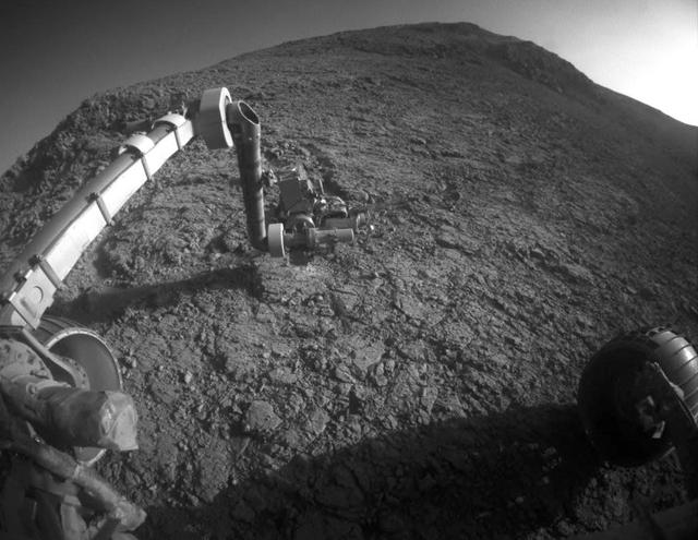
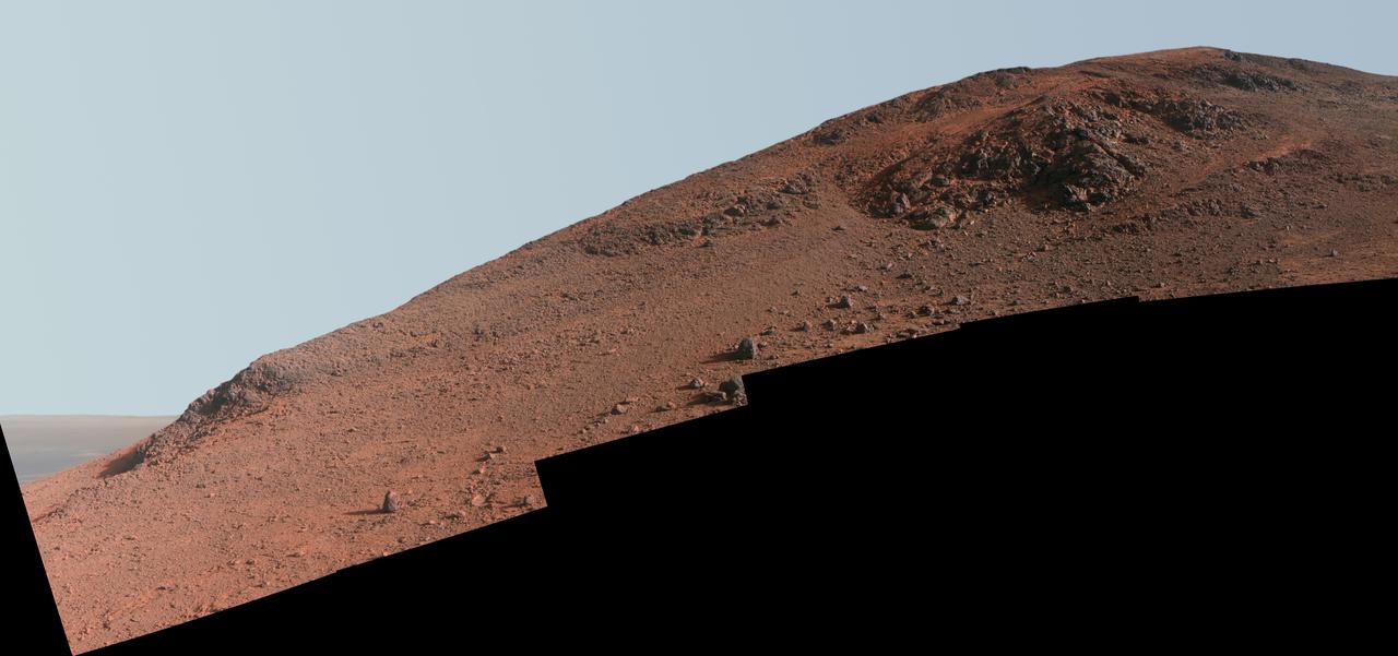
The target beneath the tool turret at the end of the rover's robotic arm in this image from NASA's Mars Exploration Rover Opportunity is "Private John Potts." It lies high on the southern side of "Marathon Valley," which slices through the western rim of Endeavour Crater. The target's informal name refers to a member of the Lewis and Clark Expedition's Corps of Discovery. The image was taken by Opportunity's front hazard avoidance camera on Jan. 5, 2016, during the 4,248th Martian day, or sol, of the rover's work on Mars. This camera is mounted low on the rover and has a wide-angle lens. In this image, the microscopic imager on the turret is pointed downward. Opportunity's examination of this target also used the turret's rock abrasion tool for removing the surface crust and alpha particle X-ray spectrometer for identifying chemical elements in the rock. http://photojournal.jpl.nasa.gov/catalog/PIA20285
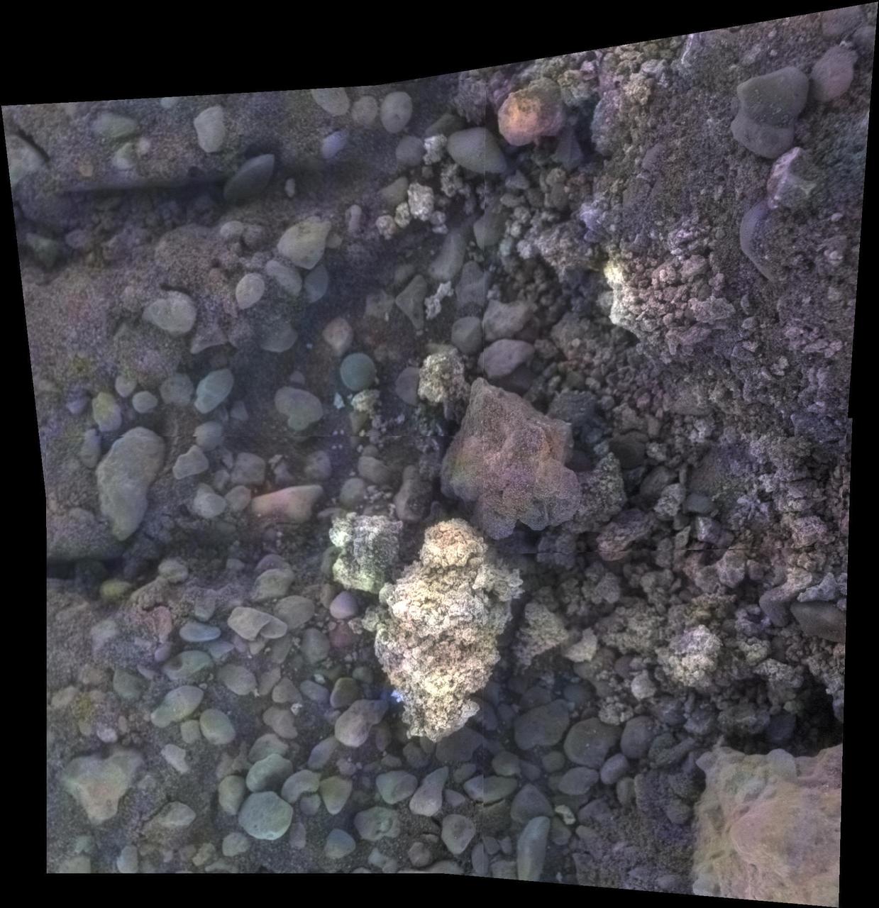
This image of a target called "Private Joseph Field" combines four images from the microscopic imager on the robotic arm of NASA's Mars Exploration Rover Opportunity, with enhanced color information added from the rover's panoramic camera. This target is within the "Marathon Valley" area of the western rim of Endeavour Crater. The component images were taken on May 29, 2016, during the 4,389th Martian day, or sol, of Opportunity's work on Mars. The mosaic shows an area spanning about 2 inches (5 centimeters). Geochemical data indicate the presence of magnesium and iron sulfates at this location, most likely corresponding to the white pebble visible near the center of the image. These sulfates may have formed by the interaction of acidic fluids with the rocks along the rim of Endeavour crater. http://photojournal.jpl.nasa.gov/catalog/PIA21142