
NASA's CloudSat satellite flew over Hurricane Maria on Sept. 17, 2017, at 1:23 p.m. EDT (17:23 UTC) as the storm had just strengthened into a hurricane in the Atlantic Ocean. Hurricane Maria contained estimated maximum sustained winds of 75 miles per hour (65 knots) and had a minimum barometric pressure of 986 millibars. CloudSat flew over Maria through the center of the rapidly intensifying storm, directly through an overshooting cloud top (a dome-shaped protrusion that shoots out of the top of the anvil cloud of a thunderstorm). CloudSat reveals the vertical extent of the overshooting cloud top, showing the estimated height of the cloud to be 11 miles (18 kilometers). Areas of high reflectivity with deep red and pink colors extend well above 9 miles (15 kilometers) in height, showing large amounts of water being drawn upward high into the atmosphere. A movie is available at https://photojournal.jpl.nasa.gov/catalog/PIA21961
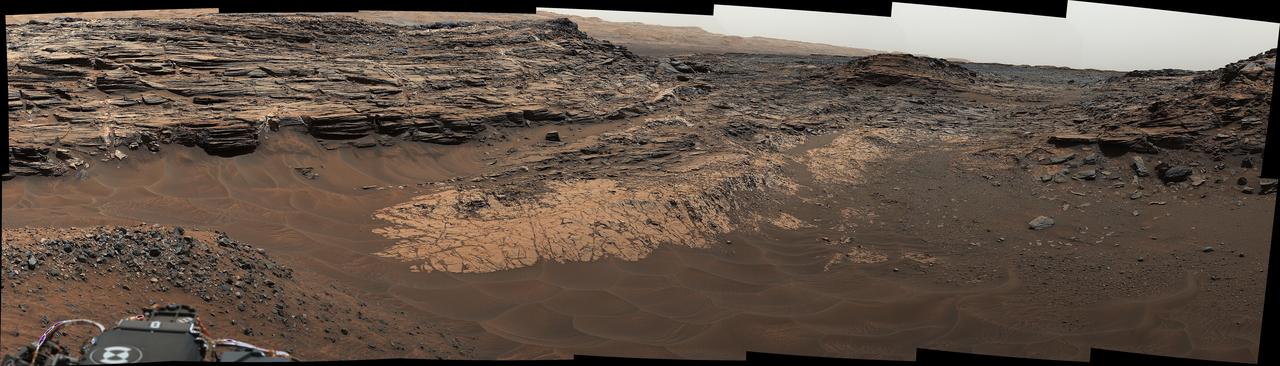
This view from the Mast Camera (Mastcam) in NASA's Curiosity Mars rover shows the "Marias Pass" area where a lower and older geological unit of mudstone -- the pale zone in the center of the image -- lies in contact with an overlying geological unit of sandstone. Just before Curiosity reached Marias Pass, the rover's laser-firing Chemistry and Camera (ChemCam) instrument examined a rock found to be rich in silica, a mineral-forming chemical. This scene combines several images taken on May 22, 2015, during the 992nd Martian day, or sol, of Curiosity's work on Mars. The scene is presented with a color adjustment that approximates white balancing, to resemble how the rocks and sand would appear under daytime lighting conditions on Earth. http://photojournal.jpl.nasa.gov/catalog/?IDNumber=pia20174
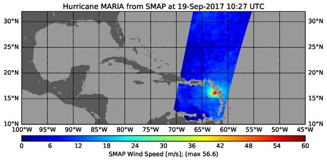
The radiometer instrument on NASA's Soil Moisture Active Passive (SMAP) spacecraft captured this image of Hurricane Maria at 6:27 a.m. EDT on Sept. 19, 2017 (10:27 UTC), showing an estimated maximum surface wind speed of 126.6 miles per hour (56.6 meters per second). While Maria was already a Category 5 hurricane at the time of this observation, it is an extremely tightly organized hurricane and SMAP cannot fully resolve its highest winds due to the 25-mile (40-kilometer) resolution of SMAP. https://photojournal.jpl.nasa.gov/catalog/PIA21960
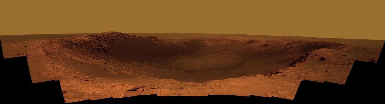
Panorama of Santa Maria Crater for Opportunity Anniversary False Color

"For me, representation is key. I want people from different backgrounds, different experiences, and different races and ethnicities to see themselves at this agency and across federal government, which is supposed to be representative of the American population. Especially for little girls like me — I grew up poor, the daughter of a former migrant worker. I grew up working in the fields, picking fruits and vegetables during weekends and school breaks. "I’m the first one in my family to get a four-year degree. I didn’t do it because it was what I was expected to do or because it was the obvious next step. I was able to go because I had teachers and advisors who saw potential even when I couldn’t. I was a first generation college student, and now I have nieces and nephews who have obtained or are in the process of obtaining their education." "It’s not only about opening doors, it’s about opening minds — giving people a vision of the possibilities that are out there. Because now you’re broadening that thinking. You’re helping them question their status quo and helping them to see a different version of themselves. When you meet someone who is doing something different but yet, you can relate to them because of what they look like or their background, it makes a huge difference." Portrait, Maria Santos, Tuesday, Oct.1, 2019 at NASA Headquarters in Washington. Photo Credit: (NASA/Aubrey Gemignani)

"For me, representation is key. I want people from different backgrounds, different experiences, and different races and ethnicities to see themselves at this agency and across federal government, which is supposed to be representative of the American population. Especially for little girls like me — I grew up poor, the daughter of a former migrant worker. I grew up working in the fields, picking fruits and vegetables during weekends and school breaks. "I’m the first one in my family to get a four-year degree. I didn’t do it because it was what I was expected to do or because it was the obvious next step. I was able to go because I had teachers and advisors who saw potential even when I couldn’t. I was a first generation college student, and now I have nieces and nephews who have obtained or are in the process of obtaining their education." "It’s not only about opening doors, it’s about opening minds — giving people a vision of the possibilities that are out there. Because now you’re broadening that thinking. You’re helping them question their status quo and helping them to see a different version of themselves. When you meet someone who is doing something different but yet, you can relate to them because of what they look like or their background, it makes a huge difference." Portrait, Maria Santos, Tuesday, Oct.1, 2019 at NASA Headquarters in Washington. Photo Credit: (NASA/Aubrey Gemignani)

"For me, representation is key. I want people from different backgrounds, different experiences, and different races and ethnicities to see themselves at this agency and across federal government, which is supposed to be representative of the American population. Especially for little girls like me — I grew up poor, the daughter of a former migrant worker. I grew up working in the fields, picking fruits and vegetables during weekends and school breaks. "I’m the first one in my family to get a four-year degree. I didn’t do it because it was what I was expected to do or because it was the obvious next step. I was able to go because I had teachers and advisors who saw potential even when I couldn’t. I was a first generation college student, and now I have nieces and nephews who have obtained or are in the process of obtaining their education." "It’s not only about opening doors, it’s about opening minds — giving people a vision of the possibilities that are out there. Because now you’re broadening that thinking. You’re helping them question their status quo and helping them to see a different version of themselves. When you meet someone who is doing something different but yet, you can relate to them because of what they look like or their background, it makes a huge difference." Portrait, Maria Santos, Tuesday, Oct.1, 2019 at NASA Headquarters in Washington. Photo Credit: (NASA/Aubrey Gemignani)

"For me, representation is key. I want people from different backgrounds, different experiences, and different races and ethnicities to see themselves at this agency and across federal government, which is supposed to be representative of the American population. Especially for little girls like me — I grew up poor, the daughter of a former migrant worker. I grew up working in the fields, picking fruits and vegetables during weekends and school breaks. "I’m the first one in my family to get a four-year degree. I didn’t do it because it was what I was expected to do or because it was the obvious next step. I was able to go because I had teachers and advisors who saw potential even when I couldn’t. I was a first generation college student, and now I have nieces and nephews who have obtained or are in the process of obtaining their education." "It’s not only about opening doors, it’s about opening minds — giving people a vision of the possibilities that are out there. Because now you’re broadening that thinking. You’re helping them question their status quo and helping them to see a different version of themselves. When you meet someone who is doing something different but yet, you can relate to them because of what they look like or their background, it makes a huge difference." Portrait, Maria Santos, Tuesday, Oct.1, 2019 at NASA Headquarters in Washington. Photo Credit: (NASA/Aubrey Gemignani)
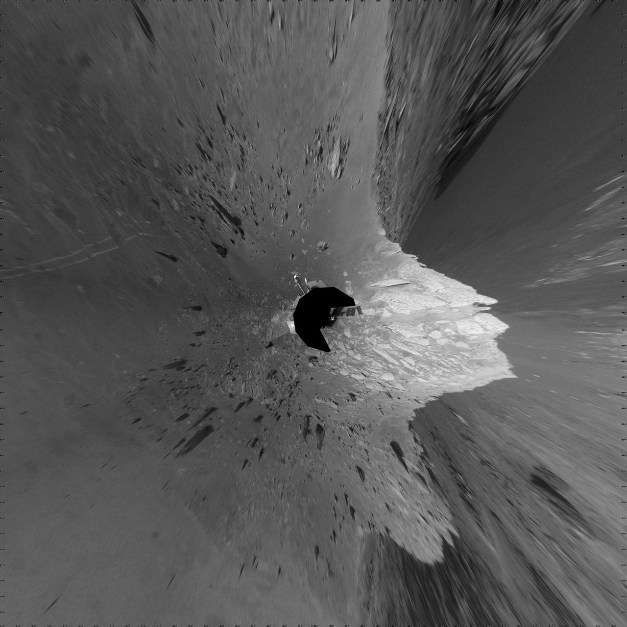
NASA Mars Exploration Rover Opportunity used its navigation camera to record this view of Santa Maria crater at the end of a drive, bringing it to the western edge of this crater.
This image from NASA Mars Exploration Rover at the edge of Santa Maria crater shows diverse textures of the crater. Contrast has been enhanced to emphasize the textures.
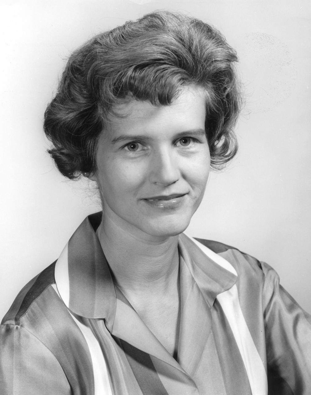
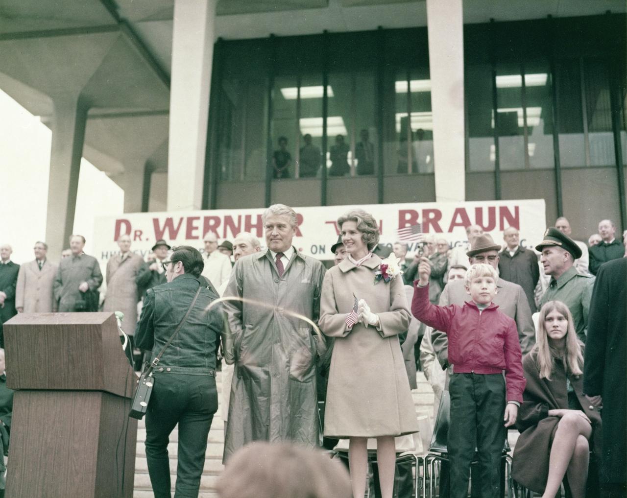
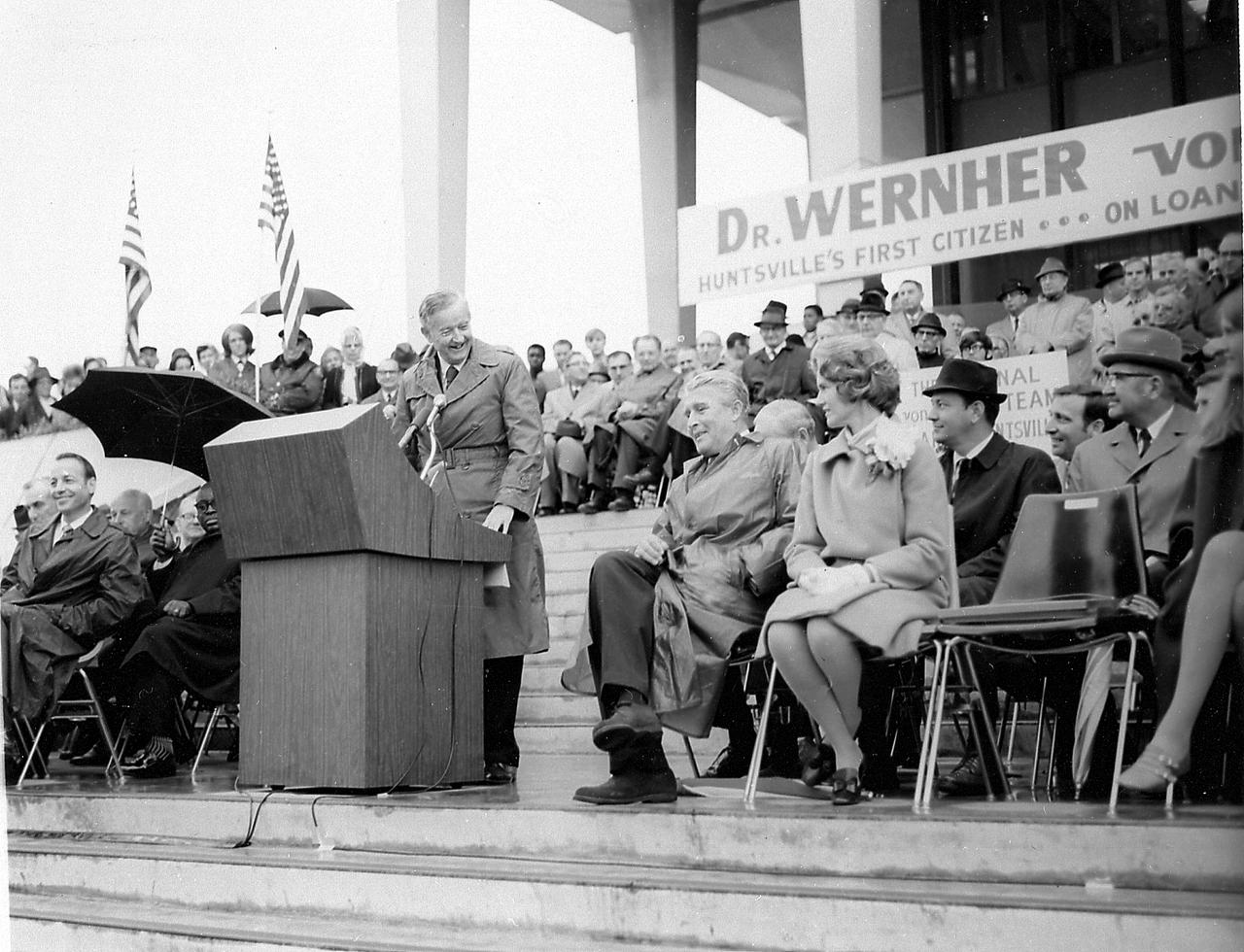
This is a portrait of Maria von Braun, wife of the famous Marshall Space Flight Center (MSFC) director Wernher von Braun. Her husband, Wernher, who led America to the Moon, served as MSFC’s first director from July 1, 1960 until January 27, 1970.

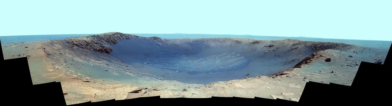
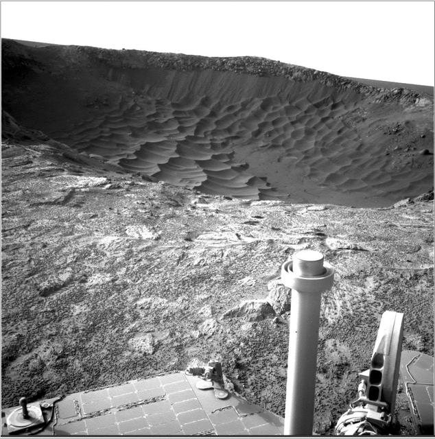
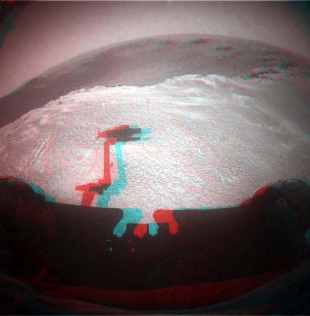
NASA Mars Exploration Rover Opportunity spent the seventh anniversary of its landing on Mars investigating a crater called Santa Maria, which has a diameter about the length of a football field. 3D glasses are necessary to view this image.
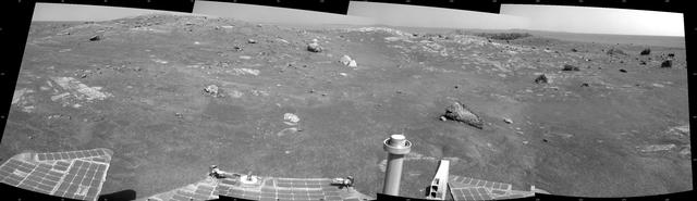
NASA Mars Exploration Rover Opportunity is spending the seventh anniversary of its landing on Mars investigating a crater called Santa Maria, which has a diameter about the length of a football field. This scene looks eastward across the crater.

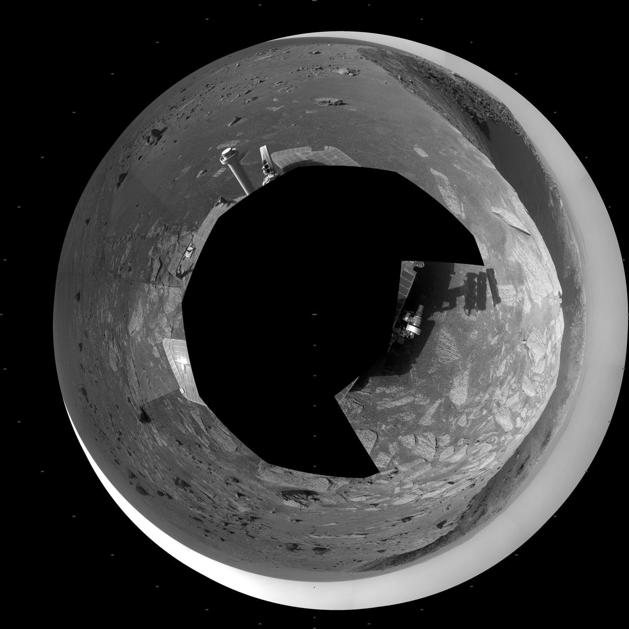
A football-field-size crater, informally named Santa Maria, dominates the scene in this 360-degree view from NASA Mars Exploration Rover Opportunity.
A football-field-size crater, informally named Santa Maria, dominates the scene in this 360-degree stereo view from NASA Mars Exploration Rover Opportunity.
This vertical projection view is of a football-field-size crater, informally named Santa Maria, as seen by NASA Mars Exploration Rover Opportunity.
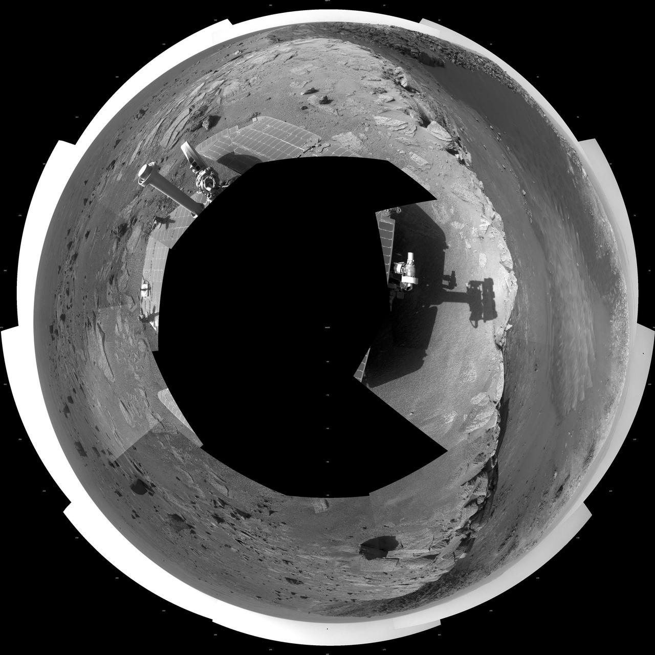
A football-field-size crater, informally named Santa Maria, dominates the scene in this polar projection from NASA Mars Exploration Rover Opportunity.
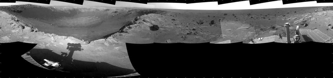
This 360-degree mosaic of images from the navigation camera on NASA Mars Exploration Rover Opportunity shows the view from the western rim of Santa Maria crater. South is at the center, north at both ends.
This 360-degree mosaic of images from the navigation camera on NASA Mars Exploration Rover Opportunity shows the view from the western rim of Santa Maria crater is presented as a polar projection, with north at the top.

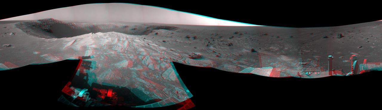
This 360-degree, stereo mosaic of images from NASA Mars Exploration Rover Opportunity shows the view from the western rim of Santa Maria crater on Dec. 19, 2010. 3D glasses are necessary to view this image.
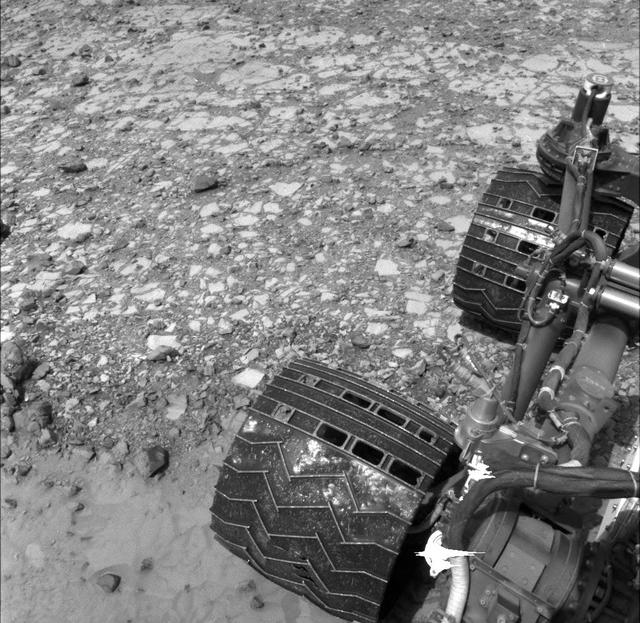
NASA Curiosity Mars rover used its Navigation Camera Navcam to capture this view partway back down a slope it climbed toward Marias Pass on lower Mount Sharp. The image was taken May 22, 2015.
This 360-degree mosaic of images from the navigation camera on NASA Mars Exploration Rover Opportunity shows the view from the western rim of Santa Maria crater is presented as a vertical projection, with north at the top.
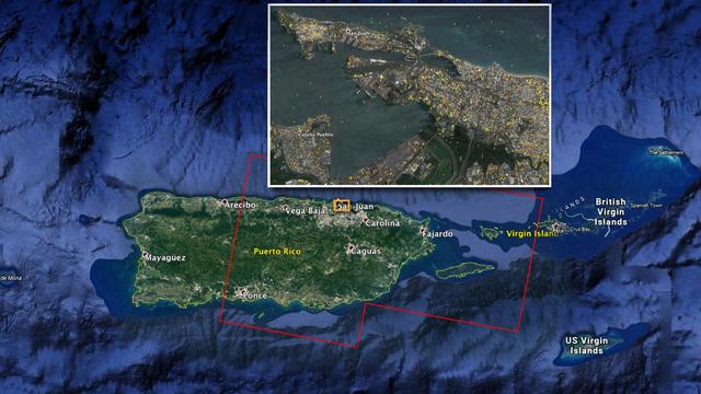
The Advanced Rapid Imaging and Analysis (ARIA) team at NASA's Jet Propulsion Laboratory in Pasadena, California, and Caltech, also in Pasadena, created this Damage Proxy Map (DPM) depicting areas of Eastern Puerto Rico that are likely damaged (shown by red and yellow pixels) as a result of Hurricane Maria (a Category 4 hurricane at landfall in Puerto Rico on Sept. 20, 2017). The map is derived from synthetic aperture radar (SAR) images from the Copernicus Sentinel-1A and Sentinel-1B satellites, operated by the European Space Agency (ESA). The images were taken before (March 25, 2017) and after (Sept. 21, 2017) the storm's landfall. The map was delivered to responding agencies, including the Federal Emergency Management Agency (FEMA), on Sept. 22, 2017. FEMA combined the map with building infrastructure data to estimate a damage density map, which was sent to its Urban Search and Rescue teams in the field in Puerto Rico. The map covers an area of 105 by 60 miles (169 by 96 kilometers), shown by the large red polygon in the figure. The inset, denoted by the orange rectangle, shows the extent of damage in and around the capital city of San Juan. Each pixel measures about 98 feet (30 meters) across. The color variation from yellow to red indicates increasingly more significant ground surface change. Preliminary validation was done by comparing the map with anecdotal reports of damage. This damage proxy map should be used as guidance to identify damaged areas, and may be less reliable over vegetated and flooded areas. Sentinel-1 data were accessed through the Copernicus Open Access Hub. The image contains modified Copernicus Sentinel data (2017), processed by ESA and analyzed by the NASA-JPL/Caltech ARIA team. This research was carried out at JPL under a contract with NASA. https://photojournal.jpl.nasa.gov/catalog/PIA21964
This 360-degree panorama shows the "Marias Pass" area, at center, and part of the slope that NASA's Curiosity Mars rover climbed to get there, at right. The scene combines multiple images taken by Curiosity's Navigation Camera (Navcam) on May 22, 2105, during the 992nd Martian day, or sol, of the rover's work on Mars. North is at both ends; south is in the middle. On the previous sol, Curiosity reached this location by climbing a slope with steepness of up to 20 degrees. From this location, the rover's Chemistry and Camera (ChemCam) instrument examined a rock target called "Elk" and found its composition to be about 80 percent silica. http://photojournal.jpl.nasa.gov/catalog/PIA20266
This image from NASA Mars Rover Opportunity is from the edge of a football-field-size crater informally named Santa Maria. The rover upraised robotic arm, itself out of view, casts a dragon-shaped shadow in the foreground. 3D glasses are necessary.
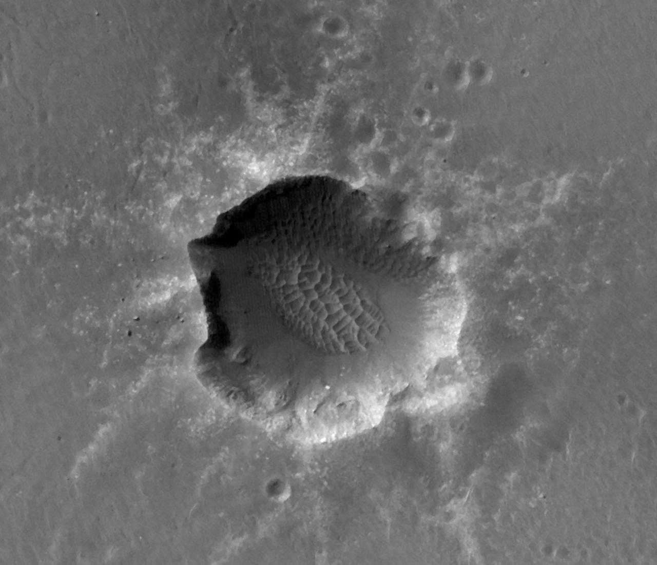
This image of Santa Maria Crater was taken by HiRISE camera on NASA Mars Reconnaissance Orbiter where NASA rover Opportunity approached Santa Maria Crater in December 2010.

Sen. Maria Cantwell, D-WA, Ranking Member of the Senate Committee on Commerce, Science, and Transportation Maria Cantwell, questions Matthew Anderson, President Trumps' nominee to be Deputy Administrator of the National Aeronautics and Space Administration, during a confirmation hearing, Thursday, March 5, 2026, at the Russell Senate Office Building in Washington. Photo Credit: (NASA/Bill Ingalls)

Journalist and former First Lady of California Maria Shriver talks prior to reading the poem "The Summer Day" by Mary Oliver during the National Tribute to Sally Ride at the John F. Kennedy Center for the Performing Arts, Monday, May 20, 2013 in Washington. Photo Credit: (NASA/Bill Ingalls)
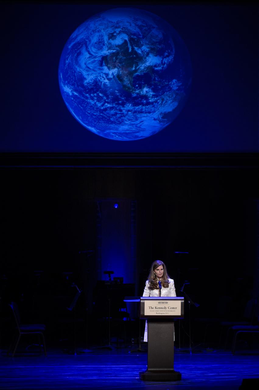
Journalist and former First Lady of California Maria Shriver reads the poem "The Summer Day" by Mary Oliver during the National Tribute to Sally Ride at the John F. Kennedy Center for the Performing Arts, Monday, May 20, 2013 in Washington. Photo Credit: (NASA/Bill Ingalls)

Sen. Maria Cantwell, D-WA, Ranking Member of the Senate Committee on Commerce, Science, and Transportation, questions Jared Isaacman, President Donald Trump’s nominee to be the next administrator of NASA, during a hearing, Wednesday, April 9, 2025, at the Russell Senate Office Building in Washington. Photo Credit: (NASA/Bill Ingalls)
NASA Spanish Communications Lead María-José Viñas Garcia delivers opening remarks prior to an event with NASA astronauts Jessica Watkins, Kjell Lindgren, and Robert Hines at the Martin Luther King Jr Memorial Library, Thursday, March 30, 2023, in Washington. Lindgren, Hines, and Watkins spent 170 days in space as part of Expeditions 67 and 68 aboard the International Space Station. Photo Credit: (NASA/Keegan Barber)
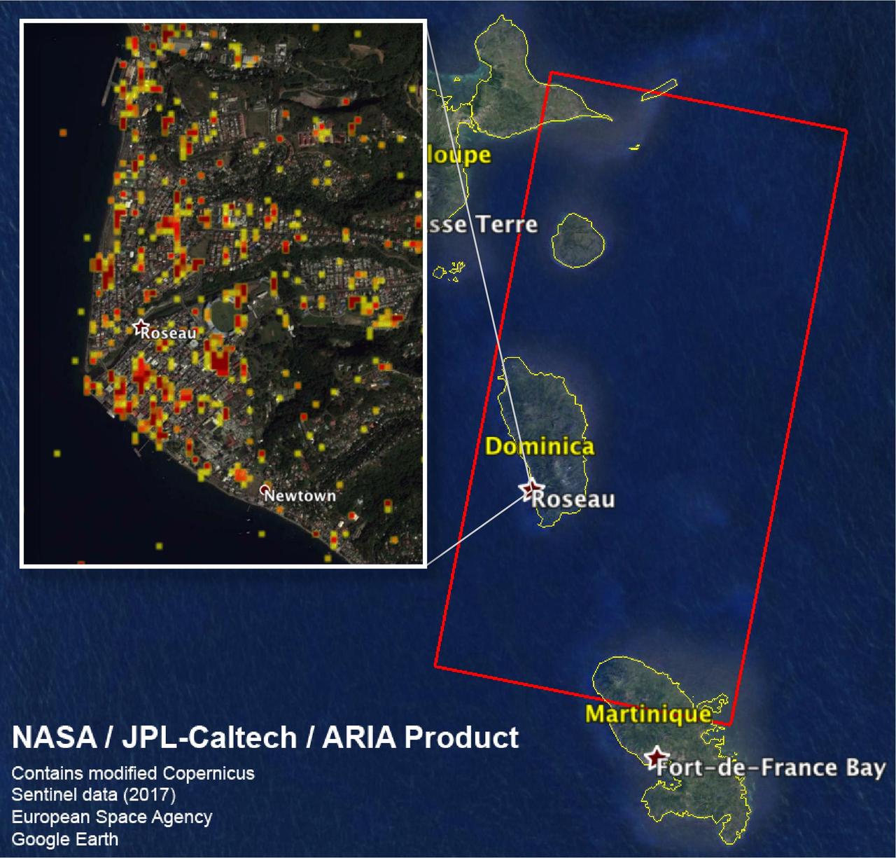
The Advanced Rapid Imaging and Analysis (ARIA) team at NASA's Jet Propulsion Laboratory in Pasadena, California, and Caltech, also in Pasadena, created this Damage Proxy Map (DPM) depicting areas including the Commonwealth of Dominica, that are likely damaged (shown by red and yellow pixels) as a result of Hurricane Maria (a Category 5 storm at landfall in Dominica on Sept. 18, 2017). The map is derived from synthetic aperture radar (SAR) images from the Copernicus Sentinel-1 satellites, operated by the European Space Agency (ESA). The images were taken before (March 27, 2017) and after (Sept. 23, 2017) the landfall of the storm. The map covers the area within the large red polygon, which measures 53 by 106 miles (85 by 170 kilometers). Each pixel measures about 98 feet (30 meters) across. The color variation from yellow to red indicates increasingly more significant ground surface change. Preliminary validation was done by comparing the data to a crowdsourced map by Clemson Center for Geospatial Technologies and optical satellite imagery feom DigitalGlobe. This damage proxy map should be used as guidance to identify damaged areas, and may be less reliable over vegetated areas. Sentinel-1 data were accessed through the Copernicus Open Access Hub. The image contains modified Copernicus Sentinel data (2017), processed by ESA and analyzed by the NASA/JPL-Caltech ARIA team. This research was carried out at JPL under a contract with NASA. https://photojournal.jpl.nasa.gov/catalog/PIA22037

Senate Commerce, Science, and Transportation Committee Chair Maria Cantwell, D-Wash., left, talks with NASA Administrator Bill Nelson prior to Nelson testifying before the Senate Committee on Commerce, Science, and Transportation during a hearing titled “Examining NASA’s Budget and Priorities,” Tuesday, May 16, 2023, at the Russell Senate Office Building in Washington. Photo Credit: (NASA/Bill Ingalls)

Sen. Maria Cantwell, D-Wash., the Chair of the Senate Committee on Commerce, Science, and Transportation, listens as Pam Melroy, President Biden’s nominee to be the next deputy administrator of NASA, testifies before the Senate Committee on Commerce, Science, and Transportation, Thursday, May 20, 2021, at the Hart Senate Office Building in Washington. Melroy is a former NASA astronaut. Photo Credit: (NASA/Bill Ingalls)

NASA Spanish Communications Lead María-José Viñas Garcia gives remarks during an event where NASA and the Hispanic Heritage Foundation signed a Space Act Agreement to collaborate and expand STEM opportunities for Latino K-12 and university students and reduce barriers to agency activities and opportunities, Monday, Sept. 30, 2024, at the NASA Headquarters Mary W. Jackson Building in Washington. Photo Credit: (NASA/Bill Ingalls)

NASA Spanish Communications Lead María-José Viñas Garcia gives remarks during an event where NASA and the Hispanic Heritage Foundation signed a Space Act Agreement to collaborate and expand STEM opportunities for Latino K-12 and university students and reduce barriers to agency activities and opportunities, Monday, Sept. 30, 2024, at the NASA Headquarters Mary W. Jackson Building in Washington. Photo Credit: (NASA/Bill Ingalls)

NASA Administrator Jim Bridenstine, right, is seen with Senator Roger Wicker, R-Miss., Chairman of the Senate Committee on Commerce, Science, and Transportation and Senator Maria Cantwell, D-Wash., Ranking Member of the committee prior to a committee hearing titled "The New Space Race: Ensuring U.S. Global Leadership on the Final Frontier," Wednesday, March 13, 2019 at the Dirksen Senate Office Building in Washington. Photo Credit: (NASA/Joel Kowsky)
Committee Chair Sen. Maria Cantwell, D-Wash., listens to former U.S. Senator Bill Nelson, President Biden’s nominee to be the next administrator of NASA, as he appears before the Senate Committee on Commerce, Science, and Transportation, Wednesday, April 21, 2021, Russell Senate Office Building in Washington. Photo Credit: (NASA/Bill Ingalls)
NASA Spanish Communications Lead María-José Viñas Garcia gives remarks during an event where NASA and the Hispanic Heritage Foundation signed a Space Act Agreement to collaborate and expand STEM opportunities for Latino K-12 and university students and reduce barriers to agency activities and opportunities, Monday, Sept. 30, 2024, at the NASA Headquarters Mary W. Jackson Building in Washington. Photo Credit: (NASA/Bill Ingalls)
This view from the Mast Camera (Mastcam) on NASA's Curiosity Mars rover shows a site where two different types of bedrock meet on lower Mount Sharp. The scene combines multiple images taken by the left-eye camera of Mastcam on May 25, 2015, during the 995th Martian day, or sol, of Curiosity's work on Mars, in a valley just below "Marias Pass." The color has been approximately white-balanced to resemble how the scene would appear under daytime lighting conditions on Earth. The paler part of the outcrop, in the foreground, is mudstone similar to what Curiosity examined in 2014, and in early 2015, at "Pahrump Hills." The darker, finely bedded bedrock higher in the image and overlying the mudstone stratigraphically is sandstone that the rover team calls the "Stimson" unit. The scene covers an area about 10 feet (3 meters) wide in the foreground. Malin Space Science Systems, San Diego, built and operates the rover's Mastcam. NASA's Jet Propulsion Laboratory, a division of the California Institute of Technology, Pasadena, manages the Mars Science Laboratory Project for NASA's Science Mission Directorate, Washington. http://photojournal.jpl.nasa.gov/catalog/PIA19676

Maria Zuber, GRAIL principal investigator, Massachusetts Institute of Technology, Cambridge, answers a reporter's question at a press briefing about the upcoming launch to the moon of the Gravity Recovery and Interior Laboratory (GRAIL) mission, Thursday, Aug. 25, 2011 in Washington. GRAIL's primary science objectives are to determine the structure of the lunar interior, from crust to core, and to advance understanding of the thermal evolution of the moon. The mission will place two spacecraft into the same orbit around the moon which will gather information about the its gravitational field enabling scientists to create a high-resolution map. Photo Credit: (NASA/Carla Cioffi)
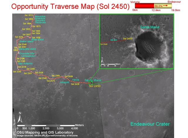
This map shows the path that NASA Mars Exploration Rover Opportunity followed from the 1,813th Martian day, or sol, to Sol 2450 Dec. 15, 2010 when Opportunity approached a crater informally named Santa Maria.

NASA Mars Reconnaissance Orbiter acquired this color image on March 9, 2011, of Santa Maria crater, showing NASA Mars Exploration Rover Opportunity perched on the southeast rim. The rover is the bluish speck on the crater rim arrow.
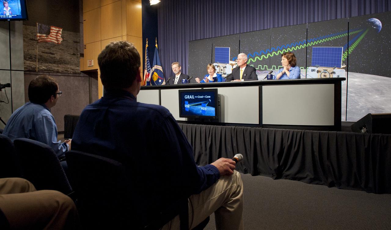
On the panel from right: Leesa Hubbard, teacher in residence, Sally Ride Science, San Diego; David Lehman, GRAIL project manager, NASA's Jet Propulsion Laboratory, Pasadena, Calif.; Maria Zuber, GRAIL principal investigator, Massachusetts Institute of Technology, Cambridge and Jim Green, director, Planetary Science Division, NASA Headquarters, Washington are seen at a press briefing to discuss the upcoming launch to the moon of the Gravity Recovery and Interior Laboratory (GRAIL) mission, Thursday, Aug. 25, 2011 in Washington. Photo Credit: (NASA/Carla Cioffi)
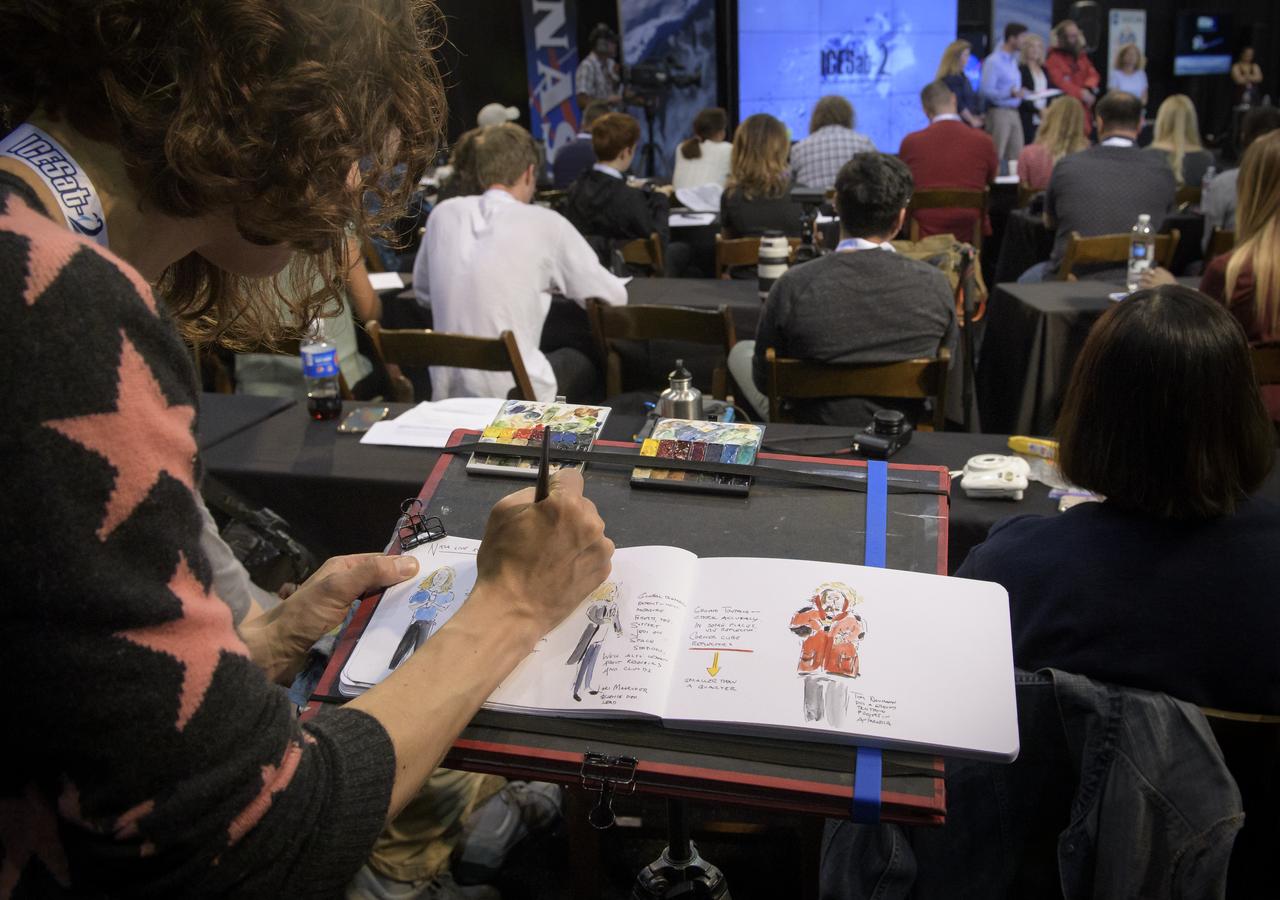
Artist and NASA social media attendee Maria Coryell-Martin captures a prelaunch briefing for the NASA Ice, Cloud and land Elevation Satellite-2 (ICESat-2), Thursday, Sept. 13, 2018, at Vandenberg Air Force Base in California. The ICESat-2 mission will measure the changing height of Earth's ice. Photo Credit: (NASA/Bill Ingalls)

Chairman Roger Wicker, R-Miss., left, and Ranking member Sen. Maria Cantwell, D-Wash., right listen as NASA Administrator Jim Bridenstine testifies before the Senate Committee on Commerce, Science, and Transportation during a hearing titled, “Moon to Mars: NASA’s Plans for Deep Space Exploration,” Wednesday, July 17, 2019, at the Hart Senate Office Building in Washington. Photo Credit: (NASA/Bill Ingalls)
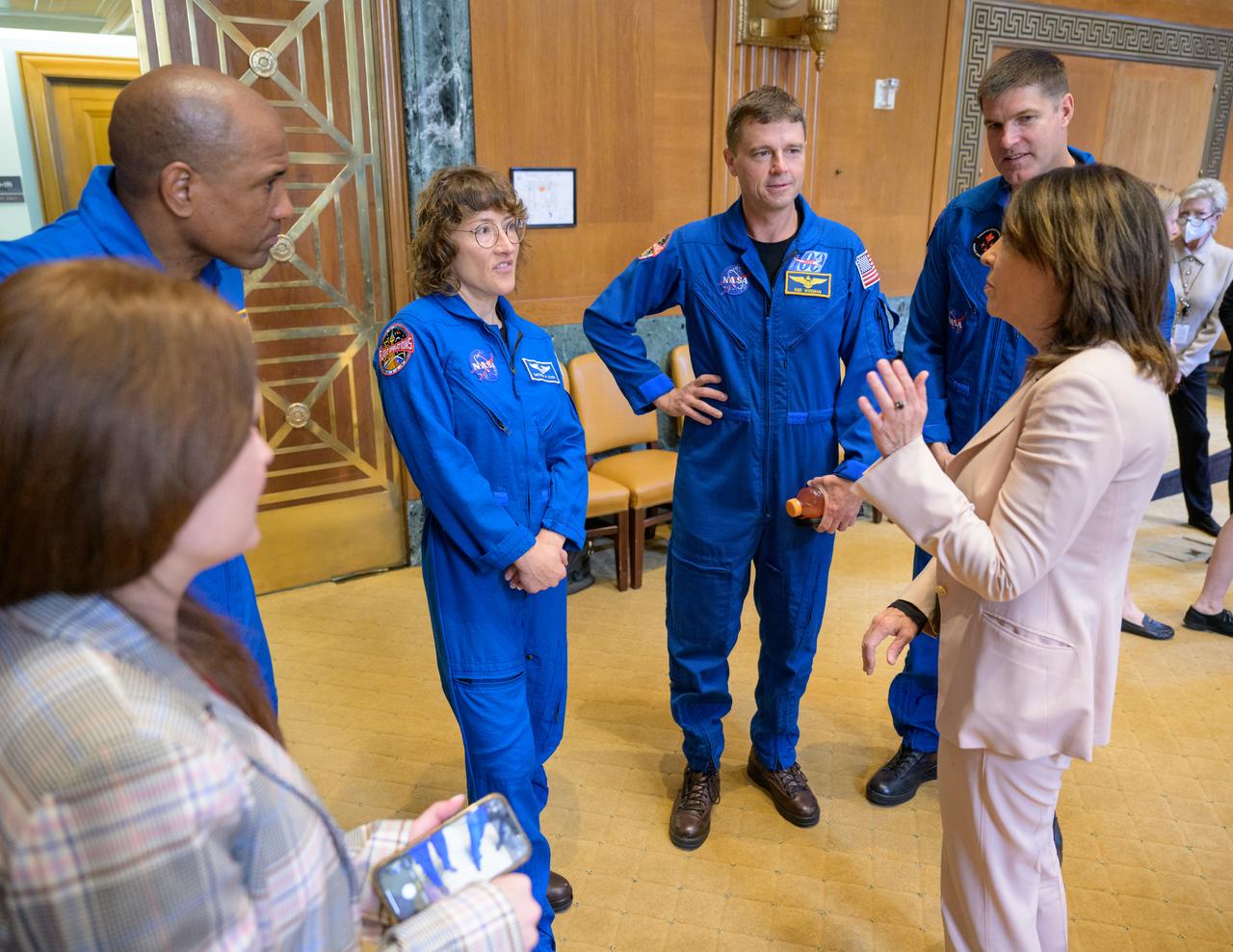
Senator Maria Cantwell, D-WA., meets with NASA astronauts Victor Glover, left, Christina Hammock Koch, Reid Wiseman, and CSA (Canadian Space Agency) astronaut Jeremy Hansen, right, during a meet and greet, Wednesday, May 17, 2023, at the Dirksen Senate Office Building in Washington. Wiseman, Glover, Hammock Koch, and Hansen, who will fly around the Moon on NASA’s Artemis II flight test, visited Washington to discuss their upcoming mission with members of Congress and others. Photo Credit: (NASA/Bill Ingalls)

U.S. Sen. Maria Cantwell, D-Wash., left, talks about Dr. Elizabeth M. Robinson, nominee for Chief Financial Officer for NASA, right, prior to her confirmation hearing in front of the Senate Committee on Commerce, Science and Transportation, Thursday, Oct. 15, 2009, on Capitol Hill in Washington. Photo Credit: (NASA/Paul E. Alers)
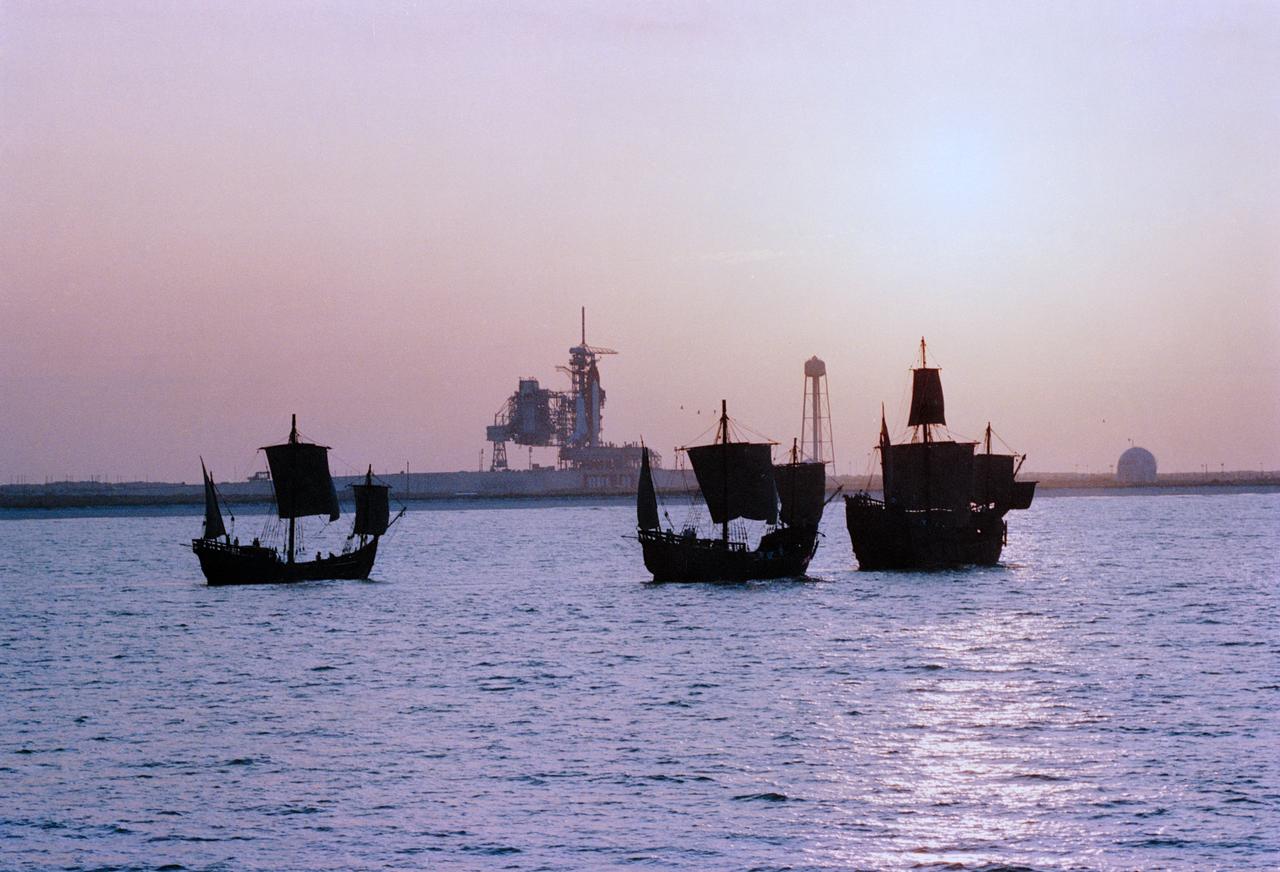
Replicas of Christopher Columbus' sailing ships Santa Maria, Nina, and Pinta sail by Endeavour, Orbiter Vehicle (OV) 105, on Kennedy Space Center (KSC) Launch Complex (LC) Pad 39B awaiting liftoff on its maiden voyage, STS-49. This view was taken from the water showing the three ships silhouetted in the foreground with OV-105 on mobile launcher platform profiled against fixed service structure (FSS) tower and rectracted rotating service structure (RSS) in the background. Next to the launch pad (at right) are the sound suppression water system tower and the liquid hydrogen (LH2) storage tank. View provided by KSC with alternate number KSC-92PC-970.
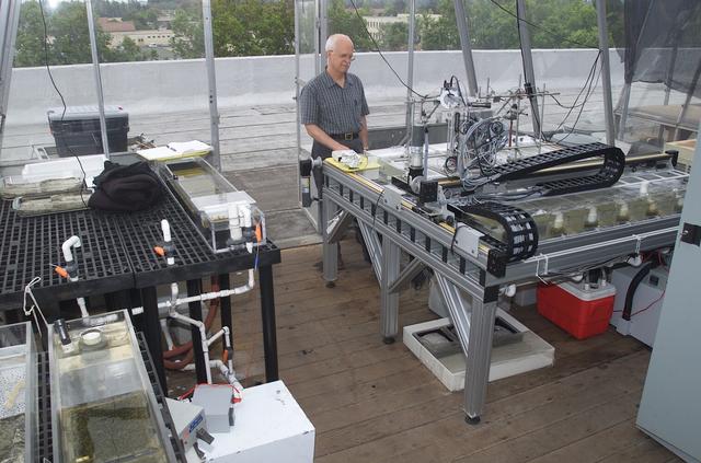
Microbial Mats; n-239 roof, Greenhouse one: Overivew of Greenhouse with Dave Des Marias
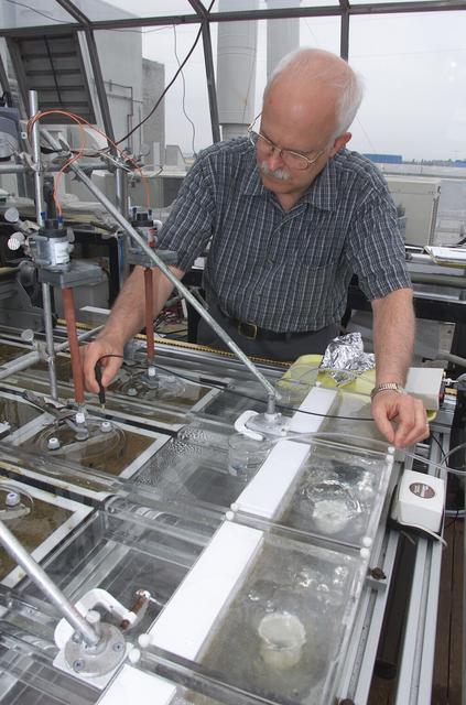
Microbial Mats; n-239 roof, Greenhouse one: overview of flux measurement test with Dave Des Marias
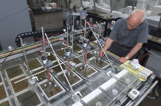
Microbial Mats; n-239 roof, Greenhouse one: overview of flux measurement test with Dave Des Marias
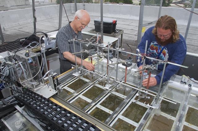
Microbial Mats; n-239 roof, Greenhouse one: overview of flux measurement test with Dave Des Marias and Stephen Carpenter

This composite view from NASA Voyager 2 shows Neptune on Triton horizon. The foreground in this computer generated view of Triton maria as they would appear from a point approximately 45 km above the surface. http://photojournal.jpl.nasa.gov/catalog/PIA00344
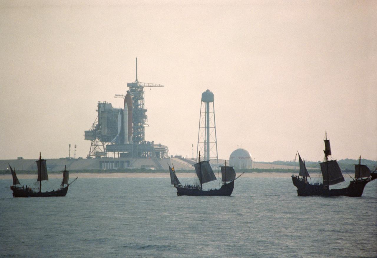
S92-39074 (6 May 1992) --- The centuries-old technology that built Christopher Columbus' three sailing ships passes within a half mile of the 20th-Century Space Shuttle Endeavour, in background, awaiting liftoff on Launch Pad 39B. The replicas of the Santa Maria, Nina, and Pinta wind-powered ships, managed by the Spain '92 Foundation, are on a tour to ports around the Gulf of Mexico and up the Atlantic Coast of the United States. Endeavour is set to lift off on its maiden voyage, STS-49, on May 7, 1992. Video footage of the two types of exploration vessels will be used by NASA for a variety of productions, including the annual Von Braun Exploration forum sponsored by NASA's Marshall Space Flight Center (MSFC), Huntsville, Alabama, in October, 1992. This year's theme is Exploration and the Evolution of Nations. 1992 is the 500th anniversary of Columbus' voyage to the New World.
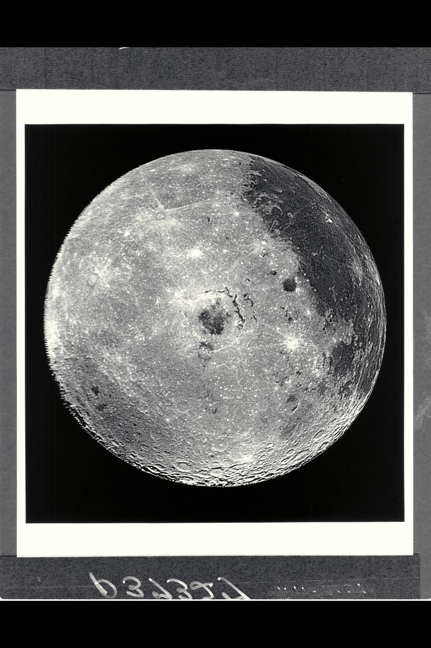
Range : 350,000 miles This image of the western hemisphere of the Moon was taken through a green filter by Galileo at 9:35 am PST. In the center is the Orientale Basin, 600 miles in diameter, formed about 3.8 billion years ago by the impact of an streroid-size body. Orientale's dark center is a small mare. To the right is the lunar near side with the great, dark Oceanus Procellarum above and the small, circular, dark Mare Humorum Below. Maria are broad plains formed mostly over 3 billion years ago as vast bassaltic lava flows. To the left is the lunar far side with fewer maria, but, at lower left, the South-Pole-Aitken basin, about 1200 miles in diameter, which resemble Orientale but is much older and more weathered and battered by cratering. The intervening cratered highlands of both sides, as well as the maria, are dotted with bright, young craters. This image was 'reprojected' so as to center visibility of small features.
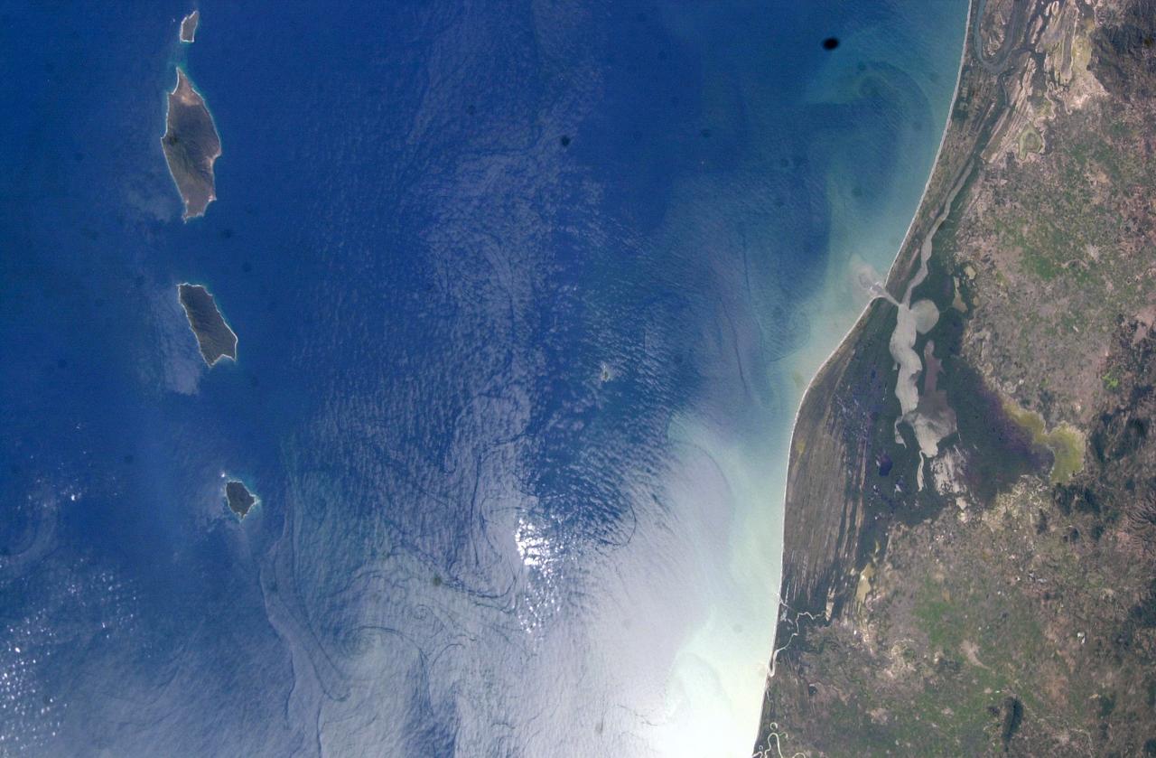
ISS006-E-51456 (2003) --- Marias Islands, Mexico is featured in this image photographed by an Expedition Six crewmember on the International Space Station. The view shows the land-sea interactions along a section of Mexico's west coast just south of Mazatlan and the Isla Marias archipelago. The islands are a manifestation of intersecting plate boundaries -- the East Pacific Rise spreading center that traces south from the Gulf of California, and the subduction zone that consumes the Cocos plate beneath southern Mexico. These islands are biologically important: they comprise the Islas Marias Biosphere Reserve and contain endemic species of raccoons and rabbits, and important habitat for birds and marine life. Between the islands and the mainland, swirling surface currents are highlighted by the sun glint reflecting off the ocean surface. Along the Mexican coast, water flows out from a coastal lagoon, and near shore currents carry sediment (light colored water) along the beach front.
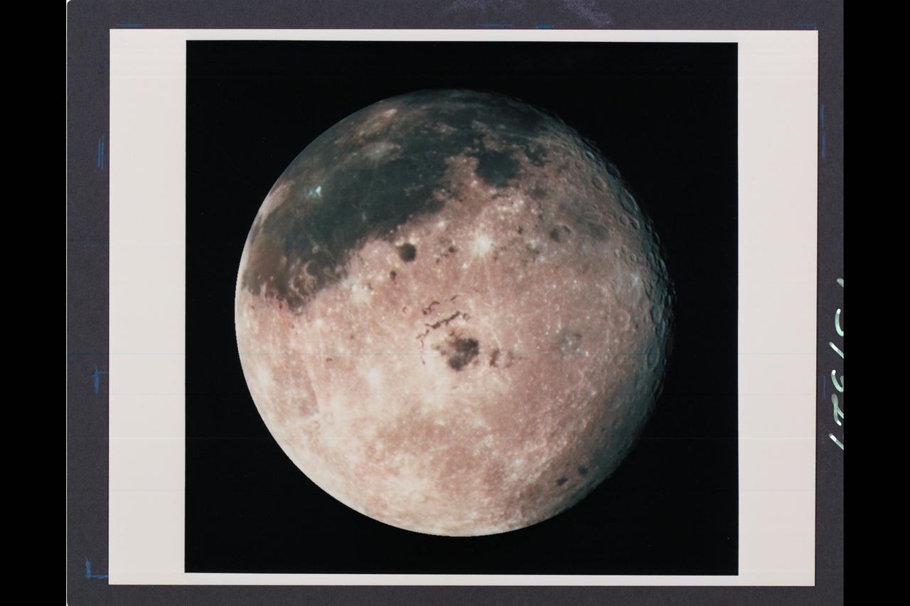
Range : 350,000 miles (JPL Ref: P-37329) This image of the western hemisphere of the Moon was taken through a green filter by Galileo at 9:35 am PST. In the center is the Orientale Basin, 600 miles in diameter, formed about 3.8 billion years ago by the impact of an streroid-size body. Orientale's dark center is a small mare. To the right is the lunar near side with the great, dark Oceanus Procellarum above and the small, circular, dark Mare Humorum Below. Maria are broad plains formed mostly over 3 billion years ago as vast bassaltic lava flows. To the left is the lunar far side with fewer maria, but, at lower left, the South-Pole-Aitken basin, about 1200 miles in diameter, which resemble Orientale but is much older and more weathered and battered by cratering. The intervening cratered highlands of both sides, as well as the maria, are dotted with bright, young craters. This image was 'reprojected' so as to center visibility of small features.
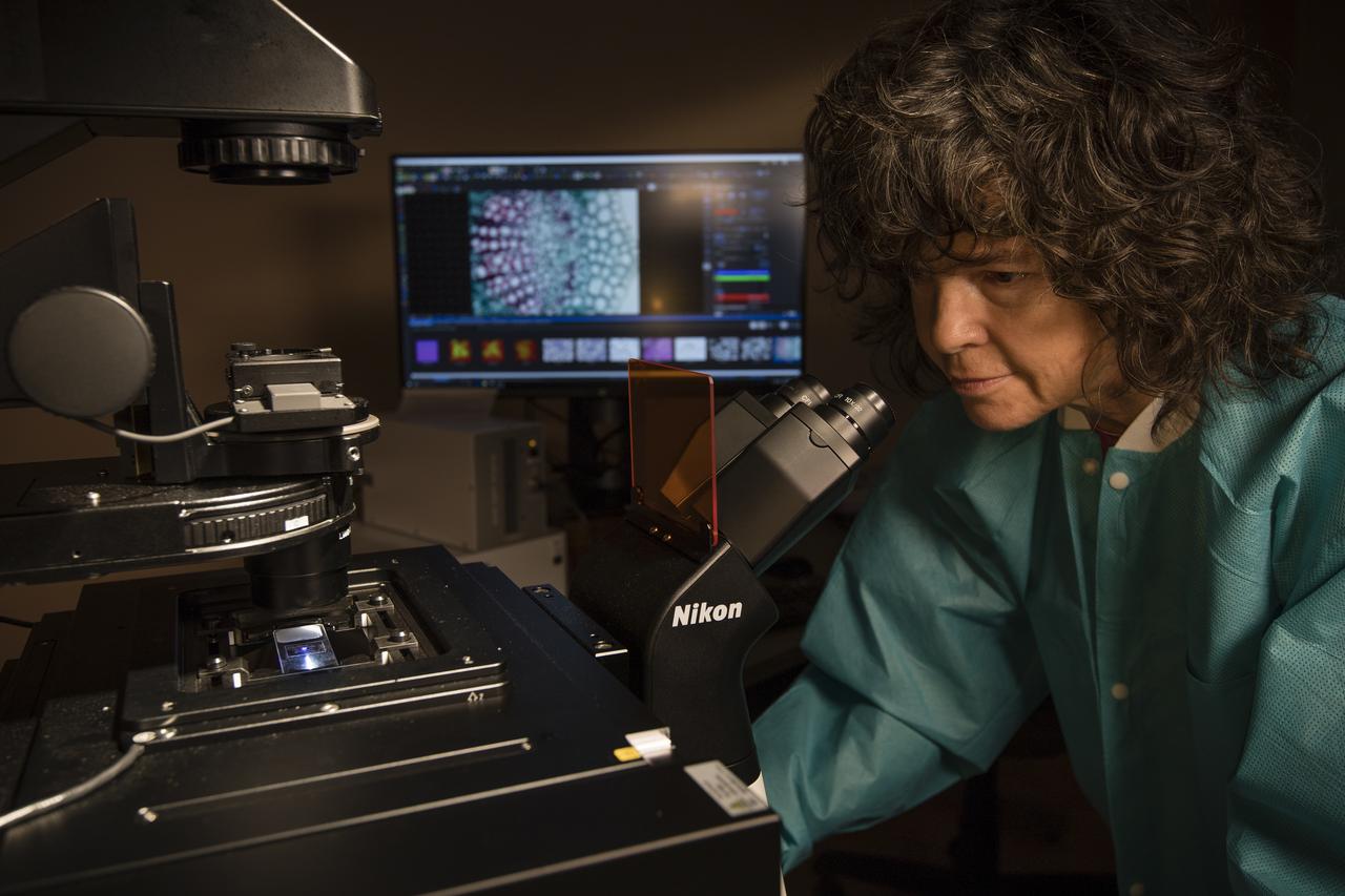
Anna Maria Ruby, project scientist for the ISS Research Office at NASA’s Kennedy Space Center in Florida, views samples on a microscope in the Microgravity Simulation Support Facility on Dec. 20, 2018.
This image from NASA's Curiosity Mars rover reveals details of a bedrock discoloration pattern at a site between "Marias Pass" and "Bridger Basin." The discoloration is not associated with individual layers. It crosses layers and shows clear horizontal boundaries to the darker toned bedrock. This suggests it is related to alteration by fluids that flowed through fractures and permeated into the bedrock. The image was taken by the right-eye (telephoto) camera of the rover's Mast Camera instrument on Sept. 2, 2015, during the mission's 1,092nd Martian day, or sol. http://photojournal.jpl.nasa.gov/catalog/PIA20269

Galileo spacecraft image of the Moon recorded at 9:35 am Pacific Standard Time (PST), 12-09-90, after completing its first Earth Gravity Assist. Western hemisphere of the Moon was taken through a green filter at a range of about 350,000 miles. In the center is Orientale Basin, 600 miles in diameter, formed about 3.8 billion years ago by the impact of an asteroid-size body. Orientale's dark center is a small mare. To the right is the lunar near side with the great, dark Oceanus Procellarum above the small, circular, dark Mare Humorum below. Maria are broad plains formed mostly over 3 billion years ago as vast basaltic lava flows. To the left is the lunar far side with fewer maria, but, at lower left South-Pole-Aitken basin, about 1200 miles in diameter, which resembles Orientale but is much older and more weathered and battered by cratering. The intervening cratered highlands of both sides, as well as the maria, are dotted with bright young craters. This image was "reprojected" so as to center the Orientale Basin, and was filtered to enhance the visibility of small features. The digital image processing was done by DLR, the German Aerospace Research Establishment near Munich, an international collaborator in the Galileo mission. Photo was provided by Jet Propulsion Laboratory (JPL) with alternate number P-37327, 12-19-90.
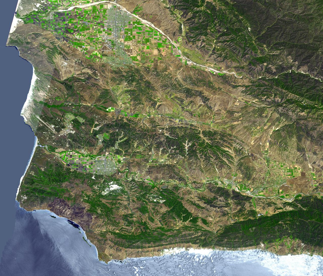
The area around Vandenberg Air Force Base, California is shown in this simulated natural color ASTER image. The city of Santa Maria is at the top left, and Lompoc is at the bottom left. Vandenberg includes the area along the coast and the prominent airport. This image was acquired on August 31, 2001 by the Advanced Spaceborne Thermal Emission and Reflection Radiometer (ASTER) on NASA's Terra satellite. With its 14 spectral bands from the visible to the thermal infrared wavelength region, and its high spatial resolution of 15 to 90 meters (about 50 to 300 feet), ASTER images Earth to map and monitor the changing surface of our planet. http://photojournal.jpl.nasa.gov/catalog/PIA03882
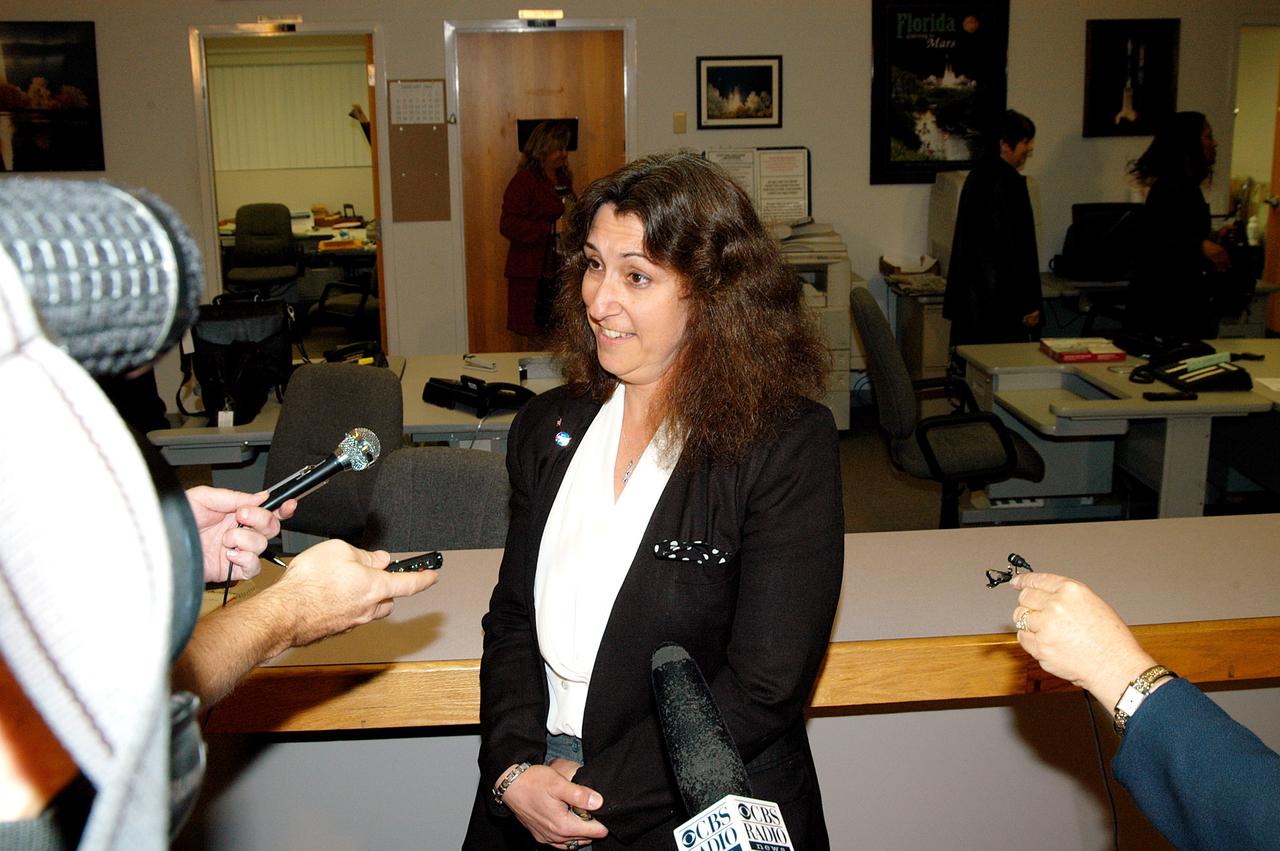
KENNEDY SPACE CENTER, FLA. -- Maria Littlefield, chief technologist with the Launch Services Program Office, talks to the media at the NASA-KSC News Center after viewing President George W. Bush’s message on the future of NASA. The President stated his goals for NASA’s new mission: Completing the International Space Station, retiring the Space Shuttle orbiters, developing a new crew exploration vehicle, and returning to the moon and beyond within the next two decades. Pres. Bush was welcomed by NASA Administrator Sean O’Keefe and Expedition 8 Commander Michael Foale, who greeted him from the International Space Station.

About 50,000 Clementine images were processed to produce the four orthographic views of the Moon. The images show albedo variations (normalized brightness or reflectivity) of the surface at a wavelength of 750 nm (just longward of visible red). The image projection is centered at 0 degree latitude and 180 degrees longitude. Mare Moscoviense (dark albedo feature upper left of image center) and South Pole-Aitken Basin (dark feature at bottom) represent maria regions largely absent on the lunar farside. The Clementine altimeter showed Aitken Basin to consist of a topographic rim about 2500 km in diameter, an inner shelf ranging from 400 to 600 km in width, and an irregular depressed floor about 12 km in depth. http://photojournal.jpl.nasa.gov/catalog/PIA00302
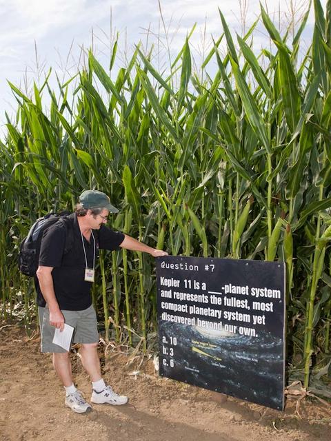
Space Farm 7 Program; NASA Day at the Dell'osso Family Farm, Lathrop,CA for the opening of the Kepler Corn Maze. Lots of fun activities were available and Kepler scientists gave talks and hands on demos to the audience of kids and adults alike to better understand Kepler and it's mission. Eric James, Ames photographer stops to read the Kepler maze know you mission sign. Photo take by Maria James.

President George Bush receives a placque commemorating the quincentenary of Columbus' voyage to the new world and exploration from Marshall's sixth Center Director Thomas J. Lee (1989-1994) during an address to Marshall employees. The three replicas of Columbus' ships, the Nina, the Pinta, and the Santa Maria sailed by the launch pad at Kennedy Space Center while STS-52 Columbia awaited launch on the anniversary of Columbus' arrival in the New World.

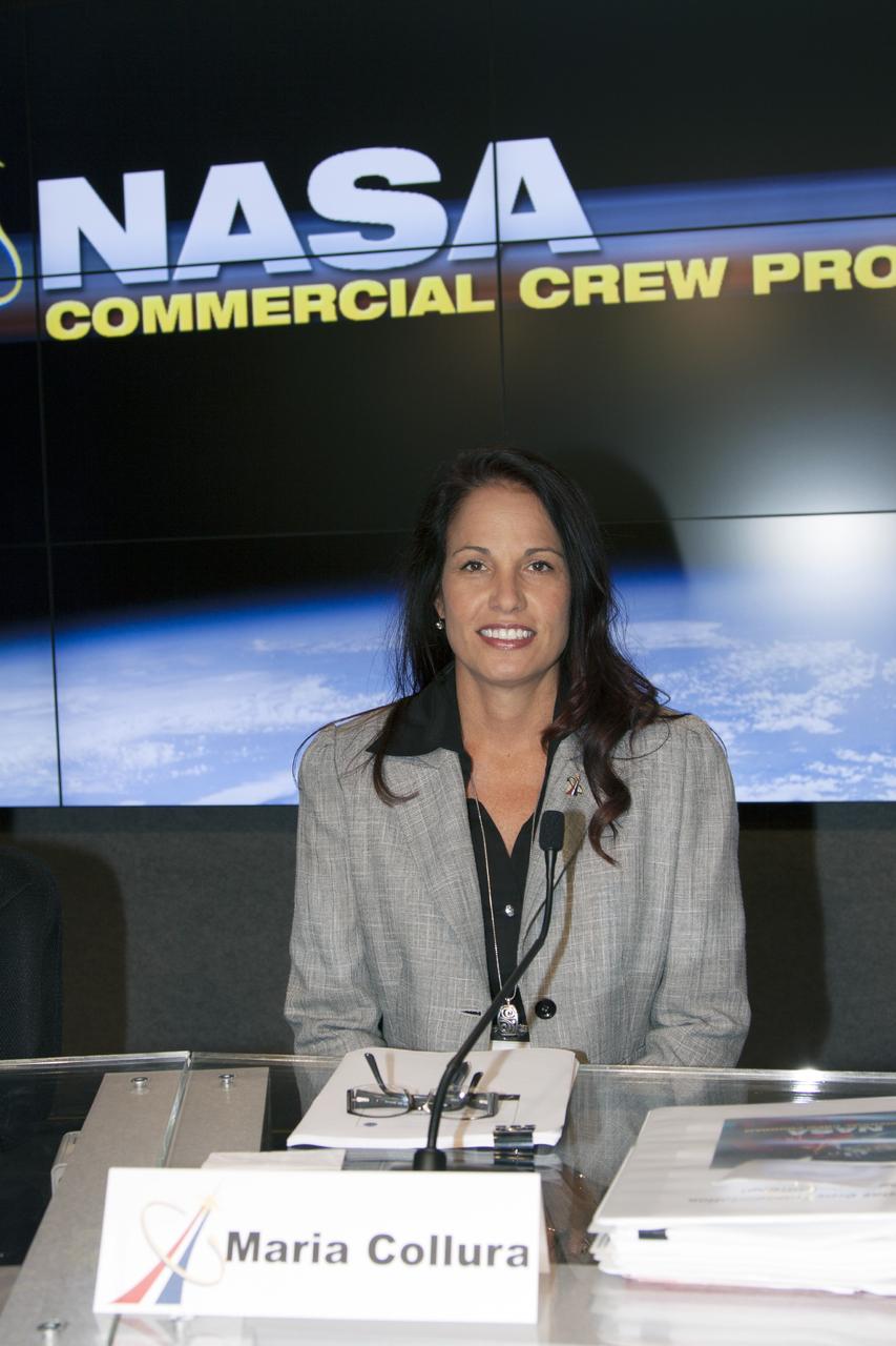
Senior managers at NASA’s Kennedy Space Center pose inside the Florida spaceport’s Central Campus Headquarters building on Feb. 24, 2020, in recognition of Women’s History Month. Pictured are: Hortense Diggs, Susan Kroskey, Janet Petro, Charlie Blackwell-Thompson, Vicki Johnston, Maria Collura, Jeanne O’Bryan, Vanessa Stromer, Kim Carter, Laura Rochester, Becky Murray, Jennifer Kunz, Barbara Brown, Kathy Loftin, Jenny Lyons, Dana Hutcherson and Dicksy Chrostowski.
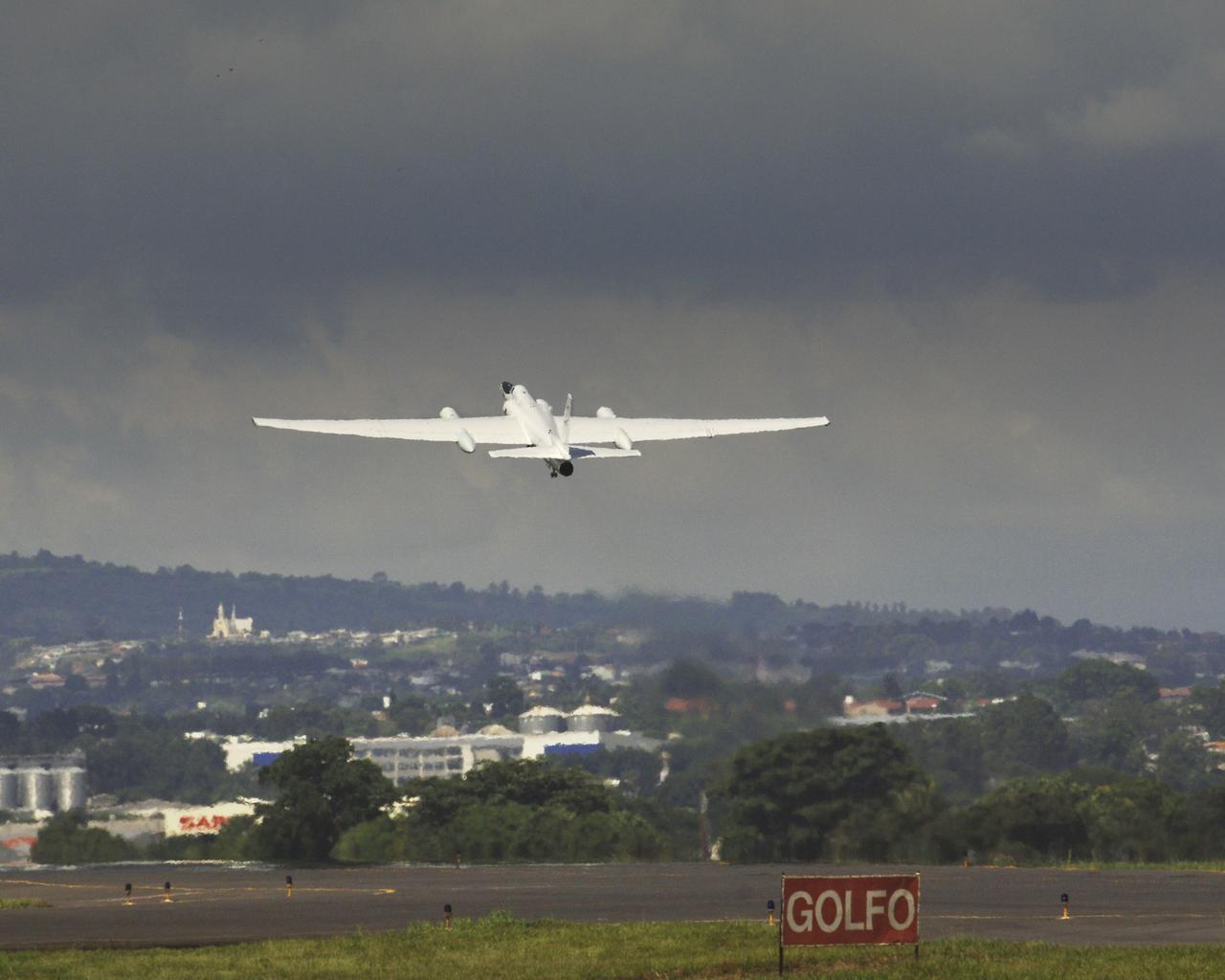
The NASA ER-2 airplane flew over hurricane Dennis as part of the Tropical Cloud Systems and Processes "TSCP" Mission. This 28-day field mission sponsored by NASA's Science Mission Directorate is studying the bursting conditions for tropical storms, hurricanes and related phenomena. The flight originated from TSCP's base-of-operations in San Juan Santa Maria airport in San Jose, Costa Rica. Photo Credit: "NASA/Bill Ingalls"
Artemis III Geology Team member, Jose Hurtado from the University of Texas at El Paso, left, and Maria Banks of NASA’s Goddard Spaceflight Center work in the Science Evaluation Room (SER) during the JETT 5 field test. JETT 5 was a week-long field test in the lunar-like landscape of San Francisco Volcanic Field near Flagstaff, Arizona while a team of flight controllers and scientists at Johnson monitor and guide their activities. Credit: NASA/Helen Arase Vargas
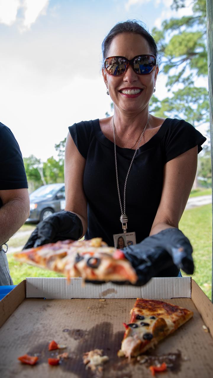
Maria Collura, deputy director of Spaceport Services and Integration at NASA’s Kennedy Space Center in Florida, is photographed serving pizza to Kennedy employees during a Safety and Health Days celebration at the spaceport’s KARS Park II on March 5, 2020. Taking place March 2 through March 6, Safety and Health Days provides Kennedy employees with a variety of presentations to attend – all of which focus on how to maintain a safe and healthy workforce.
Marshall Space Flight Center (MSFC) Director Dr. von Braun and his family were honored with a series of events prior to his relocation to Washington, D.C., where he was assigned duties at NASA Headquarters as Deputy Associate Administrator for Plarning. (Left to right) Dr. von Braun, wife Maria, son Peter, and daughter Margrit are shown on the steps of the Madison County Courthouse, Huntsville, Alabama.

Senior managers at NASA’s Kennedy Space Center pose inside the Florida spaceport’s Central Campus Headquarters building on Feb. 24, 2020, in recognition of Women’s History Month. Pictured are: Hortense Diggs, Susan Kroskey, Janet Petro, Charlie Blackwell-Thompson, Vicki Johnston, Maria Collura, Jeanne O’Bryan, Vanessa Stromer, Kim Carter, Laura Rochester, Becky Murray, Jennifer Kunz, Barbara Brown, Kathy Loftin, Jenny Lyons, Dana Hutcherson and Dicksy Chrostowski.

Senior managers at NASA’s Kennedy Space Center pose inside the Florida spaceport’s Central Campus Headquarters building on Feb. 24, 2020, in recognition of Women’s History Month. Pictured are: Hortense Diggs, Susan Kroskey, Janet Petro, Charlie Blackwell-Thompson, Vicki Johnston, Maria Collura, Jeanne O’Bryan, Vanessa Stromer, Kim Carter, Laura Rochester, Becky Murray, Jennifer Kunz, Barbara Brown, Kathy Loftin, Jenny Lyons, Dana Hutcherson and Dicksy Chrostowski.
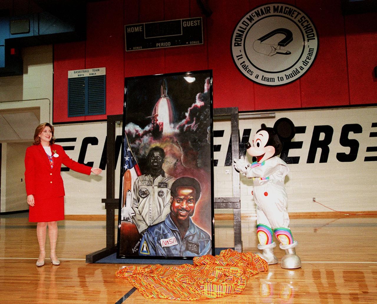
In the gymnasium of Ronald McNair Magnet School in Cocoa, Fla., Ms. Maria Rodriguez, an Walt Disney World Ambassador, and Mickey Mouse pose with a portrait of NASA astronaut Ronald McNair. The portrait was presented to the school by Walt Disney World during a tribute to McNair. The school had previously been renamed for the fallen astronaut, who was one of a crew of seven who lost their lives during an accident following launch of the Space Shuttle Challenger in January 1986
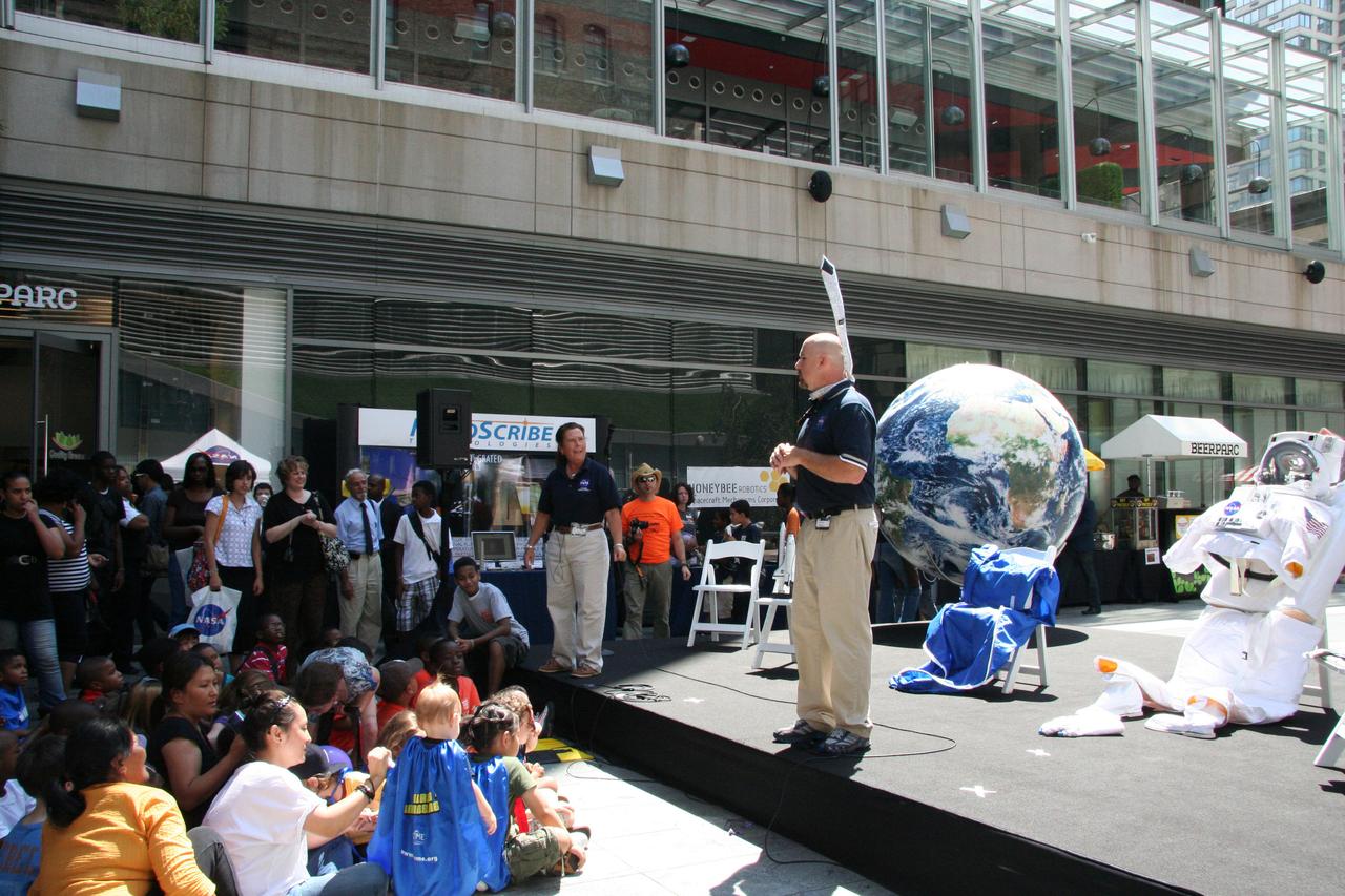
Chris Copelan (right), education program specialist at Stennis Space Center, and Maria Lott, Stennis Astro Camp director, talk about living and working in space with visitors gathered for the 'What's Your Favorite Space?' event in New York City on Aug. 17. Stennis educators teamed with peers from three other NASA centers to present a variety of hands-on activities and informational presentations during the event.
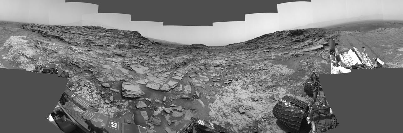
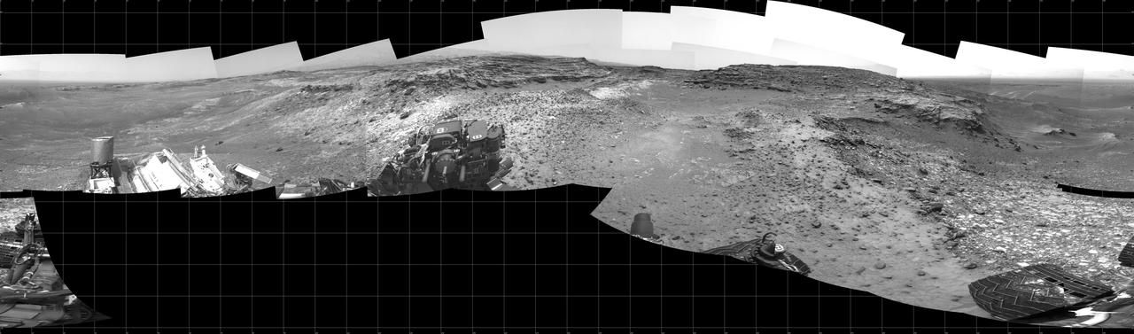
This 360-degree panorama from the Navigation Camera (Navcam) on NASA's Curiosity Mars rover shows the surroundings of a site on lower Mount Sharp where the rover spent its 1,000th Martian day, or sol, on Mars. Sol 1,000 of Curiosity's Mars-surface mission corresponded to May 30, 2015. The component images for this scene were taken on Sol 997 (May 27, 2015). The site is a valley just below "Marias Pass" on lower Mount Sharp. A map of the area is at http://mars.nasa.gov/msl/images/Curiosity_Location_Sol997-full.jpg. Tracks from the rover's drive to this site are visible at right. The rover team chose this location near Marias Pass because images from orbit showed what appeared to be a contact between two types of bedrock. The two types are evident in this panorama. The bedrock close to the rover is pale mudstone similar to what Curiosity examined in 2014 and early 2015 at "Pahrump Hills." The darker, finely bedded bedrock above it is sandstone that the rover team calls the "Stimson" unit. The largest-looking slab of Stimson sandstone in the image, in the lower left quadrant, is a target called "Ronan," selected for close-up inspection. http://photojournal.jpl.nasa.gov/catalog/PIA19679
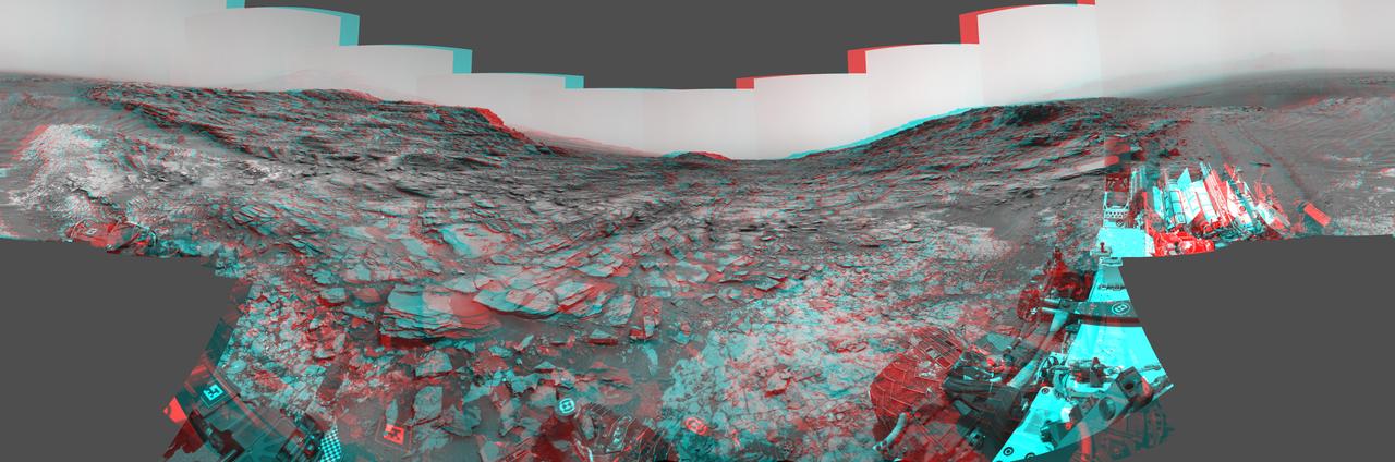
This stereo view from the Navigation Camera (Navcam) on NASA's Curiosity Mars rover shows a 360-degree panorama around the location where the rover spent its 1,000th Martian day, or sol, on Mars. The image appears three-dimensional when viewed through red-blue glasses with the red lens on the left. Sol 1,000 of Curiosity's Mars-surface mission corresponded to May 30, 2015. The component images for this scene were taken on Sol 997 (May 27, 2015). The site is a valley just below "Marias Pass" on lower Mount Sharp. A map of the area is at http://mars.nasa.gov/msl/images/Curiosity_Location_Sol997-full.jpg. The center of the scene is toward the south, with north at both ends. This stereo view combines images from Navcam left-eye and right-eye cameras. A single-eye version of the scene is at PIA19679 . Tracks from the rover's drive to this site are visible at right. The rover team chose this location near Marias Pass because images from orbit showed what appeared to be a contact between two types of bedrock. The two types are evident in this panorama. The bedrock close to the rover is pale mudstone similar to what Curiosity examined in 2014 and early 2015 at "Pahrump Hills." The darker, finely bedded bedrock above it is sandstone that the rover team calls the "Stimson" unit. The largest-looking slab of Stimson sandstone in the image, in the lower left quadrant, is a target called "Ronan," selected for close-up inspection. on lower Mount Sharp. http://photojournal.jpl.nasa.gov/catalog/PIA19678

CAPE CANAVERAL, Fla. - Panelists of the Commercial Crew Transportation Capability, or CCtCap, Pre-Proposal Conference at Kennedy Space Center in Florida are, from left, Maria Collura, Brian Hinerth, Trip Healy and Lee Pagel. CCtCap will be the next phase of certification efforts for CCP mission to the International Space Station. The purpose of the conference was to involve aerospace industry representatives in the CCtCap draft Request for Proposal, or RFP, process and provide a greater understanding for both parties before the official RFP is released in the fall of 2013. To learn more about CCP, visit www.nasa.gov/commercialcrew. Photo credit: NASA/Jim Grossmann

CAPE CANAVERAL, Fla. -- Maria Collura of NASA's Commercial Crew Program, or CCP, talks to aerospace industry representatives during a pre-proposal conference to inform prospective companies about the recently released request for contract proposals and updates to the certification requirements for crewed missions to the International Space Station, or ISS. The two-phase certification process, called Certification Products Contract, or CPC, will enable NASA to eventually purchase service missions to fly astronauts to and from the ISS. Collura serves as a CCP certification manager. To learn more about CCP, visit www.nasa.gov/commercialcrew. Photo credit: Kim Shiflett

CAPE CANAVERAL, Fla. -- In the Press Site auditorium at NASA's Kennedy Space Center in Florida, media were briefed about NASA's future science missions. Seen here are NASA Public Affairs Officer George Diller (left); Waleed Abdalati, NASA chief scientist; Amanda Mitskevich, NASA Launch Services Program manager; Scott Bolton, Juno principal investigator with the Southwest Research Institute, San Antonio; Maria Zuber, GRAIL principal investigator with the Massachusetts Institute of Technology; John Grotzinger, Mars Science Lab project scientist with the California Institute of Technology and Daniel Stern, NuStar project scientist with NASA's Jet Propulsion Laboratory in Calif. Photo credit: NASA/Jack Pfaller
KENNEDY SPACE CENTER, Fla. -- Deputy Center Director Jim Jennings speaks to guests at the annual Hispanic Heritage Month Celebration, held at the Kurt Debus Conference Facility at KSC. Chaired by Rey N. Diaz and Maria Lopez-Tellado, who received plaques of appreciation for their efforts, the event also featured a luncheon and comments by Miguel Rodriquez, chief, Integration Office, of the Joint Performance Management Office. The pledge of allegiance and invocation was led by Joseph Tellado, International Space Station_Payload Processing. The Merrit Island High School ROTC provided the color guard. The event was sponsored by the Hispanic Employment Program Working Group at KSC
Prior to MSFC (Marshall Space Flight Center) Director, Dr. von Braun's transfer to NASA Headquarters where he had been appointed Deputy Associate Administrator for Plarning, he was honored during a series of events recognizing his contribution to the space effort during his career in Huntsville, Alabama. In this photo at the Madison County Courthouse, Dr. von Braun is shown seated next to his wife, Maria, as U.S. Senator John Sparkman comments on his career in Huntsville, Alabama, where he worked for both the Army and NASA (National Aeronautic Space Administration).
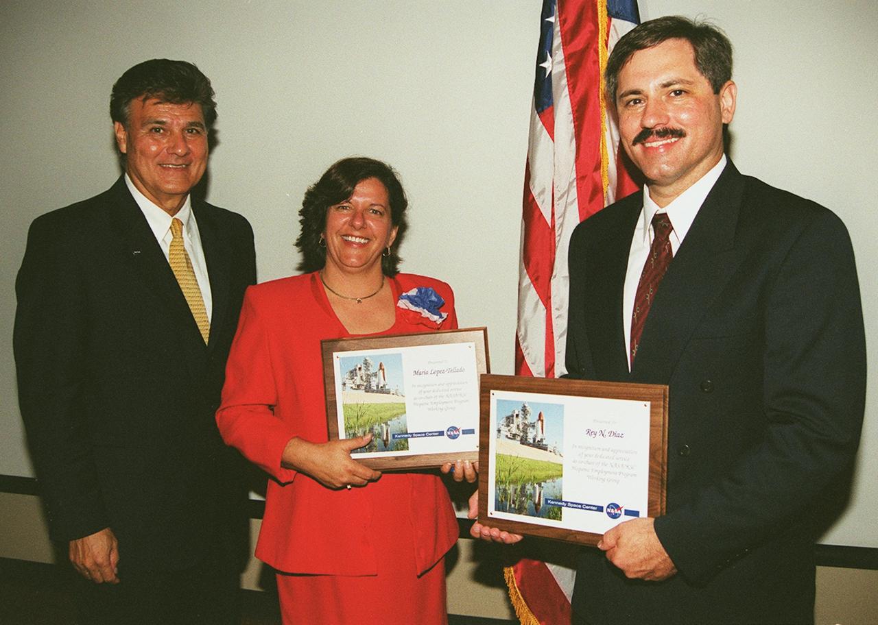
KENNEDY SPACE CENTER, Fla. -- Maria Lopez-Tellado (center) and Rey N. Diaz (right) display the plaques they received at the annual Hispanic Heritage Month Celebration, held at the Kurt Debus Conference Facility at KSC. The two were recognized for their efforts as chairs of the event, which featuraed a luncheon and comments by Deputy Center Director Jim Jennings and Miguel Rodriquez, chief, Integration Office, of the Joint Performance Management Office. Joseph Tellado (left), International Space Station/Payload Processing, led the pledge of allegiance and invocation. The Merrit Island High School ROTC provided the color guard. The event was sponsored by the Hispanic Employment Program Working Group at KSC
CAPE CANAVERAL, Fla. – Maria Collura of NASA's Commercial Crew Program is seen before the start of an industry conference inside the Television Auditorium at NASA's Kennedy Space Center in Florida. The conference was held following the program's request for proposals from commercial companies for a development and certification contract called the Commercial Crew Transportation Capability CCtCap. The contract will provide a finish line for the agency following more than four years of development work by CCP and American aerospace companies. CCtCap is the second phase of a two-phase certification plan for privately built and operated integrated crew transportation systems. Photo credit: NASA/Jim Grossmann

This view from NASA's Curiosity Mars rover shows an example of discoloration closely linked to fractures in the Stimson formation sandstone on lower Mount Sharp. The pattern is evident along two perpendicular fractures. Curiosity's Navigation Camera (Navcam) acquired the component images of this mosaic on Aug. 23, 2015, during the 1.083rd Martian day, or sol, of the mission. The location is along the rover's path between "Marias Pass" and "Bridger Basin." In this region, the rover has found fracture zones to be associated with rock compositions enriched in silica, relative to surrounding bedrock. http://photojournal.jpl.nasa.gov/catalog/PIA20268
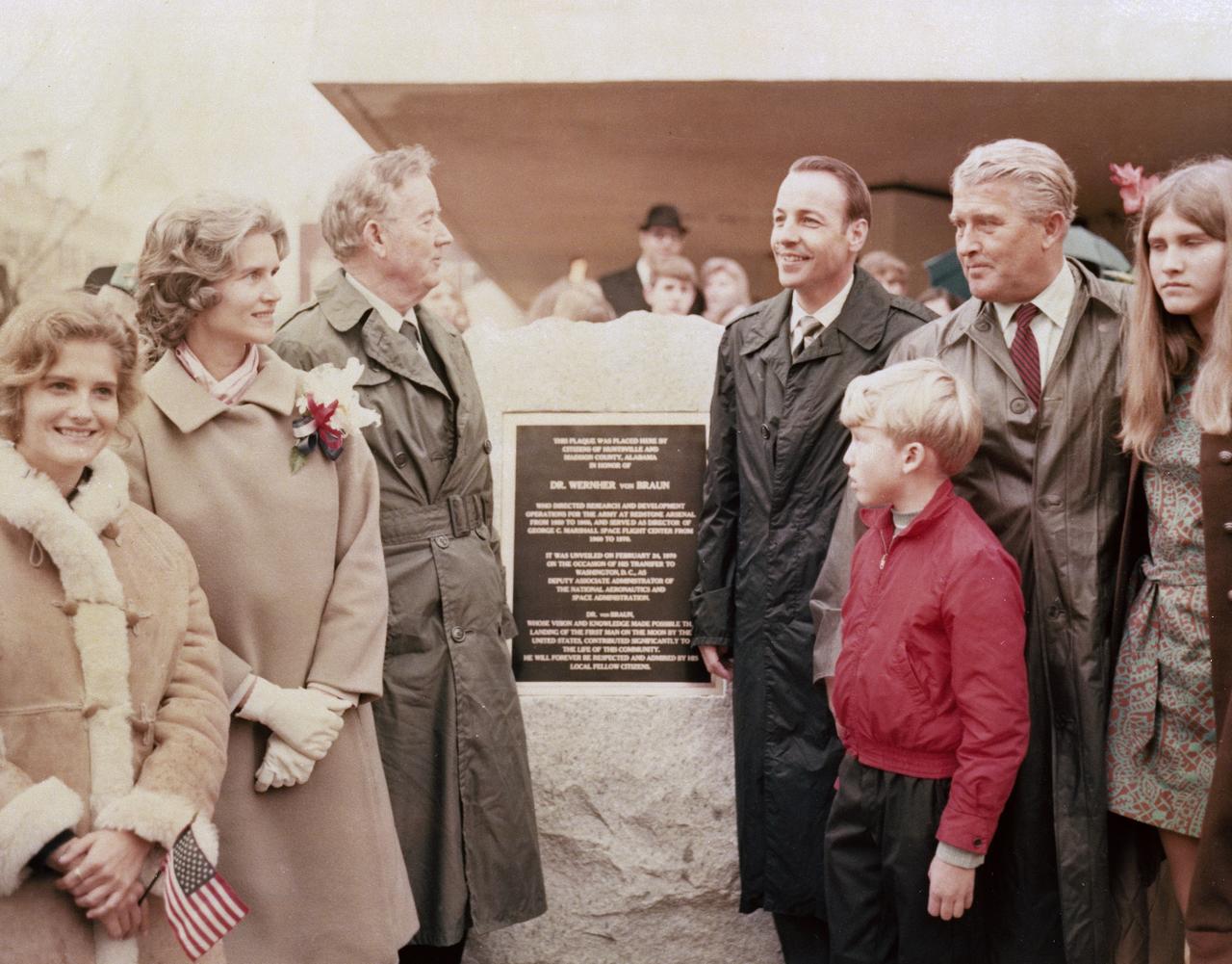
In February 1970, MSFC Director Dr. von Braun was named NASA Deputy Associate Administrator for Plarning and transferred to the Agency's Headquarters in Washington D.C. Prior to his departure, Huntsvillians, along with state local dignitaries, honored his years of service to the Army and NASA with a series of events. One included unveiling a plaque in von Braun's honor. Pictured with Dr. von Braun are (left to right), his daughter Iris, wife Maria, U.S. Senator John Sparkman and Alabama Governor Albert Brewer, Dr. von Braun, son Peter, and daughter Margrit.
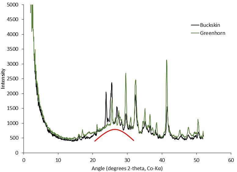
This graph presents information from the NASA Curiosity Mars rover's onboard analysis of rock powder drilled from the "Buckskin" and "Greenhorn" target locations on lower Mount Sharp. Buckskin, in the "Marias Pass" area, and Greenhorn, in the "Bridger Basin" area, both contain high concentrations of silica. X-ray diffraction analysis of powered samples inside Curiosity's Chemistry and Mineralogy (CheMin) instrument revealed that each of them contains silica in the form of noncrystalline opal. The broad hump in the two X-ray diffraction patterns is diagnostic of opaline silica. Some of the silica in Buckskin is in the form of tridymite. http://photojournal.jpl.nasa.gov/catalog/PIA20273
Stennis Space Center employees Maria Etheridge (l to r), Linda Sauland Maurice Prevost visit a Coast Electric Power Association display featuring energy-efficient light bulbs during 2009 Energy Awareness Day activities on Oct. 20. The exhibit was one of several energy-efficiency and energy-awareness displays on-site for employees to visit. Vendors included Mississippi Power Company, Coast Electric Power Association, Mississippi Development Authority - Energy Division,Jacobs FOSC Environmental, Southern Energy Technologies, and Siemens Building Technologies.
María-José Viñas, NASA’s Spanish language communications lead, left, introduces NASA astronauts Frank Rubio, second from left, and Stephen Bowen and UAE (United Arab Emirates) astronaut Sultan Alneyadi as the trio visited Rolling Terrance Elementary School to speak to students, Friday, March 22, 2024, in Takoma Park, Maryland. Bowen and Alneyadi spent 186 days aboard the International Space Station as part of Expedition 69; while Rubio set a new record for the longest single spaceflight by a U.S. astronaut, spending 371 days in orbit on an extended mission spanning Expeditions 68 and 69. Photo Credit: (NASA/Joel Kowsky)
A rock fragment dubbed "Lamoose" is shown in this picture taken by the Mars Hand Lens Imager (MAHLI) on NASA's Curiosity rover. Like other nearby rocks in a portion of the "Marias Pass" area of Mt. Sharp, Mars, it has unusually high concentrations of silica. The high silica was first detected in the area by the Chemistry & Camera (ChemCam) laser spectrometer. This rock was targeted for follow-up study by the MAHLI and the arm-mounted Alpha Particle X-ray Spectrometer (APXS). Silica is a rock-forming compound containing silicon and oxygen, commonly found on Earth as quartz. High levels of silica could indicate ideal conditions for preserving ancient organic material, if present, so the science team wants to take a closer look. The rock is about 4 inches (10 centimeters) across. It is fine-grained, perhaps finely layered, and etched by the wind. The image was taken on the 1,041st Martian day, or sol, of the mission (July 11, 2015). MAHLI was built by Malin Space Science Systems, San Diego. NASA's Jet Propulsion Laboratory, a division of the California Institute of Technology in Pasadena, manages the Mars Science Laboratory Project for the NASA Science Mission Directorate, Washington. JPL designed and built the project's Curiosity rover. http://photojournal.jpl.nasa.gov/catalog/PIA19828
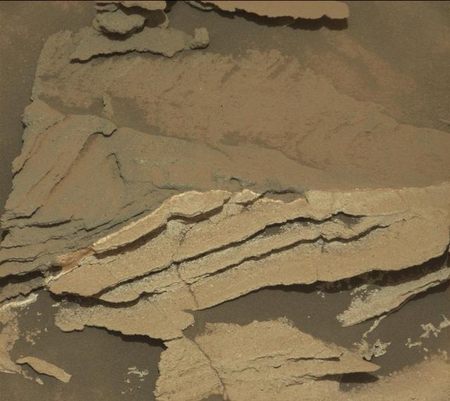
A rock outcrop dubbed "Missoula," near Marias Pass on Mars, is seen in this image mosaic taken by the Mars Hand Lens Imager on NASA's Curiosity rover. Pale mudstone (bottom of outcrop) meets coarser sandstone (top) in this geological contact zone, which has piqued the interest of Mars scientists. White mineral veins that fill fractures in the lower rock unit abruptly end when they meet the upper rock unit. Such clues help scientists understand the possible timing of geological events. First, the fine sediment that now forms the lower unit would have hardened into rock. It then would have fractured, and groundwater would have deposited calcium sulfate minerals into the fractures. Next, the coarser sediment that forms the upper unit would have been deposited. The area pictured is about 16 inches (40 centimeters) across. The image was taken on the 1,031st Martian day, or sol, of the mission (July 1, 2015). MAHLI was built by Malin Space Science Systems, San Diego. NASA's Jet Propulsion Laboratory, a division of the California Institute of Technology in Pasadena, manages the Mars Science Laboratory Project for the NASA Science Mission Directorate, Washington. JPL designed and built the project's Curiosity rover. http://photojournal.jpl.nasa.gov/catalog/PIA19829
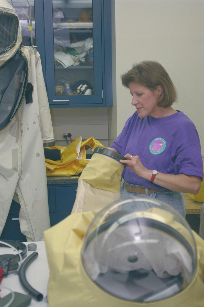
1996 'STELLAR' teacher in Space Suit Lab
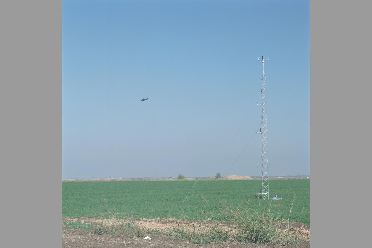
MD-900 (N900MH) Helicopter Noise Abatement Test - Crows Landing, Microphones
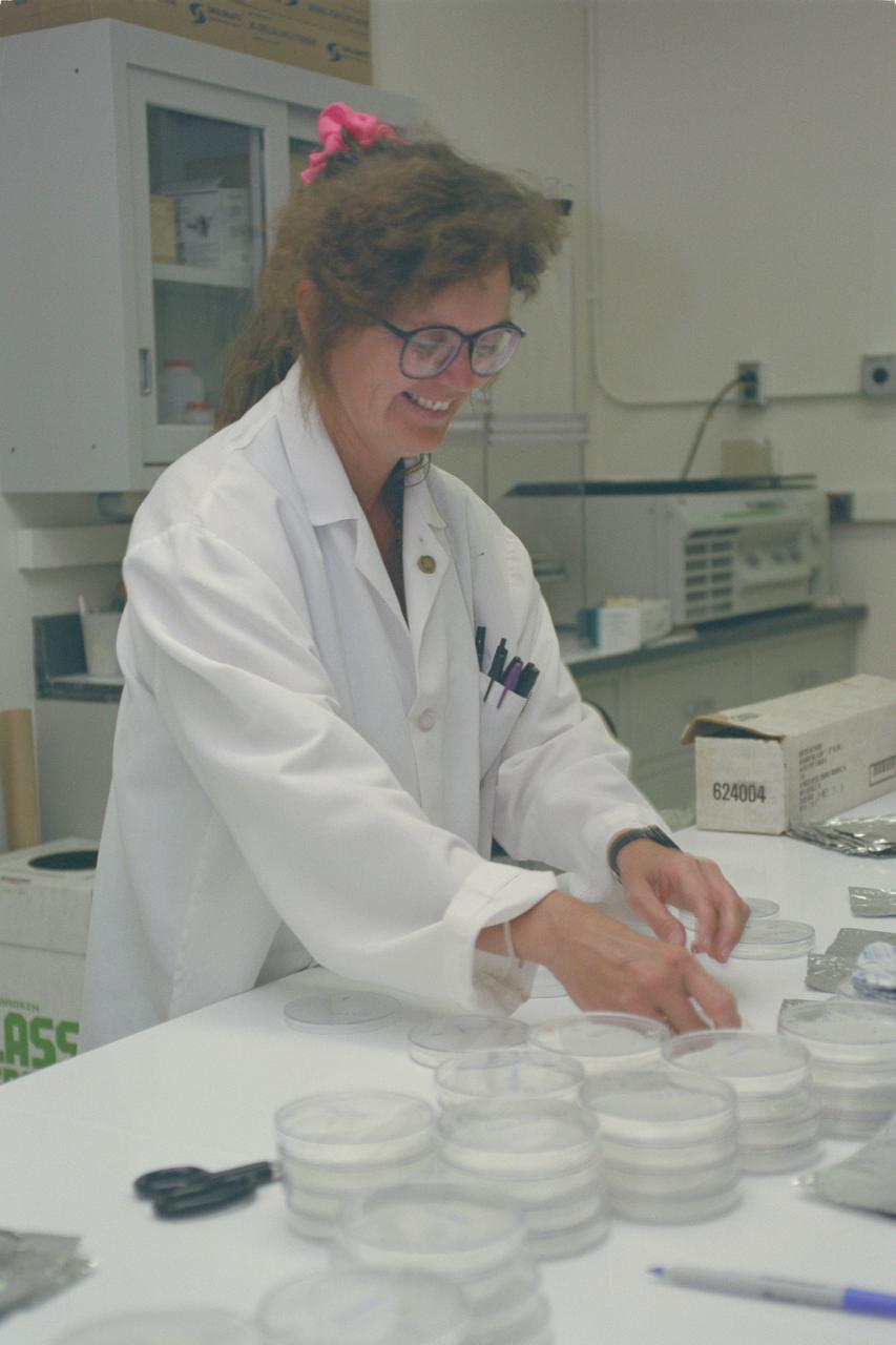
1996 'STELLAR' teacher in CELSS lab
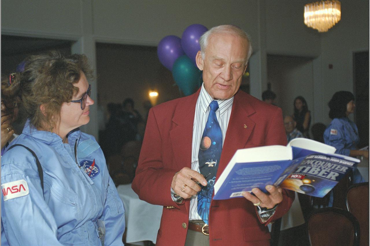
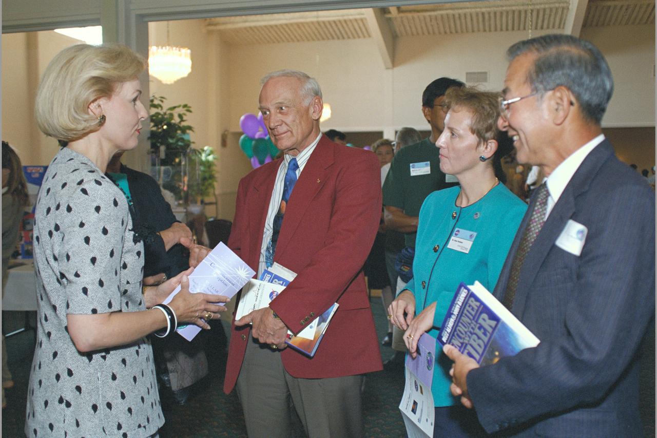
1996 'STELLAR' program commencement with special guest Astronaut Buzz Aldrin drops by to tour and chat. Aldrin was attending his book signing at US Space Camp earlier in the day.
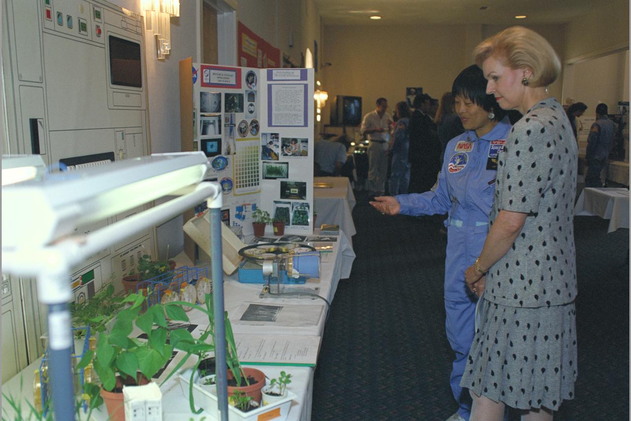
1996 'STELLAR' program commencement with special guest Mrs. Gayle Wilson (CA governor's wife) as she tours the STELLAR project displays with STELLAR students and teachers
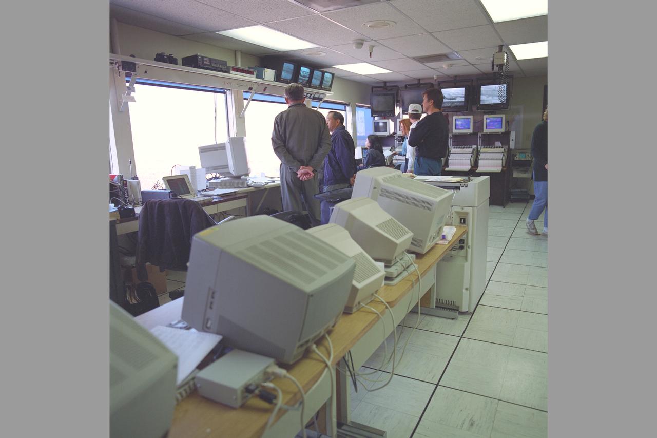
MD-900 (N900MH) Helicopter Noise Abatement Test - Crows Landing, Control Room with test evaluation crew
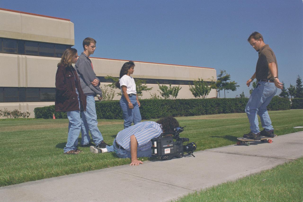
1996 MCP (Multimedia Curriculum Project) summer students practice techniques with Ames Documentation Technology Branch Video Groups' Patty Viajar and Adam Souza (photography student)
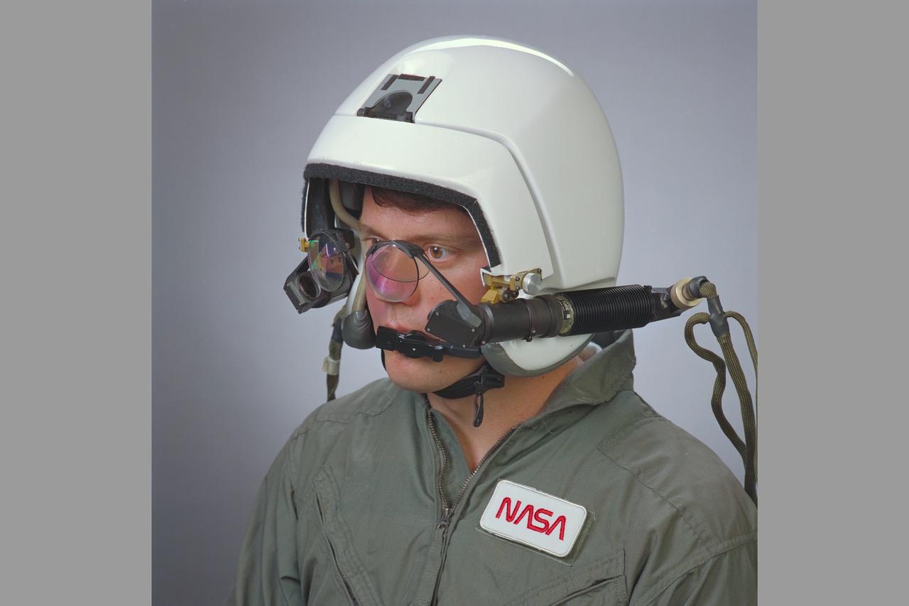
RASCAL color helmet mounted display with Oliver Field
1996 'STELLAR' and MCP summer programs commencement. Apollo Astronaut Buzz Aldren drops by after attending his book signing at US Space Camp eariler in the day is shown here with Gayle Wilson (governor's wife) and Ken Munechika (R) and Dr. Rose Grymes (center)