This view from the Mast Camera (Mastcam) in NASA's Curiosity Mars rover shows the "Marias Pass" area where a lower and older geological unit of mudstone -- the pale zone in the center of the image -- lies in contact with an overlying geological unit of sandstone. Just before Curiosity reached Marias Pass, the rover's laser-firing Chemistry and Camera (ChemCam) instrument examined a rock found to be rich in silica, a mineral-forming chemical. This scene combines several images taken on May 22, 2015, during the 992nd Martian day, or sol, of Curiosity's work on Mars. The scene is presented with a color adjustment that approximates white balancing, to resemble how the rocks and sand would appear under daytime lighting conditions on Earth. http://photojournal.jpl.nasa.gov/catalog/?IDNumber=pia20174
NASA Curiosity Mars rover used its Navigation Camera Navcam to capture this view partway back down a slope it climbed toward Marias Pass on lower Mount Sharp. The image was taken May 22, 2015.
This 360-degree panorama shows the "Marias Pass" area, at center, and part of the slope that NASA's Curiosity Mars rover climbed to get there, at right. The scene combines multiple images taken by Curiosity's Navigation Camera (Navcam) on May 22, 2105, during the 992nd Martian day, or sol, of the rover's work on Mars. North is at both ends; south is in the middle. On the previous sol, Curiosity reached this location by climbing a slope with steepness of up to 20 degrees. From this location, the rover's Chemistry and Camera (ChemCam) instrument examined a rock target called "Elk" and found its composition to be about 80 percent silica. http://photojournal.jpl.nasa.gov/catalog/PIA20266
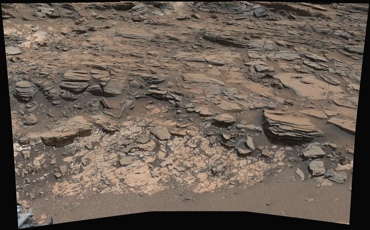
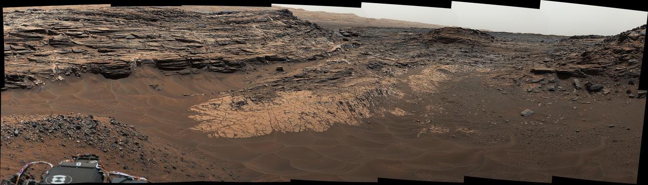
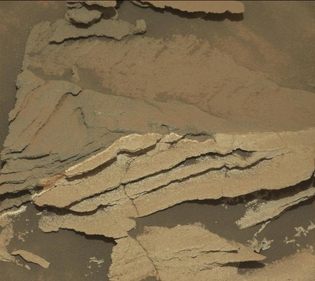
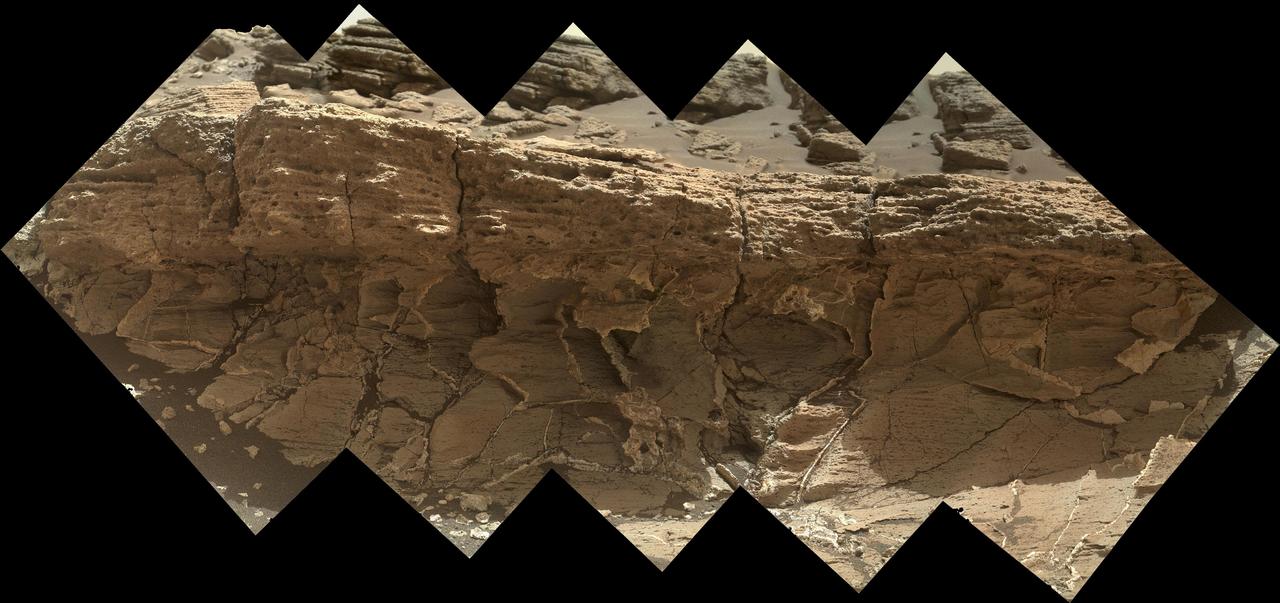
This view from the Mast Camera (Mastcam) on NASA's Curiosity Mars rover shows a site where two different types of bedrock meet on lower Mount Sharp. The scene combines multiple images taken by the left-eye camera of Mastcam on May 25, 2015, during the 995th Martian day, or sol, of Curiosity's work on Mars, in a valley just below "Marias Pass." The color has been approximately white-balanced to resemble how the scene would appear under daytime lighting conditions on Earth. The paler part of the outcrop, in the foreground, is mudstone similar to what Curiosity examined in 2014, and in early 2015, at "Pahrump Hills." The darker, finely bedded bedrock higher in the image and overlying the mudstone stratigraphically is sandstone that the rover team calls the "Stimson" unit. The scene covers an area about 10 feet (3 meters) wide in the foreground. Malin Space Science Systems, San Diego, built and operates the rover's Mastcam. NASA's Jet Propulsion Laboratory, a division of the California Institute of Technology, Pasadena, manages the Mars Science Laboratory Project for NASA's Science Mission Directorate, Washington. http://photojournal.jpl.nasa.gov/catalog/PIA19676
This image from NASA's Curiosity Mars rover reveals details of a bedrock discoloration pattern at a site between "Marias Pass" and "Bridger Basin." The discoloration is not associated with individual layers. It crosses layers and shows clear horizontal boundaries to the darker toned bedrock. This suggests it is related to alteration by fluids that flowed through fractures and permeated into the bedrock. The image was taken by the right-eye (telephoto) camera of the rover's Mast Camera instrument on Sept. 2, 2015, during the mission's 1,092nd Martian day, or sol. http://photojournal.jpl.nasa.gov/catalog/PIA20269
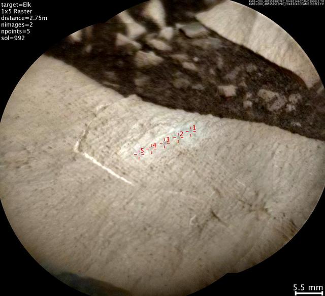
This image from the Chemistry and Camera (ChemCam) instrument on NASA's Curiosity Mars rover shows detailed texture of a rock target called "Elk" on Mars' Mount Sharp, revealing laminations that are present in much of the Murray Formation geological unit of lower Mount Sharp. Researchers also used ChemCam's laser and spectrometers to assess Elk's composition and found it to be rich in silica. The image covers a patch of rock surface about 2.8 inches (7 centimeters) across. It was taken on May 22, 2015, during the mission's 992nd Martian day, or sol. ChemCam's Remote Micro-Imager camera, on top of Curiosity's mast, captured the image from a distance of about 9 feet (2.75 meters). Annotations in red identify five points on Elk that were hit with ChemCam's laser. Each of the highlighted points is a location where ChemCam fired its laser 30 times to ablate a tiny amount of target material. By analyzing the light emitted from this laser-ablation, researchers can deduce the composition of that point. For some purposes, composition is presented as a combination of the information from multiple points on the same rock. However, using the points individually can track fine-scale variations in targets. http://photojournal.jpl.nasa.gov/catalog/PIA20267
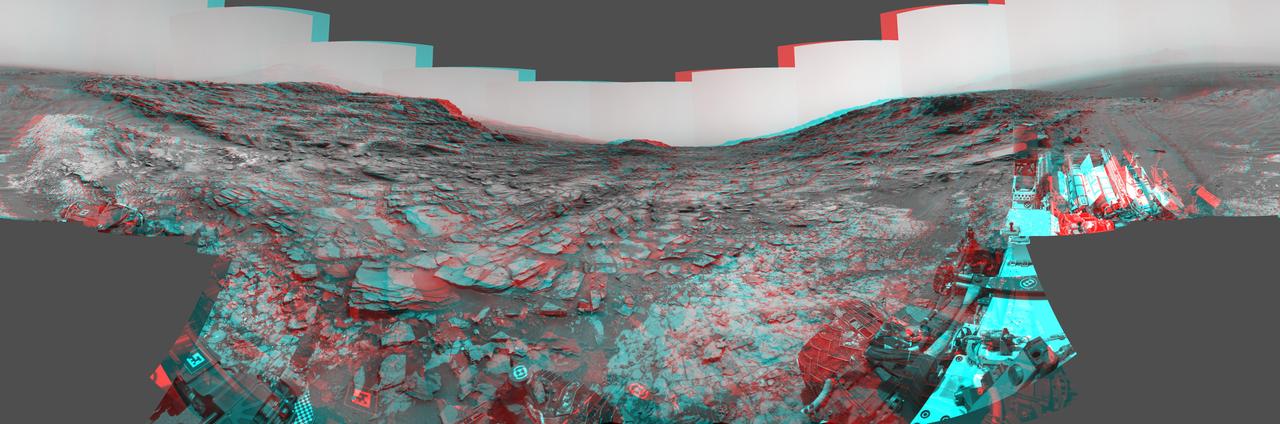
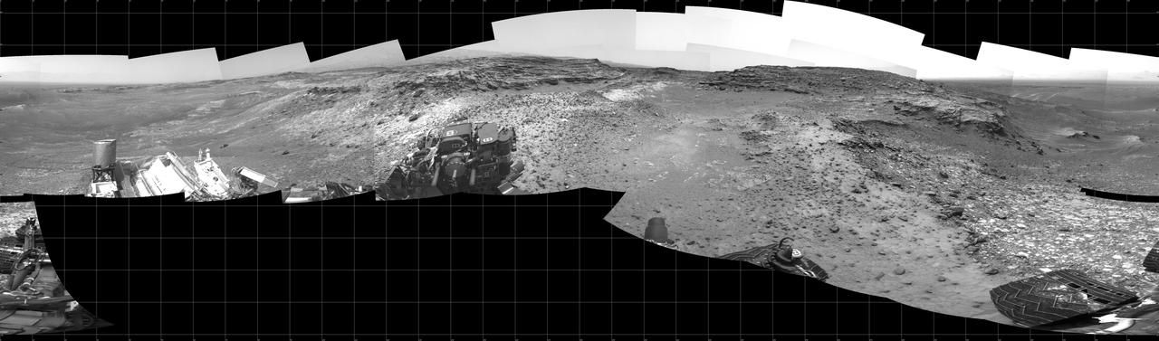
This stereo view from the Navigation Camera (Navcam) on NASA's Curiosity Mars rover shows a 360-degree panorama around the location where the rover spent its 1,000th Martian day, or sol, on Mars. The image appears three-dimensional when viewed through red-blue glasses with the red lens on the left. Sol 1,000 of Curiosity's Mars-surface mission corresponded to May 30, 2015. The component images for this scene were taken on Sol 997 (May 27, 2015). The site is a valley just below "Marias Pass" on lower Mount Sharp. A map of the area is at http://mars.nasa.gov/msl/images/Curiosity_Location_Sol997-full.jpg. The center of the scene is toward the south, with north at both ends. This stereo view combines images from Navcam left-eye and right-eye cameras. A single-eye version of the scene is at PIA19679 . Tracks from the rover's drive to this site are visible at right. The rover team chose this location near Marias Pass because images from orbit showed what appeared to be a contact between two types of bedrock. The two types are evident in this panorama. The bedrock close to the rover is pale mudstone similar to what Curiosity examined in 2014 and early 2015 at "Pahrump Hills." The darker, finely bedded bedrock above it is sandstone that the rover team calls the "Stimson" unit. The largest-looking slab of Stimson sandstone in the image, in the lower left quadrant, is a target called "Ronan," selected for close-up inspection. on lower Mount Sharp. http://photojournal.jpl.nasa.gov/catalog/PIA19678
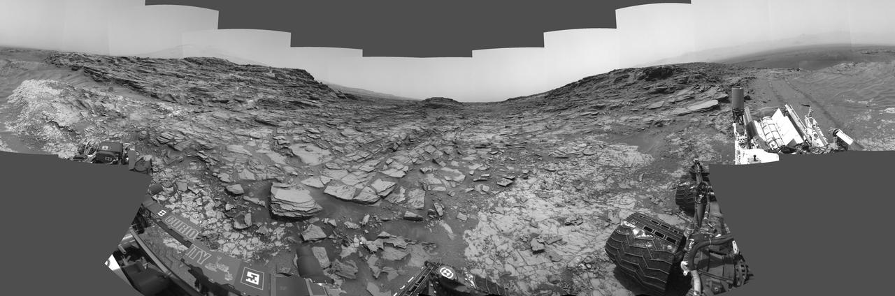
This 360-degree panorama from the Navigation Camera (Navcam) on NASA's Curiosity Mars rover shows the surroundings of a site on lower Mount Sharp where the rover spent its 1,000th Martian day, or sol, on Mars. Sol 1,000 of Curiosity's Mars-surface mission corresponded to May 30, 2015. The component images for this scene were taken on Sol 997 (May 27, 2015). The site is a valley just below "Marias Pass" on lower Mount Sharp. A map of the area is at http://mars.nasa.gov/msl/images/Curiosity_Location_Sol997-full.jpg. Tracks from the rover's drive to this site are visible at right. The rover team chose this location near Marias Pass because images from orbit showed what appeared to be a contact between two types of bedrock. The two types are evident in this panorama. The bedrock close to the rover is pale mudstone similar to what Curiosity examined in 2014 and early 2015 at "Pahrump Hills." The darker, finely bedded bedrock above it is sandstone that the rover team calls the "Stimson" unit. The largest-looking slab of Stimson sandstone in the image, in the lower left quadrant, is a target called "Ronan," selected for close-up inspection. http://photojournal.jpl.nasa.gov/catalog/PIA19679
A rock fragment dubbed "Lamoose" is shown in this picture taken by the Mars Hand Lens Imager (MAHLI) on NASA's Curiosity rover. Like other nearby rocks in a portion of the "Marias Pass" area of Mt. Sharp, Mars, it has unusually high concentrations of silica. The high silica was first detected in the area by the Chemistry & Camera (ChemCam) laser spectrometer. This rock was targeted for follow-up study by the MAHLI and the arm-mounted Alpha Particle X-ray Spectrometer (APXS). Silica is a rock-forming compound containing silicon and oxygen, commonly found on Earth as quartz. High levels of silica could indicate ideal conditions for preserving ancient organic material, if present, so the science team wants to take a closer look. The rock is about 4 inches (10 centimeters) across. It is fine-grained, perhaps finely layered, and etched by the wind. The image was taken on the 1,041st Martian day, or sol, of the mission (July 11, 2015). MAHLI was built by Malin Space Science Systems, San Diego. NASA's Jet Propulsion Laboratory, a division of the California Institute of Technology in Pasadena, manages the Mars Science Laboratory Project for the NASA Science Mission Directorate, Washington. JPL designed and built the project's Curiosity rover. http://photojournal.jpl.nasa.gov/catalog/PIA19828
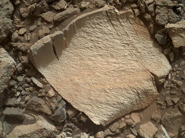
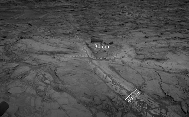
A rock outcrop dubbed "Missoula," near Marias Pass on Mars, is seen in this image mosaic taken by the Mars Hand Lens Imager on NASA's Curiosity rover. Pale mudstone (bottom of outcrop) meets coarser sandstone (top) in this geological contact zone, which has piqued the interest of Mars scientists. White mineral veins that fill fractures in the lower rock unit abruptly end when they meet the upper rock unit. Such clues help scientists understand the possible timing of geological events. First, the fine sediment that now forms the lower unit would have hardened into rock. It then would have fractured, and groundwater would have deposited calcium sulfate minerals into the fractures. Next, the coarser sediment that forms the upper unit would have been deposited. The area pictured is about 16 inches (40 centimeters) across. The image was taken on the 1,031st Martian day, or sol, of the mission (July 1, 2015). MAHLI was built by Malin Space Science Systems, San Diego. NASA's Jet Propulsion Laboratory, a division of the California Institute of Technology in Pasadena, manages the Mars Science Laboratory Project for the NASA Science Mission Directorate, Washington. JPL designed and built the project's Curiosity rover. http://photojournal.jpl.nasa.gov/catalog/PIA19829
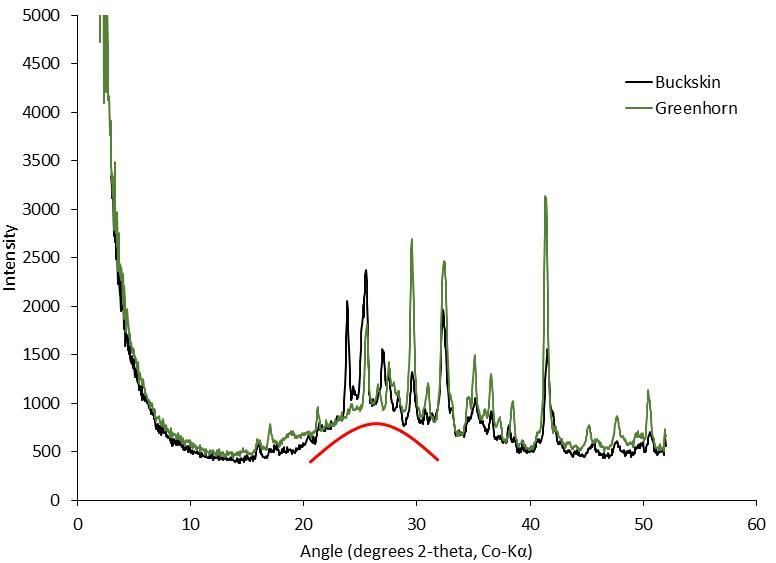
This graph presents information from the NASA Curiosity Mars rover's onboard analysis of rock powder drilled from the "Buckskin" and "Greenhorn" target locations on lower Mount Sharp. Buckskin, in the "Marias Pass" area, and Greenhorn, in the "Bridger Basin" area, both contain high concentrations of silica. X-ray diffraction analysis of powered samples inside Curiosity's Chemistry and Mineralogy (CheMin) instrument revealed that each of them contains silica in the form of noncrystalline opal. The broad hump in the two X-ray diffraction patterns is diagnostic of opaline silica. Some of the silica in Buckskin is in the form of tridymite. http://photojournal.jpl.nasa.gov/catalog/PIA20273

This view from NASA's Curiosity Mars rover shows an example of discoloration closely linked to fractures in the Stimson formation sandstone on lower Mount Sharp. The pattern is evident along two perpendicular fractures. Curiosity's Navigation Camera (Navcam) acquired the component images of this mosaic on Aug. 23, 2015, during the 1.083rd Martian day, or sol, of the mission. The location is along the rover's path between "Marias Pass" and "Bridger Basin." In this region, the rover has found fracture zones to be associated with rock compositions enriched in silica, relative to surrounding bedrock. http://photojournal.jpl.nasa.gov/catalog/PIA20268
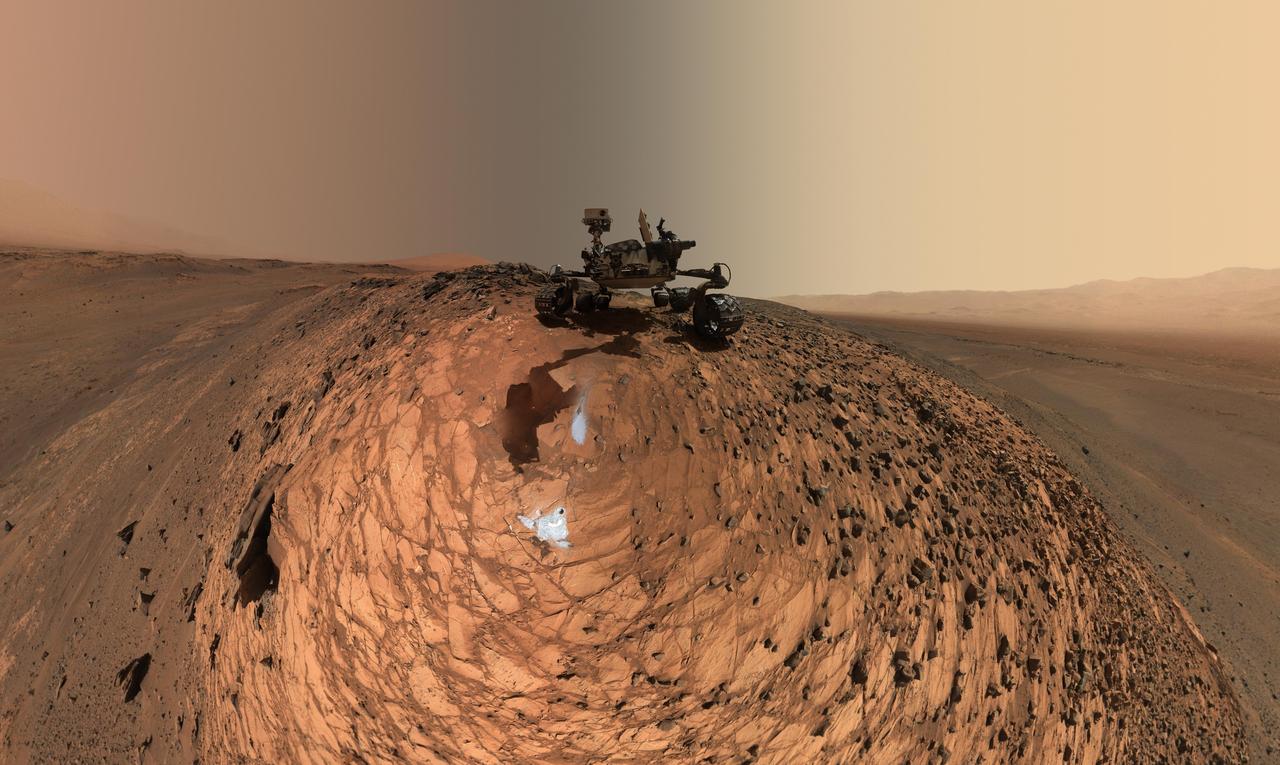
This low-angle self-portrait of NASA's Curiosity Mars rover shows the vehicle above the "Buckskin" rock target, where the mission collected its seventh drilled sample. The site is in the "Marias Pass" area of lower Mount Sharp. The scene combines dozens of images taken by Curiosity's Mars Hand Lens Imager (MAHLI) on Aug. 5, 2015, during the 1,065th Martian day, or sol, of the rover's work on Mars. The 92 component images are among MAHLI Sol 1065 raw images at http://mars.nasa.gov/msl/multimedia/raw/?s=1065&camera=MAHLI. For scale, the rover's wheels are 20 inches (50 centimeters) in diameter and about 16 inches (40 centimeters) wide. Curiosity drilled the hole at Buckskin during Sol 1060 (July 30, 2015). Two patches of pale, powdered rock material pulled from Buckskin are visible in this scene, in front of the rover. The patch closer to the rover is where the sample-handling mechanism on Curiosity's robotic arm dumped collected material that did not pass through a sieve in the mechanism. Sieved sample material was delivered to laboratory instruments inside the rover. The patch farther in front of the rover, roughly triangular in shape, shows where fresh tailings spread downhill from the drilling process. The drilled hole, 0.63 inch (1.6 centimeters) in diameter, is at the upper point of the tailings. The rover is facing northeast, looking out over the plains from the crest of a 20-foot (6-meter) hill that it climbed to reach the Marias Pass area. The upper levels of Mount Sharp are visible behind the rover, while Gale Crater's northern rim dominates the horizon on the left and right of the mosaic. A portion of this selfie cropped tighter around the rover is at PIA19808. Another version of the wide view, presented in a projection that shows the horizon as a circle, is at PIA19806. MAHLI is mounted at the end of the rover's robotic arm. For this self-portrait, the rover team positioned the camera lower in relation to the rover body than for any previous full self-portrait of Curiosity. This yielded a view that includes the rover's "belly," as in a partial self-portrait (PIA16137) taken about five weeks after Curiosity's August 2012 landing inside Mars' Gale Crater. Before sending Curiosity the arm-positioning commands for this Buckskin belly panorama, the team previewed the low-angle sequence of camera pointings on a test rover in California. A mosaic from that test is at PIA19810. This selfie at Buckskin does not include the rover's robotic arm beyond a portion of the upper arm held nearly vertical from the shoulder joint. Shadows from the rest of the arm and the turret of tools at the end of the arm are visible on the ground. With the wrist motions and turret rotations used in pointing the camera for the component images, the arm was positioned out of the shot in the frames or portions of frames used in this mosaic. This process was used previously in acquiring and assembling Curiosity self-portraits taken at sample-collection sites "Rocknest" (PIA16468), "John Klein" (PIA16937), "Windjana" (PIA18390) and "Mojave" (PIA19142). MAHLI was built by Malin Space Science Systems, San Diego. NASA's Jet Propulsion Laboratory, a division of the California Institute of Technology in Pasadena, manages the Mars Science Laboratory Project for the NASA Science Mission Directorate, Washington. JPL designed and built the project's Curiosity rover. http://photojournal.jpl.nasa.gov/catalog/PIA19807
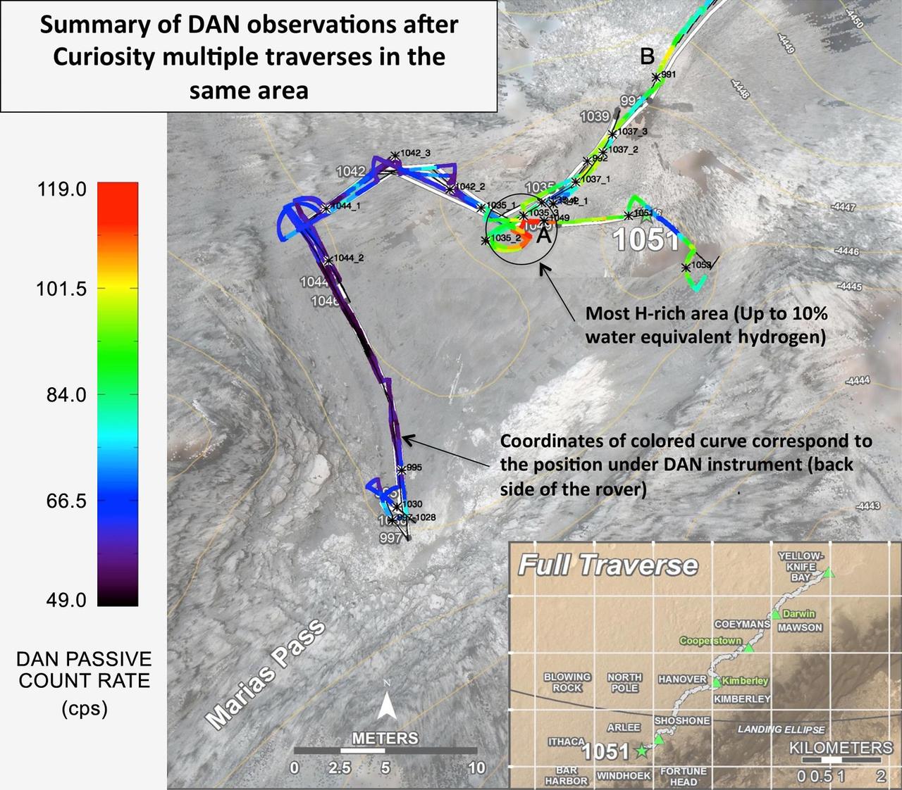
Curiosity's Russian-made instrument for checking hydration levels in the ground beneath the rover detected an unusually high amount at a site near "Marias Pass," prompting repeated passes over the area to map the hydrogen amounts. The instrument is named Dynamic Albedo of Neutrons, or DAN. It detects hydrogen by the effect of hydrogen atoms on neutrons entering the ground either from cosmic rays and Curiosity's power source (DAN's passive mode) or from the instrument's neutron pulse generator (DAN's active mode). DAN recognizes which neutrons have bounced off hydrogen from their rerduced energy level. This map, covering an area about 130 feet (40 meters) across, shows results from DAN's multiple traverses over the area, with color coding for levels of hydrogen detected. The red coding indicates amounts of hydrogen three to four times as high as the amounts detected anywhere previously along Curiosity's traverse of about 6.9 miles (11.1 kilometers) since landing in August 2012. The inset map at lower right shows the full traverse through Sol 1051 (July 21, 2015), with names assigned to rectangles within Gale Crater for geological mapping purposes. The vertical bar at left indicates the color coding according to counts per second in DAN's passive mode. The hydrogen detected by DAN is interpreted as water molecules or hydroxyl ions bound within minerals or water absorbed onto minerals in the rocks and soil, to a depth of about 3 feet (1 meter) beneath the rover. The amount of hydrogen is often expressed as "water equivalent hydrogen" based on two hydrogen atoms per molecule of water. In the same area where DAN detected an unusually high amount of hydration, Curiosity's Chemistry and Camera (ChemCam) instrument detected an unusually high amount of silica in several rock targets. The DAN and ChemCam findings led to the rover's science team choosing a rock target called "Buckskin" for collection of a drilled sample to be analyzed by the rover's internal laboratory instruments. Russia's Space Research Institute developed DAN in close cooperation with the N.L. Dukhov All-Russia Research Institute of Automatics, Moscow, and the Joint Institute for Nuclear Research, Dubna. The neutron generator development was supervised by the late technical designer German A. Smirnov of the All-Russia Institute of Automatics. Moscow. http://photojournal.jpl.nasa.gov/catalog/PIA19809
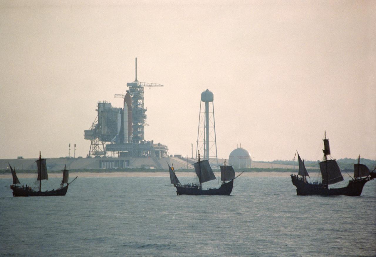
S92-39074 (6 May 1992) --- The centuries-old technology that built Christopher Columbus' three sailing ships passes within a half mile of the 20th-Century Space Shuttle Endeavour, in background, awaiting liftoff on Launch Pad 39B. The replicas of the Santa Maria, Nina, and Pinta wind-powered ships, managed by the Spain '92 Foundation, are on a tour to ports around the Gulf of Mexico and up the Atlantic Coast of the United States. Endeavour is set to lift off on its maiden voyage, STS-49, on May 7, 1992. Video footage of the two types of exploration vessels will be used by NASA for a variety of productions, including the annual Von Braun Exploration forum sponsored by NASA's Marshall Space Flight Center (MSFC), Huntsville, Alabama, in October, 1992. This year's theme is Exploration and the Evolution of Nations. 1992 is the 500th anniversary of Columbus' voyage to the New World.
Pale zones called "halos" border bedrock fractures visible in this 2015 image from NASA's Curiosity Mars rover which has been darkened (a previously released image can be seen at PIA20268). Measurements overlaid on the image offer a sense of scale for the size of these fractures. The rover team determined that the halos are rich in silica, a clue to the duration of wet environmental conditions long ago. The location is on the lower slope of Mars' Mount Sharp. Curiosity's Navigation Camera (Navcam) acquired the component images of this mosaic on Aug. 23, 2015, during the 1.083rd Martian day, or sol, of the mission. The location is along the rover's path between "Marias Pass" and "Bridger Basin." In this region, the rover has found fracture zones to be associated with rock compositions enriched in silica, relative to surrounding bedrock. https://photojournal.jpl.nasa.gov/catalog/PIA21649
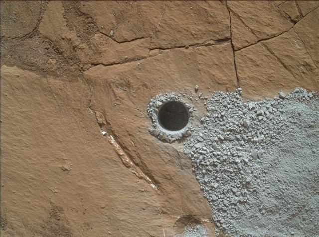
NASA's Curiosity Mars Rover drilled this hole to collect sample material from a rock target called "Buckskin" on July 30, 2015, during the 1060th Martian day, or sol, of the rover's work on Mars. The diameter is slightly smaller than a U.S. dime. Curiosity landed on Mars on Aug. 6, 2012, Universal Time (evening of Aug. 5, PDT). The rover took this image with the Mars Hand Lens Imager (MAHLI) camera, which is mounted on the same robotic arm as the sample-collecting drill. Rock powder from the collected sample was subsequently delivered to a laboratory inside the rover for analysis. The rover's drill did not experience any sign during this sample collection of an intermittent short-circuiting issue that was detected earlier in 2015. The Buckskin target is in an area near "Marias Pass" on lower Mount Sharp where Curiosity had detected unusually high levels of silica and hydrogen. MAHLI was built by Malin Space Science Systems, San Diego. NASA's Jet Propulsion Laboratory, a division of the California Institute of Technology in Pasadena, manages the Mars Science Laboratory Project for the NASA Science Mission Directorate, Washington. JPL designed and built the project's Curiosity rover. http://photojournal.jpl.nasa.gov/catalog/PIA19804
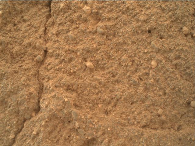
This view of a sandstone target called "Big Arm" covers an area about 1.3 inches (33 millimeters) wide in detail that shows differing shapes and colors of sand grains in the stone. Three separate images taken by the Mars Hand Lens Imager (MAHLI) camera on NASA's Curiosity Mars rover, at different focus settings, were combined into this focus-merge view. The Big Arm target on lower Mount Sharp is at a location near "Marias Pass" where a mudstone bedrock is in contact with overlying sandstone bedrock. MAHLI recorded the component images on May 29, 2015, during the 999th Martian day, or sol, of Curiosity's work on Mars. The rounded shape of some grains visible here suggests they traveled long distances before becoming part of the sediment that later hardened into sandstone. Other grains are more angular and may have originated closer to the rock's current location. Lighter and darker grains may have different compositions. MAHLI was built by Malin Space Science Systems, San Diego. NASA's Jet Propulsion Laboratory, a division of the California Institute of Technology in Pasadena, manages the Mars Science Laboratory Project for the NASA Science Mission Directorate, Washington. http://photojournal.jpl.nasa.gov/catalog/PIA19677
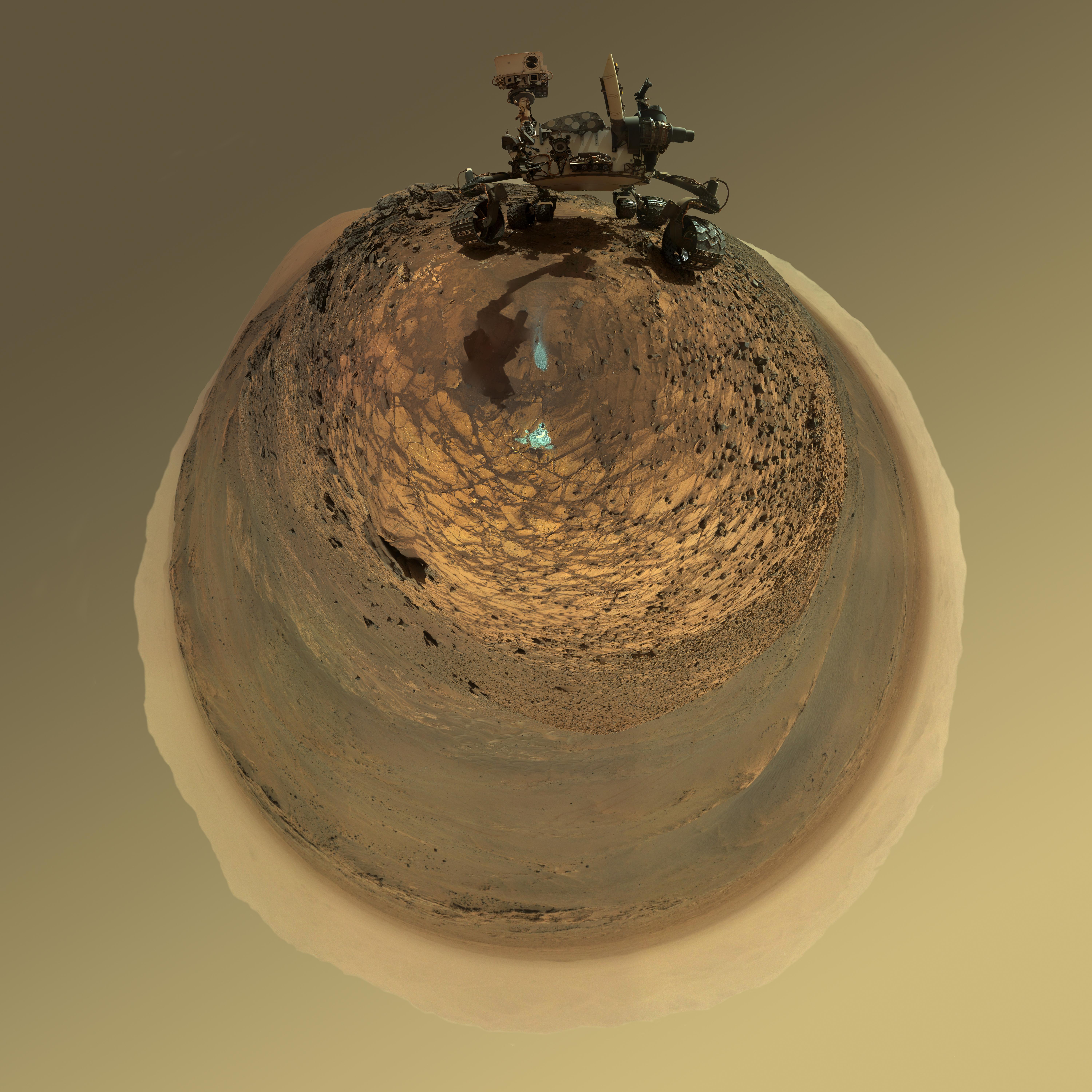
This version of a self-portrait of NASA's Curiosity Mars rover at a drilling site called "Buckskin" on lower Mount Sharp is presented as a stereographic projection, which shows the horizon as a circle. It is a mosaic assembled from the same set of 92 component raw images used for the flatter-horizon version at PIA19807. The component images were taken by Curiosity's Mars Hand Lens Imager (MAHLI) on Aug. 5, 2015, during the 1,065th Martian day, or sol, of the rover's work on Mars. Curiosity drilled the hole at Buckskin during Sol 1060 (July 30, 2015). Two patches of pale, powdered rock material pulled from inside Buckskin are visible in this scene, in front of the rover. The patch closer to the rover is where the sample-handling mechanism on Curiosity's robotic arm dumped collected material that did not pass through a sieve in the mechanism. Sieved sample material was delivered to laboratory instruments inside the rover. The patch farther in front of the rover, roughly triangular in shape, shows where fresh tailings spread downhill from the drilling process. The drilled hole, 0.63 inch (1.6 centimeters) in diameter, is at the upper point of the tailings. The rover is facing northeast, looking out over the plains from the crest of a 20-foot (6-meter) hill that it climbed to reach the "Marias Pass" area. The upper levels of Mount Sharp are visible behind the rover, while Gale Crater's northern rim dominates most of the rest of the horizon.the horizon on the left and right of the mosaic. MAHLI is mounted at the end of the rover's robotic arm. For this self-portrait, the rover team positioned the camera lower in relation to the rover body than for any previous full self-portrait of Curiosity. The assembled mosaic does not include the rover's arm beyond a portion of the upper arm held nearly vertical from the shoulder joint. Shadows from the rest of the arm and the turret of tools at the end of the arm are visible on the ground. With the wrist motions and turret rotations used in pointing the camera for the component images, the arm was positioned out of the shot in the frames or portions of frames used in this mosaic. MAHLI was built by Malin Space Science Systems, San Diego. NASA's Jet Propulsion Laboratory, a division of the California Institute of Technology in Pasadena, manages the Mars Science Laboratory Project for the NASA Science Mission Directorate, Washington. JPL designed and built the project's Curiosity rover. http://photojournal.jpl.nasa.gov/catalog/PIA19806