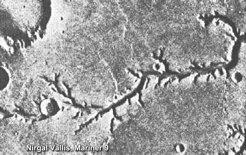
This view of channels on Mars came from NASA Mariner 9 orbiter. In 1971, Mariner 9 became the first spacecraft to enter orbit around Mars.
![Oblique view of the crater complex near Ascraeus Lacus in the Tharsis region of Mars was taken by Mariner 9. It is the northernmost of the prominent dark spots observed by Mariner during its approach to the planet. The spot consists of several intersecting shallow crater-like depressions. The main crater is approximately 21 kilometers (13 miles) across, the whole complex about 40 kilometers (25 miles) across. The crater probably is in a relatively high area of the Martian surface, which accounts for its being visible above the dust storm. The faint circular features outside the crater are probably atmospheric. Mariner 9 was the first spacecraft to orbit another planet. The spacecraft was designed to continue the atmospheric studies begun by Mariners 6 and 7, and to map over 70% of the Martian surface from the lowest altitude (1500 kilometers [900 miles]) and at the highest resolutions (1 kilometer per pixel to 100 meters per pixel) of any previous Mars mission. Mariner 9 was launched on May 30, 1971 and arrived on November 14, 1971. http://photojournal.jpl.nasa.gov/catalog/PIA03100](https://images-assets.nasa.gov/image/PIA03100/PIA03100~medium.jpg)
Oblique view of the crater complex near Ascraeus Lacus in the Tharsis region of Mars was taken by Mariner 9. It is the northernmost of the prominent dark spots observed by Mariner during its approach to the planet. The spot consists of several intersecting shallow crater-like depressions. The main crater is approximately 21 kilometers (13 miles) across, the whole complex about 40 kilometers (25 miles) across. The crater probably is in a relatively high area of the Martian surface, which accounts for its being visible above the dust storm. The faint circular features outside the crater are probably atmospheric. Mariner 9 was the first spacecraft to orbit another planet. The spacecraft was designed to continue the atmospheric studies begun by Mariners 6 and 7, and to map over 70% of the Martian surface from the lowest altitude (1500 kilometers [900 miles]) and at the highest resolutions (1 kilometer per pixel to 100 meters per pixel) of any previous Mars mission. Mariner 9 was launched on May 30, 1971 and arrived on November 14, 1971. http://photojournal.jpl.nasa.gov/catalog/PIA03100

Mariner 9 View of Arsia Silva

South Polar Cap of Mars as seen by Mariners 9 & 7

Nix Olympica Identified by Mariner 9 on Mars Approach

Mariner 9 views of shield volcano

South Pole as viewed by Mariner 9 on Mars Approach

Mariner 9 views Canyon System emerging from Martian Dust Storm

Mariner 9 views Olympus Mons standing above the Martian Dust Storm
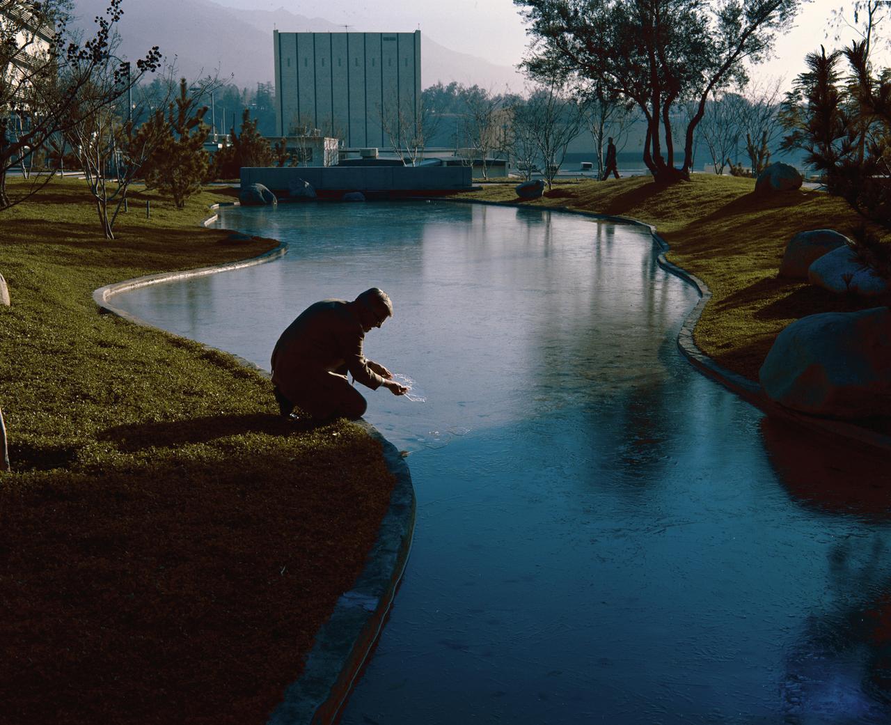
This archival image was released as part of a gallery comparing JPL's past and present, commemorating the 80th anniversary of NASA's Jet Propulsion Laboratory on Oct. 31, 2016. This photograph from 1971 shows the open-air gathering area at NASA's Jet Propulsion Laboratory known as "The Mall." It looks east towards the Applied Mechanics building (the blocky white building now numbered 157). The person in the foreground is Robert Steinbacher, the project scientist for the Mariner 9 mission to Mars. The concrete bridge crossing the ponds remains, even though the ponds have been removed. Many trees and another building, the Central Engineering Building (301), block the view to Building 157 now. http://photojournal.jpl.nasa.gov/catalog/PIA21125
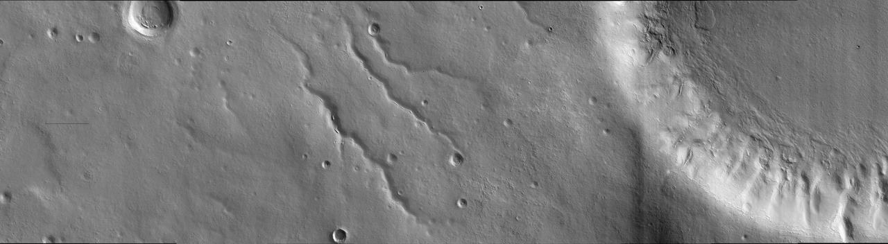
This image was taken in the mid-latitudes of Mars' southern hemisphere near the giant Argyre impact basin. It is located just to the west of a prominent scarp known as Bosporos Rupes. The left side of the image shows cratered plains. Some of the craters are heavily mantled and indistinct, whereas others exhibit sharp rims and dramatic topography. The largest crater in this half of the image is about 2.5 kilometers (1.5 miles) wide. Mounds and ridges, which may be remnants of an ice-rich deposit, are visible on its floor. Three sinuous valleys occupy the center of the image. Valleys such as these were first observed in data returned by the NASA Mariner 9 spacecraft, which reached Mars in 1971. The right side of the image shows part of an impact crater that is approximately 20 kilometers (12 miles) in diameter. The furrowed appearance of the crater's inner wall suggests that it has been extensively modified, perhaps by landslides and flowing water. Like other craters in the area, the floor of this crater has a rough and dissected texture that is often attributed to the loss of ice-rich material. This image was taken by the High Resolution Imaging Science Experiment (HiRISE) camera onboard NASA's Mars Reconnaissance Orbiter spacecraft on March 24, 2006. The image is centered at 40.64 degrees south latitude, 303.49 degrees east longitude. The image is oriented such that north is 7 degrees to the left of up. The range to the target was 2,044 kilometers (1,270 miles). At this distance the image scale is 2.04 meters (6.69 feet) per pixel, so objects as small as 6.1 meters (20 feet) are resolved. In total this image is 40.90 kilometers (25.41 miles) or 20,081 pixels wide and 11.22 kilometers (6.97 miles) or 5,523 pixels high. The image was taken at a local Mars time of 07:30 and the scene is illuminated from the upper right with a solar incidence angle of 81.4 degrees, thus the sun was about 8.6 degrees above the horizon. At an Ls of 29 degrees (with Ls an indicator of Mars' position in its orbit around the sun), the season on Mars is southern autumn. http://photojournal.jpl.nasa.gov/catalog/PIA08047